Embed Size (px)
Citation preview
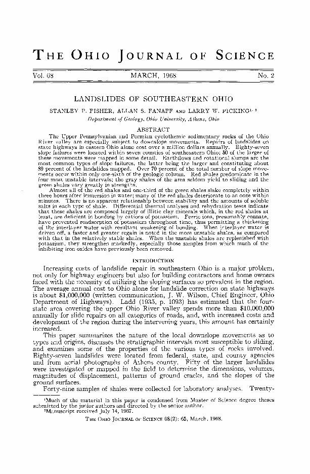
THE OHIO JOURNAL OF SCIENCE
Vol. 68 MARCH, 1968 No. 2
LANDSLIDES OF SOUTHEASTERN OHIOSTANLEY P. FISHER, ALLAN S. FANAFF AND LARRY W. PICKING1 ' 2
Department of Geology, Ohio University, Athens, Ohio
ABSTRACTThe Upper Pennsylvanian and Permian cyclothemic sedimentary rocks of the Ohio
River valley are especially subject to downslope movements. Repairs of landslides onstate highways in eastern Ohio alone cost over a million dollars annually. Eighty-sevenslope failures were located within seven counties of southeastern Ohio; 50 of the larger ofthese movements were mapped in some detail. Earthflows and rotational slumps are themost common types of slope failures, the latter being the larger and constituting about89 percent of the landslides mapped. Over 70 percent of the total number of slope move-ments occur within only one-sixth of the geologic column. Red shales predominate in thefour most unstable intervals; the gray shales of the area seldom yield to sliding and thegreen shales vary greatly in strengths.
Almost all of the red shales and one-third of the green shales slake completely withinthree hours after immersion in water; many of the red shales deteriorate to an ooze withinminutes. There is no apparent relationship between stability and the amounts of solublesalts in each type of shale. Differential thermal analyses and rehydration tests indicatethat these shales are composed largely of illitic clay minerals which, in the red shales atleast, are deficient in bonding by cations of potassium. Ferric ions, presumably connate,have prevented readsorption of potassium throughout time, thus permitting a thickeningof the interlayer water with resultant weakening of bonding. When interlayer water isdriven off, a faster and greater regain is noted in the more unstable shales, as comparedwith that in the relatively stable shales. When the unstable shales are replenished withpotassium, they strengthen markedly, especially those samples from which much of theinhibiting iron oxides have previously been removed.
INTRODUCTIONIncreasing costs of landslide repair in southeastern Ohio is a major problem,
not only for highway engineers but also for building contractors and home ownersfaced with the necessity of utilizing the sloping surfaces so prevalent in the region.The average annual cost to Ohio alone for landslide correction on state highwaysis about $1,000,000 (written communication, J. W. Wilson, Chief Engineer, OhioDepartment of Highways). Ladd (1935, p. 1093) has estimated that the four-state area covering the upper Ohio River valley spends more than $10,000,000annually for slide repairs on all categories of roads, and, with increased costs anddevelopment of the region during the intervening years, this amount has certainlyincreased.
This paper summarizes the nature of the local downslope movements as totypes and origins, discusses the stratigraphic intervals most susceptible to sliding,and examines some of the properties of the various types of rocks involved.Eighty-seven landslides were located from federal, state, and county agenciesand from aerial photographs of Athens county. Fifty of the larger landslideswere investigated or mapped in the field to determine the dimensions, volumes,magnitudes of displacement, patterns of ground cracks, and the slopes of theground surfaces.
Forty-nine samples of shales were collected for laboratory analyses. Twenty-xMuch of the material in this paper is condensed from Master of Science degree theses
submitted by the junior authors and directed by the senior author.2Manuscript received July 14, 1967.
THE OHIO JOURNAL OF SCIENCE 68(2): 65, March, 1968.
66 STANLEY P. FISHER, ALLAN S. FANAFF AND LARRY W. PICKING Vol . 68
three of the samples, obtained from 15 different slides, were from red shales knownto be intimately involved in slope failures. Where the shale cropped out at theslide site, a couple of samples of it were taken at random elevations. A hand augerwas used where the site was covered by debris and, where it was not possible tofind the shale "intact", samplings from the largest slump block were taken. Forpurposes of comparison, 11 green shales and 15 gray shales were also sampled,although these comparative samples could not always be obtained from withinthe precise interval of slope movement.
LOCATION AND GEOLOGY OF THE AREA
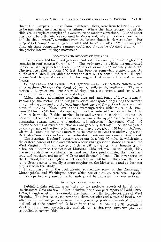
The area selected for investigation includes Athens county and six neighboringcounties in southeastern Ohio (fig. 1). The study area lies within the unglaciatedportion of the Appalachian Plateau and is well drained and maturely dissected.The average relief is about 350 feet, but becomes somewhat greater along thebluffs of the Ohio River which borders the area on the south and east. Ruggedterrain and thin, sandy soils inhibit farming, so that most of the land remainsforested.
Pennsylvanian and Permian rock systems strike northeast-southwest acrossall of eastern Ohio and dip about 30 feet per mile to the southeast. The rocksection is a cyclothemic succession of silty shales, sandstones, and coals, withsome thin limestones, ironstones, and clays.
Thick massive nonmarine conglomerates and sandstones of Lower Pennsyl-vanian age, the Pottsville and Allegheny series, are exposed only along the westernmargin of the area and are the least important parts of the section from the stand-point of landslips. Next above is the Conemaugh series, which range in thicknessfrom 355 feet to 545 feet and crops out across the center of the area in a belt 10 to20 miles in width. Bedded marine shales and some thin marine limestones arepresent in the lower part of this series, whereas the upper part contains onlynonmarine strata, including abundant red calcareous claystones. Coal andlimestone seams of minable thicknesses are generally lacking. The Monongahelaseries, youngest of the Pennsylvanian system, averages about 270 feet in thicknesswithin this area and contains more minable coals than does the underlying series.Red calcareous shales and nodular freshwater limestones are common throughout.
The Permian (Dunkard) system crops out in a belt 30 miles in width alongthe eastern border of Ohio and extends a somewhat greater distance eastward intoWest Virginia. Thin sandstones and shales with some freshwater limestones anda few coals occur to the north of Marietta, Ohio, whereas, to the south, thickmassive sandstones, conglomerates, and red clays predominate, the "northerngray and southern red fades" of Cross and Schemel (1956). The lower series ofthe Dunkard, the Washington, is between 300 and 370 feet in thickness; the over-lying Greene series is usually a mere capping on the higher hills and so does notplay a role in this study.
In summary, it is the cyclothemic sedimentary rocks of the Conemaugh,Monongahela, and Washington series which are of most concern here. Specificintervals particularly susceptible to landslip will be discussed in a later section.
PREVIOUS INVESTIGATIONS
Published data relating specifically to the geologic aspects of landslides insoutheastern Ohio are few. Most inclusive is the two-part report of Ladd (1927,1928), though most of his examples are drawn from the folded-rock area of WestVirginia. The first report concerns the characteristics and causes of local slides,whereas the second paper reviews the engineering problems involved and themethods of slide control which have been tried. Marshall (1953) presents ashort outline of field investigative methods and engineering corrective practicesas applied in eastern Ohio.
No. 2 LANDSLIDES OF SOUTHEASTERN OHIO 67
POTTSVILLE
SERIESALLEGHENY C O N E M A U G H M O N O N G E H E L A
SERIES SERIES SERIES
FIGURE 1. Sample location map. (•) denotes landslides mapped and studied in detail;(x) marks other, smaller landslides. :
Subgrade soil conditions and highway drainage in relation to notable roadfailures in Ohio are examined by Eno (1928, 1934). Savage (1951) has publisheda few examples of slides in the northeastern part of the state. Webb and Collins(1967) discuss the geologic aspects of a large slide in Vinton county which, however,took place in lake silts and did not involve the ancient bedrock. •
TYPES OF LOCAL DOWNSLOPE MOVEMENTS
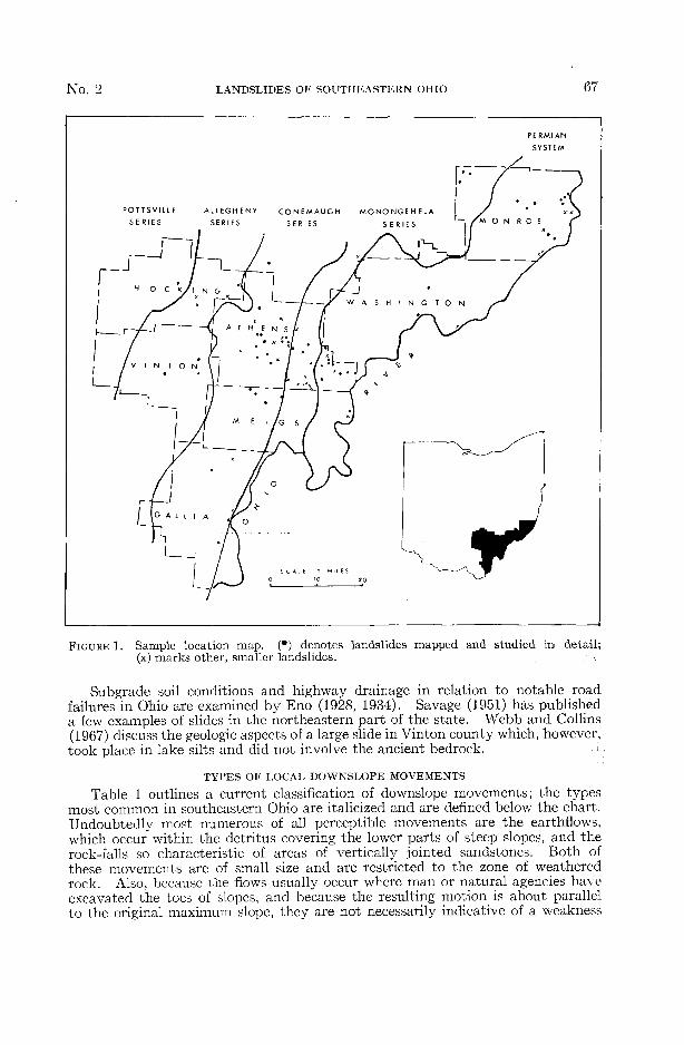
Table 1 outlines a current classification of downslope movements; the typesmost common in southeastern Ohio are italicized and are defined below the chart.Undoubtedly most numerous of all perceptible movements are the earthflows,which occur within the detritus covering the lower parts of steep slopes, and therock-falls so characteristic of areas of vertically jointed sandstones. Both ofthese movements are of small size and are restricted to the zone of weatheredrock. Also, because the flows usually occur where man or natural agencies haveexcavated the toes of slopes, and because the resulting motion is about parallelto the original maximum slope, they are not necessarily indicative of a weakness
68 STANLEY P. FISHER, ALLAN S. FANAFF AND LARRY W. PICKING Vol. 68
TABLE 1
Classification of downslope movements. {Modified after Sharpe, 1960).
Kind
Slowflow
Rapidflow
Slide
Movements
Rate
UsuallyImperceptible
Slow
1
Ra
Me
1
,o
pid
jdium
o
Rapid
plus Ice
Rock-glacier
Debris-avalanche
Earth or Rock
Dry or withsome Ice or Water
Rock-creep
Talus-creep
Soil-creep
*Rotational slump(mass intact)
* Rotational slide(mass jumbled)
Rock/debris-slide
Rock/debris-fall
plus Water
Solifluction
Earth flow
Mud flow
Debris-avalanche
*Slippage surfaces may or may not be bottomed upon a competent bed.Types of movements italicized are those most prevalent in the study area.
within a particular stratum or type of bedrock. Therefore, no special effort wasmade to find and include these types of movements in this study.
Of the 50 largest landslides investigated or mapped, approximately 89 percentwere classified as rotational landslides or slumps, the remainder being debris-slides and rock-falls. Two subtypes of rotational slumps have been recognizedin this area. The first consists of those slumps in which the curvature of slippageis completed within "rock" having a rather homogeneous physical behavior.The material may be either a thick and uniform section of shales and siltstones ora thick talus piled against the lower part of the slope. In the latter case, either aflow or a rotational movement can occur. In the second subtype, the curve offailure has been deflected or bottomed upon a competent sandstone or limestonestratum. This subtype comprises about 11 percent of the landslides mapped forthis report. In many cases the sliding mass of either subtype may be brokeninto several major blocks. Table 2 lists a few criteria for distinguishing actualrotational slides from earthflows. Many characteristics of the earthflows alsoapply to debris-slides.
Most of the slides in this area are less than 400 feet wide and have upslopelengths of between 50 and 150 feet. In one instance the high wall of a coal stripmine was observed to have failed along a distance of some 1200 feet. Verticaldisplacements along the crown scarps are usually only a few feet, the maximumsingle drop measured being 22 feet. The depth to the base of the typical flowmass is only a few feet, whereas the larger rotational blocks may have a thicknessof several tens of feet. In lieu of drilling or trenching equipment, the depths to

No. 2 LANDSLIDES OF SOUTHEASTERN OHIO 69
the basal shear surfaces were estimated by observing fracture patterns, zones ofcrushed rock and water seeps, or by using the graphic slip-circle method.
TABLE 2
Field criteria distinguishing earthflows from landslides
Earthflows Rotational Landslides
Mixed materials, few blocks. Few opencracks. Seldom comes to rest as highangle slope. Water seeps.
Crown scarps shallow and concave down-slope.
Squeeze ridges over the toe; lateralspreading but with few deep cracks.
Usually wider than long (in southeasternOhio). Slip surface approximates originalslope.
Trees are flattened or tilted downslopeover entire length.
Predominantly of blocks which retainbedding and lithologic identity. Hum-mocky, high angle surface.
Crown scarps open, deep, steep, andirregular. May end without curvingdownslope.
Fan pattern of transverse cracks overthe toe. Pressure bulges may occurbeyond the toe.
Width/length ratio variable. Blocksrotate so as to flatten or even reversethe original slope; the "sags" may retainwater.
Trees near head of slide are tilted or leanupslope.
CAUSES OF LOCAL DOWNSLOPE MOVEMENTSAbout two dozen different factors may contribute to downslope movements in
general, but only those believed to be operative in southeastern Ohio are mentionedhere. Some factors should be viewed as inherent, geologic conditions, severalof which are always present, that make a slope susceptible to sliding, but do not ofthemselves initiate the failure. Conditions include: (1) steep slopes, (2) jointedrocks, (3) porous and finer rock textures, (4) soluble cements in clastic rocks,(5) clay seams or thick clay shales subject to lubrication by (6) appreciable subsoilwater common to regions of adequate precipitation, and (7) dip of the beds withthe slope of the land, a condition quite important throughout the Appalachianstates but much less crucial in Ohio.
A second group of factors in the understanding of landslides are the triggeringactions—mechanisms that finally initiate a slide at a particular place and time,even though similar detrimental geologic conditions may exist throughout theregion. Triggering actions include: (1) vibrations, either natural earth tremorsor man-made, such as blasting, (2) oversteepening of a slope by weathering, streamundercutting, or man, (3) weighting of an unstable slope by construction or by thesudden addition of water, and (4) increased pore-water pressures in rocks, especiallywhere a water-bearing stratum is constricted or loses permeability. It is notalways possible to decide whether a given factor will act or has acted as a conditionor as a triggering action, but a review of all possible reasons for sliding at a specificlocality will usually suggest the proper explanation.
A prime contributory factor or triggering action for flows and landslides is,as will be apparent below, shallow subsurface waters. Many rock-falls are initiatedby the expansion of freezing water in fractures, but wrater also plays several otherroles in earthflows and landslides. The annual precipitation for the Ohio Rivervalley averages 40 inches per year and occurs during an average of 120 days.The greatest seasonal rainfall is from June through August, with over 11 inches,
70 STANLEY P. FISHER, ALLAN S. FANAFF AND LARRY W. PICKING Vol. 68
but spring months may also register heavy rainfall. At Athens the springs of1963 and 1964 were unusually wet; in both years March alone had between eightand ten inches of rain, which is double the normal amount. To these rains mustbe added some of the meltwater from late winter snows. Thus the combinationof rain plus meltwater makes the change from winter to spring the prime seasonfor slope failures.
A relationship between rainfall and downslope movements is suggested bythe fact that almost two-thirds of the larger slides in the area occurred on slopesfacing south-southwest to southeast. Data are too sparse for a satisfactoryexplanation at this time, but such slopes do face the main southwesterly stormtrack and so may collect more water than do the more protected northerly slopes.Also, the regional dip of the rock strata in this area should direct the subsurfacedrainage of infiltration waters toward the east-southeast and out onto these slopeswhich are subject to the majority of the larger slides.
Water infiltrating into the soil passes on downward by means of pores or jointsystems in sandstones and limestones until its progress is impeded by an imperviouslayer of shale or clay. Thus, abnormally high hydraulic head can build up withinthe overlying porous materials during periods of heavy rains. Similarly, if theexcess water issues into an area of thick soil on a slope or behind a bank of finecolluvium, pore-water pressure tends to force the grains apart and may actuallybuoy up or "float" a moderate thickness of the superficial materials, thus reducingthe shearing strength and triggering a slide or earthflow. The same result canoccur on a slope where a porous sandstone underlies an impervious material atshallow depth. Were excessive underground waters unable to discharge laterally,perhaps because of decreased permeability or constriction of the sandstone,increasing water pressure might break through to the surface and initiate a smallslide. It must be recognized, too, that the first open fissures at the head of themoving mass serve to conduct increasing amounts of runoff water down into thezone of failure.
Shales and claystones present a more complex activation of slope movements.The shearing strength of shale is quite low, depending as it does upon the slightinternal friction of microscopic platy grains and upon electrostatic bonding orcohesion between the particles. This cohesion is usually dependent upon a skinof adsorbed, oriented water molecules and sometimes also upon surface tensionbetween the water and any air that may exist from time to time in the pores of thecoarser phases of the sediment. However, excess water under pressure mayreduce the cohesion, either by altering the molecular film of water or by destroyingthe surface tension as all air spaces become filled with water. Also, pore-waterpressure in the silty phases of the rock may spread the grains apart so that internalfriction is further diminished. Finally, certain clay minerals have the abilityto absorb much water and swell, thus exerting an upward pressure that mayreduce shear resistance within a claystone, and may conceivably reduce thestabilizing effect of the weight of thin overburden.
Frequencies of Slope MovementsAbout three-quarters of the landslides in southeastern Ohio occur within
only one-fifth of the stratigraphic column: those parts characterized by the thickestred shales and claystones. The three rock intervals most subject to slope failuresare designated units C, E, and G in the general rock column (fig. 2). Theseintervals are 55, 120, and 210 feet thick, respectively, and each accounts for 20
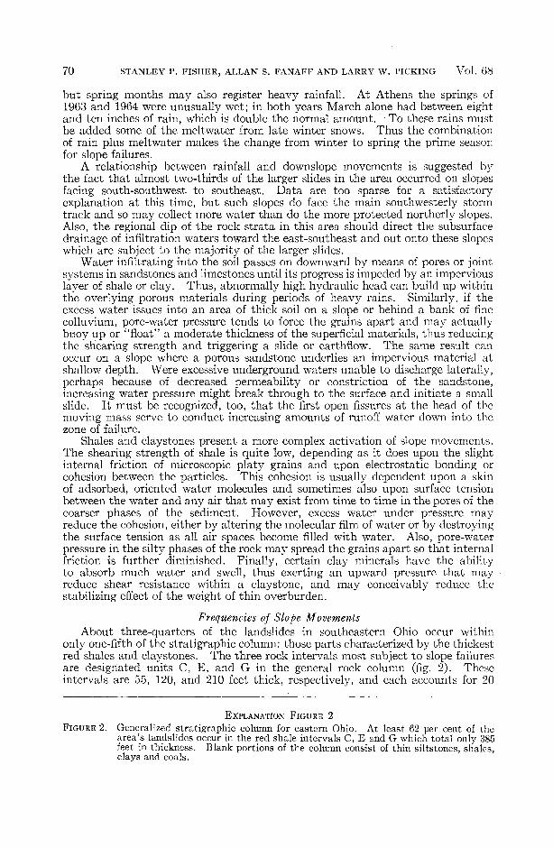
EXPLANATION FIGURE 2
FIGURE 2. Generalized stratigraphic column for eastern Ohio. At least 62 per cent of thearea's landslides occur in the red shale intervals C, E and G which total only 385feet in thickness. Blank portions of the column consist of thin siltstones, shales,clays and coals.

No. 2 LANDSLIDES OF SOUTHEASTERN OHIO 71
AGE GROUP SERIES MEMBER UNITP
ER
MIA
N
DU
NK
AR
D
GREENE
WASHINGTON
MONONGAHELA
CON EMAUGH
PE
NN
SY
LV
AN
IAN
POTTSVILLE
ALLEGHENY
Gilmore Ss & Sh
Nineveh Ss & Sh
Fish Creek Ss
Jollytown Ss
Hundred Ss
Creston Red Sh
Mannington Ss & Sh
Waynesburg CoalUniontown Red Sh
Tyler Red ShSewickley SsMeigs Cr. Coal
Fishpot Ls
Pittsburgh Coal
Connellsville Ss
Clarksburg Red Sh
U. Grafton Ss
Skelley LsAmes Ls
Round Knob Red ShCow Run Ss
Brush Creek Ls& Red Sh
U. Mahoning Ss
L. Freeport SsM. Kittanning Coal
Homewood Ss
L. Mercer Ss.
Sharon CgI .
72 STANLEY P. FISHER, ALLAN S. FANAFF AND LARRY W. PICKING Vol. 68
percent or more of the landslides in the area studied. Although not specificallynoted in the rock column, the Brush Creek and Creston red shales each contributefive to ten percent of the local landslides.
In an unpublished report, Price and Lilly (1936) noted the same relationshipbetween frequency of sliding and the occurrence of red shales throughout WestVirginia, particularly in the Clarksburg (Unit E) and the Pittsburgh (Unit C;the Round Knob beds of Ohio) red-bed members of the Conemaugh series. Theystate (p. 32):
Out of 100 slips occuring in shale horizons, 55 are in red shale. Fifteen or more are in theClarksburg "Reds", 8 or more in the Pittsburgh "Reds", and 32 in unidentified or variousother red shales.
These red shales were former muds which have consolidated by drying and compactionand generally represent structureless masses with little or no inherent strength. Freshexposures in most unweathered shale of this type have shown the mass to be highlyfractured in all directions, and to consist of innumerable small fragments with the fracturedsurfaces slickensided and polished.
Field Characteristics of the Red ShalesIn general, the more stable rock intervals have a greater number of thick
sandstones which, although they yield to rock-falls, are seldom involved in rota-tional slumps or earthflows. The red shales that occur within the more stableunits are more silty, are fewer, and appear to be lenses and not as laterally extensiveas those in the more active parts of the section. The term "red beds", as usedin this paper, refers to the nature of the strata of some two dozen intervals, inmost of which the shale or clay seams, though commonly red or purple in color,may also be mottled with yellow, gray, and green. Ferruginous and/or calcareousnodules are common, and the reddish shales often grade laterally and verticallyinto thin, irregular limestones.
Some differences between the types of failures of the major red shale intervalswere noted in the field. Unit C (Round Knob red beds) usually displays eitherhighly broken and jumbled rotational slides or actual earthflows. In both casesthe various lithologies involved are quite intermixed. The ratio of failure pervertical foot of section is greater here than in other red-bed units. These shalesare somewhat micaceous and laminated, locally almost fissile, more jointed, andcontain extensive patterns of ancient dessication marks on most bedding surfaces.Individual clay-shale intervals are thicker than the other units, being as much as24 feet in thickness at one locality. When wetted and weathered, these shalesform a plastic mass over which even walking is very difficult.
In contrast, Unit G (Tyler-Uniontown red beds) and especially Unit E(Clarksburg red beds) usually yield rotational slumps which remain relativelyintact. Thus, the surfaces of these slides are less hummocky. The larger slidesdo tend to break into separate blocks, but with neither thorough disruption ofbeds nor intermixing of various lithologies. Individual red shales of these twointervals appear to be thinner, more massive, less silty and micaceous, and lessjointed than those of Unit C.
Laboratory Investigations of the ShalesSlaking Tests
The effects of water upon the various shales were tested by immersion of cutcubes of shales of equal size, which were then observed during a period of three andone-half days. The time at which initial breakdown appeared and the manner ofdeterioration were carefully noted. The samples were observed continuouslyduring the first hour, at one-hour intervals during the next five hours, and attwelve-hour intervals thereafter. The results are given in table 3.
Twenty-three red-shale samples from undisturbed beds adjacent to 15 landslideswithin Units C, E, G, and H were tested; seven of these samples were tested a

No. 2 LANDSLIDES OF SOUTHEASTERN OHIO 73
second time as a check and all behaved as they had at first. With three exceptions,the red-shale samples deteriorated completely; almost all slaked within one hourinto chunks one to two mm in diameter, and two-thirds eventually became oozescovering the bottoms of the beakers. Three red shales became oozes withinonly ten minutes, and almost a dozen flaked badly on the bedding surfaces in thesame span of time.
Eight samples of gray shales, under the same treatment, were essentially
TABLE 3
Slaking characteristics of shales involved in landslides and of nearby control samples
Hours required for slaking
Rock Slaked NotSample Unit Form 1 2 3 4 5 12 24 36 48 60 72 84 Slaked
Symbol (f) denotes the time at which surfaces flaked but the sample did not deterioratecompletely.
*Breakdown to chunk or granular form (Ch); to ooze (Oo).

74 STANLEY P. FISHER, ALLAN S. FANAFF AND LARRY W. PICKING Vol. 68
uneffected; all maintained their original block form throughout, although perhapsone-half of these samples eventually showed very minor flaking. One sample hadparted along the surficial laminae and softened slightly by the end of three andone-half days. Eleven green shales were also tested. These varied widely inbehavior, some slaking within five hours, a few parting slightly, but most notdeteriorating at all.
Grain-Size Analyses and Mineral ContentIn preparation for mineral identification of the coarser fraction of the shales,
trial size analyses of nine red shales and three each of the green and gray shaleswere attempted using a Fisher-Dott (tube) separator. The red shales' analyses,when plotted, were more closely grouped and were somewhat finer than werethose of either the gray or green shales tested. However, grain-size analyses ofclays, dependent as they are upon settling velocities of the particles, are consider-ably influenced by the sizing technique used and the degree of dispersion obtained,and, where one suite of samples slakes exceptionally easily, sample preparationsare difficult to control. Inasmuch as the finer median sizes of the red shales mostprobably reflected their tendency to slake, the tests were discontinued.
Samples used for microscopic mineral identification included the 15 shalesdisaggregated for size analysis, the coarse residues from the oozes of a dozen slakedshales, and a dozen thin sections. Fragments of additional shales were examinedwith a binocular microscope to obtain a rough appraisal of the silt (quartz) content.
The gray shales, which were relatively stable during the immersion tests,generally contained a notably greater percentage of quartz and muscovite thandid either the green or red shales. A few of the gray shales should more properlyhave been classified as siltstones, and two of the four non-slaking green-shalesamples also proved to have been siltstones. Thus, there appears to be a relation-ship between increasing amounts of quartz silt and improved stability of the rock.However, the precise reasons for this relationship are not certain because, in allthe types of shales, the quartz grains are chiefly angular and the range of sizesis quite similar.
Hematite pellets (and aggregates) up to ten microns in diameter occur sporadic-ally in many of the red and green shales. They may have derived from an un-identified ferrous mineral, a very little of which remains as green, mottled totranslucent, pitted grains.
Many of the shales sampled were slightly calcareous, but, because the reactionto HC1 was both mild and spotty, no attempt was made to extract the quantitiesof calcite present. A minor amount of the calcium carbonate was present in theform of sideritic stringers or threads.
Tests for pH and ElectrolytesWhile investigating the quick clays of Canada and Scandanavia, Kerr (1963,
pp. 135-137) discovered that "electrolytes in a mass of clay tend to bind theparticles together; consequently, as salt is leached out of the clay, it becomesthixotropic." The red shales of this report are generally considered to be of non-marine origin, and it is thus possible that they may be deficient in connate salts.
Further, work done by the Huber Corporation (1955, pp. 102-104) indicatesthat a clay slurry will give a pH value which varies according to the percent ofclay concentration and the amount of settling that has occurred. These findingssuggested to the writers that a wide range of pH and/or electrolyte values amongthe samples might point to a rapid means of detecting unstable shales—an "indexof deflocculation" or breakdown. Such an index might relate to the slakingpotentials, to ultimate particle sizes, and, thereby, possibly to the ion exchangecapabilities of the clays. The many variables that could negate these relationshipsrequired rigidly controlled preparations of the samples, but, in spite of limitedequipment and time available, it was decided to run trials on both techniques.
No. 2 LANDSLIDES OF SOUTHEASTERN OHIO
Thirty-nine samples of the three types of shales were tested for hydrogen-ionand for total-electrolyte concentrations, the latter component being measured bythe conductances of the clay slurries. No systematic variance of the conductancesor of the pH values between the stable and unstable shales could be ascertained.Neither was there any apparent correspondence between the conductances andpH readings in general. Although unsuccessful, the experiments are mentionedbecause they were a part of this study and because they may yet offer a rapidmeans of identifying unstable shales within the local rock column.
When the data are arranged according to stratigraphic position, however,each shale unit appears to have rather definite limits of conductance, which mayhave significance in stratigraphic correlation or environmental determinations.For example, all shales of Unit C have no measurable conductance, whereas theconductance of Unit G varies from zero to one millivolt, that of Unit H rangesfrom two to three and one-half millivolts, and that of Unit E varies from threeand one-half to five and one-half millivolts. Inasmuch as the Pennsylvaniansedimentary rocks are cyclothemic and represent changes from marine or brackishto fresh-water environments, the several ranges of conductances may reflectcertain chemical changes of the ancient waters which received the clays. Thetechnique might be refined as a tool for rapid correlation or for tentative environ-mental determination on a local scale.
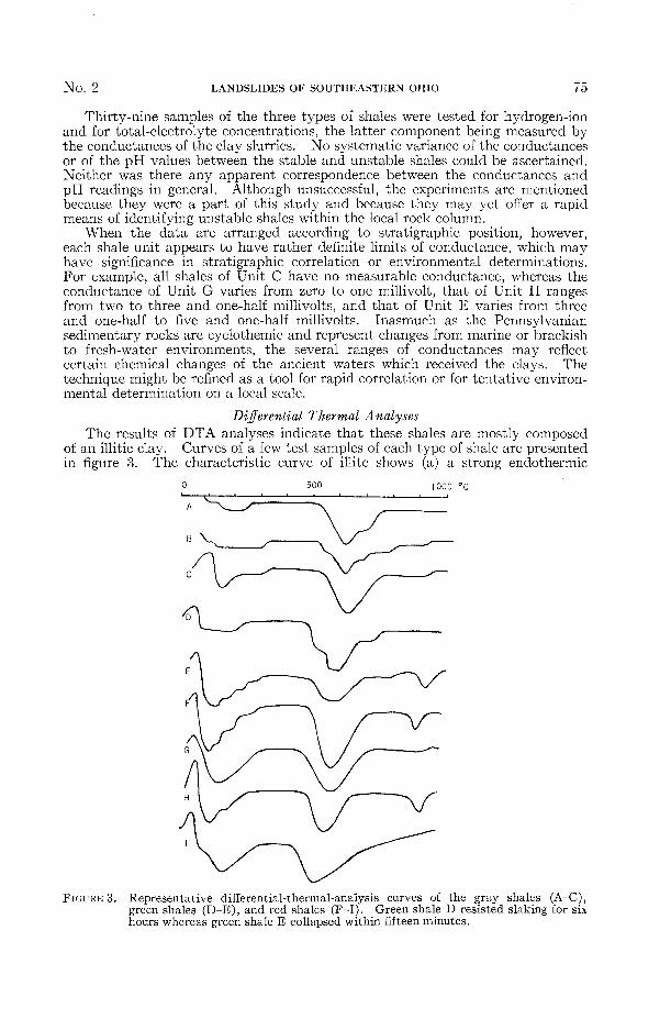
Differential Thermal AnalysesThe results of DTA analyses indicate that these shales are mostly composed
of an illitic clay. Curves of a few test samples of each type of shale are presentedin figure 3. The characteristic curve of illite shows (a) a strong endothermic
500 I0C0
FIGURE 3. Representative differential-thermal-analysis curves of the gray shales (A-C),green shales (D-E), and red shales (F-I). Green shale D resisted slaking for sixhours whereas green shale E collapsed within fifteen minutes.
76 STANLEY P. FISHER, ALLAN S. FANAFF AND LARRY W. PICKING Vol . 6 8
reaction between zero and 250°C as interlayer water between the plates of unitlattices is driven off, (b) a second very strong endothermic peak between 475 and550°C corresponding to the loss of hydroxyls from within the lattices, and (c) aslight reaction between 840 and 940°C. This last reaction is not always presentand is usually much less intense than the first two. It is probably the result ofbreakdown or rearrangement of the lattice structure. Some of the test samplesgive evidence of being composed of interlayered clay minerals, as shown by ashelf or step in the second endothermic peak. These interlayered clays are prob-ably mixtures of illite in larger percentages, stacked with smaller amounts ofkaolin or, especially, montmorillonite, but final determination of compositionsmust await future X-ray study.
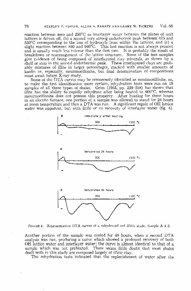
Some of the DTA curves may be erroneously identified as montmorillinite, so,to make the first identification more certain, rehydration tests were run on 15samples of all three types of shales. Grim (1953, pp. 229-238) has shown thatillite has the ability to rapidly rehydrate after being heated to 600°C, whereasmontmorillonite does not possess this property. After heating for three hoursin an electric furnace, one portion of a sample was allowed to stand for 24 hoursat room temperature and then a DTA was run. A significant regain of OH latticewater was apparent, but with little or no recovery of interlayer water (fig. 4).
Immediately after heating
500 1000 °C
Rehydrated 24 hours
500 1000 °C
Rehydrated 48 hours
500 1000 °C
FIGURE 4. Representative DTA curves of a rehydrated red illitic shale, Sample A-4-2.
Another portion of the sample was cooled for 48 hours, when a second DTAanalysis was run, producing a curve which showed a profound recovery of bothOH lattice water and interlayer water; the curve is almost identical to that of asample which was not preheated. There seems little doubt that most shalesdealt with in this study are composed largely of illitic clay.
The rehydration tests indicated that the replenishment of water after the
No. 2 LANDSLIDES OF SOUTHEASTERN OHIO i I
48-hour period is much more complete in the red shales than in the gray shales.The DTA curves record a major difference between the two kinds of shales; thefirst endothermic reaction, resulting from the loss of interlayer water, is muchmore intense in the unstable red shales than in the gray shales. Thus, theremust be a greater attracting force for water between the layers of the red shales.This reaction may, of course, be affected to some extent by major changes inatmospheric humidity and by the treatment of the samples prior to thermalanalysis. To minimize this problem, all samples were carefully treated alikeand 20 gray- and 10 green-shale samples were run as comparisons with over 60red shales.
Some samples of the green shales showed a large amount of interlayer water,whereas others showed very little. Correlation between those green shales whichslaked most readily and those which showed high interlayer water content wasexcellent.
Pot»«lumP Aluminum, ( J
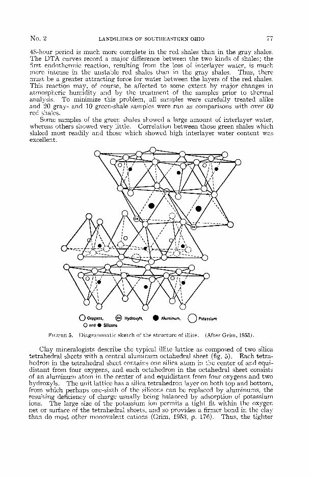
FIGURE 5. Diagrammatic sketch of the structure of illite. (After Grim, 1953).
O Oxygans, (OH) Hydroxyls,
O and • Silicons
Clay mineralogists describe the typical illite lattice as composed of two silicatetrahedral sheets with a central aluminum octahedral sheet (fig. 5). Each tetra-hedron in the tetrahedral sheet contains one silica atom in the center of and equi-distant from four oxygens, and each octahedron in the octahedral sheet consistsof an aluminum atom in the center of and equidistant from four oxygens and twohydroxyls. The unit lattice has a silica tetrahedron layer on both top and bottom,from which perhaps one-sixth of the silicons can be replaced by aluminums, theresulting deficiency of charge usually being balanced by adsorption of potassiumions. The large size of the potassium ion permits a tight fit within the oxygennet or surface of the tetrahedral sheets, and so provides a firmer bond in the claythan do most other monovalent cations (Grim, 1953, p. 176). Thus, the tighter
78 STANLEY P. FISHER, ALLAN S. FANAFF AND LARRY W. PICKING Vol. 68
the bond, the less the acceptance of interlayer water. Further, the size of thepotassium ion is such that it does not easily enter into and augment the net ofwater molecules, but tends to disrupt and inhibit the buildup of the water net.However, if the illite is degraded by the leaching of potassium ions, any surfacecharges existent will be partially balanced by interlayer water, and the bond ofthe clay is thereby weakened.
Grim (1958, p. 17) and White (1956, p. 1024) suggest that four or less orientedmolecular layers of water can occur in a non-liquid state between the unit platesof illite, while the clay remains in a rigid, non-plastic state. Additional waterinduces less organized layers and the clay becomes more plastic and fluid untilcomplete loss of cohesion and strength results. The water bond does not neces-sarily occur between every lattice unit; a series of lattice units may be bonded bypotassium to form a crystal, and water bonds may hold several of these crystalstogether in a compound form. Thus, the volume and spacing of interlayer watersinfluence considerably the degree of stability of the shale.
Potassium Fixation TestsDion (1944, p. 411) and Wilklander (1950, p. 261) have shown that an abund-
ance of ferric oxide in clays tends to reduce ion exchange of cations and to preventpotassium fixation. To test the role of potassium in the local unstable clays andshales, it was desirable to remove as much ferric oxide as possible and then toattempt to reconstitute potassium within some of the trial samples.
The reduction and solution of the iron oxides in the experimental samples ofshales was accomplished by using nascent hydrogen, as described by Dion (1944,p. 413). A 400 ml beaker was one-third filled with aluminum foil folded at rightangles to maintain maximum spacing, to which was added 100 ml of distilled watermixed with 10 g of sodium tartrate, followed by 2 g of powdered shale sample.This mixture was slowly boiled for an hour or until the red-brown coloration ofthe .sample disappeared, thus indicating that reduction and solution of the ironoxide had taken place. For each shale, a second, control sample was boiled indistilled water for the same length of time in an attempt to cancel out any physicalchanges that may have been induced by the treatment. All samples were centri-fuged and washed three times with distilled water.
Nine very unstable red shales were selected for testing. After removal of asmuch of the iron oxides as possible (none went to complete reduction), both thetreated sample and an untreated control sample of the same shale were halved.The first half of each pair was soaked for one-half hour in a ten percent potassiumhydroxide solution; the second half of each pair was again soaked in distilledwater. All four specimens were mechanically agitated, allowed to stand for threehours, and then dried for 15 hours at 85°C. The four dried plugs now represented(1) a portion of the shale from which the iron oxides had been removed but whichhad not been treated with excess potassium, (2) a portion with iron oxides removedbut then treated with an excess of potassium ions, (3) a portion containing theoriginal iron oxides but untreated with potassium ions, and (4) a portion containingboth the original iron oxides and the added potassium.
Each plug was then immersed in distilled water and observed for slaking, theresults of which were very similar for each plug of the four-part suite of all ninered shales tested. All plugs which had not received excess potassium slakedimmediately, whereas those to which potassium had been added showed onlymoderate signs of deterioration or none at all, even after 16 hours of immersion.This was true of both the plugs containing original iron oxides and the plugsfrom which much of the iron oxides had been removed, though the former showedsomewhat greater effects of the immersion. Certainly, it appeared that thestability of the samples was appreciably enhanced by the addition of potassium,whether or not the iron oxides had been previously removed.
During the drying stage of the above procedure, it was noted that the plugs

No. 2 LANDSLIDES OF SOUTHEASTERN OHIO 79
treated with potassium hydroxide shrank significantly more than those not sotreated. These plugs were difficult to break with a stirring rod. This seemedas generally true for the samples still containing iron oxides as for the samplesfrom which the iron oxides had been removed. To estimate the progressive effectsof the addition of potassium, samples of four red shales were treated as describedabove, but with each portion of shale being subjected to successively longer periodsof boiling than the preceding portion. Periods of boiling for the reduction of theiron oxides ran from two to five hours; the periods of drying and immersion inwater were extended from two to four times the original periods. Although therewas no means available for precise measurements, the portions of clay from whichincreasing amounts of iron oxides had been removed exhibited a toughness andan increasing stability commensurate with the assumed progressively efficientbonding by the potassium cations.
CONCLUSION
The unstable illitic red shales of southeastern Ohio have apparently beendegraded by the leaching of interlayer potassium ions. Plants utilizing potassiummay also have played a role in this removal (Bray and De Turk, 1939, pp. 101-106).Degraded illites behave very similarly to montmorillonites in the presence ofmoisture, with the exception that expandability is not nearly so great. Theclays can remain in the degraded form throughout the weathering cycle, transporta-tion, and continental deposition, but, if ultimately deposited under marine condi-tions, they should reabsorb potassium from the sea water and regain stable form(Weaver, 1958, p. 856, Keller, 1956, p. 2703).
The most obvious characteristic of the local shales, that makes them more orless unique among Paleozoic argillaceous rocks of the eastern United States,is their red color, which results from an abundance of ferric iron oxides. Thissuggests that simultaneous deposition of ferric iron with degraded illitic clayprecluded reabsorption of the bonding potassium ion in the depositional environ-ment. The continued presence of iron has greatly inhibited the reconstitutionof the clay throughout diagenesis and later geologic time. Thus, the degradedstate of many of the local clays may offer the possibility, previously suggested,that determination of pH values and of the types and amounts of electrolytespresent might, with further study, provide a rapid means of identifying both themore unstable shales and their broad depositional regimen.
It was not the intention of this paper to discuss techniques for the preventionor correction of landslides. However, in addition to obvious methods for pre-venting waters from percolating into unstable shales, some stability might beimparted by applications of potassium-bearing sprays or dusts over a period oftime. Of course, the size of the area likely to be involved in failure and the costsare serious hurdles to this approach.
The present report is an initial effort to catalogue and to understand somethingof the slope movements in the Ohio River region. Future studies should includeX-ray analyses of the composition of the troublesome shales and early recognitionof unstable slopes and incipient landslips from aerial photographs.
LITERATURE CITEDBray, R. H. and E. E. De Turk. 1939. The Release of Potassium from Non-replaceable Forms
in Illinois Soils. Soil Sci. Soc. Amer. Proc. 3: 101-106.Cross, A. T. and M. P. Schemel. 1956. Geology and Economic Resources of the Ohio River
Valley in West Virginia. W. Va. Geol. Survey, 22, part I, 131 p.Dion, H. G. 1944. Iron Oxide Removal from Clays and its Influence on Base Exchange
Properties and X-ray Diffraction Patterns of the Clays. Soil Science, 58: 411-424.Eno, F. H. 1928. Highway Subsoil Investigations in Ohio, Preliminary Report. The Ohio
State University Engineering Experiment Station Bull. 39, 64 p.. 1934. Some Effects of Soil, Water and Climate upon the Construction, Life and
Maintenance of Highways. The Ohio State University Engineering Experiment StationBull. 85, 60 p.
80 STANLEY P. FISHER, ALLAN S. FANAFF AND LARRY W. PICKING Vol. 68
Grim, R. E. 1953. Clay Mineralogy. Mc-Graw-Hill Book Co., New York. 384 p.. 1958. Organization of Water on Clay Mineral Surfaces and its Implications for the
Properties of Clay-Water Systems. Nat. Research Council, Highway Research BoardSpecial Report 40: 17-23.
Huber Corporation. 1955. Kaolin Clays and Their Industrial Uses. J. M. Huber Corporation,New York.
Keller, W. D. 1956. Clay Minerals as Influenced by Environments of Their Formation.Bull. Amer. Assoc. Petrol. Geol. 40: 2689-2710.
Kerr, P. F. 1963. Quick Clay. Sci. Amer., Nov., 132-138.Ladd, G. E. 1927. Landslides and Their Relations to Highways, Part I. Public Roads,
8(2): 21-31. Part II, 1928, Public Roads, 9(8): 153-162.•—• . 1935. Landslides, Subsidence and Rock-falls. Amer. Railroad Engineering Assoc.
Proc. 36: 1091-1162.Marshall, H. E. 1953. Some Experiences of the Department of Highways with Landslides
in Ohio. Proc. 4th Annual Symposium on Geology as Applied to Highway Engineering,Morris Harvey College and West Virginia State Road Commission, 12-23.
Price, P. H. and K. O. Lilly. 1936. An Investigation Affecting Highways in West Virginia.Unpublished report, W. Va. Geol. Survey, Morgantown, 51 p.
Savage, C. N. 1951. Mass-Wasting; Classification and Damage in Ohio. Ohio Jour. Sci.51: 399-408.
Sharpe, C. F. 1960. Landslides and Related Phenomena. Columbia University Press, NewYork, 137 p.
Weaver, C. E. 1958. Geologic Interpretation of Argillaceous Sediments; Part I, Origin andSignificance of Clay Minerals in Sedimentary Rocks. Bull. Amer. Assoc. Petrol. Geol.42: 254-271.
Webb, D. K. and H. R. Collins. 1967. Geologic Aspects of a Recent Landslide in VintonCounty, Ohio. Ohio Jour. Sci. 67: 65-74.
White, A. W. 1956. Underclay Squeezes in Coal Mines. Trans. A.I.M.M.E., October,1024-1028.
Wilklander, L. 1950. Fixation of Potassium Clays Saturated with Different Cations. SoilSci. 69: 261-271.