Embed Size (px)
Citation preview
SUNDERLAND
Tynemouth
Bedlington
Morpeth
Cramlington
Blyth
WhitleyBay
Longbetton
Wallsend
Jarrow
Heburn
SouthShields
NorthShields
AshingtonNewbiggin-
by-Sea
GATESHEAD
NEWCASTLEUPON TYNE
WhitburnBlaydon
Ryton
Ponteland
Whickham
Birtley
Chester-le-Street
Stanley
Consett
Washington
Houghton-leSpring
Houghton-leHole
Seaham
The Councils of Tyne and Wear and Northumberland are developing a network of cycle routes to all local areas, linking homes to employment, shops, education, recreation and medical facilities. For more information and ideas about cycling visit:
l www.northumberland.gov.ukl www.northtyneside.gov.ukl www.newcastle.gov.ukl www.sustrans.org.uk
l www.southtyneside.infol www.gateshead.gov.ukl www.sunderland.gov.uk/cyclingl www.ctc.org.ukl www.gosmarter.co.uk
Double sided map with hundreds of miles of routes
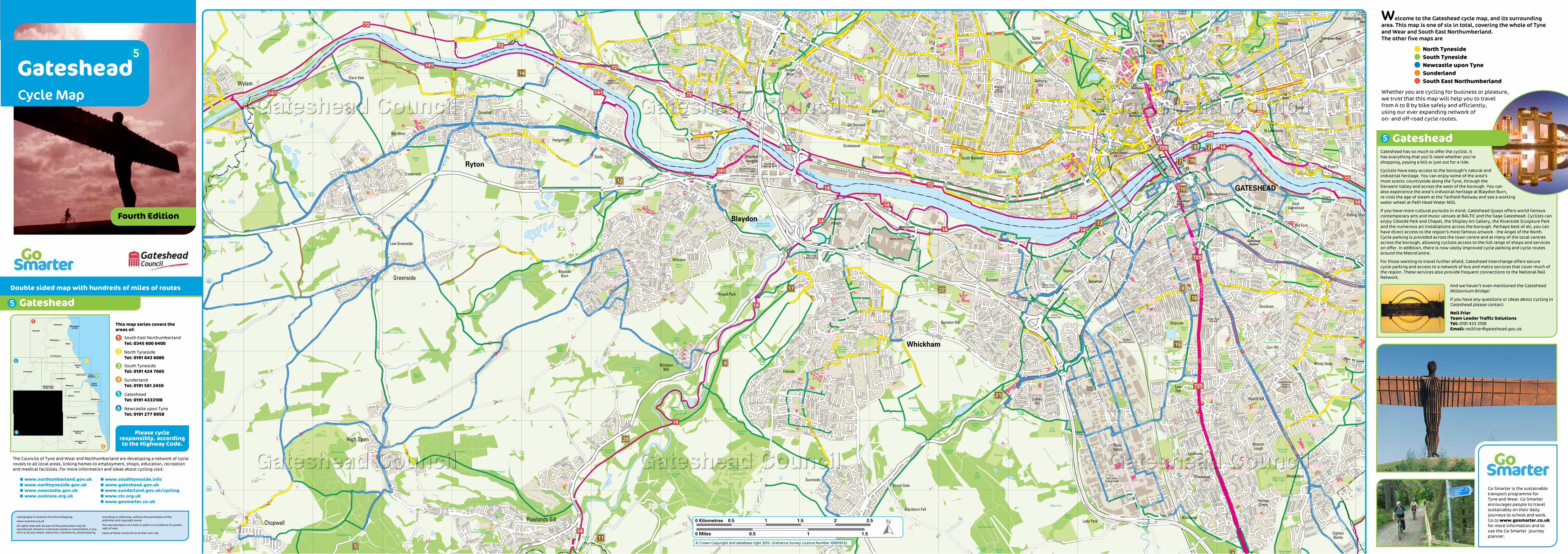
Gateshead
Welcome to the Gateshead cycle map, and its surrounding area. This map is one of six in total, covering the whole of Tyne and Wear and South East Northumberland.The other five maps are
North TynesideSouth TynesideNewcastle upon TyneSunderlandSouth East Northumberland
Whether you are cycling for business or pleasure, we trust that this map will help you to travel from A to B by bike safely and efficiently, using our ever expanding network of on- and off-road cycle routes.
Gateshead has so much to offer the cyclist. It has everything that you’ll need whether you’re shopping, paying a bill or just out for a ride.
Cyclists have easy access to the borough’s natural and industrial heritage. You can enjoy some of the area’s most scenic countryside along the Tyne, through the Derwent Valley and across the west of the borough. You can also experience the area’s industrial heritage at Blaydon Burn, re-visit the age of steam at the Tanfield Railway and see a working water wheel at Path Head Water Mill.
If you have more cultural pursuits in mind, Gateshead Quays offers world famous contemporary arts and music venues at BALTIC and the Sage Gateshead. Cyclists can enjoy Gibside Park and Chapel, the Shipley Art Gallery, the Riverside Sculpture Park and the numerous art installations across the borough. Perhaps best of all, you can have direct access to the region’s most famous artwork - the Angel of the North.Cycle parking is provided across the town centre and at many of the local centres across the borough, allowing cyclists access to the full range of shops and services on offer. In addition, there is now vastly improved cycle parking and cycle routes around the MetroCentre.
For those wanting to travel further afield, Gateshead Interchange offers secure cycle parking and access to a network of bus and metro services that cover much of the region. These services also provide frequent connections to the National Rail Network.
And we haven’t even mentioned the Gateshead Millennium Bridge!
If you have any questions or ideas about cycling in Gateshead please contact:
Neil Frier Team Leader Traffic SolutionsTel: 0191 433 3108 Email: [email protected]
This map series covers the areas of:
South East Northumberland Tel: 0345 600 6400
North Tyneside Tel: 0191 643 6086
South Tyneside Tel: 0191 424 7665
Sunderland Tel: 0191 561 2450
Gateshead Tel: 0191 4333108
Newcastle upon Tyne Tel: 0191 277 8958
Cartography © Sustrans FourPoint Mapping www.sustrans.org.uk
All rights reserved. No part of this publication may be reproduced, stored in a retrieval system or transmitted, in any form or by any means, electronic, mechanical, photocopying,
recording or otherwise, without the permission of the publisher and copyright owner.
The representation of a track or path is no evidence of a public right of way.
Users of these routes do so at their own risk.
Fourth Edition
Please cycle responsibly, according to the Highway Code.
GatesheadCycle Map
Gateshead
Go Smarter is the sustainable transport programme for Tyne and Wear. Go Smarter encourages people to travel sustainably on their daily journeys to school and work. Go to www.gosmarter.co.uk for more information and to use the Go Smarter journey planner.
© Crown Copyright and database right 2015. Ordnance Survey Licence Number 100019132
65
64
62
63
61
60
59
12 13 14 15 16 17 18 19 20 21 22 23 25 26 27 2824
65
64
62
63
61
60
59