Embed Size (px)
Citation preview

1New Orleans, December 4th 2008 Confidential – © 2007, VITO NV – All rights reserved
The PEGASUS System :
using a HALE UAV to provide very high resolution images in real time
N. Lewyckyj – VITONew Orleans, December 4th 2008

2New Orleans, December 4th 2008 Confidential – © 2007, VITO NV – All rights reserved
VITO in a nutshell

3New Orleans, December 4th 2008 Confidential – © 2007, VITO NV – All rights reserved
• Autonomous public research company (shares 100 % owned by Flemish government)
• > 540 highly qualified researchers and technicians
• Bridge between scientific knowledge and industrial applications or government policy
• 3 main research fields : energy-materials-environment• Research projects on behalf of European (EC, ESA) and
National authorities (policy support)• Technology development in cooperation with industry • Annual budget : 101 M U$ (2007)
VITO : Flemish Institute for Technological Research

4New Orleans, December 4th 2008 Confidential – © 2007, VITO NV – All rights reserved

5New Orleans, December 4th 2008 Confidential – © 2007, VITO NV – All rights reserved
Remote sensing and earth observation processes
Remote sensing and image processing– Space- and airborne sensors – Advanced research and image processing– Production & distribution of derived products– Use of new technologies (UAVs)
6New Orleans, December 4th 2008 Confidential – © 2007, VITO NV – All rights reserved
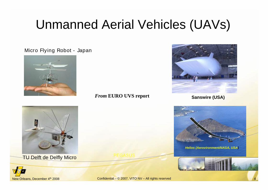
Unmanned Aerial Vehicles (UAVs)
From EURO UVS report
Micro Flying Robot - Japan
Helios (Aerovironment/NASA, USA)
Sanswire (USA)
TU Delft de Delfly Micro PEGASUS

7New Orleans, December 4th 2008 Confidential – © 2007, VITO NV – All rights reserved
UAVs are complementary to conventional RS systems
• Complementary to satellites:– No orbital constraints -> very flexible trajectory ->higher update
rate– Higher spatial resolution and precision possible– Much cheaper -> easier to use more systems (constellations)– Requires less heavy infrastructure in operation– Can be very rapidly deployed– Easier change of the payload
• Complementary to manned aircrafts– Real time possible– Less constraints from air traffic control– Can be used in not optimal weather– Can hover above a limited ROI– Offer equivalent performances– Mostly much cheaper– No risk for pilots

8New Orleans, December 4th 2008 Confidential – © 2007, VITO NV – All rights reserved
UAV = Technology in evolution
1st W.W. RQ-5 Hunter > 3,000 hours(Iraq - 2003)

9New Orleans, December 4th 2008 Confidential – © 2007, VITO NV – All rights reserved
HALE UAV: the missing link in EO and DM
0.1-5 km Airborne sensors,
600-800 km Polar orbiting satellites
35400 km Geostationary satellites
Ground levelObs
erva
tion
altit
udes
5-10 km
12-30 km Stratospheric platforms, HALE-UAV
Medium altitude UAV
UAV

10New Orleans, December 4th 2008 Confidential – © 2007, VITO NV – All rights reserved
Pegasus is ProjectVery high resolution camera
Stratospheric UAV
Mobile GCS with satellite communication
Powerfull CDPC (grid computing)

11New Orleans, December 4th 2008 Confidential – © 2007, VITO NV – All rights reserved
The MERCATOR platform

12New Orleans, December 4th 2008 Confidential – © 2007, VITO NV – All rights reserved
– 32 kg, 18 m wingspan– Solar cells (day) + batteries (night)– Flying attitude : day 18 km - night 15 km– Rapid deployement possible– No need for important infrastructure– Ground launch (propellors) or using balloon– Operationnal speed ~ 20 m/s– Endurance: weeks to months– Data downlink (170 Km LoS)
Constraint: – max. 2kg payload– 50W over day– clearance
Mercator-1 principal characteristics

13New Orleans, December 4th 2008 Confidential – © 2007, VITO NV – All rights reserved

14New Orleans, December 4th 2008 Confidential – © 2007, VITO NV – All rights reserved
Zephyr in White Sands
http://www.newscientist.com/blog/technology/labels/UAVs.html

15New Orleans, December 4th 2008 Confidential – © 2007, VITO NV – All rights reserved
Zephyr : endurance WR (> 80 hours)

16New Orleans, December 4th 2008 Confidential – © 2007, VITO NV – All rights reserved
Performances of HAP increase continuously
2008
2007
2006
2005
0
10000
20000
30000
40000
50000
60000
70000
0 20 40 60 80 100
endurance (hours)Fly
ing
alt
itu
de (
ft)

17New Orleans, December 4th 2008 Confidential – © 2007, VITO NV – All rights reserved
The MEDUSA camera

18New Orleans, December 4th 2008 Confidential – © 2007, VITO NV – All rights reserved
MEDUSA instrument: specifications
• Ground sampling distance: 30 cm (@ 18 km )• Wavelength range: 400 – 650 nm (RGB)• 2 CMOS sensor 10.000 x 1.200 pixels• Swath width: 3000 m• SNR = 100 @ 8:00 am equinox• 60% forward overlap between images• Near-realtime data delivery

19New Orleans, December 4th 2008 Confidential – © 2007, VITO NV – All rights reserved
Constraints• Mounted on front of UAV fuselage• Mass: 2-3 kg• Available power: 50 W (during daytime)• Pressure down to 60 mbar• Base temperature down to -70°C• Large temperature variations• Volume: 1m length, 12 cm diameter• Attitude behavior of the platform (motion blurring)

20New Orleans, December 4th 2008 Confidential – © 2007, VITO NV – All rights reserved
baffles
Passive compensator
4 lens tube
Mirror Entrance window
http://medusa.vgt.vito.be/
• Focal Plane assembly• Data Command & handling Unit• IMU• S-band transmitter• GPS receiver• Power regulator
MEDUSA instrument: layout

21New Orleans, December 4th 2008 Confidential – © 2007, VITO NV – All rights reserved
First geometric calibration tests(panchrom. COTS sensor)
Calibration target at ~ 100 feet• Point diameter 2 mm• Spacing 2.2 cm

22New Orleans, December 4th 2008 Confidential – © 2007, VITO NV – All rights reserved
First outdoor tests
Object MEDUSA image
Distance camera target ~ 230 feet

23New Orleans, December 4th 2008 Confidential – © 2007, VITO NV – All rights reserved
The Mobile Ground Control station

24New Orleans, December 4th 2008 Confidential – © 2007, VITO NV – All rights reserved
• Mobile (fits in standard size container)• Control of UAV + • Reception telemetry (GPS, IMU)• Reception payload data • Data archiving (2TB)• Transmission to VITO via satellite comm.• Control range up to 170 km• Autonomous (power generators)• Includes an autonomous µ-PAF
A mobile GCS offers high flexibility

25New Orleans, December 4th 2008 Confidential – © 2007, VITO NV – All rights reserved
Reprogrammable flight planning
• Flight planning up to 1000 way points• Meteorological data on line => flight envelop• Warning system “out of range”• Possible on-line reprogramming of the flight pattern

26New Orleans, December 4th 2008 Confidential – © 2007, VITO NV – All rights reserved
The Central Data Processing Center

27New Orleans, December 4th 2008 Confidential – © 2007, VITO NV – All rights reserved
Central Data Processing Center
– Archiving of all data (database)– Actually ~60 TB available– HDF5 self describing forma– Automatic processing data– Up to level 4 products on request– Parallel processing (real time)– Web services and applications

28New Orleans, December 4th 2008 Confidential – © 2007, VITO NV – All rights reserved
The PEGASUS project

29New Orleans, December 4th 2008 Confidential – © 2007, VITO NV – All rights reserved

30New Orleans, December 4th 2008 Confidential – © 2007, VITO NV – All rights reserved
R ~ swath
GSD = 0.3 m
R ~ 3 km
Update ~ 8.2 min
Coverage ~ 28.3 km²
R ~ 0.5 swath
GSD = 0.3 m
R ~ 2.7 km
Update ~ 1.6 min
Coverage ~ 5.7 km²
Coverage using M1+ Medusa
31New Orleans, December 4th 2008 Confidential – © 2007, VITO NV – All rights reserved
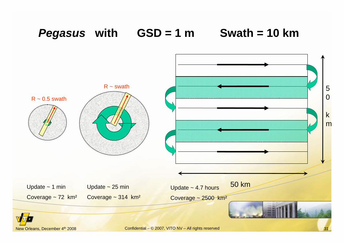
R ~ 0.5 swath
Update ~ 1 min
Coverage ~ 72 km²
Update ~ 25 min
Coverage ~ 314 km²
R ~ swath
Pegasus with GSD = 1 m Swath = 10 km
Update ~ 4.7 hours
Coverage ~ 2500 km²
50
km
50 km

32New Orleans, December 4th 2008 Confidential – © 2007, VITO NV – All rights reserved
Pegasus is dedicated to local and regional applications
• Low speed (~ 20 m / s) = > limited coverage
• Control from the GCS limited to 170 km radius (mobile CGS only between events )
• Very high resolution = > limited swath (3 km @ 30 cm GSD)
• No storage on board

33New Orleans, December 4th 2008 Confidential – © 2007, VITO NV – All rights reserved
Coverage of Europe
• Annual coverage for research at 20 cm ~ 30 HAPs• Operationnal annual coverage at 30 cm ~ 52 HAPs
(including dedicated HAPs, max. coverage 150.000 km²)• 30-50 fixed GCS + some ‘mobile’ GCSs• One GCS can command more than one HAP• Command of one HAP can be passed from one CGS to
another• DPC : One central unit (one per country ?)• Different instruments (VIS, IR, SAR,…)

34New Orleans, December 4th 2008 Confidential – © 2007, VITO NV – All rights reserved
The PEGASUS advantages• Low speed => very flexible trajectories• Autonomous mobile GCS with rapid deployment• Long Endurance : days to weeks continuously• No need for airport infrastructure• Automatic flight planning with possible update• Equipped with a high resolution RGB digital camera• Instrument recovery (test/maintenance/upgrade)• Data in near real-time available via protected internet• Flying above ATC• Large part of automatic image processing (QA/QC)• Continu acquisition (database) + dedicated missions

35New Orleans, December 4th 2008 Confidential – © 2007, VITO NV – All rights reserved
• Limited in payload weight (2 kg => 5-10 kg)
• Limited in available power (50 W, day time)
• Limited speed
• Regulatory problems (clerance e.g. OSIRIS project)
The PEGASUS drawbacks

36New Orleans, December 4th 2008 Confidential – © 2007, VITO NV – All rights reserved
How expensive are RS systems?
• Satellite imagery:IKONOS “prioritary” : ~ € 20.000 for orthorectified image of 17 x17 km²
• Airborne systems: ~ € 30.000 to € 50.000 (incl. stand-by)
• Prototype Pegasus (HAP + GCS + payload + software) : 16 M€
• Production Pegasus : estimated to ~ 8-10 M€(Global observer – Aerovironment USA: ~ 20 MU$, including 2 GCS)
• Small low altitude UAVsAirplane : up to 20 k€Helicopters (incl. autonomous flight system) ~ 50 - 1000 k€

37New Orleans, December 4th 2008 Confidential – © 2007, VITO NV – All rights reserved
Some conclusionsand trends
38New Orleans, December 4th 2008 Confidential – © 2007, VITO NV – All rights reserved
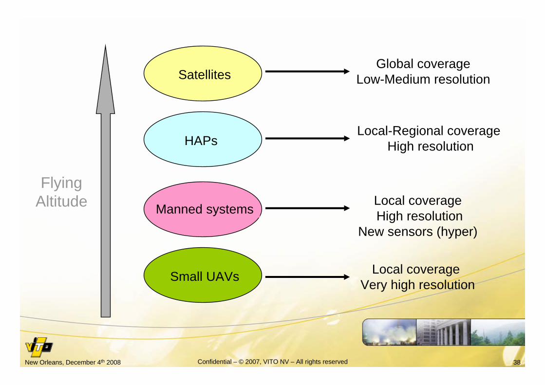
Satellites
Manned systems
Flying Altitude
Global coverageLow-Medium resolution
HAPsLocal-Regional coverage
High resolution
Local coverageHigh resolution
New sensors (hyper)
Small UAVs Local coverageVery high resolution
39New Orleans, December 4th 2008 Confidential – © 2007, VITO NV – All rights reserved
The “perfect” sensor system do not exist
• Only combination of systems provides adequate information, especially for real-time issues
• Interoperability is therefore a key issue
• Selection of information is crucial (avoid data overflow)

40New Orleans, December 4th 2008 Confidential – © 2007, VITO NV – All rights reserved
Some trends are
• Standardization (e.g. OGC for geographic information)• Development of smart sensors• Miniaturization and cost lowering• Development of sensor networks/constellations• Higher resolution => more data• Data fusion (all type) will get more and more important• Processing will be more and more automated• Data processing in limited specialized centers
-> communication is very important• Concerning RS, UAV’s will play a major role during the
next decade

41New Orleans, December 4th 2008 Confidential – © 2007, VITO NV – All rights reserved
Pegasus :a revolution or just a normal evolution ?

42New Orleans, December 4th 2008 Confidential – © 2007, VITO NV – All rights reserved
The Vulture program From http://dsc.discovery.com/news/2008/04/28/vulture-plane.html
Extra Wide Plane to Stay Aloft for Five Years Eric Bland, Discovery News April 28, 2008 -- A new Defense Advanced Research Projects Agency (DARPA) initiative, codenamed Vulture, aims to create a plane that can fly continuously for five years.

43New Orleans, December 4th 2008 Confidential – © 2007, VITO NV – All rights reserved
http://news.bbc.co.uk/2/hi/science/nature/6916309.stm
Mercator scale model (2003)

44New Orleans, December 4th 2008 Confidential – © 2007, VITO NV – All rights reserved
Thank you for your attention
http://www.vito.behttp://www.pegasus4europe.com