Embed Size (px)
Citation preview
The hydrological cycle tirelessly distributes water between land, ocean, atmosphere and
cryosphere. Stefan Hagemann and his colleagues at the Max Planck Institute for Meteorology
in Hamburg study the exact details of how this happens. They investigate the various feedback
mechanisms between wetlands, artificial irrigation, permafrost and climate.
The Perpetual Pump
TEXT UTE KEHSE
Ph
oto
: Ok
ap
ia
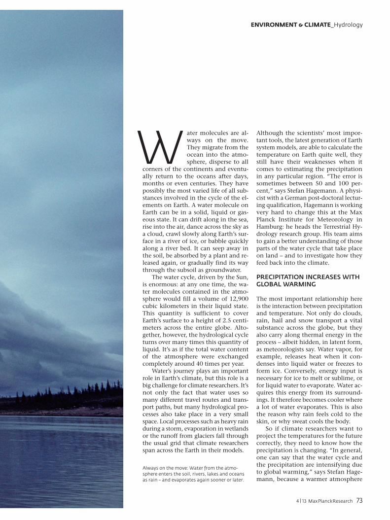
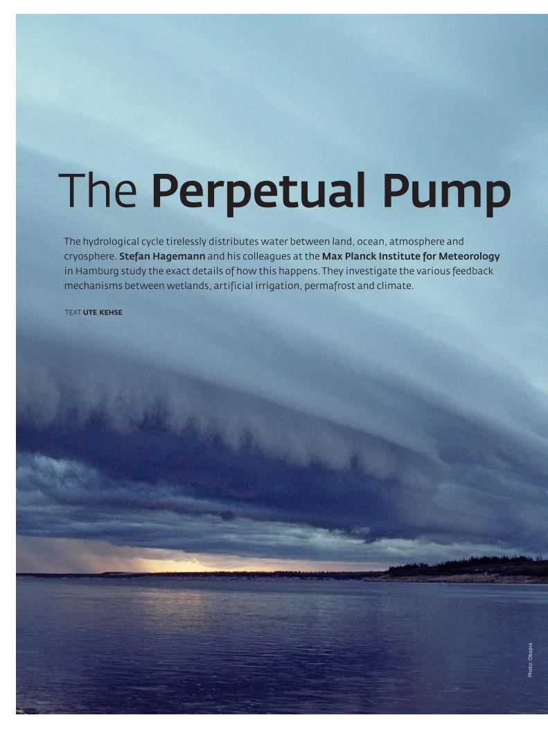
Always on the move: Water from the atmo-sphere enters the soil, rivers, lakes and oceans as rain – and evaporates again sooner or later.
W ater molecules are al-ways on the move. They migrate from the ocean into the atmo-sphere, disperse to all
corners of the continents and eventu-ally return to the oceans after days, months or even centuries. They have possibly the most varied life of all sub-stances involved in the cycle of the el-ements on Earth. A water molecule on Earth can be in a solid, liquid or gas-eous state. It can drift along in the sea, rise into the air, dance across the sky as a cloud, crawl slowly along Earth’s sur-face in a river of ice, or babble quickly along a river bed. It can seep away in the soil, be absorbed by a plant and re-leased again, or gradually find its way through the subsoil as groundwater.
The water cycle, driven by the Sun, is enormous: at any one time, the wa-ter molecules contained in the atmo-sphere would fill a volume of 12,900 cubic kilometers in their liquid state. This quantity is sufficient to cover Earth’s surface to a height of 2.5 centi-meters across the entire globe. Alto-gether, however, the hydrological cycle turns over many times this quantity of liquid. It’s as if the total water content of the atmosphere were exchanged completely around 40 times per year.
Water’s journey plays an important role in Earth’s climate, but this role is a big challenge for climate researchers. It’s not only the fact that water uses so many different travel routes and trans-port paths, but many hydrological pro-cesses also take place in a very small space. Local processes such as heavy rain during a storm, evaporation in wetlands or the runoff from glaciers fall through the usual grid that climate researchers span across the Earth in their models.
Although the scientists’ most impor-tant tools, the latest generation of Earth system models, are able to calculate the temperature on Earth quite well, they still have their weaknesses when it comes to estimating the precipitation in any particular region. “The error is sometimes between 50 and 100 per-cent,” says Stefan Hagemann. A physi-cist with a German post-doctoral lectur-ing qualification, Hagemann is working very hard to change this at the Max Planck Institute for Meteorology in Hamburg: he heads the Terrestrial Hy-drology research group. His team aims to gain a better understanding of those parts of the water cycle that take place on land – and to investigate how they feed back into the climate.
PRECIPITATION INCREASES WITH GLOBAL WARMING
The most important relationship here is the interaction between precipitation and temperature. Not only do clouds, rain, hail and snow transport a vital substance across the globe, but they also carry along thermal energy in the process – albeit hidden, in latent form, as meteorologists say. Water vapor, for example, releases heat when it con-denses into liquid water or freezes to form ice. Conversely, energy input is necessary for ice to melt or sublime, or for liquid water to evaporate. Water ac-quires this energy from its surround-ings. It therefore becomes cooler where a lot of water evaporates. This is also the reason why rain feels cold to the skin, or why sweat cools the body.
So if climate researchers want to project the temperatures for the future correctly, they need to know how the precipitation is changing. “In general, one can say that the water cycle and the precipitation are intensifying due to global warming,” says Stefan Hage-mann, because a warmer atmosphere
ENVIRONMENT & CLIMATE_Hydrology
4 | 13 MaxPlanckResearch 73
Gra
ph
ics:
MP
I fo
r M
eteo
rolo
gy
– S
aee
d (
top
), M
PI f
or
Met
eoro
log
y (b
ott
om
, 4)
can store more water. But there are also regions that are getting drier. “If it rains even less in a predominantly dry region, evaporation can decrease there, and with it, also the cooling. It thus becomes even warmer there,” explains the Hamburg-based researcher. Conse-quently, the decreasing precipitation aggravates the warming even more – a textbook example of positive feedback.
Hagemann and his six colleagues fo-cus on three quite different hydrologi-
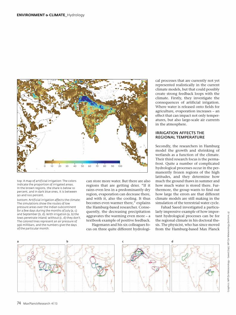
cal processes that are currently not yet represented realistically in the current climate models, but that could possibly create strong feedback loops with the climate. Firstly, they investigate the consequences of artificial irrigation. Where water is released onto fields for agriculture, evaporation increases – an effect that can impact not only temper-atures, but also large-scale air currents in the atmosphere.
IRRIGATION AFFECTS THE REGIONAL TEMPERATURE
Secondly, the researchers in Hamburg model the growth and shrinking of wetlands as a function of the climate. Their third research focus is the perma-frost. Quite a number of complicated hydrological processes occur in the per-manently frozen regions of the high latitudes, and they determine how much the ground thaws in summer and how much water is stored there. Fur-thermore, the group wants to find out how large the errors are that different climate models are still making in the simulation of the terrestrial water cycle.
Fahad Saeed investigated a particu-larly impressive example of how impor-tant hydrological processes can be for the regional climate in his doctoral the-sis. The physicist, who has since moved from the Hamburg-based Max Planck
ENVIRONMENT & CLIMATE_Hydrology
top: A map of artificial irrigation: The colors indicate the proportion of irrigated areas. In the brown regions, the share is below 10 percent, and in dark blue ones, it is between 90 and 100 percent.
bottom: Artificial irrigation affects the climate: The simulations show the routes of low pressure areas over the Indian subcontinent for a few days during the months of July (a, c) and September (b, d). With irrigation (a, b) the lows penetrate inland; without (c, d) they don’t. The colored lines represent an air pressure of 996 millibars, and the numbers give the days of the particular month.
a b c d
10 20 30 40 50 60 70 80 90 1000
74 MaxPlanckResearch 4 | 13
Ph
oto
s: N
AS
A
Institute to the Climate Service Center, also in Hamburg, looked into irrigation in India and Pakistan.
“The Indian subcontinent is one of the most intensively irrigated regions on Earth,” says Saeed, who himself originates from northern Pakistan. The climate is shaped by the monsoon: there is hardly any rain in winter, but in summer, humid maritime air is trans-ported from the Arabian Sea and the Gulf of Bengal for several months and falls as rain on the slopes of the Hima-layas. In some places, the annual aver-age precipitation is 10,000 millimeters – more than ten times as much as in Germany.
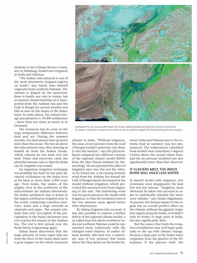
The monsoon has its roots in the large temperature difference between land and sea. During the summer months, the land masses heat up much more than the ocean. The hot air above the subcontinent rises, thus drawing in humid air from the Indian Ocean, which releases its wet load over the land. Dams and reservoirs catch the plentiful summer rain so that the fields can be irrigated year-round.
An ingenious irrigation technique was probably the basis for the early ad-vanced civilization on the Indus river as far back as more than 5,000 years ago. Even today, the waters of the mighty river in the northwest of the subcontinent are utilized intensively: the Indus catchment area is home to the largest continuous irrigated zone in the world, comprising countless reser-voirs, dams and a huge network of channels and pipes. The experts esti-mate that only one-eighth of the pre-cipitation in the Indus catchment area ever reaches the estuary in the Arabian Sea. The rest is first spread over the fields before evaporating again.
Fahad Saeed discovered that the huge amounts of water vapor that rise from the floor of the Indus basin have a great impact on the whole monsoon
climate in India. “Without irrigation, the areas of low pressure from the Gulf of Bengal wouldn’t penetrate very deep-ly into the interior,” says the physicist. Saeed compared two different versions of the regional climate model REMO from the Max Planck Institute for Me-teorology. He incorporated the effect of irrigation into one, but not the other. As he found out, a too-strong westerly wind from the Arabian Sea toward the Gulf of Bengal always developed in the model without irrigation, which pre-vented the monsoon lows from migrat-ing to the east. The interfering wind was less pronounced in the model with irrigation, so that the modeled route of the low pressure areas agreed better with observations.
By taking irrigation into account, it was also possible to remove a further deficit of the regional climate model: a so-called heat low above northwest In-dia and northern Pakistan could be rep-resented more realistically with the changed water balance. In earlier cli-mate models, this heat low, a station-ary area of low pressure that forms above the Thar desert on the border be-
tween India and Pakistan due to the ex-treme heat in summer, was too pro-nounced. The temperatures calculated from models were sometimes 5 degrees Celsius above the actual values here, and the air pressure modeled was also significantly lower than that observed.
IF GLACIERS MELT, THE INDUS RIVER WILL HOLD LESS WATER
In Saeed’s model with irrigation, this systematic error disappeared, the heat low was less intense. “Irrigation must obviously be taken into account in or-der to realistically simulate the mon-soon climate,” says Stefan Hagemann. At present, the human impact in the re-gion has an overall positive effect on the climate: without the gigantic irriga-tion region along the Indus, it wouldn’t only be hotter in large parts of India, but also significantly drier.
But the source that feeds the irriga-tion installations may well begin grad-ually to dry up with climate change, because a large part of the Indus water originates from the glaciers of the Hi-malayas. If the glaciers melt, the
Compared to its usual width (top), the Indus swells greatly during the monsoon (bottom). Its water is stored in reservoirs so that it can be used to supply the fields during the dry season.
4 | 13 MaxPlanckResearch 75
amount of water available for irriga-tion will decrease. The evaporation in the irrigation region could then de-crease, and its positive effect diminish. Future climate models must therefore also take into account changes in land use, says Hagemann.
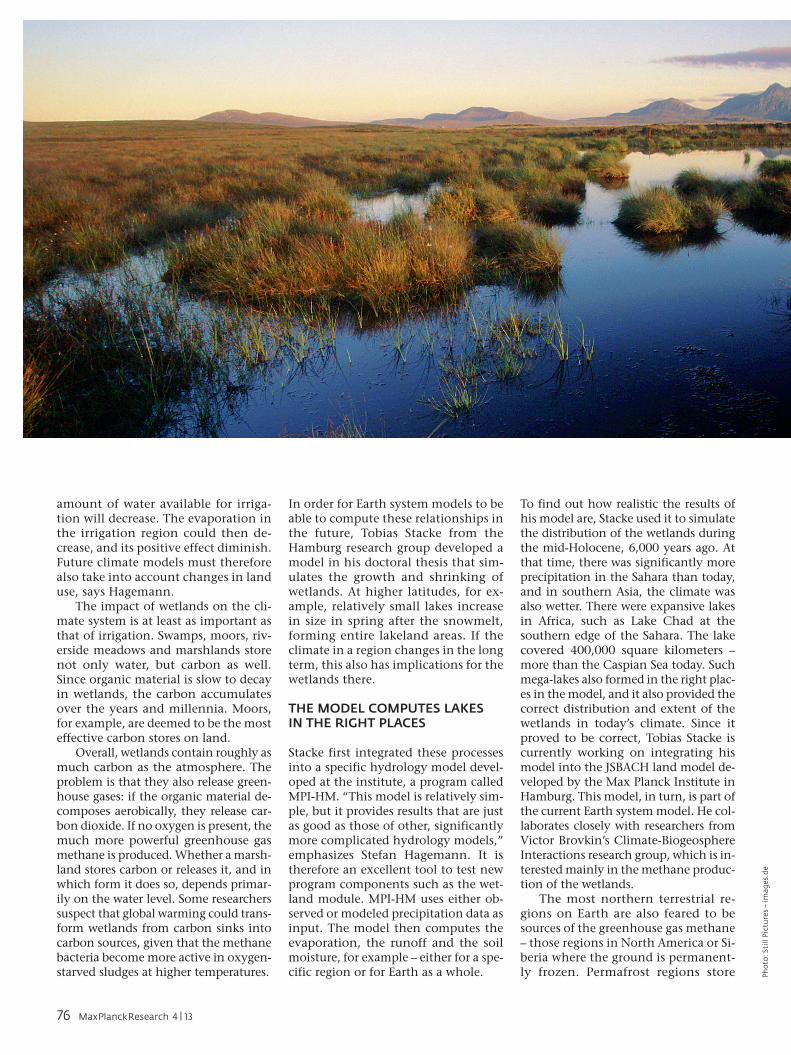
The impact of wetlands on the cli-mate system is at least as important as that of irrigation. Swamps, moors, riv-erside meadows and marshlands store not only water, but carbon as well. Since organic material is slow to decay in wetlands, the carbon accumulates over the years and millennia. Moors, for example, are deemed to be the most effective carbon stores on land.
Overall, wetlands contain roughly as much carbon as the atmosphere. The problem is that they also release green-house gases: if the organic material de-composes aerobically, they release car-bon dioxide. If no oxygen is present, the much more powerful greenhouse gas methane is produced. Whether a marsh-land stores carbon or releases it, and in which form it does so, depends primar-ily on the water level. Some researchers suspect that global warming could trans-form wetlands from carbon sinks into carbon sources, given that the methane bacteria become more active in oxygen-starved sludges at higher temperatures.
In order for Earth system models to be able to compute these relationships in the future, Tobias Stacke from the Hamburg research group developed a model in his doctoral thesis that sim-ulates the growth and shrinking of wetlands. At higher latitudes, for ex-ample, relatively small lakes increase in size in spring after the snowmelt, forming entire lakeland areas. If the climate in a region changes in the long term, this also has implications for the wetlands there.
THE MODEL COMPUTES LAKES IN THE RIGHT PLACES
Stacke first integrated these processes into a specific hydrology model devel-oped at the institute, a program called MPI-HM. “This model is relatively sim-ple, but it provides results that are just as good as those of other, significantly more complicated hydrology models,” emphasizes Stefan Hagemann. It is therefore an excellent tool to test new program components such as the wet-land module. MPI-HM uses either ob-served or modeled precipitation data as input. The model then computes the evaporation, the runoff and the soil moisture, for example – either for a spe-cific region or for Earth as a whole.
To find out how realistic the results of his model are, Stacke used it to simulate the distribution of the wetlands during the mid-Holocene, 6,000 years ago. At that time, there was significantly more precipitation in the Sahara than today, and in southern Asia, the climate was also wetter. There were expansive lakes in Africa, such as Lake Chad at the southern edge of the Sahara. The lake covered 400,000 square kilometers – more than the Caspian Sea today. Such mega-lakes also formed in the right plac-es in the model, and it also provided the correct distribution and extent of the wetlands in today’s climate. Since it proved to be correct, Tobias Stacke is currently working on integrating his model into the JSBACH land model de-veloped by the Max Planck Institute in Hamburg. This model, in turn, is part of the current Earth system model. He col-laborates closely with researchers from Victor Brovkin’s Climate-Biogeosphere Interactions research group, which is in-terested mainly in the methane produc-tion of the wetlands.
The most northern terrestrial re-gions on Earth are also feared to be sources of the greenhouse gas methane – those regions in North America or Si-beria where the ground is permanent-ly frozen. Permafrost regions store P
ho
to: S
till
Pic
ture
s –
ima
ges
.de
76 MaxPlanckResearch 4 | 13
>
Ph
oto
: Mic
ha
el Z
ap
f; g
rap
hic
: MP
I fo
r M
eteo
rolo
gy
large quantities of carbon in organic matter, just like wetlands; they are deep-frozen swamps, as it were. If the ground thaws there, the accumulated carbon could be released rapidly. Ad-ditional quantities of methane and carbon dioxide would get into the at-mosphere and aggravate the warming effect. Climate researchers have there-fore long been asking themselves how the permafrost will react to global warming – where, how rapidly, and to what depth the ground will thaw.
However, these questions aren’t so easy to answer, because the hydrology of the permafrost is much more com-plicated than that of normal soil. This is due to the thin, active layer that thaws in summer and then lies on top of the largely water-impermeable fro-zen layer. The top layer is often quite swampy, even in areas of low precipita-tion. Only extremely small quantities of water run off in winter, but in spring, during snowmelt, there is significantly greater runoff.
Since the melt water can’t penetrate very deeply into the ground, it runs off much more rapidly than at moderate latitudes. In addition, meter-high ice
wedges often form in permafrost soils, which can suddenly collapse after heavy rain, for example. This gives rise to so-called thermokarst lakes, which, in turn, aggravate the soil erosion.
THE SOIL ACTS LIKE A MEMORY
As comparative tests show, the current Earth system models still fail to correct-ly reproduce the specific hydrological
behavior of permafrost soils in today’s climate. “Most Earth system models don’t take into account even the sim-plest processes that take place in the per-mafrost, such as the freezing or thawing of the soil water,” criticizes Stefan Hage-mann. His group wants to change this: the researchers are involved in the PAGE21 EU project, which is investigat-ing the vulnerability of the permafrost regions due to climate change.
Tobias Stacke, Stefan Hagemann and Tanja Blome (from left) research the interplay between water cycle and climate.
ENVIRONMENT & CLIMATE_Hydrology
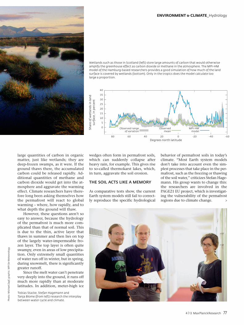
Wetlands such as those in Scotland (left) store large amounts of carbon that would otherwise amplify the greenhouse effect as carbon dioxide or methane in the atmosphere. The MPI-HM model of the Hamburg-based researchers provides a good simulation of how much of the land surface is covered by wetlands (bottom). Only in the tropics does the model calculate too large a proportion.
Sh
are
of
we
tla
nd
s in
lan
d
surf
ace
, in
pe
rce
nt
40
35
30
25
20
15
10
5
0 Observed range of variation
Observed mean
Degrees north latitude
MPI-HM model
80 60 40 20 0 -20 -40 -60
4 | 13 MaxPlanckResearch 77
Tanja Blome is currently working on the hydrological processes typical of perma-frost areas. During this project, she is co-operating closely with colleagues from the Max Planck Institute for Biogeo-
chemistry in Jena, who have incorporat-ed these processes into the Max Planck land surface model JSBACH in order to simulate the methane production of the permafrost soils more reliably.
Be it in permafrost soils, in wetlands or in the artificially irrigated agricultur-al landscapes of the Indian subconti-nent, the water balance on land, and thus the soil moisture, can play a key role regionally in medium-term fore-casts. Stefan Hagemann’s group is therefore also working in the BMBF project known as MiKlip (medium-term climate forecasts). This involves im-proving climate forecasts for the next years through to the next decade.
A detailed understanding of the hydro-logical processes on land could help here: since the soil can store water for a long time, it acts like a memory. A dry period or a flood can affect temperatures and precipitation for months. How strongly plants grow and how much wa-ter they release from their pores also de-pends on the soil moisture.
To date, soil moisture has gone into the Earth system model of the Max Planck Institute for Meteorology only in a greatly simplified form: “The soil was represented as a single layer,” re-ports Hagemann. Model plants and evaporation gradually extracted the rain water from the soil. During dry pe-
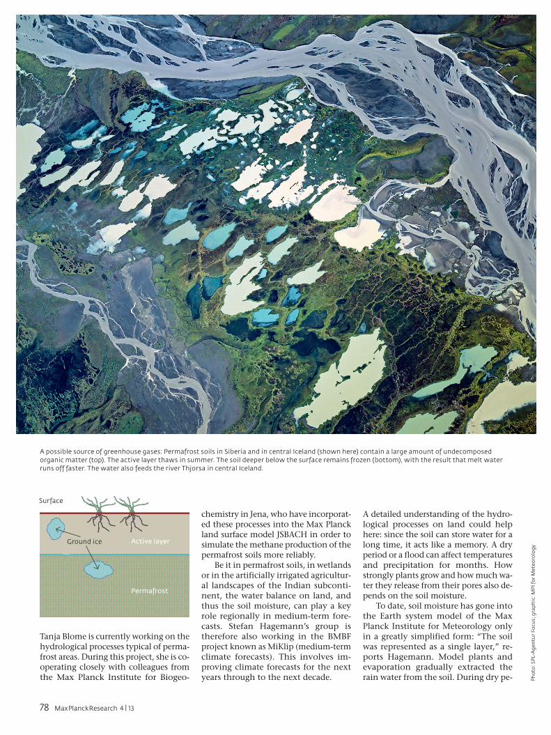
A possible source of greenhouse gases: Permafrost soils in Siberia and in central Iceland (shown here) contain a large amount of undecomposed organic matter (top). The active layer thaws in summer. The soil deeper below the surface remains frozen (bottom), with the result that melt water runs off faster. The water also feeds the river Thjorsa in central Iceland.
Ground ice Active layer
Permafrost
Surface
Ph
oto
: SP
L-A
gen
tur
Fo
cus;
gra
ph
ic: M
PI f
or
Met
eoro
log
y
78 MaxPlanckResearch 4 | 13
TO THE POINT● Gigantic amounts of moisture are constantly being moved between land, oceans,
atmosphere and cryosphere – as much as if the total water in the atmosphere were exchanged 40 times per year. The water cycle on land is closely coupled with the regional and global climate.
● As simulations done by the researchers at the Max Planck Institute for Meteorolo-gy show, the massive extent of irrigation on the Indian subcontinent causes it to be less hot and dry in the region than in a climate without irrigation. Global warming could reduce the amount of water available for this process.
● Whether wetlands release carbon dioxide or methane depends on the water level in the ecosystems. Simulations of the water balance of swamps, moors, river meadows and marshlands thus help provide a more accurate determination of their role in the climate system.
● Forecasts of whether permafrost soils release more greenhouse gases during climate change also require knowledge of the water balance in these regions. The reason is that the soils that have so far been frozen all year round could emit more carbon dioxide and methane the more they thaw.
UMWELT & KLIMA_xxxxxxxxxx
riods, the soil moisture in the models rapidly decreased to zero, with the re-sult that water could no longer evapo-rate. “But this isn’t realistic,” says Hage-mann. This error is evident in certain regions, for example along the Danube or the Amazon, where the model regu-larly computes higher summer temper-atures than occur in reality.
HOW WET IS THE SOIL AT GREATER DEPTHS?
In order to remedy the problem, Ste-fan Hagemann represents the soil as five stacked layers in his latest version of the model. “Especially in moderate-ly dry regions, where part of the ground isn’t covered by vegetation, this yields a better description,” says the researcher.
Since it’s difficult to measure the soil moisture everywhere, Hagemann is also working on adjusting the model data with satellite data. “The satellite sees only the top few centimeters of the soil,” he reports. Therefore, it hasn’t yet really been possible to say how wet the
soil is at greater depths. Hagemann’s goal now is to compute this from the satellite data with the aid of his new model. The European Space Agency, ESA, is also interested in this research work, the physicist explains: “They want to use the model to evaluate the satellite data.”
The collaboration with other re-searchers within and outside of the Max Planck Society is very important for Hagemann’s research group, espe-cially since the team is financed whol-ly from third-party funds. In addition to the BMBF project MiKlip and the EU project PAGE21, the researchers are currently also participating in the EU project EMBRACE (Earth system Mod-el Bias Reduction and assessing Abrupt Climate changE), which is concerned with improving Earth system models. In these comprehensive research proj-ects, the Hamburg-based meteorolo-gists contribute knowledge that has scarcely been taken into account so far: detailed knowledge of the perpet-ual pump that moves water through the Earth system.
Mikrotron GmbHLandshuter Straße 20–2285716 UnterschleissheimTel. +49 (0) 89-72 63 [email protected]
Outstanding CapacityMotionBLITZ® LTR5 portableMobile High-Speed Systemfor long-time recording
• for analysing unintermitted testseries and long-lasting processes
• up to 130 minutescontinuous recordingwith 1280 x 1024Pixels at 506 fps
• real-time hard drive recording
• high light sensitivity:2.500 ASA monochrom2.000 ASA RGB
• user-optimizedMotionBLITZ® Director2 Software