Embed Size (px)
Citation preview

The Physical Landscape and Migration – Impacts on livelihood strategies of villagers in
Kampung Sadir
ILUNRM, spring 2006
Group members: Aske Skovmand Bosselmann, ADK05039
Kasper Vind Teilmann, LFK06001 Nina Hanne Holst, EM05080
Tran Vo Ngoc, ADK05029
Den Kongelige Veterinær og Landbohøjskole Roskilde Universitetscenter Supervisors: Andreas de Neergaard Torben Birch-Thomsen

ii
Abstract
Kampung Sadir is a small Bidayuh village of 64 households located south of Kuching in the
state of Sarawak. Like many other rural communities the village is transforming from being a
subsistence economy towards becoming a cash economy, and livelihood strategies of the
residents are changing.
The livelihoods of the residents are complicated by several factors related to the physical
environment. The village is surrounded by mountains and only accessible via gravel and dirt
roads, which result in high transportation costs of goods and products. The soil is classified
as being only marginally suitable for agriculture, which is complicated further by steep slopes
and erosion hazards.
The residents of the village have traditionally been occupied with subsistence farming,
particularly hill rice cultivation, which is closely related to the traditional culture, but today a
significant part of the residents are also involved in cash crop farming. The land associated
with Kpg. Sadir is Native Customary Land and legally land tenure is insecure, but so far there
have not been any conflicts regarding land ownership.
Lack of job opportunities in the village, disregarding farming, together with a desire for an
urban life style with all its modern commodities has caused an out migration of a large part of
the young population. The out migration is apparently related to the educational level, and
results in movement of the educated people out of the village, as well as lack of man power
for the farmers in the village
The Bidayuh culture and the beautiful natural surroundings provide an opportunity for
tourist development in the village. Homestays, guiding and an entrance fee can provide both
direct and indirect economic benefits for the villagers. With proper management tourism
might increase the environmental awareness of the villagers, but unmanaged it can have
detrimental effects on the area.
Both the physical landscape and migration patterns have a decisive influence on the
livelihoods of the residents. An expansion of cash crop farming, driven by land use schemes
promoted by the government, and tourism development can improve the livelihoods of the
residents in Kpg. Sadir.
iii
Acknowledgement
This report is the product of the course “Interdisciplinary Land Use and Natural Resource
Management (ILUNRM)” and is primarily based on data collected during a two week field
study in Kampung Sadir in Sarawak, from March 4 to March 19, 2006.
Firstly, we would like to thank our Malaysian co-students Robert Basiuk, ‘Fred’ Yap Yau Sin,
Clement Joe Ak Gilbert Nyaod, Murali Krishnam, Marshall Kana Samuel, ‘Rosa’ Hii Lu
Yong and Lo Sheau Wai. Thank you very much for your good cooperation and assistance as
well as your great humour during our stay in Bilik No 1. We would also like to thank our
interpreter and contact to the young residents of the Kampung Mr. Fred.
We appreciate all the help we have received from our Malaysian supervisors. Thank you for
your inputs and comments during your visits in Kpg. Sadir and especially for the efforts you
put into arranging and accommodating the field trip.
Our Danish supervisors, Torben Birch-Thomsen and Andreas de Neergaard, deserve special
appreciation for their help, guidance and support prior to, during and after the fieldtrip. We
especially appreciate their participation in discussions as well as in ‘village activities’ during
the stay in Kpg. Sadir.
Last, but surely not least, we would like to express our sincere gratitude to all the residents of
Kpg. Sadir for their warm hospitality and willingness (and sometimes eagerness) to participate
in our surveys, field walks and PRA exercises. Thank you very much for opening up your
village and homes to us. Finally, we would especially like to thank Michael, who let us stay in
his house, Bilik No 1, and our two kitchen ladies, who kept the coffee warm and the beer
cold.

iv
Table of contents
Abstract .................................................................................................................................. ii Acknowledgement................................................................................................................. iii Table of contents ....................................................................................................................iv List of appendices ...................................................................................................................v List of tables, boxes and figures..............................................................................................v Abbreviations .........................................................................................................................vi 1 Introduction .....................................................................................................................1
1.1 Thematic Context ................................................................................................. 1 1.2 Background .......................................................................................................... 1 1.3 Research Question................................................................................................ 2 1.4 Methodology ........................................................................................................ 2
1.4.1 Interviews and questionnaires ...................................................................... 3 1.4.2 Participatory Rural Appraisal (PRA) methods............................................. 3 1.4.3 Natural resource survey................................................................................ 3
1.5 Reading guideline................................................................................................. 4 2 The existing physical environment of Kampung Sadir...................................................5
2.1 Location and terrain ............................................................................................. 6 2.2 Soil quality and characteristics............................................................................. 7 2.3 Water quality and availability .............................................................................. 9
3 Land Tenure and Land Use ...........................................................................................10 3.1 Land Tenure ....................................................................................................... 10 3.2 Land use patterns................................................................................................ 12
3.2.1 The cultural staple ...................................................................................... 12 3.2.2 The economic crops ................................................................................... 15
4 Population, income and movement ...............................................................................17 4.1 Overview of population distribution .................................................................. 18 4.2 Occupation and income level ............................................................................. 19 4.3 Causes of population movement ........................................................................ 20
4.3.1 Education.................................................................................................... 21 4.3.2 Trying their luck in larger cities................................................................. 22 4.3.3 The ones staying back ................................................................................ 22 4.3.4 Reasons and impacts of population movement.......................................... 23
5 Tourism development in Kpg. Sadir .............................................................................24 5.1 Benefits of tourism – lessons from Annah Rais................................................. 24 5.2 Promoting Kpg. Sadir......................................................................................... 26 5.3 Attractions and activities in and around Sadir ................................................... 27 5.4 Sustainability of tourism development............................................................... 30
6 Discussion......................................................................................................................33 6.1 Reflection on methods........................................................................................ 35
7 Conclusion.....................................................................................................................38 8 Perspective ....................................................................................................................39 9 Bibliography..................................................................................................................40

v
List of appendices
Appendix 1 – Guide for semi-structured interviews with villagers in Sadir........................... I Appendix 2 - Interview guide for the residents from Kpg. Annah Rais .............................. IV
Appendix 3 - Questionnaire for tourists in Kpg. Annah Rais ................................................V
Appendix 4 - Tourist records for 2005 and 2006................................................................. VI Appendix 5 – Water sampling results plus soil assessment................................................ VII Appendix 6 – Community Calendar .................................................................................... IX
Appendix 6 – Community time line.......................................................................................X
Appendix 7 – Tourist attraction assessment........................................................................ XII Appendix 8 – Synopsis........................................................................................................XX
Appendix 9 – Logboogs .....................................................................................................XIX
List of tables, boxes and figures
Tables: Table 1.1 – Methods used .......................................................................................................2 Table 1.2 – Interviews and questionnaires. .............................................................................3 Table 2.1 – Coliform count in the water samples: .................................................................9 Table 3.1 – Data on land use and holdings from the Household Survey. .............................10 Table 4.1 – Push and pull factors for migration in Kpg. Sadir. ............................................20 Table 5.1 – A SWOT overview of tourism development in Sadir........................................32 Boxes: Box 2.1 – The road..................................................................................................................5 Box 2.2 – The sad story of the vegetable garden ....................................................................9 Box 3.1 – Frightened by the Penyamum ...............................................................................11 Box 3.2 – The danger of collecting durian fruits ..................................................................12 Box 3.3 – Religious rice........................................................................................................14 Box 4.1 – The youth..............................................................................................................17 Box 4.2 – Population distribution .........................................................................................18 Box 5.1 – The waterfalls .......................................................................................................28 Box 5.2 – The hot springs .....................................................................................................29 Box 5.3 – Wallace trail..........................................................................................................30 Box 5.4 – Carrying capacity..................................................................................................30 Box 5.5 – Waste management...............................................................................................31 Box 5.6 – The millionaire from Brunei….............................................................................36 Figures: Figure 2.1 – Problems mentioned in household survey. .........................................................6 Figure 2.2 – Kpg. Sadir area map. ..........................................................................................7 Figure 2.3 – Typical soil profile..............................................................................................8 Figure 3.1 – Land for cultivation. .........................................................................................11 Figure 3.2 – Types of crops cultivated..................................................................................12 Figure 3.3 – Crops and inputs. ..............................................................................................13 Figure 3.4 – Inputs on land used in 2006. .............................................................................13 Figure 3.5 – Income level vs. input.......................................................................................14 Figure 3.6 – A typical hill rice field. .....................................................................................15 Figure 3.7 – A Typical cash crop system..............................................................................16

vi
Figure 4.1 – Results from problem ranking. .........................................................................17 Figure 4.2 – Resident or non resident, data from household survey.....................................18 Figure 4.3 – Income level distribution. .................................................................................19 Figure 4.4 – Occupation of the villagers in Kpg. Sadir ........................................................20 Figure 4.5 – Residential status and studying.........................................................................21 Figure 4.6 – Years of education and residential status..........................................................22 Figure 5.1 – Perceived advantages of future tourism............................................................24 Figure 5.2 – Does tourism benefit the community in Annah Rais? n= 27 AR residents ......25 Figure 5.3 – Are you directly involved in tourism? ..............................................................25 Figure 5.4 – How tourists learned about Kpg. Annah Rais. .................................................26 Figure 5.5 – What would be interesting for visitors to see in Kpg. Sadir? ...........................27 Figure 5.6 – Tourists main reason for visiting Annah Rais ..................................................28
Abbreviations
Kpg. Kampung (village)
PRA Participatory Rural Appraisal
SALCRA Sarawak Land Consolidation and Rehabilitation Authority
RM Ringgit Malaysia, the Malaysian currency
NCL Native Customary Land
NCR Native Customary Rights
NTFP Non Timber Forest Products
MP Member of Parliament
1
1 Introduction
1.1 Thematic Context
Malaysia is pursuing its goal of reaching the same level of development as the western world
in 2020 (Vision 2020); a vision like that has its impacts on the livelihood strategies also of the
rural parts of Malaysia (Mohamed 1999). The Malaysian population is experiencing a rapid
transformation in connection with the shift from being a national economy based on
production towards a knowledge based economy (shift from primary towards becoming
secondary and tertiary sector), where a lot of emphasis is put on education and processing of
products from the primary sector (Hassan 2004). One of the greatest impacts on the small
rural communities is the rural-urban migration caused by the desire to be urbanized and take
part in the new jobs.
Despite the economic growth and the move toward becoming a more developed, shifting
cultivation for subsistence farming in Malaysia is still widely practiced in rural communities
(Hansen and Mertz, 2003). The government considers shifting cultivation as an obstacle
towards becoming more developed. Hence they promote and subsidize permanent cropping
schemes for various cash crops such as pepper, oil palm, rubber and cocoa (ibid). Another
way of diversifying livelihoods and income opportunities that are promoted by the
government is for communities to become involved in tourism (Yaman and Mohd 2004).
1.2 Background
“Approximately 200 years ago a group of Bidayuh people moved away from their original
village in search of a place, where they could feel safe from the Punyamum, headhunters.
Several decades later, after having moved from place to place because of deadly diseases and
a great fire that burnt down a longhouse, they finally settled in present day Kampung Sadir.
Enclosed by mountains the village has been left largely undisturbed since then, with two
exceptions 1) the Japanese invasion during World War II, when Japanese soldiers moved into
the longhouse and demanded a head tax and 2) a logging concession that was established in
the 1980s and reduced the traditional domain of Sadir.”
The dramatic history of Kampung Sadir is extracted from the community time line that was
made with assistance from several elderly residents of Kampung Sadir. Together with a large
number of children, the elderly today constitute a large proportion of the population in the
village, because the young people leave for the larger cities during and after their education.
This leaves fewer family members in the households to cultivate the fields of rice and cash
crops that are scattered mainly within the traditional domain of Kampung Sadir. The domain
was formed long ago, when individuals went into the forest and cleared land for agriculture,
mainly rice. Since that time most of the land has been managed by individual households,
while the rest is part of a communal area, mainly grown with Durian trees. All land is Native

2
Customary Land (NCL) and tenure is legally speaking restricted to the use of the land
(Ngidang 2005).
Kampung Sadir is located two hours drive south of Kuching, the capital of Sarawak, but is
enclosed by a mountain range and only accessible by a narrow gravel and dirt road in poor
condition, which exacerbates the effects of the remote location of the village in relation to
markets and larger towns. There are approximately 580 residents, who occupy 64 out of the
74 houses that the village consists of. Electricity has been supplied since 1988 and many of
the houses are now equipped with refrigerators, televisions and other modern commodities.
The local primary school was constructed in 1956 and has around 150 boarding-school pupils
from neighbouring villages.
Most residents base their livelihood on agriculture, although the soil is generally poor and the
terrain hilly, which complicates the agricultural practices. Rice is the staple food and most
households cultivate hill rice for subsistence, while some grow cash crops like pepper, durian,
cocoa and rubber. The Bidayuh culture is closely linked to the rice production and many
social activities are related to rice cultivation. Although Christianity was introduced in the
1970s and the village has its own Anglican Church, old religious beliefs and customs can still
be found in Kampung Sadir. A small proportion of the residents are employed outside the
village, mainly in Kuching, where they work for varying periods.
The neighbour village Annah Rais, located approximately 6 km from Sadir, has an old
Bidayuh longhouse, which attracts many tourists. Kampung Sadir offers the same genuine
Bidayuh culture and is furthermore surrounded by green hills and waterfalls, so tourism could
be a future income opportunity for the village.
1.3 Research Question
Considering the thematic context and background we have formulated the research question
as follows:
How do the physical landscape and migration patterns affect the livelihood strategies
in Kampung Sadir and the available opportunities?
1.4 Methodology
Information and data needed to answer our research question was gathered by using a variety
of qualitative and quantitative methods in order to ensure a broad coverage and data
triangulation. The following methods were used:
Table 1.1 – Methods used
• Household Survey • Other Interviews • Questionnaires • Soil Sampling • Water Sampling • Informal conversations
• Community Calendar (PRA) • Problem Identification and Ranking
(PRA) • Community Timeline (PRA) • Field Visits • Assessment of Tourism Potential • Own Observations
3
All methods mentioned above are described in our synopsis in appendix XX. The natural
resource survey results, questionnaires and interview guides are all attached to the appendix.
The following sections consist of short descriptions of the methods, while a reflection on
their use can be found at the end of the discussion part.
1.4.1 Interviews and questionnaires
A household survey was completed from which we expected to receive the bulk of
information regarding various subjects, e.g. household structure, livelihoods, agricultural
practices, and opinions concerning tourism. The survey consisted of semi-structured
interviews with 37 households sampled from across the village. The respondents located their
fields on a pre-sketched map of the Sadir area, from which we could assess the extent of the
cultivated land as well as travel time to the fields. Several other interviews as well as
questionnaires were conducted with different persons as described in table 1.2.
Table 1.2 – Interviews and questionnaires.
Respondent Methods and issues covered
Headman of Kpg. Sadir Informant interviews on village issues, e.g. demographics and general concerns, and land tenure. (1)
Local Minister, also rice farmer
Key informant interviews to gain insights into the village culture and general information on rice cultivation (1)
The young people Semi structured interview on migration issues, their dreams and preferences regarding livelihoods (7)
Tourist Manager, Annah Rais
Informant interview on how tourism is managed in Annah Rais (1)
Tourist Committee Chairman, Annah Rais
Informant interview of history and benefits from Tourism in Annah Rais (1)
Tourists in Annah Rais Questionnaire: What attracts tourists to Kpg. Annah Rais and duration of stay (15)
Residents of Annah Rais Structured interview about impacts of tourism on livelihoods (27)
Various persons Informal conversation on various subjects, e.g. a Member of Parliament on future agricultural schemes
1.4.2 Participatory Rural Appraisal (PRA) methods
Three different PRA exercises were carried out; a Problem Identification and Ranking
exercise to ensure that we examined problems that were perceived to be genuine by the
villagers; a Community Calendar to study the yearly activities, expenditures and incomes in
the village, with emphasis on the rice cultivation; and a Community Timeline to provide us
with information on important occurrences in the history of the village.
1.4.3 Natural resource survey
We used several methods to perform an assessment of the natural resources in the area. Soil
samples were taken at different locations and examined in situ, and water samples were
analyzed for various parameters. Field sketches were made based on field visits that, together
with walks through the landscape, provided first hand information about implications of
agricultural practices as well as land use patterns. Locations of the key tourist attractions were

4
determined through interviews with the local respondents and by visiting and mapping the
sites using a GPS.
1.5 Reading guideline
The following part of the report consists of four main themes that will be examined by using
the field data:
• The physical environment
• Land tenure and land use
• Causes and impacts of migration patterns
• Tourism potential and possibilities
Each theme will be presented in its own section and the associated data will be analysed and
discussed within the context of the theme. The sections are followed by a general discussion,
which incorporates the four themes which is followed by the conclusion and a glance beyond
the present day situation in the perspective.

5
2 The existing physical environment of Kampung Sadir
As our research question focuses on how the physical landscape influences the livelihood
strategies of the population in Kpg. Sadir, the logical first step is to assess and map the
existing physical environment and natural resources, in particular infrastructure, terrain, water
and soil condition. This section is based on selected information from the household survey,
interviews with key informants, a natural resource survey (soil and water sampling, and field
visits) and an assessment of the possible tourist attractions of Sadir and the surrounding area.
Kpg. Sadir is located in the Siburan Sub District. From Kuching a tar sealed road lead to the
neighbouring village Kampung Annah Rais. From here a difficult dirt road of about five
kilometres follow the Annah River through the hilly landscape to Kpg. Sadir (see Box 2.1).
The gravel road was built for large timber lorries in 1983 in connection with the logging
concession, so today transportation of larger amounts of goods has to be done by 4WD.
According to the Headman this costs a few hundred RM. He estimates that the
transportation costs can be reduced with as much as 2/3 if the road is tar-sealed and people
pool together to buy cars. During the logging concession the last parts of primary forest in
the hills adjacent to the village were removed, so the surrounding areas are now largely
covered by secondary forest.
Box 2.1 – The road From several information sources we learned that the road to Kpg. Sadir is a constraint in breaking the subsistence cycle for the residents of the village. The steepness and poor quality of the stretch of road from Kpg. Annah Rais to Kpg. Sadir, as illustrated on the picture, makes transportation to and from agricultural markets, for tourists and commuters between Kuching and Sadir very difficult. We felt the travesty every time we needed to leave Sadir as it is graphically illustrated in the picture.
The livelihoods of the community are mainly based on subsistence farming of hill rice,
vegetables and fruits, off-farm labour and some cash crop farming. The difficult
transportation of goods influence the marketing of products compared to other villages in
less remote areas, as mentioned by some households during the interviews. The poor road
seems to be a constraint in breaking the subsistence cycle and as shown in figure 2.1 it was
also mentioned by many households. A tar-sealed road would improve access opportunities
for the residents as well as for visitors and could “…be seen as having potential to ease the

6
problem of remoteness and to facilitate rural development.” (Cramb & Windle, 1996) The
local Member of Parliament has promised that work on tar-sealing the road will begin this
year. However, according to the Headman of Kpg. Sadir the village has applied for the road
to be tar-sealed several times to no effect. If the work is not commenced this year the
residents have threatened to boycott the next election.
0
5
10
15
20
25
30
Poor Road
and
transport
Electricity
shortage
poor house
condition
communi-
cation
migration/
manpow er
Ho
useh
old
s
Figure 2.1 – Problems mentioned in household survey. The road is by far
the most common perceived problem; 28 of 37 mentioned it, while other issues were mentioned much less.
2.1 Location and terrain
Kampung Sadir is located in a hilly terrain and is surrounded by mountains in almost all
directions. The elevation of the fields associated with the village varies from 70 to 550 m.a.s.l.
and is located within an area that measures maximum 5 km from east to west and maximum
2½ km from north to south. In figure 2.2 the black circle shows the main area of Kpg. Sadir,
while the dots are fields in various sizes. The boundaries of the village domain was identified
by the Headman, while the fields have been pointed out by the household respondents and
combined with data collected via GPS during field visits. The boundaries of the area are
mainly formed by rivers, hills and other geographical features. Figure 2.2 provides an
overview of the extent of the village land plus certain features in the area surrounding Sadir.
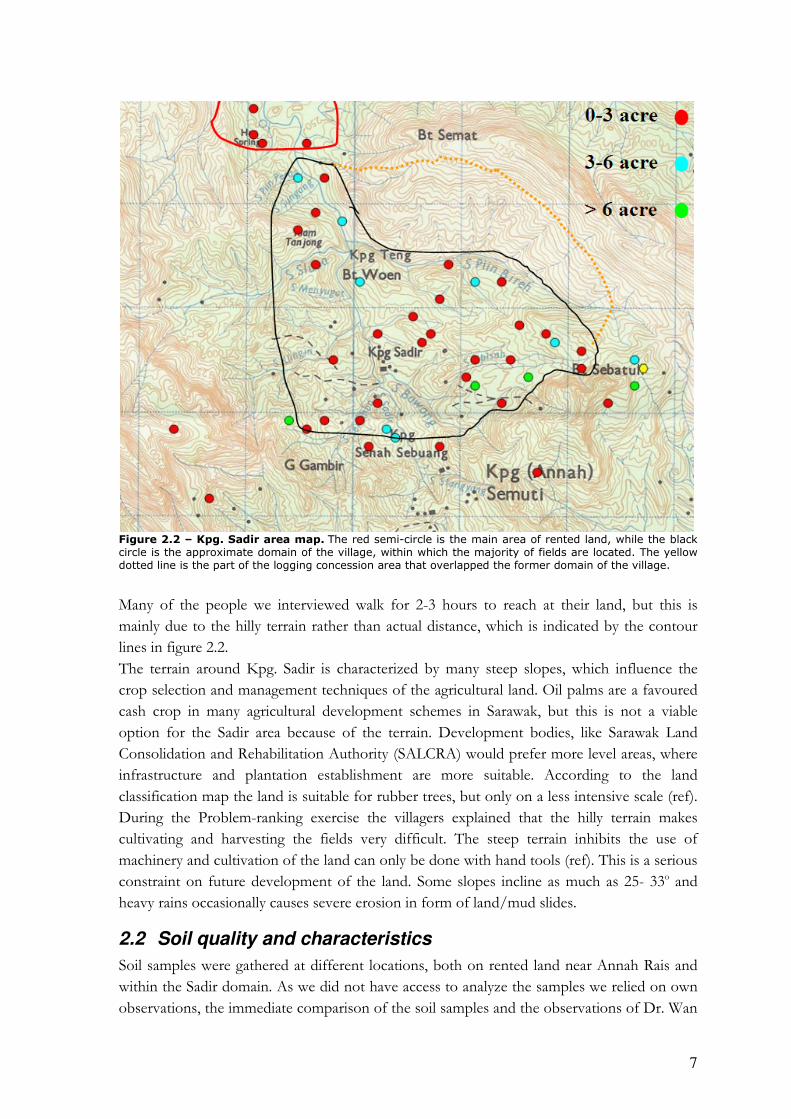
7
Figure 2.2 – Kpg. Sadir area map. The red semi-circle is the main area of rented land, while the black circle is the approximate domain of the village, within which the majority of fields are located. The yellow dotted line is the part of the logging concession area that overlapped the former domain of the village.
Many of the people we interviewed walk for 2-3 hours to reach at their land, but this is
mainly due to the hilly terrain rather than actual distance, which is indicated by the contour
lines in figure 2.2.
The terrain around Kpg. Sadir is characterized by many steep slopes, which influence the
crop selection and management techniques of the agricultural land. Oil palms are a favoured
cash crop in many agricultural development schemes in Sarawak, but this is not a viable
option for the Sadir area because of the terrain. Development bodies, like Sarawak Land
Consolidation and Rehabilitation Authority (SALCRA) would prefer more level areas, where
infrastructure and plantation establishment are more suitable. According to the land
classification map the land is suitable for rubber trees, but only on a less intensive scale (ref).
During the Problem-ranking exercise the villagers explained that the hilly terrain makes
cultivating and harvesting the fields very difficult. The steep terrain inhibits the use of
machinery and cultivation of the land can only be done with hand tools (ref). This is a serious
constraint on future development of the land. Some slopes incline as much as 25- 33o and
heavy rains occasionally causes severe erosion in form of land/mud slides.
2.2 Soil quality and characteristics
Soil samples were gathered at different locations, both on rented land near Annah Rais and
within the Sadir domain. As we did not have access to analyze the samples we relied on own
observations, the immediate comparison of the soil samples and the observations of Dr. Wan

8
Sulaiman during a field walk. These findings supported the soil- and agricultural capability
maps that classified the area as 4te, which besides steep slopes and serious erosion hazards,
indicates a soil that is only marginally suitable for agriculture. Besides rubber trees the soil is
suitable for subsistence cultivation of hill rice and maize (Maas et al. 1986). Figure 2.3 show a
typical soil profile.
Organic matter
10-12 cm
Sandy layer
-> 25 cm
Sandy clay
25 cm ->
Figure 2.3 – Typical soil profile. The soil types in the area are characterised by a low fertility, which is partly due to the sandy texture of the soil combined with the steepness of the slopes, which causes a high level of leaching of nutrients and runoff of organic matter.
The upland soils of Kpg. Sadir have been intensively leached. Although the limited nutrient
reserves are quickly depleted when the land is brought under cultivation, crop yields can be
maintained by adequate fertilizer application. Instead of buying fertilizers that they often
cannot afford, fields are left fallow for periods of 7-10 years. These long periods of fallow
may indicate that the soils are very slow to replenish nutrients or that there is no acute lack of
land.

9
Box 2.2 – The sad story of the vegetable garden A rubber and pepper farmer (76) had planted a vegetable garden behind the small hut located on his farm. However, apart from a small amount of ripus, none of the vegetables had survived and the plot was bare. The reasons for this were most likely lack of nutrients, sandy soils and perhaps lack of care for the garden (the size was manageable). In many ways, this has been a bad year for the farmer, who has also experienced his chickens being stolen and his previous hut (complete with solar powered radio and TV) burning down to ground.
2.3 Water quality and availability
The water survey focused on two main components, namely water quality and availability.
The household survey showed that water shortage is not an issue and droughts were not
mentioned. All houses have running water that originates from two gravity-fed sources in two
rivers. The fields are often located next to rivers or streams and some farmers water their
crops during dry periods, especially vegetable gardens, but no major irrigation systems are in
place.
Water samples were taken from the two sources upstream, as well as from two places
downstream from the village and from tap water. As can be seen in table 2.1 the E. coli
counts from both sources and from both tap water samples are higher than the limit values in
Drinking Water Quality Standard for Malaysia (NREB 2005a) and National Water Quality
Standard for Malaysia (NREB 2005b). It may cause diseases if people drink the tap water
untreated or swallow water while bathing in the river. During our field walks we observed
that fields are located close to the river upstream from the village and also close to the actual
source. Farmers often spend the night in huts on the fields during busy periods. This might
partly explain the high E. coli count. The E. coli can also stem from animal faeces as the test
we performed is unable to distinguish between human and animal faecal coliforms. (See
appendix 5 for the results of the water sampling). Table 2.1 – Coliform count in the water samples: The water samples were analyzed for several parameters, e.g. ammonium-nitrogen, nitrate-nitrogen, phosphate, but none exceeded the standard limits (NREB 2005a,b)1 Sample location Kpg. Sadir
gravity fed source
Sg. Sburok gravity fed source
Longhouse tap water
School tap water
Limits, water quality standard / drinking water standard
Total coliform counts / 100 ml
238 228 - - 100 / 2
Faecal coliform counts / 100 ml
355 224 296 230 10 / 0
1 The incoherence between total coliform and the faecal coliform counts can be caused by faults in the testing methods, but the important point is that the numbers more than twice as high as the limit values.
10
3 Land Tenure and Land Use
Land tenure is an important aspect of land use. With secured ownership of land the incentive
to invest in the land, especially on a long term basis, and to prevent nutrient exhaustion is
higher than if the ownership is insecure or if rights to the land is reduced to user rights
(Schlager & Ostrom 1992). As a Bidayuh village with subsistence and cash crop farming, and
tenure influenced by both the traditional adat and the formal land code, these two issues land
tenure and land use are closely connected. Information regarding the two issues has been
obtained primarily through the household survey, interviews with the Headman and field
visits, which allowed us to observe and verify typical land use patterns.
3.1 Land Tenure
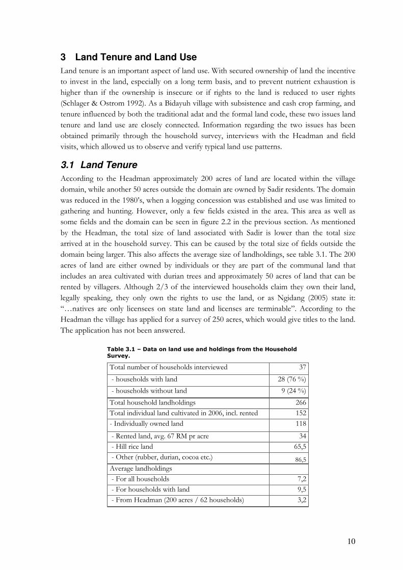
According to the Headman approximately 200 acres of land are located within the village
domain, while another 50 acres outside the domain are owned by Sadir residents. The domain
was reduced in the 1980’s, when a logging concession was established and use was limited to
gathering and hunting. However, only a few fields existed in the area. This area as well as
some fields and the domain can be seen in figure 2.2 in the previous section. As mentioned
by the Headman, the total size of land associated with Sadir is lower than the total size
arrived at in the household survey. This can be caused by the total size of fields outside the
domain being larger. This also affects the average size of landholdings, see table 3.1. The 200
acres of land are either owned by individuals or they are part of the communal land that
includes an area cultivated with durian trees and approximately 50 acres of land that can be
rented by villagers. Although 2/3 of the interviewed households claim they own their land,
legally speaking, they only own the rights to use the land, or as Ngidang (2005) state it:
“…natives are only licensees on state land and licenses are terminable”. According to the
Headman the village has applied for a survey of 250 acres, which would give titles to the land.
The application has not been answered.
Table 3.1 – Data on land use and holdings from the Household Survey.
Total number of households interviewed 37
- households with land 28 (76 %)
- households without land 9 (24 %)
Total household landholdings 266
Total individual land cultivated in 2006, incl. rented 152
- Individually owned land 118
- Rented land, avg. 67 RM pr acre 34
- Hill rice land 65,5
- Other (rubber, durian, cocoa etc.) 86,5
Average landholdings
- For all households 7,2
- For households with land 9,5
- From Headman (200 acres / 62 households) 3,2
11
The Sarawak Land Code from 1958 unified many different laws pertaining to land tenure and
land use, and several amendments have been made since then. Generally the Land Code
undermines the adat practices concerning landholdings and makes it difficult to keep land as
NCL, e.g. a continuous occupation of the land is required, which make the current rice
cultivation with 7-10 year fallow periods impossible (Ngidang, Mertz). However, so far there
have not been any conflicts with the government concerning the current landholdings and
therefore the villagers’ perception of ownership of this land has not been challenged.
According to the Headman the domain of Sadir has remained largely unchanged since the
forest was cleared after the arrival of the first settlers. Those who own land today do so
because their ancestors cleared the forest claimed the land and passed it on to their children
according to the adat inheritance system (see box 3.1).
Box 3.1 – Frightened by the Penyamum According to the timeline and the Headman the first settlers arrived at Kampung Sadir 200 years ago after being pushed away from their original settlement by the threat of Penyamums, headhunters. When they arrived some people were afraid of going into the forest to clear and claim land and thus became landless. In compliance with the adat custom those who clear a plot of forest obtain an individual claim to the land. The landless rented land from the common area or depended on employment as labour or the collection of forest products. Some of the landless households today are descendants of the people who were afraid of the Penyamums.
Since 1958, when the Sarawak Land Code was implemented, it has not been possible to claim
more NCR land. The only way to cultivate more fields is to rent land or shorten the fallow
periods. Since the soil is poor in the area and the 7-10 year fallow period is needed, renting of
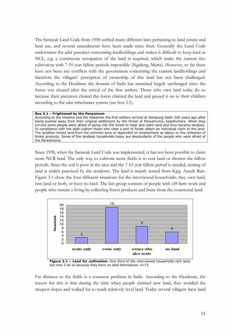
land is widely practiced by the residents. The land is mainly rented from Kpg. Annah Rais.
Figure 3.1 show the four different situations for the interviewed households; they own land,
rent land or both, or have no land. The last group consists of people with off farm work and
people who sustain a living by collecting forest products and fruits from the communal land.
3
19
9
6
0
2
46
8
10
12
1416
18
20
rents only owns only owner who
also rents
no land
House
hold
s
Figure 3.1 – Land for cultivation. One third of the interviewed households rent land, but only 3 do so because they have no land themselves. n=73
Far distance to the fields is a common problem in Sadir. According to the Headman, the
reason for this is that during the time when people claimed new land, they avoided the
steepest slopes and walked far to reach relatively level land. Today several villagers have land

12
as far away as the Indonesian border to the south, 3 hours walk away. They do not use these
fields, however, and some households rent out their plots to another village
All villagers are allowed to collect fruits from the communal orchards, mainly durian, but
there are certain rules to follow, e.g. durians can only be collected from the ground except for
those who belong to the generation who planted the durian gardens, who are allowed to
harvest from the trees as well (see box 3.2). Collection of NTFP on communal land and the
surrounding areas is done by almost all households, with no distinction of income levels.
However, the poorest households, who usual have no land, seem to be more dependent on
the collection. Bamboo and forest vegetables are among the most common NTFP, while the
collection of rattan is limited due to over-harvesting.
Box 3.2 – The danger of collecting durian fruits Collecting durian fruits in the orchard is not without hazards. Since it for some is only permitted to collect fruits that have fallen to the ground, people rush to the orchard when it is windy. On a windy night 13 years ago a villager was collecting durian fruits in the dark, when a large fruit fell from a tree and hit him. The impact left the villager paralysed for life and today he is managing his fields of rice and cash crops from his wheelchair with the help of a large family.
3.2 Land use patterns
There are predominantly two patterns of land use in Kpg. Sadir; rice production and cash
crop production. Besides these two main patterns there is a wide variety of other uses, e.g.
vegetables gardens, orchards for own consumption and gathering of forest products. As
figure 3.2 and 3.3 show, the majority of the households cultivate rice, some supplement with
cash crops, while a smaller part of the village only grow cash crops or only rely on off farm
work.
67% 67%
56%
33%
14% 11%
0
5
10
15
20
25
30
Pad
i
Veg
etab
les
Dur
ian
Pep
per
Rub
ber
Coc
oa
Household
s
Figure 3.2 – Types of crops cultivated. Percentage of interviewed households, who cultivate different crops. Some households cultivate several crops
3.2.1 The cultural staple
The hill rice cultivation is more or less homogenous among the farmers. It is normal practice
to cultivate maize for own consumption after the clear felling and before the wood is burned,
and many vegetables are intercropped in the rice. Each plot is usually only used one year as
shown in the community calendar (Appendix 6). Whether this is because of invasion of
weeds or loss of nutrients is uncertain, but several respondents in the household survey

13
mentioned weeds as a bigger problem than poor soils. As shown in figure 3.3 pesticides,
which are not subsidized, are used on both rice and cash crop fields.
0
1
2
3
4
5
6
7
8
only padi other crops
only
padi and
other
Ho
us
eh
old
s use none
only fertilizer
only pesticides
use both
Figure 3.3 – Crops and inputs. Use of inputs compared to the household’s crops. (n=37)
The figures 3.3 and 3.4 show a link between use of inputs and crop type as well as inputs and
land ownership. Farmers, who only grow rice are among the poorer segment of the village
and cannot afford both inputs. They choose pesticides because, as one of the respondents
said: “it is better with a low yield than no yield”, indicating that the poor soil result in a low
yield but weeds out-compete rice completely. The importance of pesticides is underlined in
figure 3.4; all the people who only rent land and grow rice use pesticides.
0
1
2
3
4
5
6
7
8
9
rented land own land both no land
# o
f h
ou
seh
old
s
none
only fertilizer
only pesticides
both
Figure 3.4 – Inputs on land used in 2006. Use of inputs related to ownership of land2 (n=37)
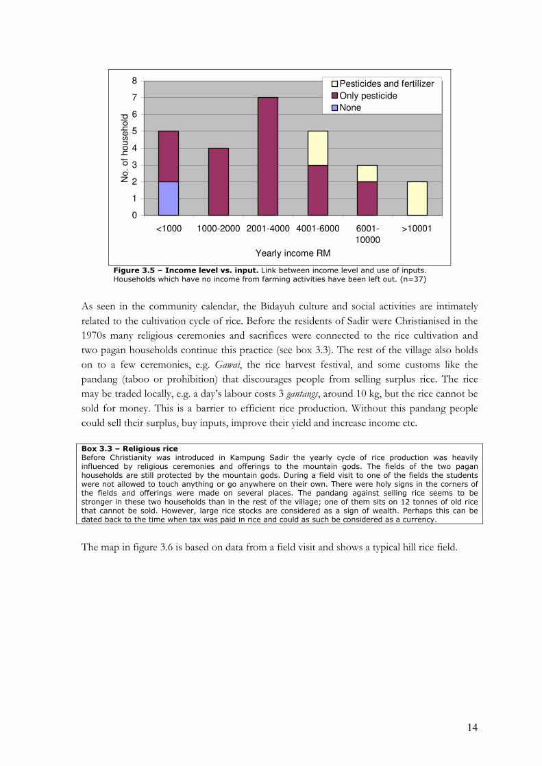
The connection between income level and use of inputs are further substantiated in figure
3.5. From the chart it can be derived that the use of fertilizer is linked to higher income, but
also that even the poor households use pesticides.
2 We are aware of the inconsistency that one household with no land uses pesticides. They might use it in a homegarden.
14
0
1
2
3
4
5
6
7
8
<1000 1000-2000 2001-4000 4001-6000 6001-
10000
>10001
Yearly income RM
No.
of
household
Pesticides and fertilizer
Only pesticide
None
Figure 3.5 – Income level vs. input. Link between income level and use of inputs. Households which have no income from farming activities have been left out. (n=37)
As seen in the community calendar, the Bidayuh culture and social activities are intimately
related to the cultivation cycle of rice. Before the residents of Sadir were Christianised in the
1970s many religious ceremonies and sacrifices were connected to the rice cultivation and
two pagan households continue this practice (see box 3.3). The rest of the village also holds
on to a few ceremonies, e.g. Gawai, the rice harvest festival, and some customs like the
pandang (taboo or prohibition) that discourages people from selling surplus rice. The rice
may be traded locally, e.g. a day’s labour costs 3 gantangs, around 10 kg, but the rice cannot be
sold for money. This is a barrier to efficient rice production. Without this pandang people
could sell their surplus, buy inputs, improve their yield and increase income etc.
Box 3.3 – Religious rice Before Christianity was introduced in Kampung Sadir the yearly cycle of rice production was heavily influenced by religious ceremonies and offerings to the mountain gods. The fields of the two pagan households are still protected by the mountain gods. During a field visit to one of the fields the students were not allowed to touch anything or go anywhere on their own. There were holy signs in the corners of the fields and offerings were made on several places. The pandang against selling rice seems to be stronger in these two households than in the rest of the village; one of them sits on 12 tonnes of old rice that cannot be sold. However, large rice stocks are considered as a sign of wealth. Perhaps this can be dated back to the time when tax was paid in rice and could as such be considered as a currency.
The map in figure 3.6 is based on data from a field visit and shows a typical hill rice field.

15
Figure 3.6 – A typical hill rice field. Hill rice with intercropped vegetables, i.e. pumpkin, ginger, banana, cucumber, ripus (a local porridge grain) and others. The farmer clears a field that has been under fallow for a period of time, burns the dried wood, sow rice and takes care of weeds until the harvest period, after which the plot is left for fallow. What cannot be seen on the sketch, but characterises most rice fields in the area, are the steep slopes with estimated inclinations of up to 45o.
3.2.2 The economic crops
Approximately half the interviewed households receive a substantial income from some sort
of cash crops, mainly pepper, durian, rubber and/or cocoa. Figure 3.7 shows a typical cash
crop farm. Figure 3.3 and 3.4 show that cash crop growers use fertilizers and own their land.
The household survey show that rented land is cultivated with rice and, while cash crops are
grown on owned land. Almost all cash crop growers use fertilizers, because they are
subsidized under cash crop schemes. Some farmers refrain from buying fertilizers because of
high transportation costs. Naturally, there is no pandang against selling cash crops, but the
poor road condition result in high transportation costs and this may make cash cropping
economically unviable for some farmers. The farmers in the area do have an advantage over
farmers in other areas. Because of the hilly terrain the durian fruits mature over an unusual
long period of three months and can be sold at higher off season prices.
16
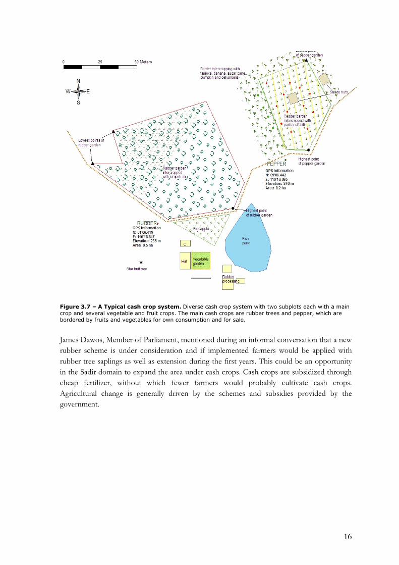
Figure 3.7 – A Typical cash crop system. Diverse cash crop system with two subplots each with a main crop and several vegetable and fruit crops. The main cash crops are rubber trees and pepper, which are bordered by fruits and vegetables for own consumption and for sale.
James Dawos, Member of Parliament, mentioned during an informal conversation that a new
rubber scheme is under consideration and if implemented farmers would be applied with
rubber tree saplings as well as extension during the first years. This could be an opportunity
in the Sadir domain to expand the area under cash crops. Cash crops are subsidized through
cheap fertilizer, without which fewer farmers would probably cultivate cash crops.
Agricultural change is generally driven by the schemes and subsidies provided by the
government.
17
4 Population, income and movement
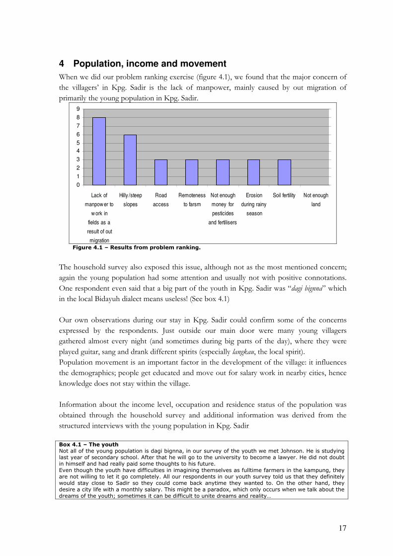
When we did our problem ranking exercise (figure 4.1), we found that the major concern of
the villagers’ in Kpg. Sadir is the lack of manpower, mainly caused by out migration of
primarily the young population in Kpg. Sadir.
0
1
2
3
4
5
6
7
8
9
Lack of
manpow er to
w ork in
fields as a
result of out
migration
Hilly /steep
slopes
Road
access
Remoteness
to farsm
Not enough
money for
pesticides
and fertilisers
Erosion
during rainy
season
Soil fertility Not enough
land
Type of problem
No. of stones
Figure 4.1 – Results from problem ranking.
The household survey also exposed this issue, although not as the most mentioned concern;
again the young population had some attention and usually not with positive connotations.
One respondent even said that a big part of the youth in Kpg. Sadir was “dagi bignna” which
in the local Bidayuh dialect means useless! (See box 4.1)
Our own observations during our stay in Kpg. Sadir could confirm some of the concerns
expressed by the respondents. Just outside our main door were many young villagers
gathered almost every night (and sometimes during big parts of the day), where they were
played guitar, sang and drank different spirits (especially langkau, the local spirit).
Population movement is an important factor in the development of the village: it influences
the demographics; people get educated and move out for salary work in nearby cities, hence
knowledge does not stay within the village.
Information about the income level, occupation and residence status of the population was
obtained through the household survey and additional information was derived from the
structured interviews with the young population in Kpg. Sadir
Box 4.1 – The youth Not all of the young population is dagi bignna, in our survey of the youth we met Johnson. He is studying last year of secondary school. After that he will go to the university to become a lawyer. He did not doubt in himself and had really paid some thoughts to his future. Even though the youth have difficulties in imagining themselves as fulltime farmers in the kampung, they are not willing to let it go completely. All our respondents in our youth survey told us that they definitely would stay close to Sadir so they could come back anytime they wanted to. On the other hand, they desire a city life with a monthly salary. This might be a paradox, which only occurs when we talk about the dreams of the youth; sometimes it can be difficult to unite dreams and reality…

18
4.1 Overview of population distribution
In figure 4.2, information about number of individuals living in Kpg. Sadir or are considered
as non-residents are plotted against their age. The reason for not using the term out migrated
for the non-residents is because a relative large share of this group attend secondary school
outside Sadir and are not considered as out migrated, nor are they considered as residents of
the kampung. This is the reason for the high number of non-residents in the age of 11-20. As
a result, the majority of the population in Sadir consist mostly of old people, and those
younger than 15 years of age (see box 4.2).
Box 4.2 – Population distribution During our stay in Kpg. Sadir it was not hard to notice that the main population consisted of rather young villagers and members of the older generations. In this picture we see one of the children attaining primary school and in the background is the oldest man in the kampung.
The data in figure 4.2 is just a still picture of the population distribution from the kampung.
It does not show when individuals leave Sadir, but only their present age. We do not know
whether they moved away at 15 years of age or at 60.
0
10
20
30
40
50
60
70
<10 11-20 21-30 31-40 41-50 51-60 61-70 71-80 >80
Age
No
. of
ind
ivid
uals
Non-resident, n=113
Resident, n=152
Figure 4.2 – Resident or non resident, data from household survey.

19
4.2 Occupation and income level
The poverty line for a household of 4.8 individuals in the rural part of Sarawak is RM7200
per year (UNDP 2005). Sadir households have an average income of RM5800 and average
size of 4.8 people. The income level distribution of the villagers can be derived from the
chart in figure 4.3. Almost one third of the households from our survey earned RM1800 or
less per year, and this is their only income. However, the poverty line is based on the
assumption that households must buy food and the main part of Sadir households live of
their own produce which implies that their cash income is used for procuring commodities
other than food. Thus it is difficult to estimate which households actually live below the
poverty line as we have not put a value to their agricultural production and NTFP collection,
which differs in size between households.
Figure 4.3 – Income level distribution. n=35 (lack of information from two households)
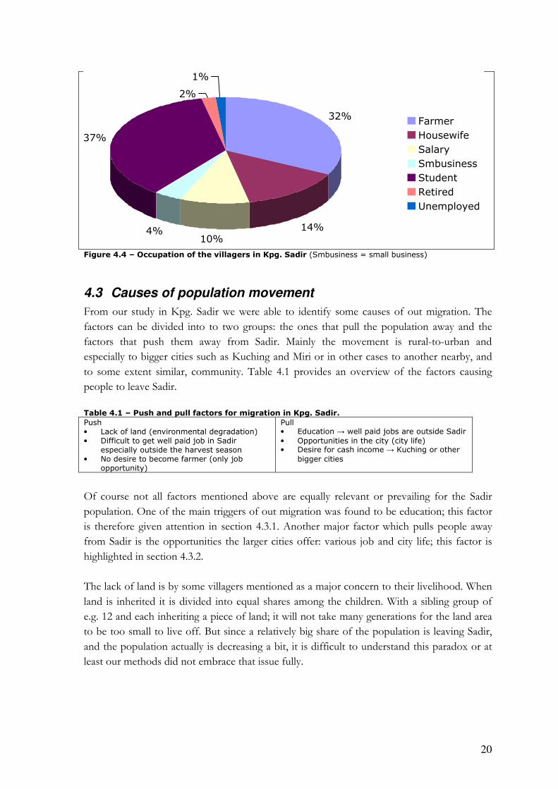
The village has two dominant occupations, with more than two thirds of the population
being occupied as either farmers or students (figure 4.4). This is clearly linked to the age
distribution where the older generation is mainly occupied as farmers and the youth attends
school.
0
2
4
6
8
10
12
14
<=1800
>=1801 <=3600
>=3601 <=5400
>=5401 <=7200
>=7201 <=9000
>9001
Yearly Income (RM)
20
Figure 4.4 – Occupation of the villagers in Kpg. Sadir (Smbusiness = small business)
4.3 Causes of population movement
From our study in Kpg. Sadir we were able to identify some causes of out migration. The
factors can be divided into to two groups: the ones that pull the population away and the
factors that push them away from Sadir. Mainly the movement is rural-to-urban and
especially to bigger cities such as Kuching and Miri or in other cases to another nearby, and
to some extent similar, community. Table 4.1 provides an overview of the factors causing
people to leave Sadir.
Table 4.1 – Push and pull factors for migration in Kpg. Sadir.
Push Pull • Lack of land (environmental degradation) • Difficult to get well paid job in Sadir
especially outside the harvest season • No desire to become farmer (only job
opportunity)
• Education → well paid jobs are outside Sadir
• Opportunities in the city (city life) • Desire for cash income → Kuching or other
bigger cities
Of course not all factors mentioned above are equally relevant or prevailing for the Sadir
population. One of the main triggers of out migration was found to be education; this factor
is therefore given attention in section 4.3.1. Another major factor which pulls people away
from Sadir is the opportunities the larger cities offer: various job and city life; this factor is
highlighted in section 4.3.2.
The lack of land is by some villagers mentioned as a major concern to their livelihood. When
land is inherited it is divided into equal shares among the children. With a sibling group of
e.g. 12 and each inheriting a piece of land; it will not take many generations for the land area
to be too small to live off. But since a relatively big share of the population is leaving Sadir,
and the population actually is decreasing a bit, it is difficult to understand this paradox or at
least our methods did not embrace that issue fully.
32%
14%10%
4%
37%
2%
1%
Farmer
Housewife
Salary
Smbusiness
Student
Retired
Unemployed

21
4.3.1 Education
A big share (30 individuals) of the group of people ranging from age 11-20 is attending
secondary school and is hence boarding there (see figure 4.5). It does not necessarily mean
that this group actually has out migrated, since some might want to move back to Kpg. Sadir
when they have finished their studies, thus this pattern is referred to as a population
movement.
0
10
20
30
40
50
60
70
<10 11-20 21-30 31-40 41-50 51-60 61-70 71-80 >80
Age
No. of re
sid
ents
Non resident students n=31
Resident students, n=20
Non-resident, not student, n=82
Resident, not student, n=132
Figure 4.5 – Residential status and studying.
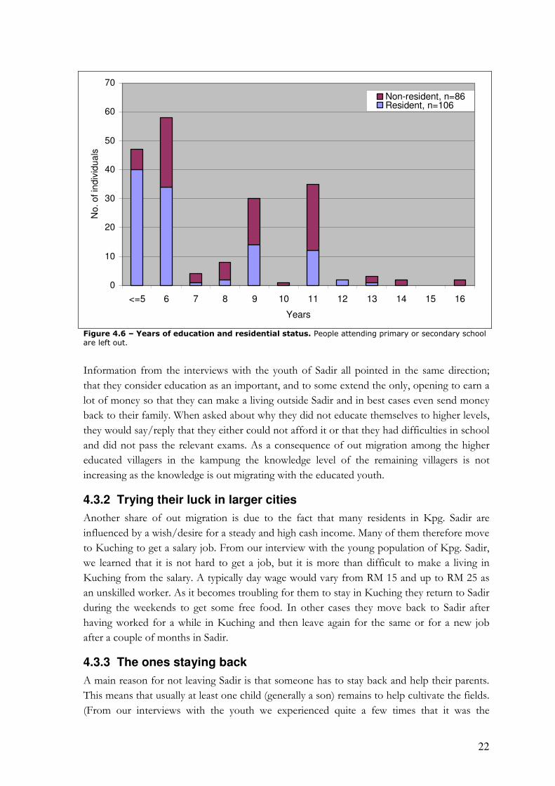
To investigate whether there is a pattern connecting level of education with level of out
migration, the chart in figure 4.6 is produced. In this chart the students that either attends
primary or secondary school are left out so that they do not affect the numbers, which are in
the group prone to migrate. The average years of study for the out migrated people are 8.3
whereas the average for residents of Kpg. Sadir is 4.5. Additionally it can be mentioned that
only 5 persons left Kpg. Sadir with no education at all but as much as 33 Sadir residents had
no education. This fact indicates the evident pattern between educational level and out
migration status.
22
0
10
20
30
40
50
60
70
<=5 6 7 8 9 10 11 12 13 14 15 16
Years
No
. o
f in
div
idu
als
Non-resident, n=86Resident, n=106
Figure 4.6 – Years of education and residential status. People attending primary or secondary school are left out.
Information from the interviews with the youth of Sadir all pointed in the same direction;
that they consider education as an important, and to some extend the only, opening to earn a
lot of money so that they can make a living outside Sadir and in best cases even send money
back to their family. When asked about why they did not educate themselves to higher levels,
they would say/reply that they either could not afford it or that they had difficulties in school
and did not pass the relevant exams. As a consequence of out migration among the higher
educated villagers in the kampung the knowledge level of the remaining villagers is not
increasing as the knowledge is out migrating with the educated youth.
4.3.2 Trying their luck in larger cities
Another share of out migration is due to the fact that many residents in Kpg. Sadir are
influenced by a wish/desire for a steady and high cash income. Many of them therefore move
to Kuching to get a salary job. From our interview with the young population of Kpg. Sadir,
we learned that it is not hard to get a job, but it is more than difficult to make a living in
Kuching from the salary. A typically day wage would vary from RM 15 and up to RM 25 as
an unskilled worker. As it becomes troubling for them to stay in Kuching they return to Sadir
during the weekends to get some free food. In other cases they move back to Sadir after
having worked for a while in Kuching and then leave again for the same or for a new job
after a couple of months in Sadir.
4.3.3 The ones staying back
A main reason for not leaving Sadir is that someone has to stay back and help their parents.
This means that usually at least one child (generally a son) remains to help cultivate the fields.
(From our interviews with the youth we experienced quite a few times that it was the

23
youngest son who had to stay behind – tough luck.) When they are not busy with the hill rice
harvest, they often get some salary work nearby, usually in Kuching.
4.3.4 Reasons and impacts of population movement
From the previous chapters, it is evident that there are some groups, which move more than
others; and an appropriate question would then be “why are they moving?” Population
movement can be divided into two categories, 1) conservative movement and 2) innovative
movement (Parnwell & King 1998). The first one consists of movement as a mitigation
measure to protect an existing level of livelihood and the latter one is an approach of
enhancing the present livelihood. Both categories are present in Sadir. The migration due to
the lack of land and hence low income opportunities as a farmer would be considered as
conservative migration. They are left with “Hobson’s choice3”; either they stay under the
worsening conditions or they take the opportunity to move to Kuching to get a job, at least
for a while. The tolerance threshold has been passed and may in some situations lead to a
substitution of one set of problems in situ for another set of problems ex situ (Parnwell &
King 1998). Migration is thus used as a way of coping when other options (such as
agricultural intensification) fail to provide a livelihood. The ones taking a higher education
leave Sadir as an innovative migrant. They hope to improve their current livelihood by getting
an education and hopefully a well-paid job afterwards.
From an informal interview with the Headman we learned that the population numbers were
stable and had been like that for many years. Still, a part of the villagers are claim that they
have insufficient land available for agricultural activities. The issue about lack of land can
therefore not be a new problem and therefore not a new cause of out migration. Additionally
it can be mentioned that out migration perhaps is not that big a problem because the
population is almost the same. It can be a measure of the carrying capacity of the village is at
the current point; an increase in population would then need additional land.
Even though rural exoduses often are caused by land degradation, Kpg. Sadir is also
experiencing a process of urbanization where the reasons often are due to the destination
more than on the origin. It is therefore both a question of being pushed away from the
kampung because of lack of land and being pulled in the direction of urbanization and the
opportunities offered in the cities.
3 The choice of taking the thing offered or nothing at all.
24
5 Tourism development in Kpg. Sadir
Tourism was highlighted both in our assignment paper as one of the potential economic
activities for Kpg. Sadir and by MP James Dawos mainly because the nearby village of Annah
Rais is already an established tourist attraction and have more than 6.000 visitors a year
(Annah Rais Tourism Records).
In this section we assess the tourism potential and possibilities of Kpg. Sadir. The tourism
potential is assessed through the current strengths and weaknesses; while the possibilities
include options to advance Kpg. Sadir as a tourism destination and hence opportunities for
the residents to attain either direct or indirect economical benefits from tourism, which mean
a diversification of income opportunities.
Locations and attraction ratings of the key attractions were determined through interviews
with the villagers and ground truthing of the sites, including GPS for later mapping purposes.
For comparative reasons we investigated how the development of tourism had taken place in
Annah Rais and the perceived negatives and positives it had brought to the village, as well as
the extent of people’s involvement in tourism activities. The few tourists who came to Sadir
during our stay there were also asked to fill out a questionnaire.
5.1 Benefits of tourism – lessons from Annah Rais
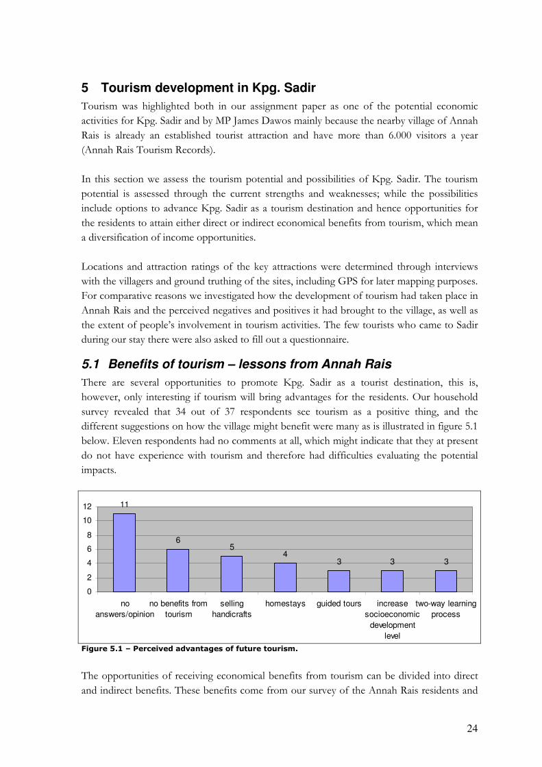
There are several opportunities to promote Kpg. Sadir as a tourist destination, this is,
however, only interesting if tourism will bring advantages for the residents. Our household
survey revealed that 34 out of 37 respondents see tourism as a positive thing, and the
different suggestions on how the village might benefit were many as is illustrated in figure 5.1
below. Eleven respondents had no comments at all, which might indicate that they at present
do not have experience with tourism and therefore had difficulties evaluating the potential
impacts.
11
65
43 3 3
0
2
4
6
8
10
12
no
answers/opinion
no benefits from
tourism
selling
handicrafts
homestays guided tours increase
socioeconomic
development
level
two-way learning
process
Figure 5.1 – Perceived advantages of future tourism.
The opportunities of receiving economical benefits from tourism can be divided into direct
and indirect benefits. These benefits come from our survey of the Annah Rais residents and

25
informant interviews with the day-to-day Tourist Manager and the Tourism Committee
chairman in Annah Rais. Figure 5.2 below show that two thirds of the residents in Annah
Rais consider tourism beneficial for the community.
Yes
67%
No
26%
Maybe
7%
Figure 5.2 – Does tourism benefit the community in Annah Rais? n= 27 AR residents
The direct benefits of tourism in Kpg. Sadir could go to individual residents e.g. by income
through guiding tours, homestays, selling of handicrafts, foods etc. as is the case for one third
of the residents in Annah Rais (figure 5.3). However, the current availability of locally made
handicrafts is low, and is as such not yet a potential income source if tourists start coming.
Guiding for international tourists, is limited to those residents whose English is fluent
enough.
Yes
33%
No
67%
Figure 5.3 – Are you directly involved in tourism? n = 27 AR residents.
The potential indirect benefits would probably, as in Kpg. Annah Rais, mainly be derived
from entrance fees to either the kampung or selected attractions, e.g. the waterfalls. Last year
Annah Rais’ income from entrance fees reached more than RM30.000 (Annah Rais Tourism
Statistics). This income could be used for maintenance of the longhouse, welfare to families
in need and prizes for kids who do well in school etc., or whatever the village development
committee JKKK4 decides. Even though this is not a direct income it could help raise the
living standards of the residents, as it would ameliorate poverty for the worst off families, and
4 “Jawatankuasa Keselamatan dan Kemajuan Kampung”, which in English means “The Village Development and Security Committee”. It is a Committee elected by the villagers in the kampung and is operating as the local administration.
26
save the families in the longhouse the expenses and time for maintaining the longhouse, thus
leaving them with a greater disposable amount of money than before.
From the data presented above it is apparent that the residents in Annah Rais appreciate
these indirect benefits: even if they are not directly involved, many still feel that the
community as a whole benefits from tourism. A constraint on the development of tourism in
Kpg. Sadir is that the potential tourism market might be too small to justify investments and
improvement of access to the waterfalls and the restoration of houses. However, small-scale
improvements might not be costly since materials mostly are collected in the forest. If an
entrance-fee system was established, this income would be able to pay for improvements as is
the case at present in Annah Rais as reported by the residents, the day-to-day Tourist
Manager and the chairman of the Tourism Committee.
Some positive spin off effects could be an improvement in general facilities, which will be
available for the residents as well, and an incentive for conserving the traditional Bidayuh life-
style as this is what many tourists are also interested in experiencing; this was mentioned by
some of the AR residents as an important benefit of tourism in their village.
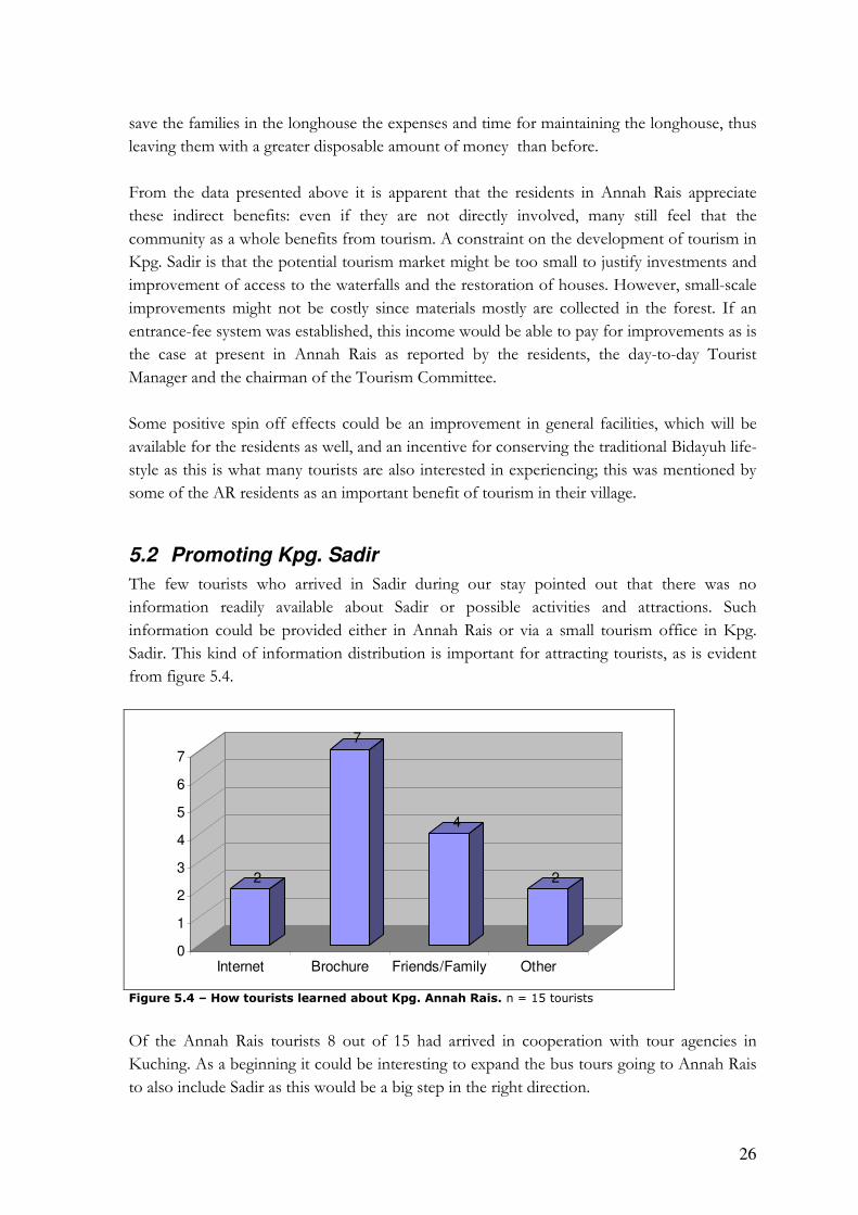
5.2 Promoting Kpg. Sadir
The few tourists who arrived in Sadir during our stay pointed out that there was no
information readily available about Sadir or possible activities and attractions. Such
information could be provided either in Annah Rais or via a small tourism office in Kpg.
Sadir. This kind of information distribution is important for attracting tourists, as is evident
from figure 5.4.
2
7
4
2
0
1
2
3
4
5
6
7
Internet Brochure Friends/Family Other
Figure 5.4 – How tourists learned about Kpg. Annah Rais. n = 15 tourists
Of the Annah Rais tourists 8 out of 15 had arrived in cooperation with tour agencies in
Kuching. As a beginning it could be interesting to expand the bus tours going to Annah Rais
to also include Sadir as this would be a big step in the right direction.
27
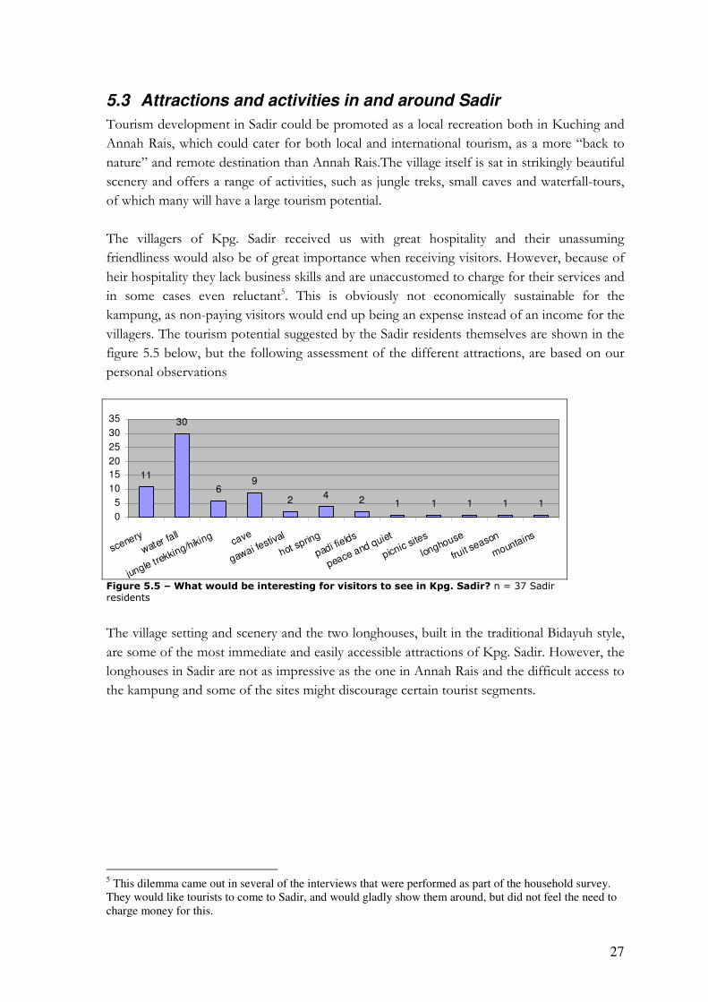
5.3 Attractions and activities in and around Sadir
Tourism development in Sadir could be promoted as a local recreation both in Kuching and
Annah Rais, which could cater for both local and international tourism, as a more “back to
nature” and remote destination than Annah Rais.The village itself is sat in strikingly beautiful
scenery and offers a range of activities, such as jungle treks, small caves and waterfall-tours,
of which many will have a large tourism potential.
The villagers of Kpg. Sadir received us with great hospitality and their unassuming
friendliness would also be of great importance when receiving visitors. However, because of
heir hospitality they lack business skills and are unaccustomed to charge for their services and
in some cases even reluctant5. This is obviously not economically sustainable for the
kampung, as non-paying visitors would end up being an expense instead of an income for the
villagers. The tourism potential suggested by the Sadir residents themselves are shown in the
figure 5.5 below, but the following assessment of the different attractions, are based on our
personal observations
11
30
69
24
2 1 1 1 1 1
0
5
10
15
20
25
30
35
scenery
water fall
jungle trekking/hiking
cave
gawai festival
hot spring
padi fields
peace and quiet
picnic sites
longhouse
fruit s
eason
mountains
Figure 5.5 – What would be interesting for visitors to see in Kpg. Sadir? n = 37 Sadir residents
The village setting and scenery and the two longhouses, built in the traditional Bidayuh style,
are some of the most immediate and easily accessible attractions of Kpg. Sadir. However, the
longhouses in Sadir are not as impressive as the one in Annah Rais and the difficult access to
the kampung and some of the sites might discourage certain tourist segments.
5 This dilemma came out in several of the interviews that were performed as part of the household survey. They would like tourists to come to Sadir, and would gladly show them around, but did not feel the need to charge money for this.
28
0
5
1
12
0
2
4
6
8
10
12
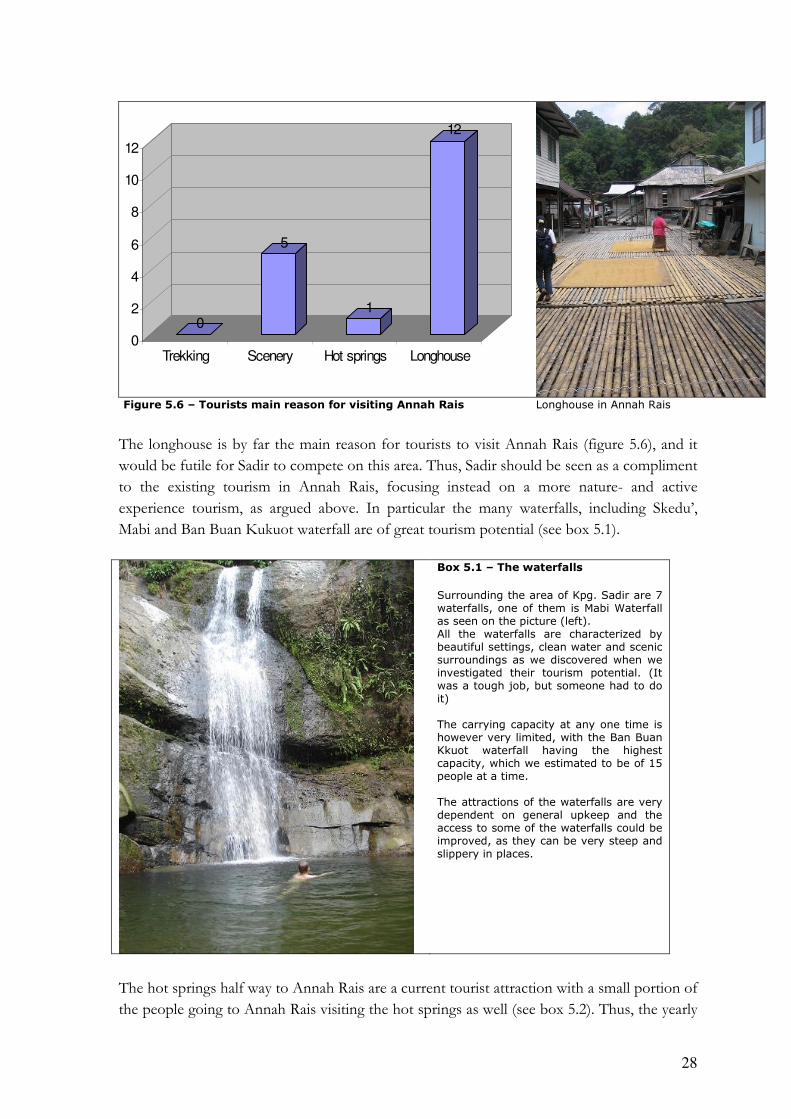
Trekking Scenery Hot springs Longhouse
Figure 5.6 – Tourists main reason for visiting Annah Rais Longhouse in Annah Rais
The longhouse is by far the main reason for tourists to visit Annah Rais (figure 5.6), and it
would be futile for Sadir to compete on this area. Thus, Sadir should be seen as a compliment
to the existing tourism in Annah Rais, focusing instead on a more nature- and active
experience tourism, as argued above. In particular the many waterfalls, including Skedu’,
Mabi and Ban Buan Kukuot waterfall are of great tourism potential (see box 5.1).
Box 5.1 – The waterfalls
Surrounding the area of Kpg. Sadir are 7 waterfalls, one of them is Mabi Waterfall as seen on the picture (left). All the waterfalls are characterized by beautiful settings, clean water and scenic surroundings as we discovered when we investigated their tourism potential. (It was a tough job, but someone had to do it) The carrying capacity at any one time is however very limited, with the Ban Buan Kkuot waterfall having the highest capacity, which we estimated to be of 15 people at a time. The attractions of the waterfalls are very dependent on general upkeep and the access to some of the waterfalls could be improved, as they can be very steep and slippery in places.
The hot springs half way to Annah Rais are a current tourist attraction with a small portion of
the people going to Annah Rais visiting the hot springs as well (see box 5.2). Thus, the yearly

29
number of visitors is estimated at well below 3.000. However, the hot springs seems to be
historically more linked to Annah Rais than Sadir and it is questionably how much tourism it
could generate for Sadir.
Box 5.2 – The hot springs The access to the hot springs is via a small downtrodden path, which is easy to follow, but there are no signs to show the access. The hot springs themselves are located within the river, where the hot water penetrates the riverbed in several locations. Some of these have been isolated into pools by small partitions made of rocks. The pools are 40 cm at the deepest point, and smells of sulphur.
The water is lukewarm to hot, as there is some inflow of cold water from the river. On the farthest riverbed a shed is being constructed, but the roofs is still unfinished and therefore not produce any shade.
Aside from shorter walks to the waterfalls, jungle treks and hikes could also be a possibility,
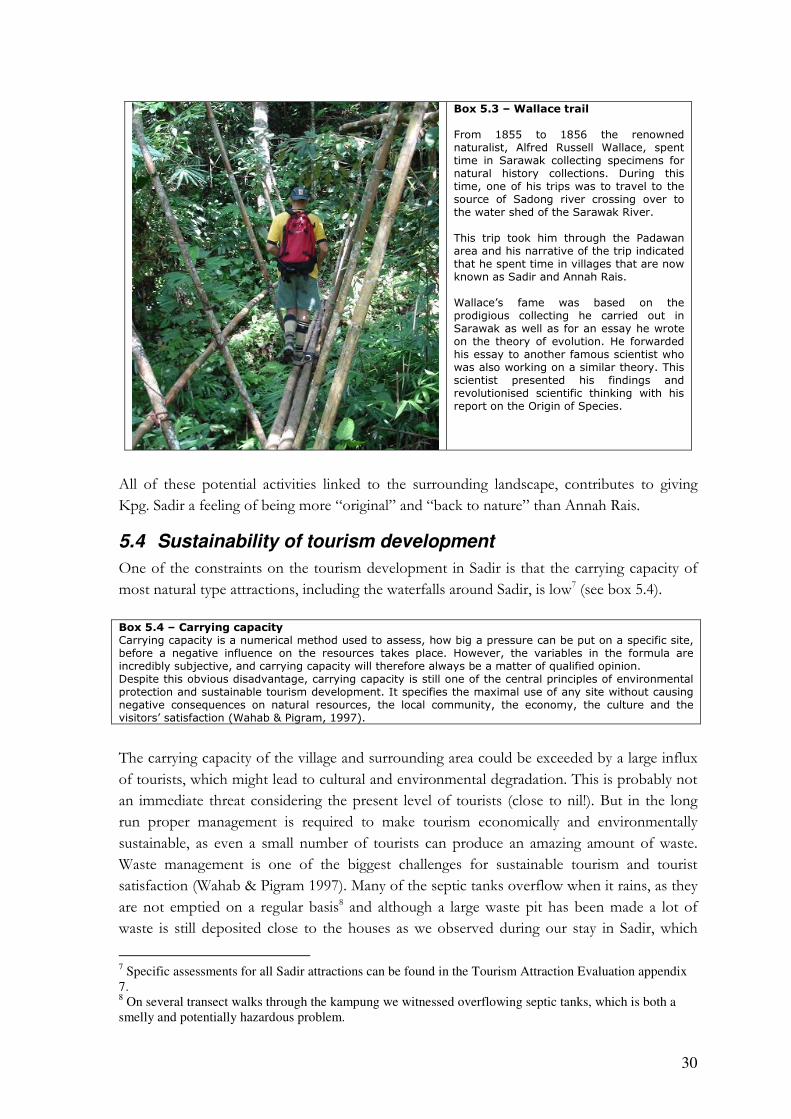
including “the Wallace trail” See box 5.3. Historical links to the Wallace trail and other
Wallace sites in Sarawak could be an important factor in developing historical tourism. But
even though the Wallace trail poses some interesting opportunities for historically interested
tourists, the Wallace history is currently not well developed even in Kuching, and without
supporting connections in Kuching, the attraction value will be limited6.
6 Information regarding the historical development of tourism in Sarawak and especially the Wallace trail, has been acquired through several conversations with Robert Basiuk, a key informant on tourism, leader of our Malaysian counterparts and a full time tourism operator in Sarawak.
30
Box 5.3 – Wallace trail From 1855 to 1856 the renowned naturalist, Alfred Russell Wallace, spent time in Sarawak collecting specimens for natural history collections. During this time, one of his trips was to travel to the source of Sadong river crossing over to the water shed of the Sarawak River. This trip took him through the Padawan area and his narrative of the trip indicated that he spent time in villages that are now known as Sadir and Annah Rais. Wallace’s fame was based on the prodigious collecting he carried out in Sarawak as well as for an essay he wrote on the theory of evolution. He forwarded his essay to another famous scientist who was also working on a similar theory. This scientist presented his findings and revolutionised scientific thinking with his report on the Origin of Species.
All of these potential activities linked to the surrounding landscape, contributes to giving
Kpg. Sadir a feeling of being more “original” and “back to nature” than Annah Rais.
5.4 Sustainability of tourism development
One of the constraints on the tourism development in Sadir is that the carrying capacity of
most natural type attractions, including the waterfalls around Sadir, is low7 (see box 5.4).
Box 5.4 – Carrying capacity Carrying capacity is a numerical method used to assess, how big a pressure can be put on a specific site, before a negative influence on the resources takes place. However, the variables in the formula are incredibly subjective, and carrying capacity will therefore always be a matter of qualified opinion. Despite this obvious disadvantage, carrying capacity is still one of the central principles of environmental protection and sustainable tourism development. It specifies the maximal use of any site without causing negative consequences on natural resources, the local community, the economy, the culture and the visitors’ satisfaction (Wahab & Pigram, 1997).
The carrying capacity of the village and surrounding area could be exceeded by a large influx
of tourists, which might lead to cultural and environmental degradation. This is probably not
an immediate threat considering the present level of tourists (close to nil!). But in the long
run proper management is required to make tourism economically and environmentally
sustainable, as even a small number of tourists can produce an amazing amount of waste.
Waste management is one of the biggest challenges for sustainable tourism and tourist
satisfaction (Wahab & Pigram 1997). Many of the septic tanks overflow when it rains, as they
are not emptied on a regular basis8 and although a large waste pit has been made a lot of
waste is still deposited close to the houses as we observed during our stay in Sadir, which
7 Specific assessments for all Sadir attractions can be found in the Tourism Attraction Evaluation appendix 7. 8 On several transect walks through the kampung we witnessed overflowing septic tanks, which is both a smelly and potentially hazardous problem.
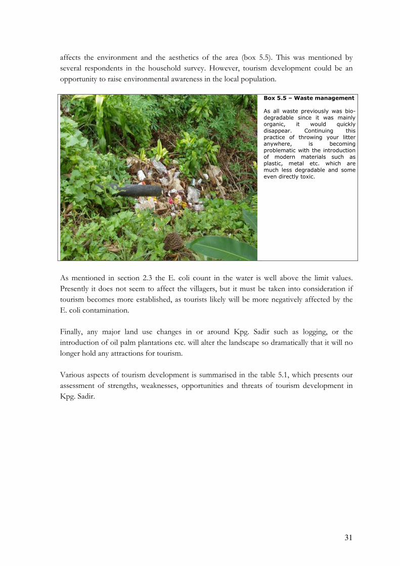
31
affects the environment and the aesthetics of the area (box 5.5). This was mentioned by
several respondents in the household survey. However, tourism development could be an
opportunity to raise environmental awareness in the local population.
Box 5.5 – Waste management As all waste previously was bio-degradable since it was mainly organic, it would quickly disappear. Continuing this practice of throwing your litter anywhere, is becoming problematic with the introduction of modern materials such as plastic, metal etc. which are much less degradable and some
even directly toxic.
As mentioned in section 2.3 the E. coli count in the water is well above the limit values.
Presently it does not seem to affect the villagers, but it must be taken into consideration if
tourism becomes more established, as tourists likely will be more negatively affected by the
E. coli contamination.
Finally, any major land use changes in or around Kpg. Sadir such as logging, or the
introduction of oil palm plantations etc. will alter the landscape so dramatically that it will no
longer hold any attractions for tourism.
Various aspects of tourism development is summarised in the table 5.1, which presents our
assessment of strengths, weaknesses, opportunities and threats of tourism development in
Kpg. Sadir.

32
Table 5.1 – A SWOT overview of tourism development in Sadir
Strengths • The longhouses, physical landscape and
surroundings are very beautiful • Friendly and hospitable population • Waterfalls • Hot springs • Jungle treks, e.g. “Wallace trail” • Historical links to the Wallace trail and other
Wallace sites in Sarawak
• More “original” and “back to nature” than Annah
Rais
Weaknesses • The longhouses in Sadir are not as impressive as
the one in Annah Rais • Difficult access to Kpg. and some sites • Carrying capacity of attractions are low • Villagers mentality: lack of business skills • Wallace history currently not well developed • No information about what to see and do • Currently a low availability of handicrafts
Opportunities • Promotion of Sadir in Annah Rais as
extension/compliment and a local recreation • Cooperation with tour agencies in Kuching • Catering for local & international tourism. • Direct and indirect economic benefits
Threats • Exceeding carrying capacity of the village and
surrounding area • Too small market to support/justify investments • Proper management is required to make tourism
economically and environmentally sustainable • Major land use changes, e.g. logging, rubber
plantations etc.

33
6 Discussion
The following discussion takes point of departure in figure 6.1 which shows the four themes
and their main interrelations; influences, threats and possibilities.
Figure 6.1 – Present and Future Connections The red arrows indicate a negative influence; the green arrows indicate a positive influence.
The physical landscape is considered both a constraint and a blessing in disguise for the
residents of Kpg. Sadir. The landscape with its poor soil and hilly terrain is only marginally
suitable for agriculture, but the terrain is probably also the reason why there as yet have been
no serious conflicts with the government over land tenure, except for the logging concession.
However, NCL can be expropriated in the name of development and one of the latest
amendments to the Land Code removed the link between indigenous cultures and land
tenure and -use. To sustain land as NCL, a physical occupation of the land is necessary.
Native history, traditions and institutions are no longer enough, and legally even the user
rights for the communal land and areas used for hunting and gathering, are insecure.
Kpg. Sadir is in a transition stage between subsistence economy and cash economy, but does
not seem to cope with it very well. The remoteness from bigger cities has resulted in limited
occupation opportunities. In effect the only options available are either to be a farmer, a day
Physical
landscapeLand tenure
and land use
Population,
income &
movement
Tourism development
Culture
Income opportunities
Road, soil quality & terrain
Poor soil => no tenure conflicts w. government
Attractions/sites
Poor managem
ent ==> environm
ental degradation
Raising environmental awareness
Rem
ote
ne
ss,
occu
pa
tion
opp
ort
unitie
s Ma
jor la
nd
use
ch
an
ge
s
Renting ><owning
plots
Education
Pandang, lack
of m
anpower
Insecure
tenure
New land u
se sc
hemes
Poor road
34
labourer or a small business-holder. As the subsistence economy is still widespread in the area
and the cash economy only slowly gains dominance the result is that subsistence farming is
by far the dominant occupation. The rice cultivation is also a very important aspect of the
Bidayuh culture. This is underlined by the pandang that prevents an economical exploitation
of surplus rice. However, the cultivation creates a social centre; families meet and share the
workloads and households are thereby connected through interdependent relationships - it is
a part of the community identity. But the young generation does not want to work in the
fields and when we asked them if they wanted to become farmers, they found it amusing, as
if the answer was obvious. Their dream is to work in larger cities and at least spend part of
their lives there. A big part of the motivation is that they want to participate in the cash
economy and earn money to buy the products they desire. This is one of the main pull
factors of out migration and as a consequence it is mainly the older generations who are
involved in agriculture. The disconnection of agriculture from the younger generations’
livelihood strategies means that the traditional Bidayuh lifestyle centred on subsistence rice
farming is destined to decline and maybe even disappear. Out migration, which apparently is
related to education, results in a knowledge gap between those who stay behind in the village,
and as such remain close to the culture, and those who leave for further education or salary
work in the larger cities, where cultural affinity is blurred by the many different groupings.
Hassan (2004) mentions that traditional agricultural practices and traditional rural lifestyles
are generally associated with backwardness by young people in Malaysia. The young people in
Sadir did not mention this, but it is implied by the wish to live a modern life in the city and to
have a salary work and not least by their reaction to the question on being a farmer.
The physical landscape also has adverse effects on the possibility of developing tourism, as
transportation for many tour companies and also individual tourists will seem too costly in
both time and damage to vehicles, unless these are 4WD. The major benefit that tourism
could offer Kpg. Sadir is to provide supplementary income for the residents and general
upkeep of the village structures. It will never be a substitute for farming or other income-
generating activities, except maybe for a few individuals, as the case is in Annah Rais. But the
opportunities for extra income might also prevent some of the out-migration, if for instance
occasional guiding for tourists could solve the young population’s dilemma of wishing to stay
close to Sadir and simultaneously to have a cash-income. Proper management is required to
make tourism economically, culturally, socially and environmentally sustainable. Thus the
development of tourism could result in an increasing environmental awareness. If not,
tourism might end up degrading the physical environment to the detriment of the livelihoods
of the residents of Kpg. Sadir. It would be wise to have a local tourism committee, perhaps
with roots in the present JKKK, to plan and implement tourism and disperse the benefits
throughout the social strata of the village. Equally, tourism is dependent on the villagers
continuing to be positively minded towards tourism, and interested in offering services such
as home stays, guiding etc.
During our study we were not told of anyone, who had returned to the village to use his/her
education to improve the agricultural practices. Improvement seems driven by government

35
extension and schemes. If new land use schemes are introduced and result in better
opportunities to create a substantial income from agriculture and perhaps in a less straining
manner than hill rice cultivation, the incentive to stay in or return to the village might be
increased. But this is not certain. One of the rubber farmers has abandoned 500 trees because
nobody wanted to work in the plantation. Whether this was due to the actually rubber
tapping or the fact that it was still low paid work is not evident; management of larger
plantations may be more attractive. This could conflict with the structure of land tenure, and
may not be possible during the current system of smaller, individual, dispersed plots. If the
next generation of heirs to the land is less interested in continuing the agricultural practices, it
may open up for an accumulation of land in larger plots. This is conditioned by the legal
approval of such a move, which may not be possible as long as the land is not surveyed and
remains NCL. However, sale of land, or rather the user rights to land, is taking place today
with the Headman as supervising authority. If plantation schemes were to be introduced on a
larger scale it would change the character of the landscape and reduce the foundation for the
kind of back-to-nature tourism, which is currently a possibility.
6.1 Reflection on methods
When we arrived to Kpg. Sadir we were not sure which specific data was needed to answer
our objectives and if these were relevant compared to the situation in the village. However,
after the first interview with the Headman and a talk with the minister during rice stomping,
we picked up some general concerns related to livelihoods. Subsequently, our research
question and objectives, as well as some questions in the household interview, were adjusted
and our search for data became more focused for a while. As more data was collected and
new issues surfaced our objectives and methods adjusted likewise.
Several factors resulted in different returns from the household interviews; some interviews
were conducted straightforward and sticking to the interview guideline, while others were
supplemented with follow-up and explanatory questions. This especially influenced the
information concerning income. Some residents spoke English, which meant that we
communicated better and asked more, in-depth questions, while other interviews were done
in Malay or Bidayuh and some information was either not translated or lost due to
misunderstandings. Generally, it can be difficult to get a full answer, because the respondents
do not have time to consider everything related to the question. Sometimes the information
given was obviously not correct, but still had to be triangulated (see box 5.6). These factors
make it difficult to assess some of the data and numbers concerning income and field size,
number of plots etc. therefore should these numbers be used with care. In table 3.1 for
example, the total cultivated land owned by residents is almost the same size as total fallow
land, even though fallow land should be several times larger due to fallow periods of
normally 8 years. One reason for the mismatch may be that respondents thought about their
cultivated fields when asked how many fields they had. When asked further they also
mentioned their fallow land, but this was not always done. One respondent was probed
36
further and mentioned 70 acres of fields in total and therefore accounts for a large share of
the land.
Because the survey was done through a semi structured approach in the houses of the
residents, we were able to instil a certain level of trust in the conversation, e.g. one resident
told us that he was cultivating land inside the logging concession area although use of this
area has been restricted to hunting and gathering since 1980’s.
Box 5.6 – The millionaire from Brunei… During the household survey we interviewed the same household twice by mistake. Instead of telling us that he had already been interviewed, he thought it was more fun to change his story a bit. He portrayed himself as the owner of a whole shopping street, several buildings and a fleet of lorries; a humble man with a monthly income of more than 500.000 RM. It did not take long to dismiss his story with another villager, who in return told us his version of the story: the respondent was a wanted felon from Brunei!
During the more or less informal interviews with key informants a lot of information was
obtained, but it is important to be aware that a person’s perception of a given subject or
situation is subjective and might be his alone, e.g. during the first interview with the
Headman he told us the poor road was the main concern for the village; a perception not
found in the problem ranking exercise and the household survey.
A Bidayuh interpreter was used in many of the interviews, which made the communication
less than perfect. Some long sentences were translated into a single yes or no and reduced the
returns from the interviews. However, we taught and learned some skills of interpretation
and the number of conversations lost in translation was reduced.
The small group of residents in the problem ranking exercise could not speak on behalf of
the whole village, but the information obtained corresponded very well with later findings.
The exercise took place on the second evening of our stay and the residents were probably
still uncertain about our presence, which might explain the size of the group. However, the
exercise ended with Danish and Bidayuh songs and undoubtedly removed some barriers for
further participation. For the next PRA session more than 20 villagers showed up. Both
sessions was affected by one person taking charge of the activities and we therefore had to
interfere more than intended and asking questions to all participants to get their view as well.
The two exercises were quite successful and provided us with important information.
The field visits and field sketches supported other findings very well and provided useful
insights into the agricultural practices and added information about the land use on the
farmers scale, which wasn’t obtained through the household survey. The group spent a lot of
time on the water sample analysis compared to the use of the results; a feeling that might be
the result of the analysis only showing one parameter, the coliform bacteria, to be higher than
the limit. With no possibility to analyze the soil samples, we had to rely on physical
examination, which proved to be sufficient for the purpose as we also had a soil map and the
testimonies from the residents of Kpg. Sadir.

37
In general we are satisfied with the amount of information our methods have supplied. All
methods have in some way contributed to answering our research question, though some
methods were more useful than others.
38
7 Conclusion
In conclusion the physical landscape and its elements pose both difficulties and opportunities
for developing the livelihoods of the residents of Kpg. Sadir beyond the present level.
The soil quality and terrain reduce yields and restricts the choice of large-scale cash crop
production to rubber, pepper and durian. Furthermore, the terrain makes the use of
machinery impossible and thereby restricts future modernization/intensification of
agricultural activities.
The road condition is another constraint that affects many development opportunities
negatively, e.g. tourism development, access to and from markets and the possibility of
commuting to jobs outside the village. A new tar-sealed road can alleviate these constraints
and construction is scheduled to begin later this year, according to James Dawos, MP.
Education and a wish for a steady cash income result in a large share of the youth moving
toward larger cities. This trend results in both lack of manpower in farming activities and a
rural-urban movement of the higher educated segments.
Currently, the most realistic opportunities for improving the livelihoods of the residents seem
to be:
1) an expansion of the present cash crop production to break the subsistence cycle and
2) a development of a tourism based on homestays and the surrounding landscape.
However, both of these strategies are dependent on improved access to and from the
kampung.
39
8 Perspective
In the following section we look at the possible future development of Kpg. Sadir and have
chosen to write this section as two/three imaginary scenarios of the village 20 years from
now.
Scenario 1: Suburbia: Plantations and commuting
A plantation scheme has resulted in most of the agricultural land being accumulated with a
few owners. Less than 10% of the villagers are employed within this industry, and those who
are make good livings. Development plans for tourism were abandoned as the plantation
scheme offered better employment opportunities and the layout of the landscape changed as
a result and hence the foundation for tourism. The road was tar-sealed in 2006/2007 and the
villagers who are not employed in the plantations commute to jobs in Kuching. The Capital
has grown at an explosive rate and.is therefore much closer to Sadir than in 2006. The
residents of Kpg. Sadir now live their lives in suburbia.
Scenario 2: Tourism as the determinant for development
The development of tourism in Kpg. Sadir has become a success with both local and
international tourists who enjoy experiencing both the natural landscapes as well as the
traditional Bidayuh culture of Kpg. Sadir. Tourism has thus brought economic benefits
through entrance fees, guiding etc. and helped to preserve the culture as this is one of the
attractions. People are proud of their culture and have preserved the longhouse, and they still
cultivate hill–rice, though not as extensively as before. Now cash cropping is more common.
Scenario 3: Stagnation and depopulation
The tar sealing of the road was of inferior quality and quickly eroded, thus bringing no
benefits to the community. While the older generations dwindled the younger generations
moved to Kuching, Miri and Kuala Lumpur, which offered better employment opportunities.
Only a few farmers are now left and when they are dead, Sadir will in effect be a ghost
town…
40
Bibliography
Cramb, R.A. & J. Windle (1996): Roads, Remoteness and Rural Development: Social Impacts of Rural
Roads in Upland Areas of Sarawak, Borneo. Agricultural Economics Discussion Paper 3/96,
Department of Agriculture, University of Queensland, Brisbane, QLD 4072
Hansen, T. S. and O. Mertz (2003): Migration, Off-Farm Labour and Government policies –
Three decades of change in shifting cultivation. In: Local Land Use Strategies in a
Globalizing World: Shaping Sustainable Social ad natural Environments. Eds: O. Mertz, R. Wadley & A. E. Christensen. Institute of Geography, University of Copenhagen.
Hassan, A. A. G. (2004): Migration Policy and the Challenges of Rural and Urban Population in
Malaysia. Presented at European Network of Housing Research Conference July 2nd – 6th
2004, Cambridge. Faculty of Economics, Universiti Utara Malaysia
Maas, E.F. & L. C. Pang (1986): Sarawak Land Capability Classification. 2nd edition. Sarawak.
Mohamed, M. (1999): Malaysia on Track for 2020 Vision [online]. UN [cited 3.4.-06], revised
2005. Available at URL:
http://unpan1.un.org/intradoc/groups/public/documents/apcity/unpan003222.pdf
Ngidang, D. (2005): Deconstruction and Reconstruction of Native Customary Land Tenure
in Sarawak. Southeast Asian Studies, Vol. 43, no 1, June 2005, pp. 49 – 75
NREB (2005a): Drinking Water Quality Standard, [online]. Natural Resources and
Environmental Board of Sarawak. [Cited 4/4 2006], revised 3/10 2005. Available at URL:
<http://www.nreb.gov.my/table_DrinkingWater.html>
NREB (2005b): National Water Quality Standard for Malaysia, [online]. Natural Resources and
Environmental Board of Sarawak. [Cited 4/4 2006], revised 3/10 2005. Available at URL:
<http://www.nreb.gov.my/cgi-bin/cdsp.cgi?f=138>
Parnwell MJG, King VT. 1998. Environmental changes and population movements: the Iban
of Sarawak. Pages 137-168, In King VT (Ed.) Environmental challenges in South-east Asia.
Curzon Press, United Kingdom.
Schlager, E. & E. Ostrom (1992): Property-Rights Regimes and Natural Resources: A
Conceptual Analysis. Land Economics, August 1992, 68(3), pp. 249 – 62
UNDP (2005): Malaysia achieving the millennium development goals successes and challenges. [online]
United Nations Country Team Malaysia. Economic planning unit, Prime Minister’s
Department, Malaysia. [cited 10.4-06] Available at URL:
http://www.epu.jpm.my/New%20Folder/publication/UNDP1.pdf

41
Wahab, Salah og Pigram, John J. (1997), Tourism, Development and Growth – the
challenge of sustainability, Routledge, London
Yaman, A. R. and Mohd, A. (2004): Community-based Ecotourism: A New Proposition for
Sustainable Development and Environmental Conservation in Malaysia. Journal of Applied
Sciences 4 (4): 583-589, 2004

I
Appendix 1 – Guide for semi-structured interviews with villagers in Sadir
Interviewers:__________ Date__________ Interview district _______ Presentation of interviewer, explanation of project and the objective of the interview, and how it will be carried out. Name(s): ____________________ Sex: _______ 1. How many people lives in your household/bilek: ____________ 2. Number of children: ______ Household Age Occupation: Educational level Permanent resident You: Spouse: Child 1 2 3 4 5 6 7 8 9 10 11 3. Where is your land located? (Draw on a map): 4. How many parcels of land do you have and what are the sizes?: Parcels: Size Time to go
there Owned Planted (X) or
fallow (0) 1 2 3 4 5 6 7 8 5. What are your main crops?

II
Crops Ha/trees Yield (Kg or bags pr crop season)
Own consumption
Part own consumption/ part sale
How much income is derived from the crop?
Hill Rice Durian Pepper Vegetable Cocoa Maize Rubber Rambutan Other:
6. Is your present land sufficient / do you need additional land? _____________ If yes,
what arrangement have you made for additional land?
7. Can you grow enough rice? _______________ If no, what is your solution?
8. What kind of inputs do you use?
Fertilizer: Organic: _________ Chemical: _________ Expenditure?: _______ Pesticides: _____________ What kind?: ___________ Expenditure?: __________
9. What are the major constraints in your agricultural practice? Constraint: How do you manage these constraints: Erosion: Terrain: Poor soils: Inadequate tools: Distance to plots: Manpower: Other: 10. Has the village ever faced a water shortage?
a. Yes b. No 11. If yes, how many times has this happened in your memory?
a. None b. 1 time c. 3 times d. > 5 times
III
12. Do you water the crops during dry season?
a. Yes b. No
13. Do you collect NTFP in the forest? NTFP Own
consumption Part own consumption/ part sale
How much income is derived from the crop?
Bamboo Rattan Vegetable Other: 14. Would you like visitors to come to Kpg. Sadir? 15. How do you think the village can benefit from visitor? 16. What would be interesting for visitors to see in your area?
17. In your opinion what are the main problems facing the people of Kpg. Sadir?:

IV
Appendix 2 - Interview guide for the residents from Kpg. Annah Rais
Short structured interview with the residents of Kpg. Annah Rais
Name: Male: _ Female: _______ Age: Main source of income: Studying, his parents are farming and pays for his living expenses
1) How long have you lived here in Annah Rais
2) How long have there been tourists in Annah Rais?
3) Why do you think tourists come to Annah Rais?
4) Are you directly involved in the tourism here in Annah Rais?
a. If no, why not?
b. If yes, how (cooking, homestays, guiding etc)
5) Do you benefit in any way from tourism? How?
6) Does tourism affect your daily life?
a. If yes, how?
7) Do you think the community benefits from tourism?
_____________________________________________________________________

V
Appendix 3 - Questionnaire for tourists in Kpg. Annah Rais
Questionnaire for tourists in Kampung Annah Rais
1. Personal details - Age: - Occupation:
2. How did you learn about Kampong Annah Rais? - internet - brochure’s - friends/relatives - other, what: 3. How long are you planning to stay? - Just today - 1 night - 2 nights - more 4. What activities do you plan to undertake while you are here? - trekking - visit hot springs - see traditional long house - other, what: 5. Is this the sole destination of your travel/holiday or part of a larger tour? - yes - no 6. What were the main reasons (attractions) why you chose to visit Kampong Annah Rais? - trekking - beautiful scenery - hot springs - traditional long house, cultural activities - friendly people - other, what: 7. What have been the best part of you visit here? Explain: 8. What could be improved to make the experience better? Explain: Thank you for helping☺

VI
Appendix 4 - Tourist records for 2005 and 2006
Month RM entrance fee Tourist number
January 2005 1565 313 February 2005 1375 275 March 2005 2326 482 April 2005 2795 559 May 2005 3135 627 June 2005 2391 487 July 2005 3437 695 August 2005 1808 380 September 2005 2949 597 October 2005 1941 421 November 2005 2753 593 December 2005 3678 828 Total 2005 30.153 6257
January 2006 2205 487 February 2006 2471 515 Note: this number only includes individuals and smaller groups. Bigger groups are registered separately. Also extra money is made by individuals who do guided tours etc.

VII
Appendix 5 – Water sampling results plus soil assessment Sample ID S1 S2 S3 S4 S5 S6
Location Kampung
Sadir
gravity feed source
Gravity feed
source Sg.
Sburok (School)
Centre of
Kampung
Sadir (Under the bridge)
At the
end of
kampung Sadir
Tab water
(Kpg Sadir
longhouse)
Tab water
St
Bernard school)
Time 10.10 a.m 11.10 a.m 11.45 a.m 12.30 p.m 12.45 p.m 12.50 p.m
Date 10/3/2006 10/3/2006 10/3/2006
10/3/200
6 10/3/2006
10/3/200
6
Parameter
Temperature oC (In Situ
10.3.06 )
23.6 23.9 24.6 25.4 - -
pH Value (Insitu
10.3.06)
7.1 5.9 5.7 6.5 - -
Dissolved Oxygen (DO)
mg/l (In Situ
10.3.06)
8.6 6.8 6.3 6.2 - -
Conductivity
µS (In Situ
10.3.06)
24 15 24 27 - -
Turbidity NTU
1.0 0.53 0.50 1.5 - -
Biochemical
Oxygen Demand
(BOD) mg/l
<2 <2 <2 <2 - -
Chemical
Oxygen
Demand
(COD) mg/l
<2 <2 <2 <2 - -
Total
Suspended Solid (TSS)
mg/l
<2 <2 <2 <2 - -
Ammonium-
nitrogen
(NH3-N) mg/l
<0.05 <0.05 <0.05 <0.05 - -
Nitrate-
Nitrogen
(NO3-N)
mg/l
<0.05 <0.05 <0.05 <0.05 - -
Phosphate
(PO4) mg/l <0.23 <0.23 0.39 0.41 - -
Total Coliform
Count
CFU/100ml
238 228 1360 6000 830 1020

VIII
Fecal
Coliform
Count CFU/100ml
355 224 370 4000 115 170
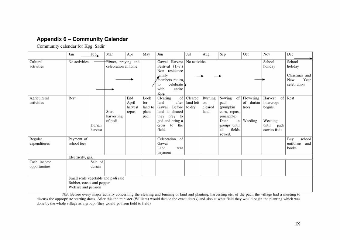
IX
Appendix 6 – Community Calendar
Community calendar for Kpg. Sadir
NB: Before every major activity concerning the clearing and burning of land and planting, harvesting etc. of the padi, the village had a meeting to discuss the appropriate starting dates. After this the minister (William) would decide the exact date(s) and also at what field they would begin the planting which was done by the whole village as a group, (they would go from field to field)
Jan Feb Mar Apr May Jun Jul Aug Sep Oct Nov Dec
Cultural activities
No activities Easter, praying and celebration at home
Gawai Harvest Festival (1.-7.) Non residence family members return to celebrate with entire Kpg.
No activities School holiday
School holiday Christmas and New Year celebration
Agricultural activities
Rest Durian harvest
Start harvesting of padi
End April harvest repus
Look for land to plant padi
Clearing of land after Gawai. Before land is cleared they prey to god and bring a cross to the field.
Cleared land left to dry
Burning on cleared land
Sowing of padi (pumpkin corn, repus, pineapple). Done in groups until all fields sowed.
Flowering of durian trees Weeding
Harvest of intercrops begins. Weeding until padi carries fruit
Rest
Payment of school fees
Celebration of Gawai Land rent payment
Buy school uniforms and books
Regular expenditures
Electricity, gas, Sale of
durian Cash income
opportunities
Small scale vegetable and padi sale Rubber, cocoa and pepper Welfare and pension

X
Appendix 6 – Community time line
BEASAR KG. SADIR, PADAWAN
“Awar mura Kg. Sadir ati ayuh manug so Bung Mitakuh, nga Bung Sinngi, Anah Raih. Jadi soti inu asar Sadir ati manug. Jadi ripas anu, so purug nyamba nyamba muh ngitong adup. Jadi ho munu ngara so kapung ati ayuh maad ka Tibawang Sidos. Jadi nyamba muh ruu di Tibawang. Kira-kira muh ratus sawa-i guh, ati ayuh kinyam adup-i uh bo kabus. Bada tibaro, ayuh muh bu maad Kg. Bung Simuti. So ti tu meh nyamba nyamba muh nang itong-i. Nah pungun di Kg. Sadir ati.” (Headman Kg. Sadir, 2006)
HISTORY OF KG. SADIR
Year Important events
200 years ago People from Mt. Mitakuh, highlands somewhere around Annah Rais moved to Tibawang Sidos. After a deadly disease, they moved to
Semuti and finally settled down in Sadir. They start to build longhouses before the World War One.
1941-1942 Japanese occupation during the World War Two. The
Japanese soldiers live in on of the longhouses. They start to collect “Head tax”. Any villagers who did not pay tax would be jailed. The villagers pay their tax with rice.
1943 The British came back to Sarawak. They establish a
district council in Bau. Kg. Sadir was one of the
Mt. Mitakuh
Tibawang Sidas
Semuti
Sadir
The origin of Kg. Sadir
Many had died because of cholera
- built longhouse - destroyed by fire - lose everything in the longhouse
Villagers start to build houses in Sadir about 200 years ago.
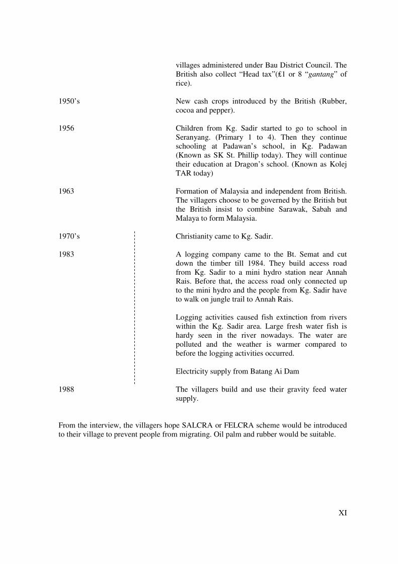
XI
villages administered under Bau District Council. The British also collect “Head tax”(₤1 or 8 “gantang” of rice).
1950’s New cash crops introduced by the British (Rubber,
cocoa and pepper). 1956 Children from Kg. Sadir started to go to school in
Seranyang. (Primary 1 to 4). Then they continue schooling at Padawan’s school, in Kg. Padawan (Known as SK St. Phillip today). They will continue their education at Dragon’s school. (Known as Kolej TAR today)
1963 Formation of Malaysia and independent from British.
The villagers choose to be governed by the British but the British insist to combine Sarawak, Sabah and Malaya to form Malaysia.
1970’s Christianity came to Kg. Sadir. 1983 A logging company came to the Bt. Semat and cut
down the timber till 1984. They build access road from Kg. Sadir to a mini hydro station near Annah Rais. Before that, the access road only connected up to the mini hydro and the people from Kg. Sadir have to walk on jungle trail to Annah Rais.
Logging activities caused fish extinction from rivers
within the Kg. Sadir area. Large fresh water fish is hardy seen in the river nowadays. The water are polluted and the weather is warmer compared to before the logging activities occurred.
Electricity supply from Batang Ai Dam 1988 The villagers build and use their gravity feed water
supply. From the interview, the villagers hope SALCRA or FELCRA scheme would be introduced to their village to prevent people from migrating. Oil palm and rubber would be suitable.

XII
Appendix 7 – Tourist attraction assessment
Sauh water fall
Location: N 01 06.778 S 110 16.087 Overview: Sauh Water fall is located approximately 20 minutes walk from Sadir village. The path leading to the waterfall is moderately steep through a variety of old farmland. The access to the waterfall arrives at the top via the small stream feeding the water. Access to the first pool requires descending a steep unsecured slope to reach the first plunge pool. The first step of the waterfall is approximately 10m and the pool is 7 X 8 m and about 2.5 m deep. The water spills over an escarpment and drops another 10 m to a second pool. There is a rock overhang creating a cave behind the second waterfall. The second pool is 5 X 6 m and has a pool that is 2.5 m deep. There is a third drop of about 5-7 m until the stream that leads away from the waterfall. Type of Attraction: Natural / waterfall Current Visitation The people of Sadir are the main visitors and the waterfall serves as a local recreation site. SWOT Analysis
� Strengths -waterfall is only 15 minutes from the main road (20 minutes from Kpg Sadir) -Beautiful setting and clean water -Scenic surroundings -Can accommodate 10 people or more
� Weaknesses -no infrastructure -difficult access both by car to beginning of trail and then by foot to waterfall -Slope down to waterfall is unsecured and difficult to descend -No sitting area -Garbage
� Opportunities -Promote in Annah Rais as an optional activity for visitors -Develop simple access and steps down to the waterfall

XIII
-Entrance gate at Sauh village, with funds going towards paying wages of a maintenance and clean-up crew -Establish simple seating areas around the main plunge pools
� Threats -Extensive farming disrupts the area. -Road access does not improve
Attraction Name: Ban Buan Kukuot
Location: N 01 06.954 S 110 15.254 Overview: BBK waterfall is approximately one-hour walk from Kampung Sadir. The trail is moderate to steep following ridgelines through a variety of old farmland. Much of the trail is exposed, thus walking during the mid-day can be very hot. The waterfall is over 30 m high with the last drop being the longest at about 20m. The upper parts of the waterfall have 4 different steps, but there is no easy access to the upper parts of the waterfall. There is another trail that probably leads to the upper parts of the waterfall, but this was not fully explored. At the base of the waterfall is a 10 X 14 m pool. There is easy access to the pool as the trail passes through a small farm, ending at the waterfall. The pool is generally shallow and is only 1.5 m deep at the deepest part. The pool is exposed with little shade. There are boulders surrounding the pool, but few flat areas providing seating. The surrounding area is rocky with open vegetation consisting mainly of tree ferns and some bamboo. The farm adjacent to the waterfall is a mix of pepper, new cocoa, ground nuts and durian trees of various ages. Some algal growth in the pool near the end of the trail could be indicative of additional nutrients resulting from either washing or additional fertiliser inputs. Type of Attraction: Natural / waterfall Current Visitation: Very low visitation. SWOT Analysis
� Strengths -The tallest waterfall in the area -Striking scenery and impressive formation
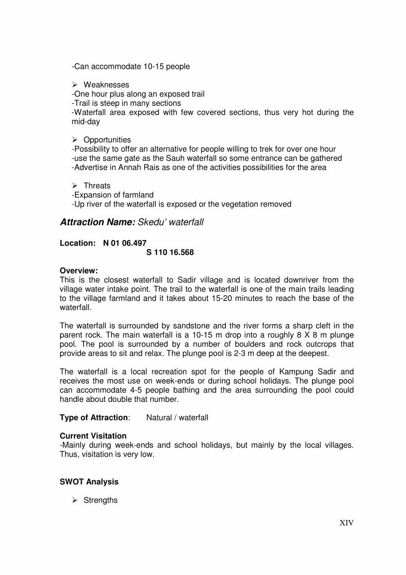
XIV
-Can accommodate 10-15 people
� Weaknesses -One hour plus along an exposed trail -Trail is steep in many sections -Waterfall area exposed with few covered sections, thus very hot during the mid-day
� Opportunities -Possibility to offer an alternative for people willing to trek for over one hour -use the same gate as the Sauh waterfall so some entrance can be gathered -Advertise in Annah Rais as one of the activities possibilities for the area
� Threats -Expansion of farmland -Up river of the waterfall is exposed or the vegetation removed
Attraction Name: Skedu’ waterfall
Location: N 01 06.497 S 110 16.568 Overview: This is the closest waterfall to Sadir village and is located downriver from the village water intake point. The trail to the waterfall is one of the main trails leading to the village farmland and it takes about 15-20 minutes to reach the base of the waterfall. The waterfall is surrounded by sandstone and the river forms a sharp cleft in the parent rock. The main waterfall is a 10-15 m drop into a roughly 8 X 8 m plunge pool. The pool is surrounded by a number of boulders and rock outcrops that provide areas to sit and relax. The plunge pool is 2-3 m deep at the deepest. The waterfall is a local recreation spot for the people of Kampung Sadir and receives the most use on week-ends or during school holidays. The plunge pool can accommodate 4-5 people bathing and the area surrounding the pool could handle about double that number. Type of Attraction: Natural / waterfall Current Visitation -Mainly during week-ends and school holidays, but mainly by the local villages. Thus, visitation is very low. SWOT Analysis
� Strengths
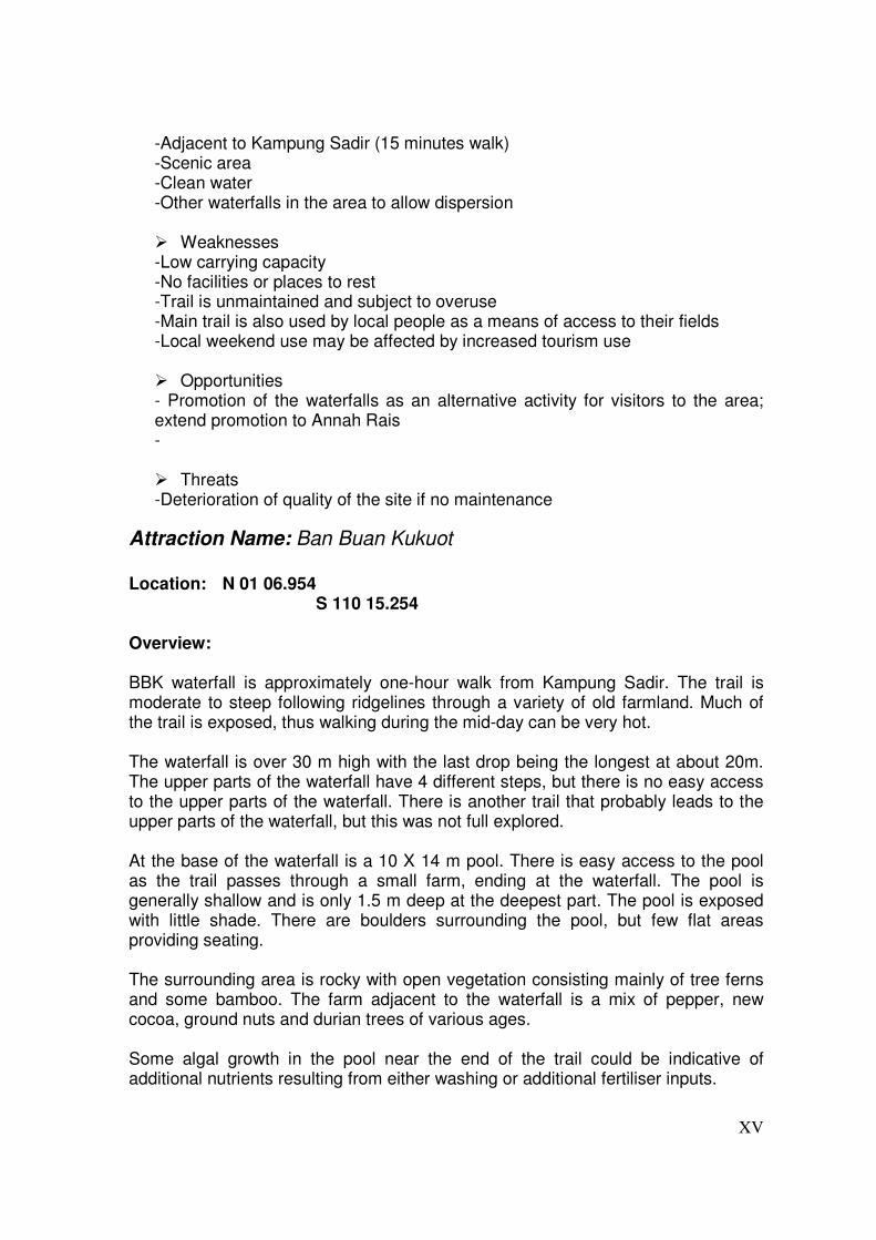
XV
-Adjacent to Kampung Sadir (15 minutes walk) -Scenic area -Clean water -Other waterfalls in the area to allow dispersion
� Weaknesses -Low carrying capacity -No facilities or places to rest -Trail is unmaintained and subject to overuse -Main trail is also used by local people as a means of access to their fields -Local weekend use may be affected by increased tourism use
� Opportunities - Promotion of the waterfalls as an alternative activity for visitors to the area; extend promotion to Annah Rais -
� Threats -Deterioration of quality of the site if no maintenance
Attraction Name: Ban Buan Kukuot
Location: N 01 06.954 S 110 15.254 Overview: BBK waterfall is approximately one-hour walk from Kampung Sadir. The trail is moderate to steep following ridgelines through a variety of old farmland. Much of the trail is exposed, thus walking during the mid-day can be very hot. The waterfall is over 30 m high with the last drop being the longest at about 20m. The upper parts of the waterfall have 4 different steps, but there is no easy access to the upper parts of the waterfall. There is another trail that probably leads to the upper parts of the waterfall, but this was not full explored. At the base of the waterfall is a 10 X 14 m pool. There is easy access to the pool as the trail passes through a small farm, ending at the waterfall. The pool is generally shallow and is only 1.5 m deep at the deepest part. The pool is exposed with little shade. There are boulders surrounding the pool, but few flat areas providing seating. The surrounding area is rocky with open vegetation consisting mainly of tree ferns and some bamboo. The farm adjacent to the waterfall is a mix of pepper, new cocoa, ground nuts and durian trees of various ages. Some algal growth in the pool near the end of the trail could be indicative of additional nutrients resulting from either washing or additional fertiliser inputs.

XVI
Type of Attraction: Natural / waterfall Current Visitation: Very low visitation. SWOT Analysis
� Strengths -The tallest waterfall in the area -Striking scenery and impressive formation -Can accommodate 10-15 people
� Weaknesses -One hour plus along an exposed trail -Trail is steep in many sections -Waterfall area exposed with few covered sections, thus very hot during the mid-day
� Opportunities -Possibility to offer an alternative for people willing to trek for over one hour -use the same gate as the Sauh waterfall so some entrance can be gathered -Advertise in Annah Rais as one of the activity possibilities for the area
� Threats -Expansion of farmland -Up river of the waterfall is exposed or the vegetation removed
Attraction Name: Annah Rais
Location: N 01 06.497 S 110 16.568 Overview: . Type of Attraction: Natural / waterfall Current Visitation Approximately 6.250 per year.
Attraction Name: Hot Springs
Location: Midways between Annah Rais and Sadir

XVII
Overview: The access to the hot springs is located midways between Annah Rais and Sadir. There are no signs to show the access, so they are not readily available. The access is via a small downtrodden path, which is easy to follow. The hot springs themselves are located within the river, where the hot water penetrates the riverbed in several locations. Some of these have been isolated into three pools by small partitions made of rocks. The pools are 40 cm at the deepest point, and quite naturally smell like sulphur. The water is lukewarm to hot, as there is some inflow of cold water from the river. On the farthest riverbed a shaded area is under construction, but the roof is still unfinished. The river must be crossed to reach the hot springs, as they are placed by the side of the river that is furthest from the road. Type of Attraction: Natural / Hot springs Current Visitation Unknown, but only a small portion of the people going to Annah Rais visit the hot spring as well. Thus the yearly number of visitors is well below 5.000.
Attraction Name: “Wallace Trail”
Location: Tebedu to Annah Rais Overview: From 1855 to 1856 the renowned naturalist, Alfred Russell Wallace, spent time in Sarawak collecting specimens for natural history collections as well as travelling in the first and second divisions. During this time, one of his trips was to travel to the source of Sadong river crossing over to the water shed of the Sarawak river. This trip took him through the Padawan area and his narrative of the trip indicated that he spent time in villages that are now known as Sadir and Annah Rais. Wallace’s fame was based on the prodigious collecting he carried out in Sarawak as well as for an essay he wrote on the theory of evolution. He forwarded his essay to another famous scientist who was also working on a similar theory. This scientist presented his findings and revolutionised scientific thinking with his report on the Origin of Species. While much of the trail from Tebedu to Annah Rais is now road, there is still a section requiring walking on foot (from Tepoi to Sebakar). Type of Attraction: Historical / Natural

XVIII
Current Visitation: -Very low SWOT Analysis
� Strengths -Historical significance and appeal -Links to other historic areas in and around Kuching -Wider appeal -Linking of village, natural history and historical appeal
� Weaknesses -Very little information or interpretation on Wallace in Kuching -Museum does not provide starting point or other information -Lack of interpretive personnel in the villages to provide continuity -Lack of information regarding the significance of Wallace
� Opportunities -Development of the Wallace trail in conjunction with the museum, and other sites with historical significance. -Day trip or multi-day possibilities -Visitor centres and information services to provide additional attractions in the villages
� Threats -no information or interpretation is provided in Kuching -The other sites are not developed to provide a starting point -The existing area is developed in a manner to eliminate the “trail”
Attraction Name: Kampong Sadir
Location: End of the road from Annah Rais Overview: Kpg. Sadir is a small Bidayuh village (64 households), which is located in the hilly area of the Padawan district, about 32 km south of Kuching. The center of the village is a traditionally built longhouse dating back to the 19xx. Like in many other rural village communities, most of the working force is employed in towns and are not always present in the village. This means that elderly and young children dominate the daily life in Kpg. Sadir. The village is located about 200 m.a.s.l., on a hill side above a smaller tributary to the Annah River that flows by Kpg. Annah Rais.

XIX
The 5 km mountain gravel and dirt road from Annah Rais, is the only connection to Kpg. Sadir, which makes access to and from the village quite difficult. The population is friendly and unassuming, and receives visitors very well. The surrounding area is beautiful and offers a range of activities, such as jungle treks and waterfall-tours. Type of Attraction: Cultural/natural Current Visitation: -Very low SWOT Analysis
� Strengths · The physical landscape and surroundings are very beautiful · Beautiful and unspoiled waterfalls · Friendly population · More “original” than Annah Rais
� Weakness · The longhouse in Sadir is not as impressive as the one in Annah Rais · Carrying capacity of attractions is low · Villagers mentality: they do not like to charge money for their services � Opportunities · Tourism in Sadir should be an extension of the tourism in Annah Rais, as tourists will have to pass through Annah Rais to get to Sadir. · Catering for backpacker tourism, more “back to nature” and remote than Annah Rais. · Visits to padi farms, rubber gardens etc. · Homestays (maybe at Michael’s place, where a certain percentage went into village fund??) · Entrance fees to either kampung or attractions · If Sadir could be promoted in Annah Rais as an extension which offers other attractions than Annah Rais it would be optimal. E.g.: see longhouse in Annah Rais, visit Hot springs, go to Sadir for accommodation, jungle treks, waterfalls, the Wallace trails.
� Threats - Exceeding carrying capacity of village and surrounding area
Conclusion If tourism is introduced to Kpg. Sadir it will still only be a supplementary income. Guiding etc. would only benefit the individual recipients, whereas entrance fees of some kind could potentially benefit the entire community through maintenance of the longhouse, welfare to families when a family member dies, prizes for kids who do well in school etc., as is presently the case in Kpg. Annah Rais

XX
Appendix 8 – Synopsis
Final Synopsis
Submitted by the group on 1st of March 2006
Developments in livelihood strategies of villagers
in Kampong Sadir, Sarawak, Malaysia
ILUNRM, spring 2006
Group members: Aske Skovmand Bosselmann, ADK05039
Kasper Vind Teilmann, LFK06001 Nina Hanne Holst, EM05080
Tran Vo Ngoc, ADK05029
Den Kongelige Veterinær og Landbohøjskole Roskilde Universitetscenter Supervisors: Andreas de Neergaard Torben Birk-Thomsen
Kuching
XXI
Table of Contents 1 Introduction...........................................................................................................................I
1.1 Background ........................................................................................................... I 1.2 Ecotourism and sustainability ..............................................................................II
2 Research question/assignment/working questions.............................................................. II 3 Methodology...................................................................................................................... III
3.1.1 Key informant ............................................................................................. III 3.1.2 The issue matrix.......................................................................................... III 3.1.3 PRA: Community history ........................................................................... III 3.1.4 PRA: Community mapping......................................................................... IV 3.1.5 PRA: Activities and income/expenditures calendar ................................... IV 3.1.6 PRA: Problem-ranking methods ................................................................. IV 3.1.7 Own observations......................................................................................... V 3.1.8 Mapping of natural resources and tourism attraction sites using GPS. ....... V 3.1.9 Soil and erosion investigation..................................................................... VI 3.1.10 Questionnaire and interviews...................................................................... VI 3.1.11 Materials ..................................................................................................... VI
4 References........................................................................................................................ VII 4.1 Articles and books .............................................................................................VII 4.2 Homepages ........................................................................................................VII
5 Appendices...................................................................................................................... VIII 5.1 Appendix A: Overview of possible issues and methods ................................. VIII 5.2 Appendix B - Assumptions/hypotheses: ............................................................. X 5.3 Appendix C – Guide for semi-structured interviews with villagers in Sadir: .... XI 5.4 Appendix E - Interview guide for Tourist manager from Kpg. Annah Rais... XIII 5.5 Appendix D - Questionnaire for tourists in Kpg. Annah Rais ..........................XV 5.6 Appendix F – Project Time schedule ................................................................XV 5.7 Appendix G – Village history and timeline ...................................................XVII
9

I
10 Introduction
Background
The field study will take place in the Sarawak province of Borneo-based Malaysia in South East Asia. Farming traditionally has been and still is one of the main sources of income and occupation in Sarawak, but a diversification of livelihood strategies into non-farm activities is occurring (Hansen and Mertz, 2003). Our case study will be carried out in a small village called Kpg. Sadir, which is located in the hilly area of the Padawan district, about 32 km south of the administrative capital of Sarawak, Kuching. Kpg. Sadir is inhabited by a group of Bidayuh people, who left the larger neighbouring village of Kpg. Annah Rais around 70 years ago. The village is located about 1000 m.a.s.l., on a hill side above a smaller tributary to the Annah River that flows by Kpg. Annah Rais. It is surrounded by three smaller communities that also originate from Annah Rais. The only access with a vehicle to the village is via a 4 km mountain gravel and dirt road from Annah Rais, which makes transportation of agricultural products to the nearest market difficult. Besides the difficult transportation of goods, a poor soil makes it hard to make cash cropping economical viable and most of the farming that is taking place is for subsistence use. The agricultural activities are mainly comprised of cultivation of upland hill rice, which is the staple food of the village, and agroforestry practices, which are taking place on land, classified as ‘non-agricultural’ land. The land is classified as such due to a very shallow and sandy soil that, combined with a steep terrain, makes it prone to erosion. The fact that the surrounding forests were completely logged in the 1980’s does not make the situation better. Like in many other rural village communities, most of the working force is employed in towns and are not always present in the village. This means that elderly and young children dominate the daily life in Kpg. Sadir. Some of the villagers, who work on the rice fields, have to rent land from residents in Kpg. Annah Rais, because of shortage of suitable agricultural land in Kpg. Sadir. The livelihood strategies of the Bidayuh people from Kpg. Sadir are mainly based on off-farm labour, some cash crop farming and subsistence farming of hill rice and agroforestry products. However, due to the unique setting of the village in the hilly regions of the Padawan area, there is a potential for ecotourism in the area, which could create a significant supplementary income for the villagers. Ecotourism already exist in Kpg. Annah Rais, where tourists come to bath in nearby hot springs, trek in the green hilly surroundings and visit the Annah Rais longhouse, which has become known as the largest intact

II
longhouse on Borneo. With a determined effort and support from tourist developers there is a similar prospect for ecotourism in Kpg. Sadir as presently exist in Kpg. Annah Rais. In terms of land tenure, it is claimed that only 30% of the villagers actually have their own land. This land is native customary rights (NCR) land and villagers do not have individual document of title to this land. Thus, under the land code, their rights to this land are not registered. The implication of this is that the land cannot be used as collateral for loans.
Ecotourism and sustainability
Tourism has for many years been promoted as a non-destructive industry well-suited for actively developing Third World countries as it has a quick turn-over rate, and has been seen as a panacea for many developing countries (Hardy, Beeton & Pearson, 2002:485). The tourism industry is dependent on the protection and conservation of the environment for reasons of long-term sustainability, both economic and ecological. However short term goals of quick profits and minimal expenditures, often receives the higher priority. For many remote areas with beautiful natural scenery, such as Kpg. Sadir, ecotourism can be a good way to develop the area and generate income for the local population though it requires planning and management to be sustainable. However, while the ideology of ecotourism is conservationist and protective of nature, it often takes place in particularly vulnerable areas, and is particularly dependent on the destinations only receiving a very limited number of tourists and very well-managed use of resources and waste-handling and –treatment if detrimental effects on the environment is to be avoided (Shaw & Williams, 2002: 299-300).
11 Research question/assignment/working questions
The objective of this project is to investigate the livelihood strategies of the Bidayuh people living in Kpg. Sadir in relation to the poor agricultural soil and the potential introduction of ecotourism in the area. This is done through the following research question and related sub questions. How will the current livelihood strategies of the inhabitants in Kpg. Sadir be affected
by the possible introduction of ecotourism?
Sub questions:
• What is the predominant livelihood strategy in the village today? • What difficulties exist in the current agricultural and agroforestry practices and can
they be improved? • What is the ecotourism potential for the area? • What kind of development will be required to establish ecotourism? • Which impacts will ecotourism have on the natural and physical environment?

III
• Which impacts will ecotourism have on the social and cultural environment of the community?
• What implications does the land tenure cause for the villagers in the kampong? See appendix C for assumptions and hypotheses related to the research questions.
12 Methodology
This section describes the different methods we will use to obtain the relevant data needed to answer the two research questions. Each subsection explains one or two methods that can be used to answer one or more of the sub questions posed under the research questions. Obviously we will not be able to use all the methodologies in the limited time we have available. A final decision on what methodologies we will use will be taken in corporation with the Malaysian group, when we have arrived in Malaysia and more is known about Kpg. Sadir and what our final angle will be. The methods are shortly described below along with an explanation of how we plan to carry them out. Further and more specific details on each method can be found in the appendices.
Key informant
One of the first things we plan to do when we arrive in Kpg. Sadir is to see the headman and ask him to point out whom he thinks would be a good key informant for our work in Kpg. Sadir. The key informant will be our contact to the rest of the villagers and should, where appropriate, point out resource persons for our interviews, PRA’s and mapping of natural resources and tourist attractions. Furthermore the key informant will be an intermediary between us and the villagers and an aid in ‘breaking the ice’. Although, we know that information from the key informants will not always correspond with the data collected from the investigations in the village, it is still important information when we first arrive in the village as it helps us to establish an overview of the village in the past, present and perspectives to improve livelihoods in the future.
The issue matrix
In appendix 5.1 an issue matrix is found. This matrix gives an overview of issues we wish to investigate, data we need to collect and methods to collect these data when we are going to Kpg. Sadir. It also worked, for us as a method to make a brain storm and provides an overview and starting point for our synopsis.
PRA: Community history
When investigating a community, a good starting point is to get familiar with the historical background of the community in general. We will try to gather the informants in one meeting and let them formulate their history together, with members of both the elderly and the young population of Kpg. Sadir present. This way we hope to get an impression of

IV
various issues and their impacts on the community. In relation to the research questions the issues we want to investigate are: past and present agricultural and agroforestry use, land use changes, population development (population growth/decline), politics (local), tenure ship, livelihood changes (strategies), and involvement in tourism activities in Kpg. Annah Rais. See appendix 5.7 for a more detailed guide to the method.
PRA: Community mapping
In this exercise, the informants will be asked to draw a map of their village and the upland. The map should contain existing resources, boundaries of the community and physical elements such as relief, important buildings, holy places and possible future tourist attractions/sites, titled land etc. The informants are also asked to identify areas where they have specific problems i.e. with water, erosion and possibly any illegal use of resources due to legislative decisions. The informants will be provided with a big sheet of paper where main elements such as roads and watercourses are already outlined. The produced map from this exercise can be used to analyze where the villagers see any constraint/problems or opportunities, both regarding ecotourism and their agricultural practices. This information can then be used in our further investigation of the community, and it is therefore planned to be conducted in the beginning of our stay.
PRA: Activities and income/expenditures calendar
In order to get an overview of the villager’s livelihoods we will obtain information about the income generating activities as well as main expenditures during the year through the use of different calendars. Because the agricultural activities and tourism-related employment in Kpg. Annah Rais are directly related to some of the larger incomes and expenditures as well as major festivities during the year, we will aim at producing three calendars. One that show the agricultural activities, e.g. weeding and harvesting; one that show the income and expenditure related activities, e.g. school fees, off-farm labour (tourism-related employment/sales); and one that show other important activities during the year; e.g. migration, religious holidays, occurrence of diseases etc. The calendars will be made with a selected group of people from the village and, if possible, during one session, as this will save us some time. When one group has made the first calendar it will be easier and faster to make the second as they already know the procedure. Women and men will be asked to participate in the making of the calendars, in order to disaggregate the gender related activities. If the village is divided into distinct social classes, there is an incentive to divide the group according to these in order to clarify differences in dependence on various activities.
PRA: Problem-ranking methods
We have been informed that a poor soil in Kpg. Sadir makes agricultural activities difficult, and that the remoteness is a restraint on income generating activities, but that ecotourism
V
might be a possibility. However, to see if this understanding corresponds with the villagers own perception of their situation or if they focus on other issues we plan to do a problem/opportunity ranking exercise. This will give us an idea of the problems, constraints and possibilities that exist in the village as perceived by the villagers. By asking the villagers to choose the issues instead of us suggesting them, we avoid dealing with problems or possibilities that doesn’t exist or doesn’t seem important to the villagers. The exercise is divided into two parts. First a group of selected people will be asked to mention what they perceive to be the main problems related to a specific problem area; e.g. lack of development, low agricultural yields etc. Thereafter, the problems are ranked, either by a simple card method, where each person prioritize three problems, or by any other method that will be suitable in the situation. Ideally the approach should make us able to distinguish problems prioritized by women and men respectively, so as to determine gendered differences in opinion. After the problem ranking we have the possibility to proceed by asking the participants what they think are possible solutions to the problem (e.g. do they themselves consider ecotourism a solution?). This may help us focus on issues that we haven’t thought off yet. As in other parts of our project work it is important that it is clear for the participants that we are not able to implement the suggested solutions, in order not to Raise false expectations.
Own observations
After conducting the community history and mapping exercise we can now conduct more precise estimates of where to make some more thorough investigations. The following sections deal with the observations and sample collection we will do in the field.
Mapping of natural resources and tourism attraction sites using GPS.
With the use of GPS we will map the natural resources, areas of community and different agricultural/agroforestry fields in one exercise and in another map the possible tourist sites, such as viewpoints, trekking routes etc. This method will be conducted together with people from the community where we will ask them around the community and to show us the most important places. The same exercise can be conducted with both men and woman if it turns out that gender is an issue. As a follow up on the community mapping we will go to the places mapped by the community and check whether the sizes and distances to and from these mapped places are the same proportions in real life (in situ). If the community mapped places does not fit with in situ this can be interpreted as an expression of either this particularly area is very important to the community or the opposite.
VI
Soil and erosion investigation
With information provided from the community history and mapping processes we will take soil samples from potentially problematic sites. With use of various analyzing kits the soil samples are tested for N content, pH, conductivity and C content. This will give us an idea of the soil fertility and the potential for agricultural purpose. Depending on the problems we discover during our stay in the village we will do different soil investigations. Erosion is a big problem in the area, presently related to agriculture, but if ecotourism is established and many tourists visit the area, this can have an even more dramatic effect on the erosion risk. We can estimate the soil loss in different areas with the Universal Soil Loss Equation (USLE).
Questionnaire and interviews
In the matrix in appendix A it can be seen that we will use questionnaire and interviews to examine various factors related to our research question. Questionnaires will be used in the nearby Kpg. Annah Rais, where tourism has been a major source of income for some years, to investigate what attracts the tourist, and what characterizes their stay in the village. In Annah Rais we plan to make a semi-structured interview with the tourist manager in the kampong. This will hopefully ensure us some valuable information about the tourist situation in Annah Rais, which could be applied in kpg. Sadir. If possible we want to make a similar interview with a representative from Sarawak Ministry of Tourism in Kuching. With use of semi-structured interviews in Kpg. Sadir we will examine the livelihood strategies of the villagers and their view on ecotourism. In appendix C an interview guide is developed. The informants in Kpg. Sadir will be chosen from a stratified selection method where the groups we wish to distinguish are income (high, middle, low income) and age (high, middle, low age). Furthermore we will try to get as many women as men to answer the questionnaires. This stratification method will ensure us to get information from a very broad part of the villagers in Kpg. Sadir. We plan to do approximately 10 interviews, as we think this is the most realistic number we can do, while still being sure of the quality of the interviews and not ending up with an overflow of information.
Materials
Big sheet of paper, pens in various colours GPS Digital camera Compass Laptop Soil sample analyzing kit
VII
13 References
Articles and books
Christensen, Hanne (2002): Ethnobotany of the Iban and Kelabit. University of Århus. Hong, E. (1987): Natives of Sarawak – survival in Borneo’s Vanishing Forest. Institute
Masyarakat Mertz, O. et al (2003): Productivity crisis in shifting cultivation systems? Impacts of fallow,
labour, nutrient management and governmental policies. In: Local Land Use Strategies
in a Globalizing World: Shaping Sustainable Social ad natural Environments. Eds: O. Mertz, R. Wadley & A. E. Christensen. Institute of Geography, University of Copenhagen, pp. 1 – 23
Ngidang, D. (2005); Deconstruction and Reconstruction of Native Customary Land Tenure
in Sarawak, in Southeast Asian Studies, Vol. 43, No.1, June Selener, D., N. Endara & J. Carvajal (1999): Participatory Rural AppRaisal and Planning.
International Institute of Rural Reconstruction. Shaw, G. & A. M. Williams (2002), Critical issues in Tourism – A Geographical
Perspective, Blackwell Publishers Ltd., UK & USA Hardy, A., R. J.S. Beeton & L. Pearson (2002): Sustainable Tourism: An Overview of the
Concept and its Position in Relation to Conceptualisms of Tourism. Journal of Sustainable Tourism, vol. 10, No.6
World Tourism Organization (1998), Guide for local authorities on developing sustainable
tourism, WTO Publications, Madrid Yaman, R. A. and Mohd, A. (2004): Community-based Ecotourism: A New Proposition for
Sustainable Development and Environmental Conservation in Malaysia. Journal of Applied Sciences 4 (4): 583-589,
Homepages
State government of Sarawak: http://www.sarawak.gov.my/ British Foreign Ministry - Country profile of Malaysia: http://www.fco.gov.uk/servlet/Front?pagename=OpenMarket/Xcelerate/ShowPage&c=Page&cid=1007029394365&a=KCountryProfile&aid=1018965335747 CIA World Factbook: http://www.cia.gov/cia/publications/factbook/geos/my.html Lonely Planet: www.lonelyplanet.com/malaysia
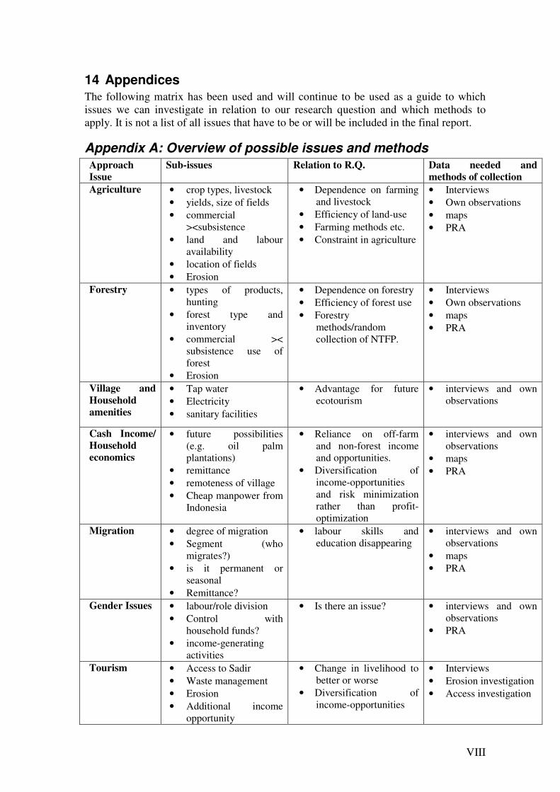
VIII
14 Appendices
The following matrix has been used and will continue to be used as a guide to which issues we can investigate in relation to our research question and which methods to apply. It is not a list of all issues that have to be or will be included in the final report.
Appendix A: Overview of possible issues and methods
Approach
Issue
Sub-issues Relation to R.Q. Data needed and
methods of collection
Agriculture • crop types, livestock • yields, size of fields • commercial
><subsistence • land and labour
availability • location of fields • Erosion
• Dependence on farming and livestock
• Efficiency of land-use • Farming methods etc. • Constraint in agriculture
• Interviews • Own observations • maps • PRA
Forestry • types of products, hunting
• forest type and inventory
• commercial >< subsistence use of forest
• Erosion
• Dependence on forestry • Efficiency of forest use • Forestry
methods/random collection of NTFP.
• Interviews • Own observations • maps • PRA
Village and
Household
amenities
• Tap water • Electricity • sanitary facilities
• Advantage for future ecotourism
• interviews and own observations
Cash Income/
Household
economics
• future possibilities (e.g. oil palm plantations)
• remittance • remoteness of village • Cheap manpower from
Indonesia
• Reliance on off-farm and non-forest income and opportunities.
• Diversification of income-opportunities and risk minimization rather than profit-optimization
• interviews and own observations
• maps • PRA
Migration • degree of migration • Segment (who
migrates?) • is it permanent or
seasonal • Remittance?
• labour skills and education disappearing
• interviews and own observations
• maps • PRA
Gender Issues • labour/role division • Control with
household funds? • income-generating
activities
• Is there an issue? • interviews and own observations
• PRA
Tourism • Access to Sadir • Waste management • Erosion • Additional income
opportunity
• Change in livelihood to better or worse
• Diversification of income-opportunities
• Interviews • Erosion investigation • Access investigation

IX
Land tenure • tenure rights • customary (adapt)
versus legal tenure
• Lack of incentives • feelings of exclusion
from development • importance of land titles • Conflicts between adapt
and legal tenure system (inheritance etc.)
• interviews and own observations
• maps • PRA • Laws (customary and
legal) • Land titles

X
Appendix B - Assumptions/hypotheses:
- The main sources of income and food are hill rice cultivation, agroforestry practices and income from off-farm labour and some cash crops.
- Erosion, poor soil conditions, lack of land located near the village and remote markets are the main constraints and weaknesses.
- The agricultural situation can be improved either by expansion; further renting of land on neighbouring areas, as there is no new land to be opened, by intensification; more inputs, or by improved agroforestry practices to enhance soil fertility and diversify production
- If agroforestry practices are improved or intensified in order to enhance the soil quality and deliver products for sale or own consumption, the reliance on town work and rented land can be reduced.
- Kpg. Sadir is more remotely located than Kpg. Annah Rais and can offer closer-to-the-real-culture ecotourism. This can be used in the present to attract tourists, who want off the track experiences, and in the future to attract a broader audience, when Annah Rais has become ‘overcrowded’.
- If Kpg. Sadir wants to establish ecotourism, then better infrastructure is needed, as well as institutional change at village level, contact to tourist agencies in Kuching and training in tourist management. Tourist developers can provide help.
- Experiences from the impacts of ecotourism on the surrounding area of Annah Rais will indicate what kind of impacts can be expected in Sadir. With appropriate planning the negative impacts can be reduced.
- If Kpg. Sadir try to establish ecotourism in the area, it can result in one of two impacts on the cultural identity of the villagers; it will either increase their cultural identity as their culture can become an important part of the tourist site and they feel proud to present and teach outsiders about their culture; or a large number of tourist predominantly interested in nature will bring a more developed world into the village, the young villagers will feel ashamed of their ‘old fashioned’ culture, which will lead to greater migration away from the area.

XI
Appendix C – Guide for semi-structured interviews with
villagers in Sadir:
GPS location ________ _________ Date______ Presentation of interviewer, explanation of project and the objective of the interview, and how it will be carried out. Name: ____________________ Sex: _______ 17. How many people lives in your door/bilek: _____________ Number of children:
______ Age Occupation: You: Spouse: 18. Main source of income: Farming: Forestry: Hunting: Gathering: Off-farm: What kind of work:____________ Where:_____________________
Handicrafts:
19. Where is your land located? (Draw on a map, remember size, e.g. ha.): 20. How much land do you have in total?: ___________________ How much land do
you own and how much do you rent?: _________________________ 21. What is the status of your land (NCR, title, application pending)?:
________________ 22. How long time does it take to go there?: _________________ 23. What are your main crops? Crops Ha Yield (Kg or bags pr crop season) Wet Rice: Hill Rice:
Maize: Beans: Other agri-crops:
24. How many crop seasons pr year? ____________________

XII
25. What kind of inputs do you use?
Fertilizer: Organic: _________ Chemical: _________ Pesticides: _____________ What kind?: ____________
26. Do you practice agroforestry and how?
27. What are the main products: crops/fodder/services?:
__________________________
______________________________________________________________________ 28. How much of your agroforestry and/or agricultural practices are for subsistence /
commercial use? 29. What are the major constraints in your agricultural practice? Erosion: Irrigation: Terrain: Inadequate tools: Poor soils: Distance to plots: Other: 30. How do you manage these constraints? ________________________________________________________________________________________________________________________________________________ 31. Do you collect NTFP in the forest?
What kind of products: _________________________________________ _______________________________________________________________
32. Do you think there is a potential for ecotourism in Kpg. Sadir and the surrounding
areas? 33. Would you like ecotourism to be introduced in Kpg. Sadir? _______________________________________________________________________ _______________________________________________________________________ 34. Would you like to work with tourists? _______________________________________________________________________ _______________________________________________________________________ 35. How do you think you can benefit from tourism? _______________________________________________________________________ _______________________________________________________________________

XIII
Appendix E - Interview guide for Tourist manager from Kpg. Annah Rais
This interview guide can also be used, in a modified version, for an interview with a representative from Sarawak Ministry of Tourism. Presentation of interviewer, explanation of project and the objective of the interview, and how it will be carried out.
1. Personals: a. Name: b. Position: c. Age: d. Years in village: e. Member of committees:
2. What is your role in the ecotourism business?
a. How long have you been working with tourism? b. What do you actually do?
3. How did the ecotourism start?
a. Did it require new roads? b. New committees in the village, e.g. a tourist committee? c. What kind of constraints to development of the ecotourism did you
experience in the beginning, if any? d. Did you get any help from NGOs or governmental agencies? e. Do you receive any support now?
4. How does it work?
a. Are there any agencies in Kuching representing the village? b. Do the tourist stay overnight in the village? c. What kind of tourist attractions do you have?
i. Caves? ii. Viewpoints?
iii. Fauna? iv. Flora? v. Cultural attractions?
d. Where do the tourists come from? i. Foreign as well as Malaysian?
e. How do you promote ecotourism? f. Are there any strategies to further develop ecotourism in the region?
5. How important are the tourist for the village?
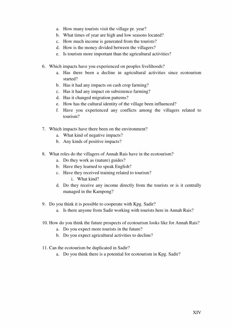
XIV
a. How many tourists visit the village pr. year? b. What times of year are high and low seasons located? c. How much income is generated from the tourists? d. How is the money divided between the villagers? e. Is tourism more important than the agricultural activities?
6. Which impacts have you experienced on peoples livelihoods?
a. Has there been a decline in agricultural activities since ecotourism started?
b. Has it had any impacts on cash crop farming? c. Has it had any impact on subsistence farming? d. Has it changed migration patterns? e. How has the cultural identity of the village been influenced? f. Have you experienced any conflicts among the villagers related to
tourism?
7. Which impacts have there been on the environment? a. What kind of negative impacts? b. Any kinds of positive impacts?
8. What roles do the villagers of Annah Rais have in the ecotourism?
a. Do they work as (nature) guides? b. Have they learned to speak English? c. Have they received training related to tourism?
i. What kind? d. Do they receive any income directly from the tourists or is it centrally
managed in the Kampong?
9. Do you think it is possible to cooperate with Kpg. Sadir? a. Is there anyone from Sadir working with tourists here in Annah Rais?
10. How do you think the future prospects of ecotourism looks like for Annah Rais?
a. Do you expect more tourists in the future? b. Do you expect agricultural activities to decline?
11. Can the ecotourism be duplicated in Sadir?
a. Do you think there is a potential for ecotourism in Kpg. Sadir?

XV
Appendix D - Questionnaire for tourists in Kpg. Annah Rais
1. Personal details - Name: - Age: - Occupation:
2. How did you learn about Kpg. Annah Rais? - internet - brochure’s - friends/relatives - other, what:
3. How long are you planning to stay? - Just today - 1 night - 2 nights - more
4. What activities do you plan to undertake while you are here? - trekking - visit hot springs - see traditional long house - other, what:
5. Is this the sole destination of your travel/holiday or part of a larger tour? - yes - no 6. What were the main reasons (attractions) why you chose to visit Kpg. Annah Rais? - trekking - beautiful scenery - hot springs - traditional long house, cultural activities - friendly people - other, what:
7. What has been the best part of your visit here? Explain: 8. What could be improved to make the experience better? Explain: Thank you for helping☺
Appendix F – Project Time schedule
Date Planned activities Actual activities and work

XVI
division
4th of March Arrival in Kuching 5th of March Danish and Malaysian
students intro meeting in Kuching.
6h of March Transport to Padawan area, 7th of March Meeting with counterpart +
methodology preparation
8th of March Presentation of common research project Community meeting
9th of March Community history and mapping
10th of March Interviews with Village Headman and residents
11th of March GPS mapping of agriculture 12th of March Interviews with Tourist
Manager, Kmp. Annah Rais and questionnaires for tourists
13th of March GPS mapping of tourist attractions
14th of March Follow up interviews and gawai
15th of March Soil and erosion investigation 16th of March Gawai and analysis of data 17th of March Debriefing and presentation of
results
18th of March Transport to Kuching, Farewell party
19th of March End of field course Note: different activities are assigned to different group members, so multiple activities can be undertaken in a
day.
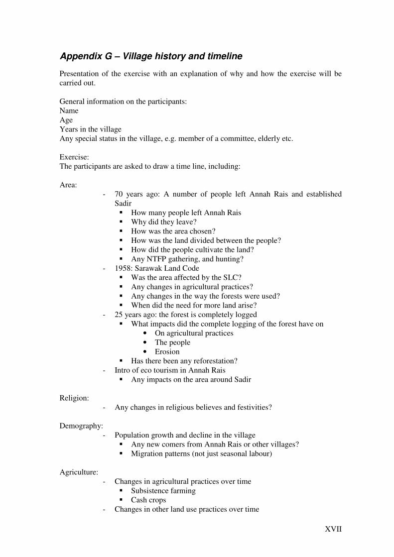
XVII
Appendix G – Village history and timeline
Presentation of the exercise with an explanation of why and how the exercise will be carried out. General information on the participants: Name Age Years in the village Any special status in the village, e.g. member of a committee, elderly etc. Exercise: The participants are asked to draw a time line, including: Area:
- 70 years ago: A number of people left Annah Rais and established Sadir � How many people left Annah Rais � Why did they leave? � How was the area chosen? � How was the land divided between the people? � How did the people cultivate the land? � Any NTFP gathering, and hunting?
- 1958: Sarawak Land Code � Was the area affected by the SLC? � Any changes in agricultural practices? � Any changes in the way the forests were used? � When did the need for more land arise?
- 25 years ago: the forest is completely logged � What impacts did the complete logging of the forest have on
• On agricultural practices • The people • Erosion
� Has there been any reforestation? - Intro of eco tourism in Annah Rais
� Any impacts on the area around Sadir Religion:
- Any changes in religious believes and festivities? Demography:
- Population growth and decline in the village � Any new comers from Annah Rais or other villages? � Migration patterns (not just seasonal labour)
Agriculture:
- Changes in agricultural practices over time � Subsistence farming � Cash crops
- Changes in other land use practices over time
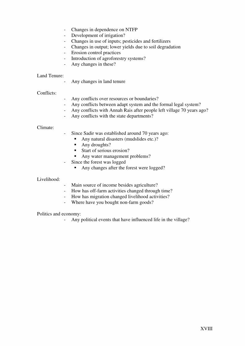
XVIII
- Changes in dependence on NTFP - Development of irrigation? - Changes in use of inputs; pesticides and fertilizers - Changes in output; lower yields due to soil degradation - Erosion control practices - Introduction of agroforestry systems? - Any changes in these?
Land Tenure:
- Any changes in land tenure Conflicts:
- Any conflicts over resources or boundaries? - Any conflicts between adapt system and the formal legal system? - Any conflicts with Annah Rais after people left village 70 years ago? - Any conflicts with the state departments?
Climate:
- Since Sadir was established around 70 years ago: � Any natural disasters (mudslides etc.)? � Any droughts? � Start of serious erosion? � Any water management problems?
- Since the forest was logged � Any changes after the forest were logged?
Livelihood:
- Main source of income besides agriculture? - How has off-farm activities changed through time? - How has migration changed livelihood activities? - Where have you bought non-farm goods?
Politics and economy:
- Any political events that have influenced life in the village?

XIX
Appendix 9 – Logbooks Kasper Teilmann, LFK6001
Day Date Day-time Evening
Sun 05 Field trip briefing in Kuching and
meeting with Malaysian counterparts.
Mon 06 Preliminary study and discussion of
project proposal. Participation in rice
stomping
Interview with headman. Discussion of
project proposal.
Tue 07 Finishing the interview guide for
household survey.
Testing interview guide
Problem ranking exercise
Wed 08 Presentation of project proposal,
group discussion of project and
survey questionnaire
Danish dinner. And project discussions.
Thu 09 Visited the school, and got a map of
Kpg. Sadir. Visit at the broken hydro
power station and the dam
Visit at the water supply pool. Preparing the
map for household survey. Party in the night
with MP and supervisors.
Fri 10 Field visit with rice harvest, soil
sampling, and GPS measurement.
Waterfall assessment.
Two interviews for the household survey.
Sat 11 Five interviews for the household
survey
Community calendar part one. Transcription
of interviews.
Sun 12 Church ceremony. Interview with
chairman of the tourism committee
in Annah Rais.
Soil observation guided by Dr. Wan
Sulaiman. Two interviews for the household
survey
Mon 13 Shopping, postcard writing and
phone calls in Seventh Mile.
Arranging a meeting with a pagan
farmer or the next day.
Struggling with GPS, georeferring, photo of
satellite images
Tue 14 Left together with the pagan farmer
to visit his field. Preparation for
community calendar part two.
Additional interview with the visited farmer.
Mapping of visited fields.
Wed 15 Sketch plan of Kpg. Sadir domain
and transcription of interviews
Interview with the youth. Community
mapping.
Thu 16 Typing and preliminary data analysis. Party at MP James Dawos house.
Fri 17 Analysis of data and preparation of
final presentation.
Analysis of data and preparation of final
presentation.
Sat 18 Final presentation. Farewell dinner/party with villagers in Sadir.
Sun 19 Convalescence… Farewell dinner/party with Malaysian
counterparts.
Vo Ngoc Tran
Day Date Day-time Evening-time
Sun 05 Field trip briefing in Kuching and
meeting Malaysian students.
Mon 06 Preliminary study and discussion of
project proposal. Participation in
stomping rice.
Semi- structure interview with headman.
Discussion of project proposal.
Tue 07 Presentation of project proposal,
group discussion of project and
survey questionnaire.
Problem ranking exercise.
Wed 08 Presentation of project proposal,
group discussion of project and
observation survey.
Danish dinner. And project discussions.
Thu 09 Transecting walk to find out
waterfalls, GPS measurement. Visit
at the broken hydro power station
and the dam
Visit at the water supply pool. Party in the
night with MP and supervisors.
Fri 10 Field visit with rice harvest, soil
sampling, and GPS measurement.
Interview for the resident in Annah Rais.
XX
Sat 11 Five interviews for the household
survey
Community calendar part one. Transcription
of interviews.
Sun 12 Church ceremony. Interview with
chairman of the tourism committee
in Annah Rais.
Soil observation guided by Dr. Wan
Sulaiman. Transcription of interviews.
Mon 13 Shopping, postcard writing and
phone calls in Vietnam. Arranging a
meeting with a pagan farmer or the
next day.
Transcription of interviews
Tue 14 Left together with the pagan farmer
to visit his field.
Transcription of interviews
Wed 15 Typing and preliminary data
analysis.
Interview with the youth. Community
mapping.
Thu 16 Typing and preliminary data analysis. Party at MP James Dawos house.
Fri 17 Analysis of data and preparation of
final presentation.
Analysis of data and preparation of final
presentation.
Sat 18 Final presentation. Farewell dinner/party with villagers in Sadir.
Sun 19 Convalescence… Farewell dinner/party with Malaysia
counterparts.
Nina Holst, em05080
Day Date
Day-time
Late afternoon/Evening
Sat 05 Arrival at Telang Usang
Sun 05 Briefing by the supervisors on field
trip content and meeting with
Malaysian counterparts.
Mon 06 Transport to Kpg. Sadir. Discussion
of joint project proposal.
Participation in rice stomping.
Introduction to, and interview with the
Headman. Work on joint project proposal
and presentation for Wednesday.
Tue 07 Work on interview guides for
household survey, AR residents,
tourist questionnaires etc.
Problem ranking exercise and finishing the
joint project proposal and the presentation
for Wednesday.
Wed 08 Presentation of joint project
proposal, group discussion of project
and survey questionnaire in the
afternoon.
Danish dinner. And project discussions.
Thu 09 Transect walk to Kpg. Sauh and Mabi
Waterfall in the morning with GPS.
Visit at the broken hydro power
station and the dam.
Visit at the water supply pool. Preparing the
map for household survey. Party in Sadir
with MP James Dawos and supervisors.
Fri 10 Field visit with rice harvest, soil
sampling, and GPS measurement.
Picture documentation of Mabi
waterfall for tourism section.
Intro meeting on tourism survey w. Annah
Rais Headman, 1 interview with Annah Rais
resident.
Meeting in-group on time schedule and
procedures for the rest of the trip.
Sat 11 Result from water sampling arrived.
Interview w. Annah Rais Tourism
Manager and 2 Annah Rais residents.
Preparation for PRA Community
Calendar exercise no. 1.
1 interview for household survey. PRA
Community Calendar exercise 1 w. village
Minister, transcription of interviews.
Sun 12 Sermon in church. Interview with
chairman of the tourism committee
in Annah Rais. Soil observation
guided by Dr. Wan Sulaiman.
Two interviews for the household survey.
Transcription of interviews
Mon 13 Shopping and postcard writing in
Seventh Mile. Group meeting.
Arranged to go w. rubber farmer next
morning, so early to bed.
Tue 14 Early trip to rubber and pepper
garden w. farmer. Observation, GPS
and in-depth interview all morning.
Torben helped put the GPS-information from
field visits of both Rubber & Pepper Garden
and Hill rice field into the computer. Detailed
mapping of visited fields w. Kasper.
Wed 15 Group-meeting on objectives for Interview with the youth. Community
XXI
next couple of days. Arranging of
Community Mapping in the evening
mapping. (Aske did Community Timeline as
we had a lot more participants than
anticipated)
Thu 16 Delivering Andreas to Kph. Plaman
Nyabet. Compiling and preliminary
data analysis of interviews with
Annah Rais residents. Preparing
presentation for Saturday.
Description of Hot Springs and Sadir
as tourist attractions.
Party at MP James Dawos house. Designated
(sober) driver of the evening.
Fri 17 Remaining data compilation and
encoding and preparation for final
presentation on Saturday. Transect
walk to Mabi WF for extra pics for
tourism presentation.
Remaining data compilation and encoding
and preparation for final presentation on
Saturday and division of roles.
Sat 18 Final presentation of preliminary
findings.
Farewell dinner/party with villagers in Sadir.
Sun 19 Convalescence… Farewell dinner/party with Malaysian
counterparts.
Aske Skovmand Bosselmann, ADK05039
Day Date Day-time Late afternoon / Evening
Sun 05 Field trip briefing in Kuching and
meeting with Malaysian
counterparts.
Preliminary study and discussion of project
proposal.
Mon 06 Preliminary study and discussion of
project proposal. Stomping rice.
Discussion of project proposal.
Tue 07 Discussion of project proposal. Work
on household survey interview
guide.
Problem ranking exercise. Finished project
proposal.
Wed 08 Presentation of project proposal,
group discussion of project and
survey questionnaire
Danish dinner. Discussion of current tourist
situation in Sarawak.
Thu 09 School visit, got a map of Kpg.
Sadir. Visit at the broken hydro
power station and the dam
Visit at the water supply pool and Skdu
waterfall. Preparation of map for household
survey. Dinner with MP and supervisors.
Fri 10 Field visit with rice harvest, soil
sampling, and GPS measurement.
Waterfall assessment.
Test of map for household survey.
Household survey interviews.
Sat 11 Household survey interviews.
Preparation of PRA exercise
Community calendar part one and Household
survey interview. Interview transcription.
Sun 12 Church ceremony. Interview with
Tourist chairman, Annah Rais.
Soil walk guided by Dr. Wan Sulaiman.
Interview with Brunei ‘millionaire’.
Mon 13 Shopping, postcard writing and
phone calls in 7th Mile. Arrangement
of field visits for the next day.
Data typing
Tue 14 Hill rice and rubber field visits.
Preparation for community calendar
part two.
Mapping of visited fields. Group discussion
on objectives.
Wed 15 Sketch map of Kpg. Sadir domain
Collection of questionnaires in Annah
Rais, visit to Hot Spring
Group meeting. Interview with Headman on
Land Tenure. Community Time PRA.
Thu 16 Data typing and preliminary data
analysis.
Party at MP James Dawos house.
Fri 17 Analysis of data and preparation of
final presentation.
Analysis of data and preparation of final
presentation.
Sat 18 Final presentation. Farewell dinner/party with villagers in Sadir.
Sun 19 Convalescence… Farewell dinner/party with Malaysian
counterparts.