Embed Size (px)
Citation preview
The Polar Communications and Weather mission, a concrete
solution for seamless observation of the Arctic
Joint Center for Satellite Data AssimilationCamp Springs, MDLouis Garand (EC) and PCW U&STJanuary 13, 2010
DRAFT – Page 2 – January 11, 2010
outline
• Brief history of HEO “Molniya” concept• Goals, Requirements• Imager characteristics• Orbital characteristics• Radiative transfer, simulated datasets, algorithm
development• International context and partnership
DRAFT – Page 3 – January 11, 2010
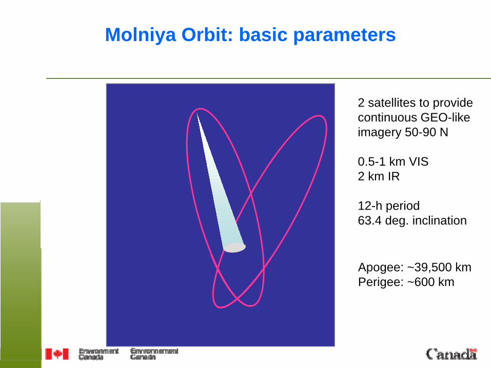
Molniya Orbit: basic parameters
2 satellites to providecontinuous GEO-likeimagery 50-90 N
0.5-1 km VIS2 km IR
12-h period63.4 deg. inclination
Apogee: ~39,500 kmPerigee: ~600 km
DRAFT – Page 4 – January 11, 2010
Background on Molniya concept
• Russia: - Used extensively for communications and classified missions - Mission including Earth observation planned: “Arctica”
• United States- Concept for Earth observation first proposed by Kidder and Vonder Haar (1990)
- NASA/Goddard proposed a mission in 2004-2005 under Earth Science Pathfinder Program. Main focus was on high latitude winds. Main payload was a 6-channel imager. Stopped at Phase A level.
• Canada- CSA initiated a satcom/HEO mission concept study in 2005- Saw the opportunity to take relay from NASA in 2006
DRAFT – Page 5 – January 11, 2010
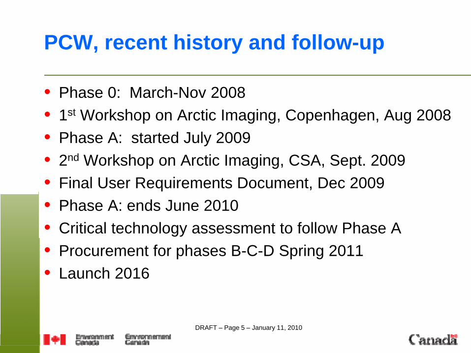
PCW, recent history and follow-up
• Phase 0: March-Nov 2008• 1st Workshop on Arctic Imaging, Copenhagen, Aug 2008• Phase A: started July 2009• 2nd Workshop on Arctic Imaging, CSA, Sept. 2009• Final User Requirements Document, Dec 2009• Phase A: ends June 2010• Critical technology assessment to follow Phase A• Procurement for phases B-C-D Spring 2011• Launch 2016
DRAFT – Page 6 – January 11, 2010
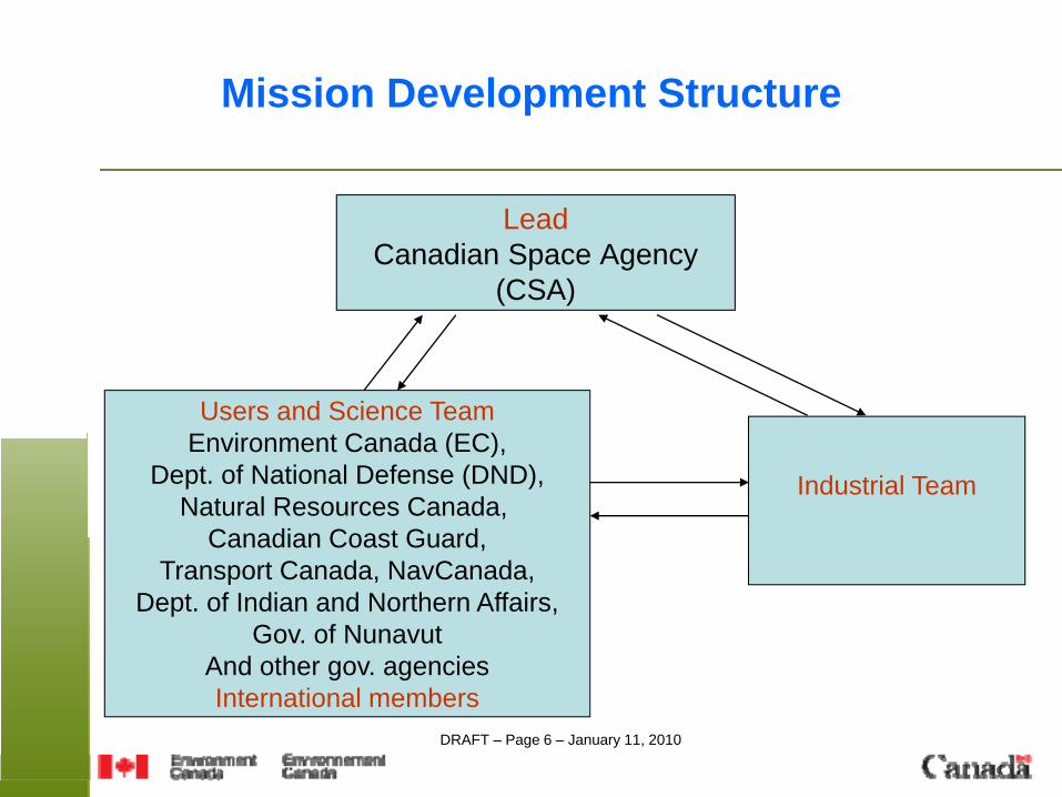
Mission Development Structure
LeadCanadian Space Agency
(CSA)
Users and Science TeamEnvironment Canada (EC),
Dept. of National Defense (DND),Natural Resources Canada,
Canadian Coast Guard,Transport Canada, NavCanada,
Dept. of Indian and Northern Affairs,Gov. of Nunavut
And other gov. agenciesInternational members
Industrial Team
DRAFT – Page 7 – January 11, 2010
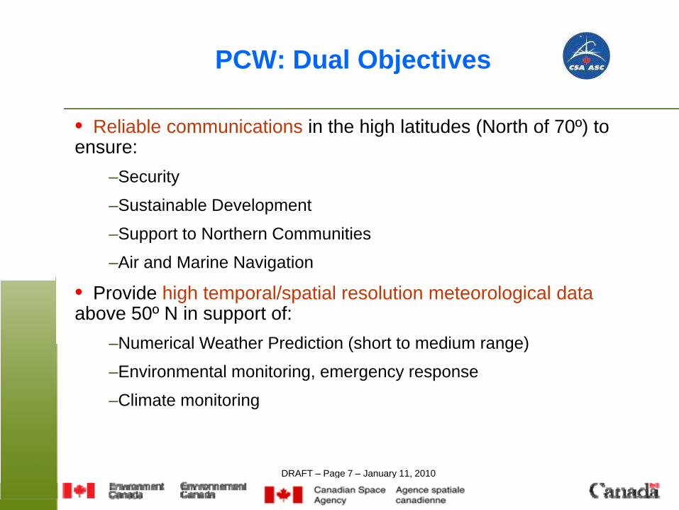
PCW: Dual Objectives
• Reliable communications in the high latitudes (North of 70º) to ensure:
–Security
–Sustainable Development
–Support to Northern Communities
–Air and Marine Navigation
• Provide high temporal/spatial resolution meteorological dataabove 50º N in support of:
–Numerical Weather Prediction (short to medium range)
–Environmental monitoring, emergency response
–Climate monitoring
DRAFT – Page 8 – January 11, 2010
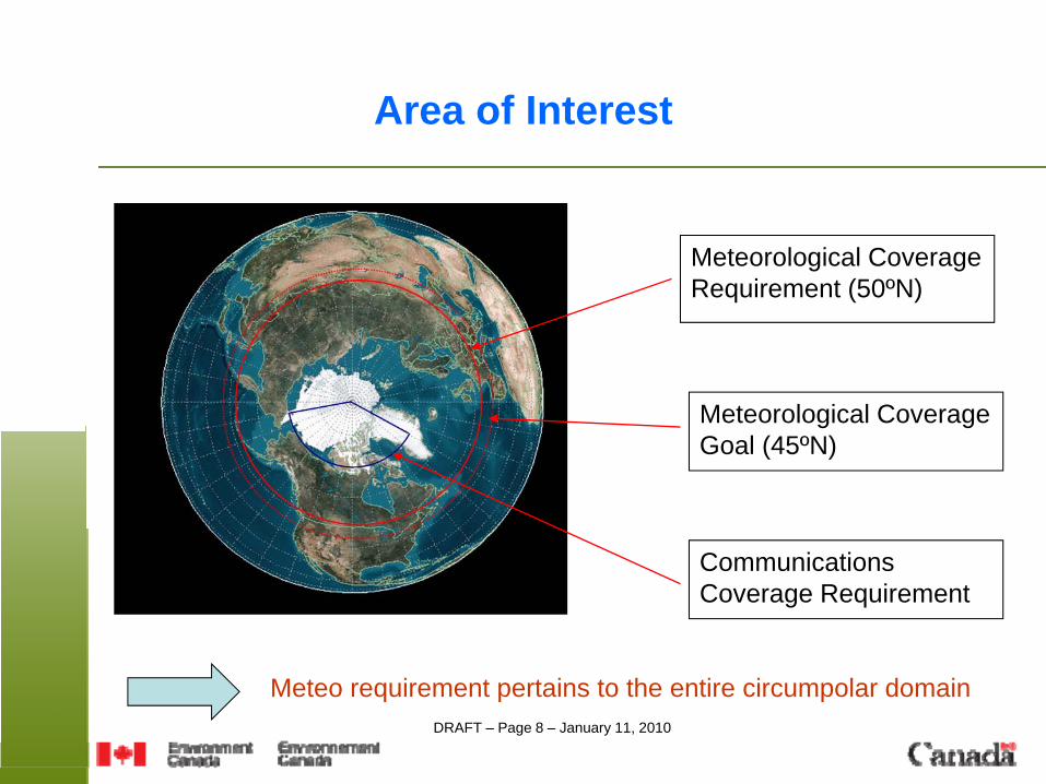
Area of Interest
Meteorological Coverage Requirement (50ºN)
Meteorological Coverage Goal (45ºN)
Communications Coverage Requirement
Meteo requirement pertains to the entire circumpolar domain
DRAFT – Page 9 – January 11, 2010
Specific Objectives (meteorology)
• To provide continuous meteorological services and information for the entire circumpolar region, with the imagery data “refreshed” as frequently as practical. GOAL 15 min.
• To improve weather prediction accuracy by providing high quality data currently not available or available with insufficient spatial / temporal resolution
• To improve the monitoring and prediction of air quality variables• To develop measures of climate change through high quality
monitoring of key atmospheric and surface variables• To have the observing system with 2 satellites in place by 2016.
Lifetime of 5 years (goal 7 years).
PCW to have an operational status linked to NRT meteorologyNew mandate for Canada
DRAFT – Page 10 – January 11, 2010
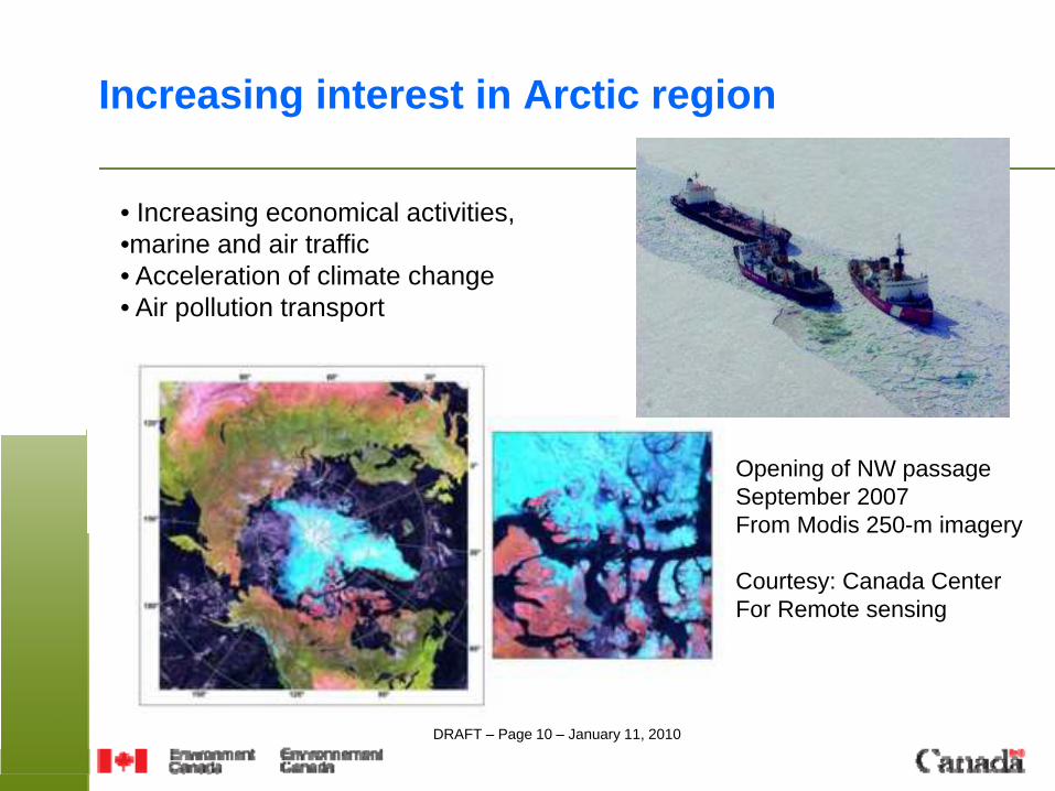
Increasing interest in Arctic region
• Increasing economical activities, •marine and air traffic• Acceleration of climate change• Air pollution transport
Opening of NW passageSeptember 2007From Modis 250-m imagery
Courtesy: Canada CenterFor Remote sensing
DRAFT – Page 11 – January 11, 2010
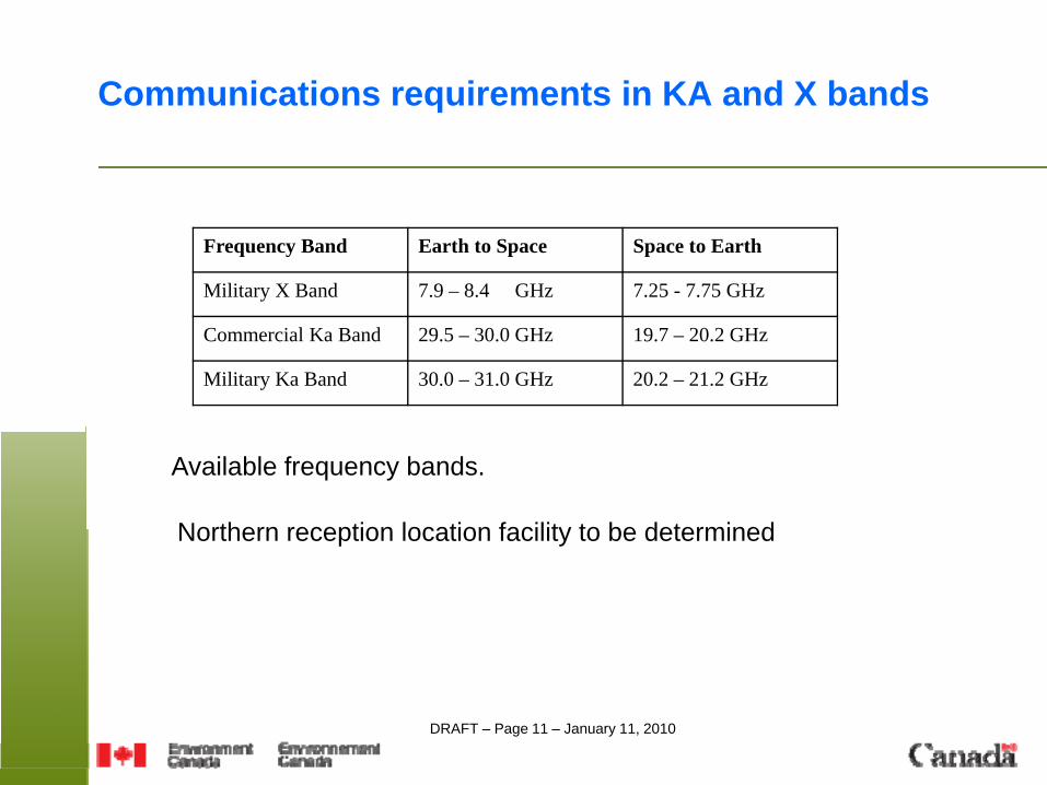
Frequency Band Earth to Space Space to Earth
Military X Band 7.9 – 8.4 GHz 7.25 - 7.75 GHz
Commercial Ka Band 29.5 – 30.0 GHz 19.7 – 20.2 GHz
Military Ka Band 30.0 – 31.0 GHz 20.2 – 21.2 GHz
Communications requirements in KA and X bands
Available frequency bands.
Northern reception location facility to be determined
DRAFT – Page 12 – January 11, 2010
Meteorology: expected products
• a) Winds from sequences of images: high priority product
• b) Surface type analysis: ice, snow, ocean, vegetation and surface characteristics such as emissivity, albedo, vegetation index
• c) Surface temperature, detection of boundary-layer temperature inversions, diurnal cycle
• d) Mid-tropospheric humidity/temperature sensitive channels for hourly direct assimilation complementing GEO radiance assimilation
• e) Volcanic ash detection
DRAFT – Page 13 – January 11, 2010
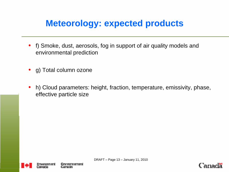
Meteorology: expected products
• f) Smoke, dust, aerosols, fog in support of air quality models and environmental prediction
• g) Total column ozone
• h) Cloud parameters: height, fraction, temperature, emissivity, phase, effective particle size
DRAFT – Page 14 – January 11, 2010
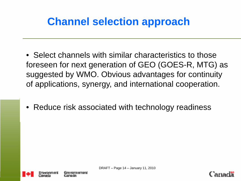
Channel selection approach
• Select channels with similar characteristics to those foreseen for next generation of GEO (GOES-R, MTG) as suggested by WMO. Obvious advantages for continuity of applications, synergy, and international cooperation.
• Reduce risk associated with technology readiness
DRAFT – Page 15 – January 11, 2010
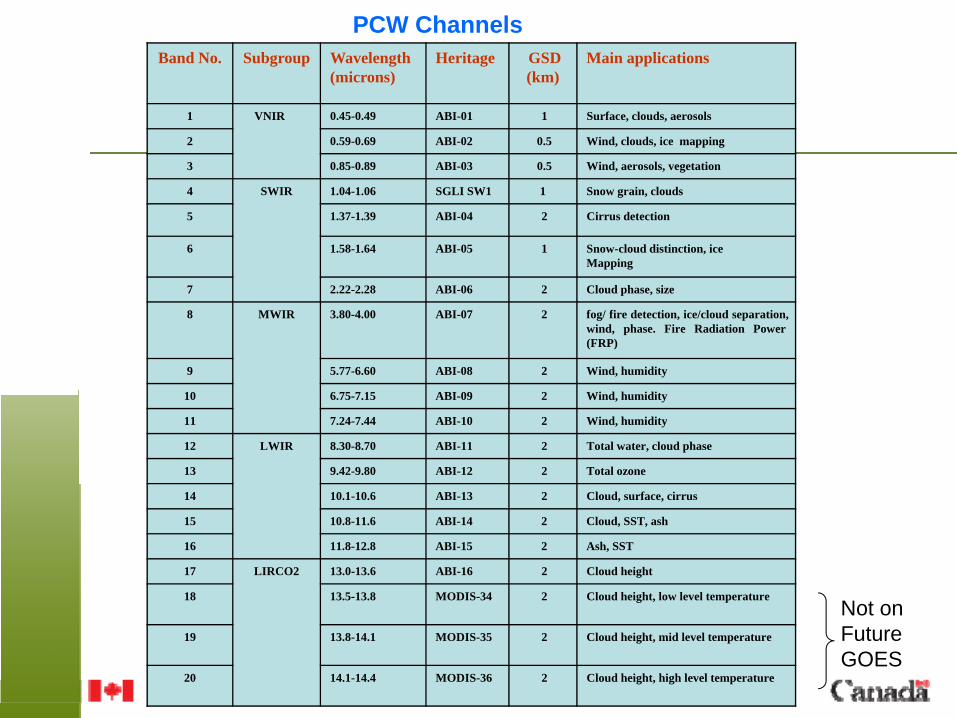
Band No. Subgroup Wavelength(microns)
Heritage GSD (km)
Main applications
1 VNIR 0.45-0.49 ABI-01 1 Surface, clouds, aerosols
2 0.59-0.69 ABI-02 0.5 Wind, clouds, ice mapping
3 0.85-0.89 ABI-03 0.5 Wind, aerosols, vegetation
4 SWIR 1.04-1.06 SGLI SW1 1 Snow grain, clouds
5 1.37-1.39 ABI-04 2 Cirrus detection
6 1.58-1.64 ABI-05 1 Snow-cloud distinction, iceMapping
7 2.22-2.28 ABI-06 2 Cloud phase, size
8 MWIR 3.80-4.00 ABI-07 2 fog/ fire detection, ice/cloud separation,wind, phase. Fire Radiation Power(FRP)
9 5.77-6.60 ABI-08 2 Wind, humidity
10 6.75-7.15 ABI-09 2 Wind, humidity
11 7.24-7.44 ABI-10 2 Wind, humidity
12 LWIR 8.30-8.70 ABI-11 2 Total water, cloud phase
13 9.42-9.80 ABI-12 2 Total ozone
14 10.1-10.6 ABI-13 2 Cloud, surface, cirrus
15 10.8-11.6 ABI-14 2 Cloud, SST, ash
16 11.8-12.8 ABI-15 2 Ash, SST
17 LIRCO2 13.0-13.6 ABI-16 2 Cloud height
18 13.5-13.8 MODIS-34 2 Cloud height, low level temperature
19 13.8-14.1 MODIS-35 2 Cloud height, mid level temperature
20 14.1-14.4 MODIS-36 2 Cloud height, high level temperature
PCW Channels
Not onFutureGOES
DRAFT – Page 16 – January 11, 2010
Main imagery requirements (1/2)
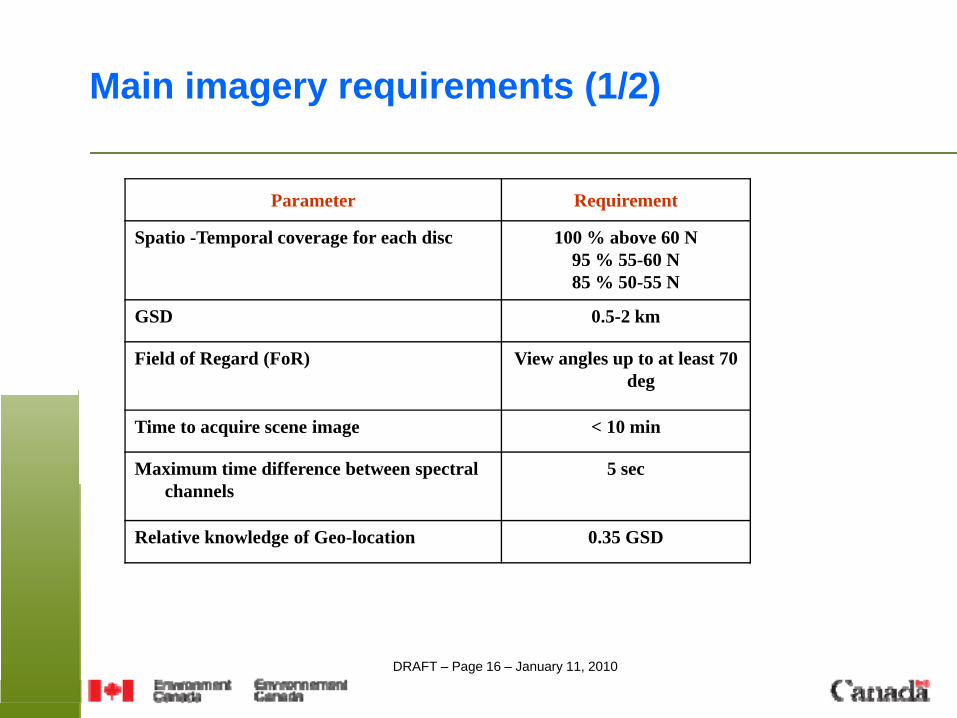
Parameter Requirement
Spatio -Temporal coverage for each disc 100 % above 60 N95 % 55-60 N85 % 50-55 N
GSD 0.5-2 km
Field of Regard (FoR) View angles up to at least 70 deg
Time to acquire scene image < 10 min
Maximum time difference between spectral channels
5 sec
Relative knowledge of Geo-location 0.35 GSD
DRAFT – Page 17 – January 11, 2010
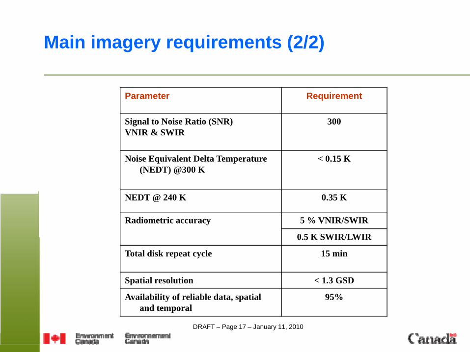
Parameter Requirement
Signal to Noise Ratio (SNR) VNIR & SWIR
300
Noise Equivalent Delta Temperature (NEDT) @300 K
< 0.15 K
NEDT @ 240 K 0.35 K
Radiometric accuracy 5 % VNIR/SWIR
0.5 K SWIR/LWIR
Total disk repeat cycle 15 min
Spatial resolution < 1.3 GSD
Availability of reliable data, spatial and temporal
95%
Main imagery requirements (2/2)
DRAFT – Page 18 – January 11, 2010
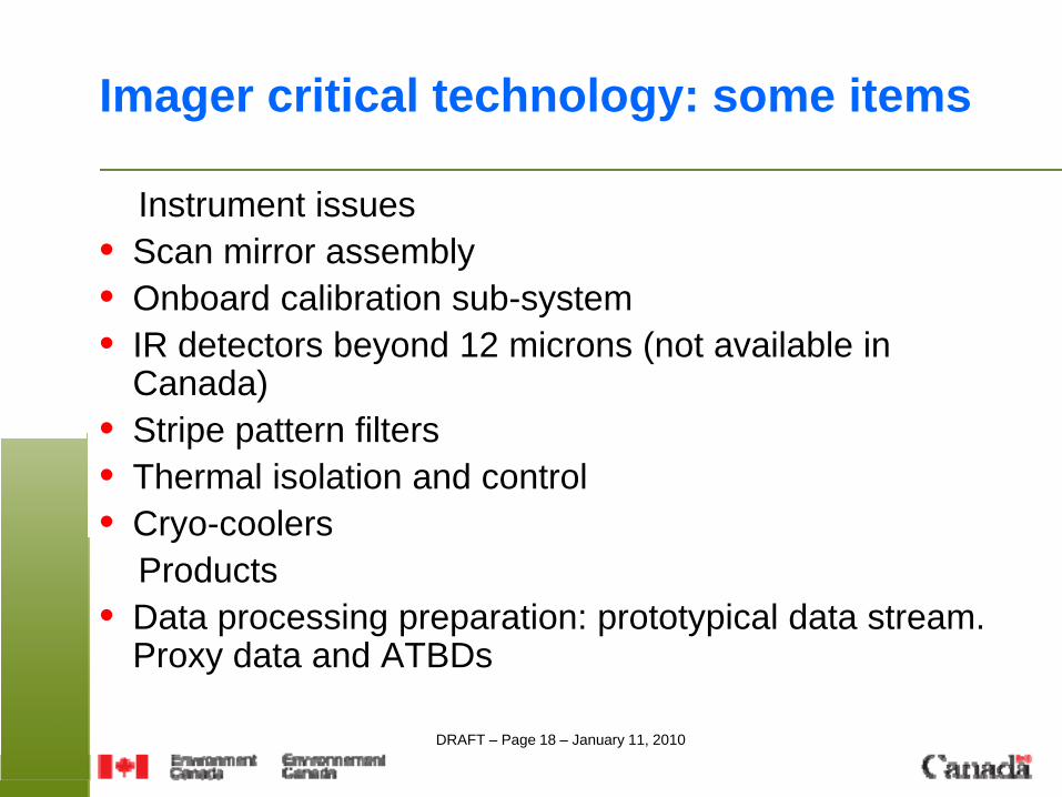
Imager critical technology: some items
Instrument issues• Scan mirror assembly• Onboard calibration sub-system• IR detectors beyond 12 microns (not available in
Canada)• Stripe pattern filters• Thermal isolation and control• Cryo-coolers
Products• Data processing preparation: prototypical data stream.
Proxy data and ATBDs
DRAFT – Page 19 – January 11, 2010
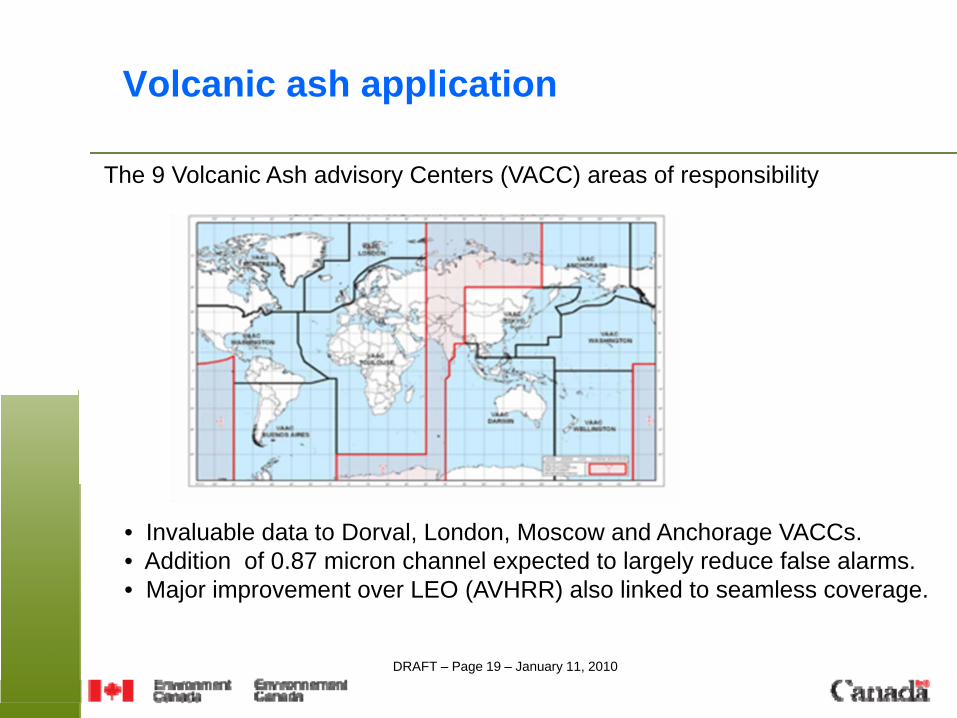
Volcanic ash application
The 9 Volcanic Ash advisory Centers (VACC) areas of responsibility
• Invaluable data to Dorval, London, Moscow and Anchorage VACCs.• Addition of 0.87 micron channel expected to largely reduce false alarms. • Major improvement over LEO (AVHRR) also linked to seamless coverage.
DRAFT – Page 20 – January 11, 2010
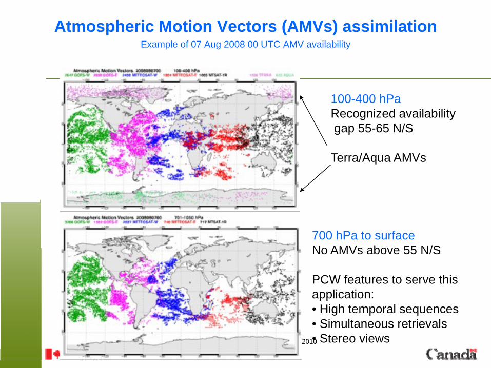
Atmospheric Motion Vectors (AMVs) assimilationExample of 07 Aug 2008 00 UTC AMV availability
100-400 hPaRecognized availabilitygap 55-65 N/S
Terra/Aqua AMVs
700 hPa to surfaceNo AMVs above 55 N/S
PCW features to serve this application:• High temporal sequences• Simultaneous retrievals• Stereo views
DRAFT – Page 21 – January 11, 2010
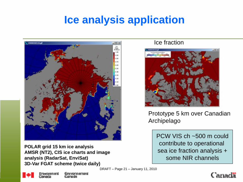
POLAR grid 15 km ice analysisAMSR (NT2), CIS ice charts and image analysis (RadarSat, EnviSat)3D-Var FGAT scheme (twice daily)
Prototype 5 km over CanadianArchipelago
Ice analysis application
Ice fraction
PCW VIS ch ~500 m couldcontribute to operational sea ice fraction analysis +
some NIR channels
DRAFT – Page 22 – January 11, 2010
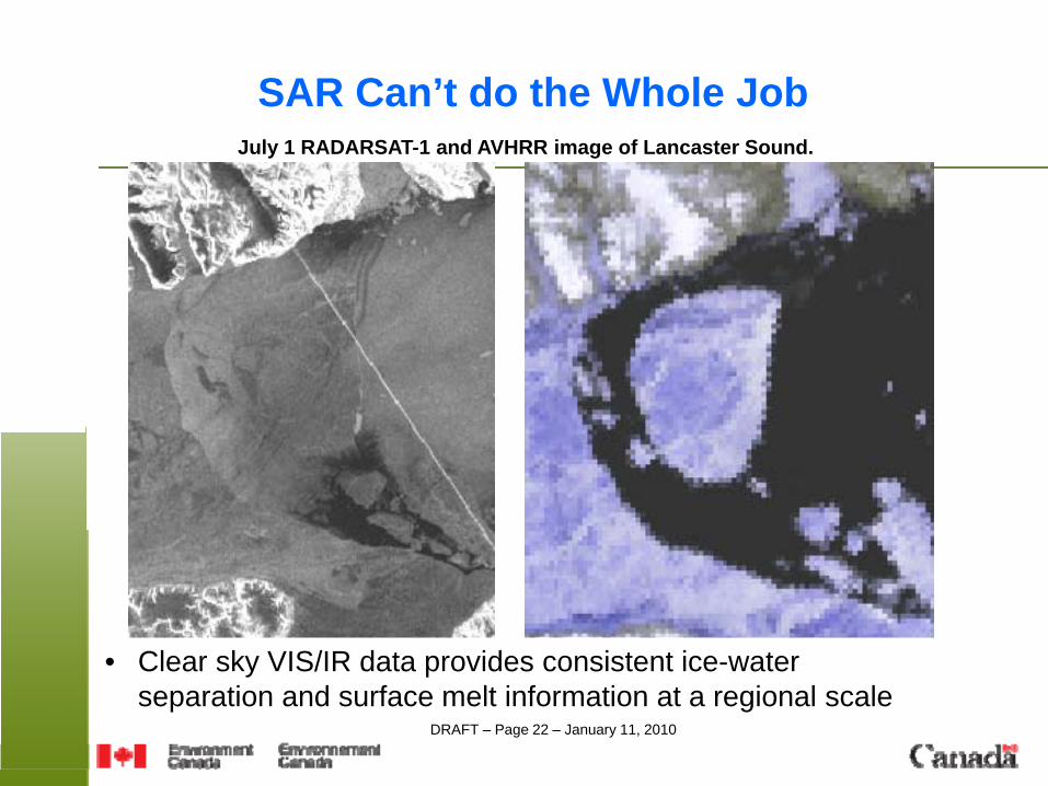
SAR Can’t do the Whole JobJuly 1 RADARSAT-1 and AVHRR image of Lancaster Sound.
• Clear sky VIS/IR data provides consistent ice-water separation and surface melt information at a regional scale
DRAFT – Page 23 – January 11, 2010
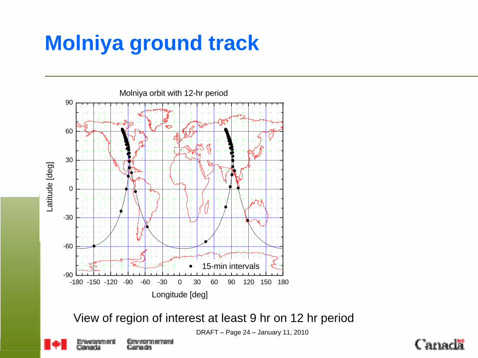
Some properties of the Molniya orbit
• Apogees/perigees have fixed positions• Period is slightly less than 12-h resulting in precession of about 3.5
h per year w.r.t sun vector. • 2 sats in 2 planes: 2 apogee points, largest coverage gaps occur on
other side of globe- SAT-2 reaches a given apogee point 6-h behind SAT-1- once a day, at +/- 3h from apogee, SAT1 and SAT2 are at same nadir position (redundancy)
• 2 sats in 1 plane: 4 apogee points, gaps evenly distributed. Best for stereo views.- The 4 apogees, 90 deg long apart, occur at same local time
DRAFT – Page 24 – January 11, 2010
Molniya ground track
-180 -150 -120 -90 -60 -30 0 30 60 90 120 150 180-90
-60
-30
0
30
60
90
15-min intervals
Latit
ude
[deg
]
Longitude [deg]
Molniya orbit with 12-hr period
View of region of interest at least 9 hr on 12 hr period
DRAFT – Page 25 – January 11, 2010
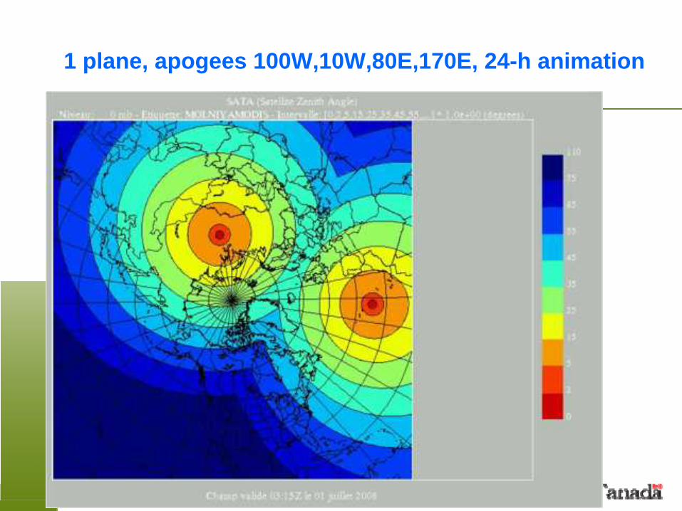
1 plane, apogees 100W,10W,80E,170E, 24-h animation
DRAFT – Page 26 – January 11, 2010
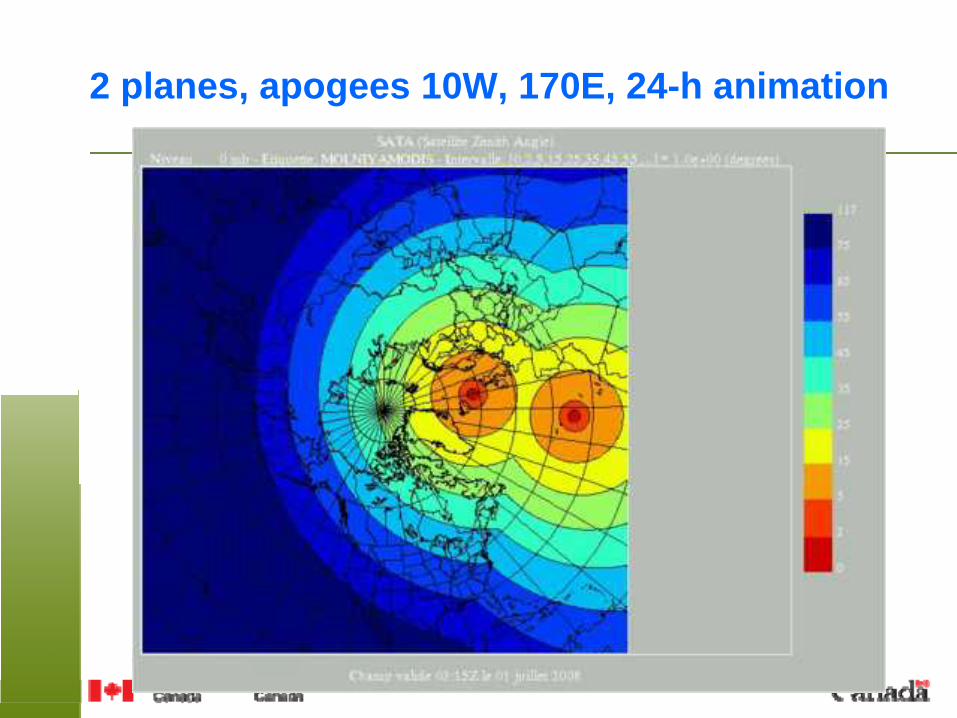
2 planes, apogees 10W, 170E, 24-h animation
DRAFT – Page 27 – January 11, 2010
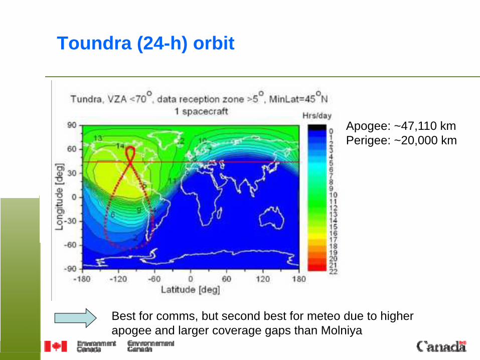
Toundra (24-h) orbit
Best for comms, but second best for meteo due to higher apogee and larger coverage gaps than Molniya
Apogee: ~47,110 kmPerigee: ~20,000 km
DRAFT – Page 28 – January 11, 2010
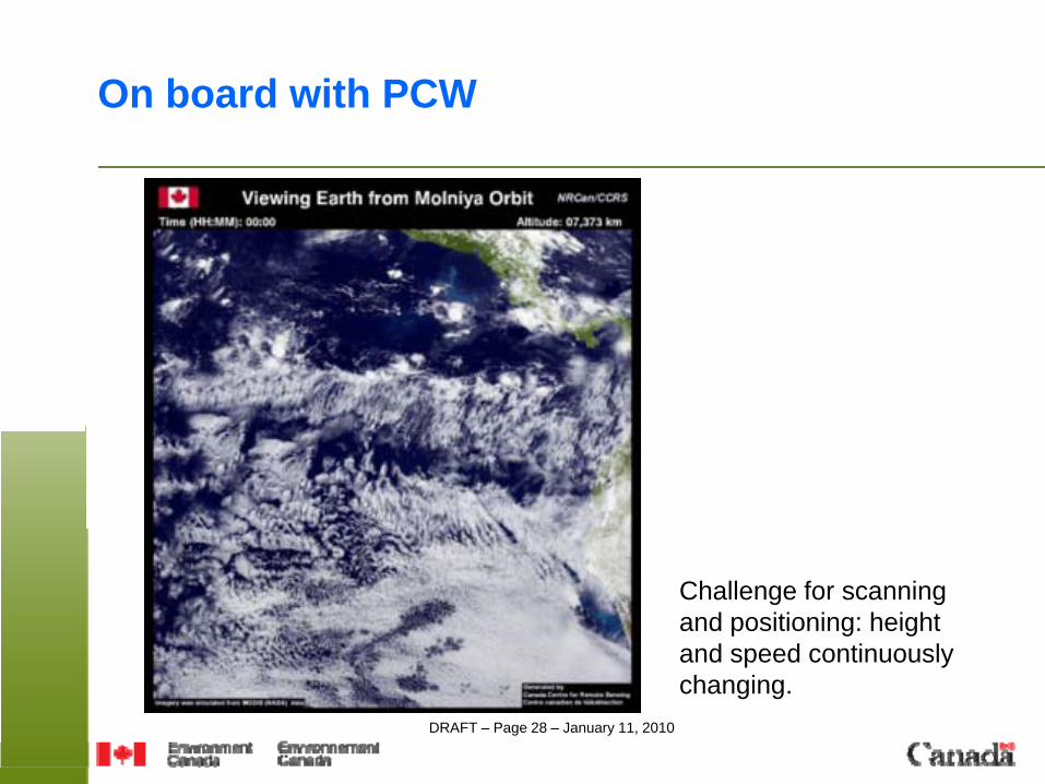
On board with PCW
Challenge for scanningand positioning: height and speed continuously changing.
DRAFT – Page 29 – January 11, 2010
Potential additional payloads
Requests For Proposals (RFP) just sent by Canadian Space Agency for possible added payloads on PCW. Areas include:
• Atmospheric remote sensing (ex: FTS for greenhouse gases and sounding, UV-VIS-NIR for chemical species).
• Plasma physics, aurora imaging, particle dynamics, magnetic field.
DRAFT – Page 30 – January 11, 2010
Phase A U&ST activities
• End-to-end simulator of PCW imager from Level 0 (raw) to Level 1c (calibrated/navigated):- scanning process- channel co-registration- remapping from 1b to 1c
• Data processing preparation, proxy radiances• OSSE related to AMV (?) • Ground segment, data acquisition/distribution scenarios• Other aspects of mission

DRAFT – Page 31 – January 11, 2010
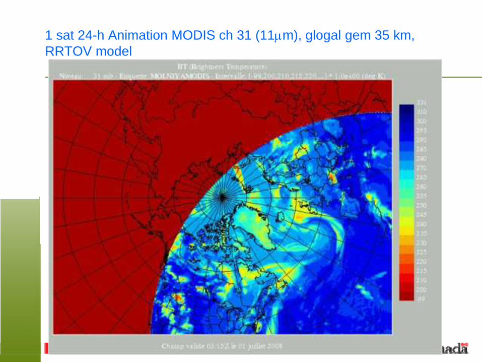
Radiative transfer, simulated imagery
Software developed to compute PCW all sky radiances from model output using:
• RTTOV (can simulate current sensors, no VIS, NIR)• CRTM (can simulate ABI specifically, no VIS, NIR)• In house code to cover VIS, NIR channels
Model output:• Global 35 km• Arctic circumpolar 45-90 N, 10 km• Limited area, 1300X1700 km, 2.5 kmOrbit defines viewing angles
DRAFT – Page 32 – January 11, 2010
1 sat 24-h Animation MODIS ch 31 (11μm), glogal gem 35 km, RRTOV model
DRAFT – Page 33 – January 11, 2010
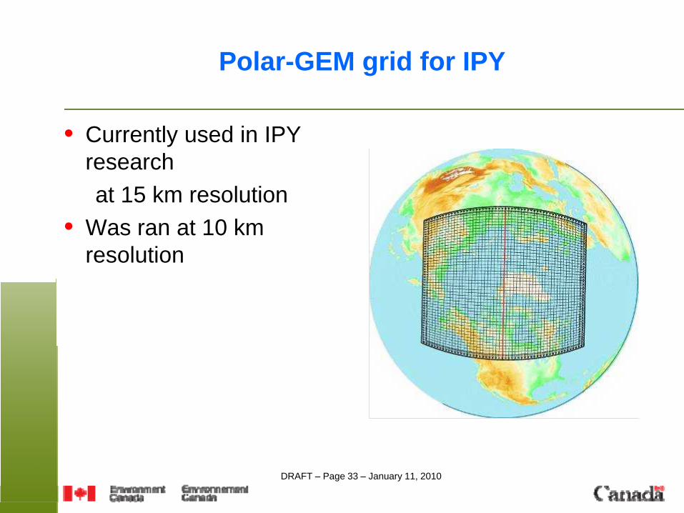
Polar-GEM grid for IPY
• Currently used in IPY researchat 15 km resolution
• Was ran at 10 km resolution
The image cannot be displayed. Your computer may not have enough memory to open the image, or the image may have been corrupted. Restart your computer, and then open the file again. If the red x still appears, you may have to delete the image and then insert it again.
DRAFT – Page 34 – January 11, 2010
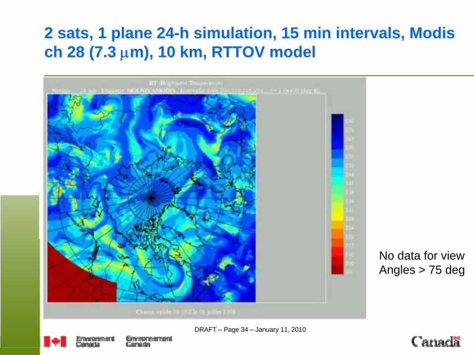
2 sats, 1 plane 24-h simulation, 15 min intervals, Modis ch 28 (7.3 μm), 10 km, RTTOV model
No data for viewAngles > 75 deg
DRAFT – Page 35 – January 11, 2010
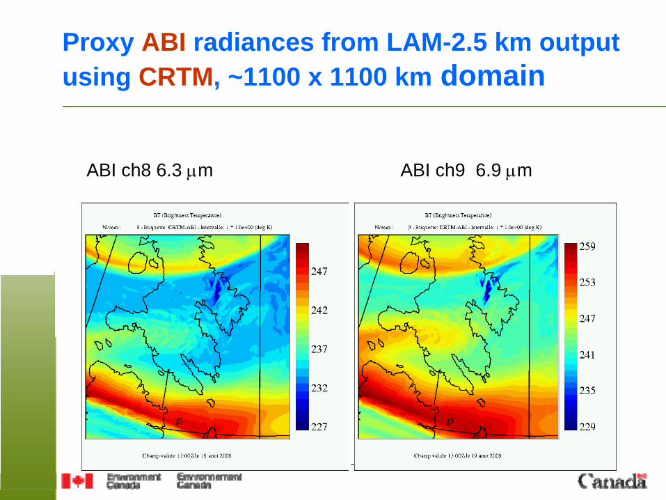
Proxy ABI radiances from LAM-2.5 km output using CRTM, ~1100 x 1100 km domain
ABI ch8 6.3 μm ABI ch9 6.9 μm
DRAFT – Page 36 – January 11, 2010
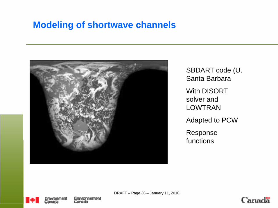
Modeling of shortwave channels
SBDART code (U. Santa Barbara
With DISORT solver and LOWTRAN
Adapted to PCW
Response functions
DRAFT – Page 37 – January 11, 2010
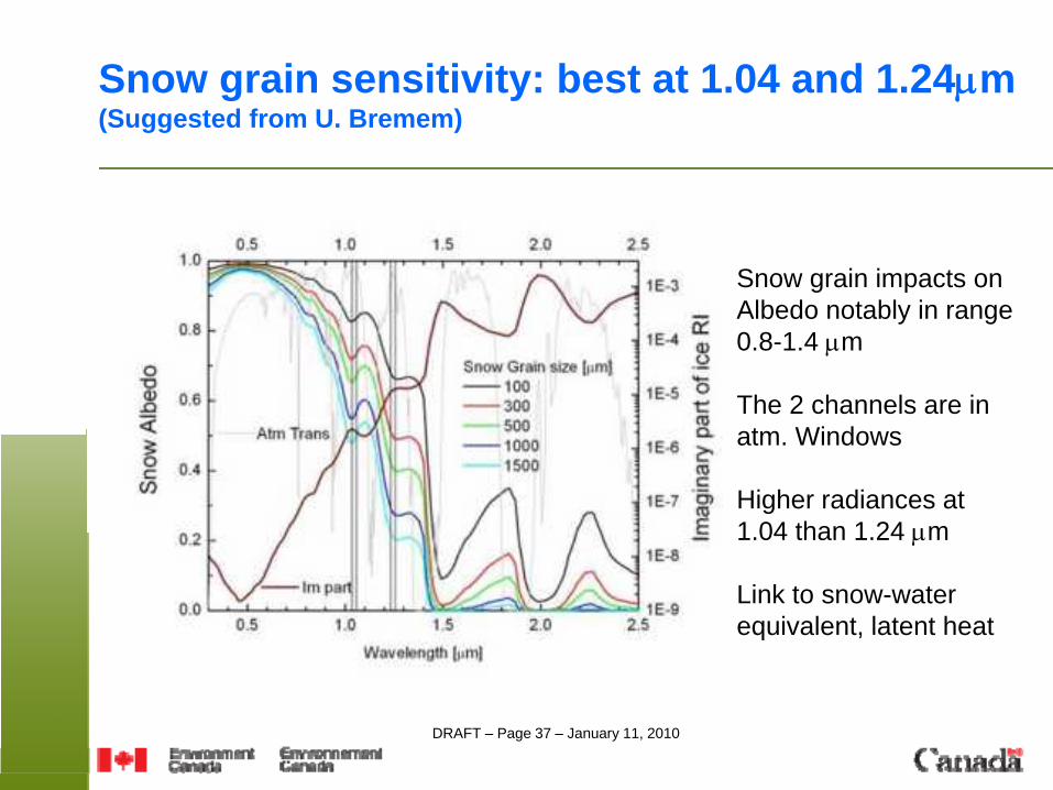
Snow grain sensitivity: best at 1.04 and 1.24μm(Suggested from U. Bremem)
Snow grain impacts onAlbedo notably in range0.8-1.4 μm
The 2 channels are in atm. Windows
Higher radiances at 1.04 than 1.24 μm
Link to snow-water equivalent, latent heat
DRAFT – Page 38 – January 11, 2010
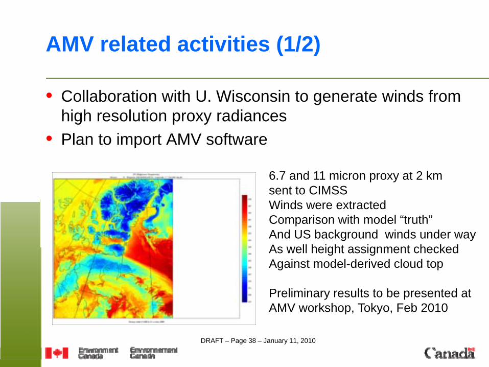
AMV related activities (1/2)
• Collaboration with U. Wisconsin to generate winds from high resolution proxy radiances
• Plan to import AMV software
6.7 and 11 micron proxy at 2 km sent to CIMSSWinds were extractedComparison with model “truth”And US background winds under wayAs well height assignment checkedAgainst model-derived cloud top
Preliminary results to be presented at AMV workshop, Tokyo, Feb 2010
DRAFT – Page 39 – January 11, 2010
AMV related activities (2/2)
• Planning OSSE using alternate method based on ensembles, used to evaluate impact of Aeolus winds (lidar, 2011) after Tan et al (ECMWF Tech Memo 510, 2007).- uses real data for all types except that under evaluation- impact based on reduction of spread in ensembles- tuning required using real observations- AMV extracted from model output in “likely places” and error assignation not trivial
DRAFT – Page 40 – January 11, 2010
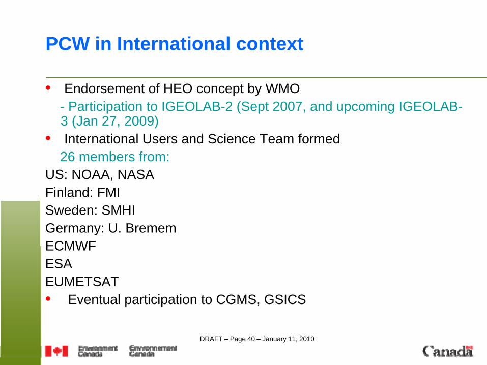
PCW in International context
• Endorsement of HEO concept by WMO- Participation to IGEOLAB-2 (Sept 2007, and upcoming IGEOLAB-3 (Jan 27, 2009)
• International Users and Science Team formed26 members from:
US: NOAA, NASA Finland: FMISweden: SMHIGermany: U. BrememECMWFESAEUMETSAT• Eventual participation to CGMS, GSICS
DRAFT – Page 41 – January 11, 2010
PCW INTL U&ST
Todd Arbetter (NOAA)Niels Bormann, ECMWFChangyong Cao (NOAA)Pablo Clemente-Colon (NOAA)Juhani Damski (FMI)Adam Dybbroe (SMHI)Andrew Heidinger (NOAA)Sean Helfrich (NOAA)Georg Heygster (U. Bremem)Alain Hilgers (ESA)Alexander Ignatov (NOAA)Mike Kalb (NOAA)Karll-Goran Karlsson (FMHI)Jeff Key (NOAA)
Alexander Kokhanovsky (U. Bremem)Marianne Koenig (EUMETSAT)Shobha Kondragunta (NOAA)Jarkko Koskinen (FMI)Juha-Pekka Luntama (ESA)Patrick Minnis (NASA Langley)Terry Onsager (NOAA)Jouni Pulliainen (FMI)Steve Platnick (NASA Goddard)Lars Peter Riishojgaard (JCSDA)Yrjo Sucksdorff (FMI)Anke Thoss (SMHI)
DRAFT – Page 42 – January 11, 2010
Specific US-Canada collaboration
Meteorology• MOU already in place between EC and NOAA-NESDIS
which could include PCW• Coordination with GOES-R on data processing,
calibration, algorithm development, product distribution
Space segment possibilities• Adaptation of ABI key components for PCW• Evaluation of launch possibilities
DRAFT – Page 43 – January 11, 2010
Conclusion
• PCW will provide for the first time seamless observation of the Arctic.
• High-level meteorology requirements for PCW were inspired by strong synergy with GOES-R as well as identified needs specific to the Arctic.
• Phase-A activities focuses on demonstrating added value and feasibility of the mission.
• International interest is a very important asset. • Key milestone is procurement for Phases B-C-D in spring 2011.
• Thanks