Embed Size (px)
Citation preview
THE POLYNESIAN VOYAGING CANOE:
THE REGIONALIZATION OF SEAFARING
TECHNOLOGIES
by
KRISTOPHER ELIAS RANNEY
A THESIS
Presented to the Department of History and the Robert D. Clark Honors College
in partial fulfillment of the requirements for the degree of Bachelor of Arts
March 2018
ii
An Abstract of the Thesis of
Kristopher Elias Ranney for the degree of Bachelor of Arts in the Department of History to be taken March 2018
Title: THE POLYNESIAN VOYAGING CANOE: THE REGIONALIZATION OF SEAFARING TECHNOLOGIES
Approved: _______________________________________
Professor Scott M. Fitzpatrick
Scholars in the field of Oceanic archeology and anthropology have radically
altered the accepted narrative of human habitation of the Polynesian islands in recent
years, emphasizing a rapid expansion of territory along with some evidence of trade and
cultural exchange. This indicates a sophisticated seafaring culture, capable of
maintaining contact between island groups for several hundred years after the initial
dispersal. The canoes of Polynesia have thus been reexamined in terms of utility and
complexity, but no dedicated effort has been adequately made to examine the regional
derivative canoe designs against the various proposed prehistoric voyaging canoes, nor
has there been an effort of backward analysis from those designs. By examining historic
sources describing the canoes used at the time of European contact along with other
datasets, the evolution of their design can be better understood. This is given with
consideration of the ecological and cultural realities specific to the region, which in turn
grants a clearer picture of the original Polynesian voyaging canoe.
iii
Acknowledgements
I would like to thank Dean Terry Hunt for his long-standing support of this
project. When I originally asked to conduct this thesis under him I knew very little
about Pacific archeology, but was graciously given free rein to indulge my own
interests. Although he was not able to remain my primary thesis advisor, I remain
grateful beyond measure for his continuous guidance and support. I want to thank
Professor Scott Fitzpatrick in equal measure for his generosity when he stepped in as
my primary advisor during the last hours of my project; helping a student he had met
only once before. His advice is the only thing making this paper readable today. Finally,
I would like to thank Professor Samantha Hopkins for her willingness to support this
project well before I had a project to aid. The time and effort provided by all my
advisors has been more than generous. I would be remiss if I did not also thank
Professor Mossberg for her encouragement in pursuing this course of study, as well as
Professors Deb and Dan Morrison for their willingness to encourage me, no matter my
current academic whimsy. My family has also been aiding me throughout my academic
career. Without the aid of my parents and brother, who are always eager to proofread
my papers no matter their obscurity, I would not have a thesis.
iv
Table of Contents
Chapter 1: Seascape 1
Introduction 1 Geography 2
Chapter 2: Polynesian Dispersal Technologies 5
Introduction 5 Early Scholarship on Human Population dispersal in the Pacific 5 Modern Debate 9 Modeling Dispersal and Voyaging 20 Layman Research and Voyaging 22
Chapter 3: The Evolution of Vessel Design 23
Introduction 23 Biological Models 26 Archeology 28 Historic Accounts 32 Central Polynesia 37 West Polynesia 41 Hawai`i 44 New Zealand 47 Rapa Nui 51
Chapter 4: Reconstruction and Conclusion 56 Bibliography 62
v
List of Figures
Map of Polynesia and Surrounding Island Groups 4 Models of Human Dispersal 13 Historic Voyaging Canoe Plans 23 Hōkūle‘a 25 Canoe Lashings 25 Tahitian Canoe 39 Hawai`ian Canoe 45 War Speech 49 Rapa Nui Canoe 54 Sail Designs on Historical Polynesian Canoes 59
vi
List of Tables
Canoe Recreation Sailing Chart ..................................................................................... 20
Chapter 1: Seascape
Introduction
Polynesia was settled in two major phases, separated by approximately two
thousand years. West Polynesia, consisting primarily of the Samoan and Tongan
archipelagos, was settled between ca. 1,000-800 BCE,1 followed by the settlement of
East Polynesia between approximately 1,000-1,200 CE.2 One probable explanation for
the long pause between colonization phases, followed by the rapid colonization of East
Polynesia, was the innovation of new maritime technologies.3 In this paper, I will
analyze the historic descriptions of vessels used by traditional cultures in Polynesia to
try to derive some of the traits of a common ancestor, focusing on its five major
regions: the Hawai`ian island chain, the New Zealand archipelago, the outlying island
of Rapa Nui, and finally the Western and Central archipelagos, which constitute by far
the largest local cultural variation, as well as the largest overall area. These regions are
primarily determined based on remoteness, as each was a cultural sphere of influence
into which very little communication existed after the first several centuries post-
settlement.4
A complex craft capable of navigating large stretches of ocean under variable
conditions precisely and relatively quickly would have been the only feasible transport
between islands; if they did not function to the level required for long distance transport
to be a feasible option, the dispersal into East Polynesia would have lasted far longer.
1 Burley and Addison, 2014 2 Willmshurst, et al., 2011 3 Anderson 2003, 79, Irwin 2008, 15-17, Montenegro, Á., et al. 2014, 2016 4 Rehg, K.L., 1995, Rolett 2002
2
Once that assumption is in place, it is only the specifics that need examining;
ascertaining how the historic vessels of Polynesia relate to their ancestors. The ways in
which the natural and cultural environment effected the changes seen in the historic
record is crucial in understanding what an original predecessor of their canoes would
have been designed.
Geography
Despite Polynesia being set in an area roughly the same as that of North
America, only 300,000 square kilometers of its vast expanse is located above the water
line, with 270,000 of those comprising New Zealand alone. Nearly half of the remainder
is found in the Hawai`ian island chain, leaving the scant 15,000 square kilometers to be
lost in the 22 million square kilometers of ocean that comprise the region. Located on
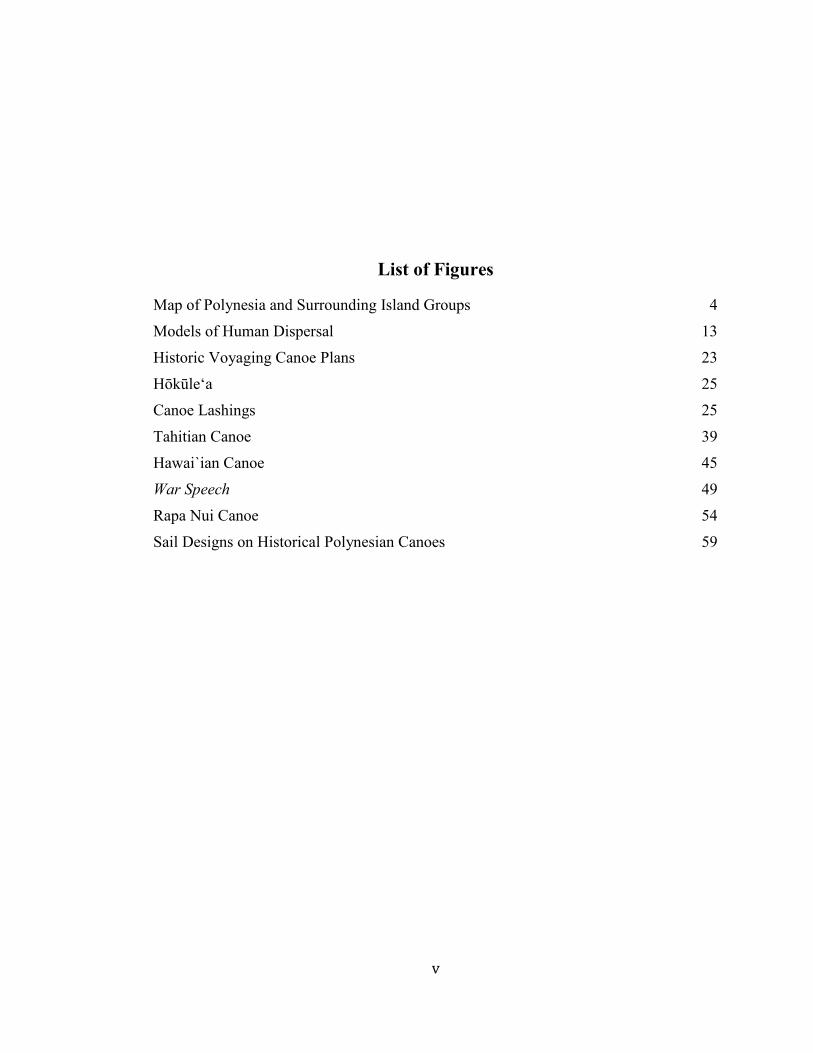
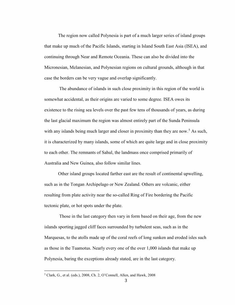
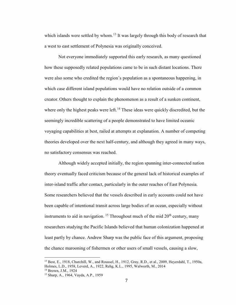
the eastern expanse of the Pacific Islands inside the bounds of Hawai`i, New Zealand,
and Rapa Nui, which are approximately equidistant (figure 1), it is unsurprising that this
region was not settled until relatively recently.
The vast majority of the region is comprised of small islands, separated by large
spans of ocean. Even within island chains or archipelagos, it is not unusual to be out of
sight of most, if not all, other traces of land. There are aproximitly a dozen major
archipelagos in the region, besides Hawai`i and New Zealand, including Tonga and
Samoa in West Polynesia, and the Society Islands, the Marquesas, the Tuamotus, and
Mangareva that make up most of Central-East Polynesia (figure 1). They vary in
geography from island to island, mostly in relation to their age, being comprised of tall
jagged mountains, before weathering all the way down to atolls, islands comprised
entirely of the coral reef that once circled sunken peaks.
3
The region now called Polynesia is part of a much larger series of island groups
that make up much of the Pacific Islands, starting in Island South East Asia (ISEA), and
continuing through Near and Remote Oceania. These can also be divided into the
Micronesian, Melanesian, and Polynesian regions on cultural grounds, although in that
case the borders can be very vague and overlap significantly.
The abundance of islands in such close proximity in this region of the world is
somewhat accidental, as their origins are varied to some degree. ISEA owes its
existence to the rising sea levels over the past few tens of thousands of years, as during
the last glacial maximum the region was almost entirely part of the Sunda Peninsula
with any islands being much larger and closer in proximity than they are now.5 As such,
it is characterized by many islands, some of which are quite large and in close proximity
to each other. The remnants of Sahul, the landmass once comprised primarily of
Australia and New Guinea, also follow similar lines.
Other island groups located farther east are the result of continental upwelling,
such as in the Tongan Archipelago or New Zealand. Others are volcanic, either
resulting from plate activity near the so-called Ring of Fire bordering the Pacific
tectonic plate, or hot spots under the plate.
Those in the last category then vary in form based on their age, from the new
islands sporting jagged cliff faces surrounded by turbulent seas, such as in the
Marquesas, to the atolls made up of the coral reefs of long sunken and eroded isles such
as those in the Tuamotus. Nearly every one of the over 1,000 islands that make up
Polynesia, baring the exceptions already stated, are in the last category.
5 Clark, G., et al. (eds.), 2008, Ch. 2, O’Connell, Allen, and Hawk, 2008
4
What is remarkable is that all but a handful of these diverse lands were settled
by humans, well before the introduction of precise navigation aids, and almost certainly
exclusively on large canoes,6 rather than the giant hulled vessels that allowed for the
European and East Asian expansions into distant maritime regions.
Map of Polynesia and Surrounding Island Groups
Figure 1: Map delineating the classic borders between the Polynesian, Micronesian, and
Melanesian regions. (Micronesia, Melanesia, Polynesia. Australian National University,
CartoGIS CAP 00-341. http://asiapacific.anu.edu.au/mapsonline/base-maps/micronesia-
melanesia-polynesia. (Accessed Feb. 2, 2018))
6 Irwin, G., 2008
5
Chapter 2: Polynesian Dispersal Technologies
Introduction
Voyaging is a central aspect of the Polynesian culture, being the most recent of
hundreds of generations of seafarers7. The fact that a Neolithic culture was the first to
reach the heart of the Pacific, before the industrializing Europeans or even the more
local East Asian Empires, is a narrative that was used in the past as an impetus to those
who fought back against the philosophies of superiority that marked European
colonialism.8 Understanding any given subject is never as simple as reading the
prescribed textbook, as first one must know the context of its writing. This chapter will
explore the literature surrounding human population dispersal into the Pacific, as well
as some of the broader narratives circulated outside scholarly circles. The context this
work provides is important in understanding how later vessel development transpired.
Early Scholarship on Human Population dispersal in the Pacific
There is not an extensive amount of details given by early European explorers as
to the specific design of indigenous Polynesian vessels. The most important and
influential explorer was the English captain, James Cook, who made three expeditions
into the Pacific, including the one during which he was killed. After making landfall on
numerous islands throughout the region, including Easter Island (Rapa Nui), The
Sandwich Islands (Hawai`i), and New Zealand, he wrote, “In consequence of this and
our former voyage, warrants our pronouncing it to be, though perhaps not the most
numerous, certainly, by far, the most extensive nation upon earth,” (Cook, J., 1821, Vol. 7 Anderson 2003, Clark, G., et al., 2008, Irwin, G., 2008 8 Finney, B.R., 1994b, Finney, B.R., 1999, Finney, B.R., 2003
6
VI, 231). The idea did not stagnate with Cook, as the idea of a navigator people who
sailed across the Pacific and back quickly became the popular image of the Polynesians
up through the 19th and early 20th centuries.9 Others noted various aspects of indigenous
vessel design, but made no real effort to understand the connections between population
groups, let alone specifics like shared technology until the mid-19th century. The theory
of an interconnected Polynesia was developed throughout this period through
investigation into oral traditions and voyaging technology. This idea consisted of a
varying level of intentional movement between island groups, mostly dependent on
large time intervals and some chance.10 Its basic structure involved a slow expansion of
Polynesians into the Pacific through the development of the lateen or spritsail and the
capability of sailing into and across the wind.11
Early research on human interaction in Polynesia was primarily focused on
determining their relationships with other human ‘families’, as was popular throughout
the academic world at the time.12 It was thought that such research would create a map
of relationships, both regarding ethnicity and cultural diffusion. These studies almost
always linked the origin of Polynesians to Southeast Asia, although the specifics varied
considerably based on which features were seen to take precedence. Perhaps the most
important field in studying the early dispersal of Polynesians was linguistics, as it
allowed for a basic chronology to be made of the entire language family, showing
9 Best, E., 1918, Fornander, A., 1878 10 Best, E., 1918 11 Irwin, G., 2008 12 Best, E., 1918, 1927, Gregory, H.E., 1922, Heine-Geldern, R., 1950, Heyerdahl, T., 1950b, 1979, Holton, G.E.L., 2004, Linton, R., 1926, Smith, C.H., and Kneeland, S., 1855, Wake, C.S., 1883
7
which islands were settled by whom.13 It was largely through this body of research that
a west to east settlement of Polynesia was originally conceived.
Not everyone immediately supported this early research, as many questioned
how these supposedly related populations came to be in such distant locations. There
were also some who credited the region’s population as a spontaneous happening, in
which case different island populations would have no relation outside of a common
creator. Others thought to explain the phenomenon as a result of a sunken continent,
where only the highest peaks were left.14 These ideas were quickly discredited, but the
seemingly incredible scattering of a people demonstrated to have limited oceanic
voyaging capabilities at best, railed at attempts at explanation. A number of competing
theories developed over the next half-century, and although they agreed in many ways,
no satisfactory consensus was reached.
Although widely accepted initially, the region spanning inter-connected nation
theory eventually faced criticism because of the general lack of historical examples of
inter-island traffic after contact, particularly in the outer reaches of East Polynesia.
Some researchers believed that the vessels described in early accounts could not have
been capable of intentional transit across large bodies of an ocean, especially without
instruments to aid in navigation. 15 Throughout much of the mid 20th century, many
researchers studying the Pacific Islands believed that human colonization happened at
least partly by chance. Andrew Sharp was the public face of this argument, proposing
the chance marooning of fishermen or other users of small vessels, causing a slow,
13 Best, E., 1918, Churchill, W., and Roussel, H., 1912, Gray, R.D., et al., 2009, Heyerdahl, T., 1950a, Holmes, L.D., 1958, Leverd, A., 1922, Rehg, K.L., 1995, Walworth, M., 2014 14 Brown, J.M., 1924 15 Sharp, A., 1964, Vayda, A.P., 1959
8
haphazard, seeding of the Pacific Islands over the course of several centuries. This
theory never gained much headway in the broader academic community. The prevailing
winds and currents around the equatorial Pacific flow westward made it far more likely
that any such castaways would be swept in that direction, but it remained part of the
layman communities’ view of the subject for decades.
Another possibility considered was that Polynesia was settled not from Asia, but
rather from the Americas because of the prevailing westerly winds. In 1830, missionary
William Ellis first proposed this hypothesis, but it remained untested until the famous
Kon Tiki expedition set out in 1947. Thor Heyerdahl, who was the architect of the
demonstration, set out from Peru on a balsa wood raft in order to demonstrate that such
a method was a viable theory of human population dispersal.16 The theory was based
largely on the cosmetic similarities between the architectural designs of Polynesian and
a few South American cultures. These included some stonework on Rapa Nui that used
very similar architectural ascetics17, and iconography found in the Marquesas Islands
that resemble alpaca18. One of his keystone arguments focused on the South American
rafts for which he modeled Kon Tiki, which shared many features with the double-
hulled canoes used in Polynesia. He also used the existence of raft technology in much
of the less accessible islands of Polynesia, and some uses of the word for raft in place of
canoe in some areas, as additional evidence.
When [I] arrived in the Tuamotu archipelago on a replica of the Peruvian sailing raft it created much excitement among the elders of the Raroia tribe, who inform him that this was a very ancient type of boat used by
16 Heyerdahl, T., 1950a, Heyerdahl, T., 1950b, 17 Golson, J., 1965 18 Heyerdahl, T., 1965
9
their ancestors and described in the traditions generally as paepae, but in still older legends rongo-rongo. (Heyerdahl, T., 1950, 23).
This similarity ultimately proved to be coincidental in origin, as the Polynesian canoe
has been shown to have had an entirely different source.19
While the expedition itself was a success, Heyerdahl’s ideas have since been
broadly refuted, primarily through linguistic, cultural, genetic, and archeological studies
that all support a west to east population dispersal.20 Even at the time, many
anthropologists criticized his cherry-picked evidence. “Heyerdahl’s claim that attempts
to relate the Polynesians to the Old World have failed was no doubt news to the
majority of anthropologists who believe that the evidence is so conclusive that Old
World origin is a premise from which one may work without question,” (Holmes 1958,
127). Both theories of drift voyaging were eventually dismissed in favor of the older
model of intentional two-way navigation, but there were still numerous questions left to
be answered.
Modern Debate
In recent decades, the scholarship surrounding the study of East Polynesia has
undergone significant revision, namely in the basic chronology of its initial
colonization. Most older models of Polynesian colonization relied on the ‘Long
Chronology’, which suggested that East Polynesia was colonized in a period between
200 BCE and 1000 CE.21 These dates were determined through a variety of sources,
including linguistics, pollen sediment cores, and later, radiocarbon dating. Scholars
19 Clark, G., et al., 2008, Irwin, G., 2008 20 Golson, J., 1965, Heine-Geldern, R., 1950, Holton, G.E.L., 2004, Holmes, L.D., 1958 21 Anderson, A., 1995, Best, E., 1918
10
from across the field of linguistics sought to study the formation of the language family,
as it was seen as a way to determine how languages developed out of one another
without the worry of outside influence.22 Unfortunately, early research did not account
for inter-island communication. The current understanding of how island populations
interacted indicates that any island within a day’s sail share much of their linguistic
traits.23 There is evidence of at least some contact occurring between remote
populations. This added complication caused the extensive reevaluation of how these
languages developed.
The actual dating of much of this early work was done through the study of
pollen sediments in lake and swamp beds. Most water bodies have periods of greater or
lesser run-off feeding into them, resulting in patterns that can be found in the deposited
sentiments that can be counted much like tree rings to determine the approximate age of
any samples embedded within the stratigraphic record. Although the process can be
made more difficult by various climate events, such as storms; by taking a core sample,
it is possible to get a chronology of vegetation in the area around the water body.24 In
modern studies it is more convenient to date pieces within the core using carbon 14
samples as it neutralizes some of those effects.
It was common for islanders to bring crop plants with them when populating a
new island, like taro, banana, and coconut.25 These pollens suddenly appearing in a
sample are a good indication that islanders have arrived. Ash and the decrease of native
pollens are also an indication, as they signify burning of native forest to make way for
22 Clark, R., 1979 23 Di Piazza, A.D., et al., 2006, Pawley, A., 2015, Rehg, K.L., 1995, Walworth, M., 2014 24 Cañellas-Boltà, N., et al., 2012, Hunt, T., & Lipo, C., 2012, Mann, D., et al., 2008 25 Addison, D.J., 2008, Lepofsky, D., 2016, Wilmshurst, J.M., et al., 2011
11
fields. While these tests were quite sound in their assessment, their chronology was
consistently overestimated because it was assumed the very earliest settlers would not
leave a noticeable impact.26 This was also the problem in estimating the chronology on
archeological evidence alone. Based on what we now know of how populations grow in
these conditions, this kind of evidence should have been visible within a couple of
generations, rather than the centuries originally assumed, as the initial seed population
tends to grow exponentially until capacity is reached.27
Firm dates enter into the picture with the development of radiocarbon dating in
the mid-20th century. Early radiocarbon dates supported the long chronology, as they
showed a varying timescale to the exact times in which similarly placed islands were
populated. These dates all tended to be quite old and spread out, ranging from 1000 CE
on some islands to 200 BCE on others.28 The problem arises when it is considered that
the carbon being dated does not show when the sample was used in the target event,
such as a log being burned in a cooking fire. It corresponds to the sample being
removed from the carbon cycle, when carbon 14 was first incorporated into the structure
of the tree. Therefore, any samples taken from long-lived trees can give dates hundreds
of years before the event being measured. This is called the ‘old wood’ problem within
the field of archeology.29 When unreliable data points are removed, far more consistent
dates appear all across eastern Polynesia, all corresponding to approximately 1100 to
26 Athens, J.S., et al., 2014, Lipo, C., & Hunt, T., 2016, Wilmshurst, J.M. et al., 2011 27 Hunt, T.L., & Lipo, C.P., 2017 28 Anderson, A., 1995, Best, E., 1918, Finney, B.R., 1996, Kirch, P.V, 2000, 230-238 29 Hunt, T.L. & Lipo C.P., 2008, Schiffer, M.B., 1986, Wilmshurst, J.M., et al., 2011
12
1200 CE.30 The chronology of all of the theories so far discussed played a major role in
their perception. The drift theory, in particular, was dependent on a slow, random
colonization. With the new, tighter time frame, many of the old models of the culture
surrounding voyaging and colonization had to be reevaluated. Many of the
preconceptions of Polynesian population dispersal, such as successive generations of
voyagers, were questioned.
30 Allen, M.S., and Wallace, R., 2007, Hunt, T.L., and Lipo, C.P., 2006, Kennett, D., et al., 2006, Matisoo-Smith, E., 2012, McGlone, M.S., & Wilmshurst, J.M., 1999, Rieth, T., & Cochrane, E., 2015, Wilmshurst, J.M., et al., 2008, Wilmshurst, et al., 2011
13
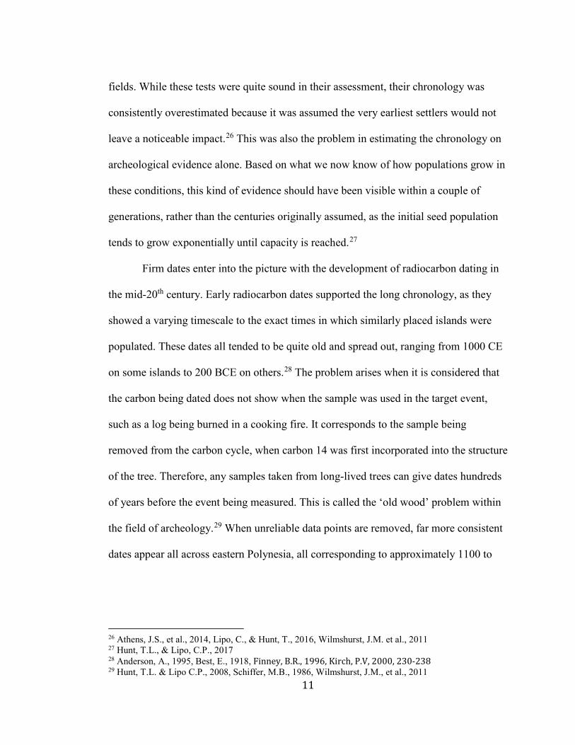
Models of Human Dispersal
C Figure 2: Three models of human dispersal in Polynesia derived from Radio Carbon
tests under different levels of scrutiny, (A) Emory & Sinoto 1965, (B) Kirch 1984
(Kirch, P.V., 2000, 231), (C) speculates that the Society Islands, with the possible
inclusion of Gambier Island was settled between 1025 and 1121 CE, while the more
remote and marginal islands were settled in a wave between 1200 and 1290 CE. The
most recent models indicate that the early dates found in the Societies may be
inaccurate. (Wilmshurst, J.M., et al., 2011)
The initial catalyst for colonization of East Polynesia is still somewhat of a
mystery. There is substantial speculation as to why such an endeavor was undertaken,
ranging from warfare or famine-induced refugees, exploration for its own sake, or a
simple land grab spurred on by advances in maritime technology.31 We may never
know why, but we are increasingly close to a better understanding. As of the writing of 31 Burley, D.V., and Addison, D.J., 2014, Burley, D., et al., 2015, Clark, G., et al. (eds.), 2008, 87-93, Di Piazza, A., et al., 2006, Rongo, T., et al., 2009, Wilmshurst, J.M., et al., 2011

14
this paper, estimations for the settlement of Eastern Polynesia are split into two parts.
There is the early settlement from Samoa into the Society Islands and Gambier between
ca. 1025 CE and 1121 CE,32 and the rest of East Polynesia in the thirteenth century
(figure 3). There is some evidence to support that the earlier dates in the first wave are
inaccurate, allowing for rapid colonization of the entirety of Eastern Polynesia within a
few hundred years, possibly as short as a single century.33 The implications of the
theory would be astonishing in the sheer scope of the endeavor, especially for a people
unaware of that scope from the beginning.
Research into the actual function and manner of use with which the vessels used
to undergo these proposed migrations have also evolved significantly. The modern
scholarship on human population dispersal in East Polynesia is primarily focused on the
debate of the extent of intentional traffic between island groups. It is now well accepted
that such travel did exist at this point;34 but it is one thing to say that voyagers set out
with the intent of finding new islands to inhabit, and quite another to say that voyagers
set out to go to islands long settled. The two major contributors to this debate are Ben
Finney, who actively supported the interconnection narrative since the late 1950s until
his death in 2017, and Atholl Anderson, who advocates the narrative of limited two-way
voyaging.
Each of these theories is in large part based on the variability in the
sophistication of sail plans used at the time of heightened contact after initial
colonization. Finney’s model relies on the strategic use of winds to navigate between
32Wilmshurst, J.M., et al., 2011 33 Wilmshurst, J.M, et al., 2011 34 Collerson, K.D., and Weisler, M.I., 2007, Couper, A.D., 2009, Lewis, D., 1972, Weisler, M.I., and Kirch, P.V., 1996
15
island groups, as local differentials to global norms allow for travel between islands in
mostly downwind or crosswind trajectories, while sailing against the global prevailing
winds.35 The possibility of significantly more complex vessel designs than those found
historically is also considered. Finney is not as concerned with providing a history of
colonization, as much as mapping prehistoric trade routes as a more the central facet of
his studies, but other researchers have concluded that aspects of his basic model make
sense regarding safety in navigating. It allows for the slow advance of sailors into the
prevailing wind during brief reversals, leaving them with a fair amount of certainty of
being able to return home.36 Unfortunately, while they are often drawn from oral history
alongside wind pattern data, archeological evidence for substantial contact is often far
less abundant. In his work, he has lamented this lack of a clear ‘smoking gun’.
Unfortunately, pottery making declined after Lapita voyagers reached the mid-Pacific, and was not spread farther east by their Polynesian descendants. Moreover, although obsidian occurs in New Zealand and Easter Island, tools made from this type of volcanic glass were apparently not widely spread from these peripheral islands. (Finney, B.R., 2007, 1873)
His data is also often reliant on the maximum performance characteristics of pre-contact
canoe technology, thus drawing some criticism to his more grandiose claims.37
Atholl Anderson approaches the problem from a slightly different perspective.
He also assumes intentional two-way navigation but differs in one clear area. In his
models of inter-island navigation, he does not allow for the ability to navigate against
the wind. Instead, he more often has relied on shifts in climate patterns, associated with
35 Finney, B.R., 1988, Finney, B.R., et al., 1989, Finney, B.R., 1996, Finney, B.R., 2001, Horvath, S.M., & Finney, S.M., 1969 36 Irwin, G., 2008, 22 37 Anderson, A., 2008
16
El Niño events, causing a temporary reversal of the predominant winds to facilitate
upwind migration.38 This approach has the benefit of providing a window of suitable
winds to allow an eastward expansion closely matching the time- period of the late
chronology.39 Of course, there are still questions left to be asked by this model.
The downwind sailing theory makes a minimum estimation of performance, which has the virtue of not over-estimating it. EI Niño is employed as a forcing agent and provides a loose chronology for colonization. However, it constrains the direction of advance and rather begs the question of why downwind Lapita voyages were not made west- ward to Papua New Guinea and Australia in La Niña conditions. (Irwin, G., 2008, 24)
Motivation is difficult to determine, but among populations so capable of traversing
vast stretches of an ocean against the prevailing conditions, the question of why they
never turned around is a relevant one.
There probably was some westward travel, if only due to sailors being blown off
course, but why there is then so little evidence of westward dispersals remains a point of
some study. There is almost a complete lack of linguistic and cultural exchange evident
in the Western islands of Oceania. It is somewhat understandable that there might not
be a noticeable movement of people; as it is a well-accepted behavior theory that given
the chance populations will tend to expand into areas with less competition even if they
are not as rich in resources.40 This is called the ideal free distribution, and it seems to fit
the data from the Polynesian expansion to a degree, but it is curious when the warlike
and conquest prone cultures described historically would not have left more of a mark.
38 Finney, B.R., 1988, Goodwin, I.D., et al., 2014, Irwin, G., 2008 39 Anderson, A., 2006a 40 Kraft, J.R., et al., 2002
17
An important addition to all of the theories so far discussed, both past and
present that has heavily influenced the canon of Polynesian colonization is the idea of
contact with the Americas. Unlike the theories of Heyerdahl and his supporters, this
theory indicates that it was the Polynesians who first made contact with the Americas,
rather than the reverse. There is tantalizing evidence can be found throughout both
Polynesia and western South America. However, equivocal evidence for direct contacts
has often proven elusive.41 The sweet potato is undoubtedly of South American origin,
and yet it is a staple of the Polynesian diet, while the chicken, a bird native to Southeast
Asia, possibly found its way into the culture of the Inca before European contact.42 This
is not a new observation, and, in fact, played a role in dismantling Heyerdahl’s claims.
It took Thor Heyerdahl and his crew nearly four months to drift to the Tuamotu islands, and sweet potato tubers become rotten in less time than… it is more logical to assume that it was made by a seafaring people like the Polynesians who could have made a trip from the Marquesas Islands to northern Peru in three weeks in a sailing canoe averaging seven knots. (Holmes, L.D., 1958, 129)
There is also some evidence of cultural diffusion through similarities in artifacts and
words,43 although it is quite scant in comparison to the botanical evidence. What
remains is to find concrete evidence of human involvement, as whatever contact existed
appears to have been very brief and late in time, which seemed to have left minimal
impact on either region.
Outside of the questions of how and why Polynesians started and continued to
navigate between islands, there is also the question of when and why they stopped. By
the 14th century there is almost no evidence for new human settlements or fresh gene
41 Thomson, V.A., 2014 42 Fitzpatrick, S.M., & Callaghan, R., 2009, Storey, A.A., 2007, Storey, A.A., et al., 2011 43 O’Connor, J.T., White, F.J., & Hunt, T.L., 2016, Walworth, M., 2014
18
flow, as well as the abandonment of many of the more remote or marginal islands that
were inhabited.44 One of the narratives proposed that the initial surge of colonization
into East Polynesia was followed by a ‘devolution’ in vessel design after all the
available land was claimed. This hypothesis is partly in response to the observations of
the maritime technology on outlying Polynesian islands, made by European explorers
who stated that the vessels at the islanders’ disposal were not capable of concerted
efforts in exploration. It is thought that the vessels observed in Hawai`i, Rapa Nui, and
New Zealand were the descendants of early voyaging canoes, made by a healthy
population no longer in the throes of expansion.45 Without the need for long oceanic
voyages, large canoes were impractical, and thus discontinued even in the areas where
building them was relatively easy. This hypothesis disregards trade as an incentive for
travel.
The rival view sees an average advancement in vessel design across Polynesia,46
citing such advancements as the crab-claw sail design in Hawai`i that allowed for better
management of the wind, and a closer tack into the wind.47 These advancements were
not necessarily beneficial for inter-island transport, but rather a case of individual
groups providing crafts best suited for their needs, given their resources.48 For example,
the giant canoes of New Zealand do not compare at all to those on Rapa Nui, and
neither is capable of inter-island transport, but both were adequate to the needs of their
island populations.
44 Anderson, A., 2001, Anderson, A., 2015 45 Anderson, A., 2008 46 Anderson 2006b, 760 47 Campbell 1995, 12-18 48 Arana, P.M., 2014, Best, E., 1918, 175
19
There is also the possibility of a combination of these two ideas, as there is
evidence of contact between Central and West Polynesia around the same time as the
first European explorers ventured into the area, allowing for the advancements from
either region to make it into the other.49 This hypothesis is one of the main causes of
controversy within current research, as such an influx of new maritime technologies, the
possibility of spreading of European ideas ahead of their explorers,50 all added to the
changes already seen, would have distorted how the first vessels would have performed.
It may never be entirely clear what the original Polynesian voyaging canoes looked like,
or even if there was a standard when the original pioneers set out for seas. Regardless,
the very idea of such a craft has rooted itself deep within the academic community that
studies these phenomena.
A real effort has yet to be made in modeling the exact form of the Polynesian
voyaging canoe, and not simply because of the lack of information. Past efforts, such as
those of Finney and Anderson, have focused entirely on a limited, or even a single
source off of which they modeled their vessel. As has been demonstrated, a great deal is
known from the various historic records, so long as one is aware of the hyperbole that
was common in early anthropological texts. A consorted project to catalog the various
diagrams and descriptions available from early explorers and settlers could create the
data set required to finally get a solid image of how the original Polynesian voyaging
canoe was designed.
49 Finney, B.R., 1988, Rolett, B.V., 2002, Walter, R., Sheppard, P.J., 1996 50 Best, E., 1976, 341, Campbell, I.C., 2003, Haddon, A.C., & Hornell, J., 1936, 18, 87, Richards, R., 2008
20
Modeling Dispersal and Voyaging
One of the largest fields that is undergoing current expansion is that of
modeling. Since the early period of research in the region it has been recognized that the
distance separating islands seems to have played a major role in their sequence of
habitation. Almost every pause in settlement has been due to a significant water barrier
between islands. Fiji, Tonga, and Samoa have a 1200 km gap separating them from
their nearest neighbor in Melanesia, whereas the distance between the archipelagos is
approximately 800 km, a span that could be crossed in approximately 48 hours based on
the reported characteristics of their craft at contact, as well as models of sailing
performances of reconstructed craft.51
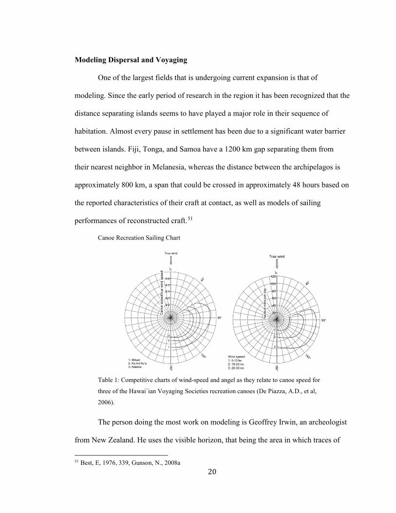
Canoe Recreation Sailing Chart
Table 1: Competitive charts of wind-speed and angel as they relate to canoe speed for
three of the Hawai`ian Voyaging Societies recreation canoes (De Piazza, A.D., et al,
2006).
The person doing the most work on modeling is Geoffrey Irwin, an archeologist
from New Zealand. He uses the visible horizon, that being the area in which traces of
51 Best, E, 1976, 339, Gunson, N., 2008a
21
the island become visible such as changes in ocean currents or seabird activity, and
compares it to the distance from its neighbors to postulate probable settlement
patterns.52 These models are very elegant and intuitive. Similar models are being used
to predict settlement patterns all across the world, including speculation into the future.
As of now, Irwin’s work is best optimized for the settlement of the Lapita Complex.
Current accepted colonization dates in East Polynesia seem to indicate an extremely
rapid colonization, with only a small correlation between settlement order and
remoteness.53
It has been shown that El Niño Southern Oscillation events can cause unusually
prolonged easterly shifts to the prevailing winds, allowing for more daring explorations
in that direction,54 possibly explaining the acceleration of the expansion. There is
evidence for such an oscillation around the time of the colonization of East Polynesia,55
and, in fact, these match up reasonably with projected dispersal and settlement dates.
Given very rudimentary metrics for vessel performance under those conditions it is very
possible that they would have been capable of reaching many of the island groups in
East Polynesia with little trouble. From those islands the more remote regions also
become viable targets under those conditions. Taking this research into account, it
seems likely that a major change in vessel design was less important than climatic
factors in initiating East Polynesia’s settlement. These insights are why these
speculative models are so useful in consort with the more physical archeology found in
digs and reconstruction efforts.
52 Irwin, G., 2008, Irwin, G., 2015 53 Wilmshurst, J.M., et al., 2011 54 Anderson, A., et al., 2006a, Goodwin, I.D., et al., 2014, Montenegro, Á., et al., 2016 55 Montenegro, A., et al., 2014, Montenegro, A., et al., 2016, Piazza, A.D., 2013
22
Layman Research and Voyaging
The drive to better understand the voyaging past of Polynesia is not exclusive to
researchers, and in fact, makes up a large segment of the Neo-Traditionalism
movement. In modern times, Polynesian voyages are a point of pride amongst the
people that now live in the region, and a point of acclaim they hold up to the rest of the
world. Starting in the mid 20th century, and fully underway by the 1970s, the Hawai`ian
Renaissance had swept the islands, bringing with it a revival of native watercraft such
as surfing and paddle-driven canoe racing. The movement was primarily a way in which
native Hawai`ians could create a unified identity, for use in both the political and
broader cultural spheres.56 One of the most iconic symbols of this movement are the
voyaging canoes built during this period. Ben Finney, one of the leading figures in this
revival, was a large part of their gaining such a prominent position. He co-founded the
Polynesian Voyaging Society, and in that capacity built several double canoes with
which to provide proof of concept for his theories.57 That research, as well as its active
use as an object of cultural icon, cemented the idea of voyaging into the Neo-
Traditionalist identity of the Polynesian people. Other Neo-Traditionalist movements
were happening in concert throughout Polynesia. In 1995 replica double canoes from
numerous groups met at Awarua in French Polynesia, to establish a common identity
and purpose. Such movements continue to this day, raising awareness of Polynesian
culture, both within and outside Polynesia.
56 Finney, B.R., 1994b, Finney, B.R., 2003 57 Finney, B.R., 2003

23
Chapter 3: The Evolution of Vessel Design
Introduction
The exact form of the Polynesian voyaging canoe is still a mystery in its
specifics, but advances in our knowledge have been made through a combination of
archeological research, historical reconstruction, and analysis of physical factors of
wind and current that would have restricted the forms used in sailing. It has been
demonstrated that environmental factors that occur in a specific region can have an
enormous effect on how the basic Polynesian culture and architectural traditions express
themselves.58 The basic form of the Polynesian canoe is well known, based on common
traits exhibited on all islands in the region up into the historic period. They were, “slim
canoes hewn with stone adzes, lashed together with coconut fiber line, powered by mat
sails” (Finney, B.R., 1977).
Historic Voyaging Canoe Plans
Figure 3: Plans depicting a single outrigger canoe (vaka or hamatafua) described in the
Tongan Archipelago. Noteworthy are the storage compartments (a4) and the ribbed
internal structure (b and c) (Haddon, A.C., & Hornell, J., 1936).
It is typical to think of ‘primitive’ canoes as dugouts, but, with a few exceptions,
this is broadly untrue in Polynesia. The specifics of design varied widely between island 58 DiNapoli, R.J., et al., 2017
24
groups, but most often vessels were made up of lashed planks.59 Holes would be bored
through the plank at its edges, so that rope could be fed through to stitch each side
together. This allows for a much more versatile construction in both hull shape and size,
as it is not dependent on the dimensions of the trunk. They are all constructed out of
multiple buoyant bodies, most typically a single hull with an outrigger lashed alongside
to spread out the craft’s balance point; a necessary arrangement for roll stability and the
use of sails on such an otherwise narrow craft. A platform would be constructed on top
of this frame for living space while underway, with the hollow of the hull primarily
used for storage of provisions and trade goods.60 Often the largest craft had two semi-
symmetrical hulls for added stability and storage potential. Sometimes a second
outrigger was used, but such arrangements were typically only found in the more
western portions of the Pacific Islands, well outside of Polynesia.61 It granted greater
stability at the cost of increased drag.
One aspect of this hull configuration that has provoked some controversy is that
they could have been shunted.62 Shunting is the process in which a vessel changes its
heading across the wind by changing the location of its sails to the opposite end of the
vessel, rather than tack across the wind or wearing with the wind, both of which have
downsides that make them undesirable. If shunting were a common procedure, it would
mean that the sail plan utilized by the Polynesians would have been incredibly mobile,
and thus probably not as rigid as is called for in the Finney model. Descriptions of
59Arana, P.M., 2014, Haddon, A.C., & Hornell, J., 1936, 8, 32, 144, 148, Johns, D.A., Irwin, G.J., & Sung, Y.K., 2014, Sinoto, H.Y., 1979 60 Best, E., 1976, 136, Haddon, A.C., & Hornell, J., 1936, 13-15, 189 61 Irwin, G., 2008 62 Irwin, G., 2008
25
Polynesian sails seem to support the basic plan needed for this maneuver, although
without much conviction of its use.63 On the other hand, there is substantial evidence
that the typical Polynesian canoe was built with a distinct bow and stern, as well as the
sail plan mentioned above being a possible historic innovation.64
Hōkūle‘a
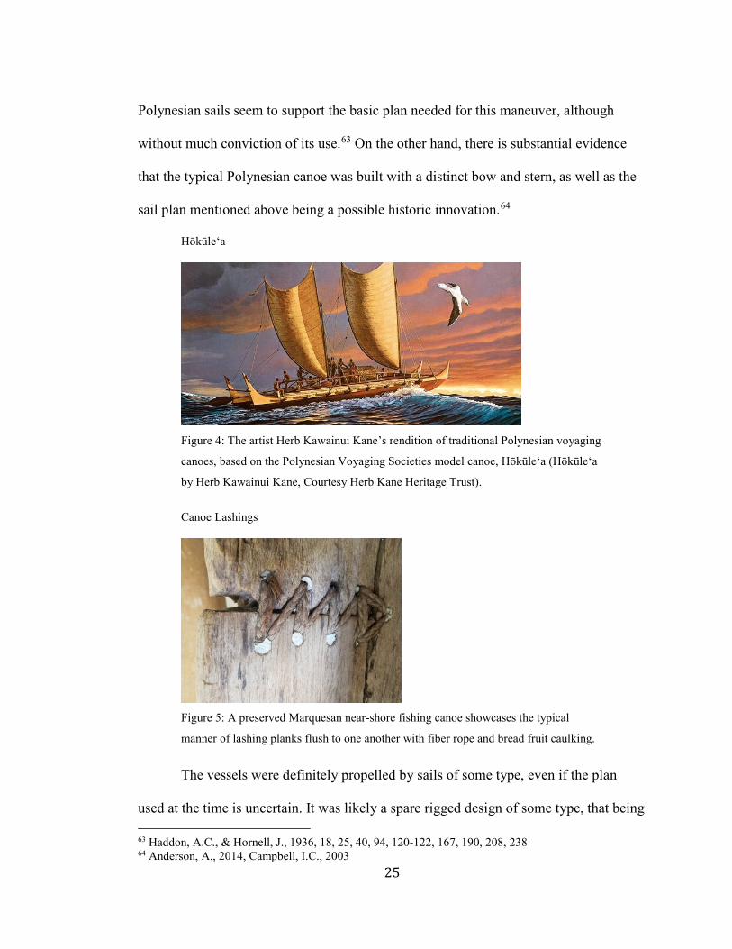
Figure 4: The artist Herb Kawainui Kane’s rendition of traditional Polynesian voyaging
canoes, based on the Polynesian Voyaging Societies model canoe, Hōkūle‘a (Hōkūle‘a
by Herb Kawainui Kane, Courtesy Herb Kane Heritage Trust).
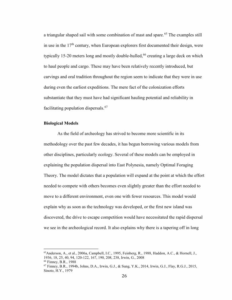
Canoe Lashings
Figure 5: A preserved Marquesan near-shore fishing canoe showcases the typical
manner of lashing planks flush to one another with fiber rope and bread fruit caulking.
The vessels were definitely propelled by sails of some type, even if the plan
used at the time is uncertain. It was likely a spare rigged design of some type, that being 63 Haddon, A.C., & Hornell, J., 1936, 18, 25, 40, 94, 120-122, 167, 190, 208, 238 64 Anderson, A., 2014, Campbell, I.C., 2003
26
a triangular shaped sail with some combination of mast and spare.65 The examples still
in use in the 17th century, when European explorers first documented their design, were
typically 15-20 meters long and mostly double-hulled,66 creating a large deck on which
to haul people and cargo. These may have been relatively recently introduced, but
carvings and oral tradition throughout the region seem to indicate that they were in use
during even the earliest expeditions. The mere fact of the colonization efforts
substantiate that they must have had significant hauling potential and reliability in
facilitating population dispersals.67
Biological Models
As the field of archeology has strived to become more scientific in its
methodology over the past few decades, it has begun borrowing various models from
other disciplines, particularly ecology. Several of these models can be employed in
explaining the population dispersal into East Polynesia, namely Optimal Foraging
Theory. The model dictates that a population will expand at the point at which the effort
needed to compete with others becomes even slightly greater than the effort needed to
move to a different environment, even one with fewer resources. This model would
explain why as soon as the technology was developed, or the first new island was
discovered, the drive to escape competition would have necessitated the rapid dispersal
we see in the archeological record. It also explains why there is a tapering off in long
65Anderson, A., et al., 2006a, Campbell, I.C., 1995, Feinberg, R., 1988, Haddon, A.C., & Hornell, J., 1936, 18, 25, 40, 94, 120-122, 167, 190, 208, 238, Irwin, G., 2008 66 Finney, B.R., 1988 67 Finney, B.R., 1994b, Johns, D.A., Irwin, G.J., & Sung, Y.K., 2014, Irwin, G.J., Flay, R.G.J., 2015, Sinoto, H.Y., 1979
27
distance voyaging at approximately the same time we see that most islands had fully
colonized their coastlines.68
Another model that can explain the discontinuation of voyaging is a model that
disincentives voyaging. In island ecology it has been observed that similar bird species
often find their way onto different islands. These birds are generally very good fliers,
but after reaching an island, the species almost always evolves behavior and physiology
that prevent longer flights.69 There are a number of possible explanations for this
phenomenon, such as the wasted energy needed to maintain the trait, when it is no
longer a useful skill in deriving food, or the likelihood of straying too far from the
island to get back is much higher for the better flyers. The same can be used to describe
canoe voyaging potential, as when voyaging became less viable of an option, the design
of the canoes would change to make them less capable of straying too far from their
home island.
To best understand the evolution of the Polynesian canoe after dispersal, it takes
every dataset that can be derived even tangentially related to the topic. Biological and
ecological models can be incredibly helpful in determining what some of the most
pressing environmental factors would have been. The realities of the risks that would
have had to have been weighed against their possible reward across generations, would
have been the primary force dictating how canoe designs changed over time. There is
no real way to truly understand the dangers faced by early voyagers beyond extensive
statistical analysis utilizing data that is as of yet unknown. Any direct evidence is
crucial in providing a firm data point off which to base further speculations. 68 Lepofsky, D., 2016 69 Komdeur, J., et al., 2004
28
Archeology
One reason the vessels of Polynesia cannot be studied in a like manner as those
found in Europe in the same respective eras has to do with the geography of the region,
as well as some of the particular elaments in the design. European ships relied on deep
keels to navigate rough seas and strong currents, whereas the Polynesians utilized
catamaran like designs to create a more stable platform. The latter requires no ballast
that would drag a sinking ship to the bottom, where the anaerobic environment may
preserve the wooden hull for further analysis. Most of those finds were also found not in
the ocean, but in river estuaries; a phenomenon almost completely missing in Polynesia.
There are few large rivers in Polynesia, nor a great need for pre-European contact
Polynesians to have sailed up the few that exist. There very well might be pieces of
submerged canoe in the lagoons and sand beaches that are common in the region, but it
is unlikely any will be found without an extreme effort that is beyond the scope of
serious archaeology in the area.
There have been canoe fragments found in the Society Islands and New
Zealand,70 dating roughly to the time-period of initial colonization, but they were
predominantly found by chance. The Society Islands site, a swampy portion of Huahine
called Fa’ahia, was the site of a hotel renovation that allowed the dredging of the entire
site before it was irrevocably altered. Analysis of the artifacts determined that they were
probably part of a double canoe approximately 24 meters (80 ft) long. This is primarily
based on the configuration of two large deck plank segments that fit the design of
historic contemporaries almost perfectly. The site may have been that of a construction
70 Johns, D.A., Irwin, G.J., & Sung, Y.K., 2014, Sinoto, H.Y., 1979
29
or renovation attempt that was abandoned for some reason, based on several artifacts
that seem to be have been undergoing construction before they were deposited,
including a bailing device and the steering oar.71 The site also contained several stone
tools that would have been appropriate for woodworking.
The vessel appears to have been of the same basic design as those found in
historical accounts, with a few differences. The before-mentioned steering oar is far
blockier than later ones found in the area, being more reminiscent of those found in the
Marshall Islands,72 possibly indicating a point of contact. There was also a canoe brace
found that does not match the shape of latter examples of spanners, of which the artifact
is thought to be an example. To what extent this indicates a change in design is
unknown. The site was dated at being deposited somewhere between 700 and 1200 CE.
Based on new estimates of the settlement chronology of the region, that would indicate
that the vessel these artifacts came to the region as part of the earliest wave of explorers
given that the early dates are well outside all the currently accepted earliest settlement
of the region.73 Given the range of materials that were analyzed for radiocarbon dates, it
is likely that they received several dates that were much older than the target event. The
vessel could have originated much further west, as there were still ample signs of
communication throughout this period.
The Anaweka estuary find in New Zealand consisted of a single section of hull,
and was only found by extreme providence after a cut bank left it exposed after a
71 Sinoto, H.Y., 1979 72 Sinoto, H.Y., 1979 73 Athens, J.S., et al., 2014, Wilmshurst, J.M., et al., 2011
30
storm.74 While a single hull panel is not able to give a great deal of new data regarding
the exact structure of prehistoric vessel design, it can be used to help shore up our
understanding. This find is primarily of importance because it does not differ
significantly from the basic idea of how the ancient canoes of the region were designed.
As previously stated, historical accounts of vessel design across Polynesia, and the rest
of the Pacific Islands, almost invariably consisted of a dugout or log-built base, with
side-strike planks to build up the hull. The exact ratio between log-base and side-strikes
varied based primarily on the availability of the large trees needed to build a complete
dugout vessel of the size required for oceanic voyaging. The dimensions of a vessel can
tell us a great deal about the priorities of its builders.
The panel itself is just over 6 meters (20 ft) long, making the vessel it was made
for at least 12 meters (40 ft), assuming it had a symmetrically curved hull. As those
found historically in the region did so, it is likely that is the case.75 It is roughly straight-
edged and likely was more so if the effects of the past few centuries of neglect were to
be ignored, with a tapered point curving upward on one side, indicating that it adjoined
either the bow or the stern. It also includes a carved turtle on a raised section near the
outside tapered end. Since turtles were not native to the region, this indicates that either
the cultural significance of turtles in voyaging, as seen in much of tropical Polynesia,
had been maintained up to this point, or that this particular vessel had been constructed
in an area with more frequent turtle sightings. It was probably located on the stern
starboard side, above the waterline, if it is to be assumed that the turtle was facing
74 Johns, D.A., Irwin, G.J., & Sung, Y.K., 2014 75 Johns, D.A., Haddon, A.C., & Hornell, J., 1936, 211, Irwin, G.J., & Sung, Y.K., 2014
31
forward and on the outside of the canoe.76 It was built with reinforcing ribs carved out
of the same timber as the panel and bore holes marking it as a central timber. The bores
themselves show sign of repair and maintenance, indicating that the craft, or at least the
plank, was well used before it was deposited. It had likely traveled a great deal as part
of one or more different canoes before that event, originating well outside of New
Zealand.77
Given the infrequent finds from which archeologists have derived their
knowledge of canoes, it is surprising how much in known. With these fragments as
guides, it has been possible to verify that at least some of the vessels were of a similar
design to what archeologists and historians have proposed as the standard design of the
ancient Polynesian voyaging canoe. Our current understanding of human population
dispersal that resulted in the peopling of Eastern Polynesia can be described as
something akin to a land rush. It is unclear as to the precise sequence of events that led
to the first migrants from Tonga or Samoa, the two most likely origins for colonists, to
start searching out new islands, but whatever did, had them on nearly every island large
enough to support agriculture within one-hundred years.78 Even the most marginal of
islands show evidence of a human presence dating to between the 12th and 14th
centuries.79 Evidence for limited trade, legalistic and cultural exchange, and the
seasonal exploitation of remote islands continued throughout this period,80 before
dropping off to a far more limited contact between nearby island groups as it became 76 Johns, D.A., Irwin, G.J., & Sung, Y.K., 2014 77 Johns, D.A., Irwin, G.J., & Sung, Y.K., 2014 78 Athens, J.S., et al., 2014, Wilmshurst, J.M., et al., 2011 79Anderson, A., 2006a, Athens, J.S., et al., 2014, Di Piazza, A., & Pearthree, E., 2001, Wilmshurst, J.M., et al., 2011 80 Clark, G.R., et al., 2014, Collerson, K.D., and Weisler, M.I., 2007, Couper, A.D., 2009, Di Piazza, A., & Pearthree, E., 2001, Scaglion, R., 2005, Walworth, M., 2014, Weisler, M.I., and Kirch, P.V., 1996
32
more efficient to exploit inland territories on one’s own island, rather than journey to an
already populated island.
Historic Accounts
There were many people involved in the historical mapping and categorizing of
the Pacific Islands, starting in the 16th century when Vasco Núñez de Balboa first
sighted the Pacific Ocean from Panama in 1513. It did not take long before expeditions
were sent to plumb its depths, as they searched out land, treasure, and trade. Explorers
flooded the region over the next 300 years, hailing from Spain, Portugal, France, the
Netherlands, and the relatively late-coming but prolific Britain.81 Some searched for
new routes to known regions, while others sought out new lands. Many Europeans
thought that the sheer size of the Pacific Ocean indicated the existence of a new
continent somewhere in the regions of Polynesia, Melanesia, and Micronesia, or as it
was then known, the South Sea.82 It was called Terra Australis, and its potential
existence led to the discovery of many of the most remote Polynesian islands. It was
also this theory that spawned the notion that Polynesia comprised a sunken continent.83
Over the course of the European expeditions, nearly every island in the Pacific was
documented to some degree, including some of the first anthropological analyses
conducted on such expeditions.84
The first expedition to reach the Pacific Islands was the Spanish fleet led by
Ferdinand Magellan, who attempted the circumnavigation the globe in 1519. While
81 Delaney, J., 2010 82 Estensen, M., 2006, Hawkesworth, J., 1773, Vol. 2, 184, Henry, D., 1774, Vol. 1 471, Home, H., 1775, 18, 38, 46-47, Pringle, J., 1776, 2, Purchas, S., 1625 83 Brown, J.M., 1924 84 Harari, Y.N., 2014
33
passing through Polynesia, they saw only two islands in the Tuamotus where they report
no interaction with any native presence, as well as Guam.85 They make little mention of
the peoples they encounter, much less the sailing vessels in the area. Álvaro de
Mendaña y Neira’s 1567 and 1595 expeditions were the next major forays into the
South Pacific, resulting in the description of the Solomon Islands in some detail, as well
as some description of the Marquesas Islands.86 The last major Spanish expedition into
the Pacific Islands, led by Pedro Fernandes de Queirós, discovered the Buen Viaje
Islands in Melanesia, and probably sighted the Society and Tuamotu archipelagoes on
his way west.87
The first English venture into the Pacific was made by Sir Francis Drake in
1577, becoming the second to do so in a single mission, and the first to command the
expedition throughout. His journey through Polynesia was not long, with no landfalls
until he reached the Indonesian islands.88 Englishmen would not return to the region for
over a century when William Dampier circumnavigated the globe in 1679. Although he
accomplished this feat three times, ending in his death as a result of the last expedition
in 1710, he spent a majority of his time in Indonesia and Australia.89 He was followed
by Samuel Wallis, who in 1766 set sail with orders to explore the region. He mapped
much of the Society Islands, as well as the Tuamotus,90 before proceeding onward to
the Marshall Islands in Micronesia. He was meant to travel in company with Philip
Carteret but was separated while traveling through the straits of Magellan. Carteret went
85 Beaglehole, J. C., 1966, Ch. II, Purchas, Samuel, 1625 86 Beaglehole, J. C., 1966, Ch. III, Purchas, Samuel, 1625 87 Beaglehole, J. C., 1966, Ch. IV 88 Beaglehole, J. C., 1966, 60-63, Trusler, J., 1778, ii 89 Beaglehole, J. C., 1966, 170-174, Trusler, J., 1778, 228 90 Beaglehole, J. C., 1966, 200-206, Trusler, J., 1778, 2-56
34
on to describe the Pitcairn and the Carteret Islands.91 The last major British voyages of
discovery was those of James Cook starting in 1768. Perhaps the most prolific of any
explorer in history, he was the first European to traverse much of the Pacific, including
the Hawai`ian Island chain on his third voyage.92 Although his mapping of Hawai`i
granted his ascendency into the halls of the European discoverers, it was his, and his
crew’s, descriptions of the people they came across that set his voyages apart.93 Even
the islands already thoroughly traversed can trace most of their anthropological history
back to Cook’s expeditions.
Throughout this period, the Indonesian islands were traversed almost continually
by Portuguese, Spanish, Dutch, and English shipping, with a heavy emphasis on the
Dutch. The Dutch East India Company, which was founded in 1602, was responsible
for much of the region’s maritime traffic, including expeditions to discover new islands
and shipping routes. The voyage of Abel Janszoon Tasman in 1642 was perhaps their
most successful exploratory venture, during which his fleet became the first Europeans
to land on both Tasmania and New Zealand.94 They also traveled through the Tongan
archipelago and Fuji. Other Dutch enterprises, funded by rival companies, also
contributed to discoveries in the region. In 1615 Jacques Le Maire and Willem
Corneliszoon Schouten explored the Tongan archipelago as part of their
circumnavigation of the globe,95 and in 1722 Jacob Roggeveen, who sailed for the
91 Beaglehole, J. C., 1966, 200-213, Trusler, J., 1778, 160-170 92 Beaglehole, J. C., 1966, Ch. X, XI, XII, Cook, J. 1777, Vol. 1 and 2, Trusler, J., 1778, 186-227 93 Harari, Y.N., 2014, 276-278 94 Beaglehole, J. C., 1966, Ch. VII 95 Beaglehole, J. C., 1966, 127-184
35
Dutch West India Company, was the first European to sight Rapa Nui.96 He also
mapped much of the Society Islands, including Bora Bora, parts of the Tuamotu
archipelago, as well as Samoa.97
The last dominant world power to send an expedition to explore Polynesia was
the French. In 1766 Louis Antoine de Bougainville was tasked with the journey to
circumnavigate the globe. Although being primarily politically motivated, as it was
meant mostly as a gesture to indicate French ability after their defeat in the Seven Years
War with Britain, the voyage is vital due to it being the first to bring dedicated
naturalists as part of its crew. They stopped on the island of Otaheite in the Societies, as
well as in Samoa,98 and although they did not discover any new lands, theirs were the
more descriptive accounts. France would come to have cultural dominion over the
region in the subsequent centuries, in part due to the precedent set by this voyage.
These expeditions were undertaken with the express purpose of expanding
territory and trade routes of the European powers that sponsored them. Developments
in their cultural prerogatives, particularly science and knowledge generation in general,
made it paramount for such expeditions to not only describe the lands and peoples they
saw in terms of potential conquest, but also speculate as to their origins and the reason
for their state of being.99 This unique set of priorities are what let future historians and
cultural anthropologists receive a snapshot view of many hundreds of cultures, before
increased interconnection to far-flung regions altered them from traditional practice. In
the case of artifact design, such as with maritime vessels, this can be crucial in
96 Beaglehole, J. C., 1966, 181-182, Roggeveen, J., 1722, 93 - 115 97 Beaglehole, J. C., 1966, 180-197 98 Beaglehole, J. C., 1966, Ch. IX, Bougainvill, L.A., 1831, Henry, D., 1774, Dunmore, J.,1965, 57-113 99 Harari, Y.N., 2015
36
understanding what attributes were native to the culture at the time of contact with the
explorers in question, and what was introduced later.
A relatively significant amount of time was dedicated to describing Polynesian
boats, for a variety of reasons, the most straightforward of which is that these were
primarily naval expeditions, headed by boating people who would quite naturally first
analyze the maritime capabilities of the people they came across. In describing the
vessels of the Maori of New Zealand, Dr. Savage wrote, “These will contain upwards of
thirty warriors, and they sometimes lash two of them together. Ten or 15 of these
double canoes must form a powerful fleet and would prove formidable to a European
merchant ship,” (Savage, J., 1807, 62). From a military mindset, assessing a potential
enemy’s mobility over a primarily aquatic environment is crucial, and scientifically the
question of human origins on the islands has everything to do with that same capability.
Cook was entirely convinced of an interconnected Polynesian culture, based on oral
traditions describing ancient voyages, as well as an understanding of the geography of
the islands that allowed Cook to traverse thousands of miles through central Polynesia
with confidence of finding whichever island he directed himself toward.100 Boats were
among the most prevalent drawing made throughout the European expeditions. It is
unclear what the specific vessel design was during the colonization phase, but their
general form is not a complete mystery, as there are numerous historical accounts of the
vessels found in the area in the 17th and 18th centuries.
In the next few sections I will analyze the historic vessels of Polynesia as they
were described by these and latter expeditions. It is likely that many of the accounts are
100 Cook, J., 1777
37
faulty in some way, whether it be from imprecise recollection or observation, or straight
exaggeration. It is very likely that many of the lengths that will be mentioned will be
over estimating the true scale. Regardless, it is possible to determine many of the
characteristics associated to various craft, if not the specific hull plan. Through this
analysis it should be possible to gain insight on their common ancestors that were
capable of feats of long distance navigation and transport across Oceania.
Central Polynesia
Current models of the settlement history of Eastern Polynesia indicate that, after
the original rapid expansion, contact tapered off until almost no long-distance voyaging
occurred after approximately the 14th century.101 The exception to that rule was in
Central Polynesia, where islands and island groups were close enough together so that
water gaps larger than the distance one could sail in a day were uncommon, thus
allowing for continued contact across a vast distance, while mainly engaging in only
short-range expeditions.102 In this context I am defining Central Polynesia as including
the islands from the Society group all the way to Mangareva, than north to the
Marquises and South to the Australs. This is a decreasing sphere of influence model that
allowed for a great deal of cultural transmission long after the outer rim regions of
Polynesia had been cut off from contact. Even if that contact was almost never direct
outside of ones’ closest neighbors, the technologies used in maritime transport remained
101 Wilmshurst, J.M., et al., 2011. 102 Rolett, B.V., 2002, Walworth, M., 2014
38
relatively standard across most of this region,103 quite probably staying the most faithful
to the original design.
Central Polynesia seems to have retained the most inter-island contact in East
Polynesia after this initial period of extreme mobility, although this is not to say that
contact was frequent or uniformly spaced.104 The extent is not known, but it is likely
that many regions remained entirely insular for decades or even centuries. As has been
previously discussed, rescue voyaging was one of the only viable rationales behind
voyaging after the 14th century according to current models. The outlying islands, such
as the Line Islands or Rapa Iti had water gaps greater than 1000 km. Those that were
capable of supporting their populations would have had no reason to engage in
voyaging, and being out of the way of exchange routs between larger islands, it is
entirely possible they remained completely out of contact.
In this paper, I have concentrated primarily on cultural distinctions separating
construction techniques, but it is often dictated less on these terms than by the materials
present on the island, as well as the unique climate of the region. Numerous factors of
environment played into the exact model of canoe and sail plan used on different island
groups, such as average distance traversed, average wind speed, variable distance and,
wind speed, variable wind vector, and average wind vector in relation to the average
destination vector. For these reasons, it is likely that the places where these vessels were
first designed in Central and Western Polynesia retained the most significant amount of
continuity in design. While function altered significantly across time as they morphed to
103 Haddon, A.C., & Hornell, J., 1936, 26-96, 103-194 104 Rolett, B.V., 2002, Kahn, J.G. 2014
39
fit a more localized need for sailing vessels, the physical conditions of the regions
seascape remained mostly constant.
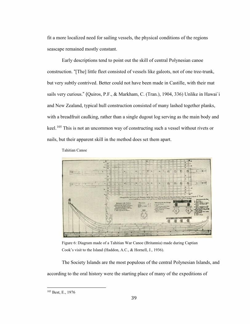
Early descriptions tend to point out the skill of central Polynesian canoe
construction. “[The] little fleet consisted of vessels like galeots, not of one tree-trunk,
but very subtly contrived. Better could not have been made in Castille, with their mat
sails very curious.” (Quiros, P.F., & Markham, C. (Tran.), 1904, 336) Unlike in Hawai`i
and New Zealand, typical hull construction consisted of many lashed together planks,
with a breadfruit caulking, rather than a single dugout log serving as the main body and
keel.105 This is not an uncommon way of constructing such a vessel without rivets or
nails, but their apparent skill in the method does set them apart.
Tahitian Canoe
Figure 6: Diagram made of a Tahitian War Canoe (Britannia) made during Captian
Cook’s visit to the Island (Haddon, A.C., & Hornell, J., 1936).
The Society Islands are the most populous of the central Polynesian Islands, and
according to the oral history were the starting place of many of the expeditions of
105 Best, E., 1976
40
discovery and long distance contact.106 The island of Ra’iātea especially tends to be
named as the original home of many of Polynesia’s peoples in their histories.107 There is
some evidence supporting the region being colonized approximately a century before
the rest of East Polynesia.108 As physical and cultural center to the region, the island
group had cultural dominance over the region in historical times, likely spanning back
into the prehistoric period as well.109
The Society Islands, like much of the region, are lush with tropical flora, but are
somewhat lacking in large timbered trees. Their canoes tended to have a keel shaped
into an arch out of a single trunk, but the hull of the vessel was completely of a lashed
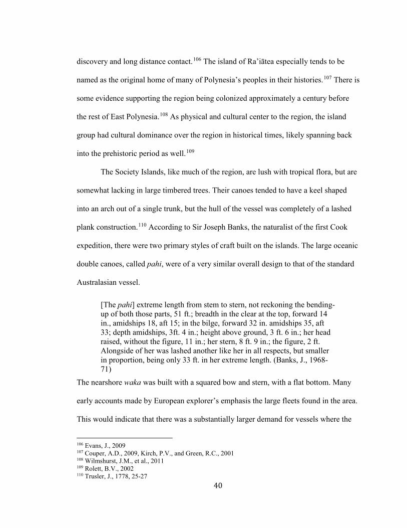
plank construction.110 According to Sir Joseph Banks, the naturalist of the first Cook
expedition, there were two primary styles of craft built on the islands. The large oceanic
double canoes, called pahi, were of a very similar overall design to that of the standard
Australasian vessel.
[The pahi] extreme length from stem to stern, not reckoning the bending-up of both those parts, 51 ft.; breadth in the clear at the top, forward 14 in., amidships 18, aft 15; in the bilge, forward 32 in. amidships 35, aft 33; depth amidships, 3ft. 4 in.; height above ground, 3 ft. 6 in.; her head raised, without the figure, 11 in.; her stern, 8 ft. 9 in.; the figure, 2 ft. Alongside of her was lashed another like her in all respects, but smaller in proportion, being only 33 ft. in her extreme length. (Banks, J., 1968-71)
The nearshore waka was built with a squared bow and stern, with a flat bottom. Many
early accounts made by European explorer’s emphasis the large fleets found in the area.
This would indicate that there was a substantially larger demand for vessels where the
106 Evans, J., 2009 107 Couper, A.D., 2009, Kirch, P.V., and Green, R.C., 2001 108 Wilmshurst, J.M., et al., 2011 109 Rolett, B.V., 2002 110 Trusler, J., 1778, 25-27
41
islands would have retained greater contact with surrounding island groups than those
of the outer rim of East Polynesia.
West Polynesia
Although Central Polynesia most probably retained the form of voyaging canoe
in East Polynesia through the function of long distance trade and seafaring, the Samoan
and Tongan archipelagos are almost certainly the true origin of the technology and quite
possibly retained a greater degree of continuity. Their craft were certainly reportedly
more seaworthy and participated in more frequent long distance expeditions at the time
of European contact.111 Called Western Polynesia, it remained interconnected with
central Polynesia,112 to a greater or lesser extent, but probably remained in greater
contact with the island groups of Melanesia. Humans reached the islands at or shortly
after the end of the Lapita Complex, which was another period of increased mobility
across island groups, this time in Near Oceania characterized by the spreading of a
distinctive pottery style. For an unknown reason pottery in its entirety was abandoned as
a concept by the early settlers of West Polynesia, but it is still very likely that Lapita
descendent voyagers were their predicators.113
The canoes found in Samoa were typical of the double style, but were
constructed out of an almost completely dugout hull, or possibly out of non-uniform
wooden slabs sewn together.114 There is conflicting information as to their speed, but at
the least they were capable of around 7 knots, possibly much faster. Double canoes
111 Best, E., 1976, 333 112 Di Piazza, A., & Pearthree, E., 2001, Lan Hogbin, H., 1940, Walter, R., and Sheppard, P.J., 1996 113 Anderson, A., 2014, Irwin, G., 2008 114 Best, E., 1976, 342
42
measuring between 10 and 15 m were reportedly used in transferring smaller vessels to
distant fishing grounds. Outrigger canoes are described on less favorable terms.
Having both a prow and stern, these canoes cannot be manoeuvred without tacking; consequently the outrigger that constitutes their safety is, in using their sail, alternately to leeward and windward, and does not, when to leeward, add much to the stability of the canoe. They carry less sail than the canoes of the other natives of Polynesia, and, to guard against the danger of upsetting, the natives rig a sprit or boom (suati) projecting from the opposite side to that on which the outrigger is fitted. This boom is secured with guys to the top of the mast. When the wind blows fresh some of the men go out upon it, and thus balance or counteract the force of the wind. (Wilkes, C., 1849, 214)
All of Samoa’s oceanic canoes are shrouded in contradictions to some extent.
Conflicting early accounts, followed by a near complete abandonment of the style, to be
latter filled by Fijian and Tongan designs leaves very little on which to base a
reconstruction.
Unlike the large oceanic canoes, many of the smaller vessels were constructed
of tightfitting lash plank constructions. The Va'a alo, a craft generally less than 7 m in
length used in bonito fishing, especially deserves mention for the skilled woodworking
required in its construction.115 Each craft was lashed in such a way as to have no
exposed lashings on the exterior hull,116 on planks less than 1.25 cm thick. The
existence of lash plank constructed vessels in an area where their development has been
deemed unlikely may indicate a point of contact with other regions, perhaps in Central
Polynesia. Beyond that, the large vessels earlier described exemplify remarkably similar
designs to those found in the Society Islands, far more so than displayed in other
regions.
115 Armstrong, K., et al., 2011, Smith, S.P., 1920 116 Best, E., 1976, 339-340
43
The Tongan Archipelago is notable for being actively documented traversing
island groups at the time of European contact, being able to exert a degree of economic
and political control over Samoa, Fiji, and possibly others including Vanuatu and
Tahiti, up to the 15th century.117 Their canoes were reportedly able to reach speeds in
excess of 11 kt and were very well crafted out of lashed planks.118 Double Canoes were
measured between 9 and 28 m, with differing rigging plans based on length. The
smaller vessels were designed to shunt while the larger craft held more stout masts
designed to tack. They are the home of perhaps the most quintessential Australasian
canoe, being on, and in some ways within, the border between Near and Remote
Oceania.
There is also some evidence of interspersed contact with the Melanesian and
Micronesian regions influencing their designs,119 opening the possibility of influences
coming into broader Polynesian design not originally found in their construction. They
share a history in that all three regions underwent dispersal periods at around the same
time, the time of initial colonization of West Polynesia also being the time when Fiji
and much of central and eastern Micronesia was settled.120 One key shared technology
is the double hulled canoe; found in Polynesia and the eastern portions of Melanesia,
but not in the rest of Remote Oceania.121 Movement was possible between other Pacific
peoples especially during the period of increased mobility in the 11th to 14th centuries.
The island of Fiji appears especially often throughout the oral history of western
117 Aswani, S., & Graves, M.W., 1998, Burley, D.V., 1998, Clark, G.R., et al., 2014. Geraghty, P., 1994, Gunson, N., 2008a, Gunson, N., 2008b, Petersen, G., 2010 118 Best, E., 1976, 339 119 Finney, B., 1996, Lan Hogbin, H., 1940, Kirch, P.V., 2000 120 Fitzpatrick, S.M., 2008, Intoh, M., 1997 121 Anderson, A., 2014, Haddon, A.C., & Hornell, J., 1936
44
Polynesia as a source of exchange for marital partners, particularly in royalty. It is
unknown as to the extent of this contact, although the lack of significant swap of
technology or other cultural vectors speaks to a fairly limited connection.
Hawai`i
Hawai`ian canoes differ from those found in the central region of Polynesia in
many ways. This is not surprising, as the island chain was likely completely out of
contact with the region since at least the 14th century.122 Hawai`i remained in contact
with central Polynesia for the prior three centuries after the initial settlement of the
islands, although to what extent is unknown.123 Located at the furthest northern range of
Polynesia, Hawai`i has a unique culture, related to but distinct from that of central
Polynesia. It is among the most thoroughly studied island groups in the Pacific, being
the key place of study of many of the field’s greatest researchers. In recent years, it has
also played host to much of the Polynesian cultural revival movement. Seeing just how
these canoes differ can shed some light on to what extent it is an independent entity
from the rest of Polynesia.
One of the key differences in hull design is that Hawai`ian canoes almost always
had a dug-out base with lashed plank tops to increase the hull’s surface area, and thus
the hulling potential.124 This was far more expedient than lashing the whole structure.
This convenience was in large part thanks to the abundance of large native trees in the
122 Kane, H.K., 1998 123 Collerson, K.D., and Weisler, M.I., 2007, Couper, A.D., 2009, Lewis, D., 1972, Weisler, M.I., and Kirch, P.V., 1996 124 Haddon, A.C., & Hornell, J., 1936, 8-10, Holmes, T., 1981, 64
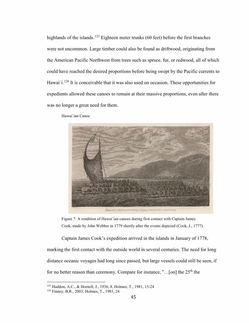
45
highlands of the islands.125 Eighteen meter trunks (60 feet) before the first branches
were not uncommon. Large timber could also be found as driftwood, originating from
the American Pacific Northwest from trees such as spruce, fur, or redwood, all of which
could have reached the desired proportions before being swept by the Pacific currents to
Hawai`i.126 It is conceivable that it was also used on occasion. These opportunities for
expedients allowed these canoes to remain at their massive proportions, even after there
was no longer a great need for them.
Hawai`ian Canoe
Figure 7: A rendition of Hawai`ian canoes during first contact with Captain James
Cook, made by John Webber in 1779 shortly after the events depicted (Cook, J., 1777).
Captain James Cook’s expedition arrived in the islands in January of 1778,
marking the first contact with the outside world in several centuries. The need for long
distance oceanic voyages had long since passed, but large vessels could still be seen, if
for no better reason than ceremony. Compare for instance, “…[on] the 25th the
125 Haddon, A.C., & Hornell, J., 1936, 8, Holmes, T., 1981, 15-24 126 Finney, B.R., 2003, Holmes, T., 1981, 24
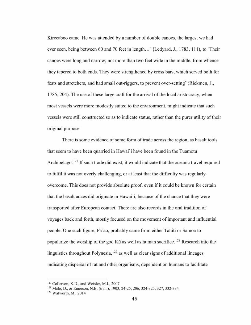
46
Kireeaboo came. He was attended by a number of double canoes, the largest we had
ever seen, being between 60 and 70 feet in length…” (Ledyard, J., 1783, 111), to “Their
canoes were long and narrow; not more than two feet wide in the middle, from whence
they tapered to both ends. They were strengthened by cross bars, which served both for
feats and stretchers, and had small out-riggers, to prevent over-setting” (Rickmen, J.,
1785, 204). The use of these large craft for the arrival of the local aristocracy, when
most vessels were more modestly suited to the environment, might indicate that such
vessels were still constructed so as to indicate status, rather than the purer utility of their
original purpose.
There is some evidence of some form of trade across the region, as basalt tools
that seem to have been quarried in Hawai`i have been found in the Tuamotu
Archipelago.127 If such trade did exist, it would indicate that the oceanic travel required
to fulfil it was not overly challenging, or at least that the difficulty was regularly
overcome. This does not provide absolute proof, even if it could be known for certain
that the basalt adzes did originate in Hawai`i, because of the chance that they were
transported after European contact. There are also records in the oral tradition of
voyages back and forth, mostly focused on the movement of important and influential
people. One such figure, Pa`ao, probably came from either Tahiti or Samoa to
popularize the worship of the god Kū as well as human sacrifice.128 Research into the
linguistics throughout Polynesia,129 as well as clear signs of additional lineages
indicating dispersal of rat and other organisms, dependent on humans to facilitate
127 Collerson, K.D., and Weisler, M.I., 2007 128 Malo, D., & Emerson, N.B. (tran.), 1903, 24-25, 206, 324-325, 327, 332-334 129 Walworth, M., 2014
47
spreading to different islands,130 also points toward at least a few centuries of contact.
Once contact was ended, large canoes were still required to some extent in transport
between islands in Hawai`i. The large craft of the original colonization phase would not
have been required, because of the sharply decreased storage requirements, as well as
the decreased likelihood of encountering a storm on the shorter journey.
New Zealand
The vessels of New Zealand, as they were at the time of European contact, were
also constructed out of a dugout log base, but often discarded the outrigger, double hull,
and sails found in most other regions.131 It is possible that the islands’ extreme
abundance made such things redundant in most cases, especially in nearshore
transportation. New Zealand is entirely unlike the other islands of Polynesia. It is
comprised of two large islands originating from tectonic uplift, rather than volcanic
activity. They are also located well outside the tropical zone, meaning that most of the
traditional Polynesian crops, such as breadfruit and banana will not grow anywhere on
the islands. Sweet Potato grows to some extent on the North Island, but for the most
part, the inhabitants of New Zealand were hunter/gatherers.132 Nonetheless, the
population of the islands was able to surge due to the abundance of wild foodstuffs.
The Maori canoes likely deviated significantly more from the original voyaging
model than those found on Hawai`i, partly as a result of the substantially different
environment located in New Zealand. Unlike in other regions of Polynesia, the Double
Canoe appears to have been widely out of use by the time Europeans arrived on the
130 Matisoo-Smith, E., et al., 1998 131 Best, E., 1976, 23-64 Haddon, A.C., & Hornell, J., 1936, 194 132 Green, R.C., 1975

48
scene.133 They are evident in the historical record but are most often identified as two
single hulled canoes that have been temporarily lashed together with a relatively small
gap between the two hulls. "Sometimes they fasten two [canoes] together with rafters,
which we call a double canoe," (Best, E., 1976, 30). There is some evidence, especially
on the South Island, that double canoes were more widely used into historic times for
their superior stability in rough weather but such practice evidently didn’t last into the
European colonization period of the island’s history. Single-hulled paddle driven canoes
seem to have been the more popular model.134
Construction of canoes on New Zealand was much like that on other Polynesian
islands, although the trees were exceptionally well suited for the use.
We were now no longer at a loss to know of what trees they make their canoes, as they can be no other than these pines. On this little isle were some which measured twenty inches diameter, and between sixty and seventy feet in length, and would have done very well for a foremast to the Resolution, had one been wanting. (Cook, J., 1777)
An account made by Dr. Savage, after a visit to the islands in 1805, describe the process
still in practice at the time.
Their canoes are formed of the trunk of a fir-tree, hollowed out by the adze, and usually raised upon by a plank of a foot broad on each side: they are of various dimensions, from thirty to sixty feet in length and upwards, and from two feet six inches to more than five feet broad; sharp at each extremity, and about three feet deep, including the plank before mentioned. This plank is united to the body of the canoe by ligatures, and a quantity of rush or flax placed in the seam, so as to answer the purpose of caulking. Their war-canoes are ornamented with carving and painting, and many of them are really very handsome.… The common canoes are seldom more than about thirty feet in length… They are also provided with nets, hooks, and lines, as an almost inseparable part of their equipment. Paddles are universally made use of, and, from the great strength and activity of the natives, the canoe is impelled forward with
133 Best, E., 1976, 24, Haddon, A.C., & Hornell, J., 1936, 194-215 134 Best, E., 1976, 46, Haddon, A.C., & Hornell, J., 1936, 194
49
uncommon velocity. A large stone supplies the place of an anchor. (Savage, J., 1807) War Speech
Figure 8: "A party of warriors had collected at the Bay of Islands for the purpose of
making a hostile visit to a Hauraki tribe. They were detained by contrary winds; and for
several days were constantly engaged in listening to speeches from their chiefs, who
addressed them from a canoe hauled on shore ... one [canoe], which I measured, was 70
feet long, and carried one hundred fighting men,” (Earle, Augustus, 1793-1838).
There is also a great deal known about the felling and moving of the logs that were
made into the canoes, thanks to historical accounts given by early European settlers in
the region.135 It is impossible to know the specifics of how the method described above
differs from that used in the centuries before European contact, but it is likely that the
broad ideas are similar, at the least.
Sails were used in New Zealand but to a much lesser extent than most other
regions of Polynesia.136 This absence is perhaps the most exciting aspect of the islands’
135 Best, E., 1976, 84-89, Haddon, A.C., & Hornell, J., 1936, 194 136 Best, E., 1976, 251-269, Haddon, A.C., & Hornell, J., 1936, 208-209
50
canoes, as on face value the dismissal of such an efficient labor-saving device seems
unusual from a culture that had used it to such effect for so many generations. The more
widely verified weather conditions found in the region, as compared with tropical
Polynesia, may partly explain its fall from favor. The effort in constructing sail and
tackle, as well as the broader hulls needed to support them, may have proven too costly
for standard vessels, as it was never clear when they might be used. If a crew had to
include enough paddlers to move the vessel efficiently, it could very well have been
decided that hauling around the extra weight and drag was not worth the benefit of the
chance of natural transport.
Despite this general paring down of the original Polynesian design, the New
Zealand canoes were more than adequate in dealing with most needs the peoples of the
islands contrived for themselves. The various types of Maori vessels have traditionally
been split into three categories. They are typically only account for single hulled craft,
as those were by far the most popular design. The waka taua is the most famous of the
Maori canoe designs, being the largest and most meticulously crafted. Its base could
consist of multiple segments, lashed together, or be dug out of a single log.137 They
were generally grandly decorated, with the high bow and stern pieces found throughout
many of the Pacific island cultures. They are often called ‘war canoes’ in European
sources,138 as one of their more ostentatious uses was the transport of warriors to battle.
They were capable of hauling large crews long distances, making them ideal for
circumventing New Zealand’s rugged terrain.
137 Best, E., 1976, 65-175 138 Best, E., 1976, 48, 65, Haddon, A.C., & Hornell, J., 1936, 200-212
51
Other vessels were used for more mundane uses, such as fishing and general
transport between habitation sites. Waka tete was basically a slightly scaled down
version of waka taua, with less emphasis on the artistry and polish, and more on the
practical use of the craft.139 It was the primary deep-sea fishing vessel on the islands by
the time of European contact. Waka tiwai were significantly smaller and
characteristically did not include any modifications over the dugout hull. They were
reportedly used for a variety of activities, such as the transport of small groups over
calm water bodies.140 There does not seem to be any tradition of lashed together small
craft, outside of a few early accounts of questionable reliability. The rich variety of
canoe found on the islands is a testament to the importance the ocean had on the lives of
the people living on New Zealand, while their apparent divergence from their
progenitors marks their vast difference in purpose. The next island that is to be
examined is even more dissimilar to those of tropical Polynesia.
Rapa Nui
Much of eastern Polynesia shared a comparatively extended period of contact, as
well as substantial resources to dedicate to shipbuilding. Rapa Nui was colonized during
the expansion of the Polynesians into the Eastern Pacific after contact was made with
South America,141 but likely remained completely isolated afterward.142 The island was
most likely colonized around 1250 CE, but earlier dates going back as far as 300 CE
139 Best, E., 1976, 24 140 Best, E., 1976, 24 141 Lipo, C.P. & Hunt, T.L., 2016 142 Barnes, S.S., et al. 2006
52
have also been reported but are not widely trusted for accuracy.143 The former date is by
far the most probable, as it corresponds to the most reliable radiocarbon dates found in
association with human activity on the island,144 as well as the dates found on many
other islands throughout Eastern Polynesia, strongly indicating a common event
spurring their colonization. Even more debate has raged around the origin of the
Rapanui people, going back to wild theories of sunken continents,145 and displaced
Egyptians.146 If a 1250 CE colonization event is accurate, it is likely that their ultimate
origin was Samoa, or the Society Islands.147 In particular to Rapa Nui, Mangareva was a
likely waypoint.148 After the island was settled, it is likely there was little to no contact
with any external population. Analysis of the genetics of Polynesian rat bones found in
excavations indicate that only a single line was ever present on the island, strongly
suggesting that there was never a second voyage to contribute to the admixture.149
There has yet to be a discovery linking the island to any trading circles. Rapa Nui was
well outside the envelope of even the most generous estimates of inter-island contact
post colonization phase, and was thus left to develop into a completely unique branch of
the Polynesian cultural tree. 150
The vessels found on Rapa Nui were not nearly so grand as those found in the
rest of Polynesia, as the island was relatively poor in resources, both terrestrial and
143 Kirch, P.V, 2000, 234 144 Anderson, A., 1995, Lipo, C.P. & Hunt, T.L., 2016, Mulrooney, M.A. et al., 2011, Rieth, T., & Cochrane, E., 2015, Walworth, M., 2014, West, K., et al., 2017, Wilmshurst, J.M., et al., 2011 145 Brown, J.M., 1924 146 Heyerdahl, T., 1950b 147 Athens, J.S., et al., 2014, Hunt, T.L. and Lipo C.P., 2008, Wilmshurst, J.M., et al., 2011 148 Green, R.C., 1998 149 Barnes, S.S., et al., 2006 150 DiNapoli, R.J., et al., 2017, Walworth, M., 2014
53
maritime.151 There have not been any archaeological examples found, but a significant
effort was put into describing them by early European explorers, particularly by the
Cook expedition in 1774.152 They were constructed on similar lines as the outrigger
canoes found elsewhere in Polynesia, having a raised bow and lashed plank hull
construction, but were far smaller and didn’t have the log base typical of that craft.
Instead, they were constructed entirely out of short timber planks that were the only
reliable source of timber on the island, as the only large trees found on the island were
giant palm, which are drastically unsuited for shipbuilding.153 They are reported to have
leaked considerably due to the absence of any caulking material produced on the
island.154 It also appears as though they were entirely paddle driven, rather than relying
on sails. All told, they were far from the oceanic transit capable craft from which they
descended.
Despite the need for frequent bailing, the boats were used for nearshore fishing.
The absence of extensive coral reefs or other marine habitats suitable for supporting fish
populations severely constrained the abundance of maritime resources available to a
people so limited in the scope of their enterprise. Large fish, such as tuna, do frequent
the waters around the island, but not in any great numbers.155 Far more abundant are the
small fish native to the coastal waters, including 44 endemic species.156 The unique
aquatic environment most assuredly had an enormous impact on how its use was
developed. Unlike other Polynesian islands, fishing on Rapa Nui was never meant to be
151 Arana, P.M., 2014, Hunt, T.L. and Lipo C.P., 2006, Ladefoged, T.N., et al., 2010 152 Cook, J., 1777, Ch. 2, VIII 153 Haddon, A.C., & Hornell, J., 1936, 99-100 154 Arana, P.M., 2014 155 Arana, P.M., 2014 156 Randall, J.E.
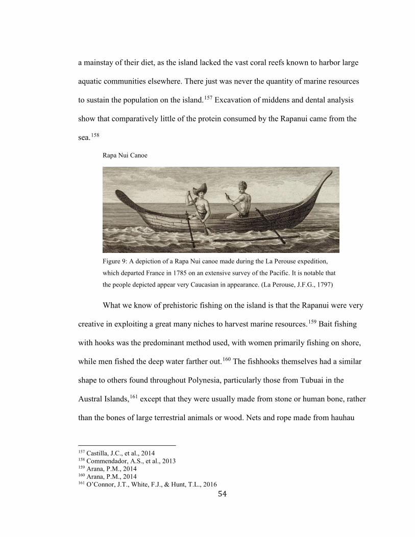
54
a mainstay of their diet, as the island lacked the vast coral reefs known to harbor large
aquatic communities elsewhere. There just was never the quantity of marine resources
to sustain the population on the island.157 Excavation of middens and dental analysis
show that comparatively little of the protein consumed by the Rapanui came from the
sea.158
Rapa Nui Canoe
Figure 9: A depiction of a Rapa Nui canoe made during the La Perouse expedition,
which departed France in 1785 on an extensive survey of the Pacific. It is notable that
the people depicted appear very Caucasian in appearance. (La Perouse, J.F.G., 1797)
What we know of prehistoric fishing on the island is that the Rapanui were very
creative in exploiting a great many niches to harvest marine resources.159 Bait fishing
with hooks was the predominant method used, with women primarily fishing on shore,
while men fished the deep water farther out.160 The fishhooks themselves had a similar
shape to others found throughout Polynesia, particularly those from Tubuai in the
Austral Islands,161 except that they were usually made from stone or human bone, rather
than the bones of large terrestrial animals or wood. Nets and rope made from hauhau
157 Castilla, J.C., et al., 2014 158 Commendador, A.S., et al., 2013 159 Arana, P.M., 2014 160 Arana, P.M., 2014 161 O’Connor, J.T., White, F.J., & Hunt, T.L., 2016
55
bark fiber were also used on occasion, both from boats and on shore.162 Fishing was not
the only use for boats on Rapa Nui, although perhaps the most obvious. While not
directly documented, they were presumably also used in harvesting obsidian from the
Motu Iti quarry, a small outlying island off Rapa Nui’s west coast. Obsidian itself is not
typical in Polynesia, so it was once speculated that it could have solicited long-distance
trade with other islands. This does not appear to be the case, as no obsidian tool found
elsewhere in Polynesia has been traced to the Rapa Nui sites.
162 Arana, P.M., 2014
56
Chapter 4: Reconstruction and Conclusion
The evolution of vessel design after initial inhabitation of East Polynesia can be
linked primarily with the changing needs for watercraft exhibited by the region’s
population, molded through the specific environment of the island or archipelago in
question. There have been substantial efforts in the past to better understand the
function and utility of the Polynesian voyaging canoe, particularly in the last 40 years.
Until that point, there was no clear consensus as to whether such vessels had even
existed, as many believed that the prospect of crossing the large water barriers of
Polynesia was beyond the capability of the islanders themselves, and any population
dispersal must have occurred over a long period of time by chance drifting.
What would have happened to the prehistoric discoverers of Hawaii and New Zealand if they had tried to get back to their home islands? The mean effect of the Pacific currents on the outward journeys of discovery would probably have been to set the voyagers to the west of their imagined course. On their hypothetical return journeys, the set would probably have been in the same direction. The navigators would thus have had a good chance of a reunion in the New Hebrides or Micronesia rather than anywhere in Eastern Polynesia. (Sharp, A., 1963, 389)
It was not until Finney’s conclusive demonstrations of purposeful oceanic
crossings reliably made using approximately recreated Polynesian canoes and
navigation techniques that the idea started to receive more universal acceptance.163 The
1976 expedition, in which the Hōkūleʻa, a double canoe with modern crab claw sails,
navigated from Hawai`i to Tahiti using nothing but traditional navigation techniques
still in use on Satawal Island in Micronesia, conclusively demonstrated at least the
potential of such technologies and techniques being used in Polynesia during the distant
163 Babayan, C., et al., 1987, Finney, B.R., 1994b
57
past.164 The Polynesian Voyaging Society, as well as similar organizations found
throughout the region, have continued to build similar craft, exhibiting them across
Polynesia and the world as part of the Neo-Traditionalism movement earlier examined.
The voyaging canoes used in the various modern cultural societies across
Polynesia all far more resemble those of Western Polynesian designs than those native
to the east, and are predominantly made using modern materials. The sail plan is much
larger than even the most generous estimates of what the native technology was capable
of producing.165 Even the navigation methods essential to the use of the vessels in
proving that they could be sailed between island groups had long since died out in
Polynesia, hence the necessity of importing the art from a Malaysian navigator. It is
hard to see the benefit of such artifacts when viewed as pure reconstructions, but as
celebrations of Polynesian voyaging, they are exquisitely designed craft.
While purposeful navigation between island groups is now widely accepted,
Finney’s model is not without detractors. Atholl Anderson has broadly criticized the
Traditionalist movement in general because of its somewhat nationalistic tendency
toward overestimating any past technology or enterprise when given a chance.
The seafaring manifestation of the colonization-continuity hypothesis is the neo-traditionalist proposal that stellar navigation and large, fast, weatherly double-hulled canoes existed prior to the discovery of Remote Oceania and were used during dispersal. Like the traditionalist model, mauled by Andrew Sharp, it appeals to the 'principle of degeneration,' in this case, the idea that maritime technology had been more highly developed during Remote Oceanic colonization than was observed at the period of European contact. The assumed competence of the early technology, exemplified in the design, construction, and sailing of so-called 'replica' vessels, together, with computer simulation studies using
164 Lewis, D., 1970 165 Anderson, A., 2008
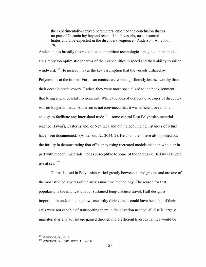
58
the experimentally-derived parameters, enjoined the conclusion that as no part of Oceania lay beyond reach of such vessels, no substantial hiatus could be expected in the discovery sequence. (Anderson, A., 2003, 78)
Anderson has broadly theorized that the maritime technologies imagined in its models
are simply too optimistic in terms of their capabilities in speed and their ability to sail to
windward.166 He instead makes the key assumption that the vessels utilized by
Polynesians at the time of European contact were not significantly less seaworthy than
their oceanic predecessors. Rather, they were more specialized to their environment,
that being a near coastal environment. While the idea of deliberate voyages of discovery
was no longer an issue, Anderson is not convinced that it was efficient or reliable
enough to facilitate any interisland trade. “…some central East Polynesian material
reached Hawai’i, Easter Island, or New Zealand but no convincing instances of return
have been documented.” (Anderson, A., 2014, 2). He and others have also pointed out
the futility in demonstrating that efficiency using recreated models made in whole or in
part with modern materials, not as susceptible to some of the forces exerted by extended
use at sea.167
The sails used in Polynesian varied greatly between island groups and are one of
the most studied aspects of the area’s maritime technology. The reason for that
popularity is the implications for sustained long-distance travel. Hull design is
important in understanding how seaworthy their vessels could have been, but if their
sails were not capable of transporting them in the direction needed, all else is largely
immaterial as any advantage gained through more efficient hydrodynamics would be
166 Anderson, A., 2014 167 Anderson, A., 2008, Irwin, G., 2008
59
hard pressed to make up for the increased distance needed to be traversed while tacking.
Throughout the entire prehistoric settlement of the Pacific Islands humans have spread
eastward; but if they used sails to accomplish those feats, scholars are met with the
conundrum of the prevailing winds throughout the region. Any sailor would have either
needed to sail against the wind, which requires more complex sails,168 wait for the
winds to shift for a reliable period in which they can conduct their voyage which
requires both luck and an understanding of long term weather patterns and a way to
reliably record them,169 or rely on orally communicated maps of a region’s constantly
changing wind patterns. All three possibilities have been examined with considerable
scrutiny, but there is still no solid consensus. It is likely that some combination holds
the answer, but at what ratio is yet undecided.
Sail Designs on Historical Polynesian Canoes
Figure 10: Comparative diagram of the four most common and diverse sail plans used
in Polynesia (Irwin, G., 2008, 16).
The vessels of Polynesia are essential because of how they were utilized in the
colonization of the region. We do not know exactly what they looked like, or precisely 168 Anderson, A., 2008 169 Anderson, A., et al., 2006a
60
what they were capable of regarding sailing characteristics. All that we do know is that
they allowed the people of West Polynesia to traverse thousands of kilometers of open
ocean, to nearly every destination, reliably enough to make it worth the chance of
settling those islands. All we have left are remnants of memories; a few shards of wood
and the journals of men who often only knew part of what they saw. To fully recreate
these vessels will probably prove impossible, but any effort to better understand them
must be worthwhile. Through an understanding of this lost technology it might be
possible to better understand their builders, those that made the last great push in the
colonization of our planet.
It is evident that the research on Polynesia’s history has undergone substantial
revision over the past few centuries. What we know of the region’s maritime past has
changed based on social acceptability, ideals of conceivable reality, and on the amount
of raw information that is known. The changes in the understanding of how Polynesia
was colonized has had far more of an impact on the contemporary ideas of vessel design
than any direct evidence. As the evidence of a rapid dispersal through East Polynesia
mounted, coupled with revised linguistic and genetic studies that indicated more
prolonged contact, the accepted sophistication of the canoes had to be increased to meet
the demand of the new models. The vessels proposed by various researchers over the
past few decades generally emphasize the need to account for the speed and scale these
voyages would have had to meet in order for the events we see in the archeological
record to take place.
In compiling my image of the historic vessels of Polynesia I relied heavily on
extant data, although a few manuscripts of interest have only recently been rediscovered
61
by diligent historians. I merely described the findings of the earliest historical visitors to
the islands and matched their descriptions to our ever-changing image of the most likely
realities. Current theories indicate a rapid exploration and colonization period, followed
by a drop off in communications, which fundamentally alters the status and utility of
every vessel described in the historical period. The evolution of the form and function
of the Polynesian vessel were incredibly numerous, even as they did fall into certain
generalizations. Although probably not the only factor in the retention of the more
traditional style of Polynesian voyaging canoe, the island of tropical Polynesia seems to
have had some advantage. This is most likely primarily due to the simple fact that the
vessels were originally designed in that environment, and as such required minor
alterations as their function changed, as opposed to those of New Zealand which were
far more radically altered. There is also significant cause for believing that the canoes of
Central and Western Polynesia still retained some amount of long-distance voyaging
capability and purpose into the historical period. The distance separating islands, the
lagoons filled with fish, the wind patterns, the fact that the canoe was built for that
environment, the retention of some contact influencing ideas, all affected how the
vessels of the islands evolved. A more systematic study of Polynesian vessel design
over time and across space would be needed to ratify this hypothesis.
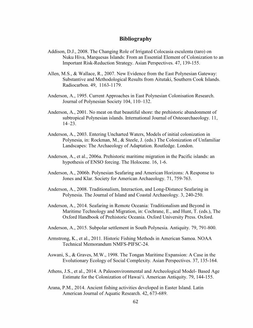
62
Bibliography
Addison, D.J., 2008. The Changing Role of Irrigated Colocasia esculenta (taro) on Nuku Hiva, Marquesas Islands: From an Essential Element of Colonization to an Important Risk-Reduction Strategy. Asian Perspectives. 47, 139-155.
Allen, M.S., & Wallace, R., 2007. New Evidence from the East Polynesian Gateway: Substantive and Methodological Results from Aitutaki, Southern Cook Islands. Radiocarbon. 49, 1163-1179.
Anderson, A., 1995. Current Approaches in East Polynesian Colonisation Research. Journal of Polynesian Society 104, 110–132.
Anderson, A., 2001. No meat on that beautiful shore: the prehistoric abandonment of subtropical Polynesian islands. International Journal of Osteoarchaeology. 11, 14–23.
Anderson, A., 2003. Entering Uncharted Waters, Models of initial colonization in Polynesia, in: Rockman, M., & Steele, J. (eds.) The Colonization of Unfamiliar Landscapes: The Archaeology of Adaptation. Routledge. London.
Anderson, A., et al., 2006a. Prehistoric maritime migration in the Pacific islands: an hypothesis of ENSO forcing. The Holocene. 16, 1-6.
Anderson, A., 2006b. Polynesian Seafaring and American Horizons: A Response to Jones and Klar. Society for American Archaeology. 71, 759-763.
Anderson, A., 2008. Traditionalism, Interaction, and Long-Distance Seafaring in Polynesia. The Journal of Island and Coastal Archaeology. 3, 240-250.
Anderson, A., 2014. Seafaring in Remote Oceania: Traditionalism and Beyond in Maritime Technology and Migration, in: Cochrane, E., and Hunt, T. (eds.), The Oxford Handbook of Prehistoric Oceania. Oxford University Press. Oxford.
Anderson, A., 2015. Subpolar settlement in South Polynesia. Antiquity. 79, 791-800.
Armstrong, K., et al., 2011. Historic Fishing Methods in American Samoa. NOAA Technical Memorandum NMFS-PIFSC-24.
Aswani, S., & Graves, M.W., 1998. The Tongan Maritime Expansion: A Case in the Evolutionary Ecology of Social Complexity. Asian Perspectives. 37, 135-164.
Athens, J.S., et al., 2014. A Paleoenvironmental and Archeological Model- Based Age Estimate for the Colonization of Hawai‘i. American Antiquity. 79, 144-155.
Arana, P.M., 2014. Ancient fishing activities developed in Easter Island. Latin American Journal of Aquatic Research. 42, 673-689.
63
Babayan, C., et al., 1987. Voyage to Aotearoa. The Journal of the Polynesian Society. 96, 161-200.
Barnes, S.S., et al. 2006. Ancient DNA of the Pacific rat (Rattus exulans) from Rapa Nui (Easter Island). Journal of Archaeological Science. 33, 1536-1540.
Beaglehole, J. C., 1966. The Exploration of the Pacific. Stanford University Press. Stanford.
Best, E., 1918. Polynesian Navigators: Their Exploration and Settlement of the Pacific. Geographical Review. 5, 169-182.
Best, E., 1927. The Discovery and Settlement of Rarotonga by Polynesians: a brief account thereof preserved in Maori tradition. The Journal of the Polynesian Society. 36, 122-134.
Best, E., 1976. The Maori Canoe. An Account of Various Types of Vessels used by the Maori of New Zealand in Former Times, with some Description of those of the Isles of the Pacific, and a Brief Account of the Peopling of New Zealand. A. R. Shearer. Wellington.
Bougainvill, L.A., 1831. Voyage de Lapérouse. Imprimerie de Casimir. Paris.
Brown, J.M., 1924. The Riddle of the Pacific. T. Fisher Unwin Ltd., London.
Burley, D.V., 1998. Tongan Archaeology and the Tongan Past, 2850–150 B.P.. Journal of World Prehistory. 12, 337–392.
Burley, D.V., & Addison, D.J., 2014. Tonga and Samoa in Oceanic Prehistory: Contemporary Debates and Personal Perspectives. The Oxford Handbook of Prehistoric Oceania. DOI: 10.1093/oxfordhb/9780199925070.013.017
Burley, D., et al., 2015. Bayesian Modeling and Chronological Precision for Polynesian Settlement of Tonga. PLoS ONE. 10, e0120795.
Campbell, I.C., 1995. The Lateen Sail in World History. Journal of World History. 6. 1-23.
Campbell, I.C., 2003. The Culture of Culture Contact: Refractions from Polynesia. Journal of World History. 14, 63-86.
Cañellas-Boltà, N., et al., 2012. Macrofossils in Raraku Lake (Easter Island) integrated with sedimentary and geochemical records: towards a palaeoecological synthesis for the last 34,000 years. Quaternary Science Reviews. 34, 113-126.
Castilla, J.C., et al., 2014. A review and analysis of Easter Island’s traditional and artisan fisheries. Latin American Journal of Aquatic Resources. 42, 690-702.
64
Churchill, W., & Roussel, H., 1912. Easter Island: The Rapanui Speech and the Peopling of Southeast Polynesia. The Carnegie Institution of Washington.
Clark, R., 1979. Language, in: Jeninnings, J.D. (edt.), The Prehistory of Polynesia. Harvard University Press. Harvard. 249-270.
Clark, G., et al. (eds.), 2008. Islands of Inquiry: Colonisation, seafaring and the archaeology of maritime landscapes. ANU Press, Canberra.
Clark, G.R., et al., 2014. Stone tools from the ancient Tongan state reveal prehistoric interaction centers in the Central Pacific. PNAS. 111, 10491-10496.
Collerson, K.D., & Weisler, M.I., 2007. Stone Adze Compositions and the Extent of Ancient Polynesian Voyaging and Trade. Science. 317, 1907-1911.
Commendador, A.S., et al., 2013. A stable isotope (δ13C and δ15N) perspective on human diet on rapa nui (Easter Island) ca. AD 1400–1900. American Journal of Physical Anthropology. 152, 173-185.
Cook, J., 1777. A Voyage Towards the South Pole and Round the World. Performed in His Majesty’s Ships the Resolution and Adventure, in the years 1772, 3, 4, and 5. Written by James Cook, Commander of the Resolution. In which is Included Captain Furneaux's Narrative of his Proceedings in the Adventure during the Separation of the Ships. In two volumes. Illustrated with maps and charts, and a Variety of Portraits of Persons and Views and Places, Drawn During the Voyage by Mr. Hodges, and Engraved by the most Eminent Masters. W Strahan and T Cadell. London.
Cook, J., 1821. The Three Voyages of Captain James Cook Round the World, complete in seven volumes, with map and other plates. Longman, Hurst, Rees, Orme, and Brown. Paternoster Row.
Corney, B.G. (tran.), 1908. The voyage of Captain Don Felipe González to Easter Island 1770-1. Hakluyt Society. London.
Couper, A.D., 2009. Sailors and Traders: A Maritime History of the Pacific Peoples. University of Hawai`i press. Honolulu.
Delaney, J., 2010. Strait through. Magellan to Cook & the Pacific. Princeton University Library. Princeton.
Di Piazza, A., & Pearthree, E., 2001. Voyaging and basalt exchange in the Phoenix and Line archipelagoes: the viewpoint from three mystery islands. Archeology in Oceania. 36, 146–152.
Di Piazza, A., et al., 2006. Sailing virtual canoes across Oceania: revisiting island accessibility. Journal of Archaeological Science. xx, 1-7.
65
DiNapoli, R.J., et al., 2017. East Polynesian Islands as Models of Cultural Divergence: The Case of Rapa Nui and Rapa Iti. The Journal of Island and Coastal Archaeology. 0, 1-18.
Dunmore, J.,1965. French Explorers in the Pacific, Vol. I. Oxford University Press. London.
Earle, A., 1838. War speech. R. Martin & Co, London. Reference Number PUBL-0015-09.
Emory, K. P., & Sinoto, Y. H.,1965. Preliminary Report on the Archeological Investigations in Polynesia: Field Work in the Society and Tuamotu Islands, French Polynesia, and American Samoa in 1962, 1963, 1964. Bernice P. Bishop Museum.
Estensen, M., 2006. Terra Australis Incognita: The Spanish Quest for the mysterious Great South Land. Allen & Unwin. Crows Nest NSW.
Evans, J., 2009. Ngā Waka o Neherā, the first voyaging canoes. Libro International. Auckland.
Feinberg, R., 1988. Polynesian Seafaring and Navigation: Ocean Travel in Anutan Culture and Society. The Kent State University Press, Kent.
Finney, B.R., 1988. Voyaging Against the Direction of the Trades: A Report of an Experimental Canoe Voyage from Samoa to Tahiti. American Anthropologist. 90, 401–405.
Finney, B.R., et al., 1989. Wait for the West Wind. The Journal of the Polynesian Society. 98, 261-302.
Finney, B.R., 1994b. Voyage of Rediscovery: A Cultural Odyssey through Polynesia. Berkeley: University of California Press.
Finney, B.R., 1996. Colonizing an Island World in: Prehistoric Settlement of the Pacific (Goodenough, W.H. ed.). American Philosophical Society, Philadelphia. pp. 71-116.
Finney, B.R., 1999. The Sin at Awarua. The Contemporary Pacific. 11, 1-33.
Finney, B.R., 2001. Voyage to Polynesia’s Land’s End. Antiquity Publications Ltd. 75, 172-181.
Finney, B.R., 2003. Sailing in the wake of the ancestors: reviving Polynesian voyaging. Bishop Museum Press, Honolulu.
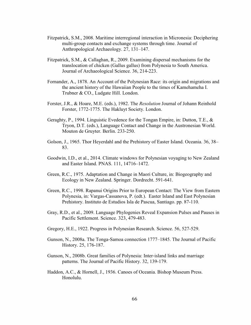
66
Fitzpatrick, S.M., 2008. Maritime interregional interaction in Micronesia: Deciphering multi-group contacts and exchange systems through time. Journal of Anthropological Archaeology. 27, 131–147.
Fitzpatrick, S.M., & Callaghan, R., 2009. Examining dispersal mechanisms for the translocation of chicken (Gallus gallus) from Polynesia to South America. Journal of Archaeological Science. 36, 214-223.
Fornander, A., 1878. An Account of the Polynesian Race: its origin and migrations and the ancient history of the Hawaiian People to the times of Kamehameha I. Trubner & CO., Ludgate Hill. London.
Forster, J.R., & Hoare, M.E. (eds.), 1982. The Resolution Journal of Johann Reinhold Forster, 1772-1775. The Hakluyt Society. London.
Geraghty, P., 1994. Linguistic Evedence for the Tongan Empire, in: Dutton, T.E., & Tryon, D.T. (eds.), Language Contact and Change in the Austronesian World. Mouton de Gruyter. Berlin. 233-250.
Golson, J., 1965. Thor Heyerdahl and the Prehistory of Easter Island. Oceania. 36, 38–83.
Goodwin, I.D., et al., 2014. Climate windows for Polynesian voyaging to New Zealand and Easter Island. PNAS. 111, 14716–1472.
Green, R.C., 1975. Adaptation and Change in Maori Culture, in: Biogeography and Ecology in New Zealand. Springer. Dordrecht. 591-641.
Green, R.C., 1998. Rapanui Origins Prior to European Contact: The View from Eastern Polynesia, in: Vargas-Cassanova, P. (edt.). Easter Island and East Polynesian Prehistory. Instituto de Estudios Isla de Pascua, Santiago. pp. 87-110.
Gray, R.D., et al., 2009. Language Phylogenies Reveal Expansion Pulses and Pauses in Pacific Settlement. Science. 323, 479-483.
Gregory, H.E., 1922. Progress in Polynesian Research. Science. 56, 527-529.
Gunson, N., 2008a. The Tonga‐Samoa connection 1777–1845. The Journal of Pacific History. 25, 176-187.
Gunson, N., 2008b. Great families of Polynesia: Inter‐island links and marriage patterns. The Journal of Pacific History. 32, 139-179.
Haddon, A.C., & Hornell, J., 1936. Canoes of Oceania. Bishop Museum Press. Honolulu.
67
Harari, Y.N., 2014. The Marriage of Science and Empire, in: Sapiens: A Brief History of Humankind. Harper. New York. 275-30.
Hawkesworth, J. 1773. An Account of the Voyages Undertaken by the Order of his Present Majesty for Making Discoveries in the Southern Hemisphere, And successively performed by Commodore Byron, Captain Wallis, Captain Carteret, And Captain Cook, In the Dolphin, the Swallow, and the Endeavour: Drawn up From the Journals which were kept by the several Commanders, And from the Papers of Joseph Banks, Esq. In three volumes. Illustrated with Cuts, and a great Variety of Charts and Maps relative to Countries now first discovered, or hitherto but imperfectly known. W. Strahan; and T. Cadell. London.
Heine-Geldern, R., 1950. Heyerdahl's Hypothesis of Polynesian Origins: A Criticism. The Geographical Journal. 116, 183-192.
Henry, D., 1774. An Historical Account of all the Voyages Round the World, Performed by English Navigators; Including those lately Undertaken by Order of his Present Majesty. The Whole Faithfully Extracted from the Journals of the Voyagers: Drake, undertaken in 1577-80, Cavendish, 1586-88, Cowley, 1683-86, Dampier, 1689-9, Cooke, 1708-11, Rogers, 1708-11, Clipperton And Shelvocke, 1719-22, Anson, undertaken in 1740-44, Byron, 1764-66, Wallis, 1766-68, Carteret, 1766-68, And Cook, 1768-71, Together with that of Sydney Parkinson, Draftsman to Joseph Banks, Esq who circumnavigated the Globe with Capt. Cook, in his Majesty's Ship the Endeavour. And The Voyage of Mons. Bougainville round the World, Performed by Order of the French King. Illustrated with Maps, Charts, and Historical Prints.In four volumes. To which is added, an Appendix. Containing the Journal of a Voyage to the North Pole, by the Hon. Commodore Phipps. and Captain Lutwidge. F. NEWBERY. London.
Heyerdahl, T., 1950a. The Voyage of the Raft Kon-Tiki. The Geographical Journal. 115, 20-41.
Heyerdahl, T. 1950b. The Kon-Tiki expedition. George Allen & Unwin Ltd. London.
Heyerdahl, T., 1965. The Statues of the Oipona Me'ae, with a Comparative Analysis of Possibly Related Stone Monuments, in: Heyerdahl, T., & Ferdon, E.N. Jr. (eds.), Reports of the Norwegian Archaeological Expedition to Easter Island and the East Pacific. Monographs of the School of American Research and the Kon-Tiki Museum; no. 24, Part 2. Forum Publishing House. Stockholm. 123–151.
Heyerdahl, T. 1979. Early Man and the Ocean: a search for the beginnings of navigation and seaborne civilizations. Doubleday, Garden City.
Holton, G.E.L., 2004. Heyerdahl’s Kon Tiki Theory and the Denial of the Indigenous Past. Anthropological Forum. 14, 163-181.
68
Holmes, L.D., 1958. An Appraisal of the Kon Tiki Theory. Oceania. 29, 127-131.
Holmes, T., 1981. The Hawaiian Canoe. Editions Limited. Hong Kong.
Home, H., 1775. Sketches of the History of Man. In four volumes. James Williams. Dublin.
Horvath, S.M., & Finney, S.M., 1969. Paddling Experiments and the Question of Polynesian Voyaging. American Anthropologist. 71, 271-276.
Hunt, T.L. & Lipo C.P., 2006. The Statues that Walked: unraveling the mystery of Easter Island. Freedom Press, New York.
Hunt, T.L. & Lipo C.P., 2008. Evidence for a Shorter Chronology on Rapa Nui (Easter Island). 3, 140-148.
Hunt, T.L. & Lipo C.P., 2012. Ecological Catastrophe and Collapse: The Myth of 'Ecocide' on Rapa Nui (Easter Island). PERC Research Paper No. 12/3. SSRN: https://ssrn.com/abstract=2042672 or http://dx.doi.org/10.2139/ssrn.2042672
Hunt, T.L., & Lipo, C.P., 2017. The Last Great Migration: Human Colonization of the Remote Pacific Islands, in: Boivin, N., et al. (eds.), Human Dispersal and Species Movement: From Prehistory to the Present. Cambridge University Press. Cambridge.
Intoh, M., 1997. Human Dispersals into Micronesia. Anthropological Science. 105, 15-28.
Irwin, G., 1992. The Prehistoric Exploration and Colonisation of the Pacific. Cambridge University Press, Cambridge.
Irwin, G., 2008. Pacific Seascapes, Canoe Performance, and a Review of Lapita Voyaging with Regard to Theories of Migration. University of Hawai`i Press. 47, 12-27.
Irwin, G.J., & Flay, R.G.J., 2015. Pacific colonisation and canoe performance: Experiments in the science of sailing. Journal of the Polynesian Society. 124, 419-443.
Johns, D.A., et al., 2014. An early sophisticated East Polynesian voyaging canoe discovered on New Zealand’s coast. PNAS. 111, 14728-14733.
Kahn, J.G. 2014. Colonization, Settlement, and Process in Central Eastern Polynesia. The Oxford Handbook of Prehistoric Oceania. 10.1093/oxfordhb/9780199925070.013.020.
Kane, H.K., 1998. Ancient Hawaii. Kawainui Press. Captain Cook.
69
Kennett, D., et al., 2006. Prehistoric human impacts on Rapa, French Polynesia. Antiquity. 80, 340-354.
Kirch, P.V., 1984. The Evolution of the Polynesian Chiefdoms. Cambridge University Press. Cambridge.
Kirch, P.V., 2000. On the Road of the Wind: An Archeological History of the Pacific Islands Before European Contact. University of California Press, Berkley.
Kirch, P.V., & Green, R.C., 2001. Hawaiki, Ancestral Polynesia: An Essay in Historical Anthropology. Cambridge University Press. Cambridge.
Komdeur, J., et al., 2004. Why Seychelles Warblers fail to recolonize nearby islands: unwilling or unable to fly there?. International Journal of Avian Science. 146, 298–302.
Kraft, J.R., et al., 2002. Group choice and individual choices: modeling human social behavior with the Ideal Free Distribution. Behavioural Processes. 57, 227-240.
La Perouse, J.F.G., 1797. Atlas du voyage de La Perouse. L'Imprimerie de la Republique. Paris.
Ladefoged, T.N., et al., 2010. Soil nutrient analysis of Rapa Nui gardening. Archeology in Oceania. 45, 80–85.
Lan Hogbin, H., 1940. “Polynesian” Colonies in Melanesia. The Journal of the Polynesian Society. 49, 199-220.
Lepofsky, D., 2016. A Radiocarbon Chronology for Prehistoric Agriculture in the Society Islands, French Polynesia. Radiocarbon. 37, 917-930.
Leverd, A., 1922. Polynesian Linguistics. II.- New Hebrides. The Journal of the Polynesian Society. 31, 171-181.
Lewis, D., 1970. Polynesian and Micronesian Navigation Techniques. The Journal of Navigation. 23, 432-447.
Lewis, D., 1972. We, the Navigators: The Ancient Art of Landfinding in the Pacific. University of Hawai`i Press, Honolulu.
Linton, R., 1926. Settlement of Islands, in: Ethnology of Polynesia and Micronesia. Field Museum Press, Chicago. 14-19.
Lipo, C.P. & Hunt, T.L., 2016. Chronology and Easter Island prehistory, in: Stefan, V.H., and Gill, G.W. (eds.), Skeletal Biology of the Ancient Rapanui (Easter Islanders). Cambridge University Press. Cambridge.
70
Malo, D., & Emerson, N.B. (tran.), 1903. Hawaiian Antiquities. Hawaiian Gazette, Honolulu.
Mann, D., et al., 2008. Drought, vegetation change, and human history on Rapa Nui (Isla de Pascua, Easter Island). Quaternary Research. 69, 16-28.
Matisoo-Smith, E., et al., 1998. Patterns of Prehistoric Human Mobility in Polynesia Indicated by mtDNA from the Pacific Rat. PNAS. 95, 15145-15150.
Matisoo-Smith, E., 2012. The Great Blue Highyway: human migration in the Pacific, in: Crawford, M.H. and Campbell, B.C (Eds.), Causes and Consequences of Human Migration. Cambridge University Press, Cambridge, pp. 188-416.
McGlone, M.S., & Wilmshurst, J.M., 1999. Dating initial Maori environmental impact in New Zealand. Quaternary International. 59, 5-16.
Montenegro, Á., et al., 2014. From West to East: environmental influences on the rate and pathways of Polynesian colonization. The Holocene. 24, 242–256.
Montenegro, Á., et al., 2016. Using seafaring simulations and shortest-hop trajectories to model the prehistoric colonization of Remote Oceania. PNAS. 113, 12685–12690.
Mulrooney, M.A. et al., 2011. High-precision dating of colonization and settlement in East Polynesia. PNAS. 108, E192–E194.
O’Connell, J.F, et al., 2008. Pleistocene Sahul and the origins of seafaring, in: Anderson, A., Barrett, J.H., & Boyle, K.V., 2010 (eds.), The Global Origins and Development of Seafaring. McDonald Institute for Archaeological Research. Cambridge.
O’Connor, J.T., et al., 2016. Fishhook variability and cultural transmission in East Polynesia. Archaeology in Oceania. 00, 1–13.
Pawley, A., 2015. Linguistic Evidence as a Window into the Prehistory of Oceania. The Oxford Handbook of Prehistoric Oceania. 10.1093/oxfordhb/9780199925070.013.006
Petersen, G., 2010. Indigenous Island Empires: Yap and Tonga Considered. The Journal of Pacific History. 35, 5-27.
Piazza, A.D., 2013. An Isochrone Map of the Prehistoric Seascape around Samoa. Geographical Research. 52, 74–84.
Pringle, J., 1776. A Discourse upon some late Improvements of the means for Preserving the Health of Mariners. Delivered at the Anniversary Meeting of the Royal Society, November 30, 1776. The Royal Society. London.
71
Purchas, S., 1625. Purchas his pilgrimes In five bookes. The first, contayning the voyages and peregrinations made by ancient kings, patriarkes, apostles, philosophers, and others, to and thorow the remoter parts of the knowne world: enquiries also of languages and religions, especially of the moderne diuersified professions of Christianitie. The second, a description of all the circum-nauigations of the globe. The third, nauigations and voyages of English-men, alongst the coasts of Africa ... The fourth, English voyages beyond the East Indies, to the ilands of Iapan, China, Cauchinchina, the Philippinae with others ... The fifth, nauigations, voyages, traffiques, discoueries, of the English nation in the easterne parts of the world. Henry Fetherston. London.
Quiros, P.F., & Markham, C. (Tran.), 1904. The Voyages of Pedro Fernandez de Quiros, 1595 to 1606. Bedford Press. London.
Randall, J.E., & Cea, A., 2012. Shore Fishes of Easter Island. University of Hawaii Press, Honolulu.
Rehg, K.L., 1995. The Significance of Linguistic Interaction Spheres in Reconstructing Micronesian Prehistory. Oceanic Linguistics. 34, 305-326.
Richards, R., 2008. On Using Pacific Shipping Records to Gain New insights into culture contact in Polynesia before 1840. The Journal of Pacific History. 43, 375-382.
Rieth, T., & Cochrane, E., 2015. The Chronology of Colonization in Remote Oceania. The Oxford Handbook of Prehistoric Oceania. Oxford.
Rolett, B.V., 2002. Voyaging and Interaction in Ancient East Polynesia. Asian Perspectives. 41, 182-194.
Rongo, T., et al., 2009. Did ciguatera prompt the late Holocene Polynesian voyages of discovery?. Journal of Biogeography. 36, 1423–1432.
Savage, J., 1807. Some Account of New Zealand: Particularly the Bay of Islands, and Surrounding Country. J. Murray and A. Constable and Company. London.
Scaglion, R., 2005. Kumara in the Ecuadorian Gulf of Guayaquil?, in: Ballard, C., et al. (eds.), The Sweet Potato in Oceania: A Reappraisal. Centatime. Sydney. 35-42.
Schiffer, M.B., 1986. Radiocarbon dating and the “old wood” problem: The case of the Hohokam chronology. Journal of Archaeological Science. 13, 13-30.
Sharp, A., 1964. Ancient Voyagers in Polynesia. University of California Press, Berkley.
Sinoto, H.Y., 1979. Excavations on Huahine, French Polynesia. Pacific Studies. 3, 1-40.
72
Smith, C.H., Kneeland, S., 1855. The Natural History of the Human Species: Its Typical Forms, Primeval Distribution, Filiations, and Migrations. Gould and Lincoln. Boston.
Smith, S.P., 1920. Supplement to the “JOURNAL OF THE POLYNESIAN SOCIETY,” for June, 1920. Kava Drinking Ceremonies Among the Samoans And A Boat Voyage round 'Upolu Island, Samoa. The Journal of the Polynesian Society. 29, 1-21.
Storey, A.A., et al., 2007. Radiocarbon and DNA evidence for a pre-Columbian introduction of Polynesian chickens to Chile. PNAS. 104, 10335–10339.
Storey, A.A., et al., 2011. Identifying Contact with the Americas, A Commensal Based Approach, in: Jones, T.L., et al. (eds.), Polynesians in America, Pre-Columbian Contacts with the New World. AltaMira Press. Plymouth.
Thomson, V.A., et al., 2014. Using ancient DNA to study the origins and dispersal of ancestral Polynesian chickens across the Pacific. PNAS. 111, 4826–4831.
Trusler, J., 1778. A Descriptive Account of the Islands Lately Discovered in the South-Seas.Giving a full Detail of the present State of the Inhabitants, their Government, Religion, Language, Manners, Customs, &c. &c. &c. from the first Discovery to the present Time.Carefully collected, digested, and systematically arranged, by the Reverend Dr. John Trusler, From Mendana, De Quiros, Schouten, Tasman, Dalrymple, Bouganville, Byron, Carteret, Wallis, Hawkesworth, Parkinson, Fourneaux, Forster, Cook, and others.With some Account of the Country of Camchatca, a late Discovery of the Russians. J. Trusler & R. Baldwin. London.
Vayda, A.P., 1959. Polynesian Cultural Distribution in New Perspective. American Anthropologist. 61. 817–826.
Wake, C.S., 1883. The Papuans and the Polynesians. The Journal of the Anthropological Institute of Great Britain and Ireland. 12, 197-222.
Walter, R., & Sheppard, P.J., 1996. The Ngati Tiare Adze Cache: further evidence of prehistoric contact between West Polynesia and the Southern Cook Islands. Archeology in Oceania. 31, 33-39.
Walworth, M., 2014. Eastern Polynesian: The Linguistic Evidence Revisited. Oceanic Linguistics. 53, 256-272.
Weisler, M.I., & Kirch, P.V., 1996. Interisland and interarchipelago transfer of stone tools in prehistoric Polynesia. Proceedings of the Natural Academy of Science. 93, 1381-1385.
73
West, K., et al., 2017. The Pacific Rat Race to Easter Island: Tracking the Prehistoric Dispersal of Rattus exulans Using Ancient Mitochondrial Genomes. Frontiers in Ecology and Evolution. 5, 1-13.
Wilkes, C., 1849. Voyage Round the World: Embracing the Principal Events of the Narrative of the United States Exploring Expedition. Geo. W. Gorton. Philadelphia.
Wilmshurst, J.M., et al., 2008. Dating the late prehistoric dispersal of Polynesians to New Zealand using the commensal Pacific rat. PNAS. 105, 7676–7680.
Wilmshurst, J.M., et al., 2011. High-precision radiocarbon dating shows recent and rapid initial human colonization of East Polynesia. PNAS. 108, 1815–1820.