Embed Size (px)
Citation preview

THE POTASH DEPOSITS OF ALSACE.
By HOYT S.
INTRODUCTION.
When potash was discovered in Alsace in 1904 the monopoly of the potash industry that had rested with the owners of the great deposits in north-central Germany since 1860 was broken. The new field, although less extensive than that of Germany, was very soon recog nized as having several important advantages over the older developed field. The Alsatian deposits underlie a large area in exceedingly regular beds, and the salts are on the average remarkably rich in potash. The deposits consist of a simple mixture of potassium and sodium chlorides, known as sylvinite, with very little other soluble material. This mixture of crude salts requires only the simplest chemi cal treatment in order to purify it into the higher grades of potash salts. The field itself is somewhat farther from ocean ports than the north-central German region, but as it lies in a well-developed part of the Rhine Valley, directly on the routes of main-line water and rail transportation, this difference is not a serious handicap. It is natural, therefore, that the first mine opened in the new Alsatian field at once took third or fourth rank as a producer with all the older Ger man mines, a position it has since been well able to maintain.
It has seemed a strange coincidence that the only two really large deposits of soluble potash salts that have been found in the whole world should have been opened within .the domain controlled by a single empire. The return of Alsace to France now divides the monopoly of this important natural resource, and general interest in the details of the Alsatian field and its prospects for the future has increased.
Many excellent descriptions of the geology and the conditions of the Alsatian potash deposits have already been published. Most of these descriptions, naturally, are written in either French or German and from the viewpoint of those having a special local interest. It is the writer's good fortune to have had the opportunity to visit all
1 The writer visited the potash mines in Alsace as the guest of the French Government, going there as an authorized representative from the Department of the Interior and representing both the United States Geological Survey and the Bureau of Mines in an investigation -of foreign potash resources.
17

18 CONTRIBUTIONS TO ECONOMIC GEOLOGY, 1920, PAET I.
the properties accessible in this field during the spring of 1919 and to be able to give from his own viewpoint not only an abstract of what has already been published but some original account of recent developments. A list and brief summaries of most of the important published references to the geology or deposits of this immediate region are given in the bibliography at the end of this report.
LOCATION AND ACCESS.
The potash deposits lie beneath the open valley of the Ehine in the southern part of Alsace, about 20 to 25 miles north of the
Swiss border. This re gion, known as Upper Alsace, is about equally divided between the slopes of the Vosges Mountains on the west arid the broad level floor of the Ehine and its tributaries on the east. The whole region is one of old settlement and intensive cultiva tion. ' Mulhouse is an important manufactur ing center;, being the seat of large cotton and woolen goods mills and calico printing, paper, and other in dustrial establishments. The region is well sup plied with railways, which include the main line of the State rail way that extends along the Ehine Valley and
many branch lines. The valley is also intersected by. many canals, the largest of which, the Ehine-Ehone Canal, is an important water way available for the shipment of potash if needed.
The general situation of the potash field with respect to the main valley, railways, and some of the larger settlements in the region is shown by the accompanying index map (fig. 4). The Vosges Mountains present a steep and rugged front toward the Ehine, largely forest covered, the lower slopes cultivated in vineyards.
ISMiles
FIGURE 4. Map showing potash field and valley of the Rhine in the vicinity of the Mulhouse, Alsace.

THE "POTASH DEPOSITS OF ALSACE. 19
East of the Rhine, in Baden, Germany, the Black Forest similarly presents a rugged westward-facing front toward the Rhine Valley, with the river close at its foot. The valley is a broad expanse of meadows and wooded areas, with many towns scattered throughout and large tracts under cultivation.
No evidence of either the potash or the large masses of common salt that are associated with it is to be found at the surface of the ground in this region, and the salts were discovered only by boring in a search for other things. Soon after the presence of the valuable potash was recognized, an association for exploration put down more than 100 deep borings, of which 95 penetrated rock salt and 17 found the potash layers, and in this way the general outline of the deposit as indicated on the accompanying map (fig. 4). was made known. The deposit is found in two beds, of surprising regularity, both of which seem to thin out or to be faulted off at the edges of the "basin." It is reported, however, that an extension of these deposits has been found by some borings on the east side of the Rhine, near Buggingen and Zienken, in Baden, but it is now sup posed that this extension is not of commercial importance. The area of the main field as outlined is about 65 square miles, and throughout this field the lower and thicker of the two beds of potash is practically continuous. The upper and thinner bed is less ex tensive 5 and, included within the same outline, occupies an area of about 33 square miles. These are the areas used in the computations of reserves of the field given on page 27.
HISTORY AND OWNERSHIP.
The most complete account of the history of the discovery and de velopment of these deposits is given by M. Felix Binder, with whom the writer had the pleasure of being associated in his recent examination of the field and from whom the following summary was obtained. M. Binder is an Alsatian, long prominent in industrial affairs in Alsace, and as he has made an enthusiastic study of the whole problem of the Alsatian deposits he is especially qualified to give the record, much of which is from personal or first-hand knowledge.
The existence of common salt in deposits underneath the Rhine Valley near Mulhouse has been known since 1869, when it was en countered by a boring put down at Dornach to a depth of about 300 feet. However, it was not until much later that the existence of potash in association with this salt was discovered. Early in 1903, some croppings of coal having attracted the attention of J. B. Grisez, he sunk a small shaft to explore for the deposit. This work was not successful, but nevertheless M. Grisez interested Joseph Vogt, chiefly because of the interest M. Vogt held in property concerned. An association was formed in March, 1904, through the initiation of
20 CONTRIBUTIONS TO ECONOMIC GEOLOGY. 1920, PART I.
M. Vogt, including three other persons besides himself and M. Grisez, which provided the necessary funds for sinking, an explora tory boring. This work was commenced June 13, 1904, at a point a little over 2 miles south of Wittelsheim, near the railway from Lut- terbach to Cernay. This boring reached a depth of 3,700 feet on November 1, 1904. It passed through the potash, which was not at first recognized, but later M. Vogt, noticing its red color, submitted samples for analysis, and the discovery was made. In spite of the seeming importance of such a discovery, some time was lost in an attempt to enlist local support for a project to extend these explora tions, and it was not until the matter was presented to those already familiar with the potash industry in Germany that the needed funds were readily forthcoming. A.consortium created by M. Vogt under the name Societe Amelie transferred all its shares to the Deutsche Kaliwerke, one of the large German operating concerns having headquarters at Bernterode, in the north-central German potash field. An extensive system of exploration by drilling was soon carried out and this association acquired large interests in the southern two-thirds of the field. M. Vogt then arranged to continue the exploration to the north, forming a new company of exclusively French and Alsatian capital under the name of Societe Anonyme des Mines de Kali Ste.-Therese.
The German ownership was later divided, presumably by the sale of stock, to finance the development of .the several mines, but by far the largest interest remained with the Deutsche Kaliwerke. The principal German owners were the Aktiengesellschaft Deutsche Kaliwerke, of Bernterode (Untereichsfeld); the Gewerkschaft Wintershall, of Heringen, on Werra River; and the Gewerkschaft Hohenzollern, of Freden, on Leine River. The other propertiesremained in French-Alsatian ownership. This general condition has been maintained since 1911, except that in 1913 the government of Alsace-Lorraine purchased shares in the Keichsland, Theodor, and Prinz Eugen properties.
At present ownership or control' of all the potash properties in Alsace is represented by P. A. Helmer, sequestre general des mines de potasse, and Fernand Vogt, directeur general de la mine Ste.- Therese. The local office of the sequestre is the Bureau provisoire de vente de la potasse d'Alsace, 1 rue des Fabriques, Mulhouse, Alsace.
OUTPUT FROM ALSATIAN FIELD.
According to reports, the first mining shaft was completed in 1909, and a total production of 37,000 metric tons of crude salts was obtained in 1910. The production in 1911 is reported 1 as 102,644
1 Frankfurter Zeitung, Apr. 3, 1913.

THE POTASH DEPOSITS OF ALSACE. ' 21
tons of crude salts, which was reduced to 66,760 tons as actually marketed. Reports for 1912 give 137,243 tons x of crude salts as the gross output from three shafts operating in the Alsatian potash field, which was marketed as 88,756 tons of potash and raw salts, equivalent to 17,963 tons of pure potash (K20). Similar statistics for 1913 show 350,341 tons of crude salts taken from the 17 shafts, of which 219,912 tons of potash and raw salts, equivalent to 40,707 tons of K20, wei%e sold. In 1913 most of the output was of 12 to 15 per cent grade, which was sold in Germany, France, and the United States, with a considerable production of 40 to 50 per cent pure chloride of potassium distributed in about the same way.
The complete records of production during the war are not at hand, but details concerning the output from the Amelie and some of the other mines are given in the mine descriptions on subsequent pages. .
SHIPPING FACILITIES.
The Ehine is navigable for boats of 1,200 tons or less from Rotter dam as far as Kehl, the port of Strasbourg, which is about 70 miles by rail or canal north of Mulhouse. The State railway west of the Rhine affords direct connection from Mulhouse to Strasbourg or' Kehl and beyond, and there is also a system of canals the largest of which, known as the Rhine-Rhone Canal, furnishes a direct water way for shipment. The shipping facilities are therefore ample. Several of the potash plants are near the main line of the State rail way, and the others have direct rail connections.
The usual route for export from the potash mines is by rail to Kehl and by river boat thence to Rotterdam or Antwerp, whence the salts may be transshipped to any foreign country. Rail con nection may of course be had to other ports or to any other part of Europe. Strasbourg is about 375 miles by the river route. from Rotterdam. The distance from the Alsatian potash field to the ocean is somewhat longer than that from the potash field of north- central Germany, but as the transfers of cargo from rail to canal boat and .from canal boat to ocean vessel must be made from either district, the difference in distance is not a serious handicap.
GEOLOGY OF THE DEPOSITS.
The Rhine Valley from Basel, on the Swiss border, to Mainz or Frankfort, in Germany, at the north, is a broad, level floor bordered by the abrupt and rugged fronts of the Vpsges Mountains on the west and the Black Forest (Schwarz Wald) on the east. A broad, rounding arch of the sedimentary strata has been broken at the crest by a system of north-south faults, and a long strip in the axis
1 Daily Consular and Trade Repts., No. 202, pp. 1126-1127, Aug. 28, 1914.
22 CONTRIBUTIONS TO ECONOMIC GEOLOGY, 1920, PART I.
of the arch has dropped, leaving the escarpments of the present mountain fronts facing inward toward the valley, and the back surface of the arch, forming the outer - mountain slope, dipping gradually away on either side. This structural feature is .known to German geologists as a graben, The present bottom of the Ehine Valley is filled with thick deposits of river sediments, and the river channel follows a meandering course over the surface of this alluvial plain. The bottom lands are fertile and, being open to easy access by rail and water, are the site of important agricul tural and industrial activity and settlements.
The sediments that lie beneath the floor of the Rhine Valley have little evident relation to those in the adjacent mountains. In the valley, below the river alluvium, are shales, rock salt, gypsum or anhydrite, and other deposits indicating deposition in standing evaporating water. Beds contemporaneous with the deposits under neath the valley are exposed in some of the foothills at the valley border, but apparently these beds are composed of coarser materials, including conglomerates, as if deposited by running waters over a dry land surface.
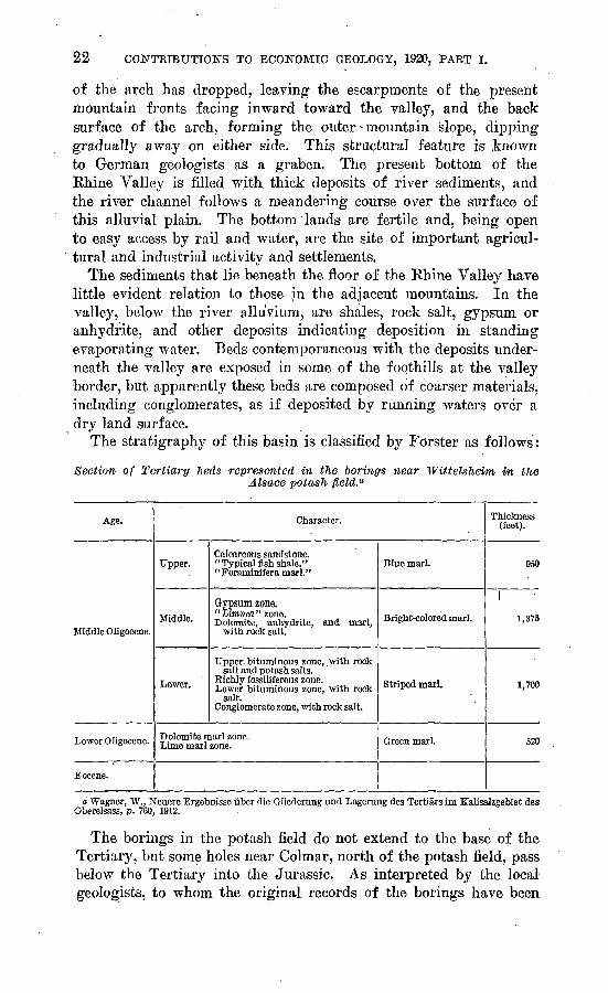
The stratigraphy of this basin is classified by Forster as follows:
Section of Tertiary beds represented in the borinffs near Wittelsheim in theAlsace potash field.a
Age.
Middle Oligocene.
Lower Oligocene.
Eocene.
Character.
Upper.
Middle.
Lower.
Calcareous sandstone. "Typical fish shale." "Foraminifera marl."
Gypsum zone. "Limnea" zone. Dolomite, anhydrite, and marl,
with rock salt.
Upper bituminous zone, .with rock salt and potash salts.
Richly fossiliferous zone. Lower bituminous zone, with rock
salt. Conglomerate zone, with rock salt.
Dolomite marl zone. Lime marl zone.
Blue marl.
Bright-colored marl.
Striped marl.
Green marl.
Thickness (feet).
950
1
1,375
1,700
520
a Wagner, W., Neuere Ergebnisse iiber die Gliederung und Lagerung des Tertiars im Kalisalzgebiet des Oberelsass, p. 760, 1912.
The borings in the potash field do not extend to the base of the Tertiary, but some holes near Colmar, north of the potash field, pass below the Tertiary into the Jurassic. As interpreted by the local geologists, to whom the original records of the borings have been

THE POTASH DEPOSITS OF ALSACE. 23
available, these records indicate, the following as the general history of deposition in the part of the Rhine Valley near Mulhouse.
In late Jurassic time the area of the Vosges-Rhine plain and the Black Forest was covered by the sea, which retreated at the end of the Jurassic. During Cretaceous time these areas were land surfaces. As a result of earth movements Eocene deposits were laid down in certain basins that were developed on the Cretaceous land surfaces, and the records indicate that at the beginning of Oligocene time a general subsidence must have occurred, followed by the deposition of a considerable thickness of sediments. The first deposits were gray or greenish marls, described as calcareous and later dolomitic, con taining anhydrite, and these deposits are taken by the local geologists as an indication that the period of deposition was initiated by an in cursion of the sea. It seems to the writer unnecessary to postulate the presence of marine waters to account for the deposition of gyp sum and anhydrite, as these materials are quite as likely to be thrown down from evaporating natural saline solutions derived from ter restrial waters in a continental basin as from marine waters. The basin is said to have been deepest near Wittelsheim, where this part of the sedimentary section, known to the local geologists as "lower Oligocene," is represented by a thickness of about 520 feet..
The greater part of the section represented in the borings in the potash field is called " middle Oligocene." The epoch in which this part was laid down began with the deposition of conglomerate with some anhydrite, dolomitic marl, and rock salt, indicating the drying up of saline solutions, whether derived from a continental water body or an arm of the sea. Here again the axis of greatest depression that is, the part of the basin that apparently received the greatest thickness of deposits was in the vicinity of Wittelsheim, well to the west side of the valley of the Rhine. The beds succeeding the con glomerate, described as " striped marls," include rock salt and at the to"p of the section the two potash beds. The whole thickness of this division is 1,700 feet in the boring at Wittelsheim. A richly fossil- iferous zone underlies the potash beds, and the fauna derived from this zone has been carefully studied. The fossil zone is considered an excellent horizon marker, as it is widely recognized beyond the limits of the potash basin. Comparison of the sections found within the potash basin and at or beyond its margins shows that while fine sediments or salts were being deposited in the center, coarser mate rials, in places conglomerates, were being laid down toward the mountains, clearly indicating, in part at least, the limit of the basin of deposition.
The two beds of potash salts are distinct layers included within grayish shales described as dolomitic. Other beds of rock salt and anhydrite are, however, interstratified with the shale, showing a gen-
24 CONTRIBUTIONS TO ECONOMIC GEOLOGY, 1920, PART I.
eral condition of concentration of solutions, undoubtedly by evapora tion in an inclosed basin. The practical absence of soluble sulphate salts or of the soluble compounds of magnesia is worthy of special note, as this feature distinguishes the Alsatian potash deposits from those of the Stassfurt region, in northern Germany.
The colored or variegated marls that overlie the potash beds con stitute a section aggregating 1,125 to 1,375 feet in the vicinity of Wittelsheim and contain a thick deposit of common salt in the lower part and gypsum or anhydrite both in the lower part and at the top of the section. These beds grade into coarser sediments, in cluding conglomerates, toward the edge of the basin.
An upper portion of the "middle Oligocene," reported as only about 300 feet thick in the first boring at Wittelsheim but very much thicker elsewhere, is distinguished by several fossiliferous layers and has received the general designation "blue marl." It is described as a deposit laid down in deeper waters. This part of the section is discussed in some detail in the paper by Wagner already cited.
The tectonic or structural geologic record, as interpreted by the local geologists, includes repeated risings and sinkings of portions of the earth's surface in this region, to account for the supposed changes from marine to fresh water and from chemical deposition and fine sediment to coarser deposits accumulated mechanically. Un doubtedly many oscillations of this sort have occurred, but it is also quite justifiable. to assume that a continental basin in the Ehine Valley may have been for a time isolated and without outlet, with perhaps a water supply insufficient to equal the evaporation from the water surfaces as they rose and expanded over the floor of the valley. Slight climatic variations might readily account for alter nating rise and desiccation of the inclosed waters, as also for the inwash of sometimes coarse and sometimes sparse and finer sedi ments from adjacent slopes. The assumption of the early existence of the great Ehine graben is fundamental, and it may well be sup plemented by the further assumption of periodic readjustments of the component elements of the graben. The waters that filled the basin might have been marine, but they might also have been derived from the evaporation of ordinary river and ground waters, such as produce the many continental saline lakes in other parts of the world. The frequent reflooding and interruption of the desiccation process readily accounts for the alternation of chemical precipitates and of mechanically contributed sediments, and it may also account for the dilution and removal of the final mother liquors containing some of the constituents that would normally result from the evapo ration of a solution of natural salts but that seem to be lacking here.
THE POTASH DEPOSITS OF* ALSACE. 25
NATURE AND QUALITY OP THE POTASH BEDS.
In the descent into one of the potash mines nothing can be seen of the deposits passed in the shaft, because they are covered by the concrete lining of the shaft, or, near the top, by a metal collar. The first sight"of any of the underground deposits is obtained as one steps from the mine cage into the mine workings. Here broad en tries, well lighted by electricity, have been excavated in the thicker of the two potash beds. The galleries branch in various directions and are closed here and there by doors (brattices), which a-re needed to direct the circulation of the air that is forced through the mine for ventilation.
The sight of the potash salts in place is striking. High walls of sparkling crystalline salts are banded in approximately horizontal stripes of red and white, more or less wavy, giving the impression of a portion of an immense flag. On clean mine faces the colors are beautifully clear. Some of the bands are a deep, rusty red or brick red. Other portions are delicately pink, and there is much white and gray granular crystalline material. The belief that the red and some of the pink salts are directly associated with the richer potash portions of the bed is so generally expressed throughout the field that it must have some foundation in fact, although perfectly white or transparent crystals of almost pure potassium chloride have been found. Examination in detail shows that the coarse crystals, both red and white, are much intermixed, and it is not usually possible to trace a distinct boundary between them, but in general aspect the banding is very distinct.
The top and bottom of the potash beds, wherjg the salts rest against adjacent clay or shale seams, are, however, very clearly delimited. The shale leaves a very smooth clean surface in the roof of the mine, marked by some irregular pits or patches but usually breaking clean from the salts. This is also true of the clearly defined shale seams that occur within the potash bed.
The two beds preserve their individual characteristics, including general thickness and relation to each other, as well as 'details of the shale partings and chemical character of the constituent members, with remarkable constancy throughout the field. The upper bed, containing about 3 to 5 feet of potassium chloride of richer grade than the lower bed, is the thinner. It is separated from the lower bed by about 60 feet of saline shale which, where exposed in the mine workings, is almost slatelike in appearance. When this shale is ex posed to air or moisture it swells so much that it breaks up. The lower potash bed, averaging from 10 to 16 feet in thickness, occupies a larger area than the upper bed. In both thickness and quality the two beds are said to vary from place to place throughout the field,
1278° 21 3

26 CONTRIBUTIONS TO ECONOMIC GEOLOGY, 1920, PART I.
and it is also reported that where these features are found to vary from the average1 in one bed they vary also in a corresponding way in the other bed.
Many analyses of the potash salts from these beds might be quoted, but all show essential uniformity in the general character of the salts. Many specimens taken from the mine carry as reported from 25 to 30 per cent or more of potash (KaO), and carefully cut samples from clean faces, unnecessary contamination with dirt be ing excluded, may yield even high percentages. It has been fre quently stated that all the salts commercially available from this field may be calculated as averaging 22 per cent KjO. Nevertheless, the general average of mine-run material now producedj or that which has been produced under the German regime, is much less than this. Hand' sorting at the mouth of the mine yields some material averaging about 22 per cent. The remainder, however, generally runs lower, usually not over 12 to 15 per cent. Thus the various grades in the output of crude salts are obtained. The two samples taken at the Amelie mine, the analyses of which are given on page 32, are doubtless fair representatives of the output from the best and thickest part of the deposit. These samples carried about 15 per cent potash (K20) in ordinary mine-run crushed salts from the lower section of the thicker potash bed> and 21 per cent in a similar product from the thinner upper bed. They also carried from 7 to 8 per cent of insoluble matter, probably clay that adhered to the salts, as it was mined, not all of which is it ordinarily practicable to separate. For commercial purposes it seems fair to estimate the average quality of tl^e output over the entire field at about 18 per cent potash (K20), and even this estimate assumes moderate care for the exclusion of undesirable materials fpund in the deposits.
The details of the two beds are discussed in the descriptions of some of the individual mines, as the mines are the only places from which such data may be satisfactorily obtained.
Some excellent specimens of the salts collected by the writer in the Amelie mine have been, deposited in the United States National Museum. It is difficult to preserve this material so that it will retain the appearance it had when taken from the mine, as the salts, when exposed to the air, collect sonie moisture which darkens their colors and gives their granular crystalline surfaces a more translucentappearance.
iESTIMATED RESERVES OF POTASH IN THE ALSATIAN
FIELD.
Estimates of the reserve supply of potash in the potash field of Alsace have been frequently quoted, and, as these are based on sub stantially the same data and course of deduction, they are in essential

THE POTASH DEPOSITS OF ALSACE. 27
agreement. Such estimates were apparently made first by Forster.1 The area of the whole field underlain by the lower and thicker of the two beds is stated as 172 square kilometers, and the area underlain by the upper bed as 84 square kilometers. The average thickness of the lower bed as determined from all measurements available is stated to be 4.147 meters, but this bed contains some streaks of shale. By tabulating the eight detailed measurements of the lower potash bed, which show the relative proportions of potash salts to shale, the potash is found to make up 84.56 per cent of the whole bed. This factor applied to the average thickness of the whole bed gives 3.507 meters as.the estimated thickness of potash salts alone. The upper bed contains no shale partings and the available measurements give an average thickness of 1.164 meters. By simple computation the cubic content of both beds is figured as 700,980,000 cubic meters of potash salts, which at a specific gravity of 2.1- is equivalent to 1,472,- 058,000 metric tons. The usual assumption of the average potash con tent for the field at 22 per cent K20 would give in round numbers somewhat more than 300,000,000 tons of pure potash (K20) as the estimated reserve in the ground. This would provide the world's needs at the normal rate of consumption before the war for about 275 years.
Van Werveke 2 and later Binder 3 and others, using the same fac tors, obtained the same results. So far as ascertained, there has been no disposition to criticise or dispute either the accuracy of these com putations, which are easily checked, or the interpretation that is placed on them.
There is, however, a considerable difference between the total re serve supply of p6tash believed to exist in the ground and the amount that will probably be recovered in mining. As will be seen by a study of the records of mining operations, much of the mate rial is wasted in the process of recovery. In many of the first work ings only the best part of the thickest bed has been taken out, and at least a portion of the salts must be left in place to support the roof. In much of the work that has been done so far more than a mere layer of the valuable salts at the top has been left, and if care is not used and more efficient methods adopted much of this may be wasted. Where pillars or walls are left for support there is to
1 Forster, B., Ergebnisse der Untersuchung von Bobrproben aus den seit 1904 1m Gange befindlichcn zur Aufsuchung von Steinsalz und Kalisalzen ausgefilhrten 'Tiefbobi-ungen im Tertlilr Oberelsass: Geol. Landesanstalt Elsass-Lothringen Mitt., Band 7, Heft 4, p. 504, 1911.
s Van Werveke, L., Die Ergebnisse der geologischen Forschungen In Elsass-Lothringen und ihre Verwendung zu Krlegszwecken : Wiss. Gesell. Strassburg Schriflen, Heft 28, p. 58, 1916.
"Binder, Felix, Rupport de 1'industrie de la potasse de la Haute Alsace, p. 11, Paris, 1917.
28 CONTRIBUTIONS TO ECONOMIC GEOLOGY, 1920, PAET I.
be expected a rather high percentage of loss. Faults, sharp folds, or irregularities, though not numerous, lead to the abandonment of certain parts of the deposit. Consequently in estimating the value of the deposit, it would be incorrect to interpret the figure indicat ing gross weight as if this represented the yield to be expected from the field.
Moreover, scrutiny of the results of operation shows that the qual ity of the raw salts produced in mining operations does not run as high as the figures on which the total tonnage estimates are based. Very probably the higher figures given showing the purity of the deposits in the ground are correct, as is indicated by the analyses of carefully cut and preserved samples. However, in ordinary mining operations much dirt is included from within or without the original limits of the deposit, and the crude material as taken from the mines, including both ordinary and hand-sorted grades, prob ably does not contain over 18 per cent of potash (K20). The accidentally included dirt need not diminish the estimate of total resources of the field, but it does affect the practical interpretation to be given to figures quoted as showing the average quality of the deposit as represented by its average output.
THE MINES.
The following pages contain a summary of the records, so far as available at present writing, concerning the individual mines or properties in the Alsatian potash field. The whole area seems to have been subdivided under the German mining law for Alsace into 106 individual minor concession units, which were, however, ceded or granted to private owners in blocks of several units each, making the simple group of about 16 major- concessions usually shown on the detailed maps of this potash field. Some of the larger conces sions were further combined for mining purposes by the building of two shafts near together, but on different properties, so that the two might operate as a single mine. The details of such operations are described in the following text.
AMELIE MINE.
HISTOEY.
The Societe Miniere Amelie (Gewerkschaft Amelie), founded June 13, 1906, commenced boring the first shaft in the Alsace potash field in 1908 and first produced potash salts in 1910. The mine was admitted to the Kalisyndikat October 14, 1910, and a quota of 14.66 thousandths of the total German potash production was granted to it, tnus placing the mine at once third in point of pro- $u<?tipn in the whole German potash industry. The reduced quota

THE POTASH DEPOSITS OF ALSACE. 29
assigned in February, 1918, was 8.32 thousandths for shaft 1 and 2.2.3 thousandths to shaft 2, a total of 10.55; shaft 1 alone then held fourth position in size of output.
The production from the Amelie mine is reported, so far as the record seems available, as follows:
Potash sold from Amelie mine, Alsace, in metric tons of KzO.
1910 _________________________________ 5, 538 1911, 1912__________ '.________Complete records not available.1913 __________________________________ 22,7161914 _1_________________________________ 15, 5511915 __________a___________________________________ 3, 7651916 __________________________________ 901917 _________________________________ None. 1918________-_____________________ No record.
The Amelie mine was producing about 400 tons of crude salts daily at the time of the writer's visit, in April,-1919. This is practically the equivalent in pure potash of the production under German man agement in 1913, although the present output consists entirely of crude salts as they come from the mine, the refinery not being in a condition to operate.
The salts from the Amelie have been, like the output from the other properties in Alsace, much in demand because of their high grade and lack of other contaminating salts. It is not known why production from this property was allowed to lapse during the war, but it is assumed that other mines in Alsace, such as the Theodor, were found to be more advantageously workable under stress. There is a large refinery for making potassium chloride at the Amelie mine, which was more or less damaged during the war, mainly by deprecia tion through use and lack of proper care.
SITUATION.
The two shafts of the Amelie mine are about 1 mile south to south east from the town of Wittelsheim, and a little more than 8 miles in a direct course almost due northwest from the center of the town of Mulhouse. The mine is connected by a short spur with Richwiller station, on the main line of the State railway between Strasbourg and Mulhouse. The general situation of the mine places it near the center of the southern broader portion of the basin in which the potash salts were deposited. The property belonging to this organi zation is a square area of 1,800 hectares (4,448 acres).
OWNERSHIP.
Originally founded by Joseph Vogt, the Societe* Amelia was sold to the Deutsche Kaliwerke for the sum, according to M. Binder, of 32,000,000 marks, payable partly in specie and partly in stock of the
30 CONTRIBUTIONS TO ECONOMIC GEOLOGY, 1920, PART I.
concern. In 1918 the capital stock of the Amelie mine was listed at 6,000,000 marks ($1,428,000 at normal exchange). This consisted of 1,000 shares, of which 997 were in possession of the Aktiengesellschaft Deutsche Kaliwerke. This is a German corporation whose principal property or headquarters is at Bernterode (Untereichsfeld), in the southern Harz potash district in Germany, and which also owned interests in several cases controlling' interests in other German and Alsatian potash mines. It held important parts of the capital stock of the Amelie, Marie, Marie-Louise, Anna, Reichsland, Max, Else, and Josef mines in Alsace. This, like all other German owner ship in Alsatian potash properties, is now under "the control of the French sequestre administrar, the final disposition of the title await ing action by the French Parliament.
GENERAL FEATURES.
The two shafts of the Amelie mine are in the Nonnenbruch Woods, which skirt the valley of the Thur south and southeast of Wittel- sheim. Like the rest of the Ehine Valley in the general region of the potash field, the country here is exceedingly flat, with a very low, even slope from the foothills of the Vosges down to the Rhine itself, a distance of 15 miles or more. This includes a portion of the valley of 111 River and its tributaries, which is essentially a part
, of one broad plain.The head frames, shaft houses, and mine and refinery buildings,
like those of the other potash .mines in Alsace, are substantial and mostly well built, constructed according to the most modern stand ards evolved from the experience of the German potash industry. Considering the comparative simplicity of the mining and refining problems, the equipment seems at first sight unnecessarily heavy and bulky. The two views published herewith (PI. IV) are reproduced from snapshots taken by the writer, showing something of the gen eral style of construction and arrangement at the Amelie mine.
Shaft 1 was sunk to a depth of 246 feet through the alluvial water-bearing valley fill, a method of freezing the ground frequently being used to seal out the water during construction. The shaft was finally sealed by the insertion of a continuous section of iron tubing, which was set into the cement lining of the lower part of the shaft. The upper of the two potash beds was encountered at a depth of 2,066 feet and has a thickness of 4.26 feet, and the lower or main potash bed was reached at 2,129 feet and has a thickness of 18.4 feet. "The base of the main level is at a depth of 2,165 feet. The details of the potash beds are discussed in a subsequent paragraph.
Shaft 2 is about 3,000 feet southwest of shaft 1, and the two are connected in the underground workings. In this shaft the top of

U. S. GEOLOGICAL SURVEY BULLETIN 715 PLATE IV
A. STORAGE AND REFINERY BUILDINGS AT AMELIE SHAFT 1, WITTELSHEIM,ALSACE. , -. . .-.. -. .-.-.-.- -. , ....,-
B. SHAFT HOUSE AND HEAD FRAME AT AMELIE SHAFT 1.
THE POTASH DEPOSITS OF ALSACE. 31
ThicknessK 2 0
(per cent)
Potash ._..2'6"
Mean content K2 0
22.0%
28.7%
24.0%
the upper potash bed was encountered at a depth of 1,699 feet and the lower bed at 1,771 feet; the main working level starts at 1,788 feet. The beds in shaft 2 are similar to those in shaft 1. This second shaft was put into operation toward the end of 1912.
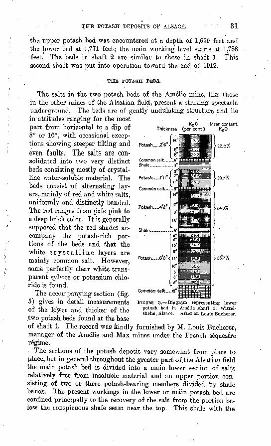
THE POTASH BEDS.
The salts in the two potash beds of the Amelie mine, like those in the other mines of the Alsatian field, present a striking spectacle underground. The beds are of gently undulating structure and lie in attitudes ranging for the most part from horizontal to a dip of 8° or 10°, with occasional excep tions showing steeper tilting andeven faults. The salts are con solidated into two very distinct beds consisting mostly of crystal line water-soluble material. The beds consist of alternating lay ers,-mainly of red and white salts, uniformly and distinctly banded. The red ranges from pale pink to a deep brick color. It is generally supposed that the red shades ac company the potash-rich por tions of the beds and that the white crystalline layers are mainly common salt. However, some perfectly clear white trans parent sylvite or potassium chlo ride is found.
The accompanying section (fig. 5) gives in detail measurements of the lower and thicker of the two potash beds found at the base of shaft 1. The record was kindly furnished by M. Louis Bucherer, manager of the Amelie and Max mines under the French sequestre regime.
The sections of the potash deposit vary somewhat from place to place, but in general throughout the greater part of the Alsatian field the main potash bed is divided into a main lower section of salts relatively free from insoluble material and an upper portion con sisting of two or three potash-bearing members divided by shale bands. The present workings in the lower or inain potash bed are confined principally to the recovery of the salt from the portion be low the conspicuous shale seam near the top. This shale with the
26^7%
Shale.
Potash -6V
Common salt....!
FIGURE 5. Diagram representing lower potash bed in Ame'lie .shaft 1, Wittel- sheim, Alsace. After M. Louis Bucherer.

32
salts above it, the latter being about 2£ feet thick, affords a good roof for mining, whereas if the uppermost salts are removed, the shale above bulges and falls in great masses, thereby rendering the workings dangerous. In April, 1919, when this mine was visited by the writer, the thick section of potash salts in the center of the main bed, included between the two prominent shale seams, was also being left for later working, and only the lower section of a little more than 6 feet of potash was being mined, because of the inconvenience of working a thicker face at one time.
The interval of about 65 feet between the two potash beds appears to be occupied mainly by shale of fairly uniform, slatelike character, but it contains also some thin beds of salt.
The upper potash bed is mined at the Amelie shaft 1, where it has a thickness of 5 feet 10 inches of potash salts below an exceedingly regular roof of clay that is almost slaty. This is the richer of the two beds and is taken out in its entirety. The material may be shipped separately or used to enrich the general average grade of the material derived from the lower workings.
Two samples, taken by the writer in the usual systematic way, so that they undoubtedly represent fairly the general 'run of crude material as it was being produced from these beds, have been ana lyzed in the chemical laboratory of the United States Geological Survey at Washington, with the following results:
Composition of crude potash produced from the Amelie mine, Alsace.
[E. Theodore Erickson, analyst.]
determinations (per cent of sample as re ceived) .
K.. ....... ....................Na.. ..........................Ca. ...........................Mg.. ..........................ci:.. ..........................S0 4 . ..........................
A
12.56 24.71 1.19 .03
50.34 2.41 8.00 .33
99.57
B
17.47 21.78
.99
.02 50.13 2.10 7.02 .30
99.81
Calculated salts.
>.,
KC1............... ............NaCL. ...... ..................MgClj..... ....................CaSO*..-.. ....................
H2O....... ...................
A
23.95 63.17
.12 3.42 '.50
* OO
8.00
99.49
B
33.31 55.73
.08 2.98 .30 .30
7.02
99.72
Sample A was taken in a large stock pile said to be from the lower part of the lower or main bed of potash worked as described above, and sample B was taken in a railroad car partly loaded for shipment, said to be material mainly from the upper potash bed as worked at the Amelie mine. The potassium reported in sample A is equivalent to 15.13 per cent potash (K20), and that in sample B to 21.04 per cent K2O. These determinations were made by the chlor- platinate method of determining potash and agree very closely with
THE POTASH DEPOSITS OF ALSACE. 33
the values reported at the mine based on determinations made by the perchloric acid method.
These figures are somewhat lower than the averages shown in the ideal section illustrated on page 31, but the divergence is probably not more than should be expected. The section on page 31 is based on samples carefully cut and preserved from foreign matter, whereas the run of mine or crude salts produced in ordinary mining include not only material from the common salt beds but, as shown by the analyses, 7 to 8 per cent of insoluble (earthy) material, which was not included in the calculations made for the ideal section.
Carnallite has occasionally been found in the Amelie mine but is so exceptional that it is pointed out as a curiosity. Carnallite is revealed by its tendency to effloresce when exposed, and it has been found in small irregular or pockety patches at the very top of the lower or main potash bed. The mineral has been identified by chemi cal analysis. The magnesia in the material as mined is, however, so low that it may be counted essentially absent.
REFINERY.
The refining plant for producing purified potassium chloride was not in operation in April, 1919, having been more or less damaged during the war, mostly by depreciation-through neglect, which per mitted deep rusting of the iron equipment. The equipment is large and of standard design, such as is reviewed in a subsequent section of this report. /
MAX MINE. /I
The Max mine is near the Amelie, and these two, which with the Josef and Else shafts form a group, were opened largely under con trol of the Deutsche Kaliwerke, and are still administered through a single management under the French sequestre regime. The Max shaft is connected by underground workings with the Amelie shafts.
The Gewerkschaft Max was founded March 3,1909. The property is a square area of 1,800 hectares (4,448 acres) southeast of the Amelie concession, to which it is similar in size and form. The shaft reached the depth of the two potash layers about the middle of 1912. The Max mine received an allotment for production under the Kalisyndikat, which was 7.81 thousandths in the list of February, 1918. ;
The mine is immediately adjacent to the mam line of the State railway between Basel, Mulhouse, and Strasbourg, the local) station or shipping point being JRichwiller.
The capital stock consisted of 1,000 shares, of which 444 shares were held by the Aktiengesellschaft Deutsche Kaliwerke of Bernte- rode, in Germany. The ownership of the remainder is not reported.

34 CONTRIBUTIONS TO ECONOMIC GEOLOGY, 1920, PART I.
The Max mine was visited April 11, 1919. At that time it was in operation and was reported to be producing at the rate of about 400 tons of crude salts a day, of which about 40 to 50 tons averaged 20 to 22 per cent K20 and the rest averaged 12 to 15 per cent.
The equipment of this mine is of standard type, like that of the Amelie, except that there is only one shaft, and compliance with the double-shaft requirement of the German mining law has been made by establishing connection in the mine workings with Amelie shaft 1, which is about 4,000 feet distant, northwest of the Max. There is a refining plant for manufacturing purified potassium chloride salts, but it was not in operation in April, 1919. The higher-grade product mentioned in the statement of present output is obtained by hand sorting of the blocks as brought from the mine before the material is crushed. Large storage bins, capable of holding 100,000 tons, were about one-fifth full at the time of this visit.
The upper and thinner potash bed was encountered at a depth of 1,624 feet in the Max shaft, and the lower bed at 1,686 feet. The thickness and details of the beds as well as the composition of the salts are very similar to the same features in the Amelie.
The following analysis of the salts" was furnished at the mine office:
Composition of potash salts from Max mine.[Dr. Horst, analyst.]
\ KC1______________ ____________________ 26. 75| NaCl________________-___________:______ 57. 43
CaSO,________________________________ 1.92\ MgCl2_________________________________ .36
; CaCL _________________________________ 1.26 ;H2O_________________________________ . 71
. Insoluble___________-_______-_____ 11.23
C 99.66A ' '
The working conditions were much the same as at the Amelie. At the time of the writer's visit 224 men were employed, and the output was therefore about 2 tons of crude salts per man per day. The view given herewith (PL Y, A) is a reproduction of a kodak picture taken April 11, 1919, showing the head frame of the Max shaft, a corner of the refinery to the left (north of the shaft house), and the power house on the right. The Eichwiller railroad siding is just beyond the buildings. Earth piled at the base of the shaft house as a pro tection against bombardment during the war was in process of re moval. The buildings are typical of the field and in fact of con struction at the German potash mines generally.
JOSEF AND ELSE MINE,
The Josef and Else shafts, about 1,500 feet apart, in adjacent con cessions designated by these names, are connected in the underground

U. S. GEOLOGICAL SURVEY BULLETIN 715 PLATE V
A. MAX MINE, NEAR WITTELSHEIM, ALSACE.
B. REICHSLAND MINE, WITTENHEIM, ALSACE.
THE POTASH DEPOSITS OF ALSACE. 35
workings and constitute essentially a single mine. The concessions adjoin and lie west of the Amelie and Max concessions. The shafts are about a mile west of Amelie shaft 2, and are thus a part of the Amelie-Max group. The Josef and Else shafts are, however, on the branch of the railroad that runs westward from Mulhouse by way of Lutterbach and Cernay. These shafts are listed as shipping from the same station as the Max (Richwiller), as the1 Cernay line is a branch from the main line of the State railway that runs from Mulhouse direct to Strasbourg.
Both companies, the Gewerkschaft Josef zu Wittelsheim and the Gewerkschaft Else zu Wittelsheim, were owned before the war by the Aktiengesellschaft Deutsche Kaliwerke of Bernterode, a corporation operating in the German potash region, which held 980 of the 1,000 snares of the capital stock of each of these subsidiaries.
The Josef shaft had reached a depth of 1,709 feet when the top of the lower or main potash bed was penetrated in October, 1912, and the top of this bed was cut in the Else shaft at about the same time at a depth of 1,608 feet. The upper potash bed has a thickness of about 3 feet and the lower about 16^ feet in both of these shafts.
The allotment assigned to the Josef by the Kalisyndikat list of February, 1918, was 1.98 thousandths and that to the Else 2.06 thou sandths. These shafts were not in operation in April, 1919, and were not visited by the writer.
The following analyses were furnished at the office of the Amelie and Max workings, to show the character of the salts. These are believed to be essentially of the same character throughout this dis trict, although the sample from the Else shaft gave somewhat higher potash results than the average. In all the samples from the main potash beds the salts of magnesium and the soluble sulphates are very low.
Composition of crude potash from Josef and Else shafts.
[Dr. Horst, analyst.]
KC1.......................................................................... ........NaCl.... ............................................................................MgClj. ..............................................................................CaS04- ..............................................................................FaO.... ............................................................................
Josef.
'25.4965.03
.082.63'.616.38
100. 22
Else.
35.25'51.582.78.18.70
9.76
100. 25
ANNA MINE.
The Gewerkschaft Anna, of Wittelsheim, is a subsidiary of the Gewerkschaft Hohenzollern, of Freden, south of Hannover, in the north German potash district, which holds 750 shares of a total of
36 CONTRIBUTION'S TO ECONOMIC GEOLOGY, 1920, PART I.
1,000 shares capital stock. Of the remainder 96 shares are held by the Deutsche Kaliwerke, previously referred to. This is listed as one of the Kalisyndikat properties that is " in process of building a shaft." The report to the Kalisyndikat states that shaft 1 on the Anna was started November 1, 1911, and had reached a depth of at least 741 feet, and that shaft 2 was started August 1, 1913, and had reached a depth of 344 feet. The management of this property was evidently closely allied with that of the adjacent Keichsland prop erty. No production is reported, as the shafts are said to be still incomplete. The workings on the Anna concession were not visited by the writer.
The concession is adjacent, to and directly northwest of Mulhouse, and so far as present evidence goes is believed to include in greater part lands underlain by only the lower or thicker of the two beds of
( potash salts.. The property consists of about 1,200 hectares (nearly 3?000 acres), a part of which is probably outside the' potash-bearing field. Some of the main routes traversed to and from Mulhouse and the other potash properties pass -through the Anna concession just northwest of Mulhouse.
REICHSLAND MINE.
The Gewerkschaft Reichsland was founded in 1911, with a capital stock of 1,000 shares, of which 600 shares were held by the Gewerk schaft Anna, which was in turn a subsidiary of the Gewerkschaft Hohenzollern. According to report the Government of Alsace- Lorraine, in 1913, bought interests in the Reichsland as well as in the Theodor and Eugen mines. The Keichsland shafts and equip ment are much farther advanced than those of the Anna, as this com pany reported production at least as early as 1916. The sales quota assigned to the Keichsland mine in the Kalisyndikat list of February, 1918, was 8.87 thousandths, which was a reduction from the year preceding but still places this mine well up in the ranks of largest producers in the whole German industry. The sales of potash from the Reichsland mine in 1916 amounted to 10,409 metric tons of K2O and in 1917 to 12,629 metric tons. Its output at the time of visit was reported as about 800 tons of crude salts lifted, a part of which was being used in the production of about 50 tons of refined salts daily. This is considerably more than the reported prewar pro duction.
The Reichsland mine is near Wittenheim, 4 miles almost due north of Mulhouse, on the left side of 111 River. A provisional con nection was first made with the minor line of railroad running from Mulhouse to Wittenheim, but. later a connection with the main State railway at Richwiller station was established. The mine is
THE POTASH DEPOSITS OF ALSACE. 37
probably readily accessible to the river canals, but shipments are made by rail.
The Reichsland mine is a complete unit, consisting of the two shafts required by the German law, a refining plant for preparing refined grades of potassium chloride salts, and a large storage warehouse. It has a complete steam-power plant, and according to report its stack is the highest chimney in upper Alsace, which contains many manufacturing enterprises. Plate V, Z?, shows a general view of the plant taken from the public road south of Wittenheim. ->,
The valley lands adjacent to 111 River, north of Mulhouse, are largely cleared fields, cultivated as meadows or in grain and truck crops. The Reichsland mine stands practically alone in these fiat meadows about half a mile southwest of the town of Wittenheim. The shafts, equipment, and refinery were left, at the time of the armistice, m somewhat better repair than those of most of the otherpotash mines in Alsace, and consequently this property was prompt to respond to French efforts to reestablish the production of potash from this field. The refinery and mine workings were visited by the writer April 10, 1919. - o
The two shafts, which are about 1,000 feet apart, are near the ex treme northwest corner of the Reichsland concession, which, being the side of the concession that is toward the center of the field, may be supposed to be in the best or thickest part of the deposit on this property. At present the mining is carried on from the west shaft. The underground development is extensive, reaching mostly south ward from the site of the surface buildings along the border of the adjacent Anna property.
Only the lower of the two potash beds, of the Alsatian field is found in the workings on the Reichsland property. The top of this bed was reached at a depth of 1,863 feet in the shafts. The overlying beds consist mainly of saline shale, and the potash bed is just below a deposit of common salt 410 feet thick. The potash bed lies in gentle folds, having dips of 10° to 20° in the present workings. The same potash bed is only 1,207 feet deep in a boring just north of Illsach, in the southern part of the Reichsland concession and near the extreme edge of the field as now delimited. The potash in the Reichsland mine presents a working face about 7 feet thick. Where exposed more completely, however, it is seen to be between 9 and 10 feet in total thickness but considerably broken by shale partings. As at the Amelie mine, it is composed of an alternation of thin layers of white salt, pink and deep-red sylvite, and clay. One of the inter- bedded layers of clay is used as a-roof in the mine. This layer has been cross-fractured and the cross seams filled with crystallized salts of salmon-pink to red colors, said to be mainly sodium chloride. The shale roof in the mine is marked by pits or irregular surface patches,
38 CONTRIBUTIONS TO ECONOMIC GEOLOGY, 1920, PAKT I.
presumably impressions of crystal forms against which the mud hardened.
As in the other mines in this field the temperature of the rock is very high (reported 42° to 48° C.) and the galleries are kept cool enough for comfortable working only by forced ventilation. The rocks at mining depth seem to be dry, as no moisture, except that leaking about the upper collars of the mine shafts, was observed in the district.
The refining process being carried on here in a commercial way at the time of visit is described in the general section on " Surface treat ment" (pp. 44r-46). The potash works had then been in possession of the French authorities for so short a time that little in the way of regular operation could be considered as established, but much e'x- cellent work was being done.
THEODOR MINE./. _
The Theodor and Prinz Eugen shafts are close together, so that they constitute but a single mine, although opening on two adjacent concessions. This mine is north of the Reichsland, on the same (west) side of the 111 Valley, in the edge of the woods a little farther from the river. The shafts are about 9 miles almost due north of Mulhouse, midway between the towns of Wittenheim and Pulver- sheim.
The capital stock of the Gewerkschaft Theodor and also that of the Gewerkschaft Eugen consisted of 1,000 shares each, of which 501 were held by the Gewerkschaft Wjntershall, of Heringen, in Ger many, and 334 by the Elsass-Lothringischen Fiskus, presumably the local government owner that has already been referred to in connec tion with the Keichsland mine. Both the Theodor and Prinz Eugen organizations were founded April 11, 1911. The Theodor shaft was in process of building from October, 1911, until the later part of 1912. The quotas for production allotted by the Kalisyndikat list of February, 1918, were 7.98 thousandths to the Theodor and 7.01 to the Prinz Eugen, a total of 14.99 thousandths' for this mine.
The record of production from the Theodor mine, including both properties, is given in the following terms:
Potash salts sold from Theodor and Prinz Euffen properties in 1916 and 1917, .in metric tons of KzO.
Kainit, 12 to 15 per cent K20.. . ................:....................................
1916
3,0416,0273,0916,627
195
18,981
1917
1,21325,9851,8591,426
499
30,982

THE POTASH DEPOSITS OF ALSACE. 39
' The Theodor property was visited by the writer on April 11 and 12, 1919. The underground workings were not examined. They are said to have been badly worked by unskilled Russian prisoners before the end of the war and to have been left in a rather dangerous con dition. However, an output of about 200 tons of crude salts daily was being made from the mine,' and a part of this had been shipped, but much of the crude salts brought to the surface had been used in experimental operations in starting the refinery. The output of re fined salts was estimated at about 20 tons daily, of which about 500 tons had accumulated in storage.
The top of the upper potash bed is reported to have been encoun tered at a depth of 1,791 feet, and the top of the lower bed-at 1,853 feet. The upper bed is stated to be 4.1 feet thick and to average 26 to 27 per cent K2 O> and the lower bed to be 13.45 feet thick and to average 23 per cent K20. The outline as given for the area in whichthe upper potash bed is found indicates a southern limit just south of this mine, which may be shown in the mine workings and by borings farther southeast. If so, the upper potash bed seems to terminate abruptly from the recorded thickness of about 4 feet of potash aver aging 26 to 27 per cent K20.
The equipment of the refinery was formerly very complete and is being studied in much detail by the present operators. The records of production in 1916 and 1917, showing an output chiefly of lower grades of fertilizer salts, indicate that the refinery equipment was al lowed to lapse into disuse toward the later part of the war, and when the property was taken over by the French the machinery had been largely dismantled, parts of it were scattered, and the extensive iron work, was deeply rusted and badly out of repair.
MABIE-LOTTISE MINE.
The Marie-Louise and Marie shafts, on concessions of the same names and therefore representing two properties, are only 820 feet apart. They constitute but a single mine, and at present 'operations are carried on through the Marie-Louise shaft, which is the northern of the two. The two shaft houses are connected by a long covered storage building, but there is no refining plant here. The refinery is reported to have been ordered in Germany before the war, which prevented its delivery.
The Gewerkschaft Marie-Louise and Gewerkschaft Marie were organized in 1911. The capital stock of each of these companies is. divided into 1,000 shares, of which 501 were held by the Deutsche Kaliwerke, of Bernterode, Germany.
The Marie-Louise shaft cut the potash in 1913 at depths of 2,040 and 2,109 feet. The upper potash bed is reported by a German authority to be 4.9 feet thick and to have an average of 32.9 per cent

40 CONTRIBUTIONS TO ECONOMIC GEOLOGY, 1920, PART I.
K2O, and the lower bed to be 13.1 feet thick and to have an average potash content of 22.6 per cent. The shaft on the Marie concession was sunk at the same time as that on the Marie-Louise and reached the two potash beds at depths of 2,191 and 2,230 feet. The upper bed in this shaft is reported (also by German authority) to be 4.9 feet thick and to average 29.2 per cent K20 and the lower bed to be 13.1 feet thick and to average 27.02 per cent K2O. The quota for production assigned by the Kalisyndikat list of February, 1918, allowed 7.52 thousandths to the Marie-Louise shaft and 2.27 to the Marie shaft, a combined output for the mine of 9.79 thousandths. The output from these properties is not reported.
The mine is 2 miles northeast of Wittelsheim and lies directly alongside the main line of the Strasbourg-Basel Railroad, north of Kichwiller. The railroad shipping point is Bolwiller, a town of considerable size 2 miles farther north.
The mine was examined by the writer April 11, 1919. The prin cipal workings extend north and northeast from the Marie-Louise shaft, where material from both upper and lower beds has been taken out, chiefly, however, along exploratory galleries, so that a large tonnage is definitely blocked out. A north-south drift connects the two shafts, and only a small amount of work has been done from the Marie shaft.
The two potash beds are worked by the room and pillar method at the one place where the exploratory drifts are being extended into regular mine workings. The lower part of the thick lower pot ash bed, below a shale parting in the salts, such as has-been described in the section on the Amelie mine, is first taken out. . It is the inten tion that the overlying potash shall be removed later. At present it seems necessary to leave large pillars containing about 25 per cent of the original bed for the support of the mine roof, but it is hoped eventually to recover much of this material. In April, 1919, about 500 men were employed, of whom 300 worked underground. The output was stated as 400 tons of crude salts a day.
The potash beds are thick and very uniform or regular in char acter in this mine, and, to judge from the analyses quoted, this and the Wittelsheim district in general seem to be near the center of deposition of the potash, the beds being of the maximum thickness for the field and the material of excellent grade. There is a marked undulation in the position of the beds, a fold at one place giving a dip as high as 40°. The potash beds in the Marie shaft are 79 feet below the level of the same beds in the Marie-Louise mine, but it is reported that no faulting is visible. The shale beds dividing the principal potash, bed into layers make very perfect roofs under which the salts may be removed, and they apparently hold securely throughout the mine, even in old workings. The upper potash bed
THE POTASH DEPOSITS OF ALSACE. 41
is the richer of the two, averaging, according to analyses reported by the French operators, 26 to 27 per cent potash.
The lower and thicker bed is found in three principal divisions, similar to those in the section at the Amelie mine, separated by 6 to 10 inches of shale. About 1£ feet at the top of this lower bed consists of dark-red and'white banded salts. A middle section, about 5 feet thick, is banded red and white; and the lower section, also about 5 feet thick, is more uniformly pink with white bands of salt in it. There is a foot or more of common salt at the base. The pink salt is described as sylvine. The average potash content of these divisions is said by a French authority to be 26 per cent, slightly more or less, for the upper part, 16 per cent' for the middle part, and 22 per cent for the lower part, exclusive of the common salt at the base.
The potash is at a lower elevation in the Marie shaft than in the Marie-Louise, and the galleries at the base of the shaft had been filled by water that dripped through leakage about the collars of the shafts, which had not been drained at the time the property was visited. It appears, however, that water standing in these mines, without drainage or circulation, does not cause serious damage, as several' shafts in the district that were allowed to fill in this way during the war and have since been drained show little or no damage.
The mine is as a whole in excellent condition for full operation. The galleries are open and regular and are so laid out that develop ment may proceed according to a regular plan. The quality, regular ity, and thickness of the beds are favorable, and when both shafts are put into operation this should be a very productive property.
ALEX AND RUDOLF MINE.
The Alex and Rudolf mine consists of two shafts on adjacent con cessions of the same name, which together constitute essentially a single mine. The shafts are about 2?000 feet apart, and each shaft had its own set of buildings, so that operations could be conducted more or less independently. The buildings of the Rudolf were used for storing ammunition during the war and were partly destroyed by fire, so that at the end of the war they were not in condition for operation.
These properties are of original French-Alsatian ownership. The association designated in the German records Gewerkschaft Alex was founded in 1907 as a subsidiary of the Societe Ste.-Therese, referred to more specifically in a subsequent paragraph. The capital stock is divided into 100 shares for each concession, the greater part of which is held by the Ste.-Therese association. The work had just been com pleted at the outbreak of the war,°and the property was not operated much thereafter. Preliminary quota figures for production assigned by the Kalisyndikat in the list of February, 1918, were 2.19 thou-
1278° 21 4

42 CONTRIBUTIONS TO ECONOMIC GEOLOGY, 1920, PART T,
sandths for the Alex .shaft and 1.98 thousandths for the Rudolf, a total of 4.17 for the two if considered as a single mine.
The Alex and Rudolf shafts are on the main highway, about half way between Bolwiller and Pulversheim. They are connected by a short spur track from the main line of the Strasbourg & Basel Rail way just south of Bolwiller. The Alex shaft is 7-J miles in a direct line. northwest of Mulhouse.
The Alex shaft is reported to be 2,624 feet deep, and this and the Rudolf passed through both potash beds.
The Alex mine was examined by the writer April 12, 1919. It is described as the last shaft sunk in the field before the war, and the equipment is evidently newer or in better condition than at most of the other mines. All is of standard German make. The mine on the Alex concession consists of the shaft and the usual surface buildings, substantially built of concrete, but there is as yet no refining plant for the manufacture of the higher grades of salts. According to report 290 workmen were employed at the time of visit, of whom 210 worked underground. The production at that time was stated to be 350 tons daily of crude salts averaging 15 per cent potash (K20), and there was in storage about 12,000 tons of crushed and ground crude salts ready for shipment.
The examination of the mine disclosed a system of galleries opened in excellent order as preliminary to the further operation of the mine. The main gallery is lined with concrete near the base of the shaft. Like the others in this field, the mine seemed very warm in fact, uncomfortably so in the portion beyond the system of ventilation.
The potash beds are less tilted here than in the Marie-Louise property, south of the Alex. The level rises at an angle of about 2° in the direction of the Rudolf shaft, but the gallery following thepotash bed is described as passing over a saddle and then down again in that direction. The bedding exposed is exceedingly regular, with the usual succession of red and white banded salts containing partings of clay shale. At present only about 6 feet of the lower part of the main bed is being taken out, except at one place where the whole bed, exclusive of about 1 foot of common salt at the base, was being re moved. The details of the measurements are similar to those of the Marie-Louise mine.
STE.-THEB,ESE MINE.
The property of the Kaliwerke Sankt Therese Aktiengesellschaft, as designated on the German records, consists of the Ste.-Therese and Regisheim concessions at Ensisheim, in each of which is a shaft. These concessions and the Alex and Rudolf, described above, are the only properties in the field that were of original French-Alsatian ownership. The titles of these,properties have therefore not been
THE POTASH DEPOSITS OF ALSACE. 43
disturbed by the war. The association was formed in 1910, and at the end of 1915 the Ensisheim No. 1 shaft had reached a depth of 2,460 feet, and the Ensisheim No. 2 shaft a depth of 1,804 feet. No record was obtained of the depth or character of the potash beds, as these shafts are said to have been flooded during the war and were inaccessible at the time of the writer's visit.
These shafts are connected by a branch railway which joins the main line of the State railway at Bolwiller.
TECHNOLOGY.
MINES.
The equipment of the mines in Alsace is of standard type, similar to that of mines in the older developed potash fields of north-central Germany. As required by the German mining law, each mine con sists of at least two connected shafts, a provision doubtless designed for safety in case of accident and to assist ventilation. The shafts are mostly lined with concrete except near the surface, where an iron collar is put down through the loose alluvial and water-bearing beds. The shafts are equipped with two elevator mine cages, apparently of a standard type. The cages are double-decked and carry a num ber of iron mine cars in which the salts are brought from the mine. Open lights are used, as there is apparently no danger from gas. The rock temperature throughout the region is rather high (reported 42° to 48° C., equivalent to 107.6° to 118.4° F.), and'comfortable working conditions are obtained by forced ventilation. The mines are dry except that in some places there is a slow seepage of water from the upper part of the shaft, where it passes through the valley deposits. This water collects in a sump and is removed from the mine in mine cars. Ordinary hand augers and electric drills are used, and the salts are blasted down. The blocks are sorted by hand and the waste is used to fill the spaces mined out. Some timbering is done, mostly in the main galleries, and one gallery was lined with concrete for a short distance from the main shaft. In general the workings stand well, unless the salts are removed in entirety, when large masses of the overlying shale are likely to break down with exposure to the air.
The workings in many of the mines have scarcely advanced beyond the stage of exploratory development, with the extension of main galleries to block out the reserves. In some places a room and pillar system of working has been tried, in which both the necessity of leaving some of the salts for a roof and the large pillars required considerably reduce the percentage of recovery. It is possible that some of this material may be taken out later. In other places a " long:wall" system of mining is employed, whereby a continuous working face is advanced and the space worked out is filled to the
44 CONTRIBUTIONS TO ECONOMIC GEOLOGY, 1920, PART I.
rear, generally down the slope, with waste broken out in mining and also with waste salts brought back in the mine cars from the refinery. Where the dip is steep the salts are mined in stopes by the usual manner. In many places the workings on the upper and thinner bed are reached through stopes from the lower level.
From present and past operations it seems fair to assume that each shaft may be counted as capable of bringing to the surface 600 to 750 tons of salts daily, which is equivalent to about 200,000 to 250,000 tons a year. As the crude salt will probably average on the whole about 14 to 15 per cent, and a smaller amount will be of 20 to 22 per cent grade, it seems fair to estimate the annual output of a single shaft if worked at approximate capacity as about 30,000 to 40,000 tons of K20. This is considerably in excess of the reported past production from any of the mines. For example, the combined output from the two shafts of the Theodor and Prinz Eugen mine was reported as 30,982 tons .of K20 in 1917. However, it is understood that the production of all the properties was much restricted under the man agement of the Kalisyndikat, so that the estimate given above is thought to be as close as can be obtained from present evidence.
SURFACE TREATMENT.
The broken salts that are brought from the mine are passed through a bin to a jaw crusher, where the coarser blocks are brought down to about the size of a man's fist, and the material is then spread on a revolving table, where it is picked over in a hurried way by one or several workers, who remove the larger blocks of waste that happen to come to the surface with the rest. From this table it is fed to a lower level into grinding mills, which are of several types. From these the material either passes into storage for shipment as crude salts or goes into the refinery.
If the material is to be refined, it is elevated and passed through a screen. The fines are relatively cleaner and purer, and the coarse material includes more shale, which is not so readily broken up in the mills. It is then transported, usually by belt, into hoppers, from which at intervals it is fed into boiling vats fitted with agitators. Here the raw salts are heated with liquors derived from previous crystallizations. The liquors and salts from these solution .vats are discharged periodically, and the residue is drawn into draining vats which have perforated bottoms and revolving rakes, the latter assisting the draining of the residue while it is still hot. When the free liquor is practically all run off the residue is thrown out at the edge by means of the revolving rakes and goes to the waste, usually being returned to the mine to fill old workings. The moist residue still contains several per cent of potash.
THE POTASH DEPOSITS OF ALSACE. 45
The liquor goes to settling vats, where it stays about 15 minutes, beginning to crystallize on the surface almost at once. A long glass tube thrust into the solution, then closed at the top and withdrawn, shows the progress of settlement of the muddy slime, and a hinged drainage pipe is let down into the vat, so that its outlet end follows the rather distinct limit of the cleared liquid. At the last the mud and salt left in the bottom of the tank are again washed with hot mother liquor.
The liquor, which is still distinctly muddy, is drawn from the settling tanks through troughs to a battery of iron crystallizing vats of the ordinary type, where as it'cools it deposits the crop of muriate (potassium chloride) of varying degrees of purity, the quantity and quality of the product obtained depending somewhat on the care with which the various steps of the process are conducted, the length of time allowed for crystallizing, and the amount of chilling. After the liquor has stood for several days it is withdrawn and returned to the process. There is so much muddy sediment in the liquor that the .final product has an earthy color. The salts that crystallize on the sides of the vats are fairly clean, but no effort has yet been made to take these out separately. The crust that forms with each cooling is from 2 to 5 inches thick on the sides of the tanks and somewhat thicker at the bottom. The salt is dug out of the crystallizers by hand and loaded over the sides into tramcars, whence it is taken to a rotary dryer for finishing. The yield was reported to be a little better than 3 tons of crystallized salts pel: crystallizing vat. Thus a plant with 72 crystallizing vats, worked in three groups, would yield about 80 tons of refined product daily.
The mother liquors are used repeatedly, as the accumulation of undesirable constituents in them is slow. Thi£ is considered one of the great advantages enjoyed by this field as compared with the German potash regions, where, on account of an excess of soluble magnesian salts in the mother liquor, much of it has to be discarded regularly.
The coal consumption at a plant with 72 crystallizers, producing 80 tons of refined salts daily, was stated as 13 tons a day in the refinery and about 7 tons more for general purposes in the mine, not including electric current used for lighting. The cost of coal was quoted at 56 francs per metric ton.
Some estimates of the cost of producing the salts were compiled by F. K. Cameron 1 from data given by the operators in April, 1919, which are, however, based on wage rates lower than those now ob tained in the field. These estimates, which are given below, include
1 Potash from Alsace, in Hearings before the Committee on Ways and Means, House of Representatives, July 28, 1919, pp. 273-278.
46 CONTRIBUTIONS TO ECONOMIC GEOLOGY, 1920, PART I.
delivery to an ocean port, which might be either Havre, Antwerp, or Rotterdam, as all of these are accessible by way of the Rhine and connecting waterways.
Estimated cost per ton of producing potash from Alsatian deposits.
1. For potassium chloride averaging 18 per cent K2O orbetter:
Mining________________-_________________ $4.00Milling ____________________________ . 85 Bagging_ __ _ __________ 1. 50 Renewals and repairs______________ '.____ 1.00 Office and supervision___________________ . 75 Interest______ ___________________ 1. 00 Freight ____________________________ 2. 00
11.10 Cost per unit of KSO______L__________________, . 617
2. For potassium chloride averaging 45 per cent K2O orbetter:
Mining_____________________________ 10.00 Milling ____________________________ 4.12 Bagging___________________________ 1.50 Renewals and repairs _____________-_____ 4. 50Office and supervision___________________ 1.88 Interest, etc_________________________ 3. 75 Freight_____________________________ 3. 00
28. 75 Cost per unit of K20____________:______ . 639
These figures do not include a charge for amortization, profit, taxes, and ocean freight. It is reasonable to expect some of the above figures to be modi- fled downward with further experience and development of trained and ample working forces. The present freight rates on crude salts from the mine is 20 francs to Havre, 18 francs to Antwerp, and 16 francs to Rotterdam, but thereis a good prospect for early and substantial reduction, especially in the rate to Havre.
Ocean freights at the date of present writing (October, 1919) are about $6.50 a ton from European ports to Atlantic ports in the United States. It is reported that while no objection is made by the carriers to handling the lower grades of crude potash salts, the refined salts (muriate) can not be shipped in wooden vessels and, if carried in steel boats, must not be allowed to come into contact with the steel on account of corrosion. For this reason higher rates are asked by the carriers for the higher-grade salts.
ORIGIN OF THE ALSATIAN POTASH DEPOSIT.
Most of the geologists and others who have formulated hypotheses in explanation of the manner in which the deposits of potash in Al sace came into existence in their present form have assumed as a basis of reasoning that the large deposits of anhydrite and common

THE POTASH DEPOSITS OF ALSACE. 47
salts as well as the potash are the residues left by the drying of sea water. ' The general assumption is that an arm of the ocean, supposed to have occupied the site of the present Khine Valley, was partly or wholly cut off by a barrier, and that although there were subsequent incursions of sea water caused by alternate raising and lowering of the barrier, or possibly by waters breaking or flooding over the barrier at intervals, the water in the basin behind the barrier finally dried up and deposited its soluble constituents in the natural order in which such deposition might be assumed to have taken place. This has been a favorite hypothesis used by geologists to account for salt as well as potash deposits in various parts of the world. The process of over flow of such a barrier by tide and wave action may be seen in opera tion on a small scale in many places along the seacoast, where barrier bars built by the waves between projecting headlands cut off lagoons of salt water from free access to the sea, and in these lagoons the seawater concentrates and deposits gypsum and salt.
Forster is followed by Wagner and others in an assumption of re peated oscillations of land level in the region, to account for flooding, at times by salt water, as indicated by organic forms of marine types, or by saline deposits, or, as assumed, even by anhydrite, and at times by fresh water.
The writer is inclined to take exception to these as fundamental assumptions for an explanation of the origin of the deposits. The geologic history of the region has been very complex and can hardly be deciphered from the few clues at hand. However, it is a perfectly natural assumption that the Rhine graben became in post-Jurassic, probably early Tertiary time a depression without outlet or inlet and not necessarily connected with the sea, although the bottom may have settled to and below sea level. There are many such areas in block-faulted regions, of which the Rhine Valley is apparently a good example. Normal drainage tributary to such a basin would have been impounded there, forming a lake whose surface would expand until evaporation from the surface area became equivalent to the water that flowed into the basin. The concentration of the ordinary saline constituents of river and ground waters would pro ceed, as is exemplified in many parts of the world, and as a result an inland salt lake would very probably be formed. Slight climatic variation, through seasonal or periodic changes, would raise and lower the water level, and at periods of exceptionally large inflow the salt lake waters would be diluted and sediment would probably be spread over the bottom.
It is well known that many basins in the western United States have held deep lakes which have now entirely dried up. Such evi dently was the final result in the Rhine graben. It is logical to as sume in a general way that waters which drained a region of much
48 CONTRIBUTIONS TO ECONOMIC GEOLOGY, 1920, PART I.» ' '
limestone, such as the region adjacent to the Rhine Valley, and which undoubtedly carried considerable calcium carbonate, might, with concentration, react with the soluble magnesian and sulphate salts in the concentrating lake water, thereby precipitating CaSO4 and both CaC03 and MgC03 as anhydrite and dolomite. As the waters diminished in volume and the solution became more concentrated, common salt in considerable quantity would naturally be deposited. At length a solution consisting mainly of sodium and potassium chlorides remained in such proportions that with chilling sylvite began to come down. It happens that the potash-rich salts were de posited separately from the main mass of sodium chloride, overlain and underlain by deposits of clay. The detailed structure of the de posit is such as is readily accounted for on this hypothesis, if we assume that the chill of winter would precipitate sylvite in a thin layer, and the evaporation of the following summer would precipitate a corresponding layer of common salt. The process evidently went on for 25 to 50 years or more, until a considerable deposit of the mixture of these two salts, known as sylvinite, had accumulated. Flooding with muddy waters temporarily diluted the brine and stopped the deposition at intervals but at first was not sufficient to break up the process. After the second layer of the potash salts had been formed, for some cause perhaps the deeper flooding with fresh river waters and the burial of the deposit with silt and possibly the establishment of an overflow outlet the rest of the solution may have been drained away, and the adjustment of events that produced the potash did not come again.
Earth movements were probably taking place in the region during this time, as even now earthquakes are said to indicate a continuance of such phenomena. However, it seems unnecessary to assume an' introduction of sea water to account for each deposit of salts, or even to account for the presence of marine types of organic life, for these salts are known to be accumulated in great quantity by the concentration of comparatively fresh waters, and forms of marine types are introduced and live in salt or saline water when conditions there are favorable to their existence. There is nothing catastrophic about this hypothesis, nor any assumption of unusual or very com plex happenings. It fits with processes that may be observed in various stages to be taking place throughout the world at the present time. Many of the details of the history are lacking and probably will never be known. Possibly carnallite and other salts would also have been formed if the process had not been interrupted as it was, but this depends on the composition of the residual liquors from which the sylvite was produced, and these residual liquors were evi dently lost by dilution or overflow, so that this point can not be proved.
THE POTASH DEPOSITS OF ALSACE. 49
BIBLIOGRAPHY.1
1. 1877. Zundel, Ch., and Mieg, Mathieu, Notice sur quelques sondages aux environs de Mulhouse et en Alsace [Notes on some borings in the vicinity of Mulhouse and in Alsace]: Soc. ind. Mulhouse Bull., vol. 47, pp. 631-641.
Gives notes and such record as is available concerning borings in the vicinity of Mulhouse, together with a page of profiles of 13 wells plotted for comparison. The deepest of these wells (240 meters), put down by Gustave Dollfus at Dornach in 1869, en countered gypsum and salt and gives a basis for some discussion of stratigraphy and correlation, but otherwise this paper has no di- ,rect bearing on the later discovery of potash in this region. ..
2. 1888. Mieg, Mathieu, Note sur un sondage execute1 a Dornach (pres Mul house) en 1869 [Note on a boring put down at Dornach (near Mulhouse) in 1869]; Soc. geol. France Bull., vol. 16, pp. 256-264.
A well put down by Gustave Dollfus in 1869, seeking water, reached a depth of 240 meters (800 feet), the deepest in the vicinityof Mulhouse. The paper gives the results of a detailed study of the section passed through, from the examination of samples, with notes on correlation. The upper part of the section to a depth of 28.6 meters yields fossils, which are identified, but the rest of the section, including gypsum and some salt at the base, is re ported as absolutely sterile.
3. 1908. Vogt, Joseph, and Mieg, Mathieu, Note sur la d&couverte des sels de potasse en Haute-Alsace [Note on the discovery of salts of potash in Upper Alsace]: Soc. ind. Mulhouse Bull., vol. 78, pp. 261-273.
This is an announcement in some detail of the results of the explorations by boring conducted by the Soci6t6 Bonne Esp6rance under the direction of M. Vogt, through which the discovery of potash in Alsace was made. A map gives the location of the borings, with indication of the results attained (whether successful in cutting the potash or finding only salt), shows the depth and location of other borings not yet completed, and presents an inter pretation of the structure of the potash beds by means of struc ture contours. Many of the details of the borings are reviewed, and the nature of the deposit and its probable further extension are discussed.
4. 1908. Forster, B., Kalisalzlager im Ober-Elsass [Potash salt deposit inUpper Alsace]: Zeitschr. prakt. Geologie, Jahrgang 16, pp. 517-519.
Review of "Note sur la dficouverte des sels de potasse enHaute-Alsace," by Joseph Vogt and Mathieu Mieg, 1908. (Seeabove.)
5. 1909. Forster, B., Vorlaufige Mitteilung fiber die Ergebnisse der Unter- suchung der Bohrproben aus den seit 1904 im Gange befindlichen Tiefbohrungen im Oligocan des Ober-Elsass [Preliminary com munication on the results of the study of the samples from the deep borings that have been in progress since 1904 in the Oligocene of Upper Alsace] : Geol. Landesanstalt Elsass-Lothringen Mitt., Band 7, Heft 1, pp. 127-132.
Referring to the fact as well recognized that the discovery of the large salt deposits with the associated potash layers was made
1 The writer desires to acknowledge friendly cooperation by Messrs. L. M. Prlndle and J. M. Nlckles In the review of the German literature.
50 CONTRIBUTIONS TO ECONOMIC GEOLOGY, 1920, PART I.
since 1904 through the activities of 'an organization " Gute Hoffnung " under the direction of M. Vogt, of Niederbruck, explains how the study of the samples from the boring was taken up by the Geological Survey of Alsace-Lorraine. Core material from 33 borings in this district and the profiles from 12 others were avail able for study in February, 1908, when this work was taken up. The paper is mostly a brief summary concerning the stratigraphy as worked out from these records and the classification made is the basis for that quoted in several subsequent papers. (See No. 8 of this list.)
6. 1909. Pervinquiere, L., DScouverte de sels de potasse en Alsace [Discovery of potash salts in Alsace] : Rev. scientifique, Paris, 47e Annee, ler Semestre, pp. 434-435.
This is a review of the paper by Vogt and Mieg, " Note sur la dgcouverte des sels de potasse en Haute-Alsace," 1908, referred to above. It concludes by expressing the hope that this basin may extend into France, a hope that is considered doubtful, because it has been seen that the beds thin toward the south, but as the Oligocene exists about Belfort it would be in order to make an investigation.
7. 1910. Gorgey, R., Minerale tertiiirer Kalisalzlagerstatten [Minerals of the Tertiary potash salts deposits] : Min. pet. Mitt., Neue Folge, Band 29, Heft 6, pp. 517-519.
Brief notes concerning the minerals associated with rthe potash salts at Kalusz and in Alsace.
8. 1911. Forster, B., Ergebnisse der Untersuchung von Bohrproben aus den seit 1904 im Gange befindlichen, zur Aufsuchung von Steinsalz und Kalisalzen ausgefuhrten Tiefbohrungen im Tertiar Oberelsass [Re sults of the study of well samples from the deep borings in the Tertiary of Upper Alsace, which have been going on since 1904 in the search for rock salt and potash salts]: Geol. Landesanstalt Elsass-Lothringen Mitt., Band 7, Heft 4, pp. 349-524.
After a brief introductory statement as to the origin of the in vestigations and a list of preceding publications on the subject, describes in detail the core samples from 56 borings and the Wit- telsheim shaft, and gives a tabulation of certain details from 120 borings. A discussion of structure, both folding and faulting, is supplemented by two text figures which have been reproduced in later papers. The first estimates found of reserve tonnage of the field are made (pp. 503-504). The paper closes with a discus sion of stratigraphy and with a collection of detailed maps and profiles in colors, which have been repeatedly reproduced in later reports.
0. 1911. Wagner, W., Die Kalisalzlager im Tertiar des Oberelsasses [The pot ash salt stratum in the Tertiary of Upper Alsace]: Philomath. Gesell. Elsass-Lothringen Mitt., Band 4, Heft 4, pp. 471-486.
The paper is a review, largely by abstract, from the Forster paper (No. 8 of this list), with an historical geologic interpreta tion of the stratigraphic data from the Alsace potash region. The substance of the historical record is reviewed in the present paper under the heading " Geology of the deposits." Forster's diagrams showing structure in the field are reproduced.
THE POTASH DEPOSITS OF ALSACE. 51
10. 1912. Meisner, , Der oberelsassische Kalibergbau [The Upper Alsace potash mining]: GHickauf, Jahrgang 48, Band 2, pp. 1321-1324.
A r6surn6 of what was known of the Alsace potash deposits, ac companied by several small but clear text maps showing in broadly generalized outline the geology of the upper Rhine basin, the situation and means of access to the potash field, and the relative position of the 11 shafts then in existence.
11. 1912. Beil, C., Die Ausdehnung des oberrheinischen Kalivorkommens [The extension of the upper Rhine potash occurrence]: Gliickauf Jahrgang 48, Band 2, pp. 1804-1807.
Reviews explorations by borings in various districts about the Alsace potash field and mentions a potash discovery in Baden, Ger many. Gives a map showing former ownership of~th~e concessions in the Alsace field, on which an area northeast of Mulhouse, lying on both sides of the Rhine, is designated " new potash district." The discovery between Buggingen and Zienken of sylvinite of quality similar to that in Alsace is mentioned. However, the area of valley between the Schwarzwald and the Rhine is narrow and is cut off to the north by the Kaiserstuhl and also to the south, so that there is practically no space where .such deposits may be found. At Banzenheim, on the west side of the Rhine, two borings and pos sibly a third have revealed the potash layer, which is similar in quality to that of the main field but only 1 to 1.5 meters thick. Various considerations make its development impracticable, in part because 160 meters of river sediments would make shaft sinking expensive; the operation at so great a depth of only a very thin deposit and the high temperature observed are also unfavorable.
12. 1912. Binder, F61ix, and1 others, Mines de potasse dans la Haute-Alsace [Potash mines in Upper Alsace]: Soc. ind. Mulhouse Bull., vol. 82 No. 4, pp. 207-300.
This is an important work, combining under one cover a very complete record of the data available at the time concerning the potash deposits in Alsace. It contains chapters on the history by Fe"lix Binder, on the geology and mineralogy by M. Binder and Edm. Boucart, on the borings by E. R6my, and on the sinking of shafts and mining by Guy de Place, as well as sections on mechanical equipment and discussions of various aspects of the potash industry by other contributors. It quotes the profiles and plotted sections, showing the wells and the map of the field from the Forster report (No. 8 of this list), with French legends.
IS. 1912. Gorgey, R., Zur Kenntnis de Kalisalzlager von Wittelsheim im Ober- Elsass [Knowledge of the potash salt deposit of Wittelsheim in Upper Alsace]: Min. pet. Mitt, Band 31, pp. 339-468.
An extensive discussion, dealing chiefly with details of the potash salts and associated1 strata in the deposits of Alsace, based on microscopic study and chemical analysis of the materials col lected in the mines. Sections including the potash are described In minute detail, subdivisions a few centimeters each in thickness being reviewed and the results tabulated. From these data is derived a generalization that the sylvite and1 rock salt were laid down in alternating layers in pairs an underlying salt deposit over which the sylvite was filled in compactly. The salt was

52 CONTRIBUTIONS TO ECONOMIC GEOLOGY, 1920, PART I.
deposited with fine grain at first, and the crystals grew larger and irregular on the upper surface. Then the sylvite apparently came down abruptly and in fine grain, so as to fill up the irregularities in the salt layer and leave a smooth upper surface. In some places this succession is capped by a thin layer of salt and then some clay. Some good1 illustrations showing the banding in the deposits are given. It is concluded, on the whole, that the Upper Alsace potash deposits are quite different in nature from any other known potash deposits and that they must have originated from solutions of distinct character. The paper includes some colored plates illustrating the relations of the salts in the deposits.
14. 1912. Van Werveke, L., Tektonische Vorgange zur Zeit der Entstehung unserer Steinsalz- und Kalisalzlagerstatten [Dynamic processes at the time of the origin of our rock-salt and potash-salt deposits]: Philomat. Gesell. Elsass-Lothringen Mitt., Band 4, Heft 4, Jahrgang 1911, pp. 575-582.
In the introduction this paper mentions the other salt deposits north of Alsace, with which potash is not known to be associated, and expresses the belief that an explanation of this difference may be found in reasons based on the structural geology. The bar hy pothesis as an explanation of the origin of the north German salt and potash deposits is reviewed. After considering the general geologic events preceding the Oligocene, when the sea came into the Rhine Valley out of the Paris Basin, the author discusses the various oscillations of the land levels, which he says took place very irregularly in the different parts of the Rhine Valley. The hills on the left side of the Rhine about opposite the " Sundgau " are said to have formed the bar which, through its movements up and down, so ruled the access of the sea to the Rhine Basin that from time to time different deposits were formed. The basin now occupied by the potash was for the time the deepest part of the whole Rhine Valley. Nowhere north of this basin is there evi dence of an especially strong rising of the land that would have cut off another potash basin, and therefore it appears that the author draws the conclusion that potash is not to be expected in association with the salt deposits north of the Wittelsheim region.
15. 1912. Wagner, W;, Neuere Ergebnisse uber die Gliederung und Lagerung des Tertiars im Kalisalzgebiet des Oberelsass [New results on the subdivision and the bedding of the Tertiary in the potash region of Upper Alsace]: Philomath. Gesell. Elsass-Lothringen Mitt., Band 4, Heft 5, pp. 743-764.
The author says that the records obtained during the sinking of the mine shafts in the potash region of Alsace have yielded additional details which were not recognizable in the bore logs. A brief review of the general stratigraphic classification of Fb'rster is given. The ". Kalksandsteinzone " he now finds divisible into three parts, which are named and described. The matter is, he
- says, of practical economic significance, as it provided additional clues for the tracing of the extension of the potash field. Other subdivisions, including the " Cyrenenmergel" and the " Melet- taschiefer," are similarly treated, and a table showing thicknesses of the various members is given. This is followed by a brief review of formations underlying this section. The Dogger, which
THE POTASH DEPOSITS OF ALSACE. 53
is the foundation of these Tertiary deposits, is equally developed on both sides of the Rhine and must have been evenly deposited over the present Vosges and .the Black Forest. The paper closes with a short discussion of folds and fdults and a profile section (with greatly exaggerated vertical component) across the Rhine Valley, showing the author's interpretation of the geologic struc ture.
10. 1913. Binder, F., and others, Die Kalibergwerke im Oberelsass ]The potash mines in Upper Alsace]: Ind. Gesell. Mulhausen ^ahresber., pub lished as a pparate pamphlet by the Strassburger Druckerei und Verlagsanstalt, pp. 1-Q3.
This is a complete translation into German of No. 12 of this list.
17. 1913. Harbort, E., Zur Frage der Genesis der Steinsalz- und Kalisalzlager- statten im Tertiar vom Oberelsass und Baden [On the question of the genesis of the rock-salt and potash-salt deposits in the Tertiary of Upper Alsace and Baden]: Zeitschr. prakt. Geologie, Band 21, pp. 189-198.
This paper contains at the beginning a list of preceding litera ture on the Alsace potash deposits. It is in the main a presenta tion of the arguments contradicting the bar hypothesis as an ex planation of the origin of the salt and potash deposits in Alsace. In brief, this author believes that an inclosed basin existed in Tertiary time in which a periodic drying up of the waters from Tertiary rivers took place, and that these rivers derived their salt content by leaching older salt and potash deposits of the Zech- stein, exposed in areas tributary to the basin.
The paper contains a statement of Fb'rster's hypothesis as to the origin of the potash salts, which Van Werveke and Wagner follow in all essential details. This assumes a succession of sinkings and risings of the land, which has been referred to in the reviews of Forster's papers. Against this hypothesis Harbort offers the fol lowing objections. The bar theory, he says, does not now find gen eral acceptance, even as an explanation of the north German potash and salt deposits. The Von Walther. idea is that a mediter ranean sea existed over the whole of this area, which may not have been connected with the ocean, and that this sea gradually evap orated so that the salt brine flowed into the lowest parts and finally deposited the salts there. Both these hypotheses presuppose a dry desert climate. Harbort questions if the Oligooene climate could have been of this sort, citing the brown coal found in these de posits and other plant remains, including palms, as evidence that it was not. The bar theory does not agree with the bore profile records, which represent. a manifold alternation of fresh-water, brackish-water, and marine fades. Therefore he disputes the as sumption of alternating movements in the earth's crust, up and down, and sees only a major process of sinking with successive fillings by sediments from all sides of the. valley. He supposes that only at, certain periods was the sinking specially pronounced, so that an inflow from the sea may have been obtained. The strong predomination of clastic sediments in the basin is said to be evi dence against the bar theory, as this detritus did not come over a bar but came.by rivers fr'Om the land, and these were of fresh

54 CONTRIBUTIONS TO ECONOMIC GEOLOGY, 1920, PART I.
water rather than of salt. From the chemist's point of view also he argues that the salts in the Alsatian deposits are not such as would have separated from normal sea water. F<5rster, he says, recognizes this fact and argues secondary changes in the salt beds to explain their present composition, but the stratification of the deposits is original and not secondary and will not admit of such'a hypothesis. For these reasons Harbort turns away from the bar hypothesis and offers another explanation of the origin of the Al- sa^tian salt and potash deposits, as follows:
In early Tertiary time the graben in the upper Rhine Valley was already formed and had experienced erosion and deposition of sedi ments. Rivers from adjacent territory flowed into it, carrying salts dissolved from exposed deposits in neighboring regions. There are no salt deposits in the Zechstein in this immediate vicin ity, but some regions to the north, as for instance north of Heidel berg, might have had the Zechstein salts, which may have washed out and drained into the Rhine Valley. These river waters prob ably came in dilute but dried up periodically, especially during the summers. Calculations show that the Alsatian deposit is relatively small as compared to even a small part of the Zechstein deposits, so that the washing away of even a small part of the Zechstein might easily account for the whole deposit in the Rhine Valley. This hypothesis as to the origin, therefore, assumes that it is " descendant" or secondary, derived from the older deposits of the Zechstein.
The paper contains some good views showing bedding or banding of the deposits.
18. 1913. Wagner, W., Vergleich der jiingeren Tertiilrablagerungen des Kali- salzgebietes im Oberelsass mit denen des Mainzer Beckens [Com parison of the younger Tertiary deposits of the potash region in Upper Alsace with those of the Mainz Basin]: Geol. Landesanstalt Elsass-Lothringen Mitt, Band 8, Heft 2, pp. 273-287.
19. 1914. Van Werveke, L., Die Tektonik des Sundgaues, ihre Beziehung zu den Kalisalzvorkommen im Oberelsass und in Baden und ihre Entstehung [The tectonics of the " Sundgau," its relation to the potash salt occurrences in Upper Alsace and in Baden, and their origin]: Geol. Landesanstalt Elsass-Lothringen Mitt., Band 8, Heft 2, pp. 235-271.
This is a discussion on lines laid down in previous papers by the same author. The first sections of the paper discuss the folds and faults in the general vicinity of Mulhouse in .the Rhine Valley and are followed by a section on the age of the disturbances.
An appendix is added in which a reply to the Harbort discus sion (No. 17) is given. Van Werveke does not believe the Alsatian deposits were derived from the Zechstein. There is abundant in dication, he says, that fresh water came from the north into the Rhine Basin, but none came from salt deposits. Referring to an argument of Harbort's about the formation of bitumen in rela tion to salt deposits, Van Werveke says this could not be so be cause " petroleum is bound to fresh-water strata." Only by sink ings and mobile bars and closable bays were conditions to be had for the deposition of potash in Alsace. Explaining again in detail the tectonics by which the Rhine graben came into existence, he
THE POTASH DEPOSITS OF ALSACE. 55
concludes with the statement that differential motions of this part of the earth's surface have occurred, resulting in the shutting off or letting in of the sea from time to time, and that through these events the potash and other deposits were formed.
20. 1915. Rozsa, Von M., Uber den chemischen Aufbau der Kalisalzablagerungen im Tertiar des Oberelsass [On the chemical composition of the potash salts deposits in the Tertiary of Upper Alsace]: Zeitschr. anorg. Chemie, Band 93, pp. 137-150.
Rozsa says that the chemistry of the deposits corroborates the hypothesis, based on geologic evidence, that in the Tertiary history of the Wittelsheim Basin there have been discontinuous periods of evaporation of mixtures of brine derived from inflows of sea water, residual brines from former crystallizations in the basin, with the added fresh water of tributary drainage. As a result there was a complete elimination of kainite and kiserite, with the precipitation of sulphates and magnesia in dolomite and anhydrite, and the salts deposited were sodium chloride, potas sium chloride (sylvite), and carnallite. The carnallite, according to this writer, suffered in places a secondary change to sylvite. The alternation of salts and sediments is stated to have been caused principally by periodic temperature changes of the evapo rating brines.
21. 1916. Van Werveke, L., Die Ergebnisse der geologischen Forschungen inElsass-Lothringen und ihre Verwendung zu Kriegszwecken [Theresults of the geologic investigations in Alsace-Lorraine and their
. application to the purposes of the war]: Wiss. Gesell. StrassburgSchr., Heft 28.
This paper is introduced with a summary of the geologic work done in Alsace-Lorraine, including a list and diagrams of maps that have been published. It gives a discussion of the subject of potash in Alsace and (on p. 58) a recalculation of the reserve tonnage of potash' salts in the field as 97f million cubic meters of salts in the upper layer and 603£ million cubic meters in the lower layer, which, at a specific gravity .of 2.1, gives a total of 1,472 million tons of salts.
22. 1916. Wagner, W., Einpressungen von Salz in Spalten der oberelsassischen Salz- und. Kalisalzablagerungen. Ein Beitrag zur Frage vom Aufstelgen des Salzgebirges [The injection by pressure of salt into fissures of the Upper Alsace salt and potash deposits]: Geol. Landesanstalt Elsass-Lothringen Mitt., Band 9, Heft 2, pp. 135-159.
Discusses some specific phenomena of compression as evidenced in the salt and potash deposits, and gives some excellent illus trations of specimens, with identification of the salt and sylvine parts.
23. 191-7. Binder, Felix, Rapport de 1'industrie de la potasse de la Haute Alsace [Report on the potash industry of Upper Alsace], pp. 1-91, MinistSre de la guerre, Service d'Alsace-Lorraine, Paris.
24. 1918. Kestner, Paul, The Alsace potash deposits: Soc. Chem. Industry (London) Jour., November 15.
25. 1919. Cameron, Frank K., Potash from Alsace: Hearings before Cora. Ways and Means, House of Representatives, on H. R. 4870, part 6, pp. 273-278.