Embed Size (px)
Citation preview
“The Power of Disembodied Imagination: Perspective’s Role inCartography.” Cartographica, 31:3, 1994 (1-17). (Lead Article)
Ken HillisAssociate Professor of Media Studies
Department of Communication [email protected]
Abstract In almost opposite fashion to medieval maps, perspective technique helps in imagining
how the human body conceptually might be set aside by the painter/viewer/discoverer/subject.
This would allow a disembodied visual imagination to extend its point of view across a world
cartographically laid out in advance. Bird’s-eye-view plans are an intermediate hinge between
perspective and cartography that help condition early modern vision, and generate the
speculative confidence needed for world discovery. The grid articulates distances, making great
expanse manageable in advance, and legitimizes or embodies an imagined “reality” not yet
found.
***************
The Renaissance flowering of cartographic activity following rediscovery of Ptolemy’s formulae
for map projection is well documented, as are connections between this rediscovery and the
oceanic expeditions subsequently undertaken during “The Age of Discovery” (hereafter called
Discovery). Ptolemaic perspective, via its transformation into a technique for representation in
painting, is also held a contributor to Discovery (Edgerton 1975, 1987; Cosgrove 1984). This
second statement, asserting a link between the grid of Renaissance perspective and that of
ptolemaic meridians and parallels, has been contested (Alpers 1987). This paper suggests
relationships between both types of grid and the optical understandings that guide them. It
examines the generation of the individualized confidence needed to undertake a Discovery
conceived in advance through certain visual metaphors contained within, and driving both
Renaissance perspective and a cartography based on ptolemaic grids.
Alpers’ disavowal of a “determining” link (1987, p. 70) between Renaissance perspective
and ptolemaic cartography is lent credibility for several reasons. More research remains to be
done. Terrain exists for a more considered argumentation of the case for linkage. Arguably,
Edgerton (1975) has made the greatest contribution in this area. He makes this suggestion in the
introductory and concluding chapters of The Renaissance Rediscovery of Linear Perspective, his
detailed investigation of the varied origins of Italian Renaissance perspective technique.
Elsewhere in the text Edgerton asserts that “In the Florentine mind’s eye, all was becoming a
matter of scale. Today the painting—and tomorrow the world” (1975, p. 90). Other than drawing
the reader's attention to the possible influence of Paolo Toscanelli's letter of 1474 (and the
missing map accompanying it) to Fernam Martins, canon of Lisbon, and associate of Columbus,
there is no argumentation for ways by which perspective may have played a role in Western
voyaging.
This lack is not surprising. Given the destruction and loss of much material that
otherwise might have constituted a record of fact, any extant “determining” evidence must arise,
in part, from an imaginative resonance in the mind of the researcher—an ability to conceive
plausible links between the shards of material that remain (Toscanelli’s letter), and the
inferences to be drawn from them (Wagner’s 1895 reconstruction of the missing map, in Harley
1990, p. 34). Other than in certain suggestive ideas that arise from examining the meaning of the
grid, and its role in subsequent perspective and cartographic proto-technologies, the
incorporation of evidence as a means of proving the interpenetrating influences of these
techniques, while a useful exercise, in itself seems doomed to remain largely unconvincing to a
world of enquiry legitimated by the constitution of fact.
Finally, however faintly, Alpers’ refutation echoes with an insistence on disciplinary
distinction. Interdisciplinary implications often seem problematic for academic disciplines to
acknowledge. Most researchers acknowledge a connection, for example, between art and
cartography but few do more than comment across their disciplinary frontiers (Rees 1980).
A reply to the ongoing question of influences on the Discovery may itself take form in a
series of further probes that attempt to relax but not discard the notion that perspective and
cartography as events exist as discrete, separately bounded realms, and to suggest a way to
examine the microcosmic body of perspective and the macrocosmic world of cartography as
complementary processes already conceptually joined, yet between which links are impossible to
articulate with any certainty. Perspective and cartography depend on the grid—an ancient
concept employed, for example, by the Romans in the tradition of the land measurers
(agrimensores). Perspective and cartography are concerned with proportion, number, and
potentially infinite relationships. Both are systems for the imputation of meaning. Unlike
medieval representation, they are not saturated with meaning, being explicit in their demand for
completion through our according of meaning to them.
During the fifteenth century, a link between visual perception and knowing gains formal
expression, as do visual techniques to represent and guide development of this new form of
knowledge. The rediscovery of Ptolemy influences fifteenth-century perception through an
increasing imposition and interjection of the grid onto representations of the world, and between
people and their world. Renaissance linear perspective systematically organizes space visually. It
freezes time, makes it accessible at a glance, and redefines it away from a present-centred
moment to a movement from past to present to future. Perspective encourages the visualization,
and then construction, of relational mental mapping, a causal process that sequentially shifts
one’s point-of-view from here to there, a progressive movement from the extant position of the
body towards the vanishing point at the horizon of the visual gaze that later also will beckon the
captains of Discovery. The Discovery is an event, and cartography maps it well, both in advance
and after the fact. Perspective pre-conditions the imagination and curious outlook of those
individuals who will perform the legwork in making Discovery happen.
Renaissance perspective is an urban viewpoint (Cosgrove 1984, p. 70). Its use meant
“that it contained an architectural setting or vista” (Field 1988, p. 253). Bird’s-eye views,
hybrids between painting and maps, often have cities as their subject matter. When compared to
late medieval antecedents, Renaissance bird’s-eye views reveal a change in the point-of-view of
the viewer, a vertical shift in power up to the viewer-as-subject, and away from the object of his
or her view that now lies below. In perspective’s delivering of its unified field of vision to the
eye of the beholder, humans trace a path to the place where they may become the measure of
things: a role earlier reserved for a medieval God as arbiter of true experience. Painting the
picture of this pathway, fixing the world within a single purview, coincides with the rise of a
Renaissance Humanist individualism that announces the world can be used through the senses of
the individual. Linear perspective originates, and is completed in, the eye of the spectator.
Distance is implicit. This perspective infinitely extends the range of enquiry of the dispassionate,
exploring, scientific individual, and in making this extension, naturalizes these qualities in
advance of the implications of the agency they contain.
To Renaissance thought, this Humanized being is “a macrocosm of a universe
constructed according to fixed mathematical relationships” (Cosgrove 1984, p. 92). His or her
measure can be precisely coordinated within the urban views of quattrocento northern Italian
painting as easily as on a map. Perspective maps such as bird’s-eye views gain power through
their seemingly natural representational structuring of reality. Equally important to discovery of
new dominions is a growing sense that individual places individually experienced are the
essential constituents of experience.
The Global Body
The distinction between maps and painting was indistinct in the European medieval period, a
time when few people used or understood maps (Harvey 1991), though they were not unknown.
The most common medieval map was the mappamundi, a map of the world or orbis terrarum.
Mappaemundi were multivalent symbols saturated with Christian moral and religious meaning,
devotional instruments that also recorded geographic and encyclopedic information. The Ebstorf
mappamundi (ca. 1240 AD), named after the Benedictine nunnery of Ebstorf in Lower Saxony
(Harley 1990, p. 11), explicitly embraces Christian symbolism (Rees 1980, p. 65). As a
mnemonic body of Christ, this T-O map (orbis terrarum) embodies not only the values that
underlay medieval avoidance of ocean travel beyond the pillars of Hercules, but also
understandings about how its medieval viewers were constituted, and how they related to the
map.
For Edgerton (1987, p. 29) the Ebstorf map’s unique feature is “that Jesus's body is . . .
superimposed on the mappamundi.” I would suggest, however, that the map is superimposed on
the body of Christ. The hands emerge from slits in the fabric of the map, as if from the openings
of a garment. The body-referencing eucharistic world is a textured cloak the Saviour wears and
carries with Him. The Ebstorf map symbolizes the salvation of the world (Woodward 1985, p.
515), but also that the world is imbued with the spirit and presence of the Divine. Circular in
form, like the communion wafer, the map calls attention to the miracle of transubstantiation, the
central and renewing mystery of Catholic teaching in which the wafer becomes the body of
Christ. That the medieval mind accords to a painting a value as real as that which it represents
(Evernden 1992, pp. 44-45) reflects the logic of transubstantiation. The medieval map “is
literally true” (Tomasch 1992, p. 67). Images are animated by something beyond the viewing
self, and are not mimesis, for they participate with/in nature. Paintings, including the Ebstorf
map, are virtually reality. In their becoming the world they represent, they offer an understanding
of that world that dissolves what now is called the subject-object dichotomy. If the world is
coeval to the body of Christ, then the map depicting the earth is as complete as the earth itself
(Edgerton 1987, p. 29). There is nothing more. The ne plus ultra at the pillars of Hercules (on the
Ebstorf map the upturned feet of Christ) was proof to any devout mariner against sailing across
the western sea. The Ebstorf map instructs that one would have been abandoning the body of
Christ and heading no-where, a kind of self-imposed excommunication from a belief system
teaching that God “always was, always will be, and always remains the same.”
How to contemplate the experience of devotees making and looking at maps like
Ebstorf? The accordance of virtually real character to medieval representation has been noted.
The medieval artist was unconcerned with depth, and “considered himself not detached and
outside the things he was depicting, but rather among them, as if he himself were right ‘in’ the
picture surface” (Edgerton 1987, p. 38). From this radically interiorized position, the painter saw
each compositional element separately and independently (Edgerton 1975, p. 21). Panofsky
reasoned that what might today be judged a medieval inability to render homogeneous, uniform
space, flowed from artistic concordance with Aristotle’s belief that space was discontinuous and
finite (Edgerton 1975, p. 159).
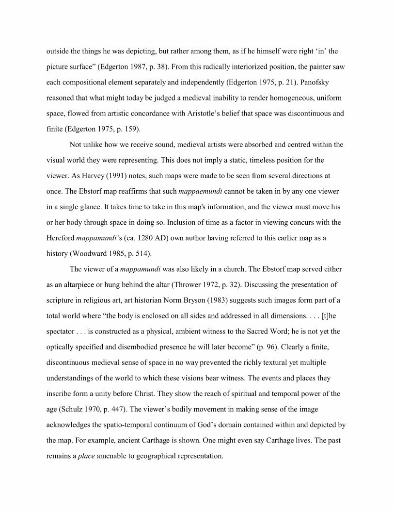
Not unlike how we receive sound, medieval artists were absorbed and centred within the
visual world they were representing. This does not imply a static, timeless position for the
viewer. As Harvey (1991) notes, such maps were made to be seen from several directions at
once. The Ebstorf map reaffirms that such mappaemundi cannot be taken in by any one viewer
in a single glance. It takes time to take in this map's information, and the viewer must move his
or her body through space in doing so. Inclusion of time as a factor in viewing concurs with the
Hereford mappamundi’s (ca. 1280 AD) own author having referred to this earlier map as a
history (Woodward 1985, p. 514).
The viewer of a mappamundi was also likely in a church. The Ebstorf map served either
as an altarpiece or hung behind the altar (Thrower 1972, p. 32). Discussing the presentation of
scripture in religious art, art historian Norm Bryson (1983) suggests such images form part of a
total world where “the body is enclosed on all sides and addressed in all dimensions. . . . [t]he
spectator . . . is constructed as a physical, ambient witness to the Sacred Word; he is not yet the
optically specified and disembodied presence he will later become” (p. 96). Clearly a finite,
discontinuous medieval sense of space in no way prevented the richly textural yet multiple
understandings of the world to which these visions bear witness. The events and places they
inscribe form a unity before Christ. They show the reach of spiritual and temporal power of the
age (Schulz 1970, p. 447). The viewer’s bodily movement in making sense of the image
acknowledges the spatio-temporal continuum of God’s domain contained within and depicted by
the map. For example, ancient Carthage is shown. One might even say Carthage lives. The past
remains a place amenable to geographical representation.
The Ebstorf map expresses a cyclical vision of life through its deeply symbolic style, and
its use of multiple point-of-view. Later, the Renaissance version of past, present and future will
dovetail more snugly with an individual understanding of the reality of the body that moves from
birth to death. The medieval meta-physical conception, while not refuting individual progression
through space (indeed incorporating it), has a communal sense of culture gained from being
witness at countless births and deaths, changes of season, and passages of the planets in the sky.
Renewal and destruction are part of this world-without-end, and not yet the discrete book-ends a
post-Renaissance individual will place before and after linear personal experience.
The Ebstorf mappamundi is Christ incarnate on this earth. Substance and form here are
not the separated phenomena they will later become. Other medieval mappaemundi, not unlike
Scripture revealed, also were meant to be interpreted. The Hereford map is a world as the realm
of death—M O R S encircles the world-as-wafer. Yet this does not contradict the message of the
Ebstorf map. If there is such a thing as medieval “world picture,” it is one of multivalent
ambiguity (more than only a duality of signs in art) within which a form of synthesis is always
possible. That the plague-ridden world is a garment on which is embroidered the beauty and art
of Christ is not inimical to the limitations that circle the form of the human body reminding us
that this too will pass.
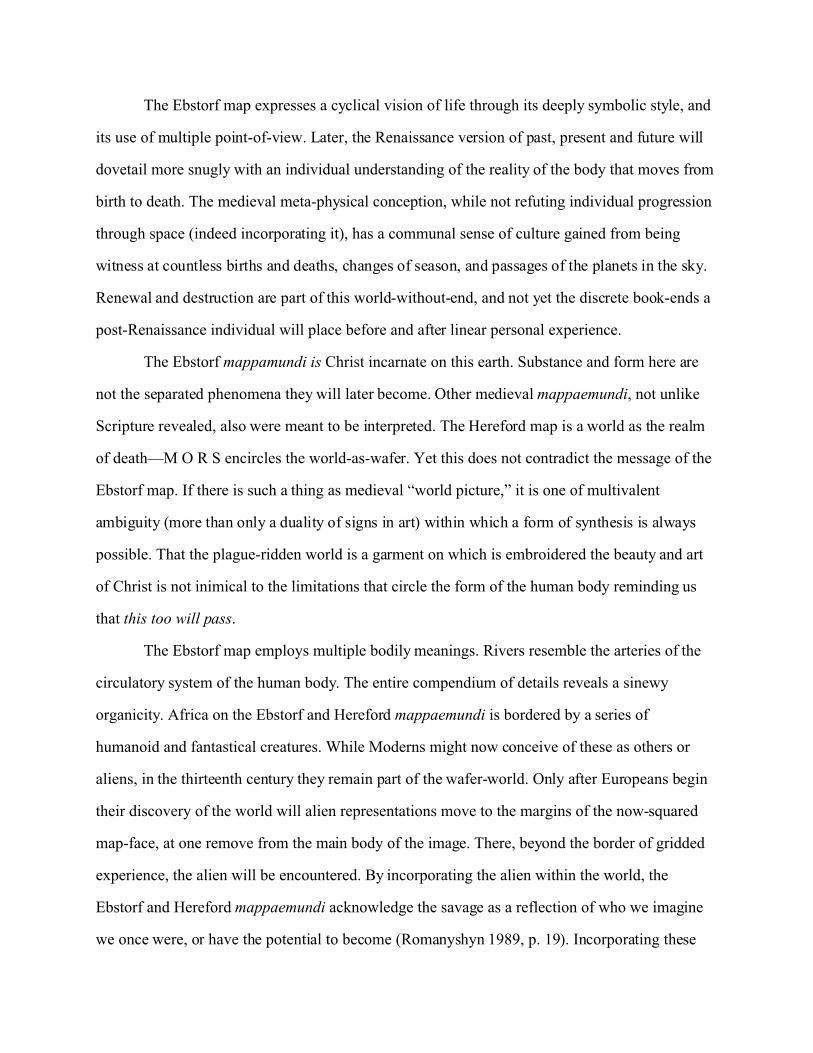
The Ebstorf map employs multiple bodily meanings. Rivers resemble the arteries of the
circulatory system of the human body. The entire compendium of details reveals a sinewy
organicity. Africa on the Ebstorf and Hereford mappaemundi is bordered by a series of
humanoid and fantastical creatures. While Moderns might now conceive of these as others or
aliens, in the thirteenth century they remain part of the wafer-world. Only after Europeans begin
their discovery of the world will alien representations move to the margins of the now-squared
map-face, at one remove from the main body of the image. There, beyond the border of gridded
experience, the alien will be encountered. By incorporating the alien within the world, the
Ebstorf and Hereford mappaemundi acknowledge the savage as a reflection of who we imagine
we once were, or have the potential to become (Romanyshyn 1989, p. 19). Incorporating these
figures also inscribes a belief that “as there were no limits to God’s power there could be no
rightful bounds to Christendom's geographical sway” (Tomasch 1992, p. 79). But the alien is
also the image of the ancestor, the child is father to the man. This circular understanding of
events will straighten out into the linear alienation of the externalized other, who will be situated
along the pathway leading the eye to Renaissance perspective's vanishing point. The medieval
visual world, what we see when, somewhat as in viewing a Cubist painting, we orient ourselves
to objects from all sides, will yield to what Gibson (1950, pp. 26-28) calls the bounded visual
field of visual space—what we perceive when we fixate with the eyes.
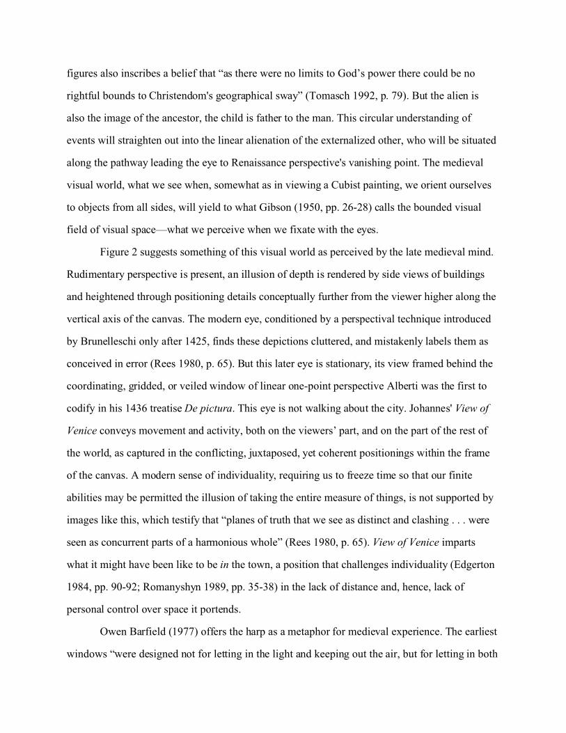
Figure 2 suggests something of this visual world as perceived by the late medieval mind.
Rudimentary perspective is present, an illusion of depth is rendered by side views of buildings
and heightened through positioning details conceptually further from the viewer higher along the
vertical axis of the canvas. The modern eye, conditioned by a perspectival technique introduced
by Brunelleschi only after 1425, finds these depictions cluttered, and mistakenly labels them as
conceived in error (Rees 1980, p. 65). But this later eye is stationary, its view framed behind the
coordinating, gridded, or veiled window of linear one-point perspective Alberti was the first to
codify in his 1436 treatise De pictura. This eye is not walking about the city. Johannes' View of
Venice conveys movement and activity, both on the viewers’ part, and on the part of the rest of
the world, as captured in the conflicting, juxtaposed, yet coherent positionings within the frame
of the canvas. A modern sense of individuality, requiring us to freeze time so that our finite
abilities may be permitted the illusion of taking the entire measure of things, is not supported by
images like this, which testify that “planes of truth that we see as distinct and clashing . . . were
seen as concurrent parts of a harmonious whole” (Rees 1980, p. 65). View of Venice imparts
what it might have been like to be in the town, a position that challenges individuality (Edgerton
1984, pp. 90-92; Romanyshyn 1989, pp. 35-38) in the lack of distance and, hence, lack of
personal control over space it portends.
Owen Barfield (1977) offers the harp as a metaphor for medieval experience. The earliest
windows “were designed not for letting in the light and keeping out the air, but for letting in both
of them together. In fact the word ‘window’ is a corruption of ‘wind-eye’” (p. 66). The wind
makes a sound of its own, but in the harp’s strings it echoes or imitates itself as it agitates the
wind-harp. The harp has neither inside nor hidden dimension. Its medium is the air that enters
and leaves the body continually, and is the source of human inspiration (p. 72).
David Lindberg documents well Leonardo Da Vinci's comparison of the eye to a camera
obscura (1976, pp. 164-68). Though the device may have been known as early as fifth-century
B.C. China, and certainly by Al-Hazen in the tenth century (Hammond 1981, pp. 1-3), Barfield
nominates it as a fitting emblem for Renaissance enquiry. The camera obscura’s tiny window on
the world is instrumental in bringing about the human mind's distancing or bracketing of its
relationship to what now becomes “environment.” The camera obscura is part of the reality it
represents (1977, p. 69), in that, for the Renaissance, Nature lay both beyond and within the
individual. Its medium is light, entering the body at the eye. Of all the senses, we can block off
information the eye receives most easily. Like the modern individual, this camera has an inside
hidden from view. The camera receives stimuli and responds in kind, introducing a cognitive
paradigm for moulding individual awareness of sequential causality and distance as supposed
aspects of our ability to judge. For Barfield, the medieval act of imitation, as expressed in
painting (The Imitation of Christ, in the Aristotelian sense of how things ought to be), is reduced
by Renaissance perspective to a technique of copying: a pattern that counts, that we can view but
are not required to feel. Joan Gadol notes that “[p]erspectival art restored and expressed the
theoretical outlook in which objectivity is attributed, not to perceptual experience, but to the
abstract, general rules which reason discovers in it, those ‘first principles’ which man discerns
‘in Nature’” (1969, p. 69).
This change is anticipated by Roger Bacon in his Opus majus (ca. 1260). He recommends
elevating geometry as a means of accessing
the ineffable beauty of the divine wisdom . . . [so that] at length after the restoration ofthe New Jerusalem we should enter a larger house decorated with a fuller glory. Surelythe mere vision perceptible to our senses would be beautiful, but more beautiful since weshould see in our presence the form of our truth, but most beautiful since aroused by the
visible instruments we should rejoice in contemplating the spiritual and literal meaningof Scripture. (in Edgerton 1975, p. 18, emphasis added)
Bacon’s proposal is a gamble: stringing a sight-line to render the world of sound and
silence visible. In opposition to the immediacy of the medieval auditory world, understanding is
to be gained by examining things at the distance that visual inspection requires. It will be
reasoned that God’s existence logically negates a void implicit in the finite. The world will cease
to be understood as finite. The way will be paved for infinite space (Edgerton 1975, p. 18), a
conception that favours the grid in imposing order on such a conceptually vast and challenging
metapossession.
The Grid
Ptolemy’s eight-book Geographia was rediscovered in 1400 and translated into Latin ca. 1406.
Book One recounts two methods for mapping a flat surface, and outlines a way to conceptualize
these representations given a spherical Earth. Ptolemaic mapping relates astronomical
observations to the laying of a grid across the convex surface area to be mapped. The lines of the
grid then can be numbered consecutively according to meridians and parallels, longitude and
latitude. Any point can be identified as separate from any other, though each is interrelated to all
other conceptual points by virtue of being equally enmeshed within the grid.
Book Seven presents a third explanation. It outlines a geometrical projection that,
arguably, is akin to linear perspective as an aid to making two-dimensional maps as
representative as possible of the earth's curved surface. This method differs from Book One’s,
for here “we see the earth drawn from space” (Woodward 1989, p. 10). This method anticipates
Renaissance perspective as a pictorial assist to map makers and users, an aid to transforming a
three-dimensional world of places into a spatialized two-dimensional flatworld. Though we see
the earth as if from space, still “[t]he viewer was asked to look at the globe as he would a
conventional picture—at eye level from a fixed point of observation” (Rees 1980, p. 67). Only
with the rediscovery of Geographia, lost to Western knowledge for 1,200 years, could this third
concept, one that exchanges the assumed horizontality of cartography for the verticality of
perspective, be put to paper. It becomes easier to conceptualize that if cartography can be made
to stand up, if it can be envisioned as a two-dimensional vertical plane, then perspective equally
can be induced to recline, thereby relaxing one assumed spatial distinction between these
technologies, or in Edgerton’s words, “linking the celestial to the earthly sphere” (1987, p.37).
Ptolemy intended to represent a systematized relationship between the different
geographical features of the earth. Renaissance minds found wider uses latent in the method.
McLuhan and McLuhan (1988, p. 101), referring to Renaissance perspective, note that
[r]etrieval is not simply a matter of hauling the old thing back onto stage holus-bolus.Some translation or metamorphosis is necessary to place it into relation to the newground—as anyone can testify who has experienced “revivals” in our culture, whether infashion or music or any other form. The old thing is brought up to date, as it were.
Svetlana Alpers, writing of seventeenth-century Dutch art and cartography—a period
when the outcome of developments described below had become more apparent than during the
quattrocento—asserts that “the Ptolemaic grid . . . must be distinguished from . . . the perspective
grid” (1987, p. 71), because, in part, the former is a view from nowhere. As Rees has noted, this
view from nowhere is, in fact, always located. What I take to be Alpers’ focus on the
impossibility of an embodied viewer in ptolemaic point-of-view versus that of Albertian
perspective fails to consider that “nowhere” really means that no representative body is intended
to stand in direct relationship to the ptolemaic grid. This emphasis on “nowhere” minimizes the
power of the imaginative viewer to engage concretely with Ptolemy’s proposals from where he
or she is standing, and to appropriate them for use “elsewhere.” Rees argues that “the Ptolemaic
network of meridians and parallels was the model for the scaled, checkerboard pavement of
Alberti’s ‘construzione legittima’ of 1435 that was used to determine relative positions” (1980,
p. 68). Edgerton has suggested that one of Geographia’s inspirations may have been Ptolemy’s
interest in a theatrical illusion of Greek stage design, specifically how an image seen through an
open doorway at the rear of the stage could be rendered as if at a considerable distance. Book
Seven’s view from space was meant to represent the known world “as if seen behind and within
the ‘proscenium’ of the celestial circles” (Edgerton 1987, p. 37).
Such a conception prefigures Shakespeare's remark that “all the world’s a stage,” but if
the Bard was correct, where then are viewers physically located, given their dual positions as
holistic planetary beings and as viewers looking at themselves? The Ebstorf map's medieval
viewer could take consolation from the place-centred specificity reinforced through his or her
taking part in the robe of Christ. The world as a robe speaks to human physical need for warmth
and shelter.
Early Renaissance perspective painting is theatrical. Perfectly proportioned urban
exteriors and views often are peopled by saints or sumptuously attired nobility. Wealth proceeds
in tandem with faith. But these paintings are also technical essays into the nature of what they
represent, their technique very much a surface examination of visual appearances (see Spencer,
p. 17, in Alberti 1956). The detailed treatment of surface details, combined with the procession
of finery, may permit an inadvertent devaluation of the sheltering symbolism contained in the
idea of Christ’s medieval world-garment. Clothing alone may no longer seem adequate to shield
the body from continual visual inspection that now comes from many individuated quarters.
There may arise within the viewer a need to exit to an off-stage Green Room of one’s own,
inside the box of the camera obscura, behind the “window-as-grid” that Alberti will posit as a
central technique in grasping this Realistic method of imaging (see Figure 5).
But what of the nature of the performance to be staged upon the grid? A conceptually
uniform overlay presupposes a uniform topic, and denies embodied places by freezing them in
the arbitrary moment in time represented by the solitary and removed viewing position the grid
is intended to serve. Everything is connected up in advance in a presumption of the unity of the
space it covers (Carter 1988, p. 204). When space is depicted only visually, it is reduced to pure
dimension, and the places of the world to a multiplicity of things. The grid plots the “form of our
truth” Roger Bacon had wished to attain through visual inspection. But if the grid might yield up
knowledge through quantitative comparisons between coordinates, for this to be useful, the
observer’s physical position would have to be severed from his or her topographical siting. To
gain the access to knowledge via the progressive direction and comparative dimension that the
marriage of the grid to visual representation would suggest feasible, it would first be necessary
to alienate the sense of vision from the body. Extending Alpers, one might even say that Ptolemy
had anticipated dispensing with the body. Renaissance cartographic and perspective
representation implies something akin to an out-of-body experience, as if the eye were a visual
machine located at the end of a very long co-axial cable attached to the body. Though with
Alberti the eye’s distance from the canvas is the function of a strict set of mathematical
prescriptions designed to ensure harmony, proportion and dignity, this eye now begins either to
float in space above the map or before the painting. Both forms of representation become the
extended territory the eye surveys.
There is a central paradox, a price to be paid, in the Renaissance recycling of Ptolemy’s
ideas. Fifteenth-century cartography likely concorded with Ptolemy’s vision. However, if Book
Seven’s techniques were to be applied to perspective painting, the human body would become
the focus of perspective and subject to scientific visual inspection. The body-as-object (and by
extension humanity) would become subject to, even inscribed by, the laws of technique that are
intended to render nature more subject to human control.
If there is movement here in the demarcation between nature and culture, it occurs at the
site of the body. “The body and its actions . . . have a richly ambiguous social meaning. They can
be made to emphasize perceived distinctions between nature or culture as the need arises, or to
reconcile them” (Marvin 1988, p. 110). Commenting on a quattrocento understanding of nature,
Spencer notes that “Nature, defined as all that is outside the individual and of which he is also a
part, is homogeneous and amorphous” (in Alberti 1956, p.18). This “natural” ambiguity, I
suggest, allowed Renaissance perspective to place the body-as-object in the same category as
nature-as-object. It is possible this worked to undermine a distinction Ptolemy would appear to
have assumed between man and nature in his description of his third method. However, it was
the Renaissance that put his theory to the test, in the process learning how to look back upon the
human body as a thing.
One might say that the Ebstorf mappamundi exemplifies the real (Christ) being cloaked
by a (mundane) method of understanding. The same might be argued for the superimposed
method of the grid, except that the world-garment of Christ on Ebstorf is itself now a thing
cloaked by the grid in an additional weave of unbreakable, infinitely repeatable pattern to which
nature is bound. Such an ordered repeatability was infinitely reassuring. Discussing the work of
Da Vinci, Cosgrove notes that the Renaissance application of human reason is
suggested to reveal a world whereby God had created the world and man in a consistentand orderly way . . . Proportion and balance produced a harmony which underlay theform and motion of all creation. It was through measurement . . . that the proportion andharmony of the universe could best be apprehended. (1984, p. 84)
Though the Ebstorf mappamundi and Renaissance cultural production both organize a
Glory to God, on the newly coordinated Renaissance stage there is a marked reduction in
inherent meaning. Unlike Ebstorf-as-experience, meaning becomes an event, brought to
Renaissance production from separate locations determined by individuated viewers’ separate
co-axial viewing identities. Unlike Ebstorf, the concrete meaning of the body is not
acknowledged, even as its surfaces are relentlessly scrutinized for their relationship to a perfect,
proportional harmony within the larger world. The eye of the artist/subject imposes the sense of
order with help from the grid.
The late-medieval and Renaissance periods were concerned to find a way to better know
the nature of things. Meanings were on shaky ground following the Crusades. Cyclical waves of
bubonic plague decimated populations. A new light was needed to guide the faithful, an
illuminated signpost to direct events along the right path. As a radical solution to the late-
medieval quest for greater understanding of man's environment, the world first is emptied of
meaning, so that a new order might then be mapped onto its symbolically bite-sized, yet infinite
surface. By the beginning of the sixteenth century
the new grid cartography . . . tended to reinforce faith in the divine mission ofChristianity . . . [and] had become in its own right a talismanic symbol of Christianauthority . . . believed to exude moral power, as expressing nothing less than the will ofthe Almighty to bring all human beings to the worship of Christ under European culturaldomination. (Edgerton 1987, pp. 11-12)
What is suggested is nothing less than the uniform topic cartography presupposes. What
remains unresolved is how individuals might have an imaginative stake within this new order
that will privilege an individualism ironically defined and located through number and relational
coordination.
The Carto-Spective Hinge of Bird’s-eye Views
Imagine you are looking at a coordinated map of a city's central area. You are standing either
directly before or slightly to one side looking down at it as it lies flat before you. Next, picture
yourself standing before a painting of this city, rendered in unitary perspective. In the foreground
are the largest buildings. The ones at a distance diminish in size as transversals along the ground
line increasingly converge the closer they get to the vanishing point. An illusion of depth is
created for you through relating each object in the image not only to your position, but also to all
other objects in the painting. Everything is uniform and measurable, including yourself (as in
Schön, Figure 1).
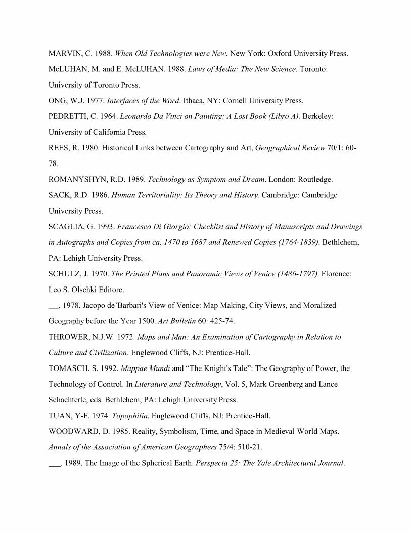
Now, consider Plan of Florence (Figure 3) and the artist in the bottom right foreground.
For purposes of an optical education, ca. 1480, the young man sketching Florence is you. His
inclusion in the painting is a device to condition your understanding of space. Though he is to
the right, and apparently beneath you, ideologically your position and his are as one.
The vantage point in Johannes' earlier View of Venice was elevated and drawn from
“church-tower” perspective (Rees 1980, p. 69), but here we are much higher and more removed
from the subject matter. The city is beneath and before us, even if the technique limits showing
all its many places.
Finally, still situated above the city, make the quick ascent to the position of the aerial
viewer of Bird’s-eye-view Plan (1500), attributed to Jacopo de’Barbari (Figure 4). Later view
plans of Venice such as Matthaeus Merian the Elder’s (1638) will lower their sights and drop
elevation slightly. In Willem Blaeu’s 1614 multiple perspective elevation of Venice the viewing
position is actually lower than in Johannes’ ca. 1400 painting, though the image is viewed from
such a great horizontal distance that the eyes take in the requisite information in one fell swoop.
Earlier views such as Johannes’ were empirically inaccurate. Visual fidelity was not their
overriding concern. Orthogonal foreshortening created errors of scale that increased
commensurately with the area they attempted to image (Rees 1980, p. 69). Yet foreshortening
allowed these images to resonate with the verticality of the body. Accuracy could be augmented
only if rendered from an abstracted or airborne position. The growing reliance on a horizontal
alignment of the image that this more aerial version of accuracy requires, concords with the
increasing awareness of the vastness of the Earth’s surface transmitted to European centres of
map-making via the voyages of Discovery of the late fifteenth and early sixteenth centuries. By
1500, bird’s-eye views are sky-high. By 1522, Magellan’s expedition circumnavigates the globe.
The lowering of point-of-view in seventeenth-century panoramas and views reflects a
world and nature beginning to yield to human control. Though heavenly situated views continue
to be produced, the aerial surveillance implied by Jacopo’s Bird’s-eye-view Plan starts to be
relaxed, in part because his theatricality has succeeded in its goal. Image by image the
Renaissance eye has been taken higher. At each step the increased purview is less important than
the incremental conditioning of the detached eye to learn to map, to read an increasingly distant
world as detached. It would be misleading to suggest any strict causality here. In Braun and
Hogenberg's Civitates orbis terrarum, for example, views such as Dordrecht (1575) are rendered
from a lower vantage point than, say, that of Aachen (1576), which is almost pure plan (Goss,
1993). Allowance also must be made for regional variations in style due to preferences, patron or
client requirements, and time taken to disseminate techniques of representation spatially.
However, as the eye learns to read the world as detached, and as methods of rendering distance
from any point-of-view are perfected and disseminated to the point where distance becomes a
methodology, techniques such as bird's-eye views, while retaining saliency, somewhat relax,
without dispensing with, their aerial orientation. They begin to incorporate more frequently both
plans and elevations. The task of training the eye to be distant from, yet curious about, what lies
before it is largely accomplished.
There is at least one other interpretation of Jacopo's efforts. Bird's-eye-view Plan can be
read as a flight of fancy. Jacopo is moved to produce this masterpiece, in part, because he can.
His sophisticated perspectival illusion is an act of technical virtuosity, a pre-Nietzschean
exercise in the will to power. The surveillance possibilities of Jacopo's aerial positioning
converge with the absolutism of unitary perspective. This absolutism insists on its primacy and
breaks with the “frustrations” of medieval multivalency. Blaeu’s 1614 elevation demonstrates
the enhanced sophistication of a reformulated multiple perspective. This later technique evolved
from Alberti’s “legitimate construction,” but the reintroduction of anything suggesting
multiplicity becomes possible only when a society has attained sufficient power and influence
that important things—the things that matter—are felt to be already under absolute control.
Returning to the vantage point Jacopo creates, we are so high up that in order to sense the
depth of the subject matter positioned below and ahead of us, the city is presented as if on a
raked stage. The “rear” or top portion of the image of the woodcut is raised, as if its foreground
were on a hinge, so that we can make sense of what is shown. We have the sensation of being
almost directly on top of the city, and are not far from Da Vinci's 1502 mathematized city view
of Imola, a “true logical copy” (Gadol 1969, p. 180), that dispenses with church-tower
perspective and exemplifies the cross-over to pure plan. As disincorporated eyeballs floating in
space, we are almost able to rotate on the imaginary co-axial cable that connects us to our earth-
body. We have almost achieved the same parallel, frontal viewing relationship with cartography
as already established with perspective painting. With Plan of Imola Da Vinci fuses the
measurement of cartography with the art of drawing.
By eliminating the need to suggest three dimensionality, by “raising the viewpoint from
oblique to vertical, the artist-cartographers of the Renaissance initiated practices that ironically
would allow cartography to dispense with their services” (Rees 1980, p. 71). Perspective’s
vertical representation, a static but peopled urban devotional technique, gives way to horizontal,
infinite space. The canvas of unitary perspective pivots down from a vertical stance to a
horizontal position, but only after the body has learned how to relate to this new form. In a sense
one walks before one flies, but more precisely, the re-orientation of medieval embodied vision to
a cartographic optical overview offers a bridging symbolism that helps position the Renaissance
body within a world of visually ordered cartographized space. With Jacopo, we are almost ready
to be guided downward through the image, and passing through the vanishing point, to discover
the infinite space of the cartographic map. Renaissance man’s passage into cartography is eased
by the perspectival practice of painting the human body behind or in a grid, making it the focus
of geometric attention. But in fixing the body as a spectacle for the measuring eye, the
relationship between the body and its context is broken (Romanyshyn 1989, p. 116).
With Renaissance bird’s-eye views, space is made visible in a precise and orderly fashion
(Harley 1988, p. 292), and it is possible to believe one sees all. Whether bird’s-eye views are a
precursor to a cartographic view that extends from nowhere or everywhere, or part of a more
general “extending” and disembodied view evolving at this time, one thing is sure. Bird’s-eye
views are the view of no-body. Such a view suggests a horizontal world-without-end made
possible by shifting the vertical picture-like position of Ptolemy’s third method so that it reclines
in a modern cartographic fashion.
The critical device within this method to which Alberti gave fifteenth-century definition
was the vanishing point, a convergence at which parallel edges of objects, stretching away from
the eyes of the viewer, appear to join. Positioning the vanishing point along both vertical and
horizontal axes allowed for the possibility of different vistas along which to organize things
represented on canvas, while maintaining both the integrity of proportional relationships
between these things, and delivering up the entire image to the eyes of the viewer. Wherever the
vanishing point is located, the illusion of depth produces the effect of an avenue, a road, or track
along which things move. Objects no longer float in space as they sometimes appeared to in
medieval images, but the trade-off is a momentary freezing in time. The great stillness, and sense
of calm in Renaissance devotional art, seems at time’s expense, perhaps initially less an issue
when ostensibly the subject matter is Divine. This stillness arises, in part, from the body-as-
object which retains no capacity to appear as anything but static. This lack of temporal dynamic
is compensated for by the introduction of a spatial continuum which the avenue or road suggests.
Though the body is frozen, the eye is free to track the different objects arrayed along this transit,
and even to speculate about what might lie through and beyond the vanishing point. It
understands the vanishing point merely to represent on canvas our inability to see beyond the
horizon, over the next tall hill. Though the role of this device is now understood, before its
introduction Western art never directed attention to what might lie beyond its own
representation. In the Ebstorf mappamundi, as in transubstantiation, God and material meld. The
mappamundi is not a-part from the whole. The irony of perspective is that in its original
conception as a pure, uncluttered devotional access/axis to God, a distance, or distancing void, is
created. The division of the whole into parts, which the squares of the grid visually exemplify,
makes access to this God not only less immediate, but also, and at the same time, a central issue
of spatial concern.
In contradistinction to a purer Judeo-Christian theology that posits the creator as distinct
from His things, the Ebstorf map could be said to retain the pagan notion that the Cosmos also
resides in the thing. Separated from the Divine immediacy that Ebstorf created and which was its
contribution to an earlier piety, how is the devout Renaissance individual to find God, if the
order of the grid now mirrors the proportion and divine beauty of the cosmos? The obvious place
to start is “on the road.”
The grid is not unlike the automobile Illich (1973) describes in Tools for Conviviality. It
can be argued that rather than being a tool to span distances, it creates them. In its coming to be,
it causes the fashioning of a world of distance in order to justify its existence. In unitary
perspective, the effect of distance has more than one outcome. There is distance between the
objects in the painting. Depth is suggested through a shrinking of the size of the body. The
further away the depicted body is proposed to lie from the position of the viewer, the smaller it
will be rendered. In medieval art the size of the object indicated its status. Things were not
depicted as recorded on the retina but as perceived, in the sense of being judged or valued (Hall
1966, pp. 78-80). But in Renaissance art the foreground is the privileged arena. The viewer may
infer that things in the background are less important because they are smaller. Judging between
things based on purely visual criteria of surfaces starts to make sense.
A second effect of distance concerns the extended object of the gaze as it is directed to
the vanishing point. Though the foreground of the canvas commands visual attention because of
the proportion of surface area given over to objects, the vanishing point does not coincide with a
foreground object, the gaze can be split and also pulled towards this point that lies conceptually
to the “rear” of the image. As the gaze scans objects of decreasing size and importance, it finally
reaches the vanishing point. This point suggests an infinite continuation of the world which, save
for the limitations of the canvas would and could be shown in full. The vanishing point also
suggests that the things within this world positioned at points beyond the canvas’ ability to
represent them would all be relatively tiny, no larger than what might be represented or visually
discerned just this side of the vanishing point of the image. Things beyond the vanishing point
might even shrink to nothing. A creative ambiguity is introduced here. The viewer is encouraged
to gaze out over a landscape that may appear headed for insignificance, or appear less important
than the foreground which seems closer to our viewing position. Yet its reduction must also be a
factor in any human imagining of its conquest. Figure 6, for example, resolves this by blocking a
view of this point with the base of the foregrounded bust.
This tension also may be partially resolved through a second set of relationships created
by the positioning of the body of the viewer with respect to the canvas. If objects shrink in
importance as they recede from view, what of the viewer who, in the opposite direction, also is
some distance from the objects positioned in the foreground of the image? One might even say
this is a conscious devotional agenda of this technique. As Pedretti notes, Brunelleschi's
perspectiva artificialis—the inspiration for Albertian one-point perspective—“was still
considered the only correct system of perspective” late in the sixteenth century (Pedretti 1964, p.
172). Within this system, the primacy of iconic depiction depends on the position of the viewer
being fixed in space, but this also causes her or him to be conceptually smaller and less
significant than the foregrounded bodies-as-objects perspective delivers along the viewer’s line
of sight. To such a consideration should be appended the alienating dimension of Hieronymous
Rodler’s veiled window.
From the position of the viewer behind the imaginary window, to the diminishing
importance of the discrete objects placed in decreasing size along the lines that lead to the
vanishing point, to the infinite number of things that might lie beyond it, objects (including the
body of the viewer) are laid out on a line, a continuum of distance running from the self through
the intermediary canvas to infinity. This is one, though not the only, logical result of the late
medieval search for a more adequate way of understanding natural processes. Things are “ex-
plained,” laid out on a flat surface and opened up (Ong 1977, p. 134). The genius of perspective
is to organize this in linear fashion. Its inadvertency is to suggest our position on this line,
though the Albertian veil (Figure 5) also functions to partially shield the artist/viewer from too
close an inspection that might be directed not outward from the self, as modern subjectivity
might first assume, but from any other individual point-of-view “out there” along the line of
vision that could be “reversed” back in the direction of the viewer. Behind this window the self
is an observing subject. The window helps cleanse the world of imputed meanings, and
transforms it to an object of vision (Romanyshyn 1989, p. 42). This transformation of the world
differs from the medieval ambiguity between image and reality. Rather, it substitutes or reduces
reality—be this Christ or “nature”—to image, whereupon this image is made to suggest to the
subject new ways to conceive of reality. This dynamic is alluded to by Rosalind Krauss in her
essay Grids. Within grids, the window is the
matrix of ambi- or multi-valence, and the bars of the windows—the grid—are what helpus to see, to focus on, this matrix. . . . they function as the multi-level representativethrough which the work of art can allude, and even reconstitute, the forms of Being.(1980, p. 6)
Perspective is referenced visually, not texturally in the sense that would entice our touch.
A movement arises within Renaissance painting that de-emphasizes the surface-as-texture. Gold
leaf and other distracting adornments are abandoned. Painting techniques reach levels of
sophistication and refinement such that the eye may dance across the image as if the surface
itself had dissolved. This demands a detached visual sense, one requiring not texture, but
reasoned proportion and line to efficiently guide inspection and eye movement.
When things are explained, they have been set apart from each other (Ong 1977, pp. 139-
40). The disentanglement of medieval sense from significance has required this parsing
operation. What was previously unknown is now made visible. The greater role of auditory
culture to the medieval mind, one that produced what the modern eye judges as visual clutter in
medieval artwork, but also one that inherently melded the consumer of the image to that which
the image represents, now yields to a more illuminated inspection that sheds technical light on
what previously were mysteries of the world.
One implication for the viewer is seen in Schön's visual metaphor (Figure 1), or in the
amazing drawings of Francesco Di Giorgio, in which people are subsumed within entablatures,
columns and other architectural elevations and sundry imaginary machinery (see Scaglia 1993,
pp. 199, 212, 221, 245). For Schön and Di Giorgio the grid suggests the iron cage of logic. The
lines of perspective have reversed direction back to the viewer, enmeshing her or him within
their coordinated, equalizing net. The viewer becomes an object in coordinated space to be
examined and scientifically explained. Bryson (1983) writes that when gazing at a perspective
painting “something is looking at my looking: a gaze . . . whose vista I can imagine only by
reversing my own, by inverting the perspective before me, and by imagining my own gaze as the
new, palindromic point of disappearance on the horizon” (p. 106). For Bryson this is how the
new Albertian space “returns the body to itself in its own image, as a measurable, visible,
objectified unit,” and how perspective, conceived “in an atmosphere of religious witness . . .
solidifies a form which will provide the viewing subject with the first of its ‘objective’
identities” (p. 107). In Figure 6 the truncated figure gazes back at his viewers, as they also look
beyond him to glimpse the miniaturized Edenic other-world beyond the arcade within which this
“palindromic” gaze is situated and attends.
As a technique, perspective helps initiate a chain of investigations into natural processes
by conceptually suggesting a way to illuminate the world. It visually organizes the now-discrete
things within it so that they might more clearly reveal their benefit or danger to man. Yet as an
exemplar of representative art, unitary perspective manifests a cultural fascination to produce an
ever-more-perfect representation of the surface of things. Bryson (1983, p. 7) has written about
this as the West’s search for an “essential copy.” The logical outcome of this (after passing
through the vanishing point?) is a merging of image with reality, the practical effect being a
substitution of visual images for concrete experience in all “walks of life.” What differs here
from medieval images is that representation comes to precede or foreground reality, there is a
linear temporality at work, unlike the circular simultaneity of medieval devotional art.
For the Renaissance body, with its ancestral memory of cyclical natural calamities, to
believe in the Divine inspiration of perspective allows it to more easily embrace the idea of
venturing forth, of leaving home, even of finding Roger Bacon's New Jerusalem, even if across
the Atlantic. Discovery is made easier still if this body has a dry-run, if it can eye-ball such a
possibility conceptually through perspectival art. Yet in doing so, human corporeality is in the
process of being discarded (Romanyshyn 1989, p. 19). The floating eye constructs its New
Jerusalem in advance of ever leaving town.
The body is not actually physically disowned, yet conceptually this is required to create a
space within which the visually stimulated imagination sallies forth, away from the body with all
its suffering references to the history of medieval plague and limitation, towards a dealt
unknown that must be an improvement over what history reveals to have been nature's hand.
This unknown also will be amenable to individual control because it is, as perspective suggests,
still small enough, because beyond the vanishing point, so that it can be preconceived to yield to
human agency, a power inherent in the larger size we accord our body-as-object in the
foreground of the coordinated line of ex-planation.
The creation of a coordinated distance between things, one that has relational exchange
value by virtue of the quantifiable comparisons inherent in the grid, is important in gaining
power over nature. It extends and elaborates the natural power of vision to survey things from
afar, and elevates that power to a method, a way of knowing (Romanyshyn 1989, p. 33). Hannah
Arendt writes that
human surveying capacity . . . can function only if man disentangles himself from allinvolvement in and concern with the close at hand and withdraws himself to a distancefrom everything near him. The greater the distance between himself and hissurroundings, world or earth, the more he will be able to survey and to measure and theless will worldly, earth-bound space be left to him. The fact that the decisive shrinkage ofthe earth was the consequence of the invention of the airplane, that is, of leaving thesurface of the earth altogether, is like a symbol for the general phenomenon that anydecrease of terrestrial distance can be won only at the price of putting a decisive distancebetween man and earth, of alienating man from his immediate earthly surroundings.(1958, p. 251, emphasis added)
Perspective and cartography shrink the earth. Bird's-eye views and Plan of Imola
prefigure flight (one of Da Vinci’s great interests). Arendt targets the boomerang effect of visual
investigation. It introduces a displacement that concurs with perspective’s forward sense of
spatial motion. Ne plus ultra is stripped of its sacred association, reduced to one more profane
site on the grid.
In detaching vision from embodiment we too are diminished, our left-behind bodies
marginalized in similar fashion to that which lies beyond perspective’s horizon. This is one
reason why it becomes easier for the eye to venture forth. The body that would hold it in place
has been reduced to insignificance. Separated from the body, from any point along a line where
it is “located,” the eye will be able to gaze back or forward on the body, to perform a kind of
watching of oneself watching perspectivally. This body will appear smaller in size than if the eye
were “back at home,” reembodied. What emerges in this contradictory dynamic is an increased
curiosity about the margin. The centric line of perspective is a metaphor for a “reality” that can
shrink to a paper-thinness only as high as this horizontal line itself. If this thin line, first seen in
Albertian perspective as extending ahead of the vertically oriented body of the self and towards
infinity, is looked at from a second point-of-view—that is, if the disembodied eye, now situated
high above this horizontal line, and at a point out along it equidistant from his or her original
point-of-view and the vanishing point, gazes down upon it, recording what lies along this line in
one fell swoop—it (the horizontal line) takes on the infinite dimension thought to be contained
within the width of the human gaze. We emerge from a margin or end-zone defined by the
verticality of the body, but also by one end of this visual continuum. We come to conceive our
interests to lie in investigating the things before us, doing so first, perhaps, along the horizontal
line, and finally at its far end and in the new horizontal centres that lie potentially beyond.
Yi-Fu Tuan, writing of the “axial shift” that demarcates the European medieval world
view from the modern, has noted the move from a vertically ordered world and universe to a
more horizontal set of scientific understandings. These penetrate the “vertical plane” and direct
the gaze towards the horizon (1974, pp. 134-35). In spite of the darker possibilities Schön
(Figure 1) or Di Giorgio suggest, the dimension of novelty in cartographically sallying forth
must not be denied. After centuries of feudal rootedness, perspective views offer an
individuating and comforting charm in their progressive, forward novelty, and in their promise to
“dictate” the direction to be taken (Carter 1987, p. 172). The notion of margin is important in
linking perspective and cartography because it is on or at the margin—that end of the line just
described that begins at the subject, and that is required by each of these techniques as a location
for viewing—that the modern individual is born. If any thing suggests a missing link between
perspective and cartography, it is this individuated location which exemplifies Renaissance
spatial repositioning and the establishment of new centres. It becomes somewhat moot to argue
which technique first informs the other, but “with the invention of perspective a new way of
seeing emerges that is consistent with the central role of the individual” (Evernden 1985, p. 86).
As art, perspective teaches newly emerging individuals what the world will look like
from the privacy of their veiled off but measurable coordinates. The geometric primacy of
Renaissance perspective strips natural processes and places of their symbolism and reduces them
to things. What remains is a surface shorn of danger and surprise, a blank landscape wherein the
farther one casts a perspectival gaze, that is, the farther one conceptually extends the horizon, the
more sharpened, like a straight-as-an-arrow highway that joins the horizon as an indivisible
point, the convergence of the parallel lines of one's visual field. Da Vinci’s refinements to
perspective techniques augment the role of distance. Recognizing as early as 1492 that
discrepancies in Alberti’s method caused distortions in represented objects’ breadth and height,
Da Vinci proposed, as a corrective, a much narrowed angle of vision. This required painters to
position themselves “at a distance twenty times the size of the object” to be represented (Pedretti
1964, p. 169), considerably farther than Alberti had prescribed. Echoing Arendt, Romanyshyn
observes that
our knowledge of the earth becomes more precise on the condition that we distanceourselves from it. . . . we assume this habit of distance . . . forgetting the connectionbetween this habit and the kind of convergent knowledge which brings precision. (1989,p. 84)
Distance, as a method of understanding, can render things far afield more beckoning.
Though things lying at or beyond an extended horizon may each be small, on the other side of
the optical infinity this horizon represents, things no longer recede in size (Hagen 1985, p. 60).
In perspective, the farther away these things are from the viewer, the nearer they must be to each
other. We do not think about space in this manner, yet have come to see it this way (Barfield
1977, p. 73). This surface is the one on which the world will be cartographically reimagined,
printed, distributed and consumed. Though theoretically the grid privileges no one position over
any other, the perspectivally disembodied eye will remake the grid in its own image. As each
mark that delineates an object, place, or event is inscribed along and between the coordinated
squares that segregate the flat cartographic surface, and as subsequent map users examine earlier
markings and perceive their intention, the real impact of Renaissance perspective on cartography
will surface over and over again. This is “not what it did for art per se but how it conditioned the
mind's eye to ‘see’ three-dimensional images a priori” (Edgerton 1991, p. 108).
How the West was Won
Though Ptolemy had knowledge only of the known world of his time, his cartographic methods
make clear that he anticipated a “wider” world, and that it would be “susceptible to the same
rational, quantitative measurement as the inhabited world” (Edgerton 1987, p. 36). Evernden,
noting Da Vinci's contribution to rethinking of natural processes, writes that he “had to show us
what this new world looked like before we could begin to investigate it; he made it real. Indeed,
he made it the definition of the real” (1992, p. 70). Edgerton’s discussion (1987, p. 48) of Da
Vinci's Man in a Circle and a Square supports the suggestion that this newly spatialized nature
will be at the margin of human experience. The limbs of this man point to the edges of the paper,
the old centre is deemphasized. In pointing towards the margins of his own illustration, this man
points towards us—the new multiple and horizontally dispersed centres—even as we are outside
looking on. He points not only in the direction of Discovery but, to the degree that the
Renaissance body anticipates its own impending marginality, he becomes the signpost pointing
in the direction of the individual subject's newly centrifugal birthright: Bacon’s New Jerusalem.
The maximal extension of the man's limbs towards the margins of the paper, like a compass rose,
speaks to the grid’s decentring possibilities, its privileging of no one point in particular. To the
man, as for cartography, the margins are as important as the centre. Perhaps more so. North,
south, east, and west all call him towards the vanishing point and away from here.
One might take momentary poetic license and superimpose Leonardo’s man on an image
of Columbus, the first voyager to view a ptolemaic gridded map “with utter confidence that the
depicted ratios of parts to whole corresponded with physical reality” (Edgerton 1991, p. 151).
Renaissance man, already more individualized through the new relational dynamics between
subject and object that perspective demands and confers, is able geometrically to conceptualize
how he can go beyond ne plus ultra even for the glory of God. It becomes possible to undertake
what would have been a sacrilege to medieval faith, to set forth on a pilgrimage in any direction
(Tomasch 1992, p. 89). In The Mariner's Mirrour (ca. 1588), after a Dutch work of the same
period, a ship sails towards the vanishing point that is obscured by a block of text (see Cohen
1980, p. 166). Astrolabes and quadrants depend from the heavens, as the vessel transits an
opening framed by two dividers used to measure map distances. The Pillars of Hercules, the feet
of Christ: both are reduced to mathematical instrumentation, as this form of substitution also has
released the energy needed to go forth into the wider world.
Once at sea, Columbus’ mind’s eye will understand that the grid articulates all the spaces
that will need to be crossed, and that it does so in a way that seems realistic and attainable. It
does not minimize distance, but its effect allows a voyage of Discovery to be taken one step at a
time, making great distances conceptually manageable. The map lays down an ordered harmony,
“a Nature of certainty and reason” (Evernden 1992, p. 78), it calms a stormy sea in advance.
Columbus the individual sails forth across the grid, yet his authority already rests on the kind of
proto-social consensus contained within the grid that pre-legitimates a reality not yet Discovered.
For such a user the map, at least for a time, must become the territory, replete with all those
things that make it attractive, in the sense that its form generates a speculative confidence (Carter
1987, p. 212) that transcends the limits of situated bodily knowledge. The map as territory, as a
strategy to help mold a form of spatial agency, is necessary to clear the way for geographic
accessibility (Sack 1986, p. 86).
Concluding Remarks
This essay has examined affinities between perspective and cartography with emphasis on any
relation therein to Discovery. What if Geographia had not been lost to the West for 1,200 years,
or if Ptolemy’s methods had had greater application in his own era? Alpers (1987) argues that
Ptolemy was already a Modern in many respects. The Renaissance classical revival that led to
his rediscovery in this case unearthed a radically old way of knowing. To Renaissance
Humanism, aware of its recent medieval past, mapping conceptually realized an overcoming of a
world view that resisted the movement of places and things. The medieval era suffered from a
surfeit of meaning that may have weighed too heavily on its own foundations. The refinement of
mapping exemplified by Jacopo represents the increasing ability to move things about at will.
Yet in everyday life people count on things to keep their place. Things remaining in place
root human sanity, and give us our place (Romanyshyn 1989, p. 192). When, as in coordinate
mapping, it becomes conceptually possible to dislocate things, then it is possible too for us to be
displaced. A scant 57 years separate Alberti's De pictura from Columbus’ 1492 voyage. The
rapid dis-placement of the Renaissance, variously understood as a “paradigm shift” or “cultural
revolution,” was also a freeing up from the stickiness of encrusted medieval meanings and ritual
enactments, and abetted the possibility of Discovery to gestate over such a brief span of
progressive time.
Visual technologies such as perspective and cartography help form a dream of
transcendence. But first there must be resources to make this possible. In materialist fashion, one
might argue that ne plus ultra gave expression to the relative material impoverishment of its era,
and conclude that the “vision” of the Ebstorf mappamundi is fundamentally mundane in its
blending of, what seems to modern eyes, a conflicting amalgam of transcendence and place,
sacredness and the body. One might also advance the notion that perspective, cartography and
Discovery are playthings that accrue to a richer, more confident society. It is well to remember
that the latent power of representation of any kind is to guide concrete manifestation of what the
representation initially suggests. A people get the technology some of its members imagine, but
first there is the technology of the image.
I have attempted to trace a few of the implications flowing from early Renaissance
experiments that, arguably, dislocate the body from vision, because I understand the material
body, eyes included, to form the basis or actuality of geographic experience from which we
negotiate an ongoing and intersubjective relationship with history. I want to save a place within
this experience for the medieval richness a purely materialist approach might be tempted to
dismiss. As Medievals understood, the body is material. They also knew it was a House of God,
wherein, if pure, a culture of faith and humility might take place.
Perspective severed these reciprocal understandings. It prefigured a material individual,
ironically made possible by a conceptual de-materializing of point-of-view to a position spatio-
temporally askance from the body’s. To such a Modern, perpetually in motion, in two or more
places at once, shifting between an active, dis-embodied agency and a passive bodily stance, the
flat, virgin surface of cartography combines a perpetual vestibule, a secular and tiled narthex of
infinite length, and a lighthouse that signals
W.E.L.C.O.M.E. . .H.O.M.E.
References
ALBERTI, L.B. 1956. On Painting, John Spencer, trans. New Haven: Yale University Press.
ALPERS, S. 1987. The Mapping Impulse in Dutch Art. In Art and Cartography: Six Historical
Essays, David Woodward, ed. Chicago: University of Chicago Press.
ARENDT, H. 1958. The Human Condition. Chicago: University of Chicago Press.
BARFIELD, O. 1977. The Rediscovery of Meaning and Other Essays. Middleton, CT: Wesleyan
University Press.
BRYSON, N. 1983. Vision and Painting: The Logic of the Gaze. New Haven: Yale University
Press.
CARTER, P. 1987. The Road to Botany Bay. Chicago: University of Chicago Press.
COHEN, J.B. 1980. Album of Science from Leonardo to Lavoisier: 1450-1800, Vol. 1. New
York: Charles Scribner's Sons.
COSGROVE, D.E. 1984. Social Formation and Symbolic Landscape. London: Croom Helm.
. 1990. Aspects of Mapping in the Cultural Context of Sixteenth-Century Venice. Paper
presented at the symposium: “The Venetian Engraver Giulio Sanuto: Printmaking and
Cartography in Sixteenth-century Italy,” National Gallery of Scotland, December 1, 1990.
COSTALL, A. 1985. How Meaning Covers the Traces. In Visual Order, N.H. Freeman and
M.V. Cox, eds. Cambridge: Cambridge University Press.
DELEUZE, G. 1988. Foucault. Sean Hand, trans. Minneapolis: University of Minnesota Press.
EDGERTON, S.Y. JR. 1975. The Renaissance Rediscovery of Linear Perspective. New York:
Basic Books.
. 1987. From Mental Matrix to Mappamundi to Christian Empire: The Heritage of
Ptolemaic Cartography in the Renaissance. In Art and Cartography: Six Historical Essays,
David Woodward, ed. Chicago: University of Chicago Press.
. 1991. The Heritage of Giotto’s Geometry. Ithaca, NY: Cornell University Press.
EVERNDEN, N. 1985. The Natural Alien. Toronto: University of Toronto Press.
. 1992. The Social Creation of Nature. Baltimore: Johns Hopkins University Press.
FIELD, J.V. 1988. Perspective and the Mathematicians, Alberti to Desargues. In Mathematics
from Manuscripts to Print, 1300-1600. Cynthia Hay, ed. Oxford: Clarendon Press.
GADOL, J. 1969. Leon Battista Alberti: Universal Man of the Early Renaissance. Chicago:
University of Chicago Press.
GIBSON, J.J. 1950. The Perception of the Visual World. Boston: Houghton Mifflin.
GOSS, J. 1992. The City Maps of Europe: 16th. Century Town Plans from Braun and
Hogenberg. Chicago: Rand McNally.
HAGEN, M.A. 1985. There is no Development in Art. In Visual Order, N.H. Freeman and M.V.
Cox, eds. Cambridge: Cambridge University Press.
HALL, E.T. 1966. The Hidden Dimension. Garden City, NY: Doubleday.
HAMMOND, J. 1981. The Camera Obscura: A Chronicle. Bristol: Adam Hilger.
HARLEY, J.B. 1988. Maps, Knowledge, and Power. In The Iconography of Landscape, Denis
Cosgrove and Stephen Daniels, eds. Cambridge: Cambridge University Press.
. 1990. Maps and the Columbian Encounter. Milwaukee, WI: University of Wisconsin,
Golda Meir Library.
HARVEY, P.D.A. 1991. Medieval Maps. Toronto: University of Toronto Press.
ILLICH, I. 1973. Tools for Conviviality. London: Calder and Boyars.
KRAUSS, R. 1980. Grids: Formal and Image in 20th. Century Art. New York: Pace Gallery.
LINDBERG, D.C. 1976. Theories of Vision from Al-kindi to Kepler. Chicago: University of
Chicago Press.
MARVIN, C. 1988. When Old Technologies were New. New York: Oxford University Press.
McLUHAN, M. and E. McLUHAN. 1988. Laws of Media: The New Science. Toronto:
University of Toronto Press.
ONG, W.J. 1977. Interfaces of the Word. Ithaca, NY: Cornell University Press.
PEDRETTI, C. 1964. Leonardo Da Vinci on Painting: A Lost Book (Libro A). Berkeley:
University of California Press.
REES, R. 1980. Historical Links between Cartography and Art, Geographical Review 70/1: 60-
78.
ROMANYSHYN, R.D. 1989. Technology as Symptom and Dream. London: Routledge.
SACK, R.D. 1986. Human Territoriality: Its Theory and History. Cambridge: Cambridge
University Press.
SCAGLIA, G. 1993. Francesco Di Giorgio: Checklist and History of Manuscripts and Drawings
in Autographs and Copies from ca. 1470 to 1687 and Renewed Copies (1764-1839). Bethlehem,
PA: Lehigh University Press.
SCHULZ, J. 1970. The Printed Plans and Panoramic Views of Venice (1486-1797). Florence:
Leo S. Olschki Editore.
. 1978. Jacopo de’Barbari's View of Venice: Map Making, City Views, and Moralized
Geography before the Year 1500. Art Bulletin 60: 425-74.
THROWER, N.J.W. 1972. Maps and Man: An Examination of Cartography in Relation to
Culture and Civilization. Englewood Cliffs, NJ: Prentice-Hall.
TOMASCH, S. 1992. Mappae Mundi and “The Knight's Tale”: The Geography of Power, the
Technology of Control. In Literature and Technology, Vol. 5, Mark Greenberg and Lance
Schachterle, eds. Bethlehem, PA: Lehigh University Press.
TUAN, Y-F. 1974. Topophilia. Englewood Cliffs, NJ: Prentice-Hall.
WOODWARD, D. 1985. Reality, Symbolism, Time, and Space in Medieval World Maps.
Annals of the Association of American Geographers 75/4: 510-21.
. 1989. The Image of the Spherical Earth. Perspecta 25: The Yale Architectural Journal.
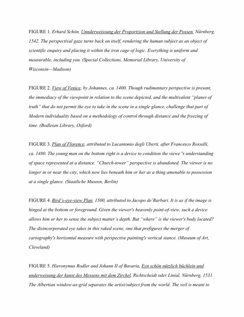
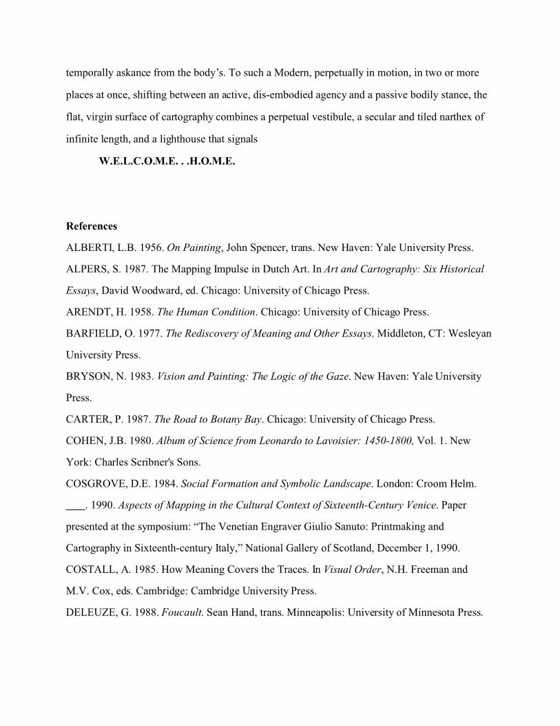
FIGURE 1. Erhard Schön, Unnderweissung der Proportzion und Stellung der Possen, Nürnberg,
1542. The perspectival gaze turns back on itself, rendering the human subject as an object of
scientific enquiry and placing it within the iron cage of logic. Everything is uniform and
measurable, including you. (Special Collections, Memorial Library, University of
Wisconsin—Madison)
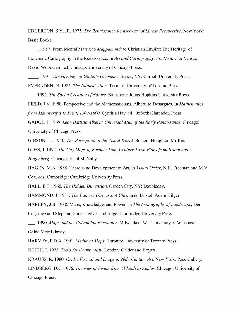
FIGURE 2. View of Venice, by Johannes, ca. 1400. Though rudimentary perspective is present,
the immediacy of the viewpoint in relation to the scene depicted, and the multivalent “planes of
truth” that do not permit the eye to take in the scene in a single glance, challenge that part of
Modern individuality based on a methodology of control through distance and the freezing of
time. (Bodleian Library, Oxford)
FIGURE 3. Plan of Florence, attributed to Lucantonio degli Uberti, after Francesco Rosselli,
ca. 1480. The young man on the bottom right is a device to condition the viewe’'s understanding
of space represented at a distance. “Church-tower” perspective is abandoned. The viewer is no
longer in or near the city, which now lies beneath him or her as a thing amenable to possession
at a single glance. (Staatliche Museen, Berlin)
FIGURE 4. Bird’s-eye-view Plan, 1500, attributed to Jacopo de’Barbari. It is as if the image is
hinged at the bottom or foreground. Given the viewer's heavenly point-of-view, such a device
allows him or her to sense the subject matter’s depth. But “where” is the viewer's body located?
The disincorporated eye takes in this raked scene, one that prefigures the merger of
cartography's horizontal measure with perspective painting's vertical stance. (Museum of Art,
Cleveland)
FIGURE 5. Hieronymus Rodler and Johann II of Bavaria, Eyn schön nützlich büchlein und
underweisung der kunst des Messens mit dem Zirckel, Richtscheidt oder Linial, Nürnberg, 1531.
The Albertian window-as-grid separates the artist/subject from the world. The veil is meant to
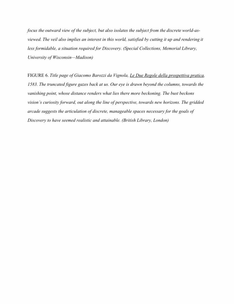
focus the outward view of the subject, but also isolates the subject from the discrete world-as-
viewed. The veil also implies an interest in this world, satisfied by cutting it up and rendering it
less formidable, a situation required for Discovery. (Special Collections, Memorial Library,
University of Wisconsin—Madison)
FIGURE 6. Title page of Giacomo Barozzi da Vignola, Le Due Regole della prospettiva pratica,
1583. The truncated figure gazes back at us. Our eye is drawn beyond the columns, towards the
vanishing point, whose distance renders what lies there more beckoning. The bust beckons
vision’s curiosity forward, out along the line of perspective, towards new horizons. The gridded
arcade suggests the articulation of discrete, manageable spaces necessary for the goals of
Discovery to have seemed realistic and attainable. (British Library, London)