Embed Size (px)
Citation preview
1
This PC/ Data(D)/2017 Law/ Myanmar Territorial Sea and Maritime Zones Law
Myanmar Territorial Sea and Maritime Zones Law
(The Pyidaungsu Hluttaw Law No.14, 2017)
The 9th Waning of Waso, 1379 M.E.
(17 July, 2017)
The Pyidaungsu Hluttaw hereby enacts this Law.
Chapter I
Title and Definitions
1. This Law shall be called the Myanmar Territorial Sea and Maritime
Zones Law.
2. The following expressions contained in this Law shall have the meanings
given hereunder:
(a) State means the Republic of the Union of Myanmar;
(b) Government means the Union Government of the Republic of the
Union of Myanmar;
(c) The Relevant Ministry means a Union Ministry assigned by the
Union Government;
(d) Maritime Zones means maritime zones of the State including
territorial sea, contiguous zone, exclusive economic zone and
continental shelf;
(e) Baselines means the baselines specified in the Annexe (A) to this
Law;
(f) Internal waters means waters on the landward side of the baseline of
the territorial sea;
(g) Foreigner means a person who is not a citizen, an associate citizen or
a naturalized citizen;
(h) Vessel means any motorized or non-motorized vessel that can travel
on-water or underwater;
(i) Foreign ship means a ship which is registered in a foreign country,
not in Myanmar and a ship owned by a foreigner which is not
registered in any country;
2
This PC/ Data(D)/2017 Law/ Myanmar Territorial Sea and Maritime Zones Law
(j) Natural resources means living and non-living resources of the
seabed, and its subsoil and the waters superjacent to the seabed and
the water level. In this expression, natural resources promulgated in
the gazette by the government, from time to time, are also included.
(k) Nautical mile means international nautical mile.
Chapter II
Objectives
3. The objectives of this Law are as follows:
(a) to have security, rule of law and tranquility for the interests of the
State in the territorial sea, contiguous zone, exclusive economic zone
and continental shelf;
(b) to protect and conserve, and excavate natural resources systematically
for long term in the territorial sea and maritime zones of the State and
to do marine scientific researches;
(c) to protect and conserve from the pollutions on the sea, airspace and
impact on marine environment through the territorial sea and
maritime zones of the State.
Chapter III
Territorial Sea
4. The territorial sea of the State extends seawards to a distance of twelve
nautical miles from the baselines.
5. The sovereignty of the State extends to the territorial sea, to its seabed,
subsoil and to the airspace over the territorial sea.
6. (a) Unless it is contrary to the provisions of this Law, vessels of all states
other than foreign warships shall enjoy the right of innocent passage
through the territorial sea. This passage shall be deemed to be
innocent passage so long as it is not prejudicial to the peace, rule of
law and tranquility or security of the State;
(b) A foreign warship may pass innocent passage through the territorial
sea only if prior permission of the government is obtained;
3
This PC/ Data(D)/2017 Law/ Myanmar Territorial Sea and Maritime Zones Law
(c) The relevant government department and government organization
has the right to direct foreign warship entering without getting prior
permission of the government to leave immediately from the area
where they arrive through the territorial sea.
7. During the passage through the territorial sea:
(a) any foreign ship shall observe the existing laws of the State;
(b) any foreign ship shall traverse the territorial sea by the shortest way
without stopping or anchoring except by reason of natural disaster or
force majeure;
(c) a foreign fishing vessel shall keep systematically its fishing gear and
equipment in a secured position for sea;
(d) foreign research vessel shall do research only if prior permission of
the Government is obtained;
(e) foreign submarines and other underwater vehicles shall navigate on
the surface of the sea and show their flag.
8. If a foreign ship engages in any of the following activities while innocent
passage through the territorial sea, it shall be considered to be prejudicial to the
peace, rule of law and stability or security of the State:
(a) any threat, use of force or any other act against the sovereignty,
territory integrity or political independence of the State or in any
other manner in violation of the principles of international law
embodied in the Charter of the United Nations;
(b) any exercise or practice or use with weapons of any kind;
(c) collecting information to the prejudice of the security or defence of
the State;
(d) act of propaganda that affects the security or defence of the State;
(e) the launching, landing or taking on board of any aircraft;
(f) the launching, landing or taking on board of any military device;
4
This PC/ Data(D)/2017 Law/ Myanmar Territorial Sea and Maritime Zones Law
(g) the loading and unloading of any commodity, currency, person or
animal which are not permitted under the existing customs, fiscal,
immigration or sanitary laws;
(h) act to pollute and affect the sea, airspace and impact on marine
environment;
(i) catching acquatic animals including fishes, by any way, fishing,
supporting and preparing for these businesses, and making to damage
the natural resources;
(j) the carrying out of research or survey activities;
(k) any act aimed at interfering with any systems of communication, any
other facilities or installations or structures of the State;
(l) any other activity not having a direct bearing on innocent passage.
9. The Foreign ship shall observe the relevant existing laws and international
rules for protection of collision at the sea in the innocent passage through the
territorial sea.
10. (a) Oil tankers, nuclear-powered ships and the ships carrying other
inherently dangerous or noxious substances by nuclear or by nature
shall pass sea lanes , controlled and designated by the State.
(b) The relevant ship shall, when passing under sub-section (a), carry
necessary documents and observe precautionary measures established
for such ships by international agreements.
11. The relevant ministry shall take into account the following facts in the
designation of sea lanes and the prescription of traffic separation schemes on
charts with the approval of government and shall promulgate it to know the public:
(a) the recommendations of the competent international organization for
this purpose;
(b) any channels customarily used for international navigation;
(c) the special characteristics of particular ships and channels;
(d) the density of traffic.
5
This PC/ Data(D)/2017 Law/ Myanmar Territorial Sea and Maritime Zones Law
12. The Government:
(a) may take the necessary steps in its territorial sea to prevent passage
which is not innocent;
(b) may take the necessary steps to prevent any breach of conditions
relating to ships proceeding to internal waters or a call at a port
facility outside internal waters;
(c) may suspend temporarily the innocent passage of foreign ships in the
territorial sea if such suspension is necessary for the protection of the
security of the State. Such suspension shall take effect after having
been duly published.
13. No charge shall be levied upon foreign ships by reason only of their passage
through the territorial sea. However, the State may levy on specific services
rendered to the ship.
14. The relevant government departments and government organizations may,
in accordance with the law, stop, investigate, search, arrest and prosecute the
vessel relating to the following offences and matters which occur on board foreign
ships passing through the territorial sea:
(a) being the consequences of the crime which extends to the State;
(b) being the crime which disturbs the peace, the rule of law, and
tranquility of the State;
(c) being the request for assistance of the State by the master of the ship
or by a diplomatic agent or consular officer of the flag State;
(d) being necessary measures for the suppression of illicit traffic in
narcotic drugs or psychotropic substances;
(e) being necessary measures for the suppression of the act of violence,
trafficking in persons, smuggling in persons or arms trafficking or
piracy directly or indirectly.
15. The relevant government departments and government organizations may,
after the foreign ships violates any existing laws in the internal waters of the State,
6
This PC/ Data(D)/2017 Law/ Myanmar Territorial Sea and Maritime Zones Law
take any steps according to the provisions of section 14 while passing through the
territorial sea after leaving internal waters.
16. The State may exercise civil jurisdiction in the following matters relating to the
innocent passage of foreign ship through the territorial sea:
(a) failure of obligations or liabilities assumed or incurred by the foreign
ship in the course or for the purpose of its voyage through the internal
waters and territorial sea of the State;
(b) imposition of any liability by a foreign ship for the purpose of civil
proceedings in the internal waters.
Chapter IV
Contiguous Zone
17. The contiguous zone of the State is an area beyond and adjacent to the
territorial sea and extends to a distance of 24 nautical miles from the baselines.
18. In the contiguous zone, the State has the right to exercise necessary control
relating to the following matters:
(a) to safeguard the security of the State; and
(b) to prevent infringement of the customs, fiscal, immigration or sanitary
laws of the State and to punish the persons who violate them in
accordance with the laws.
Chapter V
Exclusive Economic Zone
19. The exclusive economic zone of the State is an area beyond and adjacent to
the territorial sea. Such exclusive economic zone extends to a distance of 200
nautical miles from the baselines.
20. The State has the following rights and jurisdiction to exercise within
exclusive economic zone:
(a) sovereign rights and authority for exploring, exploiting, conserving
and managing the natural resources on the seabed, the seabed and its
subsoil, the waters superjacent to the seabed and the water level in the
7
This PC/ Data(D)/2017 Law/ Myanmar Territorial Sea and Maritime Zones Law
exclusive economic zone, and other activities for the economic
exploration, exploitation, and aquaculture including the production of
energy from the water, currents and winds;
(b) exclusive rights and jurisdiction for the establishment, maintenance
and use of artificial islands, off-shore terminals, installations and
structures, and jurisdiction which can specify the security area for
such places;
(c) exclusive jurisdiction to authorize, regulate and control marine
scientific research;
(d) rights and jurisdiction to protect and conserve the marine environment
sustainability and to prevent and control marine pollution;
(e) other rights provided for in the United Nations Convention on the
Law of the Sea, 1982.
21. In the exclusive economic zone, all States may enjoy the right of freedom of
navigation, over flight within the air space over the zone and laying of submarine
cable, pipelines and its related facilities in accordance with the law. In doing so, it
shall not affect the rights and jurisdiction of the State.
22. The relevant government departments and government organizations may,
in accordance with the existing laws, search, inquiry, arrest and prosecute any ship
for exploring, exploiting, conserving and managing the natural resources in the
exclusive economic zone.
Chapter VI
Continental Shelf
23. The continental shelf of the State comprises the seabed and subsoil of the
submarine areas that extends beyond the territorial sea throughout the natural
prolongation of its land territory to the outer edge of the continental margin.
24. The natural resources of the continental shelf consist of:
(a) the mineral and living and non-living resources. Living and non-
living resources include living organisms belonging to sedentary
species and organisms which, at the harvestable stage, either are
8
This PC/ Data(D)/2017 Law/ Myanmar Territorial Sea and Maritime Zones Law
immobile on or under the seabed or are unable to move except in
constant physical contact with the seabed or the subsoil;
(b) natural resources notified by the government from time to time.
25. The State has the right to exercise the following rights and jurisdiction in the
continental shelf:
(a) exploration, exploitation, conservation and management of the natural
resources;
(b) establishment, maintenance and use of artificial islands, off-shore
terminals, installations and structures;
(c) jurisdiction to authorize, regulate and control marine scientific
research.
(d) conservation and protection of marine environment, and reduction,
prevention and control of marine pollution due to submarine cables,
pipelines and its related facilities;
(e) underground tunnelling;
(f) prescribing other rights provided from time to time by the
international law.
Chapter VII
The Right of Hot Pursuit
26. The State may, in accordance with the stipulations, exercise the right of hot
pursuit of a foreign ship which violates or is believed that it has violated this Law
and other existing laws. Such right of hot pursuit ceases if a foreign ship pursued
enters its territorial sea or the territorial sea of a third State.
Chapter VIII
Demarcation of sea boundary with neighbouring countries
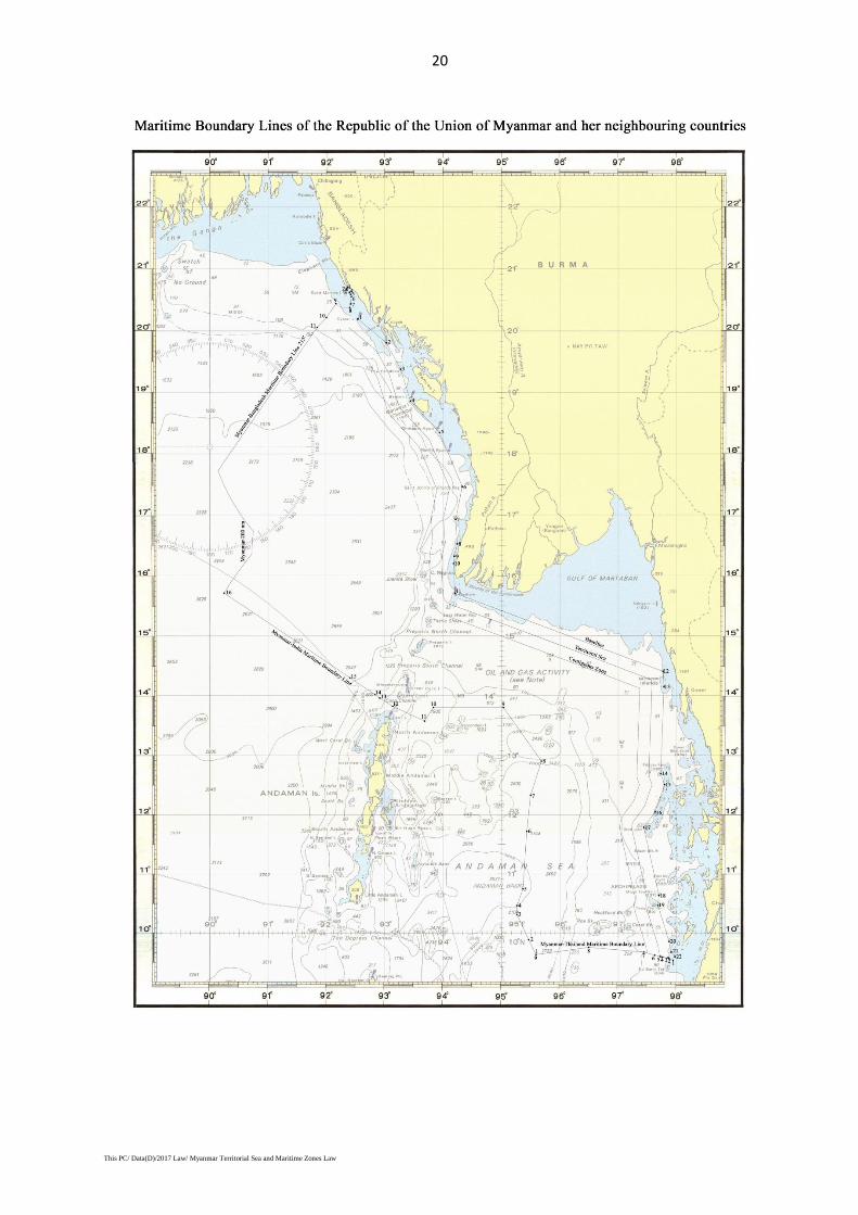
27. The sea boundary line of Myanmar-Bangladesh is demarcated by the
judgment of the International Tribunal on the Law of the Sea issued on 14 March,
2012. The coordinates of sea boundary line of Myanmar-Bangladesh is as
mentioned in Annexe (B) and the nautical chart of boundary line is as mentioned
in Annexe (C).
9
This PC/ Data(D)/2017 Law/ Myanmar Territorial Sea and Maritime Zones Law
28. The sea boundary line of Myanmar-India is demarcated by the bilateral
agreement concluded in 1986. The coordinates of sea boundary line of Myanmar-
India is as mentioned in Annexe (B) and the nautical chart of boundary line is as
mentioned in Annexe (C).
29. The sea boundary line of Myanmar - Thailand is demarcated by the bilateral
agreement concluded in 1980. The coordinates of sea boundary line of Myanmar-
Thailand is as mentioned in Annexe (B) and the nautical chart of boundary line is
as mentioned in Annexe (C).
Chapter IX
Prohibitions
30. No one shall move any objects, including ancient objects and historic
objects at the seabed of the contiguous zone without the prior permission of the
Government.
31. No one shall act any of the followings in the exclusive economic zone
without the prior permission of the Government:
(a) exploration;
(b) exploitation of natural resources;
(c) doing research;
(d) excavating or drilling for any purpose;
(e) establishing, maintaining or using artificial island, off-shore terminal,
installations and structures.
32. No one shall act any of the followings in the continental shelf without the
prior permission of the Government:
(a) exploration;
(b) exploitation of natural resources;
(c) doing research;
(d) searching, excavating or drilling for any purpose;
(e) establishing, maintaining or using artificial island, off-shore terminal,
installations and structures;
10
This PC/ Data(D)/2017 Law/ Myanmar Territorial Sea and Maritime Zones Law
(f) extending or maintaining submarine cables and pipelines.
Chapter X
Offences and Penalties
33. Whoever violates any prohibitions contained in sections 30, 31 or 32 or any
rules issued under this Law shall, on conviction, be punished with imprisonment
not exceeding seven years or with a fine or with both. If an offender is a foreigner
or a person who relates to the interests of a foreign country, he shall pay a fine
determined by the court with foreign currency in accordance with prescribed
currency exchange rate.
34. Whoever abets in violation of any prohibitions of sections 30, 31 or 32 or
any rules issued under this law shall, on conviction, be punished with a fine as
prescribed in original offence. If an offender is a foreigner or a person who relates
to the interests of foreign country, he shall pay a fine determined by the court with
foreign currency in accordance with prescribed currency exchange rate.
35. Whoever attempts to violate any prohibitions of sections 30, 31 or 32 or any
rules issued under this Law shall, on conviction, be punished with imprisonment
not exceeding three years or with a fine or with both. If an offender is a foreigner
or a person who relates to the interests of a foreign country, he shall pay a fine
determined by the court with foreign currency in accordance with prescribed
foreign currency exchange rate.
36. Whoever violates or attempts or abets to violate any prohibitions of sections
7, 8 or 10 shall have action taken under relevant existing laws.
37. The relevant court may confiscate any ship other than warships out of ships
which are involved in any offence mentioned in sections 33, 34 and 35. Equipment
installed on any part of the ship and instruments on board of that ship may be
confiscated.
11
This PC/ Data(D)/2017 Law/ Myanmar Territorial Sea and Maritime Zones Law
Chapter XI
Miscellaneous
38. The State may take action against any offenders for the conservation and
protection of marine environment.
39. An action taken against any offender under this Law shall not preclude the
right to take action under any other existing laws.
40. The actions taken against any offender under section 36 shall not affect the
matters relating to civil jurisdiction contained in section 16.
41. There shall be no prosecution under this Law without the prior sanction of
the Government.
42. In implementing the provisions of this Law:
(a) the relevant ministry may issue rules, regulations and bye-laws with
the approval of the Union Government;
(b) the relevant ministry may issue notifications, orders, directives and
procedures.
43. The Territorial Sea and Maritime Zone Law (The PyithuHluttaw Law No.3,
1977) is hereby repealed by this Law.
I hereby sign under the Constitution of the Republic of the Union of
Myanmar.
Sd/ HtinKyaw
President
The Republic of the Union of Myanmar
12
This PC/ Data(D)/2017 Law/ Myanmar Territorial Sea and Maritime Zones Law
1. For the purposes of this Law, in marking the territorial sea, contiguous zone,
exclusive economic zone and continental shelf of the state, measurement is made
from straight baseline which have been drawn by connecting with the following
fixed points by reason of the geographical conditions prevailing on the coasts of
the State or of the economic requirements of the coastal regions:
Schedule
2. Rakhine Coast
(a) Southern Point of ……. Lat 20· 11’ 49’’N
Mayu Island Long 92· 32’ 19’’E
(b) Boronga Point …… Lat 19· 48’ 30’’N
Long 93· 01’ 42’’E
(c) South Terrible Rock …… Lat 19· 22’ 56’’N
Long 93· 16’ 20’’E
(d) Western Point …… Lat 18· 51’ 48’’N
of Henry Rocks Long 93· 26’ 15’’E
(e) Nerbudda Island …… Lat 18· 20’ 50’’N
Long 93· 56’ 25’’E
(f) Church Rocks …… Lat 17· 27’ 39’’N
Long 94· 19’ 46’’E
(g) North West Group …… Lat 16· 55’ 28’’N
Of Hnget-taung Island Long 94· 12’ 45’’E
(h) Goyangyi Island …… Lat 16· 31’ 20’’N
Long 94· 14’ 21’’E
(i) South Rock …… Lat 16· 18’ 55’’N
Long 94· 11’ 20’’E
(j) Black Rock …… Lat 16· 11’ 50’’N
Long 94· 10’ 50’’E
(k) Pathein Light House …… Lat 15· 42’ 13’’N
Long 94· 12’ 06’’E
3. Gulf of Martaban
Annexe (A)
13
This PC/ Data(D)/2017 Law/ Myanmar Territorial Sea and Maritime Zones Law
(a) Pathein Light House …… Lat 15· 42’ 13’’N
Long 94· 12’ 06’’E
(b) Western Point of …… Lat 14· 24’ 15’’N
Heinze ‘Bok Island Long 97· 46’ 02’’E
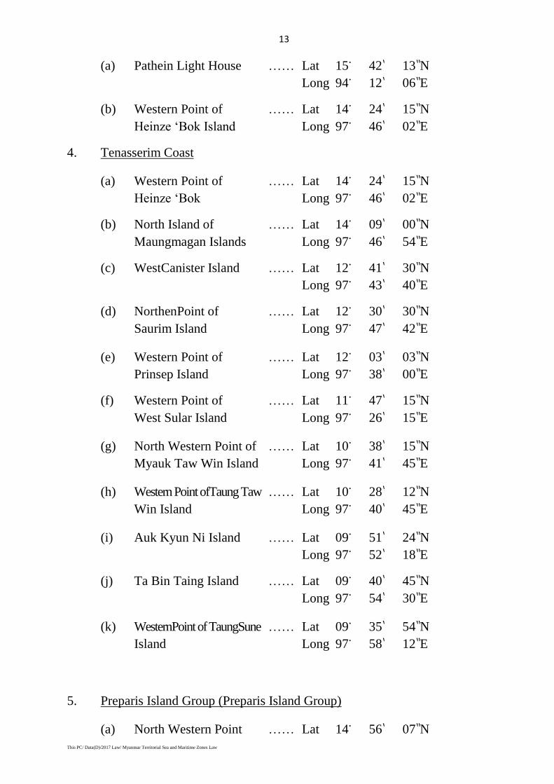
4. Tenasserim Coast
(a) Western Point of …… Lat 14· 24’ 15’’N
Heinze ‘Bok Long 97· 46’ 02’’E
(b) North Island of …… Lat 14· 09’ 00’’N
Maungmagan Islands Long 97· 46’ 54’’E
(c) WestCanister Island …… Lat 12· 41’ 30’’N
Long 97· 43’ 40’’E
(d) NorthenPoint of …… Lat 12· 30’ 30’’N
Saurim Island Long 97· 47’ 42’’E
(e) Western Point of …… Lat 12· 03’ 03’’N
Prinsep Island Long 97· 38’ 00’’E
(f) Western Point of …… Lat 11· 47’ 15’’N
West Sular Island Long 97· 26’ 15’’E
(g) North Western Point of …… Lat 10· 38’ 15’’N
Myauk Taw Win Island Long 97· 41’ 45’’E
(h) Western Point ofTaung Taw …… Lat 10· 28’ 12’’N
Win Island Long 97· 40’ 45’’E
(i) Auk Kyun Ni Island …… Lat 09· 51’ 24’’N
Long 97· 52’ 18’’E
(j) Ta Bin Taing Island …… Lat 09· 40’ 45’’N
Long 97· 54’ 30’’E
(k) WesternPoint of TaungSune …… Lat 09· 35’ 54’’N
Island Long 97· 58’ 12’’E
5. Preparis Island Group (Preparis Island Group)
(a) North Western Point …… Lat 14· 56’ 07’’N
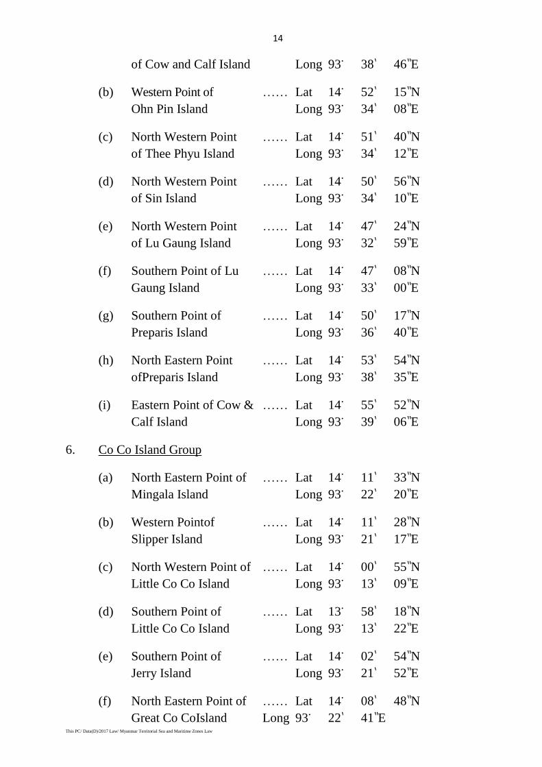
14
This PC/ Data(D)/2017 Law/ Myanmar Territorial Sea and Maritime Zones Law
of Cow and Calf Island Long 93· 38’ 46’’E
(b) Western Point of …… Lat 14· 52’ 15’’N
Ohn Pin Island Long 93· 34’ 08’’E
(c) North Western Point …… Lat 14· 51’ 40’’N
of Thee Phyu Island Long 93· 34’ 12’’E
(d) North Western Point …… Lat 14· 50’ 56’’N
of Sin Island Long 93· 34’ 10’’E
(e) North Western Point …… Lat 14· 47’ 24’’N
of Lu Gaung Island Long 93· 32’ 59’’E
(f) Southern Point of Lu …… Lat 14· 47’ 08’’N
Gaung Island Long 93· 33’ 00’’E
(g) Southern Point of …… Lat 14· 50’ 17’’N
Preparis Island Long 93· 36’ 40’’E
(h) North Eastern Point …… Lat 14· 53’ 54’’N
ofPreparis Island Long 93· 38’ 35’’E
(i) Eastern Point of Cow & …… Lat 14· 55’ 52’’N
Calf Island Long 93· 39’ 06’’E
6. Co Co Island Group
(a) North Eastern Point of …… Lat 14· 11’ 33’’N
Mingala Island Long 93· 22’ 20’’E
(b) Western Pointof …… Lat 14· 11’ 28’’N
Slipper Island Long 93· 21’ 17’’E
(c) North Western Point of …… Lat 14· 00’ 55’’N
Little Co Co Island Long 93· 13’ 09’’E
(d) Southern Point of …… Lat 13· 58’ 18’’N
Little Co Co Island Long 93· 13’ 22’’E
(e) Southern Point of …… Lat 14· 02’ 54’’N
Jerry Island Long 93· 21’ 52’’E
(f) North Eastern Point of …… Lat 14· 08’ 48’’N
Great Co CoIsland Long 93· 22’ 41’’E
15
This PC/ Data(D)/2017 Law/ Myanmar Territorial Sea and Maritime Zones Law
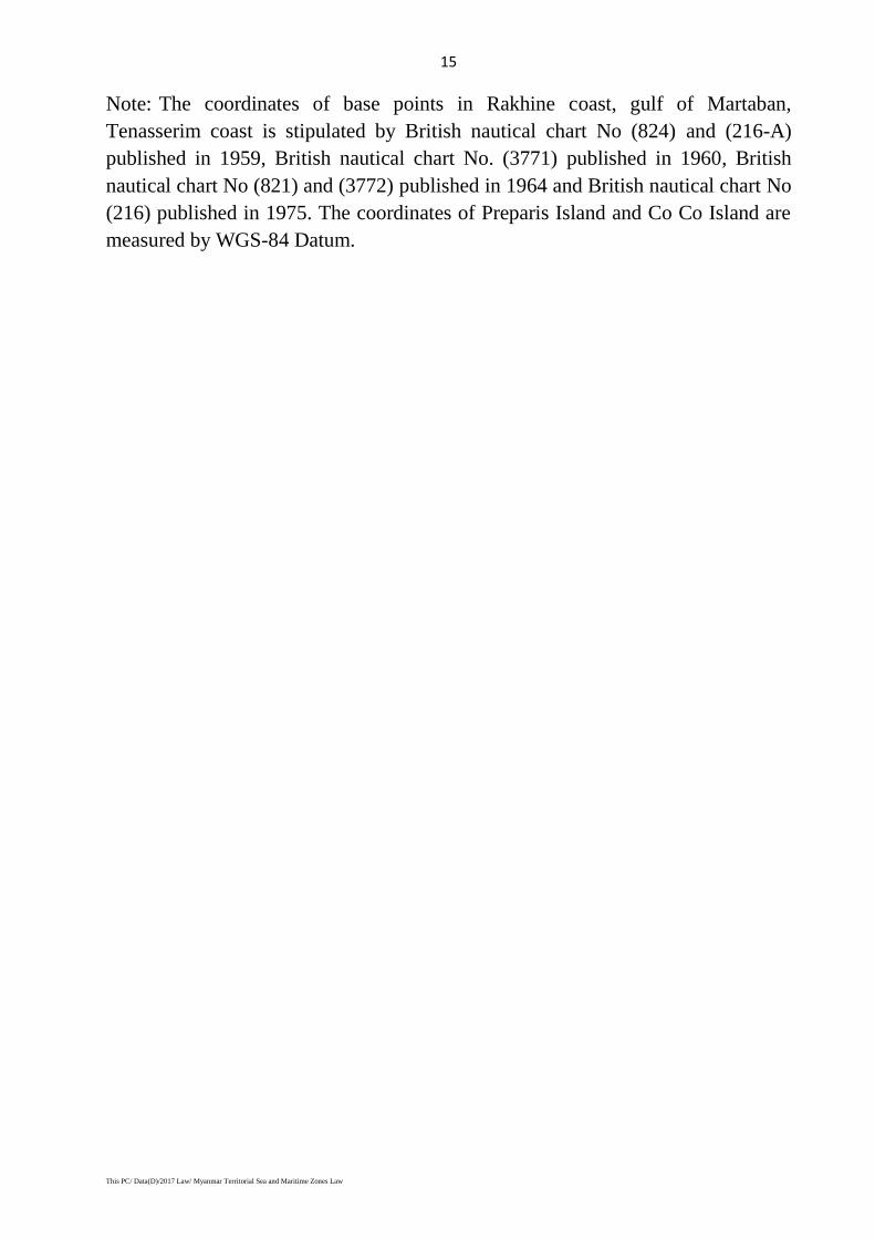
Note: The coordinates of base points in Rakhine coast, gulf of Martaban,
Tenasserim coast is stipulated by British nautical chart No (824) and (216-A)
published in 1959, British nautical chart No. (3771) published in 1960, British
nautical chart No (821) and (3772) published in 1964 and British nautical chart No
(216) published in 1975. The coordinates of Preparis Island and Co Co Island are
measured by WGS-84 Datum.
16
This PC/ Data(D)/2017 Law/ Myanmar Territorial Sea and Maritime Zones Law
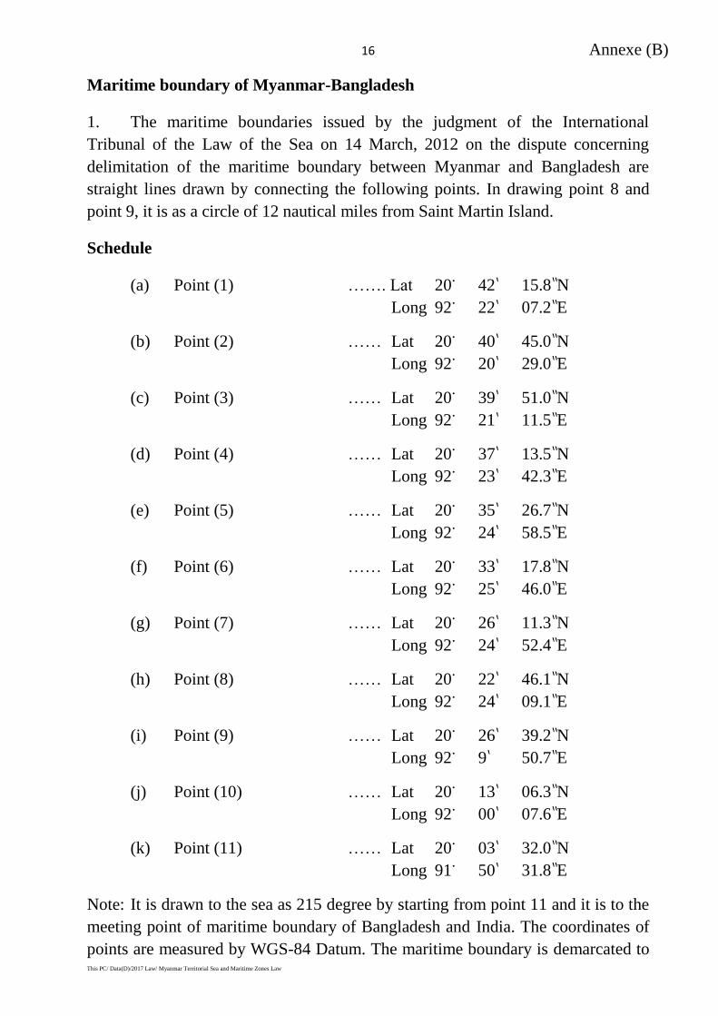
Maritime boundary of Myanmar-Bangladesh
1. The maritime boundaries issued by the judgment of the International
Tribunal of the Law of the Sea on 14 March, 2012 on the dispute concerning
delimitation of the maritime boundary between Myanmar and Bangladesh are
straight lines drawn by connecting the following points. In drawing point 8 and
point 9, it is as a circle of 12 nautical miles from Saint Martin Island.
Schedule
(a) Point (1) ……. Lat 20· 42’ 15.8’’N
Long 92· 22’ 07.2’’E
(b) Point (2) …… Lat 20· 40’ 45.0’’N
Long 92· 20’ 29.0’’E
(c) Point (3) …… Lat 20· 39’ 51.0’’N
Long 92· 21’ 11.5’’E
(d) Point (4) …… Lat 20· 37’ 13.5’’N
Long 92· 23’ 42.3’’E
(e) Point (5) …… Lat 20· 35’ 26.7’’N
Long 92· 24’ 58.5’’E
(f) Point (6) …… Lat 20· 33’ 17.8’’N
Long 92· 25’ 46.0’’E
(g) Point (7) …… Lat 20· 26’ 11.3’’N
Long 92· 24’ 52.4’’E
(h) Point (8) …… Lat 20· 22’ 46.1’’N
Long 92· 24’ 09.1’’E
(i) Point (9) …… Lat 20· 26’ 39.2’’N
Long 92· 9’ 50.7’’E
(j) Point (10) …… Lat 20· 13’ 06.3’’N
Long 92· 00’ 07.6’’E
(k) Point (11) …… Lat 20· 03’ 32.0’’N
Long 91· 50’ 31.8’’E
Note: It is drawn to the sea as 215 degree by starting from point 11 and it is to the
meeting point of maritime boundary of Bangladesh and India. The coordinates of
points are measured by WGS-84 Datum. The maritime boundary is demarcated to
Annexe (B)
17
This PC/ Data(D)/2017 Law/ Myanmar Territorial Sea and Maritime Zones Law
200 nautical miles from the baseline to the sea. However, the contiguous places of
maritime boundary of Bangladesh-Myanmar is to the such boundary line.
Myanmar-India maritime boundary
1. Myanmar-India maritime boundary signed bilaterally on 23December, 1986
is straight line connected with the following (16) main points.
Schedule
(a) Main point (1) ……. Lat 09· 38’ 00’’N
Long 95· 35’ 25’’E
(b) Main point (2) …… Lat 09· 53’ 14’’N
Long 95· 28’ 00’’E
(c) Main point (3) …… Lat 10· 18’ 42’’N
Long 95· 16’ 02’’E
(d) Main point (4) …… Lat 10· 28’ 00’’N
Long 95· 15’ 58’’E
(e) Main point (5) …… Lat 10· 44’ 53’’N
Long 95· 22’ 00’’E
(f) Main point (6) …… Lat 11· 43’ 17’’N
Long 95· 26’ 00’’E
(g) Main point (7) …… Lat 12· 19’ 43’’N
Long 95· 30’ 00’’E
(h) Main point (8) …… Lat 12· 54’ 07’’N
Long 95· 41’ 00’’E
(i) Main point (9) …… Lat 13· 48’ 00’’N
Long 95· 02’ 00’’E
(j) Main point (10) …… Lat 13· 48’ 00’’N
Long 93· 50’ 00’’E
(k) Main point (11) …… Lat 13· 34’ 18’’N
Long 93· 40’ 59’’E
(l) Main point (12) …… Lat 13· 49’ 11’’N
Long 93· 08’ 05’’E
18
This PC/ Data(D)/2017 Law/ Myanmar Territorial Sea and Maritime Zones Law
(m) Main point (13) …… Lat 13· 57’ 29’’N
Long 92· 54’ 50’’E
(n) Main point (14) …… Lat 14· 00’ 59’’N
Long 92· 50’ 02’’E
(o) Main point (15) …… Lat 14· 17’ 42’’N
Long 92· 24’ 17’’E
(p) Main point (16) …… Lat 15· 42’ 50’’N
Long 90· 14’ 01’’E
Note: The coordinates are those from the India nautical chart No (31) published in
1976 and India nautical chart (41) published in 1979, signed bilaterally.
Myanmar-Thailand maritime boundary
Myanmar-Thailand maritime boundary signed bilaterally on 25 July, 1980 is
straight line connected with the following (9) main points.
Schedule
(a) Main point (1) ……. Lat 09· 32’ 15’’N
Long 97· 56’ 20’’E
(b) Main point (2) …… Lat 09· 34’ 29’’N
Long 97· 52’ 10’’E
(c) Main point (3) …… Lat 09· 34’ 54’’N
Long 97· 51’ 12’’E
(d) Main point (4) …… Lat 09· 35’ 39’’N
Long 97· 45’ 29’’E
(e) Main point (5) …… Lat 09· 36’ 02’’N
Long 97· 43’ 29’’E
(f) Main point (6) …… Lat 09· 37’ 24’’N
Long 97· 37’ 36’’E
(g) Main point (7) …… Lat 09· 40’ 35’’N
Long 97· 26’ 36’’E
(h) Main point (8) …… Lat 09· 45’ 30’’N
Long 96· 29’ 35’’E
19
This PC/ Data(D)/2017 Law/ Myanmar Territorial Sea and Maritime Zones Law
(i) Main point (9) …… Lat 09· 38’ 00’’N
Long 95· 35’ 25’’E
Note: The coordinates are those from the British nautical chart No (3052) and
(830) published in 1975, signed bilaterally.
Annexe (C)
20
This PC/ Data(D)/2017 Law/ Myanmar Territorial Sea and Maritime Zones Law


![[Unofficial Translation] Occupational Safety and Health ... · Occupational Safety and Health Law (Pyidaungsu Hluttaw Law No 8 of 2019) ... Council means the Occupational Safety and](https://img.pdfslide.net/doc/110x75/5f6cc0aa590a343e3e127063/unofficial-translation-occupational-safety-and-health-occupational-safety.jpg)