Embed Size (px)
Citation preview

High Wycombe Conservation Area - Railway and Victorian Expansion1
This document forms part of a larger conservation appraisal for High Wycombe and should be read in conjunction with the master document which gives development control guidelines.
1 LOCATION AND LANDSCAPE SETTING
Location This small sub-area to the north of the town centre is characterised by the steep hill that continues from Crendon Street (formerly Crendon Lane). This is classifi ed as an incised dip slope (Z10) in the Buckinghamshire Landscape Plan and is a typical Chiltern feature.
The steep side to the chalk valley has been incised to create a plateau to accommodate the railway and the seven metre step up to Totteridge Road leads to the short length of Amersham Hill that is included in this conservation area.
The Victorian villas that step up Amersham Hill once led to an area of wild heath that topped the hill prior to the expansion of the suburbs that extend towards Hazlemere.
The conservation area boundary lies to the rear of properties to the west of the main road, and north of St Augustines Catholic Church. Amersham Hill Conservation Area, and Priory Road Conservation Area both adjoin this sub area, and form a continuation of the Victorian development of the town.
General character, plan form and landscape contextHigh Wycombe town centre lies at the bottom of the valley formed by the River Wye cut from the chalk hills of the Chilterns. It is the steep sided slope to the north that provides the setting for the railway station on a small plateau. The current railway lines are placed on an extension of the plateau carved into the chalk hillside that created the seven metre step up to the Totteridge Road.
HIGH WYCOMBE CONSERVATION AREA
The Railway and Victorian ExpansionArea Study 5
March 2011
High Wycombe Conservation Area - Railway and Victorian Expansion 2
Across the road from the railway station is a square of development that used to house the Railway Commercial Hotel and is still home to numerous shops and The Flint Cottage public house (now renamed The Bootlegger).
North of the railway station is a string of late Victorian villas along the road on the west side of Amersham Hill; there is a clear rhythm in the street scene as the buildings are consistent in their style, size and use of materials. Other, larger villas on the east side of Amersham Hill are hidden, set back from the road.
The plot density of the development on the corner of Castle Street and Crendon Street is high with shops along the street frontage and development extending back to the railway lines. This contrasts with the more relaxed plan form of the Victorian villas that originally had spacious rear gardens. The proximity of these buildings to the town has meant, however, that they are now mainly occupied by businesses and buildings or car parks have extended over many of the spaces to the rear.
2 HISTORICAL DEVELOPMENT AND ARCHAEOLOGY
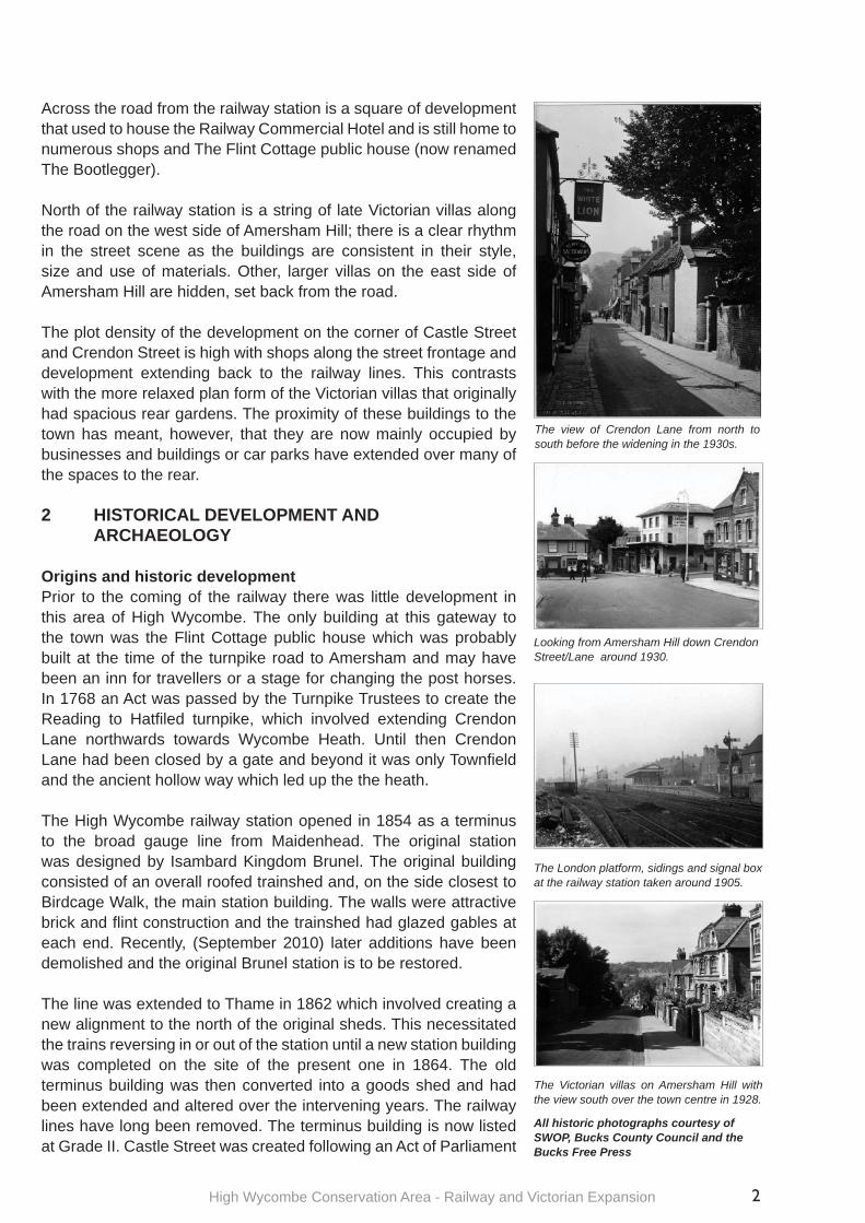
Origins and historic developmentPrior to the coming of the railway there was little development in this area of High Wycombe. The only building at this gateway to the town was the Flint Cottage public house which was probably built at the time of the turnpike road to Amersham and may have been an inn for travellers or a stage for changing the post horses. In 1768 an Act was passed by the Turnpike Trustees to create the Reading to Hatfi led turnpike, which involved extending Crendon Lane northwards towards Wycombe Heath. Until then Crendon Lane had been closed by a gate and beyond it was only Townfi eld and the ancient hollow way which led up the the heath.
The High Wycombe railway station opened in 1854 as a terminus to the broad gauge line from Maidenhead. The original station was designed by Isambard Kingdom Brunel. The original building consisted of an overall roofed trainshed and, on the side closest to Birdcage Walk, the main station building. The walls were attractive brick and fl int construction and the trainshed had glazed gables at each end. Recently, (September 2010) later additions have been demolished and the original Brunel station is to be restored.
The line was extended to Thame in 1862 which involved creating a new alignment to the north of the original sheds. This necessitated the trains reversing in or out of the station until a new station building was completed on the site of the present one in 1864. The old terminus building was then converted into a goods shed and had been extended and altered over the intervening years. The railway lines have long been removed. The terminus building is now listed at Grade II. Castle Street was created following an Act of Parliament
The view of Crendon Lane from north to south before the widening in the 1930s.
Looking from Amersham Hill down Crendon Street/Lane around 1930.
The London platform, sidings and signal box at the railway station taken around 1905.
The Victorian villas on Amersham Hill with the view south over the town centre in 1928.
All historic photographs courtesy of SWOP, Bucks County Council and the Bucks Free Press
High Wycombe Conservation Area - Railway and Victorian Expansion3
in 1876 to link Church Street to Crendon Lane, and intended to improve the access to the railway station.
In 1906 the railway line was altered to connect High Wycombe with London and became the Great Western and Great Central Joint Railway. The excavations increased the width of the cutting along the length of the line demanding a doubling of the viaduct over Frogmoor and bringing Priory Avenue and Totteridge very close to the brink. The line from High Wycombe through Bourne End and Loudwater has been disused since 1970 and the railway tracks lifted, although the section between Bourne End and Maidenhead remains in use.
Until the extension of the Borough Boundary in 1880, anything beyond the station was not in the borough, but this fi rst extension took the Borough up what is now Amersham Hill to where Lucas and Shrubbery Road cross it. It was after 1880 that development on large plots for dwellings commenced.
Late Victorian villas built by the prosperous factory owners, bank managers and other professionals spread up Amersham Hill along what used to be the old turnpike road to Amersham; for example, Arthur Vernon, a leading architect, mayor of Wycombe on several occasions, and magistrate lived at No 20, built for himself. The proximity of the railway station also allowed commuters to move in to the area, creating an early metro-land community.
The junction of Castle Street, Crendon Street, Amersham Hill and the railway station was a hub for travellers. In the early 20th century the Railway Tavern occupied the site at the top of Crendon Street with the Langham Hotel on the opposite corner of Crendon Street and the Railway Commercial Hotel (formerly the Railway Temperance Hotel) on the northern corner of Castle Street. The buildings alongside the Railway Commercial Hotel running along Castle Street were houses at that time, but by the 1930s had all become shops and business premises.
In 1930 the Langham Hotel was demolished along with other buildings at the top of Crendon Street to enable the road to be widened and a new corner building refl ecting the same curve used at the bottom of Crendon Street was constructed. The wider road was to cope with the increase in traffi c both to the railway and further, towards Amersham. Old maps show a line of railway cottages, with classical detailing, facing north onto Birdcage Walk. These alas have long been demolished.
Following a fi re in 2005, the Edwardian station was refurbished and there are plans underway to redevelop the station
The view from Crendon Street looking north as Amersham Hill sweeps up into Amersham Road
This row of shops along Castle Street were originally part of the Railway Hotel development. but may have been built as speculative dwellings
The Victorian facades of this pair of cottages has been retained - the rear has been completely rebuilt
High Wycombe Conservation Area - Railway and Victorian Expansion 4
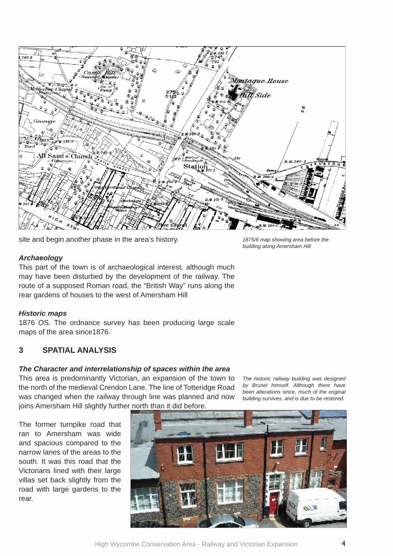
site and begin another phase in the area’s history. ArchaeologyThis part of the town is of archaeological interest, although much may have been disturbed by the development of the railway. The route of a supposed Roman road, the “British Way” runs along the rear gardens of houses to the west of Amersham Hill
Historic maps1876 OS. The ordnance survey has been producing large scale maps of the area since1876.
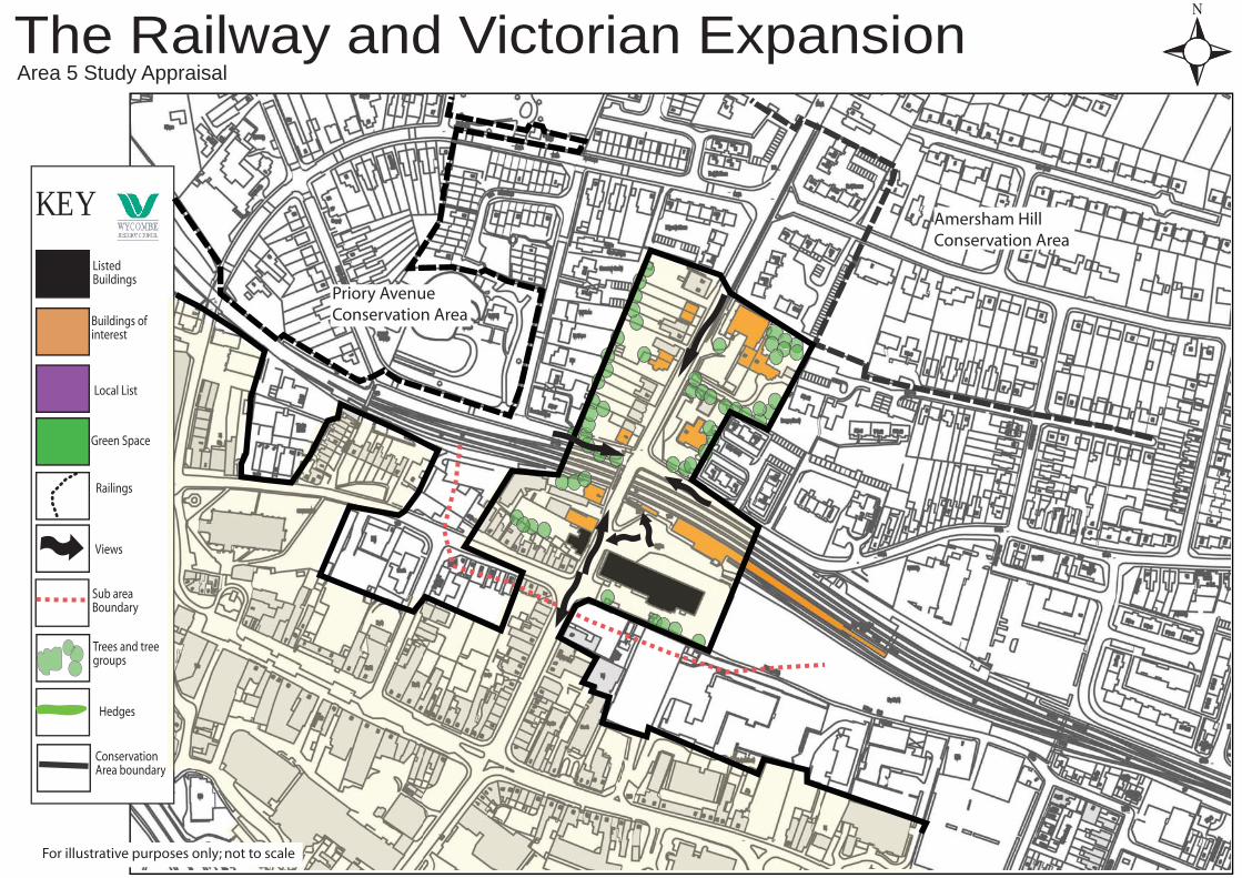
3 SPATIAL ANALYSIS
The Character and interrelationship of spaces within the areaThis area is predominantly Victorian, an expansion of the town to the north of the medieval Crendon Lane. The line of Totteridge Road was changed when the railway through line was planned and now joins Amersham Hill slightly further north than it did before.
The former turnpike road that ran to Amersham was wide and spacious compared to the narrow lanes of the areas to the south. It was this road that the Victorians lined with their large villas set back slightly from the road with large gardens to the rear.
1875/6 map showing area before the building along Amersham Hill
The historic railway building was designed by Brunel himself. Although there have been alterations since, much of the original building survives, and is due to be restored.

High Wycombe Conservation Area - Railway and Victorian Expansion5
The small square of development around The Flint Cottage is the only part that refl ects the earlier plan form of more tightly packed buildings crowding up to the railway lines. Beyond the railway, the main road junction (closed to traffi c) with Priory Road, has an avenue of mature trees along the boundary with the railway cutting and further mature trees in the gardens of adjacent properties, creating a verdant character when glimpsed from the busy road.
The only open space in this sub area is the surfaced area around the station itself, used mainly for vehicular access to the station and other commercial premises. There is a small area next to the road that has been planted with fl owers and shrubs that breaks up the unrelentingly hard landscape.
When Crendon Street was widened in the 1930s it created a greater sense of space, signifi cantly altering the character of the street by opening up the previously dark and narrow lane, which had medieval origins.
Important views and vistasThe key views of the area are to and from Amersham Hill. From the hill the view is over the town towards Marlow Hill on the other side of the valley. The reciprocal view from Marlow Hill is equally spectacular. Additionally, the view up Amersham Hill from Crendon Street allows an appreciation of the scale of the hill as it climbs out of the valley.
4 CHARACTER ANALYSIS
Activity and landuseThis sub area is a Victorian expansion based around the development of the railway. To the immediate east of the road, beyond the railway cutting, pairs of semidetached villas lie adjacent to the road. To the east, where originally grand single houses stood alone in large plots, there has been modern infi ll with smaller houses replacing the Edwardian buildings, but the original layout can still be traced. The villas, with their large gardens, have now mostly been taken over by businesses. The area around the Flint Cottage has a tighter plan form, most of which, again, started as housing and has been taken over by shops and offi ces.
Architectural and historical quality of buildings and the contribution they make to the special interest of the areaRailway Station: The railway was opened in 1854 with the main building designed by Isambard Kingdom Brunel. This has now been recognised for the architectural and historic interest it holds and has been listed by the Secretary of State at Grade II. There have been many additions and alterations over the years. The sheds are timber framed with brick cladding and Welsh slate roofs while the offi ces that the paying public fi rst approached are knapped fl int with brick dressings. When the offi ces had another fl oor added it was in plain red brick.
A view across the railway tracks at the station shows the deep cutting on the Totteridge Road side that was necessary to enable the railway to be extended through the town and on to Thame.
The Flint Cottage, now renamed as The Bootlegger, has been overlooking the increasing traffi c fl ows along Amersham Hill for around 200 years.
The Victorian villas that were built following the arrival of the railway - imposing homes for the wealthy middle classes of High Wycombe. The gabled roofl ines stepping up the hillside provide an elegant backdrop to the station forecourt
High Wycombe Conservation Area - Railway and Victorian Expansion 6
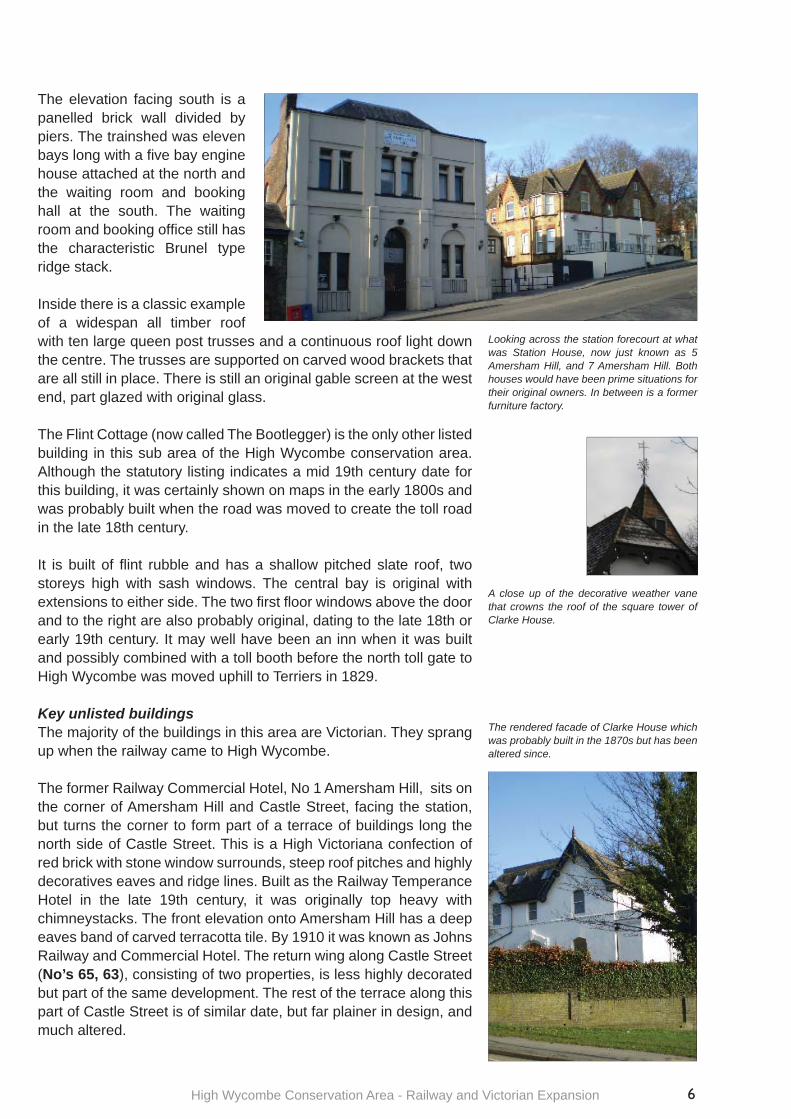
The elevation facing south is a panelled brick wall divided by piers. The trainshed was eleven bays long with a fi ve bay engine house attached at the north and the waiting room and booking hall at the south. The waiting room and booking offi ce still has the characteristic Brunel type ridge stack.
Inside there is a classic example of a widespan all timber roof with ten large queen post trusses and a continuous roof light down the centre. The trusses are supported on carved wood brackets that are all still in place. There is still an original gable screen at the west end, part glazed with original glass.
The Flint Cottage (now called The Bootlegger) is the only other listed building in this sub area of the High Wycombe conservation area. Although the statutory listing indicates a mid 19th century date for this building, it was certainly shown on maps in the early 1800s and was probably built when the road was moved to create the toll road in the late 18th century.
It is built of fl int rubble and has a shallow pitched slate roof, two storeys high with sash windows. The central bay is original with extensions to either side. The two fi rst fl oor windows above the door and to the right are also probably original, dating to the late 18th or early 19th century. It may well have been an inn when it was built and possibly combined with a toll booth before the north toll gate to High Wycombe was moved uphill to Terriers in 1829.
Key unlisted buildingsThe majority of the buildings in this area are Victorian. They sprang up when the railway came to High Wycombe.
The former Railway Commercial Hotel, No 1 Amersham Hill, sits on the corner of Amersham Hill and Castle Street, facing the station, but turns the corner to form part of a terrace of buildings long the north side of Castle Street. This is a High Victoriana confection of red brick with stone window surrounds, steep roof pitches and highly decoratives eaves and ridge lines. Built as the Railway Temperance Hotel in the late 19th century, it was originally top heavy with chimneystacks. The front elevation onto Amersham Hill has a deep eaves band of carved terracotta tile. By 1910 it was known as Johns Railway and Commercial Hotel. The return wing along Castle Street (No’s 65, 63), consisting of two properties, is less highly decorated but part of the same development. The rest of the terrace along this part of Castle Street is of similar date, but far plainer in design, and much altered.
Looking across the station forecourt at what was Station House, now just known as 5 Amersham Hill, and 7 Amersham Hill. Both houses would have been prime situations for their original owners. In between is a former furniture factory.
The rendered facade of Clarke House which was probably built in the 1870s but has been altered since.
A close up of the decorative weather vane that crowns the roof of the square tower of Clarke House.
High Wycombe Conservation Area - Railway and Victorian Expansion7
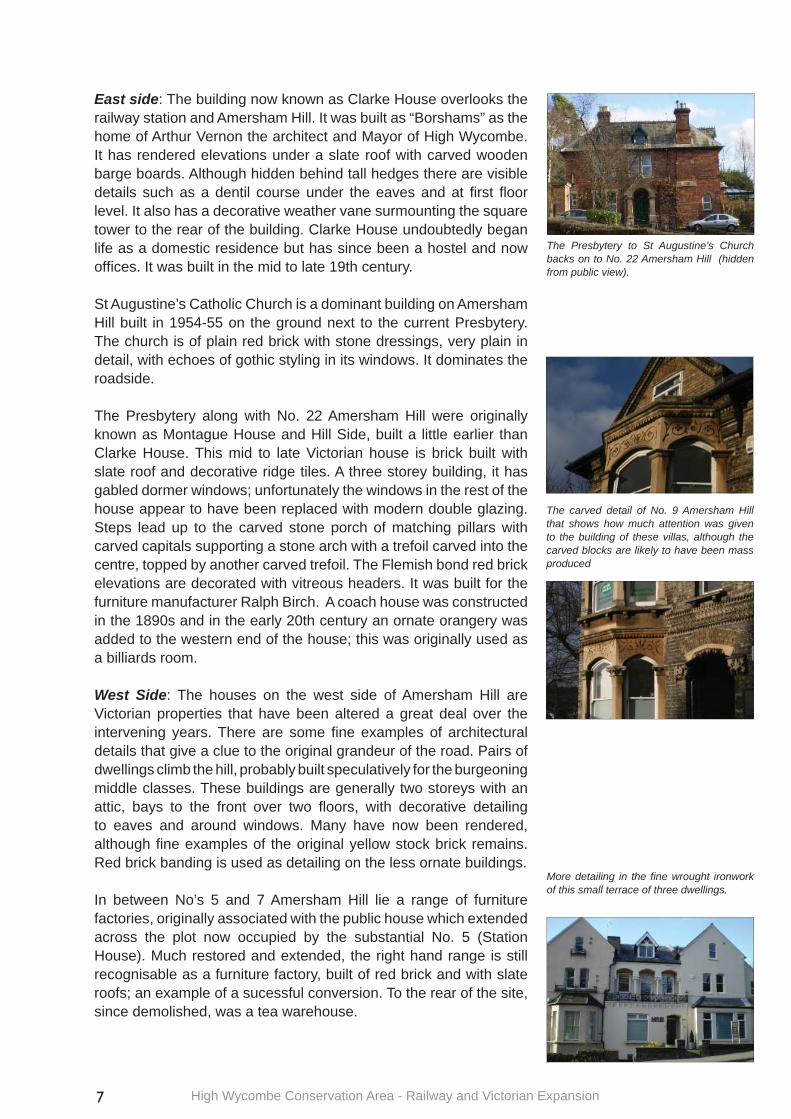
East side: The building now known as Clarke House overlooks the railway station and Amersham Hill. It was built as “Borshams” as the home of Arthur Vernon the architect and Mayor of High Wycombe. It has rendered elevations under a slate roof with carved wooden barge boards. Although hidden behind tall hedges there are visible details such as a dentil course under the eaves and at fi rst fl oor level. It also has a decorative weather vane surmounting the square tower to the rear of the building. Clarke House undoubtedly began life as a domestic residence but has since been a hostel and now offi ces. It was built in the mid to late 19th century.
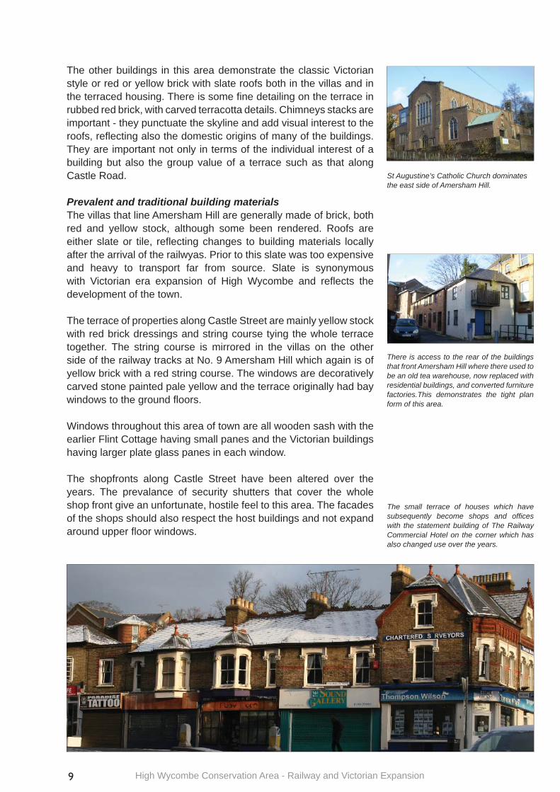
St Augustine’s Catholic Church is a dominant building on Amersham Hill built in 1954-55 on the ground next to the current Presbytery. The church is of plain red brick with stone dressings, very plain in detail, with echoes of gothic styling in its windows. It dominates the roadside.
The Presbytery along with No. 22 Amersham Hill were originally known as Montague House and Hill Side, built a little earlier than Clarke House. This mid to late Victorian house is brick built with slate roof and decorative ridge tiles. A three storey building, it has gabled dormer windows; unfortunately the windows in the rest of the house appear to have been replaced with modern double glazing. Steps lead up to the carved stone porch of matching pillars with carved capitals supporting a stone arch with a trefoil carved into the centre, topped by another carved trefoil. The Flemish bond red brick elevations are decorated with vitreous headers. It was built for the furniture manufacturer Ralph Birch. A coach house was constructed in the 1890s and in the early 20th century an ornate orangery was added to the western end of the house; this was originally used as a billiards room.
West Side: The houses on the west side of Amersham Hill are Victorian properties that have been altered a great deal over the intervening years. There are some fi ne examples of architectural details that give a clue to the original grandeur of the road. Pairs of dwellings climb the hill, probably built speculatively for the burgeoning middle classes. These buildings are generally two storeys with an attic, bays to the front over two fl oors, with decorative detailing to eaves and around windows. Many have now been rendered, although fi ne examples of the original yellow stock brick remains. Red brick banding is used as detailing on the less ornate buildings.
In between No’s 5 and 7 Amersham Hill lie a range of furniture factories, originally associated with the public house which extended across the plot now occupied by the substantial No. 5 (Station House). Much restored and extended, the right hand range is still recognisable as a furniture factory, built of red brick and with slate roofs; an example of a sucessful conversion. To the rear of the site, since demolished, was a tea warehouse.
The Presbytery to St Augustine’s Church backs on to No. 22 Amersham Hill (hidden from public view).
The carved detail of No. 9 Amersham Hill that shows how much attention was given to the building of these villas, although the carved blocks are likely to have been mass produced
More detailing in the fi ne wrought ironwork of this small terrace of three dwellings.

High Wycombe Conservation Area - Railway and Victorian Expansion 8
No. 9 - 11 Amersham Hill has a plethora of decorative features, including shaped and moulded brick details, incised scrolls in the stone work of the bays and to the oriel window heads on both the ground and fi rst fl oor, door header and elabourately carved capitals either side of the door. The yellow stock brick work is particularly fi ne.
No.s 21 - 25 Amersham Hill is a group of three attached dwellings of cream-painted rendered brickwork under slate roofs. The central property (No 23) has an attractive recessed balcony feature with decorative ironwork to the front, and oversized carved capitals between the three window openings. No 21 retains some ironwork balconette features to the upper fl oor windows, whereas this has been lost from No 25 which has been altered and extended.
No.s 31 - 33 Amersham Hill, although now a single business premise, retains the look of the semi-detached villa that it once was. It is built of yellow brick with intricate carving to the pale stone that surrounds the doors and windows. The pillars to either side of the front doors help to illustrate the affl uent nature of the original inhabitants.
Castle Street:The short run of terraced properties along Castle Street that began their lives as housing are now shops and offi ces but still contribute to the tightly packed plan form of that part of the sub area. Mostly yellow stock brick with red brick stringcourse and eaves detailing, their upper fl oors retain some of the Victorian detailing. The properties closest to the corner are contiguous with the former Railway Hotel that fronts Amersham Hill and were originally part of that premises. Further west the buildings become plainer and more diverse in character, although quite a few have retained their original windows on the upper fl oor. Ground fl oor details have been obliterated by the insertion of modern shop fronts.
Local detailsThe Bootlegger (Flint Cottage) demonstrates the vernacular use of fl int in the area and how it has contributed to the look of local buildings. The building material was echoed in the original name of the public house, which has alas fallen victim to the current trend of renaming pubs with whimsical names, allowing for no sense of place or local reference.
The local vernacular is continued with the later use of coursed fl int for detailing on the old station buildings. In both cases the buildings use a cheap and widely available local material rather than imported brick.
The trees on Priory Avenue that contribute to the quality of the environment viewed from the station forecourt.
The imposing villa facades as they progress up Amersham hill.
Nos. 31-33 Amersham Hill demonstrates the fi ne detailing that the affl uent inhabitants wanted to fl aunt.
High Wycombe Conservation Area - Railway and Victorian Expansion9
St Augustine’s Catholic Church dominates the east side of Amersham Hill.
The other buildings in this area demonstrate the classic Victorian style or red or yellow brick with slate roofs both in the villas and in the terraced housing. There is some fi ne detailing on the terrace in rubbed red brick, with carved terracotta details. Chimneys stacks are important - they punctuate the skyline and add visual interest to the roofs, refl ecting also the domestic origins of many of the buildings. They are important not only in terms of the individual interest of a building but also the group value of a terrace such as that along Castle Road.
Prevalent and traditional building materialsThe villas that line Amersham Hill are generally made of brick, both red and yellow stock, although some been rendered. Roofs are either slate or tile, refl ecting changes to building materials locally after the arrival of the railwyas. Prior to this slate was too expensive and heavy to transport far from source. Slate is synonymous with Victorian era expansion of High Wycombe and refl ects the development of the town.
The terrace of properties along Castle Street are mainly yellow stock with red brick dressings and string course tying the whole terrace together. The string course is mirrored in the villas on the other side of the railway tracks at No. 9 Amersham Hill which again is of yellow brick with a red string course. The windows are decoratively carved stone painted pale yellow and the terrace originally had bay windows to the ground fl oors.
Windows throughout this area of town are all wooden sash with the earlier Flint Cottage having small panes and the Victorian buildings having larger plate glass panes in each window.
The shopfronts along Castle Street have been altered over the years. The prevalance of security shutters that cover the whole shop front give an unfortunate, hostile feel to this area. The facades of the shops should also respect the host buildings and not expand around upper fl oor windows.
There is access to the rear of the buildings that front Amersham Hill where there used to be an old tea warehouse, now replaced with residential buildings, and converted furniture factories.This demonstrates the tight plan form of this area.
The small terrace of houses which have subsequently become shops and offi ces with the statement building of The Railway Commercial Hotel on the corner which has also changed use over the years.
High Wycombe Conservation Area - Railway and Victorian Expansion 10
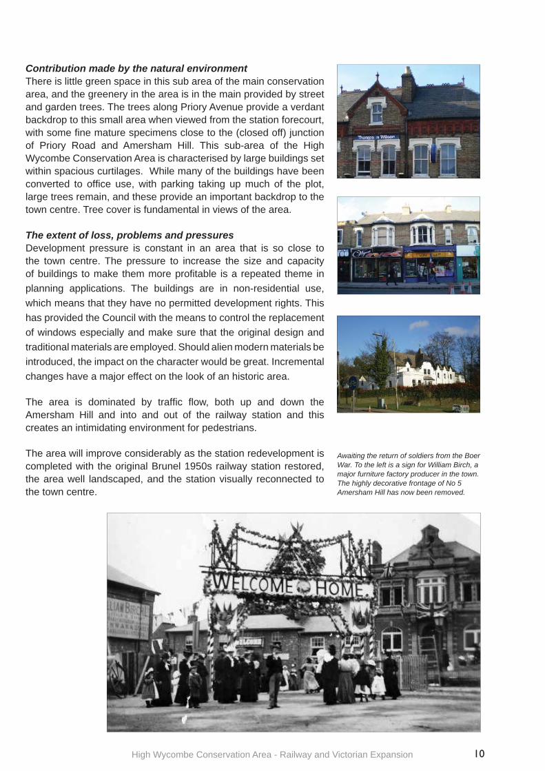
Contribution made by the natural environmentThere is little green space in this sub area of the main conservation area, and the greenery in the area is in the main provided by street and garden trees. The trees along Priory Avenue provide a verdant backdrop to this small area when viewed from the station forecourt, with some fi ne mature specimens close to the (closed off) junction of Priory Road and Amersham Hill. This sub-area of the High Wycombe Conservation Area is characterised by large buildings set within spacious curtilages. While many of the buildings have been converted to offi ce use, with parking taking up much of the plot, large trees remain, and these provide an important backdrop to the town centre. Tree cover is fundamental in views of the area.
The extent of loss, problems and pressuresDevelopment pressure is constant in an area that is so close to the town centre. The pressure to increase the size and capacity of buildings to make them more profi table is a repeated theme in planning applications. The buildings are in non-residential use, which means that they have no permitted development rights. This has provided the Council with the means to control the replacement of windows especially and make sure that the original design and traditional materials are employed. Should alien modern materials be introduced, the impact on the character would be great. Incremental changes have a major effect on the look of an historic area.
The area is dominated by traffi c fl ow, both up and down the Amersham Hill and into and out of the railway station and this creates an intimidating environment for pedestrians.
The area will improve considerably as the station redevelopment is completed with the original Brunel 1950s railway station restored, the area well landscaped, and the station visually reconnected to the town centre.
Awaiting the return of soldiers from the Boer War. To the left is a sign for William Birch, a major furniture factory producer in the town. The highly decorative frontage of No 5 Amersham Hill has now been removed.
Area 5 Study AppraisalThe Railway and Victorian Expansion
Wall
KEY
Listed Buildings
Buildings of interest
Railings
Green Space
Sub areaBoundary
Trees and tree groups
Views
Hedges
Local List
Conservation Area boundary
Amersham Hill Conservation Area
Priory AvenueConservation Area
For illustrative purposes only; not to scale