Embed Size (px)
Citation preview
THE RESEARCH ON THE AMBIGUOUS PATH IDENTIFICATION TECHNOLOGY OF EXPRESSWAY BASED ON GIS
Tian Zhihuia, Miao Quanshengb, Zeng Yuhuaic
aSchool of Environment and Water Conservancy ,Zhengzhou University ,100 Kexue Road,Zhengzhou, China,450001 -
[email protected] bThe Department of Electrical and Mechanical Engineering , Henan Academy of Engineering
Longhu,Zhengzhou,China,451191 - [email protected]. cGeography Institute of Guangzhou, 100 Xianlie Zhong Road, Guangzhou, China, 510070 - [email protected].
Commission IV, WG-IV-6
KEY WORDS: Spatial Information Sciences,GIS, ISPRS Archives,Identification,Analysis,Expressway Online Tolls, Ambiguous
Path ZIdentification Technology ABSTRACT: With the expressway forming the network, different construction costs of expressway sections cause the ambiguous path problems of the expressway network. The identification of the expressway ambiguous path is the key technology that relates to the expressway’s interconnection toll fair, accurate and efficient. This paper discusses the expressway he bottleneck problem of ambiguous path in the interconnection tolls and its causes. Analysis of the status of the studies of the ambiguous path identification technology,.The paper discusses and points out the principles and methods of the mbiguous path identification based on GIS / GPS technology. Through the author’s experiments,proves to have advantages of with less investment, interconnection tolls accurate, and convenient. It will be the main direction of the ambiguous path identification and interconnection tolls.
1. INTRODUCTION
1.1 The Definition of The Expressway Ambiguous Path
In recently years, the nation speeds up regional expressway network construction taking expressway as the backbone, to meet the needs of national economy and social development. As far as Henan province is concerned, the total kilometre of the expressway of Henan province is already up to 4550 km by 2007 year, which is the first place in the country [1](The Central China Expressway Corporation,2007).As the express highway networks are built,increased and connected, vehicles entering the expressway from a entrance, can reach their destinations along two or more paths. So, the expressway ambiguous path problem arises, which appears in the expressway tolling system. All papers should be sent to the meeting organisers in digital form. However, if in exceptional circumstances, the paper cannot be prepared digitally, it must be prepared on A4 paper according to these guidelines, and sent to the organisers for scanning. 1.2 Ambiguous path problem has been a bottleneck to the expressway tolling system to be solved immediately
In terms of the expressway, with investment diversification, many independent (independent investor,independent administration),closed expressway segments are connected together by some kind of form, which forms a closed express highway network, as shown in figure 1. There is a tolling method called all-purpose card system now, which requires that main path toll-stations be setup only at the entrance of the expressway (A1-A6), regardless of road segments (C1-C6).
When vehicles enter road network, drivers get an IC card recording to relevant information (including vehicles’ type,entering date and time,toll-station number and so on) at the
Figure 1 Diagram of the express highway network structure expressway entrance, and they can reach destinations through two or more paths in the whole road network. When getting to road network, drivers must hand over the IC card, and pay toll calculated according to their vehicles’ type and road haul[2] ( Song Yinghua,2002). The expressway tolling online system identifies vehicles by IC card , the toll is calculated by shortest path. At the same time, owing to uniform toll, that is, provincial traffic administration departments establish tolling centers, to sum up bills with non-cash according to the tolling records of every expressway toll-station real-time uploading. And they also make percentage basis, settle the bill and transfer the fund, which means the express highway toll by cash[3] (Chen Bolong, Quan jinlong,2006).
943
The International Archives of the Photogrammetry, Remote Sensing and Spatial Information Sciences. Vol. XXXVII. Part B4. Beijing 2008
With the road becoming network, vehicles drived on the expressway can choose many paths. As is shown in figure 1, from A1 to A4, drivers can choose one path A1C1C2C3C4A4 or A1C1C6C5C4A4. The expressway ambiguous path makes an important influence on the express way toll: (1)Now the expressway tolling system takes IC card to identify vehicles, and the tolls are calculated by shortest path mileage with the same tolling standard. This method is possible when the expressway network has low connectivity and only one investment owner. But with the expressway networks interconnected, vehicles reaching destinations along many paths, it will cause embarrassing situation. (2)Huge investment usually involves a combination way of state and multi-capital. Investment owners concern through fares for vehicle conditions and their respective road segment conditions, and moreover, concern their earnings. The present tolling method is difficult in certainly knowing the above. (3)To different road segments, construction cost and investment are different, and tolling standards per mile are different too. For example, that of mountain areas are with huge earth volume, cost higher than plains, so city suburban area cost is higher than that of rural area because of high removal expense. Generally speaking, the expressway toll is 0.5RMB per kilometer, but it is 0.8RMB per kilometer on the bridge of the Yellow River expressway due to the different investment,operational cost and technological standard. (4)With the expressway construction development, it is an important task to improving the service level of the expressway management and operation. Among them, for vehicle to pass quickly is the significant performance. So, How to indentify the path of vechicles drive is a better methods that can assign tolls to owners accuratly[4](Wu Wenhai,2004). 2. THE RESEARCH’S STATUS OF THE EXPRESSWAY
AMBIGUOUS PATH IDENTIFYING TECHNOLOGY
The present path identifying methods mainly include station marking,license identifying,vehicle typing statistical approach and consult coinciding and so on[5]( Zheng Yuan, Li Jiang, Shi Lijuan,2007). 2.1 Station marking
This method is setting marking station on ambiguos road segments the expressway network. When vehicles pass through this segment, administrators record marking station code information on their passports, and different paths differ in station codes, in order to make sure of vehicles actual driving paths, to accurately decide driving paths. There are two kind of marking station: (1)ETC traffic lane identifying station This way is setting stations on ambiguous road segments, and recording station information in the passing vehicle receiver through launching radio wave (or infrared ray) without stopping, but installing receiver is necessary. With technology further developed and the application of present radio-frequency technique on the expressway, we can adopt portal framed structure radio-frequency system, which sets gantry mounting
on ambiguous segment, and radio-frequency recognizer is designed by traffic lanes, to make on this segment passing rate at 5~140km/h and record information on RF card, to recognize this vehicle driving path through launching high frequency radio wave. Then the system transmits data to settlement up center database as toll basis at each exit. (2)MTC traffic lane identification station This method is setting several traffic lanes with toll Island, in front setting directions, and installing high location and low location non-contact IC card read-write equipments, high location suitable for trucks or buses and low location suitable for cars. Drivers row IC cards within read-write antenna rules distance, then automatic railing opens, vehicles pass through, this station information is recorded. It needs to set webcams (taking a candid photo on rushing railing vehicles),fog lamps and other safety provisions. This method is driver self-help form, without man-made tolling but need man supervision. Making use of marking station can accurately judge vehicle driving path. Although it needs huge investment, this method can accurately decompose every toll data, and to the utmost extent protect the expressway users’ and investors’ interests. Judging vehicle driving path accurately is the marking station advantage. It is reasonable , open and fair, to the utmost protects investors’ interests, and brings few disputes to accurately assign tolls. But it has several shortcomings of huge investments and influencing masterstroke passage, and it requires better equipment stability and timely maintenance. 2.2 CDMA vehicle position supervision technology
On the expressway the application of CDMA technology is calculating the position of a vehicle by CDMA position technology. This plan adopts a wireless data terminal called InDTU131C with routing function. This equipment takes 2.5G or 3G mobile network as carrying network to realize data remote-wireless-transmission, and to realize up and down terminals two-way intercommunication, that is, to transmit data from remote station controller PLC to center control room, at the same time, up terminal system controls down terminal equipment through control software. In light of this project real-time characteristic and significance, it requires that communication equipment continuously run every minute. 2.3 Vehicle license plates identification method
Installing vehicle identification equipment such as photography snatching identification system on entrance-exit traffic lanes and a special location that may cause ambiguity on the expressway network. Making use of vehicle identification technology, the system can identify passing vehicle license plates. In putting passing time,the expressway crossings of vehicle coming and going,passing ambiguous stations and license plate information into tolling online settlement up center database, and at entrance using license plate information(or license plate information input at exit) recorded in IC card when vehicle exits to find out plate identification station of passing vehicles in this period. Further more, the system can find out this vehicle relative accurate driving path and then calculate toll. This method doesn’t affect vehicle normal speed and its maintenance cost is low. But at present, the accuracy of photograph snatching and license identification doesn’t satisfy needs. Usually, the error is between 3~8%, which means if traffic flow is more than 4000 per day on the expressway,
944
The International Archives of the Photogrammetry, Remote Sensing and Spatial Information Sciences. Vol. XXXVII. Part B4. Beijing 2008
there will be 1200~3000 judgment error. These errors need manual working off arrears, which raises investor’s works, in addition, it still ensures clean license, fixed installing location, special bad weather and lights reflection influence. Moreover, this method need to adopt portal framed structure license identification system, which sets gantry mounting on ambiguous segment, and vehicle identification equipment is designed by traffic lanes, to make vehicles driving on this segment passing rate at 5~140km/h and identify this vehicle license number. Then the system transmits data to settlement up center database as every exit inquiry basis. 2.4 Consult Coinciding Method
Relative corporation investors who refer to ambiguous path take consultation to make sure of every investor decomposing toll. This method has some deviation, but, if investors both sides can reach an agreement, which means this operation is possible. This decomposing way lacks some science basis, so it needs amendment to the agreement, by artificial sample way, classifying vehicles on ambiguous path, and finding out proportion to calculate amendment coefficient. This method advantage is simple and requires less equipments, only referring to workmen investigation. But its shortcoming is also obvious, low assignment basis and accuracy. Many investors will find it difficulty to reach agreement on ambiguous path problem.
3. THE AMBIGUOUS PATH CONFIRMATION TECHNOLOGY BASED ON GIS
Compared with the above expressway ambiguous path identification technology, the ambiguous path identification technology based on GIS/GPS is always the pioneer and focal point of researches. 3.1 The construction of the expressway geographic database
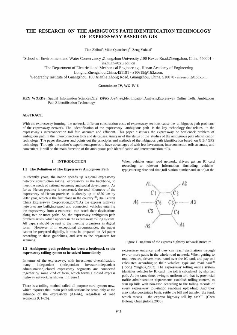
Introducing GIS into the expressway to identify ambiguous path, the basic work is the construction of the expressway geographic database. The present expressway toll takes a province as collection tolling construction unit, so we must construct provincial level expressway geographic databases. Because of ambiguous path identification servicing for toll networked calculation, it need to provide the accurate location of vehicles passing through entrances, exits and marking points of the ambiguous segments and calculate path length accurately. The expressway data is superimposed on a topographic map of basic serial scales, and it needs to process the expressway map data including collection, projection and correction. Chinese provincial administration unit area is comparatively large, most more than 10,000 KM2(some west provinces and autonomous regions area are more than 100,000KM2). According to the requirement of rules for locating expressway by Ministry of Communications, the fundamental exchange of information map selected by expressway reference system has three sorts: the exchange map of municipality, provincial capital, big city and local level city is 1:50000(for personal use one can select from 1:10000 to 1:100000 series) scales topographic map; the provincial exchange map is 1:250000(the northwest area for personal use one can select 1:500000) scales topographic map; the country and traffic industry exchange map is 1:1000000(ministry for personal use one can select from
1:2500000 to 1:5000000 series)scales topographic map[6] (Ministry of Communications,1997) . According to purposes, the expressway thematic-map data can be classified into several sorts: the expressway line and its construction, such as bridge, channel, tolls-station, service district, expressway maintenance spot, communication construction and so on. The line is the core of data among them. It requires organizing GIS-T data around the line of road, and organizing the construction along lines simultaneously (Figure 2) [7]( Tian Zhihui, Hu peng ,Wu Fang, Xiong Wei,2005). Road segment is the basic unit of the express highway. In the interior of segments, a line is the same. The division of line segment is based on many factors that can bring ambiguous , such as expressway miles, property of road ,quantity of line lanes and so on. 3.2 The ambiguous path identification method based on shortest path algorithm
In GIS network analysis, the shortest path algorithm is the basic, and ambiguous path identification method based on the shortest path algorithm also is the most common way in the expressway toll online now. There are many algorithms in researches and applications both at home and abroad, among them, Dijkstra is more classical than others. We will find its concrete algorithm in document[8]( Hu Peng,You Lian.2002). It usually applies in ambiguous path analysis. Its principle is the following: in road network, supposing the traffic flow between any two notes intensively passes through some line which is with the smallest impedance (travel time or path length can replace it), but flow on other lines is zero. So, we can use the methods of the shortest path algorithm to assign toll to investor’s corporation. It doesn’t need too many equipment investments. But practically, the travel time of ambiguous path segments isn’t fixed, which varies as this segment flows. If we use time to calculate, then the path is varied; although the shortest path length of ambiguous path is the only value, when two paths are almost equally long, it relates to drivers’ decisions and habits to choose the driving path. The expressway toll is calculated with shortest path algorithm in Shanghai, so the toll collection and division contradict the practical driving path. This contradiction leads to the face that some investors on longer paths can’t get toll. So, shortest path method can’t satisfy investors with a uniform view.
Figure 2 The Data of the GIS-T organized around the line of
road
945
The International Archives of the Photogrammetry, Remote Sensing and Spatial Information Sciences. Vol. XXXVII. Part B4. Beijing 2008
3.3 The ambiguous path identification method based on traffic probability allocation model
When taking GIS to identify ambiguous path, it can adopt the ambiguous path identification method based on traffic probability allocation model. Supposing there are many paths but little flow between two points, and the flow obviously runs along shortest path. With flow increasing, the flow on shortest path will increase. And when it is up to some degree, the driving time on this path will be prolonged because of traffic jam. In this situation, this path is no longer shortest path. Thus, part of users will choose new shortest path. As the flow between two points still increases, the paths between of these points are all occupied, till the driving times on that paths are equal, and at the end they are in balance. When all of the road network users know network situation and try to choose shortest path, the network is in balance. in some networks where users considerate the driving time influence made by congestion, when networks reach balance, paths used by every group OD are with equal and the smallest driving time, and the driving time is more than or equal to shortest time on those paths not used. This definition is called Wardrop's first principle or Wardrop balance[9]( Pei Yulong,2004). In traffic network allocation models, the application of ambiguous path probability allocation method is most wide. The principle is that, in every expressway network, passing times between entrances and exits are in proportion allocated to many replaceable lines. If a driver chooses a line K from feasible lines connecting entrances and exits, the proportion is as following:
∑ −−=k
ee TTkp kkθθ)( (1)
In this formula: )(kp --the proportion of choosing line K; TK—driving time on line K;
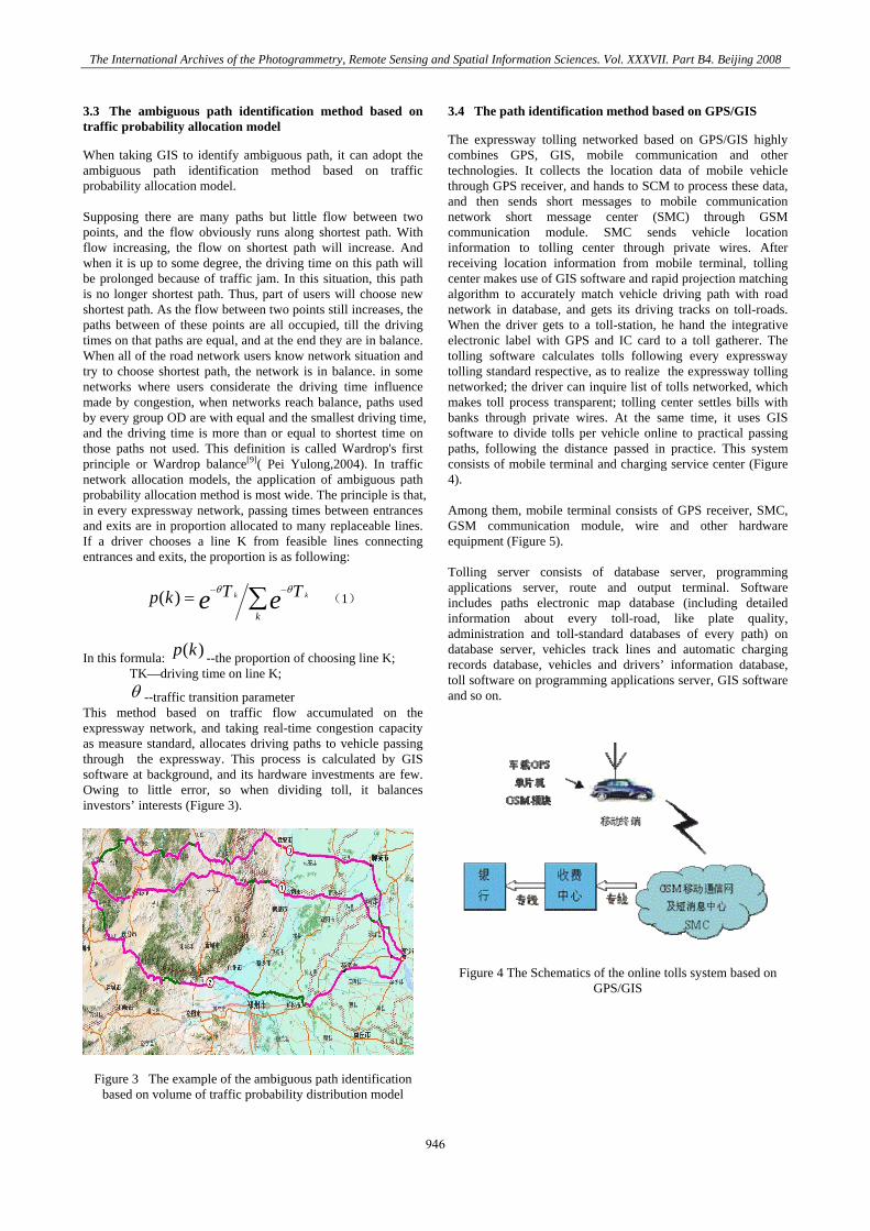
θ --traffic transition parameter This method based on traffic flow accumulated on the expressway network, and taking real-time congestion capacity as measure standard, allocates driving paths to vehicle passing through the expressway. This process is calculated by GIS software at background, and its hardware investments are few. Owing to little error, so when dividing toll, it balances investors’ interests (Figure 3).
Figure 3 The example of the ambiguous path identification based on volume of traffic probability distribution model
3.4 The path identification method based on GPS/GIS
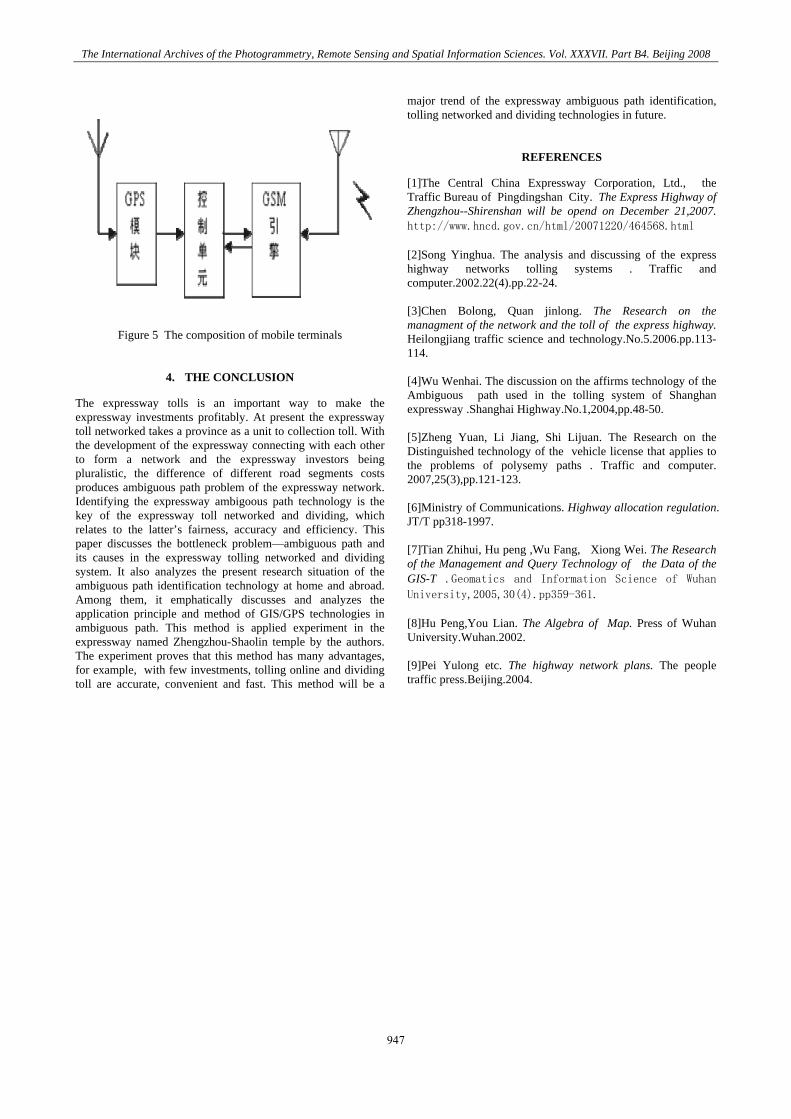
The expressway tolling networked based on GPS/GIS highly combines GPS, GIS, mobile communication and other technologies. It collects the location data of mobile vehicle through GPS receiver, and hands to SCM to process these data, and then sends short messages to mobile communication network short message center (SMC) through GSM communication module. SMC sends vehicle location information to tolling center through private wires. After receiving location information from mobile terminal, tolling center makes use of GIS software and rapid projection matching algorithm to accurately match vehicle driving path with road network in database, and gets its driving tracks on toll-roads. When the driver gets to a toll-station, he hand the integrative electronic label with GPS and IC card to a toll gatherer. The tolling software calculates tolls following every expressway tolling standard respective, as to realize the expressway tolling networked; the driver can inquire list of tolls networked, which makes toll process transparent; tolling center settles bills with banks through private wires. At the same time, it uses GIS software to divide tolls per vehicle online to practical passing paths, following the distance passed in practice. This system consists of mobile terminal and charging service center (Figure 4). Among them, mobile terminal consists of GPS receiver, SMC, GSM communication module, wire and other hardware equipment (Figure 5). Tolling server consists of database server, programming applications server, route and output terminal. Software includes paths electronic map database (including detailed information about every toll-road, like plate quality, administration and toll-standard databases of every path) on database server, vehicles track lines and automatic charging records database, vehicles and drivers’ information database, toll software on programming applications server, GIS software and so on.
Figure 4 The Schematics of the online tolls system based on GPS/GIS
946
The International Archives of the Photogrammetry, Remote Sensing and Spatial Information Sciences. Vol. XXXVII. Part B4. Beijing 2008
Figure 5 The composition of mobile terminals
4. THE CONCLUSION
The expressway tolls is an important way to make the expressway investments profitably. At present the expressway toll networked takes a province as a unit to collection toll. With the development of the expressway connecting with each other to form a network and the expressway investors being pluralistic, the difference of different road segments costs produces ambiguous path problem of the expressway network. Identifying the expressway ambigoous path technology is the key of the expressway toll networked and dividing, which relates to the latter’s fairness, accuracy and efficiency. This paper discusses the bottleneck problem—ambiguous path and its causes in the expressway tolling networked and dividing system. It also analyzes the present research situation of the ambiguous path identification technology at home and abroad. Among them, it emphatically discusses and analyzes the application principle and method of GIS/GPS technologies in ambiguous path. This method is applied experiment in the expressway named Zhengzhou-Shaolin temple by the authors. The experiment proves that this method has many advantages, for example, with few investments, tolling online and dividing toll are accurate, convenient and fast. This method will be a
major trend of the expressway ambiguous path identification, tolling networked and dividing technologies in future.
REFERENCES
[1]The Central China Expressway Corporation, Ltd., the Traffic Bureau of Pingdingshan City. The Express Highway of Zhengzhou--Shirenshan will be opend on December 21,2007. http://www.hncd.gov.cn/html/20071220/464568.html [2]Song Yinghua. The analysis and discussing of the express highway networks tolling systems . Traffic and computer.2002.22(4).pp.22-24. [3]Chen Bolong, Quan jinlong. The Research on the managment of the network and the toll of the express highway. Heilongjiang traffic science and technology.No.5.2006.pp.113-114. [4]Wu Wenhai. The discussion on the affirms technology of the Ambiguous path used in the tolling system of Shanghan expressway .Shanghai Highway.No.1,2004,pp.48-50. [5]Zheng Yuan, Li Jiang, Shi Lijuan. The Research on the Distinguished technology of the vehicle license that applies to the problems of polysemy paths . Traffic and computer. 2007,25(3),pp.121-123. [6]Ministry of Communications. Highway allocation regulation. JT/T pp318-1997. [7]Tian Zhihui, Hu peng ,Wu Fang, Xiong Wei. The Research of the Management and Query Technology of the Data of the GIS-T .Geomatics and Information Science of Wuhan University,2005,30(4).pp359-361. [8]Hu Peng,You Lian. The Algebra of Map. Press of Wuhan University.Wuhan.2002. [9]Pei Yulong etc. The highway network plans. The people traffic press.Beijing.2004.
947

The International Archives of the Photogrammetry, Remote Sensing and Spatial Information Sciences. Vol. XXXVII. Part B4. Beijing 2008
948