Embed Size (px)
Citation preview

i
The River Stiffkey
A State of the Environment Report
Produced by Norfolk Biodiversity Information
Service
Spring 2014
© Hugh Venables
© Galatas
© nick macneill
© N Chadwick

ii
Cover Photos Clockwise from top left: Stiffkey Saltmarsh (©Hugh Venables and licensed for reuse under this Creative
Commons Licence); Brown Hare (©Galatas and licensed for reuse under this Creative Commons Licence); River Stiffkey
(©N Chadwick and licensed for reuse under this Creative Commons Licence); Binham Priory (©nick macneill and licensed
for reuse under this Creative Commons Licence).
Norfolk Biodiversity Information Service (NBIS) is a Local Record Centre holding
information on species, geodiversity, habitats and protected sites for the county of
Norfolk. For more information see our website: www.nbis.org.uk
This report is available for download from the NBIS website www.nbis.org.uk
Report written by Lizzy Oddy, May 2014.
Acknowledgements:
The author would like to thank the following people for their help and input into this
report: Mark Andrews (Environment Agency); Prof Anthony Davy (University of East
Anglia); Tim Jacklin (Wild Trout trust); Dr Hannah Mossman (Manchester Metropolitan
University); Kelly Powell (Norfolk County Council Historic Environment Service); Julia
Stansfield (Environment Agency); Sarah Taigel (University of East Anglia); Jonah Tosney
(Norfolk Rivers Trust).
iii
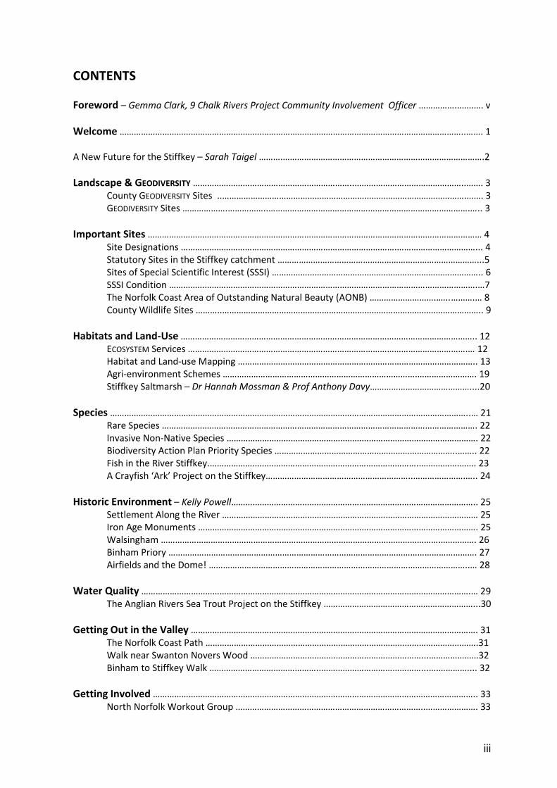
CONTENTS
Foreword – Gemma Clark, 9 Chalk Rivers Project Community Involvement Officer ……………..………. v
Welcome ………………………………………………………………………………………………………………………………..……. 1
A New Future for the Stiffkey – Sarah Taigel ……….………………………………………………………………………….2
Landscape & GEODIVERSITY …………………………………………………………..………………………………………..……. 3
County GEODIVERSITY Sites ..………………………………………………………………………………………….……. 3
GEODIVERSITY Sites ……………….……………..………………………………………………………………………….….. 3
Important Sites …………………………………………………………………………………………………………………………… 4
Site Designations ……………………………………………………………………………….……………………………... 4
Statutory Sites in the Stiffkey catchment …………………………………………………………………………...5
Sites of Special Scientific Interest (SSSI) …………………………………………………………………………….. 6
SSSI Condition ………………………………………………………………………………………………………………….…7
The Norfolk Coast Area of Outstanding Natural Beauty (AONB) ………………………..…..……….… 8
County Wildlife Sites ………..……………………………………………………………………………………………….. 9
Habitats and Land-Use …………………………………………………………………………………………………………….. 12
ECOSYSTEM Services ……………………………………………………………………………………………………….… 12
Habitat and Land-use Mapping ……………………………………………………………………………………….. 13
Agri-environment Schemes ……………………………………………………………………….……………………. 19
Stiffkey Saltmarsh – Dr Hannah Mossman & Prof Anthony Davy……………………………………....20
Species ……………………………………………………………………………………………………………………………………..… 21
Rare Species ……………………………………………………………………………………………………………………. 22
Invasive Non-Native Species ……………………………………………………………………………………………. 22
Biodiversity Action Plan Priority Species …………………………………………………………………..…….. 22
Fish in the River Stiffkey.……………………………………………………………………………..…………….……. 23
A Crayfish ‘Ark’ Project on the Stiffkey……………………………………………………..………………….….. 24
Historic Environment – Kelly Powell………………………………………………………………………………………….. 25
Settlement Along the River ……………………………………………………………………………………………… 25
Iron Age Monuments ………………………………………………………………………………………………………. 25
Walsingham ……………………………………………………………………………………………………………………. 26
Binham Priory …………………………………………………………………………………………………………………. 27
Airfields and the Dome! ………………………………………………………………………………………………..… 28
Water Quality ………………………………………………………………………………………………………………………….… 29
The Anglian Rivers Sea Trout Project on the Stiffkey ………………………………………………………...30
Getting Out in the Valley …………………………………………………………………………………………………………. 31
The Norfolk Coast Path …………………………………………………………………………………………………….31
Walk near Swanton Novers Wood ………………………………………………………………...…………………32
Binham to Stiffkey Walk ………………………………………..……………………………………...….………….... 32
Getting Involved ……………………………………………………………………………………………………………………….. 33
North Norfolk Workout Group ……………………………………………………………………..…………………. 33

iv
Species Recording …………………………………………………………………………………………………….…….. 34
The Countryside Code ……………………………………………………………………………….……................. 35
Glossary ……………………………………………………………………………………………………..…………….……. 36
Useful Web Links …………………………………………………………………………………..………………………. 38

v
FOREWORD
The River Stiffkey (or Stewkey as is sometimes locally known) rises from its source from a small
wooded lake in Swanton Novers. It then travels through and passes the villages of Fulmodeston,
Great Snoring, East Barsham, North Barsham, Houghton St Giles and Little Walsingham.
Like many rivers its cultural and historical influence can still be seen, such as by the impressive
priory in Walsingham and the Iron Age Hill Fort at Warham. These significant settlements were no
doubt selected due to their proximity to the river which at the time would have transported goods
and materials in flat bottomed barges.
The river itself is a very beautiful and ecologically rich habitat and has a good population of brown
trout. It is also surrounded by some of the country’s best arable farmland. Some of these farmers
are working with the Norfolk Rivers Trust to help improve the quality of the river that flows through
their land and these individuals are crucial players in the long term management and health of the
river.
The river then runs through Great Walsingham, Wighton, Warham and Stiffkey before meeting the
marshes at Blakeney. In total the river is around 18 miles long from source to sea.
The river is special in that it is a chalk river of which there are only around 200 in the world. It is
surrounded by arable land, coniferous plantations, woodland and marshland.
Access to this river is relatively limited. However for wildlife and river enthusiasts there are spots at
which you are guaranteed to see something special. Water voles and otters are regular visitors
along with buzzards, osprey, barn owls and kingfishers. Trout and brook lamprey may be glimpsed in
the clear waters. The river is also special for INVERTEBRATES and includes a wide selection of
damselflies and dragonflies.
There are some good accessible points, including Public Rights of Way, a circular walk near the
source at Swanton Novers, four fords at Houghton St Giles and three permissive walks at Binham
that take in the breathtaking Priory. There is also the hill fort at Warham and a linear walk via
Cockthorpe Common linking to the Norfolk Coast Path National Trail and following the river to the
sea.
The 9 Chalk Rivers project recognises the important part the river plays in the wider area both for
wildlife and people. The river has been modified (straightened) in places. It also suffers from silt
build up from roads and adjacent farmland. Habitats need to be improved for species alongside the
need for better flood storage solutions to safeguard communities. Enhancement work from the
Norfolk Rivers Trust aims to improve functioning and quality for wildlife and people even more.
I hope you enjoy reading this guide to the river and please do see it for yourself. Norfolk is so lucky
to be blessed with the presence of these amazing chalk rivers, which truly are gems of the natural
world. However they need our attention if we want to safeguard their future so if you want to
get involved with the work of the project then we would love to hear from you.
Gemma Clark - 9 Chalk Rivers Project Community Involvement Officer
http://www.norfolkriverstrust.org/

vi
1
WELCOME
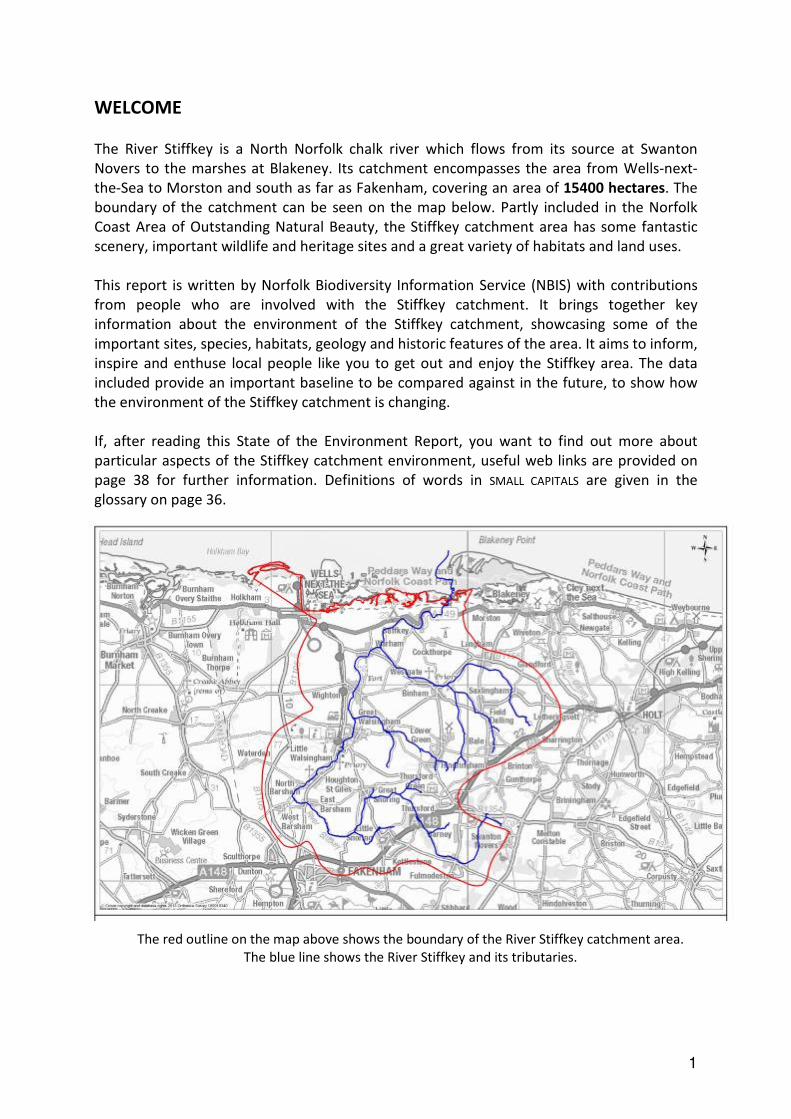
The River Stiffkey is a North Norfolk chalk river which flows from its source at Swanton
Novers to the marshes at Blakeney. Its catchment encompasses the area from Wells-next-
the-Sea to Morston and south as far as Fakenham, covering an area of 15400 hectares. The
boundary of the catchment can be seen on the map below. Partly included in the Norfolk
Coast Area of Outstanding Natural Beauty, the Stiffkey catchment area has some fantastic
scenery, important wildlife and heritage sites and a great variety of habitats and land uses.
This report is written by Norfolk Biodiversity Information Service (NBIS) with contributions
from people who are involved with the Stiffkey catchment. It brings together key
information about the environment of the Stiffkey catchment, showcasing some of the
important sites, species, habitats, geology and historic features of the area. It aims to inform,
inspire and enthuse local people like you to get out and enjoy the Stiffkey area. The data
included provide an important baseline to be compared against in the future, to show how
the environment of the Stiffkey catchment is changing.
If, after reading this State of the Environment Report, you want to find out more about
particular aspects of the Stiffkey catchment environment, useful web links are provided on
page 38 for further information. Definitions of words in SMALL CAPITALS are given in the
glossary on page 36.
The red outline on the map above shows the boundary of the River Stiffkey catchment area.
The blue line shows the River Stiffkey and its tributaries.

2
A New Future for the Stiffkey – Sarah Taigel, UEA
Over the first half of 2013 a collaborative project between the Norfolk Rivers Trust and a team
from the UEA successfully developed and trialled a unique approach to creating a catchment
management plan for the Stiffkey. The most important catchment issues were seen to be:
- Silt runoff and build up requiring in river dredging
- Lack of river function due to CANALISATION and the river being detached from its floodplain
- Low flow, seasonal flooding and lack of buffering (no wetlands) impacting in-channel habitat
- Lack of access for community to enjoy the recreation potential of the river area
The UEA team created 3D computer models and
maps representing the current landscape and a
possible future landscape if the river was restored.
During March 2013 these models and maps were
shown at workshops for stakeholders to gather
feedback on these issues within the Stiffkey
catchment. Comments on the visualisations were
displayed at a second open day in May 2013 to
allow additional contact with a wider community
focus.
Overall results indicated unanimous agreement that priority should be given to the reduction and
mitigation of silt runoff into the river network. Improving the habitat along the river and reducing
damaging flooding were considered equally important.
Feedback indicated a good response to the idea of restoring sections of the River Stiffkey. In
particular comments were noted on the potential for improved water quality, better quality
habitat, and the more natural aesthetics of the restored land form and possibility of improved
access.
The Stiffkey visioning research has been developed as part of a PhD based at the UEA to develop tools to enable the visioning of
future catchment landscapes. Sarah Taigel’s research is being conducted as part of ESRC PhD Studentship No. ES/I022139/1

3
LANDSCAPE AND GEODIVERSITY
County GEODIVERSITY Site
There is one County GEODIVERSITY Site (CGS) within the Stiffkey catchment. A CGS is a tier
above GEODIVERSITY Sites (see below) and has the same status in planning as a County Wildlife
Site (see page 4) They are designated by the Norfolk CGS Group which is a sub-committee of
the Geological Society of Norfolk.
Rising Hill CGS is a small private gravel pit, occasionally used by the owner for farm
aggregates, ensuring fresh exposures. The main sections reveal tills, gravels and sands from
the latter part of the ANGLIAN GLACIAL PERIOD.
(Information from CGS Citation)
GEODIVERSITY Sites
These are non-designated sites of GEODIVERSITY interest determined by the Norfolk
GEODIVERSITY Partnership. There are nine GEODIVERSITY sites within the Stiffkey catchment.
These are:
Name Description
Four Acre Plantation Pit Disused gravel pit
Little Barney Brickworks Former brickworks
Rising Hill Pit Overgrown disused quarry
Smoker’s Hole Gravel Pit Small farm pit
Morston Cliff Cliff
Cockthorpe Chalk Pit Small exposure
Hall Farm Chalk Pit & Stiffkey Chalk Pit Disused chalk pit
Wells Chalk Pit & Leicester Lime
Company Pit
Disused chalk pit
Wells Railway Cutting Old railway cutting used as a contractors yard
GEODIVERSITY underpins the landscape of the Stiffkey catchment. Natural processes have
been working over many thousands (and millions) of years to produce the landforms and
soils of the valley, and the range of important wildlife habitats we see today.
GEODIVERSITY has made a big contribution to human life through resources which we often
take for granted such as drinking water, minerals, building stone and soils for farming.

4
IMPORTANT SITES
Did you know that there are sites within the Stiffkey catchment that are important for
their wildlife or geology at a county, national or even international level? These sites are
crucial for the conservation of rare plants, animals and geology, and many of them are
open to the public allowing you to explore and experience nature for yourself.
Site Designations
There are a number of designations that a site can be given in the UK, providing different
levels of protection. For example, ‘statutory sites’ are protected by law in the planning
process, while ‘non-statutory’ sites are not, although they are still recognised as
important and taken into account in planning. The different levels of designation are
summarised below:
Designation Description
Ramsar Site Statutory
international
An internationally important wetland site,
designated under the RAMSAR CONVENTION.
Special Protection
Area (SPA)
Statutory
international
European designation for sites of international
importance for birds.
Special Area of
Conservation (SAC)
Statutory
international
European protected site designated by the UK
government. Sites of international importance
under the EC HABITATS DIRECTIVE.
Site of Special
Scientific Interest
(SSSI)
Statutory
national
Designated and protected by Natural England as
the best sites for wildlife or geology in the
country.
National Nature
Reserve (NNR)
Statutory
national
A site of national importance for nature
conservation. Allow scientific research and most
have at least some public access.
Local Nature
Reserve (LNR)
Statutory
local
A site of special nature conservation interest
locally, designated by local authorities.
County Wildlife Site
(CWS)
Non-
statutory
county
Sites outside of statutory protected areas but of
wildlife importance at a county level.

5
Statutory Sites in the Stiffkey Catchment
Site Type Site Name Area within Stiffkey catchment (ha)
Ramsar North Norfolk Coast 461.7
Special Area of
Conservation
North Norfolk Coast 441.6
Special Area of
Conservation
The Wash & North Norfolk Coast 21.3
Special Protection
Area
N Norfolk Coast 461.7
National Nature
Reserve
Swanton Novers Wood 41.4
National Nature
Reserve
Blakeney 412.4
National Nature
Reserve
Holkham 160
Local Nature
Reserve
Hindringham Meadows 6.82
Stiffkey Saltmarsh © Hugh Venables and licensed for reuse under this Creative Commons Licence
6
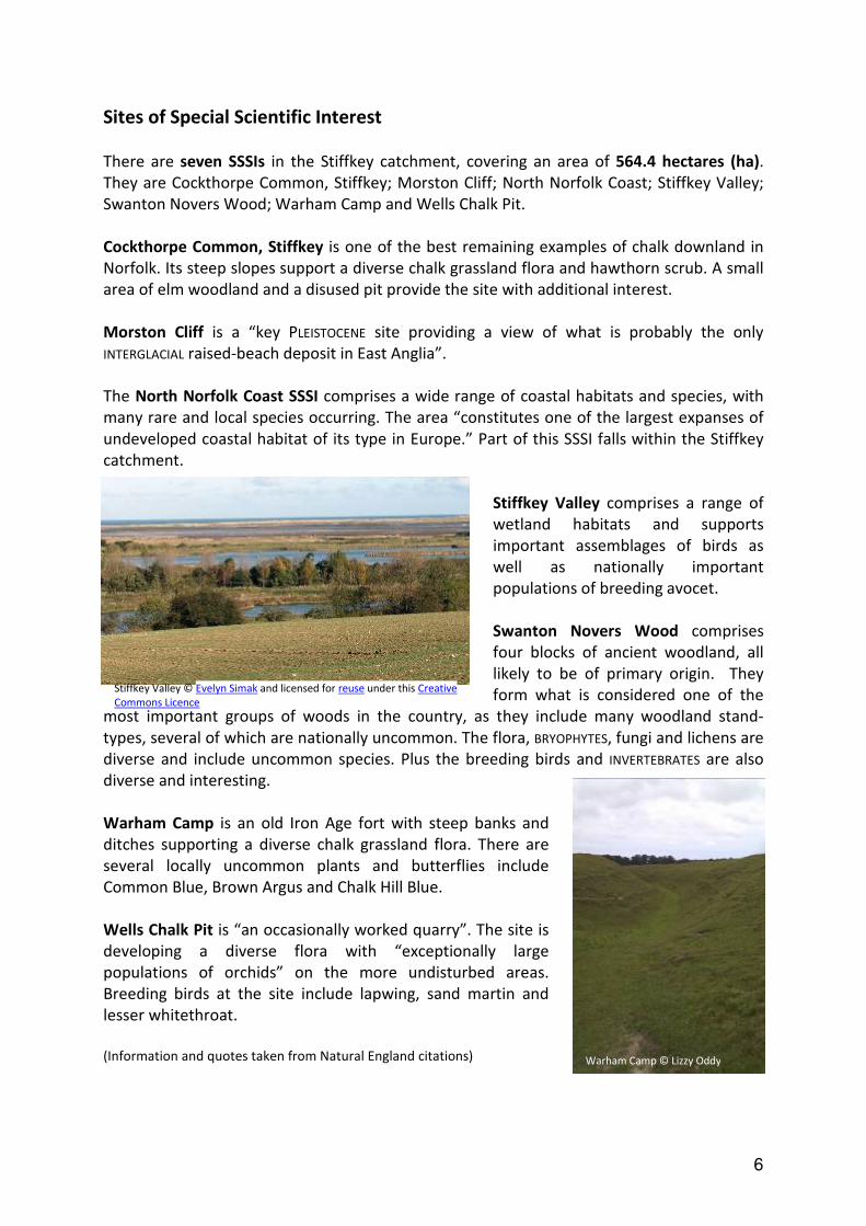
Sites of Special Scientific Interest
There are seven SSSIs in the Stiffkey catchment, covering an area of 564.4 hectares (ha).
They are Cockthorpe Common, Stiffkey; Morston Cliff; North Norfolk Coast; Stiffkey Valley;
Swanton Novers Wood; Warham Camp and Wells Chalk Pit.
Cockthorpe Common, Stiffkey is one of the best remaining examples of chalk downland in
Norfolk. Its steep slopes support a diverse chalk grassland flora and hawthorn scrub. A small
area of elm woodland and a disused pit provide the site with additional interest.
Morston Cliff is a “key PLEISTOCENE site providing a view of what is probably the only
INTERGLACIAL raised-beach deposit in East Anglia”.
The North Norfolk Coast SSSI comprises a wide range of coastal habitats and species, with
many rare and local species occurring. The area “constitutes one of the largest expanses of
undeveloped coastal habitat of its type in Europe.” Part of this SSSI falls within the Stiffkey
catchment.
Stiffkey Valley comprises a range of
wetland habitats and supports
important assemblages of birds as
well as nationally important
populations of breeding avocet.
Swanton Novers Wood comprises
four blocks of ancient woodland, all
likely to be of primary origin. They
form what is considered one of the
most important groups of woods in the country, as they include many woodland stand-
types, several of which are nationally uncommon. The flora, BRYOPHYTES, fungi and lichens are
diverse and include uncommon species. Plus the breeding birds and INVERTEBRATES are also
diverse and interesting.
Warham Camp is an old Iron Age fort with steep banks and
ditches supporting a diverse chalk grassland flora. There are
several locally uncommon plants and butterflies include
Common Blue, Brown Argus and Chalk Hill Blue.
Wells Chalk Pit is “an occasionally worked quarry”. The site is
developing a diverse flora with “exceptionally large
populations of orchids” on the more undisturbed areas.
Breeding birds at the site include lapwing, sand martin and
lesser whitethroat.
(Information and quotes taken from Natural England citations)
Stiffkey Valley © Evelyn Simak and licensed for reuse under this Creative
Commons Licence
Warham Camp © Lizzy Oddy

7
(Information taken from the Natural England website: http://www.sssi.naturalengland.org.uk/special/sssi/glossary.cfm)
SSSI Condition* Last Monitored
Cockthorpe Common,
Stiffkey
Unfavourable Recovering Sep 2013
Morston Cliff Unfavourable Recovering Mar 2010
North Norfolk Coast Favourable – 68 units
Unfavourable Recovering – 2
units
Various dates
Stiffkey Valley Unfavourable Recovering Sep 2013
Swanton Novers Wood Unfavourable Recovering Sep 2011 & Oct 2013
Warham Camp Favourable July 2009
Wells Chalk Pit Unfavourable Recovering July 2010
* See ‘SSSI Condition’ box above for further information
(Information taken from http://www.sssi.naturalengland.org.uk/Special/sssi/search.cfm)
.
SSSI Condition
SSSIs are managed by Natural England who regularly assesses their condition under six
categories:
Favourable: This means the site is being adequately conserved and is meeting its
conservation objectives.
Unfavourable Recovering: All the necessary management measures are in place on the
site and provided that this is sustained, favourable condition will be reached in time.
Unfavourable No Change: The site is not being conserved and is in poor, but not
worsening condition. The longer it remains in this state the more difficult it is likely to be
to achieve recovery.
Unfavourable Declining: The site condition is becoming progressively worse and changes
to site management or external pressures are needed to reverse this.
Part Destroyed: Part of the special interest feature of the site has suffered lasting
damage and will never recover.
Destroyed: All of the special interest feature of the site has suffered lasting damage and
will never recover.

8
The Norfolk Coast Area of Outstanding Natural Beauty (AONB)
Designated in 1968, the Norfolk Coast AONB stretches from the Wash in the west through to the
dune system at Winterton in the east. It is an area of remarkable beauty, diversity and scientific
importance.
The AONB contains habitats including sand and mud flats, dunes, shingle, saltmarsh, reedbeds,
grazing marsh and soft cliffs. The natural beauty of the area includes its distinctive wildlife and
cultural heritage as well as the scenic beauty of the landscape.
The Norfolk Coast Partnership has been running since 1991. It aims to “conserve and enhance the
natural beauty of the area, to facilitate and enhance public enjoyment, understanding and
appreciation of the area and to provide sustainable forms of social and economic development
that in themselves conserve and enhance the area’s natural beauty.”
(Information and quotes from: http://www.norfolkcoastaonb.org.uk/index.php)
Map showing where the Stiffkey catchment area falls within the Norfolk Coast Area of Outstanding
Natural Beauty.

9
County Wildlife Sites
County Wildlife Sites (CWS) are particularly important sites for wildlife in Norfolk. While not
protected by law, they are taken into account in the planning process. There are 34 CWS in
the Stiffkey catchment, covering an area of 159.23 ha. Many CWS are privately owned and
do not allow public access. However two of them are publicly accessible (see pg 11).
County Wildlife Site Monitoring
County Wildlife Sites are monitored every year
to determine what percentage of them is in
Positive Conservation Management. The
statistic for each district is reported to central
government.
Being in Positive Conservation Management
means that a site is actively being maintained or
improved for the species for which is designated
as important. This is often achieved through
Environmental Stewardship schemes. Such
schemes are run by Defra, and they encourage
farmers and landowners to manage their land in
a way that provides benefits to the environment
alongside the traditional farming outputs such
as crops and livestock (see page 19 for more
information on Environmental Stewardship).
In the reporting year 2012/13, of the 34 County
Wildlife Sites within or overlapping the Stiffkey
catchment 26 of them (76.5%) were in positive
conservation management and 8 of them
(23.5%) were not.
Thursford Wood County Wildlife Site © Evelyn
Simak and licensed for reuse under this Creative
Commons Licence

10
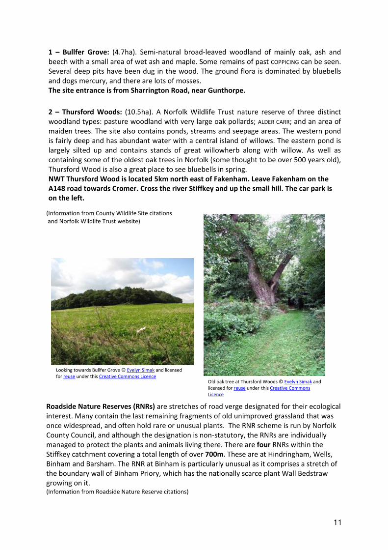
County Wildlife Sites with public access within the Stiffkey catchment
1 – Bullfer Grove
2 – Thursford Woods
2
1
11
(Information from County Wildlife Site citations
and Norfolk Wildlife Trust website)
Roadside Nature Reserves (RNRs) are stretches of road verge designated for their ecological
interest. Many contain the last remaining fragments of old unimproved grassland that was
once widespread, and often hold rare or unusual plants. The RNR scheme is run by Norfolk
County Council, and although the designation is non-statutory, the RNRs are individually
managed to protect the plants and animals living there. There are four RNRs within the
Stiffkey catchment covering a total length of over 700m. These are at Hindringham, Wells,
Binham and Barsham. The RNR at Binham is particularly unusual as it comprises a stretch of
the boundary wall of Binham Priory, which has the nationally scarce plant Wall Bedstraw
growing on it. (Information from Roadside Nature Reserve citations)
1 – Bullfer Grove: (4.7ha). Semi-natural broad-leaved woodland of mainly oak, ash and
beech with a small area of wet ash and maple. Some remains of past COPPICING can be seen.
Several deep pits have been dug in the wood. The ground flora is dominated by bluebells
and dogs mercury, and there are lots of mosses.
The site entrance is from Sharrington Road, near Gunthorpe.
2 – Thursford Woods: (10.5ha). A Norfolk Wildlife Trust nature reserve of three distinct
woodland types: pasture woodland with very large oak pollards; ALDER CARR; and an area of
maiden trees. The site also contains ponds, streams and seepage areas. The western pond
is fairly deep and has abundant water with a central island of willows. The eastern pond is
largely silted up and contains stands of great willowherb along with willow. As well as
containing some of the oldest oak trees in Norfolk (some thought to be over 500 years old),
Thursford Wood is also a great place to see bluebells in spring.
NWT Thursford Wood is located 5km north east of Fakenham. Leave Fakenham on the
A148 road towards Cromer. Cross the river Stiffkey and up the small hill. The car park is
on the left.
Looking towards Bullfer Grove © Evelyn Simak and licensed
for reuse under this Creative Commons Licence Old oak tree at Thursford Woods © Evelyn Simak and
licensed for reuse under this Creative Commons
Licence

12
HABITATS AND LAND USE
Different habitats also provide different ‘services’ to people. For example woodlands provide
timber and help absorb CO2. Areas of grassland in built-up areas are important for flood
prevention during heavy rain, as they allow the excess water to soak into the ground. Plus,
getting out into nature helps people to unwind and relax from the stresses of daily life. This
concept, known as ‘ECOSYSTEM Services’ is explained further below.
ECOSYSTEM Services
As humans we gain many benefits from natural ECOSYSTEMS. These are known as ECOSYSTEM
services and they can be divided into four categories:
Provisioning – nature providing us with goods such as food, fuel, fresh water, natural
medicines and biochemicals.
Regulating – nature providing services such as pollination, pest control, water purification
and climate regulation.
Cultural – the non-material benefits of nature, such as spiritual enrichment, recreation and
aesthetic experiences.
Supporting – nature providing services which underpin all the other ECOSYSTEM services,
such as soil creation, nutrient cycling and photosynthesis.
Over the last few years, more and more people have realised the importance of the
natural world to the health, wellbeing and even the survival of humans. Many ECOSYSTEM
services are being assigned monetary values, often based on how much it would cost to
replace the service with a human-made alternative. This helps decision makers by
expressing the value of an ECOSYSTEM in a tangible way, but can be controversial. Some
people argue that the ‘intrinsic value’ of nature should be reason enough to conserve it.
A habitat is “an environment in which an organism or ecological community normally lives
or occurs”. While some species are able to live in a variety of habitats, there are others
that can only survive in a particular habitat type. Land use describes how the land is being
utilised by people.

13
Habitat and Land-Use Mapping
The map on page 15 shows the different habitat types (e.g. saltmarsh, neutral grassland,
deciduous woodland etc) and land uses (e.g. arable land, golf courses, churchyards etc)
within the boundary of the Stiffkey catchment.
The habitats and land uses were mapped from a combination of aerial photographs and
from the Natural England Priority Habitat Inventory information held by NBIS. In some cases,
exact habitat types could not be determined using these methods e.g. grassland types not
included in the Natural England Priority Habitat Inventories. In this case, the area was
mapped as ‘undetermined grassland’.
The final map was used to determine the overall area of each habitat and land-use type in
the Stiffkey catchement. These areas can be compared over time to reveal losses or gains in
particular habitats and land-uses.
Pond at Langham © Norfolk Rivers Trust

14

15

16

17
Grassland – There are a number of types of grassland within the Stiffkey catchment area.
These include Calcareous Grassland (30.8ha, 0.2% of total area), Neutral Grassland
(including Lowland Meadows, 119.38ha, approx 0.8% of total area) and Coastal and
Floodplain Grazing Marsh (173.22ha, approx 1.1% of total area). These are all Biodiversity
Action Plan habitats. Calcareous grassland is found on base rich soils and often supports a
very rich flora, including nationally rare or scarce species (UKBAP 2007). Unimproved neutral
grassland can be found on a wide variety of sites – from grazed or hay-cut fields to
recreation grounds and churchyards. The habitat has undergone a dramatic decline over the
last century, mainly due to
changes in farming methods .
Coastal and Floodplain Grazing
Marsh is defined as “periodically
inundated pasture, or meadow
with ditches which maintain the
water levels, containing standing
brackish or fresh water” (UKBAP
2007). It is usually grazed, or
cut for hay or silage, and is
important for both breeding and
wintering birds. Much of the
habitat and land
use mapping for the area was
completed using aerial photos,
which doesn’t allow for different grassland types to be determined. Therefore any grassland
areas not included in the Natural England Priority Habitat Inventory Mapping have been
classified as Undetermined Grassland (1203ha, 7.8% of total area).
Woodland – The Stiffkey Catchment contains both deciduous (609.4, 3.95% of total area)
and coniferous woodland (302.6ha, 1.96% of total area). Some of the woodlands are also
classified as ancient woodland or wet woodland.
Wet woodland (41.7ha; 0.27% of total area) is important for many species. The high
humidity levels are ideal for mosses to grow. Deadwood in association with water provides a
Floodplain grazing marsh by the River Stiffkey © N Chadwick and licensed
for reuse under this Creative Commons Licence
Oak and sycamore woodland south of Stiffkey Marshes © N Chadwick and
licensed for reuse under this Creative Commons Licence
unique habitat important for
many invertebrates.
Ancient woodland (41.2ha;
0.27% of total area) is defined as
an area that has been
continuously wooded since at
least 1600AD. It can include both
semi-natural woodland and
plantations on ancient woodland
sites. Ancient woodland is rare –
it is thought to cover just 3% of
England’s land area. It is also
exceptionally rich in wildlife, and
can act as a reservoir from which
wildlife can spread out into new
woodlands.

18
Mudflats (22.3ha; 0.14% of total area) – This
intertidal habitat consists of deposited clay
and silt sediments. It is commonly found
between subtidal channels and saltmarsh.
Mudflats are known for their high productivity
but relatively low diversity of species present.
They can support large numbers of predatory
birds and fish.
Saltmarsh (627.2 ha; 4% of total area) – Coastal saltmarsh consists of the upper, vegetated
portions of intertidal mudflats. The vegetation on a saltmarsh is limited to a low number of
salt-tolerant species which are adapted to regular immersion by the tides. They act as an
important resource for wading birds and wildfowl, and provide sheltered nursery sites for
several species of fish. Since medieval times, many saltmarshes have been converted to
agricultural land.
(Information taken from UK Biodiversity Action Plan documents)
Mudflats at Stiffkey saltmarsh © Evelyn Simak and licensed
for reuse under this Creative Commons Licence
Stiffkey saltmarsh © Hugh Venables and licensed for reuse under
this Creative Commons Licence
Stiffkey saltmarsh © Phil Champion and licensed for reuse under
this Creative Commons Licence

19
Arable areas can sometimes seem boring, bare and devoid of wildlife. However if they are
managed well they support important species, some of which are found nowhere else.
There are over 11000ha of arable land in the Stiffkey catchment – by far the largest area of
any habitat or land-use type, at 75.5% of the total area of the catchment.
Agri- Environment Schemes
Agri Environment Schemes reward farmers for managing parts of their land in a way that benefits
the environment. Environmental Stewardship is an agri-environment scheme run by Natural
England. There are 646 parcels of land currently under Environmental Stewardship in the Stiffkey
catchment. There are different levels of Environmental Stewardship:
• Entry Level Stewardship (ELS) – 64 land parcels in the Stiffkey catchment are covered by
Entry Level Stewardship or the organic equivalent. Open to all farmers, ELS delivers simple
and effective environmental management, including options such as hedgerow
management, providing WILD BIRD COVER and creating BUFFER STRIPS.
• Higher Level Stewardship (HLS) – 582 land parcels in the Stiffkey catchment are under
Higher Level Stewardship. This is a competitive scheme that involves more complex
management options and aims to provide more wide ranging environmental benefits.
Current Environmental Stewardship options in place within the Stiffkey catchment include:
• Management of woodland edges
• Field corner management
• Protection of in-field trees
• Low input permanent grassland
• Wet grassland creation for wading birds and wildfowl
• Arable reversion by natural regeneration
Environmental Stewardship is now coming to an end, and will be replaced by the New
Environmental Land Management Scheme (NELMS).
(Information taken from http://www.naturalengland.org.uk/ourwork/farming/funding/es/default.aspx)
20
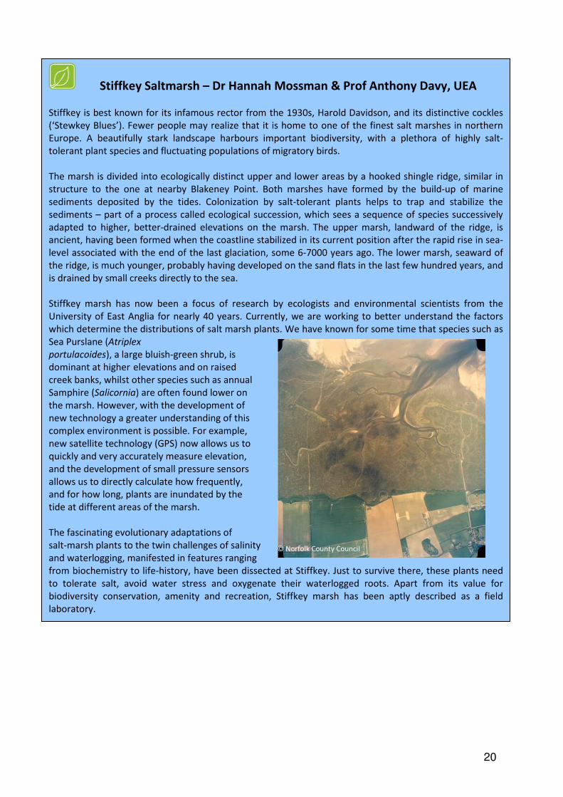
Stiffkey Saltmarsh – Dr Hannah Mossman & Prof Anthony Davy, UEA
Stiffkey is best known for its infamous rector from the 1930s, Harold Davidson, and its distinctive cockles
(‘Stewkey Blues’). Fewer people may realize that it is home to one of the finest salt marshes in northern
Europe. A beautifully stark landscape harbours important biodiversity, with a plethora of highly salt-
tolerant plant species and fluctuating populations of migratory birds.
The marsh is divided into ecologically distinct upper and lower areas by a hooked shingle ridge, similar in
structure to the one at nearby Blakeney Point. Both marshes have formed by the build-up of marine
sediments deposited by the tides. Colonization by salt-tolerant plants helps to trap and stabilize the
sediments – part of a process called ecological succession, which sees a sequence of species successively
adapted to higher, better-drained elevations on the marsh. The upper marsh, landward of the ridge, is
ancient, having been formed when the coastline stabilized in its current position after the rapid rise in sea-
level associated with the end of the last glaciation, some 6-7000 years ago. The lower marsh, seaward of
the ridge, is much younger, probably having developed on the sand flats in the last few hundred years, and
is drained by small creeks directly to the sea.
Stiffkey marsh has now been a focus of research by ecologists and environmental scientists from the
University of East Anglia for nearly 40 years. Currently, we are working to better understand the factors
which determine the distributions of salt marsh plants. We have known for some time that species such as
Sea Purslane (Atriplex
portulacoides), a large bluish-green shrub, is
dominant at higher elevations and on raised
creek banks, whilst other species such as annual
Samphire (Salicornia) are often found lower on
the marsh. However, with the development of
new technology a greater understanding of this
complex environment is possible. For example,
new satellite technology (GPS) now allows us to
quickly and very accurately measure elevation,
and the development of small pressure sensors
allows us to directly calculate how frequently,
and for how long, plants are inundated by the
tide at different areas of the marsh.
The fascinating evolutionary adaptations of
salt-marsh plants to the twin challenges of salinity
and waterlogging, manifested in features ranging
from biochemistry to life-history, have been dissected at Stiffkey. Just to survive there, these plants need
to tolerate salt, avoid water stress and oxygenate their waterlogged roots. Apart from its value for
biodiversity conservation, amenity and recreation, Stiffkey marsh has been aptly described as a field
laboratory.
© Norfolk County Council

21
SPECIES
You can see from the graph that the largest proportion of records is made up of birds and plants.
The North Norfolk Coast is well known for its fantastic bird life and the flocks of bird watchers
who visit generate large numbers of records. Many of the plant records are from the late 1980s
and early 1990s when there was a concerted recording effort by plant recorders in the county.
Fish, amphibian and reptile records make up a much smaller proportion of total records for the
Stiffkey catchment. This is perhaps both due to the fact that they are relatively elusive and that
there are many fewer species of these groups to be found in this area.
There are thousands of species which call the Stiffkey catchment area home. From the
spiky sea holly to the tuneful blackcap, from the strangely shaped bullhead fish to the tiny
pygmy shrew, NBIS holds 62997 individual records of 4921 species from within the Stiffkey
catchment.
This chart shows the percentage of the total number of species records made up by each group of
species (plants, mammals, birds etc) recorded in the Stiffkey catchment. [Based on the data held by
Norfolk Biodiversity Information Service, January 2014]
Other Species – 0.3% Other Invertebrates – 10.0%
Butterflies – 2.6%
Moths – 15.0%
Fish – 0.2%
Amphibians &
Reptiles – 0.2%
Birds – 30.3%
Mammals – 3.1%
Fungi & Lichen
– 7.8%
Plants – 30.6%

22
Himalayan Balsam
Photo: Mary Pipes
Rare Species
Invasive Non-native Species
Biodiversity Action Plan Priority species
431 of the species recorded in the Stiffkey
catchment since 2000 are what would be
classed as ‘Species of Conservation Concern’.
These are species that are rare or scarce, or
that are protected at an international,
European, national or local level. They include
35 species of flowering plant and 23 species of
mammal. It is important to know where these
species are found in order to protect them
from further decline. For more information on
how you can get involved in species recording
see pg 34.
Grey partridge © David North
Twelve of the species recorded in
the Stiffkey catchment since 2000
are invasive non-native species.
These have been introduced to the
area by people and have a
tendency to spread rapidly and
cause problems for our native
wildlife. Knowing where they are
enables conservationists to keep a
check on their distribution and
intervene before they start causing
a problem. The Norfolk Non-Native
Species Initiative co-ordinates this
work.
Invasive Common cord grass © Jürgen Howaldt licensed under the Creative
Commons Attribution-Share Alike 2.0 Germany license
Biodiversity Action Plan (BAP)
Priority species are a priority for
conservation in the UK based on
their international importance,
rapid decline and high risk of
further decline and extinction. The
list was revised in 2007 and now
includes 1150 species.
179 of the Species of Conservation
Concern in the Stiffkey catchment
are Biodiversity Action Plan
Priority species. Brown Hare © Galatas and licensed for reuse under this Creative
Commons Licence

23
European Eel
The European Eel has a long, thin cylindrical body and a very slimy
skin. It is thought that they spawn in the Sargasso Sea, south-west
of Bermuda, after which the adults die. The eggs drift on the Gulf
Stream to Europe, hatching and developing en-route. The GLASS EELS
enter the rivers in spring, using the tidal flow. Eels remain in
freshwater for several years before beginning their return journey.
Individuals of more than 40 years old have been recorded.
Eels are unique among British fish in being able to migrate
overland, over wet terrain. This is usually done at night.
There has been a major decline in glass eel numbers during the last
few decades in Europe.
Bullhead
This is a small, bottom-dwelling fish which feeds on aquatic
INVERTEBRATES. It is vulnerable to predation by fish such as trout and
birds like kingfishers and herons. Spines on the fins offer it some
protection but it generally hides during the day, venturing out at
dawn and dusk to feed. Generally a solitary species, during the
summer and winter months, males become aggressively territorial.
3-Spined Stickleback
With its 3 or 4 spines aligned in front of its dorsal fin, this
small and short-lived fish is commonly found while pond-
dipping. During the breeding season, males develop a
vivid red belly and flanks with a bright blue iris. Once the
eggs are fertilised it is the male who cares for the nest and
the fry alone. He fans oxygenated water over the nest,
protects it from predators and looks after the fry for the
first few days after hatching.
Bullhead © Hans Hillewaert licensed under
the Creative Commons Attribution-Share Alike 3.0
Unported license
River Lamprey © Tiit Hunt licensed under the Creative
Commons Attribution-Share Alike 3.0 Unported license
Fish in the River Stiffkey (Information taken from: Davies C et al (2004) British Freshwater Fishes – the Species and their Distribution. Harley Books.)
The River Stiffkey was rated as ‘Good’ for fish by the Environment Agency in 2009, under the terms
of the Water Framework Directive. 15 species of fish have been recorded in the River Stiffkey. Here
are just a few of them:
River Lamprey and Brook Lamprey
These are a primitive, jawless fish which have a skeleton made of cartilage instead of bone. The
round mouth has a sucker and teeth in adult lamprey. River Lamprey migrate from saltwater to
spawn in freshwater, while brook lamprey remain in freshwater for their entire lives. While river
lamprey migrate to the sea in autumn and feed on host fishes, attaching to them with their
powerful sucker and rasping through the skin to feed on flesh and blood, brook lamprey don’t feed
as adults and live for only 6 months. Lamprey are secretive and rarely seen and require clean,
flowing water and a loose gravel substrate to spawn successfully. They die after spawning. They are
threatened by habitat degradation, and river lamprey are affected by physical barriers to their
upstream migration, such as locks, weirs and dams.
3-spined stickleback © JaySo83 licensed under
the Creative Commons Attribution-Share Alike 3.0
Unported license
24
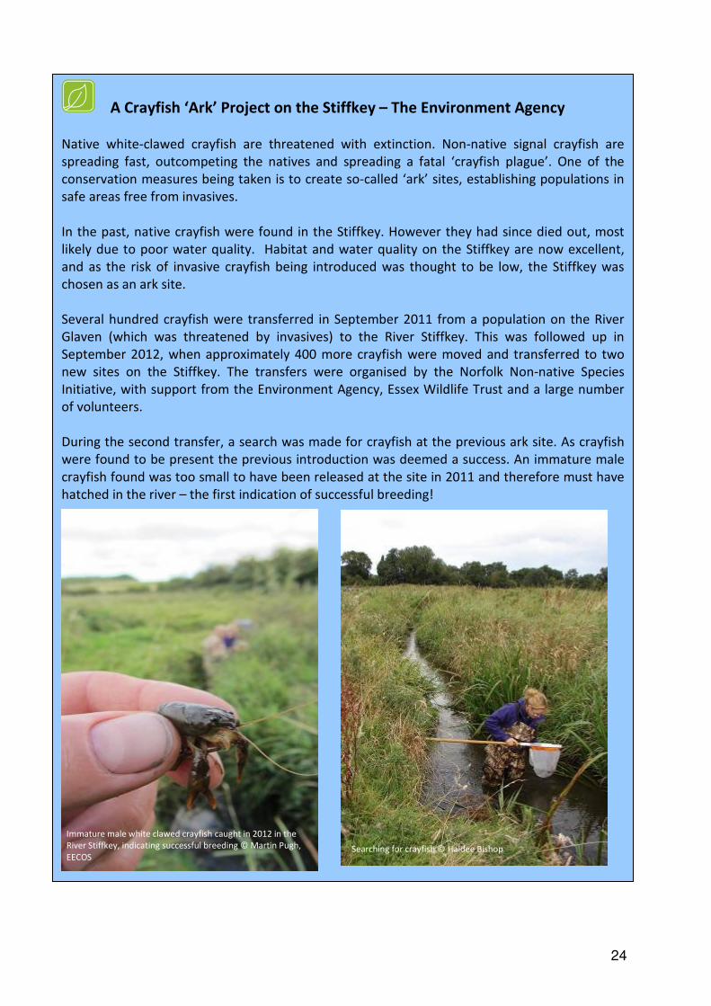
A Crayfish ‘Ark’ Project on the Stiffkey – The Environment Agency
Native white-clawed crayfish are threatened with extinction. Non-native signal crayfish are
spreading fast, outcompeting the natives and spreading a fatal ‘crayfish plague’. One of the
conservation measures being taken is to create so-called ‘ark’ sites, establishing populations in
safe areas free from invasives.
In the past, native crayfish were found in the Stiffkey. However they had since died out, most
likely due to poor water quality. Habitat and water quality on the Stiffkey are now excellent,
and as the risk of invasive crayfish being introduced was thought to be low, the Stiffkey was
chosen as an ark site.
Several hundred crayfish were transferred in September 2011 from a population on the River
Glaven (which was threatened by invasives) to the River Stiffkey. This was followed up in
September 2012, when approximately 400 more crayfish were moved and transferred to two
new sites on the Stiffkey. The transfers were organised by the Norfolk Non-native Species
Initiative, with support from the Environment Agency, Essex Wildlife Trust and a large number
of volunteers.
During the second transfer, a search was made for crayfish at the previous ark site. As crayfish
were found to be present the previous introduction was deemed a success. An immature male
crayfish found was too small to have been released at the site in 2011 and therefore must have
hatched in the river – the first indication of successful breeding!
Immature male white clawed crayfish caught in 2012 in the
River Stiffkey, indicating successful breeding © Martin Pugh,
EECOS
Searching for crayfish © Haidee Bishop
25
HISTORIC ENVIRONMENT – Kelly Powell, Norfolk County Council Historic
Environment Service
Settlement along the River The significance of the River Stiffkey to the surrounding area throughout history can be seen
by studying aerial photographs of the area. Notable clusters of earthworks survive along the
banks of the river and its tributaries; this is particularly significant given the general rarity of
earthworks within Norfolk, where many have been levelled by agriculture over the centuries.
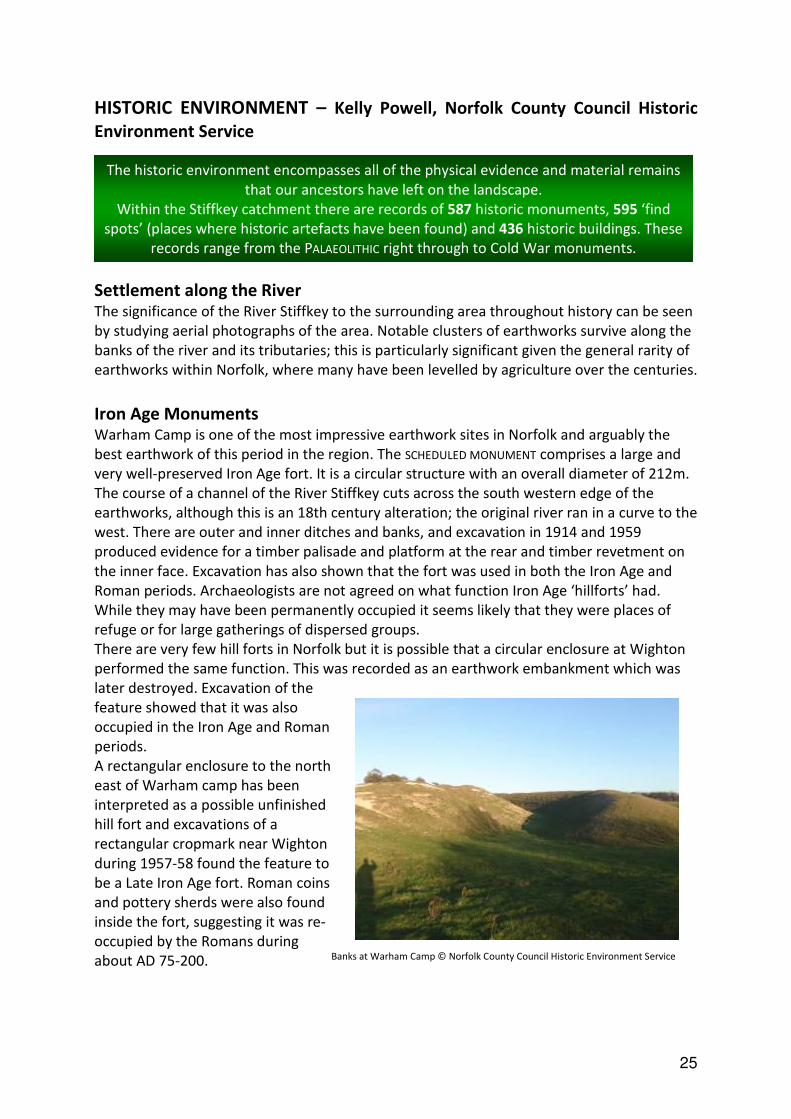
Iron Age Monuments Warham Camp is one of the most impressive earthwork sites in Norfolk and arguably the
best earthwork of this period in the region. The SCHEDULED MONUMENT comprises a large and
very well-preserved Iron Age fort. It is a circular structure with an overall diameter of 212m.
The course of a channel of the River Stiffkey cuts across the south western edge of the
earthworks, although this is an 18th century alteration; the original river ran in a curve to the
west. There are outer and inner ditches and banks, and excavation in 1914 and 1959
produced evidence for a timber palisade and platform at the rear and timber revetment on
the inner face. Excavation has also shown that the fort was used in both the Iron Age and
Roman periods. Archaeologists are not agreed on what function Iron Age ‘hillforts’ had.
While they may have been permanently occupied it seems likely that they were places of
refuge or for large gatherings of dispersed groups.
There are very few hill forts in Norfolk but it is possible that a circular enclosure at Wighton
performed the same function. This was recorded as an earthwork embankment which was
later destroyed. Excavation of the
feature showed that it was also
occupied in the Iron Age and Roman
periods.
A rectangular enclosure to the north
east of Warham camp has been
interpreted as a possible unfinished
hill fort and excavations of a
rectangular cropmark near Wighton
during 1957-58 found the feature to
be a Late Iron Age fort. Roman coins
and pottery sherds were also found
inside the fort, suggesting it was re-
occupied by the Romans during
about AD 75-200.
The historic environment encompasses all of the physical evidence and material remains
that our ancestors have left on the landscape.
Within the Stiffkey catchment there are records of 587 historic monuments, 595 ‘find
spots’ (places where historic artefacts have been found) and 436 historic buildings. These
records range from the PALAEOLITHIC right through to Cold War monuments.
Banks at Warham Camp © Norfolk County Council Historic Environment Service

26
Walsingham Walsingham became a highly significant religious centre in the medieval period and remains
so today. Its historic importance is clearly visible in the modern day village of Little
Walsingham.
The rise of Walsingham began in 1061 when Richelde of Fervaques built a holy house after
receiving visions of the Virgin Mary. This structure was probably a small wooden building
said to have been modelled on the house in Nazareth where the Annunciation took place.
The Augustinian Priory of St Mary was begun sometime after 1153 and funded by Richelde's
son Geoffrey and the holy house was replaced in the mid-13th century by a larger chapel.
Later a Franciscan Friary of St Mary (known as Greyfriars) was also built near the site and
these sites became the main centre of pilgrimage in England from the 12th to the 14th
century. The priory became prosperous and was patronised by the Royal family. A large new
priory church with a gatehouse and prior's hall was built in the 14th-15th centuries. The
village of Little Walsingham grew around the site in order to accommodate the pilgrims.
Existing remains of the priory comprise fragments of 13th to 15th century buildings including
the chancel, refectory, precinct walls and gates. There are also two Holy wells east of the
priory. Greyfriars survives to the south west; the ruins now surrounding a 19th
century
house. Surviving medieval/early post medieval buildings include the Shirehall dating to the
late 15th or early 16th century. The structure of this early building suggests it had a main
first floor hall with kitchen and services beneath or possibly a poor pilgrims' room below a
hall for wealthier clientele. In the 18th or 19th century it was used as a courtroom and the
fittings now make up part of the Shirehall Museum exhibits. A medieval cross stood in
Common Place, the brick structure that supported it now houses a pump and is a SCHEDULED
MONUMENT.
The prosperity of the village came to an end with the dissolution of the monasteries and the
priory had been dismantled by 1539. It was gifted to
Thomas Sidney who appears to have sold much of
the fittings and stonework. Evidence from
excavations on the site indicates the Holy House was
destroyed by burning. After the dissolution of the
priory in 1538 some of the ruins were built into a
new mansion (Abbey House) that was built on the
site.
Many of the late and post medieval buildings in Little
Walsingham contain reused medieval stones from
the religious buildings that were removed at the
dissolution and numerous historic buildings are
standing in the village. Pilgrimage to Walsingham
began again in the modern period.
Walsingham Priory ruins © Norfolk County Council Historic Environment Service

27
Binham Priory Binham Benedictine Priory was founded in the late 11th / early 12th century and dissolved in
1539, and is an important example of the almost complete survival of a monastic precinct. In
1086 Binham was held by Peter de Valognes and the priory was founded by him and his wife,
subordinate to St Albans Abbey, possibly as early as 1093.
The cloisters, conventual buildings (including dormitories, garderobes, the chapter house
and refectory) precinct wall and gatehouse are in ruins, but the nave of the church, which is
still in use as a parish church, is upstanding. The buildings date mostly from the 13th or 14th
centuries. Earthworks of other buildings survive within the precinct, including possible guest
accommodation and agricultural buildings. A complex water management system has also
survived, including the remains of fishponds. An evaluation excavation to determine the
location of the lost west precinct wall in 2007 located the line of the inner face of the
medieval wall along with evidence for structures located against the wall. In 2009 an
evaluation revealed two graves pre-dating the 12th century north aisle, which may have
belonged to an earlier church, possibly of Saxon date.
The importance of the river to the priory is demonstrated by the presence of earthworks
along the river to the east, thought to be the remains of dams.
Binham Priory is owned by Norfolk Archaeological Trust and partly in English Heritage
guardianship.
Binham Priory church © Norfolk County Council Historic Environment Service
A medieval wayside cross on the village green at Binham still stands and is thought to have
been erected by the monks of the priory following a medieval market grant. A market and
fair were held here until the early 1950s. A similar medieval cross still stands in the village of
Cockthorpe to the north. Both the priory and crosses are designated SCHEDULED MONUMENTS.
28
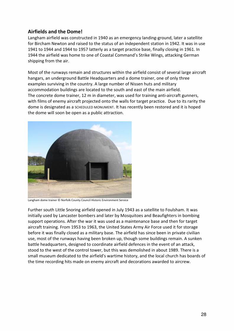
Airfields and the Dome! Langham airfield was constructed in 1940 as an emergency landing-ground, later a satellite
for Bircham Newton and raised to the status of an independent station in 1942. It was in use
1941 to 1944 and 1944 to 1957 latterly as a target practice base, finally closing in 1961. In
1944 the airfield was home to one of Coastal Command’s Strike Wings, attacking German
shipping from the air.
Most of the runways remain and structures within the airfield consist of several large aircraft
hangars, an underground Battle Headquarters and a dome trainer, one of only three
examples surviving in the country. A large number of Nissen huts and military
accommodation buildings are located to the south and east of the main airfield.
The concrete dome trainer, 12 m in diameter, was used for training anti-aircraft gunners,
with films of enemy aircraft projected onto the walls for target practice. Due to its rarity the
dome is designated as a SCHEDULED MONUMENT. It has recently been restored and it is hoped
the dome will soon be open as a public attraction.
Langham dome trainer © Norfolk County Council Historic Environment Service
Further south Little Snoring airfield opened in July 1943 as a satellite to Foulsham. It was
initially used by Lancaster bombers and later by Mosquitoes and Beaufighters in bombing
support operations. After the war it was used as a maintenance base and then for target
aircraft training. From 1953 to 1963, the United States Army Air Force used it for storage
before it was finally closed as a military base. The airfield has since been in private civilian
use, most of the runways having been broken up, though some buildings remain. A sunken
battle headquarters, designed to coordinate airfield defences in the event of an attack,
stood to the west of the control tower, but this was demolished in about 1989. There is a
small museum dedicated to the airfield's wartime history, and the local church has boards of
the time recording hits made on enemy aircraft and decorations awarded to aircrew.
29
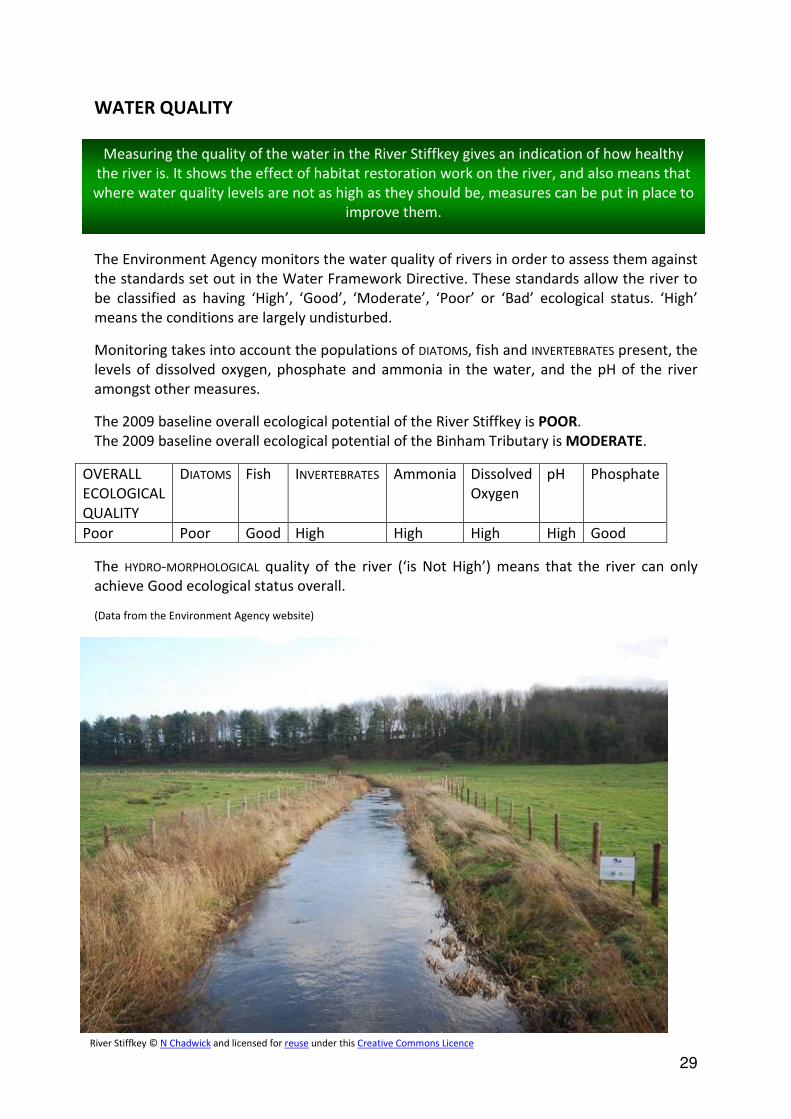
WATER QUALITY
The Environment Agency monitors the water quality of rivers in order to assess them against
the standards set out in the Water Framework Directive. These standards allow the river to
be classified as having ‘High’, ‘Good’, ‘Moderate’, ‘Poor’ or ‘Bad’ ecological status. ‘High’
means the conditions are largely undisturbed.
Monitoring takes into account the populations of DIATOMS, fish and INVERTEBRATES present, the
levels of dissolved oxygen, phosphate and ammonia in the water, and the pH of the river
amongst other measures.
The 2009 baseline overall ecological potential of the River Stiffkey is POOR.
The 2009 baseline overall ecological potential of the Binham Tributary is MODERATE.
OVERALL
ECOLOGICAL
QUALITY
DIATOMS Fish INVERTEBRATES Ammonia Dissolved
Oxygen
pH Phosphate
Poor Poor Good High High High High Good
The HYDRO-MORPHOLOGICAL quality of the river (‘is Not High’) means that the river can only
achieve Good ecological status overall.
(Data from the Environment Agency website)
Measuring the quality of the water in the River Stiffkey gives an indication of how healthy
the river is. It shows the effect of habitat restoration work on the river, and also means that
where water quality levels are not as high as they should be, measures can be put in place to
improve them.
River Stiffkey © N Chadwick and licensed for reuse under this Creative Commons Licence

30
The Anglian Rivers Sea Trout Project on the Stiffkey – The Wild Trout Trust
The Anglian Rivers Sea Trout Project is a collaboration between anglers, fishery scientists and managers,
conservationists, landowners and local communities. It aims to conserve and improve the habitat and wildlife
of four rivers in North Norfolk (the Glaven, Stiffkey, Burn and Nar), using sea trout stocks to measure river
health.
A review of existing information on sea trout on the Stiffkey suggested that there was good spawning habitat
above Wighton, but a lack of suitable gravel areas below, and that the sluice where the river meets the sea
could be a barrier to fish migration. A lack of cover could also mean that predation by herons was a problem,
especially when the water level was low. Research showed that brown trout density had increased between
1988-2007, but that populations were declining in the Binham stream tributary.
Once the existing information had been collated, detailed conservation plans could be designed to enhance
stocks, prepare and undertake surveys and design appropriate monitoring programmes to measure progress.
On the Stiffkey this included an initial survey of barriers to fish migration and a habitat assessment.
Finally, a prioritised programme of capital conservation projects including fish passes, barrier removal and
habitat restoration could be delivered. There have been two projects implemented on the Stiffkey so far:
Gravel Riffle Installation
The Stiffkey channel has been artificially straightened and widened for a long time. This has made it prone to
sediment accumulation and the growth of emergent vegetation such as reeds and rushes, necessitating regular
maintenance dredging. The dredging has limited trout populations, mainly due to the absence of the clean, silt-
free gravel required for trout spawning. In 2009, working with Holkham Estate (the landowner), the Wild Trout
Trust installed ten gravel riffle areas. Approximately 700 tonnes of gravel were used to create 300m of shallow
riffle habitat. The river banks were reprofiled alongside the gravel, and stockproof fencing and drinking points
were installed. Since completion, a number of trout spawning sites have been seen each winter on the
introduced gravel. Luke Mitchell, a PhD student from University College London has studied the use of the
installed gravels and egg survival rates compared with natural gravel areas. Silt accumulation within installed
gravels is an ongoing problem and modification of the channel size and shape, as well as addressing the
sources of sediment, is needed to provide a sustainable solution.
Tidal Sluice Fish Pass
The Stiffkey enters the sea through a sluice which closes at high tide to protect reclaimed and protected land
from flooding. This is potentially a significant barrier to the free movement of fish. To overcome this problem, a
“pet door” type opening was installed in the main tidal flap gate. This remains open after the main gate shuts
on a rising tide, and then closes much more gradually via a door attached to an adjustable floatation device.
Research on the effectiveness of the pass and movements of trout and eels between the Stiffkey and the sea is
being carried out by Gill Wright, a PhD student from Southampton University in conjunction with the
Environment Agency.
Future works
Future works are being discussed on the lower river and wetlands by the Norfolk Rivers Trust and landowners.
Experience from projects on other Norfolk rivers such as the Glaven has shown that restoring the river’s
natural channel size, meandering course and floodplain connection provides a long-term, self-sustaining
improvement for biodiversity. Options for similar improvements on the Stiffkey are being considered.
For more information on this project see www.wildtrout.org/content/anglian-rivers-sea-trout-project

31
GETTING OUT IN THE STIFFKEY CATCHMENT AREA
The Norfolk Coast Path
The Norfolk Coast Path runs for 42 miles between Hunstanton in the west and Cromer in the
east. At Holme it combines with the Peddars Way and becomes the Peddars Way & Norfolk
Coast Path National Trail.
Almost the entire route of the Norfolk Coast Path runs through the Norfolk Coast Area of
Outstanding Natural Beauty. It is a relatively modern route and combines the peace and
quiet, and at times remoteness, of nature, with the warmth of village life.
The section close to/passing through the Stiffkey catchment area lets you skirt around salt
marshes, creeks and mudflats teeming with life.
There are lots of opportunities for getting out and enjoying the Stiffkey catchment.
There are over 45km of public footpaths within the Stiffkey catchment, along with 24km
of bridleways, 5.7km of restricted byways (restricted byways allow access on foot,
horseback, cycling or any other non-mechanical vehicle) and 3.3km of ‘byways open to
all traffic’.
Public rights of way in the Stiffkey catchment

32
Walk near Swanton Novers Wood
Provided under the Higher Level Stewardship Scheme, this circular walk gives you closer
views of the privately owned Swanton Novers Wood. During the summer you might be lucky
enough to spot birds such as honey buzzard, red kite, marsh harrier and hobby, among
others. A pollen and nectar mixture has been planted on the south side of the wood for the
benefit of butterflies, bees and other insects.
Please keep to the footpath, and remember that there is no access to Swanton Novers Wood
itself.
Binham to Stiffkey Walk
This walk is 5.3 miles in length and should take around 2.5 hours to complete.
The route begins at the spectacular Binham Priory, an English Heritage site which is open all
year. You will then follow quiet country lanes and footpaths across the disused Langham
Second World War airfield, through the beautiful Cockthorpe Common, beside Stiffkey Fen
(a great spot for birdwatching!) before finishing along a short section of the Norfolk Coast
Path, beside Stiffkey saltmarshes.
For route details and information about public transport (as the route is not circular)
download the pdf from www.norfolkcoastaonb.org.uk/pages/pspage.php?PageID=628
Binham Priory © nick macneill and licensed for reuse under this Creative
Commons Licence
Langham Airfield © Nigel Jones and licensed
for reuse under this Creative Commons Licence
33
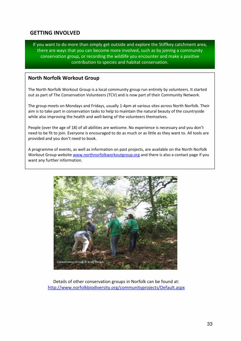
GETTING INVOLVED
If you want to do more than simply get outside and explore the Stiffkey catchment area,
there are ways that you can become more involved, such as by joining a community
conservation group, or recording the wildlife you encounter and make a positive
contribution to species and habitat conservation.
North Norfolk Workout Group
The North Norfolk Workout Group is a local community group run entirely by volunteers. It started
out as part of The Conservation Volunteers (TCV) and is now part of their Community Network.
The group meets on Mondays and Fridays, usually 1-4pm at various sites across North Norfolk. Their
aim is to take part in conservation tasks to help to maintain the natural beauty of the countryside
while also improving the health and well-being of the volunteers themselves.
People (over the age of 18) of all abilities are welcome. No experience is necessary and you don’t
need to be fit to join. Everyone is encouraged to do as much or as little as they want to. All tools are
provided and you don’t need to book.
A programme of events, as well as information on past projects, are available on the North Norfolk
Workout Group website www.northnorfolkworkoutgroup.org and there is also a contact page if you
want any further information.
Details of other conservation groups in Norfolk can be found at:
http://www.norfolkbiodiversity.org/communityprojects/Default.aspx
Conservation Group © Scott Perkin

34
Species Recording
Norfolk Biodiversity Information Service (NBIS) collects, collates, manages and disseminates
information on species, habitats, GEODIVERSITY and protected sites in Norfolk. The majority of
species records come from volunteer recorders, who regularly send in details of the wildlife
they have seen.
If you want to record wildlife in the Stiffkey catchment and be part of improving our
understanding of the Valley’s environment, helping to protect it, you need to record the
‘four Ws’ – WHAT you saw, WHERE you saw it, WHEN you saw it and WHO you are.
If you’re not 100% sure of what species it is, then please don’t record it. Or send a photo to
NBIS so they can check the identification.
You can email your records to [email protected] or why not use their online recording
form at http://www.nbis.org.uk/AllSpeciesSurvey

35
THE COUNTRYSIDE CODE
The countryside code helps members of the public to respect, protect and enjoy the
countryside. It is mostly common sense, and by following it we can ensure that visiting the
countryside is an enjoyable experience for everyone.
Be safe, plan ahead and follow any signs:
Even if you’re just venturing out locally it is best to get the latest information on where
you can and can’t go. For example some areas of open land may be closed while work
is carried out or during breeding seasons. Follow advice and local signs. Be prepared
for the unexpected!
Leave gates and property as you find them:
Respect the working life of the countryside. Our actions can have an effect on people’s
livelihoods, our heritage and the safety and welfare of animals and ourselves.
Protect plants and animals, and take your litter home:
We have a responsibility to protect our countryside both now and for future
generations. Make sure you don’t harm animals, birds, plants or trees.
Keep dogs under close control:
The countryside is a great place to exercise dogs. However it is every owner’s duty to
ensure that their dog is not a danger or nuisance to farm animals, wildlife or other
people.
Consider other people:
Showing consideration and respect for other people who live, work or use the
countryside for recreation helps to make it a pleasant environment for everyone.

36
GLOSSARY
ALDER CARR – A waterlogged area of woodland dominated by alder trees.
ANGLIAN GLACIAL PERIOD – An extreme Ice Age which occurred about 450,000 years ago.
BRYOPHYTES - Mosses and liverworts.
BUFFER STRIPS – Strips of land left uncultivated between cultivated land and features such as
ponds, streams, ditches and woodland. They protect these features from fertiliser run-off
from the cultivated land and can also provide extra habitat for wildlife if managed correctly.
An Environmental Stewardship option.
CANALISATION – The process of artificially straightening and deepening a river, altering its
characteristics.
COPPICING – A traditional method of woodland management involving cutting back a tree or
shrub to ground level to stimulate new growth.
DIATOM – A single-celled alga which has a cell wall made of silica.
EC HABITATS DIRECTIVE – A European Union Directive adopted in 1992 aiming to protect 220
habitats and around 1000 species listed in the directive’s Annexes. Led to the setting up of a
network of Special Areas of Conservation.
ECOSYSTEM – A biological environment consisting of all the organisms living in a particular
area, as well as the non-living components with which the organisms interact (such as air,
soil, water and sunlight).
GEODIVERSITY – The variety of rocks, minerals, fossils, soils and landforms, and the natural
processes that formed them.
GLASS EELS – A young eel at the time that it first enters brackish or fresh water, when it is
translucent.
HYDRO-MORPHOLOGICAL – The physical characteristics of the shape, boundaries and content of
a water body.
INTERGLACIAL - A period of milder climate between two glacial periods.
INVERTEBRATES – Animals without a backbone.
PALAEOLITHIC - The cultural period of the Stone Age beginning with the earliest chipped stone
tools, about 750,000 years ago, until about 15,000 years ago.
PLEISTOCENE – The geological age forming the earlier half of the Quarternary Period, about 2
million years ago to 10,000 years ago, characterised by widespread glacial ice.

37
SCHEDULED MONUMENT – A nationally important archaeological site or historic building, given
protection against unauthorised change.
RAMSAR CONVENTION – An international treaty for the conservation and sustainable use of
wetlands.
WILD BIRD COVER – An Environmental Stewardship option where land is planted specifically to
provide cover for wild birds.
38
USEFUL WEB LINKS
General
Norfolk Biodiversity Information Service: www.nbis.org.uk
Norfolk Biodiversity Partnership: www.norfolkbiodiversity.org
Norfolk Non-native Species Initiative: http://www.norfolkbiodiversity.org/nonnativespecies/
Norfolk Wildlife Trust: http://www.norfolkwildlifetrust.org.uk/
Norfolk Rivers Trust: http://www.norfolkriverstrust.org/
Landscape and Geodiversity
Geological Society of Norfolk: http://www.norfolkgeology.co.uk/
Norfolk Geodiversity Partnership: https://sites.google.com/site/norfolkgeodiversity/
Important Sites
Protected sites:
http://www.naturalengland.org.uk/ourwork/conservation/designatedareas/default.aspx
SSSI Citations: http://www.sssi.naturalengland.org.uk/special/sssi/search.cfm
Norfolk Coast AONB: www.norfolkcoastaonb.org.uk
Thursford Wood County Wildlife Site: http://www.norfolkwildlifetrust.org.uk/wildlife-in-
norfolk/nature-reserves/reserves/thursford-wood
Habitats and Land-Use
UK Biodiversity Action Plan Habitats: http://jncc.defra.gov.uk/page-5706
Norfolk Biodiversity Action Plans: http://www.norfolkbiodiversity.org/actionplans/
Ancient Woodland: www.naturalengland.org.uk/Images/standing-advice-ancient-
woodland_tcm6-32633.pdf
Environmental Stewardship:
http://www.naturalengland.org.uk/ourwork/farming/funding/es/default.aspx
Species

39
UK Biodiversity Action Plan Species: http://jncc.defra.gov.uk/page-5717
Historic Environment
Norfolk Heritage Explorer: http://www.heritage.norfolk.gov.uk/
Environmental Quality
Water Quality: http://maps.environment-
agency.gov.uk/wiyby/queryController?topic=wfd_rivers&ep=2ndtierquery&lang=_e&layerGroups=1
&x=595717.4994999999&y=336138.001&extraClause=EA_WB_ID~%27GB105034055840%27&texto
nly=off&latestValue=&latestField=
Anglian Rivers Sea Trout Project: www.wildtrout.org/content/anglian-rivers-sea-trout-project
Getting Out in the Valley
Norfolk Coast Path:
http://www.nationaltrail.co.uk/PeddarsWay/
www.norfolk.gov.uk/Leisure_and_Culture/Norfolk_Trails/Norfolk_Coast_Path/index.htm
Swanton Novers Permissive Walk: cwr.defra.gov.uk/mapboards/pdfs/AG00250819.pdf
Binham to Stiffkey walk: www.norfolkcoastaonb.org.uk/pages/pspage.php?PageID=628
Getting Involved in the Valley
North Norfolk Workout Group: www.northnorfolkworkoutgroup.org
Norfolk Community Groups:
http://www.norfolkbiodiversity.org/communityprojects/Default.aspx
NBIS Online Recording: http://www.nbis.org.uk/AllSpeciesSurvey