Embed Size (px)
Citation preview
THE ROCHESTER MINING DISTRICT, NEVADA.
By FRANK C. SCHRADER.
INTRODUCTION.
This report is based on a two weeks' visit made to the Rochester district and vicinity by the writer in May, 1913. A brief prelimi nary statement of the results'of the reconnaissance was given to the press by the Survey in June, 1913.
Information generously given by mining companies, prospectors, engineers, and surveyors operating in the district has been of: ma terial aid. in the preparation of this report.
The Rochester district, comprising about 25 square miles, is in west-central Nevada, in the southern part of Humboldt County. It is 9 miles southeast of Nixon, formerly Oreana, on the main line of the Southern Pacific Railroad, and 20 miles northeast of the town of Lovelocks. With both of these places it has daily freight, ex press, passenger, and mail service. A private branch railroad, the Nevada Short Line, extends from Nixon 5 miles across the lowland to the edge of the district.
The mining settlement of Fitting, formerly Spring Valley, lies a few miles to the northeast. South of Fitting, heading almost in the heart of the Rochester district, is American Canyon, noted for its large production of placer gold. The eastern part of the Rochester district was formerly known as the Sacramento district.
SURFACE FEATURES.
The Rochester district lies in the Humboldt Range, which is separated from the Montezuma or Trinity Mountains by the Hum boldt Valley on the west, and from the Pahute Range by the Buena Vista Valley on the east. Most of these valleys, which are 8 to 10 miles wide, are of the flat-bottomed infilled Great Basin type.
The Humboldt Range, also called the Koipato Range in the re ports of the Fortieth Parallel Survey,1 is about 75 miles long and culminates on the north in Star Peak, 10,000 feet above sea level.
Near its middle point, in the latitude of Nixon and Rochester, the range is traversed by a low pass known as Cole Canyon (PI.
1 Hague, Arnold, and Etamons, S. F., Descriptive geology: TJ. S. Geol. Expl. 40th Par., vol. 2, p. 713, 1877.
325
326 CONTRIBUTIONS TO ECONOMIC GEOLOGY, 1913, PART I.
VIII), which divides it into two parts. The northern part, which has a northerly trend, Louderback x calls the Star Peak Range, and the southern part, which has a northeasterly trend, he calls the Hum- boldt Lake Range.
The Star Peak Range, in which the Rochester district lies, is fairly uniform in outline and has an average width of about 10 miles, its maximum width, which is about 15 miles, being in its southern part. Buffalo Peak, a huge mass nearly 8,400 feet in elevation, forms its southern end. The lowest pass in the range is Spring Valley Pass, 6,250 feet in elevation, or nearly 2,000 feet above the adjoining Humboldt Valley on the west.
The range is described by Hague 2 as a simple ridge with the axis near the center of the uplift, from, which numerous canyons with broad basin-like heads, abruptly becoming narrower as they descend, extend down the mountain slopes at regular intervals. This descrip tion applies particularly to the Rochester district, where the heads of the lateral canyons almost coalesce.
The Rochester district lies in the southern part of the Star Peak Range, chiefly on its upper west slope, at elevations between 4,000 and 7,500 feet, as shown on the accompanying map (PI. VIII). The area is mountainous but not rugged. Many of the canyons and ravines are passable for wagons, and most of them contain springs and wells of potable water.
The western part of the area is drained chiefly by Packard, Weaver, Rochester, Limerick, and Sacramento canyons, which enter Humboldt Valley, and Cole Canyon. The eastern part of the area is drained by Buffalo, South American, and American canyons and by Spring Valley, all of which open into Buena Vista Valley.
Within the district the crest of the range is represented by a relatively narrow ridge, about 6,600 feet in elevation. Its dominant
' feature is Nenzel Hill, an oval silicified knob, 3,000 feet long by 2,000 feet wide, at the head of Rochester and South American canyons. This hill rises 7,300 feet above sea level, or 500 feet above the adjoin ing portions of the divide. Lincoln Hill, a prominent landmark, which forms the end of the ridge bounding Rochester Canyon on the north, about 2f miles west of Nenzel Hill, rises to an elevation of 6,600 feet.
HISTORY, PRODUCTION, AND MINING OPERATIONS.
The presence of mineral deposits in the Humboldt Range and the Rochester region was known half a century ago. Mining began in this part of Nevada about the year 1860 with the organization of
1 Louderback, G. D., Basin range structure of the Humboldt region : Geol. Soc. America. Bull., vol. 15, p. 294, 1904.
a Hague, Arnold, and Emmons, S. P., op. cit., p. 713.
ROCHESTER MINING DISTRICT, NEV. 327
the Humboldt district, on the northwest slope of Star Peak.1 The Star Peak and Bueria Vista districts were organized in 1861.2
Kochester Canyon took its name from some pioneers who in travel ing overland from Rochester, N. Y., in the early sixties, prospected and mined at its mouth and are said to have examined most of the Humboldt Range from this locality southward. Some of the party worked the Montana lode in 1867, but soon after ceased operations. Supplies in those days were hauled overland from Sacramento and the rich ore was shipped by way of San Francisco to Swansea, Wales.
Evidences of former work in this district are the old Montana shaft near Lincoln Hill, sunk in the early sixties, and the Oro Fino shaft, in Gold Ridge, to the north (PI. VIII). Rich float is said to have been discovered at Lincoln Hill by Tooper Bennett in 1888.
The first successful lead-silver smelter in Nevada was built and operated on Humboldt River just below Oreana to treat ore from the Montezuma mine, in the Trinity district. 2
The discovery of ore in Nenzel Hill, the center of the present activity, was made a decade or more ago by Charles E. Stevens, a pioneer. Little work, however, was done at that time, and the ground reverted to the Government.
Later, in 1909, Joseph Nenzel and others relocated the ground, and a small shipment of ore was made in August, 1912, partly from the Causten tunnel, but mainly from talus or float. Large bodies of $50 to $60 ore were found in November, 1912, and in February and March, 1913, other bodies were opened in a second vein, at a depth of 130 feet. A carload and several smaller consignments of the rela tively high-grade ore were shipped about Christmas, 1913, by Nenzel from the Causten, and by Frank Schick and Walt Moynaugh from the Weaver No. 2 claim. These shipments attracted attention to Rochester and the district was soon after visited by half a score of able mining engineers, nearly all of whom reported on it favorably.
In less than a month the hitherto desolate canyon had a population of more than 2,000 people and contained many substantial two-story buildings. Three town sites, Rochester (or Lower Town), Central Rochester, and East Rochester, were laid out, but these soon coalesced along a main street, 2£ miles in length, extending from Lincoln Hill to the base of Nenzel Hill. East Rochester, near the head of the can yon, at an elevation of 6,200 feet, soon became and has continued to be the principal camp.
Blocks 300 by 600 feet in area were leased and actively worked by experienced mining men and at the time of the writer's visit, in May,
1 Hague, J. D., Mining industry: U. S. Geol. Expl. 40th Par., vol. 3, p. 310, 1870. 3 Ransome, F. L., Notes on some mining districts in Humboldt County, Nev.: U. S. Geol.
Survey Bull. 414, p. 10, 1909. 53317° Bull. 580 15 22
328 CONTRIBUTIONS TO ECONOMIC GEOLOGY, 1913, PART I.
1913, the development of the mines and the showing of ore made without aid of outside capital were remarkable. Ground was opened under six or eight leases to a depth of 130 feet by crosscut tunnels from 100 to 300 feet in length. About 2,000 tons of ore, averaging approximately $30 to the ton, had been mined and shipped, and much more, 100,000 tons it was said, was in sight. Nearly a score of prop erties were producing.
From March to November, 1913, inclusive, the known shipments from the district amounted to approximately 14,000 tons of ore having a total value of about $415,000, and the production for the year 1913 was approximately $500,000. In addition much milling ore had accumulated on the dumps. Of the ore shipped, 12,740 tons came from Nenzel Hill, chiefly from the Big Four, Codd, and Cplligan leases, and averaged approximately $28 to the ton; 1,120 tons, averaging $50 to the ton, came from Packard; and 120 tons, which averaged $79 to the ton, came from the Buck and Charley lease, opposite Lincoln Hill. Some ore was produced also by Lin coln Hill and by the Limerick and Sunflower groups at the head of Eochester Canyon. The total production to September, 1914, is reported to be more than $1,200,000. In addition it is estimated that there had been developed in the district by that date more than .100,000 tons of milling ore, of which the Codd lease is credited with 50,000 tons averaging from $10 to $20 'to the ton, the Four J lease with 20,000 tons, and the Rochester-Weaver mine with 15,000 tons. The average value of the ore produced during the 18 months ending June 30, 1913, is about $25 to the ton. Most of the ore mined has been sent to the Wabuska and Salt Lake smelters, although some was shipped to the Western Ore Purchasing Co., at Goldfield.
By December, 1913, development on most of the principal leases had extended to depths of about 300 feet, and the Causten tunnel, 630 feet in length, had reached a depth of 400 feet.
Two companies, the Eochester Mines Co- and the Rochester- Weaver Mining Co., own most of the developed ground on "Nenzel Hill. According to the first annual reports of these companies, there was shipped during the year 1913 from the Eochester Mines Co.'s ground 14,726 tons of ore, averaging $25.04 to the ton, worth $368,770, the net profit being about $19,192, and from the Eochester- Weaver Mining Co.'s ground 953 tons, averaging $31.74 to the ton, worth $30,254.30.
At first the ore was chuted in sacks several hundred feet down the steep side of Nenzel Hill, thence stone-boated nearly a half mile farther to the head of the wagon road in Eochester Canyon, down which it was freighted to Nixon. Early in the spring of 1913. how ever, 6 miles of road of easy grade, suitable for auto trucks, was con structed jointly by the Eochester Mines Co. and the lessees, at a cost of
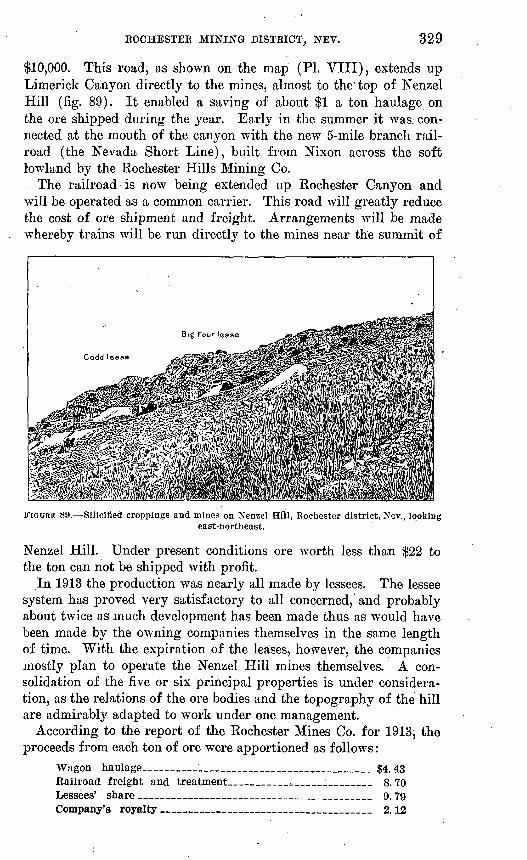
BOCHESTER MINING DISTRICT, NEV. 329
$10,000. This road, as shown on the map (PI. VIII), extends up Limerick Canyon directly to the mines, almost to the'top of Nenzel Hill (fig. 89). It enabled a saving of about $1 a ton haulage on the ore shipped during the year. Early in the summer it was/con nected at the mouth of the canyon with the new 5-mile branch rail road (the Nevada Short Line), built from Nixon across the soft lowland by the Rochester Hills Mining Co.
The railroad is now being extended up Rochester Canyon and will be operated as a common carrier. This road will greatly reduce the cost of ore shipment and freight. Arrangements will be made whereby trains will be run directly to the mines near the summit of
FIGURE 89. Silicified croppings and mines on Nenzel Hill, Rochester district, Nev., lookingeast-northeast.
Nenzel Hill. Under present conditions ore worth less than $22 to the ton can not be shipped with profit.
In 1913 the production was nearly all made by lessees. The lessee system has proved very satisfactory to all concerned, and probably about twice as much development has been made thus as would have been made by the owning companies themselves in the same length of time. With the expiration of the leases, however, the companies mostly plan to operate the Nenzel Hill mines themselves. A con solidation of the five or six principal properties is under considera tion, as the relations of the ore bodies and the topography of the hill are admirably adapted to work under one management.
According to the report of the Rochester Mines Co. for 1913, the proceeds from each ton of ore were apportioned as follows:
Wagon haulage_________________________ $4.43 Railroad freight and treatment_______;_________ 8. 70 Lessees' share __________________________ 9.79 Company's royalty ________________ 2.12
CONTRIBUTIONS TO ECONOMIC GEOLOGY, 1913, PART I.
A very complete 100-ton cyanide plant is now being built, at a cost of $100,000, by the newly organized Eochester Consolidated Mining & Milling Co. The plant is located in the southeastern part of the district, in Rochester Canyon, near the Rochester and Packard road forks, on the railroad, about half a mile below Lower Town. At the outset ore from the Nenzel Hill mines will be delivered at the plant by a 2-mile aerial tram. '
In this plant a Blake crusher, a 10-stamp mill, and tube mills will be used for crushing. The plant, although primarily intended for treating ore from the Rochester mines group, will also do custom work for the various mines of the district, which will make the large, reserves of milling ore accumulated in the district available for treat ment. The plant is expected to be in operation by January 1, 1915. Water for the plant is to be brought by pipe line from Hardesty Canyon, 5 miles distant, near Packard. The machinery is to be driven by hydroelectric power supplied from the Lahontan dam.
Shipment mill tests made of the ores to be treated by the process to be here used are said to indicate a recovery of about 95 per cent of the silver and 92 per cent of the gold from the sulphide ores and 85 per cent of the silver and 90'per cent of the gold from the oxidized ores. From the 200-foot level down the ores are said to be nearly all sulphide.
In April, 1914, the camp was shipping 130 to 150 tons of ore a day, about 40 tons of which was being shipped by the Rochester Hills Mining Co. In May there was reported to be in sight on the dumps and blocked out at the Nenzel Hill mines 100,000 tons of ore averag ing $15 to the ton, or about $1,500,000 worth of good milling-grade ore. For each ton of shipping ore taken out about 4 tons of low- grade or $15 milling ore is developed. The Nenzel Hill ore, it is estimated, can be mined for about $3 a ton and milled at a cost of about $6 a ton.
Ample water for milling and domestic use can be brought by gravity, it is said, from Lee Springs, a few miles to the north. At the time of the writer's visit sufficient water could also be pumped from the basin at the east base of Nenzel Hill, where several strong springs issue into South American Canyon. This water apparently owes its source largely to the easterly dip of the rocks in the adjoin ing axis of the range. The quantity stored here that could be relied on in the dry season depends mainly on the volume of the alluvial deposits, which fill the basin and seem to have considerable thickness. Springs occur also in the neighboring American, Limerick, and Weaver canyons. Thus far. the water supply for Rochester has been obtained from wells 10 to 40 feet deep sunk in the alluvial gravels of Rochester Canyon. The supply for Packard is drawn
ROCHESTER MINING DISTRICT, NEV. 331
from Black Knob Spring, about a mile and a half away, in Cole Canyon (PI. VIII).
The climate of Eochester is ideal in summer, but the winters are severe for Nevada. The hills are generally free of snow in early .April. High winds are common, as are also thunderstorms or cloudbursts, which late in May, 1913, flooded the canyons with short lived torrents.
Grass and scattered trees of the western juniper grow on the hillsides.
At the time of the writer's visit, in May, 1913, the district had a population of about 1,000 people, of whom 700 were in East Roch ester, where 200 miners were at work in Nenzel Hill and 250 were in Lower Town, and Packard, the newest settlement, only a few weeks old, at the south base of Packard Hill, had a population of about 100, which was daily increasing. Panama, on the northeast near Spring Valley Pass, in the head of Limerick Canyon, a mile and a half over the ridge from Rochester, contained a score of people.
Nixon, formerly little more than a watering station in the desert for Southern Pacific trains, had become a small town.
GEOLOGY. -
BOCKS OF THE REGION.
GENERAL FEATURES.
Hague* described the Humboldt Range as consisting of an Archean nucleus, surrounded and unconformably overlain by Triassic strata of great thickness, these in turn being overlain by Jurassic beds, which, along the base of the range and locally elsewhere, are steeply tilted, broken, and associated with masses of Tertiary rhyolite and basalt, and with poorly exposed Miocene beds called the Truckee group. The Archean and Triassic rocks were described as sparingly cut by Mesozoic dikes, chiefly diabase. The Triassic rocks were separated by Hague into two groups, which in ascending order he designated the Koipato and Star Peak " series," but which are here termed formations.
KOIPATO FORMATION.
The Koipato formation, so called from the Indian name of the Humboldt Range, occupies, according to the map of the Fortieth Parallel Survey, approximately the north half of the southern half of the Star Peak Range, including the Rochester district. It forms a belt 8 miles wide, trending from Cole Canyon diagonally north-
1 Hague, Arnold, and Emmons, S. F., op. cit., p. 714.
332 CONTRIBUTIONS TO ECONOMIC GEOLOGY, 1913, PART I.
eastward across the range to Unionville, whence, as a narrow strip, the formation is shown as extending 9 miles, northward along the east base of the range. Similarly, along the west base, a narrow tongue of the Star Peak formation is mapped as extending south ward to Sacramento Canyon.
The Koipato formation was supposed by Hague to consist chiefly of metamorphosed silicified sedimentary rocks, beds of quartzite overlain by interstratified beds of limestone, quartzite, and " felsitic porphyroids." It was referred to the.Triassic and regarded as of the same geologic age as the lower members of the " Red Beds " of the Rocky Mountain region. Its thickness was estimated at 6.000 feet.
STAR PEAK FORMATION.
In or near the Rochester district the Star Peak formation suc ceeds the Koipato formation on the southeast. It occupies mainly the southern fourth and the northern half of the Star Peak Range. Its thickness was estimated by Hague at 10,000 feet.
According to the section compiled by Ransome 1 from Hague's description it consists of the following members:
Section of the Star Peak formation, -Star Peak Range, Nev.
[Compiled from the description by Arnold Hague.]Feet.
Quartzite and overlying limestone __ _______'.- 4, 000-5, 000 Massive limestone ________:_____________ 1,800-2,000 Black arenaceous slates__________________ 200- 300 Slaty quartzites alternating with greenish schistose
rocks_____ ______________________ 1,500 Limestones, dark, almost black at the base, passing
up into gray and blue varieties- __ 1, 200-1, 500
Ransome 2 also writes:The Star Peak formation is noted for its abundant Middle Triassic vertebrate
and invertebrate fossils, which have been described by Gabb,8 Meek,4 Hyatt and Smith,6 and J. C. Merriam.8 * * * Hyatt and Smith 7 , [and Smith 8 ] state that the Upper Triassic is also represented in the Humboldt Range, and list half a dozen fossils. The beds containing them are said to be unconformably overlain by limestone containing Jurassic forms.
1 Ransome, F. L., op. cit., p. 31.2 Idem, p. 32.3 Gabb, W. M., Paleontology: California Geol. Survey, vol. 1, pp. 19-35, 1864.* Meek, F. B., Paleontology: U. S. Geol. Expl. 40th Par., vol. 4, pt. 1, pp. 99-129, Pis.
X and XI, 1877.5 Hyatt, Alpheus, and Smith, J. P., The Triassic cephalopod genera of America: U. S.
Geol. Survey Prof. Paper 40, pp. 21-23, Pis. XXII-XXV, 1905.8 Merriam, J. C., Triassic Ichthyosauria : California Univ. Mem., vol. 1, No, 1, pp. 18-19,
1908.7 Hyatt, Alpheus, and Smith, J. P., op. cit., p. 26.8 Smith, J. P., The Middle Triassic marine invertebrate faunas of North America: U. S.
Geol. Survey Prof. Paper 83, 1914. -
ROCHESTER MINING DISTRICT, NEV. 333
Later and more detailed work than that of the Fortieth Parallel Survey has shed more light on the geology of the range and led to certain revisions in the interpretation of the geologic phenomena and classification of the rocks. Of these revisions the following are .the more important:
According to Louderback,1 the supposed Archean nucleus exposed in Eocky Canyon, 7 miles north of Nixon, is post-Triassic intrusive granite with associated contact-metamorphic phenomena in both the granite and the host rocks.
According to Ransome,2 the Koipato formation as a whole is a volcanic complex, consisting chiefly of rhyolitic flows, in which non- volcanic sediments, including limestones, form only a subordinate part. With this view, the determinations of the rocks in the Rochester, district by Jones 3 and others, including the presentwriter, are essentially in accord.
The boundary between the Koipato and Star Peak formations, which is erroneously represented on the Fortieth Parallel Survey map as passing through Nenzel Hill, apparently lies well to the east of Nenzel Hill and of the area shown on the accompanying map (PI. VIII), but, as Ransome has pointed out, the place of division between the two formations lacks accurate definition. On the northeast the rhyolites of the Koipato formation and of Nenzel Hill extend about a mile and a quarter down American Canyon to the 5,740-foot con tour, where they are succeeded by greenstone and sedimentary rocks apparently belonging to the Star Peak formation. Approximately the same is true of their extension down South American Canyon, on the east, and into the mountains forming the crest of the range, on the southeast.
VALLEY FILL.
The intermontane valley fill, particularly that between the mouth of Rochester Canyon and the railroad west of it, consists chiefly.of the deposits of the Quaternary Lake Lahontan, in large part overlain by recent alluvium, talus, and debris washed from the neighboring mountains. As seen at Nixon and elsewhere, the lake beds consist chiefly of very fine, soft silts, over which freighting by team is difficult and expensive.
STBUCTTJBE.
The general structure of the Star Peak Range is described by Hague 4 as that of an anticlinal fold extending diagonally across
1 Louderback, G. D., op. cit, pp. 317-318.2 Ransome, F. L., loc. cit. N3 Jones, J. C., Geology of Rochester, Nev.: Min. and Sci. Press, vol. 106, pp. 737-738,
1913. * Hague, Arnold, and Emmons, S. F., op. cit, pp. 716, 728.
334 CONTRIBUTIONS TO ECONOMIC GEOLOGY, 1913, PART I.
the topographic uplift, striking about N. 30° E. and crossing the range obliquely at Spring Valley Pass.
In a broad way this anticlinal structure appears to extend, x so far as the present writer's observations show, through the southern part of the range.
Louderback 1 regards the Star Peak Range as an elevated and eastward-tilted fault block of .pre-Cretaceous rocks similar to the Humboldt Lake Eange, which he has carefully studied. The main fault along the west base of the range is regarded by him as the same as that which, extending through Cole Canyon, separates the Star Peak and Humboldt ranges.
BOCKS OP THE ROCHESTER DISTRICT.
The Rochester district lies in an area mapped by the Fortieth Parallel Survey as occupied by the Koipato formation. As has been already stated, later work has shown that this formation is a volcanic complex consisting chiefly of rhyolitic rocks, but within the district it contains also limestone, shale, quartzite, and some greenstones of igneous origin.
The rocks having the largest areal extent near Rochester and those most closely associated with the ore deposits are light colored and are chiefly rhyolite or rhyolitic, but with them are included also some quartz latite, dacite, andesite, and altered quartz porphyry. As shown on the accompanying map (PL VIII), these rocks occupy almost the whole of the eastern part of the Rochester district and ex tend westward to Lincoln Hill.
The formation consists of superimposed flows of rhyolite and rhyo litic lavas, with intercalated beds of tuff, breccia, and obsidian. In places, as at the head of Rochester Canyon, the rocks appear to be agglomeratic. The rhyolites are locally very variable in texture, changing abruptly from dense felsitic lavas to coarse porphyries. Flows in Nenzel Hill and on the Sunflower ground, farther south, show some flow banding or lamination.
In Nenzel Hill and on the divide a mile and a half to the north, at the head of Limerick Canyon, the rocks dip about 30° E. and are transversely sliced by a very pronounced sheeting, the dominant structure of the region, which dips about 60° W. The rocks are cut into sheets or slices from a few inches to 5 feet or more in thickness. This sheeting is locally accompanied by more or less profound par allel shearing and by the development of schistosity, which is best seen on the weathered edges, of the sheets. Slickensiding and groov ing are also very common. Locally, at least, as shown in the Causten tunnel, there is another pronounced sheeting with a dip to the north and a less conspicuous one to the east-southeast. The rocks and the
1 Louderback, G. D., op. cit., pp. 316-322.
U. S. GEOLOGICAL SURVEY GEORGE OTIS SMITH, DIRECTOR
BULLETIN 580 PLATE VIII
LEGEND
Quaternary gravels and alluvium
^
' s-v/_^ x -;
Greenstone, altered and schistose
Undifferentiated; chiefly light--^ r/j\ucolored rhyolitic rocks
^ 6/i>ask''s, / i iK/'Kn^liili'A'/-/!$^/?L§* ^$y^y/i//$u:i<
Triangulation and topographic station
Base and most of the claim boundaries surveyed by R. D. Piokett
Geology by F. C. Schmder
±(> .'*-&?<%^<f<g3?&£*
_W/V/V/V v
/ ^-^- . i//A
-^'iri'l^/ ///_^ ^'- x l ~/\-\'
:.' : - % '- As /.\/
GEOLOGIC MAP OF THE ROCHESTER DISTRICT, NEVADA1
24,000 0 1,000 2,000 3,000 4,000 5,000 6,000 Feet
Contour interval 100 feet 1914
IMile
ROCHESTER MINIKG DISTRICT, NEV. 335
ore zone are also cut by a nearly vertical east-west cross jointing into slices from 1 foot to 4 feet in width.
Nenzel Hill appears to be composed almost wholly of the rhyolitic complex. The rocks there are considerably faulted. Besides the sheeting in the north end of the hill the rocks, locally at least, are traversed by a system of close fracture planes or joints that strike N. 30° W. and another system that strikes approximately at right angles to this structure.
In Packard Kidge, 2 miles south of Nenzel Hill, as shown in figure 90, the rhyolitic rocks dip 50° WNW., apparently conform ably beneath some rather thin bedded and less disturbed arenaceous limestones and shales.
5.60E1.
Eroded
,590 1,000 FEET
FIGURE 90. Diagrammatic cross section of Packard Ridge, Rochester district, Nov., show ing position of the principal ore deposits. Looking N. 30° EX C, Craggy croppings of sllicifled schistose rhyolite; 0, present main ore body, 30 feet wide and 1,200 feet long; F-F', fault fissure; BCTO, probable course of ore-depositing solutions.
Similarly at the west base of Lincoln Hill, 3 miles west of Nenzel Hill, the rhyolites appear to pass conformably beneath the same limestone-shale series as at Packard, which here dips 20°-60° WSW. In the Packard and Lincoln Hill exposures, however, the layering in the rhyolites is obscure and has been less definitely determined than in Nenzel Hill.
At Packard the sedimentary beds are unaltered and appear to have been deposited on the rhyolite. At Lincoln Hill, however, the limestones, which are leaden to dark bluish gray and are rather thick bedded, are in part metamorphosed. They are partly schistose, are silicified, and contain diopside, actinolite, garnet, and other contact-metamorphic minerals, developed near the rhyolite, which indicates that the rhyolite may be intrusive and later than the lime stones, but the actual contact of the two formations is not sufficiently well exposed to prove that the metamorphic phenomena were caused by the rhyolite.
336 CONTRIBUTIONS TO ECONOMIC GEOLOGY, 1913, PAET I.
In this connection it may be noted that rhyolite dikes, to which attention was called by Reid,1 also intrude the schists and other rocks about a mile north of Spring Valley Pass, and the lower part of Limerick Canyon, according to Ransome,2 lies in granite porphyry which has the appearance of being intrusive.
A little farther from the Lincoln Hill contact the limestone beds are rich in poorly preserved fossil remains, some of which G. H. Girty has provisionally determined as crinoid stems and remains of ammonites, probably of Triassic age.
The sedimentary rocks here described extend up Weaver Canyon and the gulch bounding Packard Ridge on the west, but their bound ary in these localities has not been traced.
Exposures adequate for the determination of the thickness of the rhyolite series do not occur in the district. From the top of Nenzel Hill, however, to a point below the Causten tunnel the rocks have a thickness of at least 500 feet. From outcrops extending inter ruptedly farther down the slope in the head of Rochester Canyon it is very probable that the thickness may exceed 1,000 feet. Simi larly, from exposures extending across the district (PI. VIII) to the east base of Lincoln Hill and the ridge to the south, the thickness is estimated at about 2,000 feet. This estimate, however, makes no allowance for a possible duplication of layers by faulting or for changes in structure, such as may occur in a region so highly disturbed.
The more glassy and tuffaceous varieties of the rhyolite rocks occur in the upper part of Nenzel Hill, in.thin layers, some of which resemble beds of dense quartzite. JHere a. dark gray speckled, medium-grained facies, locally called granite on Crown Point claim No. 1, in the northeast slope of the hill, is really a tuff or flow breccia and contains considerable pumiceous glass and fine dust- like volcanic detritus.
The rocks, particularly in the mineralized areas as at Nenzel Hill, are in general silicified, devitrified, and sericitized. To silicification Nenzel and Lincoln hills and Packard Ridge owe the preservation of their forms, which rise above the surrounding surf ace.
As stated by Jones,3 however, the rocks retain enough of their original character to be recognizable in the field and in places they show relatively well preserved phenocrysts'of quartz.
Under the microscope the rhyolites are found to consist essentially of a microcrystalline to glassy groundmass in which are a few phenocrysts of quartz and orthoclase, with well-developed* micro- perthite and microcline, in some varieties, and rarely a few small foils of altered pale-brown biotite or of green chlorite derived from
1 Reid, J. T., oral communication. 3 Ransome, P. L., op. cit, p. 36. 8 Jones, J. C. f op. cit., p. 738.
ROCHESTER. MINING DISTRICT, -NEV. 337
the biotite. The rocks generally-show approximate parallelism in the arrangement of their constituents, which in some places is clearly fluxion banding but in others is obscure and may have been effected by pressure. The latter view is supported by wavy extinction, which is common in the quartz phenocrysts. Spherulitic structure is com mon in the specimens from Packard.
The hydrothermal alteration of the rocks increases with nearness to the veins and ore deposits. In .some places, both groundmass and phenocrysts, notably the feldspar, are. completely replaced, or nearly so, by secondary silica, which, as seen in thin section, forms veinlets, stringers, and irregular crystalline patches throughout the slide, en circles the quartz phenocrysts as aureoles, and lines druses.
Apparently almost contemporaneously with the process of silicifi- cation there was developed in some rhyolites considerable secondary orthoclase, and, in some facies, microperthite and microcline.
Sericitization is also general and has proceeded to advanced stages. Some orthoclase phenocrysts are almost wholly replaced by sericite and kaolin. A thin section from the Colligan tunnel is threaded by veinlets and seams of sericite, and one of a glassy por- phyritic rock from Packard, besides containing patches of this mineral, shows a network of irregular veinlets and seams of it.
In the more mineralized areas, the rocks commonly contain finely disseminated pyrite, which weathers to limonite and hematite and tints the rocks light rusty brown.
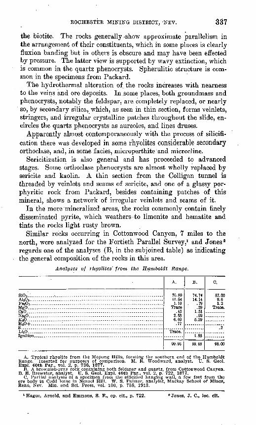
Similar rocks occurring in Cottonwood Canyon, 7 miles to the north, were analyzed for the Fortieth Parallel Survey,1 and Jones 2 regards one of the.analyses (B, in the subjoined table) as indicating the general composition of the rocks in this area.
Analyses of rhyolites' from the Humboldt Range.
sio».:.... ................................................................AltOs.....................................................................Fe203 ...... ..............................................................MgO..... ................................................................CaO.. ....................................................................Na20. ....................................................................K»0.. ....................................................................HaO+....................................................................S. ........................................................................LijO.... .................................................................
A.
76.8011.641.10
Trace.43
2.536.69.77
Trace.
99.96
B.
74.7414.14
.79
.391.51.92
5.29
1.88
99.66
C.
87.009.61.2
Trace.
.2
98.00
A. Typical rhyolite from the Mopung Hills, forming the southern end of the Humboldt Range. Inserted for purposes of comparison. M. R. Woodward, analyst. U. S. Geol. Bxpl. 40th Par., vol. 2, p. 736, 1877.
B. A brownish-gray rock containing both feldspar and quartz, from Cottonwood Canyon. B. E. Brewster, analyst. U. S. Geol. Bxpl. 40th Par., vol. 2, p. 722. 1877.
C. Partial analysis of a specimen from the silicifled hanging wall, a few feet from the ore body in Codd lease in Nenzel Hill. W. S. Palmer, analyist, Mackay School of Mines, Reno, Nev. Min. and Sci. Press, vol. 106, p. 738, 1913.
1 Hague, Arnold, and Emmons, S. F., op. cit., p. 722. 2 Jones, J. C., loc. clt.
$38 CONTRIBUTIONS TO ECONOMIC GEOLOGY, 1913, PAET I.
Analysis C is regarded by Jones as illustrating the increase in silica near the ore bodies, some of which, as he states, consist almost wholly of quartz that has replaced the rhyolite.
Analyses B and C agree well in their more important constituents with that of the typical rhyolite, A, except that C, as was to be expected, is high in silica and B is low in sodium, which from the alteration that has taken place in the rock is not surprising.
The areas shown on the map as greenstone, one three-fourths of a mile northeast of Lincoln Hill and the other at Spring Valley Pass, contain chiefly highly altered, compressed, and partly schistose dark rocks, which appear to be chiefly metamorphosed andesite por phyry, or possibly in some places diorite porphyry, with some basalt or diabase. There is also some light-greenish sericitic and micaceous quartz schist. The darker diabasic rocks contain some finely dis seminated pyrite, mainly in or associated with the altered augite phenocrysts as shown in specimens from Sacramento Canyon and Spring Valley Pass.
In the schist in the west slope of Lincoln Hill, which he calls mica-tourmaline schist, the tourmaline, according to Jones,1 is a pink variety or rubellite, containing, however, the predominating alkali soda rather than the usual lithium, and mica that is asso ciated with it also appears to be the soda mica, paragonite.
The andesitic rocks, in which the ferromagnesian minerals are highly altered, contain residual phenocrysts of calcic plagioclase and are traversed by veinlets of secondary quartz and calcite. The diabase, in part at least, is less altered dynamically than the other rocks and probably represents later intrusive sheets and dikes.
ORE DEPOSITS.
LODES.
GENERAL FEATURES.
The deposits of the Star Peak Range in general are silver-gold ores, characterized mineralogically by the presence of one or more of the sulphantimonites. They occur chiefly in the Star Peak forma tion in structurally favorable places, and although rich near the sur face have not proved persistent to great depth. To these statements the Rochester ore deposits, geologically and in part mineralogically, form an exception. They are chiefly antimonial silver and gold bear ing deposits but they occur mainly as" replacement deposits in the sheeted rhyolite and are irregular, lodelike, or veinlike in form. Their material is chiefly quartz. The associated minerals observed are given in the table on pages 340-341.
1 Jones, J. C., loc. cit.
KOCHESTEE MINING DISTRICT, NEV. 339
The deposits occur in two north-south belts, each about a mile in width the Nenzel Hill belt on the east and the Lincoln Hill belt on the west. The belts parallel the range and approximately the dominant structure of the country rock, to which the deposits in large measure conform.
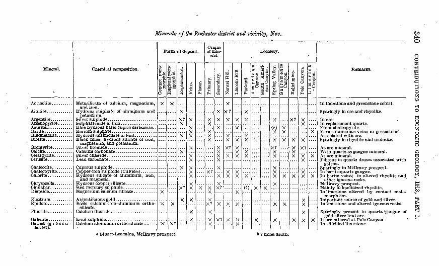
Minerals of the Rochester district and vicinity, Nev.
Mineral.
Actinolite..........
Biotite.............
Calcite..............Cerargyrite. ........
Chrysocolla. ........
Fluorite. ...........
Garnet (g r o s s u - larite?).
Chemical composition.
Metasilicate of calcium, magnesium, and iron.
Hydrous sulphate of aluminum and potassium.
Black mica, hydrous silicate of iron, magnesium, and potassium.
Silver chloride ........................
Hydrous silicate- of aluminum, iron, and magnesia.
Basic calcium-iron-aluminum ortho- silicate.
Form of deposit.
v 1 Contact meta- A 1 morphic.
X
X
Regional nieta- raorphic.
X
X
X?
Replacement.
y?
X
X
X?
X
1
X
v
X v
X
yx
X
v
Placer.
X
Origin of min
eral.
Primary.
X
v
V?
Xy
x?v
X
Secondary.
X
X
X
Xy
xvX?
X
X?
Locality.
NenzelHill.
X?
X
X"
X
X?
X
X X
X
X
Lincoln Hill.
X
X
X X X
X X
X
X
Packard.
X
vX
x"X
X
(»)
American Canyon.
X
X
X
South Ameri can Canyon.
X
"3
1 p< 02
fa \X
XX? X
y
x
X
X
Sacramento Canyon.
X
X
X
X
....
Relief mine.
X?
X
X X X
X
X
§
S0
"o
PH
X
X
X?
X v
X
X
X
Limerick - Canyon.
X
"x"
X
X
' Remarks.
In limestone and greenstone schist.
Sparingly in ore and rhyolite.
In ore. In replacement quartz. From chalcopyrite. Forms numerous veins in greenstone; Associated with ore. Sparingly in rhyolite and andesite.
As ore mineral. With quartz as gangue mineral. As ore mineral. Fibrous in quartz druses associated with
galena. Sparingly in Mcllravy prospect. In barite-quartz gangue. In barite veins; in altered rhyolite and
other igneous rocks. Mcllravy prospect. Mainly in kaolinized rhyolite. In limestone altered by contact meta-
morphism. Important source of gold and silver. In limestone and altered igneous rocks.
Sparingly present in quartz 'gangue of gold-silver-lead ore.
Is ore mineral at Pole Canyon. In silicifled limestone.
03 rf^O
a-o
O O
o
o f o
a Stuart-Lee mine, Mcllravy prospect. & 2 miles south.
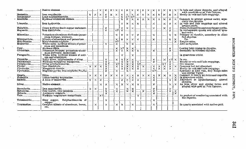
Gold................
Malachite...........
Microcline..... .....
Opal................
Paragonite..........
Proustite. ..........Psilomelane........
Pyrite..............
Quartz............Kubellite...........
Sflver... ............
Stibnite.. ..........
Green hydrous basic copper carbonate.
Potassium-aluminum disilicate (potas sium feldspar, triclinic).
White mica; hydrous silicate of potas sium and aluminum.
Potassium feldspar; potassium-alumi num disilicate; monoclinic.
White mica; hydrous silicate of sodi um and aluminum.
Magnetic pyrite; iron sulphide (FenSu)
Gray copper. Sulphantimonite of copper.
. Complex silicate of aluminum, boron, etc.
X
*
....
X
X
X
X
X
X
X
X
X
X
X
X
X
X
X
X
V f
X
X
vX
X
X
X
X
X
X
X
X
....
X
X
X
X?
X
X VX
X X
X
X? X
X
X
X
X
X
X X X
X
X X
X
X
X? Xv
X X X X X
X
X
X
X
X
X X? X
X
X
X
X
X
X X
X X X X X X
X
X
X
X X
X
X X? X
X
X
X
X
X
X X
X
X X X X X
X
X
X
X X
X
X
X
X
X
X
X
X X? X X
X
X
X
X
X
X
X
.X
X
X
X
X
X
X
X
X
X
X
X X v?
X
X
X
X
X
X X
X
X
X
X
X
X
....
XX?"
X X
X
....
X
X
X
X
X
X
X
X
X? X X X X
X
X
X
X
X
X
X
X
X
X X
X
"x
X X X
X
X X
In lode and placer deposits, and alloyed with much silver at Pole Canyon.
Mostly in vein and lode croppings.
Common ia altered igneous rocks, espe cially the rhyolite.
In vein and lode croppings and altered igneous rocks.
Fromchalcopyrite and cupriferous pyrite. In replacement quartz and altered igne
ous rocks. Primary in rhyolite, secondary in silici-
fled rnyolite. Do.
Empire mine. Also in rhyolite.
Coating joint planes in rhyolite. Secondary in silicified rhyolite.
In greenstone schist.
In ore. Mostly in vein and lode croppings. Ore mineral. Common but not abundant. Mostly in vein and lode croppings. Sparingly in East vein, Roy Ridge mine
and Spring Valley.' Common in nearly all rocks and deposits. In greenstone schist. Abundant in hydrothermally altered
rhyolite. As wire silver and similar forms and
alloyed with gold at Pole Canyon.
As product of weathering associated with the deposits.
In quartz associated with native gold.
a o oW
o S02HW i iO
CO
342 CONTRIBUTIONS TO ECONOMIC GEOLOGY, 1913; PAET I.
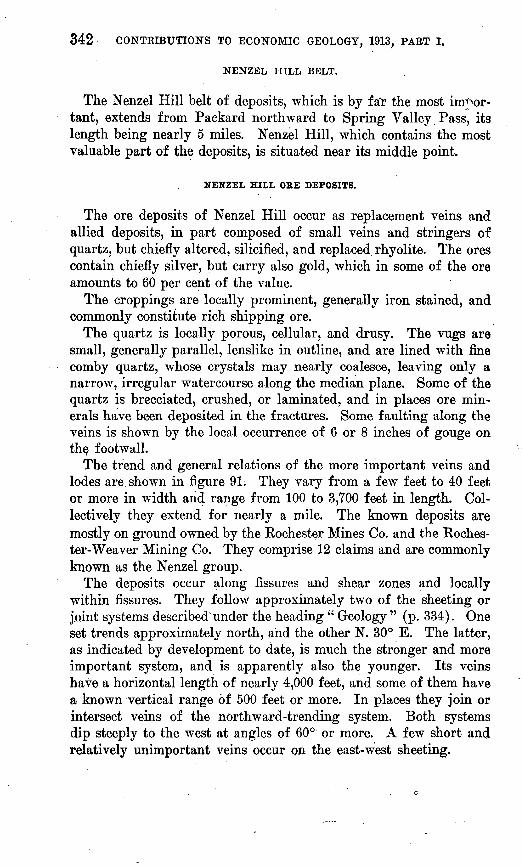
NENZEL HILL BELT.
The Nenzel Hill belt of deposits, which is by f a'r the most im^or- tant, extends from Packard northward to Spring Valley.Pass, its length being nearly 5 miles. Nenzel Hill, which contains the most valuable part of the deposits, is situated near its middle point.
NENZEL HILL ORE DEPOSITS.
The ore deposits of Nenzel Hill occur as replacement veins and allied deposits, in part composed of small veins and stringers of quartz, but chiefly altered, silicified, and replaced rhyolite. The ores contain chiefly silver, but carry also gold, which in some of the ore amounts to 60 per cent of the value.
The croppings are locally prominent, generally iron stained, and commonly constitute rich shipping ore.
The quartz is locally porous, cellular, and drusy. The vugs are small, generally parallel, lenslike in outline, and are lined with fine comby quartz, whose crystals may nearly coalesce, leaving only a narrow, irregular watercourse along the median plane. Some of the quartz is brecciated, crushed, or laminated, and in places ore min erals have been deposited in the fractures. Some faulting along the veins is shown by the local occurrence of 6 or 8 inches of gouge on the, footwall.
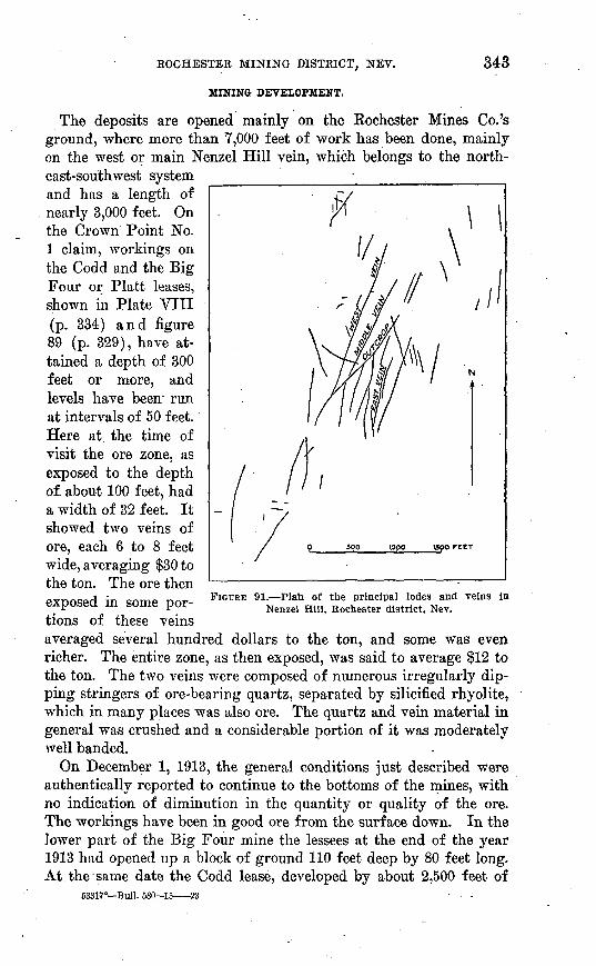
The trend and general relations of the more important veins and lodes are. shown in figure 91: They vary from a few feet to 40 feet or more in width and range from 100 to 3,700 feet in length. Col lectively they extend for nearly a mile. The known deposits are mostly on ground owned by the Rochester Mines Co. and the Roches ter-Weaver Mining Co. They comprise 12 claims and are commonly known as the Nenzel group.
The deposits occur along fissures and shear zones and locally within fissures. They follow approximately two of the sheeting or joint systems described under the heading " Geology " (p. 334). One set trends approximately north, and the other N. 30° E. The latter, as indicated by development to date, is much the stronger and more important system, and is apparently also the younger. Its veins have a horizontal length of nearly 4,000 feet, and some of them have a known vertical range of 500 feet or more. In places they join or intersect veins of the northward-trending system. Both systems dip steeply to the west at angles of 60° or more. A few short and relatively unimportant veins occur on the east-west sheeting.
ROCHESTER MINING DISTRICT, NEV. 343
MINING DEVELOPMENT.
The deposits are opened mainly on the Rochester Mines Co.'s ground, where more than 7,000 feet of work has been done, mainly on the west or main Nenzel Hill vein, which belongs to the north east-southwest system and has a length of nearly 3,000 feet. On the Crown Point No. 1 claim, workings on the Codd and the Big Four or Platt leases, shown in Plate VIII (p. 334) and figure 89 (p. 329), have at tained a depth of 300 feet or more, and levels have been~ run at intervals of 50 feet. Here at the time of visit the ore zone, as exposed to the depth of about 100 feet, had a width of 32 feet. It showed two veins of ore, each 6 to 8 feet wide, averaging $30 to the ton. The ore then exposed in some por tions of these veins averaged several hundred dollars to the ton, and some was even richer. The entire zone, as then exposed, was said to average $12 to the ton. The two veins were composed of numerous irregularly dip ping stringers of ore-bearing quartz, separated by silicified rhyolite, which in many places was also ore. The quartz and vein material in general was crushed and a considerable portion of it was moderately well banded.
On December 1, 1913, the general conditions just described were authentically reported to continue to the bottoms of the mines, with no indication of diminution in the quantity or quality of the ore. The workings have been in good ore from the surface down. In the lower part of the Big Four mine the lessees at the end of the year 1913 had opened up a block of ground 110 feet deep by 80 feet long. At the same date the Codd lease, developed by about 2,500 feet of
FIGURE 91. Plan of the principal lodes and veins in Nenzel Hill, Rochester district, Nev.
53317° Bull. 580-15- -23
344 CONTRIBUTIONS TO ECONOMIC GEOLOGY, 1913, PART I.
work and credited with a production of over 9,000 tons of ore, had an ore shoot known to be 150 feet deep and ,160 feet long.
In March the operators of the Big Four mine reported 3,000 tons of ore in the stopes ready for shipment. Late in April they were stoping a width of 7 feet of good shipping ore just beneath the 50- foot level stope, which last autumn produced $100,000, and on the 160-foot level south and on the lower levels stoping, raising, and pinking showed that the ore body in.places has a width of 14 feet.
In the Codd mine, late in January, 1914, an ore shoot was opened on the hanging-wall side of the 150-foot level. This averaged about $65 to the ton, of which about $6 was'in gold. This mine, from the surface down to the bottom level, still contains large bodies, 4 to 14 feet wide, of milling ore, amounting to about 25,000 tons and averag ing about $14 to the ton.
Late in April, 1914, the shaft on the Codd lease had attained a depth of 500 feet, and good ore was being mined from the 320-foot level north, and in May the main vein, with good ore in the east crosscut on this level, was struck. The workings were being con nected with the main Causten level, which is 400 feet below the out crop of the vein.
According to later reports, on the 425-foot level a width of 10 feet of the vein averages $20 and 3 feet of it about $35 to the ton, and much $25 ore is said to be blocked out. Here also a 40-foot crosscut to the east from the bottom of the shaft has encountered a new vein, thought to be the " back " vein, which is 12 feet in width and in ore content compares favorably with the main vein. Four feet of it averages about $28 to the ton and the rest is good milling ore. The location is on the Causten lower tunnel level, at 800 feet from the portal, and the vein is thought to contain much workable ore below this level and the surface.
Developments in September, 1914, have shown the presence of this vein, with practically the same width and ore tenor as above de scribed, extending through the deep parts of the Big Four and Four J mines, thus indicating a continuous length of 1,000 feet of milling ore on the several leases at depths of 400 to 600 feet.
The Causten or Four J lease, about 1,000 feet north of the Codd lease, is opened mainly by a lower tunnel, the Causten or main cross cut tunnel, which is 300 feet lower than the collar of the Codd shaft, and by an upper tunnel 300 feet above the lower one. At the time of visit the upper tunnel, 265 feet in length, connected with 120 feet of drift and had yielded some $6 ore.
The lower tunnel at that time had a length of nearly 200 feet. It penetrated altered decomposed brownish iron-stained blocky rhyo- lite, less siliceous than the average rock in Nenzel Hill. Some of
ROCHESTER MINING DISTRICT, NEV. 345
the less oxidized rock near the face contains pyrite finely dissemi nated. The tunnel driven to the east follows a zone of crushed, altered, and silicified rhyolite and rhyolite breccia 18 inches wide which in places gave assays of more than $300 to the ton, but, as in the upper tunnel, the average material is not of shipping grade. Several tons of it lay sacked on the dump. In some of this ore 10 per cent of the value is said to be in gold. The country rock is cut by joints into cuboidal blocks 2 to 3 feet, across.
By December 1, 1913, the tunnel had been extended to a length of a thousand feet, giving a depth of about 400 feet on the main vein, and a body of $16 ore had been cut. In January, after further sinking in the bottom of the Codd mine and drifting in the Causten ground, a new ore shoot 3 to 4 feet wide was reported. The ore in this shoot is said to resemble that, of the Colligan lease on the Weaver ground, on the southern slope of Nenzel Hill, and to average about $100 to the ton, with two-thirds of its value in gold. This ore body, it may be observed, is apparently at the same elevation as the ore of the Colligan workings and is probably at about the same geologic horizon.
Recently it has been reported that workings from this tunnel have been extended to the depth of 520 feet, the greatest yet attained in the district, and that the vein, which continues about 8 feet in width to this depth, consists chiefly of milling ore, of which by June the mine had blocked out and accumulated 20,000 tons. There are, how ever, some bodies of richer ore from which the Four J lessees began shipping early in March. Subsequently, in an upraise from the main level, a shoot of $30 ore 2-| feet wide was encountered, which is thought to be a continuation of the shoot exposed in the north end of the Codd lease.
The operators of the No. 4 lease, which lies between the Codd and the Causten leases, ship from time to time a carload of $30 ore from relatively shallow workings. About a thousand feet north of these, the lessees of Block 8, on the Crown Point No. 3 claim, opened by shaft and tunnel in the northeast slope of Nenzel Hill at 7,000 feet elevation, are also working in good ore. The Camille Rock lessees, also on the Crown Point Mining Co.'s ground, near by, are reported (April, 1914) to be working a 6-foot vein of ore, mostly of shipping grade, which has been stripped on the surface and shows well for a distance of 400 feet. At the depth of 65 feet the vein contains a body of gold-silver ore 6 feet in width, which assays from $40 to $80 to the ton.
The ore minerals in the deposits of Nenzel Hill occur chiefly in quartz that has replaced rhyolite and are sporadically distributed
346 CONTRIBUTIONS TO ECONOMIC GEOLOGY, 1913, PART I.
through this in small aggregates, much of the ore having a blotchy or mottled appearance. To some extent they occur in the vugs, and secondarily they follow lamination or fractures in the quartz.
The silver-bearing minerals, which are the important constituent of the ores, owing to their fine-grained aggregation, are not easily determined. In much of the ore bindheimite, a yellowish-green min eral consisting chiefly of hydrous lead antimonate and resulting from the decomposition of other antimonial ores, is common. From this occurrence it appears that silver-bearing sulphantimonites may be present. Among the minerals Jones 1 has recognized pyrargyrite. Argentite, which is regarded by Mr. E. B. Mills, superintendent of the Rochester Mining Co., as probably the principal ore mineral, seems to be present generally, accompanied in places by a little proustite. Scales of native silverware visible here and there, and rarely, with the pocket lens, a few specks of free native gold may be seen. The Big Four and Codd ore averages one four-hundredth of an ounce, or about 5£ cents in gold to the ton, but the gold is said to increase with depth. Other silver minerals reported by mining men are cerargyrite and bromyrite. At the time of the writer's visit the ore minerals could be more satisfactorily studied in material from the No. 4 shaft on the Crown Point No. 1 and in neighboring small openings in the northeast slope of Nenzel Hill than in that from the larger workings.
The ore, according to smelter returns, contains about 93 per cent silica. Besides quartz and the minerals just mentioned it contains some pyrite, a little chalcopyrite, and in places a very little spha lerite and galena. The ore is commonly stained pale brown by oxi dation products, particularly by limonite and hematite derived from the pyrite. In places it is stained green or bluish by malachite and azurite derived from the chalcopyrite. In some places these copper carbonates line vugs and appear to be of recent deposition.
In the southern part of the Nenzel Hill area, on the south slope of Nenzel Hill, the Rochester-Weaver Mining Co.'s ground has been opened by about 4,000 feet of work, including a 430-foot adit. The principal openings are on the Colligan and Shea lease blocks. The ore bodies have been found to extend to the depth of 350 feet. At that depth three veins have been crosscut.
At the Colligan lease, worked by the Rochester Nugget Mines Co., the country rock is a purplish-brown porphyritic rhyolite, consider ably altered and traversed by veinlets of sericite. The strike of the vein, N. 17° E., is intermediate between that of the northward trend ing system and that of the north-northeastward trending system. It is probably a continuation of the West vein, although its connection with that vein has not been established. It is in general nearly
1 Jones, J. C., loc. cit.
ROCHESTER MINING DISTRICT, NEV. 347
vertical, dipping here to the west and there to the east. It ranges from 1 foot to 3£ feet in width.
The vein is composed of brownish or yellowish fine-grained quartz and silicified rhyolite, the color being due to limonite. Most of the ore is soft and pulverulent, but the vein contains also some harder ore, like that of the Codd and Platt mines. At the time of the writer's visit the workings comprised a 55-foot crosscut tunnel, 90 feet of drift, and a 16-foot winze. The mine had produced 90 tons of $27 ore, of which 40 per cent of the value was in gold and the remainder in silver. According to returns of the Mason Valley Mines Co.'s smelter, the ore contains also 13 per cent of iron.
By December, 1913, the Colligan mine had attained a depth of 210 feet and the lessees had shipped 320 tons of ore, which averaged nearly $42 to the ton. More than one-third of the value of this ore was in gold. In May much of the ore was reported to average $75 to the ton.
On the neighboring Gillespie or Shea-Kelleher lease, about 1,000 feet east of the Colligan, is an incline shaft, 600 feet deep, on what appears to be a 16-foot lode, which is parallel to that of the Colligan. The workings are on the southwest slope of Nenzel Hill, in brown rhyolite. Later reports indic'ate that the mine contains an ore shoot 4£ feet wide, which averages about $50 to the ton in gold and silver. Prior to December 1 the mine had produced over 170 tons of ore, which averaged approximately $26 to the ton. At the time of the writer's visit about 6 tons of good-looking quartz ore lay on the dump. The ore contains some pyrite. In August the mine was reported to have blocked out over 10,000 tons of ore ready for stoping.
Operators of neighboring leases, the Cole, Friedman, and Case, also on the Weaver ground, on the south slope of the hill, have made small shipments. Late in March, 1914, it was reported that a shoot of $100 ore, 18 inches wide, in which the value is chiefly in gold, was struck on the Cole lease, at a depth of 125 feet. A carload shipped in May is said to have yielded returns of $142 to the ton in gold.
The East vein or ledge outcrops along the upper east slope of Nenzel Hill, lying approximately parallel with the West vein, from which it is 1,200 to 1,400 feet distant. It has a known length of about 1,000 feet, mainly within the January Fraction claim, but.it extends for a few hundred feet into the Crown Point No. 1 claim, to the north. The lode shows rugged croppings of silicified rhyolite, which dip 75° W. into the hill and toward the east form a steep scarp about 100 feet high.
The'lode is opened at several places. The most important0 opening is at the north end, in the Roy Eidge mine. At this place 8 tons of ore, said to average $100 in silver and $1.50 in gold to the ton, was
348 CONTRIBUTIONS TO ECONOMIC GEOLOGY, 1913, PART I.
taken ifrom a 50-foot shaft. The lode is from 3 to 5 feet wide. Both the vein and the wall rock contain disseminated pyrite and a very little pyrrhotite.
The Nenzel Hill ore deposits, if they persist downward, as ap pears probable, are admirably situated for working through crosscut tunnels, which, driven from the east or west side of the hill, would give from 600 to 1,000 feet of depth, according to the location of the tunnel.
In the adjacent part of Sunflower Kidge, which incloses Kochester Canyon on the south, and in the saddle separating this ridge from the south end of Nenzel Hill, several veins have been opened on the Sunflower group of claims, owned by the Kochester Belmont Mines Co. Here the Sunflower vein, opened at the time of visit by a 50-foot shaft south of the saddle, has a width of 10 feet and dips steeply to the east in rhyolite. At present (May, 1914) a lease being operated in the saddle is said to be producing good ore, and from one of the openings pockets of very rich surface ore, averaging 27 ounces in gold and 362 ounces in silver to the ton, are reported to have been taken.
The Hockley-Boughton lease, almost adjoining the Sunflower prop erty on the west, is also said to be shipping good ore, a carload of which averaged $87 to the ton.
The Limerick gold mine is opposite the Sunflower on the upper south slope of the ridge that bounds Kochester Canyon on the north. It is located on patented ground, which extends across the ridge and lies in part on the Limerick Canyon side. It is owned by C. N. Miller, of Fairport, Cal. The country rock is rhyolite, which is stained with limonite and locally has a honeycombed structure. In general the rock is so crushed, sericitized, and otherwise altered that there is scarcely anything for the prospector to follow. A sheeted structure dips 25° W., and silicified croppings one-eighth of a mile up the slope dip 60° W.
The mine is opened mainly by a 90-foot incline of 15°, which ex tends N. 20° W. along two or more ore-bearing layers of breccia composed of quartz and rhyolite. The layers in general dip west, but are very irregular. The gold is sporadically distributed in very fine particles. Cerargyrite is sparingly present, and proustite is re ported. At the time of the writer's visit a small consignment of $125 ore had been shipped, and about 5 tons were sacked on the dump.
A moderate amount of sinking and systematic east-west cross- cutting at right angles to the well-known dominant structure and vein systems of the district would be likely to show whether the prop erty contains any well-developed ledge or extensive workable de posits.
ROCHESTER MINING DISTRICT, NEV. 349
The Plain view mine is nearly a mile north of the Limerick and a half mile south of Panama, in the open head of Limerick Canyon, at about 6,300 feet above sea level. It lies in altered, silicified, and very highly sericitized gray rhyolite and is opened by considerable work extending for some distance below and above the ore road of the Rochester mines.
The lower tunnel, 500 feet long, rims N. 55° E. on an irregular shear zone or fault plane, which dips 60° NW. The rock is crushed and partly silicified, iron-stained rhyolite, considerable portions of which for a few feet in width are said to average about $9 to the ton, chiefly in gold, some of which is visible in the rock. The de posits, however, are apparently too low in grade to be workable under present conditions.
About half a mile northeast of the Plainview mine, on the west side of the pass between Limerick and American canyons and at about 6,400 feet above sea level, are strong croppings on what is known as the Orms prospect. These croppings show altered rhyolite, or perhaps dacite, for besides much quartz the rock contains con siderable lime-soda feldspar, and some chlorite after biotite.
The ledge, from 3 to 8 feet in width, strikes approximately east and west and is opened mainly by a 100-foot tunnel drift. It is composed of silicified rock, closely banded by veins and stringers of quartz, and shows considerable free gold, but the ledge at the time of the writers visit appeared to be irregular and difficult to follow.
Just over the ridge from the Orms prospect, on the southeast slope of the pass between Limerick and American canyons, are some de posits that differ from those of the Nenzel Hill class in that they are more distinctly of vein character, without the replacement fea tures which are so characteristic in Nenzel Hill. The country rock is rhyolite or quartz latite porphyry, resembling that at the Orms prospect. It occurs in heavy sheets or flows, dipping 50° E. A por tion of the rock which crops in a rather prominent reef several feet in width appears to be a later intrusive sheet or dike.
The deposits consist of a series of approximately parallel quartz stringers and veins, which also dip 50° E. in approximate conformity with the porphyry. They range from a few inches to 2£ feet in width. From croppings and prospects in the northeast slope of the hill it is estimated that one or more of the veins has a vertical range of at least 200 feet. The metallic minerals conspicuous in the veins and stringers are sphalerite, galena, and pyrite, all more or less in termingled. They occur crudely banded or as streaks and are not present in workable quantity. The metal for which the deposits are being exploited is said to be silver, the silver-bearing minerals being apparently associated with the galena and only sparingly present.
850 CONTRIBUTIONS TO ECONOMIC GEOLOGY, 1913, PART I.
SOURCE OF THE NENZEL HILL ORE DEPOSITS.
The .Nenzel Hill ore deposits, as shown by the quartz phenocrystg which they contain, and by their outward transition from nearly pure quartz into rhyolite, were formed by replacement of that rock, already rich in silica. Although the contact between the veins or ore zones and the wall rock is in general well defined, its undulatory, irregular character is also indicative of replacement.
The deposits have supposedly been formed by ascending hydro- thermal solutions derived from some intrusive magma. This magma may have been that corresponding to one of the volcanic rocks or that of some underlying granite, possibly a southerly extension of the granite mass of Eocky Canyon.
The heated solutions probably continued to ascend long after the intrusion of the magma. The water of Black Knob Spring, near Packard, is slightly warm, and in American Canyon the rocks in a 200-foot shaft are reported to be above the usual temperature for rock at that depth. But the heat in these places is likely to be due to later processes than those connected with the origin of the ore deposits.
In a few places on the south slope of Nenzel Hill structures were observed that suggested the pseudomorphic replacement of calcite by silica, but the evidence was too indefinite to justify the conclusion that silica has extensively replaced a calcite gangue as it has in some districts in Nevada and Arizona.
The irregularity in the lateral extent of silicification, considered in connection with the greater abundance of primary quartz pheno- crysts in the less silicified portions of the deposits as compared with the more silicified, indicates, as urged by Whyttock,1 that silicifica tion and ore deposition were most active in the more feldspathic portions of the rocks, the feldspar being particularly susceptible to metasomatic replacement.
PACKARD ORE DEPOSITS.
The Packard ore deposits resemble in some respects the Nenzel Hill deposits, but differ markedly from them in being less well de fined and less silicified. They occur in Packard Ridge, a broad, gently sloping spur at the south end of the Nenzel Hill belt, at an elevation of about 5,850 feet. A cross section of the hill is shown in figure 91 (p. 343).
At the time of the writer's visit the ground had been opened in four contiguous claims, known as the Packard group (PL VIII). The first location here was made in December, 1912, by Henry Lund.
1 Whyttock, P. R., oral communication on the ground; see also Min. Rev., vol. 15, No. 2, p. 21, Apr. 30, 1913.
EOCHESTER MINING DISTRICT, NEV. 351
The rich silver ore now being worked was found by R. Ray in the following May, and soon thereafter the property was sol'd for $5,000 to the Rochester-Packard Mines Co., which at once began operations, and late in May was shipping ore.
Along the crest of the ridge a belt of craggy silicified rhyolite, 100 feet wide, commonly known as the " dike," indicated by C in figure 91, rises about 12 feet above the surface. The croppings are sheeted like the adjoining rhyolite, of which they appear to be only a silici fied part. They are also traversed longitudinally by some vertical, slickensided surfaces, and the " dike " apparently is a silicified fault zone.
In a few places, where the rock has not been rendered schistose, it appears fresh and resembles Tertiary rhyolite, but under the micro scope it is found to be devitrified, silicified, and sericitized.
The ore deposits, as shown in figure 90 (p. 335), occur on both sides of the fault zone and are generally parallel to it in strike though not in dip. They conform to the general layering and schistosity of the rhyolite, the ore bodies on the southeast side of the fault zone dipping toward that feature, whereas those on the north west side dip away from it. Very little ore occurs in the fault zone itself.
The croppings of the ore deposits, unlike those of the fault zone, are not prominent and in some places are slightly lower than the general surface. They consist mainly of mineralized schistose rhyolite, which generally constitutes shipping ore from the surface down. The widespread occurrence of ore at the surface has led many to believe that the deposits as a'whole represent a great blanket vein.
The best exposure of the deposits at the time of the writer's visit was on the Packard No. 2 claim and on the Packard Fraction adjoin ing it on the west. At this locality, 150 feet west of the silicified fault zone, the deposits occupy the greater part of a belt about 30 feet wide, whose known length is about 1,200 feet. This zone is marked "O" in figure 90 (p. 335).
In places the ore had been stripped, by plow and scraper and was being worked in several openings from 1 to 8 feet in depth. From one of the main pits, about 10 feet in diameter by 8 feet in depth, a carload of ore had been shipped which averaged $61 to the ton about $58 in silver and $3 in gold.
Work was being done in 8 or 10 similar shallow openings on the Jackson, Cold Storage, Enterprise, and other ground on the east slope of the ridge, where the deposits extend interruptedly from the vicinity of the fault nearly to the base of the ridge.
The ore minerals appear to be chiefly cerargyrite and argentite. They occur in the schistose and partly silicified and replaced rhyolite.

352 CONTRIBUTIONS TO ECONOMIC' GEOLOGY, 1913, PART I.
Much of the ore is a schist with a silvery sheen, and its general appearance gives little suggestion of its value. In some varieties, however, purple or reddish-gray iron-stained quartz is present locally in bodies or lenses several or more inches in width, which, however, are irregular and ill defined and in part at least have been deposited by replacement.
Some siliceous portions of the ore are speckled and in places honey combed by cavities from which pyrite has weathered out and which are now occupied in part by hematite and limonite. In some places silver appears to occur in these cavities, associated with the iron. Small faults and sharp buckling of the rhyolites against the quartz, which is also shattered, show that considerable movement took place after the quartz was deposited.
The Packard ore deposits unquestionably have a genetic connection with the fault zone. They were probably derived from siliceous hydrothermal magmatic solutions, which, in ascending the fault fis sure shown at F-F' in figure 90 (p. 335), deposited the quartz and ore minerals by metasomatic replacement in certain layers or por tions of the rhyolite. The rock replaced, as in Nenzel Hill, was probably less siliceous and more f eldspathic than the present country rock. This selective action apparently explains why ore minerals are only very sparingly present in the silicified fault zone itself.
As the fissure, which is nearly vertical, cuts the inclined forma tions obliquely, the deposits in the beds to the east or right of the fault, as shown in figure 90 (p. 335), were deposited by solutions which on leaving the main fissure ascended, whereas those to the west or left were deposited by solutions which on leaving the fissure de scended, as indicated by the curved arrow at T in figure 90. When ore deposition took place the rocks, as indicated in the figure, ex tended far above the present surface of the ridge, to which they have since been reduced by erosion. This erosion has shifted the outcrop of the ore zone (0 in fig. 90) to a distance of 150 feet from the fault, from which it is now separated by a belt of barren rock. The deposits to the right or east of the fault may be expected in general to connect with the fault fissure in depth, and below any enrichment by oxidation that may have taken place from the surface they should show increase rather than diminution in tenor with depth and with nearness of approach to their source. With some offsets due to move ment along the main fault zone these ore deposits east of the fault probably continue to depth beyond the fault (F-F' in fig. 90), but until the amount of throw is determined their exact positions must remain unknown.
On the other hand, the deposits to the left or west of the fault, which are now the main source of the camp's production, do not, if the explanation of their origin is correct, hold out much promise of
ROCHESTER MINING DISTRICT, NEV. 35S
great downward persistence. The ore now being mined here is ap parently the result of surface enrichment in the oxidized zone and represents in large measure a concentration from portions of the deposits now eroded away. (See fig. 90.) The continuation of this relatively high-grade ore to great depths is not to be expected.
It is possible that deeper ore zones that do not outcrop may occur between the ore zone (O) now being worked and the fault. This could be determined by sinking and crosscutting on the west of the fault, preferably from the bottom of fairly deep workings in the ore zone. Strong probability that the down-thrown portions of the ore beds east of the fault may be found here lends encouragement and purpose to the undertaking.
A quartz vein 2£ feet wide, on the north end of Packard No. 2 claim, occupies a well-defined fissure in the rhyolite. The vein strikes N. 25° W. and dips 80° SW. It is composed of vitreous quartz, which carries only a little gold and practically no silver. Its course is nearly at right angles to the trend of the main deposits of the camp, with which it apparently has no connection. On the dump were seen a few crystals of smoky quartz an inch and a half in di ameter, some with perfect pyramidal termination, which appear to have come from the vein.
In October, 1913, the operators of the Packard property were reported to have opened a 3-foot vein of rich silver ore, some of it running as high as $400 to the ton. The exact location of this vein has not been learned.
During the winter and spring press notices of development re ported continued work on the deposits here described and the dis covery of new ones containing bodies of both shipping and milling ore.
Late in April, 1914, a new 11 to 20 foot vein, mostly of $25 ore, was reported to have been discovered about 200 feet down the slope to the west or hanging-wall side of the main ore zone. (See O in fig. 90.) As its dip is steeper than that of the main ore zone, to which its strike is also oblique, it should join or intersect that zone at no great depth. On the first level it is said to contain about 8 feet of good milling ore and 3 feet of high-grade shipping ore, which averages about $60 to the ton. The ore is described as composed mainly of stringers and druses containing much horn silver. Associated with slips, which are said to be common in the vein, the miners report considerable "talc" or gouge, which averages about $21.50 to the ton in silver.
Late in May another vein or ore zone, 75 feet wide, is reported to have been discovered, from which a carload of $100 ore was shipped, and some specimens, each weighing several pounds, averaged 3,000
354 CONTRIBUTIONS TO ECONOMIC GEOLOGY, 1913, PART I.
ounces in silver to the ton. In September it was- reported that the lower workings, on what is probably an extension of this zone, have opened a body of milling ore approximately 100 feet wide, 20 feet thick, and 65 feet or more long, the developments in the last-named direction still being in ore. This body also contains a few ore shoots of shipping grade. One shoot 8 .feet in width is said to average about $120 in silver and $11 in gold to the ton.
In July and August the Kromer-Hampton lease, which is on Packard ground, was said to be shipping about 100 tons a month of ore averaging about $70 to the ton, and the Nevada-Packard Co. 3 to 4 carloads a month of ore averaging about $65 to the ton. The company is said to have decided to build a mill to treat the ore by, amalgamation and cyanidation.
With the completion of the railroad into the district shipments of Packard ore will be greatly increased. Much of the ore produced in this area still conies from open-day workings.
. . LINCOLN HILL BELT.
GENERAL FEATURES.
The Lincoln Hill belt, as shown by the distribution of the claims in the western part of the area (PL VIII), extends from Weaver Canyon northward across Rochester and Limerick canyons and apparently also across the crest 'of the range into Spring Valley, on the north."
Here the newly described deposits, which early in 1913 attracted much attention and determined the location of Lower Town, occur mainly in Lincoln Hill, where at the time of the writer's visit there were several producing properties from which shipments of high- grade ore had been made, and where some very rich ore continues to be found from time to time.
LINCOLN HILL DEPOSITS.
Lincoln Hill is an elongated oval mass about a mile long and three-fourths of a mile wide, rising to an elevation above sea level of 6,600 feet, or about 1,200 feet above Rochester Canyon, which adjoins it on the south. It is separated on the north from Gold Ridge, of Oro Fino fame, by High Grade Canyon. It is composed chiefly of rhyolitic rocks in which the dominant structure is a pro nounced sheeting accompanied by shearing and schistosity. These structures strike N. 30° W. and dip 40° WSW. A second sheeting, - which in strike approximately parallels the hill, dips 65° NW.
In the rhyolite are numerous quartz veins and stringers, which are the source of the rich float found on all sides of the hill and which during the boom occasioned the staking of nearly 100 claims. They
ROCHESTER MINING DISTRICT, NEV. 355
comprise mainly two sets. The more important one follows approxi mately the strike of the northeast-southwest sheeting and appar ently corresponds to the main vein system in Nenzel Hill. The other set, at about right angles to the first set, strikes approximately north west and forms an angle of about 25° with the N. 30° W. sheeting. To this set apparently belongs also the vein of the Oro Fino mine, a mile northwest of Lincoln Hill.
The Lincoln Hill veins are smaller than the Nenzel Hill veins and more nearly resemble veins of the filled^fissure type. They contain tourmaline, specularite, and other minerals in quartz, and the valu able metal is almost entirely gold. Bromyrite has been found by Mr, J. Phelps at the south base of the hill.
The deposits occur chiefly in six or eight veins on the west slope of the hill. The principal openings on them are the Summit and Supreme mines on the northwestward-striking system and the For- villy mine on the northeast-southwest system.
On the latter system, on the Abe Lincoln No. 2 claim, at an eleva tion of 6,400 feet, the Forvilly mine, owned by Messrs. Campbell and Forvilly, is opened mainly by two 40-foot shafts, one on each of two veins which lie about 20 feet apart and dip 80° NW. Here the southeast vein is 3 feet in width and the northwest one is wider. Stoping is done on both veins to the northeast of the shafts. The walls are good but generally " frozen " and without gouge. The veins are composed mainly of quartz, in small part replacing rhyolite, and of altered and silicified rhyolite. In places they are vuggy or porous.
The ore in places is crudely branded. Its contents in gold and silver are approximately equal in value. With it is associated some finely disseminated pyrite. About 120 tons of ore, averaging about $58 to the ton, had been shipped at the time of the writer's visit, and 5 tons were sacked or piled on the dump.
The Summit or upper Forvilly mine, about 700 feet east of the mine just described,- is in a saddle in the crest of Lincoln Hill at an elevation of 6,450 feet. Its vein, which belongs to the northwest- southeast system, is 2£ feet or more in width and dips 60° NW. It is opened by an incline shaft. The country rock is rhyolite. The ore, of which several tons were lying sacked on the dump at the time of the writer's visit, is apparently of good grade and shows much free gold. It resembles the ore of the Supreme mine, next to be described, which, together with the fact that it is approximately on the projected course of the Supreme vein, suggests that the deposits at the two mines may be on the same vein.
In September, 1914, development of the Forvilly mines is reported to have continued with gratifying results, gold, mostly free milling, being found plentifully throughout the deposits. A stamp mill is said to be treating the ore on the property since October 15.
356 CONTRIBUTIONS TO ECONOMIC GEOLOGY, 1913, PART I.
At the Supreme mine, operated by W. N. Harwood and associates, which is located about 1,600 feet west-northwest of the Summit mine, at an elevation of 6,100 feet, the deposits occur in an 18-inch vein that dips 80° NNE. in rhyolite. The vein is composed mainly of a pale-brown iron-stained gangue of quartz, which has replaced rhyolite, and of silicified rhyolite. The croppings extend along the slope for several hundred feet and in the adjacent wall of High Grade Canyon are exposed for a vertical distance of over 100 feet.
The vein when visited had been opened horizontally for 40 feet and to the depth of 30 feet. It apparently consists mainly of com pletely silicified rhyolite or quartz. The walls, though well defined, are tight or frozen and without gangue, conditions which are not promising for continuity. The ore shows much free gold in wire and other forms. In some specimens the jagged wirelike forms pro trude a twentieth of an inch above the surface of the weathered quartz. The gold is noticeably abundant in the quartz within half an inch of the less completely silicified rhyolite and in the darker varieties of the quartz. In places the vein for its full width is said to average $1,500 to the ton, and picked samples are said to range from $3,000 to $5,000 to the ton.
Associated with the ore in places are pyrite and a little specularite in crystals about a fifth of an inch in diameter. A 5-ton test ship ment is reported to have averaged $187 .in gold and 12 ounces in silver to the ton. In places in the vein occur small stringers or lenses of apparently later milky-white-quartz, with a few fresh feldspars. In these, however, no gold was found.
Down the slope to the south, about 50 feet from the Supreme vein, is a similar vein, and 1,500 feet to the west-southwest, on the New Prince ground, are three parallel stringers or veins, of similar char acter, from 12 to 14 inches in width. These veins as yet have re ceived but little development.
Eecently (September, 1914) the Blowback claim, adjoining the Supreme mine on the south, is reported to have been worked and to have made a shipment of ore which averaged $250 to the ton, nearly all in gold.
Developments are also showing up well on the Flunky No. 2 claim, near by, which is reported to have just been acquired by the Lincoln Consolidatecl Co. for $37,500. It will be operated in conjunction with the company's adjoining property, on which also extensive development work is being done.
SOURCE OF THE LINCOLN HILL ORE DEPOSITS.
The Lincoln Hill ore deposits examined in 1913, like those of Nenzel Hill and Packard, appear to have been formed chiefly by hydrothermal solutions, but pneumatolytic action seems also to have
ROCHESTER MINING DISTRICT, NEV. . 357
played an important part, as is attested by the presence of tour maline in the veins. The process of formation was more of the nature of fissure filling with less replacement than in the Nenzel Hill deposits.
South of Lincoln Hill, in the north slope of the ridge that bounds Rochester Canyon on the south, the deposits of the Buck and Charley mine, which was not visited, also occur in the rhyolite. They have produced upward of $10,000 worth of ore.
In the lower tunnel of the mine, at a vertical depth of 200 feet, the vein is reported to carry a width of 4 to 15 feet of $18 ore with shoots 1 to 3 feet in width composed chiefly of ore averaging about $125 to the ton, mostly in gold. The mine is favorably situated for shipment, being directly on the line of the Nevada Short Line Rail road, which is now being extended.
In the northern part of the Lincoln Hill belt, in Limerick Canyon, are several prospects which were not visited. Among them is an opening on the Empire ground, on a quartz vein in greenstone. The quartz apparently in part has replaced barite and carries tetrahe- drite, a little .stibnite, and molybdenite.
Of the earlier workings in the Lincoln Hill belt the Oro Fino and Montezuma deserve passing notice. The Oro Fino mine, which was not visited, is situated about a mile northwest of Lincoln Hill, just across High Grade Canyon, on a southwest spur of Gold Ridge. A series of dumps suggested by their alignment that the vein belongs to the northwest system. It is thought by J. T. Reid to be on the same fissure or contact as the Humboldt Queen mine,1 near the mouth of Limerick Canyon, described by Ransome. This fissure is held by some mining men to contain other promising prospects higher up in Limerick Canyo'n.
According to reports, the Oro Fino mine in 1879 produced $58,000 in high-graole gold ore, and in the early eighties it produced about 200 tons of low-grade ore, averaging from $6 to $7 a ton, which was treated in a 5-stamp mill in the lower part of Limerick Canyon. Later Mr. Schmidt, of Ryepatch, is reported to have found in it a pocket of rich ore which yielded about $2,000. By some the mine is thought still to contain considerable workable ground.
The old Montana shaft in Rochester Canyon, about a mile below Lincoln Hill, is on what appears to be a rhyolite dike dipping steeply west in the limestone of the Koipato formation. It is owned in New York. It was sunk in the early sixties and for a time pro duced some high-grade ore. Since then it has not been productive. According to tests made by P. R. Whyttock,2 the Montezuma and adjoining ground yield good assays. °
1 Ransome, F. L., op. cit., p. 33. 2 0ral communication.
358 CONTRIBUTIONS TO ECONOMIC GEOLOGY, 1913, PART I.
DEPOSITS IN NEIGHBORING LOCALITIES.
The discoveries made in Nenzel Hill and Lincoln Hill in 1912 and 1913 naturally led to considerable prospecting in the surrounding hills, which resulted in a revival of activity at some of the old deposits and the discovery of some new ones.
McILRAVY PROSPECT.
About a mile northwest of Spring Valley Pass, and half a mile outside of the area mapped in Plate VIII, at an elevation of about 6,700 feet, is a deposit that differs from anything heretofore described in this report. It contains copper-silver ore in a barite- quartz gangue, barite having been apparently in part replaced by the quartz. The deposit occurs in the form of a bed, or bed vein, about a foot in width, which dips. 25° SW., conformably with the general structure of the country rock, a dark greenstone (diorite porphyry?), and contains layers a few feet thick of a pale-green siliceous rock which is now a sericite-quartz schist but may have been originally rhyolite.
The deposit occurs in or associated with one of these layers. It is opened mainly by a 30-foot incline. .The ore minerals are azurite, malachite, chrysocolla, a little chalcopyrite, chalcocite, cerargyrite, and apparently some silver-bearing sulphantimonite. They occur associated, mainly in lenses and kidneys from 2 to 6 inches in width lying parallel with the walls of the vein. They are more or less interbanded or streaked with the barite-quartz gangue, with some dark-greenish micaceous mineral apparently belonging to the chlorite group, and with a dark-greenish mixture composed apparently of oxide of iron and manganese, with .a little copper, pitchblende, and epidote. Some chalcopyrite also occurs in the vein. A considerable portion of the ore is said to average from 5 to 6 per cent in copper and $60 in silver to the ton.
Northwest of the Mcllravy prospect the greenstone becomes dia- basic and extends into the mountains for the distance of a mile or more. It weathers in blocky forms which roughly resemble colum nar structure, and for the first half mile or so beyond the Mcllravy prospect it contains numerous barite veins from 2 to 10 inches in width, dipping steeply northwest. Associated with the barite in the veins are some chloritic minerals. Some of the barite is coarsely crystalline.
LEE-STTJART MINE.
Beyond the Mcllravy prospect, at the head of Spring Valley, about a mile and a half north-northwest of Spring Valley Pass, de posits occur on the Lee-Stuart ground, which, at the time of the
ROCHESTER MINING DISTRICT, NEV. 359
writer's visit, were attracting attention through a strike made by a lessee named Carpenter.
The deposits comprise three parallel veins or lodes, which are shown by croppings and openings to have a length of about a mile. They dip steeply northwest into the mountain and are' spaced about 1,600 feet apart horizontally and 500 feet apart vertically, the lowest vein being at an elevation of about 6,000 feet and easy of access. They are mineralogically similar to the deposits Oof Lincoln Hill, and apparently form the northward extension of that belt of min eralization.
These deposits lie in the porphyroid rocks of the Koipato forma tion. The veins are approximately parallel with those of the main Nenzel Hill and Lincoln Hill system and seem to owe their position to the same system of sheeting -or fissuring. In size and in their composite or lodelike character, the veins resemble the deposits of Nenzel Hill, though mineralogically they appear to be more like the Lincoln Hill type. The gangue is chiefly quartz with some silicified, altered, and replaced rhyolite or other rock, a portion of which may have been originally dike material. The quartz commonly contains needles and prisms of black tourmaline and rather large scales of specular hematite. The gold is free and coarse.
The lower vein, on which most work has been done, is opened by an 800-foot tunnel, which is driven chiefly through greenstone and crosscuts the vein at about 400 feet in from the portal. Here the vein shows a width of 16 feet. It is composed mainly of a mixture of quartz and rhyolite containing free coarse gold.
Near the southeast end of the vein, about 1,500 feet from the tunnel, are the Gold Dike and two other shallow shafts. The ore here shows considerable coarse free gold. Some particles are a fifth of an inch in diameter.
The gold occurs chiefly in the quartz stringers and in the altered silicified porphyry within the lode, generally at or near the walls of the stringers. It occurs also in streaks of coarsely crystalline hematite that has apparently been derived from pyrite, and to some extent associated with fresh-looking black needles and prisms of tourmaline embedded in the quartz. Some of the hematite is very rich, the gold being contained in that mineral, with which, in places, is associated a little pyrrhotite.
These Lee-Stuart veins apparently contain a large amount of gold, but owing to the sporadic distribution it is doubtful whether they are workable under present conditions. They were an important source of the gold mined in the Spring Valley placers, and they suggest that veins of their class were probably the chief source of the gold found in the American Canyon placers. The ore of the
53317° Bull. 580-15 24
360 CONTRIBUTIONS TO ECONOMIC GEOLOGY, 1913, PABT I.
middle vein is said to contain, besides gold, argentite and other sul phides with some copper, and to be in part refractory.
Near their western ends the veins are intersected diagonally by two east-west veins, which also carry some gold. Where they inter sect the lower vein, a few hundred feet northeast of the Gold Dike shaft, they are about 80 feet apart and dip steeply north.
Here, as at Lincoln Hill, the presence of tourmaline associated with the gold inothe quartz indicates that pneumatolytic processes, as well as hydrothermal action, probably played an important part in the origin of the deposits, and the occurrence of the deposits and associated minerals toward the sides of the veins shows mineraliza tion to have taken place chiefly during the early stages of fissure filling and vein formation. That some of the veins are altered dikes appears probable, but conclusive evidence of this has not been observed.
COLE PROSPECT.
At the time of the writer's visit considerable interest was also mani fested in cinnabar prospects in the surrounding region, and several newly discovered deposits were reported from the south end of -the Star Peak Range. Most of these deposits are in the altered rhyo- litic rocks and are generally similar in their occurrence.
The nearest of the prospects is in South American Canyon, about 1£ miles from Nenzel Hill. In this locality, on the east side of a gulch on the north side of the canyon, the cinnabar deposits are said to occur in three parallel northward-dipping veins in the rhyolite, one of which belongs to G. Cole, of Rochester. The entrance was locked at the time of the writer's visit and the workings were not exam ined'. The deposits appear to be similar to those at the Dixie mine, next to be described, though apparently they are more extensive. The cinnabar, as seen in specimens, occurs as specks and small irregu lar veinlets, the largest three-tenths of an inch in width, in the altered kaolinized rhyolite. Some of the mineral is well crystallized.
DIXIE MINE.
In American Canyon, about 2 miles northeast of Nenzel Hill and 1^ miles down the canyon, cinnabar has been known for some time at the Dixie mine and Nevada Almaden prospects. These lode de posits were discovered through the finding of particles and pebbles of cinnabar in the gold placers, and recently the United Placer Co. is said to have been organized for the purpose of resuming work on the gravels of American Canyon for cinnabar and gold.
The Dixie mine is owned in Lovelock. Its deposit was described by Ransome x as a soft crushed kaolinized zone, at least 6 feet wide,
1 Ransome, F. L., op. cit., p. 37,
ROCHESTER MINING DISTRICT, NEV. 361
in porphyritic rhyolite, with little specks of cinnabar scattered through the kaolin. The zone, without exposed walls, dips into the hill at 15°-20° N. and is opened by an incline 200 feet long, with considerable drifting.
At the time of the writer's visit the incline had been sunk 200 feet deeper and additional drifts driven from it. Ore has been found all the way down, the cinnabar occurring in specks and small irregular bodies in the kaolinized rock. The ore is treated on the ground in a small mill and retort plant, which, it is said, produces quicksilver on a commercial scale from time to time. The ore is said to average about 2 per cent of metal. 1
NEVADA ALMADEN PROSPECT.
The Nevada Almaden prospect, owned by W. G. Adamson, of" Winnemucca, which was not visited by the writer, is reported to be promising. The ore occurs in limestone with some eruptive rock forming the hanging wall. The vein is said to strike northwest and to dip 20° SyV. Specimens shown to Mr. Kansome by Mr. Adamson "contained abundant cinnabar in small irregular fissures in dark- gray limestone. The vein is said to have been traced for a length of 3,500 feet and to have been opened to a maximum depth of 150 feet."2
BTTTTE PROSPECT.
A cinnabar deposit, reported to be rich, was 'found in 1913 at Ante lope Springs, about 8 miles south of Eochester, at the south end of the Star Peak Kange. It is said to be just south of a low basalt- capped foothill butte. Like the neighboring Relief mine described further on, it is most easily reached from Lovelocks, about 18 miles to the west. It is said to occur in rhyolite in small bodies or irregu lar veinlets and stringers as at the Cole prospect and the Dixie mine, near the contact of the rhyolite with limestone and to extend for 300 yards in a north-south direction.
McNICKLE PROSPECT.
Another cinnabar deposit has been found about 4 miles south of Rochester, a mile south of the McNickle camp, at the west base of the range. It also occurs in altered rhyolite.
All but one of the cinnabar deposits here described, in the southern end of the range, lie in a relatively narrow northeast-southwest belt, which for 9 miles follows the contact of the Koipato and Star Peak formations. The deposits apparently are all in the Star Peak
1 McCaskey, H. D., Quicksilver: U. S. Geol. Survey Mineral Resources, 1909, pt. 1, pp. 554-555, 1910.
2 Ransome, F. L., loc. cit.
362 CONTRIBUTIONS TO ECONOMIC GEOLOGY, 1913, PART I.
formation. .Whether they have any genetic connection with this contact could not be determined in the brief time allotted to this work.
It is worth noting that cinnabar is absent, so far as known, from the rocks of the Koipato formation, although in the Rochester dis trict deposits in those rocks contain pyrite, chalcopyrite, barite, opal, and antimonial compounds, with which cinnabar is known to be elsewhere associated. The occurrence of the deposits in the Hum- boldt Range appears to be similar to that of the deposit near lone, on the west side of the Shoshone Range, described by McCaskey,1 where also the cinnabar occurs in rhyolite along one side only of a fault contact.
RELIEF MINE.
r At the Relief mine, better known as the Old Relief mine, 4 miles south of Nenzel Hill, in the southern end of the range, the ore de posits differ from anything thus far described in the Rochester dis trict in that they occur in limestone and appear to belong to the general class of deposits that occur in the Star Peak Range and are described on page 338.
The deposit was discovered in the early sixties and was worked mainly in the seventies. Current estimates of its production range from $200,000 to $2,500,000. Much of the ore produced was very rich and contained chiefly silver chloride with some bromide, and considerable native silver, some of which formed fine specimens. It apparently contained argentite also. According to J. T. Reid,2 a carload of the ore shipped to Swansea, Wales, yielded $22,000.
Afterward the mine was worked by the old Rochester Co., and 'still later by Bailey, who for a time took out much rich ore with largeprofits. Part of the ore was treated, by pan amalgamation, in a 10-stamp mill built by the Rochester Co. near the mouth of Relief Canyon. This mill was removed in 1874.
From 1898 to 1905 the. mine was owned and worked by Mr. Hardesty, of Lovelocks, with fair results. It is now owned and operated by the Rochester Treasure Mining Co.. (Inc.), of Lovelocks.
The mine is near the head of Relief Canyon, which heads south of Buffalo Peak and opens southeastward into Black Knob Valley. It lies at an elevation of about 7,000 feet and is accessible by wagon road.
The deposit is a quartz vein or lode, from 15 to 30 feet wide, in limestone. It dips about 55° W., though the limestone dips 40° SW. The limestone is dark gray, in thin to moderately thick beds, partly slaty, and has a thickness of 600 feet or more. It is underlain by light-colored rhyolite, with which it seems to be conformable, and is
1 McCaskey, H. D., Quicksilver: U. S. Geol. Survey Mineral Resources, 1911, pt. 1, p. 908, 1912.
2 Oral communication.
KOCHESTEE MINING DISTRICT, NEV. 363
overlain by a great thickness of dark-greenish, partly schistose ande- site, which appears to extend from the vicinity of the mine to the mouth of the canyon, 2 miles distant. The rhyolite is dense and consists chiefly of a microfelsitic to glassy base in which are a few small squeezed phenocrysts of quartz microcline and microperthite.
These rocks all belong to the Star Peak formation. The contact of the limestone with the rhyolite is about 200 feet from the mine on the north, but no rhyolite has been cut in the workings. In the vicinity of the vein the limestone is in part silicified.
The deposit is opened chiefly by tunnels and drifts for a horizontal distance of nearly 1,000 feet and through a vertical range of about 320 feet. Croppings of quartz that has replaced calcite veinlets and limestone occur also 80 feet above the highest workings.
According to report and observation, the vein is strong at nearly ,all places where it has been exposed, but the ore occurs mainly as pockets or disconnected bodies ranging in value from a thousand to several thousand dollars. The rich ore is said to be mostly on the hanging-wall side of the vein and that formerly stoped came mainly from the upper and middle levels.
Work is now being done on the 200-foot or Blacksmith Shop level, which is at an elevation of about 7,000 feet and comprises several hundred feet of drifts. Access is gained to it through a 280-foot tunnel, which crosscuts the limestone and at a point 250 feet from the portal reaches the vein. At this place the vein is large and contains, besides stringers of quartz, considerable calcite and layers of lime stone, all dipping 60° NW. The calcite and the limestone seem to be in part replaced by the quartz, which was introduced in solution with the ore minerals. The quartz in general is banded and contains some small vugs lined with druses of crystalline quartz. These vugs do not contain ore. A winze is being sunk on the ore body from this level.
Qn a level about 100 feet lower, consisting of a 375-foot crosscut tunnel and a 30-foot drift on the vein, only gougelike material, some of it said to assay from $6 to $8 a ton, was found.
The upper or 100-foot level, which is about 150 feet above the sec ond level, is opened mainly by a 200-foot tunnel on the vein. The vein, for some distance from the portal, is 3 feet wide and consists of mottled ore. It carries on its hanging wall 6 inches of what appears to be reddish gouge. Farther in, however, this soft ma terial becomes good ore, 2£ feet in width, and the ore body has here been stoped to a width of at least 5£ feet. Much of the high-grade ore extracted in early days came from this level.
About 60 feet above the first or 100-foot level is a large open or daylight stope, which shows that the main part of the lode consists, for a width of 14 feet, of yellowish-brown crushed quartz, next to
364 CONTRIBUTIONS TO ECONOMIC GEOLOGY, 1913, PART I.
which, on the hanging-wall side, is 16 feet of rather siliceous min eralized material, including some limestone, all more or less banded and dipping about 50° SSW. The deposit here contains also some crushed material suggestive of altered igneous rock.
Although the quantity and character of ore in the low.er workings, so far as learned, are not encouraging for deeper work, the mine ap parently still contains considerable ore. It is also held by some that the old dumps, some of which are large, can be profitably milled.
On the opposite side of Belief Canyon, about half a mile south of the Relief mine, and at a slightly lower elevation, is the Silver King mine, which was, not visited. Its vein, in limestone; dips northwest and has been opened to a depth of 60 feet. It consists mainly of quartz and manganese oxide, roughly in the proportion of 2 to 1, and contains considerable ore, much of which ranges in tenor from $120 to $1,800 in silver and carries about a dollar in gold to the ton. The ore minerals are said to be chiefly silver bro mide and chloride, with the bromide predominant. This property is also being worked on a small scale and is producing some ore.
DEPOSITS IN POLE CANYON.
At Pole Canyon, 6 miles northwest of Rochester and 5 miles north east of Nixon, discoveries of ore were made at about the same time as at Rochester.
At the time of the writer's visit 18 miners were working in the camp, and 16 tons of ore had been taken out, averaging about $175 to the ton. The ore came mostly from the Hunter, D'Armond, and Lowry leases. Some of it is very rich. The principal metals con tained in the ore are gold, silver, and lead.
The deposits occur at an elevation of about 6,000 feet, on the broad steep ridge that forms the south side of Pole Canyon. The topog raphy is rugged and the canyon is deep, affording good exposures of the rocks. From the camp at the head of the wagon road in the canyon, at 5,200 feet elevation, the workings, half a mile distant, are reached by trail. A stream of good water flows through the canyon.
The country rocks are rhyolite and dacite, belonging to the vol canic complex of the Koipato formation, which apparently is rep resented chiefly by the rhyolitic rocks eastward to the crest of the range.
A few hundred feet west of the deposits the rhyolite is overlain, with steep dip to the west, by quartzite and this by medium to heavy bedded limestone, both apparently belonging to the Koipato forma tion. A few hundred feet farther down the slope this limestone is overlain by a black limestone, 200 feet thick, belonging to the Star Peak formation, which in turn passes beneath a series of alternating
ROCHESTER MINING DISTRICT, NEV. 365
gray and brown beds. As their dip decreases these beds pass be neath the Quaternary sediments of Lake Lahontan.
The country rock of the deposits is porphyritic and some'of it shows flow banding. It is traversed by a pronounced north-south sheeting, which has a steep dip to the west, and by numerous joints belonging to other systems. In consequence of these the rock readily separates into small fragments, many of which are less than an inch across. In places the rock is also profoundly sheared and has been rendered schistose, especially near veins and fault planes.
On the north the rhyo- litic rocks and the deposits are cut off, as shown in fig ure 92, by a dark green stone schist, which appears to have been originally an intrusive igneous rock. The contact dips deeply to the southeast into the mountain. Dark, much crushed and sheared gougelike material, apparently derived from this rock, occurs locally on either wall of the adjoining veins.
The deposits are valuable chiefly for gold and silver, but carry some lead. They comprise three approxi mately parallel veins, from 200 to 500 feet apart, in the rhyolite (fig. 92). They strike about N. 10° W. and dip 70° E. into the mountain, though in places the dip appears to decrease downward. They have a known length of 3,000 feet or more, and their outcrops show a vertical range of about 100 feet. They are well situated for working by a single crosscut tunnel,
The veins range in width from a foot to 6 feet or more. The gangue is chiefly quartz, which not only has filled the original fissure, but has replaced the adjoining country rock for distances as great as 40 feet or more from the vein in some places. The veins and rock as a rule are hard and tight, but the vein is not " frozen " to its walls. A distinct parting, in places hardly visible, separates the vein from the wall rock.
FIGURE 92. Plan and geologic relations of the prin cipal veins in the Pole Canyon district, Nev.
$66 CONTRIBUTIONS TO ECONOMIC GEOLOGY, I9l3, PART I.
The quartz in general is glassy. In part, it shows dark streaks of ore minerals and of partly replaced rhyolite. It contains many small cavities, in some of which free gold occurs, generally in close association with larger masses, apparently, of silver sulphide. The cavities, however, are not generally lined with secondary minerals, although fracture surfaces in the quartz are coated with pearly opaline silica, some of which is colored by iridescent hematite.
The ore minerals are chiefly free native gold alloyed with some silver, pyrargyrite or some dark-reddish mineral of the ruby silver group, galena, and locally in the vugs a little fibrous cerusite. Asso ciated with these minerals, but in general not abundant, are pyrite, arsenopyrite, hematite, and sphalerite. The pyrite and arsenopyrite are widely disseminated through the replacement quartz for 30 feet or more from the vein.
Nearly all the ore shows free gold in rounded nugget-like particles, the largest of which are the size of a pin head.
Most of the gold is of a pale brass or yellowish-white color, much lighter than the gold of Lincoln Hill or Spring Valley, Some of it is alloyed with about 50 per cent of silver and seems to be undoubtedly electrum.
A microscopic section of the ore shows chiefly a gangue of medium to fine-grained crystalline quartz. Considerable sericite is present in places and a. little fluorite, pyrite, and arsenopyrite. In this gangue the gold occupies very irregular interstices and fractures. In general, it is associated with and in part enveloped in a dark-reddish opaque mineral, which is probably pyrargyrite, though it was not determined owing to the difficulty of isolating it. It is probably an important source of the silver obtained from the ore.
Three periods of silicification are recorded. The first preceded the deposition of the ore minerals. Crushing, followed by ore deposition, marked the second period, which probably was not sharply separated from the first. A third and less general silicification is indicated by veinlets of barren quartz.
Where opened by the Hunter 30-foot shaft on the north end of the June No. 2 claim, the middle vein shows a width of 16 inches of partly banded or streaked gold-quartz ore of good grade. At another opening a few hundred feet to the south the ore carries also galena, considerable silver sulphide, and some arsenopyrite and pyrite.
On the D'Armond lease, where opened by a shallow shaft, trench, and cut, the lower or west vein carries on the hanging wall side a shoot of rich gold-silver-lead ore 2 feet wide. This ore, which is banded, carries about 20 per cent lead, which occurs in the form of galena. -

ROCHESTER MINING DISTRICT, NEV. 367
A few hundred feet to the south, on the Lowry lease and on the riorth end of the Blossom claim, the same vein is about 3 feet wide and has much green chloritic rock in the foot wall.
The east or Hansen vein, where opened on the Wilson lease by a 12-foot shaft and cut, has a width of 15 inches and is all good gold ore that contains some galena. Two tons of the ore, sacked on the dump, are said to average about $75 to the ton.
At the Prince opening, 400 feet to the north, where the dip flattens to 35°, the vein is 8 feet wide and is composed chiefly of glassy quartz, containing a little hematite and sphalerite.
AGE OF DEPOSITS OF THE ROCHESTER DISTRICT.
From the close connection in origin of the deposits of the Hum-boldt Range with the folding and deformation of the Triassic and Jurassic rocks, Ransome 1 regards the deposits of the Humboldt Range as probably belonging to the early Cretaceous, like the gold veins of the Mother Lode belt in California.
To this view the Rochester ore deposits seem in general to con form. Their formation accompanied or followed the pronounced sheeting and jointing of the region. As regards origin they have been referred (p. 350) to the work of ascending hydrothermal mag- matic solutions. The nearest exposed mass of intrusive rock that appears adequate to account for these solutions is the considerable area of granite 7 miles to the north in Wrights Canyon, on the east slope of the range, which, as described on page 333, intrudes both the Koipato and Star Peak formations.2 The time of this intrusion is shown to be at least post-Triassic and is regarded by Louderback as probably post-Jurassic. The ore deposits therefore belong to the same general period of intrusion as the batholiths of - Calif ornia and western Nevada, in connection with or following whose intrusion in sedimentary and other rocks ore deposits have been widely formed.
In its southern extension the granite of the Wrights Canyon mass very likely underlies and intrudes the rocks in the Rochester area, for these batholithic intrusions are known to have taken place on a large scale. This view, as suggested by Jones,3 is supported by the occurrence of tourmaline in the deposits of Lincoln Hill and Spring Valley, which mineral is as a rule closely associated with in trusive granitic rocks. Moreover, granitoid material in the gravels of Walker Gulch, adjoining American Canyon, indicates the presence of granite in the near-by axial portion of the range.
1 Ransome, F. L., op. cit., p. 46.2 Louderback, G. D., op. cit., pp. 317-318.
. 3 Jones, J. C., loc. cit.
368 CONTRIBUTIONS TO ECONOMIC GEOLOGY, 1913, PART I.
The deposits accordingly appear to belong to the late Mesozoicmetallogenetic epoch.1 From the presence of tourmaline, arseno-pyrite, and other minerals commonly of deep-seated origin, it may
be concluded that the deposits formed at considerable depth.in whathas been termed the deep-vein zone.
FUTURE OF THE DISTRICT.
From the deep-seated character of the deposits and their close association with the major geologic structures, which are shown to have been impressed upon the rocks of the region from the tops of the mountains to some distance below the floors of the deepest valleys, the deposits may reasonably be expected to extend to considerable depth. In the sulphide zone, however, they will probably become leaner and more regular in tenor than in the present workings, which are chiefly in the oxidized zone.
PLACERS.
AMERICAN CANYON.
Placer mining was at one time an important industry in the south ern end of the Star Peak Range. Activity centered chiefly in Ameri can Canyon and at Fitting in Spring Valley, 2 miles to the north. Early in the eighties these places contained flourishing placer camps. In American Canyon operations continued active until about 1895. Ransome 2 says:
The placers were first worked by Americans, who are reported to have taken out gold to the value of about $1,000,000. The ground, however, soon passed into the possession of Chinese, who formed a considerable settlement in Ameri can Canyon and mined the gravels with skill and assiduity by drifting fromcountless narrow shafts ranging from 40 to. 85 feet deep. How much gold they obtained is unknown, but some estimates, doubtless much exaggerated, place the total at about $10,000,000.
Under the Chinese system the ground, it is said, was subdivided into blocks 15 feet square.
In American Canyon, at the time of the writer's visit, two Chinese, the only inhabitants in the camp, working with a rocker, continued to win gold from the surface of the former rich diggings. After a heavy rain a few nuggets may still be picked up on the old dumps,
. but the ground is said to be almost worked out and was seemingly being abandoned.
WALKER GULCH.
In a parallel gulch, however, about half a mile north of American Canyon, at an elevation of about 4,700 feet, Mr. R. E. Walker,
1 Lindgren, Waldemar, Metallogenetic epochs: 'Bcon. Geology, vol. 4, pp. 415, 418, 1909. 8 Ransome, F. L., op. cit., p. 12.
ROCHESTER MINING DISTRICT, NEV. 369
manager of the. Dixie mine, has recently discovered what appear to be new and valuable deposits. These deposits underlie several hun dred feet of basalt and apparently are the gravels of an ancient stream that flowed over Triassic limestone. These gravels are Tertiary or older. <?
Where seen by the writer, at the east edge of the basalt, the deposits appear to extend without interruption beneath the basalt, which here forms a scarp, 10 to 12 feet high, across the channel. At the time of the writer's visit, however, no excavation had been made to prove that the gravels extend under the basalt. About 100 feet east of the basalt a 60-foot shaft had been sunk in the deposits by Mr. Walker. This shaft shows that the deposits are similar to those worked in American Canyon except that the gravels are apparently more rounded and waterworn and contain considerable granitoid material. They are clearly fluviatile and are reported to show gold nearly all the way down in the shaft. At the bottom of the shaft is blue limestone, the surface of which slopes southward, toward the middle of the channel, the dip being 30°-40°.
More recently Ernest G. Locke,1 manager of the Lockslee Gold Placer Mining Co., which has purchased the deposits, reports that he has made a thorough exploration at different points and proved by excavations made beneath the basalt that the deposits, having a width of 500 feet and a length of half a mile, underlie the lava, which in places has baked and stained them red along the contact.
South of the Walker shaft, at a point which was thought to be over the middle of the channel, Mr. Locke sank a 200-foot shaft without reaching bedrock. From the bottom of this shaft a cross cut reached the north rim rock at 130 feet, and a 65-foot drift was run to the west parallel with the channel. With new machinery now being installed development work, it is said, will be continued to the bottom' of the channel, where it is hoped the pay streak may be well defined. According to Ransome,2 the Midas shaft, also sunk in American Canyon some years ago, is 200 feet deep and all in gravels and clays.
According to Mr. Locke, the gravels dip 30°-45° E. down the mountain side and seem to have been deposited by a stream flowing eastward into Buena Vista Valley, perhaps into Lake Lahontari, which formerly occupied that valley. This comparatively steep dip may be due in part to orographic uplift since deposition.
Like the Walker shaft, the Locke shaft is said to show gold from the surface down. The gold is coarse and the particles in general average about a fifth of a cent in value, though some were estimated
1 Letter of Feb. 3, 1914. 2 Ransome, F. L., op. cit, p. 37.
370 CONTRIBUTIONS TO ECONOMIC GEOLOGY, 1913, PART I.
to have a value of a cent and a half. The gravels penetrated by the shaft are estimated by Mr. Locke to average from 75 cents to $1 to the cubic yard; those in the drift and the crosscut average some what less. The gold is worth approximately $17 an ounce.
The fact that the deposits in the drift and crosscut appear to average less than those penetrated in the shaft suggests that the gold may be concentrated at certain horizons, as in the deposits of Ameri can Canyon, where the pay streaks were found at the depths of about 40, 60, and 85 feet, respectively.1
Although the steep streamward slope of the rim rock may account for the fact that the gold is not concentrated on the bedrock thus far exposed, and although such a slope would strongly favor con centration in the bottom of the channel, it should be remembered in formulating working plans that in American Canyon apparently no gold was taken from off the bedrock.1
SPRING VALLEY.
At Spring Valley or Fitting, 3 miles northeast of Rochester, the Federal Mines Co.'s dredge, the only dredge operating in Nevada, is said to have had a very profitable season during the years 1913 and 1914. In 1913 it worked chiefly in deposits that average about 22-| cents a cubic yard, but the excavations did not extend to bedrock. The last clean-up, made early in June, 1914, is said to have shown a recovery of 30 cents to the cubic yard. The dredge is said to handle from 1,500 to 1,600 cubic yards a day with gasoline power. With electric power its capacity would be greatly increased. The gold bullion produced from these placers in 1911 ranged from 0.696 to0.730 fine.2 -
ROCHESTER CANYON.
For many years it has been the custom of a few prospectors to procure their annual " grub stake " from the gold placers in Koches- ter Canyon. Hardly any evidence of such work was observed, how ever, in the writer's hasty trip through the canyon. At the time of the writer's visit, however, the gravels were being exploited from 1 to 2 miles below Lower Town, where they are said to have a thick ness of 85 feet and to yield fair prospects. They vary from 50 to several hundred feet or more in width. A shaft had been sunk through them to bedrock, and drifts were being run from the shaft to the rim rock. The bedrock here, as shown by material from the bottom of the shaft, is dark-purple quartzite.
1 Ransome, F. L., loc. cit.2 Heikes, V. C., U. S. Geol. Purvey Mineral Resources, 1911, pt. 1, p. 681, 1912.
KOCHESTEE MINING DISTRICT, NEV. ' 371
The deposits consist of a heterogeneous mixture of the gulch gravels and finer detritus derived from the adjacent hill .slopes. Their gold was doubtless derived through erosion from the lodes in Lincoln Hill and at the Limerick mine.
WEAVER CANYON.
Whether Weaver Canyon has been prospected for placers was not learned. If it has not, attention may be called to the fact that the unusually large quantity of gold contained in the ore of the Colligan and other mines at its head suggests that this canyon may be a good one to prospect.
SOUTH AMERICAN CANYON.
In South American Canyon, heading at the east base of Nenzel Hill, excavations show some work to have been done for placers but apparently not with good results.
LIMERICK CANYON.
Recently (April, 1914) placer gold has been discovered in the head of Limerick Canyon, in the south end of the Nenzel Hill min eral belt, just north of the town of Panama at an elevation of about 6,300 feet. The location, according to Mr. E. B. Mills,1 superintend ent of the Rochester Mines Co., who has kindly supplied the sub stance of the following statement, is on a low ridge covered with sagebrush, and the gravel deposit extends about 6 feet in depth to bedrock. Two men with a rocker are said to take out from $60 to $100 a day. There seems to be no trace of the ledge or bedrock source of the gold in the vicinity. Later reports state that the sur face overburden of 1 to 2 feet of the deposit is being removed by plow and scraper and the balance hauled to water for treatment.
According to reports received in September, the deposits have an extent of nearly a mile., The pay gravel is from 12 to 1.5 inches thick and averages from $12 to $15 to the cubic yard. It lies on bedrock, where it appears to follow certain channels, and in places it is covered by 4 to 10 feet of overburden consisting of barren wash. Ten or twelve outfits are at work. Dry washing is being tried, it is said, with fair success, as the gold is mostly coarse.
Special interest attaches to this deposit for several reasons. In the first place, it lies just over the range from the deposits of Walker Gulch, and the intervening area may contain lode deposits from
* Letter of Apr. 8, 1914,
372 CONTKIBTJTIONS TO ECONOMIC GEOLOGY, 1913, PAET I.
which the placers on either side of the crest may have been derived. It should be prospected with care. In the second place, if the deposits are water-laid gravels, as they are said to be, they, like the deposits of Walker Gulch, apparently represent an ancient stream channel which may have crossed the range by way of Spring Valley Pass. This pass, now the lowest in the range, has since been eroded to a slightly lower level and any gravel that it may have contained has been removed. In the third place, the occurrence of ancient auriferous channels so near the crest of the range suggests that they,
, too, may have been important contributors to the Spring Valley and American Canyon placers.