Embed Size (px)
Citation preview
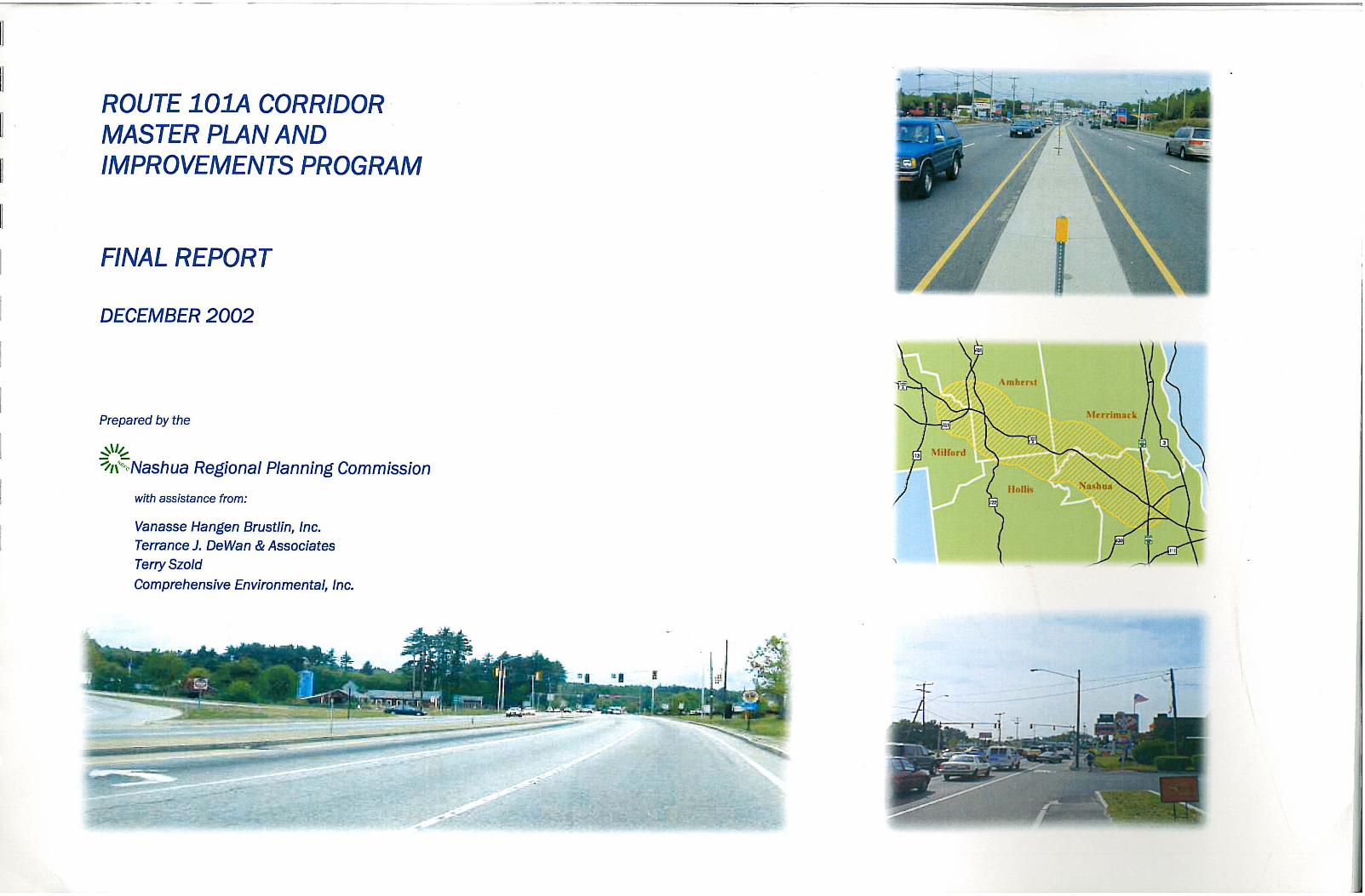
Route 101A Corridor Master Plan and Improvements Program Final Report – December 2002
Page 1 of 39.
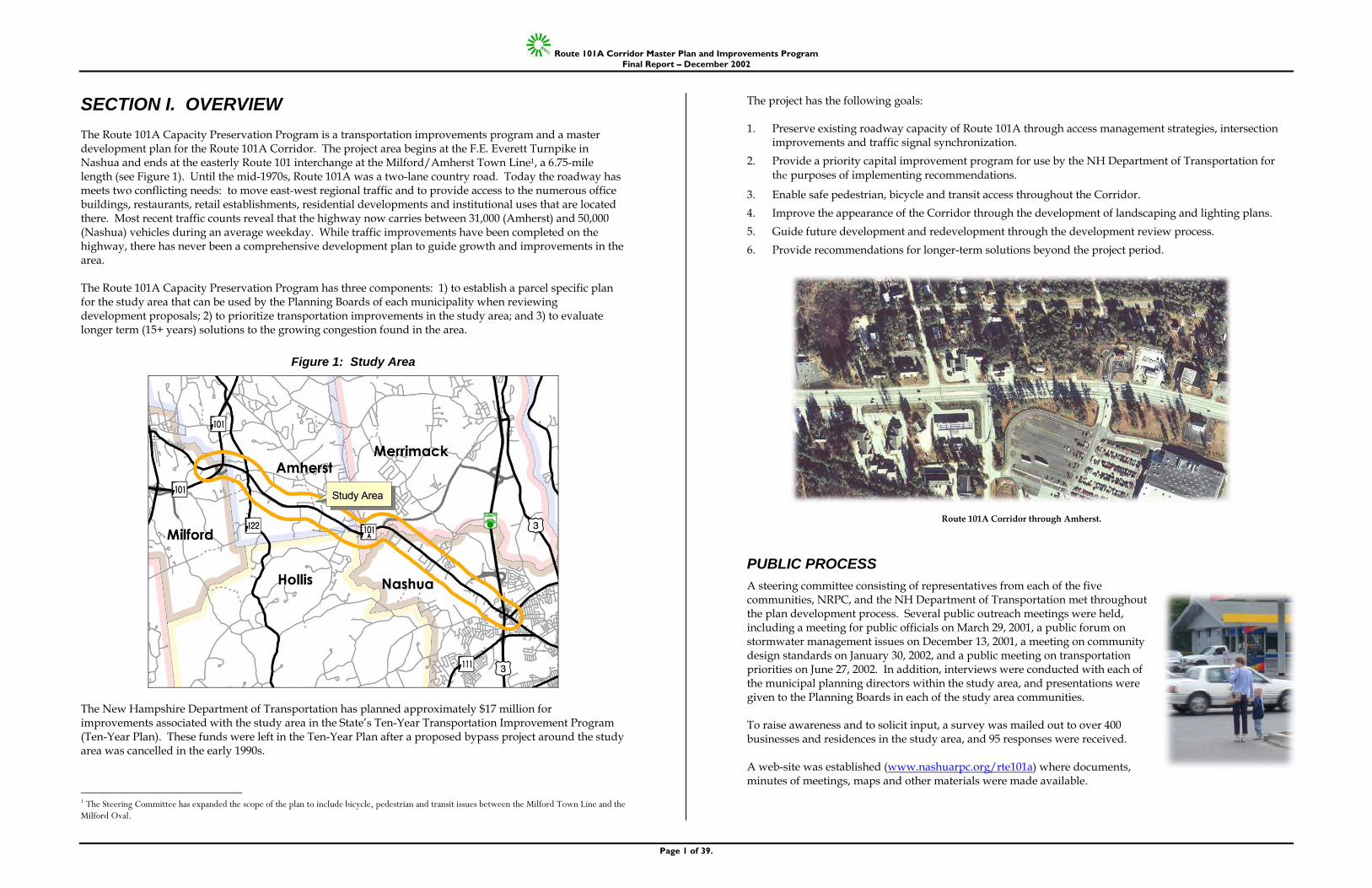
SECTION I. OVERVIEW The Route 101A Capacity Preservation Program is a transportation improvements program and a master development plan for the Route 101A Corridor. The project area begins at the F.E. Everett Turnpike in Nashua and ends at the easterly Route 101 interchange at the Milford/Amherst Town Line1, a 6.75-mile length (see Figure 1). Until the mid-1970s, Route 101A was a two-lane country road. Today the roadway has meets two conflicting needs: to move east-west regional traffic and to provide access to the numerous office buildings, restaurants, retail establishments, residential developments and institutional uses that are located there. Most recent traffic counts reveal that the highway now carries between 31,000 (Amherst) and 50,000 (Nashua) vehicles during an average weekday. While traffic improvements have been completed on the highway, there has never been a comprehensive development plan to guide growth and improvements in the area. The Route 101A Capacity Preservation Program has three components: 1) to establish a parcel specific plan for the study area that can be used by the Planning Boards of each municipality when reviewing development proposals; 2) to prioritize transportation improvements in the study area; and 3) to evaluate longer term (15+ years) solutions to the growing congestion found in the area.
Figure 1: Study Area
The New Hampshire Department of Transportation has planned approximately $17 million for improvements associated with the study area in the State’s Ten-Year Transportation Improvement Program (Ten-Year Plan). These funds were left in the Ten-Year Plan after a proposed bypass project around the study area was cancelled in the early 1990s.
1 The Steering Committee has expanded the scope of the plan to include bicycle, pedestrian and transit issues between the Milford Town Line and the Milford Oval.
The project has the following goals: 1. Preserve existing roadway capacity of Route 101A through access management strategies, intersection
improvements and traffic signal synchronization. 2. Provide a priority capital improvement program for use by the NH Department of Transportation for
the purposes of implementing recommendations.
3. Enable safe pedestrian, bicycle and transit access throughout the Corridor. 4. Improve the appearance of the Corridor through the development of landscaping and lighting plans. 5. Guide future development and redevelopment through the development review process. 6. Provide recommendations for longer-term solutions beyond the project period.
PUBLIC PROCESS A steering committee consisting of representatives from each of the five communities, NRPC, and the NH Department of Transportation met throughout the plan development process. Several public outreach meetings were held, including a meeting for public officials on March 29, 2001, a public forum on stormwater management issues on December 13, 2001, a meeting on community design standards on January 30, 2002, and a public meeting on transportation priorities on June 27, 2002. In addition, interviews were conducted with each of the municipal planning directors within the study area, and presentations were given to the Planning Boards in each of the study area communities. To raise awareness and to solicit input, a survey was mailed out to over 400 businesses and residences in the study area, and 95 responses were received. A web-site was established (www.nashuarpc.org/rte101a) where documents, minutes of meetings, maps and other materials were made available.
Route 101A Corridor through Amherst.
Route 101A Corridor Master Plan and Improvements Program Final Report – December 2002
Page 2 of 39.
PLAN ELEMENTS This plan seeks to address problems in the Route 101A Corridor both by identifying specific transportation improvements and also by providing development review guidance to the Planning Boards in the affected communities. The following are elements of this plan: • Summary of Action Plan Elements: This document outlines prioritization of recommended projects for
programming by the NHDOT. Each project will need to undergo separate public hearing processes when specific designs are developed as part of the preliminary engineering process.
• Site Specific Issues and Opportunities: This document is a tool for use by Planning Boards and applicants during development review process. It outlines parcel specific opportunities for access management, inter-site connections and bicycle and pedestrian improvements.
• Community Guidebook. This document outlines design treatments proposed within the public right-of-way, which are intended to provide guidance for NHDOT to consider during the preliminary design phase for specific projects. It also provides guidance for Planning Boards to consider when revising local site plan review regulations.
• Stormwater Management Community Guidebook. This document provides innovative stormwater management techniques for NHDOT to consider when designing specific highway projects in the Corridor, and for Planning Boards for consideration when revising local site plan review regulations.
NRPC will work with the communities on implementation of plan elements. In order for each community to implement these recommendations, it may be necessary to consider amendments to local master plans, site plan review regulations and in some cases zoning ordinances.
SECTION II. EXECUTIVE SUMMARY OF RECOMMENDATIONS The following summarizes the recommendations of this study. Additional detail is provided in subsequent chapters and in the specific stand-alone documents provided as part of the plan.
TRANSPORTATION IMPROVEMENTS The study area contains a variety of land uses, including high-density residential, office, industrial, commercial and educational uses. Opportunities for capacity preservation are limited, particularly in the more developed portions of the study area. Implementation in these areas will likely occur as a result of redevelopment.
GENERAL RECOMMENDATIONS
• Where possible, create four-way intersections with existing roads and the entrances to interconnected sites, which will minimize the need to access Route 101A to reverse direction or to access abutting properties.
• Provide and expand upon intersite connections. In several locations in the Corridor, particularly in the area on the south side of 101A between Airport Avenue and Northwest Boulevard, it is possible to connect many of the abutting parking lots so that one can travel within some areas without having to access the highway.
• Five-foot wide sidewalks should be provided on both sides of the street from the Turnpike to the Milford Oval.
• Consolidate curb cuts wherever possible, through the development review process and also through the preliminary engineering process for specific projects identified in this report.
• All 22 existing signals along Route 101A should be re-timed and pedestrian cycles should be added. The two traffic signals along Somerset Parkway should be coordinated with Route 101A signals.
• Transit stops should be clearly demarcated. Bus shelters should be constructed along with bus turnout locations where feasible. Transit stops should have direct and clearly defined pedestrian access.
• The possibility of developing a by-pass within the general corridor area was examined but was deemed infeasible due to encroachments of existing buildings.
• The possibility of creating a connection between the forthcoming Exit 9 on the Circumferential Highway to Continental Boulevard should be studied further.
SPECIFIC PROJECTS
This plan recommends major transportation improvements that are outlined in detail in “Summary of Action Plan Recommendations” by VHB. These projects are outlined as follows in terms of their prioritization by the Route 101A Steering Committee:
Early Action Program
Prior to the adoption of this plan the communities endorsed the early action program. These projects have already been endorsed and are programmed for funding and preliminary engineering by the NHDOT: • Roadway Widening. Widening of the highway to consistent 7 lanes (3 in each direction and center
turning lane) from Somerset Parkway to the Merrimack Town Line. The widening will also include sidewalk reconstruction, pedestrian crossings and transit improvements.
• Traffic Signals. Retiming and synchronization of traffic signals throughout the Corridor. • Intersection Improvements. Improvement of the intersections at Boston Post Road and Route 122 as part
of the current road resurfacing project.
Route 101A Steering Committee
The following individuals participated in Steering Committee meetings:
Frank Ballou, Hollis Arthur LeBlanc, Hollis Chris Bobay, VHB John LeBrun, Nashua Keith Cota, NHDOT Robert Lyford, NHDOT George Crombie, Nashua Frank O’Callaghan, VHB Nelson Disco, Merrimack Bill Oldenburg, NHDOT Steve Dookran, Nashua Bill Parker, Milford Karen Elmer, Amherst Marilyn Peterman, Amherst Ray Guarino, NRPC Don Ryder, Hollis Jiri Hajek, Merrimack Subramanian Sharma, NHDOT Roger Hawk, Nashua Andrew Singelakis, NRPC Kathy Hersh, Nashua Bill Veillette, Amherst Steve Heuchert, NRPC John Vogl, NRPC Todd Landry, Nashua Matthew Waitkins, NRPC Stephen Williams, NRPC
Route 101A Corridor Master Plan and Improvements Program Final Report – December 2002
Page 3 of 39.
Short-Term (1-5 years)
• Milford Sidewalks. This would provide consistent sidewalks on both sides of 101A from the Milford Town Line to the Milford Oval, including a “gateway” treatment at the Milford/Amherst town line. This will also include transit shelters and bus pullout areas, and pedestrian at-grade crossings.
• Nashua-Merrimack Sidewalks. Provide sidewalk connectivity on both sides of Route 101A between the Turnpike in Nashua and Boston Post Road in Merrimack, including crosswalk treatments and bus shelters.
• Reconstruction of NH101 East Bound/NH101A Interchange in Milford. Provides an additional right-turn lane off ramp, and the signalization of the ramp interchange.
• Craftsman Lane, Merrimack. Provides a cul-de-sac at the existing intersection of Craftsman Lane with Boston Post Road, and relocates the existing connection at that intersection.
• Signage at Exit 10 on FEE Turnpike. Provides southbound directional signage identifying route to Amherst and Milford, which will divert some traffic from Somerset Parkway and NH 101A between
Somerset Parkway and Continental Boulevard.
• Signage at Exit 7 on FEE Turnpike. Relocate directional signage northbound on the Turnpike to Amherst and Milford from Exit 7 to Exit 8 (Somerset Parkway).
• Crosswalk at Continental Boulevard. Add a crosswalk across Route 101A from Home Depot to PC Connection.
• Sidewalk Construction in Amherst. Provides new sidewalk on both sides of Route 101A between North Hollis Street and Airline Drive.
• Bus Stop Turnouts and Shelters (exclusive of Early Action Program) should be provided throughout the Corridor.
• Parallel Cross Easement Connections, Nashua. Provides connections for vehicular and pedestrian traffic among abutting properties between Cotton Road and Townsend West.
• Parallel Cross Easements, Amherst. Provides connections among abutting properties on both sides of 101A in the vicinity of Seasonal Square and Jaspers Farm. Also provides traffic signal control at centralized access points, and provides curb-cut reductions.
Mid-Term (6-10 years)
• Widen Route 101A from Boston Post Road to Continental Boulevard. Provides third eastbound through lane to match existing three westbound lanes. Provides additional westbound right-turn lane from Continental Boulevard onto NH101A. Includes crosswalk across 101A in this vicinity.
• Cotton Road/NH 101A Improvement. Provide additional right-turn lane onto Cotton Road approach.
• Shared Use Trail, Amherst to Nashua. Provide a muti-use path for bicyclists and pedestrians adjacent to the railroad right-of-way between NH 122 and Charron Avenue.
• Charron Avenue Intersection. Provide alternative to existing jug-handles.
Conceptual
Conceptual projects are those that are not recommended at this time, but for which additional study and consideration is warranted: • Pedestrian Crossings of NH101A, Grade Separated. Provide grade separated pedestrian crossings of
NH 101A at the following three locations: Somerset Parkway, Thornton Drive/Deerwood Drive, and at Home Depot/PC Connection.
• Reconstruct NH101WB/NH101A Interchange, Grade Separated. Provides a “fly-over” exit ramp from Route 101A to Route 101.
• Exit 9 Connector. Construct new connection between Circumferential Highway/F.E. Everett Turnpike interchange and Continental Boulevard, which would enable a “by-pass” of Route 101A from points north to Amherst and Milford.
• Widening of 101A, Somerset Parkway to the Turnpike, Nashua. Extend the uniform cross section (3 through lanes in each direction) along NH 101A from Somerset Parkway to the Turnpike.
PEDESTRIAN AND AESTHETIC IMPROVEMENTS
The recommendations of this report are designed to address both safety issues within the pedestrian environment and aesthetic improvements within the visual environment, including issues relating to the public right-of-way, which are to be considered by NHDOT when developing preliminary engineering plans for specific projects, and for use by Planning Boards when reviewing projects. The recommendations are excerpted from Terrence J. DeWan & Associates (tjd&a) document Community Guidebook for NH Route 101A (see Section V). That document also provides suggestions for the communities to consider when revising site plan regulations and master plan updates. Recommendations are arranged by physical elements: • Public Sidewalks. Sidewalks should be installed on both sides of the street throughout the Corridor.
They should be 5’ in width, with grass esplanades separating the sidewalk from the street where feasible. High quality bituminous concrete (asphalt) should be used as the standard sidewalk material throughout the Corridor.
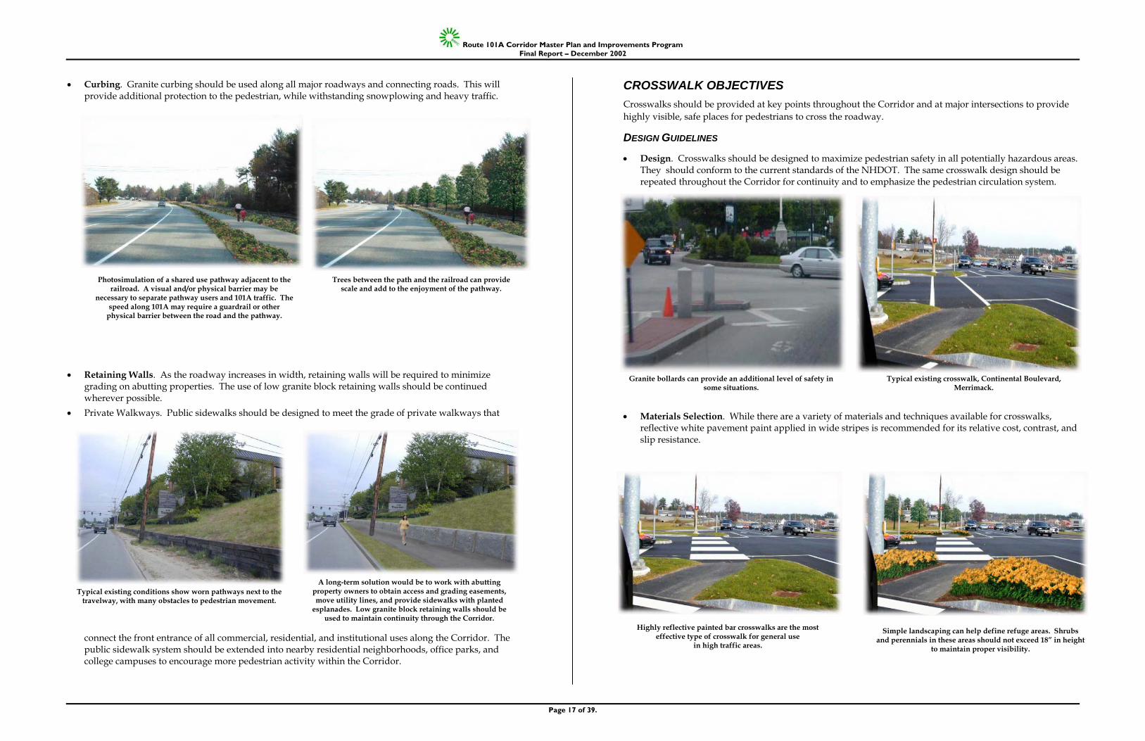
• Crosswalks. Crosswalks should be provided at key points throughout the Corridor and at major intersections to provide highly visible, safe places for pedestrians to cross the roadway. Reflective white pavement paint applied in wide stripes is recommended. Pedestrian islands (five-foot in width where possible) should be installed in driveways were the crossing distance is greater than 32 feet.
• Median Strips and Islands. Median strips greater than 6’ wide should be designed to direct water to infiltration areas within the median. NHDOT’s policy is that no vegetation is permitted in median islands that are less than 6’ in width due to safety concerns. In addition, in areas where landscaping is provided in medians, local commitment for maintenance is necessary.
• Bus Shelters. Installation of freestanding bus shelters should be located through out the Corridor, especially in areas of high ridership. Shelters should be set back a minimum of three feet from the curb-line. At low volume bus stops, signage and shade trees should be provided.
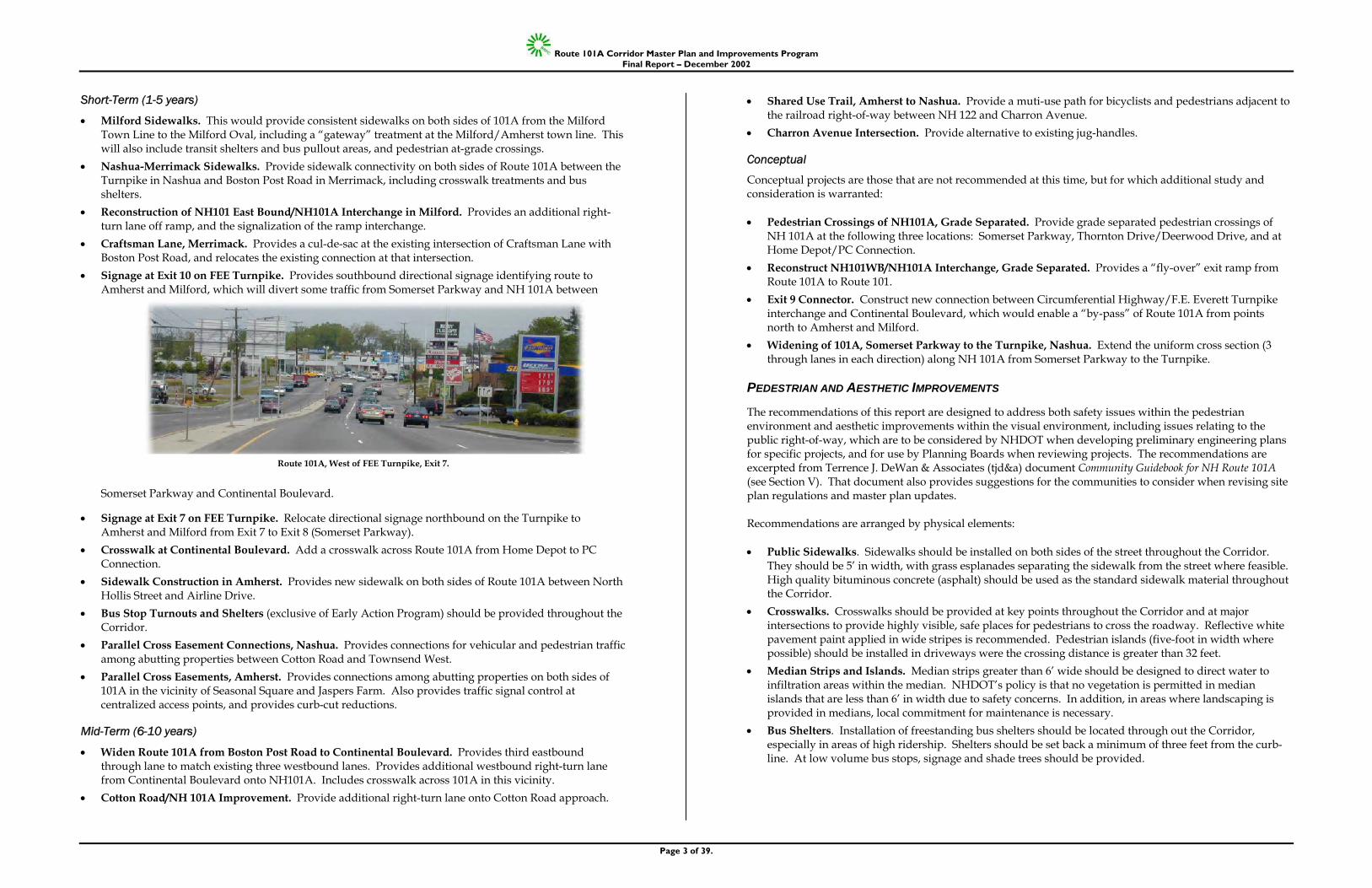
Route 101A, West of FEE Turnpike, Exit 7.
Route 101A Corridor Master Plan and Improvements Program Final Report – December 2002
Page 4 of 39.
• Gateways. Gateways indicating municipal boundaries should be given consideration to preserve unique community character, and at key intersections.
• Landscaping. Landscaping within or immediately adjacent to the Corridor should reinforce circulation paths, highlight entrances, provide shade to the sidewalk and add seasonal interest.
LAND USE AND ZONING The study provides general recommendations for amendments to local master plans, zoning ordinances and/or site plan review regulations. NRPC will work with the affected municipalities on site planning and master plan implementation steps. In order to accommodate a future widening of the highway east of Somerset Parkway, it will be necessary to increase zoning setbacks in Nashua by 20 feet. The new setback should be strictly followed to accommodate the needed right-of-way for this longer-term improvement.
STORMWATER MANAGEMENT The Route 101A Corridor traverses the Pennichuck Brook watershed, which provides a significant source of water for the City of Nashua and several adjacent communities. Key issues include the loss of groundwater recharge and the lack of maintenance of stormwater controls. Stormwater management techniques should be used by the NHDOT when producing specific plans for transportation improvements and also should be required by the communities through the development review process. Recommendations are excerpted from Comprehensive Environmental Inc.’s (CEI) Route 101A Corridor Community Guidebook, Stormwater Management. Recommendations include: • Use of run-off prevention methods (RPMs). RPMs address stormwater at its source before it enters the
drainage system of a street or development. RPMs include infiltration dividers and infiltration islands. • Require Pretreatment. Pretreatment in its basic sense is a method to provide coarse removal or
stabilization of stormwater pollutants so that they do not unnecessarily overburden the less accessible infiltration media. Methods include grass filter strips, sediment forbays and deep sump catch basins.
• Maintain Stormwater Controls. Like any filter, stormwater treatment devices require maintenance. The better the treatment efficiency, the more material will be processed. Therefore the need for maintenance plans is critical.
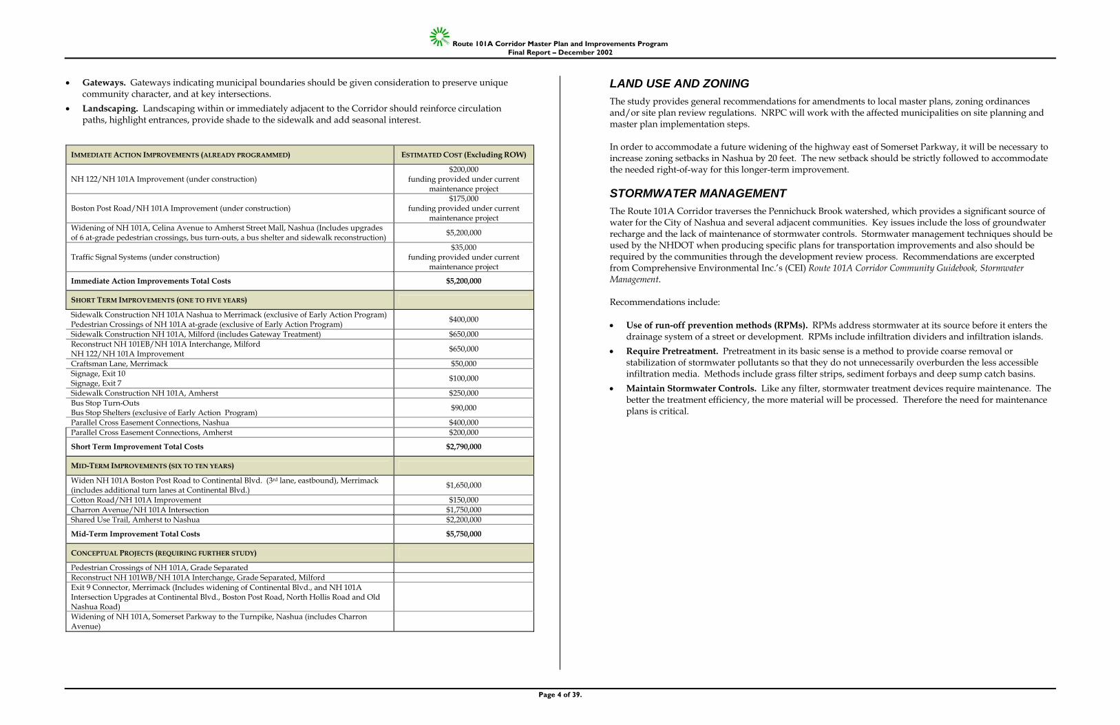
IMMEDIATE ACTION IMPROVEMENTS (ALREADY PROGRAMMED) ESTIMATED COST (Excluding ROW)
NH 122/NH 101A Improvement (under construction) $200,000
funding provided under current maintenance project
Boston Post Road/NH 101A Improvement (under construction) $175,000
funding provided under current maintenance project
Widening of NH 101A, Celina Avenue to Amherst Street Mall, Nashua (Includes upgrades of 6 at-grade pedestrian crossings, bus turn-outs, a bus shelter and sidewalk reconstruction) $5,200,000
Traffic Signal Systems (under construction) $35,000
funding provided under current maintenance project
Immediate Action Improvements Total Costs $5,200,000
SHORT TERM IMPROVEMENTS (ONE TO FIVE YEARS)
Sidewalk Construction NH 101A Nashua to Merrimack (exclusive of Early Action Program) Pedestrian Crossings of NH 101A at-grade (exclusive of Early Action Program) $400,000
Sidewalk Construction NH 101A, Milford (includes Gateway Treatment) $650,000 Reconstruct NH 101EB/NH 101A Interchange, Milford NH 122/NH 101A Improvement $650,000
Craftsman Lane, Merrimack $50,000 Signage, Exit 10 Signage, Exit 7 $100,000
Sidewalk Construction NH 101A, Amherst $250,000 Bus Stop Turn-Outs Bus Stop Shelters (exclusive of Early Action Program) $90,000
Parallel Cross Easement Connections, Nashua $400,000 Parallel Cross Easement Connections, Amherst $200,000
Short Term Improvement Total Costs $2,790,000
MID-TERM IMPROVEMENTS (SIX TO TEN YEARS)
Widen NH 101A Boston Post Road to Continental Blvd. (3rd lane, eastbound), Merrimack (includes additional turn lanes at Continental Blvd.) $1,650,000
Cotton Road/NH 101A Improvement $150,000 Charron Avenue/NH 101A Intersection $1,750,000 Shared Use Trail, Amherst to Nashua $2,200,000
Mid-Term Improvement Total Costs $5,750,000
CONCEPTUAL PROJECTS (REQUIRING FURTHER STUDY)
Pedestrian Crossings of NH 101A, Grade Separated Reconstruct NH 101WB/NH 101A Interchange, Grade Separated, Milford Exit 9 Connector, Merrimack (Includes widening of Continental Blvd., and NH 101A Intersection Upgrades at Continental Blvd., Boston Post Road, North Hollis Road and Old Nashua Road)
Widening of NH 101A, Somerset Parkway to the Turnpike, Nashua (includes Charron Avenue)
Route 101A Corridor Master Plan and Improvements Program Final Report – December 2002
Page 5 of 39.
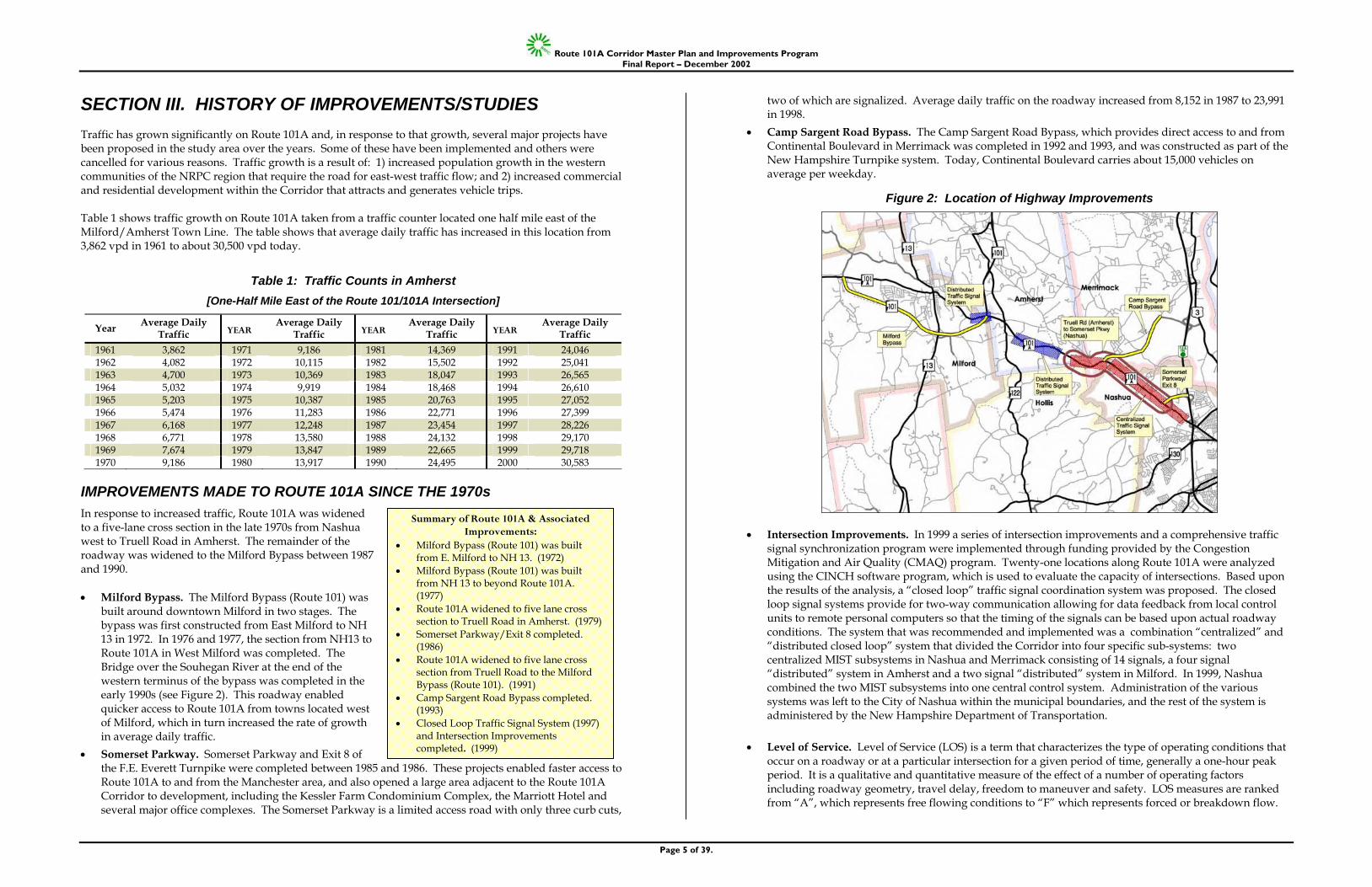
SECTION III. HISTORY OF IMPROVEMENTS/STUDIES Traffic has grown significantly on Route 101A and, in response to that growth, several major projects have been proposed in the study area over the years. Some of these have been implemented and others were cancelled for various reasons. Traffic growth is a result of: 1) increased population growth in the western communities of the NRPC region that require the road for east-west traffic flow; and 2) increased commercial and residential development within the Corridor that attracts and generates vehicle trips. Table 1 shows traffic growth on Route 101A taken from a traffic counter located one half mile east of the Milford/Amherst Town Line. The table shows that average daily traffic has increased in this location from 3,862 vpd in 1961 to about 30,500 vpd today.
Table 1: Traffic Counts in Amherst [One-Half Mile East of the Route 101/101A Intersection]
Year Average Daily Traffic YEAR
Average Daily Traffic YEAR
Average Daily Traffic YEAR
Average Daily Traffic
1961 3,862 1971 9,186 1981 14,369 1991 24,046 1962 4,082 1972 10,115 1982 15,502 1992 25,041 1963 4,700 1973 10,369 1983 18,047 1993 26,565 1964 5,032 1974 9,919 1984 18,468 1994 26,610 1965 5,203 1975 10,387 1985 20,763 1995 27,052 1966 5,474 1976 11,283 1986 22,771 1996 27,399 1967 6,168 1977 12,248 1987 23,454 1997 28,226 1968 6,771 1978 13,580 1988 24,132 1998 29,170 1969 7,674 1979 13,847 1989 22,665 1999 29,718 1970 9,186 1980 13,917 1990 24,495 2000 30,583
IMPROVEMENTS MADE TO ROUTE 101A SINCE THE 1970s In response to increased traffic, Route 101A was widened to a five-lane cross section in the late 1970s from Nashua west to Truell Road in Amherst. The remainder of the roadway was widened to the Milford Bypass between 1987 and 1990. • Milford Bypass. The Milford Bypass (Route 101) was
built around downtown Milford in two stages. The bypass was first constructed from East Milford to NH 13 in 1972. In 1976 and 1977, the section from NH13 to Route 101A in West Milford was completed. The Bridge over the Souhegan River at the end of the western terminus of the bypass was completed in the early 1990s (see Figure 2). This roadway enabled quicker access to Route 101A from towns located west of Milford, which in turn increased the rate of growth in average daily traffic.
• Somerset Parkway. Somerset Parkway and Exit 8 of the F.E. Everett Turnpike were completed between 1985 and 1986. These projects enabled faster access to Route 101A to and from the Manchester area, and also opened a large area adjacent to the Route 101A Corridor to development, including the Kessler Farm Condominium Complex, the Marriott Hotel and several major office complexes. The Somerset Parkway is a limited access road with only three curb cuts,
two of which are signalized. Average daily traffic on the roadway increased from 8,152 in 1987 to 23,991 in 1998.
• Camp Sargent Road Bypass. The Camp Sargent Road Bypass, which provides direct access to and from Continental Boulevard in Merrimack was completed in 1992 and 1993, and was constructed as part of the New Hampshire Turnpike system. Today, Continental Boulevard carries about 15,000 vehicles on average per weekday.
Figure 2: Location of Highway Improvements
• Intersection Improvements. In 1999 a series of intersection improvements and a comprehensive traffic signal synchronization program were implemented through funding provided by the Congestion Mitigation and Air Quality (CMAQ) program. Twenty-one locations along Route 101A were analyzed using the CINCH software program, which is used to evaluate the capacity of intersections. Based upon the results of the analysis, a “closed loop” traffic signal coordination system was proposed. The closed loop signal systems provide for two-way communication allowing for data feedback from local control units to remote personal computers so that the timing of the signals can be based upon actual roadway conditions. The system that was recommended and implemented was a combination “centralized” and “distributed closed loop” system that divided the Corridor into four specific sub-systems: two centralized MIST subsystems in Nashua and Merrimack consisting of 14 signals, a four signal “distributed” system in Amherst and a two signal “distributed” system in Milford. In 1999, Nashua combined the two MIST subsystems into one central control system. Administration of the various systems was left to the City of Nashua within the municipal boundaries, and the rest of the system is administered by the New Hampshire Department of Transportation.
• Level of Service. Level of Service (LOS) is a term that characterizes the type of operating conditions that
occur on a roadway or at a particular intersection for a given period of time, generally a one-hour peak period. It is a qualitative and quantitative measure of the effect of a number of operating factors including roadway geometry, travel delay, freedom to maneuver and safety. LOS measures are ranked from “A”, which represents free flowing conditions to “F” which represents forced or breakdown flow.
Summary of Route 101A & Associated Improvements:
• Milford Bypass (Route 101) was built from E. Milford to NH 13. (1972)
• Milford Bypass (Route 101) was built from NH 13 to beyond Route 101A. (1977)
• Route 101A widened to five lane cross section to Truell Road in Amherst. (1979)
• Somerset Parkway/Exit 8 completed. (1986)
• Route 101A widened to five lane cross section from Truell Road to the Milford Bypass (Route 101). (1991)
• Camp Sargent Road Bypass completed. (1993)
• Closed Loop Traffic Signal System (1997) and Intersection Improvements completed. (1999)
Route 101A Corridor Master Plan and Improvements Program Final Report – December 2002
Page 6 of 39.
The analysis pointed to the need for physical modifications to intersections which were completed at the following locations (see Figure 3):
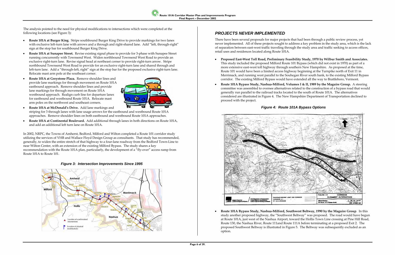
• Route 101A at Burger King. Stripe southbound Burger King Drive to provide markings for two lanes with exclusive left-turn lane with arrows and a through and right-shared lane. Add “left, through-right” sign at the stop bar for southbound Burger King Drive.
• Route 101A at Sunapee Street. Revise existing signal phase to provide for 3-phase with Sunapee Street running concurrently with Townsend West. Widen northbound Townsend West Road to provide an exclusive right-turn lane. Revise signal head at northeast corner to provide right-turn arrow. Stripe northbound Townsend West Road to provide for an exclusive right-turn lane and shared through and left-turn lane. Add a “through-left, right” sign at the stop bar for the proposed exclusive right-turn lane. Relocate mast arm pole at the southeast corner.
• Route 101A at Greystone Plaza. Remove shoulder lines and provide lane markings for through movement on Route 101A eastbound approach. Remove shoulder lines and provide lane markings for through movement on Route 101A westbound approach. Realign curb line for departure lanes for eastbound and westbound Route 101A. Relocate mast arm poles on the northwest and southeast corners.
• Route 101A at McDonald’s Drive. Add lane markings and striping for 3 through lanes with lane usage arrows for the eastbound and westbound Route 101A approaches. Remove shoulder lines on both eastbound and westbound Route 101A approaches.
• Route 101A at Continental Boulevard. Add additional through lanes in both directions on Route 101A, and add an additional left turn lane on Route 101A.
In 2002, NRPC, the Towns of Amherst, Bedford, Milford and Wilton completed a Route 101 corridor study utilizing the services of VHB and Wallace Floyd Design Group as consultants. That study has recommended, generally, to widen the entire stretch of that highway to a four-lane roadway from the Bedford Town-Line to near Wilton Center, with an extension of the existing Milford Bypass. The study shares a key recommendation with the Route 101A plan, particularly, the development of a “fly-over” access ramp from Route 101A to Route 101.
Figure 3: Intersection Improvements Since 1995
PROJECTS NEVER IMPLEMENTED There have been several proposals for major projects that had been through a public review process, yet never implemented. All of these projects sought to address a key problem in the study area, which is the lack of separation between east-west traffic traveling through the study area and traffic seeking to access offices, retail uses and residences located along Route 101A. • Proposed East-West Toll Road, Preliminary Feasibility Study, 1970 by Wilbur Smith and Associates.
This study included the proposed Milford Route 101 Bypass (which did not exist in 1970) as part of a more extensive east-west toll highway through southern New Hampshire. As proposed at the time, Route 101 would have been a limited access highway beginning at the Turnpike north of Exit 11 in Merrimack, and running west parallel to the Souhegan River south bank, to the existing Milford Bypass corridor. The existing Milford Bypass would have extended all the way to Brattleboro, Vermont.
• Route 101A Bypass Study, Nashua-Milford, Volumes I & II, 1989 by the Maguire Group. A steering committee was assembled to oversee alternatives related to the construction of a bypass road that would generally run parallel to the railroad tracks located to the south of Route 101A. The alternatives considered are illustrated in Figure 4. The New Hampshire Department of Transportation declined to proceed with the project.
Figure 4: Route 101A Bypass Options
• Route 101A Bypass Study, Nashua-Milford, Southwest Beltway, 1990 by the Maguire Group. In this study another proposed highway, the “Southwest Beltway” was proposed. The road would have begun at Route 101A, just west of the Nashua Airport, toward the Hollis Town Line crossing at Pine Hill Road, Route 130, the Nashua River, Route 111and Route 111A before terminating at a proposed Exit 2. The proposed Southwest Beltway is illustrated in Figure 5. The Beltway was subsequently excluded as an option.
Route 101A Corridor Master Plan and Improvements Program Final Report – December 2002
Page 7 of 39.
• Route 101A Bypass Study, Milford to Nashua, Rationale Report, 1992 by the Maguire Group (and associated documents released in 1993 and 1994). This report was a “precursor of an EIS on transportation alternatives.” The purpose and need of the proposed alternatives was to: “…relieve traffic congestion along the existing Route 101A, and therefore to provide for the safe and efficient movement of current and projected (20 years) traffic from Route 101 in Milford to the F.E. Everett Turnpike in Nashua.” The study evaluated several alternatives including the widening of Route 101A from four to six lanes (eight in some locations), the Southwest Beltway, and a two lane limited access roadway adjacent to the railroad corridor. The New Hampshire Department of Transportation declined to proceed with the project in the mid 1990s.
Figure 5: Southwest Beltway
SECTION IV. TRAFFIC ANALYSIS Traffic problems within the Corridor are caused generally by conflicts between through traffic and local traffic. The study area is generally constrained by active railroad tracks that form the area’s southern boundary.
KEY ISSUES IN THE STUDY AREA • There are conflicts between the competing functions of the highway as: 1) an east-west regional highway;
2) a destination for retail shoppers and industrial employees; and 3) a traffic generator with many higher density residential developments.
• Lanes shift from three to two lanes in many locations within the Corridor, which results in low utilization and poor efficiency of the third lane due to the need to frequently merge.
• Numerous curb cuts, multiple access points and a general lack of access management results in conflicts between vehicles and a reduction in highway capacity.
• Jersey barriers placed as a form of access management result in the need to reverse directions at signalized intersections and at jug-handles which causes unnecessary vehicle miles and adds to corridor congestion.
• There is a lack of interconnectivity between sites, and therefore vehicles are required to re-enter Route 101A to reach other nearby locations.
• There is a lack of amenities for pedestrians. The sidewalk system is fragmented and there is a lack of coordinated design standards. There are not enough pedestrian cycles in the signalization system and in many instances pedestrians must walk along worn paths.
• The highway is unsafe for bicyclists, and lacks bicycle lanes and/or adequate shoulders throughout. • It is difficult to accommodate transit users, as there is no consistent pedestrian environment. • Additional development of high traffic generating uses, such as retail and fast food, is contributing to
increased growth in vehicle miles traveled within the Corridor. • Lack of a single traffic signal control system makes it difficult to adequately accommodate new traffic
growth. • Possibilities for a bypass are limited due to constraints imposed by the railroad tracks and the number of
structures constructed close to those tracks. • Portions of the study area are considered “mature” with many pre-existing limitations. Amherst has the
least amount of development on Route 101A but has experienced significant building activity during the past decade.
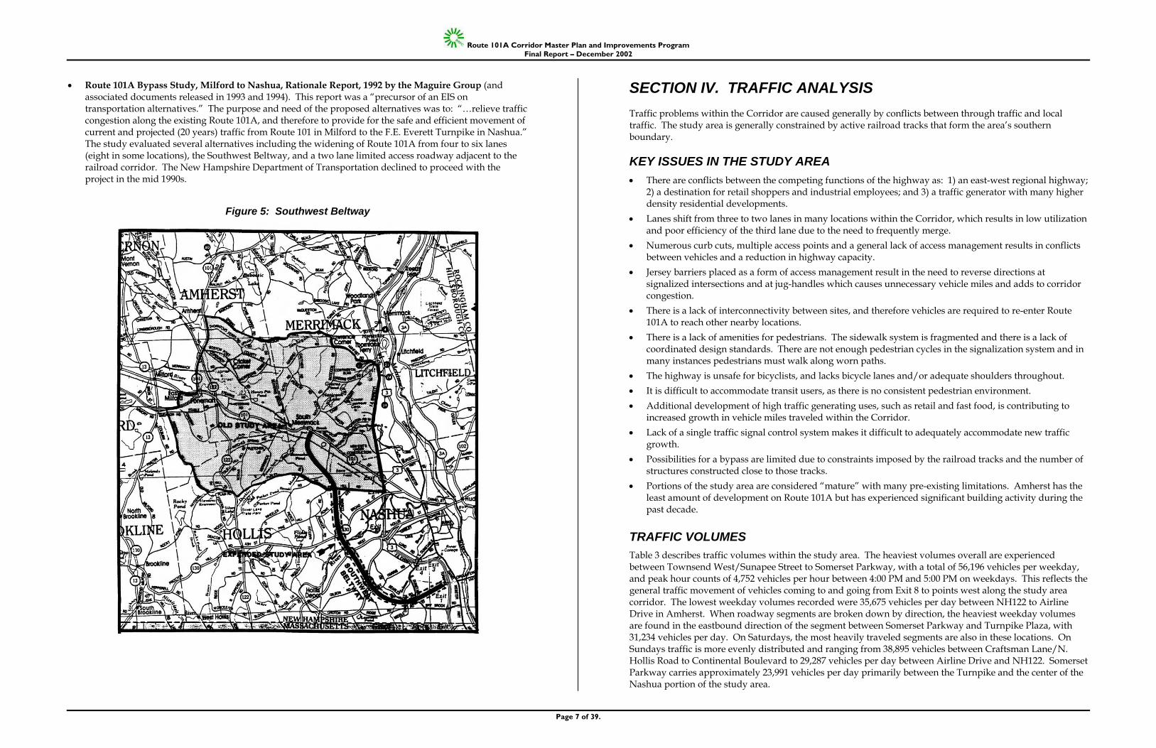
TRAFFIC VOLUMES Table 3 describes traffic volumes within the study area. The heaviest volumes overall are experienced between Townsend West/Sunapee Street to Somerset Parkway, with a total of 56,196 vehicles per weekday, and peak hour counts of 4,752 vehicles per hour between 4:00 PM and 5:00 PM on weekdays. This reflects the general traffic movement of vehicles coming to and going from Exit 8 to points west along the study area corridor. The lowest weekday volumes recorded were 35,675 vehicles per day between NH122 to Airline Drive in Amherst. When roadway segments are broken down by direction, the heaviest weekday volumes are found in the eastbound direction of the segment between Somerset Parkway and Turnpike Plaza, with 31,234 vehicles per day. On Saturdays, the most heavily traveled segments are also in these locations. On Sundays traffic is more evenly distributed and ranging from 38,895 vehicles between Craftsman Lane/N. Hollis Road to Continental Boulevard to 29,287 vehicles per day between Airline Drive and NH122. Somerset Parkway carries approximately 23,991 vehicles per day primarily between the Turnpike and the center of the Nashua portion of the study area.
Route 101A Corridor Master Plan and Improvements Program Final Report – December 2002
Page 8 of 39.
Table 3: Traffic Counts
Intersection Average Weekday Traffic Saturday Sunday Peak Hour
(Average Weekday) NH122 to Airline Drive 35,675 30,244 29,287 3,151 (5-6PM) Craftsman Lane/N. Hollis Rd. to Continental Blvd. (Eastbound) 28,044 25,013 23,054 2,408 (7-8AM)
Craftsman Lane/N. Hollis Rd. to Continental Blvd. (Westbound) 20,388 17,818 15,841 1,418 (12-1PM)
Craftsman Lane/N. Hollis Rd. to Continental Blvd. (Total) 48,432 42,831 38,895 3,826
Continental Boulevard to Blackstone Drive (Eastbound) 23,871 19,704 19,947 1,796 (4-5PM)
Continental Boulevard to Blackstone Drive (Westbound) 21,141 18,855 15,919 2,016 (4-5PM)
Continental Boulevard to Blackstone Drive (Total) 45,012 38,559 35,886 3,812
Townsend West/Sunapee to Somerset Parkway (Eastbound) 28,205 23,099 19,064 2,352 (4-5PM)
Townsend West/Sunapee to Somerset Parkway (Westbound) 27,991 26,347 19,250 2,400 (4-5PM)
Townsend West/Sunapee to Somerset Parkway (Total) 56,196 49,446 38,314 4,752
Somerset Parkway to Turnpike Plaza (Eastbound) 31,234 26,347 23,133 2,372 (4-5PM)
Somerset Parkway to Turnpike Plaza (Westbound) 20,122 17,877 14,723 1,643 (4-5PM)
Somerset Parkway to Turnpike Plaza (Total) 51,356 44,224 37,856 4,015
ACCIDENT DATA Accident data from the previous five years was collected and mapped, and is depicted in Table 4. There were a total of 1,092 accidents during this five year period, with 503 (46.1%) in Nashua, 147 (13.5%) in Merrimack, 0 (0%) in Hollis, 219 (21.1%) in Amherst, and 223 (20.4%) in Milford.
Table 4: Number of Accidents by Municipality per Year Year Milford Amherst Merrimack Nashua Total 1999 35 56 43 135 269 1998 73 55 43 116 287 1997 53 44 29 128 254 1996 62 64 32 124 282 Total 223 219 147 503 1,092
% Total 20.4% 20.1% 13.5% 46.1% 100%
In comparison to the state average accident rate of 2.0 accidents per million vehicle miles of travel, the overall Route 101A rate is 1.4 ac/mv. The accident rate on the section of Route 101A between Celina Avenue and the Amherst Plaza is 2.05 or approximately the state average.
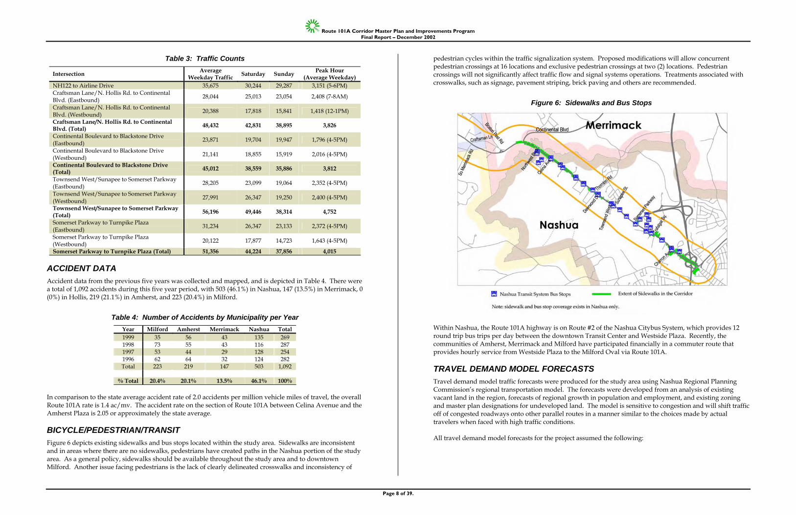
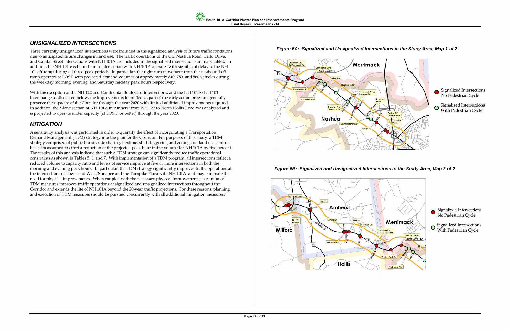
BICYCLE/PEDESTRIAN/TRANSIT Figure 6 depicts existing sidewalks and bus stops located within the study area. Sidewalks are inconsistent and in areas where there are no sidewalks, pedestrians have created paths in the Nashua portion of the study area. As a general policy, sidewalks should be available throughout the study area and to downtown Milford. Another issue facing pedestrians is the lack of clearly delineated crosswalks and inconsistency of
pedestrian cycles within the traffic signalization system. Proposed modifications will allow concurrent pedestrian crossings at 16 locations and exclusive pedestrian crossings at two (2) locations. Pedestrian crossings will not significantly affect traffic flow and signal systems operations. Treatments associated with crosswalks, such as signage, pavement striping, brick paving and others are recommended.
Figure 6: Sidewalks and Bus Stops
Within Nashua, the Route 101A highway is on Route #2 of the Nashua Citybus System, which provides 12 round trip bus trips per day between the downtown Transit Center and Westside Plaza. Recently, the communities of Amherst, Merrimack and Milford have participated financially in a commuter route that provides hourly service from Westside Plaza to the Milford Oval via Route 101A.
TRAVEL DEMAND MODEL FORECASTS Travel demand model traffic forecasts were produced for the study area using Nashua Regional Planning Commission’s regional transportation model. The forecasts were developed from an analysis of existing vacant land in the region, forecasts of regional growth in population and employment, and existing zoning and master plan designations for undeveloped land. The model is sensitive to congestion and will shift traffic off of congested roadways onto other parallel routes in a manner similar to the choices made by actual travelers when faced with high traffic conditions. All travel demand model forecasts for the project assumed the following:
Route 101A Corridor Master Plan and Improvements Program Final Report – December 2002
Page 9 of 39.
• Completion of the immediate action program as identified in the previous section of this report. • Complete development of the Circumferential Highway, north segment partial-build between FEE
Turnpike Exit 9 and NH 102 in Hudson. • Complete development of the Broad Street Parkway project between Broad Street near FEE Turnpike Exit
6 and West Hollis Street in downtown Nashua. • Completion of some other, minor capacity improving projects as identified in the NRPC adopted Long-
Range Transportation Plan. Four travel demand model scenarios for the year 2020 were developed and analyzed for the project: • Base Scenario – This model scenario includes the forecasts of population and employment adopted by the
NRPC in 1995, and the traffic improvements assumptions identified above. Total growth in population, employment and traffic in this scenario is approximately 1.5% per year on average regionwide. This scenario represents the base condition against which other forecasts are compared.
• Accelerated Growth – In this model scenario, the assumption is made that growth in population and employment in the project study area will exceed the adopted forecasts by 10% in 2020. This results in traffic forecasts in the Corridor that are approximately 10% higher than the adopted base forecasts. As a result, this scenario represents the potential maximum traffic volumes that are expected in the Corridor.
• Exit 9 Connection – Early on in the project, members of the steering committee suggested that a connection to the proposed Exit 9 on the FEE Turnpike should be studied. Exit 9 is proposed to be developed as part of the Circumferential Highway project and would be located immediately north of the location were FEE Turnpike crosses Pennichuck Brook. Members of the steering committee believed that development of this connection via Continental Boulevard could significantly reduce traffic at the eastern end of the NH 101A corridor by providing a bypass type route extending between NH 102 east of Hudson and NH 101A west in Merrimack. With the exception of the connection to Exit 9, the other assumptions for this scenario are the same as those for the Base Scenario.
• Travel Demand Management (TDM) – Travel demand management programs attempt to reduce traffic in highly congested areas by providing alternatives to the single occupant vehicle including transit, increased use of bicycle or pedestrian modes, vanpooling and the implementation of trip reduction strategies. For this project it was assumed that implementation of an aggressive TDM program would result in a 5% reduction of trips in the Corridor. This was accomplished by reducing forecasts from the base scenario by 5% with off-model adjustments.
CAPACITY, DELAY AND LEVEL OF SERVICE ANALYSIS The geometric configuration of the roadway, particularly at intersections and the timing of signal phases are key factors in traffic congestion. After development of the forecast scenarios identified above, the results were analyzed using three different methods to identify future problem areas in the Corridor: • Capacity - Capacity analysis compares the anticipated traffic volume with the calculated capacity of the
intersection or roadway link. The result is expressed in terms of a ratio. A roadway segment with a volume to capacity ratio of 1.0 is said to be at capacity. Volume to capacity ratios greater than 1.0 (1.1 for example) indicate that the roadway is over capacity and suggest the presence of congestion in the future.
• Delay – Delay is a measure of the average time spent by a motorist waiting to move through an intersection. It is calculated based on the capacity of the intersection, the traffic expected to enter the intersection from all directions and the signal timing. Delay is expressed in seconds and is another measure of the motorist’s experience of the intersection in the future.
• Level of Service – Level of Service is general measure that summarizes the overall operation of the intersection. Level of Service is summarized with letter grades A to F.
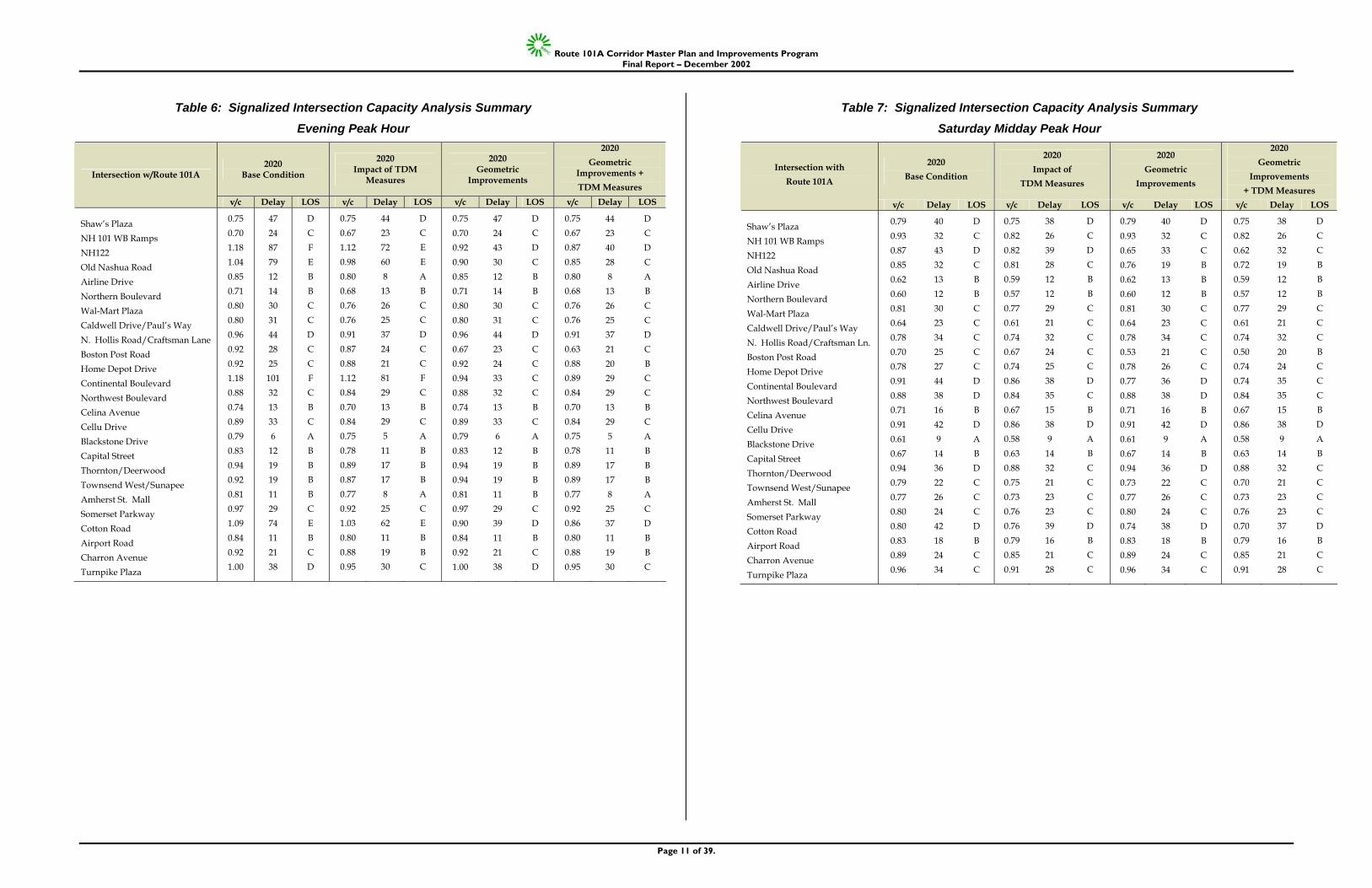
Tables 5 through 7 on the following pages show the results of the capacity, delay and level of service analysis. Each of the tables shows the results for a different peak period traffic condition: Table 5 for the morning peak hour, Table 6 for the evening peak hour, and Table 7 for the Saturday midday peak hour. Each table shows the capacity analysis, average delay and level of service for 25 signalized intersections for four different future scenarios: 1) the base condition; 2) the implementation of TDM measures; 3) the implementation of roadway geometric improvements; and 4) the implementation of both the Travel Demand Management measures and roadway geometric improvements. In every case, the future year forecasts assume development of all the early action improvements including the widening of NH 101A to three lanes between Celina Avenue and Somerset Parkway in Nashua and the signal system upgrades identified throughout the Corridor. The future-year analysis also assumes implementation of mitigation, which is tied to the Corning Lasertron industrial site in Nashua and the infrastructure improvements associated with the proposed shopping center in Milford at the NH 101/NH 101A interchange. The Corning mitigation consists of construction of an exclusive eastbound right-turn lane at the intersections of Northwest Boulevard and Charron Avenue with NH 101A. The shopping center mitigation consists of construction of exclusive left- and right-turn lanes for the northbound (site drive) approach, an exclusive eastbound right-turn lane at the Shaw’s Plaza intersection, a second westbound left-turn lane and an exclusive eastbound right-turn lane at the NH 101 westbound ramps intersection. Tables 5, 6, and 7 summarize, respectively, the signalized intersection capacity analyses for 2020 weekday morning, weekday evening, and Saturday midday peak hours based on the three mitigation scenarios.
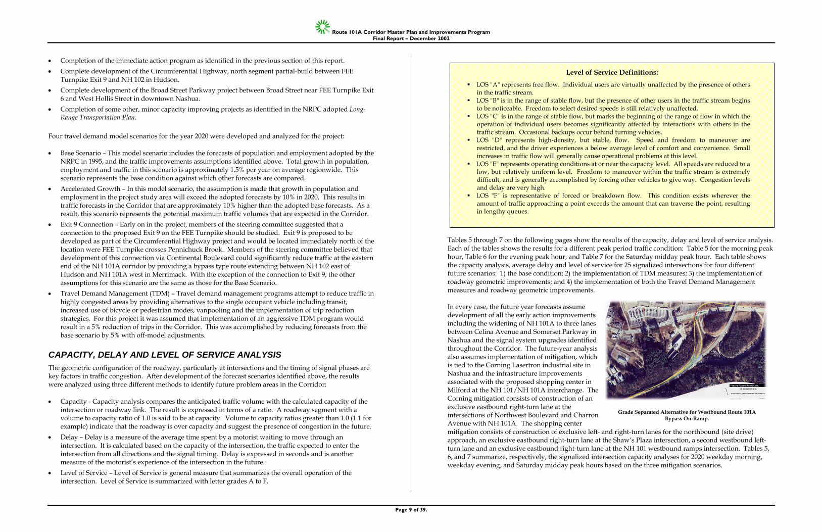
Level of Service Definitions:
LOS "A" represents free flow. Individual users are virtually unaffected by the presence of others in the traffic stream.
LOS "B" is in the range of stable flow, but the presence of other users in the traffic stream begins to be noticeable. Freedom to select desired speeds is still relatively unaffected.
LOS "C" is in the range of stable flow, but marks the beginning of the range of flow in which the operation of individual users becomes significantly affected by interactions with others in the traffic stream. Occasional backups occur behind turning vehicles.
LOS "D" represents high-density, but stable, flow. Speed and freedom to maneuver are restricted, and the driver experiences a below average level of comfort and convenience. Small increases in traffic flow will generally cause operational problems at this level.
LOS "E" represents operating conditions at or near the capacity level. All speeds are reduced to a low, but relatively uniform level. Freedom to maneuver within the traffic stream is extremely difficult, and is generally accomplished by forcing other vehicles to give way. Congestion levels and delay are very high.
LOS "F" is representative of forced or breakdown flow. This condition exists wherever the amount of traffic approaching a point exceeds the amount that can traverse the point, resulting in lengthy queues.
Grade Separated Alternative for Westbound Route 101A Bypass On-Ramp.
Route 101A Corridor Master Plan and Improvements Program Final Report – December 2002
Page 10 of 39.
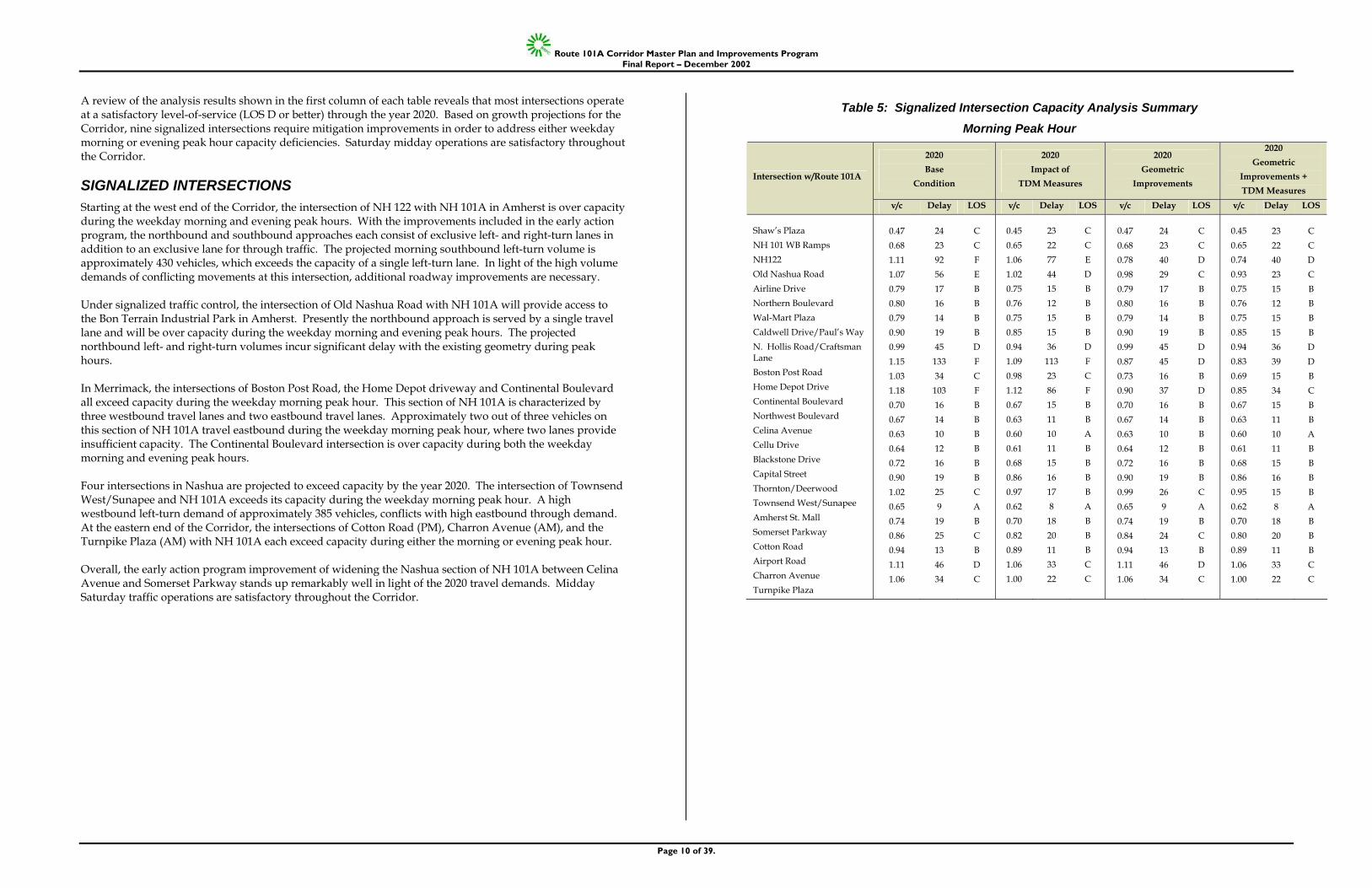
A review of the analysis results shown in the first column of each table reveals that most intersections operate at a satisfactory level-of-service (LOS D or better) through the year 2020. Based on growth projections for the Corridor, nine signalized intersections require mitigation improvements in order to address either weekday morning or evening peak hour capacity deficiencies. Saturday midday operations are satisfactory throughout the Corridor.
SIGNALIZED INTERSECTIONS Starting at the west end of the Corridor, the intersection of NH 122 with NH 101A in Amherst is over capacity during the weekday morning and evening peak hours. With the improvements included in the early action program, the northbound and southbound approaches each consist of exclusive left- and right-turn lanes in addition to an exclusive lane for through traffic. The projected morning southbound left-turn volume is approximately 430 vehicles, which exceeds the capacity of a single left-turn lane. In light of the high volume demands of conflicting movements at this intersection, additional roadway improvements are necessary. Under signalized traffic control, the intersection of Old Nashua Road with NH 101A will provide access to the Bon Terrain Industrial Park in Amherst. Presently the northbound approach is served by a single travel lane and will be over capacity during the weekday morning and evening peak hours. The projected northbound left- and right-turn volumes incur significant delay with the existing geometry during peak hours. In Merrimack, the intersections of Boston Post Road, the Home Depot driveway and Continental Boulevard all exceed capacity during the weekday morning peak hour. This section of NH 101A is characterized by three westbound travel lanes and two eastbound travel lanes. Approximately two out of three vehicles on this section of NH 101A travel eastbound during the weekday morning peak hour, where two lanes provide insufficient capacity. The Continental Boulevard intersection is over capacity during both the weekday morning and evening peak hours. Four intersections in Nashua are projected to exceed capacity by the year 2020. The intersection of Townsend West/Sunapee and NH 101A exceeds its capacity during the weekday morning peak hour. A high westbound left-turn demand of approximately 385 vehicles, conflicts with high eastbound through demand. At the eastern end of the Corridor, the intersections of Cotton Road (PM), Charron Avenue (AM), and the Turnpike Plaza (AM) with NH 101A each exceed capacity during either the morning or evening peak hour. Overall, the early action program improvement of widening the Nashua section of NH 101A between Celina Avenue and Somerset Parkway stands up remarkably well in light of the 2020 travel demands. Midday Saturday traffic operations are satisfactory throughout the Corridor.
Table 5: Signalized Intersection Capacity Analysis Summary Morning Peak Hour
2020 Base
Condition
2020 Impact of
TDM Measures
2020 Geometric
Improvements
2020 Geometric
Improvements + TDM Measures
Intersection w/Route 101A
v/c Delay LOS v/c Delay LOS v/c Delay LOS v/c Delay LOS
Shaw’s Plaza NH 101 WB Ramps NH122 Old Nashua Road Airline Drive Northern Boulevard Wal-Mart Plaza Caldwell Drive/Paul’s Way N. Hollis Road/Craftsman Lane Boston Post Road Home Depot Drive Continental Boulevard Northwest Boulevard Celina Avenue Cellu Drive Blackstone Drive Capital Street Thornton/Deerwood Townsend West/Sunapee Amherst St. Mall Somerset Parkway Cotton Road Airport Road Charron Avenue Turnpike Plaza
0.47 0.68 1.11 1.07 0.79 0.80 0.79 0.90 0.99 1.15 1.03 1.18 0.70 0.67 0.63 0.64 0.72 0.90 1.02 0.65 0.74 0.86 0.94 1.11 1.06
24 23 92 56 17 16 14 19 45 133 34 103 16 14 10 12 16 19 25 9
19 25 13 46 34
C C F E B B B B D F C F B B B B B B C A B C B D C
0.45 0.65 1.06 1.02 0.75 0.76 0.75 0.85 0.94 1.09 0.98 1.12 0.67 0.63 0.60 0.61 0.68 0.86 0.97 0.62 0.70 0.82 0.89 1.06 1.00
23 22 77 44 15 12 15 15 36
113 23 86 15 11 10 11 15 16 17 8 18 20 11 33 22
C C E D B B B B D F C F B B A B B B B A B B B C C
0.47 0.68 0.78 0.98 0.79 0.80 0.79 0.90 0.99 0.87 0.73 0.90 0.70 0.67 0.63 0.64 0.72 0.90 0.99 0.65 0.74 0.84 0.94 1.11 1.06
24 23 40 29 17 16 14 19 45 45 16 37 16 14 10 12 16 19 26 9
19 24 13 46 34
C C D C B B B B D D B D B B B B B B C A B C B D C
0.45 0.65 0.74 0.93 0.75 0.76 0.75 0.85 0.94 0.83 0.69 0.85 0.67 0.63 0.60 0.61 0.68 0.86 0.95 0.62 0.70 0.80 0.89 1.06 1.00
23 22 40 23 15 12 15 15 36 39 15 34 15 11 10 11 15 16 15 8 18 20 11 33 22
C C D C B B B B D D B C B B A B B B B A B B B C C
Route 101A Corridor Master Plan and Improvements Program Final Report – December 2002
Page 11 of 39.
Table 6: Signalized Intersection Capacity Analysis Summary Evening Peak Hour
2020 Base Condition
2020 Impact of TDM
Measures
2020 Geometric
Improvements
2020 Geometric
Improvements + TDM Measures
Intersection w/Route 101A
v/c Delay LOS v/c Delay LOS v/c Delay LOS v/c Delay LOS
Shaw’s Plaza NH 101 WB Ramps NH122 Old Nashua Road Airline Drive Northern Boulevard Wal-Mart Plaza Caldwell Drive/Paul’s Way N. Hollis Road/Craftsman Lane Boston Post Road Home Depot Drive Continental Boulevard Northwest Boulevard Celina Avenue Cellu Drive Blackstone Drive Capital Street Thornton/Deerwood Townsend West/Sunapee Amherst St. Mall Somerset Parkway Cotton Road Airport Road Charron Avenue Turnpike Plaza
0.75 0.70 1.18 1.04 0.85 0.71 0.80 0.80 0.96 0.92 0.92 1.18 0.88 0.74 0.89 0.79 0.83 0.94 0.92 0.81 0.97 1.09 0.84 0.92 1.00
47 24 87 79 12 14 30 31 44 28 25 101 32 13 33 6
12 19 19 11 29 74 11 21 38
D C F E B B C C D C C F C B C A B B B B C E B C D
0.75 0.67 1.12 0.98 0.80 0.68 0.76 0.76 0.91 0.87 0.88 1.12 0.84 0.70 0.84 0.75 0.78 0.89 0.87 0.77 0.92 1.03 0.80 0.88 0.95
44 23 72 60 8 13 26 25 37 24 21 81 29 13 29 5 11 17 17 8 25 62 11 19 30
D C E E A B C C D C C F C B C A B B B A C E B B C
0.75 0.70 0.92 0.90 0.85 0.71 0.80 0.80 0.96 0.67 0.92 0.94 0.88 0.74 0.89 0.79 0.83 0.94 0.94 0.81 0.97 0.90 0.84 0.92 1.00
47 24 43 30 12 14 30 31 44 23 24 33 32 13 33 6
12 19 19 11 29 39 11 21 38
D C D C B B C C D C C C C B C A B B B B C D B C D
0.75 0.67 0.87 0.85 0.80 0.68 0.76 0.76 0.91 0.63 0.88 0.89 0.84 0.70 0.84 0.75 0.78 0.89 0.89 0.77 0.92 0.86 0.80 0.88 0.95
44 23 40 28 8 13 26 25 37 21 20 29 29 13 29 5 11 17 17 8 25 37 11 19 30
D C D C A B C C D C B C C B C A B B B A C D B B C
Table 7: Signalized Intersection Capacity Analysis Summary Saturday Midday Peak Hour
2020 Base Condition
2020 Impact of
TDM Measures
2020 Geometric
Improvements
2020 Geometric
Improvements + TDM Measures
Intersection with Route 101A
v/c Delay LOS v/c Delay LOS v/c Delay LOS v/c Delay LOS
Shaw’s Plaza NH 101 WB Ramps NH122 Old Nashua Road Airline Drive Northern Boulevard Wal-Mart Plaza Caldwell Drive/Paul’s Way N. Hollis Road/Craftsman Ln. Boston Post Road Home Depot Drive Continental Boulevard Northwest Boulevard Celina Avenue Cellu Drive Blackstone Drive Capital Street Thornton/Deerwood Townsend West/Sunapee Amherst St. Mall Somerset Parkway Cotton Road Airport Road Charron Avenue Turnpike Plaza
0.79 0.93 0.87 0.85 0.62 0.60 0.81 0.64 0.78 0.70 0.78 0.91 0.88 0.71 0.91 0.61 0.67 0.94 0.79 0.77 0.80 0.80 0.83 0.89 0.96
40 32 43 32 13 12 30 23 34 25 27 44 38 16 42 9 14 36 22 26 24 42 18 24 34
D C D C B B C C C C C D D B D A B D C C C D B C C
0.75 0.82 0.82 0.81 0.59 0.57 0.77 0.61 0.74 0.67 0.74 0.86 0.84 0.67 0.86 0.58 0.63 0.88 0.75 0.73 0.76 0.76 0.79 0.85 0.91
38 26 39 28 12 12 29 21 32 24 25 38 35 15 38 9 14 32 21 23 23 39 16 21 28
D C D C B B C C C C C D C B D A B C C C C D B C C
0.79 0.93 0.65 0.76 0.62 0.60 0.81 0.64 0.78 0.53 0.78 0.77 0.88 0.71 0.91 0.61 0.67 0.94 0.73 0.77 0.80 0.74 0.83 0.89 0.96
40 32 33 19 13 12 30 23 34 21 26 36 38 16 42 9 14 36 22 26 24 38 18 24 34
D C C B B B C C C C C D D B D A B D C C C D B C C
0.75 0.82 0.62 0.72 0.59 0.57 0.77 0.61 0.74 0.50 0.74 0.74 0.84 0.67 0.86 0.58 0.63 0.88 0.70 0.73 0.76 0.70 0.79 0.85 0.91
38 26 32 19 12 12 29 21 32 20 24 35 35 15 38 9 14 32 21 23 23 37 16 21 28
D C C B B B C C C B C C C B D A B C C C C D B C C
Route 101A Corridor Master Plan and Improvements Program Final Report – December 2002
Page 12 of 39.
UNSIGNALIZED INTERSECTIONS Three currently unsignalized intersections were included in the signalized analysis of future traffic conditions due to anticipated future changes in land use. The traffic operations of the Old Nashua Road, Cellu Drive, and Capital Street intersections with NH 101A are included in the signalized intersection summary tables. In addition, the NH 101 eastbound ramp intersection with NH 101A operates with significant delay to the NH 101 off-ramp during all three-peak periods. In particular, the right-turn movement from the eastbound off-ramp operates at LOS F with projected demand volumes of approximately 840, 750, and 560 vehicles during the weekday morning, evening, and Saturday midday peak hours respectively. With the exception of the NH 122 and Continental Boulevard intersections, and the NH 101A/NH 101 interchange as discussed below, the improvements identified as part of the early action program generally preserve the capacity of the Corridor through the year 2020 with limited additional improvements required. In addition, the 5-lane section of NH 101A in Amherst from NH 122 to North Hollis Road was analyzed and is projected to operate under capacity (at LOS D or better) through the year 2020.
MITIGATION A sensitivity analysis was performed in order to quantify the effect of incorporating a Transportation Demand Management (TDM) strategy into the plan for the Corridor. For purposes of this study, a TDM strategy comprised of public transit, ride sharing, flextime, shift staggering and zoning and land use controls has been assumed to effect a reduction of the projected peak hour traffic volume for NH 101A by five percent. The results of this analysis indicate that such a TDM strategy can significantly reduce traffic operational constraints as shown in Tables 5, 6, and 7. With implementation of a TDM program, all intersections reflect a reduced volume to capacity ratio and levels of service improve at five or more intersections in both the morning and evening peak hours. In particular, the TDM strategy significantly improves traffic operations at the intersections of Townsend West/Sunapee and the Turnpike Plaza with NH 101A, and may eliminate the need for physical improvements. When coupled with the necessary physical improvements, execution of TDM measures improves traffic operations at signalized and unsignalized intersections throughout the Corridor and extends the life of NH 101A beyond the 20-year traffic projections. For these reasons, planning and execution of TDM measures should be pursued concurrently with all additional mitigation measures.
Figure 6A: Signalized and Unsignalized Intersections in the Study Area, Map 1 of 2
Figure 6B: Signalized and Unsignalized Intersections in the Study Area, Map 2 of 2
Route 101A Corridor Master Plan and Improvements Program Final Report – December 2002
Page 13 of 39.
The Summary of Action Plan Recommendations for the NH 101A Corridor Master Plan and Improvements Program provides a detailed description of the improvements that are recommended as part of both the TDM Measures program and the Geometric Improvements. The following summarizes those improvements: • NH 101/NH 101A Interchange - At the NH 101/NH 101A interchange the intersection of the eastbound
ramps with NH 101A should be signalized. In order to accommodate the peak hour demand volume for the right-turn movement from the eastbound exit ramp, a second right-turn lane should be constructed.
• Intersection of NH 122 and NH 101A - At the intersection of NH 122 with NH 101A, each of the four approaches require additional capacity to accommodate the projected traffic demand in the year 2020. As an addition to the early action program, an eastbound right-turn lane should be constructed. This action improves operation from LOS F to LOS E during both the weekday morning and evening peak hours. However, the intersection still exceeds its capacity, with volume to capacity ratios during these peak hours (1.11 and 1.18) dropping to 0.99 and 1.17 respectively. Additional mitigation includes reassigning the through lane of the NH 122 approaches to a shared left/through lane and changing the signal timing to reflect split phased timing for these approaches. This allows double left-turns to operate without conflicts. On NH 101A, widening is required to provide three through travel lanes in each direction with exclusive left- and right-turn lanes. The three through lanes would be tapered to two travel lanes in each direction immediately east and west of the intersection. These improvements extend the capacity of the intersection through the year 2020, with traffic operations of LOS D for each of the peak hours.
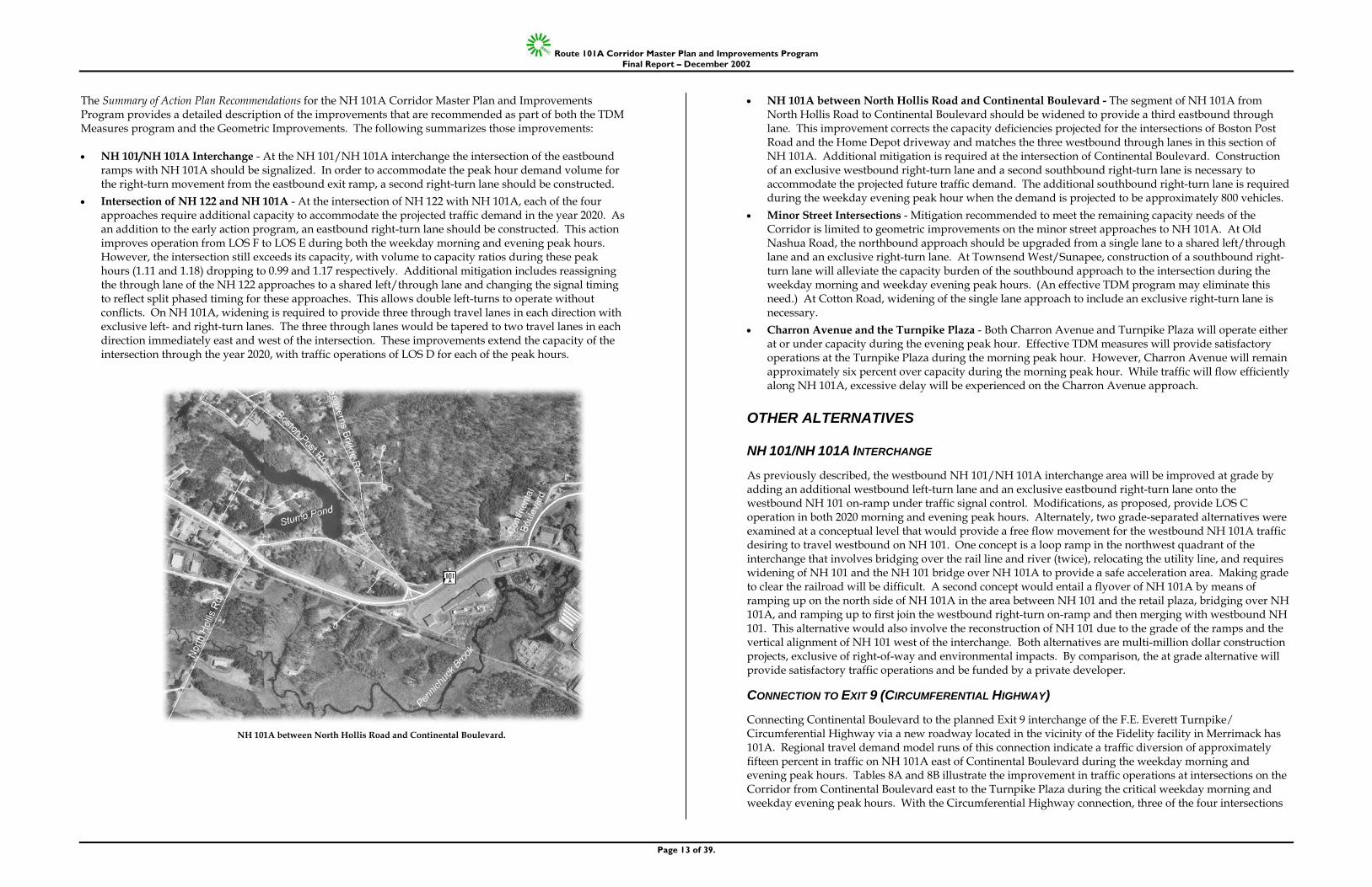
• NH 101A between North Hollis Road and Continental Boulevard - The segment of NH 101A from North Hollis Road to Continental Boulevard should be widened to provide a third eastbound through lane. This improvement corrects the capacity deficiencies projected for the intersections of Boston Post Road and the Home Depot driveway and matches the three westbound through lanes in this section of NH 101A. Additional mitigation is required at the intersection of Continental Boulevard. Construction of an exclusive westbound right-turn lane and a second southbound right-turn lane is necessary to accommodate the projected future traffic demand. The additional southbound right-turn lane is required during the weekday evening peak hour when the demand is projected to be approximately 800 vehicles.
• Minor Street Intersections - Mitigation recommended to meet the remaining capacity needs of the Corridor is limited to geometric improvements on the minor street approaches to NH 101A. At Old Nashua Road, the northbound approach should be upgraded from a single lane to a shared left/through lane and an exclusive right-turn lane. At Townsend West/Sunapee, construction of a southbound right-turn lane will alleviate the capacity burden of the southbound approach to the intersection during the weekday morning and weekday evening peak hours. (An effective TDM program may eliminate this need.) At Cotton Road, widening of the single lane approach to include an exclusive right-turn lane is necessary.
• Charron Avenue and the Turnpike Plaza - Both Charron Avenue and Turnpike Plaza will operate either at or under capacity during the evening peak hour. Effective TDM measures will provide satisfactory operations at the Turnpike Plaza during the morning peak hour. However, Charron Avenue will remain approximately six percent over capacity during the morning peak hour. While traffic will flow efficiently along NH 101A, excessive delay will be experienced on the Charron Avenue approach.
OTHER ALTERNATIVES
NH 101/NH 101A INTERCHANGE
As previously described, the westbound NH 101/NH 101A interchange area will be improved at grade by adding an additional westbound left-turn lane and an exclusive eastbound right-turn lane onto the westbound NH 101 on-ramp under traffic signal control. Modifications, as proposed, provide LOS C operation in both 2020 morning and evening peak hours. Alternately, two grade-separated alternatives were examined at a conceptual level that would provide a free flow movement for the westbound NH 101A traffic desiring to travel westbound on NH 101. One concept is a loop ramp in the northwest quadrant of the interchange that involves bridging over the rail line and river (twice), relocating the utility line, and requires widening of NH 101 and the NH 101 bridge over NH 101A to provide a safe acceleration area. Making grade to clear the railroad will be difficult. A second concept would entail a flyover of NH 101A by means of ramping up on the north side of NH 101A in the area between NH 101 and the retail plaza, bridging over NH 101A, and ramping up to first join the westbound right-turn on-ramp and then merging with westbound NH 101. This alternative would also involve the reconstruction of NH 101 due to the grade of the ramps and the vertical alignment of NH 101 west of the interchange. Both alternatives are multi-million dollar construction projects, exclusive of right-of-way and environmental impacts. By comparison, the at grade alternative will provide satisfactory traffic operations and be funded by a private developer.
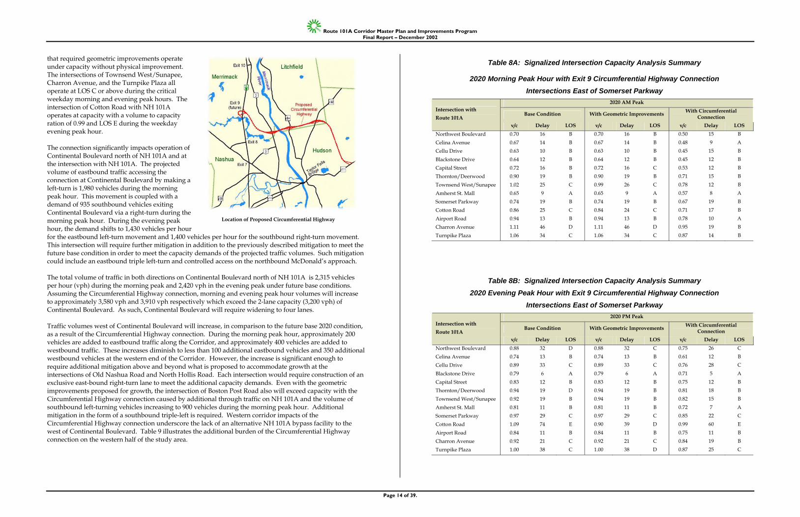
CONNECTION TO EXIT 9 (CIRCUMFERENTIAL HIGHWAY)
Connecting Continental Boulevard to the planned Exit 9 interchange of the F.E. Everett Turnpike/ Circumferential Highway via a new roadway located in the vicinity of the Fidelity facility in Merrimack has 101A. Regional travel demand model runs of this connection indicate a traffic diversion of approximately fifteen percent in traffic on NH 101A east of Continental Boulevard during the weekday morning and evening peak hours. Tables 8A and 8B illustrate the improvement in traffic operations at intersections on the Corridor from Continental Boulevard east to the Turnpike Plaza during the critical weekday morning and weekday evening peak hours. With the Circumferential Highway connection, three of the four intersections
NH 101A between North Hollis Road and Continental Boulevard.
Route 101A Corridor Master Plan and Improvements Program Final Report – December 2002
Page 14 of 39.
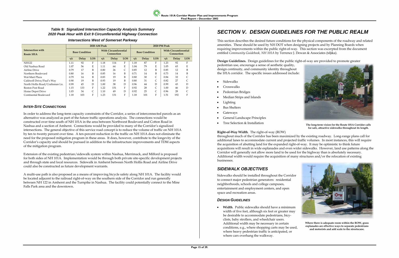
that required geometric improvements operate under capacity without physical improvement. The intersections of Townsend West/Sunapee, Charron Avenue, and the Turnpike Plaza all operate at LOS C or above during the critical weekday morning and evening peak hours. The intersection of Cotton Road with NH 101A operates at capacity with a volume to capacity ration of 0.99 and LOS E during the weekday evening peak hour. The connection significantly impacts operation of Continental Boulevard north of NH 101A and at the intersection with NH 101A. The projected volume of eastbound traffic accessing the connection at Continental Boulevard by making a left-turn is 1,980 vehicles during the morning peak hour. This movement is coupled with a demand of 935 southbound vehicles exiting Continental Boulevard via a right-turn during the morning peak hour. During the evening peak hour, the demand shifts to 1,430 vehicles per hour for the eastbound left-turn movement and 1,400 vehicles per hour for the southbound right-turn movement. This intersection will require further mitigation in addition to the previously described mitigation to meet the future base condition in order to meet the capacity demands of the projected traffic volumes. Such mitigation could include an eastbound triple left-turn and controlled access on the northbound McDonald’s approach. The total volume of traffic in both directions on Continental Boulevard north of NH 101A is 2,315 vehicles per hour (vph) during the morning peak and 2,420 vph in the evening peak under future base conditions. Assuming the Circumferential Highway connection, morning and evening peak hour volumes will increase to approximately 3,580 vph and 3,910 vph respectively which exceed the 2-lane capacity (3,200 vph) of Continental Boulevard. As such, Continental Boulevard will require widening to four lanes. Traffic volumes west of Continental Boulevard will increase, in comparison to the future base 2020 condition, as a result of the Circumferential Highway connection. During the morning peak hour, approximately 200 vehicles are added to eastbound traffic along the Corridor, and approximately 400 vehicles are added to westbound traffic. These increases diminish to less than 100 additional eastbound vehicles and 350 additional westbound vehicles at the western end of the Corridor. However, the increase is significant enough to require additional mitigation above and beyond what is proposed to accommodate growth at the intersections of Old Nashua Road and North Hollis Road. Each intersection would require construction of an exclusive east-bound right-turn lane to meet the additional capacity demands. Even with the geometric improvements proposed for growth, the intersection of Boston Post Road also will exceed capacity with the Circumferential Highway connection caused by additional through traffic on NH 101A and the volume of southbound left-turning vehicles increasing to 900 vehicles during the morning peak hour. Additional mitigation in the form of a southbound triple-left is required. Western corridor impacts of the Circumferential Highway connection underscore the lack of an alternative NH 101A bypass facility to the west of Continental Boulevard. Table 9 illustrates the additional burden of the Circumferential Highway connection on the western half of the study area.
Table 8A: Signalized Intersection Capacity Analysis Summary
2020 Morning Peak Hour with Exit 9 Circumferential Highway Connection Intersections East of Somerset Parkway
2020 AM Peak
Base Condition With Geometric Improvements With Circumferential Connection
Intersection with Route 101A
v/c Delay LOS v/c Delay LOS v/c Delay LOS Northwest Boulevard Celina Avenue Cellu Drive Blackstone Drive Capital Street Thornton/Deerwood Townsend West/Sunapee Amherst St. Mall Somerset Parkway Cotton Road Airport Road Charron Avenue Turnpike Plaza
0.70 0.67 0.63 0.64 0.72 0.90 1.02 0.65 0.74 0.86 0.94 1.11 1.06
16 14 10 12 16 19 25 9
19 25 13 46 34
B B B B B B C A B C B D C
0.70 0.67 0.63 0.64 0.72 0.90 0.99 0.65 0.74 0.84 0.94 1.11 1.06
16 14 10 12 16 19 26 9
19 24 13 46 34
B B B B C B C A B C B D C
0.50 0.48 0.45 0.45 0.53 0.71 0.78 0.57 0.67 0.71 0.78 0.95 0.87
15 9
15 12 12 15 12 8
19 17 10 19 14
B A B B B B B A B B A B B
Table 8B: Signalized Intersection Capacity Analysis Summary 2020 Evening Peak Hour with Exit 9 Circumferential Highway Connection
Intersections East of Somerset Parkway 2020 PM Peak
Base Condition With Geometric Improvements With Circumferential Connection
Intersection with Route 101A
v/c Delay LOS v/c Delay LOS v/c Delay LOS Northwest Boulevard Celina Avenue Cellu Drive Blackstone Drive Capital Street Thornton/Deerwood Townsend West/Sunapee Amherst St. Mall Somerset Parkway Cotton Road Airport Road Charron Avenue Turnpike Plaza
0.88 0.74 0.89 0.79 0.83 0.94 0.92 0.81 0.97 1.09 0.84 0.92 1.00
32 13 33 6
12 19 19 11 29 74 11 21 38
D B C A B D B B C E B C C
0.88 0.74 0.89 0.79 0.83 0.94 0.94 0.81 0.97 0.90 0.84 0.92 1.00
32 13 33 6
12 19 19 11 29 39 11 21 38
C B C A B B B B C D B C D
0.75 0.61 0.76 0.71 0.75 0.81 0.82 0.72 0.85 0.99 0.75 0.84 0.87
26 12 28 5
12 18 15 7
22 60 11 19 25
C B C A B B B A C E B B C
Location of Proposed Circumferential Highway
Route 101A Corridor Master Plan and Improvements Program Final Report – December 2002
Page 15 of 39.
Table 9: Signalized Intersection Capacity Analysis Summary 2020 Peak Hour with Exit 9 Circumferential Highway Connection
Intersections West of Somerset Parkway 2020 AM Peak 2020 PM Peak Intersection with Route 101A
Base Condition With Circumferential Connection Base Condition With Circumferential
Connection
v/c Delay LOS v/c Delay LOS v/c Delay LOS v/c Delay LOS NH122 Old Nashua Road Airline Drive Northern Boulevard Wal-Mart Plaza Caldwell Drive/Paul’s Way North Hollis Road/Craftsman Ln. Boston Post Road Home Depot Drive Continental Boulevard
1.11 1.07 0.79 0.80 0.79 0.90 0.99 1.15 1.03 1.18
92 56 17 16 14 19 45 133 34 103
F E B B B B D F C F
1.18 1.11 0.80 0.85 0.83 0.93 1.00 1.22 1.10 1.23
114 64 26 16 19 19 38 151 49 131
F E C B B B D F D F
1.18 1.04 0.85 0.71 0.80 0.80 0.96 0.92 0.92 1.18
87 79 12 14 30 31 44 28 25 101
F E B B C C D C C F
1.23 1.05 0.85 0.73 0.84 0.82 0.99 1.00 0.96 1.51
92 65 12 14 32 27 43 46 28
192
F E B B C C D D C F
INTER-SITE CONNECTIONS
In order to address the long-term capacity constraints of the Corridor, a series of interconnected parcels as an alternative was analyzed as part of the future traffic operations analysis. The connections would be constructed over time south of NH 101A in the area between Northwest Boulevard and Cotton Road in Nashua and a section of Amherst. Connections would be provided to many of the Corridor’s signalized intersections. The general objective of this service road concept is to reduce the volume of traffic on NH 101A by ten to twenty percent over time. A ten-percent reduction in the traffic on NH 101A does not eliminate the need for the proposed mitigation program in these areas. It does, however, contribute to the longevity of the Corridor’s capacity and should be pursued in addition to the infrastructure improvements and TDM aspects of the mitigation program. Extension of the existing pedestrian/sidewalk system within Nashua, Merrimack, and Milford is proposed for both sides of NH 101A. Implementation would be through both private site-specific development projects and through state and local resources. Sidewalk in Amherst between North Hollis Road and Airline Drive could also be constructed as future development warrants. A multi-use path is also proposed as a means of improving bicycle safety along NH 101A. The facility would be located adjacent to the railroad right-of-way on the southern side of the Corridor and run generally between NH 122 in Amherst and the Turnpike in Nashua. The facility could potentially connect to the Mine Falls Park area and the downtown.
SECTION V. DESIGN GUIDELINES FOR THE PUBLIC REALM This section describes the desired future conditions for the physical components of the roadway and related amenities. These should be used by NH DOT when designing projects and by Planning Boards when requiring improvements within the public right-of-way. This section was excerpted from the document entitled Community Guidebook, NH 101A by Terrence J. Dewan & Associates (tdj&a). Design Guidelines. Design guidelines for the public right-of-way are provided to promote greater pedestrian use, encourage a sense of aesthetic quality, design continuity, and community identity throughout the 101A corridor. The specific issues addressed include: • Sidewalks • Crosswalks • Pedestrian Bridges • Median Strips and Islands • Lighting • Bus Shelters • Gateways • General Landscape Principles • Tree Selection & Installation Right-of-Way Width. The right-of-way (ROW) throughout much of the Corridor has been maximized by the existing roadway. Long-range plans call for additional lanes to accommodate current and projected traffic volumes. In most instances, this will require the acquisition of abutting land for the expanded right-of-way. It may be optimistic to think future acquisitions will result in wide esplanades and even wider sidewalks. However, land use patterns along the Corridor will generally not allow more land to be used for the highway than is absolutely necessary. Additional width would require the acquisition of many structures and/or the relocation of existing businesses.
SIDEWALK OBJECTIVES Sidewalks should be installed throughout the Corridor to connect major pedestrian generators: residential neighborhoods, schools and college campuses, entertainment and employment centers, and open space and recreation areas.
DESIGN GUIDELINES
• Width. Public sidewalks should have a minimum width of five feet, although six feet or greater may be desirable to accommodate pedestrians, bicy-clists, baby strollers, and wheelchair users. Additional width may be necessary in certain conditions, e.g., where shopping carts may be used, where heavy pedestrian traffic is anticipated, or where cars overhang the walkway.
The long-term vision for the Route 101A Corridor calls for safe, attractive sidewalks throughout its length.
Where there is adequate room within the ROW, grass esplanades are effective ways to separate pedestrians
and motorists and add scale to the streetscape.
Route 101A Corridor Master Plan and Improvements Program Final Report – December 2002
Page 16 of 39.
• Esplanades. Throughout much of the Corridor, the right-of-way is very near the edge of the curbline, leaving little room for planted esplanades. The major exception is a section in Amherst between Northern Boulevard and North Hollis Road, where there appears to be room for a three-foot planting strip. Properly designed esplanades can be important areas for stormwater infiltration.
• New Development. In new development or redevelopment sites, where conditions warrant, developers should be encouraged to locate sidewalks within the front setback, to increase separation from 101A traffic and to provide for a plantings next to the road.
• Design. The design of new sidewalks should be coordinated with existing site conditions (trees, utilities, street signs, etc.) to avoid conflicts and potential hazards. Obstructions should be relocated or removed wherever possible. Walks should be designed to facilitate snow removal. Grades, cross-pitches, and intersections shall be designed to comply with ADA.
• Material Selection. High quality bituminous concrete (asphalt) should be used as the standard sidewalk material throughout the Corridor. Broom finished concrete should be used in sections of Nashua to reinforce the concrete sidewalks that have been recently installed there. This recommendation should be considered on a site specific basis. Concrete provides more contrast with the roadway, thus minimizing the apparent width of the paved area within the ROW. Long-term durability and appearance of all sidewalks should be an important consideration. Construction methods should comply with current industry standards
• Pervious Surfaces in Special Areas. Non-bedded pavers or other forms of pervious surfacing should be used for sitting areas within the ROW, at bus shelters, and other designed spaces to minimize stormwater runoff.
• Lighting. Sidewalks should be lit to the minimum standards recommended by the Illuminating Engineering Society of North America (IESNA) to promote safe use in the evening hours.
• Drainage. Grading should utilize infiltration areas to handle stormwater wherever possible. Culverts and traditional enclosed drainage systems should be used as a secondary means. Roadway and parking lot sheet flow of stormwater across sidewalks should be avoided. Culverts should be sized to prevent ponding and provide uninterrupted walking. Sidewalks should be graded to utilize the esplanade or adjacent grass area for infiltration wherever possible.
Photosimulation showing how street trees can add scale and define the edge of the right-of-way.
Shrubs can further define the roadway and reduce the visibility of adjacent parking lots. Plantings in this
illustration are outside the ROW and would require a landscape easement.
Where easements cannot be acquired, sidewalks will need to be constructed against the curb.
Existing conditions where 101A parallels the railroad, near Old Nashua Road, Amherst.
Concrete sidewalks provide maximum contrast and reduce the visual width of the ROW.
New 101A sidewalks should match into private walkways.
Route 101A Corridor Master Plan and Improvements Program Final Report – December 2002
Page 17 of 39.
• Curbing. Granite curbing should be used along all major roadways and connecting roads. This will provide additional protection to the pedestrian, while withstanding snowplowing and heavy traffic.
• Retaining Walls. As the roadway increases in width, retaining walls will be required to minimize
grading on abutting properties. The use of low granite block retaining walls should be continued wherever possible.
• Private Walkways. Public sidewalks should be designed to meet the grade of private walkways that
connect the front entrance of all commercial, residential, and institutional uses along the Corridor. The public sidewalk system should be extended into nearby residential neighborhoods, office parks, and college campuses to encourage more pedestrian activity within the Corridor.
CROSSWALK OBJECTIVES Crosswalks should be provided at key points throughout the Corridor and at major intersections to provide highly visible, safe places for pedestrians to cross the roadway.
DESIGN GUIDELINES
• Design. Crosswalks should be designed to maximize pedestrian safety in all potentially hazardous areas. They should conform to the current standards of the NHDOT. The same crosswalk design should be repeated throughout the Corridor for continuity and to emphasize the pedestrian circulation system.
• Materials Selection. While there are a variety of materials and techniques available for crosswalks,
reflective white pavement paint applied in wide stripes is recommended for its relative cost, contrast, and slip resistance.
Photosimulation of a shared use pathway adjacent to the railroad. A visual and/or physical barrier may be
necessary to separate pathway users and 101A traffic. The speed along 101A may require a guardrail or other
physical barrier between the road and the pathway.
Trees between the path and the railroad can provide scale and add to the enjoyment of the pathway.
Granite bollards can provide an additional level of safety in some situations.
Typical existing crosswalk, Continental Boulevard, Merrimack.
Highly reflective painted bar crosswalks are the most effective type of crosswalk for general use
in high traffic areas.
Simple landscaping can help define refuge areas. Shrubs and perennials in these areas should not exceed 18” in height
to maintain proper visibility.
A long-term solution would be to work with abutting property owners to obtain access and grading easements, move utility lines, and provide sidewalks with planted
esplanades. Low granite block retaining walls should be used to maintain continuity through the Corridor.
Typical existing conditions show worn pathways next to the travelway, with many obstacles to pedestrian movement.
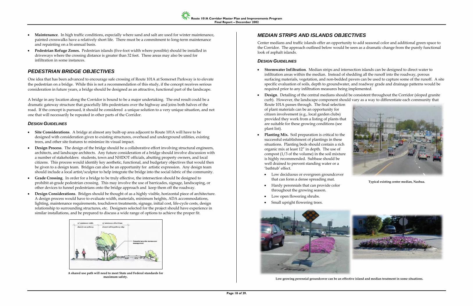
Route 101A Corridor Master Plan and Improvements Program Final Report – December 2002
Page 18 of 39.
• Maintenance. In high traffic conditions, especially where sand and salt are used for winter maintenance, painted crosswalks have a relatively short life. There must be a commitment to long-term maintenance and repainting on a bi-annual basis.
• Pedestrian Refuge Zones. Pedestrian islands (five-foot width where possible) should be installed in driveways where the crossing distance is greater than 32 feet. These areas may also be used for infiltration in some instances.
PEDESTRIAN BRIDGE OBJECTIVES One idea that has been advanced to encourage safe crossing of Route 101A at Somerset Parkway is to elevate the pedestrian on a bridge. While this is not a recommendation of this study, if the concept receives serious consideration in future years, a bridge should be designed as an attractive, functional part of the landscape. A bridge in any location along the Corridor is bound to be a major undertaking. The end result could be a dramatic gateway structure that gracefully lifts pedestrians over the highway and joins both halves of the road. If the concept is pursued, it should be considered a unique solution to a very unique situation, and not one that will necessarily be repeated in other parts of the Corridor.
DESIGN GUIDELINES
• Site Considerations. A bridge at almost any built-up area adjacent to Route 101A will have to be designed with consideration given to existing structures, overhead and underground utilities, existing trees, and other site features to minimize its visual impact.
• Design Process. The design of the bridge should be a collaborative effort involving structural engineers, architects, and landscape architects. Any future consideration of a bridge should involve discussion with a number of stakeholders: students, town and NHDOT officials, abutting property owners, and local citizens. This process would identify key aesthetic, functional, and budgetary objectives that would then be given to a design team. Bridges can also be an opportunity for artistic expression. Any design team should include a local artist/sculptor to help integrate the bridge into the social fabric of the community.
• Grade Crossing. In order for a bridge to be truly effective, the intersection should be designed to prohibit at-grade pedestrian crossing. This may involve the use of barricades, signage, landscaping, or other devices to funnel pedestrians onto the bridge approach and keep them off the roadway.
• Design Considerations. Bridges should be thought of as a highly visible, horizontal piece of architecture. A design process would have to evaluate width, materials, minimum heights, ADA accommodations, lighting, maintenance requirements, touchdown treatments, signage, initial cost, life-cycle costs, design relationship to surrounding structures, etc. Designers selected for the project should have experience in similar installations, and be prepared to discuss a wide range of options to achieve the proper fit.
MEDIAN STRIPS AND ISLANDS OBJECTIVES Center medians and traffic islands offer an opportunity to add seasonal color and additional green space to the Corridor. The approach outlined below would be seen as a dramatic change from the purely functional look of asphalt islands.
DESIGN GUIDELINES
• Stormwater Infiltration. Median strips and intersection islands can be designed to direct water to infiltration areas within the median. Instead of shedding all the runoff into the roadway, porous surfacing materials, vegetation, and non-bedded pavers can be used to capture some of the runoff. A site specific evaluation of soils, depth to groundwater, and roadway grade and drainage patterns would be required prior to any infiltration measures being implemented.
• Design. Detailing of the central medians should be consistent throughout the Corridor (sloped granite curb). However, the landscape component should vary as a way to differentiate each community that Route 101A passes through. The final selection of plant materials can be an opportunity for citizen involvement (e.g., local garden clubs) provided they work from a listing of plants that are suitable for these growing conditions (see plant list).
• Planting Mix. Soil preparation is critical to the successful establishment of plantings in these situations. Planting beds should contain a rich organic mix at least 12” in depth. The use of compost (1/3 of the volume) in the soil mixture is highly recommended. Subbase should be well drained to prevent standing water or a ‘bathtub’ effect. • Low deciduous or evergreen groundcover
that can form a dense spreading mat. • Hardy perennials that can provide color
throughout the growing season. • Low open flowering shrubs. • Small upright flowering trees.
Typical existing center median, Nashua.
Low growing perennial groundcover can be an effective island and median treatment in some situations.
A shared use path will need to meet State and Federal standards for maximum safety.
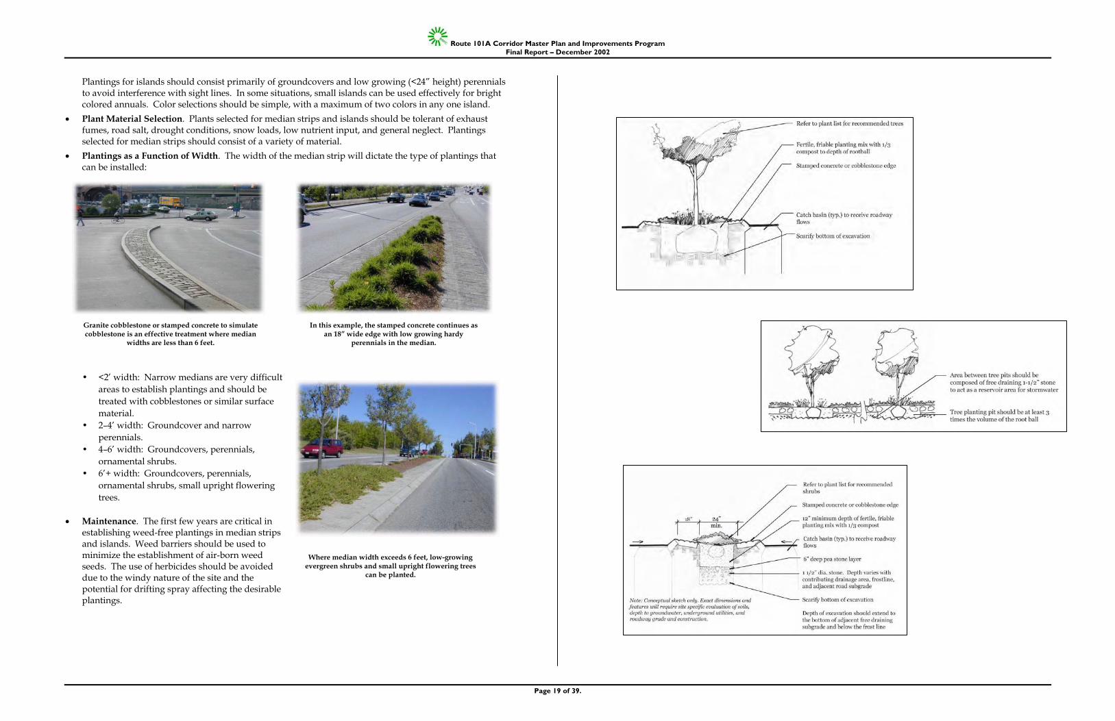
Route 101A Corridor Master Plan and Improvements Program Final Report – December 2002
Page 19 of 39.
Plantings for islands should consist primarily of groundcovers and low growing (<24” height) perennials to avoid interference with sight lines. In some situations, small islands can be used effectively for bright colored annuals. Color selections should be simple, with a maximum of two colors in any one island.
• Plant Material Selection. Plants selected for median strips and islands should be tolerant of exhaust fumes, road salt, drought conditions, snow loads, low nutrient input, and general neglect. Plantings selected for median strips should consist of a variety of material.
• Plantings as a Function of Width. The width of the median strip will dictate the type of plantings that can be installed:
• <2’ width: Narrow medians are very difficult
areas to establish plantings and should be treated with cobblestones or similar surface material.
• 2–4’ width: Groundcover and narrow perennials.
• 4–6’ width: Groundcovers, perennials, ornamental shrubs.
• 6’+ width: Groundcovers, perennials, ornamental shrubs, small upright flowering trees.
• Maintenance. The first few years are critical in
establishing weed-free plantings in median strips and islands. Weed barriers should be used to minimize the establishment of air-born weed seeds. The use of herbicides should be avoided due to the windy nature of the site and the potential for drifting spray affecting the desirable plantings.
Granite cobblestone or stamped concrete to simulate cobblestone is an effective treatment where median
widths are less than 6 feet.
In this example, the stamped concrete continues as an 18” wide edge with low growing hardy
perennials in the median.
Where median width exceeds 6 feet, low-growing evergreen shrubs and small upright flowering trees
can be planted.
Route 101A Corridor Master Plan and Improvements Program Final Report – December 2002
Page 20 of 39.
LIGHTING OBJECTIVES Roadway lighting along the Route 101A Corridor should be designed to provide the minimum level of illumination necessary for security, safety, and visual appeal for both pedestrians and vehicles. Lighting should encourage activity after sunset without adding to unnecessary skyglow. Functional, aesthetic, and safety goals should be met with distinctive yet cost effective fixtures. Lighting is one universal element found throughout the Corridor. Long-range planning and development should strive for continuity in lighting levels, placement and design. The following lighting guidelines are designed to balance the need for visibility and safety while enhancing the visual quality of the Corridor.
Provide lighting that offers a high level of visibility and safety
Unify the quality of the visual environment through the selection of attractive, appropriately scaled fixtures.
Avoid light fixtures or mountings that can cause distractions or hazards to motorists or pedestrians.
Avoid intrusions onto abutting property owners, especially residential uses.
Promote efficient energy use.
DESIGN GUIDELINES
• Coordinated Design. Although the City and each town should have input into the final selection of poles and fixtures there should be some coordination in the general look, illumination levels, type, poles, and height.
• Luminaires. The use of metal halide lamps is strongly recommended for its color rendition and energy efficiency. Lamps should be housed in a luminaire that is classified by IESNA as a cutoff distribution.
• Pole Height. Light fixtures used along 101A should not exceed 25 feet in height. Where applicable, 30’ poles may be allowable to reduce the number of poles.
• Light Trespass. Lighting should not cause spillover onto neighboring residential or institutional properties or create dangerous conditions due to glare on adjacent roadways.
• Energy Saving Devices. Lighting design should include the installation of timers, photo sensors, and other energy saving devices to reduce the overall energy required and eliminate unnecessary lighting.
• Illumination. Roadway lighting should be designed to illuminate the roadway and sidewalk, with a concentration on roadways. Light fixtures should be selected and aimed to prevent glare.
• Illumination Levels. Illumination levels should be defined by IESNA recommendation RP-8-2000 “ANSI Standard Practice for Roadway Lighting,” or the current manual. Levels should be designed for specific locations.
• Layout. The alignment and spacing of fixtures should follow a regular pattern that is coordinated with the location of side roads, driveways, utilities and other roadway elements.
• Coordination with Planting Plan. The layout of light fixtures should compliment the spacing and rhythm of surrounding plantings, especially large shade trees. The lighting placement should take into consideration growth patterns of trees to avoid excessive pruning as trees mature.
The above example is the ‘Transit Series’ fixture by LUMEC Inc. The non-exposed lighting fixture on the left, with the taller pole and longer mounting arm could be a very appropriate combination along 101A.
These two examples are also by LUMEC Inc. The Domus Series (right) and the Opticone
Series are in keeping with the Guidelines for corridor lighting.
Although this fixture is in a private development, its clean contemporary look is
appropriate for the 101A corridor.
Route 101A Corridor Master Plan and Improvements Program Final Report – December 2002
Page 21 of 39.
BUS SHELTER OBJECTIVES Attractive bus shelters can add comfort and visibility to public transit, thereby encouraging ridership and a reduction in personal vehicle trips.
DESIGN GUIDELINES
• Location. The Nashua Transit System Citybus offers service in the Nashua area of the Corridor. Most of the bus stops are located at well known boarding points along the Corridor. While these are most likely in logical places, all bus stops should be reviewed for sight distance, conflicts and visibility before any improvements are made.
• Bus Shelters. The installation of freestanding bus shelters should be considered throughout the Corridor, especially in areas of high ridership. The design of the shelters should be consistent throughout Route 101A and the Citybus service area to give greater recognition to the service.
• Design. Bus shelters are an opportunity to strengthen the design continuity of the Corridor by using attractive, durable materials that are indigenous to New England. Shelters should be designed by an architect or industrial designer specifically for this installation.
• Siting. Bus shelters should be set back a minimum of three feet from the curbline. Four to five feet is the preferred setback. Ideally, the shelters should be oriented away from the street to avoid splashing of standing rainwater onto waiting passengers. The shelters should be sited to face oncoming traffic and to give police a clear view of the interior. The use of plantings with seasonal interest is strongly encouraged.
• ADA. Planning for public transit should include assuring compliance with the Americans with Disabilities Act. Accommodations should include wheelchair ramps, shelters, signage, clear zone and accessible routes.
• Other Amenities. At the busier bus stops, the site plan may include newspaper racks, a trash receptacle, a mailbox, a phone booth and similar street furniture. Bus shelters should also be seen as opportunities to have local artists participate in the planning and execution of the facility. Street furnishings should be placed at least three feet from the curbline. Six feet is preferred.
• Low Volume Bus Stops. Not every bus stop will warrant the installation of a bus shelter. However, each stop should have seating, route signage and information, a tree or some other source of shade and paved access to the sidewalk and the curb.
• Graphics. Route markers should be mounted in a
prominent location. The design of the markers should reflect an overall awareness of the significant graphics in wayfinding and identification.
A typical bus stop along Route 101A.
Pull-off lanes for buses should include a 100 foot deceleration /acceleration lane with a 50 foot bus loading space. The design of bus shelters should include additional pedestrian comforts
such as trees, trash receptacles, and mounted bus schedules.
Route 101A Corridor Master Plan and Improvements Program Final Report – December 2002
Page 22 of 39.
GATEWAY OBJECTIVES Gateways, special improvements at municipal boundaries and other significant locations, can add a sense of place and human scale to the roadway. With proper input from the communities, gateways can be a point of pride and an expression of their history and culture.
DESIGN GUIDELINES
• Treatment. Gateways can be as simple as a welcome sign or a more elaborate blend of graphics, landscaping, earthforms, sculpture and lighting. They should be bold and appropriately scaled to the landscape of the highway. The design should be a collaboration between the NHDOT and individual communities.
• Location. Gateway treatments are most appropriate at the borderline between abutting communities.
• Other Gateway Locations. There are a number of other locations along the Corridor which should receive a higher level landscape treatment, including: • Somerset Parkway at the intersection of Route 101A • SE corner of the NH Vocational School in Nashua • Boston Post Road intersection in Merrimack • Caldwell Drive in Amherst • Northern Boulevard in Amherst • Route 122 Intersection in Amherst
LANDSCAPE OBJECTIVES Landscaping within or immediately adjacent to the Corridor should reinforce circulation paths, highlight entrances, provide shade to the sidewalk and add seasonal interest. The corridor can be unified by a rich variety of street trees, flowering shrubs and masses of color. Throughout most of the Corridor, the travelway extends to the right-of-way, leaving little or no room for plantings on public property. Opportunities for plantings will have to be realized on private property with the permission of the abutting landowner.
DESIGN GUIDELINES
• Boulevard Effect. Where possible, large spreading deciduous trees should be planted along the Corridor to define the edge of the travelway, provide shade for pedestrians and add scale to the roadway.
• Coordination with Utilities. The location of all plantings should be coordinated with both underground and overhead utilities and lighting.
• Simplicity. Plantings along the Corridor should stress simplicity in form and number of species. Shrubs, perennials, annuals and ornamental grasses should be planted in masses or ‘drifts’ that emphasize colors and textures.
• Variety. Using of a variety of plant material that exhibits seasonal color and interesting texture is encouraged to create a distinctive, yet low-maintenance environment. Plantings should strike a balance between monoculture (the use of a single species) and excessive variety.
• Tree and Plant Protection. Every effort should be made to preserve existing or unique trees or other plant material throughout the Corridor. Transplanting and reusing trees and other plant materials is strongly encouraged.
• Safety. The form and height of plant materials as they mature should be considered so they will not create unsafe conditions or block sight lines for pedestrians or motorists.
• The Merrimack/Nashua boundary could be emphasized as a gateway while raising public awareness of Pennichuck Brook and significant wetlands.
• Minimum Plant Sizes. Unless otherwise required by site conditions, plant materials should meet the following size guidelines:
Canopy Trees 2½ ” caliper Flowering Trees 2” caliper Evergreen Trees 5-7’ height Deciduous Shrubs 24” height Evergreen Shrubs 18” ht./spread Perennials 2 year clumps Ornamental Grasses 2 year clumps Ground Covers 3” pots
Trees and grade change effectively separate the parking lot from neighboring land uses.
The Merrimack/Nashua boundary could be emphasized as a gateway while raising public
awareness of Pennichuck Brook and significant wetlands. Weeping willows form a gateway space,
reinforced by yellow-twig dogwood, pepperbush and other native wetland plantings.
The entrance to a new community should welcome visitors and create a positive visual image that is unique to the place.
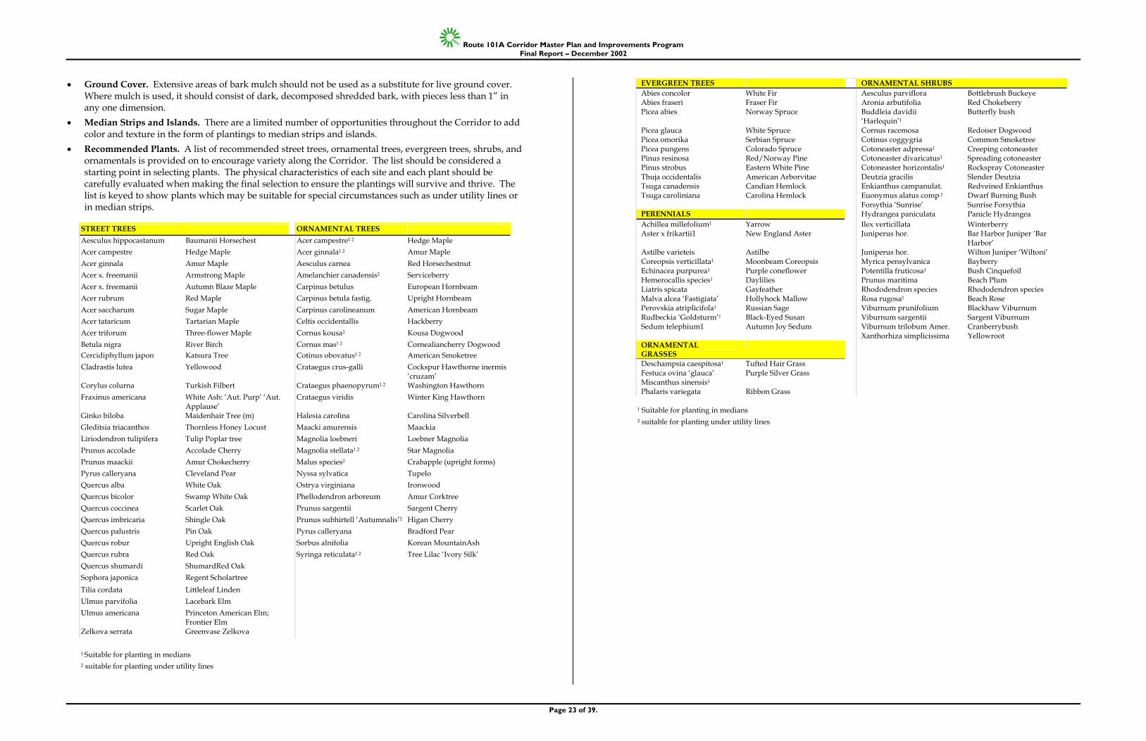
Route 101A Corridor Master Plan and Improvements Program Final Report – December 2002
Page 23 of 39.
• Ground Cover. Extensive areas of bark mulch should not be used as a substitute for live ground cover. Where mulch is used, it should consist of dark, decomposed shredded bark, with pieces less than 1” in any one dimension.
• Median Strips and Islands. There are a limited number of opportunities throughout the Corridor to add color and texture in the form of plantings to median strips and islands.
• Recommended Plants. A list of recommended street trees, ornamental trees, evergreen trees, shrubs, and ornamentals is provided on to encourage variety along the Corridor. The list should be considered a starting point in selecting plants. The physical characteristics of each site and each plant should be carefully evaluated when making the final selection to ensure the plantings will survive and thrive. The list is keyed to show plants which may be suitable for special circumstances such as under utility lines or in median strips.
STREET TREES ORNAMENTAL TREES Aesculus hippocastanum Baumanii Horsechest Acer campestre1 2 Hedge Maple Acer campestre Hedge Maple Acer ginnala1 2 Amur Maple Acer ginnala Amur Maple Aesculus carnea Red Horsechestnut Acer x. freemanii Armstrong Maple Amelanchier canadensis2 Serviceberry Acer x. freemanii Autumn Blaze Maple Carpinus betulus European Hornbeam Acer rubrum Red Maple Carpinus betula fastig. Upright Hornbeam Acer saccharum Sugar Maple Carpinus carolineanum American Hornbeam Acer tataricum Tartarian Maple Celtis occidentallis Hackberry Acer triforum Three-flower Maple Cornus kousa2 Kousa Dogwood Betula nigra River Birch Cornus mas1 2 Cornealiancherry Dogwood Cercidiphyllum japon Katsura Tree Cotinus obovatus1 2 American Smoketree Cladrastis lutea Yellowood Crataegus crus-galli Cockspur Hawthorne inermis
‘cruzam’ Corylus colurna Turkish Filbert Crataegus phaenopyrum1 2 Washington Hawthorn Fraxinus americana White Ash: ‘Aut. Purp’ ‘Aut.
Applause’ Crataegus viridis Winter King Hawthorn
Ginko biloba Maidenhair Tree (m) Halesia carolina Carolina Silverbell Gleditsia triacanthos Thornless Honey Locust Maacki amurensis Maackia Liriodendron tulipifera Tulip Poplar tree Magnolia loebneri Loebner Magnolia Prunus accolade Accolade Cherry Magnolia stellata1 2 Star Magnolia Prunus maackii Amur Chokecherry Malus species2 Crabapple (upright forms) Pyrus calleryana Cleveland Pear Nyssa sylvatica Tupelo Quercus alba White Oak Ostrya virginiana Ironwood Quercus bicolor Swamp White Oak Phellodendron arboreum Amur Corktree Quercus coccinea Scarlet Oak Prunus sargentii Sargent Cherry Quercus imbricaria Shingle Oak Prunus subhirtell ‘Autumnalis’2 Higan Cherry Quercus palustris Pin Oak Pyrus calleryana Bradford Pear Quercus robur Upright English Oak Sorbus alnifolia Korean MountainAsh Quercus rubra Red Oak Syringa reticulata1 2 Tree Lilac ‘Ivory Silk’ Quercus shumardi ShumardRed Oak Sophora japonica Regent Scholartree Tilia cordata Littleleaf Linden Ulmus parvifolia Lacebark Elm Ulmus americana Princeton American Elm;
Frontier Elm
Zelkova serrata Greenvase Zelkova
1 Suitable for planting in medians 2 suitable for planting under utility lines
EVERGREEN TREES ORNAMENTAL SHRUBS Abies concolor White Fir Aesculus parviflora Bottlebrush Buckeye Abies fraseri Fraser Fir Aronia arbutifolia Red Chokeberry Picea abies Norway Spruce Buddleia davidii
‘Harlequin’1 Butterfly bush
Picea glauca White Spruce Cornus racemosa Redoiser Dogwood Picea omorika Serbian Spruce Cotinus coggygria Common Smoketree Picea pungens Colorado Spruce Cotoneaster adpressa1 Creeping cotoneaster Pinus resinosa Red/Norway Pine Cotoneaster divaricatus1 Spreading cotoneaster Pinus strobus Eastern White Pine Cotoneaster horizontalis1 Rockspray Cotoneaster Thuja occidentalis American Arborvitae Deutzia gracilis Slender Deutzia Tsuga canadensis Candian Hemlock Enkianthus campanulat. Redveined Enkianthus Tsuga caroliniana Carolina Hemlock Euonymus alatus comp.1 Dwarf Burning Bush
Forsythia ‘Sunrise’ Sunrise Forsythia PERENNIALS Hydrangea paniculata Panicle Hydrangea Achillea millefolium1 Yarrow Ilex verticillata Winterberry Aster x frikartii1 New England Aster Juniperus hor. Bar Harbor Juniper ‘Bar
Harbor’ Astilbe varieteis Astilbe Juniperus hor. Wilton Juniper ‘Wiltoni’ Coreopsis verticillata1 Moonbeam Coreopsis Myrica pensylvanica Bayberry Echinacea purpurea1 Purple coneflower Potentilla fruticosa1 Bush Cinquefoil Hemerocallis species1 Daylilies Prunus maritima Beach Plum Liatris spicata Gayfeather Rhododendron species Rhododendron species Malva alcea ‘Fastigiata’ Hollyhock Mallow Rosa rugosa1 Beach Rose Perovskia atriplicifola1 Russian Sage Viburnum prunifolium Blackhaw Viburnum Rudbeckia ‘Goldsturm’1 Black-Eyed Susan Viburnum sargentii Sargent Viburnum Sedum telephium1 Autumn Joy Sedum Viburnum trilobum Amer. Cranberrybush Xanthorhiza simplicissima Yellowroot ORNAMENTAL GRASSES
Deschampsia caespitosa1 Tufted Hair Grass Festuca ovina ‘glauca’ Miscanthus sinensis1
Purple Silver Grass
Phalaris variegata Ribbon Grass
1 Suitable for planting in medians 2 suitable for planting under utility lines
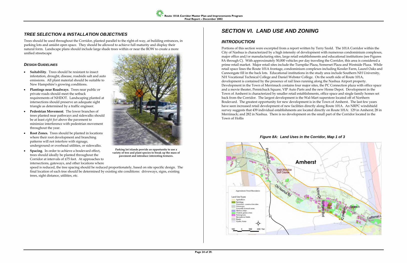
Route 101A Corridor Master Plan and Improvements Program Final Report – December 2002
Page 24 of 39.
TREE SELECTION & INSTALLATION OBJECTIVES Trees should be used throughout the Corridor, planted parallel to the right-of-way, at building entrances, in parking lots and amidst open space. They should be allowed to achieve full maturity and display their natural form. Landscape plans should include large shade trees within or near the ROW to create a more unified streetscape
DESIGN GUIDELINES
• Suitability. Trees should be resistant to insect infestation, drought, disease, roadside salt and auto emissions. All plant material should be suitable to New Hampshire’s growing conditions.
• Plantings near Roadways. Trees near public or private roads should meet the setback requirements of NHDOT. Landscaping planted at intersections should preserve an adequate sight triangle as determined by a traffic engineer.
• Pedestrian Movement. The lower branches of trees planted near pathways and sidewalks should be at least eight feet above the pavement to minimize interference with pedestrian movement throughout the year.
• Root Zones. Trees should be planted in locations where their root development and branching patterns will not interfere with signage, underground or overhead utilities, or sidewalks.
• Spacing. In order to achieve a boulevard effect, trees should ideally be planted throughout the Corridor at intervals of ±75 feet. At approaches to intersections, gateways, and other locations where speed is reduced, the tree spacing should be reduced proportionately, based on site specific design. The final location of each tree should be determined by existing site conditions: driveways, signs, existing trees, sight distance, utilities, etc.
SECTION VI. LAND USE AND ZONING
INTRODUCTION Portions of this section were excerpted from a report written by Terry Szold. The 101A Corridor within the City of Nashua is characterized by a high intensity of development with numerous condominium complexes, major office and/or manufacturing sites, large retail establishments and educational institutions (see Figures 8A through C). With approximately 50,000 vehicles per day traveling the Corridor, this area is considered a prime retail market. Major retail sites include the Turnpike Plaza, Somerset Plaza and Westside Plaza. While retail space lines the Route 101A frontage, condominium complexes including Kessler Farm, Laurel Oaks and Cannongate fill in the back lots. Educational institutions in the study area include Southern NH University, NH Vocational Technical College and Daniel Webster College. On the south side of Route 101A, development is contained by the presence of rail lines running along the Nashua Airport property. Development in the Town of Merrimack contains four major sites, the PC Connection plaza with office space and a movie theater, Pennichuck Square, VIP Auto Parts and the new Home Depot. Development in the Town of Amherst is characterized by smaller retail establishments, office space and single family homes set back from the Corridor. The largest development is the Wal-Mart superstore located off of Northern Boulevard. The greatest opportunity for new development is in the Town of Amherst. The last few years have seen increased retail development of new facilities directly along Route 101A. An NRPC windshield survey suggests that 439 individual establishments are located directly on Route 101A: 129 in Amherst; 28 in Merrimack; and 282 in Nashua. There is no development on the small part of the Corridor located in the Town of Hollis
Figure 8A: Land Uses in the Corridor, Map 1 of 3
Parking lot islands provide an opportunity to use a variety of tree and plant species to break up the mass of
pavement and introduce interesting textures.
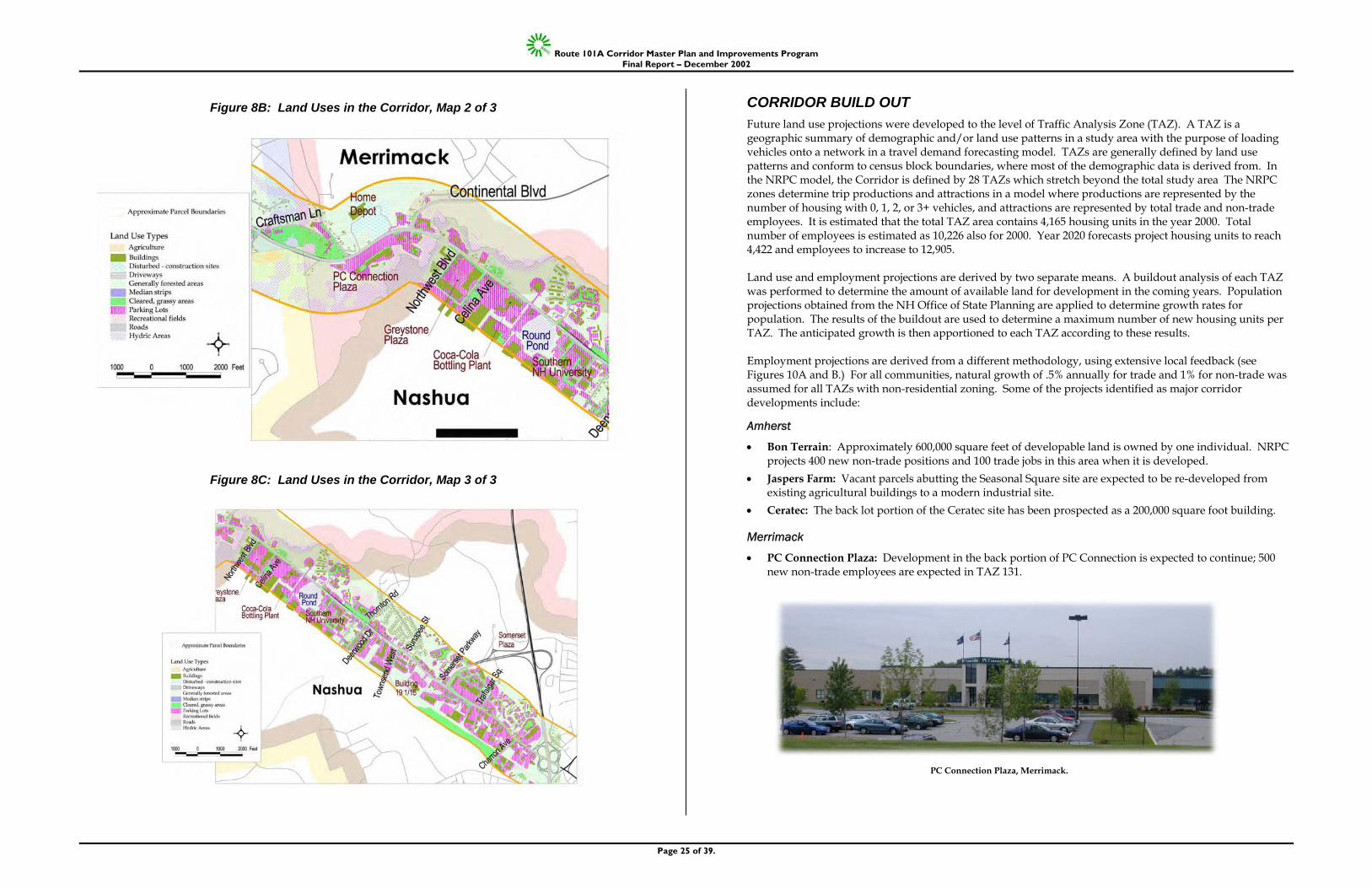
Route 101A Corridor Master Plan and Improvements Program Final Report – December 2002
Page 25 of 39.
Figure 8B: Land Uses in the Corridor, Map 2 of 3
Figure 8C: Land Uses in the Corridor, Map 3 of 3
CORRIDOR BUILD OUT Future land use projections were developed to the level of Traffic Analysis Zone (TAZ). A TAZ is a geographic summary of demographic and/or land use patterns in a study area with the purpose of loading vehicles onto a network in a travel demand forecasting model. TAZs are generally defined by land use patterns and conform to census block boundaries, where most of the demographic data is derived from. In the NRPC model, the Corridor is defined by 28 TAZs which stretch beyond the total study area The NRPC zones determine trip productions and attractions in a model where productions are represented by the number of housing with 0, 1, 2, or 3+ vehicles, and attractions are represented by total trade and non-trade employees. It is estimated that the total TAZ area contains 4,165 housing units in the year 2000. Total number of employees is estimated as 10,226 also for 2000. Year 2020 forecasts project housing units to reach 4,422 and employees to increase to 12,905. Land use and employment projections are derived by two separate means. A buildout analysis of each TAZ was performed to determine the amount of available land for development in the coming years. Population projections obtained from the NH Office of State Planning are applied to determine growth rates for population. The results of the buildout are used to determine a maximum number of new housing units per TAZ. The anticipated growth is then apportioned to each TAZ according to these results. Employment projections are derived from a different methodology, using extensive local feedback (see Figures 10A and B.) For all communities, natural growth of .5% annually for trade and 1% for non-trade was assumed for all TAZs with non-residential zoning. Some of the projects identified as major corridor developments include:
Amherst
• Bon Terrain: Approximately 600,000 square feet of developable land is owned by one individual. NRPC projects 400 new non-trade positions and 100 trade jobs in this area when it is developed.
• Jaspers Farm: Vacant parcels abutting the Seasonal Square site are expected to be re-developed from existing agricultural buildings to a modern industrial site.
• Ceratec: The back lot portion of the Ceratec site has been prospected as a 200,000 square foot building.
Merrimack
• PC Connection Plaza: Development in the back portion of PC Connection is expected to continue; 500 new non-trade employees are expected in TAZ 131.
PC Connection Plaza, Merrimack.
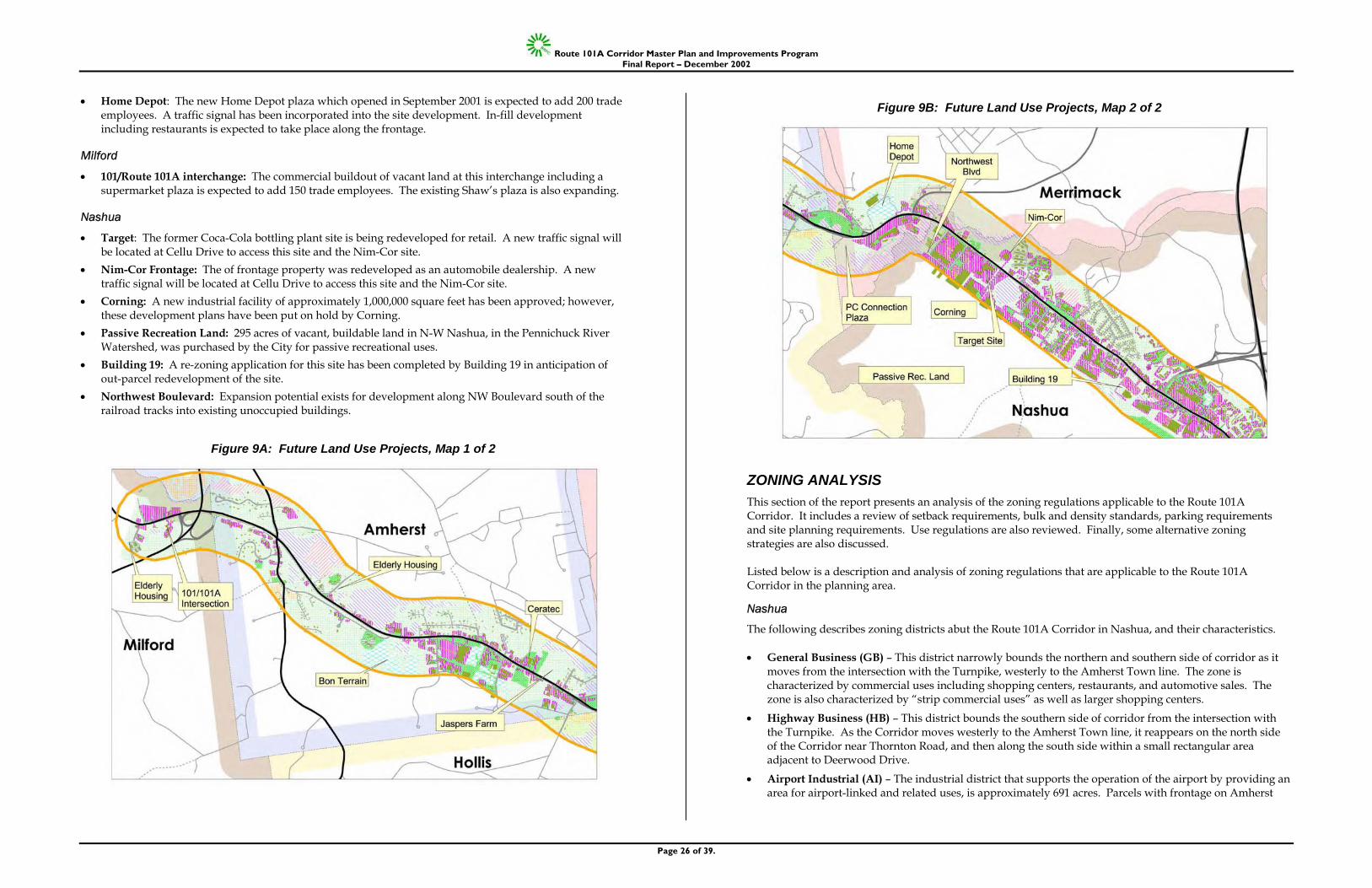
Route 101A Corridor Master Plan and Improvements Program Final Report – December 2002
Page 26 of 39.
• Home Depot: The new Home Depot plaza which opened in September 2001 is expected to add 200 trade employees. A traffic signal has been incorporated into the site development. In-fill development including restaurants is expected to take place along the frontage.
Milford
• 101/Route 101A interchange: The commercial buildout of vacant land at this interchange including a supermarket plaza is expected to add 150 trade employees. The existing Shaw’s plaza is also expanding.
Nashua
• Target: The former Coca-Cola bottling plant site is being redeveloped for retail. A new traffic signal will be located at Cellu Drive to access this site and the Nim-Cor site.
• Nim-Cor Frontage: The of frontage property was redeveloped as an automobile dealership. A new traffic signal will be located at Cellu Drive to access this site and the Nim-Cor site.
• Corning: A new industrial facility of approximately 1,000,000 square feet has been approved; however, these development plans have been put on hold by Corning.
• Passive Recreation Land: 295 acres of vacant, buildable land in N-W Nashua, in the Pennichuck River Watershed, was purchased by the City for passive recreational uses.
• Building 19: A re-zoning application for this site has been completed by Building 19 in anticipation of out-parcel redevelopment of the site.
• Northwest Boulevard: Expansion potential exists for development along NW Boulevard south of the railroad tracks into existing unoccupied buildings.
Figure 9A: Future Land Use Projects, Map 1 of 2
Figure 9B: Future Land Use Projects, Map 2 of 2
ZONING ANALYSIS This section of the report presents an analysis of the zoning regulations applicable to the Route 101A Corridor. It includes a review of setback requirements, bulk and density standards, parking requirements and site planning requirements. Use regulations are also reviewed. Finally, some alternative zoning strategies are also discussed. Listed below is a description and analysis of zoning regulations that are applicable to the Route 101A Corridor in the planning area.
Nashua
The following describes zoning districts abut the Route 101A Corridor in Nashua, and their characteristics. • General Business (GB) – This district narrowly bounds the northern and southern side of corridor as it
moves from the intersection with the Turnpike, westerly to the Amherst Town line. The zone is characterized by commercial uses including shopping centers, restaurants, and automotive sales. The zone is also characterized by “strip commercial uses” as well as larger shopping centers.
• Highway Business (HB) – This district bounds the southern side of corridor from the intersection with the Turnpike. As the Corridor moves westerly to the Amherst Town line, it reappears on the north side of the Corridor near Thornton Road, and then along the south side within a small rectangular area adjacent to Deerwood Drive.
• Airport Industrial (AI) – The industrial district that supports the operation of the airport by providing an area for airport-linked and related uses, is approximately 691 acres. Parcels with frontage on Amherst
Route 101A Corridor Master Plan and Improvements Program Final Report – December 2002
Page 27 of 39.
Street have been primarily devoted to commercial use through a combination of use variances and use special permits previously granted.
• Park Industrial (P1) – Consisting of two subdistricts: PI 1: The PI zone 1 is located in the northwest quadrant of the City, and adjoins a substantial amount of Pennichuck Waterworks land. This District is composed of approximately 961 acres, along with 200 acres of buffer zone for water supply protection. PI 2: The PI zone 2 is located west of Exit 8 off the turnpike, and includes Trafalgar Square, the Southwood Properties, hotels, and other office buildings, medical facilities, light industrial uses and a postal distribution facility.
• Urban Residence (RC) – Located north of Amherst Street and west of Somerset Parkway. This area is principally developed for multifamily housing.
• Suburban Residence B (R18) – Primarily located off Thornton Road, and principally developed for single family housing.
GENERAL BUSINESS (GB) DISTRICT
Summary of Permitted Uses
The district includes a large array of retail uses (including larger floor area retail use), restaurants, (fast food by special permit), (automotive sales, service, and repair by special permit); personal services, medical uses, movie theatres, research offices, (wholesale trade by special permit), and an array of community facilities and educational uses. Most residential use is prohibited; however, multifamily high-rise dwellings and elderly housing are permitted by special permit.
Applicable Dimensional Requirements
Minimum lot area: 10,000 sq. ft. Minimum lot frontage: 50 feet Minimum lot depth: 75 feet Minimum lot width at front setback line: 50 feet Minimum front and side yards: 10 feet and 7 feet, respectively Maximum building height: 60 feet, 4 stories Maximum floor/ area ratio: 1.25 Minimum open space: 5% Maximum building area: None
Analysis and Findings
Given the width of this district throughout the length of the Corridor in Nashua, redevelopment and new development will likely be limited to the scale of development already in place. It is important to point out, however, that the applicable dimensional requirements shown above can result in substantial lot coverage and density. Therefore, it may be useful for the City to evaluate how future redevelopment could lead to opportunities to accomplish the following: • Reduce the number of curb-cuts and identify potential incentives/requirements within the ordinance to
encourage curb-cut consolidation; and • Consider reducing the base density (FAR), establishing a larger open space percentage, and defining
bonus standards for access management initiatives.
• Consider requiring larger setbacks to accommodate highway ROW.
HIGHWAY BUSINESS (HB) DISTRICT
Summary of Permitted Uses
Includes a large array of retail uses (including smaller floor area retail use), restaurants, fast-food, automotive sales, service, and repair; personal services, medical uses, movie theatres, wholesale trade, and an array of community facilities and educational uses. Research offices and residential use are prohibited.
Applicable Dimensional Requirements
Minimum lot area: 20,000 sq. ft. Minimum lot frontage: 80 feet Minimum lot depth: 80 feet Minimum lot width at front setback line: 100 feet Minimum front and side yards: 20 feet and 10 feet, respectively Maximum building height: 60 feet, 4 stories Maximum floor/ area ratio: 0.75 Minimum open space: 20% Maximum building area: none
Analysis and Findings
Given the narrow width of this district, redevelopment and new development opportunities are limited. “Strip” commercial uses, even those with small building footprints, do generate substantial numbers of trips. The previous recommendations for the General Business (GB) District are also applicable to the Highway Business (HB) District.
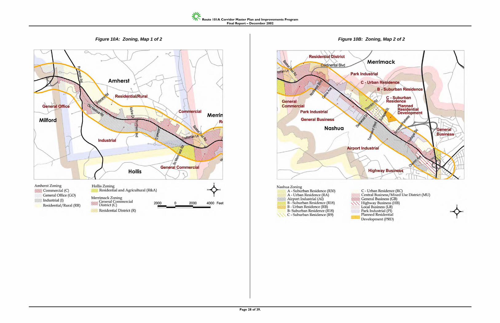
Route 101A Corridor Master Plan and Improvements Program Final Report – December 2002
Page 28 of 39.
Figure 10A: Zoning, Map 1 of 2
Figure 10B: Zoning, Map 2 of 2
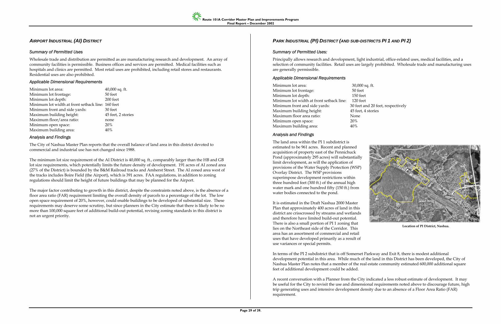
Route 101A Corridor Master Plan and Improvements Program Final Report – December 2002
Page 29 of 39.
AIRPORT INDUSTRIAL (AI) DISTRICT
Summary of Permitted Uses
Wholesale trade and distribution are permitted as are manufacturing research and development. An array of community facilities is permissible. Business offices and services are permitted. Medical facilities such as hospitals and clinics are permitted. Most retail uses are prohibited, including retail stores and restaurants. Residential uses are also prohibited.
Applicable Dimensional Requirements
Minimum lot area: 40,000 sq. ft. Minimum lot frontage: 50 feet Minimum lot depth: 200 feet Minimum lot width at front setback line: 160 feet Minimum front and side yards: 30 feet Maximum building height: 45 feet, 2 stories Maximum floor/area ratio: none Minimum open space: 20% Maximum building area: 40%
Analysis and Findings
The City of Nashua Master Plan reports that the overall balance of land area in this district devoted to commercial and industrial use has not changed since 1988. The minimum lot size requirement of the AI District is 40,000 sq. ft., comparably larger than the HB and GB lot size requirements, which potentially limits the future density of development. 191 acres of AI zoned area (27% of the District) is bounded by the B&M Railroad tracks and Amherst Street. The AI zoned area west of the tracks includes Boire Field (the Airport), which is 391 acres. FAA regulations, in addition to zoning regulations should limit the height of future buildings that may be planned for the Airport. The major factor contributing to growth in this district, despite the constraints noted above, is the absence of a floor area ratio (FAR) requirement limiting the overall density of parcels to a percentage of the lot. The low open space requirement of 20%, however, could enable buildings to be developed of substantial size. These requirements may deserve some scrutiny, but since planners in the City estimate that there is likely to be no more than 100,000 square feet of additional build-out potential, revising zoning standards in this district is not an urgent priority.
PARK INDUSTRIAL (PI) DISTRICT (AND SUB-DISTRICTS PI 1 AND PI 2)
Summary of Permitted Uses:
Principally allows research and development, light industrial, office-related uses, medical facilities, and a selection of community facilities. Retail uses are largely prohibited. Wholesale trade and manufacturing uses are generally permissible.
Applicable Dimensional Requirements
Minimum lot area: 30,000 sq. ft. Minimum lot frontage: 50 feet Minimum lot depth: 150 feet Minimum lot width at front setback line: 120 feet Minimum front and side yards: 30 feet and 20 feet, respectively Maximum building height: 45 feet, 4 stories Maximum floor area ratio: None Minimum open space: 20% Maximum building area: 40%
Analysis and Findings
The land area within the PI 1 subdistrict is estimated to be 961 acres. Recent and planned acquisition of property east of the Pennichuck Pond (approximately 295 acres) will substantially limit development, as will the application of provisions of the Water Supply Protection (WSP) Overlay District. The WSP provisions superimpose development restrictions within three hundred feet (300 ft.) of the annual high water mark and one hundred fifty (150 ft.) from water bodies connected to the pond. It is estimated in the Draft Nashua 2000 Master Plan that approximately 400 acres of land in this district are crisscrossed by streams and wetlands and therefore have limited build-out potential. There is also a small portion of PI 1 zoning that lies on the Northeast side of the Corridor. This area has an assortment of commercial and retail uses that have developed primarily as a result of use variances or special permits. In terms of the PI 2 subdistrict that is off Somerset Parkway and Exit 8, there is modest additional development potential in this area. While much of the land in this District has been developed, the City of Nashua Master Plan notes that a member of the real estate community estimated 600,000 additional square feet of additional development could be added. A recent conversation with a Planner from the City indicated a less robust estimate of development. It may be useful for the City to revisit the use and dimensional requirements noted above to discourage future, high trip generating uses and intensive development density due to an absence of a Floor Area Ratio (FAR) requirement.
Location of PI District, Nashua.
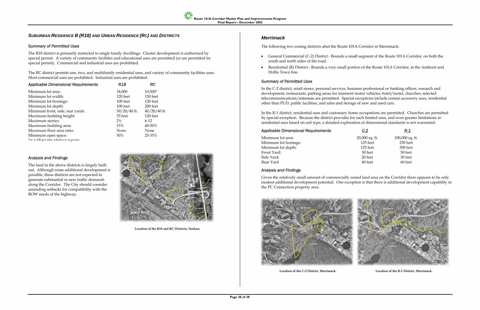
Route 101A Corridor Master Plan and Improvements Program Final Report – December 2002
Page 30 of 39.
SUBURBAN RESIDENCE B (R18) AND URBAN RESIDENCE (RC) AND DISTRICTS
Summary of Permitted Uses
The R18 district is primarily restricted to single family dwellings. Cluster development is authorized by special permit. A variety of community facilities and educational uses are permitted (or are permitted by special permit). Commercial and industrial uses are prohibited. The RC district permits one, two, and multifamily residential uses, and variety of community facilities uses. Most commercial uses are prohibited. Industrial uses are prohibited.
Applicable Dimensional Requirements R18 RC
Minimum lot area: 18,000 10,500* Minimum lot width: 120 feet 150 feet Minimum lot frontage: 100 feet 120 feet Minimum lot depth: 100 feet 200 feet Minimum front, side, rear yards: 30/20/40 ft. 40/20/40 ft. Maximum building height: 35 feet 120 feet Maximum stories: 2½ 6-12 Maximum building area: 15% 40-50% Maximum floor area ratio: None None Minimum open space: 50% 25-35% *or 3,500 per unit, whichever is greater
Analysis and Findings
The land in the above districts is largely built out. Although some additional development is possible, these districts are not expected to generate substantial or new traffic demands along the Corridor. The City should consider amending setbacks for compatibility with the ROW needs of the highway.
Merrimack
The following two zoning districts abut the Route 101A Corridor in Merrimack: • General Commercial (C-2) District - Bounds a small segment of the Route 101A Corridor, on both the
south and north sides of the road. • Residential (R) District - Bounds a very small portion of the Route 101A Corridor, at the Amherst and
Hollis Town line.
Summary of Permitted Uses
In the C-2 district, retail stores, personal services, business professional or banking offices, research and development, restaurants, parking areas for transient motor vehicles, hotel/motel, churches, selected telecommunications/antennas are permitted. Special exceptions include certain accessory uses, residential other than PUD, public facilities, and sales and storage of new and used cars. In the R-1 district, residential uses and customary home occupations are permitted. Churches are permitted by special exception. Because the district provides for such limited uses, and even greater limitations to residential uses based on soil type, a detailed exploration of dimensional standards is not warranted.
Applicable Dimensional Requirements C-2 R-1
Minimum lot area: 20,000 sq. ft. 100,000 sq. ft. Minimum lot frontage: 125 feet 250 feet Minimum lot depth: 125 feet 300 feet Front Yard: 30 feet 50 feet Side Yard: 20 feet 30 feet Rear Yard 40 feet 60 feet
Analysis and Findings
Given the relatively small amount of commercially zoned land area on the Corridor there appears to be only modest additional development potential. One exception is that there is additional development capability in the PC Connection property area.
Location of the R18 and RC Districts, Nashua.
Location of the C-2 District, Merrimack. Location of the R-1 District, Merrimack.
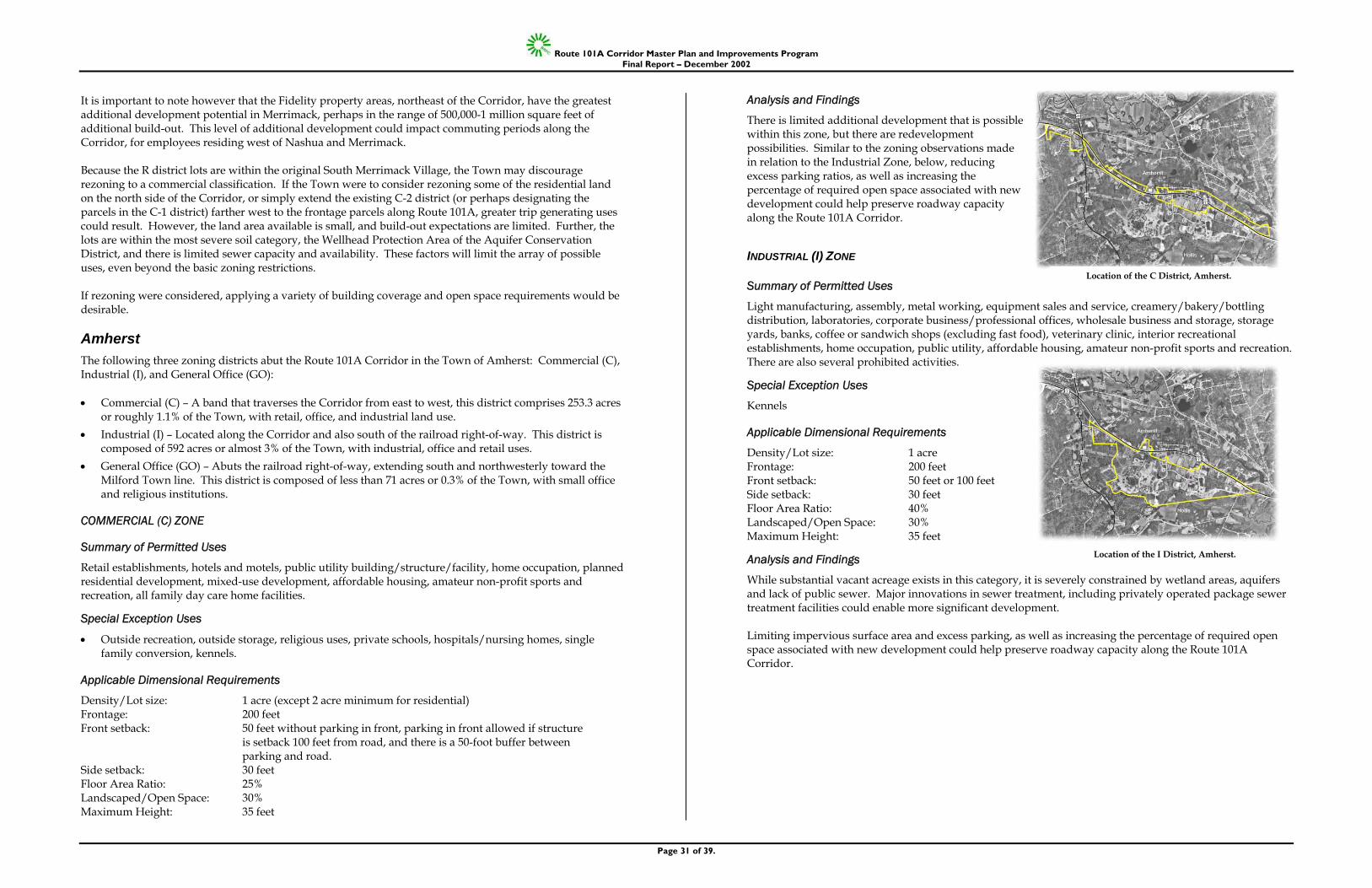
Route 101A Corridor Master Plan and Improvements Program Final Report – December 2002
Page 31 of 39.
It is important to note however that the Fidelity property areas, northeast of the Corridor, have the greatest additional development potential in Merrimack, perhaps in the range of 500,000-1 million square feet of additional build-out. This level of additional development could impact commuting periods along the Corridor, for employees residing west of Nashua and Merrimack. Because the R district lots are within the original South Merrimack Village, the Town may discourage rezoning to a commercial classification. If the Town were to consider rezoning some of the residential land on the north side of the Corridor, or simply extend the existing C-2 district (or perhaps designating the parcels in the C-1 district) farther west to the frontage parcels along Route 101A, greater trip generating uses could result. However, the land area available is small, and build-out expectations are limited. Further, the lots are within the most severe soil category, the Wellhead Protection Area of the Aquifer Conservation District, and there is limited sewer capacity and availability. These factors will limit the array of possible uses, even beyond the basic zoning restrictions. If rezoning were considered, applying a variety of building coverage and open space requirements would be desirable.
Amherst The following three zoning districts abut the Route 101A Corridor in the Town of Amherst: Commercial (C), Industrial (I), and General Office (GO): • Commercial (C) – A band that traverses the Corridor from east to west, this district comprises 253.3 acres
or roughly 1.1% of the Town, with retail, office, and industrial land use. • Industrial (I) – Located along the Corridor and also south of the railroad right-of-way. This district is
composed of 592 acres or almost 3% of the Town, with industrial, office and retail uses. • General Office (GO) – Abuts the railroad right-of-way, extending south and northwesterly toward the
Milford Town line. This district is composed of less than 71 acres or 0.3% of the Town, with small office and religious institutions.
COMMERCIAL (C) ZONE
Summary of Permitted Uses
Retail establishments, hotels and motels, public utility building/structure/facility, home occupation, planned residential development, mixed-use development, affordable housing, amateur non-profit sports and recreation, all family day care home facilities.
Special Exception Uses
• Outside recreation, outside storage, religious uses, private schools, hospitals/nursing homes, single family conversion, kennels.
Applicable Dimensional Requirements
Density/Lot size: 1 acre (except 2 acre minimum for residential) Frontage: 200 feet Front setback: 50 feet without parking in front, parking in front allowed if structure
is setback 100 feet from road, and there is a 50-foot buffer between parking and road.
Side setback: 30 feet Floor Area Ratio: 25% Landscaped/Open Space: 30% Maximum Height: 35 feet
Analysis and Findings
There is limited additional development that is possible within this zone, but there are redevelopment possibilities. Similar to the zoning observations made in relation to the Industrial Zone, below, reducing excess parking ratios, as well as increasing the percentage of required open space associated with new development could help preserve roadway capacity along the Route 101A Corridor.
INDUSTRIAL (I) ZONE
Summary of Permitted Uses
Light manufacturing, assembly, metal working, equipment sales and service, creamery/bakery/bottling distribution, laboratories, corporate business/professional offices, wholesale business and storage, storage yards, banks, coffee or sandwich shops (excluding fast food), veterinary clinic, interior recreational establishments, home occupation, public utility, affordable housing, amateur non-profit sports and recreation. There are also several prohibited activities.
Special Exception Uses
Kennels
Applicable Dimensional Requirements
Density/Lot size: 1 acre Frontage: 200 feet Front setback: 50 feet or 100 feet Side setback: 30 feet Floor Area Ratio: 40% Landscaped/Open Space: 30% Maximum Height: 35 feet
Analysis and Findings
While substantial vacant acreage exists in this category, it is severely constrained by wetland areas, aquifers and lack of public sewer. Major innovations in sewer treatment, including privately operated package sewer treatment facilities could enable more significant development. Limiting impervious surface area and excess parking, as well as increasing the percentage of required open space associated with new development could help preserve roadway capacity along the Route 101A Corridor.
Location of the C District, Amherst.
Location of the I District, Amherst.
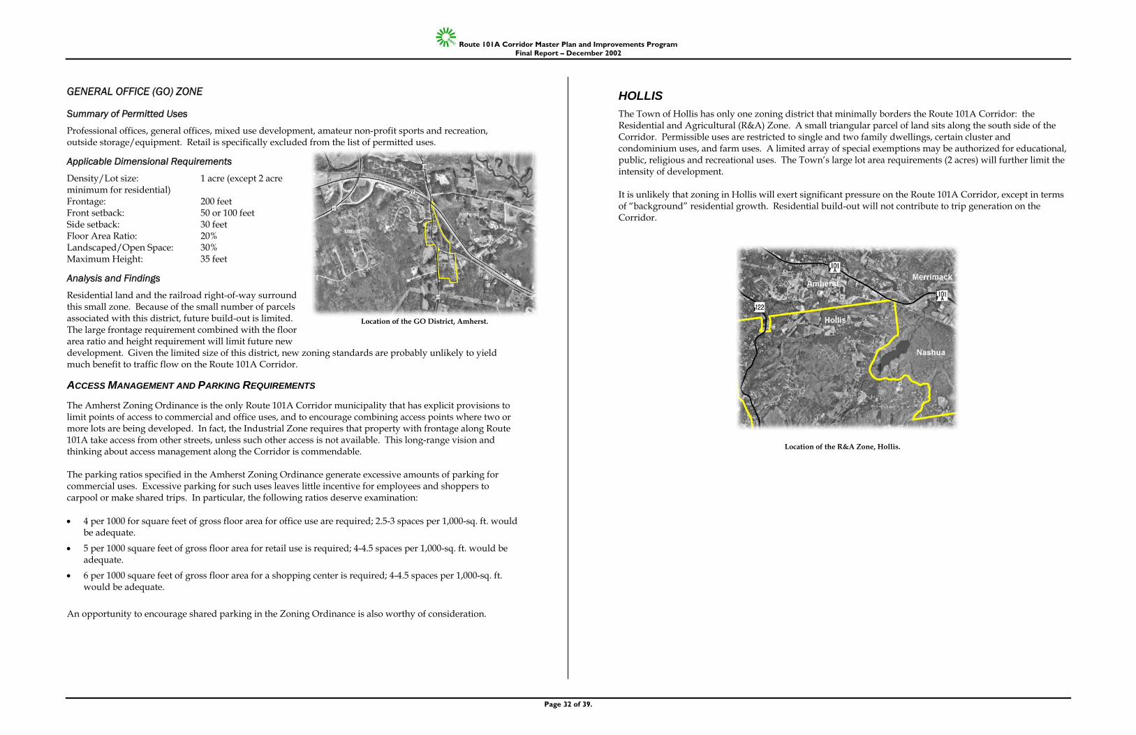
Route 101A Corridor Master Plan and Improvements Program Final Report – December 2002
Page 32 of 39.
GENERAL OFFICE (GO) ZONE
Summary of Permitted Uses
Professional offices, general offices, mixed use development, amateur non-profit sports and recreation, outside storage/equipment. Retail is specifically excluded from the list of permitted uses.
Applicable Dimensional Requirements
Density/Lot size: 1 acre (except 2 acre minimum for residential) Frontage: 200 feet Front setback: 50 or 100 feet Side setback: 30 feet Floor Area Ratio: 20% Landscaped/Open Space: 30% Maximum Height: 35 feet
Analysis and Findings
Residential land and the railroad right-of-way surround this small zone. Because of the small number of parcels associated with this district, future build-out is limited. The large frontage requirement combined with the floor area ratio and height requirement will limit future new development. Given the limited size of this district, new zoning standards are probably unlikely to yield much benefit to traffic flow on the Route 101A Corridor.
ACCESS MANAGEMENT AND PARKING REQUIREMENTS
The Amherst Zoning Ordinance is the only Route 101A Corridor municipality that has explicit provisions to limit points of access to commercial and office uses, and to encourage combining access points where two or more lots are being developed. In fact, the Industrial Zone requires that property with frontage along Route 101A take access from other streets, unless such other access is not available. This long-range vision and thinking about access management along the Corridor is commendable. The parking ratios specified in the Amherst Zoning Ordinance generate excessive amounts of parking for commercial uses. Excessive parking for such uses leaves little incentive for employees and shoppers to carpool or make shared trips. In particular, the following ratios deserve examination: • 4 per 1000 for square feet of gross floor area for office use are required; 2.5-3 spaces per 1,000-sq. ft. would
be adequate.
• 5 per 1000 square feet of gross floor area for retail use is required; 4-4.5 spaces per 1,000-sq. ft. would be adequate.
• 6 per 1000 square feet of gross floor area for a shopping center is required; 4-4.5 spaces per 1,000-sq. ft. would be adequate.
An opportunity to encourage shared parking in the Zoning Ordinance is also worthy of consideration.
HOLLIS The Town of Hollis has only one zoning district that minimally borders the Route 101A Corridor: the Residential and Agricultural (R&A) Zone. A small triangular parcel of land sits along the south side of the Corridor. Permissible uses are restricted to single and two family dwellings, certain cluster and condominium uses, and farm uses. A limited array of special exemptions may be authorized for educational, public, religious and recreational uses. The Town’s large lot area requirements (2 acres) will further limit the intensity of development. It is unlikely that zoning in Hollis will exert significant pressure on the Route 101A Corridor, except in terms of “background” residential growth. Residential build-out will not contribute to trip generation on the Corridor.
Location of the GO District, Amherst.
Location of the R&A Zone, Hollis.
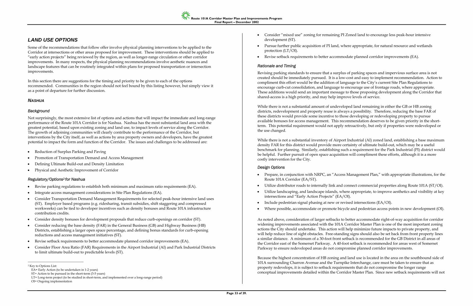
Route 101A Corridor Master Plan and Improvements Program Final Report – December 2002
Page 33 of 39.
LAND USE OPTIONS Some of the recommendations that follow offer involve physical planning interventions to be applied to the Corridor at intersections or other areas proposed for improvement. These interventions should be applied to “early action projects” being reviewed by the region, as well as longer-range circulation or other corridor improvements. In many respects, the physical planning recommendations involve aesthetic nuances and landscape features that can be routinely integrated within plans for proposed transportation or intersection improvements. In this section there are suggestions for the timing and priority to be given to each of the options recommended. Communities in the region should not feel bound by this listing however, but simply view it as a point of departure for further discussion.
NASHUA
Background
Not surprisingly, the most extensive list of options and actions that will impact the immediate and long-range performance of the Route 101A Corridor is for Nashua. Nashua has the most substantial land area with the greatest potential, based upon existing zoning and land use, to impact levels of service along the Corridor. The growth of adjoining communities will clearly contribute to the performance of the Corridor, but interventions by the City itself, as well as actions by area property owners and developers, have the greatest potential to impact the form and function of the Corridor. The issues and challenges to be addressed are: • Reduction of Surplus Parking and Paving • Promotion of Transportation Demand and Access Management • Defining Ultimate Build-out and Density Limitation • Physical and Aesthetic Improvement of Corridor
Regulatory/Options2 for Nashua
• Revise parking regulations to establish both minimum and maximum ratio requirements (EA). • Integrate access management considerations in Site Plan Regulations (EA). • Consider Transportation Demand Management Requirements for selected peak-hour intensive land uses
(ST). Employer based programs (e.g. ridesharing, transit subsidies, shift staggering and compressed workweeks) can be tied to developer incentives such as density bonuses and Route 101A infrastructure contribution credits.
• Consider density bonuses for development proposals that reduce curb-openings on corridor (ST). • Consider reducing the base density (FAR) in the General Business (GB) and Highway Business (HB)
Districts, establishing a larger open space percentage, and defining bonus standards for curb-opening reductions and access management initiatives (ST).
• Revise setback requirements to better accommodate planned corridor improvements (EA). • Consider Floor Area Ratio (FAR) Requirements in the Airport Industrial (AI) and Park Industrial Districts
to limit ultimate build-out to predictable levels (ST).
2 Key to Options List:
EA= Early Action (to be undertaken in 1-2 years) ST= Action to be pursued in the short-term (3-5 years) LT= Long-term project (to be studied in short-term, and implemented over a long-range period) OI= Ongoing implementation
• Consider “mixed use” zoning for remaining PI Zoned land to encourage less peak-hour intensive development (ST).
• Pursue further public acquisition of PI land, where appropriate, for natural resource and wetlands protection (LT/OI).
• Revise setback requirements to better accommodate planned corridor improvements (EA).
Rationale and Timing
Revising parking standards to ensure that a surplus of parking spaces and impervious surface area is not created should be immediately pursued. It is a low-cost and easy to implement recommendation. Action to compliment this effort would be the addition of language to the City’s current Site Plan Regulations to encourage curb-cut consolidation, and language to encourage use of frontage roads, where appropriate. These additions would send an important message to those proposing development along the Corridor that shared-access is a high priority, and may help improve levels of service. While there is not a substantial amount of undeveloped land remaining in either the GB or HB zoning districts, redevelopment and property reuse is always a possibility. Therefore, reducing the base FAR of these districts would provide some incentive to those developing or redeveloping property to pursue available bonuses for access management. This recommendation deserves to be given priority in the short-term. This potential requirement would not apply retroactively, but only if properties were redeveloped or the use changed. While there is not a substantial inventory of Airport Industrial (AI) zoned land, establishing a base maximum density FAR for this district would provide more certainty of ultimate build-out, which may be a useful benchmark for planning. Similarly, establishing such a requirement for the Park Industrial (PI) district would be helpful. Further pursuit of open space acquisition will compliment these efforts, although it is a more costly intervention for the City.
Design Options
• Prepare, in conjunction with NRPC, an “Access Management Plan,” with appropriate illustrations, for the Route 101A Corridor (EA/ST).
• Utilize distributor roads to internally link and connect commercial properties along Route 101A (ST/OI). • Utilize landscaping, and landscape islands, where appropriate, to improve aesthetics and visibility at key
intersections and “Early Action Projects” (EA/OI). • Include pedestrian signal phasing at new or revised intersections (EA/OI). • Where possible, accommodate or promote bicycle and pedestrian access points in new development (OI). As noted above, consideration of larger setbacks to better accommodate right-of-way acquisition for corridor widening improvements associated with the 101A Corridor Master Plan is one of the most important zoning actions the City should undertake. This action will help minimize future impacts to private property, and will help reduce line of sight obstacles. Free-standing signs should also be set back from front property lines a similar distance. A minimum of a 30-foot front setback is recommended for the GB District in all areas of the Corridor east of the Somerset Parkway. A 40-foot setback is recommended for areas west of Somerset Parkway to ensure redeveloped areas do not compromise planned corridor improvements. Because the highest concentration of HB zoning and land use is located in the area on the southbound side of 101A surrounding Charron Avenue and the Turnpike Interchange, care must be taken to ensure that as property redevelops, it is subject to setback requirements that do not compromise the longer range conceptual improvements detailed within the Corridor Master Plan. Since new setback requirements will not

Route 101A Corridor Master Plan and Improvements Program Final Report – December 2002
Page 34 of 39.
apply retroactively, it is anticipated that as property owners redevelop land in this vicinity, that they will collaborate with the City in facilitating long-term corridor objectives. The variety of design options provided above should help improve the quality of experience for those who use Route 101A. Preparation of an “Access Management Plan” for the City will help illustrate realistic opportunities to reduce curb cuts and promote shared access options for various developments on the Corridor. In order to help direct and promote use of service/frontage roads as a method to reduce the growth of curb openings along the Corridor, and where possible the consolidation of existing curb openings, a plan, drawn at appropriate scales, is required. The preparation of such a plan will involve detailed analysis of existing conditions, circulation patterns, ownership and parcel data, and intersection function. This planning effort will help compliment the regulatory incentives and requirements discussed above. Landscape and aesthetic improvements will add definition and visibility to various access points and critical corridor intersections. Pedestrian and bicycle improvements particularly along service or collector roads that link abutting land uses, should be pursued at selected intersections.
AMHERST As previously noted, Amherst is the only municipality along the Route 101A Corridor that has explicit provisions in its zoning regulations to limit points of access to lots zoned for commercial/industrial uses, and to encourage combining access points where two or more lots are being developed. The Industrial Zone requires that property with frontage along Route 101A take access from other streets, unless such access is not available. This long-range vision should help guide future development along the Corridor. Reducing excess parking ratios (specific suggestions are provided in the previous report), as well as increasing the percentage of required open space associated with new development, could help preserve roadway capacity along the Route 101A Corridor. The issues and challenges to be addressed are: • Reduction of Surplus Parking and Paving • Maintain Access Management Provisions • Defining Ultimate Build-out and Density Limitation • Physical and Aesthetic Improvement of the Corridor
Regulatory Options
• Revise parking regulations to establish revised minimum and potentially maximum ratio requirements.(EA/ST).
• Increase the minimum percentage of open space required for new development in the Commercial (C), Industrial (I), and General Office (GO) zoning districts (EA/ST).
• Encourage or require shared access provisions for abutting properties pursuing commercial use (EA/OI).
Design Options
• Continue to utilize distributor/service roads to internally link and connect commercial properties along Route 101A (OI).
• Utilize landscaping, and landscape islands where appropriate to improve aesthetics and visibility at key intersections and “Early Action Projects” (EA/ST).
• Include pedestrian signal phasing at new or revised intersections (EA/ST). • Accommodate or promote bicycle and pedestrian access points in new development where possible
(EA/OI).
The above regulatory and design options should be fairly easy to accomplish, and are compatible with the Town’s planning goals. An important opportunity exists to encourage shared parking in the Zoning Ordinance. This initiative would help complement and augment the Town’s transportation planning and development review process.
HOLLIS As noted in the previous report, there is a limited amount of land in Hollis that exerts direct influence on the Route 101A Corridor. Provided that the overall distribution of zoning district classification and land use remains the same, the Town will impact service levels along the Corridor primarily through background residential growth. • Promotion of Transportation Demand and Access Management • Maintain existing land use and zoning classifications (LT/OI). • Resist direct, new access points to Route 101A Corridor (LT/OI). • Town to sponsor or encourage resident ridesharing to Route 101A Corridor workplace destinations
(LT/OI). The above recommendations are compatible with the Town’s planning goals and will help support the region’s transportation objectives for the Corridor. Efforts to provide ridesharing options to employment destinations along the Corridor will be mutually beneficial to Town residents and the region.
MERRIMACK As previously noted, the relatively small amount of commercially zoned land area on the Corridor in Merrimack appears to have only modest additional development potential. Clearly, the Fidelity property northeast of the Corridor has the greatest additional development potential in the Town, and could impact commuting periods along the Corridor for employees residing west of Nashua and Merrimack. Some of the owners of R district lots within the original South Merrimack Village may seek rezoning to commercial classifications. Although the land area is small and build-out expectations are modest, if the Town were to consider rezoning some of this residential land on the north side of the Corridor to commercial use, greater trip generating uses could result. It would be desirable for the Town to encourage smaller lots to be combined to accommodate the change of use to commercial. • Promotion of Access Management • Provide Ultimate Build-out and Density Limitation • Insert building coverage requirements in applicable Commercial Districts applied to residential zoned
property (ST/OI). • Encourage or require shared access provisions for abutting properties pursuing commercial use (ST/OI). The above recommendations could be accomplished with modest effort. Encouraging or requiring shared access provisions will help ensure more orderly traffic flow along the Merrimack portion of the Corridor.
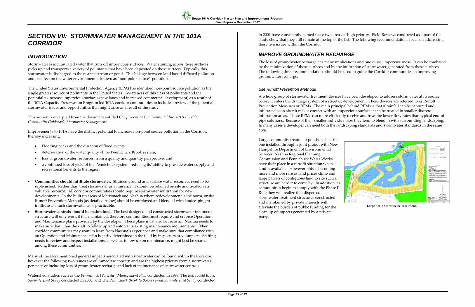
Route 101A Corridor Master Plan and Improvements Program Final Report – December 2002
Page 35 of 39.
SECTION VII: STORMWATER MANAGEMENT IN THE 101A CORRIDOR
INTRODUCTION Stormwater is accumulated water that runs off impervious surfaces. Water running across these surfaces picks up and transports a variety of pollutants that have been deposited on these surfaces. Typically this stormwater is discharged to the nearest stream or pond. This linkage between land based diffused pollution and its effect on the water environment is known as “non-point source” pollution. The United States Environmental Protection Agency (EPA) has identified non-point source pollution as the single greatest source of pollutants in the United States. Awareness of this class of pollutants and the potential to increase impervious surfaces (new lanes and increased commercial development) as a result of the 101A Capacity Preservation Program led 101A corridor communities to include a review of the potential stormwater issues and opportunities that might arise as a result of the study. This section is excerpted from the document entitled Comprehensive Environmental Inc. 101A Corridor Community Guidebook, Stormwater Management. Improvements to 101A have the distinct potential to increase non-point source pollution in the Corridor, thereby increasing:
• Flooding peaks and the duration of flood events; • deterioration of the water quality of the Pennichuck Brook system; • loss of groundwater resources, from a quality and quantity perspective; and • a continued loss of yield of the Pennichuck system, reducing its’ ability to provide water supply and
recreational benefits to the region. • Communities should infiltrate stormwater. Strained ground and surface water resources need to be
replenished. Rather than treat stormwater as a nuisance, it should be retained on site and treated as a valuable resource. All corridor communities should require stormwater infiltration for new developments. In the built up areas of Merrimack and Nashua where redevelopment is the norm, onsite Runoff Prevention Methods (as detailed below) should be employed and blended with landscaping to infiltrate as much stormwater as is practicable.
• Stormwater controls should be maintained. The best designed and constructed stormwater treatment structure will only work if it is maintained, therefore communities must require and enforce Operation and Maintenance plans provided by the developer. These plans must also be realistic. Nashua needs to make sure that it has the staff to follow up and enforce its existing maintenance requirements. Other corridor communities may want to learn from Nashua’s experience and make sure that compliance with an Operation and Maintenance plan is easily determined in the field by inspectors or volunteers. Staffing needs to review and inspect installations, as well as follow up on maintenance, might best be shared among these communities.
Many of the aforementioned general impacts associated with stormwater can be found within the Corridor, however the following two issues are of immediate concern and are the highest priority from a stormwater perspective including loss of groundwater recharge and lack of maintenance of stormwater controls Watershed studies such as the Pennichuck Watershed Management Plan conducted in 1998, The Boire Field Brook Subwatershed Study conducted in 2000, and The Pennichuck Brook to Bowers Pond Subwatershed Study conducted
in 2001 have consistently named these two areas as high priority. Field Reviews conducted as a part of this study show that they still remain at the top of the list. The following recommendations focus on addressing these two issues within the Corridor
IMPROVE GROUNDWATER RECHARGE The loss of groundwater recharge has many implications and one cause: imperviousness. It can be combated by the minimization of these surfaces and by the infiltration of stormwater generated from these surfaces. The following three recommendations should be used to guide the Corridor communities in improving groundwater recharge:
Use Runoff Prevention Methods
A whole group of stormwater treatment devices have been developed to address stormwater at its source before it enters the drainage system of a street or development. These devices are referred to as Runoff Prevention Measures or RPMs. The main principal behind RPMs is that if rainfall can be captured and infiltrated soon after it makes contact with an impervious surface it can be treated in smaller discrete infiltration areas. These RPMs can more efficiently receive and treat the lower flow rates than typical end-of-pipe solutions. Because of their smaller individual size they tend to blend in with surrounding landscaping. In many cases a developer can meet both the landscaping standards and stormwater standards in the same area. Large community treatment ponds such as the one installed through a joint project with New Hampshire Department of Environmental Services, Nashua Regional Planning Commission and Pennichuck Water Works have their place in a retrofit situation when land is available. However, this is becoming more and more rare as land prices climb and large parcels of contiguous land to site such a structure are harder to come by. In addition, as communities begin to comply with the Phase II Rule they will realize that dispersed stormwater treatment structures constructed and maintained by private interests will alleviate the burden of public funding for the clean up of impacts generated by a private party.
Large Scale Stormwater Treatment.
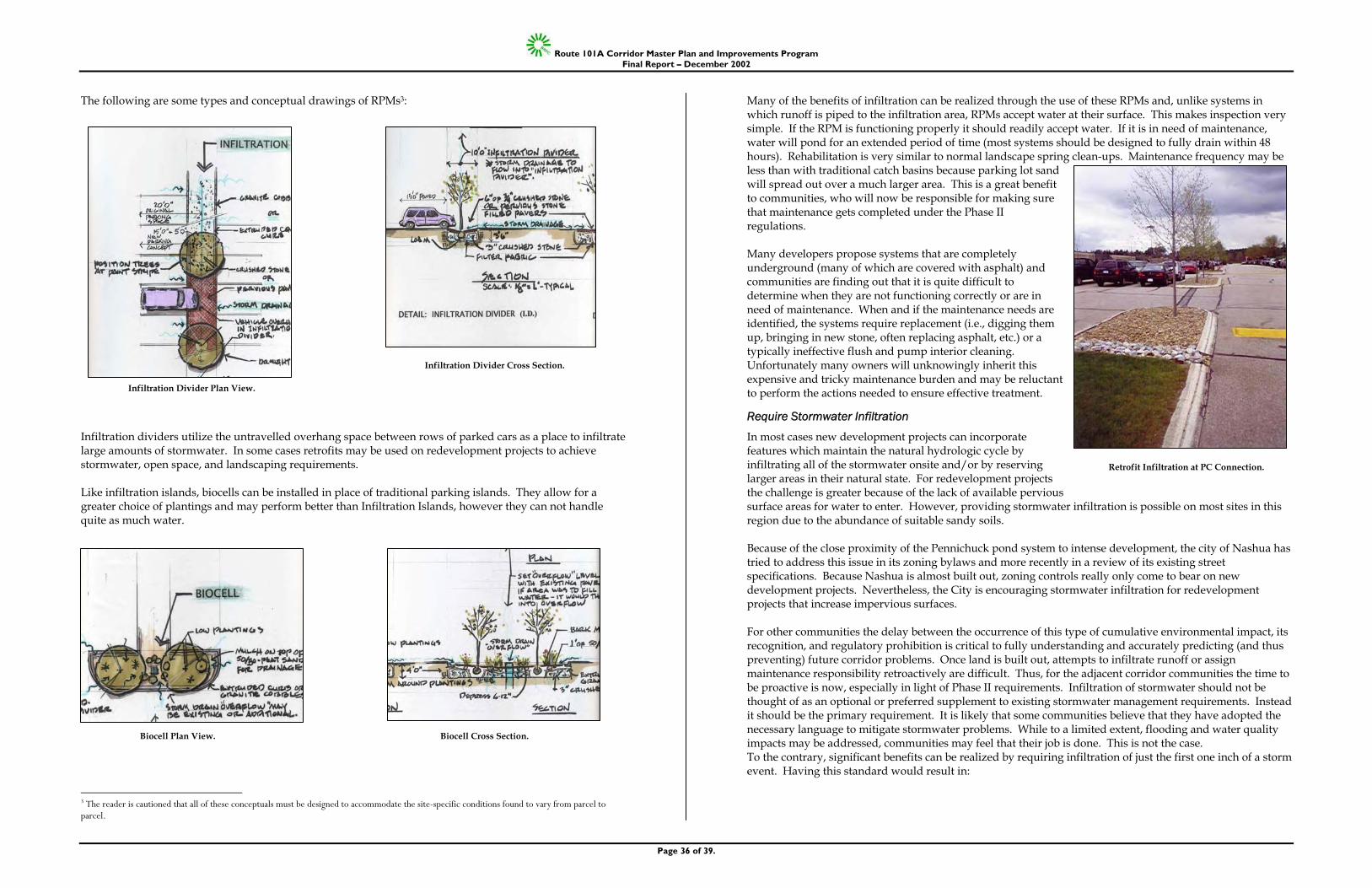
Route 101A Corridor Master Plan and Improvements Program Final Report – December 2002
Page 36 of 39.
The following are some types and conceptual drawings of RPMs3:
Infiltration dividers utilize the untravelled overhang space between rows of parked cars as a place to infiltrate large amounts of stormwater. In some cases retrofits may be used on redevelopment projects to achieve stormwater, open space, and landscaping requirements. Like infiltration islands, biocells can be installed in place of traditional parking islands. They allow for a greater choice of plantings and may perform better than Infiltration Islands, however they can not handle quite as much water.
3 The reader is cautioned that all of these conceptuals must be designed to accommodate the site-specific conditions found to vary from parcel to parcel.
Many of the benefits of infiltration can be realized through the use of these RPMs and, unlike systems in which runoff is piped to the infiltration area, RPMs accept water at their surface. This makes inspection very simple. If the RPM is functioning properly it should readily accept water. If it is in need of maintenance, water will pond for an extended period of time (most systems should be designed to fully drain within 48 hours). Rehabilitation is very similar to normal landscape spring clean-ups. Maintenance frequency may be less than with traditional catch basins because parking lot sand will spread out over a much larger area. This is a great benefit to communities, who will now be responsible for making sure that maintenance gets completed under the Phase II regulations. Many developers propose systems that are completely underground (many of which are covered with asphalt) and communities are finding out that it is quite difficult to determine when they are not functioning correctly or are in need of maintenance. When and if the maintenance needs are identified, the systems require replacement (i.e., digging them up, bringing in new stone, often replacing asphalt, etc.) or a typically ineffective flush and pump interior cleaning. Unfortunately many owners will unknowingly inherit this expensive and tricky maintenance burden and may be reluctant to perform the actions needed to ensure effective treatment.
Require Stormwater Infiltration
In most cases new development projects can incorporate features which maintain the natural hydrologic cycle by infiltrating all of the stormwater onsite and/or by reserving larger areas in their natural state. For redevelopment projects the challenge is greater because of the lack of available pervious surface areas for water to enter. However, providing stormwater infiltration is possible on most sites in this region due to the abundance of suitable sandy soils. Because of the close proximity of the Pennichuck pond system to intense development, the city of Nashua has tried to address this issue in its zoning bylaws and more recently in a review of its existing street specifications. Because Nashua is almost built out, zoning controls really only come to bear on new development projects. Nevertheless, the City is encouraging stormwater infiltration for redevelopment projects that increase impervious surfaces. For other communities the delay between the occurrence of this type of cumulative environmental impact, its recognition, and regulatory prohibition is critical to fully understanding and accurately predicting (and thus preventing) future corridor problems. Once land is built out, attempts to infiltrate runoff or assign maintenance responsibility retroactively are difficult. Thus, for the adjacent corridor communities the time to be proactive is now, especially in light of Phase II requirements. Infiltration of stormwater should not be thought of as an optional or preferred supplement to existing stormwater management requirements. Instead it should be the primary requirement. It is likely that some communities believe that they have adopted the necessary language to mitigate stormwater problems. While to a limited extent, flooding and water quality impacts may be addressed, communities may feel that their job is done. This is not the case. To the contrary, significant benefits can be realized by requiring infiltration of just the first one inch of a storm event. Having this standard would result in:
Retrofit Infiltration at PC Connection.
Biocell Plan View. Biocell Cross Section.
Infiltration Divider Cross Section.
Infiltration Divider Plan View.
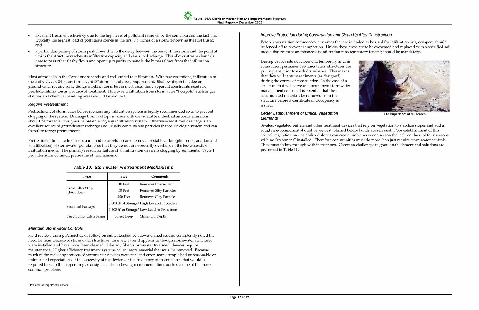
Route 101A Corridor Master Plan and Improvements Program Final Report – December 2002
Page 37 of 39.
• Excellent treatment efficiency due to the high level of pollutant removal by the soil biota and the fact that typically the highest load of pollutants comes in the first 0.5 inches of a storm (known as the first flush); and
• a partial dampening of storm peak flows due to the delay between the onset of the storm and the point at which the structure reaches its infiltrative capacity and starts to discharge. This allows stream channels time to pass other flashy flows and open up capacity to handle the bypass flows from the infiltration structure.
Most of the soils in the Corridor are sandy and well suited to infiltration. With few exceptions, infiltration of the entire 2 year, 24-hour storm event (3”storm) should be a requirement. Shallow depth to ledge or groundwater require some design modifications, but in most cases these apparent constraints need not preclude infiltration as a source of treatment. However, infiltration from stormwater “hotspots” such as gas stations and chemical handling areas should be avoided.
Require Pretreatment
Pretreatment of stormwater before it enters any infiltration system is highly recommended so as to prevent clogging of the system. Drainage from rooftops in areas with considerable industrial airborne emissions should be routed across grass before entering any infiltration system. Otherwise most roof drainage is an excellent source of groundwater recharge and usually contains few particles that could clog a system and can therefore forego pretreatment. Pretreatment in its basic sense is a method to provide coarse removal or stabilization (photo-degradation and volatilization) of stormwater pollutants so that they do not unnecessarily overburden the less accessible infiltration media. The primary reason for failure of an infiltration device is clogging by sediments. Table 1 provides some common pretreatment mechanisms.
Table 10. Stormwater Pretreatment Mechanisms
Type Size Comments
10 Feet Removes Coarse Sand
50 Feet Removes Silty Particles Grass Filter Strip (sheet flow)
400 Feet Removes Clay Particles
3,600 ft3 of Storage4 High Level of Protection Sediment Forbays
1,800 ft3 of Storage2 Low Level of Protection
Deep Sump Catch Basins 3 Feet Deep Minimum Depth
Maintain Stormwater Controls
Field reviews during Pennichuck’s follow-on subwatershed by subwatershed studies consistently noted the need for maintenance of stormwater structures. In many cases it appears as though stormwater structures were installed and have never been cleaned. Like any filter, stormwater treatment devices require maintenance. Higher efficiency treatment systems collect more material that must be removed. Because much of the early applications of stormwater devices were trial and error, many people had unreasonable or uninformed expectations of the longevity of the devices or the frequency of maintenance that would be required to keep them operating as designed. The following recommendations address some of the more common problems
4 Per acre of impervious surface
Improve Protection during Construction and Clean Up After Construction
Before construction commences, any areas that are intended to be used for infiltration or greenspace should be fenced off to prevent compaction. Unless these areas are to be excavated and replaced with a specified soil media that restores or enhances its infiltration rate, temporary fencing should be mandatory. During proper site development, temporary and, in some cases, permanent sedimentation structures are put in place prior to earth disturbance. This means that they will capture sediments (as designed) during the course of construction. In the case of a structure that will serve as a permanent stormwater management control, it is essential that these accumulated materials be removed from the structure before a Certificate of Occupancy is issued.
Better Establishment of Critical Vegetation Elements
Swales, vegetated buffers and other treatment devices that rely on vegetation to stabilize slopes and add a roughness component should be well established before bonds are released. Poor establishment of this critical vegetation on unstabilized slopes can create problems in one season that eclipse those of four seasons with no “treatment” installed. Therefore communities must do more than just require stormwater controls. They must follow through with inspections. Common challenges to grass establishment and solutions are presented in Table 11.
The importance of silt fences.
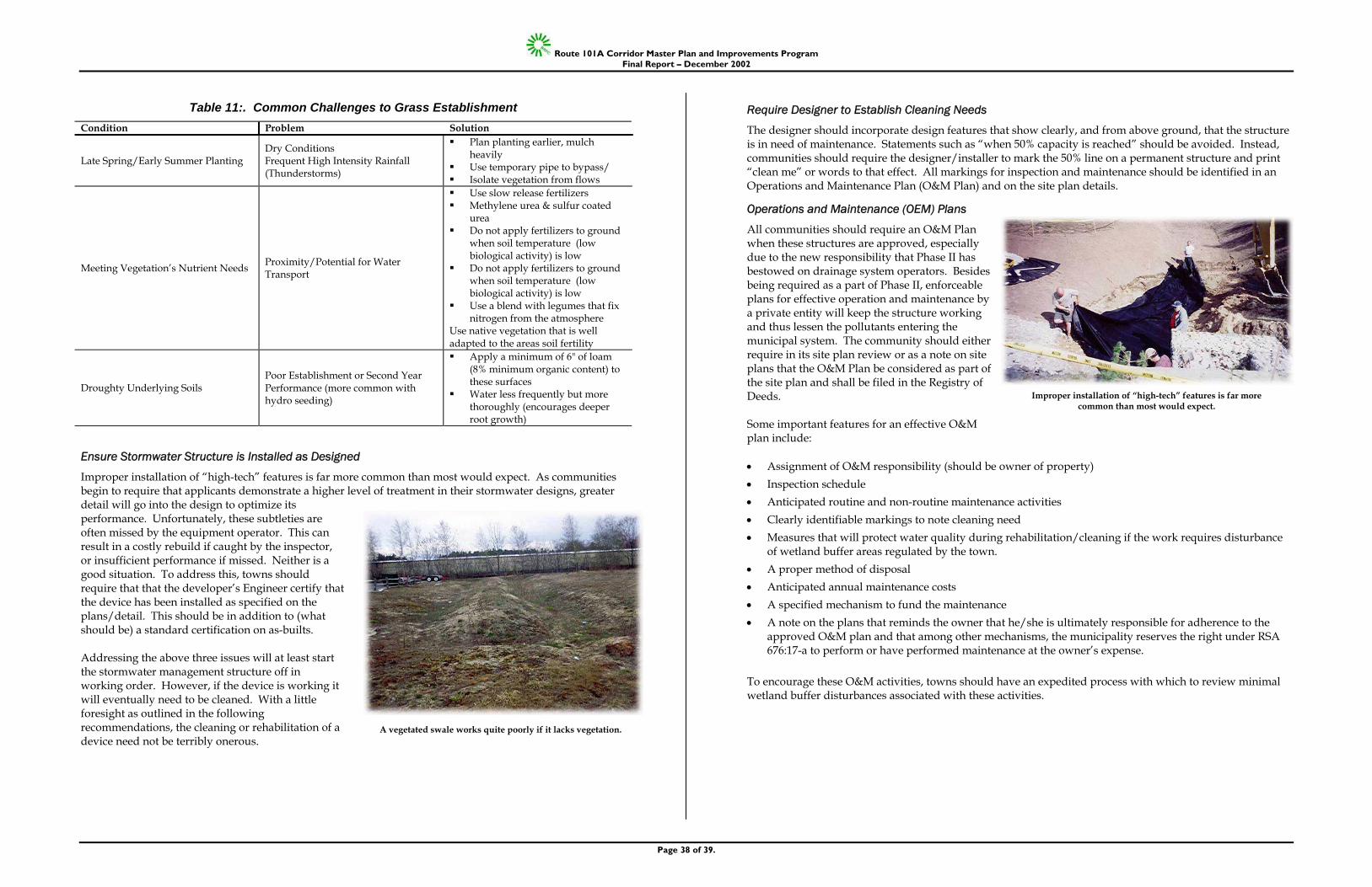
Route 101A Corridor Master Plan and Improvements Program Final Report – December 2002
Page 38 of 39.
Table 11:. Common Challenges to Grass Establishment Condition Problem Solution
Late Spring/Early Summer Planting Dry Conditions Frequent High Intensity Rainfall (Thunderstorms)
Plan planting earlier, mulch heavily
Use temporary pipe to bypass/ Isolate vegetation from flows
Meeting Vegetation’s Nutrient Needs Proximity/Potential for Water Transport
Use slow release fertilizers Methylene urea & sulfur coated
urea Do not apply fertilizers to ground
when soil temperature (low biological activity) is low
Do not apply fertilizers to ground when soil temperature (low biological activity) is low
Use a blend with legumes that fix nitrogen from the atmosphere
Use native vegetation that is well adapted to the areas soil fertility
Droughty Underlying Soils Poor Establishment or Second Year Performance (more common with hydro seeding)
Apply a minimum of 6" of loam (8% minimum organic content) to these surfaces
Water less frequently but more thoroughly (encourages deeper root growth)
Ensure Stormwater Structure is Installed as Designed
Improper installation of “high-tech” features is far more common than most would expect. As communities begin to require that applicants demonstrate a higher level of treatment in their stormwater designs, greater detail will go into the design to optimize its performance. Unfortunately, these subtleties are often missed by the equipment operator. This can result in a costly rebuild if caught by the inspector, or insufficient performance if missed. Neither is a good situation. To address this, towns should require that that the developer’s Engineer certify that the device has been installed as specified on the plans/detail. This should be in addition to (what should be) a standard certification on as-builts. Addressing the above three issues will at least start the stormwater management structure off in working order. However, if the device is working it will eventually need to be cleaned. With a little foresight as outlined in the following recommendations, the cleaning or rehabilitation of a device need not be terribly onerous.
Require Designer to Establish Cleaning Needs
The designer should incorporate design features that show clearly, and from above ground, that the structure is in need of maintenance. Statements such as “when 50% capacity is reached” should be avoided. Instead, communities should require the designer/installer to mark the 50% line on a permanent structure and print “clean me” or words to that effect. All markings for inspection and maintenance should be identified in an Operations and Maintenance Plan (O&M Plan) and on the site plan details.
Operations and Maintenance (OEM) Plans
All communities should require an O&M Plan when these structures are approved, especially due to the new responsibility that Phase II has bestowed on drainage system operators. Besides being required as a part of Phase II, enforceable plans for effective operation and maintenance by a private entity will keep the structure working and thus lessen the pollutants entering the municipal system. The community should either require in its site plan review or as a note on site plans that the O&M Plan be considered as part of the site plan and shall be filed in the Registry of Deeds. Some important features for an effective O&M plan include: • Assignment of O&M responsibility (should be owner of property) • Inspection schedule • Anticipated routine and non-routine maintenance activities • Clearly identifiable markings to note cleaning need • Measures that will protect water quality during rehabilitation/cleaning if the work requires disturbance
of wetland buffer areas regulated by the town. • A proper method of disposal • Anticipated annual maintenance costs • A specified mechanism to fund the maintenance • A note on the plans that reminds the owner that he/she is ultimately responsible for adherence to the
approved O&M plan and that among other mechanisms, the municipality reserves the right under RSA 676:17-a to perform or have performed maintenance at the owner’s expense.
To encourage these O&M activities, towns should have an expedited process with which to review minimal wetland buffer disturbances associated with these activities.
A vegetated swale works quite poorly if it lacks vegetation.
Improper installation of “high-tech” features is far more common than most would expect.
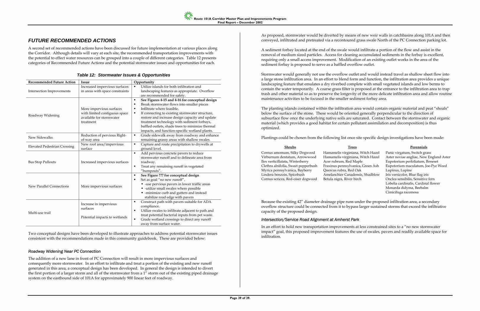
Route 101A Corridor Master Plan and Improvements Program Final Report – December 2002
Page 39 of 39.
FUTURE RECOMMENDED ACTIONS A second set of recommended actions have been discussed for future implementation at various places along the Corridor. Although details will vary at each site, the recommended transportation improvements with the potential to effect water resources can be grouped into a couple of different categories. Table 12 presents categories of Recommended Future Actions and the potential stormwater issues and opportunities for each.
Table 12: Stormwater Issues & Opportunities Recommended Future Action Issue Opportunity
Intersection Improvements Increased impervious surfaces in areas with space constraints
Utilize islands for both infiltration and landscaping features as appropriate. Overflow are recommended for safety.
Roadway Widening
More impervious surfaces with limited contiguous space available for stormwater treatment
See Figures 4-15 and 4-16 for conceptual design Break stormwater flows into smaller pieces Infiltrate where feasible. If connecting to existing stormwater structure,
restore and increase design capacity and update treatment technology with sediment forbays, baffled outlets, shade trees to minimize thermal impacts, and function-specific wetland plants.
New Sidewalks Reduction of pervious Right-of-way area
Grade sidewalk away from roadway and enhance remaining grassy areas with shallow swales.
Elevated Pedestrian Crossing New roof area/impervious surface
Capture and route precipitation to drywells at ground level.
Bus Stop Pullouts Increased impervious surfaces
Add pervious concrete pavers to reduce stormwater runoff and to delineate area from roadway.
Treat any remaining runoff in vegetated “bumpouts”.
New Parallel Connections More impervious surfaces
See Figure ??? for conceptual design Set as goal “no new runoff”.
-use pervious pavers in lower traffic areas -utilize small swales where possible -minimize curb and gutters and instead
stabilize road edge with pavers
Multi-use trail
Increase in impervious surfaces Potential impacts to wetlands
Construct path with pavers suitable for ADA compliance.
Utilize swales to infiltrate adjacent to path and treat potential bacterial inputs from pet waste.
Grade wetland crossings to direct any runoff away from surface water.
Two conceptual designs have been developed to illustrate approaches to address potential stormwater issues consistent with the recommendations made in this community guidebook. These are provided below:
Roadway Widening Near PC Connection
The addition of a new lane in front of PC Connection will result in more impervious surfaces and consequently more stormwater. In an effort to infiltrate and treat a portion of the existing and new runoff generated in this area, a conceptual design has been developed. In general the design is intended to divert the first portion of a larger storm and all of the stormwater from a 1” storm out of the existing piped drainage system on the eastbound side of 101A for approximately 900 linear feet of roadway.
As proposed, stormwater would be diverted by means of new weir walls in catchbasins along 101A and then conveyed, infiltrated and pretreated via a recontoured grass swale North of the PC Connection parking lot. A sediment forbay located at the end of the swale would infiltrate a portion of the flow and assist in the removal of medium sized particles. Access for cleaning accumulated sediments in the forbay is excellent, requiring only a small access improvement. Modification of an existing outlet works in the area of the sediment forbay is proposed to serve as a baffled overflow outlet. Stormwater would generally not use the overflow outlet and would instead travel as shallow sheet flow into a large stone infiltration area. In an effort to blend form and function, the infiltration area provides a unique landscaping feature that emulates a dry riverbed complete with small vegetated islands and low berms to contain the water temporarily. A coarse grass filter is proposed at the entrance to the infiltration area to trap trash and other material so as to preserve the longevity of the more delicate infiltration area and allow routine maintenance activities to be focused in the smaller sediment forbay area. The planting islands contained within the infiltration area would contain organic material and peat “shoals” below the surface of the stone. These would be oriented generally perpendicular to the direction of subsurface flow once the underlying native soils are saturated. Contact between the stormwater and organic material (which provides a good habitat for certain pollutant assimilation and decomposition) is thus optimized. Plantings could be chosen from the following list once site specific design investigations have been made:
Shrubs Trees Perennials Cornus amomum, Silky Dogwood Hamamelis virginiana, Witch Hazel Panic virgatum, Switch grass Virburnum dentatum, Arrowwood Hamamelis virginiana, Witch Hazel Aster noviae angliae, New England Aster Ilex verticillatata, Winterberry Acer rubrum, Red Maple Eupotorium perfoliatum, Boneset Clethra alnifolia, Sweet pepperbush Fraxinus pennsylvanica, Green Ash Eupotorium maculatum, Joe-Pye Weed Myrica pennsylvanica, Bayberry Quercus rubra, Red Oak Lupinus, Lupine Lindera benzoin, Spicebush Amelanchier Canadensis, Shadblow Iris versicolor, Blue flag iris Cornus sericea, Red-oiser dogwood Betula nigra, River birch Onclea sensibilis, Sensitive fern Lobelia cardinalis, Cardinal flower Monarda didyma, Beebalm Cimicifuga racemosa Because the existing 42” diameter drainage pipe runs under the proposed infiltration area, a secondary overflow structure could be connected from it to bypass larger sustained storms that exceed the infiltrative capacity of the proposed design.
Intersection/Service Road Alignment at Amherst Park
In an effort to hold new transportation improvements at less constrained sites to a “no new stormwater impact” goal, this proposed improvement features the use of swales, pavers and readily available space for infiltration.