Embed Size (px)
Citation preview
____ Ber. Geol. B.‐A., 82, ISSN 1017‐8880 – Landslide Monitoring Technologies & Early Warning Systems ____
‐ 7 ‐
The Safeland Project – General Overview and Monitoring Technology Development
The SafeLand Consortium a), N. CASAGLI b) & R. SUPPER c)
a) The International Centre for Geohazards, NGI, P.O. Box 3930, Ullevål Stadion, N‐0806 Oslo, Norway. b) Earth Sciences Department, University of Firenze, UNIFI. c) Geological Survey of Austria, Neulinggasse 38, A 1030 Vienna, Austria.
SafeLand is a large‐scale integrating collaborative research project (for further information see http://www.safeland‐fp7.eu/Introduction.html) funded by the Seventh Framework Program for re‐search and technological development (FP7) of the European Commission. Thematically the project belongs to Cooperation Theme 6 Environment (including climate change), Sub‐Activity 6.1.3 Natural Hazards.
SafeLand will develop generic quantitative risk assessment and management tools and strategies for landslides at local, regional, European and societal scales. It will establish the baseline for the risk associated with landslides in Europe, to improve our ability to forecast landslide hazard and detect hazard and risk zones. The scientific work packages in SafeLand are organized in five Areas:
Area 1 focuses on improving the knowledge on triggering mechanisms, processes and thresh‐olds, including climate‐related and anthropogenic triggers, and on run‐out models in landslide hazard assessment;
Area 2 harmonises quantitative risk assessment methodologies for different spatial scales, look‐ing into uncertainties, vulnerability, landslide susceptibility, landslide frequency, and identifying hotspots in Europe with higher landslide hazard and risk;
Area 3 focuses on future climate change scenarios and changes in demography and infrastruc‐ture, resulting in the evolution of hazard and risk in Europe at selected hotspots;
Area 4 addresses the technical and practical issues related to monitoring and early warning for landslides, and identifies the best technologies available in both the context of hazard assess‐ment and design of early warning systems;
Area 5 provides a toolbox of risk mitigation strategies and guidelines for choosing the most ap‐propriate risk management strategy.
Maintaining the database of case studies, dissemination of the project results, as well as project
management and coordination are defined in work packages 6, 7 and 8. Objectives of the Project SafeLand has the objectives to (1) provide policy‐makers, public administrators, researchers, scien‐tists, educators and other stakeholders with an improved harmonized framework and methodology for the assessment and quantification of landslide risk in Europe's regions; (2) evaluate the changes in risk pattern caused by climate change, human activity and policy changes; and (3) provide guide‐lines for choosing the most appropriate risk management strategies, including risk mitigation and prevention measures.
To be able to produce results at the European scale, SafeLand needs to link hazards and risks at the local scale, i.e. individual slopes and slides to the hazards and risks at the European scale. The smallest scale of interest in this proposal refers to the local slope scale (less than 3 km²) where most of the research will be done on the triggering factors. The regional studies, including the "hotspots" evaluations, form the intermediary scale: from 10 to 200 km², depending on the site. The largest scale will be the "country" and European scale.
____ Ber. Geol. B.‐A., 82, ISSN 1017‐8880 – Landslide Monitoring Technologies & Early Warning Systems ____
‐ 8 ‐
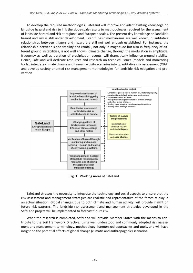
To develop the required methodologies, SafeLand will improve and adapt existing knowledge on landslide hazard and risk to link the slope‐scale results to methodologies required for the assessment of landslide hazard and risk at regional and European scales. The present day knowledge on landslide hazard and risk is still under development. Even if basic mechanisms are well known, quantitative relationships between triggers and hazard are still not well enough established. For instance, the relationship between slope stability and rainfall, not only in magnitude but also in frequency of dif‐ferent ground instabilities, is not well known. Climate change, through the modulation in amplitude, frequency as well as duration of precipitation events, will dramatically influence ground stability. Hence, SafeLand will dedicate resources and research on technical issues (models and monitoring tools), integrate climate change and human activity scenarios into quantitative risk assessment (QRA) and develop society‐oriented risk management methodologies for landslide risk mitigation and pre‐vention.
Fig. 1: Working Areas of SafeLand.
SafeLand stresses the necessity to integrate the technology and social aspects to ensure that the risk assessment and management strategies are realistic and representative of the forces at play in an actual situation. Global changes, due to both climate and human activity, will provide insight on future risk patterns. The landslide risk assessment and management strategies developed in the SafeLand project will be implemented to forecast future risk.
When the research is completed, SafeLand will provide Member States with the means to con‐
tribute to the Soil Framework Directive, using well understood and commonly adopted risk assess‐ment and management terminology, methodology, harmonized approaches and tools, and will have insight on the potential effects of global change (climatic and anthropogenic) scenarios.
____ Ber. Geol. B.‐A., 82, ISSN 1017‐8880 – Landslide Monitoring Technologies & Early Warning Systems ____
‐ 9 ‐
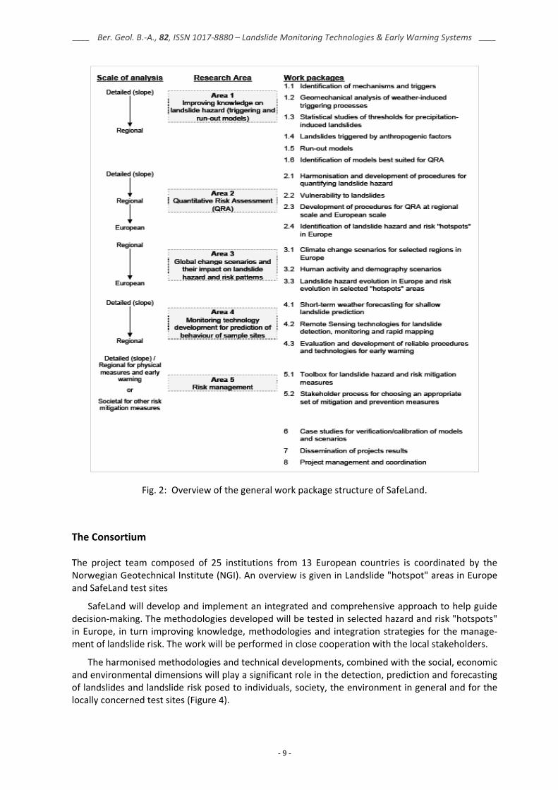
Fig. 2: Overview of the general work package structure of SafeLand.
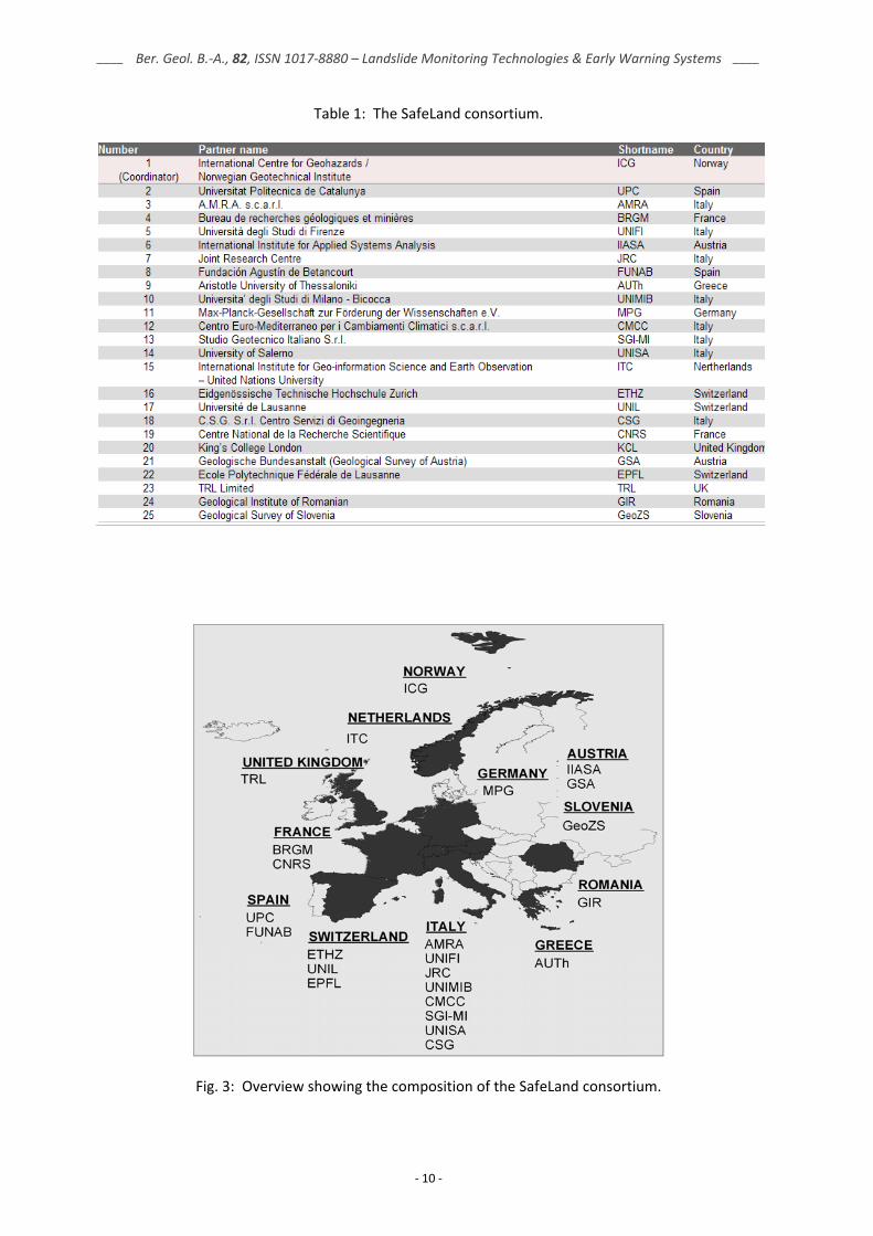
The Consortium The project team composed of 25 institutions from 13 European countries is coordinated by the Norwegian Geotechnical Institute (NGI). An overview is given in Landslide "hotspot" areas in Europe and SafeLand test sites
SafeLand will develop and implement an integrated and comprehensive approach to help guide decision‐making. The methodologies developed will be tested in selected hazard and risk "hotspots" in Europe, in turn improving knowledge, methodologies and integration strategies for the manage‐ment of landslide risk. The work will be performed in close cooperation with the local stakeholders.
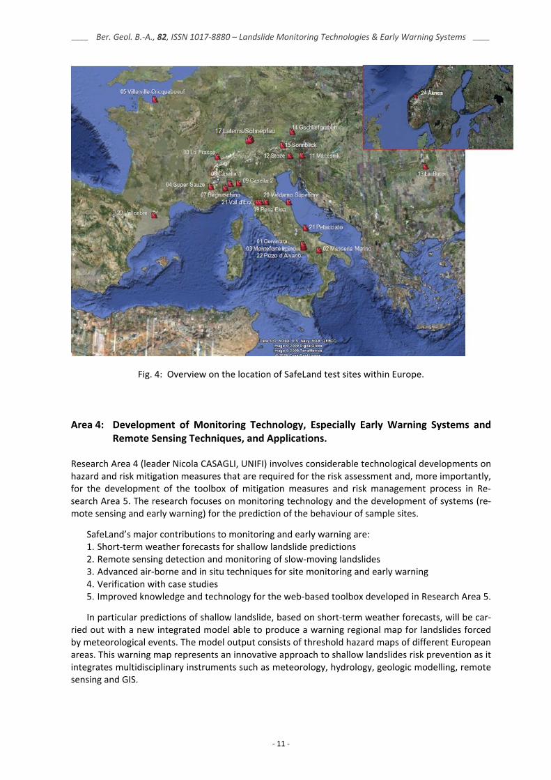
The harmonised methodologies and technical developments, combined with the social, economic and environmental dimensions will play a significant role in the detection, prediction and forecasting of landslides and landslide risk posed to individuals, society, the environment in general and for the locally concerned test sites (Figure 4).
____ Ber. Geol. B.‐A., 82, ISSN 1017‐8880 – Landslide Monitoring Technologies & Early Warning Systems ____
‐ 10 ‐
Table 1: The SafeLand consortium.
Fig. 3: Overview showing the composition of the SafeLand consortium.
____ Ber. Geol. B.‐A., 82, ISSN 1017‐8880 – Landslide Monitoring Technologies & Early Warning Systems ____
‐ 11 ‐
Fig. 4: Overview on the location of SafeLand test sites within Europe.
Area 4: Development of Monitoring Technology, Especially Early Warning Systems and Remote Sensing Techniques, and Applications.
Research Area 4 (leader Nicola CASAGLI, UNIFI) involves considerable technological developments on hazard and risk mitigation measures that are required for the risk assessment and, more importantly, for the development of the toolbox of mitigation measures and risk management process in Re‐search Area 5. The research focuses on monitoring technology and the development of systems (re‐mote sensing and early warning) for the prediction of the behaviour of sample sites.
SafeLand’s major contributions to monitoring and early warning are: 1. Short‐term weather forecasts for shallow landslide predictions 2. Remote sensing detection and monitoring of slow‐moving landslides 3. Advanced air‐borne and in situ techniques for site monitoring and early warning 4. Verification with case studies 5. Improved knowledge and technology for the web‐based toolbox developed in Research Area 5. In particular predictions of shallow landslide, based on short‐term weather forecasts, will be car‐
ried out with a new integrated model able to produce a warning regional map for landslides forced by meteorological events. The model output consists of threshold hazard maps of different European areas. This warning map represents an innovative approach to shallow landslides risk prevention as it integrates multidisciplinary instruments such as meteorology, hydrology, geologic modelling, remote sensing and GIS.
____ Ber. Geol. B.‐A., 82, ISSN 1017‐8880 – Landslide Monitoring Technologies & Early Warning Systems ____
‐ 12 ‐
A common methodology for detection, rapid mapping, characterization and monitoring of land‐slides at regional/catchment scale using advanced remote sensing techniques will be defined, as well as a common methodology for the rapid creation and updating of landslide inventories and hazard maps at regional/catchment scale. Three classes of techniques will be exploited and integrated: space borne radars, airborne and VHR space borne optical sensors, and airborne geophysics. The main expected outcome is the integration of these advanced remote sensing techniques within a QRA framework for a global integrated risk management process.
User‐oriented guidelines for incorporation of advanced remote sensing technologies within inte‐grated risk management processes and best practices will be realized. A toolbox of remote sensing applications will be proposed as part of an integrated risk management process including procedures for data acquisition and updating, recommended processing methods, road maps for data integra‐tion in QRA and risk mitigation measures.
The development and evaluation of advanced and adaptive methodologies for real‐time monitor‐ing and early‐warning systems for specific landslide sites will focus on landslides that are most af‐fected by climate triggering factors. In order to achieve the high quality necessary for early‐warning systems, SafeLand will address the following aspects: investigation stage, design of monitoring sys‐tems, infrastructure (i.e. power supply, data transfer etc), definition of key processes leading towards triggering, operational handling of the monitoring and communication with responsible authorities (early‐warning centres).
This work package is separated into 3 sub‐work‐packages:
• Short‐term weather forecasting for shallow landslide prediction (WP 4.1; leader Pasquale SCHIANO, CMCC)
• Development of remote sensing technologies for the detection, monitoring and rapid mapping of landslides (WP 4.2; leader Nicola CASAGLI; UNIFI)
• Evaluation and development of reliable procedures and technologies for monitoring and early warning (WP 4.3; leader Robert SUPPER; GSA)
In the following chapter a short overview on the content of each of the sub‐work‐packages is
given.
WP 4.1 Short‐Term Weather Forecasting for Shallow Landslide Prediction Objectives Design and implementation of an integrated model able to produce warning maps for shallow land‐slides triggered by meteorological events. Description of work Landslides triggered by rainfall can be predicted with a limited area model for numerical weather prediction that operates in the short time range: from 0 to 3 days before landslide occurrence. En‐hanced prediction closer to the event can be achieved by defining algorithms based on meteo radar and satellite data in the nowcasting range: from 0 to 6 hours before the triggering event. A near‐real‐time warning system for shallow landslides based on forecasted meteorological variables, such as cumulated and maxima/minima values of precipitation (rain and snow), will be developed at multiple scales. The research of this WP will benefit from related ongoing international studies such as the activities under development at NASA with the TRMM model. Work performed here will be carried out in close cooperation with WPs 1.1 and 1.2.
____ Ber. Geol. B.‐A., 82, ISSN 1017‐8880 – Landslide Monitoring Technologies & Early Warning Systems ____
‐ 13 ‐
WP 4.1 – Tasks • Task 1: Refinement of meteorological forecasting of extreme events in the short time and
nowcasting range (CMCC) • Task 2: Development of post‐processing methods (e.g. dynamic and statistical downscaling)
for improved coupling of meteorological and landslide models (CMCC) • Task 3: Development and testing of models for infiltration and stability in shallow slope
(UNIFI) • Task 4: Delivery of a prototype early warning system (CMCC/UNIFI)
WP 4.1 – Deliverables Deliverable D4.1: Short‐term weather forecasting for prediction of triggering of shallow landslides – Methodology, evaluation of technology and validation at selected test sites. WP 4.2 Remote Sensing Technologies for Landslide Detection, Monitoring and Rapid Mapping Description of work Remote sensing imagery is a powerful tool for the rapid assessment of surface motions over large areas and for the fast characterization of slope instability factors. Three classes of techniques will be exploited and integrated in this WP: Spaceborne radars, airborne and VHR spaceborne optical sen‐sors and airborne geophysics. WP 4.2 – Tasks
• Task 1: Define and validate a methodology for detection, rapid mapping, characterization and monitoring of landslides.
• Task 2: Define a methodology for updating landslide inventory maps and landslide hazard maps.
• Task 3: Prepare user‐oriented guidelines for the incorporation of remote sensing technolo‐gies within landslide risk management processes and best practices.
WP 4.2 – Deliverables
• D4.1: Review of monitoring and remote sensing methodologies for landslide detection, fast characterization, rapid mapping and long‐term monitoring (delivery date: 12 months) (Re‐sponsible: UNIL)
• D4.3: Creation and updating of landslide inventory maps, landslide deformation maps and hazard maps as input for QRA using remote sensing technology (delivery date: 24 months) (Responsible: CNRS)
• D4.4: Guidelines for the selection of appropriate remote sensing technologies for monitoring different types of landslides (delivery date: 24 months) (Responsible: ITC)
• D4.5: Evaluation report on innovative monitoring and remote sensing methods and future technology (together with WP4.3) (delivery date: 24 months) (Responsible: UNIFI)
WP 4.2 – Techniques
• Optical VHR satellite data (Object‐oriented analysis, Ontology): ITC, JRC, CNRS • InSAR / A‐DInSAR: UNIFI, UPC, UNIL, GeoZS, ICG, UNISA, AMRA • Airborne Geophysics: GSA • Airborne Optical Sensors / LiDAR: UNIL, ICG
____ Ber. Geol. B.‐A., 82, ISSN 1017‐8880 – Landslide Monitoring Technologies & Early Warning Systems ____
‐ 14 ‐
WP 4.3 Evaluation and Development of Reliable Procedures and Technologies for Early Warning Objectives Development and evaluation of advanced and adaptive methodologies for real‐time monitoring and early‐warning for selected landslide sites. Description of work The work will merge the experience of scientists from leading European research centres, each cov‐ering certain unique aspects of site monitoring and contributing with its complementary skills in monitoring technology, finally synthesized in a concerted evaluation of methodologies. The efforts will concentrate on a selected number of well‐instrumented and monitored landslide sites. It will include landslides from extremely slow to very rapid mass movements and from shallow to deep‐seated. The monitoring methods will cover all kinds of technologies, ranging from the application of traditional monitoring methods to the improvement of new and advanced technologies, including geoelectrical, self‐potential monitoring, acoustic noise measurements, DMS, optical fibres, acoustic emissions etc. … The work will be carried out in cooperation with WP 4.2. WP 4.3 – Tasks
• Task 1: Assessment of current state‐of‐art in monitoring and early warning (technology). • Task 2: Exploring the role of "geo‐indicators" as early warning parameters (processes and re‐
lated parameters). • Task 3: Method evaluation and implementation of guidelines for monitoring and early warn‐
ing. WP 4.3 – Deliverables
• D4.5: Evaluation report on innovative monitoring and remote sensing methods and future technology (together with WP 4.2) (delivery date: 24 months)
• D4.6: Report on geo‐indicator evaluation (delivery date: 32 months) • D4.7: Report on the development of software for early‐warning based on real‐time data (de‐
livery date: 32 months) • D4.8: Guidelines for monitoring and early warning systems in Europe – Design and required
technology (delivery date: 32 months) WP 4.3 – Techniques
• Traditional monitoring methods (inclinometers, extensometers, piezometers etc.) • New and advanced technologies (GB‐InSAR, geoelectrical, DMS, optical fibres etc.)
• Geodetic / geotechnical: ETHZ, CSG, UNIMIB, AMRA, CNRS, GeoZS • GB‐InSAR: UNIFI, IGC, UNIMIB, ATB, UPC • Terrestrial Laser Scanner: UNIL, UNIFI, UNIMIB • Geoelectrical: ETHZ, GSA • Acoustic emissions: ETHZ, UNIMIB • Self‐potential: GSA • DMS: CSG, ETHZ, UNIMIB, ATB • Optical fibres: AMRA • Suction measurement / tensiometers: ETHZ, AMRA • Sensor networks: ICG