Embed Size (px)
Citation preview
THE SATELLITE SNOW PRODUCTS
INTERCOMPARISON AND EVALUATION EXERCISE SnowPEx
Thomas Nagler ENVEO, Innsbruck
SNOWPEX WEBSITE -https://earth.esa.int/web/sppa/activities/qa4eo/snowpex
DATASETS http://snowpex.enveo.at/
ESA QA4EO SNOWPEX – 2014-2016 A contribution to WMO Global Cryosphere Watch and WCRP CLiC
• Objectives: Intercompare and evaluate global / hemispheric (pre) operational snow products derived from different EO sensors
• Evaluate and intercompare temporal trends of seasonal snow parameters from various EO based products in
• Elaborate recommendations and needs for further improvements
LEAD: ENVEO
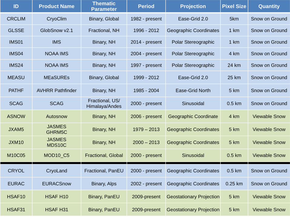
Overview of participating Snow Extent products ID Product Name Thematic
Parameter Period Projection Pixel Size Quantity
CRCLIM CryoClim Binary, Global 1982 - present Ease-Grid 2.0 5km Snow on Ground
GLSSE GlobSnow v2.1 Fractional, NH 1996 - 2012 Geographic Coordinates 1 km Snow on Ground
IMS01 IMS Binary, NH 2014 - present Polar Stereographic 1 km Snow on Ground
IMS04 NOAA IMS Binary, NH 2004 - present Polar Stereographic 4 km Snow on Ground
IMS24 NOAA IMS Binary, NH 1997 - present Polar Stereographic 24 km Snow on Ground
MEASU MEaSUREs Binary, Global 1999 - 2012 Ease-Grid 2.0 25 km Snow on Ground
PATHF AVHRR Pathfinder Binary, NH 1985 - 2004 Ease-Grid North 5 km Snow on Ground
SCAG SCAG Fractional, US/ Himalaya/Andes 2000 - present Sinusoidal 0.5 km Snow on Ground
ASNOW Autosnow Binary, NH 2006 - present Geographic Coordinate 4 km Viewable Snow
JXAM5 JASMES GHRM5C Binary, NH 1979 – 2013 Geographic Coordinates 5 km Viewable Snow
JXM10 JASMES MDS10C Binary, NH 2000 – 2013 Geographic Coordinates 5 km Viewable Snow
M10C05 MOD10_C5 Fractional, Global 2000 - present Sinusoidal 0.5 km Viewable Snow
CRYOL CryoLand Fractional, PanEU 2000 - present Geographic Coordinates 0.5 km Snow on Ground
EURAC EURACSnow Binary, Alps 2002 - present Geographic Coordinates 0.25 km Snow on Ground
HSAF10 HSAF H10 Binary, PanEU 2009-present Geostationary Projection 5 km Viewable Snow
HSAF31 HSAF H31 Binary, PanEU 2009-present Geostationary Projection 5 km Viewable Snow
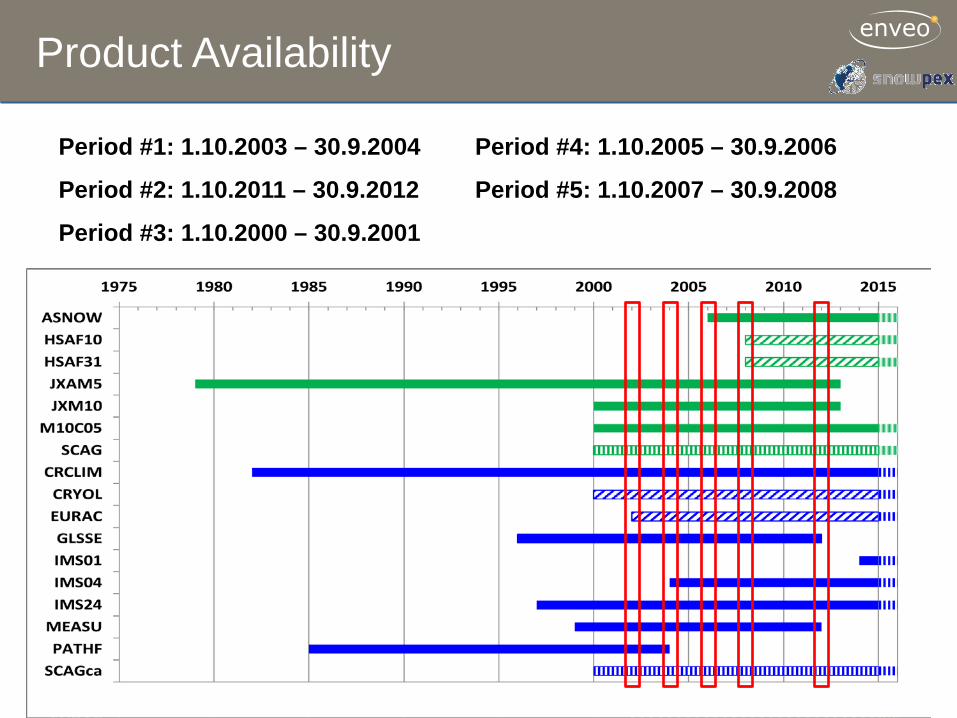
Product Availability
Period #1: 1.10.2003 – 30.9.2004
Period #2: 1.10.2011 – 30.9.2012
Period #3: 1.10.2000 – 30.9.2001
Period #4: 1.10.2005 – 30.9.2006
Period #5: 1.10.2007 – 30.9.2008
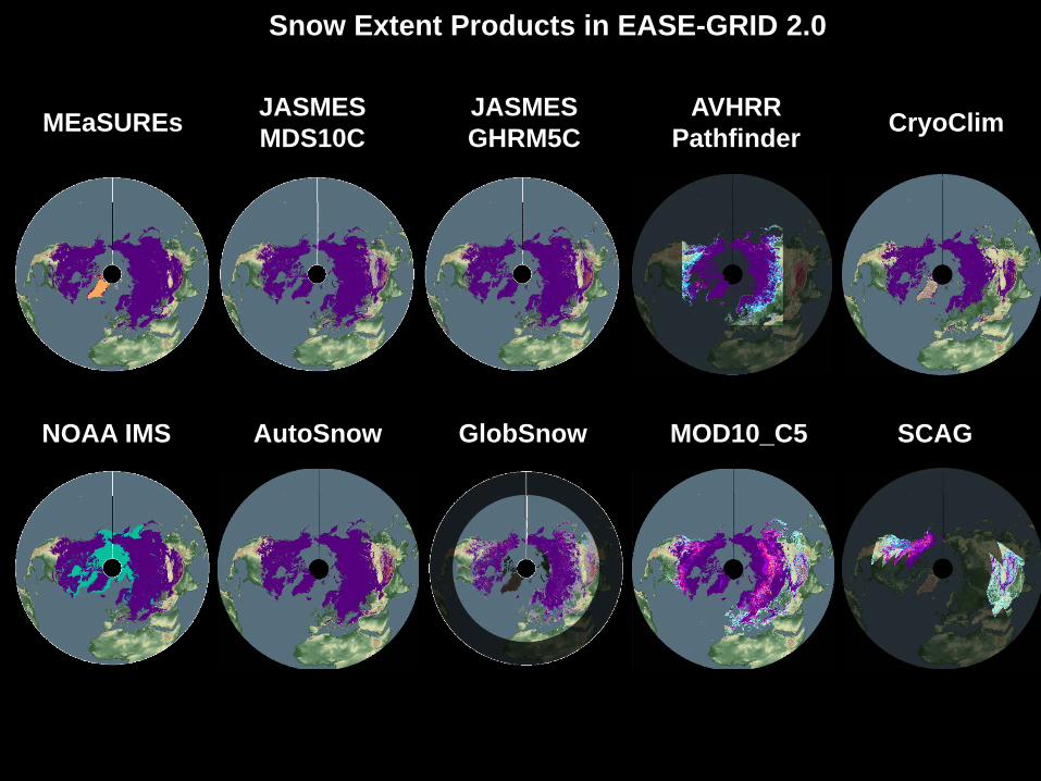
MEaSUREs JASMES MDS10C
JASMES GHRM5C
AVHRR Pathfinder
AutoSnow MOD10_C5 GlobSnow SCAG NOAA IMS
CryoClim
Snow Extent Products in EASE-GRID 2.0
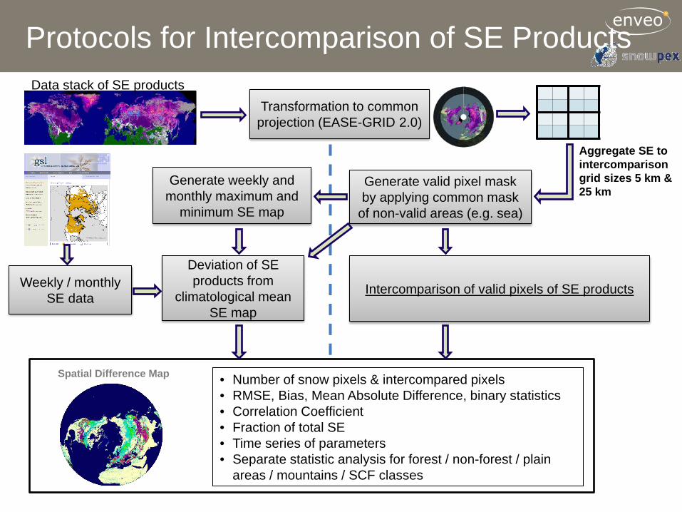
Protocols for Intercomparison of SE Products
Transformation to common projection (EASE-GRID 2.0)
Generate valid pixel mask by applying common mask
of non-valid areas (e.g. sea)
Aggregate SE to intercomparison grid sizes 5 km & 25 km
• Number of snow pixels & intercompared pixels • RMSE, Bias, Mean Absolute Difference, binary statistics • Correlation Coefficient • Fraction of total SE • Time series of parameters • Separate statistic analysis for forest / non-forest / plain
areas / mountains / SCF classes
Data stack of SE products
Intercomparison of valid pixels of SE products
Spatial Difference Map
Generate weekly and monthly maximum and
minimum SE map
Deviation of SE products from
climatological mean SE map
Weekly / monthly SE data
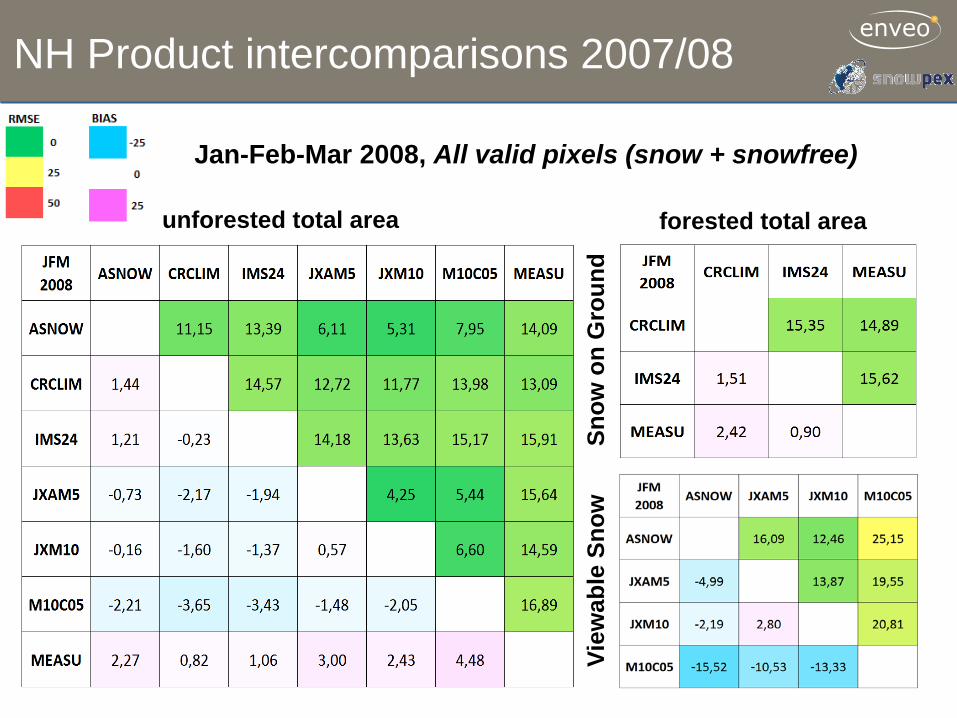
NH Product intercomparisons 2007/08
unforested total area forested total area
Snow
on
Gro
und
Jan-Feb-Mar 2008, All valid pixels (snow + snowfree)
View
able
Sno
w
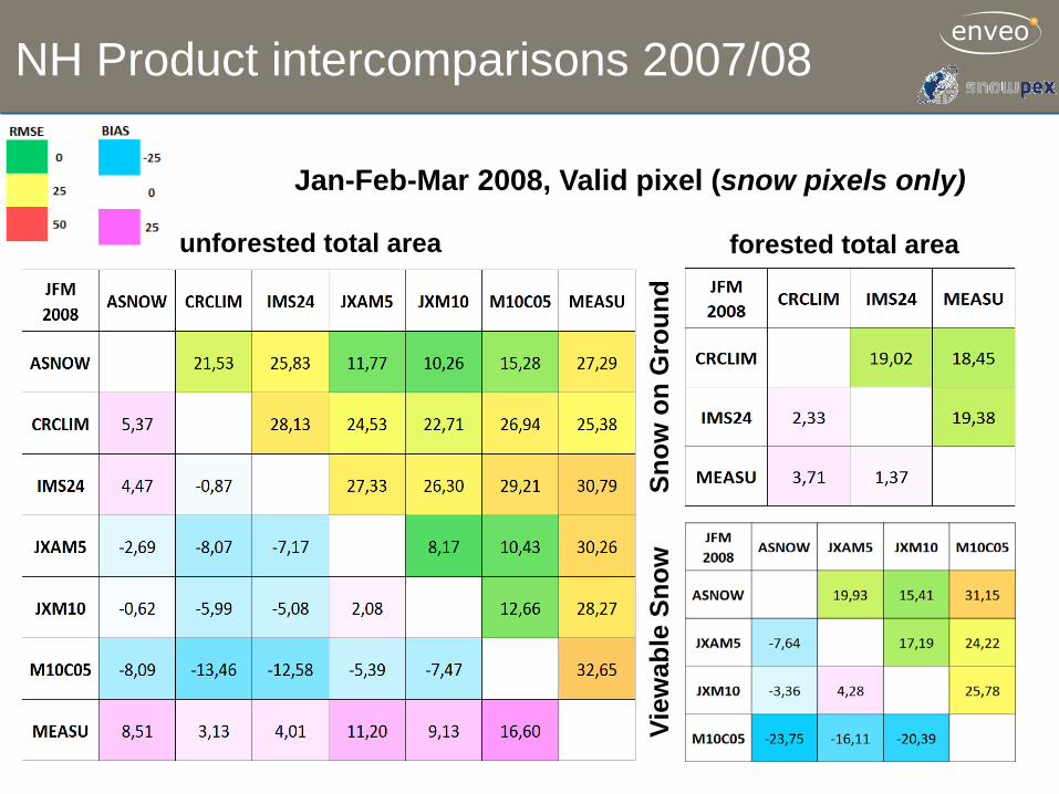
NH Product intercomparisons 2007/08
unforested total area forested total area
Snow
on
Gro
und
Jan-Feb-Mar 2008, Valid pixel (snow pixels only)
View
able
Sno
w
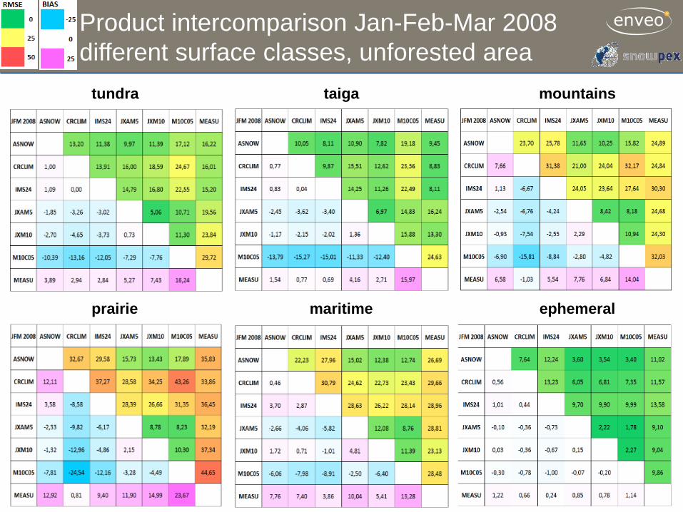
Product intercomparison Jan-Feb-Mar 2008 different surface classes, unforested area
tundra taiga
prairie maritime
mountains
ephemeral
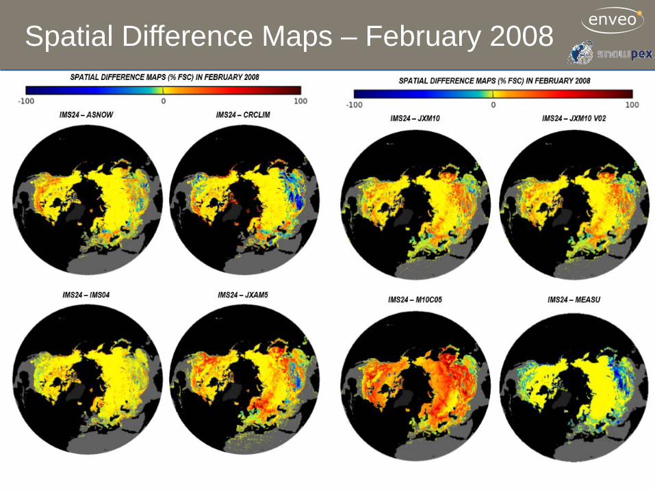
Spatial Difference Maps – February 2008
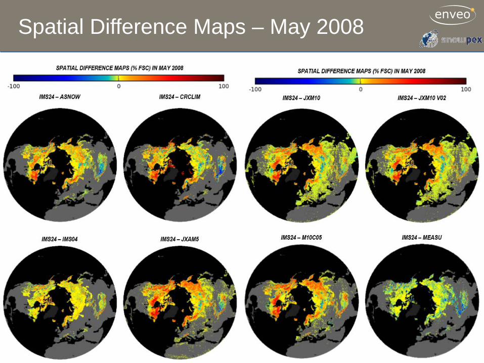
Spatial Difference Maps – May 2008
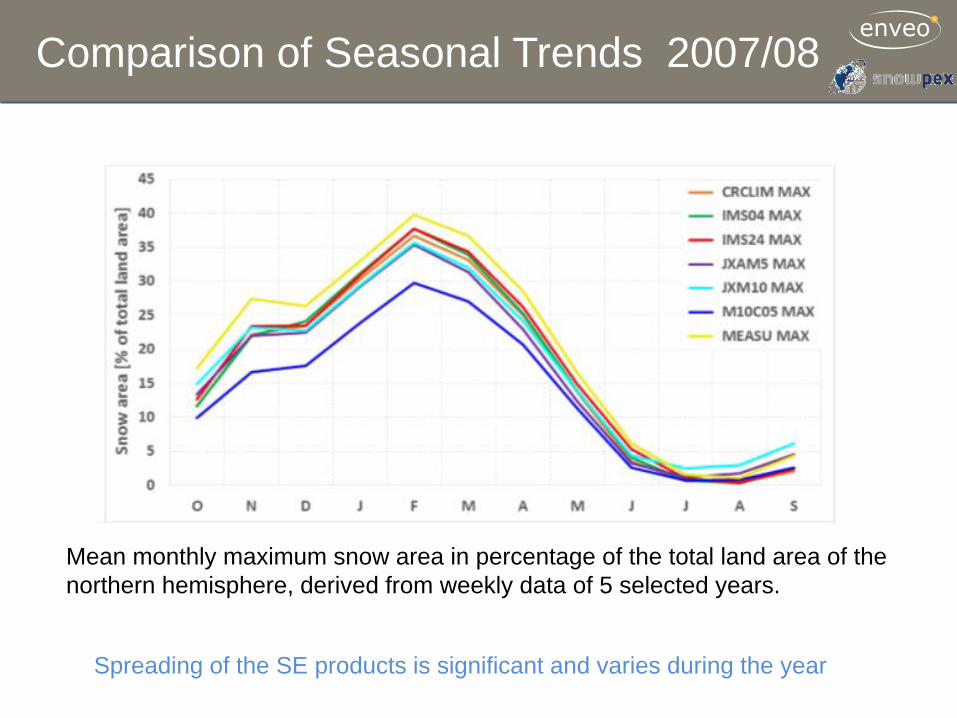
Comparison of Seasonal Trends 2007/08
Spreading of the SE products is significant and varies during the year
Mean monthly maximum snow area in percentage of the total land area of the northern hemisphere, derived from weekly data of 5 selected years.
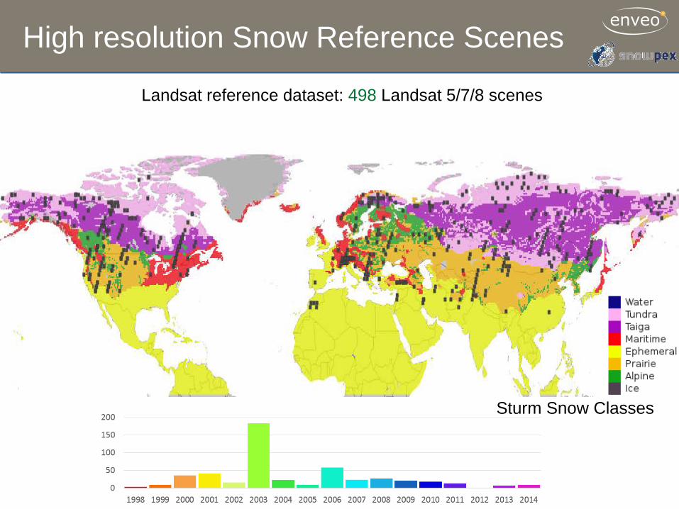
High resolution Snow Reference Scenes
Landsat reference dataset: 498 Landsat 5/7/8 scenes
Sturm Snow Classes
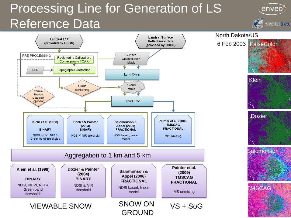
Aggregation to 1 km and 5 km
Klein et al. (1998)
BINARY
NDSI, NDVI, NIR & Green band thresholds
Dozier & Painter (2004)
BINARY
NDSI & NIR threshold
Salomonson & Appel (2006)
FRACTIONAL
NDSI based, linear model
Painter et al. (2009)
TMSCAG FRACTIONAL
MS unmixing
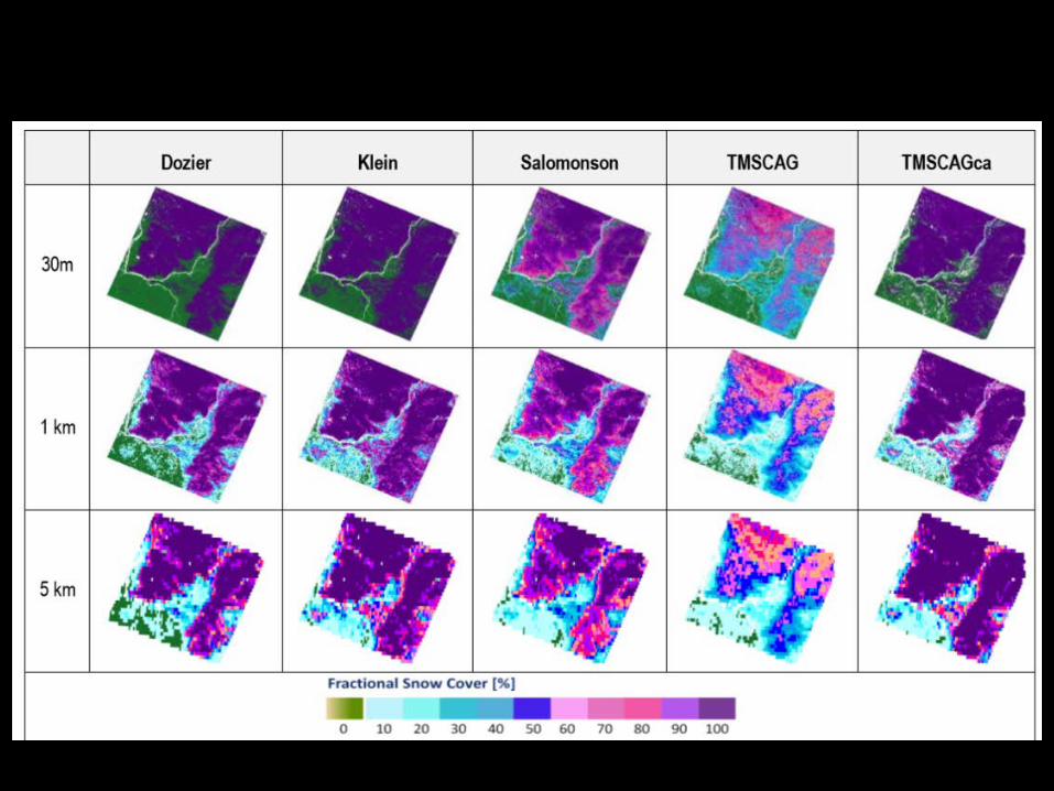
Processing Line for Generation of LS Reference Data
TMSCAG
Salomonson
Dozier
Klein
FalseColor 6 Feb 2003 North Dakota/US
SNOW ON GROUND
VS + SoG VIEWABLE SNOW
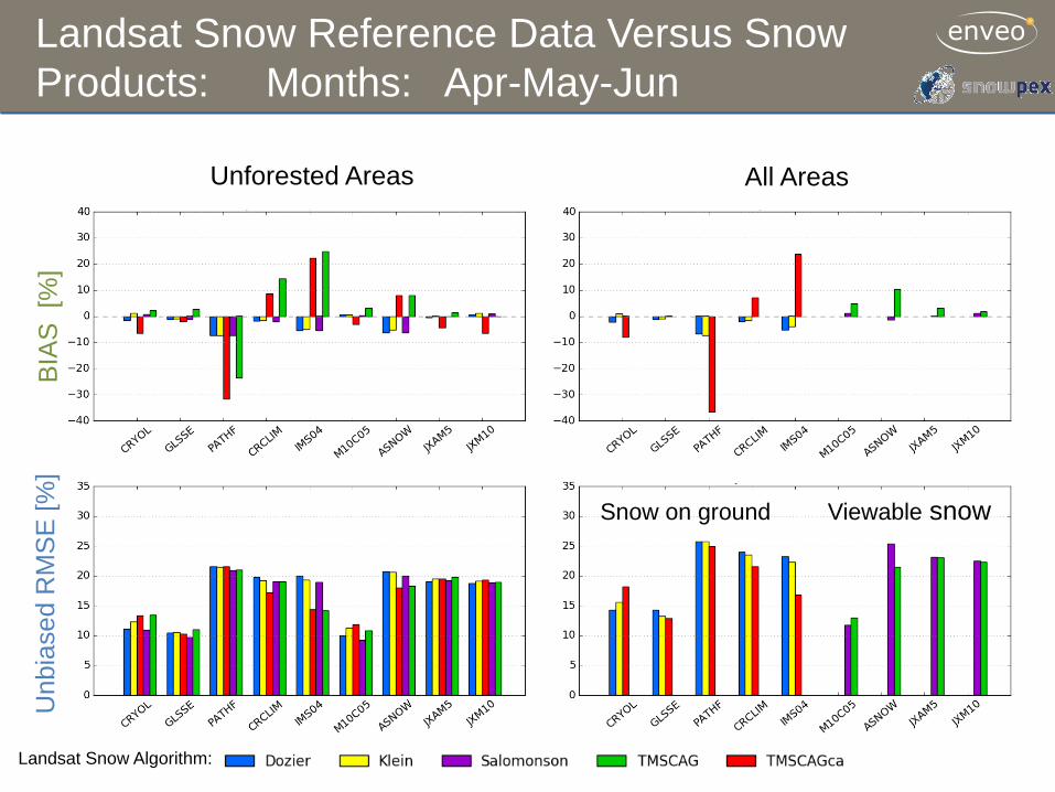
Landsat Snow Reference Data Versus Snow Products: Months: Apr-May-Jun
BIA
S [
%]
Unb
iase
d R
MS
E [%
]
Unforested Areas
Landsat Snow Algorithm:
All Areas
Viewable snow Snow on ground
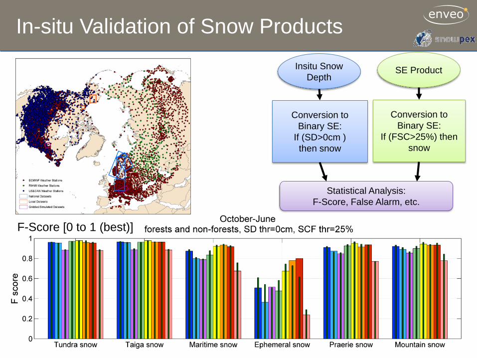
In-situ Validation of Snow Products
F-Score [0 to 1 (best)]
Conversion to Binary SE:
If (SD>0cm ) then snow
Conversion to Binary SE:
If (FSC>25%) then snow
Statistical Analysis: F-Score, False Alarm, etc.
Insitu Snow Depth
SE Product
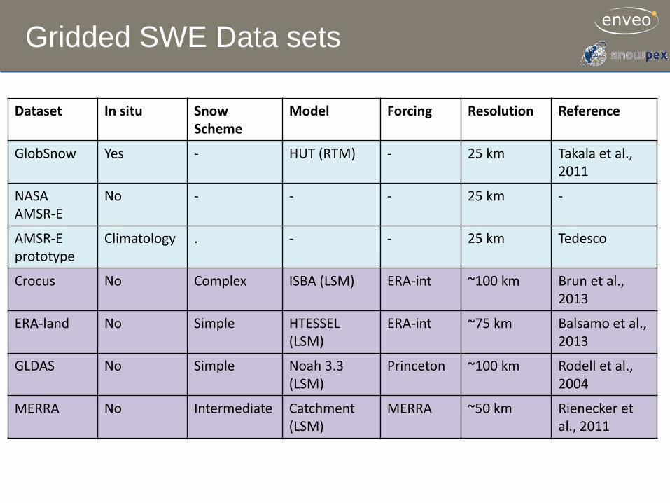
Gridded SWE Data sets
Dataset In situ Snow Scheme
Model Forcing Resolution Reference
GlobSnow Yes - HUT (RTM) - 25 km Takala et al., 2011
NASA AMSR-E
No - - - 25 km -
AMSR-E prototype
Climatology . - - 25 km Tedesco
Crocus No Complex ISBA (LSM) ERA-int ~100 km Brun et al., 2013
ERA-land No Simple HTESSEL (LSM)
ERA-int ~75 km Balsamo et al., 2013
GLDAS No Simple Noah 3.3 (LSM)
Princeton ~100 km Rodell et al., 2004
MERRA No Intermediate Catchment (LSM)
MERRA ~50 km Rienecker et al., 2011
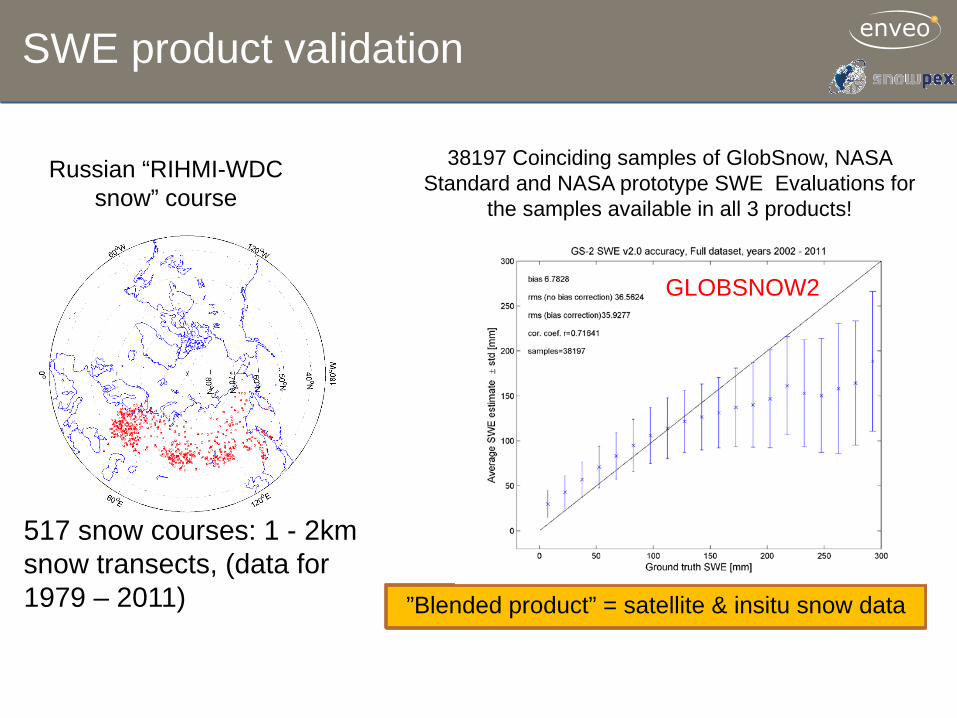
SWE product validation
517 snow courses: 1 - 2km snow transects, (data for 1979 – 2011)
38197 Coinciding samples of GlobSnow, NASA Standard and NASA prototype SWE Evaluations for
the samples available in all 3 products!
NASA STD
Product from satellite data only
NASA Prototype
Product from satellite data only
GLOBSNOW2
”Blended product” = satellite & insitu snow data
Russian “RIHMI-WDC snow” course
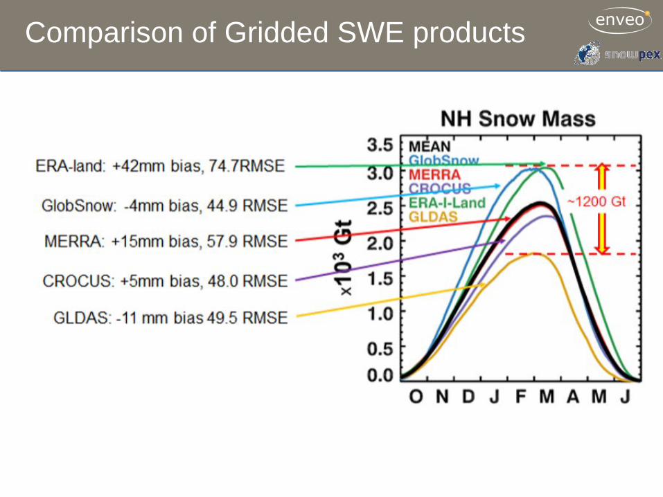
Comparison of Gridded SWE products
Conclusions
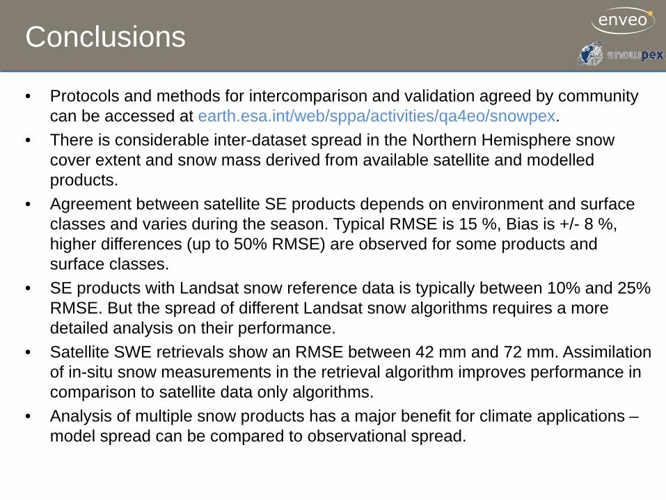
• Protocols and methods for intercomparison and validation agreed by community can be accessed at earth.esa.int/web/sppa/activities/qa4eo/snowpex.
• There is considerable inter-dataset spread in the Northern Hemisphere snow cover extent and snow mass derived from available satellite and modelled products.
• Agreement between satellite SE products depends on environment and surface classes and varies during the season. Typical RMSE is 15 %, Bias is +/- 8 %, higher differences (up to 50% RMSE) are observed for some products and surface classes.
• SE products with Landsat snow reference data is typically between 10% and 25% RMSE. But the spread of different Landsat snow algorithms requires a more detailed analysis on their performance.
• Satellite SWE retrievals show an RMSE between 42 mm and 72 mm. Assimilation of in-situ snow measurements in the retrieval algorithm improves performance in comparison to satellite data only algorithms.
• Analysis of multiple snow products has a major benefit for climate applications – model spread can be compared to observational spread.
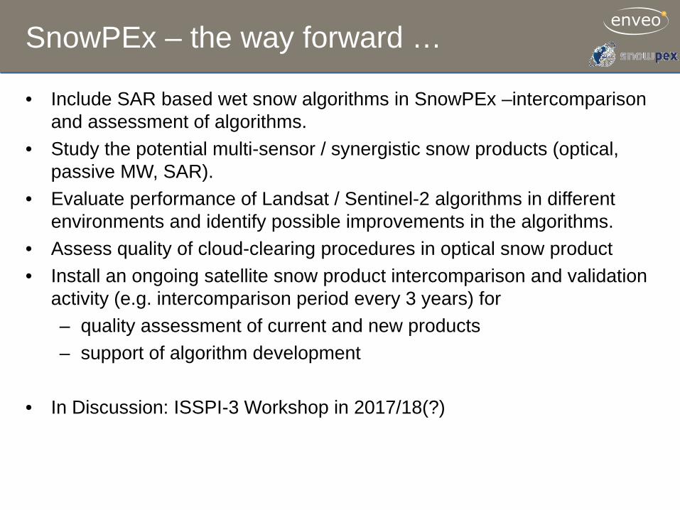
SnowPEx – the way forward …
• Include SAR based wet snow algorithms in SnowPEx –intercomparison and assessment of algorithms.
• Study the potential multi-sensor / synergistic snow products (optical, passive MW, SAR).
• Evaluate performance of Landsat / Sentinel-2 algorithms in different environments and identify possible improvements in the algorithms.
• Assess quality of cloud-clearing procedures in optical snow product • Install an ongoing satellite snow product intercomparison and validation
activity (e.g. intercomparison period every 3 years) for – quality assessment of current and new products – support of algorithm development
• In Discussion: ISSPI-3 Workshop in 2017/18(?)