Embed Size (px)
Citation preview
67The spatial deconcentration of housing resources in Warsaw, 1945-2008
AbstractCrucial aspects of geographical research are the characterisation of the evolution of distributions as a phenomenon in urban space, as well as the search for interpretations of observed changes. This article presents a new approach to deconcentration studies concerning the local conditions underpinning this global process. Locally-based changes in the spatial distribution of housing resources have been analysed using the Gini Index and an original modification to the Partial Synthetic Contribution Index. The conducted analysis provided an explicitly geographical framework around which to model spatial diversity of the deconcentration process, and allowed for the elabo-ration of an original typology for different parts of Warsaw from the urban-planning point of view.
Key wordsinternal city structure ∙ housing ∙ city life-cycles ∙ deconcentration ∙ typology of urban areas ∙ Gini Index ∙ Warsaw
For many years now, an important thrust to geographi-cal research has involved researchers in characterising the evolution of ways in which selected phenomena are distributed across urban space, as well as inter-preting any changes that are observed. The degree to which given features (land-use functions, social and other categories) are concentrated across space is considered by almost all of the more important con-cepts and theories seeking to account for the spatial processes ongoing within cities. This has been visible in the work of representatives of the Chicago School, and in theories of urban land use, as well as in studies devoted to the modelling of population density config-urations and spatial diffusion, or else concepts relating to city life-cycles.
The fact that analyses of the housing situation are of such major importance to socio-spatial research fol-lows from the way in which land use can be seen as the element to a city’s internal structure that reacts most rapidly to change (Conzen 1960). The occupation of new areas of land by housing construction can thus be
regarded as a preliminary signal and harbinger of so-cio-demographic change, since the appearance of new residential developments is associated with a city’s spatial development, and with the expansion of urban-ised land into new areas. Reference to housing density can in part explain empirically derived distance-decay models of urban population structure (Adams 1970). As housing density is closely related to population den-sity, it can offer a basis for the description of internal city structure (Klimaszewska-Budzynowska 1977).
In the Polish capital, Warsaw, it is possible to find many examples illustrating the outward spread of resi-dential construction along the main transport routes, and hence in a manner analogous to the mode of de-velopment of different functional sectors assumed by Hoyt (1939), within the framework of a clinal model of the city. The study follows Adams’s conclusion, that better understanding of urban spatial structures can-not ignore the age and density composition of urban residential areas (Adams 1970).
However, the spatial development of housing also involves spread inwards, this entailing, not merely devel-opment within the existing administrative boundaries,
Geographia PolonicaVolume 85, Issue 1, pp. 67-80http://dx.doi.org./10.7163/GPol.2012.1.6
INSTITUTE OF GEOGRAPHY AND SPATIAL ORGANIZATIONPOLISH ACADEMY OF SCIENCES
http://www.igipz.pan.pl/
http://www.geographiapolonica.pl/
THE SPATIAL DECONCENTRATION OF HOUSING RESOURCES IN WARSAW, 1945-2008
Marcin Stępniak
Institute of Geography and Spatial OrganizationPolish Academy of SciencesTwarda 51/55, 00-818 Warsaw: Polande-mail address: [email protected]
Introduction
Geographia Polonica 2012, 85, 1, pp. 67-80

68 Marcin Stępniak
to influence rates of concentration or deconcentration includes all the different kinds of specific event, like such catastrophes as large-scale fires, earthquakes, diseases, etc. (Korcelli 1974).
Where the spatial development of housing is con-cerned, post-war Warsaw has also displayed the tan-gible influence of the above factors on the intensity of the deconcentration process. Without doubt an event of fundamental significance to the course of concen-tration and deconcentration was the Second World War, and the destruction it brought. The intensive in-dustrialisation of the post-war period served to stimu-late migration processes. Overall, the second half of the 20th century witnessed both economic crises and periods with bull markets. A further major influence – if often hard to assess – was exerted by technologi-cal change, this concerning both housing construction itself, and the development of the road network and public transport.
To only some extent do analyses of the operations of centripetal and centrifugal forces in fact relate to changes ongoing in different parts of the city area. This is also true of work studying the influence on the deconcentration process exerted by various kinds of barrier (Yuill 1965), or else by differences in local re-sistance (Korcelli 1969). The look being taken at the citywide process from the local point of view is thus an illusory one. For the registering of phenomena ongoing on a scale that is local (i.e. that of the administrative district or else the urban-planning district) is only sig-nificant to the extent that the sum of these phenomena impact upon the processes operating at the level of the city as a whole.
Equally, there are few studies seeking to determine the share in city-wide processes that is accounted for by changes ongoing in particular (individual) parts of that given urban area. Such studies were rather the domain of social ecologists’ work, and they were based on the concept of natural areas (Zorbaugh 1926; Park 1936), out of which there eventually took shape the concept of social areas (Shevky & Bell 1955). This in turn offered a foundation for a whole broad current of studies into socio-spatial structures of cit-ies, that also appeared in Poland (Węcławowicz 1975, 1988; Jagielski 1978; Gaczek 1979; Kłopot 1992; Rykiel 1999), not least even in recent years (Zborowski 2005; Smętkowski 2009; Marcińczak & Sagan 2011, Marcińczak et al. 2012).
That said, it would seem that the concepts more helpful to the analysis contained in this article have been those arising out of urban morphology research, and most especially that relating to land-use succes-sion in the city. At the outset, the term ‘succession’ was employed in the broad sense, combining consid-eration from the point of view of a group of people in transit, as well as in relation to a given area. How-ever, with time, the two conceptualisations diverged from one another. The first, focusing as it does on the shift a given social group makes within a city, became a domain of sociology, while the second – above all studying land-use changes – a focus of attention for geographers (Korcelli 1974).
but also the filling-in of gaps still to be found in ar-eas already built up. In this regard, what has been noteworthy in Warsaw is the size of the individual de-velopments concerned. It has not merely been single buildings involved, or small groups of buildings in-fill-ing open spaces – as one might find in Western cit-ies, for example; but rather whole residential estates, sometimes comprising thousands of buildings. What is more, the phenomenon has concerned, not only the central part of Warsaw, but also its peripheral districts.
For this reason, the spatial development of War-saw’s residential built-up area needs to be looked at, not only as a process whose consequence is an ex-panded urbanised area, but also first and foremost as a phenomenon that gives rise to evolution of the city’s internal structure. It then becomes important to under-stand the role in the overall (citywide) deconcentration process played by different parts, and the changes ongoing in them. The phenomenon thus needs to be looked at from the new perspective of the way in which city-wide processes are conditioned at local level; and it is to this question that the present article is devoted.
Deconcentration processes and the evolution of urban morphology
Irrespective of whether housing development takes the form of outward expansion, or else entails a transfor-mation of function on land located within a city, the consequences still include a change in the degree of spatial concentration of housing resources. Indeed, the subject literature ascribes expansion, and more broadly a change in land-use structure, to the twin pro-cesses of concentration and deconcentration, these being deemed to reflect disturbances in the equilibri-um between centrifugal and centripetal forces. A city’s spatial development is the consequence of centrifugal force prevailing over centripetal, i.e. of a deconcentra-tion process (Colby 1933). We are thus dealing with a shift of both a temporal and spatial (central-to-pe-ripheral) nature, when it comes to the location of the zone of most intensive change (growth). In its wake are zones of steadily-declining scales of development (re-modelling), in line with the wave concept describing the development of a city’s spatial structure (Korcelli 1974).
Factors determining the rate of the deconcentra-tion process are assignable to one or other of four categories. The first of these is associated with succes-sive periods of economic prosperity – stimulating the deconcentration process, as well as crisis – applying a brake on the influx of people into cities. Since the lev-el of migration is one of the main factors stimulating spatial dispersion in towns and cities, the fluctuations characterising it are what mainly condition the rate of deconcentration. The factor in question has come to be linked closely with changes in people’s income levels, this conditioning the level of migration within a city (or agglomeration). A third element is taken to be technological change, first and foremost change in the transport system; while a last group of factors able
Geographia Polonica 2012, 85, 1, pp. 67-80

69The spatial deconcentration of housing resources in Warsaw, 1945-2008
n – the number of units into which the city area is divided,
P – the overall area of the city studied.
Only by converting source data in the above way was it possible to carry out a precise study whose re-sults are not influenced by differences in the areas of different analysed units.
The data resources gathered made possible the de-piction of the size and distribution of housing resourc-es at the moment of the Second World War’s end, as well as in relation to five consecutive sub-periods there-after, coinciding with:
1. the rebuilding of the capital in the aftermath of the wartime destruction, and the appearance of the first post-War housing estates (years 1945-1970);
2. post-Warsaw’s greatest housing boom, as domi-nated by the ‘large-slab’ technique used in build-ing, and the emergence of giant estates (years 1971-1978);
3. the intensifying economic crisis that also took in the building industry (years 1979-1988);
4. the change in status of the main developers from public to private, in line with the systemic transfor-mation in Poland (and in the Eastern Bloc as a whole) (years 1989-2002);
5. the accelerated development of housing construc-tion (years 2002-2008).
Housing or residential construction is taken to reflect an accumulation of housing resources in just a part of a studied area. A high level of concentration thus denotes the locating of the greater part (majority) of housing resources in a relatively small area. In these circumstances, we may refer to resources congregat-ing or being clumped together in a given area. In turn, a low level of concentration or limited concentration means a relatively even distribution of residential accommodation across a whole study area.
A similar approach is taken in the study of cities, wherein the scientific work of researchers of the so-called ‘Chicago School’ regards concentration as a pro-cess by which population gathers in a confined area (McKenzie 1926). Analogously, the deconcentration of housing resources entails people acting in such a way that a more even distribution of dwellings across a city as a whole is pursued. This is in turn the equivalent of the proportions of all a city’s dwellings present in one city district or another becoming more and more similar (evening out) as time passes. Thus capable of being considered on the same scale and in regard to the same function, concentration and deconcentration are indeed twin processes characterising phenomena in opposition to each other (Korcelli 1969: 22). The prevalence of one or the other relates to change in the distribution of housing resources across city space as a whole, in a given period.
Those seeking to describe the directions and dy-namics to changes occurring in the degree of spatial concentration of housing resources on the scale of a city as a whole have tended to make use of the Gini index or coefficient, as calculated using the formula:
In line with this way of looking at things, succession denotes a process of change involving type of land use. Taking up the definition from Hawley (1950), this is a series of events associated with the replacement over a given time period of one type of settlement or use by another. This treatment of succession as a series of separate events came to represent the conceptual basis for the creation of successional cycles (Conzen 1960). The phases to these cycles associated with population issues and within-city migrations may be related to the processes involved in the spatial devel-opment of housing (Adams 1970). This analogy may be justified in relation to the equating of the occupa-tion of new areas by successive spatial groups to spa-tial expansion of housing resources into areas in which another type of land use had hitherto been dominant. The effect of the expansion of residentially built-up are-as is to expel remaining functions from the given area. This is the case because housing displays a greater dy-namic than the other functions, and because this is an element very much desired by inhabitants, and hence exerting a powerful impact on surroundings. The thesis that may thus be advanced is that cycles of succession can be transferred across to work on the spatial devel-opment of housing, being used as a comprehensive basis for a modelled sequence of the development of housing resources that is configured locally.
Data and methods
The source of the data utilised in this article is the Polish National Census (Narodowy Spis Powszechny) of 2002, as originally obtained in detailed spatial disaggrega-tion for the 1,440 statistical areas the city of Warsaw was broken down into for census purposes. Also made use of was material from the market monitoring divi-sion of the firm REAS, which takes in housing develop-ments proceeded with in the post-census (2002-2008) period.
The first stage of the analysis saw data obtained from various different sources made uniform through aggregation at the level of the 92 areas into which Warsaw is divided from the point of view of urban planning. Furthermore, the calculation of the degree of concentration of housing resources also had to be preceded by a process relating numbers of inhabitants to areas covered by the units analysed in which they are located. To that end, use was made of the formula:
where:Mw – a standardised number of inhabitants
in unit i,Mi – the real number of inhabitants in unit i,Pi – unit’s i area,
(1)
Geographia Polonica 2012, 85, 1, pp. 67-80

70 Marcin Stępniak
of a city as a whole, it was proposed that use be made of a modified version of the Partial Synthetic Contri-bution Index (PSCI), as originally devised by Módenes (1992), which was to be calculated separately for each unit. The equation having application in this case is:
12
111
22
122
22 μn
xx
μn
xxPSCI
n
jji
n
jji
i
∑∑==
−−
−=
,
where: n – denotes the number of units
(e.g. administrative districtsor urban-planning areas,etc.) into which the studyarea (whole city) is divided,
μ1, μ2 – mean values for the proportion of the standardised number ofdwellings calculated at thebeginning (1) and end (2) of the given time interval,
xi1, xj1 as well as xi2, xj2 – values for the proportion of the standardized number of dwellings in units i and jat times (1) and (2).
Where the processes ongoing within given units bring about an increase in the degree of concentration on the scale of the city as a whole, the PSCI assumes positive values, as opposed to negative ones where their effect is a deconcentration. The greater the de-parture from zero characterising the PSCI values, then the greater their role in the overall change to the de-gree of concentration of the given phenomenon. The PSCI index offers an unambiguous insight into whether processes ongoing in a given spatial unit are reducing or increasing the degree of concentration of the given feature, while at the same time determining the mag-nitude of that role. A further advantage of the index lies in the way it takes account of all elements exerting an influence in changing the degree of concentration
μn
xxG
n
i
n
jji
21 1
2
∑∑= =
−=
,where:n – the number of fundamental units of analysis,μ – the mean value for the standardised share
of the number of dwellings present across the study area as a whole,
xi , xj – the values of this share of this standardised number in units i and j respectively (Dixon et al. 1987).
The Gini index can assume values between 0 (a per-fectly even distribution) and 1 (maximal concentration).
As the degree of concentration of housing resourc-es is calculated, it is necessary to recall that an area in which above-average housing resources are located need not form a cohesive and uniform whole. Rather, there may be several such ‘poles of concentration’ dis-tributed in various different ways across the city space as a whole (Fig. 1).
It is also worth noting that a close relationship need not necessarily pertain between the degree of concentration and locations of housing resources in the centre. Rather a given phenomenon may be char-acterised by a high degree of concentration alongside occurrence on the peripheries of the area studied only. Indeed, large housing estates accounting for a large share of overall housing are usually located on the pe-ripheries of towns and cities. The fact that other forms of land use may outcompete the residential is what ensures that city centres do not now concentrate hous-ing resources. For these reasons there is no close link between a central location and a high degree of con-centration of housing. Indeed, on the contrary, there is a justified expectation that concentrations in a central position will be low.
In attempting to answer a question as to how the phe- nomenon under study as it operates locally (i.e. within a delimited unit of area) links up with the process of deconcentration of housing resources as a property
Figure 1. The same degree of concentration caused by a different distribution of a feature.
(2)
(3)
Geographia Polonica 2012, 85, 1, pp. 67-80

71The spatial deconcentration of housing resources in Warsaw, 1945-2008
of housing, which is to say: – the participation of the housing resources located
within a given unit in relation to the overall housing resources of the whole city at the beginning of the period under study,
– the changes in the said role over the time interval addressed,
– the processes of the development of housing ongo-ing in the areas of remaining units.A three-stage method was elaborated to study the
local-level process by which housing resources decon-centrate. This offered an indication of areas in which processes having the most influence on deconcentra-tion were present. The relationship between the pro-cesses ongoing in a given area (identified fragment of urban space) and the changes in the degree of concen-tration of housing resources on the scale of the city as a whole was then analysed. The consecutive stages of the method employed entailed:1. analysis of changes in value for the standardised
(per unit area) proportion of the overall housing resource accounted for by dwellings located in the different units;
2. analysis of values of the PSCI index depicting the direction and scale of the influence changes ongo-ing locally have on the citywide deconcentration process;
3. comparison of results for the first two stages of the analysis, with a view to determining the causes underpinning the rates and directions to changes in the level of concentration of the city’s housing resource.
The process of the deconcentration of housing resourcesThe spread and augmentation of the residential built-up area
Almost 70% of the housing resources present in pre- -War Warsaw were destroyed in the course of the War (in-cluding 83% in left-bank Warsaw and 12.5% in the right-bank part of the city). The number of dwellings given over for use in the first period thereafter (i.e. 1945-1970) was mainly a reflection of the huge demand generated by the populace, while in later years being associated with the country’s economic situation above all. Reflections of this were the housing boom of the 1970s, the deep crisis of the 1980s and early 1990s, and a gradual acceleration of investment from the mid 1990s onwards.
The development of housing across Warsaw space has been associated with enlargement of the built-up residential area from the centre towards the periphery. Moreover, it has been possible to observe a clearly-out-lined city centre, initially (as of 1945) extending out as far as 2-3 km from the centre, and later (from 1970 on) around 4 km. This was related to the fact that, up until the early 1970s, housing development was limited to the area serviced by the pre-War technical infrastructure. From 1970, a second belt of residential built-up areas around 7 km out began to take shape, while from 2002 this was joined by yet a third belt some 11 km out from
the centre (Fig. 2).There was a far-from-even spatial distribution to
the wartime destruction, and hence to the locations of
available housing resources as the War ended. While the city-centre parts of Warsaw’s Śródmieście, Ochota and Wola administrative districts hardly existed at all by the War’s end (to the point that there were literally a handful of intact buildings that had come through), left-bank Warsaw retained its residential buildings in the north (Żoliborz district) and south (Mokotów). In right-bank Warsaw, the buildings of the Praga Północ (North Praga) and Targówek districts had suf-fered, while the most surviving dwellings anywhere were in the Praga Południe (South Praga) district. What that meant was that dense, typically-urban housing construction was only present some 2-3 km out from the city centre, while land more than around 5 km out was to all intents and purposes not built on at all (Fig. 3A).
Equally, the process by which new housing estates were sited immediately after the War (in the decade 1945-1955) was confined by the presence (or absence) of outfitting in pre-War technical infrastructure. Up un-til the late 1970s, new housing resources thus arose first and foremost in the central part of left-bank War-saw. Only a few developments proceeded in what are today’s peripheral districts (Fig. 3B). However, from the 1970s onwards, the limit on the available number of new areas for development in the city centre ensured that new estates first took in sites adjacent to those already built on, with the result that the city grew to-wards its peripheries. In the 1970s, the large estates put up mainly using the ‘large slab’ technology ap-peared in the west (at Bemowo), the north (Bielany) and the north-east (Targówek). In the 1980s, the list grew to include Ursynów in the south (Fig. 3C). From the early 1990s onwards, the development located peripherally (as in Białołęka, Ursynów and Ursus) was accompanied by a process of the infilling of gaps in the city centre’s built-up area (Fig. 3D).
On the eve of Poland’s systemic transformation, the central part of Warsaw was already largely built
Figure 2. Housing density in Warsaw in the years 1945-2008 according to concentric rings (1 km radius).Source: based on census 2002 (Central Statistical Office of Poland) and REAS Sp. z o.o.
Geographia Polonica 2012, 85, 1, pp. 67-80

72 Marcin Stępniak
Citywide deconcentration
The work carried out reveals a high degree of concen-tration of housing at the moment the Second World War ended (Tab. 1). Equally, for all the periods studied it was possible to observe ongoing deconcentration, while the calculated changes in values for the Gini In-dex allow for the identification of periods of greater or lesser intensity of the process. It was possible to detect a clear link between the rate of deconcentration and the scale of development, the size of already-existing resources and the location of new developments.
up. The presence of unutilised free areas above all re-flected the maintenance of large reserves of land by state-owned enterprises, as well as the presence of workers’ allotments well inside the city limits. In the post-War period, housing-estate construction was of rather a dispersed nature, with large areas not built on, not merely between housing estates, but also with-in them. It was thanks to the existence of reserves that it continued to be possible at all for new dwellings to be erected in the central part of the city.
Figure 3. Housing density (1000 dwellings per km2) in the years 1945 (A), 1970 (B), 1988 (C) and 2008 (D).Source: based on census 2002 (Central Statistical Office of Poland) and REAS sp. z o.o.
Geographia Polonica 2012, 85, 1, pp. 67-80

73The spatial deconcentration of housing resources in Warsaw, 1945-2008
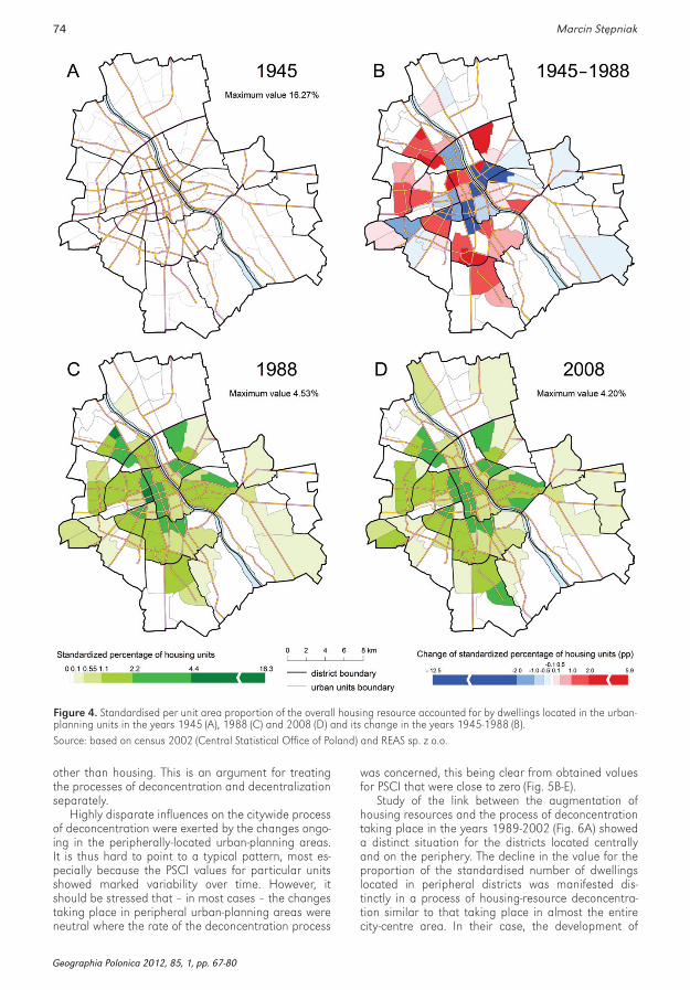
administrative districts. However, any depiction of the distribution of housing would inter alia show very great disparities when it came to the degree to which the different areas were built-up internally. This is for example revealed in the fact that urban-planning dis-tricts located in south and west Mokotów and Wola have values for the proportion of the standardised number of dwellings that are markedly lower than those in other units, including some found within the administrative districts mentioned (Fig. 4A).
The areas of decreasing share of total housing re-sources in the years 1945-1988 were mainly located in the southern part of left-bank Warsaw’s city centre, as well as in the central part of Praga (Fig. 4B). The de-velopment of housing resources beyond the Vistula’s left bank proceeded in both northerly and southerly directions, as well as almost throughout South Praga (and hence in the south-eastern part of Warsaw’s city centre). In a few cases this even encroached upon land beyond the boundaries of the central administrative districts. This became a prevalent phenomenon from 1989 onwards, leading to an extension of the built-up area in which housing was present – first and foremost along the main transport routes (Figs. 4C and 4D).
During the whole analysed period, the changes to the distribution of housing resources on the scale of Warsaw’s urban-planning areas are resolvable into two overall trends, i.e. a filling-in of housing construc-tion in the city’s central administrative districts, and a more general expansion of housing towards the periphery. The outward expansion pointed unambigu-ously to an ongoing deconcentration process, though the significance of new development being located in the centre was not obvious. Further analysis using the PSCI index was therefore applied.
The stimulated deconcentration of the years 1945-1970 linked up with a decline in the role the urban-planning areas played vis-à-vis the housing resources of the city as a whole – a phenomenon that could be made out most readily in the southern part of left-bank Warsaw’s city centre (Fig. 5A). In turn, the changes proceeding in most of the peripheral urban-planning districts exerted only very limited influence on the deconcentration process, as is made clear by values for the PSCI index that are close to zero. In only a few cases (mainly in the northern part of the city where the Bielany and Żoliborz districts meet) did the develop-ment and augmentation of housing resources ensure some stalling of the deconcentration process.
From the 1970s onwards, phenomena having the greatest influence on the deconcentration of housing resources went on playing out in the centre, in which most of the urban-planning areas were characterised by negative values for the PSCI (Figs. 5B-E). In sum, the changes taking place in the centre are seen to have stimulated the deconcentration of housing resources in all of the periods analysed. This phenomenon ap-plied, not only to units in which rates of development of housing were at a relatively low level in line with the high density of existing stock, but also to those in which new estates were located. This reflected the fact that newly-built housing units were mostly located in urban-planning areas hitherto devoted to functions
The highest housing construction volumes led to a marked decline in the level of concentration, by contrast to the higher volume of already-existing re-sources. The location of new development in areas which had not already been built on, usually located outside the city centre, caused a more visible decline in concentration.
The most marked decline in the value of the Gini index was noted in the years 1971-1978, in the period of the construction boom and the extension of housing on to new land, on top of what had up to then been rather limited development of housing construction in the city. The lowest rate of deconcentration was to be noted in the years 1945-1970 and 1989-2002. In the first case, this was the result of new developments be-ing located almost exclusively in the city’s central part, i.e. in already urbanised areas, while in the second (1989-2002) period in turn, the key feature was a rela-tively low rate of deconcentration of housing resourc-es, as conditioned by the three factors, i.e. (1) the large size of the resource already in existence, (2) a low level of new investment brought about by the global crisis in housing construction, and (3) the augmentation of the built-up area in the city, with a rapid rise in land prices as a consequence of a market economy having been introduced. The increase in the rate of deconcentration of housing resources in the years 2002-2008 above all reflected an enlivenment in house building, as well as the fact that most developments are located in pe-ripheral parts of the city, hitherto not subject to much management. The process analysed was not seen to be held back through the augmentation of the re-source in the city centre, or through the emergence of large housing estate in peripheral districts of Warsaw, these on several occasions ensuring that local centres of concentration of housing are formed.
Deconcentration from the local perspective
As of 1945, the great majority of Warsaw’s housing resource was concentrated in the urban-planning ar-eas that would today coincide with the city’s central
Table 1. Values of, and average absolute changes in, the Gini index for housing resources in Warsaw’s urban-planning ar-eas in the years 1945-2008
Yearly Gini index Average absolute changes
year value years values
1945 0.782
1970 0.706 1945-1970 –0,003
1978 0.648 1971-1978 –0,007
1988 0.608 1979-1988 –0,004
2002 0.586 1989-2002 –0,002
2008 0.562 2002-2008 –0,004
Source: based on census 2002 (Central Statistical Office of Poland) and REAS Sp. z o.o.
Geographia Polonica 2012, 85, 1, pp. 67-80
74 Marcin Stępniak
other than housing. This is an argument for treating the processes of deconcentration and decentralization separately.
Highly disparate influences on the citywide process of deconcentration were exerted by the changes ongo-ing in the peripherally-located urban-planning areas. It is thus hard to point to a typical pattern, most es-pecially because the PSCI values for particular units showed marked variability over time. However, it should be stressed that – in most cases – the changes taking place in peripheral urban-planning areas were neutral where the rate of the deconcentration process
was concerned, this being clear from obtained values for PSCI that were close to zero (Fig. 5B-E).
Study of the link between the augmentation of housing resources and the process of deconcentration taking place in the years 1989-2002 (Fig. 6A) showed a distinct situation for the districts located centrally and on the periphery. The decline in the value for the proportion of the standardised number of dwellings located in peripheral districts was manifested dis-tinctly in a process of housing-resource deconcentra-tion similar to that taking place in almost the entire city-centre area. In their case, the development of
Figure 4. Standardised per unit area proportion of the overall housing resource accounted for by dwellings located in the urban-planning units in the years 1945 (A), 1988 (C) and 2008 (D) and its change in the years 1945-1988 (B).Source: based on census 2002 (Central Statistical Office of Poland) and REAS sp. z o.o.
Geographia Polonica 2012, 85, 1, pp. 67-80

75The spatial deconcentration of housing resources in Warsaw, 1945-2008
Figure 5. PSCI values for urban-planning areas in the years 1945-2008.Source: based on census 2002 (Central Statistical Office of Poland) and REAS sp. z o.o.
Geographia Polonica 2012, 85, 1, pp. 67-80

76 Marcin Stępniak
housing had already reached its mature stage, to the point where it was possible to recognise con-temporary, peripherally-located centres of concen-tration of housing resources. In a similar way it was possible to qualify these districts as peripheral ones whose influence on the citywide process of decon-centration was entirely the reverse. The units in question were those in which there were already enough dwellings on the eve of Poland’s systemic transformation to ensure that the construction of further ones could curtail the deconcentration of housing resources in the city overall. The years 2002-2008 (Fig. 6B) in turn only brought increases for numbers of peripheral units with characteristics close to those typical for urban-planning areas in the central administrative districts of Warsaw. It can thus be assumed that the differences between such areas in the central and peripheral districts be-came blurred with the passage of time.
The typology of the urban-planning areas
The tracing of paths to the development of housing in the different areas allowed for the development of certain generalisations of wider application, this in turn providing for the elaboration of a typology of different parts of Warsaw from the urban-planning point of view. Specifically, the five main types of unit identified (Fig. 7) were those:
A) (almost solely in city-centre areas), with relatively high proportions of the standardised number of dwellings throughout the study period, the im-pact of the limited level of new developments nevertheless ensuring an ongoing decline in the contribution these units play to overall housing resources, which is to a say an indirect role in the deconcentration process characterising the city as a whole.
B) (mainly in central districts, but also occasionally on the periphery), displaying very intensive de-velopment in the initial period, but followed by
a stagnation that has led to a steady decline in the overall contribution the given areas’ housing resources make – at the time of completion of the research (2008), these areas had ‘stalled’ and were awaiting new development impulses;
C) in which housing construction has taken place to only a very limited extent, with the scale of new development being very small; these being large areas of transport-related, industrial or ex-industrial space not devoted to housing, with the result that their impact on deconcentration is not significant;
D) (solely in peripheral districts), in which housing estates only appeared at all in recent years, giv-ing rise to an initial stimulation and then sub-sequent easing of the deconcentration process;
E) (spread across the city space), in which some of the largest housing developments in the last few years (2002-2008) were sited – these were at the
same time areas in which housing was already well-developed previously, with the result that further augmentation served to curtail the city-wide process of the deconcentration of housing resources.
A proposal for a locally-conceptualised model sequence of housing-resource development
By referring to data portraying variability to the num-bers of dwellings (existing resources and new develop-ments), as well as values of the PSCI index, it proved possible to identify (Fig. 8) seven consecutive stages to the sequence for the development of housing re-sources as conceptualised on a locality-by-locality basis, i.e. at the level of the individual urban-planning area. A synthetic description is presented in Table 2. The proposed model sequence does draw conceptu-ally on the classic successional cycle (Conzen 1960; Duncan & Duncan 1957; Griffin 1965), as looked at
Figure 6. Relation between changes in standardised (per unit area) proportion of the overall housing resource accounted for by dwellings located in the different units and PSCI values in urban-planning areas in the years 1989-2002 (A) and 2002-2008 (B).Source: based on census 2002 (Central Statistical Office of Poland) and REAS Sp. z o.o.
Geographia Polonica 2012, 85, 1, pp. 67-80

77The spatial deconcentration of housing resources in Warsaw, 1945-2008
locally, i.e. studying the successive changes ongoing in a particular, precisely-delineated area (Hawley 1950).
The most important differences between the ‘clas-sical’ successional cycles and the proposed model sequence of development lies in the way in which the different stages are distinguished, and in consequence the boundaries between them. The successional cycles are taken to begin at the time a new type of land-use appears in a given area. At the same time, the pre-sent model sequence for the development of housing
resources also takes account of the period prior to the appearance of housing in the given area en masse. This fact is reflected in the presence of a first phase of ‘anticipation’ during which a given area is not sub-ject (or is subject to only a very limited extent) to con-struction work for the purposes of housing. With time, a new management plan foreseeing the presence of housing is drawn up, hence the first phase of the proposed sequence ends as the scale of new develop-ments becomes significant enough to begin to exert an influence on the level of concentration of housing resources citywide. Implementation of the plan agreed upon at the outset results in the appearance of succes-sive developments that bring about (marked) decon-centration, to the point where the invasion phase takes over. The buildings that go up are initially monofunc-tional in the main (i.e. residential), though with time they come to be augmented by buildings discharging various service functions. The next phase entailing an increase in density begins at the moment the given area has concentrated a sufficient proportion of the city’s overall housing resource that the appearance of yet further premises starts to curtail the deconcentra-tion process in the city as a whole. Furthermore, ad-ditional developments not provided for in the original plan also take place. When an end is put to the fur-ther growth in the housing resource of a given area in which it was very well developed even hitherto, this de-
Figure 7. The typology of urban-planning areas.
Figure 8. Housing-resource development at the level of the individual urban-planning area divided into seven subsequent stages (compare with Table 2)..
Table 2. Stages to the development of housing resources at the level of the individual urban-planning areas.
Stage
Characteristics
level of development of housing resources hitherto
level of new housing development
influence on the deconcentration of housing
resources across urban space
I Anticipation very low absent or very low no influence
II Invasion low or very low very high (strong) stimulation
III Increasing density moderate slow decline in the number of new developments on land already urbanised
change of trend: stalling of the process
IV Stasis moderate low renewed stimulation or lack of influence
V Renewed development moderate high stimulation
VI Renewed increase in density high high return to curtailment
VII Saturation very high lacking or very low stimulation
Geographia Polonica 2012, 85, 1, pp. 67-80
78 Marcin Stępniak
notes the shift to the saturation stage. The lack of fur-ther development has a stimulatory effect on decon-centration of the housing resource in the overall city space. At this stage, we are dealing with two possible ‘choices’ where existing residential buildings are con-cerned – either they undergo decapitalisation, or they become subject to modernisation or revitalisation. The end of the proposed model sequence is reached when the supply of free land for further development is exhausted. The saturation phase may be identified with the final phase of the successional cycle proposed by O.D. Duncan & B. Duncan (1957), or else Griffin (1965). At the same time, the changes ongoing in the given area may entail the decapitalisation of existing resources, this linking up with the recession phase proposed by Conzen (1960) as the last phase in the successional cycle.
In relation to the period under study (1945-2008), there was no possibility of observing a full cycle of devel-opment in which all stages might be taken account of. There were certain units (centrally-located ones in particular) that were not at an initial phase of the se-quence even at the outset. Likewise, as of 2008 there were only a few urban-planning areas (again mainly central) in which the last (saturation) stage of the pro-posed sequence had been reached. In turn, a great part of the peripherally-located areas had not even reached the stage of intensive development, which may indeed never be entered into in some units, in line with functions they are serving – e.g. as green space, industrial or transport-related land. Nevertheless, in a majority of cases, it was possible to observe a shift from one stage to another where the anticipated de-velopment of housing construction was concerned.
Discussion
Differences in the development of housing resources across Warsaw space were a reflection of minimum distance from the centre on the one hand and the dis-tribution of free land capable of being built on on the other, albeit with the latter element becoming increas-ingly significant as time passed. Specifically, changes in the distribution of housing reflected: (1) stagnation on the housing market and a consequent steady decline in the share of overall housing resources present in the most intensively built-up parts of the city, (2) augmen-tation of housing construction in the central part of Warsaw, wherever the existence of free land for build-ing made this an option, and (3) the spread of hous-ing resources into new, peripherally-located areas. The dominant phenomenon entailed new housing estates coming to be located close to existing resources.
It was possible to note clear linkage between the rate at which deconcentration was ongoing and the scale of new developments, the size of existing re-sources and the localisation of new developments. The highest rate of deconcentration characterised the 1971-1978 period, the lowest in turn the years 1945-1970 and 1989-2002. Of greatest significance to the course of the process were the declines in the
role played by dwellings located in the most intensively built-up, centrally-located parts of the city area, in re-spect of the overall housing resources, as well as the spread of housing construction into new, peripherally-located areas. There was no slackening in the process of deconcentration of housing resources, as a result of the augmentation of the built-up area in the city centre or the appearance of large, peripherally-located hous-ing estates.
From the early 1970s onwards, it was possible to observe a circumstance whereby changes ongoing across almost the entire city centre area helped to fur-ther deconcentration. In contrast, phenomena able to apply a brake to the process were located here and there on the periphery of the area studied, their dis-tribution being associated with the siting of the most important (largest) housing developments in the given period, albeit with these mostly being concentrated in the vicinity of already-existing housing resources.
Regardless of the exploratory power of deconcen-tration analysis, it does not allow account to be taken of all processes relating to housing resources that take place within an urban area. This is even more impor-tant in the case of the city centres in which processes of housing redevelopment (urban renewal, moderniza-tion, etc.) occur. The analysis presented here is limited to the way in which the distribution of housing resourc-es evolves. Nevertheless, it provides a supplementary picture as regards the development of internal city structure, which can be derived from an analysis of the evolution of population density. While Clark’s model describes a city’s spatial development in relation to distance from its centre, that of Korzybski includes differentiation between sectoral zones, and the one developed by Miedvievkov allows for the delimitation of a city’s internal (Klimaszewska-Budzynowska 1977). In turn, the methodology proposed here provides in-formation as to how the locally-based development of housing resources influences citywide process of deconcentration.
The matter of concentration and deconcentration processes has been of interest to researchers since the time that work was first done in the Chicago School context. Today, the study of these processes can also be seen to encompass work concerning sustainable development (Lisowski 2005), and arising out of the concepts of the compact or dispersed city (Pacione 2001), as well as the phenomenon of urban sprawl (Duany et al. 2000). The latter can now be considered a significant problem for cities in Poland (Marszał & Stawarz 2006), while spatial decentralisation (and thus deconcentration) is now regarded as a basic fea-ture characterising cities of the future (Sagan 2002). From the point of view of the sustainable development concept, a preference ought to be shown for the con-centrated, spatially compact, city, since this can allow for the attainment of greater efficiency in the distribu-tion of goods and services, including those of a social nature (Słodczyk 2002), while the city itself exerts less-er pressure on the land around it (Hall 2001). Equal-ly, however, as the model of the concentrated city is identified with worse living conditions, it is less readily acceptable to inhabitants. The effect of this kind of at-
Geographia Polonica 2012, 85, 1, pp. 67-80

79The spatial deconcentration of housing resources in Warsaw, 1945-2008
References
ADAms j.s., 1970. Residential structure of Midwestern cities, Annals of the Association of American Geographers, vol. 60, iss. 1, pp. 37-62.
Colby C.C., 1933. Centrifugal and centripetal forces in urban geography, Annals of the Association of American Geo- graphers, vol. 23, iss. 1, pp. 1-20.
Conzen m.r.g., 1960. Alnwick, Northumberland: a study in town-plan analysis. Institute of British Geographers Publi-cation, no. 27, London: George Philip & Son, 122 pp.
Dixon P.m., weiner j., mitChell-olDs t., wooDley r., 1987. Bootstrapping the Gini coefficient of inequality. Ecol-ogy, vol. 68, no. 5, pp. 1548-1551.
DuAny A., PlAter-zyberk e., sPeCk j., 2000. Suburban nation: The rise of sprawl and the decline of the American dream. New York: North Point Press, 289 pp.
DunCAn o.D., DunCAn b., 1957. The Negro population of Chicago. A study of residential succession. Monograph Series of the Chicago Community Inventory of the University of Chicago, Chicago: University of Chicago Press, 367 pp.
gACzek w.m., 1979. Struktura przestrzeni rezydencjalnej Poznania. Studium analizy czynnikowej. Seria Geografia, vol. 4, Warszawa-Poznań: Państwowe Wydawnictwo Naukowe, 141 pp.
gAłązkA A., 1998. Sytuacja mieszkaniowa ludności aglome-racji warszawskiej w latach 1970-1988. Zróżnicowania przes- trzenne i tendencje zmian. Prace Geograficzne, no. 169, Warszawa-Wrocław: Instytut Geografii i Przestrzennego Zagospodarowania PAN, Continuo, 154 pp.
gierAńCzyk w., 2006. Dzielnice rezydencjalne w przestrze-ni Torunia. [in:] T. Marszał, D. Stawarz (eds.), Przestrzeń rezydencjalna w miastach polskich, Biuletyn KPZK PAN, no. 227, Warszawa: Komitet Przestrzennego Zagospoda-rowania PAN, pp. 68-89.
griffin t.l.C., 1965. The evolution and duplication of a pat-tern of urban growth. Economic Geography, vol. 41, no. 2, pp. 133-156.
hAll t., 2001. Urban Geography. Routledge Contemporary Human Geography Series, London: Routledge, 209 pp.
hAwley A.h., 1950. Human ecology: a theory of community structure. New York: The Ronald Press Company, 456 pp.
hoyt h., 1939. The structure and growth of residential neigh-borhoods in American cities. Washington: U.S. Governmen-tal Printing Office, 178 pp.
jAgielski A., 1978. Struktura społeczno-ekologiczna miast pol- skich a koncepcje szkoły chicagowskiej. [in:] J. Turowski (ed.), Procesy urbanizacji kraju w okresie XXX-lecia Polski Rze-czypospolitej Ludowej. Wrocław: Komitet Nauk Socjolo-gicznych PAN, Ossolineum, pp. 111-133.
titude is migration out to the suburbs (Słodczyk 2002), this in turn stimulating deconcentration. There is thus here a paradoxical situation in which active pursuit of policy by decisionmakers (e.g. local authorities) in the name of a more concentrated city may have precisely the opposite effect to what was intended.
It is inter alia for the above reason that it would seem necessary to create local centres achieving a congrega-tion of housing resources, this at the same time allow-ing for spatially dispersed (and hence deconcentrated) multifunctional residential districts to be put in place, these nevertheless being characterised by concentration internally. That said, it needs to be recalled that efforts to increase the density of housing construction may have markedly negative connotations if the process involved does not comply with the basic assumptions underpin-ning urban planning, e.g. with new designs departing markedly from the style prevailing in the given housing estate (Gierańczyk 2006).
Future work would need to expand on that done hitherto in such a way that the process of deconcentra-tion is linked up with social and economic phenomena. The spatial structure to the age of construction de-scribed in this work may be said to denote the current technical state of housing resources (Gałązka 1998), and hence also the value of dwellings (Dzieciuchowicz 2007). This might serve as a starting point for further work that would assess the conditions in which the populace lives, as these link up with concentration as perceived locally, and hence with a change in quality of life. An increase in the level of spatial concentration experienced by inhabitants may give rise to a lower-
ing of the standard of living conditions offered by the given area, this resulting (in line with the concept of the successional cycle) in a lowering of the material status of those inhabiting the given part of urban space. The actual description of such a hypothetically-existing re-lationship can be achieved using the modification of the PSCI made for the purposes of the work described here. Future studies could also be adapted to use this index in forecasting.
Acknowledgements
This article is based on a Ph.D. thesis written under the supervision of Professor Grzegorz Węcławowicz. The author would like to thank Professor Węcławowicz, as well as Professor Piotr Korcelli, Professor Andrzej Zborowski, and the anonymous referees, for their help-ful and insightful comments.
In addition, the author gratefully acknowledges the as-sistance of Kazimierz Kirejczyk, the President of REAS sp. z o.o. who provided the data on housing invest-ments in Warsaw in the period of 2002-2008.
Editors’ note: unless otherwise stated, the sources of tables and figures are the author(s), on the basis of their own research
Geographia Polonica 2012, 85, 1, pp. 67-80
80 Marcin Stępniak
© Marcin Stępniak© Geographia Polonica© Institute of Geography and Spatial Organization, Polish Academy of Sciences, Warsaw, 2012
Article first received ∙ December 2011Article accepted ∙ May 2012
PArk r.e., 1936. Human ecology. American Journal of Sociol-ogy, vol. 42, no. 1, pp. 1-15.
rykiel z., 1999. Przemiany społeczno-przestrzennej struktury Łodzi. [in:] J. Kaczmarek (ed.), Zróżnicowanie przestrzen-ne struktur społecznych w dużych miastach. XI Konwersa-torium Wiedzy o Mieście, Łódź: Katedra Geografii Miast i Turyzmu, Łódzkie Towarzystwo Naukowe, pp. 75-78.
sAgAn i., 2002. Rozproszone i podzielone miasto – problem nie tylko amerykańskiej urbanizacji. [in:] I. Jażdżewska, (ed.), Współczesne formy osadnictwa miejskiego i ich przemiany. XV Konwersatorium Wiedzy o Mieście, Łódź: Uniwersytet Łódzki. Katedra Geografii Miast i Turyzmu, Wydawnic-two Uniwersytetu Łódzkiego, pp. 45-51.
shevky e., bell w., 1955. Social area analysis: theory, illustrative application and computational procedures. Stan-ford Sociological Series, no. 1, Stanford: Stanford Univer-sity Press, 70 pp.
słoDCzyk j., 2002. Przestrzenny rozwój miast a rozwój zrówno- ważony. [in:] I. Jażdżewska (ed.), Współczesne formy osadni- ctwa miejskiego i ich przemiany. XV Konwersatorium Wiedzy o Mieście, Łódź: Uniwersytet Łódzki. Katedra Geografii Miast i Turyzmu, Łódzkie Towarzystwo Naukowe, pp. 59-66.
smętkowski m., 2009. Zróżnicowania społeczno-przestrzenne Warszawy – inercja czy metamorfoza struktury miasta? Prze- gląd Geograficzny, vol. 81, no.4, pp. 461-478.
węCłAwowiCz g., 1975. Struktura przestrzeni społeczno-gospodarczej Warszawy w latach 1931 i 1970 w świetle ana-lizy czynnikowej. Prace Geograficzne, no. 116, Warszawa: Instytut Geografii i Przestrzennego Zagospodarowania PAN, 120 pp.
węCłAwowiCz g., 1988. Struktury społeczno-przestrzenne w miastach Polski. Prace Habilitacyjne IGiPZ PAN, War- szawa-Wrocław: Instytut Geografii i Przestrzennego Za-gospodarowania PAN, Ossolineum, 264 pp.
zborowski A., 2005. Przemiany struktury społeczno-przestrzennej regionu miejskiego w okresie realnego socjal-izmu i transformacji ustrojowej (na przykładzie Krakowa). Kraków: Instytut Geografii i Gospodarki Przestrzennej UJ, 576 pp.
zorbAugh h.w., 1926. The natural areas of the city. Pub-lications of the American Sociological Society, vol. 20, pp. 188-197.
klimAszewskA-buDzynowskA O., 1977. Modele rozkła-du gęstości zaludnienia Warszawskiego Zespołu Miejskiego w latach 1879-1970. Przegląd Geograficzny, vol. 49, iss. 3, pp. 481-506.
kłoPot s.w., 1992. Kształtowanie się struktury społeczno--przestrzennej polskiego Wrocławia. [in:] J.W. Misiak (ed.), Miasta polskie w procesie przemian. Studia nad Wro-cławiem i Oleśnicą, Acta Universitatis Wratislaviensis, no. 1380, Wrocław: Wydawnictwo Uniwersytetu Wro-cławskiego, pp. 23-42.
korCelli P., 1969. Rozwój struktury przestrzennej obszarów me-tropolitalnych Kalifornii. Prace Geograficzne, no. 78, War-szawa: Instytut Geografii PAN, 124 pp.
korCelli P., 1974. Teoria rozwoju struktury przestrzennej miast. Studia KPZK PAN, no. 45, Warszawa: Komitet Przestrzen-nego Zagospodarowania Kraju PAN, 166 pp.
lisowski A., 2005. Procesy centralizacji i decentralizacji w aglomeracji warszawskiej w latach 1950-2002. Prace i Studia Geograficzne, vol. 35, Warszawa: Wydawnictwo Uniwersytetu Warszawskiego, pp. 13-45.
mArCińCzAk s., musterD s. stęPniAk m., 2012. Where the grass is greener: social segregation in three major Polish cities at the beginning of the 21st century. European Urban and Regional Studies, vol. 19, no. 4, pp. 383-403.
mArCińCzAk s., sAgAn i., 2011. The Socio-spatial re-structuring of Łódź, Poland. Urban Studies, vol. 48, no. 9, pp. 1789-1809.
mArszAł t., stAwArz D., 2006. Budownictwo mieszkaniowe w polskich miastach po 1990 r. – stan i trendy rozwoju. [in:] T. Marszał., D. Stawarz (eds.), Przestrzeń rezydencjalna w miastach polskich, Biuletyn KPZK PAN, no. 227, War-szawa: Komitet Przestrzennego Zagospodarowania Kraju PAN, pp. 8-19.
mCkenzie r.D., 1926. The scope of human ecology. [in:] E.W. Burgess (ed.), The urban community, Chicago: Uni-versity of Chicago Press, pp. 172-181.
móDenes j.A., 1992. Nuevas herramientas para el análisis de la distribución de la población y el poblamiento en el territo-rio: la Región Metropolitana de Barcelona, 1981-1991. Papers de demografia, no. 67, Bellaterra: Universitat Autonoma de Barcelona. Centre d’Estudis Demografics, 17 pp.
myDel r., 1979. Rozwój struktury przestrzennej miasta Kra-kowa. Komisja Nauk Geograficznych PAN, Wrocław: Osso- lineum, 131 pp.
PACione m., 2001. Urban geography. A global perspective. London-New York: Routledge, 663 pp.
http://rcin.org.pl