Embed Size (px)
Citation preview
THE STRATIGRAPHY AND STRUCTURE OF THE PRECAMBRIAN ROCKS
O F T H E UMANAK AREA, WEST GREENLAND
by
G. HENDERSON AND T. C. R. PULVERTAFT
A b s t r a c t The Precambrian rocks of the Umanak area have been divided into a lower, predominantly gneiss group, the Umanak Gneiss, and an upper metasediment group, the Karrat Group, which has been subdivided into two formations: the lower comprises quarzites and various schists, while the higher is a uniform metagreywacke formation at least 5 km thick. These rocks have been affected by doming, overfolding and nappe development. Structural contours have been drawn to illustrate some of the more important structural features, in particular the doming of the base of the metagreywacke formation. The rocks forming the Umanak Gneiss and the lower part of the Karrat Group have recrystallized undsr amphibolite facies conditions; the rocks that form the upper part of the Karrat Group may have recrystallized under upper greenschist facies conditions where thermal metamorphism was predominant. Evidence is given in support of the idea that the rocks of the Karrat Group represent the infilling of a geo-syncline developed on an old gneiss basement, which was subsequently reactivated.
INTRODUCTION
This is a preliminary account of the geology of the Precambrian rocks in the area between 70°45' and 72°30' N on the west coast of Greenland. The mapping was carried out in the field seasons of 1962 and '63 as part of the systematic investigation of West Greenland being undertaken by the Geological Survey of Greenland (Grønlands Geologiske Undersøgelse). Three Survey sheets at scale 1 : 100 000, accompanied by structural contour maps and cross-sections, and a detailed account of the geology are in preparation. We are grateful to the Director of the Survey, mag. scient. K. ELLITSGAARD-RASMUSSEN, for permission to publish this report.
The area to be described extends from the island of Agpat in the south to Uvkusigssat Fjord in the north, and encompasses some of the most spectacular scenery in West Greenland. Long, narrow fjords with glacier lobes from the inland ice discharging into their inner ends dissect steep Alpine terrain capped by snow and ice. Many mountains rise from sea level to a height of over 2000 m. The glaciers of this area vary greatly in productivity, one of them, Rinks Isbræ, being extremely productive. The ice-smoothed mountain faces on the sides of the fjords give a continuity of exposure seldom found in other parts of the world, but the rugged terrain that forms the interior of most of the peninsulas makes much of the region difficult of access. Fortunately the area is covered by vertical and oblique aerial photos so that it has been pos-
2 HENDERSON & PULVERTAFT: Precambrian of the Umanak area
sible to prepare reasonably comprehensive geological maps; a greatly generalized geological map at scale 1 :500 000 (PI. 1) accompanies this account.
PREVIOUS INVESTIGATIONS
This is an area of Greenland whose geology was previously known only in outline. An early account of some aspects of the geology is to be found in the diaries of the German mineralogist GIESECKE (1910), who travelled across the south-western part of the area in 1811. RINK (1853) was the first to publish a geological map; he distinguished two main formations, "the primitive rocks and the trap formation laid down above them, which trap formation partly covers and partly alternates with neptunean layers containing coal and other remains of vegetation from earlier times" (translation). STEENSTRUP (1883) subdivided the metamorphic rocks into gneiss and crystalline schists. His map shows a southern gneiss zone, a central zone with gneiss and schists, and a northern, mainly schist zone. The schists were described as "Ler- og Lerglim-merskifer" (slates and phyllites). STEENSTRUP stated that in Uvkusigssat Fjord the schists pass into gneiss, and that the transistion zone has a marbled appearance, "in that there in the schist layers are separated out thin elliptical layers, partly of quartz alone, partly of quartz in association with feldspar and mica" (translation).
KRUEGER (1928) considered that he had evidence to permit a subdivision of what was essentially STEENSTRUP'S southern gneiss area into two (Jungeres Grundgebirge, Alteres Grundgebirge). Subsequent workers in this area (NOE-NYGAARD, in ROSENKRANTZ et al., 1941, and ourselves) have been unable to accept this subdivision.
The first petro graphical account of STEENSTRUP'S crystalline schists was provided by NOE-NYGAARD (in ROSENKRANTZ et al., 1942, pp. 21-26) under the term "phyllite formation". NOE-NYGAARD draws attention to a feature that is certainly very impressive, the very great thickness of these rocks; in the area examined by him their thickness was estimated to be about 4 km.
The marble occurence on the north-west side of Agpat island was worked on at small scale during the years 1933 to 1935. In 1936 a quarry was opened at Marmorilik, on the south side of Qaumarujuk fjord, and this was in operation until 1940, the material being shipped to Denmark (GALSTER, 1937; EKLUND, 1940; BØGVAD, 1950). In 1940 the quarry was closed and the installations and equipment transferred to the coal mine at Qutdligssat on Disko island to ensure continued coal production (OLDENDOW, 1946). In the summer of 1966 small quantities of marble were quarried by a Danish firm, and are being tested in Denmark with a view to future re-opening of the quarry.
The discovery in 1938 of lead-zinc mineralization in blocks in talus at the foot of the cliffs east of the marble quarry at Marmorilik, and subsequent investigations of this occurrence are described by SØLVER (1943) and PAULY (1952); an exploration concession covering this area has now been granted to a Danish-Canadian company and evaluation of the area is in progress.
STRATIGRAPHY
The Precambrian succession in this part of Greenland is a relatively uncomplicated one inasmuch as the number of constituent lifhostratigraph-ical units is not large; these have a reasonable lateral continuity and are not so disturbed that the order of succession is in any doubt. It is thus possible to present a formal lithostratigraphical classification of the metamorphic rocks of this area. In making this classification we have adhered as far as possible to the recommendations of the INTERNATIONAL
Medd. fra Dansk Geol. Forening. København. Bd. 17 [1967] 3
SUBCOMMISSION ON STRATIGRAPHIC TERMINOLOGY (1961) and also to those of the AMERICAN COMMISSION ON STRATIGRAPHIC NOMENCLA
TURE (1961). The type localities for the proposed new formations are shown on the accompanying geological map, and a very brief description of the formations is given in the text; a more comprehensive description of the formations will be given in the detailed account of the area.
One formal lithostratigraphical name, the Agpat Formation, was introduced into the literature by KRUEGER (1928)). This was the name given to his "younger basement" (Jiingeres Grundgebirge). In accordance with the views expressed by NOE-NYGAARD (in ROSENKRANTZ et al., 1941) we are unable to accept KRUEGER'S formation. There is no recognizable lithostratigraphical unit in this area corresponding to the Agpat Formation as shown and described by KRUEGER; moreover, the discordance that, according to KRUEGER (1928, p. 119), separates his Agpat Formation from the "older" gneisses at the east end of Storøen, south of Agpat, is in fact only a structural disharmony between rocks of different competence, which have been folded together during a single phase of folding. We agree with NOE-NYGAARD that there is no suggestion of a discordance on Umanak mountain, as postulated by KRUEGER. (Both Uma-nak and Storøen are localities south of the area shown on PL 1.) Many marker horizons in the gneisses have been traced without a break from areas marked Agpat Formation by KRUEGER into areas indicated by him as "Alteres Grundgebirge" (KRUEGER, 1928, PL 8).
The metamorphic rocks of this area can be divided conveniently into two groups, a lower, predominantly gneiss group for which the name Umanak Gneiss is proposed, and an upper metasediment group for which the term Karrat Group is proposed.
The Umanak Gneiss is best developed in the area known as the Umanak Fjord in the southern part of the map, and in the region to the east, while the rocks of the Karrat Group show their best development in the inner part of Karrats Isfjord in the central part of the map.
There. are two isotopic age determinations from this district; lead-isotope determinations made by Dr. S. MOORBATH, Oxford, on galena from the mineralization in the marble near Mårmorilik gave an age of 1650 ± 80 m. y.; a K/Ar determination made by mag. scient. O. LARSEN of the Mineralogical-Geological Institute, University of Copenhagen, on biotite from a pegmatite in the gneiss south of Nunarssugssuaq gave an age of 1690 + 3 0 m . y .
The Umanak Gneiss
The predominant rock type is a light-coloured biotite-gneiss, or biotite-hornblende-gneiss of mainly granodioritic composition. The rock varies from well banded to weakly banded, and in places is homogeneous. Lit-par-Iit banding occurs frequently. Concordant and cross-cutting pegmatites are present. Thin horizons of amphibolite and augen-gneiss often provide the best means of recognizing the structure.
In the area south of Mårmorilik there is an extensive slightly dis-
4 HENDERSON & PULVERTAFT: Precambrian of the Umanak area
cordant body of a homogeneous granodiorite of generally coarse grain size, with prominent feldspar megacrysts up to 2-3 cm in length. The content of biotite and hornblende is somewhat variable and often rather high. Sphene is rather common in these rocks, and is visible as reddish brown spots up to 1-2 mm in diameter. Foliation is lacking in this body in most of the area north of Perdlerfiup kangerdlua; a foliation is found, however, in a narrow zone along the contacts, and to the south, where the body becomes thinner, it assumes the character of an augen-gneiss.
Between Perdlerfiup kangerdlua and the marble formation, there are considerable areas of a leucocratic fine-grained granite. In its eastern part the granite forms a discrete body with an easily mappable boundary but in its western part it is very much intermixed with the country rock.
In the west of Upernivik island there are broad zones of rusty-weathering biotite-garnet-sillimanite-gneiss.
Three formations have been distinguished within the Umanak Gneiss; these are: (1) the Nunataq Formation, (2) the Mårmorilik Formation and (3) the Sermikavsak Formation.
The Nunataq Formation
This formation is present low down in the gneiss sequence in the inner part of the fjord Perdlerfiup kangerdlua and extends from the Nunataq east of the end of the fjord some distance along the northern side of the fjord. In the type locality on the Nunataq amphibolite and hornblende-schist, with intercalations of semipelitic schist, are the main components of the formation. Along the southern flank of its outcrop there is a narrow zone in which a variety of metasedimentary rocks are interlayered - siliceous to semipelitic schists, quartzite, dolomite and calc-silicate, amphibolite and graphitic schist.
In the westernmost outcrop it can be seen that the formation is folded into a synform; as will be mentioned later, this synform is regarded as being the downward-facing core of a nappe, the Nunårssugssuaq nappe. A glance at the map will show that the Nunataq Formation is very much thicker in the Nunataq than to the west; it is considered that the section exposed in the Nunataq is a section across the synform, so that the true thickness is only half of what is exposed here. Apart from this however there must be a very considerable westward thinning; the true thickness in the Nunataq is about 600 m, while on the north side of the fjord to the west it is only some 100 m.
In the western part, the core of the synform is occupied by a homogeneous augen-gneiss. This has a locally well developed foliation parallel to the boundary with the rocks of the Nunataq Formation.
The Mårmorilik Formation
This formation forms extensive outcrops in the southern part of the area, and is the most important marker horizon in the Umanak Gneiss. Dolo-mitic marble, often tremolitic, dominates the formation, but at both the
Medd. fra Dansk Geol. Forening. København. Bd. 17 [1967] 5
upper and lower borders of the formation fine-grained semipelite, quartz-ite and calc-silicate intervene between marble and gneiss, and horizons of similar rocks occur within the formation.
The type locality is located inland to the south-east of Mårmorilik, where the basal part of the formation is well exposed. The succession begins with 16 m of quartzite with some calc-silicate bands and a flaggy semipelite band near the top, overlain by 25 m of flaggy semipelite containing 1 m bands of tremolite marble with phlogopite. These rocks are succeeded by about 180 m of pale grey to pale creamy brown marble, in which bands with prominent tremolite crystals are common. A pale brown phlogopite is sometimes found. The highest unit in the section examined was an 8 m band of dark grey pelitic schist containing graphite; this was seen to be succeeded by a thick sequence of marble. An isolated but excellent occurrence of current bedding in quartzite near the type locality indicates that the section is right-way-up. In the area around Mårmorilik the highest rocks visible are dark-coloured, fine-grained semi-pelites; some of the rocks forming the dark cap to the mountain east of Mårmorilik are rather siliceous, and owe their dark colour to the presence of finely disseminated graphite.
It is difficult to give any figures for primary thickness since the marble has quite clearly been subjected to very considerable tectonic thickening and thinning as a result of nappe development. The formation is very thick at Mårmorilik, but this is close to the closure of the nappe, and folds can be seen within the formation in the cliffs south of Mårmorilik. Perhaps the section inland to the south-east of Mårmorilik can be taken as a guide. In the type section there is no suggestion of repetition due to folding, and from a distance in the field, and on the s aerial photos, it seems that the sequence of regularly dipping marble continues for quite a distance across the strike from the type section. The total thickness of the formation in this area must be about 1300 m.
The Sermikavsak Formation
This formation outcrops as a prominent dark band high up in the cliffs of Alfred Wegeners Halvø, and can be traced from the western end of the peninsula eastwards as far as the glacier Kangerdluarssiip sermia. Its lower part was examined on the south side of the peninsula and was found to consist mainly of dark, compact but foliated amphibolite, with a fine to medium grain size. There is some banding according to grain size, and zones up to 50 cm thick may be striped and contain a variable amount of carbonate. Within the amphibolite there are bands of rather rusty-weathering biotite-schist. The amphibolite passes up by interbanding into banded gneiss.
The formation is rather constant in thickness (50 m to 100 m) throughout most of the outcrop length; on each side of the glacier Kangerdluarssiip sermia, however, the gneiss contains a dark zone of some considerable thickness (over 1000 m), of which amphibolite forms only a part (ca. 300 m) near the top. Much of the rest of the dark zone consists of a
6 HENDERSON & PULVERTAFT: Precambrian of the Umanak area
rusty-weathering rock, probably a biotite-schist or biotite-rich gneiss; unfortunately, this zone has not been examined at close quarters, but we have seen it through binoculars from a position on the south side of the glacier. The dark zone is separated by an area of ice from the outcrops of the Sermikavsak Formation to the west but lies approximately on strike with these outcrops; for the time being only the amphibolite at the top of the zone is assigned to the formation.
The Karrat Group
This is a group of metasediments consisting of two formations, the Qeqertarssuaq Formation (lower) and the Nukavsaq Formation (upper).
The Qeqertarssuaq Formation
This formation receives its name from the island of Qeqertarssuaq, and the type locality is the small peninsula on the eastern end of the island. It is a very varied formation; the following very brief description of a section across the formation at the type locality gives an impression of its character.
The gneiss underlying the formation shows clear evidence of its sedimentary origin; in places it is a quartzitic variety, and there is a thin development of impure marble at one level. The Qeqertarssuaq Formation is about 500 m thick on the line of section. The lower 300 m consists of interbanded rocks: quartzite and siliceous gneiss, semipelitic schist with garnet, staurolite and/or sillimanite, and amphibolite. There are two lenses of ultrabasic rock. A thin section of a specimen from one of these lenses shows a fine-grained rock consisting predominantly of tremolite, with some talc and a small amount of ore. The upper 200 m is essentially hornblende-schist. In the highest part of the unit there is interbanding with granular semipelite bands.
Vertical and lateral variations in lithology are very common in this formation. There is however one characteristic feature; its top is nearly always marked by the presence of a section of hornblende-schist.
The formation is widely and thickly developed on both sides of the fjord Kangigdleq, where it reaches its maximum thickness of about 3000 m. It is also fairly thickly developed on the peninsula between Umiåmåko Isbræ and Ingia Fjord. Outside these two areas it is only thinly developed and not mappable at the scale of the accompanying map. It is important to note however that a thin representative of this formation is present between the Nukavsaq Formation and the Umanak Gneiss in areas where no such representative is shown on the map.
In the area where the formation is most thickly developed, its lower part consists largely of thick, very pure quartzites. In the western part of Kangigdleq, however, these quartzites wedge out in, and interdigitate with, semipelitic to pelitic schists; they are also usually overlain by a zone of such schists. Carbonate rocks occur as thin marble bands, but are not common.
Medd. fra Dansk Geol. Forening. København. Bd. 17 [1967] 7
The Nukavsaq Formation
This is the most widespread formation in the whole of the area and dominates the part of the map from Alfred Wegeners Halvø northwards, giving much of the country a dark grey-brown appearance. It consists of rocks that have resulted from the metamorphism and deformation of a very great thickness of interbedded muddy sandstones (greywackes) and shales or silty shales, i. e. a greywacke suite in the sense of PETTIJOHN (1957, p. 615.)
At the type locality Nukavsaq, on the north coast of Alfred Wegeners Halvø, the formation consists of thin alternations of fine-grained granular semipelite and peltic schist, with calc-silicate lenses. The granular semi-pelite often grades up into pelitic schist. As an indication of the scale of the interbanding it can be mentioned that the total thickness of the section measured at the type locality was 6.64 m and this could be broken down for purposes of description into 21 units.
Throughout a large part of the formation the granular semipelites and pelitic schists consist essentially of quartz, plagioclase, biotite (± muscovite) and small amounts of secondary chlorite. Accessory minerals are tourmaline, apatite, ore and graphite. A major difference between these rock types is in the relative amounts of biotite, muscovite and chlorite taken together and the remaining minerals, mainly quartz and plagioclase; the granular semipelites show a predominance of quartz and plagioclase, while the pelitic schists show a predominance of micas (plus chlorite).
The calc-silicate rocks consist of quartz, actinolite, plagioclase, carbonate, biotite, chlorite and sphene, with accessory apatite and ore.
The total thickness of the formation is not known since the top is not present; along the north-west side of the fjord Kangerdluarssuk however the rocks exceed 5000 m in thickness.
The main features of this formation are in summary: (1) It is very thick, over 5000 m. (2) It consists of rhythmic alternations of two main rock types through
out its entire thickness and lateral extent. Departures from this rule are so rare as to be remarkable, rare horizons rich in graphite and pyrrhotite being the most noteworthy.
(3) The two main rock types have mineral compositions showing that they were formed from muddy sandstones and shales or silty shales. Calc-silicate bands, often lenticular in form, associated with the metamorphosed muddy sandstones may represent segregation of calcareous material during the metamorphism.
(4) The metamorphosed muddy sandstones sometimes show a grading, expressed by variation in mineral composition and texture. This grading is considered to reflect original sedimentary grading.
(5) The formation lacks: conglomerates, quartzites and carbonate rocks in any significant amounts, volcanic rocks.
These characteristics are consistent with this being a metamorphosed greywacke suite. It must be emphasized that the rocks in question are entirely metamorphic and therefore we have no wish to become involved
8 HENDERSON & PULVERTAFT: Precambrian of the Umanak area
in the controversy surrounding the term "greywacke". For a review of recent ideas in this field the reader is referred to such works as those of CUMMINS (1962), BOUMA and BROUWER (1964), and DZULYNSKI and
WALTON (1965).
STRUCTURE
The structures to be seen in the metamorphic rocks in this area are impressive by any standards. Since these structures are large and usually smooth in type, and because much of the terrain is so high, almost every fjord presents structural panoramas on a large scale. As the exposure is generally good, many of the structural details may be seen in these panoramas, and the geologist does not have to resort to conjecture as in so many other parts of the world where rocks are not nearly as well exposed.
As a way of representing some of the structures in this area, structural contour maps have been prepared at a scale of 1 : 100 000 with 100 m contour intervals; a generalized version of these, with contours at 300 m intervals (PI. 2), accompanies this account. Such maps are already extensively used in sedimentary terrain but it is seldom that conditions are favourable in metamorphic terrain. The present area is particularly amenable to this type of analysis for the following reasons.
(1) There are some persistent markers, which can be identified over wide areas.
(2) The terrain is high and rather well dissected, so that a three-dimensional view can be obtained of these markers in many parts of the area.
(3) The structures being represented are reasonably large-scale structures and not unduly complex; although the method is applicable in areas of complex folding as shown by BERTHELSEN (1960), a less complicated structural style gives a more comprehensible structural contour map.
(4) In the area containing most of the interesting structures there is a topographic base map of sufficient accuracy.
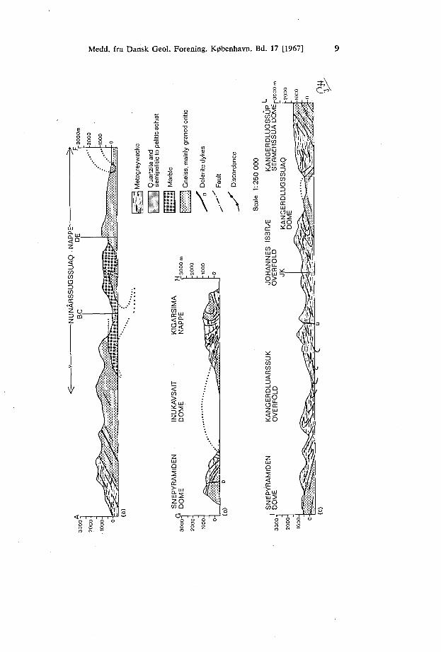
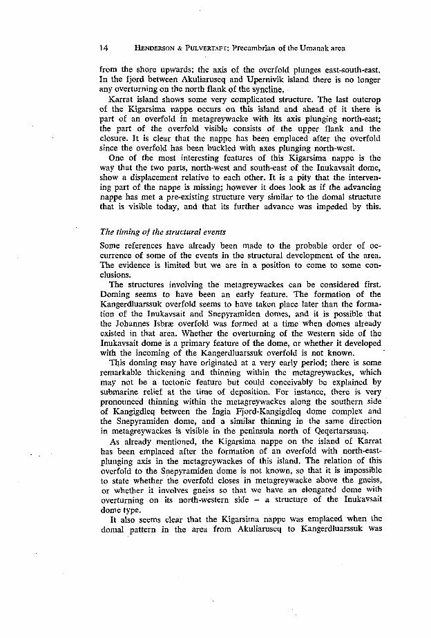
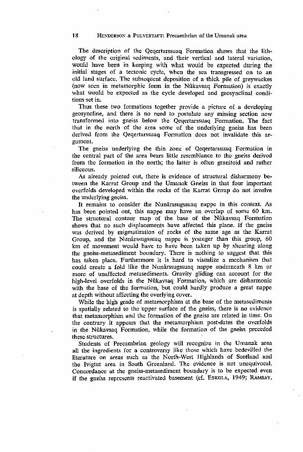
Fig. 1. Cross-sections showing the succession and the style of the structures in the Umanak area.
(a) Succession in the south of the area. Note the style of the Nunårssugs-suaq nappe with downward-facing core and tight closure of the marble.
(b) Doming and nappe development affecting gneiss and metagreywacke. Note the angular discordance below the Kigarsima nappe and the tight fold zone ahead of the nappe. The closures below the discordance belong to the recumbent syncline below the Kangerdluarssuk overfold.
(c) Doming affecting gneiss and metasediments, and overfolding within the metagreywackes. Note the refolded tight folds in the Kangerdluarssuk and Johannes Isbræ overfolds (possibly one and the same fold). The thick quartzites in the Kangerdlugssuaq dome are not present to the east.
Medd. fra Dansk Geol. Forening. København. Bd. 17 [1967] 9
Cr>\
ro o
BS. g i
I il Hl ' J
V
DDIXW
< 2
GA
RS
I A
PP
E
* z
y-
< CO
> < MJ •
INU
K
DO
M
z UJ O 2 < CC
et-UJ 5 z o CO O
O m -
m p i i
i «
\j /fur yj$ t/w f '/r1'1
flTiV?
<!$$ \ | i
i 1 i
D.UJ
»s coQ o< 3 D ^Jco
NG
ER
D
RM
ER
S:
< L U *:co
en ca CO
UjLJ
1° ^ X U J
->o
SS
UK
r r < 3 @3 So Occ Z U J
<a * 0
z UJ Q 2 < CC
Q"UJ
O
< 3 CO CO
o 3 _ 1 O CC UJ
o y j z 5
<o * Q
X ~3
i m •1 M
i i1 '!>' xK/p w 1
/{•%-"•'
(A f )\xii //i'rø (f l V« ft J Vliif 1 M
i CM,1
1 V.
1 li'ly /V/l
A1 / if Æ vå \ 1
M mi ml VM: W i
O
J
/
Z O COQ
10 HENDERSON & PULVERTAFT: Precambrian of the Umanak area
Three main markers have been used in preparing the structural contour maps: the base of the Nukavsaq Formation, the base of the Sermikavsak Formation and the base of the Mårmorilik Formation. The first of these was by far the most useful. It will not be attempted to describe each element in the structural contour map in detail; some comments on the most important aspects are however appropriate.
The Nunarssugssuaq nappe
This large nappe structure dominates the southern part of the map sheet. Its axis swings from roughly N-S on Agpat island to E-W at Mårmorilik, and the direction of transport was towards west and north. The north-east cliffs of Nunarssugssuaq present a fine panorama of the closure and lower limb of the nappe. The style of the structure in the area north of Perdlerfiup kangerdlua is shown on the cross-section Fig. 1 a.
The Mårmorilik Formation is involved in the nappe, and structural contours have been drawn on the base of the formation to illustrate the structure. In the area north of Perdlerfiup kangerdlua the marble is mainly in an upper flank position; this is confirmed by current bedding in quartzite near the type locality. At Qeqertånguit part of the closure zone is present; in this area the closure, which has a north-east axial direction, has become very sharp and has been affected by an open flexuring. South of Perdlerfiup kangerdlua the marble is mainly on the lower flank of the nappe; the sequence being inverted, the contours were therefore drawn on the top of the marble in this area. On the north-west of Agpat island, however, a well developed, smoothly rounded closure is present; this is taken as being part of the main closure of the nappe, and has a south-south-west axial plunge. For reasons that are unknown, a short distance from the closure along the upper flank of the structure the marble wedges out. The structure of the northern part of Agpat island presents problems of interpretation since there is a second marble occurrence along the north coast; the explanation that best fits the observed facts is that the eastern occurrence represents an overfold developed on the lower flank of the main nappe, but this is not proved.
Marble is present at two levels in the southern Nunataq in the southeastern corner of the map, the evidence suggesting that the two occurrences represent upper and lower flank positions. The upper flank occurrence at the inner end of the Nunataq is shown on the geological map, but the lower flank occurrence alongside the fjord is too small to represent; its position is marked by the fold axis with N-S trend on the structural contour map. The distance between this area and the closure zone suggests that the nappe may have an overlap of at least 60 km.
Finally, it can be mentioned that the core of the nappe is exposed along the northern side of Perdlerfiup kangerdlua. The foliation in the augen-gneiss mentioned earlier closes round, and there is a closure in the Nunataq Formation. In the Nunataq Formation the closure is syn-
Medd. fra Dansk Geol. Forening. København. Bd. 17 [1967] 11
formal, but is regarded as a downward-facing anticline; the axial trend in this area is E-W.
The domal structures
As can be seen from the map (PI.2) the structural contours on the base of the Nukavsaq Formation show the presence of many interesting domal structures. Certain features become apparent as soon as the structural contour map is examined. In the first place, the areal extent of the domes as expressed by the area contained within the 0 m structural contour is variable. Secondly, the form of the domes is variable; some of them are simple in their style, while others are complex. Thirdly, their distribution does not at first glance suggest any very well defined pattern.
The group of domes situated south-west of a line from Qeqertarssuaq to the inner end of the fjord Kangerdlugssuaq involve metagreywacke of the Nukavsaq Formation overlying Umanak Gneiss, with only a thin representative of the Qeqertarssuaq Formation separating these two units. No angular discordance is observable between the metagreywacke and the gneiss. If we take the Inukavsait dome as an example, the gneiss that forms the core of the dome is variably banded, part of the banding being of the lit-par-lit type. The banding in the gneiss in the zone near the boundary with the overlying metasediments is well developed; it is parallel to the boundary and to the banding in the lowest part of the metasediments. A striking feature of this Inukavsait dome is that it is overturned on its western side.
The Kangerdlugssup sermerssua dome likewise involves metagreywacke overlying a core of gneiss with only a thin representative of the Qeqertarssuaq Formation, in this case a thin amphibolite, separating the two. A curious feature to be seen just inland and north of the fjord is an abrupt bending of compositional banding in the gneiss. Inland from the gneiss/metasediment boundary, which in this area has a fairly steep dip to the west, the banding in the gneiss shows a gentle to moderate dip westwards, but as it approaches the fjord it turns abruptly downwards, becoming vertical.
The base of the Nukavsaq Formation is involved in a group of domes between Kangerlugssuaq and Ingia Fjord, but in this area a thick sequence of Qeqertarssuaq Formation separates the Nukavsaq Formation from the Umanak Gneiss. Thus one cannot in this area equate the structure of the upper surface of the gneiss with that of the base of the metagreywacke, although in the other domes described these for practical purposes are the same.
The northernmost dome in this area is the Pangnertoq dome. This shows metagreywacke overlying gneiss with a thin, discontinuous representative of the Qeqertarssuaq Formation between.
The Nungutakavsak and Qaqortukavsak overfolds
These two overfolds, although of interest in themselves, are rather small overfolds affecting the base of the Nukavsaq Formation. It is not likely
12 HENDERSON & PULVERTAFT: Precambrian of the Umanak area
that there was very much horizontal movement involved in their formation. The exposures of the Nungutakavsak overfold on the west side of Inukavsait show that a considerable amount of flowage must have taken place during the formation of this overfold. No detailed account of these folds will be given here.
Overturned folds within the Nukavsaq Formation
There are four overfolds of consequence within the metagreywackes: the Kangerdluarssuk overfold, the Johannes Isbræ overfold, the Itsakuars-suk overfold and the Uvkusigssat Fjord overfold.
The Kangerdluarssuk overfold (see cross-section Fig. 1 c) is westward-facing. In the southernmost exposure of the closure zone on the north side of Kangerdluarssuk the axis plunges north-east; in the central part of the peninsula to the north, the trend is NW-SE; in Kangerdlugssuaq the axis again plunges north-east.
In Kangerdlugssuaq the closure zone of this large overfold contains numerous tight to isoclinal folds. These are refolded around the closure of the overfold.
The Johannes Isbræ overfold (see cross-section Fig. 1 c) may be part of the Kangerdluarssuk overfold, but no immediate connection could be proved. This overfold has a N-S axial trend and westward-facing closure; like the Kangerdluarssuk overfold it shows in the closure zone numerous tight to isoclinal folds, which are refolded round the main closure. An interesting feature here is that the axis of the recumbent syncline underlying the Johannes Isbræ overfold on the southern side of the fjord Kangigdleq is not parallel to that of the overfold above, but plunges south-west. The Johannes Isbræ overfold is developed mainly in meta-greywacke, but also involves the hornblende-schist at the top of the Qeqertarssuaq Formation.
The Itsakuarssuk overfold on the west side of Qeqertarssuaq has a NW-SE axial trend and closes to the south-west; the axis is probably nearly horizontal. Some tight folds can be seen in the area of this overfold, but they are fewer than in the areas of the first two overfolds, and there are no exposures showing refolding of small folds round the main closure.
The Uvkusigssat Fjord overfold is on a smaller scale than the others. The axis has a direction slightly west of north, and the closure faces west.
The following features have a bearing on the origin of the overfolds within the Nukavsaq Formation: —
(1) The structural contour map of the base of the Nukavsaq Formation shows that there has been no substantial crustal shortening in the area of the domes since the deposition of this formation. The tight or isoclinal folding and subsequent overfolding of the metagreywackes are not therefore a response to regional compression and crustal shortening.
(2) The overfolds described occur entirely within the supracrustal rocks, mainly the metagreywackes, and do not involve the underlying gneiss.
Medd. fra Dansk Geol. Forening. København. Bd. 17 [1967] 13
(3) The swings in axial direction of the Kangerdluarssuk overfold cannot be explained as due to refolding by the Inukavsait dome. The axial swings suggest that the overfold moulded itself to a pre-existing structural pattern in the Inukavsait area.
(4) There is a lack of parallelism between the axis of the Johannes Isbræ overfold and the underlying recumbent syncline.
All these features may be explained by suggesting that the folding in the metagreywackes is due to gravity sliding during the formation of the domes.
The Kigarsima nappe
This very interesting structure (see cross-section Fig. 1 b) is a prominent feature in the western part of the area where Umanak Gneiss with a thin mantle of Qeqertarssuaq Formation and metagreywacke has been carried north-eastwards over the Nukavsaq Formation or has pushed into it like a blunt wedge. The nappe develops from a hinge on Alfred Wegeners Halvø and can be traced north-westwards as far as Karrat island. On Alfred Wegeners Halvø it seems very likely that the nappe has been emplaced as a wedge along the foliation in the metagreywacke. Immediately ahead of the nappe the metagreywackes are strongly deformed, with numerous folds and quartz rods aligned parallel to the nappe, which plunges east-south-east, and faces north-north-east. The core is formed of uniform gneiss with pronounced biotite lineation and mullion structure parallel to the axis of the closure.
In the cliffs some distance down-fjord to the south-west, the dark band of amphibolite that forms the Sermikavsak Formation can be seen to close round and wedge out on the lower flank of the closure. It is considered that this closure is part of the core of the Kigarsima nappe.
In the peninsula to the north the part of the nappe best seen is the lower flank and the closure, but part of the upper flank is present. The core is formed by gneiss, very homogeneous away from the metasediments, but well banded close to the boundary. On the east side of Inukavsait, a definite discordance was seen between the nappe and the metagreywackes below the nappe.
The nappe has been removed by erosion on the west side of Inukavsait, but is present again between north Upernivik island and Karrat island. On north Upernivik definite cut-out was observed along its base. On the Akuliaruseq peninsula and on Karrat island pronounced thinning occurs in the gneiss of the core of the nappe between the closure and the lower flank of the structure.
The structure of the rocks on the western end of Akuliaruseq is rather interesting. The top of the mountain range exhibits three klippen of the Kigarsima nappe. These overlie the syncline between the Snepyramiden dome and the Akuliaruseq-Upernivik structural high; the core of the syncline is metagreywacke and the flanks are gneiss, with some amphibolite at the contact. On the west side of Akuliaruseq the northern flank of the structural high is an overturned fold, and on the coast the boundary between gneiss and metasediments can be seen to close gradually round
14 HENDERSON & PULVERTAFT: Precambrian of the Umanak area
from the shore upwards; the axis of the overfold plunges east-south-east. In the fjord between Akuliaruseq and Upernivik island there is no longer any overturning on the north flank of the syncline.
Karrat island shows some very complicated structure. The last outcrop of the Kigarsima nappe occurs on this island and ahead of it there is part of an overfold in metagreywacke with its axis plunging north-east; the part of the overfold visible consists of the upper flank and the closure. It is clear that the nappe has been emplaced after the overfold since the overfold has been buckled with axes plunging north-west.
One of the most interesting features of this Kigarsima nappe is the way that the two parts, north-west and south-east of the Inukavsait dome, show a displacement relative to each other. It is a pity that the intervening part of the nappe is missing; however it does look as if the advancing nappe has met a pre-existing structure very similar to the domal structure that is visible today, and that its further advance was impeded by this.
The timing of the structural events
Some references have already been made to the probable order of occurrence of some of the events in the structural development of the area. The evidence is limited but we are in a position to come to some conclusions.
The structures involving the metagreywackes can be considered first. Doming seems to have been an early feature. The formation of the Kangerdluarssuk overfold seems to have taken place later than the formation of the Inukavsait and Snepyramiden domes, and it is possible that the Johannes Isbræ overfold was formed at a time when domes already existed in that area. Whether the overturning of the western side of the Inukavsait dome is a primary feature of the dome, or whether it developed with the incoming of the Kangerdluarssuk overfold is not known;
This doming may have originated at a very early period; there is some remarkable thickening and thinning within the metagreywackes, which may not be a tectonic feature but could conceivably be explained by submarine relief at the time of deposition. For instance, there is very pronounced thinning within the metagreywackes along the southern side of Kangigdleq between the Ingia Fjord-Kangigdleq dome complex and the Snepyramiden dome, and a similar thinning in the same direction in metagreywackes is visible in the peninsula north of Qeqertarssuaq.
As already mentioned, the Kigarsima nappe on the island of Karrat has been emplaced after the formation of an overfold with north-east-plunging axis in the metagreywackes of this island. The relation of this overfold to the Snepyramiden dome is not known, so that it is impossible to state whether the overfold closes in metagreywacke above the gneiss, or whether it involves gneiss so that we have an elongated dome with overturning on its north-western side - a structure of the Inukavsait dome type.
It also seems clear that the Kigarsima nappe was emplaced when the domal pattern in the area from Akuliaruseq to Kangerdluarssuk was
Medd. fra Dansk Geol. Forening. København. Bd. 17 [1967] 15
established, and it would seem probable that the Nungutakavsak' and Qaqortukavsak overfolds also preceded the Kigarsima nappe.
A tentative scheme for the order of events can thus be given: (1) Dome formation. (2) Formation of the Kangerdluarssuk and Johannes Isbræ overfolds,
and perhaps of the Itsakuarssuk and Uvkusigssat Fjord overfolds. All of these structures could have been formed by gravitational gliding. The overturning of one side of the Inukavsait dome and the development of the Qaqortukavsak overfold might belong to the later stages of this period.
(3) Formation of the Kigarsima nappe, probably slightly preceded by the overturning of part of the southern flank of the syncline between the Snepyramiden dome and the Akuliaruseq-Upernivik structural high, and also by the development of the Nungutakavsak overfold.
The Nunårssugssuaq nappe must be considered on its own. No connection has been observed between this nappe structure and any structures farther north.
Mineral lineation
Biotite lineation is found throughout much of the Nukavsaq Formation over the entire area in which it is exposed. In contrast to the wide spread of axial directions of major and minor folds, the trend of the biotite lineation is everywhere between ESE-WNW and E-W. A single exception was found in Uvkusigssat Fjord near Qaersorssuaq where biotite lineation plunging south-west was seen. Clearly the biotite lineation has no direct relation to any folds, and it is possible that it bears a closer relation to the regional stress field in the metagreywackes at the time of recrystalliza-tion than do any of the folds.
METAMORPHISM
The rocks of the Umanak Gneiss have recrystallized under amphibolite facies conditions; the quartzofeldspathic gneisses commonly contain hornblende crystals, and this mineral is characteristic of mafic bands in the gneiss, which are typified by the following assemblages:
plagioclase + hornblende + diopside plagioclase + hornblende + biotite + quartz.
Garnet is common in mafic bands in the southern part of the Umanak area. Calc-silicate rocks, found mainly in the Mårmorilik Formation but also in the Nunataq Formation, invariably contain diopside or tremolite. Pelitic and semipelitic rocks less frequently contain diagnostic assemblages, but on Upernivik island garnet and sillimanite are characteristic of the pelitic gneiss.
More interesting metamorphic rocks occur in the Nunataq Formation, where dolomitic schist has locally been altered to cordierite-anthophyllite-schist. Nearby a quartz-plagioclase-biotite-cummingtonite-garnet-schist was
16 HENDERSON & PUL VERT A.FT: Precambrian of the Umanak area
found. An E-W zone of retrograde metamorphism runs through the Nunataq and within this the hornblende schist and amphibolite have been reduced to greenschists.
The lowest formation in the Karrat Group, the Qeqertarssuaq Formation, has also recrystallized under amphibolite facies conditions. Staurolite and garnet are characteristic components of the semipelitic and pelitic schists, and either or both of these minerals may be accompanied by sillimanite. The hornblende-schist and amphibolite layers are made up of various combinations of the following minerals: hornblende, plagioclase, quartz, biotite, diopside, carbonate, sphene.
The zone of the Nukavsaq Formation closest to the base of the formation in areas where the Qeqertarssuaq Formation is thin generally shows a much coarser recrystallization than does the main part of the formation; sillimanite and garnet are prominent. This part of the formation has recrystallized under amphibolite facies conditions. Garnets extend higher up in the formation than does sillimanite; rare garnets were found at the type locality and on either side of Kangerdlugssuaq. At a single locality in the inner part of Ingia Fjord, staurolite and kyanite were found in pelitic layers in this formation.
As mentioned earlier, in the main part of the formation the assemblage typical of the granular semipelites and pelitic schists is quartz + plagioclase + biotite ± muscovite. Dr. H. MICHEELSEN of the Mineralogical-Geological Institute of the University of Copenhagen, has kindly determined the composition of plagioclase grains in samples from this formation, on the basis of their refractive indices. All but one of the samples of granular semipelite and pelitic schist contain plagioclase within the range An25-35, but the plagioclase in one sample showed a composition An.ji-48. There is no relation between the plagioclase composition and the position in the formation.
Plagioclase from a calc-silicate band at the type locality proved to be very calcic, with a composition 88 + 4 % An. The assemblage generally found in the calc-silicate layers is quartz + plagioclase + actinolite + carbonate.
The lack of diagnostic assemblages in the main part of the Nukavsaq Formation makes it difficult to define the metamorphic facies. The significant facts are: a) the plagioclase composition - An25_35 - in the semipelitic and pelitic rocks; b) the ubiquitous development of biotite, with chlorite only appearing as a secondary mineral; c) the lack of aluminosilicates in the pelites, and lack of diopside in the calc-silicate layers.
These indicate that the rocks must be at least in the upper greenschist facies, but if the facies is not still higher the metamorphism must have been mainly thermal in origin to account for the plagioclase composition (see WINKLER, 1965, pp. 98-105). On the other hand, the development of sillimanite directly from muscovite, without the intervention of anda-lusite, near the base of the formation suggests that with the increase in grade here the role of pressure became more important.
The amphibolite facies metamorphism in the Umanak Gneiss and lower
Medd. fra Dansk Geol. Forening. København. Bd. 17 [1967] 17
part of the Karrat Group outlasted the.main fold movements. Neither platy nor prismatic minerals show any deformation. Garnets in the Qeqertarssuaq Formation frequently have rolled cores mantled by featureless garnet, showing that crystallization began during deformation and continued (or was resumed) after movement had ceased. Staurolite in the same rocks is often poikiloblastic, the fabric of the matrix proceeding undisturbed through the crystals.
THE RELATION OF THE UMANAK GNEISS TO THE SUPRACRUSTALS OF THE KARRAT GROUP
It is not immediately obvious whether the Umanak Gneiss was derived by migmatization of the lower supracrustals of the Karrat Group or instead represents the basement on which the Karrat Group was deposited. This question is important to Precambrian stratigraphy and will therefore be discussed briefly now, although proof of the correct answer must await successful Rb/Sr age determinations or the advent of more refined age-determination techniques. In favour of the first alternative the following facts may be cited.
The banding at the top of the Umanak Gneiss is everywhere concordant with that at the base of the Karrat Group and, in the central part of the area, with the border between these groups.
In the area between Kangigdleq and Pangnertoq the base of the Qeqertarssuaq Formation interdigitates with gneiss and there are many metasediment relics within the upper part of the gneiss, which is often a veined gneiss. No discordances were observed here.
The grade of metamorphism in the supracrustal rocks increases towards the boundary with the Umanak Gneiss. An exception is at the head of Kangerdluarssuk, where later shearing at this boundary has resulted in retrograde metamorphism of the thin zone of Qeqertarssuaq Formation and the immediately overlying rocks of the Nukavsaq Formation.
In the northern part of the area, in and around the Pangnertoq dome, there is intense veining of the rocks of the Karrat Group and of the underlying gneiss, as has already be commented on by STEENSTRUP (1883). The veins, some of which attain a considerable thickness, consist of pegmatite or fine-grained granite. Some of them are concordant with the banding in the rocks and in some folds can be seen following the banding round the fold; others are completely discordant to the banding. A replacive origin is suggested for some veins, but others are without a doubt of dilatational type.
In Kangigdleq and west of Umiåmåko Isbræ the gneiss underlying the Karrat Group rocks is extensively veined, but the only veining of supracrustal rocks south and south-east of Ingia Fjord takes the form of scattered tourmaline-bearing pegmatites near the contact with the Umanak Gneiss.
Favouring the suggestion that the Umanak Gneiss represents the basement on which the Karrat Group was deposited the following may be said.
18 HENDERSON & PLTLVERTAFT: Precambrian of the Umanak area
The description of the Qeqertarssuaq Formation shows that the lith-ology of the original sediments, and their vertical and lateral variation, would have been in keeping with what would be expected during the initial stages of a tectonic cycle, when the sea transgressed on to an old land surface. The subsequent deposition of a thick pile of greywackes (now seen in metamorphic form in the Nukavsaq Formation) is exactly what would be expected as the cycle developed and geosynclinal conditions set in.
Thus these two formations together provide a picture of a developing geosyncline, and there is no need to postulate any missing section now transformed into gneiss below the Qeqertarssuaq Formation. The fact that in the north of the area some of the underlying gneiss has been derived from the Qeqertarssuaq Formation does not invalidate this argument.
The gneiss underlying the thin zone of Qeqertarssuaq Formation in the central part of the area bears little resemblance to the gneiss derived from the formation in the north; the latter is often granitoid and rather siliceous.
As already pointed out, there is evidence of structural disharmony between the Karrat Group and the Umanak Gneiss in that four important overfolds developed within the rocks of the Karrat Group do not involve the underlying gneiss.
It remains to consider the Nunårssugssuaq nappe in this context. As has been pointed out, this nappe may have an overlap of some 60 km. The structural contour map of the base of the Nukavsaq Formation shows that no such displacements have affected this plane. If the gneiss was derived by migmatization of rocks of the same age as the Karrat Group, and the Nunårssugssuaq nappe is younger than this group, 60 km of movement would have to have been taken up by shearing along the gneiss-metasediment boundary. There is nothing to suggest that this has taken place. Furthermore it is hard to visualize a mechanism that could create a fold like the Nunårssugssuaq nappe underneath 8 km or more of unaffected metasediments. Gravity gliding can account for the high-level overfolds in the Nukavsaq Formation, which are disharmonic with the base of the formation, but could hardly produce a great nappe at depth without affecting the overlying cover.
While the high grade of metamorphism at the base of the metasediments is spatially related to the upper surface of the gneiss, there is no evidence that metamorphism and the formation of the gneiss are related in time. On the contrary it appears that the metamorphism post-dates the overfolds in the Nukavsaq Formation, while the formation of the gneiss preceded these structures.
Students of Precambrian geology will recognize in the Umanak area all the ingredients for a controversy like those which have bedevilled the literature on areas such as the North-West Highlands of Scotland and the Ivigtut area in South Greenland. The evidence is not unequivocal. Concordance at the gneiss-metasediment boundary is to be expected even if the gneiss represents reactivated basement (cf. ESKOLA, 1949; RAMSAY,
Medd. fra Dansk Geol. Forening. København. Bd. 17 [1967] 19
1963; WINDLEY et al., 1966). An increase in the grade of metamorphism in the supracrustals as the gneiss is approached would also be expected in such circumstances. Clearly there has been an intensification of plu-tonic activity northwards with partial migmatization of the Qeqertarssuaq Formation in the Umiåmåko-Pangnertoq area and granite veining of the supracrustals in Uvkusigssat Fjord. This is understandable as increasing reactivation and eventual anatexis of the basement.
On the other hand structural disharmony between the supracrustal and infracrustal rocks may be explained by suggesting that these are two "stockwerke" developed during the deformation of a single sedimentary pile, an interpretation similar to that proposed by HALLER (1962) for the Caledonides of East Greenland, and to the ideas advanced by WEGMANN (1935).
We favour the view that the Umanak Gneiss is the product of reactivation of the basement on which the Karrat Group was deposited. The difficulties of reconciling the structures in the gneiss with those of the base of the Nukavsaq Formation and within this formation on any other assumption seem greater than those arising from the preferred explanation.
The lithostratigraphical succession established by us and the existence and form of the major structures, will be in no way affected by the outcome of this discussion. The isotopic age determinations, although both obtained on samples from within the Umanak Gneiss, almost certainly do not give the date of the formation of the gneiss; in all probability they date the close of thermal activity in the area as a whole, an activity that affected both the Umanak Gneiss and the Karrat Group.
Note added in proof:
Since this paper went to press three new K-Ar age determinations have been made on rocks from the Umanak area. These gave results of 1700 and 1730 m. y. for schists from the Karrat Group, and 1760 m. y. for a sample of Umanak gneiss, confirming the above suggestion. (LARSEN, O., 1966. Rapp. Grønlands geol. Unders., Nr. 11, 57-67).
REFERENCES
AMERICAN COMMISSION ON STRATIGRAPHIC NOMENCLATURE, 1961. Code of stratigraphic nomenclature.—Bull. Amer. Ass. Pet. Geol. Vol. 45, No. 5, 645-665.
BERTHELSEN, A., 1960. Structural contour maps applied in the analysis of double fold structures.—Geol. Rdsch., Bd. 49, 459-466.
BOUMA, A. H. and BROUWER, A. (editors), 1964. Turbidites.—Developments in sedimentology 3. Elsevier, Amsterdam.
BØGVAD, R., 1950. Grønland som mineralproducerende land.—In: BIRKET-SMITH, K., MENTZE, E., FRIIS MØLLER, M. (editors), Grønlands Bogen, 95-120. J. H. Schultz Forlag, Copenhagen.
CUMMINS, W. A., 1962. The greywacke problem.—Lpool Manchr geol. J., Vol. 3, 51-72.
DZULYNSKI, S. and WALTON, E. K., 1965. Sedimentary features of flysch and greywackes.—Developments in sedimentology 7. Elsevier, Amsterdam.
20 HENDERSON & PULVERTAFT: Precambrian of the Umanak area
EKLUND, O., 1940. Marmorbrytningen på Nordw'åstgronland.—Tek. Tidskr., Stockh., Årg. 70, Hafte 2, 5-7.
ESKOLA, P. 1949. The problem of mantled gneiss domes.—Quart. J. geol. Soc. Lond., Vol. 104, 461-476.
GALSTER, J., 1937. Grønlandsk Marmor. Forsøgsbrydninger i UmånaK Distrikt.—Grønl. Selsk. Aarsskr., 1937, 5-18.
[GIESECKE, K. L.], 1910. Karl Ludwig Gieseckes mineralogisches Reisejournal iiber Gronland, 1806-1813.—Medd. Grønland, Bd. 35.
HALLER, J., 1962. Structural control of regional metamorphism in the East Greenland Caledonides.—Proc. geol. Soc. Lond., No. 1594, 21-25.
INTERNATIONAL SUBCOMMISSION ON STRATIGRAPHIC TERMINOLOGY, 1961. Strati-graphic classification and terminology.—Rep. 21st Intern, geol. Congr. Norden, Part 25.
KRUEGER, H. K. E., 1928. Zur Geologie von Westgronland, besonders der Urn-gebung dsr Diskobucht und d3s Umanak-Fjordes.—Medd. Grønland, Bd. 74, 97-136.
OLDENDOW, K., 1946. Administrationen: Grønlands Styrelse i Besættelsesaarene. —Grønl. Selsk. Aarskr., 1946, 13-34.
PAULY, H. 1952. En undersøgelse af »Sorte engel« ved Marmorilik, samt nogle bsmærkninger om magnetkisforekomsterne i Umanak distrikt i Nordgrønland.—Medd. dansk geol. Foren., Bd. 12, 191-192.
PETTUOHN, F. J., 1957. Sedimentary rocks.—Harper and Brothers, New York. RAMSAY, J. G., 1963. Structure and metamorphism of the Moine and Lewisian
rocks of the North-West Caledonides.—In: JOHNSON, M. R. W. & STEWART, F. H. (editors), The British Caledonides. 143-175. Oliver & Boyd, Edinburgh & London.
RINK, H., 1853. Udsigt over Nordgronlands Geognosi, især med Hensyn til Bjergmassernes mineralogiske Sammensætning.—K. danske Vidensk. Selsk. Skr., 5 Række Naturv. math. Afd., Bd. 3, 71-98.
ROSENKRANTZ, A., NOE-NYGAARD, A., GRY, H., MUNCK, S. and LAURSEN, D., 1941. [Nugssuaq Ekspeditions geologiske Resultater]—Medd. dansk geol. Foren., Bd. 9, 654-663.
ROSENKRANTZ, A., NOE-NYGAARD, A., GRY, H., MUNCK, S. and LAURSEN, D., 1942. A geological reconnaissance of the southern part of the Svartenhuk peninsula West Greenland.—Medd. Grønland, Bd. 135, Nr. 3.
STEENSTRUP, K. J. V., 1883. Bidrag til Kjendskab til de geognostiske og geo-graphsike Forhold i en Del af Nord-Grønland.—Medd. Grønland, Bd. 4, 173-255.
SØLVER, S. V., 1943. Flotationsforsøg med en BIy-Zink-Pyrit-Malm fra Grønland.—Ingeniøren, Aarg. 52, K61-K63.
WEGMANN, C. E., 1935. Zur Deutung der Migmatite.—Geol. Rdsch., Bd. 26, Heft 1, 305-350.
WINDLEY, B. F., HENRIKSEN, N., HIGGINS, A. K., BONDESEN, E. and JENSEN, S. B., 1966. Some border relations between supracrustal and infracrustal rocks in South-West Greenland.—Rapp. Grønlands geol. Unders., Nr. 9.
WINKLER, H. G. F., 1965. Petrogenesis of metamorphic rocks.—Springer-Verlag, Berlin.
Medd. fra Dansk Geol. Forening. [1967] HENDERSON and PULVERTAFT GRØNLANDS GEOLOGISKE UNDERSØGELSE
THE GEOLOGICAL SURVEY OF GREENLAND PLATE 2.
Medd. fra Dansk Geol. Forening. [1967] HENDERSON and PTJLVERTAFT
GRØNLANDS GEOLOGISKE UNDERSØGELSE THE GEOLOGICAL SURVEY OF GREENLAND