Embed Size (px)
Citation preview

THE TERMINAL WOODLAND: EXAMINING LATE OCCUPATION ON MOUND D
AT TOLTEC MOUNDS (3LN42), CENTRAL ARKANSAS
by
KARA RISTER ALSPAUGH
IAN W. BROWN, COMMITTEE CHAIR
MARYSIA GALBRAITH ELIZABETH T. HORTON
MATTHEW S. WOLFGRAM
A THESIS
Submitted in partial fulfillment of the requirements for the degree of Master of Arts
in the Department of Anthropology in the Graduate School of The University of Alabama
TUSCALOOSA, ALABAMA
2014

Copyright Kara Rister Alspaugh 2014 ALL RIGHTS RESERVED

ii
ABSTRACT
The Toltec Mounds site (3LN42) (A.D. 700-1050) in central Arkansas has intrigued
archaeologists for decades. Although it dates well within the Woodland Period and has many
features characteristic of a Woodland Period site, including grog-tempered pottery and a
reliance on hunting and gathering, its mound-and-plaza layout is an architectural design
suggestive of the later Mississippi Period (A.D. 1000-1500). This confusion is addressed in this
thesis by examining two ceramic assemblages from different building stages of Mound D, the
last mound to be altered at the site. Specifically, red slipping, the presence of flat-bottomed
vessels, and flared rims are considered. The ceramics show an affiliation with northeastern
Arkansas that has been underemphasized in the past, and that may provide more information
on Toltec’s relationships with its neighbors through the end of the Woodland Period.

iii
ACKNOWLEDGEMENTS
While a (not statistically) significant part of me wanted to leave the placeholder “Thanks
Everyone!” in this acknowledgements section, that would be a vast injustice to the people who
have helped me with this project. To Dr. Ian Brown, I give my utmost thanks for your patience
with me and for allowing me to pursue my specific interest in Toltec Mounds. We learned a lot
together, and I hope you did not need to use quite all of those red pens and markers from the
potlatch last year on this thesis. To my committee members, Drs. Marysia Galbraith, Elizabeth
Horton, and Matthew Wolfgram, thank you for humoring me (for those without a background
in Southeastern archaeology), providing me with helpful feedback, and expanding my
perspectives on pottery and paleoethnobotany (here’s looking at you, Liz). I would also like to
thank my undergraduate advisor, Dr. Christopher B. Rodning, for recommending the University
of Alabama for graduate school (thanks, too, for recommending Dreamland Bar-B-Que!).
I would be remiss in leaving the Arkansas Archeological Society and the Arkansas
Archeological Survey out of fun. Without their excavations, collections and dedication to
Arkansas archaeology, this thesis would not have been possible. The folks involved with these
organizations helped teach me to use a trowel, draw unit profiles, and sort ceramics. A special
thank you goes to the Toltec Mounds Research Station for the generous loan of the ceramics to
the University of Alabama for my thesis. I began my archaeological career with the Society at
Toltec Mounds in 2010, and it has all been downhill from there.

iv
Finally, the biggest thank you of all goes to the friends and family who suffered my late
night questions and rants about punctations and plan view drawings, and who grilled me at
holiday dinners about my latest project. To the students in the grad lounge, thank you for your
support, encouragement, and knowledge of Surfer and SPSS. To mom and dad, I’m sorry you
know the difference between a feature and an artifact so well, but thank you for believing in
me. To Evan and Trey, thank you for coming to all of my graduations. And especially to my Aunt
Linda, for letting me know about an article she saw in the newspaper about some dig that was
going on at Toltec Mounds in the summer of 2010.

v
CONTENTS
ABSTRACT………………………………………………………………………………………….……………………………ii
ACKNOWLEDGEMENTS………………………………………………………………………………………………….iii
LIST OF TABLES……………………………………………………………………………………………………………..vii
LIST OF FIGURES…………………………………………………….…………………………………………………….viii
1. INTRODUCTION TO PLUM BAYOU CULTURE……………………………………………………….………1
The Project………………………………………………………………….………………………………………7
2. TOLTEC MOUNDS SITE HISTORY………………………………………………………………………..……..11
History of Site Documentation, 1821 to Present………………………….……………………11
Toltec Indian Mounds State Park and The Arkansas Archeological Survey…….….13
Mound D Excavations……………………………………………………………………………………….14
3. METHODS………………………………………………………………………………………………………………...16
Field Procedures…………………………………………………………………………………..…………..16
Analytic Procedures……………………………………………………………………………….…………17
Midden Stratigraphy……………………………………………………………………………….………..19
4. PLUM BAYOU CERAMICS………………………………………………………….………………….……….….23
Pottery Types and Varieties…………………………………………………………………….………..23
Plum Bayou Culture Decorated Sorting Manual………..………………………………………39
5. RESULTS AND DISCUSSION……………………………………………………………………………………….41
Results………………………………………………………………………………………………………..…….41

vi
Discussion………………………………………………………………………………………………………...48
Chronology………………………………………………………………..………………………….48
Migration…………………………….………………………………………..……………………..49
Plan View of the Premound Surface……………..……………………………………….51
Conclusion……………………………………………………….……………………………………….………53
REFERENCES……………………………………………………………………………………………………….………..56
APPENDIX A: PLUM BAYOU CULTURE DECORATED POTTERY SORTING MANUAL…….……59
The Manual………………………………………………………………………………………………………59
Contents………………………………………………………………….…………………………….59
References, Distributions, and Dates for Type/Varieties…………………………………..66

vii
LIST OF TABLES
5.1. Temper by Location………………………………………………………………………………………………………..…42
5.2. Exterior Decoration by Location………………………………………………………………………………………..43
5.3. Interior Surface Color by Location……………………………………………………………………………………..44
5.4. Exterior Surface Color by Location………………………………………………………………………………….…45
5.5. Type-varieties by Location………………………………………………………………………………………………...46
5.6. Consolidated Types by Location………………………………………………………………………………………..47
5.7. Sherd Form by Location…………………………………………………………………………………………………….50
5.8. Vessel Shape by Location…………………………………………………………………………………………………..50

viii
LIST OF FIGURES
1.1. Schematic of Toltec Mounds……………………………………………………………………………………………….2
1.2. Plum Bayou Sites and Regional Environmental Settings………………………………………………………3
1.3. Regional Culture Areas Surrounding Central Arkansas………………………………………………………..3
1.4. Excavation Locations of the 2010 Training Program…………………………………………………………….6
2.1. Proposed Stages of Mound D…………………………………………………………………………………………….14
3.1 West Wall Profile, Unit N31 E 136, Showing Midden Stratigraphy………………………………………20
3.2. West Wall Profile, Unit N33 E136, Continuing Midden Stratigraphy Northward………………..21
3.3. West Wall Profile, Unit N33 E134, Showing Possible Transition from Stage I to Stage II…….22
4.1. Coles Creek Incised Pottery Varieties………………………………………………………………………………..25
4.2. Coles Creek Incised, var. Argenta with White Paint…………………………………………………………..26
4.3. Varieties of Evansville Punctated Pottery………………………………………………………………………….29
4.4. French Fork Incised, var. French Fork………………………………………………………………………………..31
4.5. Mulberry Creek Cord Marked Pottery…………………………………………………………………………..…..34
4.6. Varieties of Officer Punctated……………………………………………………………………………………………35
4.7. Unknown Pottery Type……………………………………………………………………………………………………..39
4.8. Larto Red var. Mound Pond, T-shaped Rim Mode……………………..………………………………………39
5.1. Plan View of 1970s Excavations………………….……………………………..………………………………………52
5.2. Plan View of 2010 Excavations……………..………………………….……………………………………….………52

1
CHAPTER 1
INTRODUCTION TO PLUM BAYOU CULTURE
The Toltec Mounds (3LN42) archaeological site in Lonoke County, Arkansas, is thought
of as a major center for the Plum Bayou culture from about A.D. 700-1000. The misnomer
“Toltec” is believed to have come from Edward Palmer, a researcher sent by the Smithsonian
Institution to investigate the curious mounds located on farmland. He visited the then “Knapp”
Mounds, named after the Knapp family who owned the property in the 1800s. Soon afterward,
the Knapp family began calling the site Toltec Mounds. They even tried to develop a town called
“Toltec” but it never came to fruition (Jeter 1990: 253-255). The name only adds to the
enigmatic quality of the site. Toltec is certainly special but may be an important ceremonial
center for the Plum Bayou people. The presence of an earthen embankment and corresponding
ditch, the high number of mounds, the spatial arrangement of the site, and the presence (or
lack thereof) of specific material culture at Toltec make the site atypical of Plum Bayou culture
(Figure 1.1). Considering the size of the site, little evidence remains for large-scale permanent
settlement. Some researchers favor the interpretation that the layout of the site includes solar,
lunar, and stellar alignments between mounds, and a “Toltec Module”, or standard unit of
measure (Clay and Rolingson 1987), while others do not agree (Vogel 2006). There is a general
consensus that the Toltec site could be a ritual or ceremonial center that was sparsely
populated year round, particularly by elites or religious leaders, instead of a large domestic
settlement. Most Plum Bayou sites are less than 10 ha, are usually identified by midden

2
deposits, and very few have more than one mound (Rolingson 1998:102, 2002:45). The lack of
evidence of domestic structures in any significant quantity seems to support the idea that
Toltec was a ritual center.
Figure 1.1. Schematic of Toltec Mounds (Rolingson 2012, Figure 1).

3
Figure 1.2. Plum Bayou sites and Regional Environmental Settings (Rolingson 1998, Figure 97).
Figure 1.3. Regional Culture Areas Surrounding Central Arkansas (Jeter and Scott, Jr. 2008, Figure 1).

4
The site is located in an advantageous part of the Arkansas River drainage on an oxbow
lake. It is in an ecotonal setting, between the Ouachita Mountains to the west, the West Gulf
Coastal Plain to the southwest, and the Grand Prairie to the northeast (Figure 1.2). Lithic
resources are located a moderate distance away in the Ouachita Mountains, but wider trade
was aided by transport along the Arkansas River (Nassaney 1991: 180-181). Toltec includes 18
mounds, an 18 foot wide embankment and a 20 foot wide ditch that encloses the three sides of
the site that do not face Mound Pond (Rolingson 1998: 100). The area enclosed by the
embankment measures 42 hectares. Out of the 18 mounds, only a few have been excavated
due to agricultural land-leveling. Mound A is conical and approximately 15 m tall; Mound B,
perhaps one of the first truncated pyramidal mounds in the Central Mississippi Valley
(Nassaney 1991: 181), is 11.5 m tall. Mound C is about 1.5 m tall, and Mound D is barely visible
today. Mound H has also been leveled off (Rolingson 1998). The long use of the site for modern
agricultural practices has resulted in confusing stratigraphy at best and little to no remaining
evidence for the latest stages of occupation and use at worst. However, excavations on Mound
D have provided information up to at least A.D. 900, and radiocarbon dates from excavations in
the 1970s indicate that at least some of the final occupation of Toltec may still be intact
(Rolingson 1998:25).
The Plum Bayou culture in general shares characteristics with other Central Mississippi
Valley cultures and Trans-Mississippi South sites (Figure 1.3). Subsistence strategies, including
gathering nuts like acorns and hickory nuts, as well as utilizing local food resources like
maygrass and chenopod (which were cultivated but not domesticated) as well as local animals
like deer, squirrel, turtle, and fish are particularly similar. An overwhelming proportion of

5
pottery was made using grog (smashed bits of broken pottery) as the primary tempering agent.
Small samples of maize have been recovered at Toltec and other Plum Bayou sites, but it has
proved an insignificant resource (Fritz 2008:33; Nassaney 1991:190-191; Rolingson and
Mainfort 2002:39). There is also some evidence that other plants, at least an unidentifiable
grass, were used at Toltec, although whether it was domesticated or not is still up for debate.
This is based on the “Poacaea Type X” carbonized macrobotanical material, which has been
recovered in abundance at Toltec and several other Plum Bayou sites, as well as sites outside
the Plum Bayou area (notably at Spiro Mounds in Oklahoma, and although that context dates to
after the Plum Bayou, Type X seems to have been a staple for quite some time in eastern
Oklahoma) (Fritz 2008:33-34). The large amounts of Type X may indicate that something
besides the standard “hunting and gathering” was going on at Toltec. There are subtle nuances
in the distribution of these resources, though, that set Toltec apart. Fifty-two species or genera
of animals have been recovered from Toltec: the number is quite high, even for a site of its size.
Rolingson mentions that woodpeckers may have been captured not for food, but for the use of
their brightly colored feathers; this example of use of animal products may be a source of
explanation for the variety of animal remains found at Toltec Mounds (Rolingson 2002: 54-55).
Combined with the assertion that only the cuts of deer richest in meat are found at Mounds D
and S, the high number of mounds and the presence of a semi-domesticate grass indicate that
Toltec truly is atypical of the Plum Bayou Culture.
Despite its dissimilarities with most other Plum Bayou sites, Toltec Mounds is often
discussed as the “type site” for the Plum Bayou Culture, which is present throughout the whole
southeast half of Arkansas and probably beyond. This “probably beyond” remains a significant

6
problem in the research of Plum Bayou but particularly at Toltec. While some of characteristics
of the Plum Bayou, and of Toltec itself, fall in line with the Woodland Period (emphasis on
hunting and gathering, lack of maize, or corn, agriculture, and grog-tempered pottery), the
layout of Toltec and the abundance of the Type X grass do not fit into the Woodland Period
mold. Instead, they seem to indicate ties to the later Mississippi Period. This thesis aims to
process the ceramic material assemblages from the 2010 Arkansas Archeological Society
(AAS)/Arkansas Archeological Survey (ARAS) Training Program to examine ceramic trends
through time near the end of Toltec’s occupation, looking particularly at similarities or
differences between the central Arkansas ceramics and ceramics from northeast Arkansas. Two
weeks of excavation in June of 2010 exposed trenches already excavated in the late 1970s
(Figure 1.3, “Anomaly 1”) and expanded on geophysical anomalies detected further behind
Mound D (Figure 1.3, “Anomaly 2”).
Figure 1.4. Excavation Areas of the 2010 Training Program; Pre-Mound (Anomaly 1) and Midden (Anomaly 2) (AAS Program Packet 2010).

7
According to radiocarbon analyses, Mound D was the last mound to be used at Toltec
(Rolingson 1998:25), so it represents the best location for testing regarding the end of the
occupation of Toltec around A.D. 1050. The end of Toltec’s occupation is of interest in
examining some of the confusing aspects of the site. The mound-and-plaza layout at Toltec is
more typical of the Mississippi Period than the Woodland, although Toltec’s occupation is firmly
during the Woodland. Subsistence clearly relied heavily on deer, but the small presence of
maize and cultivars, like the Type X grass, is an intriguing indication of the possible transition
into more Mississippianized cultural practices. One of those practices is the use of shell temper
in pottery making.
The Project
In addition to elaborating on Rolingson’s excavations in the 1970s and examining the
possibility of establishing a ceramic chronology, the focus of this thesis is to determine what
was happening at Toltec at the transition from the Woodland to the Mississippi Period in
central Arkansas. The lack of burials in any substantial amount at the site and in the region
toward the end of the Plum Bayou occupation in Arkansas led to my hypothesis that, instead of
dying out, the Plum Bayou left their central Arkansas settlements for more dynamic areas of
North America. Of particular interest is the American Bottom, centered at the Cahokia site
outside modern-day St. Louis, Missouri. The date for the beginning of Cahokia’s flourishing,
perhaps not coincidentally, is approximately A.D. 1050, the same as Toltec’s abandonment.
While Rome was not built in a day and Toltec certainly was not abandoned in a day, the
proximity of the culture areas and gapless timeline between possible abandonment and

8
Cahokia’s flourishing brought the area just south of the American Bottom into this thesis as the
area to be compared with Toltec. Northeast Arkansas is viewed almost as a gateway between
Toltec and Cahokia, literally and metaphorically.
Migration as an explanation for cultural changes across time and space has gained some
popularity, as the examination of societies has taken a broader, regional perspective. Negative
“push” forces, such as fallout of a subsistence base, work with positive “pull” forces, like a
growing economy elsewhere, to make migration a viable solution when survival, literally and
socially, becomes a problem (Anthony 1990:899). Most often, migrations move toward
locations with which the migrants are already familiar, either because they have kinship or
economic ties there already.
Anthony lists several structures of migration that have been observed historically, and
of relevance to the Plum Bayou in central Arkansas is “return migration” (Anthony 1990:905). In
return migration, which Anthony classifies as a long distance type of migration, instead of
picking up and leaving, migrants travel to their destination but return home, and repeat this
process, over time. In this way, migration is a process which takes time to accomplish.
Sometimes the influence the destination has over the home location (because of the imported
technology or ideas) is so great that the home location becomes dependent on the destination
for sustainment (Anthony 1990:905). These influences can and should be able to be seen in the
material culture of archaeological sites, including in the ceramic assemblages.
In the traditional view of migration, when a people picks up their things and abandons
their home settlement, the archaeological record reflects this in a dearth of materials. During
the time the settlement is abandoned, no cultural material is deposited, because no one is

9
there to do the depositing. In return migration, while some people are traveling to and from
their destination, there are still people at home going about their daily lives (breaking ceramics,
eating plants and animals, and depositing those materials in refuse piles, or “middens”). Not
only does the material record continue on during return migration, but changes in the material
culture that reflect influences from the destination may also appear. These influences are the
subject of this thesis.
Based on previous published data from Mound D, shell tempered ceramics appear
sporadically throughout the space and time expanse of the mound, but increase from less than
0.1% of the sample to 1.3% from the Stage 0 midden to the Stage I/II midden (Rolingson
1998:27). Special attention to these shell tempered sherds will illuminate the effect of
interaction of the Plum Bayou with contemporary groups in northeast Arkansas and southeast
Missouri. The earliest shell-tempered pottery in the North American Southeast occurs in the
Ozarks of southeast Missouri and in north central Arkansas around A.D. 600-650,and this
technology would have spread south (Cobb and Nassaney 1995:210), although there is some
indication that shell temper was slow to catch on at some sites (Cogswell and O’Brien, 1998).
Ceramic trends in northeast Arkansas from A.D. 900-1000 include shell tempering, red filming
on vessels with strongly recurved rims, and vessels with flat bottoms (Morse and Morse
1983:220). The Plum Bayou peoples’ interaction with northeast Arkansas should be seen in an
increase in shell-tempered pottery, an increase in red filming, and an increase in flat-bottomed
vessels, over time. Because the two samples of ceramics in this study come from sealed,
chronologically separate contexts, at the same site, comparing quantitative measurements
should reveal statistically similar or different tempering agents, decoration techniques, and

10
vessel shapes. If the ceramics are statistically different, the abandonment of the Toltec Mounds
site, and possibly the general region of the Plum Bayou occupation, can be attributed to a
migration out of central Arkansas into areas of the Southeast that were becoming more
dynamic at the beginning of the Mississippi Period.
This chapter is the first of five chapters. Chapter 2 describes Toltec Mounds as it was
when first documented, as it is presently, the history of archaeological excavation at the site,
and the interpretation of mound stages. Chapter 3 details excavation methods used during the
2010 AAS/ARAS summer training program and the laboratory methods used during sampling
and sorting. Chapter 4 is a discussion of the type-variety system of ceramics for the Plum Bayou
culture and includes a ceramics sorting manual. Chapter 5 presents qualitative and quantitative
results from the two ceramic assemblages, discusses and concludes the findings of the
research, and details areas of useful future study.

11
CHAPTER 2 TOLTEC MOUNDS SITE HISTORY
History of Site Documentation, 1821 to Present
The earliest documented mention of Toltec Mounds occurred in 1821, when Thomas
Nuttall of Philadelphia and Louis Bringier of New Orleans were traveling in the area at the time
(Bringier 1821; Lottinville 1980:109, Rolingson 1999:122-125). Gilbert and Mary Eliza Knapp
owned the land in and around the site, giving Toltec its first name, Knapp Mounds. William P.
Officer, Mary’s first husband, originally purchased the land and paid taxes on it, although
several others filed patents on the property (Joshua Elder in 1836, Lewis Randolph in 1836, and
William Evans in 1852) (Rolingson 2012:12). The site was used for farming beginning sometime
in the 1850s (Rolingson 2012:13). In 1879, Edwin Curtiss of the Peabody Museum at Harvard
visited the site and drew a sketch map of the site that showed 20 mounds inside an
embankment described by Mary Eliza Knapp as six to ten feet tall (Rolingson 2012:17) and
several buildings around Mound G. The Bureau of Ethnology of the Smithsonian Institution sent
Edward Palmer to survey the region in 1882. Palmer conducted some excavation the next year
on eight mounds at Toltec, and at a few surrounding sites, including Coy Mounds, where he
unearthed parts of at least 54 skeletons (Jeter 1990; Rolingson 2002). Palmer’s assistant, Henry
J. Lewis from Pine Bluff, made sketches of the site and noted buildings near Mound G and
Mound S (Rolingson 2012:18). In 1890, William H. Holmes visited the site on behalf of the
Bureau of Ethnology. His maps included the historic structures on Mounds G and S and were

12
published in Cyrus Thomas’s mound survey report (Rolingson 2012:19; Thomas 1894).
When Mary Eliza Knapp died in 1905, William R. McLaughlin bought the land on which
Toltec is located. He had moved from Tennessee to Arkansas in the 1880s, and later apparently
took over the Toltec general store when Gilbert Knapp, Mary Eliza’s husband who owned the
store, died in 1900 (Rolingson 2012:20). What little land in the eastern part of the site was
owned by the Union National Bank of Little Rock was sold to William G. Alexander in 1938
(Rolingson 2012:21). William McLaughlin died in 1938 as well, and he left his land to several
children and grandchildren, who alternately kept the land or sold it, breaking up the ownership
of the land on which the site was located.
County roads and historic period homes, constructed from the 1930s to the 1950s, were
particularly damaging to the site, as several mounds were leveled to get them out of the way or
were used for road fill (Rolingson 2012:22,23). As early as the 1920s, grassroots efforts were
being made at preserving and protecting the site. In 1934, J.R. Fordyce, Warren K. Moorehead,
John R. Swanton, and Samuel C. Dellinger filed forms to the National Park Service in an effort to
establish the site as a protected park. In the same year, Erik K. Reed from the Park Service
visited the mounds, recommending that they be considered a national monument.
Unfortunately, their efforts failed (Rolingson 2012:23,24). In 1941, Toltec was included in a
Works Progress Administration Arkansas Writer’s Project publication. In 1966, the Arkansas
Archeological Society held its annual training program at Toltec and excavated the east side of
Mound C; this excavation was led by Hester A. Davis. When W.E. Henderson was appointed as
the Executive Director of the Arkansas Department of Parks and Tourism in 1971, luck finally fell
on Toltec’s side. Henderson grew up in Lonoke County and had worked on the farm at Toltec as
13
a boy, and was very interested in preserving the site. By 1975, Arkansas State Parks was able to
buy the land for the park for a combined $184,000 from prominent and small landowners alike.
The site was chosen as a National Historic Landmark in 1978 and was opened to the public in
1980 (Rolingson 2012).
Toltec Indian Mounds State Park and the Arkansas Archeological Survey
Martha Ann Rolingson was the first Station Archaeologist at Toltec with the ARAS, and,
along with the Division of Parks, the Survey developed a multi-part research strategy at the site
(Rolingson 2012:27). The aims were to illustrate the significance of the site for preservation and
development, to describe the site and determine its current condition, to develop an
investigative and interpretive plan, and to develop a long-term research strategy (Rolingson
1977, 1982).
Excavations began in 1977 and continued until 1980, starting with Mound D over six
weeks in the summer in 1977. In 1978, the AAS/ARAS held another field school there, and a
permanent site grid was established. Excavation in advance of a new county road yielded no
surprises. Trenches were opened behind Mound G and in part of the eastern embankment.
Mound D was reopened with the purpose of establishing the mound stages more clearly.
Surface collections were taken from the rest of the site. Archaic, Plum Bayou, and historic
artifacts were found when testing the area for the new Visitor Information Center in 1979.
Excavations in the same year on part of the embankment in the northeastern portion of the site
indicated that there was a ditch on the inside of the embankment. Mound B was partially
excavated to address erosion on the top of the mound. Those excavations exposed five stages

14
of construction and three intermixed layers of midden. Excavation continued at Mound D, too,
in 1979. In 1980, the land under the park maintenance complex (outside the embankment) was
excavated, and remote sensing magnetometry was conducted over several portions of the site,
including Mound S, to help determine future excavations. The AAS/ARAS held training
programs again in 1988, 1989, and 1990 on Mound S to test the magnetometer findings
(Rolingson 2012:27-36).
Mound D Excavations
Figure 2.1 Proposed Stages of Mound D (Rolingson 1998, Figure 12).
Rolingson’s excavations on Mound D in the late 1970s established tentative layouts for
three or four mound stages, labeled 0, I-II, and III. Stages I and II are clearly different deposits
based on the stratigraphy of the mound, but there is not an intervening midden between the

15
two. This lack of midden was interpreted to indicate that Stage I was not used before Stage II
was built, so they are combined in the literature about Toltec. All stages of mound construction
are at least somewhat preserved and so are their associated middens, despite the site’s use as
an agricultural field from at least the 1880s (Figure 2.1; Jeter 1990). See Figure 1.3 for the
locations of different excavation units from the 2010 excavations.

16
CHAPTER 3 METHODS
This chapter details the methods of excavation and laboratory techniques used to
process the materials from the 2010 Arkansas Archeological Society/Survey Training Program.
While the excavations recovered other materials besides ceramics, the ceramic assemblage is
the subject of this thesis.
Field Procedures
Excavations on Mound D and to its southwest (referred to as “Anomaly 2” during the
field season, Figure 1.3) began June 5 and concluded June 19. Around 100 volunteers and
Survey employees worked on the site during this time, some staying the entire two weeks,
others participating for a few days. Test units on Mound D were placed intentionally to expand
on Rolingson’s excavations from the late 1970s, and test units on Anomaly 2 were placed to
clarify an anomaly that appeared on remote sensing. The Anomaly 2 excavation area was used
for the Basic Excavation classes during both weeks of excavations. Incomplete excavation units
and forms (profiles, mostly) and final washing and sorting of artifacts were completed by then
Station Archaeologist Dr. Jane Anne Blakney-Bailey and Toltec station volunteers into the fall of
2010.
Test units throughout the two weeks and on both locations were exclusively two by two
meters except for a single one by two on the mound; 30cm of plowzone was excavated using

17
shovel skimming, with trowelling taking over below that. Ending depths of units ranged from
50cm to over a meter in Anomaly 2 (the off-mound midden). Quarter-inch dry screens were
used to process the excavated dirt. Artifacts were bagged and tagged according to both
arbitrary and natural levels, and occasionally by features (such as post or pit features). As part
of the training program, an active lab on site washed and processed the artifacts recovered
from dry-screening during excavations, including labeling each individual artifact (including
ceramic sherds over one half-inch). The flotation samples from 2010 excavations had not been
processed by the outset of this analysis, so the ceramics in those contexts are not included
here.
Analytic Procedures
The ceramic assemblages were loaned to the University of Alabama from the Toltec
Mounds Research Station. My sorting criteria follow the classification system Rolingson has
used in her works (1982, 1998, 2012), and a discussion of the benefits and limits of this
approach is discussed in Chapter 4. Rolingson based her type-varieties on the sorting criteria
first used by Phillips, Ford, and Griffin in their Lower Mississippi Valley survey (1951). Phillips’s
(1970) volume on the Lower Yazoo Basin details pottery designs more similar to those found in
Plum Bayou culture, and the nomenclature from that volume was adapted by Rolingson and
Stewart-Abernathy to create new type and variety names in central Arkansas. The problem with
using these types and varieties is that the Plum Bayou culture area was not in the sphere of
Phillips’s original project. As a result, some type-varieties at Toltec share names with rim modes
in the Lower Yazoo Basin (as with Officer Punctated), while other varieties were given new
18
names simply because they occur in central Arkansas (as with Coles Creek Incised, var. Clear
Lake, which looks exactly like var. Campbellsville in the Lower Yazoo Basin). This becomes
confusing when talking about ceramics with archaeologists who study other regions, and limits
cross-cultural comparison. Nevertheless, this type-variety system is utilized in this project to
provide continuity with previous work on the mound (Rolingson 1998). As such, all sherds typed
as Baytown Plain were not assigned a variety, although the texture of the temper was noted if it
was particularly coarse or fine.
Sherds over one half-inch (13mm) wide were included in the study so long as both
interior and exterior faces of the sherd were present. This distinction was made because sherds
smaller than that are extremely difficult to type, and are also too small to number in the lab.
Each sherd was measured for thickness in millimeters and the temper of each sherd was
recorded. Originally, the interior and exterior color of each sherd was measured using the
Munsell color system, but it quickly became apparent that this was more burdensome than
useful, as many sherds exhibited more than one color due to fire clouding or decoration.
Instead, broad color categories were implemented based on the resulting color of the vessel
(including black, brown, beige, orange, white, and red). The white and red categories are also
included as part of the decoration type-variety system since they were added as slips or paint.
The choices of the color of the clay and naturally occurring slips were intentional (Chilton 1999),
and this color variable is included to reflect that. Plum Bayou people did not make their choices
based on the Munsell system, so neither does this analysis.
Vessel shape was recorded when sherd size permitted. For all rim sherds, the rim form is
recorded according to the forms in Rolingson (1998:30). Some forms were added, such as

19
“exterior beveled” in addition to “interior beveled”. Because of the small size of many of the
sherds, interior and exterior decoration are recorded as individual variables; in addition, sherds
were classified with type-variety nomenclature when possible. Opening diameters were
recorded when more than 20° of the rim was present. Statistical analysis was performed with
SPSS 20 statistics package.
Midden Stratigraphy
The results presented below are products of statistical comparison of the Pre-Mound
and Midden deposits as a whole. After parsing out the stratigraphy of the Midden deposit, it
became clear that both mound fill and midden were present, and that the mound fill was more
recent in time than the midden deposits. I performed the same Chi-square and t-tests on the
assemblages from the mound fill and midden to examine the relationship between the
ceramics in that locality, since the stratigraphy was clear enough to sort out. Like most of the
tests on the Pre-Mound and Midden, the mound fill and midden assemblages were not
statistically significantly different. It is unclear how much time, if any, passed between the
deposition of the midden and the subsequent deposition of the mound fill because no
radiocarbon samples were run from these particular excavations. However, Rolingson’s 1970s
excavations indicated as much as 195 years between the pre-mound surface and the midden(s)
from Stage 0 (Rolingson 1998:25).
Based on the stratigraphy of the deepest units dug into the midden, I determined that
the Midden excavation area dug through Stage I of the mound and either the Stage 0 midden or
Pre-Mound Midden, or both. The field records were complicated and often lacked important

20
information (perhaps because the Midden was the area for the Basic Excavation classes for
both weeks of the training program), which makes complicated stratigraphy even worse to
intepret. There is clear stratigraphy of basket loading (construction of the mounds occurred one
basket load of dirt at a time) which ends at approximately 50 centimeters below surface level.
This basket loading should be Stage II of the mound, if Rolingson’s estimations of mound
expansion are accurate (see Figure 1.3).The profile for N33 E136 (Figure 3.1) indicates two
layers of midden below the basket loading, but other units were not excavated to that depth,
so we must trust this profile for the moment.
Figure 3.1. West profile wall, unit N31 E136, showing basket loading and substage midden.
A. 7.5 YR 4/5, plow zone, sand/silt loam B. 7.5 YR 3/3 with 4/4, basket loading C. 7.5 YR 4/4 with 5/6, basket loading D. 7.5 YR 5/6, basket loading E. 7.5 YR 4/4, basket loading F. 7.5 YR 3/3 with lenses of 7.5 YR 3/2 and 4/4, basket loading G. 7.5 YR 4/4, 4/6, 5/6, very mottled, basket loading H. 7.5 YR 4/4, 4/6, 10 YR 4/4, very mottled, basket loading I. 10 YR 3/3 with ashy stains, basketloading J. 7.5 YR 3/3, midden, charcoal and bone flecks

21
Figure 3.2. West wall profile, Unit N33 E136, showing basket loading and two sub-mound middens, continuing north from Figure 3.1.
Figure 3.2 seems to reaffirm the two layers of midden below the basket loading. I have
interpreted these profiles to show the Stage 0 midden in the top midden, and the pre-mound
midden in the top midden. These deposits, if they correspond to Rolingson’s 1970s research,
could be as much as 195 years apart chronologically.
A. 7.5 YR 4/3 with some lenses of 7.5 YR 5/3; very fine sand B. 7.5 YR 4/3 with greater amounts of 7.5 YR 5/3 (disturbed); very find silt/sand C. Defined, linear deposit of basket loading; very find sand/silt D. 7.5 YR 3/3 with 7.5 YR 4/3 and 5/3; very find sand/silt; midden E. 7.5 YR 6/6; more abundant charcoal flecks and greater amounts of fauna; midden F. 7.5 YR 2.5/2; buried A Horizon with trace amounts of bone fragments and charcoal

22
Figure 3.3. West profile wall of Unit N33 E134, showing possible transition from Stage I to Stage II.
In N33 E134 (Figure 3.3), the West wall profile may indicate a transition between the
Stage II fill and the Stage I fill, if the abrupt disruption in basket loading towards the northern
end (towards the left) of the profile is cultural and not a mistake on an unfinished profile
drawing.
While stratigraphy can be complex, so too can ceramic sorting criteria. The following
chapter discusses type-varieties and the strengths and weaknesses of ceramic sorting. It also
includes a preliminary sorting manual in the fashion of Brown’s Lower Mississippi Valley manual
(1998).
A. 7.5 YR 4/3, plow zone, very fine sand B. 7.5 YR 3/2, very fine sand and silt, flecks of charcoal C. 10 YR 3/2, 4/3, very find sand/silt, basket loading D. 10 YR 5/6, rodent burrow E. 10 YR 4/3 with 5/4 and 5/6, basket loading F. 7.5 YR 6/6 to 6/8, baked clay

23
CHAPTER 4 PLUM BAYOU CERAMICS AND SORTING MANUAL
2,059 ceramic sherds over one half-inch have been categorized into types and type-
varieties following Rolingson’s typology with the purpose of clarifying preliminary ceramic
phases (Rolingson 1998, 2012). 871 sherds come from the Pre-Mound sample and 1,188 sherds
come from the Midden sample. The following is a breakdown of the sample, distribution, and
descriptions of the types alphabetically. Chronological position, based on Rolingson’s revision
(Rolingson 1998) is included where appropriate (not all of the type-varieties presented here
were included in the original breakdown of phases by Stewart-Abernathy or in Rolingson’s
subsequent revision). Stewart-Abernathy presented three phases in her 1982 chapter, which
Rolingson consolidated into two based on lack of evidence for three, and a phase name that
was already being used elsewhere. Dortch Bend dates from A.D. 700-900 and Steele Bend dates
from A.D. 900-1050.
Pottery Types and Varieties
Alligator Incised
Alligator Incised, var. Jack’s Bay
Sample: 8

24
Provenience: 3 Pre-mound
nm
5 Midden
Description: Alligator Incised var. Jack’s Bay is characterized by disorganized incising on a dry
paste to form engraving-like decoration (Rolingson 1998:38; Stewart-Abernathy 1982:49). This
type-variety is not documented in Phillips (1970), but is similar to Oxbow (Phillips 1970:39).
Chronological Position: Dortch Bend.
Baytown Plain
Baytown Plain
Sample: 1,706
Provenience: 707 Pre-mound
999 Midden
Description: Rolingson used Baytown as an all-inclusive type for plain sherds with grog temper,
but does not sort it into varieties unlike Phillips (1970), who made distinctions based on
differences in paste. To maintain consistency with the information already reported for the
region, I only use the type designation (Rolingson 1998:35, 2012:75; Stewart-Abernathy
1982:44).
Distribution: Throughout the Lower Mississippi Valley and eastward.
Chronological Position: Woodland Period.

25
Coles Creek Incised
The Coles Creek type is characterized by incised lines running parallel to the lip of the vessel.
Lines can be overhanging, narrow, or wide and smooth (Phillips, Ford and Griffin 1951:96).
Phillips expanded on the Coles Creek Incised type by introducing more specific varieties
(1970:69), and Rolingson introduced more varieties based on unique designs in central
Arkansas.
Figure 4.1. Coles Creek Incised pottery varieties: a, var. Knapp; b, var. Coles Creek; c, var. Keo;
d, var Clear Lake. (ARAS negative numers TMRS14-5-0085, TMRS14-5-0111, TMRS14-5-0099,
TMRS15-5-0221).
Coles Creek Incised, var. Argenta
Sample: 9
Illustration: Figure 4.2
Provenience: 3 Pre-mound
6 Midden

26
Description: Argenta sherds have one incised line near the rim, either on the exterior or interior
of the vessel (Rolingson 1998:39, 2012:77; Stewart-Abernathy 1982:49). This variety is not
present in Phillips (1970).
Chronological Position: Steele Bend.
Figure 4.2. Coles Creek Incsied, var. Argenta with white paint. (ARAS negative number
TMRS14-5-0164).
Coles Creek Incised, var. Clear Lake
Sample: 2
Illustration: Figure 4.1d
Provenience: 1 Pre-mound
1 Midden
Description: The Clear Lake sherds in this sample have one lip line in conjunction with one or
two exterior incised rim lines, although the variety allows for up to two lip lines and three rim
lines (Rolingson 1998:39, 2012:77; Stewart-Abernathy 1982:44). Clear Lake is similar to
Campbellsville (Phillips 1970:71).

27
Chronological Position: Dortch Bend.
Coles Creek Incised, var. Coles Creek
Sample: 4
Illustration: Figure 4.1b
Provenience: 2 Pre-mound
2 Midden
Description: Coles Creek sherds have three or more parallel incised lines on the rim of the vessel
up to the lip. One sherd has at least 5 parallel lines, but is too small to tell if there are more
lines (Phillips 1970:70).
Chronological Position: Steele Bend Phase.
Coles Creek Incised, var. Elder
Sample: 1
Provenience: 1 Pre-mound
Description: Elder has one or two lines just below the rim either on or below an exterior rim
strap (Rolingson 2012:78).
Coles Creek Incised, var. Keo
Sample: 14
Illustration: Figure 4.1c
Provenience: 9 Pre-mound
5 Midden

28
Description: Keo has one to three incised lip lines, although all 14 sherds in this sample only
have one incised lip line. One line was particularly deep, and one sherd was red slipped on the
interior and exterior surface (Rolingson 1998:40, 2012:79; Stewart-Abernathy 1982:44).
Chronological Position: Dortch Bend.
Coles Creek Incised, var. Knapp
Sample: 1
Illustration: Figure 4.1a
Provenience: 1 Midden
Description: Incised lines on Knapp are irregular and sometimes discontinuous, unlike the Coles
Creek variety, which has clearly continuous and smooth incised lines. There are usually between
two and four lines below the rim on exterior of the vessel, and one lip line may be present
(Rolingson 1998:41).
Coles Creek Incised, var. Plum Bayou
Sample: 1
Provenience: 1 Midden
Description: Plum Bayou sherds have one or multiple lip lines and between 2 and 4 widely
spaced incised lines on the exterior of the vessel, beginning well below the rim (Rolingson
1998:41, 2012:80, Stewart-Abernathy 1982:47). While it is similar to var. Clear Lake, the incising
on Plum Bayou begins well below the rim.

29
Evansville Punctated
Punctations on the body and/or rim of any kind are the hallmark of the Evansville Punctated
type. Punctations may be made with the potter’s fingers or with tools. Shapes of the
punctations can be oval, semi-lunar, or hemiconical and often push up some of the clay,
creating burrs or ridges (Phillips, Ford, and Griffin 1951:90).
Figure 4.3. Varieties of Evansville Punctated pottery: a, var. Bullneck; b and c, var. Evansville.
(ARAS negative numbers TMRS14-5-0120, TMRS14-5-0096, TMRS14-5-0096).
Evansville Punctated
Sample: 1
Provenience: 1 Midden

30
Description: This sherd has an incised line parallel to the rim of the sherd with v-shaped
punctations below the line, that are disorganized rather than in rows (Rolingson 1998:43;
Stewart Abernathy 1982:47).
Evansville Punctated, var. Bullneck
Sample: 4
Illustration: Figure 4.3a
Provenience: 3 Pre-mound
1 Midden
Description: Bullneck includes punctations that are closely spaced and well-organized into rows,
usually made with tools other than the potter’s fingernails. These organized punctations occur
in bands that are normally delineated with an incised line (Rolingson 1998:43, 2012:81). This
variety is not in Phillips (1970).
Evansville Punctated, var. Evansville
Sample: 3
Illustration: Figure 4.3b-c
Provenience: 2 Pre-mound
1 Midden
Description: Evansville sherds include punctations in rows (more or less) and are more often
made with fingernails to form burs on the surface of the ceramic, although sometimes a tool
31
can be used to form the burs (Rolingson 1998:43, 2012:82). Evansville is less organized than
Bullneck.
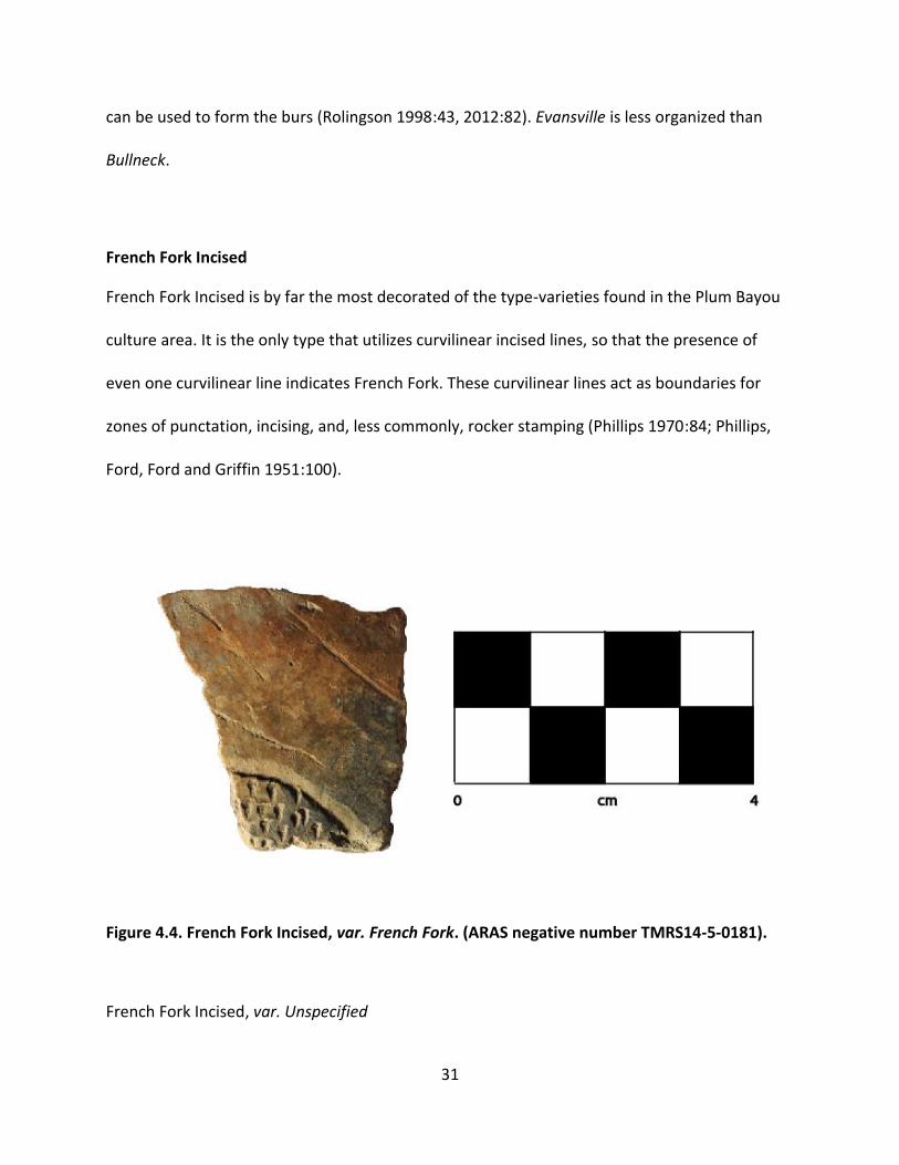
French Fork Incised
French Fork Incised is by far the most decorated of the type-varieties found in the Plum Bayou
culture area. It is the only type that utilizes curvilinear incised lines, so that the presence of
even one curvilinear line indicates French Fork. These curvilinear lines act as boundaries for
zones of punctation, incising, and, less commonly, rocker stamping (Phillips 1970:84; Phillips,
Ford, Ford and Griffin 1951:100).
Figure 4.4. French Fork Incised, var. French Fork. (ARAS negative number TMRS14-5-0181).
French Fork Incised, var. Unspecified
32
Sample: 6
Provenience: 1 Pre-mound
5 Midden
Description: These sherds include curvilinear incising but are too small to show any of the other
decoration (Rolingson 1998:43, 2012:83).
French Fork Incised var. French Fork
Sample: 1
Illustration: Figure 4.4
Provenience: 1 Midden
Description: French Fork sherds include curvilinear incised zones of punctation (Phillips
1970:84).
Larto Red
Larto Red, var. Mound Pond
Sample: 206
Illustration: Figure 4.7
Provenience: 75 Pre-mound
131 Midden
Description: Mound Pond descriptions by Rolingson are no different than the general Larto Red
type description of red filming, although Mound Pond is specifically red filmed on both interior
and exterior surfaces in Stewart-Abernathy’s 1982 chapter. Rolingson’s work is ambiguous with
regard to the sorting criteria that makes var. Mound Pond different than Larto Red in general,

33
but it seems that this type-variety should include all sherds with red filming (Rolingson 1998:46,
2012:83; Stewart-Abernathy 1982:44). Phillips, Ford, and Griffin explicitly include filming on
only one surface in the general Larto Red category (Phillips 1970:99; Phillips, Ford, and Griffin
1951:102), though neither Rolingson nor Stewart-Abernathy do so. Phillips, Ford, and Griffin’s
criterion for different varieties is paste, but Rolingson does not address this issue.
Mazique Incised
Sample: 1
Provenience: 1 Midden
Description: Mazique Incised features “juxtaposed fields, generally… triangular, of close-spaced
parallel lines, the over-all effect being obtain by changing direction of the lines from one field to
another” (Phillips 1970:129; Phillips, Ford and Griffin 1951:98; Rolingson 2012:85).
Mulberry Creek Cord Marked
Sample: 1
Illustration: Figure 4.5
Provenience: 1 Pre-mound
Description: Mulberry Creek Cord Marked sherds include either individual or paddled cord
markings. This single sherd displays individual cord markings placed parallel to each other and
about 1cm apart (Rolingson 1998:48, 2012:87; Stewart-Abernathy 1982:47).
Chronological Position: Dortch Bend.

34
Figure 4.5. Mulberry Creek Cord Marked Pottery. (ARAS negative number TMRS14-5-0127)
Officer Punctated
Officer Punctated was adapted by Rolingson as a ceramic type from a rim mode that is common
in the Lower Mississippi Valley. Officer Punctated features punctations at or on the rim and lip
of vessels. This decoration occurs so frequently at Toltec that Rolingson found it prudent to use
it as a type name. The presence of Officer Punctated increases in relative frequency in ceramic
assemblages through time (Stewart-Abernathy 1982:46).

35
Figure 4.6. Varieties of Officer Punctated: a, var. Pemberton; b-d, var. Bearskin; e, var.
England. (ARAS negative numbers TMRS14-5-0144, TMRS14-5-0157, TMRS14-5-0090,
TMRS14-5-0116, TMRS14-5-0198)
Officer Punctated, var. Bearskin
Sample: 15
Illustration: Figure 4.6b-d
Provenience: 11 Pre-mound
4 Midden
Description: Bearskin punctations occur on the exterior edge of the lip and can be made by
tools or the potter’s hands and take different forms. The most important sorting criteria is the
placement of the punctations on the edge of the lip (Rolingson 1998:48, 2012:87; Stewart-
Abernathy 1982:47).

36
Officer Punctated, var. England
Sample: 1
Illustration: Figure 4.6e
Provenience: 1 Pre-mound
Description: England punctations occur on an exterior rim strap (Rolingson 1998:49, 2012:89).
Officer Punctated, var. Pemberton
Sample: 1
Illustration: Figure 4.6a
Provenience: 1 Midden
Description: Pemberton sherds display punctations at or below the rim in association with one
or more incised lines. Punctations can extend over both sides of the incised line or be limited to
one side or the other (Rolingson 2012:89). The sherd in my sample displays punctations
bisected by an incised line.
Officer Punctated, var. Willow Beach
Sample: 6
Provenience: 3 Pre-mound
3 Midden
Description: Willow Beach punctations occur below the unmodified rim of a vessel; the
punctations are usually applied upwards into the rim, creating semi-conical punctations
(Rolingson 1998:49, 2012:90; Stewart-Abernathy 1982:47).
37
Old Town Red
Sample: 2
Provenience: 1 Pre-mound
1 Midden
Description: Old Town Red sherds are shell tempered with red slip (Phillips, Ford and Griffin
1951:129).
Salomon Brushed
Sample: 2
Provenience: 2 Midden
Description: Salomon Brushed sherds show brushing/incising with bundles of stiff material or
some other multi-pointed instrument, creating shallow striations arranged haphazardly (Phillips
1970:158; Rolingson 1998:49, 2012:91; Stewart-Abernathy 1982:47).
Chronological Position: Dortch Bend.
Decorated, Unclassified
Sample: 11
Provenience: 1 Pre-mound
10 Midden
Description: These sherds show some kind of decoration but are too small to type. Two of the
eleven are punctated, while the others are incised.

38
New Types
Sample: 52
Illustration: Figure 4.7
Provenience: 44 Pre-mound
8 Midden
Description: This category was employed to include ceramics not otherwise capture by a type-
variety, mostly red slipping on only one surface or white slipping/painting. White treatments
have not been classified into type-varieties in previous research as most sherds are too small to
see zones or other decoration. One sherd displayed incising and punctation in particularly
sloppy execution without the intent of creating a purposeful pattern and looks almost as if it
was flippant, or for practice with tools (Figure 4.7). This could be classified as Evansville
Punctated var. unspecified, but so far has no major precedent at Toltec. Figure 4.8 shows a
Larto Red var. Mound Pond sherd with a t-shaped rim, which, as far as I can tell, is
unprecedented at Toltec.

39
Figure 4.7. Unknown pottery type. (ARAS negative number TMRS14-5-0131)
Figure 4.8. Larto Red, var. Mound Pond sherd with T-shaped rim mode. (personal
photograph)
Plum Bayou Culture Decorated Pottery Sorting Manual
As part of the preparation for this thesis project, I put together a ceramic sorting manual
after the fashion of Brown’s Lower Mississippi Valley manual (1998). The type-varieties utilized

40
in the manual are categories already established by Rolingson and Stewart-Abernathy. The
purpose of the manual was to establish a flow chart of attributes to clarify and simplify ceramic
sorting. However, some of the type-varieties do not appear to be particularly useful (for
example, Larto Red var.Mound Pond, instead of plain old Larto Red), and some seem to
conflate, particularly in the Coles Creek Incised type. It also became evidence that already-
established varieties were given new names simply because they were recovered at Toltec
(again, particularly within the Coles Creek type). Page numbers in the manual (for example, “go
to page 3”) reference the manual only. A list of the Plum Bayou citations (and earlier references
where necessary) for each of the types is provided after the manual, since not all types in the
manual were present in the 2010 assemblages. See Appendix A for the Manual.

41
CHAPTER 5
RESULTS AND DISCUSSION
Results
As stated, 2,059 prehistoric ceramic sherds were analyzed for this project. Sherds from
the plow zone and any levels that included the plow zone were analyzed but not used in this
section, since their original provenience was lost or could not be verified. From the pre-mound
surface, 568 of the 871 sherds were excluded by that standard, leaving 303 that could be
included in the statistical analysis for this thesis. From the midden, 159 of 1,188 sherds were
excluded, leaving 1,029 that could be included in the statistical analysis of this project. In total,
1,332 sherds were included in the statistical analysis that follows.
Variables that were measured to examine change over time from the pre-mound
surface to the midden include: vessel shape (where discernible), sherd thickness (in mm), sherd
form (body, base, neck, rim lug, rim), the presence of decoration (and whether the decorating
was punctation, incising, brushing, or cord marking), temper (grog, grit, shell, bone, or sand),
rim mode, type-variety, and the color of the interior and exterior surfaces of the sherds. Any
difference in sherd thickness was tested statistically by t-test, while all other variables were
tested by Chi-square tests of homogeneity. Initially, these variables were grouped by general
location at Toltec Mounds (Pre-Mound surface or Midden). Upon examining those results, more
targeted tests were done on the sample from the Midden.

42
Presence of decoration, interior decoration, vessel shape, sherd form, and rim mode did
not yield significant Chi-square (Pearson’s R) values. Thickness in mm was also not significantly
different based on an independent samples t-test. Temper, exterior decoration, and exterior
surface color were significant at p<.05, while type-variety and exterior surface color
approached significance.
Table 5.1. Temper materials by location, p= .000. Temper Pre-Mound Midden Total
Grog 282 (93.1) 1002 (97.4) 1284 (96.4) Grit 11 (2.6) 18 (1.7) 29 (2.2) Bone 8 (2.6) 2 (0.2) 10 (0.8) Shell 2 (0.7) 6 (0.6) 8 (0.6) Sand 0 (0) 1 (0.1) 1 (0.1) Total 303 (100) 1029 (100) 1332 (100)
Differences in temper between the Pre-Mound surface and the Midden contexts are
significant at p<.05 (p= .000) (Table 5.1). The trends in the percentages of temper indicate a
decrease in grit and bone temper by 1.9 and 2.4 percent, respectively. Shell temper was
expected to increase over time, but after removing sherds from plow zone deposits from the
statistics, shell temper actually decreased over time, if only by 0.1 percent. While these
numbers are statistically significant, they have no practical significance because the counts for
every temper except grog are so small.

43
Table 5.2. Exterior decoration by location, p = .025. Exterior Decoration Pre-Mound Midden Total
None 258 (85.1) 885 (86) 1143 (85.8) Incising 2 (0.7) 23 (2.2) 25 (1.9) Punctation 5 (1.7) 9 (0.9) 14 (1.1) Red Slip 31 (10.2) 106 (10.3) 137 (10.3) White Slip 5 (1.7) 6 (0.6) 11 (0.8) White, Red, Incising 1 (0.3) 0 (0) 1 (0.1) Total 303 (100) 1029 (100) 1332 (100)
The exterior decoration variable serves here as a kind of shorthand guide to type-
variety; it measures the kinds of decoration present on the exterior surface of the sherds
generally (effectively, all the type-varieties that utilize incising are grouped together in the
incising category) (Table 5.2). Over time, an increase in incising by 1.5 percent accompanies a
decrease in punctation by 0.8 percent. These values are significant at p< .05 (p= .025). White
slipping also decreased by 1.1 percent over time, although type varieties for Plum Bayou
ceramics, which include white slip or painting, on the whole are underrepresented. Sherds with
red slipping make up 10.2 and 10.3 percent of the samples from the Pre-Mound and Midden,
respectively.

44
Table 5.3. Interior surface color by location, p= .001.
Interior Surface Color Pre-Mound Midden Total
Brown 82 (27.2) 316(31.2) 398 (30.3)
Black 120 (39.7) 288 (28.5) 208 (31.1)
Beige 62 (20.5) 227 (22.4) 289 (22)
Red on Orange 19 (6.3) 65 (6.4) 84 (6.4)
Red on Black 12 (4.0) 44 (4.3) 56 (4.3)
Orange 6 (2) 69 (6.8) 75 (5.7)
White 1 (0.3) 3 (0.3) 4 (0.3)
Total 302 (100) 1012 (100) 1314 (100)
In retrospect, interior surface color measured several possible causes of color, from fire
clouding to use/wear of the vessel, if it was used to cook in. It did not measure the presence of
remnant cooked material, which was noted but not statistically examined. Because of the
different causes of color on the interior of vessels, this variable probably does not help explain
change over time in ceramics (Table 5.3). However, there is a 4 percent increase in brown, 12.2
percent decrease in black, 1.9 percent increase in beige, and a 4.8 percent increase in red on
black; these values are significant at p< .05 (p= .001). The most striking of those changes is the
decrease in a black appearance of the surface, which could indicate changes in firing
techniques, if not changes in aesthetic choices.

45
Table 5.4. Exterior surface color by location, p= .138.
Exterior Surface
Color
Pre-Mound Midden Total
Brown 104 (34.4) 320 (31.6) 424 (32.3)
Black 45 (14.9) 149 (14.7) 194 (14.8)
Beige 97 (32.1) 353 (34.9) 450 (34.2)
Red on Orange 20 (6.6) 59 (5.8) 79 (6)
Red on Black 11 (3.6) 42 (4.2) 53 (4)
Orange 19 (6.3) 83 (8.2) 102 (7.8)
White 6 (2) 6 (0.6) 12 (0.9)
Total 302 (100) 1012 (100) 1314 (100)
The exterior color values are approaching significant at p=.138 (Table 5.4). The changes
in percent are less than the interior color, although it would seem that changes in the exterior
of a vessel should be purposeful, since the exterior is most visible for conveying cultural
information. Brown decreased by 2.8 percent, while beige increased by 2.8 percent. Red on
orange decreased by .8 percent, while red on black increased by .6 percent. Orange increased
by 1.9 percent, while white decreased by 1.4 percent.

46
Table 5.5. Type-variety by location, p=.230, 38 cells (86.4%) have expected counts less than 5. Type-variety Pre-Mound Midden Total
Baytown Plain 251 (82.8) 864 (84) 1115 (83.7) Larto Red var. Mound Pond 34 (11.2) 119 (11.6) 153 (11.5) Officer Punctated, var. Keo 1 (0.3) 2 (0.2) 3 (0.2) Officer Punctated, var. Bearskin 2 (0.7) 3 (0.3) 5 (0.4) Officer Punctated, var. Pemberton
0 (0) 1 (0.1) 1 (0.1)
Officer Punctated, var. Willow Beach
0 (0) 1 (0.1) 1 (0.1)
Evansville Punctated, var. Evansville
2 (0.7) 1 (0.1) 2 (0.2)
Evansville Unspecified 0 (0) 1 (0.1) 1 (0.1) Evansvilled Punctated, var. Bullneck
1 (0.2) 1 (0.1) 2 (0.2)
Coles Creek Incised, var. Clear Lake
0 (0) 1 (0.1) 1 (0.1)
Coles Creek Incised, var. Argenta 1 (0.3) 5 (0.5) 6 (0.5) Coles Creek Incised, var. Coles Creek
0 (0) 2 (0.2) 2 (0.2)
Coles Creek Incised, var. Plum Bayou
0 (0) 1 (0.1) 1 (0.1)
Coles Creek Incised, var. Knapp 0 (0) 1 (0.1) 1 (0.1) French Fork Incised, var. French Fork
0 (0) 1 (0.1) 1 (0.1)
French Fork Incised Unspecified 1 (0.3) 1 (0.1) 2 (0.2) Mazique Incised 0 (0) 1 (0.1) 1 (0.1) Old Town Red 1 (0.3) 1 (0.1) 2 (0.2) Salomon Brushed 2 (0.7) 0 (0) 2 (0.2) Alligator Incised, var. Jack’s Bay 1 (0.1) 5 (0.5) 6 (0.5) New types 6 (2) 10 (1) 16 (1.2) Decorated, Unclassified 0 (0 7 (0.7) 7 (0.5) Total 303 (100) 1029 (100) 1332 (100)
The change in type-varieties over time was difficult to get at because so many categories
only had a few sherds attributed to them, resulting in an insignificant p-value of p= .230 (Table

47
5.5). 86.4 percent of cells had expected counts of less than 5 (those type-varieties with only one
or two sherds), and tests with more than 20 percent of cells with expected counts less than 5
should not be considered significant. As a result, the type-varieties were consolidated, so that,
for example, all the Officer Punctated varieties (Bearskin, Pemberton, Willow Beach, etc.) were
combined into one category.
Table 5.6. Consolidated type by location, p=.175, 7 cells (43.8%) have expected counts less
than 5. Consolidated Type Pre-Mound Midden Total
Baytown Plain 251 (82.8) 864 (84) 1115 (83.7) Larto Red, var. Mound Pond
34 (11.2) 119 (11.5) 153 (11.4)
Officer Punctated 2 (0.7) 5 (0.5) 7 (0.5) Coles Creek Incised 2 (0.7) 12 (1.2) 14 (1.1) French Fork Incised 1 (0.3) 2 (0.2) 3 (0.2) Decorated Unspecified
0 (0) 7 (0.7) 7 (0.5)
New types 6 (2) 11 (1.1) 17 (1.3) Punctated, etc. 7 (2.3) 10 (1) 17 (1.3) Total 303 (100) 1029 (100) 1332 (100)
After consolidating the categories, only 43.8 percent of categories had expected counts
less than 5 (Table 5.6). This is still higher than acceptable for rigorous statistics, but it is closer
to the ideal 20 percent of categories with expected counts of less than 5. Consolidating
categories any more than this would result in meaningless categories, so this is as close as
analysis could get. This Chi-square yielded a value of p= .175, approaching significant. At this

48
time, a statistically significant difference in type-varieties over time is not evident, although the
change over time in exterior decoration (incising, punctation, etc.), is statistically significant.
Discussion
Chronology. Rolingson dismissed the use of the ceramic chronology which Stewart-
Abernathy had created in 1982 when she published the Mound D write up in 1998. The
stratigraphy was too damaged and the type-varieties did not cooperate nicely by changing over
time. Instead, they persist from the beginning of Toltec’s use into its abandonment around A.D.
1050. It does not help that most of the Plum Bayou ceramics are plain, as decoration is easier to
track in determining change. The two types that make up the majority of the collection are
Baytown Plain and Larto Red var. Mound Pond. While Mound Pond can include some incising, it
is characterized at Toltec as overall red slipping of a plain vessel.
In this study, while it seems that there are general, statistically significant trends from
Pre-Mound to Midden, these trends only occur on the scale of one or two percent (an increase
in incising by 1.5 percent accompanies a decrease in punctation by 0.8 percent, Table 5.2).
Neither of the tests performed on the type-variety categories was statistically significant. The
majority of type-varieties had fewer than three sherds in this analysis, which makes it difficult
to do stylistic as well as statistical comparison. Since the two samples are so similar, especially
with regard to type-varieties, it would be logical to think they are actually from the same time
period. This should not be the case, since at least some of the deposits are separated by at least
one stage of the mound (Stage 0), although there are no radiocarbon or archaeomagnetic dates

49
from these exact deposits to confirm this. Of course, it is possible that Stage 0 of the mound
was built rapidly and occupation on the mound was continuous, but Rolingson’s 1970s work
suggests that the sub-mound deposits and the midden are chronologically separated (by as
much as 195 years, if archeomagnetic and radiocarbon dates are to be trusted)(Rolingson
1998:25).
Migration. The main hypothesis of this thesis was that the ceramics would change over
time to better represent ceramics from northeast Arkansas. Attributes like shell tempering, red
slipping, and flat bases should have increased from the Pre-Mound to the Midden deposits.
However, as the results show, all of those attributes remained static or almost non-existent
(only 8 total shell tempered sherds made the cut into the statistical analysis, and shell
decreased by 0.1 percent over time, Table 5.1). While the hypothesis was not supported, the
continuity of the ceramics through time does lead to some interesting conclusions.
The stasis of red slipping and flat-bottomed bases indicates a potentially exciting area of
future research. Morse and Morse noted that Plum Bayou ceramics are similar to ceramics from
northeast Arkansas particularly because of the flat-bottomed bases of jars during the Owls
Bend and Big Lake phases, from about A.D. 700-1000. They also note that this time span is
poorly understood, especially from 700-800 A.D. (Morse and Morse 1996:127). Red filming on
shell tempered pottery increased in popularity until about A.D. 1000 in the region, while it fell
out of favor in archaeological areas to the south (Morse and Morse 1996: 130). It is not a
coincidence that red slipping and flat-bottomed bases are present at Toltec from at least A.D.
800, if that is the correct date for the Pre-Mound surface, to (at least) Stage I of the mound
(Table 5.7). It is worth mentioning that Owl’s Bend ceramics were characterized by few jars with

50
handles; in this study, handles were in such a minority of sherd forms that it was not even a
category. This may be a shared characteristic that is worth more purposeful study in future
projects. One other possible link between Toltec and northeast Arkansas is vessel shape. Morse
and Morse note that Varney/Big Lake phase jars had strongly recurved rims before A.D. 1000
(Morse and Morse 1983:220). Of the 65 vessel shapes that were discernible from the samples,
37 of them (56.9 percent) were flared jars (Table 5.8). Woodland Period jars had flared necks as
well, and while there is no indication of any way to quantify the difference between the two, it
is worth investigating further.
Table 5.7. Sherd form by location.
Sherd Form Pre-Mound Midden Total
Body 259 (85.5) 858 (83.4) 1117 (83.9)
Rim 37 (12.2) 147 (14.3) 184 (13.8)
Neck 1 (0.3) 9 (0.9) 10 (0.8)
Rim Lug 1 (0.3) 5 (0.5) 6 (0.5)
Base 5 (1.7) 10 (1) 15 (1.1)
Total 303 (100) 1029 (100) 1332 (100)
Table 5.8. Vessel shape by location.
Vessel Shape Pre-Mound Midden Total
Flared Jar 6 (60) 31 (56.4) 37 (56.9)
Hemispherical Bowl 1 (10) 12 (21.8) 13 (20
Plate 2 (20) 7 (12.7) 9 (13.8)
Bowl 1 (10) 4 (7.3) 5 (7.7)
Disc 0 (0) 1 (1.8) 1 (1.5)
Total 10 (100) 55 (100) 65 (100)

51
The similarities in the presence of handles and the recurviture of jar necks are anecdotal
at this point, but point to interaction between central Arkansas and northeast Arkansas. The
presence in both areas of red slipping and of flat bottom vessels is measurable and more
quantifiably supports the idea that the Plum Bayou interacted with the peoples in northeast
Arkansas from the beginning of Toltec’s occupation around A.D. 700 at least through the
deposition of the midden, probably around A.D. 900. This leads me to assert that the Plum
Bayou had ties to northeast Arkansas all along, not simply at the end of the occupation at
Toltec. What those interactions looked like warrants closer study of ceramics, but also of other
study areas, like paleoethnobotany.
Plan View of the Premound Surface. Adobe Illustrator was used to create the plan view
rendering of the final unit in line with Rolingson’s late 1970s trench into the Pre-Mound surface
(Figure 5.1). The unit exposed much more of the burned silt layer and post features that were
exposed in the trench, yielding interesting results (Figure 5.2). The line of features exposed in
the trench seems to end in those units and perhaps continues into the western edge of the
2010 unit, while a line of post features in the North wall of unit N42 E144 seems to continue
into the 2010 unit. Further excavation is needed to determine what sort of structure these
posts made, if any. If this is evidence of a structure, it was at least six meters long on one side.
The excavations that came down on Rolingson’s trench were the southernmost line of units,
and due to complications with units to the north of N42 E 142 and N42 E144, a continuous plan
view map was not possible, although there are more than several other post features that were
exposed during the 2010 excavations.

52
Figure 5.1. Plan View of 1970s Excavations (Rolingson 1998: Figure 14).
Figure 5.2. Plan View of 2010 Excavations, Unit N42 E146, Continuing the 1970s Excavations,
at 73.53m elevation.
A. 10 YR 2/1, general char B. 7.5 YR 4/6 with 2.5 YR 5/4 C. Post features, 10 YR 4/4

53
Conclusion
Plum Bayou ceramics chronologies and associations continue to evade clarification,
although this study has brought some new information to light. While Plum Bayou ceramics are
generally thought of as a conglomeration of Coles Creek and Baytown-like attributes, there is
new evidence, based on the continuity of red slipping, flat-bottom bases, and perhaps in
handleless, recurved jars, that the Plum Bayou people were in close contact with northeast
Arkansas during the whole occupation of central Arkansas, not only toward the end of its
occupation. Consequently, the hypothesis that Plum Bayou ceramics changed over time to
become more like northeast Arkansas ceramics was not supported. Instead, a closer
examination of similarities between the two regions for the entire occupation of Toltec would
be a useful course of study. In addition, an examination of Toltec with specific regard to other
surrounding cultures to the West in Oklahoma and, in particular, to the South in southern
Arkansas and northern Louisisana could more firmly place the Plum Bayou in the context of the
Lower Mississippi Valley.
The pottery type-varieties are a prime subject for future research as well. While some
are useful (Officer Punctated probably does deserve to be a type name), they are confusing
when comparing ceramics cross-culturally, since so much of the nomenclature was borrowed
from other research areas. A more useful course of study in the future seems to be attribute
analysis, which did provide some significant results when comparing decorative categories like
incising and punctation (Figure 5.2).
Without the tops of most of the mounds at Toltec, which have been leveled as a result
of modern agriculture, clear chronological ceramic development may continue to elude

54
archaeologists. However, excavations to the southwest (off-mound) of Mound D could provide
useful, especially for the last century or so of Toltec’s occupation. Since so much of the
“bottom” of Mound D is left, it is possible that Stage III fill and midden, well away from the
plaza, is still undisturbed (see Figure 1.1).
The last complication in understanding the Plum Bayou people’s relationships with their
neighbors is the fact that the Plum Bayou are firmly rooted in the Late Woodland, while at the
same time northeast Arkansas had already transitioned into the Mississippi Period
contemporaneously. Corn agriculture and shell tempered pottery proliferated in northeast
Arkansas starting around A.D. 700 (Morse and Morse 1996), but the Plum Bayou favored grog
temper throughout Toltec’s primary occupation, and seemingly continued to rely on hunting
and gathering as a major food source.
The discussion of Plum Bayou subsistence patterns deserves closer inspection by
archeologists who know more about what they are doing, but it is important to emphasize here
that the notion of corn agriculture replacing hunting and gathering may not be adequate when
researching Toltec and its Plum Bayou contemporaries. It is clear by the massive amounts of
Type X plant remains that, if it was not domesticated, it was heavily cultivated (which one it was
still seems up for debate). This complexity may be a reflection of the transitional chronology
(Terminal Woodland) and geographic location (between the American Bottom, where corn
agriculture dominated, and the Lower Mississippi Valley south of Vicksburg, where corn
agriculture did not quite catch on at that time) of Toltec (Fritz 2008:36). Whatever the case, it is
clear that the absence of corn does not equal the absence of farming.

55
There is evidence that shell tempering spread slowly in some areas, and understanding
why it did not spread into central Arkansas is a key point in understanding Plum Bayou’s place
in the region (Cogswell and O’Brien, 1998). If their neighbors had access and knowledge of new
developments and technology, why did the Plum Bayou maintain Woodland subsistence
strategies and grog tempered pottery? What was their relationship like with the peoples from
northeast Arkansas throughout the Plum Bayou occupation of central Arkansas? This thesis has
shown that the Plum Bayou did have significant connections with northeast Arkansas, but those
connections need to be investigated further to understand Toltec’s, and the Plum Bayou’s,
place in cultural developments in the Lower Mississippi Valley.

56
REFERENCES
Anthony, David W. 1990 Migration in Archeology: The Baby and the Bathwater. American Anthropoligst 92, 4: 895-914. Bringier, Louis 1821 Notices of the Geology, Mineralogy, Topography, Productions, and Aboriginal Inhabitants of the Regions Around the Mississippi and its Confluent Waters- in a letter from L. Bringier, Esq. of Louisiana, to Rev. Elias Cornelius-Communicated for This Journal. American Journal of Sciences and Arts 3(1):15-46. Brown, Ian W.
1998 Decorated Pottery of the Lower Mississippi Valley: A Sorting Manual. MississippiDepartment of Archives and History, Jackson.
Chilton, Elizabeth S. 1999 One Size Fits All: Typology and Alternatives in New England Ceramic Research. In Material Meanings: Critical Approaches to the Interpretation of Material Culture, edited by Elizabeth S. Chilton, pp. 44-60. University of Utah Press, Salt Lake City. Cobb, Charles R., and Michael S. Nassaney 1995 Interaction and Integration in the Late Woodland Southeast. In Native American Interactions, edited by Michael S. Nassaney and Kenneth E. Sassaman, pp. 205-228. University of Tennessee Press, Knoxville. Cogswell, James W., and Michael J. O’Brien 1998 Analysis of Early Mississippian-Period Pottery from Kersey, Pemiscot County, Missouri. Southeastern Archaeology 17:39-52. Fritz, Gayle J. 2008 Plum Bayou Foodways: Distinctive Aspects of the Paleoethnobotanical Record. In The Arkansas Archeologist, 47:31-42. Arkansas Archeological Society, Fayetteville.

57
Hill, William H. 2003 An Intensive Surface Collection and Intrasite Spatial Analysis of the Archaeological Materials from the Coy Mound Site (3LN20), Central Arkansas. Master’s thesis, Western Michigan University. Lottinville, Savoie (editor) 1980 A Journal of Travels into the Arkansas Territory During the Year 1819 by Thomas Nuttall. University of Oklahoma Press, Norman. Jeter, Marvin 1990 Arkansaw Mounds. University of Arkansas Press, Fayetteville. Jeter, Marvin D. and Robert J. Scott, Jr. 2008 Keo, Quartz Crystals, Carets, Et Cetera: Southerly Plum Bayou vs. Northerly Coles Creek Cultural Elements. In The Arkansas Archeologist, 47: 43-82. Arkansas Archeological Society, Fayetteville. Morse, Dan F., and Phyllis A. Morse 1983 Archaeology of the Central Mississippi Valley. Academic Press, New York. 1996 Northeast Arkansas. In Prehistory of the Central Mississippi Valley, edited by Charles H. McNutt, pp. 119-136. University of Alabama Press, Tuscaloosa. Nassaney, Michael S. 1991 Spatial-Temporal Dimensions of Social Integration during the Coles Creek Period in Central Arkansas. In Stability, Transformation, and Variation, edited by Michael S. Nassaney and Charles R Cobb, pp. 177-220. Plenum Press, New York. Phillips, Philip 1970 Archaeological Survey in the Lower Yazoo Basin, Mississippi, 1949-1955. Papers of the Peabody Museum of Archaeology and Ethnology, Vol. 60. Harvard University, Cambridge. Phillips, Philip, James A. Ford, and James B. Griffin 1951 Archaeological Survey in the Lower Mississippi Aluvial Valley, 1940-1947. Papers of the Peabody Museum of Archaeology and Ethnology, Vol. 25. Harvard University, Cambridge. Rolingson, Martha Ann 1977 Preliminary Report on the 1977 University Field School Excavations at the Toltec Mounds Site. Field Notes 155:3-7. Arkansas Archeological Society, Fayetteville.

58
1982 Emerging Patterns of Plum Bayou Culture. Arkansas Archeological Survey, Fayetteville. 1998 Toltec Mounds and Plum Bayou Culture: Mound D Excavations. Arkansas Archeological Survey, Fayetteville.
1999 The Toltec (Knapp) Mounds Group in the Nineteenth Century. In Arkansas Archeology: Essays in Honor of Dan and Phyllis Morse, edited by Robert C. Mainfort Jr. and Marvin Jeter pp. 119-142. University of Arkansas Press, Fayetteville.
2002 Plum Bayou Culture of the Arkansas-White River Basin. In The Woodland Southeast, edited by David G. Anderson and Robert C. Mainfort, Jr. pp. 44-65. The University of Alabama Press, Tuscaloosa. 2012 Toltec Mounds: Archaeology of the Mound-and-Plaza Compex. Arkansas Archeological Survey, Fayetteville. Rolingson, Martha Ann, and Robert C. Mainfort, Jr. 2002 Woodland Period Archaeology of the Central Mississippi Valley. In The Woodland Southeast, edited by David G. Anderson and Robert C. Mainfort, Jr. pp. 20-43. The University of Alabama Press, Tuscaloosa. Sherrod, P. Clay, and Martha Ann Rolingson 1987 Surveyors of the Ancient Mississippi Valley. Arkansas Archeological Survey, Fayetteville. Stewart-Abernathy, Judith C.
1982 Ceramic Studies at the Toltec Mounds Site: Basis for a Tentative Cultural Sequence. In Emerging Patterns of Plum Bayou Culture: Preliminary Investigations of the Toltec Mounds Research Project, edited by Martha A. Rolingson, pp. 44-53. Research Series No. 18. Arkansas Archeological Survey, Fayetteville.
Thomas, Cyrus
1894 Report on the Mound Explorations of the Bureau of Ethnology. Twelfth Annual Report of the Bureau of Ethnology, 1890-1891, edited by John W. Powell, pp. 17-742. U.S. Government Printing Office, Washington, D.C.
Vogel, Gregory 2006 Historical Metrology and a Reconsideration of the Toltec Module. Southeastern Archaeology 26(1) 6-19.

59
APPENDIX A PLUM BAYOU CULTURE DECORATED POTTERY SORTING MANUAL
The Manual
Contents
Incising…………..…………………………………………………………………………………………………………………….....60
Punctation…..………………………………………………………………………………………………………………………..…62
Filmed….………………………………………………………………………………………………………………………………….64
Brushed, Stamped, or Cord Marked………………….....………………………………………………………………….65
Combinations: Incising and Punctation…………………..…………………………………………..…………………..61
References, Distributions, and Dates for Types/Varieties.……………..…………………………………………66
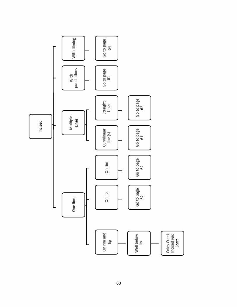
60

61

62

63

64

65

66
References, Distributions, and Dates for Types/Varieties
Alligator Incised–Hill 2003:13; Stewart-Abernathy 1982:49
Alligator Incised var. Jacks Bay–Rolingson 1998:38; Stewart-Abernathy 1982:49
Baytown Plain–Hill 2003:13; Rolingson 1998:35, 2012:75; Stewart-Abernathy 1982:44
Baytown Plain var. Vicksburg–Stewart-Abernathy 1982:44
Coles Creek Incised var. Argenta–Rolingson 1998:39, 2012:77; Stewart-Abernathy 1982:49
Coles Creek Incised var. Clear Lake–Rolingson 1998:39, 2012:77; Stewart-Abernathy 1982:44
Coles Creek Incised var. Coles Creek–Phillips 1970:70, Stewart-Abernathy 1982:49
Coles Creek Incised var. Elder–Rolingson 2012:78
Coles Creek Incised var. Galloway–Rolingson 2012:79
Coles Creek Incised var. Keo–Rolingson 1998:40, 2012:79; Stewart-Abernathy 1982:44
Coles Creek Incised var. Knapp–Rolingson 1998:41
Coles Creek Incised var. Lonoke–Rolingson 1998:41; Stewart-Abernathy 1982:44
Coles Creek Incised var. Plum Bayou–Rolingson 1998:41, 2012:80, Stewart-Abernathy 1982:47
Coles Creek Incised var. Scott–Rolingson 1998:41; Stewart-Abernathy 1982:49
Evansville Punctated–Hill 2003:13; Stewart-Abernathy 1982:47
Evansville Punctated var. Bullneck–Rolingson 1998:43, 2012:81
Evansville Punctated var. Evansville–Rolingson 1998:43, 2012:82
French Fork Incised–Hill 2003:13; Rolingson 1998:43, 2012:83; Stewart-Abernathy 1982:47
French Fork Incised var. French Fork–Phillips 1970:84
French Fork Incised var. Laborde–Stewart-Abernathy 1982:47
French Fork Incised var. Larkin–Stewart-Abernathy 1982:49
French Fork Incised var. Wilzone–Phillips 1970:86
Hollyknowe Pinched–Rolingson 1998:45
Indian Bay Stamped–Rolingson 1998:46, 2012:83
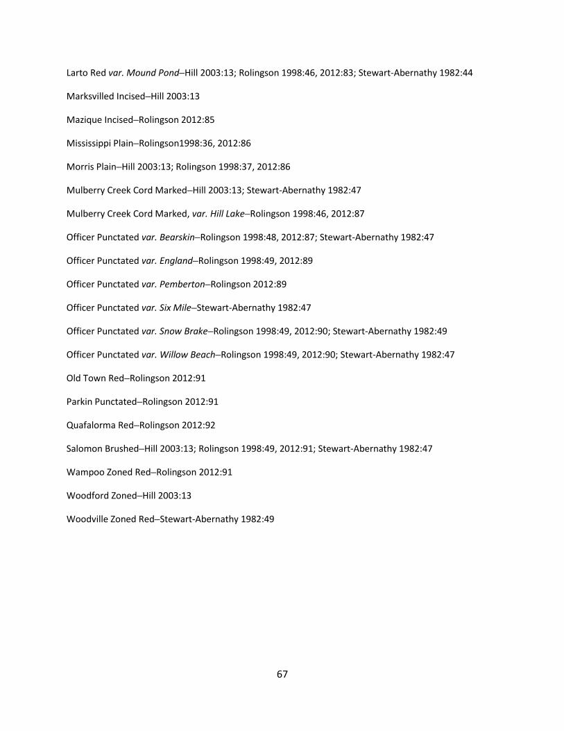
67
Larto Red var. Mound Pond–Hill 2003:13; Rolingson 1998:46, 2012:83; Stewart-Abernathy 1982:44
Marksvilled Incised–Hill 2003:13
Mazique Incised–Rolingson 2012:85
Mississippi Plain–Rolingson1998:36, 2012:86
Morris Plain–Hill 2003:13; Rolingson 1998:37, 2012:86
Mulberry Creek Cord Marked–Hill 2003:13; Stewart-Abernathy 1982:47
Mulberry Creek Cord Marked, var. Hill Lake–Rolingson 1998:46, 2012:87
Officer Punctated var. Bearskin–Rolingson 1998:48, 2012:87; Stewart-Abernathy 1982:47
Officer Punctated var. England–Rolingson 1998:49, 2012:89
Officer Punctated var. Pemberton–Rolingson 2012:89
Officer Punctated var. Six Mile–Stewart-Abernathy 1982:47
Officer Punctated var. Snow Brake–Rolingson 1998:49, 2012:90; Stewart-Abernathy 1982:49
Officer Punctated var. Willow Beach–Rolingson 1998:49, 2012:90; Stewart-Abernathy 1982:47
Old Town Red–Rolingson 2012:91
Parkin Punctated–Rolingson 2012:91
Quafalorma Red–Rolingson 2012:92
Salomon Brushed–Hill 2003:13; Rolingson 1998:49, 2012:91; Stewart-Abernathy 1982:47
Wampoo Zoned Red–Rolingson 2012:91
Woodford Zoned–Hill 2003:13
Woodville Zoned Red–Stewart-Abernathy 1982:49