Embed Size (px)
Citation preview

Brooklyn
StatenIsland
Queens
Bronx
Man
hattan
Brooklyn
StatenIsland
Queens
Bronx
Man
hattan
Jackson HeightsJackson Heights
Livonia AveLivonia Ave
Wilson AveWilson Ave
Metropolitan AveMetropolitan Ave
New UtrechtNew Utrecht
St. GeorgeSt. George
Brooklyn CollegeBrooklyn College
Hunts Point149th St. - 3rd Ave
ParkchesterParkchester
Astoria-Ditmars BlvdAstoria-Ditmars Blvd
BrooklynArmy TerminalBrooklynArmy Terminal
Avenue IAvenue I Avenue HAvenue H
East New YorkEast New York
Co-Op City SouthCo-Op City South
Co-Op City NorthCo-Op City North
TheTriboroTheTriboro
Triboro AlignmentPotential Triboro ExtensionsNew Station with TransfersNew Station
Existing Subway
Scale 1:225,000
0 1 2 3 Miles
1 The Triboro: Transit for the Boroughs | April 2016
The TriboroTransit for the Boroughs
What it means for New Yorkers
⊲ Above-ground rail line stretching 24 miles from Co-op City in the Bronx to Bay Ridge in Brooklyn.
⊲ Use of existing rail right-of-way reduces construction cost.
⊲ North-south transit corridor, allowing New Yorkers to move seamlessly between Brooklyn, Queens and the Bronx.
⊲ Two dozen new stations.
⊲ Transfers to 17 subway lines and 4 commuter rail lines.
⊲ Initial ridership of 100,000 daily commuters.

2 The Triboro: Transit for the Boroughs | April 2016
Manhattan.2 Many residents’ work or shopping trips are difficult or impossible to accomplish via the subway alone, requiring circuitous, time-consuming and multiple-transfer journeys by combinations of bus and subway.
Residents of Queens, Brooklyn and the Bronx often are com-pelled to travel through Manhattan to get to adjacent boroughs, since even this circuitous route is faster than the alternative – infrequent and unreliable buses. In these boroughs, workers spend an average of 53 minutes traveling to Manhattan, but travel for work to adjacent boroughs is longer. A trip from the Bronx to Queens takes 68 minutes each way for the average worker. A trip from Brooklyn to Queens takes 63 minutes for a typical public transit commuter.3 Though an additional 10 to 15 minutes of travel might not sound significant, the cumula-tive effect is huge: 65 hours of travel time per worker each year, or almost three additional days spent commuting.4 And those numbers don’t take into account all the trips that aren’t taken – jobs not pursued, schools avoided – because the journey is too long or complicated.
2 RPA, 2015, Overlooked Boroughs, http://www.rpa.org/publication/overlooked-boroughs-technical-report3 Census Transportation Planning Package 2006-2010, Mean Travel Time to Work by Public Transportation.4 A five day work week was the basis for this analysis; holidays/vacation days aren’t included.
The New York City boroughs of Brook-lyn, Queens, Staten Island and the Bronx are home to 6.6 million people. Many of them are poorly served by the city’s century-old, Manhattan-centric transit system. Transit improvements are typically focused on moving people in and out of Manhattan. Yet today, more New Yorkers commute within the outer boroughs than into Manhattan, and the city is gaining more jobs in Brooklyn, Queens, the Bronx and Stat-en Island than it is in the urban core.
The majority of people living in the four boroughs outside Man-hattan don’t use public transit to travel to work, even though they live in the city with the largest subway and bus network in the U.S. Why? Because New York City’s subways were designed to bring people into Manhattan, not to move them between other boroughs, and the buses that serve the boroughs are slow and unreliable.
New York City’s subways were built radially from the core to connect people to Manhattan, limiting the system’s value for res-idents traveling to other places. Indeed, the vast subway network, with 470 stations, isn’t within a reasonable walking distance for 43% of the city’s outer borough residents.1 Yet more than 50% of New York’s job growth in the last 15 years has occurred outside 1 Walking distance is assumed to be ¼ mile.
Figure 1: Transit Travel Time Reduction from Hunts Point with TriboroSource: Regional Plan Association and Conveyal

3 The Triboro: Transit for the Boroughs | April 2016
What if there were a fast, convenient and direct transit connection between the Bronx, Queens and Brooklyn?
It’s possible. In A Region at Risk: The Third Regional Plan for the New York-New Jersey-Connecticut Metropolitan Area, RPA proposed a circumferential transit line called the Triboro to connect the three boroughs. The above-ground line would cross over many subway and commuter rail lines and take advantage of underused and abandoned rights-of-way. Over the years, RPA has continued to develop the proposal. This paper outlines RPA’s most recent analysis on the Triboro Line and highlights the enormous opportunity it represents for New York and the metropolitan region.5
What Is the Triboro?Running 24 miles from Co-op City in the Bronx to Bay Ridge in Brooklyn, the Triboro would act as the wheel connecting the various spokes of the subway system branching from Manhattan. It would open an urgently needed north-south transit corridor, allowing New Yorkers for the first time to move seamlessly between communities in these three boroughs. The Triboro would intersect with 17 subway lines and four commuter rail lines along its route. The increased connectivity between bor-oughs and to existing Manhattan-bound lines would improve access to New York’s jobs, schools and resources for the hundreds of thousands of people currently living in dozens of neighbor-hoods now poorly served by transit. In addition, the Triboro could increase reverse access to the suburbs for residents of the boroughs by creating opportunities for transfers to outbound Metro-North and Long Island Rail Road commuter services.
5 Based on RPA’s Overlooked Boroughs and the University of Pennsylvania Design Studio’s Crossboro U study produced for RPA.
The new line would use an existing rail right-of-way, which means it could be built faster and more cheaply than other recent, large-scale transit projects in the New York region. The Triboro would ease subway crowding and create a more efficient, resilient and equitable transit system.
Why Rail?Providing a reliable connection between the Bronx, Queens and Brooklyn by rail will provide more direct trips within and between these boroughs than either the subway or bus networks can do today. Buses make up 43% of transit ridership in these three boroughs, but buses operate at an average speed of 8 mph as they fight the city’s heavy traffic.6 And buses are notoriously unreliable. Most routes in Brooklyn, Queens and the Bronx typically run 2 - 5 minutes late. The least reliable routes arrive on time only 50% of the day.7 Current upgrades of nine local bus routes to Select Bus Services (SBS) are speeding up these routes by 13% to 23 %,8 but there are more than 200 routes without SBS treatments, and the process of upgrading selected routes has
6 RPA, 2015, Overlooked Boroughs,http://www.rpa.org/publication/overlooked-boroughs-technical-report 7 Outer borough route query based on 2015 Analysis of MTA’s One Bus Away real time data feed by Nathan Johnson & Kuan Butts, http://busdataapi1.cloudapp.net/8 New York City Department of Transportation, “Select Bus Service Routes,” http://www.nyc.gov/html/brt/html/routes/routes.shtml
Figure 2: Slow Local Bus Routes in New York CityBuses traveling one mph or less than the borough average.Source: Regional Plan Association
Local Bus LinesSlowest Lines
4 The Triboro: Transit for the Boroughs | April 2016
been slow. Moreover, even with SBS, few routes offer the time savings and greater connectivity of the Triboro.
The rail right-of-way is intact and fully grade-separated, requir-ing few structure improvements to reactivate. The major capital investments needed to build the line would include signals, new track, rail cars and stations, and possibly power substations. Ini-tial estimates of costs range between $1 billion and $2 billion.
The Triboro has the potential to offer 100,000 riders transit service every five to 15 minutes at more than double bus speeds. Of the 22 possible stations identified, half would link to subway lines. Thousands more riders could be drawn to the Triboro to connect to the subway system rather than rely on transfers from slow bus routes.
Triboro Line Proposed Rights-of-Way
Photo: RPA
Mixing Passenger & Freight RailThe Triboro right-of-way varies from two to four tracks along its 24-mile route. The rail right-of-way is owned by Amtrak in the Bronx into Queens, and by CSX, the freight provider from northern Queens to Fresh Pond Junction and LIRR to the south of Fresh Pond to 65th Street Yard in Brooklyn. These freight lines operate only one to two trains per day on average. In the future, as many as 21 trains, each roughly a mile in length,9 could run daily along segments of the Triboro, according to a study of the corridor conducted by the Port Authority of New York and New Jersey.10
Passenger rail service can be operated alongside freight. This approach isn’t novel. Other metro areas in the U.S. and around the world successfully mix freight and passenger operations.
9 One mile train lengths are based on the average freight rail car length of 50 feet multiplied by the 110 car trains modeled for travel between Bay Ridge and Fresh Pond yards in the Cross Harbor Freight Study.10 Port Authority of New York and New Jersey, 2015, “Cross Harbor Freight Study Tier 1 Environ-mental Impact Statement,” http://www.panynj.gov/port/cross-harbor.html
CASE STUDY
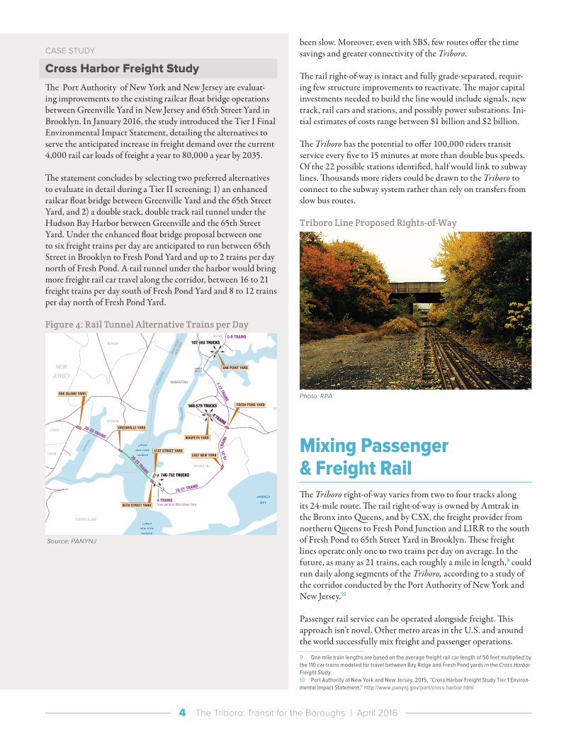
Cross Harbor Freight StudyThe Port Authority of New York and New Jersey are evaluat-ing improvements to the existing railcar float bridge operations between Greenville Yard in New Jersey and 65th Street Yard in Brooklyn. In January 2016, the study introduced the Tier I Final Environmental Impact Statement, detailing the alternatives to serve the anticipated increase in freight demand over the current 4,000 rail car loads of freight a year to 80,000 a year by 2035.
The statement concludes by selecting two preferred alternatives to evaluate in detail during a Tier II screening; 1) an enhanced railcar float bridge between Greenville Yard and the 65th Street Yard, and 2) a double stack, double track rail tunnel under the Hudson Bay Harbor between Greenville and the 65th Street Yard. Under the enhanced float bridge proposal between one to six freight trains per day are anticipated to run between 65th Street in Brooklyn to Fresh Pond Yard and up to 2 trains per day north of Fresh Pond. A rail tunnel under the harbor would bring more freight rail car travel along the corridor, between 16 to 21 freight trains per day south of Fresh Pond Yard and 8 to 12 trains per day north of Fresh Pond Yard.
Figure 4: Rail Tunnel Alternative Trains per Day
MANHATTANMANHATTAN
QUEENS
HUDSON
ESSEX
UNION
BERGEN
NASSAU
ATLANTIC OCEANATLANTIC OCEAN
UPPER
NEW YORK
HARBOR
UPPER
NEW YORK
HARBOR
LOWER
NEW YORK
HARBOR
LOWER
NEW YORK
HARBOR
BROOKLYN
BRONX
NEW
JER
SEY
NEW
YO
RK
HU
DS
ON
RIV
ER
WARDSISLAND
JAMAICA
BAY
JAMAICA
BAY
NEW
AR
K B
AY
EA
ST
RIV
ER
STATEN ISLAND
NEW
JERSEY
OAK ISLAND YARD
GREENVILLE YARD
65TH STREET YARD
FRESH POND YARD
EAST NEW YORK
OAK POINT YARD
MASPETH YARD
51ST STREET YARD
N
CROSS HARBOR FREIGHT PROGRAM
FIGURE ES-7
Rail Tunnel Alternative Daily Operations
SCALE
0 21 3 MILES
20-25 TRAINS
4 TRAINSfrom portal to 65th Street Yard
746-752 TRUCKS
107-163 TRUCKS
568-579 TRUCKS
5-8 TRAINS
7-12 TRAINS
16-21 TRAINS
20-25 TRAINS
7-8 TRAINS
TO LONG ISLAND FACILITIES
588-601 TRUCKS
TO LOCATIONS ON LONG ISLAND4 TRAINS
4 TRAINS
16-2
1 T
RAIN
S
8.19.15
Freight Rail Line and Average Daily Train PassbysRail Tunnel
Average Daily Truck Trips
Notes: Alternative operations represent an increment, as compared with the operations projected with the No Action Alternative The ranges shown for truck and train movements represent operational variations (Limited, Base, Seamless) Source: PANYNJ

5 The Triboro: Transit for the Boroughs | April 2016
One of the best examples can be found in Chicago, the center of rail freight in the U.S., where most of the nation’s main line freight corridors also mix with frequent commuter rail service. Metra, the Chicago commuter rail operator, is the fourth-largest railroad in the U.S., with ridership just slightly lower than that of New Jersey Transit. One of the busiest main lines in Chicago is dispatched by the freight operator Union Pacific, where 80 freight trains and more than 120 passenger trains run on the same track each day.11
Additional consideration for freight equipage must be made for mixed operations. A good state of repair for freight rail cars and yards would be required to allow freight and passenger trains to move efficiently throughout the corridor. The Cross Harbor Freight FEIS highlighted that serving modern rail equipment requires that the rail right-of-way, signals and rail yards be brought into a good state of repair. Rail yards would need to be expanded to accommodate increased freight demand and to clear the rail right-of-way, allowing passenger and freight trains to travel unobstructed throughout the day. Furthermore, shorter freight trains, less than a mile in length, will likely be needed to optimize mixed operations.
The Cross Harbor Freight FEIS proposed alternative of 21 freight trains per day would amount to less than one train per hour throughout the day. There could be certain times of day when the line would need to accommodate both freight and passenger travel. But in many metro markets, freight rail demand peaks during the midday (9 AM to 3 PM) and overnight (midnight to 5 AM), 12 with trucking freight peaking on the region’s major bridges between 4 AM to 8 AM and 10 AM to 4 PM.13 Passenger demand is typically highest during the morning before 9 AM and in the afternoon after 3 PM.
Successful Adaptations: London’s OvergroundAs in New York, London is seeing a growing number of “bor-ough-to-borough” trips that aren’t well served by the city’s radial underground system. London also is also experiencing regenera-tion of its outer boroughs.
To serve these expanding travel markets, Transport for London has transformed several abandoned or underutilized Tube and surface commuter and freight lines into a new circumferential system, the London Overground. Opened in 2010, and com-pleted in phases over the following two years at a cost of $2.4 billion, the Overground now carries more than half a million daily passengers. Ridership is expected to exceed one million daily passengers by 2020. The Overground is helping transform 11 Illinois Department of Transportation, 2011, “Tiger III Grant Application for CREATE,” http://www.createprogram.org/tiger3_files/CREATE_TIGER3_FINAL_10_31_2011.pdf 12 Seattle Department of Transportation, 2012, “Coal Train Traffic Impact Study,” http://www.seattle.gov/transportation/docs/121105PR-CoalTrainTrafficImpactStudy.pdf 13 Barone, R. and Levison, H, 2009, Study of Goods Movement through I-278 NYC and NJ SAFE-TEA LU Earmark #3437 / PIN X760.25.12: Task 2.1 Overview/Existing Conditions for I278 Study Area, New York City”
many formerly isolated outer borough communities, leading to new housing and employment opportunities in these places.
Figure 3: London Overground Map
River Thames
River Thames
Queen’sPark
KensalGreen
KilburnHigh Road
SouthHampstead
Watford Junction
Watford High Street
Harrow &Wealdstone
Kensal Rise
Brondesbury Park
Brondesbury
West Hampstead
Finchley Road & Frognal
WillesdenJunction
Gunnersbury
Shepherd’sBush
Crouch Hill
Headstone Lane
Kenton
St. James Street
Clapton
Rectory Road
Stoke Newington
Stamford Hill
Bruce Grove
White Hart Lane
Edmonton Green
Silver Street
Southbury
Turkey Street
CheshuntTheobalds Grove
Seven Sisters
Bethnal Green
Cambridge Heath
London Fields
Highams Park
Chingford
Harlesden
Wapping
Rotherhithe
Surrey Quays
Highbury &Islington
Barking
Leytonstone High Road
Wanstead Park
Woodgrange Park
Whitechapel
New Cross
New Cross Gate
Brockley
Honor Oak Park
Denmark Hill
Forest HillCrystal Palace
Caledonian Road& Barnsbury
HampsteadHeath
DalstonKingsland
LeytonMidland Road
SouthTottenham
EmersonPark
Bush HillPark
Enfield Town
Hammersmith& City
District
TfL Rail
TfL Rail
TfL Rail
District
Jubilee100m
DLR100mCentral
100m
TfL RailForest Gate 300m
NorthernClapham North 100m
Stratford
CentralJubilee
DLRVictoria
District
Victoria
Victoria
Shadwell
PeckhamRye
Jubilee
Upper Holloway
Harringay Green Lanes
Bushey
Carpenders Park
Hatch End
Wembley Central
South Kenton
Stonebridge Park
North Wembley
Haggerston
Dalston Junction
Hoxton
Shoreditch High Street
Kensington (Olympia)
District
West Brompton
Acton Central
South Acton
Kew Gardens
Canada Water
Richmond
Imperial Wharf
KentishTownWest
WandsworthRoad
Penge West
GospelOak
Hammersmith& CityHammersmith
& City
District
ClaphamJunction
NorthernVictoria
Bakerloo
Bakerloo
Blackhorse Road
100m
NorwoodJunction
ClaphamHigh Street
Sydenham
Anerley
Queens RoadPeckham
HackneyCentral
HackneyDowns
HackneyWick
Romford Upminster
Canonbury
CamdenRoad Homerton
Euston
Tramlink
WestCroydon
District
Trains toLuton
Trains toGatwick
Trains toSouthend
Central
Metropolitan
Circle
Trains toSouthendTrains toStansted
Liverpool Street
District line open weekends, public holidays and
some Olympia events
Wood Street
Victoria
WalthamstowQueen’s Road
WalthamstowCentral
Correct at time of going to print 05.2015
MAYOR OF LONDON
Riverboat services
National Rail
Interchange stations
Key to symbols
Step-free access from street to platform
Step-free access from street to train
Cambridge Heath and London Fields are not served by trains to/from Chingford
London Overground
Romford to Upminster services end at 2141/2154 Mondays to Fridays, and1941/1954 Saturdays. No Sunday service.
Source: Transport for London, Mayor of London
Freight and passenger services mix along sections of the Over-ground. The key east to west route, the North London Line, runs mixed operations of 6 - 12 trains per peak hour, while serving 1.24 million passenger miles and 427 million tonnes of cargo annual-ly.14
The Overground was designed by TfL’s own staff, who delivered the project in phases without budget overruns. It is operated to very high performance standards on a concession basis by LOROL, a joint venture between Hong Kong’s MTR transit company and Deutsche Bahn.
14 Network Rail, 2011, Route E – North London Line, http://www.networkrail.co.uk/aspx/4451.aspx

6 The Triboro: Transit for the Boroughs | April 2016
Moving the Region ForwardThe Triboro will do more than improve regional mobility. It also will address inequities in the transit system, give more people access to jobs, create opportunities for affordable housing, improve public health and make the transportation network more resilient to storms, flooding and other disruptions.
The Triboro addresses the city’s transit deserts in the outer bor-oughs, where service is limited for communities of all incomes. Many borough residents – 59% in the Bronx, 57% in Brooklyn and 36% in Queens – don’t own cars. These residents often require two buses and a subway ride to reach their destination, requiring an additional fare. To avoid the multiple bus transfers, they might use informal transit such as car services or shared vans. That adds to costs for riders who already struggle to pay the upfront cost of a monthly MetroCard. Simplifying rail connec-tions and reducing bus-to-subway transfers for these communi-ties not only saves time but eases the financial burden of traveling by transit.
The Triboro would link employment hubs for manufacturing and industry in Hunts Point, northern Astoria, Maspeth, and Bay Ridge, connecting residents in the Bronx, Queens and Brooklyn to greater job opportunities and helping to sustain the city’s manufacturing sector. The Triboro also would streamline transit connections to suburban economic centers in the Lower Hudson Valley and Connecticut and east to Long Island, with transfers from the Triboro to Metro-North and Long Island Rail Road. These reverse-commuting possibilities would increase job access for outer borough residents with a faster and more reliable commute without the burden of car ownership.
Areas surrounding the Triboro stations have the potential to sup-port transit-oriented affordable housing developments. Connect-ing affordable housing to reliable transit provides access to jobs deemed too far to reach by transit today. Reliable transit access to work reduces the need for car ownership and the costs associated with constructing parking, allowing for more space for housing and reducing overall development costs.
The Triboro also will connect large centers of retail and recre-ation in the region. Jackson Heights and Middle Village are shopping hubs for communities in Queens and Brooklyn, as well as transfer points to existing subway and commuter rail lines. Additionally, access to the parks and beaches will be quicker by rapid transit for communities in both Brooklyn and Queens. Public health will be enhanced by encouraging less driving and more walking, reducing auto-related air pollution, and increasing access to parkland and beaches that offer affordable recreation. Transfers from the Triboro to existing subway routes connecting to Flushing Meadows-Corona Park, Jamaica Bay, the Rockaways, Brighton and Hamilton beaches and Coney Island would simul-taneously provide quicker access to recreation for city residents and faster commutes for residents of beach communities.
Finally, the climate resiliency of public transit travel in the region would be improved with the introduction of the Triboro. During Superstorm Sandy, much of the subway network in lower Manhattan was inundated with water. Below Midtown, the entire system suffered from electrical failures. By creating new links between boroughs, the Triboro would allow riders to travel around disabled parts of the system during future weather events.
As part of the forthcoming Fourth Regional Plan, RPA will assess the full potential of the Triboro Line to solve mobility issues throughout the boroughs and to improve the prosperity, opportunity, health and resilience in the New York region.
AcknowledgementsThis policy brief was authored by Richard Barone, RPA, Vice President for TransportationAlyssa Pichardo, RPA, Associate Planner, TransportationEmily Roach, RPA, Research Associate, TransportationJeffrey Zupan, RPA, Senior Fellow, Transportation
Designed byAlyssa Pichardo, RPA, Associate Planner, Transportation Ben Oldenburg, RPA, Senior Graphic Designer
Reviewed and edited byThomas Wright, RPA, PresidentChris Jones, RPA, Senior Vice President and Chief PlannerWendy Pollack, RPA, Director, Public Affairs
Regional Plan AssociationRegional Plan Association is America’s most distinguished independent urban research and advocacy organization. RPA improves the New York metropolitan region's economic health, environmental sustainability and quality of life through research, planning and advocacy. Since the 1920s, RPA has produced three landmark plans for the region and is working on a fourth plan that will tackle challenges related to sustained economic growth and opportunity, climate change, infrastruc-ture and the fiscal health of our state and local governments. For more information, please visit www.rpa.org.