Embed Size (px)
Citation preview

EOSC 350 slide 1
The University of British Columbia Geophysical Inversion Facility
http://gpg.geosci.xyz
EOSC 350 : Environmental, Geotechnical and Exploration
Geophysics I
September 2016

EOSC 350 slide 2
Outline:
• Introduction: Example problems – Environmental, geotechnical, resource exploration
• Geophysical surveys and data images
• Inversion
• Mineral exploration example
• Summary/discussion

EOSC 350 slide 3
Environmental: UXO
• Military proving grounds • Regions of conflict • Avalanche control
http://www.nohowinc.com/ http://www.dma.state.mn.us/
http://www.centennialofflight.gov

EOSC 350 slide 4
Various types of UXO

EOSC 350 slide 5
Environmental: How do we find UXO?
?

EOSC 350 slide 6
Geotechnical: A Canadian potash mining

EOSC 350 slide 7
Geotechnical problem
• Slide: water gushing into the mine

EOSC 350 slide 8
Mineral exploration
• What do we have?
Map of surface geology

EOSC 350 slide 9
?
Mineral exploration
• What do we want? – Subsurface structures and materials
Map of surface geology

Subsurface: Physical Properties and Contrasts
Source Data
Solutions … Geophysics

EOSC 350 slide 11
Geophysics: Sources
• On the ground
• In the air
• Inside the earth

EOSC 350 slide 12
Geophysics: Physical Properties
–Density
–Magnetic susceptibility
–Electrical conductivity
–Chargeability
–Electrical permittivity
–Elastic moduli
Important to have
contrasts in physical
Properties.

EOSC 350 slide 13
Geophysics: Surveys and Data
• On the ground
• In the air
• Inside the earth
SEG Distinguished Lecture slide 14
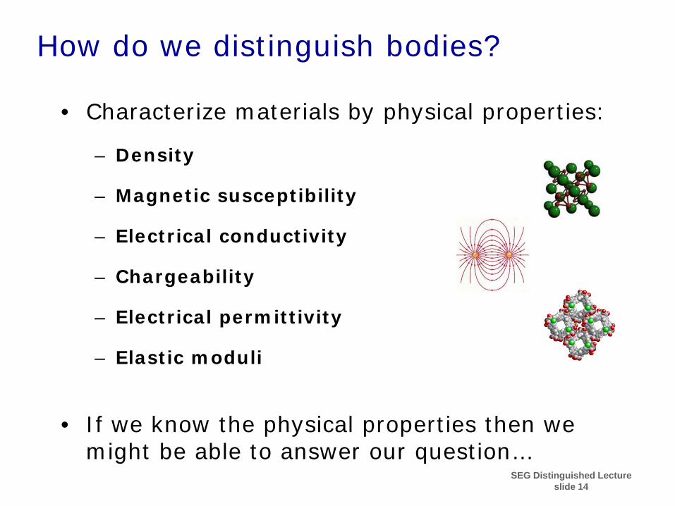
How do we distinguish bodies?
• Characterize materials by physical properties:
– Density
– Magnetic susceptibility
– Electrical conductivity
– Chargeability
– Electrical permittivity
– Elastic moduli
• If we know the physical properties then we might be able to answer our question…

EOSC 350 slide 15
Physical properties
• UXO: – Electrical conductivity and magnetic susceptibility
• Water (at potash mine): – Electrical conductivity: high if it has dissolved salt
• Minerals: – magnetic susceptibility (at Raglan) – electrical conductivity, – chargeability, – density

EOSC 350 slide 16
Environmental : Magnetic Survey
TM4
Ferrex
nT
-200
-100
0
100
200
Easting (m)
Nor
thin
g (m
)
0 10 20 30 40 50 0
10
20
30
40
50

EOSC 350 slide 17
mortar Popcan Frag 76mm
Operational Task: Dig

EOSC 350 slide 18
100 metres Approximate Scale
3.5 KM of Electrical Resistance Imaging along tunnels
Geotechnical survey data (potash mine)
NTS
UNDERGROUND 2D ERI GOCAD VISUALIZATION VIEW FROM NE
FIGURE 7
PROJECT No. DESIGN CADD CHECK
REVIEW
FILE No. ---- REV. SCALE
TITLE
PROJECT
06OCT03 28SEP04
Max CB/Max
04-1419-007

EOSC 350 slide 19
WEST EAST
143 m 148 m 155 m 159 m 163 m
Ground Penetrating Radar: Drill-holes with no water
Water found
Direct Current Resistivity image: Water found here
Two geophysical surveys along tunnels

EOSC 350 slide 20
Our mineral exploration example • Data: magnetic measurements. • Image: map of anomalies in earth’s field.
Map of surface geology
Image provides some information … but not enough.
Total field aeromagnetics

EOSC 350 slide 21
Getting more from data … • Image provides some information but not enough.
Total field
aeromagnetics
We want a “model” of subsurface materials. Invert the data

EOSC 350 slide 22
What is Inversion?
Goal: Estimate the Earth model that generated the data
Model
?
Data
Airborne, surface or borehole
measurements are data
Inversion processing

EOSC 350 slide 23
Inversion procedure:
• Divide Earth into cells (each with fixed size and unknown value).
• Inversion: find values for cells such that data are explained.
• Use mathematical optimization theory.
• Difficulties: – Solution is non-unique. – Computationally demanding.
Measurements = Data Pre-processing Inversion
Physical property distributions = MODELS
Prior information
3D, and ~ 105 cells
1κ
2κ

EOSC 350 slide 24
Geophysical inversion is analogous to medical imaging
• We need a 3D image for pinpointing a target or making a final assessment.
Image of a brain based on MRI measurements.
Image of an ore body based on magnetic field measurements.

EOSC 350 slide 25
Viewing an inversion result
• 3D volume can be viewed many ways. Here: – Data on top – Pixels showing material property value:
visible along the slice. – Isosurface:
hide all cells with values less than a chosen value.
EOSC 350 slide 26
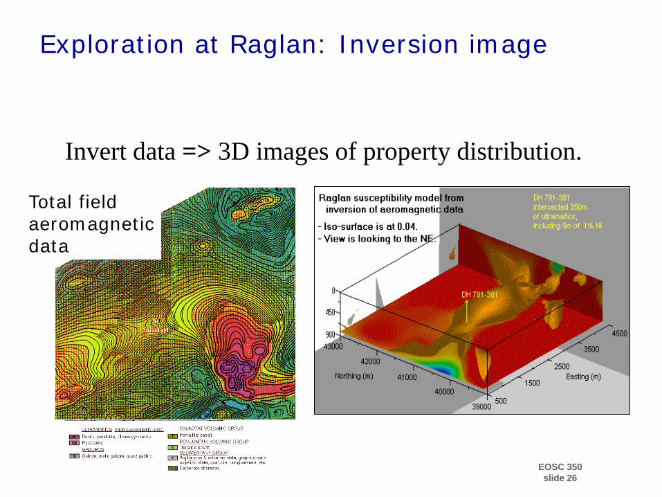
Exploration at Raglan: Inversion image
? ?
Invert data => 3D images of property distribution.
Total field aeromagnetic data

EOSC 350 slide 27
Framework for Applied Geophysics: 7 Steps
• Setup: What is the question to be answered?
• What are the diagnostic physical properties?
• Choose survey and design data acquistion.
• Data collection
• Processing of field data
• Interpretation
• Synthesis

EOSC 350 slide 28
Mineral Exploration: The “Cluny” copper/lead/zinc deposit
Physical Properties of the Rocks
Rock unit Conductivity Chargeability Adjacent shale high low
Host volcanic low-moderate low rocks
Mineral zone: - Siltstone containing (Cu, Pb, Zn) - Galena, pyrrhotite, pyrite, sphalerite
moderate high

EOSC 350 slide 29
Electrical survey: concept
DC survey Data: ”pseudosection”

EOSC 350 slide 30
Data set #1: Apparent resistivity, dipole - pole.
Electrical survey: data • Eight survey lines • Two survey configurations.
Easting (m) Easting (m)
mS/m
Easting (m) Easting (m)
mS/m
Data set #2: Apparent conductivity, pole - dipole.
10500 11500 12500
13000
14000
15000
16000
400
450
500
Easting (m)
Nor
thin
g (m
)
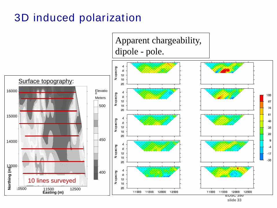
Surface topography: Elevation Meters
10 lines surveyed

EOSC 350 slide 31
3D conductivity model from 3D inversion:
Click image to see the AVI movie

EOSC 350 slide 32
IP data: what is being measured?
Source Current (Amps) Measured Voltage (Volts)
Vσ Vs(t)
Vη Measurement is: How easily does material retain charge.
Non-zero area occurs because charges took time to equilibrate.
EOSC 350 slide 33
Apparent chargeability, dipole - pole.
3D induced polarization
10500 11500 12500
13000
14000
15000
16000
400
450
500
Easting (m)
Nor
thin
g (m
)
Surface topography: Elevation Meters
10 lines surveyed

EOSC 350 slide 34
3D conductivity and chargeability: Cluny
Volume rendered resistivity model Volume rendered chargeability model

EOSC 350 slide 35
Summary For Applied Geophysics
• Multi-disciplinary: – brings together mathematics, physics, computer science,
geology, engineering into a single context.
• Requires team work and ability to communicate among different disciplines
• Two communication tools are:
– Expressing problems in terms of physical properties – Images

EOSC 350 slide 36
Framework for Applied Geophysics: 7 Steps
• Setup: What is the question to be answered?
• What are the diagnostic physical properties?
• Choose survey and design data acquistion.
• Data collection
• Processing of field data
• Interpretation
• Synthesis

• Read the paper: “A Geophysical Journey around Ireland” by James Hodgson • Download the TBL and complete it by evaluating one of the case
histories in the paper. This is handed in at the beginning of the next class.
Upcoming events: • Quiz involving “Foundations”
• Team exercise: Physical properties and case histories from
Ireland. EOSC 350
slide 37
Homework


![HUNTER GEOPHYSICS fileHunter Geophysics were commissioned by the [redacted] to undertake a geophysical survey covering the majority of the [redacted] Cemetery, [town], Victoria. Aims](https://img.pdfslide.net/doc/110x75/5a70d58c7f8b9a9d538c5a6a/hunter-geophysics-filehunter-geophysics-were-commissioned-by-the-redacted-to-undertake.jpg)