Embed Size (px)
Citation preview

VOL. 25, NO. 6 AU GUST 29, 2011
New Com mu ter Rail Line Com pletedWith No Fed eral FundsSub ur ban County May Set New Pre ce dent for Pub lic Trans por ta tion
The Denton County Trans por ta tionAuthor ity (DCTA) has marked a mile stone that it says could set a new pre ce dent inU.S. pub lic trans por ta tion. In June, theDCTA’s 21.5 mile A-train com mu ter railline made its debut with no fed eral funds.
Dee Leggett, vice pres i dent for com mu -ni ca tions and plan ning for DCTA, says theDCTA Board of Direc tors wanted to“expe dite deliv ery of this pro ject inadvance of the expan sion of Inter state 35which is adja cent to the rail cor ri dor. Thiswould allow the A-train to ser vice as mit i -ga tion to con struc tion-related con ges tion.” It also wanted to con nect with Dal las AreaRapid Tran sit, which was build ing itsGreen Line north to Carrollton. Leggettsays, “DCTA quickly saw that the fed eralpro cess was going to be lengthy.”
Board Chair man Charles Emery noted,“With the planned I-35 expan sion and thecom mu ter con ges tion that nat u rally comeswith con struc tion, we just could n’t wait for the fed eral fund ing.” So, in 2007, theBoard opted to pur sue local funds. The fol -low ing year, the Board locally approved its envi ron men tal doc u ment and sought fund -ing through the Regional Toll RevenueInitiative.
The ini tia tive stems from the TexasLeg is la ture, which enables the TexasDepart ment of Trans por ta tion to con siderpub lic- and pri vate-sec tor part ner ships tofinance road ways. Com pleted pro jectshave a toll com po nent and rev e nue forother non-toll trans por ta tion projects.
Ulti mately, the North Texas TollwayAuthor ity paid the region $3.2 bil lion in
Solar Pow ered Bluetooth Data Col lec torSim pli fies Traf fic Anal y sisAcyclica, a Boul der, CO, based com panyof traf fic pro fes sion als, has launched itsBlueCompass™ Bluetooth data col lec torsolar pow ered kits to sim plify traf fic anal -y sis, includ ing:
· Ori gin - Des ti na tion stud ies (real-timeor post pro cess)
· Real-time travel times on any road ways
· Mon i tor ing traf fic con di tions incon gested regions
· Map ping traf f ic f lows across aneigh bor hood, city or region
· Iden ti fy ing traf fic pat terns aroundsport ing events, amuse ment parks, etc.
· Track ing queue delays at inter sec tions
· Mon i tor ing wait times at air portsRang ing in price from $350 - $495, thesolar kit includes every thing needed todeploy BlueCompass™ remotely, includ -ing solar pan els, sealed lead acid bat ter iesand charge con trol ler. The man u fac tur ersclaim the kits will meet the need for moretrans par ent O-D and travel time data at a
Inside
Sur veys. . . . . . . . . . . . . . . . . . . . Page 9
Re quests for Pro pos als. . . . . . . . Page 20
Con fer ences . . . . . . . . . . . . . . . . Page 21
The downtown Denton station along the A-train commuter line in the Dallas, TXmetropolitan area. (Photo: Courtesy of the DCTA)
Please turn to Page 4
future excess toll rev e nues for the rights tooper ate State High way 121, which is nowthe Sam Rayburn Tollway. Leggettexplains that money was divided among
the coun ties in the region with Denton andCollin Coun ties receiv ing the lion’s share.“The region solic ited cit ies, coun ties and
THE URBAN TRANSPORTATION MONITORã 2011 Law ley Pub li ca tions. All Rights Re served.
Please turn to Page 4
© THE URBAN TRANSPORTATION MONITOR, AUGUST 29, 2011, VOL. 25, NO. 6 Page 2
The Urban Trans por ta tion Mon i tor, ISSN10404880, is pub lished monthly, except dur ingJan u ary and August (10 issues per year), by Law -ley Pub li ca tions, 6813 Jer e miah Ct., Fairfax Sta -tion, VA 22039, Tel: (703)764-0512, Fax:(703)764-0516, e-mail: edi [email protected]. Sub scrip tions $295 per year. Peri -od i cals post age paid at Fairfax, VA.POSTMASTER: Please send address changes toThe Urban Trans por ta tion Mon i tor, P.O. Box12300, Burke, VA 22009-2300. The Urban Trans por ta tion Mon i tor pub lishescur rent news on all modes and aspects related tourban trans por ta tion. Law ley Pub li ca tions is aninde pend ent and pri vately owned orga ni za tion. Copy right 2011, Law ley Pub li ca tions. AllRights Reserved. Repro duc tion, includ ing pho -to copy ing and fac sim ile or elec tronic trans mis -sion, in whole or in part with out writ tenper mis sion from the Edi tor is expresslypro hib ited.Law ley Pub li ca tions assumes no respon si bil ityor lia bil ity of any kind for the accu racy or com -plete ness of the infor ma tion herein, or for addi -tional or changed infor ma tion sub se quent to the date the mate r ia l was received and/orpub lished.Pub lisher/Edi tor: Dan iel B. Rathbone, Ph.D., P.E.Man ag ing Edi tor: Clarissa Reeves, M.Ed. Senior Edi tor/Writer: Carol Ochs
Rec om men da tions Made on Addressing Dis tractedDrivingMost Peo ple Guilty of Dis tracted Driv ing; GHSA says More Re search Needed into Driver Dis trac tion
The Gov er nors High way Safety As so ci a -tion (GHSA) has com pleted a pro ject tohelp state gov ern ments deal with the prob -lem of dis tracted driv ing.
GHSA Ex ec u tive Di rec tor BarbaraHarsha, who over saw the re port, says“there’s a lot of in for ma tion and re searchout there on the na ture of dis trac tion butnot a lot on what can be done about it. Wewanted to pro vide in for ma tion to statesand leg is la tures grap pling with theproblem.”
The GHSA hired a re searcher, a for mer as so ci ate ad min is tra tor with the Na tionalHigh way Traf fic Safety Ad min is tra tion,who re viewed more than 350 sci en tific pa -pers on dis tracted driv ing that were pub -lished be tween 2000 and 2011. Harshasays the find ings were “an af fir ma tion ofwhat we al ready knew or sus pected.” Shesays, “The thing that’s miss ing is that wedon’t know what coun ter mea sures orstrategies work.”
GHSA’s re port de fined dis trac tion asany time “a driver vol un tarily di verts at -ten tion to some thing not re lated to driv ingthat uses the driver’s eyes, ears or hands.”The re search in di cated that “most driv ersin sur veys re ported that they some timesen gaged in dis tract ing ac tiv i ties.” Abouttwo-thirds of all driv ers re ported us ing acell phone while driv ing, with one-third
call ing their use rou tine. About one-eighthof those sur veyed re ported texting whiledriving.
It was found that 15% to 30% of allcrashes in volved a dis tracted driver. How -ever, this per cent age may be greater sinceall in ves ti gat ing of fi cers did not re cord in -for ma tion about distraction.
Lim ited re search in di cates that cellphone use does in crease crash risk, butthere’s no con sen sus on the de gree of risk.There’s also no con clu sive ev i dence onwhether us ing hands-free cell phones areless risky. The re search does in di cate thattexting is prob a bly risk ier than cell phoneuse.
Harsha says there’s clearly a need formore re search on dis trac tion. For in stance,re search ers have not looked at is sues suchas whether dis tracted driv ers are re duc ingthe ca pac ity of sig nal ized in ter sec tions bybe ing slower off the mark when a traf ficsig nal turns green.
Dis tracted driv ing is clearly a ma jor leg -is la tive con cern. The re port found that as of June 2011, 30 states and the Dis trict of Co -lum bia have pro hib ited the use of all cellphones by nov ice driv ers. Forty-one statesand the Dis trict of Co lum bia have pro hib -ited texting by novice drivers.
Harsha notes that while more re search is needed on what works to stem dis tracted
driv ing, the GHSA re port makes sev eralrec om men da tions to states, such as:
· En act cell phone and texting bans fornov ice driv ers, who are the high estrisk driv ers.
· En act texting bans for all driv ers, since texting is more ob vi ously dis tract ingthan cell phone use.
· En force ex ist ing cell phone andtexting laws.
· Im ple ment pro grams to widely pub li -cize cell phone and texting laws.
· Help em ploy ers de velop and im ple -ment dis tracted driv ing pol i cies.
· Con tinue the use of out side edge lineand cen ter line rum ble strips to alertdriv ers when they leave traf fic lanes.
· Re cord dis tracted driv ing in crash re -ports.
Harsha ac knowl edges that dis tracted driv -ing laws can be hard to en force. She spec -u lates that even tu ally, the prob lem of dis -tracted driv ing will be solved by tech nol -ogy it self.For more in for ma tion on the re port, go toghsa.org/html/pub li ca tions/sfdist.html.
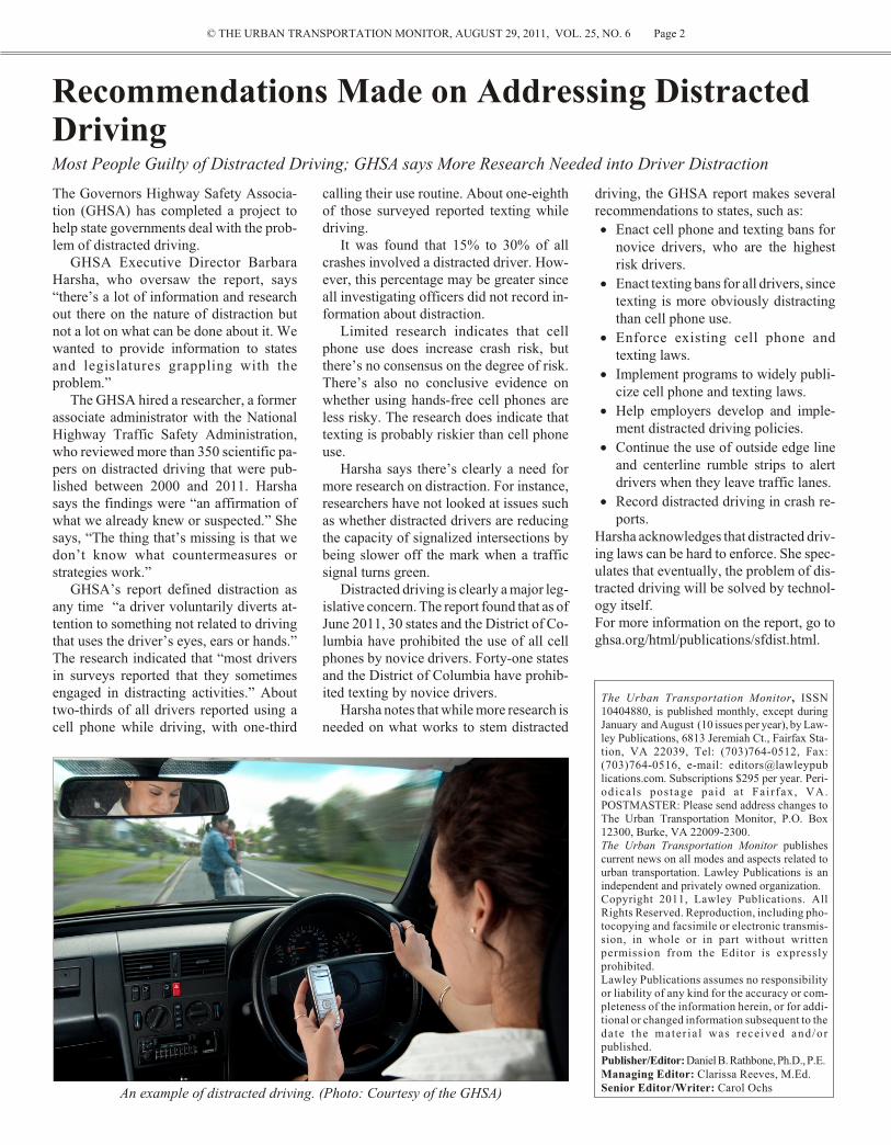
An ex am ple of dis tracted driv ing. (Photo: Cour tesy of the GHSA)

© THE URBAN TRANSPORTATION MONITOR, AUGUST 29, 2011, VOL. 25 NO. 6 Page 3
In July the Eu ro pean Com mis sion re leased new sta tis tics show ing that EU road fa tal i -ties de creased by 11% in 2010. Most coun -tries achieved dou ble-digit re duc tions inthe num ber of road deaths over the pastyear, the best be ing Lux em bourg (33%),Malta (29%), Swe den (26%) and Slovakia(26%). How ever, coun try-by-coun try sta -tis tics show that the num ber of deaths stillvar ies greatly across the EU, with fa tal i tiesper mil lion in hab it ants rang ing from 28(Sweden) to 116 (Greece).
Ac cord ing to the Eu ro pean Com mis -sion Vice Pres i dent for Trans port, nearlyall mem ber states man aged to sig nif i cantlyre duce their num ber of road deaths, re sult -ing in an es ti mated sav ing of nearly100,000 lives since 2001.
How ever, 100 peo ple still die on Eu -rope’s roads ev ery day. Given this, in Julythe Com mis sion adopted chal leng ingplans to re duce the num ber of road deathson Eu rope’s roads by half by 2020.
The Road Safety ac tion programme in -
Eu ro pean Road Fatalities Fall by 43% Since 2001U.S. Road Fatalities Fall by 27% Over Same Period
Com mu ters may be feel ing the pinch ofhigher gas prices this year, but most are notshell ing out much more for park ing. A sur -vey by Col liers In ter na tional finds the ma -jor ity of park ing ga rage own ers and op er a -tors are hold ing prices fairly steady ascom pared to last sum mer. Some com mu -ters have even seen park ing rates drop.
Col liers sur veyed rates in June 2011 atcov ered and un der ground ga rages in 61cen tral busi ness dis tricts across NorthAmer ica, with 49 in the U.S. and 12 in Can -ada. Col lier’s USA Chief Econ o mist RossMoore, says daily rates were up 0.8 per cent in 2011, re vers ing a 1.4 per cent de creaselast year. He notes that monthly rates weredown 0.2 per cent, re vers ing a 1.1 per centin crease in 2009-2010.
Driv ers in mid town New York paid thehigh est daily rates at a range of $12 to $72.That was a 2.5 per cent in crease. Round ingout the top ten most ex pen sive cit ies wereHo no lulu, Boston, Chi cago, Los An geles,down town New York, Phil a del phia, SanDiego, San Fran cisco and Calgary.
In the U.S., dou ble-digit in creases indaily park ing rates were found at ga rages inBelle vue, Wash ing ton, Hous ton, Texas,Port land, Or e gon, and Wash ing ton, D.C.On the flip side, dou ble-digit de creases inrates were found in Phoe nix, Ar i zona, Sac -ra mento, Cal i for nia, and Tampa, Florida.
Moore says daily rates tend to track thegen eral econ omy and con sumer spend ing.The mod est in crease in the daily rates mayre flect a re turn to more nor mal driv ing pat -terns and the need and de sire to be down -town. He re ports that monthly rates did notin crease de spite mod est im prove ments inof fice leas ing ac tiv ity and a gen eral im -prove ment in the business economy.
When the re port was re leased in June,Moore noted that de mand for park ing ap -pears to be slowly re turn ing to pre-re ces -sion lev els, so the rates that have held fairlysteady the past two years may be gin to riseagain if the econ omy con tin ues to re cover.He an tic i pated in creases of at least high sin -gle dig its. Since that time, the mar ket hasgone on a wild ride, but Moore says, “De -
cludes seven stra te gic ar eas and a mix ofini tia tives fo cused on mak ing im prove -ments to ve hi cles, in fra struc ture and roadus ers’ be hav ior. The stra te gic ar eas are:
· Improved safety mea sures for trucks andcars
· Build ing safer roads
· De vel op ing in tel li gent ve hi cles
· Strength en ing li cens ing and train ing
· Better en force ment
· Tar get ing in ju ries
· A new fo cus on mo tor cy clistsFor more in for ma t ion, go tohttp://europa.eu/rapid/pressReleasesAction.do?reference=IP/11/830
Se lected EU Coun tries Fa tal i ties per Mil lion Pop u la tion Change in Fa tal i ties
2001 2010 2001 - 2010
Lux em bourg 159 64 -54%
France 134 62 -51%
Deutsch land 85 45 -48%
United King dom 61 31 -47%
Nederland 62 32 -46%
Belgique/België 145 76 -44%
Italia 125 66 -44%
Eu ro pean Union 112 62 -43%
U.S.A. 148 108* -27%
Change in Traf fic Fa tal i ties Since 2001, Selected EU Coun tries, U.S.
* Pre lim i nary es ti mate by NHTSA
spite the con sid er able change in the out -look for the econ omy, our view on park -ing rates is more or less the same as whenwe pub lished the re port. While the de -mand for of fice space will be off from ourpre vi ous pro jec tions, park ing rates areunlikely to be affected.”
U.S. com mu ters can find some thingpos i tive in the re port. Though the me dianmonthly un re served park ing price is $541 in New York City, and the U.S. na tionalav er age me dian price for monthly park ing is $155, it could be a lot worse. In Lon don, the global leader in park ing prices, theme dian monthly rate is $1,084. Com mu -ters in Zu rich pay $822 a month, those inHong Kong pay $745, driv ers in To kyopay $744 and those in Rome pay $719.
For more in for ma t ion, v is it :http://dsg.colliers.com/document.aspx?report=1518.pdf or con tact Ross Moore [email protected].
Park ing Rates Hold ing Steady at Park ing Ga rages in the U.S.Rates Much Lower When Com pared to Some For eign Cit ies: Me dian Monthly Rate is $541 in New York CityCom pared to $1,084 in Lon don

© THE URBAN TRANSPORTATION MONITOR, AUGUST 29, 2011, VOL. 25 NO. 6 Page 4
tran sit agen cies for el i gi ble pro jects.County task forces were formed to re viewthe pro jects. DCTA was awarded $250mil lion for con struc tion and rail ve hi cleac qui si tion.”
The A-train is a com mu ter rail sys tem,and the DCTA ben e fits from a bal ancedcom mute. Ac cord ing to Leggett, “work ersgo south in the a.m. into the ur ban area, and uni ver sity stu dents, fac ulty and staff gonorth in the a.m. to Denton’s two large uni -ver si ties.” The ser vice is pri mar ily fo cused on week day, peak-pe riod op er a tions toserve these two pop u la tions. There is someSat ur day ser vice and ex tended Fri daynight ser vice for dis cre tion ary us ers.DCTA es ti mates daily ridership at 2,900dur ing the first five years, but it an tic i patesridership growing to 6,900 in 2035.
The rail line serves ur ban Dal las, with atrans fer to its pub lic trans por ta tion sys tem(Dal las Area Rapid Tran sit – DART), andLewisville and Denton with a uni ver sitypop u la tion of 50,000 plus. Down townDenton also has gov ern ment of fices and agrow ing re tail en vi ron ment. In ad di tion,rid ers can reach ma jor med i cal cen ters inDal las, Lewisville and Denton withA-train and Green Line connections.
Con tin ued from Page 1
Com mu ter Rail Line Com pleted With No Fed eral Funds
Op er a tional costs for the new sys temare es ti mated at $8 mil lion a year to be fi -nanced through sales tax rev e nue and thefare box. The DCTA has a lo cal sys temfare of $3 one-way and a re gional fare of$5 one-way. The re gional fare in cludes ac -cess to DCTA, DART, The T and the Trin -
ity Rail way Ex press. The es ti mated farerev e nue for the A-train is $1.26 million.
For more in for ma t ion, v is ithttp://www.dcta.net/TSA-train.asp or con -tact Claire Boxom, PR Spe cial ist, Con cus -sion, LLP, at 817-336-6824, ext. 322 orclairebloxom@con cus sion.net.
The BlueCompassTM Bluetooth datacollector. (Photo: Courtesy, Acyclica)
low cost.Spe cially de signed to with stand harsh
en vi ron men tal con di tions, the com pact and ro bust kits are Nema-housed and con formto the TS-2 spec i fi ca tion. The kits in -cludes:
· In te grated cel lu lar mo dem for re mote
de ploy ment (op tional)
· In te grated GPS for lo ca tion and timesyn chro ni za tion (op tional)
· Sim ple and open XML in ter face for fastin te gra tion
· Ethernet stan dard for easy net work con -nec tiv ity
· So lar-power op tion: fully op er a tional atun der 4 Watts (op tional)
· Up to 32GB of stor age for post pro cess -ing.
To date, a num ber of DOTs and pri vate en -gi neer ing firms have pur chased units tohave on hand for pro jects and stud ies. Theunits work by col lect ing Bluetooth in for -ma tion from trav el lers pass ing withinrange that are us ing Bluetooth-en abled de -vices. When a Bluetooth de vice is en abled,
it emits a sig nal within a unique MAC ad -dress. The BlueCompass, when it re ceivesthe MAC ad dress, timestamps the data.Enough units through out a study area al -low the col lec tion of data to show wheredriv ers with a Bluetooth en abled de vicebe gan and fin ished their trips (and wherethey trav elled in be tween). This tech nol -ogy can also be uti lized in main ar te ri als togain travel time in for ma tion at any timethrough out the day.
An other fea ture of the prod uct is that ithas a very open data for mat, which al lowsus ers to in ter face with it through the soft -ware pro vided or self-de vel oped.
For more in for ma tion, con tact AdamHicks a t (720) 854-4679 [email protected].
Con tin ued from Page 1
So lar Pow ered Bluetooth Data Col lec tor Sim pli fies Traf fic Anal y sis
The A-train arrives at a station in Dentor, TX. (Photo: Courtesy of the DCTA)

© THE URBAN TRANSPORTATION MONITOR, AUGUST 29, 2011, VOL. 25 NO. 6 Page 5
The world’s lon gest guided bus sys tem isnow car ry ing pas sen gers along a 16-mileroute from the city of Cam bridge to themore ru ral mar ket towns of St. Ives andHuntingdon in the United King dom. Thetran sit sys tem, dubbed The Busway, wentinto op er a tion ear lier this month and car -ries pas sen gers at speeds up to 60 mph.
The Cam bridge shire County Coun cilpi o neered the sys tem in an ef fort to givetrav el ers a break from fre quent traf fic con -ges tion along the A14 high way. The coun -cil’s Gareth Bell de scribes the A14 as a“no to ri ously busy motor way in Cam -bridge shire.” He says the ad van tage of aguided busway is that buses can use theseg re gated track but seamlessly move ontoex ist ing roads to take peo ple into townsand the city of Cambridge.”
Bell ex plains that the guided sec tionswere laid along a dis used rail way track be -tween Cam bridge and St. Ives. A con cretechan nel was built just wide enough to ac -com mo date buses fit ted with two smallguide wheels. Stan dard buses that willtravel along The Busway have been fit tedwith guide wheels at the front that hug thecurbs along the side of the con crete track.The en tire route is 25 miles long, with 16miles of guided track. Even though thebuses travel on reg u lar roads for ninemiles, they can use bus pri or ity mea sures,such as bus lanes and bus pri or ity traf ficsig nals to help speed their progress.
If fund ing al lows, the sys tem may beex panded in the fu ture. Bell says, “Cam -bridge shire has pro pos als to build a trans -fer sta tion at a rail way sta tion on the north -ern side of Cam bridge. If fund ing is se -cured for this, The Busway route will beex tended to the rail way station.”
Al ready, the Busway is eas ily the lon -gest guided bus sys tem in the world. Bellnotes that other guided busways do ex ist,but the next lon gest is only about 7.5 miles. It’s the O-Bahn Busway in Adelaide,South Aus tra lia.
The sys tem was launched two years late and well over bud get. The Busway hadbeen ex pected to open in spring of 2009,but there were de lays and fi nan cial dis -putes be tween the Cam bridge shire CountyCoun cil and the orig i nal con trac tor, BAMNuttall Ltd. The fi nal price tag for the pro -ject was $191 million.
The Busway pro ject was pro posed in
World’s Lon gest Guided Busway OpensNew Tran sit Sys tem Aimed at Re duc ing Travel Times
2001 to cope with over crowd ing on theCam bridge shire road net work that wascaus ing bumper-to-bumper tie-ups aroundthe an cient Uni ver sity City. Fre quent de -lays and un cer tain travel times were hurt ing the en vi ron ment and the local economy.
The Cam bridge shire County Coun cil re -ports that most guided buses will run onbio-fuel, which is greener than die sel. Itnotes The Busway will save en ergy whileen cour ag ing more peo ple to get out and en -joy the coun try side. Buses run to the FenDrayton Lakes and into the heart of the his -toric mar ket towns of St. Ives andHuntingdon.
Some busi ness own ers are hope ful theeas ier ac cess will trans late into new cus -tom ers, and the sys tem will serve theplanned 10,000 homes in the new town ofNorthstowe. But ev ery one is n’t happyabout The Busway. CAST.IRON, the Cam -bridge and St. Ives Rail way Or ga ni za tion,
wanted the rail way line re -opened in stead. The groupsays it re mains “ut terly un -con vinced” the tran sit sys -tem will “make any no tice -able dif fer ence to traf ficlev els on the A14 and thereis no doubt it will in creasecon ges tion in the city’sstreets.”
Two free park and ridesites were built along theroute as part of the pro ject,and The Busway can be ac -cessed from a park-and-ridelot just south of Cam bridge.Bus fares range from £3 to£5.40 (about $5 to $9).
Buses run along the route seven days a week from 6a.m. to mid night. At peaktimes, 7 a.m. to 7 p.m., thebuses run at least ev ery 10min utes. Two bus com pa -nies, Stage coach and Whip -pet, share the sys tem. Thereare more than 100 stopsalong the en tire route, with14 stops on the guided sec -tions. Bell re ports a 12-milejour ney on the guidewaytakes 20 min utes, in clud ingstops.
Stops along the guided
The Busway, a guided busway on an ex clu sive right ofway, lo cated in the Cam bridge area of Eng land. (Photo:
Cour tesy of Cam bridge shire County Coun cil)
track have raised plat forms that can be ac -cessed by ramps to make travel eas ier forwheel chair us ers. New bus shel ters alongthe route of fer real-time in for ma tion to letpas sen gers know when the next bus is ex -pected to ar rive. The buses them selvesfea ture air-con di tion ing, leather seats,free WiFi and power hook-ups, and theyare fully accessible.
A paved path is be ing built along sideThe Busway track to give walk ers, cy -clists and horse-rid ers an al ter na tivemeans of get ting around. The traf fic-freeroute will be come part of the Na tional Cy -cle Net work and pro vide ac cess to work,school and shop ping, as well as a means to get some exercise.
For more in for ma t ion, v is it :h t t p : / / w w w . c a m b r i d g e -s h i r e . g o v . u k / t r a n s -por t /around/thebusway/ orhttp://thebusway.info/.

© THE URBAN TRANSPORTATION MONITOR, AUGUST 29, 2011, VOL. 25 NO. 6 Page 6
The Fi nal Re port of the As so ci a tion ofMet ro pol i tan Plan ning Or ga ni za tions(AMPO) spon sored Ad vanced TravelMod el ing Study Phase 1, pres ents the con -clu sions from the first phase of the as sess -ment of ad vanced travel model (ATM)per for mance by Met ro pol i tan Plan ningOr ga ni za tions (MPOs). It also makes rec -om men da tions for the sec ond phase of thestudy.
The goal of the re search was to pro videtech ni cal guid ance to the met ro pol i tanplan ning com mu nity on the rel a tive costsand ben e fits of com mit ting re sources to the de vel op ment and im ple men ta tion of ac tiv -ity-based mod els (ABMs) as a re place -ment for trip-based models (TBMs).
The first phase con sisted of four dis -crete tasks:
· Iden tify MPOs hav ing ex pe ri ences withABMs of in ter est to other prac ti tio nersand iden tify MPOs ap pro pri ate for fur -ther study
· As sess the sta tus of the doc u men ta tionof and in for ma tion avail able from se -lected MPO ex pe ri ences with ABMs
· Iden tify per for mance and cost cri te riafor as sess ing ABMs
· De sign a study to carry out a com par i son be tween TBMs and ABMs in the samegeo graphic area.
Twenty-one MPOs and one county trans -por ta tion agency were ini tially iden ti fied.Nine of these were sur veyed for Task 2,four (three MPOs and one county trans por -ta tion agency) fully meet ing the cri te ria,and five par tially meet ing them, based onthe fol low ing cri te ria:
· Is the ABM the MPO’s pro duc tionmodel?
· Has it been ap plied to spe cific pro jects?
· Is suf fi cient in for ma tion (doc u men ta -tion) avail able to de ter mine the rel a tivecosts?
The over all sta tus of doc u men ta tion onABM de vel op ment and ap pli ca tion fromthe nine MPOs was mixed but gen er allynot suf fi cient to per mit the en vis aged as -sess ment. The study found that better doc -u men ta tion and mea sure ment of spe cificcost and per for mance met rics for both setsof mod els is needed in or der to eval u ate the rel a tive mer its of TBMs and ABMs.
Three out comes were achieved re gard -ing iden ti fy ing per for mance and cost cri te -
Ap pli ca tion of Ac tiv ity Based Mod els Com pared to Trip-BasedMod elsSpon sored by the As so ci a tion of Met ro pol i tan Plan ning Or ga ni za tions
Six tran sit agen cies from around the coun -try have been cho sen to take part in a U.S.De part ment of Trans por ta tion pro gramaimed at im prov ing man age ment of tran sit
equip ment.The U.S. De part ment of Trans por ta -
tion’s Fed eral Tran sit Ad min is tra tion hasse lected Mas sa chu setts Bay Trans por ta -tion Au thor ity, Pen in su lar Cor ri dor JointPow ers Board in the San Fran cisco Bayarea, Re gional Trans por ta tion Au thor ity in the Chi cago and North east Il li nois area,Utah Tran sit Au thor ity, Val ley Re gionalTran sit in Me rid ian, Idaho, and Vir giniaDe part ment of Rail and Pub lic Trans por ta -tion to par tic i pate in the Tran sit As setMan age ment (TAM) Pi lot Program. Thesix will share $4 million in program funds.
The goal of the pi lot pro gram is to helpim prove the con di tion of Amer ica’s tran sitsys tems and the safety of op er a tions. Par -tic i pants are be ing en cour aged to find newcost-ef fec tive ways of man ag ing andmain tain ing the con di tion of their sys temsby de ter min ing and an tic i pat ing whenequip ment will need main te nance, re pairor re place ment. TAM cov ers ev ery thingfrom rail road tracks and train sta tions tobus facilities and electrical equipment.
The 15 ap pli cants for the pro gram re -quested a to tal of about $13 mil lion dol lars, which in di cated there is sig nif i cant de -
Please turn to Page 7
The maintenance of buses is animportant part of asset management.
(Photo: Cour tesy of the VDRPT)
ria for as sess ing ABMs. The team:
· Sum ma rized avail able cost in for ma tionon ABMs
· Pre pared a po ten tial cost track ing tem -plate for use with MPOs dur ing fu turein ves ti ga tions
· Iden ti fied pol i cies that would re quiretest ing with a travel de mand fore cast ingmodel, and or ga nized them into eightcat e go ries:
- High way ca pac ity im prove mentsand op er a tional strat e gies
- Tran sit ca pac ity im prove ments andop er a tional strat e gies
- Man aged (HOT) lane anal y sis andpric ing
- Land use changes- Pol i cies to mod ify di ur nal dis tri bu -
tion of travel
- Pol i cies to re duce trips- De mo graphic changes- En vi ron men tal pol i cies.
It de ter mined that a side-by-side com par i -son would be the best way to test the costsand per for mance of both sets of mod elsrel a tive to each other.
Fi nally, the re port iden ti fied three po -ten tial ap proaches for Phase 2 of this re -search:
· Aligned Model Com par i son
· Case Study Com par i son
· Con cep tual Com par i sonThe Case Study Com par i son was se lected, with At lanta and Se at tle as test sites for the Phase 2 study.
For more in for ma tion, please go toAMPO’s website (www.ampo.org).
Par tic i pants Se lected for Tran sit As setMan age ment Pi lot Pro gramSix Agen cies to Share $4 mil lion

© THE URBAN TRANSPORTATION MONITOR, AUGUST 29, 2011, VOL. 25 NO. 6 Page 7
Re port Re leased on Stan dards Needed to Sup portElec tric Ve hi cles in the United StatesThe Amer i can Na tional Stan dards In sti tute (ANSI), co or di na tor of the U.S. vol un tarystan dard iza tion sys tem, has sub mit ted tothe U.S. De part ment of En ergy (DOE) a re -port out lin ing pri or ity ar eas where stan -dards and con for mance ac tiv i ties areneeded to fa cil i tate the safe, ef fec tive andlarge-scale de ploy ment of elec tric driveve hi cles (EDV) in the United States.
The re port de tails find ings from theApril 5-6 ANSI Work shop, Stan dards andCodes for Elec tric Drive Ve hi cles, whichANSI con vened on be half of DOE and theIdaho Na tional Lab o ra tory. Nearly 120stake holders and an other 30 webinar at ten -dees ex am ined the stan dards, codes, con -for mance pro grams and ed u ca tion ini tia -tives needed to drive the wide spreaddeployment of EDVs.
Ac cord ing to the ANSI Work shop Re -port, Stan dards and Codes for Elec tricDrive Ve hi cles, the is sues of safety andcon sumer con fi dence – and the con for -mance and train ing pro grams needed tosup port them – are key pri or i ties for thewide spread ac cep tance of EDVs and thecon tin ued growth of the mar ket. The over -arch ing con clu sion of the April work shopwas a call for better co or di na tion and har -mo ni za tion of stan dard iza tion ef forts andfor a pub lic-pri vate part ner ship to movethis work for ward quickly and ef fec tively.Par tic i pants agreed that a stan dard iza tionroadmap for North Amer ica would help toes tab lish pri or i ties for the work that needsto be done. A ma trix of the var i ous co or di -nat ing bod ies and stan dards ac tiv i tieswould also help stake holders nav i gate thevarious activities taking place andfacilitate global harmonization.
To of fer a neu tral fo rum where pub licand pri vate sec tor stake holders can workco op er a tively to ward so lu tions that willhelp build the mar ket for EDVs, ANSIformed the Elec tric Ve hi cles Stan dardsPanel (EVSP) in March 2011. The goal ofthe EVSP is to pro duce a stra te gic roadmap by year’s end that will de fine the stan dardsand con for mity as sess ment pro grams thatare needed to sup port this ma jor shift in the na tional au to mo tive land scape. The EVSPbe gan the ground work for the stan dard iza -tion roadmap at its ple nary meet ing onJune 20-21 in De troit. The ANSI Work -
shop Re port, Stan dards and Codes forElec tric Drive Ve hi cles, will serve as a keyin put document to the continued efforts ofthe EVSP.
The full work shop re port, as well asthe speaker pre sen ta tions and webinar re -cord ings of the April 5-6 work shop, areavail able at www.ansi.org/edv.
Continued from Page 6
Par tic i pants Se lected for Tran sit As setMan age ment Pi lot Pro grammand for fund ing. The pro pos als were eval -u ated on cri te ria de tailed in the No vem ber19, 2010 No tice of Fund ing Avail abil ity.
The Mas sa chu setts Bay Trans por ta tionAu thor ity will get the big gest chunk of thefund ing. It was al lo cated $950,000. Chi -cago’s Re gional Trans por ta tion Au thor ityis re ceiv ing $800,000. Pen in sula Cor ri dorJoint Pow ers Board (CALTRAIN) is get -ting $750,000 and the Vir ginia De part mentof Rail and Pub lic Trans por ta tion wasawarded $700,000. The Utah Tran sit Au -thor ity gets $500,000 and Idaho’s Val leyRe gional Transit is receiving $300,000.
Fed eral trans por ta tion of fi cials hopeoth ers will be able to rep li cate ef fec tiveTAM sys tems and “best prac tices” to im -prove trans por ta tion as set man age ment atrail and bus pub lic trans por ta tion agen ciesacross the coun try. Grant ees must use thefunds only for pro jects de tailed in theproposals they submitted.
Courtney W. Moyer, Man ager of Pol icy
and Com mu ni ca tion for the Vir ginia De -part ment of Rail and Pub lic Trans por ta -tion, says Vir ginia is cur rently one of onlya few states with an as set man age mentsys tem. Moyer says the state’s ex ist ingsys tem “al lows DRPT to fore cast cap i talneeds for state of good re pair for our ex ist -ing grant ees (tran sit op er a tors in Vir ginia) over a 20-year ho ri zon based on the use ful life of tran sit as sets.” The grant moneywill be used “to im prove the sys tem andadd a way to es ti mate cap i tal needs for ex -pan sion of ser vice as well.” The statehopes to move the sys tem to an opensource so other states can benefit from it.
For more in for ma tion con tact Do risLy ons, Of fice of Pro gram Man age ment at202-366-1656 or [email protected],or Aaron C. James, Sr., Of fice of Pro gramMan age ment at 202-493-0107 [email protected].
The TH!NK city elec tric ve hi cle. (Photo: Cour tesy, Think Global)

© THE URBAN TRANSPORTATION MONITOR, AUGUST 29, 2011, VOL. 25 NO. 6 Page 8
In a re cent ap peal against a rul ing by theSu pe rior Court of Prov i dence, a mo tor istal leged the court wrong fully ap plied thepub lic-duty doc trine in grant ing sum maryjudg ment, in light of what he con tendedwere clear stat u tory guide lines for traf ficde sign. The case arose from a mo tor ve hi -cle ac ci dent that plain tiff al leged wascaused by the city of Prov i dence throughneg li gently in stall ing and main tain ing anun safe, dan ger ous road at the ac ci dent site.Spe cif i cally, plain tiff con tended:
· the posted speed limit was “too fast for
the area”
· the in ter sec tion was un safe be cause it
had only two stop signs
· speed limit signs were hid den by veg e ta -
tive growth
· trees blocked the view of the “Road Nar -
rows” signs
In re ply to a com plaint filed by plain tiff,the city’s Traf fic En gi neer ing Di vi sion ofthe De part ment of Pub lic Works in ves ti -gated and re ported that all traf fic con trolde vices were in place, noth ing was miss ing or ob structed, the in ter sec tion did n’t war -rant the in stal la tion of a 4–WAY STOPsign and the posted speed limit was bothrea son able and pru dent for the area.
The city there fore de nied plain tiff’sclaim, hence an ap peal to the Su pe riorCourt where the city moved for sum maryjudg ment, as sert ing that based upon thepub lic-duty doc trine, its de ci sions with re -spect to the traf fic de sign of the in ter sec -tion were dis cre tion ary and not ac tion able.The Court ruled plain tiff had not shownany gen u ine is sues of ma te rial fact thatwould ex empt this case from that doc trineand found in fa vor of the city. This re sulted to the appeal in the Supreme Court.
Here, plain tiff cited G.L.1956 §9–31–1, which pro vides that a mu nic i pal -ity, sub ject to cer tain lim i ta tions, is “li a blein all ac tions of tort in the same man ner as a pri vate in di vid ual or cor po ra tion, which he claimed ab ro gates the doc trine of sov er -eign im mu nity with re spect to themunicipality.
He fur ther ar gued that in terms of §
Su preme Court of Rhode Is land Re states Ex cep tions To ThePub lic-Duty Doc trine
31–13–3, the city lacked dis cre tion in itsplace ment of traf fic-con trol de vices be -cause it is ob li gated to com ply with “clearstat u tory” guide lines es tab lished by thestate traf fic com mis sion. Given this, he al -leged that the pub lic-duty doc trine did notapply in this case.
City re sponded by claim ing the statetraf fic com mis sion had not es tab lishedman dates for the place ment or num ber ofstop signs re quired at any par tic u lar lo ca -tion. It ar gued that the word ing of §31–13–3 e.g. the city “may place” traf -fic-con trol de vices “as it may deem nec es -sary” was per mis sive, and there forediscretionary.
The court found plain tiff had failed tocite any par tic u lar state man date withwhich the city did not com ply. It de claredthe place ment of traf fic-con trol signs by amu nic i pal ity to be a quint es sen tial gov ern -men tal func tion and pre cisely the type ofdis cre tion ary gov ern men tal ac tiv ity that isshielded from tort li a bil ity under thepublic-duty doctrine.
It then re-enu mer ated the three ex cep -tions to the pub lic-duty doc trine which oc -cur when:
· the al leg edly neg li gent ac tiv i ties are nor -
mally per formed by pri vate cit i zens
· plain tiff es tab lishes a breach of a spe -
cial duty, owed to the plain tiff as a spe -
cific, iden ti fi able in di vid ual and not
merely a breach an ob li ga tion owed to
the gen eral pub lic
· state has knowl edge that it has cre ated a
cir cum stance that forces an in di vid ual
into a po si tion of peril and sub se quently
chooses not to rem edy the sit u a tion.
In terms of these ex cep tions it found thatthe place ment and main te nance of traf -fic-con trol de vices are purely gov ern men -tal func tions not nor mally per formed bypri vate cit i zens. Sec ond, it found thatplain tiff had not al leged a breach of a spe -cial duty owed to him in his in di vid ual ca -pac ity. The third ex cep tion arises whenthe state en gages in “egre gious con duct.” How ever, since it found no ev i dence in di -cat ing the city’s al leged neg li genceamounted to egre gious con duct, there was no ba sis for ap ply ing this ex cep tion.
Given that it found all the is sues in thecase were con trolled by the pub lic-dutydoc trine, there was no ba sis for mu nic i palli a bil ity, and it af firmed the rul ing of theSu pe rior Court.
Transportation Tort Liability: Case in Review
This ae rial image show the intersection of Adelaide Ave. and Melrose Street, wherepedestrian-related safety was questioned. (Image, Google, Inc.)

© THE URBAN TRANSPORTATION MONITOR, AUGUST 29, 2011, VOL. 25 NO. 6 Page 9
This Month’s Sur vey Re sults (Sur vey 1)
Bi cy cle and Pe des trian Issues
Ear lier this month, The Ur ban Trans por ta tion Mon i tor con ducted a na tion wide sur vey on bi cy cle and pe des trian is sues. Sur veys weresent to 300 dif fer ent ju ris dic tions in the U.S. A to tal of 34 com pleted sur veys were re ceived, which represents a return rate of 11%.The re spon dents are from cit ies of all sizes. The me dian pop u la tion of the re spon dents’ cit ies is 254,000.
Do your street de sign stan dards re quire the pro vi sion of pe des trian and/or bi cy cle fa cil i ties as part of the con struc tion ofnew highways?
If yes, can you briefly explain what the requirements are? Answers are listed in the order of frequency of responses.
Bi cy cle fa cil i ties
· Our thor ough fare plan dic tates which road ways will have bike fa cil i ties and what type.
· Cur rent traf fic sig nal pol icy re quires bi cy cle de tec tion (BPB or loop) for through move ments with bike min green tim ing. Des ig -nated bike routes re quire signs, leg ends, and strip ing. Cal i for nia re cently man dated bike de tec tion all lanes at traf fic sig nals withbike min green tim ing.
Pe des trian fa cil i ties
· 5' wide side walks.
· Side walk is con structed ad ja cent to de vel oped par cels only.
· One side of street at least 5' wide con tin u ous side walk.
· Side walk is re quired on at least one but pref er a ble both sides of a street.
· 5' min con crete side walk.
· Side walk with min i mum width of 4' on lo cal streets in sin gle-fam ily res i den tial dis tricts and min i mum of 5' else where.
Shared use path plan ning/in te grated plan ning
· Zon ing reg u la tions re quire sub di vi sions to in stall side walk and/or multi-use paths.
· Side walks are re quired on both sides of all new streets. Dur ing staff re view, we are rec om mend ing on-street bike lanes oroff-road paths where ap pro pri ate. We in tend to pre pare a com plete streets pol icy but have not done so at this time.
· 4-5 foot bike lanes or paved shoul ders on ar te rial streets. Side walks on ar te rial and col lec tor streets. Side walks on com mer -cial/in dus trial streets.
· Paved shoul der for bi cy cle use where the bi cy cle plan spec i fies, and side walks for ur ban and ru ral roads as needed.
· Town adopted VDOT's Com plete Streets Pol icy.
· We ac com mo date ped/bike fa cil i ties where fea si ble, but not man dated.
· The city is built up - no new high way con struc tion, but retro-fit ting is done where pos si ble and ap pro pri ate.
· All road way main te nance and con struc tion ac tiv i ties must con sider the need for pe des tri ans and bi cy clists.
· Five foot bike lanes on all col lec tors and on ar te ri als des ig nated on our Mas ter Plan. Side walks on all thor ough fares and lo calroads on both sides of the road way. Eight foot if on back of curb or six foot with three foot sep a ra tion from back of curb.
· Bikelanes and de tached side walks for all col lec tor and ar te rial street stan dards.
· City code and re lated rules and regulations re quire that road way pro jects (pub lic or pri vate) in clude side walks and bike fa cil i tiesun less an ex emp tion is granted.
· Cur rently, side walks are re quired on all streets on both sides. We are up dat ing to re quire bike lanes on cer tain streets as well.Some streets have also been iden ti fied for re quir ing hiker/biker trails to con nect to the city's shared use path plan.
· Port land's street clas si fi ca tion sys tem, and 2030 bi cy cle plan up date, des ig nate which streets have City Walk way, or City Bike -way des ig na tions and the widths or types of fu ture fa cil i ties planned on those routes.
Percentage of Respondents
Yes 100%
No 0%

`
© THE URBAN TRANSPORTATION MONITOR, AUGUST 29, 2011, VOL. 25 NO. 6 Page 10
Does your city have a plan or reg u la tions in place that re quire the pro vi sion of pe des trian and/or bi cy cle fa cil i ties (on oroff-road) at new de vel op ments?
If yes, can you briefly ex plain what the re quire ments are?
Side walks
· Side walks be hind the curb on all paved streets.
· 4-ft min i mum width side walk will be con structed one foot off of the right-of-way line along all street front ages.
· Side walks are re quired on both sides of all new streets. Dur ing staff re view, we are rec om mend ing on-street bike lanes oroff-road paths where ap pro pri ate. We in tend to pre pare a com plete streets pol icy but have not done so at this time.
· Side walks on col lec tor streets in the de vel op ment. Side walks are to be built along ex ist ing streets to con nect the new de vel op -ment to the near est ar te rial street.
· New sub di vi sions re quire 5' side walks and 10' multi-use paths around per im e ter. Con nec tions are made where avail able. If bikefa cil i ties are re quired on a new road way per our thor ough fare plan, 4 to 6 foot shoul ders are con structed or a sep a rate path is con -structed de pend ing on ve hic u lar vol umes and speed zone.
· Side walks both sides of the street.
· Side walks are re quired along both sides of all new streets ex cept lo cal streets in a sin gle-fam ily res i den tial sub di vi sion where alllots are 1 acre or greater.
In te grated/com plete streets/com pre hen sive plan/multi use
· Stan dards per ap proved Hike & Bike Trail Masterplan. Widths vary from 5 to 12 feet.
· In adopted com pre hen sive plan. As the plan is re vised this year, it will in clude ref er ence/re quire ments for the pro vi sion of com -plete streets.
· Pro vi sions in the Zon ing Or di nance, Sub di vi sion Or di nance, and Road Or di nance.
· As per VDOT's Com plete Streets Pol icy.
· Side walk is re quired on at least one but pref er a ble both sides of a street. Part of our Com pre hen sive Trans por ta tion Plan.
· Street De sign Man ual- New York City Dept. of Trans pro vides guid ance.
· We re quire side walks with all de vel op ment, bike racks at com mer cial de vel op ments and trail con struc tion when a part of ourMas ter Plan.
· Our sub di vi sion reg u la tions and our de sign guide lines spell out those pro vi sions.
· Multimodal LOS stan dards.
· City code and re lated Rules and Reg u la tions re quire that any new de vel op ment or 50% re de vel op ment must in stall side walksalong their front age as well as bike fa cil ity re quired in the Bi cen ten nial Bike ways Plan. If valid rea sons ex ist that do not al low con -struc tion, then the de vel oper pays a fee in lieu of to cover the cost of con struc tion.
· Side walk stan dards and multi-use trail stan dards.
· The City's Com pre hen sive Plan iden ti fies the shared use path sys tem which in cludes hiker/biker fa cil i ties, rails-to-trails, etc.
Has your city adopted stan dards/spec i fi ca tions for the plan ning and de sign of pe des trian and/or bi cy cle fa cil i ties?
De vel oped in-house
· De vel oped in-house per ac cess man age ment reg u la tions with guid ance from a com mit tee and AASHTO.
· We have, for Bike Racks and Bike Lock ers.
· De vel oped in house.
· De vel oped in house us ing va ri ety of sources.
· 2030 bike plan via 2-3 year pub lic pro cess. Trans por ta tion Sys tem Plan is up dated ev ery 5-10 years via pub lic in put.
Bi cy cle and Pe des trian Is sues (con tin ued)
Percentage of Respondents
Yes 95%
No 5%
Percentage of Respondents
Yes 76%
No 24%

© THE URBAN TRANSPORTATION MONITOR, AUGUST 29, 2011, VOL. 25 NO. 6 Page 11
Adapted/ref er ence ex ist ing ma te rial
· Our 2008 Bi cy cle and Pe des trian Plan ref er ences AASHTO stan dards and the WisDOT Bi cy cle Fa cil ity Hand book.
· Use State stan dards and spec i fi ca tions.
· FDOT stan dards.
· We fol low AASHTO and Fl PPM stan dards at all times.
· Pri mar ily based on VDOT which is based on AASHTO.
Both
· Side walks - de vel oped in-house and sub ject to ADA re quire ments. Bi cy cle trails - AASHTO guide lines.
· We have side walk stan dards. Use na tional stan dards where bi cy cle fa cil i ties are con sid ered.
· A com bi na tion of in-house, AASHTO, zon ing reg u la tions and the Build ing De part ment codes.
· In house, CA MUTCD.
· AASHTO man ual with in put from staff and con sul tant. Con sul tant de vel oped de sign stan dards that are in cor po rated into theHike & Bike Trail Masterplan.
· Our de sign stan dards were de vel oped in house to re flect rec om mended prac tices from AASHTO, ITE and TxDOT.
· In-house, AASHTO and Ohio DOT stan dards.
· Work ing on up dat ing the City's stan dards which will in clude in put from pro fes sional or ga ni za tions, AASHTO, in dus try stan dards,etc.
Are you sat is fied with the avail able tech ni cal re sources (doc u ments, train ing) for the plan ning and de sign of pe des trianand/or bi cy cle fa cil i ties?
If "yes", please in di cate what you con sider to be the best re source(s)AASHTO de sign guide
· Soon to be up dated AASHTO bike de sign guide, re cent NATCO bike de sign guide and MUTCD
· CA MUTCD
· CDOT Bike and Ped work shops
· Col leagues
· FDOT pub li ca tions. Also use AASHTO guide
· ITE
· ITE and AASHTO.
· Port land Pe des trian De sign Guide; Port land 2030 Bike Plan; NACTO bike de sign guide; NCHRP 562 and TTI spread sheet.
· Many dif fer ent good sources
· There are so many it is im pos si ble to say which is the best
If "no", please ex plain briefly what are the main de fi cien cies are in the ex ist ing body of doc u mented knowl edge.
· We just went through an ex er cise to de velop a Bike Mod ule for our re cently adopted Smartcode Zon ing Dis trict. There are somany unique and ex cel lent ways to in te grate bi cy cle traf fic into our ex ist ing in fra struc ture - but these are new ideas and con ceptsthat are not widely ac cepted in the en gi neer ing in dus try. More train ing and ed u ca tion is needed to ex pose more peo ple to thesecon cepts and al low for more flex i bil ity to in cor po rate them where needed.
· The AASHTO Pe des trian/Bi cy cle Guide and NACTO in for ma tion is good but there is a lot of guid ance lack ing with re spect to in -ter sec tion treat ments, par tic u larly at sig nal ized in ter sec tions
· Tech ni cal un der stand ing on the part of CA reg u la tory bod ies of the lim i ta tions im posed by tech nol ogy for bi cy cle de tec tion.
· Lack of aware ness on the part of reg u la tory bod ies of the fi nan cial im pact of un funded bi cy cle reg u la tions.
· Al though very good I be lieve there is not ad e quate in for ma tion on ur ban de sign stan dards.
Bi cy cle and Pe des trian Is sues (con tin ued)
Percentage of Respondents
Yes 86%
No 14%

Do you have an ac tive cit i zen's com mit tee(s) or other ad vi sory com mit tee(s) that make rec om men da tions about the pro vi -sion, en hance ment, and use of pe des trian and/or bi cy cle facilities?
Who con sti tutes the com mit tee(s) (e.g. cit i zens, elected of fi cials, etc.)
· All are cit i zens
· Ap pointed cit i zens and elected of fi cials
· Bi cy cle/Pe des trian Ad vi sory Com mit tee
· Bike rid ers
· Both cit i zens and elected of fi cials
· Cit i zens
· Cit i zens and city staff
· Cit i zens and elected of fi cials
· Cit i zens ap pointed by City Coun cil
· Cit i zens ap pointed by the City and County
· Cit i zens, City staff, Elected Of fi cials, busi ness own ers, etc
· Cit i zens, com mu nity groups and elected of fi cials
· City health staff, bike fa cil ity de signer, bike fa cil ity plan ner, bi cy cle ad vo cate, cit i zen
· Lay peo ple, plan ning/en gi neer ing pro fes sion als and elected of fi cials
· PBOT staff and vol un teer cit i zens
Does your city have a des ig nated bi cy cle/pe des trian co or di na tor?
Has your city em barked in the past (or is it pres ently em bark ing) on pro grams/tech niques to en cour age walk ing and bi cy -cling?
If yes, can you briefly out line these pro grams/tech niques and in di cate if they were/are suc cess ful in your opin ion?
· A va ri ety of out reach and ed u ca tion pro grams tar get ing schools and se niors. Li ai son to the Bike/ped Ad vi sory Board.
· Ac tively sup port and pro mote "Bike to Work Day."
· Con struct ing 4 mile seg ment of main hike & bike trail through north ern third of the city.
· Im proved cross walks, new side walks, new bike lanes, new shared lane mark ings and new multi-use paths.
· In stall ing bike lanes to en cour age cy cling, NYC is walkable in neigh bor hoods - it's dif fi cult to es ti mate spe cific de mand.
· Many dif fer ent pro grams in clud ing Bikes and Safe Routes to School.
· Safe Routes to School Pro gram in clud ing en gi neer ing anal y sis and pro jects. This pro cess has successfully in creased walk ingand bik ing and the en gi neer ing anal y sis has achieved over $2M in Fed eral SR2S fund ing for en gi neer ing im prove ments.
· The 2030 Bike Plan pro cess and ded i cated fund ing are in creas ing low-stress Neigh bor hood Green ways by 15 miles per year forat least 5 years (cur rently be gin ning 3rd year) with goal of 80% of house holds within 1/2 mile of Greenway upon completion.
· Neigh bor hood Green ways are a shared use space where the road is marked with sharrows, stop signs are turned at mi nor cross -ings to fa vor the bike route, ma jor cross ings are up graded per NCHRP 562 to serve a min i mum of 50 cross ings per hour.
· Share the Road Cam paign is an ed u ca tional and en cour age ment ef fort aimed at cre at ing a safer bi cy cling con di tion and in creas -ing bike travel. Too early to tell if suc cess ful, al though we have no ticed an in crease in bike travel.
© THE URBAN TRANSPORTATION MONITOR, AUGUST 29, 2011, VOL. 25 NO. 6 Page 12
Bi cy cle and Pe des trian Is sues (con tin ued)
Percentage of Respondents
Yes 76%
No 24%
Percentage of Respondents
Yes 62%
No 38%
Percentage of Respondents
Yes 82%
No 18%
© THE URBAN TRANSPORTATION MONITOR, AUGUST 29, 2011, VOL. 25 NO. 6 Page 13
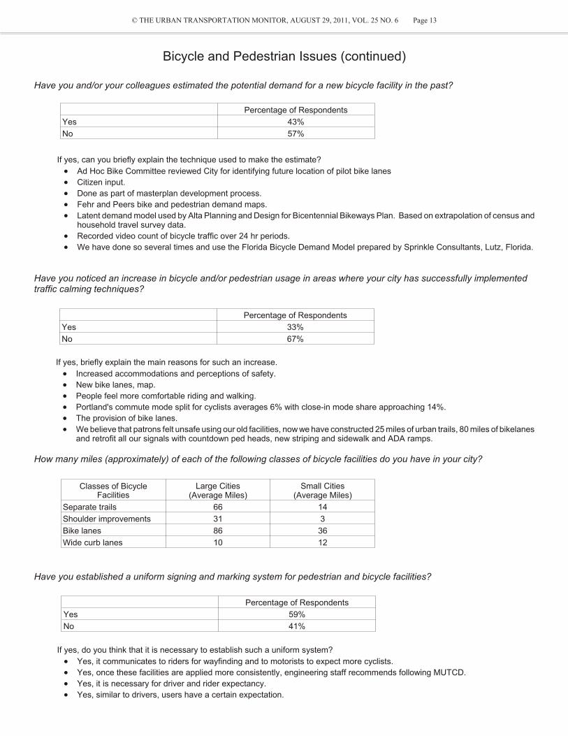
Have you and/or your col leagues es ti mated the po ten tial de mand for a new bi cy cle fa cil ity in the past?
If yes, can you briefly ex plain the tech nique used to make the es ti mate?
· Ad Hoc Bike Com mit tee re viewed City for iden ti fy ing fu ture lo ca tion of pi lot bike lanes
· Cit i zen in put.
· Done as part of masterplan de vel op ment pro cess.
· Fehr and Peers bike and pe des trian de mand maps.
· La tent de mand model used by Alta Plan ning and De sign for Bi cen ten nial Bike ways Plan. Based on ex trap o la tion of cen sus andhouse hold travel sur vey data.
· Re corded video count of bi cy cle traf fic over 24 hr pe ri ods.
· We have done so sev eral times and use the Florida Bi cy cle De mand Model pre pared by Sprin kle Con sul tants, Lutz, Florida.
Have you no ticed an in crease in bi cy cle and/or pe des trian us age in ar eas where your city has suc cess fully im ple mentedtraf fic calm ing techniques?
If yes, briefly ex plain the main rea sons for such an in crease.
· In creased ac com mo da tions and per cep tions of safety.
· New bike lanes, map.
· Peo ple feel more com fort able rid ing and walk ing.
· Port land's com mute mode split for cy clists av er ages 6% with close-in mode share ap proach ing 14%.
· The pro vi sion of bike lanes.
· We be lieve that pa trons felt un safe us ing our old fa cil i ties, now we have con structed 25 miles of ur ban trails, 80 miles of bikelanes and ret ro fit all our sig nals with count down ped heads, new strip ing and side walk and ADA ramps.
How many miles (ap prox i mately) of each of the fol low ing classes of bi cy cle fa cil i ties do you have in your city?
Have you es tab lished a uni form sign ing and mark ing sys tem for pe des trian and bi cy cle fa cil i ties?
If yes, do you think that it is nec es sary to es tab lish such a uni form sys tem?
· Yes, it com mu ni cates to rid ers for wayfinding and to mo tor ists to ex pect more cy clists.
· Yes, once these fa cil i ties are ap plied more con sis tently, en gi neer ing staff rec om mends fol low ing MUTCD.
· Yes, it is nec es sary for driver and rider ex pec tancy.
· Yes, sim i lar to driv ers, us ers have a cer tain ex pec ta tion.
Bi cy cle and Pe des trian Is sues (con tin ued)
Percentage of Respondents
Yes 43%
No 57%
Percentage of Respondents
Yes 33%
No 67%
Classes of BicycleFacilities
Large Cities(Average Miles)
Small Cities(Average Miles)
Separate trails 66 14
Shoulder improvements 31 3
Bike lanes 86 36
Wide curb lanes 10 12
Percentage of Respondents
Yes 59%
No 41%

© THE URBAN TRANSPORTATION MONITOR, AUGUST 29, 2011, VOL. 25 NO. 6 Page 14
Bi cy cle and Pe des trian Is sues (con tin ued)
What do you con sider to be the main im ped i ments that you face in cre at ing a more friendly pe des trian and bi cy cle en vi -ron ment?
· Fund ing
· Dis persed sub ur ban de vel op ment. High speeds on ar te ri als.
· Driver and bi cy cle be hav ior. Lack of us ers to cre ate a safer bi cy cling en vi ron ment.
· Ex ist ing in fra struc ture con straints of an al ready built up city.
· Fund ing and an in grained in sti tu tional cul ture.
· Fund ing, and right of way for off-road fa cil i ties.
· Fund ing, bi cy cle de tec tion tech nol ogy.
· High-vol ume cross ings are more ex pen sive to im prove, but key to mak ing neigh bor hood green ways work.
· Older in fra struc ture lim its abil ity to pro vide on-street bi cy cle fa cil i ties.
· Right of way lim i ta tions. Some high level bi cy cle rid ers as well as mo tor ists fre quently dis obey traf fic laws that cre ates ten sion and dis -trust be tween the var i ous user groups.
· Right-of-way: avail abil ity of space.
· Right-of-way for off street paths and fa cil i ties.
· The au to mo bile-centric at ti tude of the cit i zenry; fund ing lim i ta tions when there is dif fi culty in ob tain ing fund ing just to main tain streets ingood re pair.
· The per cep tion that the fa cil i ties are not be ing uti lized and the cost per ben e fit to the city.
What is your city's pol icy on the pro vi sion of side walks? (e.g. al ways on both side, de pends on land use, de pends on thefunc tional clas si fi ca tion of the road)
· Al ways on both sides.
· Al ways both sides of road and we are cur rently fund ing a pro gram to con struct 100% on one side for all ex ist ing sub stan dard ar te rial and col lec tor road ways.
· Al ways on both sides, but de pends on fund ing, land use, and func tional clas si fi ca tion.
· Al ways on both sides. Sep a rated from curb if pos si ble, but wider than stan dard 6' if need to be curb tight (8').
· Both sides along ar te rial streets. Ad ja cent to com mer cially de vel oped side of col lec tor streets.
· Both sides ex cept in in dus trial ar eas where it may be waived.
· Both sides for now, en vi ron men tal reg u la tions may re duce to one side (or none) on mi nor streets.
· Both sides, width de pends on road way clas si fi ca tion.
· De pends on ad ja cent de vel op ment.
· De pends on func tional clas si fi ca tion of the road.
· De pends on func tional clas si fi ca tion of the street.
· De pends on land use, func tional clas si fi ca tion, and ve hic u lar vol umes/speeds.
· De pends on land use.
· De pends on ROW, land use, func tional clas si fi ca tion.
· Gen er ally on both side if suf fi cient right of way.
· New pro jects - al ways on both sides.
· On new streets: on both sides of all ex cept lo cal streets with res i den tial lots greater than one acre. On ex ist ing streets: on both sides ofar te rial and col lec tor streets; on lo cal streets it de pends on a va ri ety of fac tors.
· Re quired ev ery where un less an ex emp tion is granted, then a fee is paid in lieu of.
· Side walk is re quired on at least one but pref er a ble both sides of a street.
What, if any, reg u la tions do you have in place to in crease the pro vi sion of bi cy cle park ing?
· All new or ren o vated de vel op ments must pro vide bi cy cle park ing.
· Bi cy cle park ing is a re quire ment in our uni fied de vel op ment or di nance, sub di vi sion reg u la tions and de sign stan dards for com mer cialprop erty.
· City's Land Man age ment Code spec i fies the num ber of bi cy cle park ing spaces based on land use and size.
· It is a code re quire ment on any new de vel op ment plans.
· Land use code re quires bike park ing with new de vel op ments.
· Min i mum bike park ing re quire ments for new mutli-fam ily and com mer cial dwell ings - in ter nal to site and counted sep a rate from pub licfront age re quire ments.
· Park ing code re quires a cer tain per cent age of bike park ing spaces based on ve hi cle park ing re quire ments.
· Racks must be pro vided at all com mer cial de vel op ments.
· We have an adopted Bike/Ped Mas ter Plan, have a pol icy of re quir ing racks with all new con struc tion and are funded to pro vide bikeracks at city cost at all down town busi nesses that re quest them.

`
© THE URBAN TRANSPORTATION MONITOR, AUGUST 29, 2011, VOL. 25 NO. 6 Page 15
NAME OF AGENCY AND CITY/URBAN AREA CONTACT NAME TEL. E-MAIL
San Diego Association of Governments (SANDAG)San Diego and Escondido in San Diego County, California
Chris Burke and Ingrid Weisenbach
(619) 699-1900 [email protected]@sandag.org
Minnesota Department of Transportation Minneapolis, Minnesota
Julie Johnson (651) 234-7028 [email protected]
Orange County Transportation AuthorityOrange, California
Ellen Lee (714) 560-5988 [email protected]
Florida Department of TransportationMiami-Dade and Broward Counties, Florida
Rory Santana (305) 470-7375 [email protected].
Washington State Department of TransportationSeattle and southern King County, Washington
Tyler Patterson (206) 716-1164 [email protected]
Colorado Department of TransportationDenver, Colorado
Kari Grant (303) 757-9380 kari.grant @dot.state.co.us
Harris County Toll Road AuthorityHarris County, Texas
Eric Hanson (713) 587-7983 eric.hanson@@hctra.org
Metropolitan Transit Authority of Harris CountyHouston, Texas
Vincint Obregon (713) 739-4866 [email protected]
This Week’s Sur vey Re sults (Sur vey 1)
Char ac ter is tics of HOT Pro jects
Last month, The Ur ban Trans por ta tion Mon i tor sent sur vey ques tion naires to agen cies that have ei ther ap plied HOT pro jects or are plan ning HOT pro jects. Re plies were re ceived from 8 of those agen cies. The re sults of the sur vey are pub lished here.
HOT Pro ject Con tacts
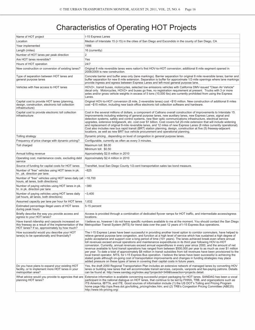
© THE URBAN TRANSPORTATION MONITOR, AUGUST 29, 2011, VOL. 25, NO. 6 Page 16
Char ac ter is tics of Op er at ing HOT Pro jects Name of HOT project I-15 Express Lanes
Location Median of Interstate 15 (I-15) in the cities of San Diego and Escondido in the county of San Diego, CA
Year implemented 1996
Length (miles) 16 (currently)
Number of HOT lanes per peak direction 2
Are HOT lanes reversible? Yes
Hours of HOT operation 24/7
New construction or conversion of existing lanes? Original 8 mile reversible lanes were nation's first HOV-to-HOT conversion; additional 8 mile segment opened in2008/2009 is new construction.
Type of separation between HOT lanes andgeneral purpose lanes
Concrete barrier and buffer area only (lane markings). Barrier separation for original 8 mile reversible lanes; barrier and buffer separation for new 8 mile extension. Separation is buffer for approximate 1/2-mile openings where lane markings provide ingress and egress between Express Lanes and left-most general purpose lane.
Vehicles with free access to HOT lanes HOV2+, transit buses, motorcycles, selected low emissions vehicles with California DMV-issued "Clean Air Vehicle"decal only. Motorcycles, HOV2+ and buses go free, no registration requirement at present. Trucks with 3 or moreaxles and/or gross vehicle weights in excess of 5 tons (10,000 lbs) are currently prohibited from using the ExpressLanes.
Capital cost to provide HOT lanes (planning,design, construction, electronic toll collectioninfrastructure)
Original HOV-to-HOT conversion (8 mile, 2-reversible lanes) cost ~$10 million. New con struc tion of ad di tional 8 milescost ~$15 million, in clud ing new back-of fice electronic toll collection software and hardware.
Capital cost to provide electronic toll collectioninfrastructure
Cost in the several millions of dollars, a component of Caltrans over all con struc tion of im prove ments to In ter state 15.Im prove ments in clud ing wid en ing of gen eral pur pose lanes, new auxiliary lanes, new Ex press Lanes, sig nal andde tec tion sys tems, safety and con trol sys tems, new fi ber op tic com mu ni ca tions in fra struc ture, elec tri cal ser viceupgrades, ex ten sive bridge work, etc. cost over $1 bil lion. Cost cov ers full 20-mile ex ten sion that will in clude wid en ingand re place ment of orig i nal 8-mile re vers ible lanes, and 12 miles of new Ex press Lanes (8 miles cur rently op er a tional).Cost also in cludes new bus rapid tran sit (BRT) sta tion plan ning, de sign, con struc tion at five (5) free way-ad ja centlo ca tions, as well as new BRT bus vehicle procurement and operational planning.
Tolling strategy Dynamic pricing , depending on level of congestion in general purpose lanes.
Frequency of price change with dynamic pricing? Configurable, currently as often as every 3 minutes.
Toll charged Maximum toll: $8.00
Minimum toll: $0.50
Annual tolling revenue Approximately $2.8 million in 2010
Operating cost, maintenance costs, excluding debtservice
Approximately $2.4 million in 2010
Source of funding for capital costs for HOT lanes TransNet, local San Diego County 1/2-cent transportation sales tax bond measure.
Number of “free” vehicles using HOT lanes in pk.hr., pk. direction per lane.
~825
Number of “free” vehicles using HOT lanes daily (all hours, all lanes, both directions)
~18,700
Number of paying vehicles using HOT lanes in pk.hr. in pk. direction per lane
~380
Number of paying vehicles using HOT lanes daily(all hours, all lanes, both directions)
~3,400
Assumed capacity per lane per hour for HOT lanes 1,632
Estimated percentage illegal users of HOT lanesduring peak hours
5-15 percent
Briefly describe the way you provide access andegress to your HOT lanes?
Access is provided through a combination of dedicated flyover ramps for HOT traffic, and intermediate access/egresslocations.
Have transit ridership and carpools increased onthis freeway as a result of the implementation of the HOT lanes? If so, approximately by how much?
I believe so, however I do not have specific numbers available to me at the mo ment. You should con tact the San Diego Met ro pol i tan Tran sit Sys tem (MTS) for trend data over the past 12 years of I-15 Express Bus operations.
How successful would you describe your HOTlane(s) to be operationally and financially?
The I-15 Express Lanes have been successful in providing another travel option to corridor commuters, have helped torelieve general purpose lane congestion, and function at a high level of service which has sustained a high degree ofpublic acceptance and support over a long period of time (10+ years). The lanes achieved break-even where annualtoll revenues exceed annual operations and maintenance expenditures in its third year following HOV-to-HOTconversion. Currently, annual revenues exceed annual expenditures in every year since 2000, and the amount of netrevenue available to fund transit operations has ranged from between $500,000 per year to as much as over $1 millionper year. To date a total of approximately $8 million in transit subsidies from toll revenues have been provisioned to the local transit operator, MTS, for I-15 Express Bus operation. I believe the lanes have been successful is achieving thestated goals although on-going cost of transportation improvements and changes in funding strategies may placeadded pressure on these types of lanes in covering their capital costs in future years.
Do you have plans to expand your existing HOTfacility, or to implement more HOT lanes in yourmetropolitan area?
Yes, the draft 2050 Regional Transportation Plan includes an extensive network of managed lanes by converting HOVlanes or building new lanes that will accommodate transit services, carpools, vanpools and fee-paying patrons. Detailscan be found at: http://www.sandag.org/index.asp?projectid=349&fuseaction=projects.detail.
What advice would you provide to agencies that are planning HOT lanes?
Extensive information is available concerning successful project packaging for HOT lanes. SANDAG has been a vocalparticipant in the national dialogue on HOT lanes, that continue to be led by FHWA, TRB, and organizations such asITS America, IBTTA, and ITE. Good sources of information include (1) the US DOT’s Tolling and Pricing Programhome page http://ops.fhwa.dot.gov/tolling_pricing/index.htm; and (2) TRB’s Congestion Pricing Committee (ABE25)http://www.trb-pricing.org/.

© THE URBAN TRANSPORTATION MONITOR, AUGUST 29, 2011, VOL. 25 NO. 6 Page 17
Char ac ter is tics of Op er at ing HOT Pro jects (con tin ued)
N/A = Not Avail able, Not Ap pli ca ble
Name of HOT project MnPASS 91 Express Lanes
Location I-394: west of downtown Minneapolis, MN
I-35W: south of downtown Minneapolis, MN
Median of State Route 91 (Riverside Freeway) from Orange/RiversideCounty line to the SR-55 (Costa Mesa Freeway), CA
Year implemented I-394: May 2005; I-35W in 2009 1995
Length (miles) 45 (I-394 and I-35W) 10
Number of HOT lanes per peak direction 1-2 2
Are HOT lanes reversible? Yes No
Hours of HOT operation 6:00 am to 10:00 am, and 2:00 pm to 7:00 pm M-F.
24 hours, 7 days
New construction or conversion of existinglanes?
Conversion of existing HOV lanes. New construction
Type of separation between HOT lanes andgeneral purpose lanes
Concrete barrier and buffer area only (lanemarkings).
Buffer area with plastic channelizers.
Vehicles with free access to HOT lanes HOV2+, transit buses, motorcycles. HOV3+, transit buses, motorcycles, emergency vehicles, zero missionvehicles, vehicles with permanently mounted disabled person licenseplates. HOV3+ policy is free with the exception of Monday-Friday, 4-6pm eastbound, when motorists pay 50% of the posted toll.
Capital cost to provide HOT lanes (planning,design, construction, electronic toll collectioninfrastructure)
$12.5 million (I-394) $135 million
Capital cost to provide electronic tollcollection infrastructure
$6.0 million (I-394) $3.3 million
Tolling strategy Dynamic pricing, depending on level of congestion in general purpose lanes.
Preset pricing, but varies by time of day.
Frequency of price change with dynamicpricing?
3 minutes. N/A
Toll charged Maximum toll: $8.00
Minimum toll: $0.25
Maximum toll: $9.75
Minimum toll: $1.30
Annual tolling revenue $1.96 in 2010 for both I-394 and I-35W For FY2010, $35.7 million
Operating cost, maintenance costs, excluding debt service
$1.94 in 2010 for both I-394 and I-35W For FY2010, $22.4 million in total operating expenses (includesdepreciation and amortization).
Source of funding for capital costs for HOTlanes
Parking garage funds (I-35W)
UPA funds for I-35W
91 Express Lanes were built and owned by CPTC, a private company. In2003, OCTA acquired the 91 Express Lanes from CPTC.
Number of “free” vehicles using HOT lanes inpk. hr., pk. direction per lane.
1,200 500
Number of “free” vehicles using HOT lanesdaily (all hours, all lanes, both directions)
4,800 8,000
Number of paying vehicles using HOT lanesin pk. hr. in pk. direction per lane
700 1,200
Number of paying vehicles using HOT lanesdaily (all hours, all lanes, both directions)
4,500 27,000
Assumed capacity per lane per hour for HOTlanes
1,500 (to maintain free-flow) 1,700
Estimated percentage illegal users of HOTlanes during peak hours
5% (I-394)
8%-10% (I-35W)
3 percent
Briefly describe the way you provide accessand egress to your HOT lanes?
There are dedicated flyover ramps to thereversible section, and access/egress locationswith skip striping at other locations.
From the eastbound direction, two ingresses from the NB SR-55 and EBSR-91 with one egress at the opposite end on the EB SR-91. From thewestbound direction, one ingress from WB SR-91 with two egresses atthe opposite end on the SB SR-55 and WB SR-91.
Have transit ridership and carpools increasedon this freeway as a result of theimplementation of the HOT lanes? If so,approximately by how much?
Yes, transit and carpools have increased, thoughthere are many factors af fect ing the in crease. In creases were 13% the first year and 8% thesec ond year after opening.
N/A
How successful would you describe your HOT lane(s) to be operationally and financially?
The HOT lanes are successful at reducingcongestion on the general pur pose lanes. Therev e nues ex ceed the op er at ing costs also, so thatis con sid ered suc cess ful. But it will take a longtime for the ex cess revenues to repay theconstruction costs.
Very successful. Total operating revenues for FY08: $46.2 million. The91 Express Lanes was the first stand alone toll facility to receive bondratings in the "A" category and has continued to receive strong ratingsfrom the rating agencies.
Do you have plans to expand your existingHOT facility, or to implement more HOT lanes in your metropolitan area?
N/A Yes, plans are to extend the 91 Express Lanes an additional 10 milesinto Riverside County.
What advice would you provide to agenciesthat are planning HOT lanes?
Educate the public and get buy-in. It is acongestion management tool, not a revenueraising tool.
Implement a toll policy. The 91 Express Lanes Toll Policy, approved byOCTA's Board of Directors, is designed to administer congestionmanagement toll pricing. One of the challenges faced when OCTAbought the 91 Express Lanes was how to design and implement acongestion management toll policy administered by a board of publiclyelected officials. OCTA implemented a Toll Policy that adjusted toll ratesbased on the number vehicles on the 91 Express Lanes and based on its stated goal to maintain a "free flow" commute and to maximizethroughput. As a result, toll adjustments do not need a Board vote eachtime a toll has to be adjusted

© THE URBAN TRANSPORTATION MONITOR, AUGUST 29, 2011, VOL. 25 NO. 6 Page 18
Char ac ter is tics of Op er at ing HOT Pro jects (con tin ued)
Name of HOT project 95 Express SR 167 High Occupancy Toll(HOT) Lanes Pilot Project
I-25 Express Lanes
Location I-95 in Miami-Dade County, but expanding intoBroward County.
SR 167 runs north-south, parallelto I-5 in southern King County,south of Seattle, WA.
Denver, CO metropolitan area
Year implemented 2008 May 3, 2008 2006
Length (miles) 9 SB 8 miles, NB 11 miles 7
Number of HOT lanes per peak direction 2 1 2
Are HOT lanes reversible? No No Yes
Hours of HOT operation 24 hours, 7 days 5am - 7pm, 7 days a week. 5am to 10am southbound; 12pm to3am northbound.
New construction or conversion of existinglanes?
Conversion of existing lane. Conversion of existing HOV lanes. Conversion of existing HOV lanes.
Type of separation between HOT lanes andgeneral purpose lanes
Buffer area with plastic channelizers. Buffer area only (lane markings).We use profiled MMA.
Concrete barrier
Vehicles with free access to HOT lanes Registered HOV3+, transit buses, motorcycles,low emissions vehicles, emergency vehicles.
HOV2+, transit buses,motorcycles, emergency vehicles.
HOV2+, transit bus, motorcycles,low emission vehicles, emergencyvehicles.
Capital cost to provide HOT lanes (planning,design, construction, electronic toll collectioninfrastructure)
$140 million $18 million $8 million
Capital cost to provide electronic toll collectioninfrastructure
N/A N/A $3 million
Tolling strategy Dynamic pricing, depending on level of congestion in general purpose lanes.
Dynamic pricing, depending onlevel of congestion in generalpurpose lanes.
Preset pricing, but varies by time of day.
Frequency of price change with dynamicpricing?
Variable but currently 15 minutes, based on HOTlane congestion
Every 1 minute, but use every 5minutes.
N/A
Toll charged Maximum toll: $7.00
Minimum toll: $0.25
Maximum toll: $9.00
Minimum toll: $0.50
Maximum toll: $3.50
Minimum toll: $0.50
Annual tolling revenue Approximately $15 million. $600,000 and increasing annually. $2.5 million
Operating cost, maintenance costs, excludingdebt service
Approximately $6.2 million N/A $1.3 million
Source of funding for capital costs for HOTlanes
Federal grant - Urban Partnership Agreement,state.
State and federal (VPPP). Federal funds and loan from theTransportation Commission
Number of “free” vehicles using HOT lanes inpk. hr., pk. direction per lane.
Not available yet. NB - 800 vphpl, SB - 760 vphpl 700
Number of “free” vehicles using HOT lanesdaily (all hours, all lanes, both directions)
Not available yet. 15,200 8,000
Number of paying vehicles using HOT lanes in pk. hr. in pk. direction per lane
Not available yet. NB - 370 vphpl, SB - 210 vphpl 540
Number of paying vehicles using HOT lanesdaily (all hours, all lanes, both directions)
Approximately 60,000 per day. 2,700 6,300
Assumed capacity per lane per hour for HOTlanes
1,600 per day. 1,500 2,000
Estimated percentage illegal users of HOTlanes during peak hours
Not available yet. 3 - 5 percent (source: WSP). 2%.
Briefly describe the way you provide accessand egress to your HOT lanes?
Intermediate access/egress locations. Skip-stripe at intermediatelocations
Single entrance and exit intobarrier-separated lanes.
Have transit ridership and carpools increasedon this freeway as a result of theimplementation of the HOT lanes? If so,approximately by how much?
Transit ridership has increased.
Not for HOV at this time. As expected at thisphase in implemtation improved operation hasoccurred throughout the whole facility for all usersincluding SOVs. True HOV increase is expectedas congestion grows in the free lanes in the futureand HOT usage becomes more attractive thusencoutageing a mode shift. Data is availlable at95Express.com
Transit in the area has beenrestructured and ridership is downabout 7 percent. Carpool data isinconclusive.
Not substantially.
How successful would you describe your HOTlane(s) to be operationally and financially?
Better than expected. Although financial successwas not a project goal, revenue collected hasgone far in offsetting expenses.
N/A Very successful.
Do you have plans to expand your existingHOT facility, or to implement more HOT lanesin your metropolitan area?
Yes. Current activities are underway on many ofthe freeways for both HOT and Express laneoperations in our region.
Yes, but we do not yet haveauthorizing legislation.
Yes
What advice would you provide to agenciesthat are planning HOT lanes?
Opertational assessment is critical throughout thethe planning phase of the project. This will reduceboth costs and delays and provide the bestproduct possible.
N/A Research other similar facilities forlessons learned and newtechnologies. Provide extensivepublic information and education.Have professional and thoroughbackoffice operations and customer relations. Research other facilities
N/A = Not Avail able, Not Ap pli ca ble

© THE URBAN TRANSPORTATION MONITOR, AUGUST 29, 2011, VOL. 25 NO. 6 Page 19
Char ac ter is tics of Planned HOT Pro jects
Name of HOT project Katy Managed Lanes HOT Lanes
Location I-10, Harris County between SH 6 and IH-610, Houston,TX
I-45 north & south; US 59 north & south; US 290, Houston, TX
Year implemented April 2009 Operation 2012 - 2013
Length (miles) 12 Total 83
Number of HOT lanes per peak direction 1 One lane per corridor
Are HOT lanes reversible? No Yes
Hours of HOT operation 5 to 11 am and 2 to 8 pm. 24/7 for EZ Tag users Current hours: 5 am - 11am; 2pm-8pm.
New construction or conversion ofexisting lanes?
New construction. Conversion of existing HOV lanes.
Type of separation between HOT lanesand general purpose lanes
Buffer area with plastic channelizers. Concrete barrier.
Vehicles with free access to HOT lanes HOV2+, transit buses, motorcycles, emergency vehicles.Motorcycles are free only during HOV hours.
HOV2+, transit buses, motorcycles, emergency vehicles.
Capital cost to provide HOT lanes(planning, design, construction, electronic toll collection infrastructure)
$250 million Approximately $70 million for the conversion.
Capital cost to provide electronic tollcollection infrastructure
$6 million Cost to provide electronic toll collection infrastructure ~approx. $25million.
Tolling strategy Preset pricing, but varies by time of day. Dynamic pricing, depending on level of congestion in general purpose lanes.
Frequency of price change with dynamicpricing?
N/A Price will be examined for possible change every 5 minutes.
Toll charged Maximum toll: $4.00 full trip
Minimum toll: $1.00 full trip
Not yet determined.
Annual tolling revenue $6.7 million N/A
Operating cost, maintenance costs,excluding debt service
$2.8 million Approx. $8 million for highway operations, toll operations andmaintenance of all systems.
Source of funding for capital costs forHOT lanes
Revenue/bonds. Federal stimulus funds
Formula grants
Local funds
Number of “free” vehicles using HOTlanes in pk. hr., pk. direction per lane.
1,258 N/A
Number of “free” vehicles using HOTlanes daily (all hours, all lanes, bothdirections)
18,749 N/A
Number of paying vehicles using HOTlanes in pk. hr. in pk. direction per lane
1,599 N/A
Number of paying vehicles using HOTlanes daily (all hours, all lanes, bothdirections)
39,995 N/A
Assumed capacity per lane per hour forHOT lanes
1,500 Capacity= 1,500 per hour per lane.
Estimated percentage illegal users ofHOT lanes during peak hours
Less than 10% N/A
Briefly describe the way you provideaccess and egress to your HOT lanes?
Immediate access to and from the freeway generalpurpose lanes at 3 locations in both directions.
Flyovers, t-ramps, slip ramps, wishbone ramps.
Have transit ridership and carpoolsincreased on this freeway as a result ofthe implementation of the HOT lanes? Ifso, approximately by how much?
N/A N/A
How successful would you describe yourHOT lane(s) to be operationally andfinancially?
The lanes are well-utilized. Traffic volume has increasedsince the lanes opened.
N/A
Do you have plans to expand yourexisting HOT facility, or to implementmore HOT lanes in your metropolitanarea?
There are plans to expand the facility but no decisionshave been made.
Possible increased number of access/egress points.
What advice would you provide toagencies that are planning HOT lanes?
Public education about how to use the lanes is veryimportant. Provide details about entrance and exitlocations and rules for HOV requirements.
N/A
N/A = Not Avail able, Not Ap pli ca ble

© THE URBAN TRANSPORTATION MONITOR, AUGUST 29, 2011, VOL. 25 NO. 6 Page 20
REQUESTS FOR PROPOSALS
PUBLIC AGENCIES — RFP notices arepublished here FREE OF CHARGE — call(703)764-0512 for details and deadline.
1. Statewide Traffic EngineeringServices Master ContractDeadline:September, 15, 2011 at 12 p.m. Contact:Sandy MacdonaldE-Mail:[email protected]:www.dot.wisconsin.gov/business/docs/201109/bto01sep11.docDescription:Multiple full service master contracts willbe awarded for the statewide provision oftechnical and professional engineering,surveying, telecommunications, and othertraffic related services for the Bureau ofTraffic Operations. Under the terms ofthese contracts, projects may be initiated inBTO or Transportation Regions in need ofservices.Project descriptionThe scope of work will be set forward ineach work order. The services under themaster contracts will encompass but NOTbe limited to the following:
• Provide engineering, planning andadministrative services for special studies
• Plans, specifications, and estimates(PS&E) review
• Roundabout analysis and review (fieldsurvey and investigation)
• Intersection alternatives analysis
• Perform specialized traffic studies(saturation flow, vehicle delay)
• Traffic Guidelines Manual (TGM)procedure development, updating, andsupport
• Perform traffic studies (signal warrant,stop warrant, crash analysis)
• Intersection lighting and lighting design
• Freeway operations analysis
• Traffic signal design
• Traffic data collection
• Traffic analysis and modeling (HCS,SYNCHRO/SIMTRAFFIC, RODEL,PARAMICS, QUADRO)
• Signing/SIS/TODS/PavementMarking/Work Zone Traffic Control/Traffic Computer Aided Design (CAD)and Geographical Information System(GIS) Services
• Traffic Management/IntelligentTransportation/Communication SystemsDesign and Integration
• Safety engineering
• Incident management
• Procurement management
• Freight management
• Intelligent Transportation System(ITS)Request
2. American Fork City Bicycle andPedestrian Study Agency:Mountainland Metropolitan PlanningOrganizationDeadline:September 22 at 3 p.m. Contact:Jim PricePhone: (801) 229-3848Website:http://67.137.11_Hlt302905916_Hlt3029059176BM_1_BM_2_.245/site/Description:Mountainland Metropolitan PlanningOrganization is soliciting the services ofqualified firms/individuals to performconsulting services for the followingproject: American Fork City Bicycle andPedestrian Study This project will producea comprehensive Bicycle and PedestrianFacilities Master Plan for the City ofAmerican Fork, UT, and detail ways toconnect existing and planned facilitiesbetween and among American Fork and itssurrounding communities. The Plan willincorporate connections to multipletransportation modes.MMPO has elected to procure a team todesign and achieve the best project possible within the program budget. This will beaccomplished through a Fixed-Price,Best-Design procurement approach. Thisapproach gives the consultant a fixed priceand encourages them to propose innovative and creative solutions for achieving thegoals and realizing the values as set forth inthis Request for Proposal.
3. Lehi Bicycle & Pedestrian Plan RFPAgency:Mountainland Metropolitan PlanningOrganizationDeadline:September 29 at 3 p.m. Contact:Jim PricePhone: (801) 229-3848Website:http://67.137.116.245/site/Description:Mountainland Metropolitan PlanningOrganization (MMPO) is soliciting theservices of qualified firms/individuals toperform consulting services for thefollowing project:Lehi City Bicycle and Pedestrian Plan: This project will produce a comprehensiveBicycle and Pedestrian Plan for the City ofLehi, UT, and detail ways to connectexisting and planned facilities between andamong Lehi and its surroundingcommunities. The Plan will incorporateconnections to multiple transportationmodes.Provide the Best Value for the Budget
MMPO has elected to procure a team todesign and achieve the best projectpossible within the program budget. Thiswill be accomplished through aFixed-Price, Best-Design procurementapproach. This approach gives theconsultant a fixed price and encouragesthem to propose innovative and creativesolutions for achieving the goals andrealizing the values as set forth in thisRequest for Proposals.Request
4. Interregional Truck Operations onI-5/SR-99 and STAA Truck RoutesImprovement StudyAgency:Sacramento Area Council of Governments(SACOG)Deadline:September 15, at 4 p.m. Contact:Mark HeimanPhone: (916) 340-6232E-Mail: [email protected]:http://www.sacog.org/rfp/interested.cfm?subid=392&rfp=102Description:SACOG is seeking Statements ofQualifications for the Interregional TruckOperations on I-5/SR-99 and STAA TruckRoutes Improvement Study
5. Dynamic Traffic Assignment StudyAgency:Houston-Southern California Associationof Governments (SCAG)Deadline:September 28, 2011 at 10 a.m. Contact:Phone: (213) 236.1957 E-Mail: [email protected]:http://www.planetbids.com/portal/portal.cfm?CompanyID=14434#Description:The objective of this project is to assistSCAG staff in developing both theoreticalknowledge and technical skills onanalyzing and modeling dynamic trafficassignment (DTA). The selectedconsultant will provide high-qualitytraining on dynamic traffic assignment. Atthe end of this project, SCAG staff shouldhave thorough understanding andknowledge about the concept and methodsof dynamic traffic assignment and havehands-on skills on application and analysisof DTA output.

© THE URBAN TRANSPORTATION MONITOR, AUGUST 29, 2011, VOL. 25 NO. 6 Page 21
N/A = Not Available; m = member; nm = non-member. To list your transportation conferences here FREE, send all information as above to: The UTM Conference Dept., P.O. Box 12300, Burke, VA 22009-2300, or call (703) 764-0512, or fax (703) 764-0516, or email: [email protected].
CONFERENCES
DATES CONFERENCE AND SPONSOR
CITY VENUE MAIN TOPICS WEBSITE /CONTACT INFO
Sept. 11-14
IBTTA 79th Annual Meeting & Exhibition
Berlin, Germany
Inter-Continental Hotel
Interoperability policy in the EU, US and other regions of the world; State of the art technology and its application; Delivering the new reality through project financing and capital markets; New paradigms and partners in an evolving global economy; Tolling around the world – case studies and best practices; The environment, congestion, safety practices and challenges; A practical guide to developing business in emerging markets;
http://www.ibtta.org/Events/eventdetailwithvideo.cfm?ItemNumber=4734
Sept. 11-15
International Conference Series on Competition and Ownership in Land Passenger Transport (ITLS-Africa, Department of Transport and Supply Chain Management at the University of Johannesburg, South African Department of Transport)
Durban, South Africa
Southern Sun Elangeni Hotel
This is the largest gathering of toll industry professionals and business partners in the world. Delegates from more than 25 countries will come to Berlin to examine best practices and innovations in toll industry finance, marketing, technology, customer service, environmental stewardship, operations and maintenance.
Alain Estiot [email protected]
Sept. 12-14
2011 GIS Public Transportation Conference (URISA and the National Center for Transit Research)
St. Petersburg, FL
Hilton St. Petersburg Bay Front
Asset management; planning, strategy, implementation, GIS program management; GIS technology tools to improve system performance, applications of real time transit data
http://www.transitgis.org/conference/2011-gis-public-transportation-conference/
Sept. 14-16
3rd International Conference on Road Safety and Simulation (RSS2011) (TRB)
Indianapolis, IN
Indiana Government Center (South Building)
Featured Topics include: driving simulation; naturalistic driving; surrogate measures of safety; safety modeling; applications; roadway design; human factors; emerging technologies; new research methods; crash causality
http://www.cvent.com/events/3rd-international-conference-on-road-safety-and-simulation/event-summary-ac892b2fc438462d88354d23139db0d7.aspx
Sept. 26-30
XXIV World Road Congress – Mobility, Sustainability and Development (World Road Association)
Mexico City, Mexico
Centro Banamex Convention Center
The theme is roads for a better life: mobility, sustainability and development. Conference will focus on the challenges facing the road and road transport sector.
+52 (55) 5528 3706 [email protected]
Oct. 3-5 APTA Annual Meeting and Expo
New Orleans, LA
Ernest N. Morial Convention Center in New Orleans
General sessions and forums focused on current issues facing public transportation. This year's annual meeting will be held in conjunction with EXPO 2011, the world's largest public transportation trade show.
http://www.apta.com/mc/annual/Pages/default.aspx
Oct. 10-12 European Transport Conference (European Transport Association)
Glasgow, Scotland
Crowne Plaza Hotel, Congress Road, Glasgow
Applied methods in transport planning; European transport policy & research; innovative transport infrastructure funding; leisure & tourism transport; local public transport; methodological innovations; rail; traffic management; traffic engineering & road safety; transport economics & appraisal
http://www.etcproceedings.org/etc2011/ Sophie Webber +44 20 7348 1970 [email protected]
Oct. 13-17 AASHTO Annual Meeting
Detroit, MI Marriott Downtown at the Renaissance Center
AASHTO/FHWA workshop on the highway infrastructure health assessment study; route numbering; high speed & intercity passenger rail: opportunities & challenges; asset management; intermodal transportation and economic expansion.
http://www.michigan.gov/aashto
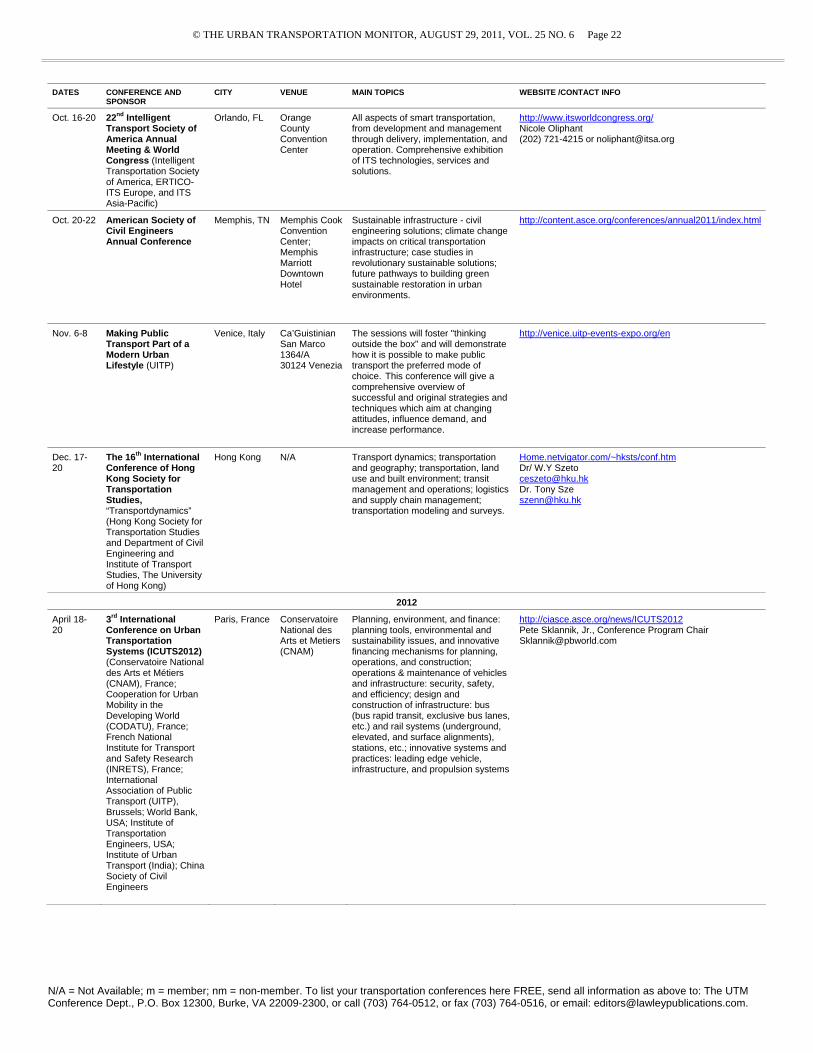
© THE URBAN TRANSPORTATION MONITOR, AUGUST 29, 2011, VOL. 25 NO. 6 Page 22
N/A = Not Available; m = member; nm = non-member. To list your transportation conferences here FREE, send all information as above to: The UTM Conference Dept., P.O. Box 12300, Burke, VA 22009-2300, or call (703) 764-0512, or fax (703) 764-0516, or email: [email protected].
DATES CONFERENCE AND SPONSOR
CITY VENUE MAIN TOPICS WEBSITE /CONTACT INFO
Oct. 16-20 22nd Intelligent Transport Society of America Annual Meeting & World Congress (Intelligent Transportation Society of America, ERTICO-ITS Europe, and ITS Asia-Pacific)
Orlando, FL Orange County Convention Center
All aspects of smart transportation, from development and management through delivery, implementation, and operation. Comprehensive exhibition of ITS technologies, services and solutions.
http://www.itsworldcongress.org/ Nicole Oliphant (202) 721-4215 or [email protected]
Oct. 20-22 American Society of Civil Engineers Annual Conference
Memphis, TN Memphis Cook Convention Center; Memphis Marriott Downtown Hotel
Sustainable infrastructure - civil engineering solutions; climate change impacts on critical transportation infrastructure; case studies in revolutionary sustainable solutions; future pathways to building green sustainable restoration in urban environments.
http://content.asce.org/conferences/annual2011/index.html
Nov. 6-8 Making Public Transport Part of a Modern Urban Lifestyle (UITP)
Venice, Italy Ca’Guistinian San Marco 1364/A 30124 Venezia
The sessions will foster "thinking outside the box" and will demonstrate how it is possible to make public transport the preferred mode of choice. This conference will give a comprehensive overview of successful and original strategies and techniques which aim at changing attitudes, influence demand, and increase performance.
http://venice.uitp-events-expo.org/en
Dec. 17-20
The 16th International Conference of Hong Kong Society for Transportation Studies, “Transportdynamics” (Hong Kong Society for Transportation Studies and Department of Civil Engineering and Institute of Transport Studies, The University of Hong Kong)
Hong Kong N/A Transport dynamics; transportation and geography; transportation, land use and built environment; transit management and operations; logistics and supply chain management; transportation modeling and surveys.
Home.netvigator.com/~hksts/conf.htm Dr/ W.Y Szeto [email protected] Dr. Tony Sze [email protected]
2012
April 18-20
3rd International Conference on Urban Transportation Systems (ICUTS2012) (Conservatoire National des Arts et Métiers (CNAM), France; Cooperation for Urban Mobility in the Developing World (CODATU), France; French National Institute for Transport and Safety Research (INRETS), France; International Association of Public Transport (UITP), Brussels; World Bank, USA; Institute of Transportation Engineers, USA; Institute of Urban Transport (India); China Society of Civil Engineers
Paris, France Conservatoire National des Arts et Metiers (CNAM)
Planning, environment, and finance: planning tools, environmental and sustainability issues, and innovative financing mechanisms for planning, operations, and construction; operations & maintenance of vehicles and infrastructure: security, safety, and efficiency; design and construction of infrastructure: bus (bus rapid transit, exclusive bus lanes, etc.) and rail systems (underground, elevated, and surface alignments), stations, etc.; innovative systems and practices: leading edge vehicle, infrastructure, and propulsion systems
http://ciasce.asce.org/news/ICUTS2012 Pete Sklannik, Jr., Conference Program Chair [email protected]