Embed Size (px)
Citation preview

IUCN Publications New Series No. 32
The Use ofEcological Guidelines for Development
in Tropical Forest Areas of South East AsiaPapers and Proceedings
of the Regional Meeting
held at
Bandung, Indonesia29 May to 1 June 1974
International Union for Conservation of Nature and Natural Resources1110 Morges, Switzerland
1975

The International Union for Conservation of Nature and Natural Resources(IUCN) is an independent international body, formed in 1948, which has itsheadquarters in Morges, Switzerland. It is a Union of sovereign states, govern-ment agencies and non-governmental organizations concerned with the initia-tion and promotion of scientifically-based action that will ensure perpetuationof the living world—man's natural environment—and the natural resources onwhich all living things depend, not only for their intrinsic cultural or scientificvalues but also for the long-term economic and social welfare of mankind.
This objective can be achieved through active conservation programmes for thewise use of natural resources in areas where the flora and fauna are of par-ticular importance and where the landscape is especially beautiful or striking,or of historical, cultural or scientific significance. IUCN believes that its aimscan be achieved most effectively by international effort in cooperation withother international agencies, such as UNESCO and FAO.
The World Wildlife Fund (WWF) is an international charitable organizationdedicated to saving the world's wildlife and wild places, carrying out the widevariety of programmes and actions that this entails. WWF was established in1961 under Swiss law, with headquarters also in Morges.
Since 1961, IUCN has enjoyed a symbiotic relationship with its sister organiza-tion, the World Wildlife Fund, with which it works closely throughout the worldon projects of mutual interest. IUCN and WWF now jointly operate the variousprojects originated by, or submitted to them.
The projects cover a very wide range, from education, ecological studies andsurveys, to the establishment and management of areas as national parks andreserves and emergency programmes for the safeguarding of animal and plantspecies threatened with extinction as well as support for certain key interna-tional conservation bodies.
WWF fund-raising and publicity activities are mainly carried out by NationalAppeals in a number of countries, and its international governing body is madeup of prominent personalities in many fields.

IUCN Publications new series No. 32
Proceedings ofa Regional Meeting on
the use ofecological guidelines for
development in the
Tropical Forest Areas ofSouth East Asia
held atBandung, Indonesia
29 May to 1 June 1974
Convened by IUCN in collaboration withthe Government of Indonesia, with
the sponsorship and support of the United NationsEnvironment Programme, the co-sponsorship of
FAO, UNESCO and the UNDP, and the financialsupport of the Swedish International Development
Authority and the World Wildlife Fundin addition to a subvention by UNESCO.
International Union forConservation of Nature and Natural Resources,
Morges, Switzerland, 1975

© 1975 International Union for Conservation of Nature and Natural Resources.UNESCO subvention 1974 DG/2.1/414/39
PRINTED BY Unwin Brothers LimitedTHE GRESHAM PRESS OLD WOKING SURREY ENGLAND
Produced by 'Uneoprint'A member of the Staples Printing Group

Foreword
Tropical rain forests apparently represent one of the last remaining reservesof unutilized land in the world and are, therefore, now becoming prime targetsfor development. Although there have been a number of instances where suchdevelopment has been conspicuously successful, especially in South East Asia,the development of land in the humid tropics does present difficulties whichappear to be greater than those in drier or more temperate climates, and therehave been many examples of serious failure and irreversible damage.
Nevertheless, if the use of these areas is properly planned and executed, theycan make important contributions to the long-term stability and well-being ofthe tropical countries and their economies.
The formulation of the principles that would lead towards a better use of therain forests was covered in the publication 'Ecological Principles for Econo-mic Development' by Raymond F. Dasmann, John P. Milton and Peter H. Free-man, prepared for IUCN and the Conservation Foundation, Washington D.C.(John Wiley & Sons Ltd., London, 1973). It was decided as part of the extensionof this initiative to prepared guidelines relevant to the development process intropical forest areas of certain regions of the world based on ecological prin-ciples and taking into account conservation objectives.
To this end, an International Meeting on the Use of Ecological Guidelines forDevelopment in the American Humid Tropics was convened in Caracas,Venezuela, from 20-22 February 1974. It brought together ecologists and plan-ners along with specialists from appropriate disciplines and officers ofGovernment agencies in Latin America dealing with agriculture, forestry andland-use. The meeting took into account existing knowledge of tropical forestecology, including the findings of a number of meetings and conferences thathad been held on this topic in recent times.
The second conference, designed similarly to consider the forests of the South-east Asian tropics was convened by IUCN in collaboration with the Governmentof Indonesia under the sponsorship of the United Nations Environment Pro-gramme and with the support of the UNEP Fund. The Food and AgricultureOrganization of the United Nations, the United Nations Development Programme,and the United Nations Educational, Scientific and Cultural Organization co-sponsored the meeting. Support was also given by the Swedish International De-velopment Authority and the World Wildlife Fund. Local arrangements for theconference were made by the Institute of Ecology, Padjadaran University, Ban-dung.
Ecological guidelines based on the findings of these meetings have already beenissued as a joint IUCN-UNEP publication (IUCN Occasional Paper No. 10, 1974).The present volume aims to provide, for record and reference, the secondseries of papers (with some account of the discussions they invoked), whichplayed so important a part in the elaboration of the guidelines. IUCN thanks themany collaborators, both individuals and organizations (especially those re-ferred to above), who contributed to the success of the meeting and to the pro-duction of this book.

Contents
Introductory remarks: Otto Soemarwoto
Address of Welcome: Mochtar Kusumaatmadja
Messages from sponsoring organizations:
IUCN: Gerardo Budowski
UNDP: Glenn H.Robinson
FAO: Norman P. Knott
UNESCO: Gunter Trapp
Opening Address: J. B. Sumarlin
Introduction to the Theme: M. E. D. Poore
Page7
7
8
10
11
12
14
17
SESSION I: Ecological input to Land Use Policies and Planning
Country Reports
(i) Australia: N. C. Gare
(ii) Indonesia: Prijono Hardjosentono
(iii) Malaysia: Lee Peng Choong
A. General
B. Sarawak
(iv) Papua New Guinea: Stephen Tago
(v) Philippines: Jose Viado, Martin R. Reyes, PrimoP. Andres and Antonio V. Glori
(vi) Thailand: Kittinanda Sompherm
Background Papers.1. Land-use planning in economic development: R. G.
Downes
2. The influence of climate on development of tropicalforest areas: H. A. Nix
3. The soil as an ecological factor in the development oftropical forest areas: F. A. van Baren
Summary of the discussion
21
23
24
25
25
26
32
38
53
57
66
88
97

SESSION II: The Forest as a Resource
Background papers:
4. The role of National Parks and reserves in economicdevelopment: N. C. Gare
5. Forest management in relation to ecological prin-ciples: J. D. Ovington
6. Shifting agriculture in tropical forest areas of south-east Asia: E. C. Chapman
Summary of the discussion
Page
99
101
111
120
136
SESSION III: Transformation of Forests to Forestry Plantationsand Agriculture
Background paper:
7. Problems associated with the use of agriculturalchemicals: J. H. Koeman
Summary of the discussion
SESSION IV: Infrastructure, Engineering Works and Industry
Summary of the discussion
A Summary of the Conclusions of the Conference: M. E. D. Poore
The Guidelines
Vote of thanks: O. Soemarwoto and M. E. D. Poore
Closing address: J. B. Sumarlin
The Conference Organization and Secretariat
List of Participants
139
141
150
153
155
157
171
179
180
181
183

Regional Conference on
THE USE OF ECOLOGICAL GUIDELINES FORDEVELOPMENT IN TROPICAL FOREST AREASOF SOUTH EAST ASIA
Introductory Remarks
Prof. Dr. Ir. OTTO SOEMARWOTO
Institute of Ecology, Padjadjaran University, Bandung, Indonesia
It gives me great pleasure to greet you at this opening ceremony and extend toyou our warmest welcome. It is also a relief to see you all assembled safelyat this conference. For the last few days we have been very much worried,since we did not know who would be coming or when and how, except of coursefor participants from Indonesia, although cables were going back and forthbetween Bandung and Morges in Switzerland. Therefore we sincerely apologizefor not being able to greet and meet you at the Jakarta Airport and assist youronward journey to Bandung. One of our distinguished guests, Dr. Duncan Poore,was booked from Jakarta to Bandung on a flight which did not exist, apparentlya ghost plane. But being a noted ecologist he managed, to overcome this en-vironmental problem and arrived safely.
Distinguished friends and colleagues, we are assembled here to considerecological principles in development. One of the most important principles isnot to pollute our environment. We would therefore, greatly appreciate, if youwould be so kind as to refrain from smoking. The organizing committee willdo its best to assist you during your stay in Bandung and make sure that noneof you will be booked on a ghost plane again. It is our wish to make your stayin Bandung both enjoyable and fruitful.
Address of Welcome
Prof. Dr. MOCHTAR KUSUMAATMADJA, SH. LLM,
Rector Padjadjaran State University
(Presented in his absence by Prof. R. Soemitro)
It is my pleasant duty to extend to you our warmest welcome to this conferencewhich is being hosted by the Institute of Ecology, Padjadjaran University. Itake great pride in the fact that our Institute of Ecology has been selected ashost for this regional conference. I am particularly proud that the Institutedoes not merely play the role of a passive host, but has been actively engagedin the planning of the conference.
Padjadjaran University has paid much attention to the problems of the environ-ment. We foresaw that willingly or unwillingly developing countries would get
7

8 Ecological Guidelines for Development in South East Asia
involved in the global environmental issue. It was felt important that insteadof passively reacting to the global environmental movement, we should makeefforts to play an active role in it, thereby trying to influence the course of themovement in the best interest of the country. For this purpose PadjadjaranUniversity established the Institute of Ecology to—(1) keep itself informed of the global environmental movement;
(2) identify areas of potential advantage and disadvantage which may accruefrom this movement; and
(3) advance the science of ecology as it relates to development in Indonesia.
To achieve the first two objectives we, Dr. Soemarwoto and myself, have beenactive in various international organizations and participated in many inter-national meetings and conferences. As to the third objective, lectures, researchand conferences have been planned and partly implemented. Last March, theInstitute of Ecology convened a Seminar on the Management of Water Re-sources. This conference and the associated Indonesian Meeting next month arealso part of this framework of activities.
Before the war Bandung was called by the Dutch 'The Paris of Java'. Its highelevation, 700 m above seal level, gives it a cool climate with a beautiful vistaof blue mountains. In 1955 when sentiments of nationalism were at their height,Bandung was selected for the site for the Afro-Asian Conference. Now weenter a new era, the era of ecology, and sentiments of ecology are high, soBandung has again been selected for an international conference, this time onecology. I trust that the atmosphere of Bandung—its climate, its scenery andits friendly people—will be conducive to fruitful deliberations and successfulconclusions, so that what will be known as the Bandung Conference will makeits mark in the history of ecology.
Messages from SponsoringOrganisations
INTERNATIONAL UNION FOR CONSERVATION OFNATURE AND NATURAL RESOURCES:
OPENING STATEMENT
Dr. GERARDO BUDOWSKI,Director General, IUCN, Morges, Switzerland
On behalf of IUCN, and even if I am separated from you by half of the world, Ishould like to convey to you how much we appreciate your presence and yourinterest in this important gathering and how sorry I am that I cannot be withyou and take an active part in the discussions. All that concerns the tropicalrain forest is at the very root of my interest, and indeed has been the basis ofmy activities for the past 27 years, and I have read with particular interest thepapers prepared for the meeting. I am sure that Bandung and the Institute ofEcology will provide an admirable setting for the discussion of the problemsfacing South East Asia.

Statements of International Organizations 9
As many of you are doubtless aware, this is the second meeting organized byIUCN on Ecological Guidelines for Development in the humid tropics. The firsttook place in Caracas, Venezuela in the second half of February this year andcentred on problems of land-use for the important tropical moist areas ofLatin America. In view of the short time that has elapsed since then, we can-not yet provide you with the Proceedings.
To those of you who have been in contact with IUCN for many years, it mayperhaps appear at a first glance unusual for IUCN to deal with such problemsas development, forestry and land-use, because you may have become accu-stomed to thinking of IUCN as an organization of scientists dealing essentiallywith wild animals and plants as well as wild places. However, while thesematters are still at the root of IUCN's preoccupations there has been an in-creasing awareness by successive General Assemblies and the ExecutiveBoard, which are the principal decision making bodies of our Union, that wecannot deal properly with our basic terms of reference unless we concernourselves appropriately with the many important factors that affect them. Theactivities of the six commissions of IUCN reflect this endeavour: Environ-mental Planning; Environmental Policy, Law and Administration; EnvironmentalEducation; besides the more traditional trio, Survival Service, National Parksand Ecology. The trend was also reflected during the last General Assemblyin Banff Canada, 1972, where the overall theme was 'conservation for develop-ment' and it will be at the root of our next General Assembly to be held inZaire in September 1975 on the theme 'Conservation for decision-makers'.Indeed, the present meeting is deliberately intended to influence decisionsabout the use of tropical moist forests in a region where this subject has beenthe object of much controversy for the last few years.
Something, of course, is already known about the ecology of the tropical rainforests, much of it very useful for decision making. But much more needs tobe known. Possibly many of you, and quite correctly, will point out the urgentneed for more research, in view of the fact that tropical forest problems inSouth East Asia today are so great. I agree with you but at the same timeinsist that much can be done with the ecological knowledge we already have.I strongly urge you to establish some guidelines on this basis. We simply can-not afford to wait until all the facts are available because we live in a worldwhere decision makers, faced with pressures from political, military, socialand economic angles, must take decisions now whether they like it or not.
IUCN has also chosen to favour activities that lead to the identification of factsthat can influence decision makers and which can give them guidance. Ofcourse we can hardly pretend to deal with some of the political and economicalfactors that at present exercise an overwhelming influence on decisions; butneither can we ignore them. Our aim is simply to provide a much greaterscientific input as early as possible in the process of decision-making.
In short, our ambition is that most decision makers (and particularly planners)should understand the ecological relationships that govern land-use and bemade aware as far as possible of the various likely consequences of what theyintend to do. These ecological phenomena reflect natural laws, from the energyderived from the sun to the production of organic matter and the interactionsof plant, animal, soil, water and climate. We can influence some of these re-lationships, but hardly change them very much.
For this reason, ecological considerations should be basic, political, economicand social decisions being grafted on to them. This is the ideal for which wehope, but I admit immediately that we may be aiming too high. Nevertheless,

10 Ecological Guidelines for Development in South East Asia
natural laws and inter-relationships will help all of us to identify the ecologicalguidelines that should come out of this meeting. If these are clearly statedand effectively brought to the attention of those who make crucial decisionsabout the land-use, planning and management of the tropical moist forests, theycan no longer be ignored or completely shuffled aside.
If we succeed, we may help in triggering off a new way of looking at the re-sources of the biosphere and perhaps even achieve a better way of channelingdevelopment towards 'quality of life'. I realise of course that these last wordsmean many different things to different people with different cultural back-grounds. To me 'quality of life' implies above all the maintenance of a healthyand diverse environment and, perhaps even more important, one in which theoptions are kept open for present and future generations. If all these aspectsof ecological thinking can infiltrate and influence decision making we will in-deed have succeeded.
I wish you all the success you deserve in this venture and you can rest assuredthat the ecologically-concerned world will seize upon any constructive sugges-tions made for this as for other regions of our planet.
UNITED NATIONS DEVELOPMENT PROGRAMME:
OPENING STATEMENT
GLENN H. ROBINSON,Project Manager, Land Capability Appraisal Project, UNDP
It was just a few minutes ago that I was asked to make a few comments on theactivities of U.N.D.P. in relation to projects that need and utilize ecologicalinformation. Projects which are involved in the use of land and the planning ofland use seem to me to be the ones which are most in need of ecological in-formation. Those projects implemented by F.A.O. are best known to me.
Within Indonesia, there are at least nine such projects including Support toLivestock Planning, Coconut Industry Development, Upper Solo WatershedManagement and Upland Development, Land and Water Resources Developmentin South East Sumatra, Tree Improvement, Support to Agriculture Planning,Planning and Development of Transmigration Schemes, Strengthening Researchon Rubber and Oil Palm in North Sumatra, and Land Capability Appraisal. Inaddition there is a project for Forest Industry Development in Irian Jaya. Eachof these projects involves the use of land and thus has an interest in the eco-logical effects of specified uses.
The Land Capability Appraisal Project is involved in the evolution of land, theclassification of land for specific uses and the making of recommendation forland use. Thus it can provide some service to each of the above projects.Within the Land Capability Appraisal Project, studies have been made relativeto soil identification, physiography, relief, water resources, water management,present land use, climate, soil fertility, cropping systems, levels of manage-ment, crop yields and some economic evaluations land use. Agricultural usesare emphasized.
Based upon these studies areas of land have been delineated on maps which

Statements of International Organisations 11
are relatively uniform in the various physical characteristics—these are calledDevelopment Units.
Next examples of kind of land use—called Land Utilization types—were chosenand used in making Capability appraisals. There are many ways to use landand the Land Utilization types include, for example, forestry, estate crops(coconut, oil palm, rubber, coffee etc), continuous rice, rice in rotation withupland crops, specified rainfed upland crops, etc.
Its land areas (Development Units) are then appraised and placed in capabilityclasses according to land utilization types and levels or intensity of manage-ment systems. Five capability classes are recognized.
Information available to the project staff relative to the effect of a land useupon the total environment is taken into consideration in the proposed systemof classification. It is expected that new information, and sources of informa-tion, will be obtained during this meeting. This will be used in the refinementand possible revision of the presently proposed Land Capability appraisals ofthe soil/land areas of Indonesia. We want our work to be a part of and hope itwill contribute to the total programme of environmental development/improve-ment.
FOOD AND AGRICULTURE ORGANIZATION OF THE UNITED NATIONS:
OPENING STATEMENT
NORMAN P. KNOTT,Regional Wildlife and National Parks Management Adviser for Asia and theFar East
We of FAO are pleased to be participants in this worthwhile conference whichis so closely related in theme to major programmes of FAO in the managementof moist tropical forest.
As you are undoubtedly aware FAO, as the Food and Agricultural Organizationof the United Nations, aims to provide technical assistance to developing,member states, within the fields of agriculture, forestry and fisheries. Thisassistance is provided following a request from the Government for such aid.
Within the South East Asia region our activities are at two levels; the countryassistance projects and regional advisory activities and projects.
The interest of FAO in the management of tropical forest and its recognitionof the interrelation between the management of this resource and human needsand activities, has been shown by Mr. Robinson's summary of the nine technicalassistance projects now underway in Indonesia and the fact that during the pastyear the Regional Forestry staff has been increased from one to six.
Present here today from FAO beside myself, are Dr. Alastair I. Fraser, Re-gional Tropical Forest Management Adviser, Mr. Peter Enderlein who workswith me on wildlife and National Parks Management, Dr. D. M. Ramsay andMr. K. F.Wiersum of the soil and water Resource Management Project for theSolo watershed and Mr. C. Robinson of the Land Classification project with itsheadquarters at Bogor. Regrettably, Dr. H. J. Steinlin, Director, Forest Re-

12 Ecological Guidelines for Development in South East Asia
sources Division, Rome, who is listed among the participants, has been unableto attend, but joins in wishing the conference all possible success.
UNITED NATIONS EDUCATIONAL, SCIENTIFIC AND CULTURALORGANISATION:
OPENING STATEMENT
Dr. GUNTER TRAPP,Programme Specialist, UNESCO Field Science Office.
It is a pleasure and an honour for me to bring to this meeting the greeting andbest wishes for success on behalf of the Director General of UNESCO and ofUnesco's Field Science Office for South East Asia in Jakarta, to which I amattached.
The United Nations Educational, Scientific and Cultural Organization, UNESCO,is co-sponsoring this meeting because of Unesco's conviction of its importanceand because of its close relations with Unesco's own activities in the field ofEcology and especially the Man and the Biosphere (MAB) programme.
I hope you will bear with me, if I stress here the essentials of this programme,as follows:
Man and the Biosphere (MAB) is an intergovernmental and interdisci-plinary programme of research, emphasizing an ecological approach tostudy of the interrelationships between man and the environment and toproblems relating to rational use and conservation of the resources ofthe biosphere. It focuses on general study of the structure and functioningof the ecological systems, on observation of, and research on, the changesbrought about by man in the biosphere and its resources, on the effects ofthese changes upon man himself, and on the training and specialized in-formation needed on these matters. The Programme is an undertaking ofinternational scientific co-operation between the Member States them-selves. It consists of a number of projects defined by the InternationalCo-ordinating Council of the Programme. The execution of these projectsis essentially the responsibility of the Member States concerned, with thenecessary stimulation and co-ordination provided by UNESCO at the inter-national level. To this end, Member States have been urged to establishnational committees ensuring their full participation in the Programme.
In the activities at the international level, close co-operation exists withthe United Nations, FAO, WHO and WMO, UNEP, as well as with competentinternational non-governmental organizations like IUCN. Coordination ofaction also exists with The International Hydrological Decade, the Inter-national Oceanographic Commission, and other UNESCO initiatives.
In the implementation of the MAB Programme, due regard is given to thedifference existing between the industrialized countries and the developingcountries, bearing in mind the need for establishing international standardsand criteria. The social sciences are being more closely integrated inthe Programme to ensure its interdisciplinary character.
The activities under the MAB Programme constitute the main axis of

Statements of International Organisations 13
UNESCO action relating to man and the environment. Between the differentProjects that have emerged in the framework of MAB, No. 1 is the projecton the ecological effects of increasing human activities on tropical andsubtropical forest ecosystems, thereby signalling the importance whichUNESCO attaches to the special subject to which you will dedicate yourtime during this meeting.
As the Regional UNESCO Field Science Offices are the extended arms ofUNESCO's headquarters into the field, it is clear that they are alsoactively involved in ecological activities. Some of you will recall ourRegional Expert in Ecology, Dr. de Rham, who has been active in mostcountries of this region but who unfortunately had to leave our JakartaOffice. Before long, however, we will have a new specialist in this Region.
Amongst the forthcoming activities, in which the field science Office forSouth East Asia in Jakarta is involved, I should like to mention the follow-ing:
* Regional meeting on Ecological Research and Framing Activities inSouth East Asia to be held in Kuala Lumpur from August 19 to 22,1974.
* International training course on tropical ecology (6 month duration)at the University of the Philippines to be held at Los Banos, startingin September 1974.
* Subregional Seminars in Bogor and Bangkok on tropical rain forestand tropical deciduous forest ecosystems, respectively, to be held inOctober/November 1974.
* Finally, various activities of our marine science experts, related toenvironmental problems.
Let me conclude by repeating Unesco's very best wishes for the success ofyour work, for the full benefit of the member states of IUCN, of Unesco and ofmankind at large.

14 Ecological Guidelines for Development in South East Asia
Opening Address
J. B. SUMARLIN,Minister of State and Chairman State Committee for Environmental Affairs,Jakarta, Indonesia.
It is indeed an honour and privilege to address this gathering of distinguishedscientists from South East Asia, Papua New Guinea, Australia, Europe andNorth America. As chairman of the State Committee for Environmental Affairsit gives me great pleasure to preside over this Regional Meeting on EcologicalPrinciples for Development in Tropical Forest Areas in South East Asia.
On this occasion I would like to extend a warm welcome on behalf of mygovernment and myself to all participants, particularly to those who have comefrom abroad. My government is indeed very pleased to serve as host for thisimportant and timely conference.
About two years ago Dr. Gerardo Budowski, Director General of the Inter-national Union for Conservation of Nature and Natural Resources, visitedIndonesia, and met my predecessor, Dr. Emil Salim. An agreement was reachedto hold a conference on ecological principles for economic development. Theplan for the conference was then worked out by the IUCN and Dr. Otto Soemar-woto, Director of the Institute of Ecology, Padjadjaran University, who is alsoa member of the Executive Board of IUCN. In recognition of these efforts, Iwould like to express my appreciation and thanks to IUCN for convening andco-sponsoring this conference with the Government of Indonesia.
I also wish to express my appreciation and thanks to the United Nations En-vironmental Programme (UNEP), United Nations Educational, Scientific andCultural Organization (UNESCO) and the United Nations Development Pro-programme (UNDP) for their support of this meeting.
I am also proud and pleased that the Institute of Ecology, Padjadjaran Univer-sity, has played a leading role in the planning and execution of this meeting. Itis my sincere wish that the Institute will continue to pioneer the advancementof the ecology of development.
Several years ago there occurred in the developed industrial nations a re-awakening over the environmental and ecological consequences of economicgrowth. In these nations, concern began to be increasingly voiced over ecology,particularly environmental pollution arising as a by-product of rapid growthin consumption, resource and energy-intensive production, and the applicationof advanced technology in industry, transport and other economic sectors.While problems of environmental pollution are by no means confined to highincome and high consumption nations, the nature of the environmental problemin these countries differs in many ways from that faced by most developingnations.
In advanced nations which have already reached high levels of material wellbeing, particularly with regard to nutritional standards, strong views have beenexpressed opting for zero or near zero economic growth as a means of dealingwith environmental problems. This choice is not open to developing countries,particularly those for which a large segment of the population lives at or nearsubsistence levels. Nonetheless, in the recent past, especially in the pre-Stockholm Conference period, developing countries, who as a group consume

Opening Address 15
only a small fraction of the world's resources, have been concerned about thepossible trade-off between economic growth and environmental protection.
We recognize that environmental problems are not confined to pollution arisingfrom the application of high-output, high consumption technology, whether inthe industrial, transport or agricultural sectors, although this may be theprime source of environmental imbalance in developed nations. Indeed, somemeasure of environmental pollution and short-sighted natural resource hus-bandry is found in many developing nations as well.
But environmental problems in developing countries have their prime rootsin lack of development and poverty. The necessary, but not sufficient, conditionfor overcoming these problems is more, not less, growth and development. Tocite just one example: in some parts of our nation, the pressure of povertyimpels marginal economic groups to seek subsistence in agriculture alongmountain slopes, using ancient methods of shifting cultivation. The resultanterosion of top soil not only depletes its fertility in tropical highlands, but doesincalculable damage to the water resource network through increased siltingof lakes, rivers, estuaries and coastal regions. In both the First and SecondFive-Year National Development Plans of Indonesia various measures havebeen adopted through transmigration, agricultural extension and acceleratedregreening to deal with this problem; but its ultimate solution will depend onthe economy's ability to create job opportunities sufficiently attractive to in-duce movement away from subsistence farming on mountain slopes or towardactivities less injurious to the ecology of the tropical highlands. Either way,more, not less, development will be required.
Nevertheless, it is also clear that a policy of pursuit of growth at all costs isnot in keeping with the broader aspirations of developing nations, includingsocio-economic as well as environmental aspirations. Perhaps all of the par-ticipants of this meeting will agree that even a carefully modulated develop-ment process can lead to changes in the environment which may in turn de-tract from the welfare of the people, both in the short and long term. In fact,in recent years National Development Plans in many developing countrieshave increasingly reflected awareness of this problem. In my country's ownSecond Five-Year National Development Plan, which entered into effect onApril 1 of this year, an entire chapter in the core of the Plan is devoted exclu-sively to the discussion of the need for the protection of the environment, andcareful husbandry of our natural resource endowments. Further, the ideas andprinciples set forth in this key chapter are woven throughout the entire fabricof the Plan document, as a prime focus of the Second Plan is that of ensuringample potential for continued advance for future generations of Indonesiansthrough greater attention to environmental questions and issues in resourcemanagement. In our view, public investment in infrastructure, particularlywater resource development, is one major means of preserving and enhancingthe nation's soil and water resource endowments. In addition, the stress placedon environmental protection and resource conservation will be reflected inintensified resource survey and research activity sponsored and directed bythe government. Further, sectoral and general government policies, includingmining, forestry, taxation and foreign investment policy, will be oriented towardprotection of the environment as well as safeguarding that part of our nationalpatrimony in mineral and forestry resources.
As I view the issues, it is clear that the duty of environmentalists in developingnations is not that of assessing the pros and cons of growth versus no growth,but rather to assist in finding ways for accelerating growth and development
16 Ecological Guidelines for Development in South East Asia
which do not degrade environmental quality and which, in the final analysis, willimprove the quality of life for present and future generations of citizens.
I would hope that this view is shared by the participants of this meeting. Ourfocus in this meeting is that of identifying a set of ecological principles thatcan serve as practical guidelines for planners and decision-makers in thedevelopment of forest areas. This is not an easy task, given the relativelylimited evidence that has been accumulated up to now regarding the ecology ofSouth-East-Asian forests, particularly tropical forests, and the relativelyrecent large-scale exploitation of major stands of tropical hardwoods in theregion. This meeting is not merely an academic exercise designed to producea scientific report on the ecology of forest areas in the region. Rather, theexpectation is that one major result of this meeting will be further progressin the forging of practical tools for productive and sensible development offorest areas consistent with environmental objectives.
In closing, I would observe that, thanks to the efforts of persons such as theparticipants of this meeting, recognition of the role of ecological considerationsin development planning is now more widespread than ever. There is now noargument over whether or not ecological questions merit special emphasis inthe development process. This question has been settled. The issue now is notwhether, but how sound ecological precepts can be properly integrated intooverall government policy, and how to best implement development policy havinga strong environmental emphasis. This meeting has chosen one of the morecomplex of the environmental issues facing many nations in South-East Asia,an issue for which there is ample scope for differences of opinion over themost appropriate set of principles and policies. Let us now begin to subjectthese principles to the test of intellectual interchange.
In the end, the meeting should set for itself nothing less than the objective offinding ways to putting the soundest of these principles to work for the benefitof present and future generations of people in the region.
In this respect, it is of fundamental importance that in the course of the ensuingdeliberations we should focus on the central role of man as an agent of changeeffecting the state of ecology. Ecological responses to human behaviour needto be studied in depth and at the same time, there is a need for examiningsocial and cultural systems and values which could be enhanced to induce manto behave responsibly towards nature so as to achieve a balanced and har-monious environment.
I trust that we have come together, here in Bandung, because we all share thecommon belief that as professionals, scholars and decision-makers, we havethe moral responsibility to help make our planet a pleasant and decent placeto live in.
May I now have the pleasure to declare this 'Regional Meeting on EcologicalPrinciples for Development in Tropical Forest Areas of South East Asia',open.

Introduction to Conference Theme 17
Introduction to the Theme of the Conference
DR. DUNCAN POORE,
Senior Ecologist, IUCN.
It is my task to tell you the background of this meeting and the way in which wehope to organize it. I had expected to begin by explaining why the meeting wasbeing held but Dr. Sumarlin has done this so eloquently that there is hardlyanything left for me to say. But there are still a few points that I would like tomake to supplement his remarks.
Those who make decisions in the present world are faced with problems whichare more difficult and more urgent than ever before. They are made evenmore complex by the large amount of information, often conflicting, that ispresented to them. What then is the justification for offering yet another set ofconsiderations that they must take into account? It is the belief that, by adher-ing to ecological principles, their decisions may be made easier, for ecologymay sometimes give clear guidance when the evidence from other directionsis complicated and confused.
Let me next turn to what we want to accomplish. As Dr. Sumarlin has rightlyemphasised, the purpose of this meeting is intensely practical. This is not ameeting to discuss scientific papers and indeed, with the permission to thosewho have written them, the papers presented to this meeting will not be read,but they are available to you as essential background for your discussion. Thepurpose of the meeting is to extract guidelines. These are not meant to beobligatory or to have the force of law but to be a list of the considerationswhich all who make decisions about the use of land and the management ofnatural resources should take into account in formulating policies and reachingdecisions about use.
The experience of the ecologist can broadly be of use in two ways. He can givevery clear guidance about the potential of various parts of land for particularuses—what opportunities are offered; and, on the other hand, he can indicate theplaces where caution is necessary and what constraints should be applied. Toooften the second of these is emphasised and the ecologist is thought as some-one who is placing barriers in the way of development. But many of the bestadvances of land use in this region are due to good applied ecology. Thetraditional cultivation of sawah, one of the most productive forms of agricul-ture in the world, is an application of ecological knowledge by experience.The introduction and success of rubber is another example of the wise applica-tion of ecological knowledge.
There are three stages at which this knowledge can well be applied and it isproposed that the conference should be organized accordingly. The first is indeciding what should be done with the land-planning; the second is in changingfrom one use to another—conversion; and the third is the management of theland once the use has been determined. So the three critical stages are:planning, where care is necessary because the decisions made are sometimesirreversable; conversion, where there is a danger of damage and unforeseenside-effects; and management, in order to sustain the potential under anyparticular form of use.
In addition to the guidelines affecting planning, conversion and management ofland, it is possible that some general ecological principles may emerge which

18 Ecological Guidelines for Development in South East Asia
underlie all of these and which affect policies or even the goals of develop-ment. It is clear from experience that the earlier that ecological knowledgeand experience can be used in the process of formulating policies the morelikely it is that development will make the best use of the potential of theenvironment and will run the least risk of damaging it or of producing unfore-seen side-effects.
And so I hope that in the course of the discussions you will continually keep inmind the possibility of extracting ecological principles from your discussionswhich may be set out at the beginning of our report as a guide in the formula-tion of goals and policies. I would like to mention two or three of these beforewe start. We are now living in a world in which resources are getting scarcerand it therefore has become very important to use those that we have to thebest advantage. One principle, then, that I suggest to you is that we should soorganize development and the use of resources that we get the greatest benefitfor human welfare out of each unit of resource. This does not often happen.For the way in which human life is organized lays greater stress on gettingthe greatest profit from capital invested and these two objectives do not alwayscoincide. If we could make them do so, then the course of action that is mostprofitable would also become the one that is ecologically most desirable. Thereare a few other principles which I believe should apply to land use. That weshould use each unit for the purpose for which it is best suited, that we shoulddo nothing that would lower the potential of the total natural resources toserve human needs, and that we should not destroy things now even if theyseem of little use to us, for they may have potential for future generations. Itis doubtful whether those who lived several hundred years ago could possiblyhave seen the uses to which we are putting resources now. It is equally likelythat we cannot imagine the uses to which our successors several hundredyears hence will wish to put the resources and it is our responsibility to passthem on so that they may be used by others in the future. I have one lastprinciple to suggest. Our environment is not constant, the climate has fluctua-ted through history and, from time to time, there have been natural disasters.Because of our present high population and the advances of technology we arenow tending to push land use to the limit of what is possible, and living withoutany reserve. If a change of climate were to come now it would have very muchmore serious effects than in the past because our way of life has become sospecialized that it has less ability to adapt to new and unexpected circum-stances. It is, I am sure, a basic ecological principle that we should try toorganize our use of land so as to retain flexibility in order that we may takethe best advantage of changing circumstances. These are some of the principlesthat I think may emerge in the course of our discussions and I am sure thatyou will find more to add to them.
Next, whom are our guidelines directed towards? In the countries of the regionthe most important are those who have to make decisions at all levels ofgovernment or who influence public opinion in particular ways, Ministers,senior administrators, members of technical departments, Members of Parlia-ment and also those who are concerned with education. But our guidelines, Ithink, should also be addressed to those from overseas who offer technicalassistance, to the UN agencies, the World Bank and to the private companieswho offer consultancy services.
A few last words about the organization of the meeting. This has been, as Ihave mentioned, specifically designed for the formulation of guidelines. Thereare four main sessions;
1. The ecological input to land use policies and planning;

Introduction to Conference Theme 19
2. The forest as a resource, national parks and nature reserves, timberproduction and shifting cultivation;
3. Transformation of forests to forestry plantation and agriculture; and4. Settlements, infrastructure and industry.
These follow the sequence I have indicated above: land use planning to beginwith, followed by the progressive stages of modification—first those in whichthe natural forest is changed but remains the base of economic land use andnext those in which the natural forest is removed and something else is putin its place. As background we have the papers which have been prepared forus and, in addition, I have written a paper which represents a preliminaryformulation of some of the guidelines which we may wish to adopt. This is putforward as a cockshy for modification, addition, subtraction, to handle as youwish. In preparing it I have used the results of the previous meeting inCaracas, the points which have arisen in the background papers which havebeen supplied for us and my own experience of land use in this region andelsewhere. I hope that you will find this some use as a basis for discussion.
Lastly some words about the final product. IUCN will produce a volume ofproceedings which will contain the papers and a record of the discussions. Itwill also contain a report on the conclusions and a text of the guidelines whichwe agree. In addition IUCN will produce a separate publication at a later dateincluding a more formal presentation of the guidelines based both on themeeting in Caracas and on the meeting here. Our regional meeting which endson Saturday will be followed by an Indonesian meeting at the beginning of nextweek and in order that our experience may be available to them the last dayof this meeting, Saturday, will be devoted to trying to agree an authoritativetext of the guidelines. The morning will therefore be set aside for a smallgroup to draft guidelines on the basis of our discussions and the afternoonwill be devoted to a report on the conclusions and the formal approval of theguidelines by the Conference. I trust that we will be able to produce somethingwhich is of real value to all of you.

Session I 21
SESSION I
Ecological input to Land Use Policies andPlanning
The Chair for the opening session was taken by Prof. Dr. Sasongko SodoAdisewojo, while Mr. R. G.Downes acted as rapporteur. As a preliminary tothe session proper, reports on the current situation were presented for sixcountries—Australia, Indonesia, Malaysia, Papua New Guinea, Philippines(tabled but not presented due to delayed arrival of delegate) and Thailand.These in a slightly shortened form are set out below and are followed by threePapers, by Dr. R. G. Downes, Dr. H. A. Nix and Prof. F. A. van Baren, which hadbeen contributed as a basis for discussion.
Like the other background papers prepared for subsequent sessions, the threecontributions referred to were not specifically presented but their authorswere given an opportunity of highlighting some of the main points and explain-ing their particular relevance to the general topic of the session and theeventual elaboration of guidelines. The same also applied to Dr. M.E.D.Poore's basic paper on the nature and range of the guidelines which it wouldbe the particular aim of the discussions to produce, but his paper is notincluded in the Proceedings of Session I, since, in its final form, as modifiedand developed throughout the conference, it is in fact represented by theConclusions and the Guidelines themselves as set out at the end of theseProceedings.
The report of the Session does, however, include a summary of the moreimportant points made in the discussions, figures in brackets indicating theGuidelines to which particular points are related.
Session I: Country Reports 23
Country Reports
(i) AUSTRALIA
PRESENTED BY
N. C. GARE
In Australia, responsibility for land-use rests with the governments of the sixstates which formed a federation in 1901, and the Australian federal govern-ment which has direct responsibility for certain territories.
A considerable amount of ecological and related scientific data has beencollected by natural resource agencies of the various states and of theAustralian government, as well as the activities of the universities andmuseums. Representatives of some of these agencies are present at thismeeting. I hope other delegate will have the chance to talk with them abouttheir activities.
The Australian Commonwealth Scientific and Industrial Research Organization(C.S.I.R.O.), especially through its divisions of land-use research, plantindustry, soils and wildlife research, has collected and collated a large amountof information, and in specific cases such as the state of Victoria, land-useand land capability surveys have been undertaken. Other agencies have donemore limited work related to their specific responsibilities and interest.
It would be fair to say that until recently there has been little attempt to collectall relevant information on a nation-wide scale and use it as a basis forrational development of national sources.
Recently however, there have been encouraging signs. Under the auspices ofthe International Biological Programme a report has just been completed onthe conservation of major plant communities in Australia. An AustralianWater Resources Council, consisting of the responsible State and AustralianGovernment Ministers, with a standing committee of senior officers, has beenformed to co-ordinate the study and use of national water resources.
A Council of Nature Conservation Ministers, representing the Australian andState Governments, has been formed, and will shortly consider recommenda-tions for an Australian ecological survey, to identify areas or regions suitablefor reservation for nature conservation purposes.
The expected trend from these developments will be to build upon the earlyinitiatives, particularly by C.S.I.R.O. and the Victoria Soil ConservationAuthority and The Land-use Agencies which it has sponsored in that State, tofoster an integrated approach throughout Australia to rational resource use.
There has been a gradual environmental awakening among the Australiancommunity over the past ten years. There is a need now for an appropriateenvironmental education programme at all levels of the community, to trans-late this public interest into informed comment and decision-making whichwill ensure that future resource-use will be the result of integrated planningin which ecological inputs play their proper part. In view of the variouslimiting factors in the Australian environment, and the haphazard andexploitative nature of much of our resource use in the past, such a developmentis overdue.
24 Ecological Guidelines for Development in South East Asia
(ii) INDONESIA
PRESENTED BYIr. H. PRIJONO HARDJOSENTONO
The forest resources in Indonesia are of vital importance not only for theeconomic development of the country, but for the establishment of the total andcontinuing wellbeing of the nation. The enacted forest policy has given priorityto the sustained yield principle, in which multiple maximum usage of forestland is also emphasized. Logs and lumber are by no means the only benefit tobe obtained from the forest resource, the development of which has as a maingoal the achievement of the total potential of goods and services rather thanjust the production of timber. The following points are to be noted:-
1.
2.
3.
4.
5.
6.
7.
8.
9.
10.
In 1971 there were 8, 450, 000 ha non-forested land in areas allocated forforest and 4, 523, 500 ha of agricultural land that badly needed measuresof soil and water conservation.
Since 1971 deforestation has continued to exceed afforestation. From1969 to 1973 the total of new plantations, mainly in Java, northern Sumatraand south Sulawesi was 120, 159 ha.
The 1st Five-year development plan included 3 programs related toForest Resource Development, namely reforestation and soil and waterconservation, development of wildlife nature reserves, and the control ofconcessionaires.
In the 2nd Five-year Development Plan, starting April 1974, the threeabove mentioned programs have been given priority status in ForestResource Development.
The reforestation and soil and water conservation program has beencentered in areas (watersheds) where investments in agriculture,industries, urban development, energy and other public works have beenor are planned to be on a large scale.
The short-term goal of this approach is to protect those large invest-ments likely to be of most benefit to the people; the long-term goal is toestablish forest resources for further economic development of thecountry in perpetuity.
To achieve these goals, coordination among agencies such as fishery,forestry, agriculture, land-use, transmigration and universities has beenestablished, but still needs some strengthening for effective implementa-tion.
The reforestation and soil and water conservation program has beensupported by seed bank and seed production projects in order to ensuremore successful results.
Plantation establishment in the program has been encouraged to use thefew indigenous species of economic value (i.e. pine, agathis, sungkaimahogany, etc.) in an effort to minimize the disturbance of the ecosystem.
Another type of reforestation that has been applied is enrichment plantingto develop a high quality forest (forest with few species and maximumvalue), especially in areas where tropical rain forest has been degradedby improper logging practices.

Session I: Country Reports 25
11. The ecological approach together with social and economic considerationshas been used as a guidance in plantation establishment and in enrichmentplanting.
12. The wildlife, nature reserve and park development program has beendirected towards several plant and animal species and areas such asUjung Kulon (banteng, rhino) Leuser & Kutai (orang utan, tropical rain-forest), Baluran (banteng, prairie), etc.
13. An attempt has been made to develop wildlife and nature reserves in afew large areas rather than maintaining many small areas as was donepreviously. This should facilitate and improve maintenance of the re-serves and parks.
(iii) MALAYSIA
PRESENTED BY
Dr. LEE PEN CHOONG
A. General
Forests still cover a large proportion of the land area in Malaysia. Up to 1970,about 24. 5 million ha or about 73. 2% of the total land area of about 33. 5million ha were still under forests which include both logged and virgin forests,but excluded areas of secondary vegetation or shifting cultivation. Since 1970it is estimated that about 0. 3 million ha of forests have been converted toother uses, mainly for agricultural land development. From surveys designedto provide data for integrated development of the forestry sector, these forestsare estimated to contain about 700 million m3 of commercial timber, sufficientto sustain current levels of production for about fifty years. The systematicexploitation of this resource will be a dominant factor affecting the ecology ofthe forest areas.
The problems which will have to be faced in the future and which are becomingcritical now are related to the management of these forests to ensure sustainedproduction of forest produce in perpetuity and the conservation of virgin areasfor scientific and ecological purposes. The major management problem inrelation to the exploitative forests is the formulation of effective silviculturalsystems which are economically feasible and which will ensure rates of re-growth consistent with the national demand for timber. The Malayan UniformSystem for silvicultural treatment which has been applied to the regenerationof logged forests within forest reserves has two major drawbacks. Thesystem which has been evolved for the lowland forest systems has been foundto be less effective in the hill forests which will form the greater part of thefuture forest estate. Poisoning of trees which are now not commerciallyacceptable but which may become so in the next decade or so is also objection-able. Accordingly, there is growing interest in the adoption of polycyclicsystems of felling whereby only the overmature trees of the commerciallydesirable species are removed in the first felling, leaving the currently un-acceptable species for subsequent fellings and promoting faster growth of theimmature trees. From available growth data it appears that regrowth wouldexceed removals at each felling so that theoretically the system appears to befeasible. Felling cycles of 25 for lowland forests to 40 years for hill forests

26 Ecological Guidelines for Development in South East Asia
are being envisaged. There are of course unresolved problems arising frompractical logging operations which would be economically viable and whichwould minimise logging damage. The system is also preferable from theenvironmental viewpoint.
There is growing social and political awareness of the importance of conser-vation of natural forests for scientific and cultural reasons. Ecologicalknowledge regarding this is however insufficient. The primary questions con-cern minimal areas, species extinction and the compability of multi-usemanagement in relation to wildlife, recreation and other uses.
A major impact on the forest areas is their conversion to agricultural use.Given the prospects for development of the main cash crops of rubber and oilpalm, it is expected that over a million hectares will be converted to agri-cultural use over the next twenty years. While the conversion will have atremendous impact on the natural forest ecosystems, planning of this develop-ment is based on sound ecological considerations, so that disruption of thephysical environment is minimised. Areas for conversion are selected byreference to criteria of land capability and processes which ensure the estab-lishment of cover- crops before the onset of the following rainy season and,together with the maintenance of vegetation cover along stream edges, mini-mise erosion and siltation of rivers.
Planning for development of virgin forest areas and their subsequent conver-sion to agriculture and other uses is best exemplified by the masterplans fordevelopment in Pahang Tenggara and Johor Tenggara in Peninsular Malaysiaand Miri-Bintulu Regions in Sarawak, regions of largely undeveloped forestareas. Preparation of these Masterplans involves surveys of the naturalresources, classification of land use potential according to land capability andfinally the allocation of land to agriculture, forestry, urban use and conserva-tion according to criteria of land capability and productivity. Provision isspecially made for the conservation of examples of natural ecosystems,especially if these are unique, and for wildlife. These plans also take into con-sideration the changing ecology, particularly of the hydrological regime, toensure that future settlement patterns are consistent with the changed ecolog-ical regime which will develop. Ultimately the plans also anticipate change inthe social and economic aspirations of settlers, in that Settlement patterns areplanned in such a manner as will foster development of a wide range ofeconomic activities, particularly those of the secondary and tertiary sectors.Development of these is essential to forestall overdependence on the land-based sectors.
In the management of the forest areas ecological knowledge needs to be furtheradvanced in order to establish a system of national parks and nature reserveswhich will enable the conservation of representative samples of all knownecosystems and of genetic resources. The long term effects of logging withinthe exploitative forests particularly in relation to preservation of species andin maintenance of soil fertility and productivity will need to be monitored.
B. SarawakSeventy five percent of the total land area (48, 050 square miles) of Sarawak isstill covered by forest. Eight major forest types are recognised, of whichMangrove Forest (671 sq. miles), Peatswamp Forest (5690 sq. miles) and MixedDipterocarp Forest (30, 030 sq. miles) are of commercial importance.
The Forest Policy approved by the Government in the year 1954, is theauthority for all forestry operations in Sarawak and is based on—

Session I: Country Reports 27
1. Permanent reservation of forest sufficient to:-
(a) protect the country's environments, soils and water supplies; and
(b) supply domestic requirements for forest produce 'that can beeconomically produced within the country', subject to l(a).
2. Management of the resources for highest possible revenue based on sus-tained yield principles.
3. Economical use of produce from unreserved land prior to alienation foractivities other than Forestry.
4. Promotion of profitable export trade.
The Permanent Forest Estate11, 951 square miles of forests (approx. 27% of Sarawak) are permanentlyreserved for production and protection forestry and divided into threecategories:
Forest Reserves (2, 530 sq. miles)—in which control of entry and operationsare strict;
Protected Forests (9, 304 sq. miles)—from which any inhabitant of Sarawakmay take freely forest produce for his domestic requirements, but not for saleor barter (the Conservator of Forests is empowered to close up to onequarter of any Protected Forest for silvicultural reasons);
Communal Forests (117 sq. miles)—constituted expressly for the benefit ofcommunities and managed by the Administrative branch of the civil serviceunder advice from the Forest Department.
The proportions of the major groupings of forest types within the permanentforest estate are summaried below:-
Summary of forest type areas, in square miles
Management of Permanent Forest Estate
Up to late sixties, virtually all logging operations in the Permanent ForestEstate were confined to the Peatswamp Forest In 1969 the first forest reservein Mixed Dipterocarp Forest was licensed for harvesting.
Mangrove Forest Management
Mangrove forest occurs along the coastline and within estuaries wherealluvium has been deposited. It is liable to flooding by saline water, and thedegree and frequency of inundation largely determines the mangrove speciesthat grow in any locality. On the seaward fringes Api-api (Avicennia spp.)and Pedada and Perepat (Sonneratia spp.) are found in pure stands. Further
Mangrove ForestPeatswamp ForestHill Forest
Total
Permanent forest estate
154 = 23%
2, 338 = 41%
9, 342 = 31%
11, 834 = 31%
of
of
of
of
Whole Country
671
5, 690
30, 030
36, 391

28 Ecological Guidelines for Development in South East Asia
inland members of the family Rhizophoraceae, including the two species ofBakau (Rhizophora spp.) and four species of Bruguiera occur and are the mostvaluable timbers of the forest. In areas that are only inundated at spring tidesButa-buta (Excoecaria agallocha) may form almost pure stands. The Nipahpalm (Nypa fruticans) covers large areas where there is an inflow of freshwater.
In the past, the forest was cut mainly for poles, piles and firewood. Usually,only stems of Rhizophora spp. and Bruguiera spp. were removed. Morerecently, one big area located at the mouth of the Rejang River was licensedfor chip production. Extraction is intensive under this operation, so that, inorder to protect river and sea fringes and ensure the regeneration of the man-grove forest, felling of such colonising species as Avicennia and Sonneratia isprohibited.
Peatswamp Forest ManagementOver the last five thousand years alluvium deposited in sheltered bays andwithin deltas of rivers has been colonised by mangrove, but with the seawardextension of the mangrove the landward areas have become less frequentlyflooded and finally not flooded at all, to form the peatswamps that now coverabout twelve percent of the land surface of Sarawak. The soil consists entirelyof peat or the undecomposed or semidecomposed vegetable matter of previousgenerations of trees. The forest types tend to change in uniform sequence fromthe perimeter to the centre of each swamp, though in more recent coastalswamps the sequence may not be fully developed. The types are:-
A. Mixed swamp forest. Occurring on the perimeter of the swamps andcovering extensive areas of mainly shallow peat near the coast. Thisis the most valuable forest type containing Ramin (Gonystylusbancanus), Jongkong (Dactylocladus stenostachys), Sepetir paya (Co-paifera palustris) and four species of Meranti (Shorea spp.)
B. Alan forest. The forest in this type is similar to that of Mixed swampforest except that it is dominated by huge, usually very defective,trees of Alan (Shorea albida). This forest type is most extensive inthe Rejang Delta.
C. Alan bunga forest. Here the forest consists of almost pure stands ofAlan (Shorea albida) with an even canopy at a height of between 180and 210 ft. Extensive areas of this forest type occur in the Second andFourth Divisions.
D. Padang alan forest. In the centre of many swamps 'padang' forest isfound. All trees are relatively small (few exceed 72 ins. girth) andthe forest has a pole-like aspect. Species are few and the mostcommon dominant is Alan (i.e. the Padang alan), though in some areasin the Rejang Delta Medang padang (Litsea crassifolia) is the mostabundant dominant. This type is known as the Padang medang.
E.& F Padang keruntum forest. The last development in the swamp foresttypes is the Padang keruntum, which only occurs in the centre of theoldest swamps in the Baram. The forest is very open and all treesare small and stunted. The only species to exceed 24 ins. girth isKeruntum (Combretocarpus rotundatus). Jongkong (Dactylocladusstenostachys) is very abundant as a small tree or shrub. SurroundingPadang keruntum forest a sixth forest type, intermediate between

Session I: Country Reports 29
Padang alan and Padang keruntum, is recognised. Neither of thesetwo forest types have any economic value.
Girth-limit cutting is practised in the Mixed Swamp Forest. A 48-inch girthlimit is imposed. Annual yield is prescribed on a 60-year cutting cycle.Heavy machinery is not used for extraction in the swamp forest. Damage tothe residual stand of old-growth stems under 48 inch girth and advanced re-geration is relatively low. Regeneration of the Mixed Swamp Forest is not aproblem. At the present, a silvicultural treatment is carried out in the yearimmediately after harvesting and consists of the removal, by poison-girdlingwith sodium arsenite, of any trees 2 ft. girth at breast height which are un-sound, damaged and badly-shaped and of undesirable species.
The use of sodium arsenite for poison-girdling is potentially dangerous andthe silvicultural section is trying to find an arboricide which is just aseffective, less expensive and not dangerous to the rural population.
No alternative land use has yet been found for the mixed swamp forest. It isthe Forest Department's intention that all mixed swamp forests in the State-land should be constituted as permanent forests and brought under sustainedyield management for timber production.
Mixed Dipterocarp Forest Management
All primary lowland forest on mineral soils is broadly classified MixedDipterocarp forest. This is the true Tropical Rain forest, and originally itmust have covered about 80 percent of the land surface of Sarawak. The forestis highly complex with numerous species, and is mainly dominated by membersof the family Dipterocarpaceae, such as Kapur (Dryobalanops spp.), Keruing(Dipterocarpus spp.), Mersawa (Anisoptera spp.), Selangan batu or Meranti(Shorea spp.).
At present only one major forest reserve in the Mixed Dipterocarp forest islicensed for harvesting. Girth limit cutting is also imposed. This forest typeis difficult to manage, and its silviculture is still being investigated. A fairamount of information has now been gathered about its ecology. Tractor log-ging causes extensive damage both to the residual stands and the forest soils.The Forest Department imposes very strict rules and heavy penalties in orderto prevent careless logging and minimize damage. The Permanent ForestEstate in the hill areas is still being menanced by shifting cultivators. TheForest Department together with other government agencies are trying to dis-courage these through education.
National Parks In Sarawak
The participants in the Symposium held at Kuching in 1963, on EcologicalResearch in Humid Tropics Vegetation, recommended a plan for the creationof a system of National Parks and Nature Reserves in Sarawak as early aspossible, before the extensive tracts of primary vegetation still remaining inSarawak are reduced by agricultural or forestry development.
At the present time, there is one fully legally constituted national park inSarawak. This is the Bako National Park which was constituted (or established)in 1957. Up to March 1973, it was managed by the Board of Trustees forNational Parks in accordance with the Sarawak National Park Ordinance, 1956.On March 28th, 1973, the Ordinance was amended so as to abolish the Board ofTrustees and give full responsibility to the Conservator of Forests for theadministration, management and constitution of national parks.

30 Ecological Guidelines for Development in South East Asia
Nine new national parks are proposed for Sarawak (see table 1), two of which,namely the Gunong Mulu National Park and the Niah National Park, are in thefinal stages of their legal constitution with work on their development now inprogress.The Gunong Mulu National Park covers a large area (204 square miles) in thefourth and fifth divisions of Sarawak and includes the second highest mountainof Sarawak (7798 feet), after which it is named. The area exhibits a wide rangeof vegetation types varying with altitude and geology. Also found here are thespectacular limestone pinnacles of Gunong Api, large caves, clear mountainstreams and abundant wildlife.
The Niah National Park includes within it the famous Niah Caves, where onemay explore not only a great number of limestone caves, but also observe thecollection of edible nest swiftlets, prehistoric wall paintings and the preservedremains of the artists themselves.
The Lambir Hills and Pelagus National Parks are both in the mid stage of theirlegal constitution. These two parks will provide outdoor recreation oppor-tunities for the people of Miri and the Lower Rajang respectively.
TABLE 1Proposals under the second Malaysia plan
Name ofNational Park
BakoGunong Mulu
Niah
Lambir Hills
Pelagus Rapids
MatangGunong GadingSimilajauSabalLoagan Bunut
Legal Status
Constituted in 1957
Final stage ofconstitution
Final stage ofconstitution
Mid stage of consti-tution
Mid stage of consti-tution
Earmarked forconstitutionduring theperiod 1974-1975
Location
1st Division
4th & 5thDivisions
4th Division
4th Division
7th Division
1st Division1st Division4th Division1st Division4th Division
Area(in square miles)
10.5
204.1
12.1
26.8
8.0
8.513.015.05.0
20.0
Wildlife Protection and ConservationIn 1958, the Wildlife Protection Ordinance was enacted to provide for the pro-tection of wildlife and for the establishment of wildlife sanctuaries. The Con-servator of Forests was appointed Chief Game Warden with responsibility foradministration of the Ordinance.
The First Schedule to the Ordinance provides for the protection of 15 speciesof endangered or threatened wildlife, including the Proboscis Monkey (Nasalislarvatus), Orangutan (Pongo pymaeus) and the Sumatran Rhinoceros (Dider-mocerus sumatrensis). This schedule was amended in 1973 to include 16
}

Session I: Country Reports 31
Yea
r pr
otec
ted
Loc
al n
ame
Sci
enti
fic
nam
eE
ngli
sh n
ame
1958
1973
Ras
ong;
Ora
ng B
elan
daM
aias
.B
adak
.U
joh
laut
.B
uron
g ap
uh;
Bur
ong
lim
a ri
nggi
t.B
anga
u.B
anga
u.B
uron
g la
ng l
aut.
Bur
ong
lang
lau
t.B
uron
g la
ut; E
ntal
a pu
teh
Bur
ong
laut
; E
ntal
a hi
tam
.R
awa.
Pen
yu p
ulo;
Pen
yu e
mpe
git.
Pen
yu s
isit
.P
enyu
tim
bo.
Sent
uku
(Iba
n)K
ekal
au (
Iban
)A
laub
uloh
(M
alay
) K
ejak
oh (
Iban
).A
lau
sang
oh (
Mal
ay)
Und
an (
Iban
).M
au b
abi
(Mal
ay)
Gag
ak o
r R
enga
k (I
ban)
.A
lau
Ped
ada
(Mal
ay)
Bru
ie (
Iban
).K
enya
lang
(Ib
an).
Taj
ai (
Iban
).R
uai
(Iba
n) a
nd (
Mal
ay).
Rua
i (I
ban)
and
(M
alay
).D
uyon
g (I
ban)
and
Doy
ong
(Mal
ay).
Chi
chak
pur
ba (
Mal
ay).
Ingk
at (
Iban
).E
ngku
li (
Iban
), R
imau
dah
an (
Mal
ay).
Ben
gkan
g (I
ban)
, Uka
ng (
Mal
ay).
Em
peli
au a
rang
(Ib
an).
Em
peli
au L
aban
g (I
ban)
; Wak
Wak
Put
eh (
Mal
ay).
Em
peli
au (
Iban
); W
ak W
ak (
Mal
ay).
Nas
alis
lar
vatu
sSi
mia
sat
yrus
Rh
ino
cero
s su
ma
tren
sis
Egr
etta
sac
raB
ubul
cus
coro
man
dus
Cic
onia
sto
rmi
Lep
topt
ilos
jav
anic
usH
alia
eetu
s le
ucog
aste
rIc
hthy
opha
ga
icht
hyae
tus
Ster
na s
umat
rana
Ster
na a
naet
heta
Duc
ula
bico
lor
Che
loni
a m
ydas
Ere
tmoc
hely
s im
bric
ata
Der
moc
hely
s co
riac
eaB
eren
icor
nis
com
atus
Anorr
hin
us
gale
ritu
sA
cero
s le
ucoc
epha
lus
corr
ugat
usA
cero
s un
dula
tus
undu
latu
sA
nthr
acoc
eros
mal
ayan
usA
nthr
ococ
eros
cor
onat
usB
ucer
os r
hino
cero
s bo
rneo
ensi
sR
hino
plax
vig
ilP
olyp
lect
ron
mal
acen
seA
rgus
ianu
s ar
gus
Dug
ong
dugo
nL
anth
anot
us b
orne
ensi
sT
arsi
us b
anca
nus
Neo
feli
s ne
bulo
saN
ycti
cebu
s co
ucan
gH
ylob
ates
m
oloc
h fu
nere
usH
ylob
ates
lar
mue
ller
i*H
ylob
ates
mol
och
mue
ller
iH
ylob
ates
lar
mue
ller
i*H
ylob
ates
mol
och
abbo
tti
Hyl
obat
es
lar
abbo
tti*
1.
Lon
g-no
sed
Mon
key
2.
Ora
ng U
tan
3.
Rhi
noce
ros
4.
Ree
f H
eron
5.
Cat
tle
Eg
ret
6.
Sto
rm's
Sto
rk7.
L
esse
r A
djut
ant
Sto
rk8.
W
hite
-bel
lied
Sea
Eag
le9.
G
rey-
head
ed F
ishi
ng E
agle
10.
Bla
ck-n
aped
Ter
n11
. B
row
n-w
inge
d T
ern
12.
Pie
d Im
peri
al P
igeo
n13
. G
reen
(or
Edi
ble)
Tur
tle
14.
Haw
ksbi
ll T
urtl
e15
. L
eath
erba
ck T
urt
le16
. W
hite
-Cre
sted
Hor
nbil
l17
. B
ushy
-cre
sted
Hor
nbil
l18
. W
rink
led
Hor
nbil
l19
. W
reat
hed
Hor
nbil
l20
. B
lack
Hor
nbil
l21
. P
ied
Hor
nbil
l2
2.
Rhi
noce
ros
Hor
nbil
l23
. H
elm
eted
Hor
nbil
l2
4.
Mal
aysi
an P
eaco
ck P
heas
ant
25.
Arg
us
Phe
asan
t26
. D
ugon
g2
7.
Bar
less
Mon
itor
Liz
ard
28.
Tar
sier
29.
Clo
uded
Leo
pard
30.
Slo
w L
oris
31.
Sun
da I
slan
d G
ibbo
n
32.
Gre
y G
ibbo
n
33.
Nor
th B
orne
an G
ibbo
n
* R
evis
ed s
cien
tifi
c na
me
ref:
Gro
ves,
19
71
TAB
LE 2
Spec
ies
Prot
ecte
d un
der
the
Wild
life
Prot
ectio
n O
rdin
ance
"" "" "" "" "" "" "" "" "" "" "" "" "" "" " ""

32 Ecological Guidelines for Development in South East Asia
additional species, including the Gibbon (Hylobates lar) and all species ofHornbills (fam. Bucerotidae), as set out in Table 2.
Thirty one species of wildlife have been designated as 'protected animal'. TheOrdinance prohibits hunting, killing, capture, sale, export or possession of suchanimals and also prohibits the export of Monkeys, Bear and Deer except underlicence.
It has been difficult to enforce this Ordinance due to such factors as the largearea of the State coupled with the lack of communication facilities, largenumber of firearms among native peoples, lack of suitably trained staff andlack of public interest.
Through the assistance of the World Wildlife Fund, Malaysia, two wildlife con-servation projects are planned for 1974. The first project will involve a sur-vey of the Orangutan population in the Ulu Batang Ai area, Second Division,with a view to recommending to the Government the establishment of a wild-life sanctuary. No such sanctuaries have as yet been established in Sarawak.
A second project, also supported by the World Wildlife Fund, involves a shortecological study of the Rhinoceros Hornbill (Buceros rhinoceros) and, ifpossible, of other indigenous species of hornbills.
There has also been correspondence with the I.U.C.N. and F.A.O. in relation topossible future assistance in the form of various conservation projects.
(iv) PAPUA NEW GUINEA
PRESENTED BYHon. STEPHEN TAGO
Papua New Guinea, with an area of 463, 500 square kilometres, is one of thelast land masses where only limited parts of the natural environment havebeen seriously disturbed or destroyed. Hence many ecosystems are relativelyunaffected by man. Table 1 gives a summary statistical sketch of the situa-tion.The vegetation ranges from coastal and swamp forests, tropical lowland andmonsoon forests to rainforests and montane forests. The topography is rugged,making transport and communications difficult. The population, numberingsome two and a half million and speaking 700-odd languages, mainly lives in therural areas.
The country is well endowed with natural resources and agricultural, fishing,forestry and mineral-based industries will be the main sources of developmentin the economy for some time to come. The present Government's policy isone of equal development among regions with more responsibility falling toPapua New Guineans themselves. It is a policy aimed at equality, self-relianceand rural development.The Improvement plan recognises that high rates of economic growth, neces-sary and essential as they are, do not themselves guarantee the achievement ofthe above ideals. It places an equal emphasis on social and cultural goals. Anatural corollary to this is that environmental considerations must form partof the planning process.
We, like other developing countries, face a spectrum of environment problems.

Session I: Country Reports 33
Many stem from the lack of development. These are problems arising fromcontaminated water supplies, poor sanitation, nutrition and disease. They areproblems which affect the majority of the people. And they are accentuatedby rapid population growth.
A. Geography
Area
Climate
Land Utilization(1969-1970)
Forest AreasCropsPasturesCleared areasOther holdings
B. Population
As at June 1971
Growth rate
Population Density
Age Structure (1971)
463, 500 km2
Tropical, with significant local variations inrainfall and temperatures due to topography
12, 000, 000 ha360, 000 ha84, 000 ha1, 120 ha
156, 000 ha
2, 520, 000
2.8% (estimated to rise to 3% per annum 1971-1976)
5.4 per Km2, with district variation from lessthan 1 to slightly more than 23 persons perKm2.
42. 8% under 15 years41.8% in 15-44 year category15.4% over 45 years.
At the other end of the spectrum, the country is beginning to face increasedproblems arising from developments in agriculture, forestry, industry andurbanisation. These are problems of social disruption—the loss of traditionand cultural orientation, pollution from industrial effluents and mining wastes,and resources deterioration such as the loss of forest and wildlife resources.At present these problems have not reached the dimensions that plague othercountries. We have the opportunity of planning our development to avoid someof the mistakes of other countries and so attain a more satisfactory patternof growth. Essentially, we wish to move toward a well-rounded developmentprogramme—one that makes rational use of our natural resources—with thebasic aim of improving the lives of all Papua New Guineans.
The achievement of these ideals will require very careful planning to balancethe social, political, economic and environmental facts of each particulardevelopment proposal and to resolve all possible land use conflicts. Thisrequires adequate data for decision making.
TABLE 1
Statistical data summary for Papua New GuineaSource: Country Programme Proposal of United Nations Development
Programme Assistance 1973-1977. December, 1972.

34 Ecological Guidelines for Development in South East Asia
The Australian Commonwealth Scientific and Industrial Research Organizationhas completed reconnaissance land resource surveys of about fifty percent ofthe country, covering mainly the high capability land and areas where themajority of the population live. By mid-1975, the surveys will include:—publica-tion of a specialist inventory of the major land resource factors; publicationof a resource atlas and the production of a computer-based natural resourcedata bank.
The Land Utilisation section of the Department of Agriculture conducts detailedsurveys of particular areas prior to their development, reporting on the fullrange of problems relating to development—soils, climate, drainage, and inconjunction with other departments, vegetation management and environmentalprotection. A major report on soils, irrigation and crop potential in theMarkham Valley will be published in 1974. Others are underway.
The Department of Forests has assessed and mapped about 5 million hectares.These surveys broadly indicate high forest resource potential as a preliminaryto further development planning. More intensive management surveys havealso been completed for a number of areas of the country.
Scientists of the national herbarium have widely studied the forest flora andthe first major publication on this aspect is expected in 1974. Research in theconversion and use of major and minor forest products is well advanced,including pulp and paper studies. A widespread forest industry serves theinternal market and though there is room for expansion in small projectsdirected to the village and rural economy, the forward development programmeis geared to the export market. The plan provides for maximum processingto be done in Papua New Guinea and these large scale industries will followan integrated system of saw and veneer mills, plywood manufacture, chip-woodand pulp production. The development will have attendant pollution problemsto be reduced to acceptable levels. The first of these large scale industrieswill come into being in the next few months and contracts for a further sixcomplexes are in the final stages of negotiations. Each unit will harvest com-pletely some 5000 hectares of forest per year so certainly a significant im-pact will be made on the forest environment.
Land-use plans, will need to be rapidly expanded to ensure utilisation andprotection of the soil and other resources. Reforestation will be an integralcomponent of the plans and some 12, 000 hectares of existing plantationsserve as a useful guide to further planting programmes. Research is beingdirected to species selection, forest genetics, establishment and cultivationtechniques and to protection. Considerable further work is indicated inhydrology and conservation and the monitoring and control of the effects ofindustrial forest management on social and conservation values.
Owing to its large area of high altitude land coupled with high rainfall, PapuaNew Guinea possesses considerable potential for hydro-electric power genera-tion and irrigation. Assessment of this potential is underway and a networkof stream gauging stations is in operation throughout the country. The firststage of a major hydro-plant for urban and industry needs is nearing comple-tion on the Ramu river and the Government has commissioned a feasibilitystudy of a first stage development in the Purari river which has enormouspotential. These schemes and the industries they will attract will requiredetailed environmental planning. The country's ground-water supplies arelarge and of good quality and are becoming of increasing importance for urbanrequirements, particularly where rain water is insufficient to cope with dryperiods.

Session I: Country Reports 35
An active programme of wildlife conservation and management by the govern-ment has been underway for some time, reflecting the very real interest thepeople of Papua New Guinea have for birds of paradise, cassowaries, mega-podes, crocodiles and many other wildlife species. The programme is de-signed to maintain the people's sources of high quality protein food obtainedfrom wildlife and cash crops such as crocodile skins, and to safeguard thecountries' unique wildlife.
A major development in the programme recently has been the establishmentof wildlife Management Areas. These are large tracts of natural habitant,preserved and controlled for wildlife production by village communities withGovernment assistance. Traditional hunting is continued, but firearms andcommercial exploitation is strictly controlled. In Papua New Guinea the useof shot guns is doubling every four years. We regard this danger to our wild-life as very severe.Another development is the incorporation of wildlife management within theGovernment sponsored projects for district and village development, along withagriculture, education, health, etc. This means that the village communitytakes full responsibility for looking after the wildlife which it uses, rather thanresenting laws and restrictions superimposed by an outside authority.
A number of the country's unique and diverse forms of wildlife are increas-ingly threatened by the impact of economic development. In particular, thebirds of paradise are in danger of drastic reduction in all accessible habitatsbecause of heavy commercialisation and trade in plumes by local communities.It is proposed to establish a number of Bird of Paradise Reserves over thenext several years in which local communities will participate in preservationof bird of paradise and other wildlife in their region. However all the Birdof Paradise habitat is owned by village communities, and it is not possiblesimply to purchase the land, because of the very complex land ownership inPapua New Guinea.
To help preserve natural flora and fauna there are four existing NationalParks, two district parks, and more than 50 proposed parks under investigation.Included also are marine parks, historical sites and nature reserves. Theseareas are under the control of the National Parks Boards, and committeeshave been set up to provide special advice, for example the Scientific AdvisoryCommittee and a number of District Advisory Committees. Because of thecomplex problems in Papua New Guinea the process of acquiring satisfactoryestablishment and control of national parks area is slow and difficult.A series of town planning studies for all major urban areas is now almostcomplete. These plans are concerned with broad urban structure and aim tobring together in a comprehensive plan proposals for land use, utilities, trans-portation and conservation. They provide the framework within which detailedplanning for the next 20 years will be undertaken.
From this report it will be seen that the Government of Papua New Guinea hasavailable to it a wide background of information on its resources and theirmanagement. It is no criticism of the agencies mentioned, and which in thepast have operated in a degree of technical isolation, if the Government nowrequires a far greater degree of coordination and a national policy whichsupersedes individual interests.
The situation at present is inadequate to meet the concern for environment andfor the incorporation of ecological principles into policy and planning areasconcerning the location of industry, land-use planning and integrated planningof resource utilization. In essence, the problems revolve around:

36 Ecological Guidelines for Development in South East Asia
(a) The current administrative arrangements for environmental zoning,land-use development, anti-pollution regulations, community develop-ment, etc.—often stem from the need for remedial action, not longterm principles;
(b) inadequate legislation fragmented through various departments,making co-ordination difficult;
(c) increasing numbers of large development projects based around asingle resource with little attempt at integrated multiple-resourceuse;
(d) limited manpower and poor utilization of the skills available.
In April this year the Chief Minister announced the formation of a separateMinistry of Environment and Conservation supported by an Office of Environ-ment and Conservation within the Department of Lands. The functions andresponsibilities are outlined in Annex A. The Office has been established as apolicy and co-ordinating group and operational responsibilities will bedelegated to other branches of Government. The reasons for this are two-fold:we cannot afford to create a large unit which in many ways would duplicatethe activities of other branches of Government and, secondly, all sectors ofGovernment need to be made aware of their environmental responsibilities.
To ensure that rural people obtain the maximum benefits from developmentsin their areas, the Government is introducing a new system of planning. Inthis system the people will have a much greater say as to what they want donein their areas. It will be different to the old style of planning whereby allplanning and decisions were made by the Central Government without muchconsideration of their effects on the lives of the rural population. To makesure that all future projects are properly implemented, the Central PlanningOffice (CPO) is setting up two levels of operations room. In the nationaloperations room, problems relating to projects in the course of construction,and any conflicts between policies, will be discussed and solved. At the lowerlevel, a district operations room is to be set up to supervise all developmentsin each district. This means that Departments will review their projectsregularly. Any problems hindering the development of any of these projectswill be solved in this room during a meeting convened between concernedDepartments. It is also planned to use it to display development aids so thatdonors can call in and see for themselves the progress of the aid they havebeen giving, and assess from project achievements how well we are using theirassistance. Since CPO will be greatly involved in preparing PNG's develop-ment plans, the office of Environment and Conservation will need to build upclose links with this Centre to insure that ecological principles are incorpor-ated into this planning process. The existing ad hoc arrangements are notgood enough for the scale of national exploitation which now faces the countryin the form of large scale forestry, agricultural, industrial and miningventures.
The task ahead of us is immense, and will seriously tax our limited manpowerresources. But there is a growing awareness of the need for incorporatingthese considerations into national planning. Statements on the need for en-vironmental control have now been incorporated in the national plans, includ-ing the need for protective or restorative measures associated with miningand for full environmental impact statements on major projects. However,there is still a great deal of uncertainty regarding the economic and politicalcosts of environmental protection, because of the almost complete lack of

Session I: Country Reports 37
monitoring or other technical services necessary and on the scale required todeal with this problem.
In addition to the policy we must have the technical facilities to back it up. Toovercome the problems discussed above we will need to rely heavily onregional co-operation and international agencies for support and assistance.It is in this context that I would like to express my appreciation to IUCN andUNDP for their generous assistance in enabling our delegation to attend thismeeting. I feel sure that the results of our deliberations will be of directbenefit to us in our efforts to incorporate ecological principles into economicdevelopment planning.
ANNEX A
FUNCTIONS AND RESPONSIBILITIES OF THE OFFICEOF ENVIRONMENT AND CONSERVATION
(a) to develop and recommend to Cabinet a national environment and con-servation policy to promote the improvement of environment and meetconservation, economic, social, health and other goals consistent with theEight Point Improvement Plan;
(b) to be responsible for and to co-ordinate all activities relating to environ-ment and conservation and for preventing or controlling pollution andprotecting and improving the quality of the environment;
(c) to formulate specific guidelines for development project appraisal whichensures that environmental and social considerations are given appropriateattention in decision making along with economic and technical considera-tions;
(d) to survey both existing and prospective environmental and conservationproblems so that appropriate recommendations can be made to achievethe goals of the national environment policy;
(e) to review existing legislation and regulations; examine alternate pollutioncontrol strategies and then prepare and administer appropriate legislationto co-ordinate all activities relating to discharge of wastes into the environ-ment and for preventing or controlling pollution and protecting and im-proving the quality of the environment and to revise this legislation asrequired;
(f) to review the existing and future requirements for training programmes,particularly in comprehensive environmental impact analysis, environ-mental planning, pollution control and monitoring;
(g) to establish and maintain liaison with Government Departments, NIDA,CPO and other agencies and institutions within the country, and to developand extend liaison with external agencies, with an interest in environ-mental protection, conservation and pollution control;
(h) to establish a national resource use and pollution register to enableanalysis of changes and trend in environmental quality and so plan forimprovement;
(i) to establish and develop a national referral bank of data and informationin the environment and conservation field;
(j) to conduct investigations, studies, surveys, research and analysis relating

(v) PHILIPPINES1
PRESENTED BY
JOSE VIADO, MARTIN R.REYES,PRIMO P. ANDRES & ANTONIO V. GLORI2
INTRODUCTION
Forests play a big role in providing a healthful environment and in developingthe country's economy. They are, however, subjected to reduction and disturb-ances which subsequently give rise to ecological problems.
The problems need to be identified; necessary researches have to be under-taken in order to provide scientific bases in the formulation of a more effectiveand workable guide in forest resource management.To start with, it is thought well to have a brief look into the general backgroundof the newly created Bureau of Forest Development which assumes the re-sponsibility of managing the forest resource.
The Bureau of Forest Development (BFD)The three defunct agencies, namely: the Bureau of Forestry, ReforestationAdministration and the Parks and Wildlife Office have fused into a unifiedBureau of Forest Development (BFD) by virtue of the Presidential DecreeNo. 1 dated September 24, 1972 which sought to 'reorganize the executivebranch of the national government'.
The Forestry Reform Code of the Philippines, approved by the President of
Working Paper on the UNESCO/MAB Project Development Program onEcological Research Inputs for Forest Resource Management, hosted bythe Bureau of Forest Development, Dr. Garcia Hall, NSBD, Manila, May 22,1974.
BFD Acting Director, Officer-in-Charge of BFD Forest Research Division,Officer-in-Charge of BFD Silviculture Division and Officer-in-Charge ofPests & Diseases Section of BFD Forest Research Division, respectively.
(k)
(l)
(m)
to ecological systems and environmental quality and to engage or co-operate with other persons, bodies or institutions carrying out similarsurveys or investigations;
to provide information and reports to the public regarding the protectionand improvement of environment and to liaise with the Education Depart-ment and other institutions in seeking ways to incorporate environmentand conservation information into education curricula;
to make and furnish such studies, reports thereon, and recommendationswith respect to matters of policy and legislation as Cabinet or theMinister may request;
to develop and implement the most appropriate mechanisms for respondingto requests for advice, information or assistance from regional or districtgovernments, and local groups on environmental and conservation problems.
38 Ecological Guidelines for Development in South East Asia
1
2

Session I: Country Reports 39
the Philippines on February 5, 1974, defines the functions and jurisdiction ofthe BFD as follows:
Functions(a) To promote the wise utilization, conservation and development of the
forest resources of the country, including their associated services re-lating to water supply, recreation and wildlife preservation;
(b) To safeguard the national interest in the maintenance of wholesomeecological environment;
(c) To accelerate the rehabilitation of denuded lands, including those underprivate ownership; and
(d) To provide a stable forestry agency and a body of laws and regulationsadequate to achieve the national policy.
JurisdictionThe BFD shall be responsible for the effective, efficient and economic classifi-cation, protection, development, management, regeneration, reforestation,occupancy and use of all public forest and forest reserves; the granting oflicences or permits for the taking or use of forest products therefrom or theoccupancy or use of the public forest; the implementation of the multiple-useand sustained yield management in the public forest, and a comprehensiveprogram of forest research; the protection, development and preservation ofnational parks, game refuges and wildlife; the implementation of a continuingprogram of Kaingin management within the public forest; the enforcement offorestry, reforestation, parks, games and wildlife laws. The BFD shall, incollaboration with appropriate government agencies, extend assistance towardsthe development, utilization and rationalization of wood industries; regulatethe operation of sawmills, veneer and plywood mills and other wood processingplants; conduct studies of domestic and world market; provide and support ofindustrial operations within the public forest; and support fiscal policiesassociated therewith.
In order to effectively carry out the above functions, the BFD is equipped withfive technical divisions, each charged with specific responsibilities (AppendicesA & A-1) geared towards a common goal i.e. forest conservation. An admini-strative division runs the whole organizational machinery.
THE FOREST ECOSYSTEM
Classification
The forest ecosystem of the world may be broadly classified according to thetwo distinct latitudinal regions—the tropical and temperate. Climate and soil,in general, have been recognized as exerting considerable influence on thenatural vegetations that in temperate regions are predominantly composed ofconifers with an admixture of deciduous hardwoods, while in the tropicalregions they are generally broadleaf hardwoods.
Components
A biological community viewed collectively as a dynamic organism, forestsexert a remarkable and far-reaching influence on human life. Their develop-

40 Ecological Guidelines for Development in South East Asia
ment is the result of a long evolution and adaptation of organic population tothe environment.
The forest ecosystem comprises biological and physical environments. Thehigher and lower floral life, the surface and subterranean faunal life includingmicroorganisms, belong to the former. The climate, soil and geographicalfeatures such as elevation and slope make up the latter.
The habitat components are interrelated and interdependent in such a mannerthat a major alteration of any of them will produce an interactive effect onthe whole forest community.
Characteristics of Tropical Forest EcosystemThe tropical rain forest is generally characterized by its larger number ofspecies and its multistoried structure. Species found therein are of greatdiversity and possess marked genetic variability. The plants are generallywoody predominated by tall trees with epiphytes. The average heights of tal-ler trees are 'rarely more than 46-55 meters though trees over 60 metersare not uncommon'.
The climatic conditions possess distinct features. The temperature is rela-tively even and the rainfall spreads over the greater part of the year. Thereare only two distinct seasons—the wet and the dry.
The soils of the tropical forest, though different in many of their properties,share certain common characteristics. They are red or yellow in color andgenerally loamy or clayey in texture, invariably with low pH and humus con-tent mostly confined to the uppermost horizons.
Stability FactorIn temperate regions the periodicity of the vegetation goes along with theseasonal variations. On the other hand, periodicity varies much less with theseasonal changes in the tropics. Forest vegetation remains green all through-out the year.
The significance of this phenomenon is obvious. The tropical forest, as abiotic organism, effects an activity in a relatively more continuous mannerwhich thus functions unfalteringly in maintaining a stable ecological balancein the system.
Sustained Productivity and Ecosystem StabilityTimber extraction in the Philippines is oriented towards the concept of per-petual forest productivity. Thus, considering the uneven-age characteristic ofthe Philippine virgin forest stands, the method of timber extraction beingemployed is selective logging in which only the mature trees, scattered singlyor in groups, are the ones harvested thereby leaving less mature ones to growand eventually mature. In the process of harvesting, the rate of growth of thestand is determined beforehand and on this the allowable cut in terms of woodvolume, within a certain period of time, is based. Thus, in the concept ofselective logging, only the growth increment is extracted thus theoreticallyattaining the sustained yield objective.
The above method bears some ecological implications. For although humanactivity is introduced, the ecosystem stability is deemed not to be disturbedsignificantly, considering that sustained productivity is, by inference, arrivedat through this system of harvesting.

Session I: Country Reports 41
Present trends of Resource UseJust recently there evolved a forest management policy which presents a newtrend in the resource use. The policy emphasizes multiple-use of the forestwhich means utilization not only in terms of wood production but also of otherequally important commodities that can be derived from the forest such aswater and essential wildlife species. The function of forest in minimizing soilerosion, which is another aspect of utilization, is not overlooked. All theseaspects are given more or less equal emphasis to such extent as deemed notto necessarily destroy the ecological balance existing in forest areas. In-formation as to the exact extent, however, is still wanting and yet to be deter-mined through research.
In line with wood utilization, there are, to date, a number of timber licenseesoperating in the country. The majority of this number is found in Mindanaoarea where the bulk of our virgin dipterocarp forests is found. These licenseesare engaged in the production of logs and other semi-finished products likelumber and veneer. Logs and lumber are exported to U.S., some Europeancountries and Japan. Appendix B gives information relating to the presentstatus of our timber industry.
As everyone may be aware, there has recently evolved a new policy whichseeks to phase out log exportation. Now in its first year of execution, a totalban on log exportation will take effect in 1976, after which all logs will belocally processed into finished products. The probable consequences of thisscheme, apart from ensuring establishment of more processing plants in thecountry which would mean additional employment, should be better utilizationof wood wastes which will eventually redound to better forest conservation.
RESEARCH
PrioritiesHand in hand with the reorganization of government agencies, was the creationof the Philippine Council for Agricultural Research (PCAR) effected by thepromulgation of Presidential Decree No. 48, which empowers that Office tocoordinate all agricultural research including forestry and fisheries. Thefirst PCAR Congress in Los Baños, Laguna, in February, 1973, was held todraw up research priorities in addition to monitoring benchmark researchinformation from all the above fields.Priorities were formulated centering on a silvicultural system embracingnursery practices and plantation establishment of dipterocarps, pines, fastgrowing species and premium and/or vanishing species such as narra, molaveand tindalo; methods of rehabilitating damaged watershed; quest for biologicalinformation needed in the formulation of silvicultural and other productionpractices; growth and yield and preparation of volume tables for hardwoodspecies; and analysis and control of kaingin making. Appendix C lists priori-ties in detail.
Funding
There appears to be no problem as far as research funding is concerned. Forevery cubic meter of log locally processed P1.00 goes to a forest researchand development trust fund. Also, for every cubic meter of log exported,P5.50 is set aside for forest research. This is not to mention some amountthat forest research draws from general funds.

42 Ecological Guidelines for Development in South East Asia
To date, forest research has some P6 million from the general fund and P9million from the trust fund to finance both on-going and proposed researchesfor the coming fiscal year 1974-75.
Future directionCompared with the research undertakings of the defunct forest agencies, theBFD research this time assumes a more purposeful image with its sightfocused on the ultimate goal where the aims of other agricultural researchventures converge. It is closely synchronized with the over-all socio-economic development activity of the country.
This reorientation was made possible through the formulation of the long-range integrated research program on forest production during the firstPCAR Congress. The long-range research program spells out importantavenues of forest research which are as follows:
1. Timber production in dipterocarp forests.2. Management of important watersheds.3. Research on fast-growing hardwoods.4. Production of tropical conifers.5. Horizontal problem areas which include, among others, analysis
and control of kaingin-making and ecosystem studies.6. Production of high-premium and second-growth hardwoods.7. Production of mangrove species for rayon, fuel or charcoal, wood
and tannin.8. Supply, growth, regeneration and harvesting of rattan, bamboo and
other minor forest products.
SUGGESTED AREAS OF INTERACTION
Among all the government agencies which take care of the country's naturalresources, the BFD has one of the widest scope of responsibility in terms ofland area. For forests of the Philippines comprise about 57% of the total landarea.Effective management and development of this vast area is not an easy jobconsidering the fact that forest is a living organism, the delicate ecologicalbalance of which hangs on the interplay of other biotic as well as abioticcomponents.Presented hereunder are some commonly observed, yet interesting, points ofinteraction of the BFD with these agencies.
Interface I—Vegetation Establishment Strategies for Mine WastesMinerals are among the precious natural resources of the country, in the formof gold, silver, copper, nickel,iron etc. The Philippine mining industry contri-butes substantially to the economic well-being of the country. The Bureau ofMines (BM) assumes the responsibility of servicing mining industries by wayof 'intensive and extensive mineral and geological surveys, exploration drill-ings, investigation and evaluation of mines and other mineral properties andformulation and recommendation of more realistic and workable rules andregulations affecting the mining industry.'
Some mining operations take place in forest areas. While in the process ofoperation, forest soils are unavoidably destroyed by dumping of mine wastes on

Session I: Country Reports 43
the forest floor. In many instances, the effluent has a high mineral contentwhich renders reforestation work difficult.
There are accordingly two major types of excavation employed in miningactivity. One is the so-called open-pit mining and the other, the undergroundmining which is simply done by tunneling. The disturbance on the surface soilbrought about by the latter is often minimal compared to the former which iscommonly used because of least cost.
It is needless to stress that mine waste, being very unstable, is highly erodible.Thus, if mining operates on watershed areas, the danger of siltation of damsand/or watershed catchment, or the possibility of eutrophication of an inlandwater body, is high.
Interface II—Ecological Implications of Industrial Forest Plantation
More and more logging industries in the Philippines are gradually expandingto more integrated wood processing companies by way of establishing proces-sing plants to make better use of species less suitable for lumber manufactureas well as wood wastes. The Paper Industries Corporation of the Philippines(PICOP) was one of the pioneers in this venture. It has now in operation a bigpulp and paper plant with a daily capacity of about 400 tons of kraft and news-print requiring 1, 600 cu. m. of pulpwood.
To meet this huge wood requirement so as not to hamper its smooth operation,the BFD extended assistance to solve the company's problem of lack of pulp-wood materials by granting temporary permission to the company to clear-cutforested areas along both sides of logging roads in the concession for raisingfast-growing species suitable for pulp and paper manufacture.
The stability and high productivity of natural ecosystems in the tropics havealways been associated with high species diversity. However, establishmentof a forest plantation deals, in most cases, with only one species. Experienceacquired from practice of monoculture of agricultural crops has shown that,unless the lost natural stabilizing mechanisms could be compensated for in theprocess of the landscape transformation, disintegration of ecosystem structureand function may result, and may eventually lead to an irreversible decline inproductivity.
The ecological implications of monoculture, therefore, need to be studied. Notonly productivity should merit concern but also the effects of monoculture onwildlife ecology when considered on a systems approach. A research study onthe ecological effects of industrial forest plantations would be a suitable areaof interaction between the BFD and private industries such as PICOP andNasipit Lumber Co. (NALCO).
Specifically, suggested studies will be on the effect of monoculture on erosionand water yield and on its trophic dynamic aspect, all of which may likewisebe influenced to a certain degree by the clear-cut method of harvesting appro-priate to even-age forest stand.
Interface III—Ecology of Watershed Areas
Perhaps one of the most important resource inputs and likely to play a keyrole in development activities and human survival in the future, is water. Theimportance of rehabilitating the watershed areas in the country today cannotbe overemphasized. This research area is also a suitable arena of concertedinter-bureau/agency collaborative efforts. No one agency can handle allecological research aspects of watershed rehabilitation and management.

44 Ecological Guidelines for Development in South East Asia
With burgeoning human population, more marginal areas have to be cultivated,families have to be relocated, industrial plants have to be set up, etc. Allthese activities, and many more, need a common input—water. Watershed re-habilitation and management, therefore, are a research area relevant tonational goals and which can provide a common working ground for the variousagencies like BFD, NIA, National Power Corporation (NPC) and DAR. Pro-posed research inputs in the rehabilitation of damaged watershed areas inthe country consist of:
1. Behavioral and socio-economic profile of displaced families near areservoir;
2. Effects of vegetation establishment on water yield; and3. Causes of changes in water yield of reservoirs for irrigation and hydro-
electric generation purposes.
Behavioral and Socio-economic Profile of Relocated FamiliesOne of the major problems that the country faces today is the proper resettle-ment of displaced families not only in the urban communities but also in therural areas. Most of these displaced families are generally low on subsistencelevel of living. As a consequence of their poor economic conditions theirtendency is to move out of thickly populated areas and to settle in areas theycan cultivate. However, some of these areas are not suitable for permanentagriculture. The settlers clear the existing vegetation and plant some cropsirrespective of the topography and soil conditions. Grass in the cleared areaeventually takes over until such time that the settlers can no longer raisecrops. Thus, they move again to other areas for the same purpose followingthe same practice.
As population increases, more temporary communities are established innon-agricultural areas. But instead of improving their living conditions theybecome more impoverished.The government, represented by the Department of Agrarian Reform (DAR)saw the plight of these people. Occupied areas were proclaimed as DAR re-servation, subdivided to suitable farm sizes and distributed to the occupants.But most often, the lands so distributed are not classified by the Bureau ofForest Development before they are subdivided and allocated to displacedpersons. In many instances, public forest land is petitioned by displacedpersons for release and, upon filing the application, they occupy the land andstart clearing it thereby destroying the forest cover most consisting of valuabletrees that are commanding good prices in the world market. Land areas thatare occupied are sometimes so steep for cultivation that the soil is predisposedto erosion.
While the DAR has a very good purpose in allocating lands to alleviate theplight of displaced persons, it is deemed better that this particular endeavourbe approached in a coordinated manner with other agencies concerned especi-ally the Bureau of Forest Development. Only areas certified as alienable anddisposable within the reservations should be taken over by the DAR for distri-bution to displaced persons. There is a need also to re-examine the areasespecially those suspected of having critical topographical and soil conditionsso that proper steps could be undertaken to correct the past mistakes. Simi-larly, research may be necessary in this connection to verify the reliabilityof the present guidelines being followed in land classification work.

Session I: Country Reports 45
Causes of changes in water yield of reservoirs for irrigation and hydro-electric generation purposesThe Philippines, essentially an agricultural country, has about 8 millionhectares of arable land out of which some 6.5 million hectares are beingcultivated and planted to annual and seasonal crops. To boost agriculture inthe country necessitates development and proper harnessing of its water re-source through the manipulation of important rivers such as Cagayan, Agno,Pampanga, Bicol, Ilog-Hilabangan, Agusan and Cotabato. This is not to men-tion some 59 lakes which are potential sources of water.
The National Irrigation Administration (NLA) is charged with the responsibilityof developing and harnessing these rivers in order that water could be suppliedto the farms in the right amount at the right time.
The National Power Corporation (NPC) impounds water of river systems inbig reservoirs for generation of electric power.
It is, however, necessary to point out that water availability in the rivers de-pends in a large measure on the condition of the watershed. Activities takingplace therein in the form of timber extraction or any other type of land usemay significantly affect water yield quantitatively as well as qualitatively. Infact, changes in water yield are being observed periodically in Ambuklaowatershed where human activities are evident.
Attention should not only be focused on the changes in water yield. It shouldlikewise be directed to the possibility of gradual siltation of irrigation damsand canals and hydroelectric reservoirs.
Effects of Vegetation Establishment on Water YieldThere are, to date, 'about 5 million hectares of brush and open areas awaitingplanting and of which some 1.3 million hectares are found in critical water-sheds urgently needing reforestation'. Critical watershed includes, amongothers, Upper Agno River Basin, Upper Cagayan River Basin, and UpperPampanga River Basin.
Investigators claim that the establishment of vegetation provides a good waterquality and regulates the flow of water in streams. However, the effects ofvegetation on Streamflow varies and depends mostly on the condition of thearea at time of planting. For instance, planting over 100, 000 trees on an erod-ing 88-acre watershed in the Tennessee Valley of the United States, accom-panied by erosion control measures, reduced peak discharges to a value rang-ing from ¼ to 1/3 of before-treatment peak values. Surface run-off was alsoreduced from 69 percent of total run-off to 44 percent. Reforestation in thesame region of about one third of a much larger watershed (1, 715 acres),together with erosion control measures, reduced summer peak discharge byfrom 1/12 to ¼ of before-treatment peaks. This marked reduction of peak dis-charges was likewise accompanied by significant reduction in erosion andsedimentation rates thus providing a better water quality and soil condition.
In the Philippines where climatic and physiographic conditions are very muchdifferent, the above results may not hold true. The effect of vegetation estab-lishment therefore needs to be studied.
RECOMMENDATIONS
In view of the foregoing it is suggested that ecological research inputs inforest resource management should cover the following studies:

46 Ecological Guidelines for Development in South East Asia
A. Ecology of Watershed Areas1. Behavioral and socio-economic
profile of relocated families
2. Causes of changes in water yieldof reservoirs for irrigation andhydro- electric generation pur-poses
3. Effects of vegetation establish-ment on water yield
4. Factors affecting soil stabilityin occupied watershed areas
B. Effects of Mining and its waste pro-ducts on the forest ecosystem
1. Effects of mining activitiesand products on:
(a) Water quality/yield(b) Aquatic ecosystems (for.
future consideration)
(c) Forest vegetation
2. Vegetation establishmentstrategies for mine wastes
3. Effects on stream waterquality of vegetation estab-lished on mine wastes
C. Ecological implications of industrialforest plantations1. Nutrient cycling pattern
2. Soil stability
3. Hydrologic characteristics
BFD/DAR/NPC/NIA
NIA/NPC/BFD/PAGASA
BFD/NPC
BFD/NIA/NPC/BS
BM/NIA/BFD/BS
BM/BFD
BM/BFD/PAGASA
BFD/BM/NIA
BFD/NIA
BS/PICOP/BFD/NALCO
BS/PICOP/BFD/NALCO
BS/PICOP/BFD/PAGASA/NALCO
BIBLIOGRAPHY
Bureau of Forest Development, 1974. Forestry Reform Code of thePhilippines.
The implementing agencies proposed in the above list are:BFD—Bureau of Forest DevelopmentBS—Bureau of SoilsPAGASA—Phil. Atmospheric Geophysical, Astronomical Services
AdministrationBM—Bureau of MinesNPC—National Power CorporationDAR—Department of Agrarian ReformNIA—National Irrigation AdministrationPICOP—Paper Industries Corporation of the PhilippinesNALCO—Nasipit Lumber Company

Session I: Country Reports 47
FAO 1971. Environmental aspects of natural resources management: Forestry.UN Conference on the Human Environment, Stockholm 1972; Agenda ItemII (a) ii, FO:HE/72/l.
Lansigan, N. P. 1973. Forests and our environment. Forestry Digest, 1(2):34-38.
PCAR 1973 a. An integrated national forestry research program for thePhilippines (Revised).1973 b. First national agriculture system research congress. Forestry
Research Division Workshop Session No. 12. Forest Production; UPLB.Presidential Committee on Wood Industries Development, 1972. Philippine
forestry and wood industries development. Agric. Info. Div., DANR.Richards, P.W. 1957. The tropical rain forest (An ecological study) 450 pp.,
Cambridge University Press.Spurr, S. H. 1964. Forest ecology. The Ronald Press Co., N.Y.Tennessee Valley Authority, 1951. Effect of 15 years of forest cover improve-
ment upon hydrologic characteristics of White Hollow Watershed.Hydraulic Data Branch, TVA, 74 pp., 1955. Influence of reforestation and erosion control upon the hydrologyof the Pine Tree Branch Watershed. 1941 to 1950 Technical Monograph86; 95 pp.
Tourney, J. W. 1928. Foundations of silviculture upon an ecological basis.Vol. 1, 438 pp., John Wiley & Sons, Inc., N.Y.
ACKNOWLEDGMENTS
The following are gratefully acknowledged for their valuable contributions inthe preparation of the working paper:
The heads of the cooperating agencies and their representatives: SecretaryConrado Estrella of the Department of Agrarian Reform, AdministratorAlfredo L. Juinio of the National Irrigation Administration, General ManagerRamon R. Ravanzo of the National Power Corporation, Director Juanito C.Fernandez of the Bureau of Mines, Director Juan A. Mariano of the Bureau ofSoils and Administrator Roman L. Kintanar of the Philippine Atmospheric,Geophysical and Astronomical Services Administration, and the Staff of theBureau of Forest Development;
The consultancy services of the UNESCO-MAB Staff; Dr. Estela L. Zamora,Dr. Ireneo Domingo and Dr. Percival Sajise;
The authors of the different case papers which were used as references of theworking paper: Director Juanito C. Fernandez and Sisenando L. Samaniego ofthe Bureau of Mines, Administrator Alfredo L. Juinio and Faustino I. Inos ofthe National Irrigation Administration, Jose P. Patalinjug and Ester M.Katibayan of the Department of Agrarian Reform;
Resource Persons: Dean Romulo A. del Castillo of the College of Forestry;U. P. at Los Baños, Forester Florencio Tamesis of the Nasipit Lumber Com-pany, Forester Leonardo D.Angeles of the Paper Industries Corporation ofthe Philippines, Forester Levi V. Florido of the Forest Research Division,BFD, Professor Napoleon Vergara of the College of Forestry, UPLB, Mr.Eugenio S. Lopez of the Department of Agrarian Reform, Mr. Catalino P.Alcanses, Jr. of the Philippine Atmospheric, Geophysical and AstronomicalServices Administration, Mr. C. Sison of the Bureau of Mines and Rufino L.Santos of the Bureau of Soils;
Dr. Jeff Romm of the Ford Foundation is likewise appreciated for his kind

48 Ecological Guidelines for Development in South East Asia
intercession which made possible the sponsorship of his Office of the UNESCO-MAB inter-agency mobile meeting.
APPENDIX A. 1
FUNCTIONS OF THE DIVISIONS OF BUREAU OF FOREST DEVELOPMENT
'PLANNING AND EVALUATION DIVISION which shall have the followingfunctions: (i) undertake economic, organization and management researchrelative to forest land management and forest industry development; (2) pre-pare long-range and annual programs of work; (3) guide the preparation ofmultiple-use plans for the public forest; (4) evaluate, through a system offield inspection, the quality and quantity of performance as measured againstestablished policies, goals and standards; (5) establish standards for landclassification in the public forest; (6) recommend changes in laws, regulations,policies and procedures as needed to achieve agency objectives; (7) maintainagency manuals; (8) and perform such other functions as may be provided bylaw.
This Division shall consist of functional sections, namely: Program Planning,Performance Evaluation, Forest Economics and Management Analysis.
SILVICULTURE DIVISION which shall have the following functions: (1) main-tain a current inventory of timber resources in the public forest, includingvirgin, cutover and degraded forests; (2) design silvicultural systems forcommercial and non-commercial timberlands; (3) prepare guidelines for work-ing unit plans; (4) provide standards for the conduct of post-harvest diagnosticsurveys and timber stand improvement activities in the public forest; (5) pre-pare the program for reforestation and disease and insect control; (6) insurethat the boundary of the permanent public forest is established in accordancewith the land classification standards prescribed by the Planning and Evalua-tion Division, and undertake the initial marking of the boundary; (7) and per-form such other functions as may be provided by law.
This Division shall consist of functional sections, namely: Silviculture andReforestation, Timber Inventory, Working Unit Plans and Land Classification.
FOREST PROTECTION AND UTILIZATION DIVISION which shall have thefollowing functions: (1) plan and develop, within the public forest, the programsfor protecting the public forest, reforestation projects, national parks andwildlife sanctuaries from fire and encroachment; (2) provide guidelines forthe effective enforcement of fish and game laws and regulations; (3) prescribestandards and procedures for the issuance of forestry licenses or permits;(4) issue timber licenses and establish guidelines in the processing of applica-tions for leases and in the preparation of operating plans for the removal oftimber and minor forest products in accordance with working unit plans; (5)develop a program for the resettlement of shifting cultivators occupying thepublic forest; (6) formulate a program for the protection and rehabilitation ofwatersheds; (7) develop, install and provide technical supervision in themaintenance of forest transportation and communication systems, buildings,and other structural facilities associated with the public forest; (8) and per-form such other functions as may be provided by law.
This Division shall consist of functional sections, namely: Timber Operations,Land Uses, Watershed Management, Utilization, Kaingin Management, andForest Protection and Engineering.

Session I: Country Reports 49
PARKS, RANGE AND WILDLIFE DIVISION which shall have the followingfunctions: (1) formulate the outdoor recreation programs in public forests,national parks, including marine parks and other related recreation units;(2) establish the carrying capacity and range-use requirements on suitablegrasslands in the public forest; (3) set standards for the issuance of grazingpermits to ensure the utilization of public range lands is in accordance withwatershed and wildlife habitat requirements; (4) determine the need for, andrecommend, the establishment of wildlife sanctuaries; (5) establish wildlifehabitat requirements for application in the managed forest; (6) recommendseason, bag and/or creel limits of game and fish within the public forest andthe marine parks, lakes and other inland waters which may be under the juris-diction of the Bureau; (7) and perform such other functions as may be providedby law.
This Division shall consist of functional sections, namely: Parks Management,Recreation Management, Wildlife Management and Range Management.
FOREST RESEARCH DIVISION which shall have the following functions: (1)conduct problem analysis, design and implement programs of basic andapplied research on the protection and utilization of the soil, water, timber,range, wildlife habitat and recreation resources of the public forest includingsilviculture, ecology, forest pests and diseases, range, wildlife and forestenvironment; (2) and perform such other functions as may be provided by law.
This Division shall consist of functional sections, namely: Silviculture, Rangeand Wildlife, Watershed Management, Pests and Diseases, and Field ResearchServices.'

50 Ecological Guidelines for Development in South East Asia
APPENDIX A. 2
BUREAU OF FOREST DEVELOPMENT ORGANIZATION CHART

Session I: Country Reports 51
APPENDIX B
PRESENT STATUS OF THE PHILIPPINE TIMBER INDUSTRY(Source: 1972 Phil. Forestry Statistics)
'TIMBER PRODUCTION
A total area of 9. 4 million hectares of production forests was under license forthe fiscal year under report, a decrease of 1. 2 million hectares from theprevious fiscal year.
An aggregate of 16. 4 million cubic meters was granted by the Bureau ofForestry as allowable cut for the fiscal year but actual production amountedto only 8. 4 million cubic meters or a mere 51 percent of what was allowed tobe cut from the production forests. The decrease is attributed to a continuingslump in the wood export market, largely the result of increasing competitionfrom Indonesian logs.
Mindanao continued to be the country's principal timber-producing region,supplying 78 percent of the volume production for fiscal year 1972. The topfive timber-producing provinces in the region were Davao, Agusan, Surigao(Norte and Sur), Zamboanga del Sur and Cotabato. Unsurprisingly, these fiveprovinces are the most forested in Mindanao.
Luzon's forests contributed 15 percent of the timber production for the samefiscal year with the following top five timber-producing provinces were NegrosOccidental, Negros Oriental, Samar, Leyte del Norte and Palawan.'
'WOOD EXPORTS
From Davao, Surigao del Sur and Agusan came 54 percent of the country'stotal log exports for 1971-72, which amounted to 7 million cubic meters andworth U.S. $173. 25 million.
Japan was the largest buyer of Philippine logs, importing 77. 5 percent of thetotal volume exported in 1971-72. Taiwan and Korea ranked far behind with9. 9 and 6. 9 percent respectively. The rest of the log exports were broughtto Okinawa, Hongkong, the U.S. and European markets.A total of 64. 5 million board feet of lumber was exported, with Davao, NegrosOccidental and Agusan supplying 69 percent. The entire export volume wasvalued at U.S. $9. 09 million.
The top three importers of Philippine lumber were Japan, Australia and theU.S. whose combined purchases amounted to 83 percent of the total lumberexported.
Veneer production for 1971-1972 amounted to 764 million board feet, 79per cent of which was exported, worth U.S. $10. 6 million. There were 785million square feet of plywood produced for the same period, 63 percent ofwhich was exported valued at U.S. $21 million'.

52 Ecological Guidelines for Development in South East Asia
APPENDIX C
LIST OF PRIORITY AREAS IN THE REVISED PROGRAM FOR FORESTPRODUCTION 1973-1974
1.
2.
3.
4.5.
6.
7.
8.
9.10.
11.12.
13.
14.
15.
16.17.18.19.
20.
Silvicultural systems, including seed research, nursery and plantingpractices, timber stand improvement, and regeneration methods indipterocarp forests.
Biological information needed in the formulation of silvicultural andother production practices in a dipterocarp forest.
Regulation of cut, including growing stock, and cutting schedules ofdipterocarps.
Methods of rehabilitating damaged watersheds.
Silvicultural research, including seeds, nursery, planting, stand improve-ment, regeneration, and fire prevention and control in the production offast growing hardwoods.
Silvicultural systems including seed, planting stock production, fireprotection, timber stand improvement, and regeneration of tropicalconifers.Studies on growth and yield and preparation of volume tables of fastgrowing hardwoods.
Biological research, including pathological and entomological problemsof tropical conifers.Analysis and control of kaingin-making.Development and production of high premium and/or vanishing speciessuch as narra, molave, dao, mahogany, ipil, batikuling, kamagong, kalantas,sangilo, banuyo, betis, lanete and lumbayao.Regeneration and improvement of mangrove forest stands.Studies on growth and yield and preparation of volume tables ofdipterocarps.
Log production, including logging methods, transportation systems, planningand control of dipterocarp forests.Improving water yield and minimizing soil erosion through proper land useand related practices in watersheds of various geomorphologicalcharacteristics.Tree improvement, including selection of trees of superior characteris-tics, breeding for disease and insect resistance, and for combinations ofdesirable characters, and mass production of genetically improved seedsof fast growing hardwoods.
Growth and yield of pine forests and preparation of volume tables.
Growing stock and cutting schedules of fast growing hardwoods.
Regulation of cut in pine forests.Collection of forestry economics and related statistics; quantificationstudies in the economics of forest production.
Supply, growth, regeneration, and harvesting of rattan, bamboo, and otherminor forest products.

21.22.
23.
24.
25.
26.
27.
28.
29.
30.
31.
32.
33.
34.
35.
36.
37.
Regulation of cut and harvesting of mangrove timber species.Logging methods, log transportation and logging planning and control offast growing hardwoods.
Studies on pine logging.Economic evaluation of forest policies and practices.
Determination and optimal allocation of productive resources for/inforest production; optimization studies in forest production.
Hydrologic cycle information needed in the management of watersheds.
Physio-ecological, entomological, pathological, and other biologicalstudies of fast growing hardwoods.
Improvement of genotypes of conifers especially the native pine species.
Forestry extension strategies and techniques.
Protection of mangrove forests.Improvement of dipterocarp genotypes, including selection of superiorphenotypes, breeding, and establishment of seed orchards.
Survey and sampling methods in forest production.
Forest ecosystem studies.
Studies on inventory of mangrove forests.
Evaluation of forestry extension activities.
Ecology of mangrove timber species.
Second growth forest hardwood species such as anabiong, tulo, binuang,and hinlaumo.'
(vi) THAILAND
PRESENTED BY
KITTINANDA SOMPHERM
ECOLOGICAL APPLICATIONS
The ecosystem is the basic functional unit in ecology, since it includes bothliving organisms and non-living environment, each influencing the propertiesof the others. We must understand ecosystems if we are to preservewilderness areas and endangered species and to maintain a high quality of life.Ecology has many applications which contribute to the well-being of humansociety. Such ecological applications can be in the fields of conservation,forestry, fisheries, agriculture and public health. Silviculture and wildlifemanagement are perhaps the only kinds of technology that have consistentlybeen based on the principles of ecology. In addition to timber production,forests play an important role in the production of water, recreation and hardto measure values such as aesthetics and biological preserves. Forestersrecognized long ago that they had to work more nearly with than againstnatural processes. Not only must they concern themselves with productionbut also with the array of impacts such as air and water pollution, erosion,
Session I: Country Reports 53

54 Ecological Guidelines for Development in South East Asia
floods, droughts and the rapidily accelerating processes of urbanization andmining.
It is clearly impossible for any one individual or organization to manage theentire environment. But it is essential that all resource specialists under-stand the constraints that man's multiple uses of natural resources placeon what they can do in their part of the environment. This understanding andmanipulation depend on a thorough appreciation of biological science alongwith awareness of the structure and function of the ecosystems of which thetrees and other living organisms take parts. Efforts have been made for yearsto give all students in schools, colleges and universities an appreciation ofnature, of the man/environment relationships and of the ways in which theiractions might contribute toward them. As the result, a number of conservationgroups were organized, thanks to our young people who had readily absorbedthe ideas and seriously engaged in various campaigns and activities intendedto protect nature and natural resources and to improve the environment for abetter quality of life for everyone.
THE FOREST RESOURCES
The forests of Thailand occur chiefly in the hilly regions surrounding thecentral plain and in the Southern Region. About two-thirds of the total forestarea is in the Northern and North Eastern Regions. They may be classifiedaccording to their general appearances into two major types: the wet and dryor the evergreen and the deciduous. Teak is the most well-known tree in thedeciduous forest of the Northern Region, and yang (Dipterocarpus alatus) isthe most common tree in the evergreen forest, while teng and rang (Shoreaobtusa and Pentacme siamensis) are the dominant species in the dry type ofdeciduous forest.
As in most countries in South East Asia, the forests are owned by theGovernment. However before 1896, the year in which the Royal ForestDepartment was established, the forests were owned by either the crown orby the chieftains throughout the country.
Forests play an important role in the economic and social life of Thailand asthey are the source of timber supply and they can be converted to agriculturalland when needed. Until recently, exporting of timber was one of the country'smajor sources of foreign exchange earnings. But today, the trend of timberexport is going down and its role on foreign exchange earning is no longersignificant. If sawn timber, veneer, plywood, pulp and paper products aretaken into account, Thailand would become a net importer of forest products:the net import bill in 1970 was about U.S. $24 million.
The destruction of forests through illegal cutting and land clearing hadresulted not only on the reduction of timber yield but also on the loss oftheir protective values. The case of the North Eastern Region may be agood example of the calamity. The dense tropical forests which once occupiedmost parts of that region had been, for a long time, slashed and burnt forshifting cultivation, and repeatedly exploited to serve the needs of the growingpopulation. Such destruction had caused soil erosion and frequent occurrencesof destructive floods. Deep layers of the rich soil were washed down to theplains below and to the sea, leaving in many areas, only a thin layer of soiland in other areas exposing the bare rock, and causing a change in the micro-climate leading toward greater desiccation and unfavorable conditions for allliving things.

Session I: Country Reports 55
LAND USE POLICY
It is the Government's policy to have about 50% of the country or approximately25 million ha as Reserved Forests of which about 11 million ha have beenconstituted so far. An additional area of about 1. 5 million ha has been setaside for recreational purposes such as national parks, forest parks and gamepreserves. It seems probable that the areas of Reserved Forests will befurther reduced to 20 millon ha, with 10 million ha as watershed protectionareas and the remainder as productive forests. The total area underagricultural crops in 1972 was about 12 million ha and has increasedsteadily. It was estimated that agricultural land would increase to 18 millionha by 1985, and to 21 million ha by 2000. Some of it must come from areascurrently classified as forest land.
The land shortage is now becoming apparent as the result of rapid increasein rural population and the inability of the traditional agricultural systems toadapt to the present circumstances. The consequence is that considerableareas of the forests have been illicitly cleared and extensively cultivatedby hill tribe people and lowlanders. Some of the areas classified asReserved Forests now contain a sizeable proportion of scrub and waste land,and some are under other types of land use. The increasing encroachmentinto the Reserved Forests has created serious problems for the reforestationprogramme as it is becoming more and more difficult to locate plantingareas free of illegal squatters. As land pressure continues to intensify,forestry will need to concentrate on the slopes and highlands, relinquishing thelower and more gently sloping areas for agriculture. Concurrently agriculturewill need to increase its productivity per unit area through the replacement ofthe old traditional practices by intensive agricultural methods with properirrigation systems, proper soil treatment, full control of insects and diseasesand using improved varieties. At the same time, all Reserved Forests mustbe fully protected and managed intensively. The main emphasis in theGovernment's present Forest Development Plan (1972-1976) is on forestprotection against illegal cutting and encroachment and on reforestation. To beeffective, such a policy must have the full backing of all agencies of theGovernment and the forest laws must be strictly enforced.
FOREST DEVELOPMENT PLANNING
The National Economic and Social Development Plans of 1962-66, 1967-71 and1972-76 all included forestry sector proposals with the main emphasis onforest reservation, inventory, management, reforestation, wildlife protectionand research. It is obvious that all forestry projects are directly related tothe national forest policy. In theory the project planner must have a clearstatement of national objectives or the Government's policies which areprovided as part of their strategy for development. But in practice the clearstatement of national forest policies is seldom available.
Planning of forest development projects requires a thorough knowledge of theavailable resources, the economic and social constraints, and the science andtechnology concerned. Ecological knowledge has been, to some extent, takeninto account in formulating policies and planning of most, if not all, forestryprojects, particularly in plantation investment. A forest plantation projectmay consist a number of items of work or decision-making such as choice of

56 Ecological Guidelines for Development in South East Asia
species, selection of site, land clearance, forest nurseries, soil preparation,planting, control of insects and diseases, fire protection and thinning. Eachof these items requires a good knowledge of ecology which has been obtainedand accumulated from text books, journals, other publications, currentresearch and experiments.

57
Session I: BACKGROUND P A P E R S . No. l
Land-use planning in Economic Development
R. G. DOWNES
Director of Conservation, Ministry for Conservation, 240 Victoria Parade,East Melbourne, Victoria 3002, Australia
INTRODUCTION
The resources available to a community reside in the land and waters overwhich it has jurisdiction. The resources are of two kinds, those that arerenewable and those that are non-renewable. The renewable resources arewater, soil, vegetation and wildlife which if properly managed will continueto serve a useful purpose. The non-renewable resources are those such asminerals which can be mined, taken away and used and, except for anypossible recycling, that resource ceases to exist as far as that particularcommunity is concerned.
The renewable resources can be treated like non-renewable resources andcommunities have done this in some countries. Systems of use and manage-ment can be of a kind which lead to complete use, destruction or loss. How-ever, with suitable methods of use and management, renewable resources canbe used to provide for the needs of the community and at the same time allowedto be self-renewing so that those needs can be provided for one generationafter another.
The extent to which the resources of the land and water systems can be usefuland remain self-renewing, depends on the degree to which they can be safelymanipulated without destroying ecological stability on which self-renewal de-pends.
Man's ability to manage the water systems is limited, nevertheless the welfareof the water systems—rivers, estuaries, bays and even the oceans, depends onman's use of the adjacent land. Consequently the manner in which the landresources are used will affect not only their capability for continued use butalso that of the waters adjacent to them.
Land resources can be used and managed in an intelligent way for thecontinuing benefit of the community; alternatively land can be wrongly usedor wrongly managed and made unproductive. Unfortunately when this happensthe bad land use usually causes a multiplicity of problems on other land andwaters, sometimes in even quite distant places.
For these reasons the way in which land is used is basic for the welfare of acommunity. Consequently decisions about the use of land should be based ona proper understanding of each different area and of the constraints on themanner in which it can be manipulated for productive use.
THE NATURE OF LAND
The variations in the character of the land from place to place did not ariseby chance. Studies show that there are recognizable patterns and that thechanges from place to place can be explained rationally.

58 Ecological Guidelines for Development in South East Asia
At each place the character of the land is due to the particular combinationof its constituent features. These features are the macro-climate and thehydrology and other micro-climatic conditions resulting from it, the geologyand the topography and the soils resulting from it, and the plants and animalcommunities that live there. Of these features, only macro-climate is reallyindependent of all others. The properties of the other features are in partdependent on the nature of each other and of the interactions one with the otherduring the period in which the landscape itself has been developing and evolving.
The particular combination of features which exists at any place is the resultof the interaction between them under the climatic conditions which haveprevailed during the period of evolution and development. Where the samesets of interactions between the features have occurred, there are similarkinds of land.
The changes in land from place to place are sometimes quite obvious and canbe recognized readily by even the most casual observer. However, where thecharacter of the land appears to be the same over large areas there willalmost certainly be many differences within that area of apparent grosssimilarity. Tropical forest areas are misjudged in this way perhaps morefrequently than many other major land zones.
The more subtle differences in land which are revealed only after a muchcloser study by skilled people are frequently those which will determine thesuccess or failure of a system of manipulation imposed on the land forproductive purposes. The history of success and failure of irrigation systemsin various parts of the world is adequate testimony of the importance of subtlechanges in land from place to place.
The evolution of the character of land by the continuing interaction betweenits features never ceases. In some places where it appears that a climaxhas been reached there is a stability. In this condition the evolutionary processappears to have reached a pinnacle of sustainable biological production fromthe array of plant and animal species available during the evolutionary period.Whether or not this is a maximum of biological production, the undisturbedsystem certainly represents the best combination and relative abundance of theavailable plant and animal species which can continue to live and competewith each other in the prevailing soil, topographic, hydrological and climaticconditions.
Although such a climax may have been reached there is a continuing inter-action among the features. The manner in which these features interact givesrise to the more subtle seasonal and annual variations and these provideimportant information with respect to the inherent stability of the system.The inherent stability determines to what extent and with what constraintsthat land may be manipulated either to increase its productivity of usefulexisting plant or animal species or, alternatively, how the systems may bechanged completely and used for the production of more useful introducedspecies of plants and animals, or even for some of the other uses required byman.
The inherent stability of land can often be assessed from the numbers anddiversity of life forms of the plant and animal species which can thrive on it.Generally, those kinds of land having the greatest numbers and diversity arethose most stable and most resilient to man's manipulation. The presenceof many species and may ecological niches provides a degree of resiliencewhich sometimes makes it almost impossible for man to impose any majorchange without great expenditure of energy.

Session I: Paper 1: R.G. Downes 59
The more vulnerable kinds of land are those in which the conditions suitfew species and the stability depends on a special set of circumstances suchas a single plant species specially adapted to the situation. Such an area ofland has a weakness. Any manipulation which destroys that plant species with-out some action being taken in the system of management to provide an alter-native means for exercising the role that those plants played, will createinstability and start another series of interactions leading to a new stabilitymostly at a less biologically productive and more degraded state.
For any kind of use that man wishes to impose on land, the objective should bethe creation of a stable ecosystem so that the land will continue to serve itschosen purpose from one generation to the next. This rule applies irrespectiveof whether use is to be for agriculture, forestry, urban or industrial use, foran airport, a road, or for a water supply catchment or a national park.
THE STUDY OF LAND
A pre-requisite to the planning of the use of land for economic developmentis a knowledge of the location and distribution of the different kinds of landand their capability for different uses.
Several things are needed for this. First, there is need for a map showingthe different kinds of land and their distribution. Second, there is need for aknowledge and understanding of the dynamic interactions between the featuresof each kind of land and its inherent stability. Third, there is need to assessthe critical features by which it is possible to judge its capability forspecific kinds of uses, and fourth, there is the need to determine whether or notthe land can be manipulated and used for any of these purposes and, if thereare hazards in this manipulation, whether they can be overcome.
From this information the decision-maker is aware of the constraints whichmust be observed when considering the future uses for each of the differentkinds of land, and the choice can proceed on a rational basis.
MAPPING OF LAND
The objective of mapping land is to portray on a plan of an area the changesin character of land which occur from place to place. The maps will be atdifferent scales depending on the kinds of differences to be portrayed forthose wishing to make use of them. Thus for broad scale planning of thepossible uses of land for whole regions, only the major differences in landneed be portrayed. However, for the detailed planning of land use, forexample the growing of horticultural crops under irrigation, quite minordifferences in the character of the land will need to be portrayed.
In the past it was quite common for single features of land, such as the soils,or the plant communities, to be used as the basis for assessing its potentialcapability for various uses. Soils and plant communities have both been usedbecause it was thought that the particular kind of soil or plant communityrepresented an integration of all other features of land. This is not necessarilyso, and its universal acceptance can lead to misjudgement of capability. Forexample, a soil may have a potential for use in one place but not in anotherbecause of the differences in topography or micro-climate at these places.Furthermore the capability of similar soils may vary because there are differ-ent soils adjacent to them either upslope or downslope.

60 Ecological Guidelines for Development in South East Asia
For this reason it is better to map land and changes of land from place to placeand at the same time try to determine and explain the reasons for the changesin land from place to place across the landscape. This is most important.
To undertake a survey and to produce a map showing the occurrence anddistribution of every significant change in the character of the land at thelevel required for the detailed consideration of its use is a time-consumingand most expensive task. Sometimes it must be done for certain areas, forexample when considering the use of land for intensive and highly productiveforms of agricultural use, or for urban and industrial use. However it isimpractical to make detailed studies for a whole region. Apart from the costthere is the matter of time to do it.
Consequently any system of mapping which can portray the pattern of changesof land and at the same time provide an explanation of the reasons for thechanges has great advantages. A person wishing to examine an area for someparticular purpose can go into the field, find the changes for himself, and makean assessment of the capability of the land for the particular purpose he hasin mind.
For this reason the system devised by my colleague Gibbons and myself andused by the Soil Conservation Authority of Victoria has great advantages.
(i) Units of Mapping
Various units need to be used at different levels of detail of the final map to beproduced, but they should bear a relationship to each other and all be consideredduring the whole process of studying land at any level of detail.
The units used by Gibbons and Downes are the land-component, land-unit,land-system and land-zone at increasing levels of generalization. The land-zone is a combination of land-systems, the land-system a combination ofland-units, and the land-unit a combination of land-components. With exceptionof the land-component, each other unit is composed of recurring patterns ofthe constituent units and these patterns are capable of description andexplanation.
(a) Land-component — When considering land for some specific use, the unitmapped must refer to an area throughout which there is uniformity of thefeatures of significance and importance for that particular form of land use.Accordingly the land-component is a unit which may vary depending on theparticular form of land use being considered. For this reason mapping ofland components is only done for a specific purpose.
A land-component represents an area in which the climate (both macro andmicro), parent material, topography, soil and vegetation are uniform withinthe limits significant for a particular form of land use. Environmentalfeatures show changes which are often gradual and it is impossible, even afterdetailed study to achieve absolute uniformity throughout a land-component.Consequently there will be some range of variation which would be significantin assessing the capability of the area for the kind of land use being considered.
(b) Land-unit—The land-unit is a group of land-components which are seldom,if ever, randomly distributed across the landscape. Land-components occur asthe result of the varying manner of the interaction of the features, and so theoccurrence and location of land-components in relation to each other has arational or identifiable basis. At this scale the changes producing different
Session I: Paper 1: R. G. Downes 61
land-components are usually due to a change in one feature only, for exampletopography.
Consequently land-units are patterns of land-components in which therelationship and arrangement of them can be portrayed in a land-unit diagram.The occurrence of these patterns makes it possible to describe quite adequate-ly a large area in terms of the basic sequence or pattern relationship ofland-components. The land-unit diagram portrays the variations of thefeatures vertically and the sequential relationship of the pattern of land-components horizontally. Sometimes when two features are interacting toproduce the changes as for example both topography and aspect, a plan diagramto show the sequential changes may be necessary.
A map of land-units and the land-unit diagrams enable those requiring moredetailed information to find for themselves in the field, the incidence anddistribution of each component of significance and importance for the purposein mind. A land-unit map which may be prepared much more quickly than aland-component map can, if it is used properly, provide essentially the sameamount of information about land as a map of land-components.
(c) Land-system—Land-system is a unit at the next highest level ofgeneralization. It is a pattern of land-units related on the basis of commonfeatures considered to be important for the likely land uses. Land-systemsoften, but not always, correspond with the areas having differences perceivableby the casual observer. Often the features which determine the boundariesbetween land-systems are changes in geomorphology or parent material,although at times some land-systems may include a pattern of land-unitsincluding some which have different geomorphology or different parentmaterials.
Land-system diagrams portray the relationship of one land-system to theothers in the landscape, and also the relationship of the land-units of whichit is composed to each other.
(d) Land-zone—The land-zone is the unit which can be used for the primarymapping of the changes on a large tract of country. It provides the basis fordeciding which areas should be studied in more detail for assessing thecapability for different kinds of land use. Land-zones are in fact patterns ofsimilar land-systems, and the boundaries between different land-zones willalways correspond with significant differences in one of the major environ-mental features such as climate, geology or topography.
(ii) Scale of Mapping
The scales of mapping of these units are likely to be of the following ordersof magnitude:-
(iii) Land CapabilityFor making decisions about the use of land the characteristics of variouskinds of land, their spatial distribution and their capability for different usesneeds to be known. This means that the characteristics of any particular kindof land must be interpreted and translated into expressions of capability for
Land-zonesLand-systemsLand-unitsLand-components
1 to 500, 0001 to 200, 0001 to 50, 0001 to 20, 000 or 1 to 10,000

62 Ecological Guidelines for Development in South East Asia
various uses. Usually the capability for productive uses of land can beexpressed in quantitative terms, but for others, such as a wildlife reserve,assessment of capability is difficult and can only be made on the basis ofsome commonly acceptable selected criteria. There is one further but notinsuperable difficulty because the decision-makers will require some gradingof the level of capability of land for various uses.
MAKING DECISIONS ABOUT LAND USE
A community needs land for a number of uses which depend upon the chosenlife style of that particular community. At present, it seems that all countriesnow aspire to the life style of modern western societies. Because of thelimitation of the world's resources such a life style cannot be permanentlysustained and it is not therefore a life style to be encouraged anywhere.Nevertheless this does not preclude the less technically developed societiesfrom selecting the most desirable features of western life style andincorporating them into their own culture to provide a desirable andpermanent life style which is less wasteful that that of the highly industrializedsocieties.
If this is to be done then the community will need land for production of basicnecessities, food, fibre, timber and water. It will need land for urban andindustrial purposes, for mining, and for the associated transport systems ofroads, railways, sea and airports and for the distribution of energy, powerand gas lines. It will need land for production of minerals and other materialfor buildings and roadmaking. It must have land for the recreation andenjoyment of the people. It needs land for national parks, wildlife reservesand scientific reference areas, not only for the maintenance of plant andanimal species and the gene pool they provide, but also as areas of differentkinds of land to serve as reference areas from which to judge the effects ofman's manipulation of similar land under various kinds of use.
Apart from the uses required for basic subsistence, none are inherently moreimportant than others and this should be recognized. For the total welfareof the community it is just as important to have the non-productive as theproductive uses of land in an industrialized society. Although all kinds ofuses are equally important, the needs and priorities for satisfying thevarious needs for land for different uses will change from time to time.
In the decision-making procedures, there should be recognition and under-standing that some uses of land are flexible and enable a change of use to beimposed later if so required. Others are inflexible and having made thechoice to use it that way, options to use it in some or all other ways areclosed, if not for ever, at least for a long time. Uses of land for agricultureor recreation are flexible, for urban or industrial use or for extractiveindustries are inflexible.
Some uses of land are compatible and others are incompatible. A nationalpark might well serve as an ideal water supply catchment but one could notallow commercial forestry in a national park. However land used forcommercial forestry could quite well serve for open space passive recreation.
As a basis for decision-making it is possible to establish a chart for aparticular land-unit. The chart will show its potential capability for variousforms of land use, whether this capability is high, medium or low according toaccepted criteria for that particular form of land use, the hazards involved

Session I: Paper 1: R. G. Downes 63
in manipulating the land for each of the potential uses, the costs involved inthis manipulation and any safeguards required to maintain or recreate theecological stability, the short and long term needs of the community foreach of these uses, whether alternative land is available already for any ofthese uses, the priority of need for any use and the compatibility or other-wise of the different possible uses.
A chart of this kind, if it is properly prepared and based on adequate data,will almost certainly reduce the range of options for the decision-maker andcertainly make the task much easier.
Acceptable criteria by which it is possible to judge the potential capabilityfor various forms of land use will vary for different uses, and may well varyfor different specific purposes within any one particular use. For example,different criteria are needed to assess the capability of an area for use as anational park or a wildlife reserve than those used for assessing thecapability of land for agriculture. Furthermore different criteria arerequired to assess the capability of land for the production of specific cropsif the land is to be used for agriculture. The main point to be observed isthe use of generally acceptable criteria for determining the capability andfor rating the level of capability as high, medium, or low for any particularuse.
This is not difficult for uses such as agriculture, forestry and grazing, wherethere is a background of research and experience by which to judge not onlythe level of capability but also the nature and cost of the inputs to attaindifferent levels of potential productivity which are sustainable on a continuingbasis.
It is much more difficult for those uses where there are no generallyaccepted quantitative measures of the capability to serve the chosen purposes.
This applies particularly to uses such as wildlife reserves and national parks.For uses such as these an area may have a uniqueness that gives it such aninestimable value that comparison with other uses on the basis of the relativecapability to serve them appears to be an unnecessary exercise.When considering the use of land for mineral production it is difficult toderive criteria which are generally acceptable to both the miners and peopleinterested in more conservative forms of land use. Furthermore, the criteriawill change markedly when considering the use of the land for the mining of aprecious metal or for the production of building materials. The criteria whichmust come into consideration as an expression of the community's policytoward the mining and use of non-renewable resources will vary according tothe policy. For example, in a community greatly concerned about the overrapid mining and use of non-renewable resources or about the undesirabledestruction of land having the potential for other uses, the following criteriacould be appropriate:-
(a) Is the material valuable for use in the immediate vicinity of the sitefrom which it is to be extracted, or for use throughout the province or thenation ? If not, must it be mined, if so at what rate ?
(b) Is this the only source of that material or are other sources alreadybeing mined ?
(c) Is this the only economic source, if so is the purpose for which it isrequired really necessary ?(d) Are there substitutes for that material already available ?

64 Ecological Guidelines for Development in South East Asia
(e) Will mining affect the capability of that land to serve other purposestemporarily or permanently?
(f) Will mining adversely affect other land resources being used foragriculture, forestry, water catchments or other purposes ?
These are typical of the questions which must be asked and answered beforedecisions are made.
The welfare of a community depends of how it uses its land. Consequently,decisions about the use of the land are so important that considerable careshould always be exercised in the process. Decisions should not be theresult of economic, social or political pressures alone. They should be madeon the basis of knowledge about the land and its capability.
The following rules for making decisions about the use of land will serve asuseful guides:-
(i) Decisions should not be made without adequate information andknowledge about the land, its capability for all possible uses and its relativesuitability for each of those different uses.
(ii) Decisions on the use of public land should not be made unless they arenecessary; a reserve of uncommitted public land is a most flexible andvaluable form of land use.
(iii) Decisions on the development and use of resources of a district shouldbe considered in relation to the whole resources of the region and, for manyresources, those of the whole nation.
(iv) Decisions should be made on the basis that all purposes for which landcan be used for the welfare of the community are inherently equal, but theneeds and priorities may vary from time to time and from place to place.
(v) Decisions should be based on an understanding that different kinds ofland have different potentialities for various uses, the most valuable landbeing that eminently suitable for a number of uses.
(vi) Decisions should be made to provide for multiple use to the greatestpossible extent.
(vii) Decisions to use the land for particular purposes should be made inthe knowledge that a suitable system of use and management, to ensure that theland will continue to serve its chosen purpose, is available.
LAND STUDY, DECISION MAKING AND PLANNING
In industrialized societies people have become concerned about the effectsof industrialization on the environment. The ill effects evident at present arethe result of two things. First, bad decisions about land use, that is thelocation of towns and industries; and second, the misconception that the naturalenvironment would continue to provide a free 'sink' into which industrialand urban wastes could be tipped. Environmental pollution is of interest andimportance because it affects so many people. Serious mistakes in decisionsabout the use of land for primary production have been made in many countries.The consequences, soil erosion, salting and other forms of land destruction,have been equally disturbing.
The current demand for environmental impact statements about proposeddevelopment projects in some societies is largely aimed at halting urban

Session I: Paper 1: R.G. Downes 65
and industrial development, or at least slowing it down and making peoplethink about the environmental consequences as well as the immediateproductive and financial benefits. Major changes of land use for any purposecan lead to serious repercussions and need consideration with respect to thelikely effects on the environment.
The procedures outlined previously in this paper provide the means of takinginto account the effects of any proposed use on the environment and eliminat-ing from further consideration those uses which will be harmful. Thetechnique however has its main application to the consideration of land whichhas not been too drastically changed from its natural state. In this respect itshould be of considerable value in assessing what might be done with areasof tropical forests—a category of land in which large areas have a superficialsimilarity but a considerable degree of diversity at the detailed level.
For the best use of resources coming from the land, ideally the order ofprocedures for decision-making should be:-
(i) Broad land studies to differentiate the different major ecosystems.
(ii) Interdisciplinary studies to obtain more detailed information about the landand water systems, the resouces available in them, their dynamics and thedegree to which they may be manipulated safely.
(iii) Within the capability of the available resources, a definition by governmentof the life style that the people would like to have. This provides a basisfor policy making and for establishing the needs of the community for landfor the whole range of uses consistent with that life style.
(iv) Town and regional planning, and resource development, taking into accountthe constraints as to the kinds of land use which migh be imposed on thedifferent areas of land. This will result in the selection and allocation ofareas for different purposes, located to provide the most effective andefficient pattern of land uses which observes the constraints but at thesame time provides environmental quality.
Items (i) and (ii) are the tasks for scientists having a variety of disciplinesbut united in an ecological understanding of the basic principles of conserva-tion; that is the proper use and management of natural resources to providefor the needs of the community now and in future.
Item (iii) is a task for the sociologists, economists, political scientists andpoliticians in consultation with those who know the environmental constraints.
Item (iv) is the task for the town and regional planners and developers workingon the basis of the prior information and decisions and within the imposedcontraints. Planners and developers should work all the time in consultationwith those who provided that information and made those decisions.
In a democratic society, it is unlikely that an ideal decision making procedurewill ever operate smoothly. However, it is an advantage to have such a systemeven if changing community life style and demands impose difficulties on itsoperation from time to time.
Decision-makers should always be aware of the continual operation of theecological principle that change will cause change. Ecologists have the taskof perceiving those possible changes and advising the decision-makers abouttheir nature, their effect in time and space and whether or not they havelocal, regional, national or international significance.

66
Session I. BACKGROUND PAPERS. No. 2
The Influence of Climate on Development ofTropical Forest Areas
H. A. NIX
CSIRO Division of Land Use Research, Canberra, A.C.T., Australia
INTRODUCTION
Tropical forests are among the most complex and diverse eco-systems onearth. Their high levels of primary productivity are sustained by favourableand near constant thermal and moisture regimes and essentially closednutrient cycling systems. However, in their undisturbed state, only a smallfraction of this primary production can be diverted to human needs for foodand fibre. Inevitably, human population pressures have led to progressivemodification and replacement of tropical forest ecosystems so that agreater proportion of net energy flow is directed towards immediate humanneeds.
One of the greatest challenges confronting man is the development andmaintenance of stable land use systems in humid tropical environments. Sucha challenge can be met, but only through understanding of total systems.Climate and weather play a key role in ecosystem structure, process andfunction, and so must play a key role in the development of this understanding.
In this paper, a brief conspectus of the general climatic characteristics of theSouth-east Asian region is provided as a general frame of reference. Majorclimatic controls, spatial and seasonal variation in major climatic elementsand climatic classifications are considered. Emphasis is given to the role ofbioclimatic analysis in developing ecological guidelines for land developmentand management of humid tropical forest environments.
GENERAL CLIMATIC CHARACTERISTICS OF SOUTH EAST ASIA
The region considered extends from the Indian subcontinent eastwards toNew Guinea and northern Australia and is bounded by the Tropics of Cancerand Capricorn. Within this broad region, the major development of humidtropical forest occurs within a band 15 °N and 15 °S of the equator. The term'Monsoon Asia' can be used for the broader region as a geographic entity(Yoshino 1971) even though classical notions of the monsoon are no longerentertained.
The major weather systems operating in the region form part of the totalglobal atmospheric circulation and it is only through understanding of thedynamics of the total system that complete understanding of componentprocesses can be attained. Recent reviews (Sellers 1969; Manabe 1971;Wallace 1971) indicate considerable progress towards this goal. Theinterconnections and strong feedback loops between tropical and higherlatitude circulations are emphasized. More specifically, aspects of thegeneral circulation in the tropics has been reviewed by Riehl and Malkus(1958), Riehl (1969) and Bates (1972). Comprehensive reviews of the major

Session I: Paper 2: H.A. Nix 67
climatic controls and resultant climatic patterns in the south east Asianregion are provided by Arakawa (1969); and Yoshino (1971).
Regional climatic controlsDevelopments in synoptic and aerological climatology together with satellitephotography of cloud cover have provided new perspectives and supportingevidence for the view that the monsoons of south-east Asia are essentiallymodifications of the general planetary wind systems. Thus, the seasonal, sun-controlled shifts of the subtropical high pressure belts and the intertropicalconvergence zones dominate the meteorology of the region. The tropicaleasterlies, including the trade winds, of the low sun period alternate withwinds which have predominantly westerly components (equatorial westerliesor monsoon winds) during the high sun period.
Very simply, the climate of the region is the outcome of a series of mechanismswhich maintain the energy balance of the globe through poleward transport ofheat energy. Much of the latent heat energy gained by trade winds passingover the heated surface of the tropical oceans, is released by convectivemechanisms in the Inter Tropical Convergence Zone (ITCZ) where the tradesof the summer and winter hemispheres converge. The poleward transport ofthis energy in the troposphere completes the meridional circulation knownas the Hadley Cell. In addition, there is a poleward transport of moisture andlatent heat energy in eddy mechanisms which form as low pressure troughs ofgreat meridional extent. Bjerknes (1969) drew attention to a third circulationin the Western Equatorial Pacific which has an east-west or zonal orientationand which he termed the Walker circulation. The interplay of these threemajor circulations determines, to a large extent, seasonal and longer-termchanges in the climate of the region. Tsuchiya (1971) has analysed rainfallfluctuations in south-east Asia in relation to perturbations of these majorcirculations.
Ramage (1968) asserted that the tropical continents are a more importantsource of heat for export to higher latitudes than the tropical oceans. Hereferred to the mountainous, insular and peninsular area extending fromMalaysia through Indonesia to New Guinea as the 'maritime continent'.Certainly the region is a major source of latent heat energy for the totalglobal atomospheric circulation. Changes in the rate of supply of heatenergy from this region due to exposed continental shelves and lower oceansurface temperatures during glacial periods were postulated as a possiblefeedback mechanism triggering glacial advance and retreat (Nix and Kalma1971).
Although the equatorial westerlies or monsoons transport great quantitiesof evaporated moisture from the oceans to the land, the rather homogenous airmasses exhibit relatively weak atmospheric and temperature gradients.Convective mechanisms are largely responsible for triggering rainfall,although weak cyclonic disturbances can bring more organized periods ofshowers and rain. In the China Sea, eastern Indian Ocean and Coral Sea, thesecyclonic depressions can develop into major disturbances or hurricanes.The eastern Philippines has one of the highest incidences of such tropicalhurricanes in the world.
In general, rainfall is at a maximum throughout the region during the high sunperiod. Topography and differential heating of land and sea play an importantrole in triggering convective showers and thunderstorms. Because of suchlocal influences, spatial and temporal variation in rainfall within the summer

68 Ecological Guidelines for Development in South East Asia
season can be very great. During the low sun period, the tropical easterliesor trades are dominant and, in general, rainfall is insignificant or low exceptwhere they have a long trajectory over warmer ocean water and rise againstmountain barriers. Where these conditions are satisfied, extremely highprecipitation occurs (e.g. eastern Philippines, east coast of Malay peninsula,southern side of New Britain).
Analysis of satellite photography (Sadler 1969) shows that the equatorial zonebetween 100 °E and 160 °E exhibits a high degree of cloudiness throughout theyear. A recent analysis (Yoshino 1971) indicates that this broad zone isinfluenced by intertropical convergence zones throughout the year, despiteshifts in their mean position. During the northern summer, a very complexpattern of intertropical convergence zones develops over the Indian sub-continent and south-east Asia, but in the northern winter a single zone runsroughly east-west between 0°- 10 °S and between the Malay peninsula andNew Guinea.
Local variations in terrain, aspect and proximity to the sea can modify theinfluence of the major weather systems very considerably. Mesoscaledeviations from the regional norm are commonplace. In particular, the complexand elevated terrain and interdigitation of land and sea in the 'maritimecontinent' makes mesoscale interpretation of climate very difficult. Localeffects such as land and sea breezes and mountain and valley winds can be veryimportant modifiers of local climate.
MAJOR CLIMATIC ELEMENTS
Detailed descriptions of variation in the major climatic elements areneither intended nor warranted in this brief review. Solar radiation, tempera-ture, evaporation and precipitation are singled out for attention because of theirdirect use in various systems of bioclimatic analysis and classification.
Global solar radiationAnnual values for global solar radiation (Kcal/cm–2/year–1) are shown inFigure 1. The data used are those of Mani et al., (1967), but with amendmentsto the south- eastern sector including Timor, New Guinea and northernAustralia, using the data of Nix and Kalma (1972). Further, more detailedestimates for New Guinea are available in Kalma (1972).
The intended purpose of Figure 1 is to destroy the popular misconceptionof the humid tropical zone as a high radiation environment. Cloud coverand suspended aerosols (mainly water vapour) reduce radiation receipts inthe ever-wet zones straddling the equator to 60-70 per cent of those receivedby the seasonally wet-dry environments to the north and south. The band ofhigh cloudiness observed on satellite photographs (Sadler 1969) which extendsfrom Sumatra through to New Guinea is clearly associated with lowradiation receipts of 120-140 Kcal/cm–2/year–1. Regions as far away as35°-40° north and south of the equator have equivalent annual receipts.
Within the south east Asian region, minimum and maximum monthly totalsof global solar radiation are clearly related to the rainfall pattern. Duringwet months, daily totals everywhere range between 300-400 gcal/cm–2/day–1,but during dry months or even dry periods between rainspells, daily valuesrise to 500-600 gcal/cm–2/day–1. Such additional inputs of radiation are ofparticular significance for grain filling at the end of the wet season; for
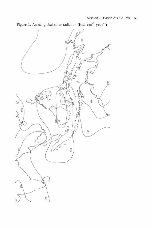
Session I: Paper 2: H. A. Nix 69
Figure 1. Annual global solar radiation (Kcal cm- 2 year-1)

70 Ecological Guidelines for Development in South East Asia
irrigated crops during the dry season; and for the growth/development balanceof perennial and free crops, even where the dry period is quite short.
TemperatureThe lowland areas of the whole region are characterized by high mean annualtemperatures (26-28 °C) with an extremely low annual range (5 °C) which,normally, is exceeded by the diurnal range (7-10 °C). Thus, for example,lowland stations in the Philippines (Flores and Balagot 1969) have an annualmean of 27 °C, an annual range of 2. 6 °C and an average diurnal range of 7. 5 °C.In the seasonally wet-dry zones, both the annual and diurnal ranges are greater(10-15 °C and 15-25 °C). At high elevations the annual range is still low (5 °C)but the diurnal range is usually higher (10-15 °C) than in the lowlands.
Altitude plays a more important role in termperature variation than latitude.Calculation of the mean decrease in temperature with altitude is compoundedby mesoscale factors such as slope, aspect, exposure, cloud cover and valleyand mountain winds. However, Braak (1929) quotes average values of 0. 60 °C/100 m up to 1500 m with a decline to 0. 55 °C/100 m with increasing elevationin Jawa and these are in general accord with calculations made for NewGuinea. The more favourable thermal environments for humans, livestockand crops at levels between 500-1500 m and even higher, have significantlyinfluenced settlement patterns in many parts of the region.
Temperature extremes exercise constraints on biological systems evenwhere occurrence is sporadic and irregular. Freezing temperatures andfrost set limits at high altitude, but no precise relation between frostincidence and elevation can be formulated because of mesoscale differences incold air drainage, insolation, cloud cover and other factors. Sukanto (1969)quotes frost occurrence of varying duration and severity ranging upwards from1500 m in high land areas of Jawa. The present snowline is variously estimatedat 4600 m (Verstappen 1964) and 4300 m (Sukanto 1969), but the only peaksabove such elevations are in West Irian.
In the lowlands, very high (> 38 °C) and very low (< 10 °C) temperatures arerare in the ever-wet zones, but are more common in the seasonally wet-dryzones. Usually such temperature extremes are associated with dry weather,clear skies and calm air. In such cases, possible thermal stress is compoundedwith water stress and serious damage to plantations, crops and gardens canoccur.
EvaporationWater is lost by evaporation to the air from plant soil and water surfaces.Evapotranspiration is the water lost by transpiration from vegetation andevaporation from the underlying surface. Because evapotranspiration ratesare modified by soil, plant and atmospheric factors with soil drying, theconcept of potential evapotranspiration was introduced to cover the case withsoil water supply not limiting. Potential evapotranspiration (PET) is animportant reference level in water balance studies and vast efforts havebeen devoted to methods of measuring and estimating it.
Potential evapotranspiration can be measured directly using a lysimeter orestimated using empirical formulae (Thornthwaite 1948; Papadakis 1961; Fitz-patrick 1963), an energy budget approach (Penman 1948) or an evaporimeter.Network requirements for simple, relatively inexpensive instruments normallyrestrict the choice to evaporimeter data or empirical estimates based onreadily available mean climatic data. The U.S. Class A Pan evaporimeter is

Session I: Paper 2: H. A. Nix 71
a standard network instrument in the region, but insufficient data werereadily available for regional analysis.
Empirical estimates of potential evapotranspiration based on Thornthwaite(1948) and Papadakis (1961) have been made for an extensive network ofstations in south-east Asia. Neither estimate gives results which are in goodagreement with observed Class A Pan values, but the Thornthwaite estimateis marginally better. The most detailed map of estimated potential evapotrans-piration available for south-east Asia has been prepared by Kayane (1971) anduses Thornthwaite estimates for more than 500 stations in south-east Asia.
Estimated annual totals exceed 1000 mm everywhere but for a few restrictedupland areas in southern India, Ceylon and Sumatra. Most of the region hasvalues exceeding 1500 mm, but less than 1700 mm. A few restricted areasin central Thailand and south-west India have estimated values in excess of1800 mm. During the wet season daily values range from 2-4 mm, but duringthe dry season may range from 4-10 mm.
PrecipitationBy definition the humid tropics is a region of high rainfall. Annual averagerainfall exceeds 1500 mm throughout most of the region and very substantialareas have values exceeding 3000 mm. Complex terrain, particularly in the'maritime continent', sometimes causes localized, but persistent, rain shadoweffects. Parts of the island of Luzon in the Philippines and the Palu valley inSulawesi in Indonesia are very dry, with annual totals between 500-1000 mm.
Despite high annual rainfall totals, which generally exceed annual potentialevapotranspiration, dry periods commonly occur because of seasonal patternsof rainfall distribution. Thus, parts of the Isthmus of Khra and of the southwestern coast of India have a regular dry season of some months duration,despite annual rainfall of 3000-5000 mm. In regions where rainfall exceedspotential avapotranspiration throughout the year, seasonal variation inrainfall tends to be masked. However, very few locations have uniform rainfalldistribution patterns. Regular seasonal peaks and troughs still occur.
The patterns of seasonal rainfall distribution reflect the varying influencesof the high-sun equatorial westerlies or monsoons and of the low sun tropicaleasterlies or trades. A high sun rainfall maximum is the general rule, but lowsun maxima occur where the tropical easterlies or trades meet high mountainbarriers, e.g., eastern Philippines, central-eastern Indochina, east coast ofMalaya north of the equator and the southern side of New Britain and of thecentral cordillera of New Guinea, south of the equator.
Fitzpatrick et al. (1966) used harmonic analysis to resolve the basic componentsof seasonality of rainfall in the tropical south west Pacific. Brookfield andHart (1966) used these data as a basis for classification of rainfall regimesin the same region. The insight provided by these studies suggests that asimilar analysis of the whole south-east Asian region would be very worth-while. Secular variation in rainfall throughout monsoon Asia has beenanalysed by Yoshimura (1971) and used to derive patterns of regionalsimilarity.
Rainfall variability is low in the ever-wet zones and highest in the seasonallywet-dry zones. The coefficient of variation around the annual mean (per cent)for rainfall ranges from less that 10 per cent on the west coast of Sumatra andcoastal Burma, but is generally within the range of 10-20 per cent throughoutthe region. A wide median belt through the Indian subcontinent and large

72 Ecological Guidelines for Development in South East Asia
areas inland from the coast in northern Australia have values exceeding 30per cent.
Rainfall intensity plays a key role in the important processes of rainfallinterception by vegetation, infiltration into the soil, surface runoff and soillosses and in the timing and duration of flood peaks. The widest network canprovide a resolution of rainfall intensity no better than unit amount of rainper day or 24 hour period. The pluviometer network in the region, whichrecords rain amounts over unit time periods of minutes, is not adequate fordetailed analysis of geographic patterns of short period rainfall intensities.
Average rainfall per wet day provides a crude measure of seasonal andspatial variation in rainfall intensity. Values exceed 25 mm/day in theseason of highest rainfall and high average values are characteristic of thewet 'Monsoon' season in the seasonally wet-dry environments. In highlandenvironments average rates are relatively low (3-10 mm/day) and comparewith rates common in the temperate zone at higher latitudes.
Estimates of maximum possible rainfall within a specified time interval(30 minutes, 1 hour, 6 hours, 12 hours, 24 hours) for a given return period(10 years, 25 years, 100 years) are needed for the design of engineeringstructures such as storage reservoirs, bridges, culverts, roads and soilconservation terraces. The WMO Guide to hydrometeorological practices(1965) examines and explains the techniques available.
CLASSIFICATION OF CLIMATE IN SOUTH EAST ASIA
General climatic classifications, particularly the more rational and systematice.g. Koppen (1913) and Thornthwaite (1931, 1948), play an important role incodifying and communicating climatic information at global and continentalscales. Although of limited utility for study of specific genotype/environmentinteractions or ecosystem process and function, they can be useful in transferof ecological information by analogy. The utility of any general, multi-attributeclassification for any specific purpose depends on the relevance of theattributes used and the choice of class interval.
Perhaps the most familiar and widely used of the general climaticclassifications is that of Koppen (1931). His five major climatic groups weredesigned to correspond with major natural vegetation formations and his Aclimates include all humid tropical forests variants. Average monthlytemperatures exceed 18 °C throughout the year and three major subdivisionsbased on seasonal rainfall distribution are used.
Af — Tropical wet climate: rainfall high throughout the year and exceeding60 mm in the driest month.
Aw — Tropical wet/dry climate: rainfall has a marked seasonal rhythm witha distinct dry period.
Am — Tropical monsoon: rainfall high throughout the year but with a shortdry season.
All calculations are based on monthly normals of temperature and precipitation.
Previous classifications of south-east Asia's climate using the Koppen systemhave been updated and amended by Mizukoshi (1971), who has used a muchmore extensive network of climatic stations. More importantly he provides amore realistic assessment of year climate by calculating relative frequenciesof Koppen climatic classes, over a series of years, at each station. Theresultant pattern (Fig. 2) of dominant year climates is used as a general

Session I: Paper 2: H. A. Nix 73
Figure 2.Dominant year climates (after Mizukoshi, 1975)

74 Ecological Guidelines for Development in South East Asia
reference to distribution of Af, Am and Aw climates in further discussion inthis paper.
Although simple, this classification serves a useful purpose in illustratingsome key points relevant to existing settlement and future land development.The most intensively settled and populated areas of south east Asia are all inAw dominant climates; the Am climates have much lower population densities;the Af climates have exceedingly low population densities. Apparent highdensity enclaves within this zone are upland areas, with modified temperaturesand are really islands of Cf climate (mild, temperate, rainy). Thus in theisland of New Guinea which has a predominantly Af climate, more than onequarter of the whole population occupies mountain valleys and highlands withCf climate.
In addition to the general climatic classifications, a veritable host of climaticindices have been developed, particularly with reference to delineation ofmoisture regime. Kawamura (1971) has explored the patterns of regionalvariation in south-east Asia expressed by a number of such indices; Lang'sRegenfactor, Martonne's Aridity Index, Angstrom's coefficient of humidityand Kira's index of moist and dry climates. However, these indices are ofmuch less value than more direct measures of the seasonal water balance.
An empirical classification based on the ratio of dry months to wet monthswas developed by Schmidt and Ferguson (1951) and used in Indonesia. Thedefinition of wet and dry months was based on earlier work by Mohr, whodefined a dry month as having less than 60 mm and a wet month more than100 mm of rainfall. Hernandez (1954)) used the same approach in classifyingrainfall types in the Philippines. The results in both cases illustrate thecomplexity of rainfall regimes in this humid, tropical insular environment.
Thornthwaite (1948) introduced a form of generalized water balance account-ing which involved book-keeping transfers of water in six compartments, i.e.precipitation, potential evapotranspiration, actual evapotranspiration, soilmoisture storage, soil moisture deficit and soil moisture surplus. Usingmonthly mean climatic data, C.W. Thornthwaite Associates (1963) publishedtables of average climatic water balance data of the continents. Kayane (1971)has presented certain of these water balance components for south-eastAsia in map form, together with a composite map showing regions of watersurplus and water deficit. For comparison with the map of annual globalsolor radiation (Fig. 1) and the map of dominant year climate (Fig. 2), Kayane'smap of annual water deficit is shown (Fig. 3). The correlations are obvious.
Although empirical and general classifications do convey useful information,they are far too general and imprecise for detailed resource inventory anddevelopment planning. At the other extreme, are classifications based onspecific genotype/environment interactions. Logically such an approachrequires a special classification for each specified genotype (or group ofgenotypes with similar ecophysiological responses) and, in consequence, tendsto be rejected on grounds of impracticality. However, advances in ourknowledge of ecophysiology on one hand and in computer based storage andretrieval mechanisms on the other, makes such an approach entirely feasible.
The beginnings of such a crop-specific and system-specific approach areevident in the works of Papadakis (1938, 1965, 1970), Azzi (1939, 1956),Prestcott (1943) and Prestcott and Lane Poole (1947) among others. Theseclassifications are based on known thermal and moisture regime constraintsof specific crops or crop groups. The work of Papadakis (1961, 1970) inclimatic classifications is of particular interest. He recognizes broad thermal

Session I: Paper 2: H. A. Nix 75
Figure 3.Annual water deficit (mm). After Kayane (1971)
76 Ecological Guidelines for Development in South East Asia
and moisture regime limits for a very comprehensive group of cultivatedplants, in addition to major structural types of vegetation. Indices derivedfrom a monthly water balance are used as measures of water supply; durationof wet and dry months and the magnitude of leaching potential. Thepublished values (1961) for much of south-east Asia are misleading onlybecause of underestimation of potential evapotranspiration. However, thebasic concepts are sound.
Direct coupling of the forcing functions of weather and climate with knownecophysiological responses offers prospects of much more relevant bioclimaticanalysis and classification. Fitzpatrick and Nix (1970) derived separate light,thermal and moisture indices for each of three major pasture groups withdistinct physiological responses. These indices, together with a multifactorialgrowth index were used in a bioclimatic analysis of the grassland ecology ofthe Australian continent. Nix and Kalma (1972) used these same indices inderiving limiting values for major structural and floristic groups in thevegetation of northern Australia and New Guinea. Again, using these indicestogether with numerical taxonomic techniques, Nix and Austin (1973) analysedand classified the climatic environment of a single species (Acacia aneura),an important browse shrub in arid inland Australia.
BIOCLIMATIC ANALYSIS AND SYNTHESIS
Whatever the tropical ecosystem, be it natural, man-modified or man-made,climate and weather exert an overwhelming influence on structure, process andfunction. The key role of climate and weather in conditioning biological andphysical processes and in determining much of the strategy and tactics ofecosystem management needs no emphasis. Yet bioclimatic analysis rarelylooms large in the hierarchy of resource evaluation and development planningpriorities. The primary reasons for this apparent anomaly are twofold. (1)Methods commonly used provide descriptive rather than prescriptive outcomesand, as such, may be considered irrelevant or inapplicable to the specificproblem. (2) Basic climatic data are totally inadequate or non-existentwithin the proposed development area.
Methods and techniques now available and under active development can domuch to relieve these limitations. Systems analysis and simulation techniquespermit a much closer coupling of climatic data and the system studied.Developments in climatonomy (Lettau 1969) can aid in mesoscale extrapolationof limited climatic data and in the generation of synthetic climatic andweather records. However, the basic price of admission to these moresophisticated techniques is a well balanced standard meteorological network.This key requirement cannot be emphasized too strongly.
MethodsThe development of sound land use policies for humid tropical forest areas,or any area, hinges upon the answers to three basic, but related, questions:
(1) For any given land use which areas offer the greatest biophysical andsocio-economic advantages?
(2) For any given area which land uses offer the greatest biophysical andsocio-economic advantages?
(3) For any given land use or area how may productivity be sustained at thehighest possible level?

Session I: Paper 2: H.A. Nix 77
Answers to these questions are sought by a tangled web of institutions—regional,national and international—each claiming responsibility for one or more ofthem. Yet, if it were possible to predict the performance of any given land use,at any location under any specified technology and any set of weather condi-tions, we could answer all three questions.
A general statement of the problem, then, is to predict the probable outcomes(ecological and economic) of any specified land use. This must be the ultimategoal of economists, agronomists, hydrologists, engineers, ecologists and otherspecialists involved in land evaluation and management. Progress towardsthis goal has followed an evolutionary path (Nix 1968) from trial and error,transfer by analogy, statistical correlation, multivariate analysis to the currentsystems analysis and simulation techniques. Climate and weather figureprominently in all of these approaches.
(i) Trial and error
Attempts to relate climate and weather to observed biological and physicalprocesses have roots in antiquity. The simplest techniques of keenobservation, coupled with generations of trial and error experiment, haveestablished traditional land use patterns. Given enough time, stable and suc-cessful systems can be evolved on such a basis, but the social cost is enormous.Where population pressures are very high and land resources available, thisapproach is still the primary basis for development and resettlementschemes. Sometimes this is disguised by a thin veneer of technologicalsophistry.
Traditional land use systems are often highly complex and very finely-attuned to the local environment. The complex timing required to fit land useoperations into the climatic cycle has been codified by ritual and custom.Climatic information thus becomes an integral part of the total system. Suchfinely attuned systems have characteristics which militate against change.Sudden change in any major component—biological, physical or cultural—canlead to massive disruption and even total destruction. In addition, suchlocation—specific technological recipes rarely transfer well and this hasimportant consequences for resettlement schemes.
(ii) Transfer by analogy
Most current land evaluation and land classification technology is firmlybased upon the concept of transfer of information by analogy. Such methodsdo not require any detailed knowledge of functional relationships betweenthe attributes measured and the potential use. However, the better thisfunctional understanding the more relevant the attributes selected formeasurement and the more useful the resultant classification. The basichypothesis is that all occurrences of a defined class will respond in a similarway to management for the specified use. Soil and climatic classificationsexemplify this approach.
Burgos (1968) provided an extensive review of bioclimatic classificationand associated techniques. He concluded that general schemes of classifica-tion were of limited use in solving specific problems. However, as pointed outin an earlier section of this paper, general climatic classifications do havesome value in codifying and communicating important information aboutclimate.
The classical instance of transfer of information and experience by analogyis the use of vegetation as an index of site quality. Most empirical climatic

78 Ecological Guidelines for Development in South East Asia
classifications have attempted to set class interval boundaries on the basisof major vegetation zones. Where the relationship between the climaticand vegetation class is stable and consistent then the presence of the vegeta-tion may be used to infer the climate. The line zone classification ofHoldridge (1947, 1966) may offer possibilities in this direction.
(iii) Statistical correlation
The development of mathematical techniques for fitting and testing relation-ships between independent variables, initiated a spate of correlation andregression analyses which continues to this day. Correlations have beensought between every climatic variable and a host of biological and physicalphenomena. In many situations, where a single climatic element exerts adominating influence on the system, such simple relationships can have usefulpredictive value. Rainfall is such an element and the literature attests to itsimportance as a component of predictive indices or equations (Stanhill 1970).
The deficiencies of this approach are due primarily to explicit assumptionsof linearity, implicit assumptions that correlation implies causation and thenormally location-specific nature of the relationship. Extrapolation to othersites, seasons and/or technologies is not recommended. These criticisms donot imply that correlation and regression analysis should be discarded. Indeedthese same techniques find ready acceptance in modelling and simulationtechniques (Austin 1971). The difference lies in the basic assumptions andlogic.
(iv) Multivariate analysis
These techniques represent a further development of correlation andregression analysis and are subject to the same criticisms. Biological res-ponse is related to sets of climatic (or other) variables. Although thestatistical equations include a more comprehensive set of relevant variablesthey are still merely static representations of what are highly dynamicsystems. They are valid only within the range of values of the attributes usedin developing the equation. Again, like their predecessors, they tend to behighly location specific. Despite these criticisms, such methods do have valueand when used with a substantial leavening of ecological insight and intuitioncan produce meaningful results (Noy-Meir 1971).
(v) Systems analysis and simulation
The need for a holistic approach to problems of resource evaluation andmanagement has long been recognized. However, until quite recently theconceptual and computational tools needed were not available. Systemsanalysis is concerned with resolution of a complex system into a numberof simpler components and subsequent synthesis into a symbolic representation(diagram, flowchart) and, ultimately, a mathematical model of the whole system.When a model is developed which adequately describes the behaviour of thesystem it can be used in simulation studies to show how the system can bemanipulated for a desired result. Basic concepts and techniques arediscussed by Watt (1966, 1968) and Dale (1970).
Despite intensive research on separate components and processes (and perhapsbecause of it) our understanding of biological systems as a functioning whole isvery limited. If we are to mobilise existing knowledge and organize researchsuch that the most important gaps in that knowledge are filled quickly, we needto devote at least as much energy to whole system-orientated research as is

Session I: Paper 2: H. A. Nix 79
currently devoted to discipline and process-oriented research. The trendtowards systems analysis represents an interesting departure from theessentially reductionist approach of Western science toward a holisticapproach much closer to Oriental philosophy.
The methods described above are not mutually exclusive. All can be used,either singly or in combination, to develop that understanding of ecosystemstructure, process and function which is so necessary for the development ofstable and productive land use systems. However, basic systems conceptsprovide a frame of reference within which all methods can be viewed in correctperspective. The single central concept is that the whole system must beunderstood in order properly to evaluate changes in any component of thesystem.
Basic data
The methods and techniques of bioclimatic analysis and synthesis dependon the availability and accuracy of climate, weather and biological and otherland-use data. An inadequate data base is a poor foundation for any analysis.Often, such a situation is maintained by strong negative feedback mechanisms.Because available data limit the choice and scope of method the resultsof analysis are of limited utility and relevance. Accordingly, extension andimprovement of existing data-gathering networks receive low priority. Sucha self-perpetuating cycle can be broken by convincing demonstations of theutility of modern methods and techniques coupled to an adequate data base.Much has been accomplished by several, United Nations sponsored,international symposia in attaining such an objective.
Given the primary position of basic data in resource evaluation, developmentand management, the establishment of adequate networks of synoptic,climatological, agrometeorological and hydrological stations should occupyhighest priority in national development planning. The World MeterologicalOrganization has promoted such an objective with considerable vigour andhas developed guidelines for network design and uniformity of instrumentation,siting and measurement.
Improvements in the data-gathering network need to be matched by improve-ments in the methods of storing, retrieving and disseminating the data. Toooften, the collection of basic data becomes an end in itself and stored dataare not readily accessible to potential users. Computer technology offerssolutions to these problems, but a great deal of manual effort is stillrequired in editing, checking and processing historical data. Security of datastorage is another important consideration. The climatic records lost in anumber of south-east Asian countries during World War II represents anincalculable resource loss.
Applications: generalThe methods and techniques of bioclimatic analysis are applied at scalesranging from the global and continental to the national, regional and local.In parallel with changes in scale, it is possible to recognize a hierarchy ofmethods and approaches ranging from those with greatest generality butleast precision to those with greatest precision but least generality. Thematching of methods to the scale and purpose of a given enquiry is a veryimportant determinant of ultimate relevance and use.
Whatever the scale or the level of generality and precision, bioclimaticanalysis involves a series of logical steps:

80 Ecological Guidelines for Development in South East Asia
1. A recipe, prescription or model of the specified land use is required.This sets out the various climatic, edaphic, biotic and cultural constraintsand lists factors known to control performance of the land use system(e.g. threshold temperatures for germination, development, survival;growing degree days during the wet season; soil moisture limits fortrafficability; probabilities of storm rainfall exceedance). These factorsand constraints may be written down as a set of rules or formalized asa mathematical model.
2. The set of rules or mathematical model specifies those attributes whichmust be measured.
3. These attributes vary in space and in time. Thus, for climatic elements,the network spacing, the frequency of observation and duration of therecord are important considerations.
4. The set of rules or mathematical model is then coupled to the specifieddata and used to generate predictions for the specified land use.
It should be obvious that the utility of any bioclimatic, or indeed any resourceanalysis, depends very much on the level of understanding of the particular landuse, the skill with which the recipe, prescription or model is formulated andthe availability of the specified data. Experienced resource assessors andmanagers go through these steps mentally and make intuitive judgements.However, unless their basic assumptions and logic are spelled out and setdown on paper, their skills and experience cannot be passed on and furtherdeveloped.
What is needed are working models (yet capable of continuous improvement inlogical structure and function) which can be used to predict the probableoutcomes (ecological, economic) of any specified land use. Although fewreally comprehensive models have been developed and used (cf. Watt 1966,1968) a very large number of partial, semi-empirical models have been de-veloped and used in engineering, agronomic, forestry, hydrological and otherapplications.
Given the multitude of potential land uses possible, it might appear that sucha use-oriented point of entry to resource evaluation is less practical than themore traditional multi-attribute general-purpose classification procedures.This would be so, if it were not for the fact that certain key processes are ofalmost equal significance for a wide range of potential land uses. Accordingly,many of the specified parameters needed for evaluation will be common tomany land uses.
The pivotal position of the water-balance in any land-use system providesa good example of such reasoning. Estimation of the various terms in thewater balance is of direct significance in land evaluation procedures forengineering, hydrological, agronomic, forest management and other applications.The extensive use of water-balance techniques for agricultural and pastoralland uses has been reviewed by Slatyer (1968) and Stanhill (1973) and forpractical applications in hydrology and watershed management by Pereira(1959). The principles of measurement or estimation of the components of thewater balance are ably summarized by Chang (1968b).
The water regime of ecosystems is the result of dynamic interactionsbetween weather, soil and plant parameters. As understanding of thesecomplex processes has grown, generalized computational models have beendeveloped for use in bioclimatic analysis. The most general and leastprecise of these have already been discussed (Thornthwaite 1948; Papadakis

Session I: Paper 2: H. A. Nix 81
1961). Considerable refinement is possible, even with these simplest ofmodels. Successively modified versions of a simple water-balance modeloriginally developed by Slatyer (1960) have been used in assessment ofregional climates of very large areas of northern Australia by the CSIRODivision of Land Research.
Crop ecosystems have received particular attention in water balanceresearch, principally because the water regime significantly influences cropyields. Studies of patterns of water use in relation to crop, soil and weatherfactors have led to the formulation of operational models for both annual andperennial crop systems, e.g. Fitzpatrick and Nix (1969), for alternating winterfallow-grain sorghum and summer fallow-wheat crop systems in Queensland;Pereira (1957), Wallis (1963) and Blore (1966) for coffee plantations in eastAfrica; Laycock (1964), Dagg (1970) and Willat (1971) for tea plantations ineast Africa. Indices derived directly from water balances have been shown togive good correlations with crop yields in many instances, e.g. Dale and Shaw(1965) with maize; Smith (1966) with coconuts; Nix and Fitzpatrick (1969)with wheat and grain-sorghum yields.
Fleming (1968) presents a simplified procedure for estimating the waterbalance of any prescribed crop system, dryland or irrigated, on a dailyroutine basis. For many purposes, the use of weekly mean data may provequite adequate. Water balance models of crop systems are most concernedwith the evapotranspiration term. In hydrological studies of catchment yieldand sediment load, the surface runoff term is of major interest. Similarly,the through-drainage term is of direct consequence for leaching and nutrientcycling.
Management of these terms in the water balance is central to any concept ofstable and productive land use. It would seem logical then to base develop-ment planning on discrete watersheds whether these be small catchments orwhole river basins. Pereira in fact argues that the watershed is the logicalunit within which interdisciplinary effort should be coordinated. He advocateda 'package deal' of land and water conservation practices, agronomic and/orsilvicultural techniques, transport and marketing infrastructure, provision ofcredit, education and health services.
Applications: specificThe humid tropical forests of south-east Asia transcend national boundariesand occupy an area of continental dimensions. Despite commonly heldassumptions of uniformly hot and wet conditions, the region exhibits climaticregimes of considerable complexity. A logical first step in the evaluation ofthese resources is a comprehensive bioclimatic analysis, on a unified basis,of the whole region.
Examples of such assessments at similar scales are provided by Bricham-baut and Wallen (1962) for a large part of Asia Minor and by Cochemé (1968)for tropical West Africa. In both of these studies, genuine attempts weremade to mobilise existing knowledge of land use patterns and managementstrategies and to incorporate these in the analysis. A further example isprovided by Nix (1974) who used simulation models of wheat crop systems inan agroclimatic analysis of winter cereal environments in Australia.
Such continental-scale assessments provide a framework for further moredetailed analysis; provide first order estimates of land use potential forspecified uses; identify deficiencies in data-gathering networks and provideinsight into the spatial and temporal patterning of climatic constraints.
82 Ecological Guidelines for Development in South East Asia
The collection of papers edited by Yoshino (1973) and concerned with majorclimatic contols and resultant influences on the water-balance of monsoonAsia is an important step in this direction.
At the national level, one would expect the development of humid tropicalforest areas to fit within some framework of expressed national goals. Thus,if the goal is to maintain the whole population at a given level of nutrition then,logically, the question is which areas offer greatest advantages in meetingthis goal. Allocation of scarce resources to promote increased productionfrom existing areas may provide a more rational solution than development ofadditional forest areas. However, it would seem that identification ofdevelopmental priorities on such a basis is comparatively rare in bothinternational funding agencies and participant countries (Nelson 1973). A greatmany developmental projects are initiated with minimal reference to thebroader context of the natural resource base.Although bioclimatic analysis is an important and essential tool in thearmoury of resource evaluation techniques, it is only as good as the availabledata will permit. It should not be viewed as a static, once-over exercise, butas a continuing, vital, component of the information flow needed for manage-ment of the national resource. If the whole approach is based on systemsanalysis and simulation techniques, then predictions can be revised withminimum delay whenever new facts become available.At the regional or project level, the emphasis shifts away from Indentificationof potential land uses towards problems of land use management. Dasmannet al. (1973) identify the tropical, ever-wet rainforest regions as among themost difficult areas of the world for intensive human settlement andeconomic development. Certainly, population densities in these Af climaticregions are very much lower than in the adjoining Am and Aw regions ofsouth-east Asia. The reasons advanced for this situation are many andcomplex and, to some extent, conflicting.
The potential of the humid tropics for production of food and fibre has beenthe subject of much debate. Chang (1968a) coupled ecophysiological andclimatic data to show that potential was limited. Stewart (1970) on the otherhand showed that tropical crop and pasture species have very high potentialproductivity levels when considered on the basis of dry matter per unit timeor per unit of light energy input. However, such high levels of productivityare sustained by very high inputs of fertilizer nutrients, principally nitrogen.This confirms the view (Odum 1973) that really large increases in agriculturalproduction depend on the coupling of the agricultural system to an industrialeconomy, which then provides the necessary fossil fuel subsidies in the formof fertilizer, chemicals, machine power.
Although tropical crop and pasture species are capable of very high levels ofproductivity, these levels are attained when these species are grown in theseasonally wet-dry environments and in the subtropics. The uniformly hightemperatures coupled with relatively low inputs of solar radiation in the ever-wet regions, affects the growth-development balance adversely—even withrelatively adapted crop and tree species. In addition to these problems, pestsand diseases pose a major threat. Janzen (1973) elaborates on this subjectand draws attention to the very real difficulties of developing sustained yieldtropical agro-ecosystems and to the very real dangers of simple-mindedextrapolation of temperate-zone technologies. Geertz (1963) attributes thecontinuing low productivity of certain areas in Jawa to institutional and histori-cal factors associated with the imposition of cash crop monoculture andplantation systems.

Session I: Paper 2: H. A. Nix 83
Given these problems, what is the possible role of bioclimatic analysis ?At the regional or project development level, it is necessary to make a muchmore detailed analysis of climatic constraints on all components of the landuse system (i.e. human work patterns; siting of roads, buildings, earthworks;crop and livestock management strategy and tactics; harvest and storage).
If the term crop is used in the widest sense, then for any crop the whole geno-type-environment-management interaction can be viewed as an investmentgame. Given a finite set of resources (e.g. light, temperature, water, nutrients)which can be assigned probabilities for any given time and location, what is thebest possible strategy for allocation of these resources to development ofsource (productive component) and sink (harvested component) structures?Obviously a thorough understanding of crop systems is required before sucha strategy can be developed. Duncan (1967) explores methods of manipulatingtemperate crop systems for higher yields through such a level of understanding.Certainly less is known about tropical crop systems, but Williams and Joseph(1970) provide an excellent review and summary of what is known. Buildingupon this base, it will be possible to develop working models of tropicalcrop ecosystems which, when coupled with appropriate climatic records, canaid in development of management strategies and tactics and in reduction ofrisk and uncertainty.
ABSTRACT
Humid tropical forests are a significant feature of the south-east Asian region.The general climatic characteristics of the whole region are reviewed andpresented as a frame of reference for discussion. Particular attention isgiven to the major climatic controls and to spatial and seasonal variation inmajor climatic elements. Climatic classification is considered as a tool inbioclimatic analysis and the application of a number of different classifica-tions to the south east Asian region is discussed.
The development of logic and method in bioclimatic analysis is reviewedbriefly. The need for a holistic approach to problems or resource manage-ment is emphasized and the possible role of systems analysis and simulationtechniques in evaluation, development and management of humid tropicalforest areas is discussed. Application of bioclimatic analysis to problems ofdevelopment is considered in both general and specific terms.
REFERENCES
ARAKAWA, H. 1969. Climates of northern and eastern Asia. In: WorldSurvey of Climatology, Vol. 8.
ASAKURA, T. 1971. Seasonal variation in water vapor balance over thenorthern hemisphere and Asia. In: Water balance of monsoon Asia: aclimatological approach. M. M. Yoshino, ed. Honolulu, University ofHawaii Press.
AUSTIN, M. P. 1971. Role of regression analysis in plant ecology. In:Quantifying Ecology. Nix, H. A. (ed.). Proc. Ecol. Soc. Aust., Vol. 6.Canberra.
AZZI, G. 1939. Trattato di ecologia agraria. Turin, Society EducationInternazionale.1956. -Agricultural ecology. London, Constable.
84 Ecological Guidelines for Development in South East Asia
BATES, J. R. 1972. Tropical disturbances and the general circulation.Quart. J.Roy. Met. Soc, 98: 1-16.
BJERKNES, J. 1969. Atmospheric teleconnections from the equatorialPacific. Month. Weather Review, 97: 163-172.
BRAAK, C. 1929. Het klimaat van Nederlandsch-Indie. Vol. I. Verhandelingenvan het Koninklijk Magnetisch en Meteorologisch Observatorium,Batavia. No. 8.
BROOKFIELD, H. C. and HART, D. 1966. Rainfall in the tropical southwestPacific. Res. School Pacific Studies, Dept. of Geography Publ. G/3.Canberra, A.N.U. Press.
BURGOS, J. J. 1968. World trends in agroclimatic surveys. In: Agroclimato-logical methods—Vroc. Reading Symposium, Agroclimatological methods.Paris, UNESCO.
CHANG Jen-Hu 1968a. The agricultural potential of the humid tropics. Geog.Rev., 58: 333-3611968b. Climate and agriculture: an ecological survey. Chicago, Aldine
Publ. co.COCHEME, J. 1968. FAO/Unesco/WMO agroclimatology survey of a semi-
arid area in West Africa south of the Sahara. In: Agroclimatologicalmethods—Proc. Reading Symposium on Agroclimatological Methods. Paris,Unesco.
DAGG, M. 1970. A study of the water use of tea in East Africa using ahydraulic lysimeter. Agric. Met., 7: 303-320.
DALE, M. B. 1970. Systems analysis and ecology. Ecol., 51: 7-16.and SHAW, R. H. 1965. Effect on corn yields of moisture stress and
stand at two fertility levels. Agron. J., 57: 475-479DASMANN, Raymond F., MILTON, John P. and FREEMAN, Peter H. 1973.
Ecological principles for economic development. London, John Wiley andsons Ltd.
DUNCAN, William G. 1969. Cultural manipulation for higher yields. In:Physiological aspects of crop yield. Jerry D. Eastin, F. A. Haskins, C. Y.Sullivan and C. H. M. Van Bavel, eds. Madison, Wisconsin, AmericanSociety of Agronomy and Crop Science Society of America.
FITZPATRICK, E. A. 1963. Estimates of pan evaporation from mean maximumtemperature and vapour pressure. J. Appl. Met., 2: 780-792., BROOKFIELD, H. C. and HART, D. 1966. Rainfall seasonality in thetropical south west Pacific. Erdkunde. 20: 181-194and NIX, H. A. 1969. A model for simulating soil water regime in
alternating fallow-crop systems. Agric. Met., 6: 303-319and 1970. The climatic factor in Australian grassland ecology. In:
Australian Grasslands. Canberra, A.N.U. PressFLEMING, P. M. 1968. Crop water requirements and irrigation. In:
Agricultural meteorology-Proc. W.M.O. Seminar, Melbourne, Australia.Melbourne, Bureau of Meteorology for W.M.O.
FLORES, J. F. and BALAGOT, V. F. 1969. Climate of the Philippines. In:Climates of northern and eastern Asia: World survey of climatology.Vol. 8. H. Arakawa, ed. Amsterdam, Elsevier.
GEERTZ, Clifford. 1963. Agricultural involution: the process of ecologicalchange in Indonesia. Berkeley and Los Angeles, University of CaliforniaPress.
HERNANDEZ, P. P. 1954. Rainfall types based on ratios of dry months to wetmonths. Manila, Weather Bureau. 31 pp.
HOLDRIDGE, L. R. 1947. Determination of world plant formations fromsimple climatic data. Science, 105 (2727): 367-368.1966. The Life Zone System. Adansonia 6 (2): 199-203.

Session I: Paper 2: H. A. Nix 85
HOUNAM, C. E. 1968. The routine measurement of evaporation. In:Agricultural meteorology-Proc. W.M.O. Seminar, Melbourne, Australia.Melbourne, Bureau of Meteorology for W.M.O.
JANZEN, Daniel H. 1973. Tropical agroecosystems. Science, 182 (4118):1212-1219
KAWAMURA, T. 1971. Representation of moist and dry climate of monsoonAsia according to climatic indices. In: Water balance of monsoon Asia—a climatological approach. M. M. Yoshino, ed. Honolulu, University ofHawaii Press.
KAYANE, I. 1971. Hydrological regions in monsoon Asia. In: Water balanceof monsoon Asia—a climatological approach. M. M. Yoshino, ed. Honolulu,University of Hawaii Press.
LAYCOCK, D. H. 1964. An empirical correlation between weather and yearlytea yields in Malawi. Trop. Agric. Trin., 41 (4): 277-291.
LETTAU, H. H. 1969. Evapotranspiration climatonomy. Monthly WeatherReview, 97: 691-699
MANABE, S. 1971. General circulation of the atmosphere. Trans. Am. Geophys.Un., 52: 313-320
MIZUKOSHI, M. 1971. Regional divisions of monsoon Asia by Koppen'sclassification of climate. In: Water balance of monsoon Asia—aclimatological approach. M. M. Yoshino, ed. Honolulu, University ofHawaii Press.
NELSON, Michael, 1973. The development of tropical lands: policy issues inLatin America. Baltimore, Johns Hopkins Univ. Press for Resources.
NIX, H. A. 1968. The assessment of biological productivity. In: LandEvaluation. G. A. Steward, ed. Melbourne, Macmillan.1974. The Australian environment and its influence on grain yield and
quality. In: Winter cereals in Australia. A. Lazenby and E. Matheson, eds.Sydney, Angus and Robertson, (in press).and AUSTIN, M. P. 1973. Mulga: a bioclimatic analysis. Trop.
Grasslands.!: 9-21.and FITZPATRICK, E. A. 1969. An index of crop water stress related
to wheat and grain sorghum yields. Agric. Met., 6: 321-337and KALMA, J. D. 1972. Climate as a dominant control in the
biogeography of northern Australia and New Guinea. In: Torres Strait-Bridge and Barrier.
NOY-MEIR, Immanuel, 1971. Multivariate analysis of the semi-arid vegetationin south-eastern Australia: nodal ordination by component analysis: In:Quantifying Ecology. Nix, H. A. (ed). Proc. Ecol. Soc. Aust., Vol. 6.Canberra.
ODUM, Howard T. 1973. Environment, power and society. New York, Willey-Interscience.
PAPADAKIS, J. 1965. Crop ecology survey in West Africa. Rome, FAO.1938. Ecologie agricole. Gembloux, Belgium, Jules Duculot.1961. Climatic tables for the world. Buenos Aires, published by the
author.1970. Climates of the world: their classification, similitudes, differences
and geographic distribution. Buenos Aires, published by the author.PENMAN, H. L. 1948. Natural evaporation from open water, bare soil and
grass. Proc. Roy. Soc. Lond. A., 193: 120-145PEREIRA, H. C. 1957. Field measurements of water use for irrigation
control in Kenya coffee. J.Agric. Sci., 49: 459-467.1959. A physical basis for land-use policy in tropical catchment areas.
Nature, 184: 1768-1771

86 Ecological Guidelines for Development in South East Asia
PERRIN DE BRICHAMBAUT, M. G. and WALLEN, C. C. 1962. A study ofagroclimatology in semi-arid and arid zones of the Near East. (W.M.O.Technical note no. 56). Geneva, W.M.O. for Unesco/WMO/FAO.
PRESTCOTT, J. A. 1943. The Australian homoclimate of the zone of naturaloccurrence of Parthenium argentatum. Trans. Roy. Soc. S. A. 67 (2).and LANE POOLE, C. E. 1947. The climatology of the introduction of
pines of the Mediterranean environment to Australia. Trans. Roy. Soc. S. A.71 (1).
RAMAGE, C. S. 1968. Role of the tropical 'maritime continent' in theatomospheric circulation. Month. Weath. Rev., 96: 365-370.
RIEHL, H. 1969. On the role of the tropics in the general circulation of theatmosphere. Weather, 24: 288-308and MALKUS, J. S. 1958. On the heat balance in the equatorial trough
zone. Geophysica, 6: 503-538.SADLER, J. C. 1969. Average cloudiness in the tropics from satellite
observations. Honolulu, East-West Center Press.SCHMIDT, F. H. and FERGUSON, J. H. A. 1951. Rainfall types based on wet
and dry period ratios for Indonesia. Verhandel. Djawatan Meteorol. danGeofis. Djakarta, 42: 177.
SELLERS, W. D. 1969. A global climatic model based on the energy balanceof the earth-atmosphere system. J. Appl. Meteorol., 8: 392-400
SEN, A. R., BISWAS, A. K. and SANYAL, D. K. 1968. The influence of climaticfactors on the yield of tea in the Assam valley. J. Appl. Meteorol., 7:94-104.
SLATYER, R. O. 1960. Agricultural climatology of the Katherine area, N.T.CSIRO, Div. Land Res. Reg. Surv. Tech. Paper 13.1968. The use of soil water balance relationships in agroclimatology.
In: Agroclimatological methods--Proc. Reading Symposium. Paris, Unesco.SMITH, G. W. 1966. The relation between rainfall, soil, water and the yield
of copra on a coconut estate in Trinidad. J. Appl. Ecol., 3: 117-125STANHILL, G. 1973. Simplified agroclimatic procedures for assessing the
effect of water supply. In: Plant response to climatic factors--Proc.Uppsala Symposium. Paris, Unesco.
STEWART, G. A. 1970. High potential productivity of the tropics for cerealcrops, grass forage crops and beef. J. Aust. Inst. Agric. Sci., 36: 85-101.
SUKANTO, M. 1969. Climate of Indonesia. In: Climates of northern andeastern Asia: World survey of climatology, Vol. 8. H. Arakawa, ed.Amsterdam, Elsevier.
THORNTHWAITE, C. W. 1948. An approach toward a rational classificationof climate. Geogr. Rev., 38: 55-94.
TSUCHIYA, I. 1971. Fluctuations of rainfall in southeast Asia—equatorialPacific and low and middle latitude circulations in the southern hemisphere.In: Water balance of monsoon Asia—a climatological approach. M. M.Yoshino, ed. Honolulu, University of Hawaii Press.
VERSTAPPEN, H. T. H. 1964. Geomorphology of the Star Mountains. NovaGuinea, Geology, 5: 101-158.
WALLACE, J. M. 1971. Tropical meteorology. Trans. Am. Geophys. Un.,52: 395-399
WALLIS, J. A. N. 1963. Water use by irrigated Arabica coffee in Kenya.J. Agric. Sci., 60: 381-388
WATT, K. E. F. (ed.) 1966. Systems analysis in ecology. New York, AcademicPress.
WATT, K. E. F. 1968. Ecology and resource management. New York,McGraw-Hill.

Session I: Paper 2: H.A. Nix 87
WILLATT, S. T. 1971. Model of soil water use by tea. Agric. Met.,8: 341-351.WILLIAMS, C. N. and JOSEPH, K. T. 1970. Climate, soil and crop production
in the humid tropics. Kuala Lumpur, Oxford University Press.YOSHIMURA, M. 1971. Regionality of secular variation in precipitation over
monsoon Asia and its relation to general circulation. In: Water balanceof monsoon Asia: a climatological approach. M. M. Yoshino, ed. Honolulu,University of Hawaii Press.
YOSHINO, M. M. 1971. Water balance problems in monsoon Asia from theviewpoint of climatology. In: Water balance of monsoon Asia—a climato-logical approach. M. M. Yoshino, ed. Honolulu, University of Hawaii Press.

88
Session I. BACKGROUND PAPERS. No. 3
The soil as an Ecological Factor in theDevelopment of Tropical Forest Areas
F. A. van BAREN
Professor of Soils State University, Utrecht; Soils Advisor, Royal TropicalInstitute, Amsterdam, Netherlands
In the Proceedings (1966) of the Symposium on Ecological Research in HumidTropics Vegetation, held in Kuching, Sarawak, in 1963, the study-group on nu-trients in vegetation, soils and soil parent material stated in the preamble tothe recommendations of the group that there was little information about theproductivity of tropical forests on different soils. It was, therefore, recom-mended that a research project be formulated to analyse the role of naturalvegetation in tropical soil fertility.
The aim of the present paper is to focus attention on some pertinent earlierresearch and to review the present state of affairs as far as fertility is con-cerned, in the light of ecological philosophy. In this paper the author dealsexclusively with the potential of virginal tropical forest soils for agriculturalproduction. The first question to be answered is whether there is any basisfor expecting a high or even average level of natural fertility of a soil that iscovered by luxurious virgin forest. Indeed the casual observer is often deeplyimpressed by the giants of trees and thick undergrowth of this cover of pri-mary vegetation. It has, however, perhaps correctly been described by Sapper(1935) as a relict of foregone times and this might explain tropical soil expertCharter's rather gloomy verdict (Charter 1949): 'Do not be deceived by theluxuriance of a tropical forest for it may conceal almost sterile soil'. Bayens(1938) points to the deterioration of Zaire's forest soils as a result of naturalexhaustion. This is, in a way, confirmed by Richards (1964) when he refers tothe paradox of luxuriant tropical vegetation on leached and impoverished soils,pointing out that there is an immense amount of nutrient material in circula-tion within the closed cycle of nutrients and immobilized within the vegetationitself.
Vine (1954) discussed the question 'Is the lack of fertility of tropical Africansoils exaggerated?' at the 2nd Inter-African Soils Conference at Leopoldville.Although starting his paper with the statement that the error of the idea thatluxuriant growth of equatorial forest indicates inherently high fertility in thesoils has been recognised for many years, he strongly criticizes condemningremarks as are to be found in the books of Stamp (1953), and of Gourou (1953).The first author describes the rapid impoverishment of the soils that isbrought about by excessive leaching when the forest cover is removed, stress-ing the lack of knowledge necessary for the sound development of areas wherethis occurs. This point of view is also held by Botelho da Costa (1953), whowrites in his textbook on Angola soils that large investments have been lostbecause of a wrong assessment of virgin soils. Gourou (l.c.) is even morenegative in his evaluation of tropical soils, stating that they are very poor inassimilable bases and phosphorus and ill-supplied with humus. Vine definitelyrejects the generalized statements of both Stamp and Gourou. In his paper hepresents a number of examples from which may be concluded that, at leastfor the areas of Nigeria with moderate rainfall, the maintenance of fertility

Session I: Paper 3: F.A. van Baren 89
presents much less difficulty than in regions of very heavy rainfall(>2000 mm/year). Nevertheless the natural fertility is problematic, whichfollows from the data of the West African Institute for Oil Palm Research. Anexperimental plot that received no manure in 1940 produced 11, 600 kg/ha ofyams (Pioscora sp.) and 2 years later only 5060 kg/ha. The yield of cassava(Manihot utilissima) grown on the same plot went down from 6700 kg/ha in1944 to 1100 kg/ha in 1946. This is not too surprising, as may be concludedfrom Table 1.
TABLE 1
Data on Forest Soils from Nigeria (after Vine, 1954).
Depth (inches)
pH
Base-exchange capacity(m.e.per 100 mg.)
Total exchangeablebases (m.e.per 100 mg.)
% Carbon
% Nitrogen
October 1941Before fellingand burning
0-6
5.0
5.6
2.5
1.16
0.089
6-18
4.4
5.3
1.4
0.66
0.054
October 1942After fellingand burning
0-6
5.5
5.7
3.0
1.09
0.083
6-18
4.4
5.4
1.5
0.66
0.047
The rapid decrease in plant nutrients after clearing the forest and planting onecrop of taro (Colocasia esculenta) in New Guinea has been described by Reyn-ders (1961) who had the opportunity to study the pattern of shifting cultivationas practised by the Papua population. Analysing the soil he proved that aftereight months at harvest time the soil was practically depleted of plant nu-trients. Even 10 years after abandonment of the plot, then covered by a poorsecondary vegetation, the level of these vital elements was much lower thanafter the initial clearing of the original forest. To this should be added thatthe rainfall in the area ranged from 3, 000-5, 000 mm per year.
TABLE 2
Decline of fertility of primeval forest soil in New Guinea after felling andplanting (after Reynders, 1961).
Soil stage
1 day after planting
1 week after planting
3 months after planting
After 8 months at harvest
8 months after abandonment
2 years after abandonment
10 years after abandonment
pH
6.5
5.9
7.0
5.8
5.7
5.6
6.0
3% acetic acid ppm
CaO
4100
2700
4600
250
tr
30
1900
MgO
600
370
830
30
tr
tr
450
K2O
250
245
180
180
105
120
180
Na2O
230
80
270
40
65
55
110

90 Ecological Guidelines for Development in South East Asia
A striking example of variations in fertility of virginal forest soils isfound in Ethiopia (Van Baren 1961).
TABLE 3
Chemical analysis of rhyolitic soils in the Gossi forests
Granulometry %
2,000-200
200-20
20-2
2
Acidity
pH-H2O 4.6
pH-KCl
Carbon %
P2O5 ppm/soil
M-V Analysis
Calcium
Magnesium
Potassium
Ammonium
Iron
Aluminium
Manganese
Sulphate
Sodium
Horizon
0-3
12
11
27
50
4.6
3.8
10.9
56
510
160
100
77
5
58
0
2
10
Profile 703-15
128
15.5
41.5
35
4.9
3.8
5.5
12
300
110
8
18
9.8
141
8.5
2
9
15-40
88
12
29.5
50.5
4.8
3.6
1.4
3
80
20
10
10
10
161
8.5
14
13
40-90
84
18
28.5
39.5
4.6
3.6
0.6
6
20
5
10
15
6
210
0
12
12
0-3
5
9.5
24.5
61.0
5.8
5.3
10.5
43
1520
300
70
65
0.4
4
10
6
8
Profile3-15
4
15.5
20.5
60
5.6
4.4
2.6
10
750
170
20
55
1.8
20
7
2
8
7115-40
4
8.5
23.5
64
5.3
4.1
1.1
21
450
130
10
13
2.7
61
3.5
3
8
40-90
3.0
19.5
23
54.5
4.9
3.7
0.5
16
200
60
10
17
1.9
87
7.5
26
10
The figures are fairly conclusive and not only illustrate the differences be-tween the two profiles, but even more those differences between their indivi-dual horizons, particularly in profile 70. It is obvious that clearing a forestwith the idea of using a soil of which only the top three centimetres containthe nutrient elements in adequate quantities represents a grave risk. As asecond case in point reference may be made to the experience acquired whenstudying virgin-forest soils collected during a prospecting survey of theKolombangara Island in the Solomons (Van Baren 1963). The descriptivereport sent with them took the line that there could be no doubt that the soilwas fertile, in view of the luxuriance of the forest. Table 4, which includesalso particulars of other samples for comparison, demonstrates that the oppo-site is true.

TABLE 4Results of analysis of soils from Kolombangara, Solomon Islands.
Fertilitygrade
I
II
III
IV
Samplenumber
A2C1
J2L1
F1K2
3035
Truog P2O5parts permillion/soil
5075
010
55
00
Parts per million in sodiumacetate-acetic acid solution
Ca
8001050
14001250
19001850
6810
Mg
200140
110175
11070
438
K
1025
1020
1510
84
Al
105
255
510
4666
Mn
20
00
00
11323
The grade IV soils were taken from the virgin forest in the east of the island,and the other samples from parts of the island already under cultivation. Thefigures are self-evident. Nutrient elements such as calcium, magnesium andpotassium are lacking in the forest soil, whereas the Al and Mn contents arehigh, indicating advanced deterioration. It is clear that this data does not givecause for optimism. Further and more recent information on forest soils fromGhana (Ahn 1970) confirm the opinion that utmost care should be taken whenconsidering exploiting tropical forest soils for agricultural purposes (Table 5).
Ahn points out that the amounts of rainfall in the two regions differ markedlyand that the more severely leached soils are generally associated with thehigher rainfall areas. The climatic agents also had an impact on the nature ofthe forest, tree-species and associations. It is mentioned that the KumasiOchrosol carries a semi-deciduous forest characterized by the dry facies of aCeltis-Triplochiton association, whereas the more weathered Oxysol of south-west Ghana is covered by tropical rainforest (soil qualification according toCharter 1955). In view of the influence of the vegetation on the soil quality itseems worthwhile to pay more attention to the chemical composition of theleaves and consequently to the quality of the organic matter and the humus-clay complex as reflected in pH and saturation percentage. That even thesame tree-species grown under different pedo-ecological conditions may havea conspicuously different ash-content and chemical composition of its leavesfollows from the data in Table 6.
Other examples of the paucity of plant nutrients in the layers below the humus-rich topsoil in primeval tropical forests are found in the study by Sombroekof the Amazon soils (1966) and in the explanatory text to the FAO-Unesco SoilMap of the World, Volume IV, South America (Unesco, 1971). Sombroek notablyremarks that the amount of available phosphorus decreases with depth rapidlyto very low values (6 ppm after Truog).
An interesting report of Lundgren (1971) on the soils of a montane forest inEthiopia confirms that organic matter is the principal carrier of the soil'sfertility as far as determined by the presence in adequate quantities of plantnutrients. The purpose of the study was to find out whether in the area invol-ved, the Munessa forest, a softwood plantation could successfully be established.Apart from the forest inventory carried out on behalf of the Ethiopian Govern-
Session I: Paper 3: F. A. van Baren 91

92 Ecological Guidelines for Development in South East Asia
14 Sat
ura-
tion
13 Cat
ion
Exc
hang
eC
apac
ity
12 Tot
al
9 10
11
Exc
hang
eabl
e B
ases
(m.c
. per
100
g)
Ca
Mg
K
8 % O
M
7 C/N
6 % N
5 % C
4 Cla
y
3 Pine
Ear
th
pHL
ower
Dep
thof
Hor
izon
(in.
)
Soil
Loc
atio
nR
ainf
all
Par
ent
Mat
eria
l
(a)
(b)
(c) ( d)
76 20 8 9 9
43.1
316
.00
13.2
010
.95
9.99
32.9
33.
171.
081.
010.
85
0.30
0.10
0.07
0.07
0.03
7.87
1.24
0.30
0.24
0.33
23.7
41.
630.
500.
460.
32
10.5
12.
201.
220.
690.
53
13.5
9.3
8.3
6.6
4.5
0.45
40.
137
0.08
50.
061
0.06
9
6.11
1.28
0.71
0.40
0.31
36 40 46 46 44
100 94 42 31 79
6.4
5.1
5.0
5.1
4.9
2 11 21 33 46
For
est
Och
roso
l(B
ekw
ai s
erie
s)K
umas
i, G
hana
55-6
0 in
Phyl
lite
(a)
(b)
(c)
(d)
20 15 12 9 9
12.6
07.
317.
838.
428.
47
2.46
1.09
0.96
0.78
0.72
0.22
0.07
0.02
0.04
0.04
0.79
0.44
0.35
0.31
0.30
1.70
0.30
0.31
0.26
0.25
4.25
1.41
1.15
0.89
0.72
13.1
10.1 9.6
8.8
8.2
0.18
90.
081
0.07
00.
059
0.05
1
2.47
0.82
0.67
0.52
0.42
22 28 42 53 55
95 95 52 93 98
4.7
4.8
5.6
4.9
4.9
3 7 16 27 42
For
est
Oxy
sol
(Boi
ser
ies)
Sout
h-w
est
Gha
na75
inPh
ylli
te
(a)
(b)
(c) (d)
TAB
LE 5
Ana
lyti
cal
data
for
tw
o fo
rest
soi
ls f
r om
Gha
na (
afte
r A
hn 1
970)
.
%%
%
12

Session I: Paper 3: F. A. van Baren 93
TABLE. 6Chemical composition of the leaves of Dacrydium elatam from Padangand from the Botanic Garden at Bogor, Java (after Hardon 1937).
Ash
CaO
MgO
K2O
Na2O
MnO
P2O5
Padang
2.16
0.59
0.33
0.52
0.08
0.02
0.10
Botanic Garden
7.59
3.43
0.69
0.57
0.05
0.15
0.15
Differences in nutrient composition of litter layers in various countriesof tropical Latin America were set out in a review of soils research inthat continent and published by the Soil Science Department of the NorthCarolina State University (1972).
TABLE 7
Nutrient composition ranges in litter layers in Guatemala, Puerto Rico,Ghana and Congo (after North Carolina State University Report, 1972).
N
P
K
kg/ha/yr
74-199
1-7
8-81
Ca
Mg
S
kg/ha/yr
45-220
10-94
9-10 (one site only)
ment, additional laboratory investigations of the soils were executed in Sweden,allowing the study of the relation of soil, vegetation and altitude. The authorcompares the data of the Munessa area (ranging in altitude from 2100-2700metres above sea level) with those of soils of the same nature, so-called Ferri-sols, after d'Hoore (1964), from the Ivory Coast, Ghana and Malawi. They showclearly the conserving influence of the altitude notably on the content of organicmatter in the topsoil. The Munessa soil (altitude 2100 m) contained an averageof 8.67% C, Ivory Coast samples 2.54% C (altitude 140 m) and 11.8% C in theMalawi soils occurring at an elevation of 1200-1800 m a.s.l. From the datapresented in Lundgren's report two have been selected which show strikingdifferences in soil organic matter content, although the ecological situation,that is altitude, rainfall, parent material and suchlike factors, seems fully com-parable. The forest-type, however, is not the same and it might be of scientificinterest to know whether the botanic composition of the forest did play a deci-sive role.
The evaluation of the data in Table 8 (p. 94) in view of the production potentialto be expected is rather speculative as there is little comparative information.The lactate extraction figures (AL) show very low to no easily available phos-phorus; only 7.6 in the humus-rich topsoil of plot 3 and zero in the other sam-ples. Also the HCl-extractable P is on the low side. Only K is present in

94 Ecological Guidelines for Development in South East Asia
Bas
esa
tur-
atio
n
Cat
ion
exch
ange
cap.
meq
/100
g
HC
L-s
olub
leA
L- s
olub
le
Cla
yK
Mg
P
mg/
100
g
Ca
P
K
mg/
100
g
Nit
ro-
gen
Car
bon
Dep
th
pH
cm
Alt
i-tu
de
m
Fo
rest
type
Plo
tN
o.
69 76
29.3
26.1
16.9
34
.3
40
.4
160
175
185
34 14 12
100 36 41
1425 375
325
57 34 34
7.6
0 0
1.33
0.2
1
0.11
20.0
9
1.57
1.14
0-10
6
.5
45-5
5 6
.9
95-1
05
7.0
2265
P-C
3
87 62 68
31.3
20.0
19.4
37.0
76
.2
80.4
145
145
130
16 20 15
55 36 41
425
185
250
43 39 42
0 0 0.2
0.37
0.09
0.09
3.5
1
0.8
2
0.59
0-10
6.
1
45-5
5 6.
0
95-1
05
6.1
2415
P-A
13 P-C
= P
odoc
arpu
s-C
roto
n
P-A
= P
odoc
arpu
s -A
rund
inar
ia
TA
BL
E 8
Ana
lytic
al d
ata
f rom
tw
o fo
rest
soi
ls f
r om
Eth
iopi
a (a
fter
Lun
dgre
n 19
71)
%%
%%
——

Session I: Paper 3: F. A. van Baren 95
favourable quantities, whereas Ca and Mg are high in plot 3 and average inplot 13. The difference in the two plots is, however, conspicuous and holds awarning that even in seemingly comparative ecological conditions a forest maycover a soil of essentially different quality.
From Brazil information is available that the soil of a tropical forest is gener-ally of a good to very good quality after deforestation and very suitable foragriculture (personal information J. G. Heymeyer). The species of trees grow-ing in combination on one plot is indicative of the quality of the soil. Aspidos-perma spp. and Gallesia gorazema occurring next to each other assure a soilof very high productivity. However, it has also been observed that, althoughinitially crop production is very satisfactory, the soil is exhausted after a fewyears if no fertilizer is applied. The secondary forest that follows is of infer-ior quality.
The data presented relating to production potential point to a generally low tovery low fertility. This makes it difficult to understand the mechanism respon-sible for the lush forest growth. A rather widespread opinion is that thanks toa well developed rootsystem reaching laterally as well as vertically overappreciable distances the forest tree has a tremendous reservoir of plant nu-trients at its disposition. Observations of Greenland and Kowal (1960) seem tomake this less than likely, at least as a 'general' rule. Their study of root-systems of Ghana forests shows that 68 to 85 percent of the roots is foundwithin the top 25 to 30 cm. This would give the subsoil a secondary role in thenutrient cycle. This would underline the risk of indiscriminate reclamationof forest areas.
Attention is finally drawn to a very interesting multinational review on fertilityproblems of soils of the humid tropics published by the Committee on TropicalSoils of the U.S.A National Research Council of the National Academy of Scien-ces (1972). The main aspects of the subject are dealt with in 12 papers, and anappendix includes summaries of country and regional reports. The volume con-cludes with a list of suggested reading. For people interested in developingtropical forest soils, this is a rich source of information.
ABSTRACT
Data collected thus far indicates that the statement that a luxurious tropicalforest may cover an almost sterile soil still holds true. A thorough pedo-ecolo-gical study should go hand in hand with an analysis of the vegetational cover.Paucity of composition with regard to tree-species and poor regrowth areindicative of limitations in ecological conditions to which full weight should begiven before decisions on reclamation of a given forest area are taken.
REFERENCES
AHN,P.M. 1970. West African Soils, Vol.1. Oxford Univ. Press.CHARTER,C.F. 1949. Cacao soils, good and bad. Rep. W. Afr. Cacao Res. Inst.
1955. The nutrient states of Gold Coast forest soils. Cacao ConferenceReport.
COMMITTEE on Tropical Soils, 1972. Soils of the humid tropics. Nat. Acad. ofSciences, Washington D.C.
D'HOORE, J. 1964. Soil map of Africa. Explanatory monograph. LagosFAO-UNESCO, 1971. Soil map of the world. Volume IV, South America.
UNESCO, Paris

96 Ecological Guidelines for Development in South East Asia
GOUROU, P. 1953. The tropical world. Longmans, London.GREENLAND, D. J. and KOWAL, J.M. L. 1960. Nutrient content of the moist
tropical forest of Ghana. Plant and Soil 12: 154-174.LUNDGREN, B.1971. Soil studies in a montane forest in Ethiopia. Dept. Forest
Ecol. and Forest Soils, Stockholm.
MOHR, E. C. J. and VAN BAREN, F.A. 1958. Tropical soils. 2nd ed.REYNDERS, J.J.1961. Some remarks about shifting cultivation in Netherlands
New Guinea. Neth. J. Agric. Sci., Vol. 9.RICHARDS, P. W. 1964. The tropical rain forest. 3rd ed. Cambridge Univ.
Press.SOIL SCIENCE DEPT. North Carolina State University, 1972. A review of soils
research in tropical Latin America. Raleigh.SOMBROEK, W.G.1966. Amazon soils. Centre for Agric. Publ. and Documenta-
tion, Wageningen.STAMP, L.D. 1953. Our underdeveloped world. London, Faber & Faber.UNESCO, 1966. Proc. of Symposium on Ecological Research in Humid Tropics
Vegetation. Unesco's Southeast Asia Science Co-operation Office,Djakarta.
VAN BAREN, F.A. 1961. The pedological aspects of the reclamation of tropi-cal, and particularly volcanic, soils in humid regions. Unesco's HumidTropics Research Symposium, Abidjan, Ivory Coast, 1959. UNESCO,Paris.
1963. Fertilité et problèmes agrochimiques des sols tropicaux. Agro-ctama,Vol.VII,No.3
VINE, H. 1954. Is the lack of fertility of tropical African soils exaggerated?Proc. 2nd Inter-African Soils Conf., Leopoldville, pp. 389-412.
97
Session I: Summary of the Discussion
The authors of background papers Nos. 1 and 2, R.G.Downes and H. A. Nix,introduced their papers with a brief account of the main points. Lee PengChoong then made the following intervention:-
'Referring to Dr. Downes's first phase for land use planning, namely inven-tory, it is essential that if the resulting data are to be used by planners anddecision-makers, they are produced in a form readily understood by peoplewithout an ecological or technical background. It is also essential to take asfull an account of the economic and social environment as of the physical, sincethe former will set limits on how the land may be used. However, because theeconomic and social situation is dynamic, it is all the more necessary to keepoptions so that changes can be accommodated.
Another important point is that while agriculture and production forestry arereversible forms of land use, the natural humid tropical forest ecosystemsare so complex that once altered they are practically impossible to restore.We know so little about the interactions involved, that we are equally ignorantabout what should be restored or how to do it. For this reason it is simpleprudence to ensure that representative samples of all natural ecosystemsshould be reserved, for scientific study and the maintenance of gene pools,which would allow restoration to be effected if the need arises' (13) A. Dilmy:if land use plans are to be viable, they should be preceded by environmentalimpact assessments (EIA), which cover both the positive and negative aspectsof alternatives. (9)
R. G. Downes: measures must be taken to prevent hostile reactions to the EIA:if they are properly carried out and take account of all types of developmentand non-development alternatives, the over-all result can be the broadening ofthe basis for decision-making, especially if the alternatives are published andcan be subject to public discussion. (9) (11)
The further point was made that there is a close relationship between EIA andcost/benefit analysis. By the attaching of monetary value to alternatives, with-out adequate knowledge, benefits and costs can be made to look 'balanced' whenin fact they are not, hence the great need for economists and ecologists to gettogether and come to terms. (11)
S. Tago: development projects must be assessed from many different points ofview or interests. There is often a great disparity between the 'will of themajority' and the social cost/benefit equation for the minority. The questionsof which communities benefit and to what extent must be properly answered byall final policies and decisions on land use. (8)Soemirat Slamet: the problem of use as opposed to the preservation of non-renewable resources needs some consideration. In this case conservationimplies wise use, rather than abstaining from use.
R. G. Downes: but if the decision to use a non-renewable resource is delayed,the land concerned may be used meanwhile as a renewable resource.
J. D. Ovington: forests, which are our concern at this meeting, are neverthe-less only part of a country's environmental resources and must, therefore, beintegrated within a comprehensive regional development plan.
A. I. Fraser: changing land from forestry to other uses does not necessarilyreduce the value of the land or reduce the number of options open and may in

98 Ecological Guidelines for Development in South East Asia
fact enhance both. Care must therefore be taken to avoid excessive protectionof resources as well as over-use.
M. E. D. Poore: nevertheless, in the case of forests, options for land use onlyremain completely open as long as the land is still under its natural forestcover: it is therefore wise to delay development which involves the removalof that cover until a need has been established and a decision is absolutelynecessary. (13) (15)
K. F. Wiersum: land use planning should be based on the greatest possiblediversity of environmental situations, in order to ensure that as well as thehigh-yielding, unstable agricultural or industrial ecosystems the low-yieldingand stable ecosystems will also be maintained and developed. (15)(17)
The last part of the discussion focused on the need for environmental andecological education, in schools, through the media and in extension services,but it was agreed that this was essentially a matter of providing a means ofimplementing land use planning and policy guidelines, by promoting communityawareness and understanding of the objectives and problems involved, ratherthan something which in itself needs to be expressed as a principle or guide-line.

Session II 99
SESSION IIThe Forest as a Resource—National Parks andNature Reserves, Timber Production andShifting Cultivation
The Chair for this Session was taken by the Hon. Stephen Tago, while Dr. Jose I.Furtado acted as Rapporteur.
Three background papers had particular reference to the subject-matter ofthe Session and are reproduced below.

101
Session II. BACKGROUND PAPERS. No.4
The Role of National Parks and Reservesin Economic Development
NEVILLE GARE
Executive Officer, National Parks and Wildlife Commission, Department of theEnvironment and Conservation, P.O. Box 1937, Canberra City, A.C.T. 2601,Australia
INTRODUCTION
In 'Ecological Principles for Economic Development', Dasmann, Milton andFreeman tell us that 'ideally economic development is a process through whichnations seek to improve the well-being of their citizens'. They go on to saythey assume that 'those charged with national leadership have the welfare oftheir people first and foremost in mind and that they have the power to controlthose whose means and ends may differ'.
In this paper I propose to discuss the contributions which National Parks andReserves can make to the welfare of people in the less developed countriesand some of the problems and conflicts involved in establishing and managingsuch areas in these countries. I also wish to illustrate some of these pointsfrom my recent experience in establishing National Parks in Papua NewGuinea.
POSSIBILITIES AND PROBLEMS
Every nation which is starting to pursue the objective of improving the welfareof its people faces the problem of how to earn money to finance social develop-ment programmes. Top priority is usually given to the exploitation of naturalresources such as forests, mineral deposits, fisheries, water resources andcultivable land. Another means of earning foreign exchange is tourism. It iseasy to assign a monetary value to these things.
It is not easy to prove the value of tourism to some economists, but in 1971 itwas Australia's ninth highest income earner, and it ranks even higher in someless developed countries.
The pursuit of these objectives is not without problems, as a study of both thedeveloped and lesser developed countries shows. The successful establish-ment of a system of National Parks and Reserves within developing countriescan be regarded as an indication that these problems exist, and that they canbe at least partly solved by a 'quality of life' approach to development.
The National Park Idea was born more than one hundred years ago. Its birthwas during a period of almost unparalleled exploitation of natural resourcesin the United States of America. The movement represented a voice of nationalconscience - a feeling that not every tree should be cut down, or every re-source commercially exploited.
Today, more than 100 years later, we must note several things springing fromthis original idea which had its first flowering at Yellowstone National Parkin 1872.

102 Ecological Guidelines for Development in South East Asia
Firstly: the U.S. National Park system now consists of over 80 parks andreserves which contribute great social and cultural benefits to Americans andearn millions of dollars from overseas visitors.
Secondly: the National Park Idea has spread to some 145 countries, most ofwhom were proudly represented at the centenary of Yellowstone in 1972.
Thirdly: and most importantly, the existing and threatened rate of exploitationof the natural environment and its resources in South East Asia and the SouthWest Pacific greatly exceeds that in the U.S.A. one hundred years ago. Today'stechnology and international markets give a capacity and a demand which callfor a far more urgent move than Yellowstone to preserve the best samples ofthe scenery, ecosystems and culture of the unique lands and peoples of thispart of the world.
There are four main benefits from an adequate National Park System:1. National Parks provide attractive natural settings within which overseas
tourists can appreciate local scenery, vegetation, wildlife, history andculture;
2. They provide for the growing outdoor recreation demands of increasinglyurbanised populations;
3. They provide scientific reference areas, in which adequate monitoringof changes due to agricultural and forestry monocultures, industrialdevelopment and other large-scale environmental disturbances can bebased;
4. They provide gene pools—the widest possible range of types of plants,animals and other organisms any of which may be essential to the futurewell-being not only of local populations, but of all people on planet Earth,through their genetic potential.
The possibility for establishing National Parks in this part of the world isstill good. There are many large areas which are still basically undisturbedby large-scale developments.The problems encountered in establishing and managing National Parks in theregion may be listed as folows:
a. Establishing a land use priority in competition with other forms ofdevelopment or use;
b. Securing funds for land acquisition, planning, development and manage-ment;
c. Securing adequate control and protection of land and water which is orhas been under customary use or ownership;
d. Recruitment and training of staff;
e. Securing basic data on which to select areas.
PRIORITY IN NATIONAL DEVELOPMENT PROGRAMMES
The problem is principally one of convincing those in power and their advisersthat reservation of resources in National Parks and reserves is just as muchin the interest of national development as physical exploitation elsewhere.This is most difficult when people and their leaders are pressing for improvedgoods and services, and treasuries have the job of financing these things.

Session II: Paper 4: N. C. Gave 103
Several problem-solving approaches can be used. One is to arrange for astudy of national parks and their impact in other countries by governmentleaders and advisers on overseas tours. Another is to establish, with the assis-tance of international aid, a pilot project to demonstrate how a National Parkmay fit into a national development programme, and how its benefits may bemeasured.
Many countries with established national parks can produce figures to showthe part they play in tourist revenue. For example, in 1971, Kosciusko NationalPark in Australia was stated to have generated a tourist expenditure of $35million (Australian Tourist Commission 1972). These figures at least justifythe adoption of a pilot project by a developing country.
In passing, it should not be forgotten that visitors to a country anticipate seeingand doing things they cannot do at home. A well selected national park systemprovides a continuing environment within which these opportunities can beretained and used again and again. In a world of diminishing non-renewableresources and increasing sameness of culture, no nation can afford to deli-berately destroy potential revenue-earners which require only careful selec-tion, protection and management, and which may stand as symbols of the uniqueenvironment and culture of each nation as all else around them changes.
In Papua New Guinea, a pilot project has been established at Varirata NationalPark, 48 kilometres from Port- Moresby, a city of some 70, 000 people withfacilities for international visitor entry by ship and aircraft. In the first 6months after opening of the Park, there were more than 6, 000 visitors. Basedon a recently-established entrance fee of $1 per car, minimum annual directrevenue from this source is estimated at $3, 000. Local people are in theprocess of establishing a Craft Centre and Shop, which will sell village-madeartifacts and provide tourists with refreshments, tropical fruit and other needs.Eight young local men are employed on the Park, and a search is in progressfor others with suitable basic education for training as park rangers. A fea-ture of the Park is an emphasis on the history and culture of the Koiari people,who were the traditional landowners.
The Park has been enthusiastically welcomed by a Government whose 8-PointDevelopment Plan includes 'Decentralisation of economic activity, planning andGovernment spending with emphasis on agricultural development, village indus-try, better internal trade, and more spending channelled to the local people andarea bodies'. The local people have welcomed not only the increased revenuefrom tourist services they are beginning to provide, and from employment ofsome of them on the Park, but also the establishment of the Park as a perma-nent place for the preservation of Koiari traditions and culture.
SECURING FUNDS
Hard-pressed Treasuries are naturally reluctant to distribute funds for pro-jects which do not show obvious and calculable economic returns. It is impor-tant that as soon as a Park is developed to a stage fit for public use, a systemof use fees should be established, so that Treasury can see direct evidence ofearning capacity. Effort should also be made to measure the indirect earningsof local communities, which should be assisted by the Tourist Authority of thecountry concerned. A record should also be kept of direct employment of localpeople on each Park, and of amounts paid to local contractors.
All these figures are important financial data, and help establish the case for

104 Ecological Guidelines for Development in South East Asia
further Government support for the establishment of a Park system. Useshould also be made of international organizations such as the World WildlifeFund (WWF) which provide financial assistance for special conservation pro-jects of world-wide importance. In the case of Papua New Guinea, such supportis already promised by WWF for the selection of reserves for the preserva-tion of the famous Birds of Paradise.
SECURING CONTROL AND PROTECTION OF LAND AND WATER AREAS
In many cases the land tenure situation in developing countries is insecure orobscure. In some cases, either a previous colonial government or the newindigenous administration which replaced it, has set aside areas as Parks orReserves with little or no consideration for the aspirations and needs of thelocal people. Where this happens, great difficulty must be expected in protect-ing the special resources which make a Park valuable. The poaching of wild-life in some of the Parks of Africa is an example of such protection problems.
I do not underestimate this problem of protection. It is basically one of educa-tion and communication, as well as careful area selection in the first place.What is certain is that a Park will be most difficult to establish successfullyunless the local people support the project. This requires early consultationto consider local land-use and development ambitions, and to carefully explainhow the National Park concept can benefit local people. Nor is the task com-plete when the Park is established. It is necessary to mount and maintain aneducation programme at all levels, but particularly among children and stu-dents, who will be the future leaders and adult citizens.
At Varirata in Papua New Guinea, discussions extended over 2 years, duringwhich preliminary work only was done in surveying the resources of the Park.The discussions covered the customary ownership and use of the land, the con-cern of the local people for the disappearance of wildlife and the alienation ofpart of the area for an expatriate-owned pig and cattle farm, and the basic pro-posals for a National Park. In the beginning the Koiari clan leaders were reluc-tant to give much information on their legends and traditions, but in the endthis information began to be freely given for use in making the Park moreinteresting for visitors and a place of learning for future young clan members.Clan leaders came forward and volunteered information on the increase inwildlife in the Park with the cessation of hunting. They policed this rigidlythemselves, though they continued hunting under traditional rules on their adja-cent hunting lands.
A conservation education programme for schools is being mounted jointly bythe Wildlife Section of the Department of Agriculture and the National ParksBoard. School groups have already visited Varirata National Park, an ex-schoolteacher has been appointed as Education Officer by the National ParksBoard. A major job for her will be explaining the Park and its functions tovisiting school groups, as well as visiting schools herself. Helping local peopleto identify with a Park, and to participate in money earning tourist serviceswill do much to protect Park values and reduce the need for protection by parkrangers. In the long run ownership of parks by the Central Government isdesirable to ensure long-term protection. But where customary ties arestrong and there is a resistance to purchase or other acquisition by the Govern-ment, there is no reason why a long-term lease tenure cannot be arranged.What customary land-rights holders often fear is that Government purchasewill result in ultimate sale of their land to other interests. A long-term lease,
Session II: Paper 4: N. C. Gave 105
providing for reversion to clan ownership in the event of the Government ceas-ing to require the land for park purposes, usually solves this problem.
RECRUITMENT AND TRAINING OF STAFF
Getting started with staffing is always difficult. While it is possible to utiliseexisting staff in similar land-use fields such as forestry, such people willusually need the benefit of specialised park management training and somere-orientation of their thinking from exploitation. This can be secured over-seas by arrangement with international aid agencies or individual countries.IUCN and FAO can provide advice on overseas training opportunities.
An alternative worth consideration is to seek the loan of one or more experien-ced overseas park experts. Again the international aid agencies can help infinding the right person and perhaps in arranging for financial assistance. Atpresent Australia is involved in a 5-year assistance programme to Papua NewGuinea, and both Australia and New Zealand have expressed a desire to helpcountries in their general region.
Once a satisfactory link is established with one or more overseas countries,assistance in training park managers and rangers in these countries can bereasonably easily arranged. It is necessary to select people with a certainminimum secondary school education, and preferably give them suitably orien-ted sub-professional or professional tertiary training. Some forestry andagriculture courses may give useful basic training, which can be built upon byshort overseas study and training tours. There is progress at present towardsspecialised park management courses in Australia and New Zealand, thoughthese are at present at the graduate rather than the sub-professional level.
Again I would like to quote from the Papua New Guinea situation. Two PapuaNew Guineans have now undergone 3-year Diploma Courses in Forestry at theP.N.G. Forestry College and later practical training courses in National Parkwork in Australia, as well as practical experience at Varirata National Park.This Park is now being used as a training park. Trainee rangers at the Fores-try College will use it for practical experience during college vacations; newdiploma graduates will be assigned there for their first field experience. Inaddition several field trainees are being selected each year after the Form 4High School examinations. They work in the Park for one year, learning thebasics of park management. At the end of the year if they seem suited to nationalpark work, they commence the diploma course at the Forestry College. Thepresence of an experienced Australian park manager until the end of 1975 willassist in guiding this training system and developing staff as they completetraining.
SECURING BASIC RESOURCE DATA
This is a major problem in many less developed countries. In some casesthere are data available from land capability and other resource surveys; inothers there is very little information, and we have to start from bits andpieces available from various sources.
Whatever the position, we must use all that is available. Forest survey data,geological and soil surveys, military mapping, data from scientific expeditions-all these and other sources can be used. Wherever international aid agenciessuch as UNESCO, ECAFE, UNDP, FAO and IUCN have been active, their data

106 Ecological Guidelines for Development in South East Asia
should be availed of (United Nationa, 1970). Where such data do not exist, acase may be prepared for submission to one or other of these agencies, seek-ing assistance in setting up a programme to pinpoint key areas for a parksystem.
In Papua New Guinea several devices have been used. The National ParksBoard set up an Advisory Committee of scientific personnel with experienceand knowledge in fields such as geology, botany, soils, wildlife, geography,anthropology and so on. A system of District Advisory Committees was alsoestablished, to draw upon local knowledge in the various administrative dis-tricts. With an experienced overseas officer on loan as Executive Director, ayoung graduate Geographer was used to collect and collate data, and carry outinspections of high priority areas. Inter-departmental contacts have beendeveloped to the full, and an attempt made to ensure inter-departmental consi-deration of competing land-use propositions before a park proposal goes beforethe Government.
CONFLICTS
In considering the conflicts which can arise, we should recognize firstly thatconservation means the rational use of resources, and not locking them awayso that they are of no further use to man. The second point to recognize isthat there are several forms of use, and they do not all mean physically con-suming resources.
Conservation and TourismGrowing tourist visitation can threaten the well being of delicate natural en-vironments and fragile cultures. Yet it is the very uniqueness of such thingswhich provides so much attraction for tourists.
It is a wise government that recognizes that tourism, particularly from over-seas, needs the maintenance of a suitable environment if it is to remain aviable industry. Positive actions by a country to maintain its own specialscenic, scientific, historic, and cultural values are of immense value to thetourist industry. The reservation of land and water areas for National Parksand Reserves is one such positive action. Another is the management of theseareas so that their special values—scenery, wildlife, culture or history—remainunimpaired. This means control over the density of visitors, where they go,perhaps how long they stay. It means rules of behaviour while they are in apark—no shooting, feeding animals, depositing litter, or removing or damagingplants and other wildlife.
It also means respect for local culture. At Varirata discussions have com-menced with the Koiari people for the construction of a small traditional vil-lage at a suitable place in the park. It is proposed that some Koiari people wouldbe present in the village during official visiting hours. They would wear tradi-tional dress, and demonstrate aspects of their customary way of life. Theywould really be actors, and would be paid to do their job as guides and teachersfor people visiting the model village. These visitors would be both touristsand Papua New Guinea schoolchildren, especially Koiaris.
This plan would divert tourists from the villages in which the Koiari peoplelive, and where they do not always appreciate disturbance of their domesticlives by bus-loads of people. At the same time it would help their young peopleto gain a deeper understanding of clan culture and traditions.

Session II: Paper 4: N. C. Gare 107
So with sensitive and skilful management, National Parks can soften the physi-cal and cultural shock of tourism, introducing overseas visitors to local scen-ery, wildlife and culture in such a way that understanding is increased on bothsides, and damage to valuable resources minimised. This sensitivity of ap-proach must be expressed in the bearing and attitude of Park staff, the way inwhich roads, tracks and other park facilities are built, the skilful use of localmaterials and architectural styles in Park buildings, and the way in whichlegends and culture are portrayed for visitors in the Park educational or inter-pretative programme. A fully developed approach to the problem would in-clude preliminary action by tourist authorities to prepare people for the placesthey are to visit. I see no reason why a series of properly-produced shortfilms on the cultures and customs of South East Asia and Pacific Island coun-tries should not be screened on Jumbo jets travelling to this region, instead ofHollywood movies.
Conservation and customary rights
Many cultures in the less developed countries have had their own conservationrules. There have been periods when certain animals must not be hunted, oreggs gathered. There are forests and other places where hunting and fishingare not permitted, and in other cases size limits have been placed on animals,birds and fish which may be captured.
Yet recently in many developing societies these conservation rules have star-ted to break down. The cause may be simply increase in population, perhapsdue to better health services and diet. Or it may be the introduction of modernweapons such as the shotgun and sticks of gelignite, or even faster transporta-tion methods such as outboard motors.
When one comes to talk with local people concerning conservation one findsmany viewpoints. As in any society, some people care not at all. If the com-munity has had long and increasing contact with Western style technology, oneoften finds most people with the 'trade-store' philosophy. That is to say, theirthoughts are on the things they can buy and sell, rather than on subsistance orexchange use of the products of the land, the rivers and the sea.
In my experience it is easiest to marry conservation and customary land orwater rights where the latter are still valued but where people are aware ofdiminishing crops or harvests of wild products. It is during this period oftransition that concerned local leaders still see a value in and a reason forwild lands and wildlife and are prepared to discuss land-use systems whichwill permit wildlife to be retained and even increase in numbers. Often theywill wish to retain hunting rights at least for a period. A flexible approachby Government can allow hunting under agreed rules. One or more centralbreeding areas may be agreed upon—these will constitute the National Parkproper. Adjacent areas may be reserved for hunting, and to these rules willapply. For example, crop limits may be set, or only traditional weapons andhunting methods may be allowed, and so on.
From the conservation viewpoint such a situation is quite acceptable, so longas the rules are agreed upon and kept by both the Government and the localpeople. In the normal equence of events the way of life of the people wouldultimately see the disappearance of hunting, particularly if other nationaldevelopment goals are met. When and if this position is reached it may berelatively easy to add all or part of the former hunting reserve to the NationalPark.
In other cases, gathering from food trees is important to local people. Pro-

108 Ecological Guidelines for Development in South East Asia
vided harvesting rules can be agreed upon, there is no real conflict betweensubsistence food-gathering and National Parks. The same might be said forfishing, canoe-making, gathering of building materials and similar pursuits.Only when commercial operations or rapidly expanding populations lead toover-exploitation does conflict become serious. Government planning shouldtake account of these needs and trends wherever possible before conflict situa-tions develop.
Solutions
We have discussed some of the general solutions to these possible conflictsbetween conservation on the one hand and tourism and customary rights on theother.
Basically it is a matter of adequate communication of ideas and forward plan-ning to allow for the social and ecological factors. Good planning means firstlytalking to the people, considering their needs and hopes, looking at the naturaland cultural resources we have, and thinking about the good and bad effectspossible from tourism. Once all these things have been adequately consideredwe can handle the situation. Parks must be big enough and situated so as tobe able to stand tourist use without deterioration. They should be chosen sothat they benefit local people by giving them access to income from touristswhile helping to preserve culture and traditions and not disrupting local custo-mary land and water use which is compatible with the National Park purpose.
If the selection of areas for National Parks is done by adequate consultationboth with the local people and with other agencies involved in national develop-ment and resource use, the conflicts can be minimised. The principal obstaclein less developed countries is non-recognition of National Parks as a valuableitem in a development programme. Patient and tireless efforts at educationand explanation, using pilot projects to demonstrate, are the only answer to thisproblem.
ECOLOGICAL PRINCIPLES
If National Parks and Reserves are to continue to be valuable to a country,they must be able to maintain their natural balance. That is, despite use bytourists, the park ecosystems should remain basically undisturbed. Two thingsare required for this objective to be met:
1. The parks must be properly managed;
2. The land and water area within each park should have been chosen sothat the park has as much natural protection as possible against out-side influences.
We are concerned here with this second requirement. It is a requirement thatoften has been overlooked in the creation of National Parks in many countries,so that some parks are in trouble as land use around them changes. The migra-tory patterns of large animals in East Africa provide an example of an essen-tial ecological factor which appears to have been given little considerationwhen the great National Parks there were set aside. Today it is a serious prob-lem in the management of some of them. Similar problems beset manyNational Parks in more developed countries as increasing population and in-dustrial and agricultural development close in on the parks.
Countries in this part of the world can take a lesson from these examples. In

Session II: Paper 4: N. C. Gare 109
many cases the opportunity will still be present for the following ecologicalprinciples to be observed:a. A park should where possible occupy the whole of a natural catch-
ment area;
b. Where the park does not extend to the top of a catchment, the land-usein the upper catchment should be of such a nature and so controlledas to provide protection for the park against water pollution, soilerosion and similar damage;
c. The migratory and other needs of wildlife should be provided for inthe selection of parks to ensure the continued welfare of wildlifespecies, and this will require biological and ecological studies in con-siderable depth;
d. Wherever possible land-use planning should provide a park with pro-tection against air and water pollution and similar adverse influencesby zoning other land around it to favour complementary and compatibleforms of resource use (e.g. water catchment protection, huntingreserve);
e. In the case of marine parks, or parks bordering on the sea or largelakes, consideration of currents and tides should be made when choos-ing boundaries, to protect beaches, shore-lines, reefs, etc. againstoutside influences;
f. As a general principle, parks should not be bisected or otherwisedivided by existing or future transportation routes, such as roads,railways and canals;
g. Parks should not surround an area or areas of other land-use, exceptwhere the permanent planned use of such land is entirely compatiblewith the objectives of management of a National Park: a naturalreserve for scientific investigation would be acceptable, but not a largevillage community whose people might wish to change their life-styleas their country develops;
h. Parks should not be located beneath present or future flight paths formodern aircraft, particularly jet aircraft.
It is not only in the location of parks, but also in their planning, developmentand management that ecological principles should be observed. Some of theseprinciples are as follows:
a. Fragile ecosystems or parts of a park should not be planned for high oreven medium density use by visitors;
b. Facilities such as toilets, eating houses and overnight accommodationsshould be carefully located so that the disposal of wastes can be effect-ed without damage to park resources;
c. In general it is best to keep overnight accommodations and similarfacilities outside National Parks, because of the urban-type problemsthey tend to generate;
d. Roads, parking areas and other hard-standing areas, which alterdrainage patterns, should be kept to a minimum in National Parks;
e. Where roads, etc., are essential inside a park, they should be carefullylocated to avoid disturbance to sensitive geological, botanical, zoologic-al and hydrological systems;

110 Ecological Guidelines for Development in South East Asia
f. Park developments should not take place, or should be kept to anabsolute minimum, until an ecological survey of park resources hasbeen carried out;
g. Management should provide for visitor levels, types of park use, andvisitor distribution to be kept within the limits of tolerance of localecosystems;
h. Planning and management should provide for all material brought inby visitors to be removed from, and not deposited within, nationalparks;
i. Management planning should ensure that the natural water regime of apark is maintained, where necessary by proper legal agreements withother land or water agencies;
j. Every park must be seen as part of a total region, which which it willinteract. To a greater or lesser degree everything which happens inthe region will have some influence on the park, and vice versa.
SUMMARY
The short-term and long-term benefits of a National Park system to a countryare discussed. In less developed countries there are very real contributionswhich National Parks and Reserves can make to a sound economy, as well asto the conservation of natural, historical and cultural heritage.
However, it is not easy to establish a recognition of these values. Communica-tion of the national park idea so that parks receive a high priority in land useallocation is difficult, so that the availability of funds for land acquisition, plan-ning, staff recruitment and training, and collection of data is restricted. Afurther problem is that of customary rights over land and water areas, whichmake acquisition and management of such areas for park purposes difficult.
Study of national parks in other countries by political and other communityleaders is encouraged and facilitated by organizations such as IUCN, UNESCOand FAO, and assistance is available from various international sources tosurvey national park possibilities in a developing country and possibly estab-lish a pilot project. This is the best way of communicating and demonstratinga new idea to the people and their leaders.
While there are potential conflicts between conservation and tourism, and be-tween conservation and customary rights, they can be solved by co-operationand clear recognition that conservation means rational use of resources toprovide the best range of services to man.
Finally, it is essential that sound ecological principles be followed in selectingareas for national parks, and in their subsequent management, in order thattheir full and lasting potential may be realised.

111
Session II: BACKGROUND PAPERS. No. 5
Forest Management in Relation to EcologicalPrinciplesJ. D. OVINGTON
Department of Forestry, Australian National University, Canberra, A. C. T.2600, Australia
THE TROPICAL FOREST RESOURCE AND ITS USE
About half of the total global forest area (1800 million hectares) occurs be-tween the Tropics and of this tropical forest just under a quarter (400 millionhectares) lies within the Asia Pacific Region. Typically the humid forests ofthe Region are characterised by a complexity of conditions, structures and treespecies. Because of a shortage of forest scientists in the Region little is knownof the autecology and synecology of the many living organisms present andforest management is rarely based on the application of detailed scientificstudy.
Most of the Asia Pacific tropical forests can be regarded as natural in thatthey are not planted. Nevertheless most have been modified greatly by man.
The Region possesses a greater population density than the other two maintropical forest regions of the world, there being about 0.8 hectares of forestper capita compared with 5.4 and 3.3 hectares for Tropical America and Tro-pical Africa respectively. The way of life of some villagers displays a remark-able appreciation of, and adjustment to, the local forest ecology, with the forestproviding many needs. Elsewhere utilisation of the forest resource by thelocal population is destructive.
Whilst the tropical forests of the Asia Pacific Region contain many differenttree species, utilisation is restricted to trees of relatively few species; thusmore than ninety per cent of the timber exports from Sabah comes from treesbelonging to the Dipterocarp family.
The FAO average yield figure of 3.1 cubic metres of wood harvested eachyear per hectare of forest from the tropical Asia Pacific Region is probablyan underestimate because of the lack of records and the difficulty of gaugingthe use made of the forest by rural people often having unrestricted accessto the forests. In general wood from these forests is mainly used as fuel. FAOrecords indicate that the forest products for the Region consumed per annum(as cubic metres in round wood equivalent per 100 capita) are 23 for sawnwood,1.5 for plywood, 4.4 for paper and paperboard and 220 for fuelwood.
Commercial exploitation of the forests is hindered by poor access and inade-quate knowledge of wood properties. As wood has become more valuable,greater support has been given to wood technology, particularly pulp technology.Recent technological advances are being applied and are resulting in an in-creased yield per hectare largely by enabling a greater range of tree speciesto be utilised and greater use of smaller trees. Furthermore the area offorest being exploited is expanding so that in general the volume of wood har-vested is increasing rapidly. Taking Indonesia as an example, from 1966 to1970 the volume of timber exported increased from 301 thousand m3 to 7,413thousand m3, the proportion of different tree species involved changing greatly.

112 Ecological Guidelines for Development in South East Asia
A multiplicity of other products is gained from the tropical forests of the AsiaPacific Region and some non-wood forest products have become valuable com-modities of international trade particularly the oils, tannins, resin and latex.
Often there is a very intimate association between the forest and the localpeople who have traditional land rights or rights to gather specified forest pro-ducts. The native population commonly collects from the forest such itemsas building materials, bamboo, various fibres, medicines, oils for burning,flowers and foliage for decoration and a variety of foods such as fruits, nuts,leaves, honey, underground stems, roots and wildlife.
The value of these forests cannot be gauged solely in terms of the productsharvested from them for they also constitute a vital aesthetic component ofthe tropical landscape, serve to maintain water quality and to regulate waterflow particularly from mountainous areas so as to lessen the danger of flood-ing, protect the soil from erosion and provide a range of habitats for the con-servation of native flora, fauna and ecosystems. Furthermore they supportsmall but numerous human settlements often possessing highly developed socio-cultural relationships. The capacity of the tropical forests to fulfil the growingneeds of recreation and tourism is largely undeveloped, partly because offailure to recognise their scenic attributes and the potential interest in thewildlife they contain but also because of the poor communications and a fearof the unknown by many people. Nevertheless, the Region now possesses anumber of magnificent National Parks, e.g. Kinabalu in Sabah, and their numberis increasing. Whilst some tropical forests in the Region have been devastatedby wasteful and destructive logging, others have been damaged by mineralextraction, e.g. the tin mining in Malaysia, so that locally forest rehabilitationpresents a formidable problem.
MANAGEMENT POLICY
Despite the multiplicity of uses and products of the tropical forests of theAsia Pacific Region, forest management has been orientated on the whole to-wards wood harvesting. Wood is required both for local consumption andexport. With increasing prosperity and population growth local consumptionof wood is expected to increase greatly. Large amounts of wood are being ex-ported from the Region to inudstrial centres elsewhere, notably Japan, Singa-pore, U.S.A. and Europe, and the world demand for hardwood imports is expec-ted to rise. Consequently, a massive increase is foreseen in the tropical hard-wood market provided costs do not increase disproportionately and techniquesare developed to utilise the wood from a greater range of tree species. Cur-rently, much of the wood exported is as logs, there being little local processing.Increased local processing of wood may be anticipated because of the employ-ment it can provide for the people of the Region but also because of environ-mental problems in the importing countries.
For many countries of the Region the tropical forest, with its vast amounts oftimber accumulated naturally over the centuries, represents a valuable sourceof finance capable of being realised quickly to stimulate development not neces-sarily connected with forestry. Consequently, there is some danger of oppor-tunistic exploitation and of the forest resource in places being so depleted forshort term gain as to make forest regeneration unacceptably slow. In moreextreme cases irreparable damage may be caused to forest ecosystemsthrough major environmental deterioration, such as severe soil loss takingplace following clear felling. Clearly, the major and urgent forestry challenge

Session II: Paper 5: J. D. Ovington 113
in the Region is to ensure that management systems are applied which areeconomic and provide for increasing production of wood from the tropicalforests whilst ensuring diverse forest values are maintained for future genera-tions.
Political realisation of the long term commercial and environmental valuesof the forest resource is slowly leading to the implementation of better forestmanagement policies. These involve more intensive prescribed forest manage-ment resource use, the establishment of permanent forest reserves effectivelyprotected from illegal use and the replacement of the extensive forestry of thepast with more scientific management based on forest resource surveys andlong term forest management programmes closely parallel to planned indus-trial development.
Probably the greatest threats to the tropical forests are their widespread andindiscriminate destruction through shifting agriculture, government alienationfor agriculture as a result of population increase and destructive exploitationbased on short term gain. The danger to the forest is further enhanced by thegeneral shortage of trained foresters in the Region to supervise forestry andlogging operations. Nevertheless, the position is not without hope for there isa body of expertise available in the Region covering a range of skills and, ifproperly organised, capable of developing management schemes to combineforest protection with controlled utilisation. Unfortunately the effectivenessof this expertise is diminished by poor co-ordination, primarily a result ofinadequate communication. There is a need for a central organisation to facili-tate a rapid interchange of experience and ideas and to provide back-up ser-vices (Florence 1972).
FOREST MANAGEMENT
Sound management planning depends upon reliable knowledge of the ecologyand extent of the forest resource, and of the likely demands to be placed on it.In many of the countries of the Region forest inventories have either beenmade, or are planned; most are based on aerial photogrammetry techniquesbacked by field sampling. For example, detailed inventories with samplegrowth plots are well advanced for Malaysia, Thailand and Papua New Guinea.In contrast the economics of forestry operations and the forecasting of futuredemands in order to rationalise forest management policies have been rela-tively neglected.
The two principal kinds of forest management, namely plantation and naturalregeneration tropical forestry, are applied in the Region. Both have advan-tages and disadvantages.
Plantation forestryThe area of forest planted in the Region though relatively small is continuallyexpanding and this trend seems destined to increase as the population multi-plies and with more intensive forest utilisation and greater mechanisation offorestry operations. The future of tropical forestry is seen by many forestersto be in plantation forestry largely because of the immense potential of planta-tions to achieve rapid growth with a large per hectare production of utilisablewood. Because of the greater per hectare wood production and the increasein the area of forest plantations, the pressures being exerted to make greateruse of the more natural forest types could lessen in the long term.

114 Ecological Guidelines for Development in South East Asia
Plantation forestry also provides considerable opportunity to restore a viableforest cover over areas devastated by previous use and particularly by shift-ing agriculture. Forest grazing and shortage of firewood make plantationestablishment difficult in the more populated areas and unconventional techni-ques may have to be adopted. In Indonesia, for example, the Forest Service hasplanted mulberries for silkworm rearing by villagers in order to initiate therestoration of a soil and vegetation cover on limestone exposed following clear-felling of forests during the war years.
Few countries in the Region have found it necessary to establish large scaleplantations but where plantations have been developed, exotic tree species havefrequently been used. Teak Tectona grandis, tropical pines particularly Pinuscaribaea, and various species of Eucalypts are common forestry plantationspecies and with their use sometimes remarkable gains have been achieved inthe production of wood utilisable under current practices. Indonesia has foundit necessary to establish about a million hectares of well managed teak planta-tions on Java, even though there are extensive reserves of indigenous tropicalrain forests on the other more sparsely populated Indonesian islands.
Undoubtedly problems of controlling weeds, diseases and insects, particularlytermites, will have to be overcome if extensive plantations are established.There is also evidence that plantation forestry may lead to serious soil deple-tion and loss. The soil under teak plantations is particularly susceptible tosheet erosion because of shading out of the understorey plants so that the soilis exposed to rainwater dripping from the large leaves of teak. As in temper-ate regions, the loss of biological diversity and the presumed greater riskfactor are of concern to foresters and conservationists generally.
Three main management systems are used in plantation forestry in the Region:(1) Over large areas, particularly in the mountains, the forest resource is
being destroyed by shifting cultivators. Various versions of the taungyasystem adopted in the Region provide some indication of the possibilityof reconciling the conflicting interests of forestry and shifting agriculture.In Laos, for example, small areas, usually in cut over forests, are clearedon a family basis and trees are planted in the fields after waste materialis burnt and just before the agricultural crop is planted. Agriculturalcrops are grown for about two years after which the land is abandonedby the farmers but by this time the trees are well established and ableto compete successfully with the luxuriant weed growth.
(2) In forest areas forest enrichment planting with trees of valued speciesmay be made in small natural or artificial clearings. This technique hasgiven very variable success, depending on site conditions.
(3) In a few locations, extensive monoculture forest plantations are beingestablished either after forest clearance or on land previously deforestedfor other purposes.
Gradually, experience of plantation forestry is increasing throughout theRegion and undoubtedly, as in temperate regions, greater emphasis will beplaced on the genetic quality of the stock used, site amelioration measures,better plantation management, mechanisation of forestry operations and theintroduction of multiple use of plantation areas.
Many tropical countries are conscious of their lack of softwoods, the mainsource of long fibres for paper. Consequently, plantation forestry in theRegion may tend to emphasise the need for establishing extensive stands ofquick growing conifers, even though such forests will be highly unnatural since

Session II: Paper 5: J. D. Ovington 115
conifer dominated forests are uncommon in the tropics. Special ecological andforest protection problems may well arise because of this change in the basicnature of the forest cover.
Naturally regenerated tropical forestsNaturally regenerated tropical hardwood forests constitute the bulk of theforests of the Region. Because of the heterogenous nature and the scattereddistribution of trees of recognised commercial value, logging in the past hasbeen usually extremely selective and consequently relatively rather costlythough profitable because of the excellent quality of the trees harvested.Nevertheless, as noted previously, within recent years the range of tree speciesaccepted by industry has increased as the wood supply has diminished and withthe application of wood technology research particularly in the use of mixedhardwoods for pulp.
Generally the forests are in relatively undeveloped areas with a small popula-tion so that there is a shortage of skilled operators and a poor infrastructurein the sense of roads, bridges and townships. Substantial investment is there-fore needed if the naturally regenerated tropical forest resource is to be usedto meet the expanding market for timber in the Pacific basin and substantialinvestment must be followed by comprehensive use of the forest resource.
Because of the need for development capital and technological expertise, muchof the recent rapid increase in utilisation of natural forests has been based onthe granting of concessions to private organisations, both local and foreign, toharvest the forest resource. Whilst some entrepreneurs have behaved res-ponsibly, others have harvested the forest with little thought of the future andin the interests of minimising logging costs have damaged young growing stock,seedlings and saplings, upset the tree species mix of the forest areas, lessenedthe likelihood of natural regeneration and in extreme cases exposed the soil toerosion over large areas. Unfortunately it seems that the severe shortage offorest officers in some areas has meant inadequate supervision of the conces-sionaires both in terms of forest protection and ensuring full returns from thetimber harvested.
Various kinds of agreements are made with private organisations. In Indonesia,for example, forest cutting outside Java has largely been by private organisa-tions operating under official permits and licences which prescribe little morethan a stipulation of lower tree size limits for cutting, some degree of cuttingcycle control and a rather crude silvicultural system of the selection type.Following the implementation of the Foreign Capital Investment Law in 1967, alarge number of concessions with areas up to 500, 000 hectares were grantedin the Dipterocarp forests of the Indonesian islands of Sumatra and Kalimantan.
In Indonesia there are several categories of permits and licences, the operat-ing periods of which can be extended on the basis of performance and greaterknowledge of the timing of the regeneration cycle. The following four are typi-cal and of these the first three categories are issued by regional governmentsand the fourth by the central government:
(1) Annual cutting permits for areas less than 1, 000 hectares;
(2) Timber licences, for a period of not more than 5 years, on areas up to5, 000 hectares;
(3) Timber licences, for a period of 10 years, on areas up to 10, 000 hectares;and

116 Ecological Guidelines for Development in South East Asia
(4) Concession licences, for a period of 20 years, on areas of more than10, 000 hectares.
Similarly, utilisation of the indigenous forest in Sabah has increased greatlywith the granting of concessions to private organisations seeking timber forexport. About 68% of the foreign income from Sabah is derived from timberand of the timber exported about 80%, goes to Japan mainly as logs with littlelocal processing.
The use made of forests and the causes of forest destruction may vary greatlyeven within a single country. In E.Malaysia the forests are threatened by thepoor management of some concession areas and shifting mountain cultivation;in W. Malaysia the lowland Dipterocarp forests are being cleared to provideland for the landless under large scale co-operative agricultural settlementschemes orientated towards the production of rubber, palm oil and other crops.Whilst the value of these crops is recognised, it is becoming increasinglyurgent that long term land use plans be formulated and implemented so as toassure reasonable stability of the forest resource area. The alienation of low-land forests increases the importance of the hill forests. Here the problemsof regenerating and managing the forest may be more formidable so thatmanagement of the forest resource must be considered as a whole.
Much silvicultural research has been devoted to developing silvicultural sys-tems to maintain the indigenous forest as a productive system by natural re-generation of trees since a frequent feature of the Dipterocarp forest is anapparent abundance of seedlings and sometimes of saplings presumably capableof responding to release from competition by the overstorey trees.
Many different kinds of treatment have been tried involving different intensitiesof exploitation felling to give different degrees of overhead cover by removalof trees of prescribed species. Unfortunately experience has shown there islittle certainty that reoccupation of the site by natural ecological successionwill be by trees of the desired species. Furthermore, logging may cause muchdamage: a recent study in Sabah showed that nearly 70% of trees left for reten-tion were damaged during moderately heavy selective logging of the rainforest. Consequently, there is a trend to more concentrated shelterwoodmethods of treatment in which partial cuts are made, and at no stage is theforest cover totally removed. Where natural regeneration proves inadequatesupplementary planting may be used sometimes with wildings collected fromthe forest rather than nursery grown stock.
A typical advanced example of such a system based on natural regenerationis the shelterwood system of Malaysia (the Malaysian Uniform System) whichin certain circumstances can be very effective.
To be successful (in terms of continuing wood production) tropical silviculturalsystems in general need to take into account:
(1) The nature of the residual stand left after logging and in particular thespecies and vigour of the seed trees;
(2) The growth, stocking and distribution of seedlings and advanced saplinggrowth both before and after felling;
(3) The damaging effect of logging on the residual seedlings, saplings andtrees and of logging and extraction roading on the environment particularlyon the natural water drainage pattern and soil physical conditions;
(4) damage to the residual trees by secondary fungal and insect attack follow-ing logging damage and damage by wind and bark scorch; and

Session II: Paper 5: J. D. Ovington 117
(5) the likelihood of weed growth, invasion by pioneer trees and increasedluxuriance of climbers.
Because of the great variability and complexity of tropical rainforest there isno universal silvicultural system suitable for general application and the silvi-cultural method applied ideally should be varied according to the nature of theparticular site. Where selection management is used and market factors areimportant in determining the species of trees to be sold, considerable skill maybe required to manipulate the forest to achieve stated objectives of manage-ment. In some circumstances selection cutting might not necessarily be themost appropriate treatment.
In many areas of South East Asia there are too few trained foresters availableto ensure high standards of operational control are maintained, so that atten-tion has to be directed towards formulating relatively simple prescriptionsfor the cutting of the growing stock and post-logging treatment. Such prescrip-tions may be successful; unfortunately they can also degrade the forest, forexample, by the progressive removal of the larger more productive trees andby leaving the residual stock in poor condition.
Whilst there are immense problems to be overcome in managing the forestsof the Region for wood production, whether by plantation or natural regenera-tion forestry, the problems of management are greatly magnified when otherforest products and values have to be considered, since for these there is evenless experience available from which to formulate sound programmes ofmanagement and even fewer specialised trained staff to implement these pro-grammes.
SOME IMPORTANT PRINCIPLES OF FOREST MANAGEMENT
In the light of the forecasted expansion of world consumption of many forestproducts with possibly a greater reliance on tropical countries as suppliersof these products, foreign capital from industrial countries seems destined toplay a vital role in the future of the tropical forests of the Asia Pacific Region.Nevertheless, it is important that the interests of the local people are not over-looked and their welfare is safeguarded. Means must be found to involve themfully in the decision making process relevant to the development of their forestresource and to acquaint them with the ecological and other consequences ofdevelopment.
The governments of foreign countries must accept some responsibility for theecological consequences of forest utilisation and development schemes abroadwhich are based on capital investment emanating from them or in which theirnationals play an active part. Equally, the granting of incentives by the hostcountry, where necessary to attract foreign capital for some purpose judgedworthy, needs to be tempered by joint acceptance of the need to consider thedanger of progressive loss of biological capital and biological productive capa-city.Individual forest development schemes should be viewed in relation to an accep-ted overall land use plan which takes into account all the various goods andservices provided by the forest resource. Once the national limits of the forestestate are agreed, its management should be based on multiple use - sustainedyield principles.
The tropical forests of the Asia Pacific Region are such diverse and complexecosystems that it is undesirable to generalise about specific management techni-
118 Ecological Guidelines for Development in South East Asia
ques, and management operations must be designed to take into account the vari-able ecological nature of the forest.
Since the tropical forests of the Asia Pacific Region are subject to change withmore intensive utilisation, attention needs to be directed to ecosystem dynamicsand the likelihood of disturbance initiating successive ecological changes. Ofparticular importance in this respect are changes in the species of plants andanimals present, soil deterioration with exposure to heavy rainfall and impairmentof water quality with silting and overheating following forest clearance.
Independent environmental impact statements should be required for every deve-lopment scheme in the tropical forest of the Region. These statements shoulddetail the consequences of alternative management systems on the whole arrayof forest values and the implications of these consequences to the well-being ofthe indigenous population.
The inadequacy of scientific knowledge of the nature and dynamics of the tropicalforests of the Asia Pacific Region presents a serious obstacle to ensuring theformulation and implementation of wise land use plans. Consequently a specialresponsibility is placed on forest managers to set aside adequate areas wherebyto preserve a good and representative diversity of species and ecological situa-tions.
Whilst, as elsewhere, a case can be made to increase research in forest ecology,there is a particular need to stimulate international research co-operation by theexchange of results and international linking of national research projects so asto cover a continuum of conditions whereby to elucidate broad management princi-ples in relation to ecological conditions.
The direction of much of the forest research underway could be better orientatedtowards
(1) improving the present understanding of the interrelationships between forestmanagement and forest ecosystem dynamics, since it is imperative thatdetailed management is in accord with the ecological nature of particularsites; and
(2) the development of an interdisciplinary approach appropriate to tropicalconditions and capable of providing comprehensive resource inventories anda valid means whereby to derive methods of natural resource allocationbased on economic, social and biological considerations.
Sufficient numbers of well trained and adequately paid people must be provided.They should be located so as to be able to oversee forest development projectsand to explain to local machinery operators (e.g. bulldozer drivers, tree fellersand road construction teams) what is required of them and to ensure that theentrepreneurs follow the agreed working plan.
SUMMARY
The nature and use of the tropical forest resource of the Asia Pacific Region, andmore particularly of South East Asia, are examined and future trends in worldtrade likely to affect the forest resources are indicated. Various factors affectingthe general management policy for the utilisation of these forests are consideredand attention is drawn to the serious threats being posed by shifting agriculture,the alienation of land for permanent agriculture in settlement schemes and destruc-tive exploitation to meet the timber needs of foreign countries. The growing andoccasionally destructive impact of forestry concessions on the indigenous forest

Session II: Paper 5: J. D. Ovington 119
is seen as a matter of special concern and examples are given of various kindsof concession agreements.
Different systems of forest management based on either plantation or naturalregeneration forestry are outlined and some advantages and disadvantages areindicated. No one system is seen as a panacea for forest management. Theneed for a flexibility of approach is stressed and is particularly desirablebecause of the ever changing nature of the requirements placed on the forestas society changes.
Several management principles regarded as being especially relevant to thedevelopment of the forest resource of South East Asia are given. These takeinto account the ecological diversity and vulnerability of tropical forest eco-systems, the multiplicity of goods and services being demanded of forests, thecritical lack of ecological research and expertise, the advisability for muchcloser supervision of practical operations and the need to safeguard the inter-ests of indigenous populations with their traditional association with theforests.
In considering a long term solution to the problem of rational use of the forestresource, stress is placed on interdisciplinary studies whereby to considerforest ecosystems in their dynamic entirety, on international co-operation inresearch, and on the environmental responsibility of all national governmentsinvolved in development schemes.
REFERENCE
Florence, R.G. 1972. The use and Development of Forest Resources in ASPACCountries. ASPAC Registry of Scientific and Technical Services. Can-berra, Australia. 51 pp.

120
Session II: BACKGROUND PAPERS. No. 6
Shifting Agriculture in Tropical Forest Areasof South East Asia
E.C. CHAPMANDepartment of Geography, Australian National University, P.O. Box 4,Canberra, A.C.T., Australia
INTRODUCTION
Shifting cultivation is commonly denounced by foresters and administratorsin South East Asian countries, as a disastrously exploitative use of tropicalforests and, more dramatically, as 'the most menacing land use problem of thetropical world' (Komkris 1970:180). It is condemned for its destruction ofprimary forest, for its low agricultural productivity, its supposed inability tosustain larger rural production as the need arises, and for the long-termdamage which it causes through accelerated erosion and by the establishmentof anthropogenic grasslands, dominated by 'lalang' or 'cogon grass'Imperata cylindrica. Some support for all these criticisms can be foundin may parts of South East Asia, but equally there are many instanceswhere swidden farming* is carried out with meticulous concern for vegeta-tion regrowth and the ecological security of the area which it uses.
Swidden cultivation provides the means, as Geertz (1963:25) has describedit, of transforming a natural forest ecosystem into a harvestable one.The unmodified mature rainforest can perhaps meet the food needs of onehuman being for each two or three square kilometres, in favourable areas;after clearing and burning, the more specialized transitional ecosystem ofsecondary forest is known to support densities of 30-50 persons per squarekilometre, without any evidence that the swidden system is breaking downover time (Clarke 1966:350; Kundstadter 1970:56; Rappaport 1971:118).
In recent years much attention has been given to the classification ofswidden systems, but we still have only the most meagre quantitativeinformation about swidden productivity and even regarding the land areaand population numbers involved in swidden farming. Most of our detailedinformation comes from small-area studies made by individual investigators.On a larger scale there is little to guide us, but Spencer's estimates ofswiddening families indicate a total population of about 30 million shiftingcultivators in South East Asia, in the mid-1960s (Spencer 1966:174). Theirnumbers will certainly have increased very substantially since then, but inthe absence of accurate census and survey data it may be safe to estimatethat 15-20 per cent of rural households in the region depend to some extenton shifting cultivation.
Spencer's estimates also provide a valuable guide to the geographicdistribution of the swiddening population in South East Asia in the mid-1960s,
* The term swidden is now commonly used in scientific literature, forslash and burn, kaingin, ladang, chena cultivation and other local names.(Swidden = burned field).

Session II: Paper 6: E. C. Chapman 121
and presumably also in the 1970s. Indonesia had 64 per cent of the total,the second main concentration was in Burma-Thailand-Laos (24 per cent), andthe Philippines (7 per cent) followed in third place. Within each of thesespatial concentrations it would probably be accurate to distinguish between twoswidden groups, 'the near' and 'the far', coinciding broadly in space with theoccurrence of Conklin' s 'supplementary' and 'integral' swidden systems(Conklin 1957:2-3). The supplementary swiddeners combine shifting cultiva-tion with permanent-field cultivation, or tree cropping, often furthersupplemented with off-farm employment; integral swiddeners depend onshifting cultivation for their way of life (Figs. 1 and 2).
Supplementary swiddening is certainly now the dominant form in each of thethree regions: in Indonesia, for examples, all main ethnic groups in Sumatracombine wet-rice cultivation with swiddens, and the same holds true forSulawesi and the coastal regions of Kalimantan; integral swiddening is strongestamong the groups of eastern Indonesia where wet-rice production is moredifficult and in central Borneo (Lebar 1972). In Thailand integral swiddeningis dominant in the uplands, where it is practised by about 500, 000 hill peoplebut in the lowlands of the northern and north-east regions probably 4 millionThai people depend to some extent on supplementary swidden cultivation.
HISTORICAL CHANGES
Archaeological evidence from Northern Thailand has shown that man tendedplants and possibly cultivated them, in the uplands, at least 12, 000 years ago(Gorman 1971:305). For the past 4, 000 years the major concentration ofpeople in South East Asia has been in the lowlands, where a long succession oftechnological developments has widened the gap between lowland farmingsystems, centred on irrigated agriculture, and the upland swidden systems. Theresults of this long-term neglect of rainfed (un-irrigated) agriculture, whetheron swiddens or permanent fields, are often dramatically evident in thecontrasting population densities of adjoining areas: for example, in the low-lands of northern Thailand wet-rice fields commonly support a physiologicdensity (ratio of population to cultivated land) of 600-700 per square kilometre,compared with 30 per square kilometre in the hill swidden areas immediatelyadjoining.
Looking back over the past two centuries we can identify at least fourdifferent ways in which shifting agriculture has been both modified and oftengreatly extended in the tropical forests of South East Asia. First, beginningstrongly before the end of the 18th Century, the influence of colonial exchangeeconomies gradually led to the inclusion of cash crops such as pepper Pipernigrum and rubber Hevea brasiliensis in the cropping patterns of farmers inthe forest.
Secondly, beginning in the early 19th Century and continuing to the present,large areas of primary or secondary forest have been cleared (and oftencleared of swidden cultivators!) for plantations of cassava Manihot spp., teaCamelia assamica, rubber, coconuts Cocos nucifera, coffee Coffea robusta,abaca Musa textilis, and teak Tectona grandis. Teak planting on the taungyasystem began in Burma in the 1850s, employing swiddeners to plant trees oncleared land which they could then use for cropping, between the rows, for twoor three years; it is currently still used in Thailand and perhaps also in otherparts of the region.
Thirdly, but mainly in recent decades, there has been the spectacular expansion

122 Ecological Guidelines for Development in South East Asia
Figure 1.Supplementary swidden cultivation near Sa Town, Nan Province, northernThailand. Upland rice is grown on the face and rolling surface of the highriver terrace, rising about 30 m above lowland fields. The swiddens shownin this photograph were all cultivated for at least two rainy seasons in theyears 1967-73.
of swidden cultivation by pioneering lowland farmers who use un-irrigablelowland and nearby slopes for supplementary food production or cash crops.
Fourthly, there are a number of notable instances of more wide-ranging move-ments of lowland people into remote forested country. One major exampleis the migration of Karen in the early 19th Century from the Salween valleyin Burma to the uplands of western North Thailand, where they now comprisethe largest 'hill Tribe' group, numbering about 250, 000 people (Hinton1973:235-236). The migrations of the Iban (Sea Dyaks) provide a secondexample: they began their movements into central Sarawak from the southernborderland with Kalimantan early in the 19th Century, cutting and burningswiddens for rice cultivation, so that by 1958 they were considered chieflyresponsible for an 18 per cent reduction of lowland rainforest to swiddens andsecondary forest (Anderson 1960:203; Freeman 1955:11-20).
If we think of swidden farming as primarily a pioneering form of land use,eventually giving way to permanent farming, then the most significant of thesechanges was probably the encouragement given to local swidden communitiesin Indonesia, in the late 18th and 19th Centuries, to make commercialplantings of benzoin, Styrax benzoin and Styrax paralleloneurus, and pepper inthe ladang (forest clearings), at the same time as upland rice. Generally thepepper vines were planted with cuttings of the coral tree, Erythrina, and

Session II: Paper 6: E. C. Chapman 123
Figure 2.A heavily swiddened landscape at elevations of 800-1200 m in evergreenforest, Fang District, northern Thailand. White areas are swiddens whereforest has been felled and was drying rapidly, prior to burning (27 January1974).
began to yield in the third year after planting. By that time the swidden wasbeing abandoned for rice cultivation, but the pepper vines continued to yieldwell for another five years, after which they were gradually engulfed bybelukar (secondary forest) (Pelzer 1970:388-9). Later the same procedure wasused for developing coffee plantings in West Java, and also rubber andcoconut production; in a similar way in the Philippines coconut plantingswere made by Kaingineros (swiddeners), in association with their upland riceor maize Zea mais; and now in Sarawak a considerable proportion of Iban riceswiddens are planted with pepper and rubber for harvest during the forestfallow after upland rice cropping has ended.
This planting system had important advantages. It produced a major tradein export crops, notably in 19th Century Indonesia, and had the secondaryadvantage for the Dutch and other colonial administrations in that it effecti-vely anchored migratory swiddeners to their semi-permanent gardens. Astime passed many of these swidden communities turned to wet-riceproduction in order to provide more food at shorter distances from theirpepper or rubber gardens. In this way, quite diverse supplementary swiddensystems emerged from the addition of tree and vine crops which were ideallymatched to the forest fallow phase of the swidden system.
From these strong beginnings in Indonesia during the early 19th Century, the'commercialization' of swidden farming in South East Asia has graduallypenetrated to the most remote farming communities in the tropical forests,leaving very few to practise the traditional subsistence swidden cycle beyondthe reach of market economies.

124 Ecological Guidelines for Development in South East Asia
FARMING IN THE FOREST
As swidden farming communities in tropical forest areas of South East Asiahave increasingly become anchored to particular territories, either becausethey were compelled by government agencies, or preferred to do so foreconomic or cultural reasons, the length of the forest-fallow period hasbecome a critical indicator. Many farmers in the lower montane forest andthe evergreen forest of the Thai-Burmese borderland regard a cultivation-fallow ratio of 1:9 as the minimum for the maintenance of yields (one croppingyear followed by nine years of forest regrowth). Much the same minimumseems to be accepted in tropical rainforest areas, but already a great manyswidden communities in different parts of South East Asia are being forcedby population pressure to re-cultivate after 2-5 years of fallow (Hinton 1970:18; Chapman 1970:233; Seavoy 1973b:527). In these instances the swiddenmethod of nutrient replacement is almost certainly breaking down. Asnutrient stocks become depleted, if cultivation is maintained the yields willprobably soon settle at a low level unless farmers respond by introducingmanuring or other more intensive farming methods for permanent-fieldagriculture.
Ecological aspects of the swidden cycleTraditional explanations of the swidden cycles have emphasized the role ofvegetation regrowth in replacing plant nutrients after each cropping episode.For example, 'If the vegetation is cut down and burned or its litter is allowedto decompose in situ, the nutrients that were present in the biota will be re-stored to the soil. This can sometimes give a high immediate fertility so that,in the first year or two after clearing, crops can be raised successfully.However, if the soils continue to be exposed to the sun and rain, bacterialaction quickly breaks down the organic material and leaching removes thenutrients from the surface soil.. . Thereafter, fertility virtually vanishes, andcrops will fail' (Dasmann, Milton and Freeman 1973:55). Many similarstatements could be cited, some of which indicate the desirability for theforest-fallow to extend beyond 15-20 years before the next clearing is made.
It now seems clear that too much emphasis has been given to the role of theforest fallow as a means of nutrient replacement and too little to its role inshading-out the grasses and small herbs which infest every swidden, fromsoon after its first burning (Seavoy 1973b). Swidden farmers themselvesusually mention the importance of invading weeds and grasses, rather thandeclining fertility, as the main reason for abandoning swiddens cut fromsecondary forest after the first or second year (Figs. 3 and 4). At the sametime they will often emphasize that the main advantage in clearing primaryforest is that weed regrowth is so much less in the first two or three yearsof cultivation.
The rate at which nutrient recovery occurs in swidden farming is clearlya matter of great ecological and economic significance. African evidencehas demonstrated that accumlation rates for nitrogen, phosphorus andpotassium in the vegetation are highest in the first five years of a forest-fallow period and that, with the exception of phosphorus, 'over half thenutrients stored in the 18-year-old fallow... had been accumulated by the5-year-old fallow' (Nye and Greenland 1960:36). Recent research inThailand, concerned with nutrient replenishment in a Lua' rice swidden afterone year of cropping in secondary evergreen forest (Fig. 5), has also showna rapid replenishment of nitrogen, phosphorus, calcium, magnesium and

Session II: Paper 6: E. C. Chapman 125
Figure 3.Regrowth after one rainy season following clearing in dry dipterocarp forest,northern Thailand. Young trees can be seen providing strong competition forgrasses, particularly Imperata cylindrica
Figure 4.A swidden cut in secondary dry dipterocarp forest. Nan Province, northernThailand. Characteristically, for northern Thai supplementary swiddeningthe fire was lit prematurely before the felled timber had dried thoroughly.Secondary burning will be needed.

126 Ecological Guidelines for Development in South East Asia
potassium in the first four years after cultivation (Zinke, Sabhasri andKunstadter 1970:273-4). The critical omission is organic carbon. Thismust be replaced in the surface soil from litter accumulation and the rootsof plants. During the first few years when grasses and shrubs dominate theregrowth on an abandoned swidden there is only a small accumulation oflitter, until sprouting stumps and seedling trees overtop the shade-intolerant grasses such as Imperata. Once woody vegetation becomesprominent, 5-10 years after the burn, it has been shown from a study of low-land dipterocarp rainforest in the Philippines that there is an abrupt increasein litter production and organic carbon levels in the surface soil (Kellman1970:98).
In brief, the key to swidden resuscitation after each period of cultivationappears to be a speedy succession to the dominance of woody vegetation. Atthe earliest this can be achieved about 5-7 years after abandonment. If theswidden is intensively cultivated over several years, or intensively weeded sothat seedling trees and stumps are removed, or if the swidden is burnt duringthe fallow period, the succession to the stage of 'woody dominance' may beindefinitely delayed. In these circumstances there is the prospect of aprotracted phase of grassland dominance and the accompanying prospectthat the swidden may not be recultivated for decades.
These remarks highlight the importance of swidden management. Clearly,the skilful swiddeners will display a number of abilities: careful timing of theburn, so that the greatest possible amount of the felled vegetation will be con-verted to ash (not as in Fig. 4!); judicious weeding, so that fast-growingtrees are retained; a measure of 'after-abandonment' care, so that furtherburning is prevented and the regrowth of trees is assisted; and the possibleplanting of trees (such as Casuarina equisetifolia and Leucaena glauca) whichwill help in the fallow period. The last of these measures is not practisedwidely in South East Asia. It has been reported from Burma, West Malaysiaand Sumatra, and from New Guinea, but there is immense scope for itsexpansion (Clarke 1966:353; Brookfield and Brown 1963:50-51; Pelzer 1948:30).Finally, two other ecological aspects of swidden farming need at least briefmention. First, we may note that the problem of accelerated soil erosion insteeply sloping swidden areas will be reduced if intensive weeding can bestopped, particularly where it extends over several years. Swiddens whichretain a large population of roots and stumps during a 2-year cultivation phaseare seldom very severely eroded, even on slopes up to 30 degrees from thehorizontal, particularly if they are cropped to rice. The root system of thecrop and the spacing of plants, whether erratically or in rows, are alsoimportant factors. Secondly, skilful swidden management is clearly morefeasible in the humid forest zones; in areas of dry deciduous and dry diptero-carp forest there is the prospect of slower tree growth and the greater risks,in a drier climatic regime, of accidental burning during the fallow period.
Diversity in swidden managementThe quality of swidden management has important repercussions. It hasdirect bearing on the population size that the swidden ecosystem can support,if the available territory is limited, and as numbers build up the mismanage-ment practices of any one group will have significant implications for theirneighbours. These relationships are well illustrated in the uplands of northernThailand which is now a congested region (Fig. 2). The region as a whole isethnically diverse, with seven main 'hill tribes' numbering in all about 500, 000people. The villages of five tribal groups are mainly above 1000 m (Fig. 5),

Session II: Paper 6: E. C. Chapman 127
which represents the approximate lower limit for opium-poppy Papaversomniferum production at this latitude. The remaining two important tribalgroups are the Karen (nearly half the total population) and the Lua', bothconcentrated mainly between 500 m and 1000 m in the uplands south-west fromChiangmai.
As Fig. 5 suggests, Northern Thai villages have increasingly looked upslopefor opportunities to extend slash-and-burn cultivation. This movement hasacted as a potential barrier to Lua' and Karen expansion downslope, as theirpopulations are also expanding, but for the Lua' in particular, the pressurehas little significance. Lua' villages commonly maintain a 1:9 cultivation/fallow cycle, operating a well-managed 10 years rotation through definedvillage territories and sending surplus population to settle in the lowlands(Kunstadter 1970:55).
At the two extremes in elevation, swidden farming is not so well managed.The Northern Thai are commonly rather casual, supplementary swiddenerswho clear and burn individual holdings, and recultivate too frequently;cultivation/fallow ratios of 1:2 are usual for appropriately low rice yields.More than 1000m higher, the Meo operate a very different and even moredrastic swidden system. The Meo are the second largest hill-tribe group(approximately 50, 000 people) and focus their attention on primary forest,or mature secondary forest where swiddens will provide two or three highyields of raw opium and afterwards be cultivated to exhaustion. Little riceis grown and the duration of residence in any area is determined by thepopulation size and the amount of poppy land available, in spells of perhapsfive or six years of continuous cultivation. Population growth throughmigration is uncontrolled and so the moves may come frequently. Theoverall effects are dramatic. 'The Miao do not progress through a countrysteadily... they move by hop-step-and-jump' (Geddes 1971:4); as they jumpthey leave extensive Imperata grasslands behind, as a memorial to over-zealous weeding. The effects of Meo depredations are now being felt by othergroups, notably the Karen, as land-for-swiddening becomes increasingly scarce.
Swidden productivity
Compared with the agricultural productivity of many lowland areas in SouthEast Asia, swidden farming in the tropical forests may appear to be anunacceptable and outdated use of increasingly scarce resources. Its criticsalso sometimes contend that the forest-fallow system does not allow increasesin agricultural production to be achieved, under the stress of populationpressure (Newton 1960:113). These generalizations are not accurate.Timber extraction is the main prospective alternative to swidden farmingin many areas, but the costs of felling higher-value trees in primary forestand then transporting them to market centres or ports are usually prohibitive,unless logs can be floated downriver. Difficulties of access also eliminatere-afforestation with teak or other high-value species as viable alternatives toswidden farming in many areas.The highest yields of swidden rice shown in Table 1 are comparable withaverage wet-rice yields in many parts of South East Asia. More generally,however, swidden rice yields amount to only 30-50 per cent of yields obtainedon wet-rice land in the same locality, sometimes in the same village(Chapman 1973:191; Hinton 1970:16). The swidden yields are of course reducedto very small levels, if calculated in relation to the total land area used inthe cultivation cycle, for example in a 10 years swidden cycle with 90 per centof the land in fallow during any one year.
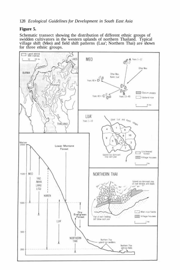
128 Ecological Guidelines for Development in South East Asia
Figure 5.Schematic transect showing the distribution of different ethnic groups ofswidden cultivators in the western uplands of northern Thailand. Typicalvillage shift (Meo) and field shift patterns (Lua'; Northern Thai) are shownfor three ethnic groups.
Session II: Paper 6: E. C. Chapman 129
TABLE 1 Estimates of upland rice yields in various swidden farming systems ofSouth East Asia.
EthnicGroup
YAO
KAREN
LAHU/LISU
LUA'
N. THAI
N. THAI
LAMET
DYAKS
IBAN
Location
Northern Thailand
Northern Thailand
Northern Thailand
Northern Thailand
Northern Thailand
Northern Thailand
Northern Laos
Kalimantan
Sarawak
Upland RiceYield (kg/ha)
1847
1464
1506
955
884
662
1150
1000
674-808
Research Worker(and reference)
Miles (Kunstadter andChapman 1970:155)
Hinton (1970:16)
Keen (1973:120)
Kunstadter (1970:115)
Chapman (1973:193)
Keen (1973:193)
Isikowitz (Kunstadterand Chapman 1970:155)
Seavoy (1973a:221)
Jackson (1968:80)
N.B. The mean lowland rice yield in northern Thailand, mainly from wet-ricefields, was 2320 kg/ha in the period 1966-68 (Statistical Yearbook,Thailand, 1967-69:169).
A notable feature of the data in Table 1 is the marked variation in swiddenyields, even within one region. The lowest yields were obtained by northernThai supplementary swiddeners and by Iban who are also now to a largeextent supplementary swiddeners, increasingly dependent upon plantings ofpepper and rubber. Why do these groups bother to cut, burn and cultivateswiddens for such low yields? In the case of the Iban, upland rice productionis traditional and they have only recently moved in large numbers into aneconomy partly dependent upon cash income. For the northern Thai, on theother hand, wet-rice farming is traditional and swidden farming provides auseful supplement. For both these groups, swidden production is a lessimportant activity than it is for the integral swiddeners (the other groupslisted) whose survival depends upon their rice yields.
So far this discussion of swidden productivity has focussed on upland rice.Are there better returns from other crops, so that as population pressurebuilds up there may be a change to other crops and rainfed farming systems ?Certainly in supplementary swidden areas there are many possibilities, result-ing in the main from a lowland situation, with access to market services. Thepossibilities centre upon tree, vine and fruit crops suitable to particularclimatic conditions; such as rubber, pepper, coconuts, pineapples and a widevariety of other fruits. Reafforestation with commercial species, such as teak,is generally not an attractive alternative to swidden cultivation from theviewpoint of the swidden farmer. All too commonly the taungya system makesinadequate provision for the wage-labour employment of swidden farmersafter the first few years of teak planting, and consequently it can have theeffect of dispossessing swidden landholders.At higher elevations in the tropical forests and in more remote locations thebarrier of distance eliminates most alternatives to subsistence production.One exception for many years in the high hills borderland of Burma-Thailand-

130 Ecological Guidelines for Development in South East Asia
Laos has been raw opium production. It is of course now subject to consider-able suppression, but also the lower prices being paid to village producersin the early 1970s (approximately US$40. 00 per kg) have reduced theattraction of poppy-growing, so that it is now only about 50 per cent morerewarding per worker than rice production. At the present time there is nowell-established alternative to opium, having the same characteristics of highvalue combined with low weight and low bulk which are prerequisites for asuccessful commercial crop in remote swidden areas.
THE FUTURE OF SHIFTING CULTIVATION IN SOUTH EAST ASIA
Landscapes such as that shown in Fig. 2 suggest that swidden farming has avery limited future in South East Asia. As population pressure increases, thechief alternatives for swidden cultivators are migration and the progressivetransformation of swiddens into terraced fields for rainfed or irrigatedagriculture. On the other hand, there are still extensive areas where primaryor secondary forests are thinly settled, such as central Borneo, much of therainforested uplands of West Malaysia and even parts of the Thailand-Laosborderland. Here well-managed swidden systems deserve to remain, and,as the demand for agricultural land increases, new areas of primary forestcan be brought out of vegetation storage for prudent swidden farming or treecrops.
The further reduction of primary and secondary forest is an inevitableconcomitant of agricultural development in the humid tropics, as it was overso many centuries in western Europe. On the other hand, there is immensescope for reafforestation on steep slopes (above about 35 degrees from thehorizontal), where intensification of land use by terracing or other means isnot easily achieved, and in many 'cogonales' (Imperata grasslands) wherethe physical effort or cash costs for reclamation are far beyond whatpeasant farmers can provide. In the Philippines alone, 'cogonales' occupymore than one-sixth of the land surface, amounting to approximately 5. 1million ha (Wernstedt and Spencer 1967:103).
The reclamation of Imperata grasslands in South East Asia is only one majorchallenge requiring the heavier involvement of government agencies, perhaps,with international support, in areas of swidden cultivation. On the other hand,many of the region's 30 million swidden cultivators will benefit more directlyif government help can be provided for intensification of farming in thoseareas where the transformation to permanent agriculture is needed, and ifgovernment assistance in other ways (for example, increased wage-labouropportunities) can be co-ordinated with agricultural development in regionalprogrammes for the upland areas.
Towards intensification of land-use: opportunities and constraintsAgricultural terracing, mainly for wet-rice fields, and the inclusion of highervalue cash crops such as rubber and pepper have become the established waysof intensifying land-use in swidden farming areas of South East Asia. Bothmeasures have the common advantage of dealing effectively with grass andweed regrowth, by drowning or shading out the herbaceous vegetation which soquickly invades cleared fields in the humid tropics.
The successful experience of Dutch colonial administrators in Indonesiademonstrated the relative ease with which the transition from integral tosupplementary swiddening could be achieved using rubber and pepper plantings.

Session II: Paper 6: E. C. Chapman 131
On the other hand, the further transition from supplementary swiddening tosmallholder production of commercial crops alone is considerably moredifficult, as illustrated by the limited success of several land developmentschemes undertaken in south-west Sarawak during the 1960s. Iban supple-mentary swiddeners whose traditional farming system is centred on uplandrice cultivation have not adapted easily to a smallholder commercial economywith each household tied to holdings of 4 ha, including 3. 2 ha of rubber, andwith neither land nor labour for the cultivation of upland rice in the old ways(Dixon 1973).
An alternative measure for agricultural intensification in the more accessibleswidden areas, and having greater flexibility than tree cropping when marketopportunities fluctuate, is the establishment of mixed-crop production onfarmers' cleared fields, using bulldozers to remove the roots and stumps offormer swiddens. Any effort of this kind involves establishing rainfedpermanent-field farming and facing the considerable hazards of soil erosion,nutrient depletion and vegetation regrowth... the reasons why shiftingcultivation is practised. On the other hand, if these risks can be kept incheck farmers stand to benefit in several ways: from the higher yields madepossible by more efficient cultivation, using ploughs instead of hoes; fromthe ability to use land which was formerly locked up in the regrowth phase ofthe swidden cycle; and from the use of fertilizers. In Nan Province ofnorthern Thailand the Thai-Australian Land Development Project is attempt-ing a venture of this kind, in an area of heavy population pressure on supple-mentary swidden cultivation. It concentrates on areas of gentle slope(mostly under 3 degrees) where the costs of construction erosion controlmeasures are relatively small. The long-term risks are that erosion controlmeasures will be neglected and that the less industrious farmers will revertto bush-fallow cultivation, when wage-labour jobs or other opportunities be-come available. Improved tools, the development of suitable animal-poweredequipment for ploughing and cultivating un-irrigated fields, and the introduc-tion of improved seed are all ways in which the productivity of farm labourcan be increased in this situation, to discourage reversion to swiddencultivation.
Thirdly, and spanning a much wider range in slopes and elevations, there isthe time-honoured practice of agricultural terracing. The advantages ofterrace construction as a means towards increased crop production areclearly visible, but the costs in heavy labour inputs are seldom so wellrecognized. The two outstanding constraints which deter farmers fromterracing more widely are steepness of slope, combined with the physicalefforts of terrace-building with only hand tools. If the constraints were notso severe we would no doubt find terracing more widespread, and swiddencultivation much less common in South East Asia. In Thailand, hill swiddencommunities have sometimes built terraces on slopes up to 10 degrees fromthe horizontal, but it has been estimated that a large part of the upland nowunder heavy population pressure from swiddening could be terracedefficiently using bulldozers, on slopes of up to 20 degrees (Keen 1973:82, 91).Even without elaborate improvements in the water supply for these terraces,rice yields can be 100 per cent higher than achieved by skilful swiddeners inthe same village (Hinton 1970:16).
All three measures towards agricultural intensification reviewed here can beemployed to good effect, but all are expensive in capital equipment or labour,or in the case of rubber smallholdings require financial support for farmhouseholds for six or seven years before the new farming systems becomes

132 Ecological Guidelines for Development in South East Asia
productive. Consequently, an increased measure of government involvementappears to be essential if the transition from swidden farming to moreproductive agricultural systems is to be accomplished speedily, in areas ofheavy population pressure. At the same time these development efforts needto be accompanied by clear legal arrangements regarding land tenure, tosafeguard the individual or community ownership of terraces or other assetswhich occupy former swidden land.
The need for regional planningThe possibilities for increasing productivity discussed here are linked to twocritical factors, steepness of slope and access to market services. The slopefactor assumes major importance in defining the areas suitable forpermanent-field plough agriculture (up to 8 degrees, with erosion controlmeasures), or for terraced farming, orcharding and rubber planting (up to30-35 degrees?), but whatever the specific limits may be in particular circum-stances there is a clear need for agricultural planning in all the areas ofswidden cultivation in South East Asia. Land capability classification, as afirst step in the process of planned development, should be based primarily onslope rather than soil type, in recognition of the greater importance of slopeas an indicator of agricultural potential in the humid tropics.
Agricultural planning by itself will be a worthless expenditure of effortunless it takes account of population growth, employment opportunities outsideagriculture and the transport system on which economic development depends.Already, for example, some men from remote swidden communities inMindanao or northern Thailand travel to lowland areas in their respectiveregions for seasonal jobs or longer-term employment. If these movementsare to be further developed, so that real incomes can be increased in uplandareas from both agricultural production and off-farm resources, effectiveregional planning is essential.
CONCLUSION
Earlier in this paper we noted that swidden agriculture was neglected formany centuries, while a long succession of technological developmentsincreased the productivity of lowland agriculture. Improvements which beganwith better control of water and the use of draft animals have been followed,most recently, by the 'green revolution' in the best irrigated areas of SouthEast Asia. Is there any prospect for a similar 'revolution' in un-irrigatedtropical agriculture, including swiddening? Current research aimed atproducing high-yielding varieties of upland rice, mungbeans Phaseolus spp.and other crops may help to increase the productivity of swidden farming,although the main benefits will be received in areas of rainfed permanent-field agriculture.
If this is the only radical improvement in the lot of shifting cultivators inSouth East Asia, over the next two or three decades, we shall have failed totake up the challenge presented by our greater understanding of swiddenfarming and its place in tropical forest ecosystems. We know the circum-stances under which swidden cultivation can be a productive and continuingmethod of forest use; equally, we know the circumstances which lead todestruction of the specialized swidden ecosystems and how these can beavoided. This knowledge should be the basis of comprehensive regionalprogrammes for the present and future economic development of agriculture

Session II: Paper 6: E. C. Chapman 133
in tropical forest areas. If no action is taken, at the least the past policiesof 'out of sight, out of mind' towards shifting cultivation will not be easilyfollowed in the future: smoke from swidden clearings and the increasing extentof Imperata grasslands will see to that.
ABSTRACT
The extent of shifting or swidden (= burned field) cultivation, has neverbeen accurately assessed in South East Asia. This method of convertingprimary and secondary forest to agricultural use is probably now practisedby at least 30 million people, or 15-20 per cent of the region's rural popula-tion. Over the past two centuries swidden cultivation has expanded andbecome greatly diversified. It is most widespread in Sumatra and the OuterIslands of Indonesia, and secondly in the upland areas of Burma, Thailand andLaos. In both areas and in the Philippines the traditional 'slash and burn'agriculture, carried out in remote forested areas, has been overshadowed bythe growth of supplementary swidden systems on the margins of permanentfarming areas. In Sumatra, for example, most ethnic groups combine per-manent-field farming with shifting agriculture; using swiddens for upland riceand cash crops, such as rubber and pepper, to supplement production from thepermanent farmland.
Population pressure has led to a drastic shortening of the bush-fallow orforest-fallow period in the swidden cycle. Yet farmers commonly regard acultivation/fallow ratio of 1:9 as minimal for the maintenance of yields; theyrecognize the importance of a quick succession from grass-shrub dominanceto the dominance of woody vegetation on the former swiddens to avoiddepletion of the swidden ecosystem and the establishment of Imperatagrasslands.
Swidden productivity depends upon careful management of forest regrowthby the entire swiddening community, since mismanagement readily leads tothe locking up of cultivable land in unproductive grasslands. As populationpressure builds up, swidden farming is capable of increased productivitythrough better management and greater labour inputs, but the traditionalmeasures for intensification of production are the construction of terracesand (over the past two centuries) the establishment of higher-yielding cashcrops such as rubber, pepper, opium poppies and fruit trees in differentecological zones. There is scope also for Government assistance in theestablishment of rainfed, permanent-field farming where population pressureis compelling the change to be made to more intensive agriculture, but onlywhere slopes are gentler (below 8 degrees) and the erosion risks are reduced.This highlights the need for effective regional planning of the rural economyin all areas where swidden agriculture is practised.
REFERENCES
ANDERSON, J. A. R. 1960. Research on the effects of shifting cultivation inSarawak. In Symposium on the impact of man on humid tropicsvegetation. Administration of the Territory of Papua and New Guinea,and UNESCO Science Co-operation Office for South East Asia. pp. 203-206.
BROOKFIELD, H. C. and BROWN, P. 1963. Struggle for land. Melbourne,Oxford University Press.

134 Ecological Guidelines for Development in South East Asia
CHAPMAN, E. C. 1970. Shifting cultivation and economic development in thelowlands of northern Thailand. In International seminar on shiftingcultivation and economic development in northern Thailand. Bangkok,Department of Land Development. pp. 226-250. 1973. Villagers as clients: a study of land development in northernThailand. In Studies of contemporary Thailand, R. Ho and E. C. Chapman,eds. Canberra, Research School of Pacific Studies, Department ofHuman Geography, Australian National University. pp. 187-212
CLARKE, W. C. 1966. From extensive to intensive shifting cultivation: asuccession from New Guinea. Ethnology 5 (4): 347-359
CONKLIN, H. C. 1957. Hanunoo Agriculture: a report on an integral systemof shifting cultivation in the Philippines. Rome, FAO.
DASMANN, R.F. , MILTON, J. P. and FREEMAN, P. H. 1973. Ecologicalprinciples for economic development. John Wiley, London & New York.
DIXON, G. 1973. Social problems in a planned village in Sarawak. Paperpresented at 45th ANZAAS Congress, Geographical Sciences Section,Perth, Western Australia.
FREEMAN, J. D. 1955. Iban agriculture: a report on the shifting cultivationof hill rice by the Iban of Sarawak. London, HMSO.
GEDDES, W. R. 1970. Opium and the Miao: a study in ecological adjustment.Oceania 41 (1): 1-11.
GEERTZ, C. 1963. Agricultural involution. University of California Press,Berkeley & Los Angeles.
GORMAN, C. 1971. The Hoabinhian and after: subsistence patterns in South-east Asia during the late Pleistocene and early Recent periods. WorldArchaeology 2:300-320
HINTON, P. 1970. Swidden cultivation among the Pwo Karen of northernThailand: present practices and future prospects. In International seminaron shifting cultivation and economic development in northern Thailand.Bankok, Department of Land Development. pp. 1-24.1973. Population dynamics and dispersal trends among the Karen of
northern Thailand. In Studies of contemporary Thailand, R. Ho and E. C.Chapman, eds. Canberra, Research School of Pacific Studies, Departmentof Human Geography, Australian National University. pp. 235-252
JACKSON, J. C. 1968. Sarawak. London, University of London Press.KEEN, F. G. B. 1973. Upland tenure and land use in north Thailand. SEATO,
Bangkok.KELLMAN, M. C. 1970. Secondary plant succession in tropical montane
Mindanao. Canberra, Research School of Pacific Studies, Department ofBiogeography and Geomorphology, Australian National University.
KOMKRIS, T. 1970. Forestry aspects of land use in areas of shiftingcultivation. In International seminar on shifting cultivation and economicdevelopment in northern Thailand. Bangkok, Department of LandDevelopment. pp. 179-214
KUNSTADTER, P. 1970. Subsistence agricultural economics of Lua' andKaren hill farmers of Mae Sariang district, Northwestern Thailand.In International seminar on shifting cultivation and economic developmentin northern Thailand. Bangkok, Department of Land Development. pp. 47-144.and CHAPMAN, E. C. 1970. Shifting cultivation and economic develop-
ment in northern Thailand. In International seminar of shifting cultiva-tion and economic development in northern Thailand. Bangkok, Depart-ment of Land Development. pp. 179-214.
LEBAR, F. M. (Ed.) 1972. Ethnic groups of insular Southeast Asia. NewHaven, Human Relations Area Files Press.

Session II: Paper 6: E. C. Chapman 135
NEWTON, K. 1960. Shifting cultivation and crop rotations in the tropics.Papua and New Guinea Agricultural J., 13: 81-118.
NYE, P. H. and GREENLAND, D. J. 1960. The soil under shifting cultivation.Farnham Royal, Commonwealth Agricultural Bureaux.
PELZER, K.J. 1948. Pioneer settlement in the Asiatic tropics. New York,American Geographical Society.1970. The swidden cultivator as producer of agricultural exports: an
Indonesian case study. In International seminar on shifting cultivationand economic development in northern Thailand, Bangkok, Department ofLand Development. pp. 383-405
RAPPAPORT, R. A. 1971. The flow of energy in an agricultural society.Scientific American 224 (3): 116-133.
SEAVOY, R. E. 1973a. The transition to continuous rice cultivation inKalimantan. Annals Assoc. Amer. Geogrs. 63 (2): 218-225.1973b. The shading cycle in shifting cultivation. Annals Assoc. Amer.
Geogrs. 63 (4): 522-525SPENCER, J. E. 1966. Shifting cultivation in southeastern Asia. University of
California Press, Berkeley and Los Angeles.STATISTICAL YEARBOOK, THAILAND, 28, 1967-69. Bangkok, National
Statistical Office.WERNSTEDT, F. L. and SPENCER, J. E. 1969. The Philippine Island World.
University of California Press, Berkeley and Los Angeles.ZINKE, P. J. SABHASRI, S. and KUNSTADTER, P. 1970. Soil fertility aspects of
the Lua' forest fallow system of shifting cultivation. In Internationalseminar on shifting cultivation and economic development in northernThailand. Bangkok, Department of Land Development. pp. 251-293.

136 Ecological Guidelines for Development in South East Asia
Session II: Summary of the Discussion
Short introductory statements having been made by the authors of BackgroundPapers Nos. 4 and 5 (th author of Paper 6 was unable to be present at theconference), Prof. Anwari Dilmy asked to present a statement on the future ofthe forests of south-east Kalimantan, of which the following is a summary:-
'The region contains 300, 000 ha of peatswamp forest; 900, 000 ha of lowland'food' or 'paddy'-belt, including 120, 000 of rice fields and 200, 000 ofcoconut, rubber and fruit; 600, 000 ha of lalang (Imperata) grassland, the so-called 'cattle'-belt; and 1, 200, 000 of Dipterocarp and other species formingthe 'forest'-belt. Under the regional plan, 25% of the land is to be underforest, so about a sixth of the lalang area, or everything above 600 m altitude,will be reforested.
For the last 3 years the conversion of lalang into more productive cattlegrassland has been under study and the preliminary report by Ir. Muhansjahof the College of Agriculture states that Brachiaria decumbens does well,being tolerant of low soil fertility and a 5-months dry season, if it is plantedafter Imperata has been ploughed up, since it grows faster than the Imperatacan recover and suppresses it: the same applies to Panicum maximum andPaspalum hexandrum which yield respectively 7-12 and 12-18 tons per ha/year,as does Paspalum plicatum, while the leguminous Centrosema pubescens andStylosanthes guianensis can also suppress lalang. On the other hand,Paspalum dilatatum and Setaria fasciculata have been unsuccessful. Usingthe better grasses about 1000 ha of good grazing have now been establishedand support 16 farmers with 100-300 cows each.
In 1974 the Provincial Government is importing 10, 000 Bali cattle, with theaim of allocating 10 per village per year and building up a meat exportbusiness. However, it is not the intention that the 500, 000 ha of lalang shouldbe entireley allocated to stock-raising, and if the soil becomes more fertileparts will be used for cultivation and production forest.
Our President has also asked us to study the conversion of part of the peat-swamp forest to rice-growing, which experience over the past 75 years hasshown to be possible if the peat layer is not thicker than 4 m. In the Second5-year Plan, there is a project for establishing 100, 000-150, 000 ha of newricefields between the Barito, Kapuas and Kahayan rivers. However, if theecological balance of the peatswamp forest is to be maintained, some of itmust be kept in reserve, so that its hydrological function, and value as asanctury for birds, crocodiles, monitors and other animals and, last but notleast value for tourism, can be fulfilled. In any case where the peat layer isthicker than 4 metres, and the cultivation potential becomes marginal,reservation is the best land use.
In southern Kalimantan there are still about 3000 families of shiftingcultivators, though a start has been made with settling them by mixing 10-20of these 'nomad' families with new settlers from Java:Madura or moredensely populated parts of south Kalimantan. We hope this will solve theshifting cultivation problem in about 10 years under the tutelage of volunteerlecturers, social workers and students who stay in the villages for six monthsat a time. ' (33)
The next matter to be considered was the format of the guidelines to beestablished on the basis of Dr. Poore's first draft and the discussions.

Session II: Summary of the Discussion 137
On the one hand, some feared that, as drafted, they were much too general,but N. C. Gare considered that they cannot be very specific if they are to bebroadly applicable. It was eventually agreed that they would have to beconsidered individually and widened or narrowed in scope as necessary toachieve a satisfactory balance.
A. Dilmy: for the guidelines to have maximum positive benefits, the plannersand decision-makers must be in close communication (as indeed were theirrepresentatives at this conference).
M.C.Downes: another aspect of communication is 'at the grass-roots' level,which implies that decision-makers take into consideration the traditionallocal practices and uses of resources, some of which are ecologically verysound.
M. E. D. Poore: there is a problem about what is the optimum size forreserves, since it could be argued that any size is too small: the sensibleanswer however is simply to make reserves as large as is politically andeconomically possible.
A. Kartahardja: a guideline is needed on the control of firewood cutters. (30)
A. I. Fraser: I would support fixing the amount of firewood on a per capita/annum basis, probably allowing about a cubic metre to be extracted per ha.The burning of cow dung and other organic matter for fuel as an alternative tofirewood is an unwise use of something which ought to be put back into thesoil. (30)
Kittinanda Sompherm: all such controls are really dependent on having acontinuing monitoring system at national and international levels. (12)(23)
Soegiarto Aprilani: the essential steps in decision-making are to-
a.
b.
c.
d.
e.
f.
g.
define the problem(s) and set the objectives;
gather all available basic and supporting data;
make a preliminary assessment of the situation and predictions;
formulate a 'final synthesis' in regard to management goals;
make the decision;
carry out field assessments to test predictions (monitoring); andcontinually re-evaluate decisions so as to improve the quality ofsuch decisions when first made in the future.
Turning to the topic of shifting cultivation—both Lee Peng Choong andPrijono Hardjosentono advocated resettlement efforts to get people awayfrom the practice, even of in the process the rights of those concerned shouldbe respected. J. W. Doyle, however, noted that for some types of land shiftingcultivation may be the best use and M. E. D. Poore considered that there wasno ecological reason why indigenous systems of shifting agriculture whichwere in reasonable balance should not be allowed to continue: however, whenstability is disturbed, ecological damage inevitably occurs. (32)(33)
J. D. Ovington: the land use of indigenous people should never be ignored:civilised people should always try to accommodate such traditional usage andthe people who practise it and to avoid sacrificing them. (34)
S. Tago: in Papua New Guinea the government is trying to integrate moderncrops and techniques with traditional habits. (33)

138 Ecological Guidelines for Development in South East Asia
B. C. Agaloos: settled shifting cultivators in the Philippines have causedproblems by drifting back to their original highland forest areas, accompaniedby lowlanders from the settlement areas. The government has now had toplace strict limits on areas of land which may be used for shifting cultivation.
K. J. White: guidelines are needed to cover the productivity and not just theprotection of tropical forest areas. (27)(28)(30)(31)
A. I. Fraser: it would be useful to supplement appropriate guidelines by achecklist of factors which need to be considered when trying to apply them.(15) (75)
H. A. Nix: Such a checklist could well show what are the absolutely minimumdata required for development planning at the local, national and regionallevels.
Didin S. Sastrapradra: returning to shifting cultivation and the suggestionimplied in the draft guideline that it can sometimes constitute a stable formof land use, I do not believe that this is ever the case in Indonesia.
Soekisno Hadikoemoro: in support of that last remark, an example can bequoted from West Irian, where despite the fact that the human population islow and, therefore, as Prof. Soemarwoto has suggested, there should be nopressures to prevent a stable system of shifting cultivation to be continuouslymaintained, there is a trend towards the shortening of the fallow periodwhich is definitely causing soil degradation.
M. E. D. Poore: the authors of background papers 5 and 6 both reached theconclusion that stable shifting cultivation can and does exist. Clearly, whenthe way in which it is practised is not in harmony with the environment, asin the example just quoted, in which the fallow period becomes too short forfertility to be restored, it needs to be discouraged and this can be brought outand the need for great care in avoiding evironmental degradation dulyemphasized, by splitting the draft guideline into two parts. (32)(33)

Session III 139
SESSION III
Transformation of Forests to ForestryPlantations and Agriculture
The Chair was taken by Dr. Jose I. Furtado and Prof. Dr. J. H. Koeman actedas rapporteur.
Professor Koeman also contributed a background paper for the Session,dealing with some of the problems involved in the use of agriculturalchemicals. The session was prefaced by his summary of the main points inthis paper and also by general introductory remarks by panel-membersDr. D. M. Ramsay and Mr. L. S. V. Murthy.

141
Session III: BACKGROUND PAPERS. No. 7
Problems Associated with the use ofAgricultural Chemicals
J. H. KOEMAN
Department of Toxicology, Agricultural University Wageningen, TheNetherlands
INTRODUCTION
It is to be expected that in many developing countries the use of agriculturalchemicals will increase markedly in the forthcoming years in order toimprove the productivity of the natural resources. According to Perfect(1972), who quotes calculations based on data from FAO production yearbooks,pesticide use would need to increase some 70-85 times for productivity torise fivefold. Likewise the use of fertilisers will also increase appreciably,one reason, for instance, being that many of the high-yielding varieties ofrice and wheat have a much higher fertiliser demand than the strains whichwere grown formerly. However, it has become well known about the last 20years that extensive applications of agricultural chemicals may also giverise to detrimental environmental effects, much as damage to other resourceslike fisheries and a general deterioration of natural ecosystems. It has beenstressed (Odum 1969) that man has generally been preoccupied with obtainingas much 'production' from the land as possible, thereby tending to neglect themany protective functions natural ecosystems have. In this way the lattervalues could become seriously endangered by further developments. It isthe aim of the present paper to provide some guidelines for the selection ofchemical methods which will minimize environmental damage. Attention willbe given especially to pesticides. Some remarks will also be made onfertiliser applications.
GENERAL CONSIDERATIONS
Particularly with respect to pest control in agriculture, it should be thepurpose of future studies to devise control methods which are injurious toso-called uneconomic species, the 'plague organisms', but relatively harmlessto economic species. Here 'economic species' not only include crops andother agricultural products, but also the many species of plants and animalswhich form part of the protective ecosystems referred to. Although it is to behoped that really selective, chemical or biological, methods will be developedin due course, it is most likely that, at least for some years to come, pesticideswill have to be used which are not perfectly selective in their mode of action.Therefore one should try to use these chemicals as selectively as possible.In this connection it is important to mention that the environmental hazard apesticide may represent is not only related to its toxicity with respect tovarious taxonomic groups of organisms, but also depends strongly on the like-lihood that non-target organisms will get exposed to a toxic dose. Animportant prerequisite in the selection of pesticides which are safe from anenvironmental point of view, therefore, is to be able to judge the probabilitythat other organisms than the species to be controlled will be in contact withthe compound concerned. One should know the possible interactions of

142 Ecological Guidelines for Development in South East Asia
pesticides with the environmental factors such as soil, water micro-organismsand higher organisms, and the way in which these interactions can be modifiedby technical means. The final aim could be to design computer models whichcan be used to predict the environmental fate of a pesticide under variousenvironmental conditions. However, at present the information available isgenerally too limited to draft appropriate models through which the computercan produce the adequate answers. Nevertheless the descriptive models,which are already useful today, will gradually develop into mathematicalmodels as more data on the varables involved become available.
The ability to predict hazards which may result from pesticide applicationsdepends on a proper judgement of a large number of parameters. These canbe grouped in three categories according to the successive phases whichcharacterize the fate of a chemical in the environment, viz. the exposurephase, the kinetic phase and the dynamic phase. The first one defines the wayin which the environment gets exposed to the chemical in first instance, thesecond phase describes the movement of the chemical through theenvironment, and the last one, the dynamic phase, is indicative for the finaltoxic reaction with certain organisms. Some of the most relevant parametersare listed in Table 1.
TABLE 1
Some of the major parameters to be judged for the prediction of theenvironmental safety or hazards of pesticide applications.
Phase
Exposure phase
Kinetic phase
Dynamic phase
Parameter
Formulation usedApplication procedureDose-rateFrequency of application.Area coveredTarget treated
Water solubilitySoil adsorptionPhysico-chemical conversionBiological conversionBiological turnover in organismsTrophic transport
Acute toxicityChronic toxicityEffect on reproductionMutagenicity
THE EXPOSURE PHASE
Pesticide applications generally aim at optimal transfer of the compound tothe object to be protected or controlled. For this purpose a wide range oftechnical procedures has been developed. Since the possible occurrence ofnegative side-effects not only depends on the type of pesticide used but also onthe methods of application, some remarks will be made on these procedures.

Session III: Paper 7: J. H. Koeman 143
Formulation and Application
In general, pesticides are never applied in their chemically or technicallypure form, but as mixtures in combination with various auxiliary ingredients.These formulations can be either solid or wet. To the former belong thegranular formulations and baits, while the latter make up the formulationsused for spraying.
Granular formulations are sometimes used for the application of pesticidesin the aquatic environment, for instance for the control of aquatic weeds.From an environmental point of view the advantages of granular formulationsover sprays are: a better localization, the reduction of drift to adjacent areas,and generally the avoidance of excessive concentrations at the time ofapplication and shortly afterwards. However, the prolonged presence of thecompound due to the gradual release from the granules may under certaincircumstances be disadvantageous. The application of pesticides in baits canbe particularly hazardous when these are not only taken up by the pestorganisms, e.g. snails, ants or rodents, but also by other species. Sometimesthis hazard can be reduced by a proper deposition of the baits, for instance byplacing them in the entrance of the burrows in the case of rodents. To someextent the dressing of seeds with pesticides should also be considered as abait formulation because generally it cannot be avoided that, after sowing, partof the seed will be consumed by granivorous birds and mammals. Thisaspect will be discussed more extensively under The Target Treated below.Sprays can be made up in various ways. The most common formulationsbeing solutions in oil or water and suspensions or emulsions of respectivelywettable powders and emulsifiable concentrates in water. The environmentalpersistence and mobility of a pesticide can be influenced markedly by thetype of formulation applied. Oily formulations, for instance, promote thepenetration of the pesticide through leaf surfaces and therefore diminish thechance that appreciable amounts run off.
In considering the possible side-effects of pesticide applications, attentionshould be given also to the equipment used. Factors such as droplet sizeand spraying volume significantly affect the radius of action of the sprayingactivities. Moreover it will make a big difference whether for instancehandspraying equipment, like knapsack sprayers, is used or aircraft.Generally with aerial spraying the application is far less selective than withgroundspraying. It could be recommended that aerial spraying should notbe allowed in areas close to places where pesticides could have undesirableenvironmental effects.
Dose-rate and Frequency of Application
The dose-rate applies to the amount of pesticide which is required to destroymost or all individuals of a pest species within a certain area. It need not bestressed that one should always select the minimum dose level which is justsufficient to get the desired effect. However, it still regularly happens inmany countries that serious environmental damage occurs as a consequenceof overdosing. In order to minimize the dose-rate, a proper use should bemade of the formulation and application techniques referred to above underFormulation and Application.
The persistence or residence time of a pesticide in the environment, e.g.the length of the period during which the compound is present in a significantconcentration, strongly depends on both the dose-rate and the frequency ofapplication. There is a general tendency to relate the possible environmental

144 Ecological Guidelines for Development in South East Asia
persistence of a pesticide mainly to its molecular stability. In this connectionthe organochlorine pesticides are for instance generally labelled as persistent,and other pesticides, like the organophosphorous compounds, as being non-persistent. However, there are agricultural areas in the world, for instancein the Netherlands, where the latter compounds are present in measurableconcentrations at any time of the year. It should be realized that the persis-tence of a chemical in the environment reflects a steady state condition whichis not only related to the degradability of the compound but also to its rate ofentry.
The Area CoveredIn most cases the pest species to be affected are not randomly distributed,but are confined to certain localities like the soil, a special plant or apeculiar habitat. Pest control will be most selective when only theselocalities are submitted to pesticide applications. However, for economicreasons the so-called coverage sometimes markedly exceeds the distributionlimits of the pest species. For instance, in tsetse control operations inAfrica, optimal advantage can be taken of the extensive ecological knowledgeabout the tsetse fly. It was found that the flies can be eradicated by applyingpesticides in a very discriminatory way. Using knapsack-sprayers pesticidesare applied to part of the potential resting-sites of the flies, namely treetrunks, branches, creeper tangles and aerial root systems to a height of aboutthree feet. It will be obvious that a switch over to aircraft for tsetse controlgives rise to a much higher coverage and therefore increases the chance thatundesirable side-effects will occur.
Apart from the relative coverage, viz. the proportion of an area which isactually treated with a pesticide, it is also important to consider the totalcoverage, namely the total surface treated within one pest control operation.Particularly in large scale operations, like for instance the extensive sprayingoperations which took place in Indonesia in connection with the so-calledBIMAS project (e.g. Beers 1970; Gorbach et al. 1971), there is some likelihoodthat the application will cover the whole or almost the whole geographical rangeof various species of organisms one wants to preserve. In connection withtsetse eradication programs in Africa it was recommended that the size ofareas treated with insecticides during one season should be kept within thelimits of the ecosystem concerned in order (a) to prevent the extermination oflocal species or races, and (b) to allow the reoccupation from adjacent stilluntreated areas (Koeman et al. 1971). This principle is also applicable toother types of pest control operations.
The Target TreatedPesticides can be applied to the soil (e.g. nematicides), water (e.g. molluscir-cides, larvicides) or plants (e.g. herbicides, insecticides, fungicides) dependingon the plague one intends to control. The range of dispersion of a pesticideand the number of species which will be exposed also depends on the type oftarget treated. Generally the environmental distribution of the pesticide andthe numbers of organisms exposed will be relatively small in the case of soilapplications and relatively large when aquatic ecosystems are treated directly.An application of special concern is the fungicidal or insecticidal treatmentof seed for sowing. In many countries of the world wild animal populationshave suffered severely from seed-dressing applications. The pesticidesmostly concerned are the organochlorine insecticides aldrin and dieldrin,the organophosphorous insecticide parathion and the alkylmercury fungicides.
Session III: Paper 7: J. H. Koeman 145
These applications may give rise to primary intoxications in many species ofgranivorous animals and secondary poisoning of scavengers and other predators.For the treatment of seeds of rice, wheat and other crops pesticides shouldpreferably be selected which have a relatively low acute toxicity for birds,mammals and other vertebrates. This will at the same time diminish thelikelihood of mass mortalities in man due to the abusive use of dressed seedfor making bread. Many incidents of this kind have been reported in recentyears, e.g. alkylmercury poisoning in Ghana and Iraq in 1967 and 1972,respectively (Bakir et al. 1973; Derban 1974).
THE KINETIC PHASE
The kinetic phase refers to the pathways along which pesticides and theirderivatives (e.g. metabolites and photoconversion products) move throughthe environment. Again a number of key-parameters can be distinguished.
Water Solubility and Soil AdsorptionA good water solubility generally implies that a pesticide will be very mobilein places where transport in the water phase is possible. The advantage canbe that the pesticide is diluted quickly to a non-toxic level. On the other handa disadvantage could be the relative large soil mobility some of thesecompounds have, which may give rise to leaching of the pesticide into thedrainage water and the subsequent contamination of streams and canals. Soiladsorption also markedly affects mobility in the soil as well as transport inthe environment in general. A strong binding of a pesticide to the clay andorganic matter components of the soil immobilizes the compound and in mostcases virtually eliminates its biological activity.
Physicochemical and Biological ConversionMost pesticides are transformed under the influence of a large number ofabiotic and biotic environmental factors such as water, oxygen, ultravioletlight, temperature, inorganic catalysts and the enzymes of many species ofliving organisms.
Fortunately the transformation of pesticides mostly results in the completeinactivation of the compound. However, occasionally activation may occur inthe first instance at a certain conversion step such as the oxidation ofparathion to paraoxon. Another example is the modern fungicide benomylwhich is activated by hydrolysis to BCM (methyl 2-benzimidazole carbamate).The biochemical breakdown of pesticides is particularly dependent on thecomposition of the microflora and fauna and various environmental conditionssuch as pH, temperature, humidity and oxygen tension. For instance thepesticide lindane is broken down more readily under anaerobic than aerobicconditions (Hill and McCarty 1967). It is therefore necessary to considerthe local conditions before predictions can be made about the metabolic fateof pesticides in a certain part of the environment. There are indicationsthat many pesticides may be broken down quite readily in the anaerobicmudlayer in the ricefields which form such an important agro-ecosystem inSouth East Asia. Moreover it is very likely that the high ambient temperaturesin the humid tropics as compared to the temperate regions will generallyincrease the rate of biochemical degradation.

146 Ecological Guidelines for Development in South East Asia
Biological Turnover in OrganismsThe Biological turnover in organisms here refers to the processes of absorp-tion, distribution and elimination. Elimination not only includes the excretionof a chemical compound, but also its possible metabolic inactivation. Of toxi-cological importance is the ultimate internal load which will be brought aboutwhen organisms are exposed to pesticides. The final tissue concentrationsreflect the balance between the rate of uptake, the degree of tissue bindingand the rate of elimination. As a rule of thumb lipophilic pesticides, e.g.pesticides with a relatively high oil/water partition coefficient, are moreeasily taken up by living organisms than hydrophilic water-soluble pesticides.The former type is able to penetrate directly through membranes like theskin, the gills and the intestinal wall. The final tissue level markedly dependson the ability of the organism to metabolize and excrete the compound. Themetabolic capacity can differ appreciably from one species to another.Experimental studies have shown that cold-blooded animals are on the wholeless capable in this respect than warm-blooded animals (Dewaide 1971).However, it cannot be excluded that at the high ambient temperatures in thetropical environment the microsomal enzyme systems may be more active.At present no detailed information is available about the metabolic capacityof various animal groups in the tropical environment.
Trophic TransportParticularly in connection with the organochlorine pesticides much attentionhas been paid in recent years to the process of trophic accumulation ofpesticides in so-called food chains. Food chain accumulation mainly dependson two factors: (a) the biological turnover in the successive species in the foodchain (see Biological Turnover in Organisms), and (b) the ecological relation-ships between the species. Accumulation is likely to occur mainly withpesticides which are easily taken up by organisms, but not readily eliminatedand in trophic systems which are characterized by specialized predator-preyrelationships.
THE DYNAMIC PHASE
The dynamic phase reflects the final toxic reaction of pesticides with livingorganisms. The sensitivity for pesticides can differ markedly amongdifferent species or different taxonomic groups. Some examples of acutetoxicity data (median lethal concentrations and doses) for a number ofpesticides with respect to crustaceans, fish and warm-blooded animals, aresummarized in Table 2 (data from Jung 1973). The peculiar susceptibility ofcertain species or groups should be taken into consideration in connectionwith the selection of pesticides for pest-control programs. With reference tofish and invertebrates, information has so far been collected mainly on theacute toxicity of pesticides and other chemicals (e.g. Muirhead Thomson 1971).Particularly in cases where long term exposure of for instance fish and fishfood organisms is likely to occur, chronic toxicity data will also be required.This should include information on possible effects on reproduction, onmutagenicity and teratogenicity and other special effects. As far as warm-blooded animals are concerned, one can rely in the first instance upon thealready existing toxicity data, which chemical companies must submit togovernmental authorities in various countries before applications can beapproved officially. This information generally includes acute and chronictoxicity data for species like rats, mice, dogs and sometimes birds, while

Session III: Paper 7: J. H. Koeman 147
acute toxicity data are provided for fish. Moreover valuable information iscontained in the monographs which are regularly published by the jointFAO/WHO expert groups on pesticides.
TABLE 2.
Acute toxicity data (median lethal concentrations and doses) for pesticideswith respect to crustaceans, fish and warm-blooded animals.
Pesticide
Organochl. pest.
LindaneDDT
Dieldrin
Endrin
Thiodan
Organoph. pest.
Parathion
Diazinon
DDVPMalathion
Carbamates
Carbaryl
Barbane
Herbicides
2, 4, 5-T
Diuron
ParaquatTrifluralin
Toxic concentration µg/L
Crustaceans
48-0.36-
10-1-
5-
0.4-
0.9-
0.07-1-
0.8-
3,000
730
160-
3, 700-240-
400100
1, 400
20240
12
80018
100
40
40, 000
100, 0008,800
Fish
18-2.1-
3.4-
0.2-
0.1-
10-
30-700-
2.3-
1, 000-
530-
590-
100-
1, 000-10-
10, 00010, 000
125
1,000
30
10, 000
5,300
10, 00029, 400
13, 000
1,300
60, 000
350, 000135, 000
13, 200
Toxic dosemg/kg b. wt
Warmbl. animals
40- 50010- 500
5- 500
1- 50
24- 500
0. 17- 32
32- 1,1505- 500
50- 500
2.8- 700
240- 5, 000
100- 5, 000
500- 5, 000
5- 5002,000-10,000
THE OVERALL JUDGMENT OF PESTICIDE HAZARDS
By a proper judgment of the different phases and parameters discussed, andsupposing that adequate information is available on the biological and otherenvironmental conditions in and around areas to be sprayed, one generally willbe able to predict the major hazards which could arise from pesticide applica-tions. This will at the same time provide an opportunity to select those

148 Ecological Guidelines for Development in South East Asia
pesticides and application methods which are least likely to cause undesirableside-effects. It must be mentioned that many environmental casualties withpesticides which have occurred in the past, like large scale mortalities offish, birds and other animals, could easily have been predicted if the para-meters outlined in the present paper had been taken into account beforehand.However, for a full assessment of the environmental hazards, additional toxi-cological studies may be required, for instance to measure the rate of bio-degradation of pesticides under certain special environmental conditions asmentioned under the heading Physicochemical and Biological Conversion. Ageneral recommendation could be in this connection that every large scalepest control operation will be guided by retrospective epidemiologicalstudies by means of chemical and biological monitoring techniques. In thisway unexpected effects can be discovered at the earliest possible moment. Itneed not to be stressed perhaps that scientists involved in studies of this kindshould be skilled biologists, able to detect subtle changes in the ecosystemsconcerned.
SPECIAL HAZARDS IN THE HUMID TROPICS
The different structure of tropical ecosystems as compared to those intemperate regions implies that the toxicological data obtained in the lattercannot generally be used without qualification to assess the risks of pesticideuse in the tropical environment. In comparison with temperate ecosystemsthe following generalizations can be made for the humid tropics:
(a) at about equal levels of ecosystem maturity, species diversity, speciesequitability (evenness in the apportionment of individuals among thespecies) and food-web complexity are higher in tropical ecosystems (Paine1966; Pianka 1966; MacArthur 1969);
(b) seasonal cycles are generally less important; and
(c) the rate of degradation or disappearance of pesticides will be higher asa consequence of various factors such as those mentioned under Physico-chemical and Biological Conversion.
Some of these conditions will diminish the risks involved in the use of certainpesticides as compared with in temperate regions, e.g. (c) above, whileconversely others could be worse, e.g. specialized trophic relationships.
As mentioned under the heading The Area Covered, when large areas aretreated, for instance by aerial spraying, irreversible damage may occurbecause certain species are affected over their whole range of distribution.On these grounds a number of tropical ecosystems can be distinguished whichcould be damaged seriously by large-scale pesticide applications, for example:-(a) mangrove swamps, (b) highland streams, (c) localized lake systems,(d) mountain forests, (e) islands and (f) specially protected areas like nationalparks and game reserves.
A special remark should be made on the wet rice agro-ecosystem. In manyparts of South East Asia rice is cultivated in areas where fisheries interestsare also important. In former times the use of certain pesticides which arehighly toxic for fish such as thiodan and endrin has regularly caused seriousfish mortality in various countries (see Kok 1972). If it is decided that fishshould be preserved in these areas pesticides should be selected orapplication techniques be designed which will prevent this effect. Furthermorethere are documented cases of intentional misuse of certain pesticides in

Session III: Paper 7: J. H. Koeman 149
tropical rivers and lakes to catch fish. Such an incident took place in the Alasriver in North Sumatra in August 1973, where endrin levels of about 1 mg/kgfresh weight were recorded in the tissues of the fish. It will be obvious thatwhole fish populations may be threatened seriously in this way.A major hazard for the future could be the ever-increasing use of herbicidesin agricultural practice (see Kasasian 1971). Although most of these compoundsare generally not very toxic for animals, their destructive effects on thevegetation could very well result in undesirable secondary effects on otherorganisms. For instance, various fish species are dependent on certainsubmerged weeds for the deposition of their eggs. Many beneficial insectswill not be able to complete their lifecycle when certain plants fail to bepresent.
This type of secondary effect may also occur when large amounts of fertiliserare introduced in certain areas. Particularly when it is likely that theirapplication will give rise to eutrophication of adjacent waters, the speciescomposition in these places may alter drastically.
REFERENCES
BAKIR, F. et al. 1973. Methylmercury poisoning in Iraq. Science 181: 230-241.BEERS, H. E. (ed.) 1970. Indonesia. Resources and their technological
development. The University Press of Kentucky, Lexington, U.S.DERBAN, L. K. A. 1974. Outbreaks of food poisoning due to alkylmercury
fungicide. Arch. Eviron. Health 28: 49-52.DEWAIDE, J. H. 1971. Metabolism of xenobiotics. Thesis. Nijmegen.GORBACH, S., HAARRING, R. KNAUF W. and WERNER, H. J. 1971. Residue
analyses in the water system of East Java after continued large-scaleapplication of Thiodan in rice. Bull. Environ. Contamination Toxicol. 6(1): 40-47
HILL, D. W. and McCARTY, P. L. 1967. Anaerobic degradation of selectedchlorinated hydrocarbon pesticides. J. Water Poll. Contr. Fed. 39 (8):1259-1277.
JUNG, K. D. 1973. Extrem fisch toxische Substanzen und ihre Bedeutung fürein Fischtest-Warnsystem. G. W. F. 114 (5): 232-234, and special tablesdistributed by the Hygiene-Institut des Ruhrgebiets, Gelsenkirchen,Germany.
KASASIAN, L. 1971. Weed control in the tropics. Leonard Hill, London.KOEMAN, J. H., RIJKSEN, H. D., SURIES, M., NA'ISA, B. K. and MACLENNAN,
K. J. A. 1971. Faunal changes in a swamp habitat in Nigeria sprayed withinsecticide to exterminate Glossina. Neth. J. Zool. 21 (4): 443-463.
MACARTHUR, R. H. 1969. Patterns of communities in the tropics. Biol. J.Linn. Soc. 1: 19-30.
MUIRHEAD THOMSON, R.C. 1971. Pesticides and freshwater fauna.Academic Press, London, New York.
ODUM, E. P. 1969. The strategy of ecosystem development. Science 164:262-270.
PAINE, R. T. 1966. Food web complexity and species diversity. Am.Naturalist 100: 65-67
PERFECT, J. 1972. Insecticide use in the tropics. Biologist 19 (3): 149-151.PIANKA, E. 1966. Latitudinal gradients in species diversity: a review of
concepts. Am. Naturalist 100: 33-46.
150
Session III: Summary of the Discussion
The discussion began with general recognition that in South East Asia, aselsewhere, much transformation of forest land is inevitable. The responsibilityof ecologists is to try to ensure that proper controls are applied to the process,so that it results in the least possible degradation of the human environment.
Mrs. Sri Soewasti Soesanto: it is equally important that ecologists shouldendeavour to secure the retention of adequate samples of all types of habitatin their original state. This involves the problem of preventing settlement intoo close proximity to critically important areas. For example, if people areallowed to settle near marshland, there is bound to be a health hazard unlesspesticides are used to control mosquitoes, and this will adversely affect thebiological productivity and other values of the marsh. (14)(18)(55)(77)
Achmad S. Sarnita: such considerations raise all the issues mentioned inPaper 7 about the use of persistent chemicals, the disposal of residues, thedanger of over-application of pesticides and the difficulty of ensuring thatthey are used at an optimum level. It seems to imply that it may sometimesbe necessary to restrict agricultural production and hence the run off oftoxic chemical residues from the land, so as to prevent contamination of awatershed and damage to fish stocks. (58)(68)
J. H. Koeman: the most acute problem is to find ways to lessen a delayedreaction to a gradual accumulation of pesticide residues. Hence the constantneed to find formulations that are not hazardous to non-target fauna or flora,or, alternatively, to devise some method of capsulating or 'time-release' ofpesticides, to reduce the possibility of a build up to toxic levels which couldaffect a wide spectrum of living things. (61)
Lee Peng Choong & H. A. Nix: the question of the input of fertilizer and energyalso needs to be carefully examined and we should avoid suggesting in theguidelines that high productivity can only be achieved by confining agricultureto areas of very high natural fertility, which tend to be limited in number andextent. We must recognize the needs of those who are trying to make a livingand raise the level of productivity in places where this can only be done byhigh energy and fertiliser input. (15)
R. G. Downes: the guidelines should be considered as pointing the way to theobjectives that are ecologically desirable. This does not mean that they are,in any sense, 'rules' or 'laws' intended to prevent the use of pesticides,fertilisers or energy, but rather that they indicate that it is good ecologicalsense to prefer an agricultural system which relies on low inputs of thesethings. (39)
Kittinanda Sompherm: one of the dangers in the transformation of forestlandis that extensive clearing, frequently followed by a strong trend towardsmonoculture, can easily lead to an upsurge of insect damage, as seen in manyteak and rice-growing areas of Thailand.
In answer to a question by Lee Peng Choong, about the possible loss offertility and hence productivity brought about by soil disturbance in the processof terracing, the consensus was that, although initially there was somedeterioration (since most nutrients would have been concentrated in top soillayer), this could be temporarily compensated by fertiliser application and,in the long-term, the prevention of erosion and stabilizing the soil throughterracing was quite certainly advantageous. (37)

Session III: Summary of the Discussion 151
H. Haeruman: we need guidelines to cover the critical need for rapidlyexpanding production to meet world food shortages. In Indonesia this need hasalready led to governmental support for the conversion of tidal mangroveforest into agricultural land, a process that is very expensive in terms offertiliser and energy input. (47) (50)
Glenn H.Robinson: it is imperative that the process referred to, which alsoextends to peatswamp forest, should be combined with proper control of waterlevels and of burning, to prevent excessive shrinking and loss of soil. It is alsonecessary that the chemical composition of the soils involved should bedetermined in advance, so that management practices can be adjusted accord-ingly. (47)(75)
N. P. Knott: turning again to a topic which perhaps is more relevant to thatof the previous Session, the 'Forest as a Resource', although it may also some-times involve a more or less significant degree of 'Transformation', I feelthere should be a guideline on the subject of wildlife production. There areseveral examples of this in South East Asia and also many furtherpossibilities for wildlife management on a basis of semi-domestication,whether by way of captive-breeding or of a 'Lapp/Reindeer' type of activity,using such species as bateng. (45)
M. C. Downes: in Papua New Guinea wildlife management seeks a balancebetween production and conservation, the raising of domestic or domesticatedlivestock in the villages and the exploitation of the wild animals of the foreston a sustained yield basis. Species which have been handled in this way haveincluded wallabies, cassowaries and crocodiles. (42)(45)
M. E. D. Poore: any guidelines on this topic will have to be allocated to twodifferent sections—sustained yield cropping to 'Forest resources' anddomestication of wild animals to 'Forest transformation'. (27)(29)
L. S. V. Murthy: I think it will have to be recognized, however, that humidtropical forest is not of very great value from the point of view of wildlifeproduction.
Anwari Dilmy: that would certainly not apply to Kalimantan where, with alow human population, we have a very good stock of wild pig, deer and buffalo,the first-named being a pest species since in this predominantly Muslim areait is not used as food. The only species, however, which is exploited andexported on a fairly large scale is a domesticated goose. (29)
A. I. Fraser et al.: waterflow is affected by logging activities, and it isimportant to remember that in Asia water is just as much a resource astimber. This needs to be reflected in guidelines, which should also draw aclear distinction between running water and the static water supplies of lake,reservoir and swampland. The common practice of converting marshlandinto cultivated land, already referred to by Mrs. Sri Soewasti Soesanto, shouldalso be considered and covered. (47)
Mrs. Sri Soewasti Soesanto: the point I particularly wanted to make is that,wherever water is scarce, human needs and uses of it should always havepriority, which would not be the case if drainage and transformation toagriculture is allowed. (48) (50)
N. P. Knott: many streams and small rivers in Asia are naturally infertilebecause of the impoverished soils through which they flow, but silt fromerosion and organic detritus may still make them, locally, of a high potentialfor fish production, provided they are reasonably unpolluted. Management of

152 Ecological Guidelines for Development in South East Asia
this resource, therefore, needs to be keyed in with cultural practices andpollution control. (52) (55)
L. S. V. Murthy: this also raises the question of the proper control of herbi-cides and pesticide seed-dressings, both in relation to methods of applicationand the assessment of direct and indirect toxicity. (60) (63) (68) (70)
Cheah Leong Chiew: some progress is being made in Peninsular Malaysia indeveloping better and less objectionable (because more specific) arboricidesand methods of application. (60)
A. Hekstra: it is worth pointing out that the use of herbicides and arboricidesis often dictated by a hope of reducing labour costs, and in populated areaswith high unemployment this trend should if possible be resisted.

Session IV 153
SESSION IV
Infrastructure, Engineering Works,Land Industry
The Chair was taken by Mr. Kittinanda Sompherm and Dr. M. Makagiansaracted as Rapporteur.
In the absence of a background paper, Dr. Makagiansar gave a stimulatingintroduction to the Session, of which the following is a summary.
It was fundamental to the application of ecological principles to economicdevelopment that goals should first be defined and this required the considera-tion of alternative life styles. A development model was needed and themissing link in the process of providing one was the contribution of the socialsciences. Any realistic model should show the interdependence of the socialsciences with the physical and biological sciences. Hitherto there has beentoo little communication between them.
Dr. Makagiansar compared the characteristics of the old and new models ofdevelopment. The old, with its emphasis on growth of GNP, the flow oftechnology and capital intensive development with industrialization as aprerequisite, had often led to increased disparity between the rich and thepoor. The dangers of this were now apparent as the limits of the resilienceof ecosystems were being reached. The social sciences therefore had acrucial part to play in the development of tropical forest regions.
In contrast, the new development (the 'ecodevelopment' advocated by MauriceStrong of the U.N, Environment Programme) must depend upon a sensitiveperception of goals and methods, and utilization of resources carefullyrelated to the resiliency of the ecosystem.
It followed that any guidelines must at this stage be tentative ('guidelines forguidelines') and adapted to local circumstances. This new approach—
1. required redefinition of life styles;
2. presumed an interdisciplinary approach centred on man;
3. should not only be oriented to basic needs; but
4. should also involve a continuing attempt to establish relationsbetween growth patterns and social and cultural institutions;
5. should incorporate environmental quality in every stage of thedevelopment process (necessitating a link between education and theenvironmental conditions of those being educated); and
6. required a futurological outlook but one that recognizes the presenceof ultimate limits.

155
Session IV: Summary of Discussion
A. Karahardja: in this Session we turn from shifting cultivation to the problemof shifting civilisation, or what to do now and in the future with human settle-ment. The question is whether something of the simplicity and freshness ofthe rural scene can be brought into urban areas or whether the pollutedatmosphere and noise of the cities will be allowed, with the industrialisation ofagriculture, to invade the countryside. Nothing can now stop the flow ofvillagers to the towns and the flow of industry to the country unless a balancecan be achieved by good planning. In this connection it is worth recalling theprinciples laid down by Sir George Stapledon in his book on 'Human Ecology'(see the second edition edited by Robert Walker, and published by CharlesKnight & Co., London, 1971), which can be summarised as follows:
1. industrial production should be based as far as possible on renewableresources;
2. productive industries must be designed on a biological model so thatresidues and wastes are recycled;
3. the soil must be treated as a living material;
4. a high proportion of mixed farming must be legally enforced;
5. nutrition should be treated as the foundation of health;
6. a proper balance between urban and rural must be established; and
7. economic arguments must never have priority over ecologicalarguments.
I hope that attention to these principals will help us in developingguidelines from this Session.
Soemirat Slamet: I am rather disturbed by the assignment of 'Priorities' asbetween economics and ecology in the last of the principles just quoted. Thetwo should be integrated and not treated as separate sciences. (70)
M. Makagiansar: it has to be realised that in so-called developing countries,the momentum comes from the process itself but also from the urge to escapefrom poverty.
R. G. Downes: we do not want to get into the position of having superficialstudies of many supposed environmental effects of every development project.What is really wanted is an institution with environmental perceptiveness,skill and integrity, in which people have faith and which not only decides onwhich projects should be subject to close scrutiny but also the particularkinds of studies to be made, if necessary in considerable depth, so that theenvironmental effects can be properly assessed for the decision-makers.
A. I. Fraser: of all the aspects of 'Infrastructure' perhaps road building hasthe greatest ecological impact (bringing about such things as settlement,indiscriminate clearing, hunting, recreational uses and fire hazards) and needsspecial attention.
R. G. Downes: the important principle is that roads by themselves should notbe allowed to determine the land use of the areas through which they pass.
A. Dilmy: but this is almost inevitable in the case of forest land unless theroad is built round its border and not through the forest. (73)

156 Ecological Guidelines for Development in South East Asia
M. E. D. Poore: perhaps the answer which should be incorporated in guidelinesis that road-siting must be part of a regional development plan, constructionup to best engineering standards, and continual monitoring maintained of theeffects, in both the short and long-term, with such remedial measures as maybe necessary. (72)
R. G. Downes: the trouble is that some mistakes are inevitable and, althoughthe damage can sometimes be repaired, it is more usual that we have to livewith them. Guidelines can do little remedy the ills produced by pastdevelopment, since they are essentially concerned with the planning andexecution of new development.
H. A. Nix: the important principle is that the cost of monitoring itsenvironmental effects should be included in the basic cost of every project.(76)(77)
The ensuing discussion, in which many participated, tended to concentrateon water development schemes and the need to assess, monitor and plan thenecessary measures to meet such effects as the overall impact of an impound-ment on a river system, including sedimentation, management of the surround-ing vegetation, treatment of decomposing vegetation submerged by an impound-ment, eutrophication, fish introduction, and the development and utilisation ofrecreational, touristic and wildlife values. It was emphasized that thesematters should receive attention throughout the affected watershed or riversystem and not just in and around the reservoir or other major waterworkconstructed. (74) (75) (79) (80)
The other main topic discussed was the resettlement of human populationsdisplaced from areas inundated in these projects. This was recognized aspresenting formidable social and environmental problems and illustratedmainly by experience in Indonesia. Some speakers regarded the resultingtransplantation of populations as presenting great social dangers, others assomething quite inescapable which in fact offered great opportunities, ofwhich the benefits far outweighed the disadvantages.
A. Dilmy quoted his personal experience of the resettlement of some 10, 000people in Kalimantan among a population of quite different linguistic andsocial background, which was so successful that now, 30 years later, it isimpossible to distinguish the migrants from the former residents. Peopleare very flexible and can quickly adapt to new social and physical conditions.Nevertheless, as others argued, resettlement should be undertaken with greatcaution and only after careful study of the social, economic and public healthproblems involved and physical and biological conditions of the land to beoccupied. (76) (77)

157
A Summary of the Conclusions of theConference
DUNCAN POORE
Senior Ecologist, IUCN Morges, Switzerland
PREFACE
I prepared a paper entitled 'An approach to ecological guidelines for tropicalforest areas of South East Asia' as a basic document to be discussed by theConference. This drew on a number of sources: the background paperssubmitted by other participants; material derived from the conference on thesame subject in Latin America held at Caracas from 20-22 February 1974;and from my own experience. It also owed much to discussion with manycolleagues.The course of the proceedings during the Conference followed the sequenceof arguments and guidelines in this paper; and the Summary of Conclusionspresented here therefore corresponds fairly closely to this earlier paper instructure and content, but has been altered and added to in order to reflectthe important issues raised during the Conference and to provide a suitableintroduction to the GUIDELINES approved by the Conference which followthis Summary.
IntroductionThe pressing need of the countries of South East Asia is to develop theirresources to improve the quality of life of an increasing population and, at thesame time, to provide the base for a stable and continuing prosperity. Thespeed with which this development is taking place presents governments withproblems of unusual complexity in planning the best allocation and managementof land; and these problems are further complicated by growing shortages ofraw materials and rising costs of production throughout the world.
The main purpose of the meeting was to explore ways in which the experienceof the ecologist may best help in reaching wise decisions about development.His claim that he can help is based on his knowledge of the interrelationshipsbetween organisms and their environment and because of the long time scalewithin which he works. Many of the successful developments in the past, suchas the introduction and expansion of the cultivation of rubber and oil palm,have been based on the intelligent application of ecological knowledge.
In very general terms the ecologist may help in two ways: by indentifyingopportunities for making the best long-term use of the land; and by drawingattention to the situations where care must be taken if deterioration or otherundesirable side effects are to be avoided. He can therefore help to providethe decision maker with a framework in which the long-term costs and benefitsof any policy or action can more accurately be estimated.
Where rapid development is needed there are temptations to make rapidcapital out of resources that are readily available or to adopt forms ofexploitation or use which have been successful elsewhere but which have notbeen sufficiently tested under local conditions.
Ecology gives the capacity to predict—if sufficient facts are available. The

158 Ecological Guidelines for Development in South East Asia
earlier, therefore, that ecological knowledge is taken into account, the betterthe use that will be made of local resources in the process of development andthe less the danger of costly mistakes or long delays while projects are asses-sed and reformulated. Perhaps most important, the ecologist can drawattention in advance to courses of action that are likely to lead to any long-termor irreversible deterioration of the resource.
There should, therefore, be a significant input of ecological knowledge whenpolicies are being formulated and alternative programmes being considered.This input should not be delayed until projects or other kinds of specific actionfor development are actually being planned.
Ideally this input should be positive and ecologists should be intimatelyassociated with the formulation of national objectives and the policiesderiving from them, as well as during the more detailed and technical stagessuch as drafting legislation, planning the allocation of land to various uses,or designing development projects. If the ecological contribution is made atthese early and formative stages, its positive and constructive nature will bemost evident.
When ecological advice cannot be provided or has not been requested suffici-ently early, it is very likely to contain elements of caution and constraint. Insuch circumstances it is useful to make it obligatory that any proposal fordevelopment activity (whether for new laws or regulations or for a particulardevelopment project) should be accompanied by an assessment of its'environmental impact' so that unforeseen and damaging consequences maybe avoided. The environmental impact assessment is a useful means ofensuring that ecological experience is taken into account in the process ofdevelopment, but it should be recognized that this is only a partial and im-perfect substitute for using ecological experience at an earlier stage.
In either case, public consultation is useful in ensuring that policies and de-cisions are based on as wide a foundation of knowledge and views as possiblewhile also making the public aware of the whole range of environmentalissues involved. The importance of education in the broadest sense cannotbe over-estimated; for it is only by having a public fully alert to environ-mental issues and well informed about them, that the operation of ecologicalguidelines will gain wide acceptance. A contribution to the meeting byDr. Makagiansar emphasized the philosophical framework necessary for themost effective continuing development.
Ecological predictions can only be made on the basis of facts and these areoften incompletely or imperfectly known. Research and survey are certainlynecessary in some instances to provide the information necessary to takewise decisions. But there is often a temptation to collect information for itsown sake and to be reluctant to take decisions on knowledge already available.The guidelines frequently stress the need for facts and the assessment offacts before taking action; this should be interpreted as meaning sufficientfacts for the kind of decision to be made. This is a matter of fine judgementwhich can only be resolved by discussion between those who have to make thedecisions and the appropriate specialists—and will vary from case to case.
Each development is in itself a form of experiment. As far as possible,therefore, each project should include provision for 'monitoring'—checking atperiodic intervals the way in which the development is affecting theenvironment and the extent to which the predictions made beforehand arejustified. This process is invaluable in assembling the facts that are necessaryto improve the quality of future decisions. The same considerations apply to

A Summary of the Conclusions of the Conference 159
monitoring as to research; it can become an activity with its own momentumcollecting information which is unnecessarily detailed.
While it is an essential ingredient in improving the development process,the objective should constantly be kept in mind when designing programmes.More is not necessarily better; the best is to collect enough but not too much.
The Guidelines resulting from the meeting are set out below in the relevantsection of this paper (see page 171). They are arranged under the followingheadings:
A.
B.
C.
D.
E.
F.
G.
Land-use policy and allocation of land to various uses (Guidelines 1-17).
Retention of the natural forest as a resource (18-34)Transformation of natural forest into field and plantation crops andfisheries (35-47).
Water resources (48-51).
Management of fisheries in river systems (52-56).
Guidelines on pesticides (57-70).
Infrastructure, engineering works and industry (71-81).
A short general discussion under each of these headings follows.
A. LAND-USE POLICY AND ALLOCATION OF LAND TO VARIOUS USES(Guidelines 1-17)
Land allocationThe natural vegetation of the humid tropical region of South East Asia isforest. Except for small areas, the uppermost slopes of the highest mountains,for example, and swamps and landslips, the whole land has been covered withtrees. This forest is both the richest and has had the longest period ofcontinuous development of any in the world. It also remained almostundisturbed in many parts until very recently. In almost all other parts ofthe world, with the exception of Amazonia, virgin forest has been almosttotally destroyed.
In this region man has settled widely in the seasonally drier areas, but hisinroads into the rain forest itself have been limited, and usually confined totracts near the coast or accessible up the larger rivers. To a much greaterdegree, therefore, than the rest of the world the region has entered the secondhalf of the 20th century with its resources of soil, vegetation and animal lifeintact. Moreover in many parts of the region, though not in all, stable andproductive forms of agriculture have developed which have retained thefertility of the original forest soil.
Both of these features, the amount of intact forest cover and good indigenousagriculture, allow a greater degree of choice in planning land utilization; theapproach can be more flexible because more alternatives are open. Theseare advantages of immeasurable value and every care should be taken toretain them.
A most important characteristic of this forest is that it is selfperpetuating.Undisturbed, it will protect soil, water, timber, wildlife and scenery withoutdeterioration or need for any management. It is both the most protective andleast expensive use of land.

160 Ecological Guidelines for Development in South East Asia
From the viewpoint of economic development, however, the forest has oftenbeen looked upon as an obstacle, and its best standing timber as a resourceto be creamed to provide investment for other forms of development. Thereis no doubt, too, that much of the forest covers soils that are suitable forproductive sustained agriculture or other uses.
For both these reasons the reserve of untouched forest has rapidly decreasedin the last decade and the process is accelerating. This is partly due to thelarge scale opening up of new land for agriculture, as in Jenka, Johore and thePahang Tenggara schemes in W. Malaysia and partly to meet the vastly in-creasing demand for timber from Japan and Korea. An ECAFE* reportpublished this year estimates that all the accessible virgin forests in thePhilippines and W. Malaysia will have been logged in the next ten years.Indonesian forests may last for 30 years.
Where timber extraction takes place, either as a stage in the planneddevelopment of suitable land for agriculture or in the planned conversion ofprimary forest to the exploitation of a sustained yield of quicker maturingtimber species, this is a normal and acceptable aspect of land use. But muchof this extraction meets neither of these conditions and cannot be justifiedaccording to any principles of good land use.
In any well planned development, the allocation of land for particular uses isbasic. It should attempt to match objectives to the resources available; andavoid using resource capital as a substitute for income. If well done, suchallocation assigns to each desirable use a proper share of the most appropriatelands available, the end result being potentially more valuable than any knownalternative. A prerequisite to this is an inventory to determine the degreeto which different land areas are suited for and will tolerate the variouspotential uses. This may do much to prevent conflicting claims for the use ofland.
Once land has been allocated and used for certain purposes, it is oftenimpossible to restore it to its original state. This may be because we do notknow how to do so—even with all our present knowledge of science the smallestarea of tropical forest cannot be reconstructed; or because it is too expensive.The wise allocation of land is therefore of the highest importance for it willensure the best immediate use and the least possible restriction of future use.
In this connection it may be helpful to consider the degrees of change to whichthe forest (or other natural ecosystems) may be subjected—as follows:
(a) Virgin, unmodified forest.
(b) Modifications of forest, e.g. forest managed for production of timber orother produce, for wildlife, recreation, etc. Cycles of shifting cultivationin balance with their environment.
(c) Transformations of forest in which the forest is totally removed andreplaced. These may be into trees (forest plantations, fruit or cash crops);into land for arable or pastoral farming; or into man-made structures(roads, towns, reservoirs, mines, etc.).
If areas are suitably chosen with proper respect for their ecological
* ECAFE Asian Industrial Development Council. Report of the Study Missionon hardwood resources in the Philippines, Indonesia and Malaysia 1974.

A Summary of the Conclusions of the Conference 161
characteristics, these modifications and transformations can be carried outwith no loss of fertility and indeed the capacity of a site for a chosen use maybe greatly enhanced—for example by terracing and irrigation. But it is eitherimpossible or very expensive to move back up this sequence (from (b) to (a) orfrom (c) to (b) to (a)). It should be recognized that the decision to transformor to modify is for practical purposes irreversible.
With misallocation or mismanagement, however, there can be another kind ofchange:
(d) Degradation of site. By erosion, invasion by weed species (e.g. Imperata)etc.
If this takes place, the usefulness of the site for almost all uses is permanentlyimpaired. Exceptions to this are for example the use of degraded sites forrubbish disposal and, occasionally, a secondary value for wildlife.
Regional environmental resource surveysRegional environmental resource surveys are necessary for wise andsuccessful development.
For agriculture and plantation forestry, the main prerequisites are aknowledge of the climate and soil, the relative importance of these varyingaccording to circumstances. For the management of natural forests for timberproduction, the present composition of the forest and its potential for adequateregeneration are important. In both, accessibility to markets and availabilityof labour have to be taken into account. For natural areas, which are to beconserved and managed as such, it is their present vegetation and fauna, theextent to which they are unique or representative of important ecosystems, andtheir intrinsic characteristics that are important. Against these instrinsicvalues must be set the potential to support urban and industrial development:mineral deposits, potential dam sites, routes for roads, sites for new towns,etc.
Where detailed surveys of climate, soils, vegetation and fauna, mineralresources, topography and hydrology are available, these will supply therequired information. If such surveys are not already being carried out, theyshould be started as soon as is feasible. Of particular importance is theearly setting up of a regional meteorological network and the systematiccollection of relevant statistical information (on population, health, hydrology,etc.).
But, where such detailed surveys are not available, there are short cuts whichwill provide very valuable information. Much can be accomplished by theuse of remote sensing or by air photography, such as the extensive surveyscarried out in Kalimantan, W. Malaysia and Sarawak. Where more detailedinformation is not available, vegetation surveys can be valuable for regionalplanning. These proceed from the premise that vegetation, especiallyundisturbed vegetation, gives a good general measure of climatic conditionsand thus of the potentialities and limitations of an average site for variouskinds of land use. Within each zone there are of course extreme sites wherethe nature of the soil overrides or compensates for the influence of climate,and offers special potentialities or imposes special constraints. In mostcircumstances knowledge of both climate and soil is necessary to assesscapability reliably.
Because the majority of the nutrients on a site covered by tropical forestare in the vegetation at any time, the luxuriance of the forest is no measure

162 Ecological Guidelines for Development in South East Asia
of the fertility of the soil on which it stands. If cleared carefully, so thatthe structure of the soil and its nutrients are retained, some forest soils arefertile, others infertile. If intended for agriculture, soils must be surveyedaccording to their potential for agriculture, and the findings of surveys shouldbe supplemented by crop trials before large areas of forest are opened up.Unless these are promising, land should be left as unmodified or as managedforest.
B. RETENTION OF THE NATURAL FOREST* AS A RESOURCE(Guidelines 18-34)
The natural forests of South East Asia are of great importance in fourrespects:
(a) as sources of forest products, both plant and animal—timber, fruit, latex,drugs, bamboo, rattan, honey, fish, animal skins, etc.;
(b) because the forest acts as a guardian of soil fertility, prevents erosion,regulates the runoff of water and possibly has a moderating influence onclimate (protection forest);
(c) as samples of forest ecosystems containing the genetic resources of theplant and animal species (and the varieties of these) in the region; orexamples of untouched natural landscapes (national parks and naturereserves); and
(d) as part of the world's total reserve of forested land.As such they contribute directly to man's economic activities, contain areservoir available for possible future use and make a very important presentand potential contribution to the psychological and cultural well-being of man-kind.
Management in order to obtain a crop of forest produce requires some modi-fication of the forest (except where it is conducted by indigenous foodgathering peoples) and will be dealt with in the next section. This section isconcerned with maintaining areas of forest substantially in their natural state,and providing for the conservation of wild animals and plants.
In the course of land-use planning it may be decided to leave forest untouchedin order to have a reserve of unallocated land but, in the case of protectionforest, national parks and nature reserves, land should be allocatedspecifically for these purposes.
Conservation of natural ecosystemsWithin the region of South East Asia there are a great number of forest types,and other natural ecosystems, each containing its own combination of speciesaccording to local differences of climate, soil, altitude and geological history.It is highly important to conserve samples of each of these, sufficiently largeto be self-perpetuating and to encompass the range of the larger mammalsand migratory species. Particularly important is the conservation of samples
* The term 'forest' is used for simplicity but the same principles apply toother unmodified ecosystems.

A Summary of the Conclusions of the Conference 163
of lowland rain forest on fertile soil, for these contain ecosystems of thegreatest richness and luxuriance. Such ecosystems have been almostcompletely destroyed by centuries of agriculture in temperate regions andthis is now much regretted in countries where no examples remain.
If samples of the various types of forest are chosen well and chosen early(which implies a survey of the resource), the percentage of the total land areadevoted to them need not compete unduly with other forms of land use; and,by careful planning and management it may be possible to combine theirprotection with other socially and economically valuable uses (e.g. recreation,education and tourism). A land classification for purposes of nature conserva-tion is given in Table 1.*
TABLE 1Categories of Land Use In Relation to The Conservation of Flora, Fauna andEcosystems
(1) Natural ecosystems, unmodified or hardly modified by human activity.(A sample of these should be maintained inviolate; if disturbed, theirintegrity is seriously and perhaps irreversibly impaired.)
(2) Semi-natural ecosystems in which conservation should be the primarypurpose of management, but which are consistent with or depend on otherforms of land use in varying degrees. (Areas in which animals or plantsare cropped as a resource should be included here.)
(3) Areas which should not necessarily be conserved as total ecosystems,but which are necessary to provide for the whole or part of the lifecycle of particular organisms (e.g. wildfowl feeding grounds).
(4) Areas in which other uses should predominate, but in which the con-servation of wildlife can be ensured by various management expedients.
(5) Areas in which the wildlife interest is so low or other uses are of suchimportance that conservation of flora and fauna should be confined toensuring the health of the land and preventing irreversible deteriora-tion.
Protection forestProtection forest should include all steep land where forest cover must bemaintained in order to prevent soil erosion and to regulate the quantity andquality of the water leaving the catchment. Use as protection forest iscompatible with a limited amount of harvesting of forest produce providedthat this does not interfere with the maintenance of the forest canopy. Its
* This Table is taken from Poore, M. E. D., 1971, Conservation of Vegetation,Flora and Fauna as part of Land Use Policy, in Plant Life of South-West Asia,Eds. Davis, P. H., Harper, P. C. and Hedge, I. C, Aberdeen (The BotanicalSociety of Edinburgh).

164 Ecological guidelines for Development in South East Asia
objectives also coincide with the conservation of natural ecosystems and ofwildlife, provided that harvesting is not in this case permitted.
The place of wildlife (wild animals and plants)The conservation of natural ecosystems will provide a reservoir of popula-tions of wild plants and animals and of the varation within them under condi-tions which will enable evolution to continue under substantially naturalconditions. But, in addition to these protected areas, there is great scope formanaging other land in such a way that it contains an abundance of wildlife,and, wherever possible, this should be made a supplementary objective ofmanagement. With the careful application of ecological knowledge, it is fre-quently possible, for example, to maintain substantial populations of wildplants and animals in areas of forest that are being managed for an economiccrop—indeed these wild plants and animals may themselves be part of thecrop. Where the land has been transformed for intensive agriculture, themaintenance of wild populations is sometimes more difficult, but the moreecological knowledge can be applied to maintaining a number of species insuch areas, the less is the risk of epidemic outbreaks of pests.
Multiple forest valuesAlthough the primary purpose of such forests must in all instances be protec-tive, it is usually possible to allow areas in them to be used for scientificresearch, education and recreational tourism provided that part remainscompletely protected and the use of the rest is regulated so that it isconsistent with the primary aim of protection. Indeed their value to societyexcept as a reserve of genetic material, is because of their importance toscience, for education and for recreation. But their value for all of thesewill decline if the protective function is neglected.
Modification of natural forests for timber productionThe domestic needs for timber and wood products and the requirements ofthe export trade are met from three sources: by the removal of areas ofvirgin forest, from managed indigenous forest derived by silviculturaltreatment from virgin forest, and from plantations. Both of the last shouldideally be managed on a sustained-yield basis; the former is exploitative.
The rate of timber extraction has grown very rapidly in the last decade mainlybecause of the increased demand for timber from the area particularly byJapan and Korea. A paper on Forestry Trends in the Asia-Far East Sectionprepared for the Asian-Pacific Forestry Commission forecasts a 4. 5 timesincrease in demand for saw logs and veneer and a 9 times increase for pulp-wood. It questions the capacity of the resource to meet the demand; expectsthat a situation of surplus will move to scarcity; and that supply from theprimary forest will have to be replaced by that from secondary forest orplantations, both producing wood of a different quality from that beingharvested now.
Many areas of lowland forest on fertile soils are being alienated for agricul-ture. Such lowland forest has so far been the main source of marketabletimber. There is already sufficient silvicultural knowledge (based on research)to manage many such areas for sustained-yield production and substantialareas are being managed in this way. Henceforth forest reserves are likelyto have to be set up on poorer soils or in hill forest. But although researchis now being carried out, silvicultural knowledge is not at present adequate inmany circumstances to manage these successfully.

A Summary of the Conclusions of the Conference 165
Where the primary objective of management of production forest is timber,combined with that of minor forest produce and wildlife, the objectives areusually met most satisfactorily in a forest having a structure and composi-tion near to that of the natural forest, as this tends to be most stable underlocal conditions and provides best security against epidemics, etc. Thereforeit is advisable to go no further than necessary in changing species andstructure.
Experience shows that manipulation of the natural forest may produce a cropthat is economically more valuable than the original forest, but having fewerspecies with higher growth rate and timber of more uniform characteristics—usually with wood of lower density.
An assessment of the ecological situation (climate, topography, soil andvegetation) will enable an ecologically sound decision to be made about thefuture use of a particular forest-covered area—for example, as managedsustained-yield forest based on the existing composition of the natural forest,replacement by a man-made forest, agriculture, industry, etc.
If it is determined that land shall be managed as productive forest for asustained yield, the stages set out in Fig. 1 may be followed. A knowledgeof the ecological conditions of the site, of the composition and structure ofthe forest, and of the biology of the main species will indicate what to do andhow to do it.
Modification of natural forest by shifting agricultureShifting agriculture ('swidden cultivation') can be defined as a system of therotation of fields rather than of crops, by short periods of cropping (one tothree years) alternating with generally longer fallow periods (up to twentyyears or more, but often only four to eight years) and characterized byclearing by slash and burn and the almost exclusive use of human energyemploying the parang, digging stick or hoe. But within this category thereare many kinds of agriculture which reflect the adaptation of man to manydifferent ecological conditions under various circumstances of technology andthe availability of labour.
There is an important distinction between those systems of shifting agriculturewhich are, and those which are not, in balance with the environment. Theformer, which are usually only possible where the density of population is low,are thought to be a harmonious adaptation to ecological conditions and not tolead even to a slow loss of fertility. In contrast, the latter, which arise whenthe balance of a stable system is upset or when new areas of forest arecolonized from outside, are not in harmony with prevailing conditions and leadto deterioration of the areas where they are practised. It is important torecognize also the distinction between 'integral' systems which provide allthe subsistence of a society and 'partial' forms in which the cultivatorsderive some of their income from cash cropping or other sources of income.
Many forces are at work, among them increases of population and spreadof technology, which are tending to upset this harmonious relationship, whereit still occurs. When such changes are considered likely it is important toplan in advance for the social adjustments that are inevitable.
The relationships of these forms of shifting agriculture and other modifica-tions and transformations of forest are shown in Fig. 2.

166 Ecological guidelines for Development in South East Asia
Figure 1Sequential Selection of Silvicultural Practices
(after Wadsworth)
C. TRANSFORMATION OF NATURAL FOREST INTO FIELD AND PLANTA-TION CROPS
(Guidelines 35-47)
Highly successful systems of agriculture both for food and cash crops havebeen developed in South East Asia, but large areas of belukar and lallang bearwitness to efforts that have been less successful.
The humid tropics are not an easy area in which to conduct stable andprofitable agriculture. Soils are often infertile and have a poor structure;
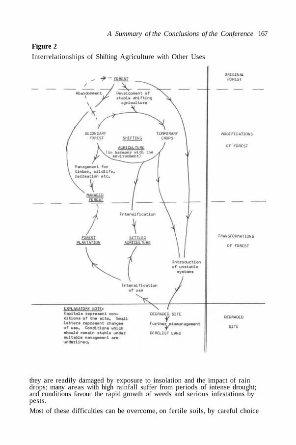
A Summary of the Conclusions of the Conference 167
Figure 2Interrelationships of Shifting Agriculture with Other Uses
they are readily damaged by exposure to insolation and the impact of raindrops; many areas with high rainfall suffer from periods of intense drought;and conditions favour the rapid growth of weeds and serious infestations bypests.
Most of these difficulties can be overcome, on fertile soils, by careful choice

168 Ecological guidelines for Development in South East Asia
of site and crops, and suitable techniques for clearing the land and subsequentmanagement. It should be recognized, however, that the greater the degree ofspecialization or tendency towards monoculture, the greater is likely to be thedependence on imported energy and fertilizer. Where systems of productiveagriculture exist which do not depend on great imports of energy andfertilizers these will have the advantage of stability in a world in which energyis likely to become scarce and more expensive.
Management for animal productionThe conversion of humid forests to open grasslands for the grazing ofruminant livestock should be approached with caution. These pastures havesometimes proved productive, particularly where they have been developed onfertile soils, but more often they have failed, resulting in degradation of theareas and low productivity of the livestock. As a consequence alternativesystems are urgently required both to improve animal production and toprevent unnecessary destruction of forest.
One alternative would be to restrict ruminant livestock to drier savannaregions. There are, however, serious constraints on livestock productionin these areas also, the main one being the intense seasonality of forageproduction. This constraint has not yet been economically removed despitemany and varied efforts to effect solutions. The use of combinations ofmeasures such as the introduction of exotic grass and legume species, waterstorage, supplementary feeding of livestock during the dry season andseasonal breeding may ultimately lessen the effect of the intensely seasonalsupply of forage. Any major improvements are likely to depend upon thesuccessful conclusion of a major investigational programme directedspecifically to the production problems of savannas.
A second alternative would be to improve those areas in the humid tropicsthat have already been cleared and have become degraded. This might beeffected by a policy of intensification that would include: the introduction ofexotic tree and pasture legumes (or the development and intensive use oflocal species if available), reduction in the size of paddocks, the introductionof rotations using large numbers of cattle on small areas of pasture for shortperiods, and the use of fertilizers if these could be economically justified.What must be emphasized is that management of both livestock and pasturesin the humid tropics is very different to management in the dry tropics.
Another promising alternative could be the integration of livestock productionwith field and tree crops, fish ponds and forestry. Most by-products of fieldcrops can be used by ruminants and the possibilities of the integration oflivestock with tree crops are particularly promising. Livestock can be easilyintegrated with coconut production in regions where the total rainfall is morethan 1800 mm and, with correct management, could be integrated withrubber, oil palm, fruit and nuts. Programmes of investigation should bestarted immediately to ascertain how integration can most economically beaccomplished. Pigs and ducks can be combined with fish culture. There mayalso be some possibilities for integrating forestry with the management ofgame animals for meat production.
In those areas where adequate labour is available, a system of very intensiveagriculture, which integrates livestock with field and tree crops and with fishponds, could recycle organic matter and nutrients and might be economicunder certain circumstances. It would have the added advantage of providingthe farmer with a varied and nutritious diet.

A Summary of the Conclusions of the Conference 169
D. WATER RESOURCES(Guidelines 48-51)
In addition to any other use, all areas of land discharge a function in thecollection and release of water; and the rate at which water is released andits quality are of crucial importance for many human activities.
Generally speaking natural vegetation provides water of higher quality anda more even discharge than areas which have been modified or transformed.For this reason there are strong reasons for maintaining natural vegetationcover on steep slopes liable to erosion and accelerated runoff.
In considering any change of land use or management within a catchmentprime consideration should be given to the effect of this on the quality andquantity of water, and the periodicity of discharge.
E. MANAGEMENT OF FISHERIES IN RIVER SYSTEMS(Guidelines 52-56)
The water bodies of the South East Asian humid tropics are characterizedby great diversity in hydrology and biology, seasonal variation of water leveland a locally high potential" for producing protein.
The complexity of these ecosystems is reflected by the large number ofspecies present, which demonstrates the very effective occupation of existingecological niches. Although the numerous interactions between species arenot yet well known, a reduction in quantity, and especially the extinction, ofabundant or important elements of the aquatic fauna may have disastrous sideeffects for the whole system. The exact nature of these effects cannot beforeseen.
The introduction of exotic or alien species into these water systems isdangerous and in some instances has proved disastrous. Experience in theAmerican tropics shows that the resulting improvement of fisheries has beendisappointing. The introduced species have often, indeed, had a damagingeffect and, once established, have proved almost impossible to eliminate.
In large river systems, management of the fisheries or regulation of thewater regime in one part may have effects in other and distant parts bymodifying the migration and spawning of fish species.
The situation is different in enclosed water bodies under direct human controlwhere monocultures can be highly productive and exotic species can be mostsuccessful.
F. PEST CONTROL(Guidelines 57-70)
Controlled use of pesticides is necessary both in controlling disease and inincreasing agricultural production. Some adverse effects have been recordedas a result of excessive or indiscriminate use of some pesticides, leadingin some instances to hazards to health and to crop losses due to theemergence of new pests, but there is not nearly enough information about thequantities of those chemicals used, their environmental effects, and theirultimate fate. These circumstances can combine to cancel the beneficial

170 Ecological guidelines for Development in South East Asia
effects and to create a potentially serious threat not only to the environment,but to crop protection and public health.
G. INFRASTRUCTURE, ENGINEERING WORKS AND INDUSTRY(Guidelines 71-81)
Large capital projects are difficult to alter once begun, even if alterationsseem desirable. This is because they require a long period for planningwith considerable investment of money and manpower. As they represent alarge social commitment they develop, too, their own political momentum.For these reasons the possible harmful effect of both require earlyattention in planning and design.
Roads, for example, can set in train developments which lead to misuse ofresources and badly situated human settlements. Attention should be givento the incidental effects when choosing the route and design of new roads.
There is already considerable experience from the building of dams in thetropics. High costs and serious problems of management affecting both thereservoirs and lower river courses may be caused by damming waters withheavy loads of sediment or a high content of nutrients. The problems ofsedimentation are greater in small than in large dams. Impoundments whichexpose large areas along their shores at low water can cause problems forlakeside settlements, for farming and for fisheries. No resettlement has beenfully successful round any tropical impoundment. The social and financialcosts of these projects have often been grossly underestimated because thedata to assess their effects have been lacking or inadequate. Nor have thebenefits been properly assessed.

A.
1.
2.
3.
4.
5.
6.
7.
8.
9.
10.
LAND-USE POLICY AND ALLOCATION OF LAND TO VARIOUS USES
Great care should be taken in reaching decisions on the designation andallocation of land for various uses.
National and regional resource surveys should be undertaken to ensurethe designation of land for the most suitable purposes.
The development of any new region should be planned as a whole, includingthe infrastructure of settlements, roads, dams, water supply, siting of saw-mills, processing plants for agricultural products and other industry. Atotal catchment area is recommended as an appropriate unit for planning.
Decisions about how land shall be used should be based on a proper under-standing of each different kind of land, its capability for different uses, andthe constraints which must be observed when it is manipulated for produc-tive purposes.
The "capability" for various uses should be assessed separately in orderthat the merits of alternative patterns of development may be compared.
When they are not already available, surveys should be started as soon aspossible as a basis for decisions about land use, for example: of socialstructure, of climate, topography and land form, soils, vegetation and fauna,mineral resources and hydrology.
Until the results of detailed surveys are available, the greatest use shouldbe made of the results of remote sensing and the use of vegetation as ameasure of climatic and soil characteristics.
Land having a wide range of capabilities should be retained as far as pos-sible in a flexible form of land use to maintain the widest possible choicefor future generations, whose needs and skills may be different.
Planning should provide for foreseeable requirements. Subject to the in-herent capability of the land (see Guideline 4), allocation to various usesshould be based on the needs of the community as determined by its chosenlife style. This requires a balancing of the national interest against theinterest of any special groups in the community.
Environmental effects of alternative courses of development or changesin land use should be assessed in advance. These should, at least, include:effects on local populations; on health and social well being; on river flowand water quality; possible influence on local climate; soil; effects on therange and abundance of wildlife*. All studies should include not only theregion to be developed, but also the surrounding areas, and, in particular,the whole catchment area of any river system affected. This assessmentmay take the form of an "environment impact assessment" or other appro-priate means.
Laws, regulations and policies on land use which will affect (among others)
* 'Wildlife' is taken to include all species of plants and animals and populationsof them.
Ecological Guidelines for development inTropical Forest Areas of South East Asia
171

11.
12.
13.
14.
15.
16.
17.
forest areas should also be subjected to an environment impact assess-ment before being passed.
Planning should be undertaken as far as possible in consultation with thoselikely to be affected in order that they may be fully aware of possible alter-natives and may be able to contribute to reaching decisions. This processmay proceed by stages and take time. At each stage the social costs andbenefits of alternatives should be evaluated.
As part of planning process, arrangements should be made to monitor theeffects of any major development and observations should be made onchange of significant variables including those listed in Guideline 9. Theresult of these observations may be used to modify the course of develop-ment, if necessary, and to provide experience to guide future ventures.
Particular care is necessary in making decisions to modify or to trans-form forest or other natural land, because these processes can only bereversed with difficulty, if at all.
Because any modification will affect the intrinsic value of natural com-munities and ecosystems, suitably large samples of these should be desig-nated and allocated for protection as far as possible before any allocationto other uses. Even on rich agricultural soils, the retention of a propor-tion of land in its original state has value, especially to preserve samplesof unchanged communities, but also to provide controls in comparison withwhich the changes brought about by agriculture can be measured and asses-sed. This is particularly urgent in lowland forest.
In addition to assessments of land capability for other purposes, an assess-ment should be made of the intrinsic merit of land in relation to the con-servation of flora, fauna and natural ecosystems. Suggested classes forsuch a land capability classification have been given in Table 1 (page 163).This assessment should be set against others (for agriculture, timber pro-duction, minerals, etc.) in determining the use of land.
Before felling of forest or major harvesting of forest produce is carriedout, an assessment of the possible final use of the land should be madein order to enable proper phasing and planning for development.
Before considering modification or transformation of untouched areas,every consideration should be given to:(a) adapting to more productive uses areas which have already been
changed (e.g. savanna for pine plantations);
(b) intensification of existing uses;
(c) using areas for more than one purpose, if these are compatible.
B. RETENTION OF THE NATURAL FOREST* AS A RESOURCE
18. Guidelines 13 and 14 recommend allocation of representative samplesof natural ecosystems and protected areas. These should be maintainedas a reservoir of genetic material, for their scientific and educationalvalue, as samples of outstanding or typical natural landscapes and as a
* The term 'forest' is used for simplicity. It should be taken to include othernatural ecosystems.
172 Ecological Guidelines for Development in South East Asia

19.
20.
21.
22.
23.
24.
25.
26.
27.
28.
29.
The Guidelines 173
reservoir for wildlife, which may be utilized in surrounding areas. Inspecific situations where there are areas of outstanding and possiblyunique value, high priority should be given to their protection which shouldbe given precedence over other forms of land use.
In order to fulfil these functions the areas protected should be related tothe needs of the plant and animal communities that it is intended to protect.Wherever possible examples of different ecosystems should be includedwithin large areas, representing, for example, different altitudinal zoneson a mountain or in the upper parts of a water catchment.
Wherever possible examples of different ecosystems should be includedsystems should be surrounded by buffer zones taking advantage of physio-graphic and other natural protective features. These should be maintainedunder natural vegetation but can be used for any forms of economic landuse which do not interfere with the integrity of the protected area.
Areas which are too steep or unstable for timber extraction or transforma-tion to agriculture should remain as protection forest and be managed sothat they perform the functions of soil protection and water regulation.
The objectives of management for such protected areas should be care-fully defined and adhered to. They should include maintaining part of thearea completely undisturbed; but in the remainder, use for scientific study,for education and for recreation should be encouraged, provided that theseuses do not conflict with the primary purpose of protection.
There should be a management plan for each protected area, and thecourse of management should be monitored to assess whether the originalobjectives were reasonable and the management has been successful.
In planning the overall development of any area, consideration should begiven to providing means for the migration of animals and dispersal ofplants between protected areas.
Areas set aside for the protection of steep slopes and catchment areasmay be used to take a harvest of forest produce, provided that this doesnot interfere with their primary function of protection. The same appliesto the buffer zones of protected natural areas but not to the reservesthemselves.
The protection of plant genetic resources in natural protected areasshould be supplemented by documented collections, for example, in botanicgardens, arboreta and seed banks, but these alone are no substitute forprotected areas.
The objective for the management of an area for the production of timberor other forest produce should be to maintain the potential for the maxi-mum sustained yield.
Such forest should be managed according to the best principles of silvi-culture and in such a way that the composition and structure are alteredno further than is necessary from that of the natural forest.
All areas of managed forest may have a very important supplementaryvalue as a habitat for wild life. Management should be aimed as far aspossible at maximizing this value. The wildlife may provide a significantsource of food, of revenue from exploitation and of reserve stocks of thespecies concerned.
30.
31.
32.
33.
34.
Predicted timber requirements should take account of the local require-ments for fuelwood, which under certain circumstances can represent avery large demand on the productive capacity of the forest. Where theviability of the forest is threatened by fuelwood collection, special planta-tions should be established as near the site of demand as possible andalternative sources of fuel should be developed.
In order to help to meet predicted timber demands, plantations should bedeveloped as rapidly as possible over suitable sites. Where agriculturalland has been abandoned, such land should be utilized for plantation fores-try rather than clearing indigenous forest for plantations.
Where the current practice of shifting agriculture ("swidden cultivation")is in harmony with the environment and not leading to long-term degrada-tion, it should continue as necessary but with regular monitoring to ensurethat changes in the situation, arising for instance from population increasesand social change, can be foreseen and any necessary adjustment made.
When shifting agriculture is not in harmony with the environment it shouldbe discouraged. If it does not already exist, it should be prevented as faras possible by providing instead for well-planned land settlement. Whereit has already occurred, efforts should be made to transform it into settledagriculture or into forest plantations by intensification of use accompaniedby appropriate extension services, provided that this is consistent withland capability factors.All measures should be designed with the greatest possible considerationfor the interests and values of the indigenous community and in full colla-boration with them.
c.
35.
36.
37.
38.
39.
40.
41.
TRANSFORMATION OF NATURAL FOREST INTO FIELD AND PLANTA-TION CROPS, ANIMAL PRODUCTION AND FISHERIES
Land should only be used for cultivation or plantation crops when suffi-cient survey of the ecological conditions has shown that the area is suit-able for such crops if appropriate methods of cultivation are used; andfield trials or observations have confirmed this assessment.
Any modification or transformation of the existing vegetation must becarried out in such a way that the least possible harm is done to the soilby radiation and rainfall, in order to retain organic matter and fertility.
Careful studies should be made of traditional and indigenous systems ofagriculture which have often remained for long periods in balance withtheir environment and have produced a sustained yield under these condi-tions. Every attempt should be made to extend such stable and productiveindigenous systems, or suitable elements of them.
Wherever possible, tree crops should be integrated into systems thatinclude the raising of animals and production of food crops.
As far as possible systems of agriculture should be favoured that do notrely heavily on the importation of energy and fertilizer.
Particular attention should be paid to the public health problems arisingfrom forest clearance.Plans for increasing animal production by introductions into the humid
174 Ecological Guidelines for Development in South East Asia

42.
43.
44.
45.
46.
47.
The Guidelines 175
tropics should take into account the reaction of the various types to theclimate and to pests and diseases.
Improvements in ruminant livestock production can most suitably be ob-tained by:
(a) development of new and suitable breeds;(b) increasing the productivity and hence the carrying capacity of existing
pastures by the use of multi-species forage and stress on improve-ments in management;
(c) integration with field and tree crop production; and(d) the utilization of all available by-product feeds.
The improvement of non-ruminant livestock production can probably bestbe accomplished by ensuring continuous and economic supply of suitablefeeds, which should include as many locally produced by-product feeds aspossible. There are also possibilities for integrating pig, chicken andduck production with fish production.
Every effort should be made to improve the productivity of existing savan-nas by the introduction and testing of new forage species, the solution ofthe problems of dry season feeding and overall improvements in manage-ment.
Further efforts should be made to domesticate indigenous animals forsustained production (e.g. deer, banteng, crocodile).
Special attention is drawn to the danger of introducing species of animalsfor domestic purposes under range conditions where there is any oppor-tunity for escaping into the wild. (Animals such as buffalo and goat havecaused considerable ecological and economic damage in many situationsafter escape from domestic control.)
Careful studies should be made before the transformation of mangroveand swamp forests to agriculture or fisheries so that long-term and irre-versible effects to these ecosystems can be avoided.
D.
48.
49.
50.
51.
E.
52.
WATER RESOURCES
In land-use decisions adequate provision must be made for safeguardingand perpetuating water supplies for domestic, food, power and industrialrequirements.
Multiple use of catchments should be consistent with the above objectivesand include full provision for present and future fishery and wildlifeneeds.
The utilization of the water resource should be based on the needs of thepeople, first consideration being given to domestic needs and that requiredfor food production.
Management of the catchment should ensure delivery of water of the qua-lity required.
MANAGEMENT OF FISHERIES IN RIVER SYSTEMS
Every effort should be made to retain the species diversity in natural

176 Ecological Guidelines for Development in South East Asia
water bodies, unless these are allocated for intensive fish cultivation pur-poses.
53. The introduction of exotic species into water systems should only be con-sidered after all other possibilities of increasing production, such as theencouragement of selected native species, have been exhausted, and shouldonly then be carried out after careful trials and with stringent precautions.
54. In large river systems regulations for fisheries management must takeinto account the riverine spawning migrations of many species. Protectivelegislation designed to maintain a breeding population of such speciesmay need to apply to large portions of any river system and to include theestuaries.
55. In floodplains that have high seasonal potential for fish production, andwhich are also farmed at low water, farming methods should be avoidedwhich may damage aquatic life. Special care should be taken in the useof pesticides, and persistent chemicals toxic to aquatic life should not beemployed.
56. Artificial breeding of important species should be developed for thedeliberate stocking of suitable waters.
F. GUIDELINES ON PESTICIDES
57. Governments should immediately establish a centralized organization tocollect and interpret information on the kinds, amounts, distribution andlocal application of all pesticides (insecticides, herbicides, fungicidesand others), both those used for public health as well as for control ofagricultural and forestry pests.
58. Regulations should be developed on production, importation, formulations,sales, distribution and application. These should be made enforceable.Criteria may be found in similar regulations in other countries of theworld. Regulations should stipulate: that pesticides and pesticide formula-tions which may represent a special hazard to humans and other organismsshould be sold and/or distributed only by designated persons, preferablyunder licence.
59. Programmes of biological control and integrated methods of pestmanagement should be encouraged (including mechanical control).
60. Wherever possible those pesticides should be used that are specific tothe pest. Moreover in general the selectivity of pesticide applicationsshould be optimized by selecting appropriate formulations and techniquesof application.
61. Research and development should be promoted into selective pesticideswhich are degradable in the environment.
62. Spraying from the air should be prohibited near areas where the chemicalsmight have undesirable effects.
63. The amount of pesticide used and the area covered in its applicationshould be kept as small as possible by a proper judgement of the degreeof infestation at which damage becomes unacceptable, by using detailedknowledge of the habits of the pest and by avoiding overdosing.
64. In large scale operations application of the pesticide should be confined

65.
66.
67.
68.
69.
70.
G.
71.
The Guidelines 177
within the limits of the ecosystem to be treated to avoid exterminatinglocal taxa and to permit recolonization from outside by non-targetorganisms which have been killed off in the area of application.
Local research should be undertaken on the toxicological and ecologicaleffects of various pesticides, as the results of research in temperateregions do not necessarily apply in the humid tropics.
Pesticides now in use should be examined first and the results of researchshould be used in designing regulations for their use.
Research should be carried out into the development of pesticidessuitable for the protection of tropical crops. Wild plants in tropicalforests may have evolved chemical protection from insect predation, andit might be profitable to examine indigenous plants in order to identifyand produce those substances in them that may limit attack by pests.
Large scale operations should be guided by epidemiological studies andby means of biological and chemical monitoring, including: changes inpopulations, physiological and behavioural changes, appearance of resis-tance or tolerance to chemicals in target populations and of concentrationsof pesticides and their conversion products in soil, water and biota.
The methods selected for pesticide applications should be compatible withthe local environment conditions.
Great care should be exercised in treating fresh water bodies withherbicides in order to avoid dramatic irreversible changes in thevegetational structure and a subsequent deterioration of whole ecosystems.Pesticides for dressing seed should be selected whose acute toxicity willbe low enough not to cause poisoning in grain-eating animals as well as inhuman beings, if treated seed should be eaten.
INFRASTRUCTURE, ENGINEERING WORKS AND INDUSTRY
In all developments of this kind, besides the probable socioeconomiceffects, the probable ecological impact should be assessed in advance andthe changes which occur afterwards should be kept under observation.
Roads72. Just as with other projects, planning for roads should be treated as an
integral part of a regional development plan, and should take intoconsideration any long-term or incidental effects of the environment.
73. If possible, no roads should be routed through areas designated asreserves or parks; but, if other considerations make this unavoidable,management plans for such reserves or parks should be drawn up beforethe roads are built and land clearing or other activities not consistentwith the objectives of management should be strictly forbidden. Ifnecessary, increased provision should be made to ensure that illegalclearing does not occur.
Water-ways, dams, etc.74. When planning and executing the improvement of existing water-ways,
canals, etc., special attention should be paid to the total effect of theseworks on the characteristics of the water and the living conditions of the

178 Ecological Guidelines for Development in South East Asia
people living near these water-ways. Public health and environmentalproblems that might be solved by any such improvement should be givenspecial attention.
75. When planning any dam or significant change of river regime, specialattention should be paid to the effect of it (or alternatives) on the flow andon the physical, chemical and biological characteristics of the water, bothat and below the intended works. This is necessary to assess possibleconsequences for human health, fisheries and wildlife, and to assess therisk of infestation by water weeds. These should include advance studies,during at least one year, of:
(a) Streamflow, sediment load and bed load;(b) water chemistry;(c) precipitation and the chemical content of rainfall;(d) aquatic vegetation and its dynamics;(e) aquatic fauna, especially fish of economic importance, their life
histories, food and feeding habits, reproductive patterns, spawning andmigration;
(f) groundwater in the neighbourhood of the proposed reservoir;(g) the sedimentation patterns and water regime of floodplains, estuaries
or deltas downstream.
76. Arrangements should be made to monitor the variables in Guideline 75 (a)to (g) above and the cost of doing so should be included in the project.
77. Public health problems that may be caused by or associated with animpoundment must be anticipated and their management needs and costsincluded in the cost benefit analysis and future management plan. Theproblems of mosquito and snailborne human diseases require specialattention. If resettlement schemes or spontaneous population movementsnear the proposed reservoir are likely to bring new populations in contactwith disease, the risk of this must be assessed in order to designprogrammes of public health.
78. Any proposed resettlement should take into account the present social,cultural, economic and health conditions of those to be resettled andtheir future needs. Resettlement should be carried out in consultationwith them and should be carefully planned and timed.
79. Any problems of weed infestation after impoundment should be anticipatedas far as possible and steps taken to prevent such infestation.
80. Preparations should be made in advance to manage the fisheries in theperiod following impoundment and to provide for the resettlement ofdisplaced animal populations.
Industry81. The planning, design, construction and operation of industries should take
into account the possible adverse effects of industrial pollution (physical,including thermal, chemical and biological) and other disadvantageousecological effects. Standards of quality for water, soil and air should bebased on proper ecological principles.

179
Vote of Thanks
Professor Otto Soemarwoto thanked all who had helped in the preparationand organization of the Conference and in bringing it to a successful conclu-sion, and in particular the Co-President, Dr. Duncan Poore, for all the workhe had done on drafting the guidelines, which had served so well to focus thediscussion and to lead to concrete results.
Dr. Poore then expressed thanks on behalf of IUCN as well as himself forthe contribution made by all participants to the valuable outcome of theMeeting and especially those who had prepared papers and taken part inpanels. The meeting had run exceptionally smoothly because all the materialand secretarial needs of the delegates had been so well and elegantly providedfor.
The Conference had been particularly grateful to Dr. Sumarlin who had foundtime, in a very busy life, not only to open the Conference and encourage us withhis thoughtful and wise address, but also to come to the final session, hearsomething of the result of our labours and experience for himself the spirit ofagreement.
Dr. Poore presented Dr. Sumarlin with a copy of the text of the Guidelines andinvited him to close the Conference.
180
Closing Address
Hon. J. B. SUMARLIN PhD.
Minister of State and Chairman of the State Committee for Environment,Jakarta, Indonesia and President of the Conference
We are now at the end of our conference. I should like to apologize to you allthat due to the heavy work-schedule in Jakarta, I was not able to join you inyour deliberations.
For the last four days you have been working very hard in this conference andit was reported to me that there were considerable arguments about variouspoints. This is not unusual in a conference, and I am not troubled by it at all;rather I am happy, since it shows that the participants have had a realinterest in the subject of the Conference and have been actively engaged in thediscussions.
I am happy that a report has been produced and that a few moments ago it wasadopted. We have now in our hands the concrete results of the Conference,although of necessity some editorial improvements and polishing will stillhave to be done. It demonstrates that a multidisciplinary approach to anecological or environmental problem is workable and that not only canscientists in different fields communicate with each other but also scientists,planners and decision-makers, since these are the three groups which havebeen assembled at the Conference. For this achievement, IUCN and theInstitute of Ecology, which planned and organized the Conference, deserve everycommendation.
I am very happy indeed that this Conference has taken a positive view ondevelopment, and that the results are intended to help planners to developforest areas in a more rational way, to maximize the benefits of developmentfor the people, and to take into account the needs of future generations andof preserving or promoting decent and harmonious environmental conditions.
The practicability and suitability of the guidelines presently produced, for theplanning process of forest areas in South-east Asia, will, of course, have tobe tested in practice. But at least we have taken the first step which can beused as a basis for further improvement in the future.
At the end of this Conference I would like very much to express myappreciation and thanks for your interest and active participation in thediscussions which contributed so much to its success. I also wish to thankthe Rector of Padjadjaran University and particularly the staff of the Instituteof Ecology, who have taken such great pains to make this Conference runsmoothly
Last but not least I wish to thank Dr. Duncan Poore, my Co-President of theConference, who prepared the draft guidelines and thus enabled us to conductour deliberations in an orderly manner.
Finally I wish you a safe journey home. 'Selamat jalan dan sampai berjumpalagi'.
I now officially declare the Conference closed.

181
REGIONAL MEETING ON ECOLOGICAL GUIDELINES FOR DEVELOPMENTIN TROPICAL FOREST AREAS OF SOUTHEAST ASIA. BANDUNG,INDONESIA, 29 May to 1 June 1974
PRESIDENT
CO-PRESIDENT
SUMARLIN, Hon. J. B. PhD.
POORE, Dr. M. E. D.
ORGANIZING COMMITTEE
CHAIRMAN
VICE-CHAIRMAN
EXECUTIVE SECRETARY
SECTIONS:
KUSUMÁATMADJA, Prof. Dr. Mochtar
ADISEWOJO, Prof. Dr. Sasongko S.
SOEMARWOTO, Prof. Dr. Ir. Otto
TREASURYSECRETARIAL OFFICE,
Coordinators
Members
DOCUMENTATION,
Coordinators
Members
PROTOCOL,
CoordinatorMembers
SOEBAGIO, Drs. R.
SOEKARTADIREDJA, Drs. E. M.M. KUSMAN SULAIMAN
1.2.3.4.5.6.
B. S. PambudhyAdang PurnawarmanRusdi UnoTommy SMoh. Ernan Arno AmsariKurdi, Drs. Romli M.
SOEMARWOTO, Mrs. Idjah O., M. A.KARYONO, M. Sc.
1.2.3.4.5.
Yudha PrawirakusumaYayat DhahiyatAde SuryadharmaCucu Komariah, Dra.Iin S. Noer
SUMARDJA, Drs. Effendy A.1.2.3.4.5.6.7.8.9.10.
Anton Klaas FernhoutKunkun Jaka GurmayaAtik DharmadiTito S. SutalaksanaDoy HardjoPeggy Yoza ZenIngrid SuryaNina UtamiIda FaridaErwina Hasiim.

182 Ecological Guidelines for Development in South East Asia
ACCOMMODATION,Coordinator
Members
FOOD SERVICE,CoordinatorMembers
RAMLAN, Drs. Aseng
1.2.3.
PANDI,1.2.3.4.5.6.7.
Kusnadi Yusaputra, Drs.Yusup BastamanHilmi.
Drs. AdeSalamah Sanoesi, Dra.P. K. UtamiTitin S.Anita HannaNinien KarlinaYulia P.Daya Pamudji.

List of Participants 183
LIST OF PARTICIPANTS
ACHMAD S'Sarnita, Drs. Director, LPPD Jatiluhur, P.O. Box 177, Jatiluhur,Indonesia.AGALOOS, Bernardo C. Officer in charge, Forest Protection & UtilizationDivision. Bureau of Forest Development. Diliman, Quezon City. Philippines.ANDRIESSE, J. P., M. Sc. B. Sc. (Agr). Pedologist: Head Section Soil GeneticsRoyal Tropical Institute Mauritskade 63, Amsterdam, Netherlands
BAI, Brown Economist, Central Planning Office, P.O. Box 3618, Port Moresby,Papua New Guinea.
CHEAH LEONG CHIEW Silviculture Division, Forest Dept. Headquarters,Peninsula Malaysia, Kualalumpur, Malaysia.CURTIS, H. S. Officer in Charge N. P. Branch Dept. of Forestry, Departmentof Forestry, BPO Box 944, Brisbane, Australia 4001.
DIDIN S. Sastrapradja, Dr. Executive Secretary of LIPI and Director,Botanical Gardens, Jalan Teuku Chik Ditire 43, Jakarta, Indonesia.DILMY, Prof. Anwari Rector, University of Lambung Mangkurat, Banjarmasin,Kalimantan, Indonesia.DOWNES, Maxwell C. Chief Wildlife Section, Papua New Guinea, DASF Konedobu,Papua New Guinea.DOWNES, Dr. R. G. Director of Conservation, 240 Victoria Parade, EastMelbourne, Victoria, Australia 3002.DOYLE, J. W. Department of Geography Australian National UniversityCanberra, ACT, Australia.ENDERLEIN, Peter Wildlife and National Parks Management, FAO, RegionalOffice, Phra Atit Rd., Bangkok 2, ThailandEVARA, Benjamin A. Investigations Officer, National Parks Board, Papua NewGuinea.FAZAR Kurnia, Ir. Directorate General of Forestry, Ministry of Agriculture,Bogor, Jalan Ir. H. Juanda 9, Bogor, Indonesia.FRASER, Alastair I. Regional Tropical Forest Management Adviser, FAORegional Office, Phra Atit Rd., Bangkok 2, ThailandFURTADO, Jose I. Dr. Professor Madya, Universiti Malaya, Kuala Lumpur,Malaysia
GARE, N. C. Executive Officer, National Parks and Wildlife Service, Depart-ment of Environment and Conservation, PO Box 1937, Canberra, ACT,Australia
HAERUMAN, Herman Dean, Faculty of Forestry, IPB, P.O. Box 69, Bogor,Indonesia.HARDIN, Michael Permanent Secretary Ministries of Forestry, Land andMineral Resources, Sarawak, Malaysia.HEKSTRA Ir. A. Advisor, LPH-DTH, Jalan Setiabudi 294A, Bandung, Indonesia
JUNUS, Drs. Assistant to the Minister of State/Vice Chairman BAPPENAS,Jalan Veteran 17, Jakarta, Indonesia.
KARTAHARDJA, Ir. A. Director, Building Research Institute, Regional HousingCenter, Ministry of Public Works & Electric Power, Jalan Tamansari 124,Bandung, IndonesiaKARTAWINATA; Dr. Kuswata. Tropical Forest Biology Program Manager,BIOTROP, Kobun Raya, Bogor, Indonesia.KITTINANDA Sompherm, In Charge of Silvicultural Research Branch, RoyalForest Dept. Bangkok 9, Thailand.

184 Ecological Guidelines for Development in South East Asia
KNOTT, Norman P. Regional Wildlife and National Parks Advisor, FAORegional Office, Phra Atit Rd., Bangkok 2, Thailand.KOCH, Dr. Ir. V.J.M. BPTK Kotak Pos 148, Bandung, Indonesia.KOEMAN, J. H., Prof. Dr. Department of Toxicology, Agricultural University,De Dreijen 11, Wageningen, Netherlands.
LEE Peng Choong, Dr. Coordinator, Natural Resources Evaluation,Economic Planning Unit, Prime Minister's Dept., Kuala Lumpur, Malaysia.MAKAGIANSAR, Dr. M. Director General for Education, Jalan RS Fatmawati,Cipete, Kebayoran, Jakarta, Indonesia.MARTYN, H. S. Conservator of Forest, Sabah, Forest Department, Sandakan,Sabah, Malaysia.MORVAN, Alain Assistant Resident Representative, United Nations DevelopmentProgramme, Jalan Thamrin 14, Jakarta, Indonesia.MURTHY, L. S. V. Conservator of Forests, Sarawak Forestry H.Q., Kuching,Sarawak, Malaysia.
NICHARAT, Swat In Charge of Forest Botany Project, Royal Forest Department,Bangkok, Thailand.NIX, Dr. H. A. Senior Research Scientist, CSIRO Division Land Use Research,CSIRO, Canberra, Australia.OAISA, Alan. Foreign Affairs Officer, Australian Embassy, Jalan Thamrin 15,Jakarta, Indonesia.OVINGTON, Prof. J. D., PhD. Australian National University, Department ofForestry, Canberra, A.C.T., Australia.
POORE, Dr. M. E. D., Senior Ecologist, IUCN, 1110 Morges, Switzerland.PRIJONO Hardjosentone, Ir. H. Director, Nature Conservation and WildlifeManagement., Jalan Ir. H.Juanda 9, Bogor, Indonesia.RACHWARTONO, (MPA) Rio. Executive Secretary, National Committee on theEnvironment, Jalan Teuku Chik Ditiro 43, Jakarta, Indonesia.RAMSAY, Dr. D. M. FAO Project Manager, Solo Watershed Project, c/o UNDP,P.O. Box 2338, Jakarta, Indonesia.ROBINSON, Dr. Glenn H. Project Manager, FAO Land Capability AppraisalProject, c/o UNDP, P.O. Box 2338, Jakarta, Indonesia.SAMBAS, Wirakusumah Forestry Faculty, University Mulawarman, JalanMulawarman, Samarinda, Indonesia.SASONGKO S, Adisewojo, Prof. Dr. Science Faculty, Institute for NaturalSciences, Padjadjaran University, Bandung, Indonesia.SOEGIARTO, Dr. Aprilani Director, National Institute of Oceanology, P.O.Box 580/DAK Jakarta, Indonesia.SOEKISNO HADIKOEMORO, Prof. Scientific Advisor to the Director Generalfor Education, Directorate General for Education, JI. R.S. Fatmawati, Jakarta,Indonesia.SOEMARWOTO, Mrs. Idjah O., M. A., Padjadjaran University, Institute ofEcology, Jalan Banda 40, Bandung, Indonesia.SOEMARWOTO, Prof. DR. Otto, Padjadjaran University Jalan Banda 40, BandungIndonesia.SOEMIRAT SLAMET, Ir., MSc. Mineral Economist/Min. Eng., Faculty ofMath & Natural Sciences, Padjadjaran State University, JI. Ir. H. Juanda 4,Bandung, Indonesia.SOETARTO, Drs. Executive Secretary, BAKOSURTANAL, Jakarta, Indonesia.SRI SOEWASTI Soesanto Mrs. Chief, Division of Physical Environment,Research Center of Ecology, National Institute of Medical Research, Ministryof Health, Jalan Percetakan Negara I, Jakarta, Indonesia.

List of Participants 185
SUKATON, R.U. Assistant to Minister of Communications for Science andTechnology, Dept. of Communications, Jakarta, Indonesia.SUMARLIN, Hon. J. B., PhD. Minister of State and Chairman, State Committeefor Environment, Jakarta, Indonesia.
TAGO, Hon. Stephen Minister for Environment and Conservation, Dept. of Lands,Konedebu, Port Moresby, Papua New Guinea.TRAPP, Dr. Gunter Programme Specialist, UNESCO, UNESCO Field ScienceOffice, Jalan M. H. Thamrin No. 14, P.O. Box 273/Jakarta, Indonesia.
VERSTRIJDEN, Drs. U. Chief Chemist Research Institute for BPTK 'Gabung'TEA AND CINCHONA, Kotak Pos 148, Bandung, Indonesia.
WEBER, Dr. Bruce E. Project Officer, IUCN, Morges 1110, Switzerland.WEBER, Mrs. Katherine D. Project Officer c/o IUCN, 1110 Morges Switzerland.WHITE, Kevin J. Assistant Director, Department of Forests, P.O. Box 5055,Boroko, Papua New Guinea.WIERSUM, K. F. FAO Associate Expert on Forestry, Upper Solo WatershedManagement Project, c/o UNDP/FAO, P.O. Box 2338, Jakarta, Indonesia.