Embed Size (px)
Citation preview

The Use of ESRI Software in the Delineation of Urban Areas for the 2010 Census
For Presentation at theESRI International User ConferenceJuly 12th, 2011
1

Urban Area Definitions
• Represent densely developed territory, encompassing residential, commercial, and other non-residential urban land uses in which social and economic interactions occur.
• Represent the “Urban Footprint”
• Structure has been explicitly defined through measures based primarily on population counts and residential population density
• Criteria have also accounted for non-residential urban land uses that are functionally part of the urban landscape
2

Urban Area Delineation Software
3
• ArcGIS 9.x• VBA using ArcObjects
• Automated delineation software developed for each major step in the process • Initial delineation: pop density• Impervious• Hops/Jumps • Enclaves
• Interactive review and update software developed various review and update stages

Identification of Impervious Qualifying Blocks
• Allows for inclusion of urban land uses in areas of low population density (commercial and industrial)
• Source: Multi-Resolution Land Characteristics Consortium (MRLC) National Land Cover Database (NLCD) 2006 impervious 30 meter raster dataset
• Use ArcGIS Spatial Analyst
4

Identification of Impervious Qualifying Blocks
• Overlay blocks on impervious raster and calculate percentage of impervious area– If 33.3% or greater, flag block
• Calculate shape index– I = 4πA / P² where I is the shape index, A is the area of the block,
and P is the perimeter• Blocks that are at least one-third impervious and are compact (I ≥
0.185) are eligible to be added to urban cores• Non compact blocks with at least one-third impervious are eligible
for inclusion if 40% of the perimeter of the block shares a boundary with a previously qualifying block
5

NLCD Impervious
6

Impervious Qualifying Blocks
7

Initial Delineation
• Tract core development– start with tracts with population density of 1000 people per square
mile (ppsm)– Add adjacent tracts with population density of 500 ppsm– Iteratively add blocks of 500 ppsm
• Block core development– Start with blocks with population density of 1000 ppsm– Iteratively add adjacent blocks with population density of 500 ppsm
• Iteratively add impervious blocks• Fill in holes (enclaves) less than 5 square miles that are completely
surrounded by qualifying land
8

Initial Delineation Demo
9
Click Here for Demo

Hops and Jumps
• Use ArcGIS Network Analyst• Connect urban territory
through road connections of less than 0.5 miles for hops and 2.5 miles for jumps
• Evaluate blocks on each side of connection to form highest density corridor
10

11
Hops and Jumps
• Connect to the area if– Total population of the
destination is greater than 1,000 or
– Population density of the destination and the hop/jump corridor is greater than 500 ppsm

Hops and Jumps
12
Post Hop/Jump Enclaves
• There are three types of enclaves:– Less than or equal to 5 square miles, surrounded by
qualifying land only– Greater than 5 square miles, greater than 2.5 miles
from the edge of the UA– Less than or equal to 5 square miles, surrounded by
qualifying land and non-qualifying water territory
13

Post Hop/Jump Enclaves
14
Less than or equal to 5 square miles, surrounded by qualifying land only
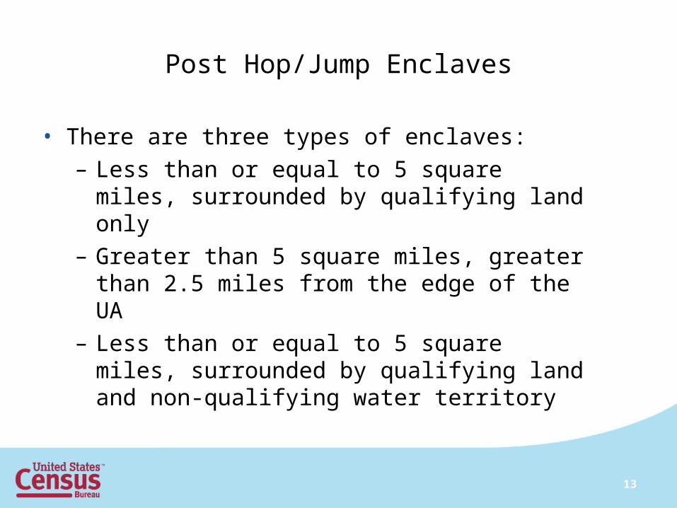
Post Hop/Jump Enclaves
15
Less than or equal to 5 square miles, surrounded by qualifying land and non-qualifying water territory

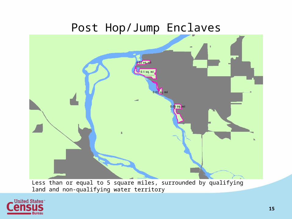
Indentations
• Use closure lines to close off areas that are indentations in the boundary.
• The length of the closure line serves as the diameter of a circle. If four circles with the diameter fit into the indentation, we add territory to the UA.
• If Ai ≥ 4π(½Li)2 and Ai ≤ 3.5 where Ai = area of indentation and Li = length of indentation closure line, then add the territory.
16
Indentations
17
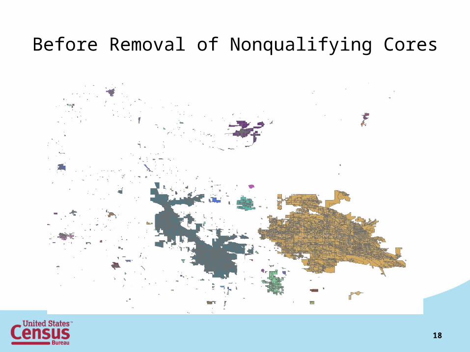
Before Removal of Nonqualifying Cores
18

After Removal of Nonqualifying Cores and Inclusion of Indentations

Questions? Comments?
Vincent Osier, Kevin Hawley, Chris Henrie, Ted SickleyGeographic Standards and Criteria BranchGeography DivisionU.S. Census [email protected](301) 763-9039
20