Embed Size (px)
Citation preview

International Journal of Geospatial and EnvironmentalResearch
Volume 3 | Number 1 Article 2
April 2016
The Use of Middle School Atlases in the SocialStudies Classroom in South KoreaJung Eun HongUniversity of West Georgia, [email protected]
Hyoun Kyoung LeeShincheon Middle School
Follow this and additional works at: https://dc.uwm.edu/ijgerPart of the Geography Commons, and the Other Education Commons
This Research Article is brought to you for free and open access by UWM Digital Commons. It has been accepted for inclusion in International Journalof Geospatial and Environmental Research by an authorized administrator of UWM Digital Commons. For more information, please contact [email protected].
Recommended CitationHong, Jung Eun and Lee, Hyoun Kyoung (2016) "The Use of Middle School Atlases in the Social Studies Classroom in South Korea,"International Journal of Geospatial and Environmental Research: Vol. 3 : No. 1 , Article 2.Available at: https://dc.uwm.edu/ijger/vol3/iss1/2

The Use of Middle School Atlases in the Social Studies Classroom inSouth Korea
AbstractMiddle school atlases are supplementary textbooks for social studies learning in South Korea. Althoughatlases are developed and designed to provide various useful resources for students’ social studies learning,especially geography, atlases have not been frequently used in actual social studies classrooms, and sometimesthey are never used. This study reports the causes of low adoption rates of middle school atlases in Koreansocial studies classrooms through the analysis of survey responses from both teachers and students. This studyalso addresses ways of increasing the use of atlases in the classroom.
KeywordsGeography education, Middle school, Atlases, South Korea
This research article is available in International Journal of Geospatial and Environmental Research: https://dc.uwm.edu/ijger/vol3/iss1/2

1. INTRODUCTION
As geographic representation and communication tools, maps are important in learning
geography and related subject areas (Bednarz et al. 2006; Niedomysl et al. 2013).
Students can develop geographic and spatial thinking skills by identifying, interpreting,
and analyzing spatial information, such as spatial distribution, relationships, and patterns
on a map (Bednarz et al. 2006; Koç and Demir 2014; Weeden 1997). Therefore, as a
collection of maps, atlases have been useful and effective instructional resources
particularly for geography education (Keller et al. 1995; Klein 2003; Wiegand 2003).
Atlases allow students to learn and understand various physical, environmental, historical,
and social topics in the local area or in the world (Battersby et al. 2011; Thomas et al.
1999). Compared with regular atlases for public use, maps in educational atlases should
be designed based on students’ map-reading skills and follow planned learning objectives
(Koç and Demir 2014; Lee and Jung 2009; Wiegand 2003). These educational atlases
need to be considered as significant materials alongside main textbooks rather than
auxiliary materials in class (Harris 1977).
The South Korean government has acknowledged the usefulness and effectiveness of
atlases as educational resources for a long time. Thus, since 1955, the Korean national
curriculum has included atlases as supplementary textbooks for social studies learning
(Lee and Jung 2009). Due to space limitations in main social studies textbooks, middle
school atlases have been developed to provide not only maps, but also various visual aid
resources, such as maps, charts, photos, and illustrations (Lee and Kim 2000; Shin and
Park 2003). Although atlases have been designed to improve students’ social studies
learning, they have not been effectively implemented in class (Jeong and Shin 2007;
Kang 2006; Shin and Park 2003). According to Kang (2005), the use of atlases in class
has been limited to a location reference; students have simply used atlases to find and
confirm a certain location on maps. Additionally, students have negative perspectives of
atlases because they are expensive, heavy, and large compared with other textbooks, so
students tend to bring atlases to class reluctantly (Shin and Park 2003). Therefore, low
classroom use of atlases has been an ongoing issue.
For the effective, practical use of atlases in class, several researchers have conducted
studies primarily focusing on the analysis of the content and organization of atlases,
atlases’ associations with main social studies textbooks, appropriateness for middle
school students, and the status of atlas use by a group of teachers or students (Kang 2006;
Lee and Kim 2000; Shin and Park 2003). However, few studies have investigated reasons
for the limited use of atlases in class based on both teachers’ and students’ perspectives
and opinions on atlases. The goal of this study is to identify the causes of low adoption
rates of middle school atlases by analyzing survey responses from both teachers and
students, which included questions regarding the actual classroom use of middle school
atlases, teachers’ and students’ evaluations and perceptions of atlases, and suggestions for
the improvement of atlases. Based on their responses, the authors propose ways of
increasing the use of atlases in the classroom. The results of this study may be valuable
for designing and developing useful and effective atlases for Korean middle school social
studies classes. However, they may also be beneficial for geography and social studies
classes in other countries by providing helpful atlases for teaching and learning as
1
Hong and Lee: Korean middle school atlases
Published by UWM Digital Commons, 2016

important instructional materials. The following are the research questions that direct this
study:
How are middle school atlases used in the classroom?
How do teachers and students assess middle school atlases?
What are ways of improving middle school atlases to be used in class more often?
2. BACKGROUND
The Korean Ministry of Education and Human Resources Development has developed
the standardized national social studies curriculum to educate and foster individuals to be
able to understand social phenomena, systems, and functions and participate as members
of society (National Curriculum Information Center 2015). The current national
curriculum has been in effect since 2009. The middle school social studies curriculum is
composed of geography, history, and other social sciences. Geography and social
sciences are combined as one subject called social studies, which is taught in the 7th and
9th grades. The course titles are Social Studies I for the 7th grade and Social Studies II
for the 9th grade. Each course has almost equal amounts of geography and other social
sciences content. In geography, students learn about regional (i.e., physical and cultural
differences in each region) and systematic geography (theme-based, i.e., physical
geography, environmental studies, economic geography, cultural geography, political
geography, and population geography). The social sciences section contains political
science, economics, civics, and sociology content. Meanwhile, the history content
covering Korean history and world history is structured as a stand-alone subject called
history, which is taught in the 8th grade.
Under the previous national curriculum (e.g., 6th: 1992 to 1996 and 7th: 1997 to
2006), the middle school social studies curriculum included geography, history, and
social sciences, so at that time, middle school atlases provided resources for both
geography and history content (National Curriculum Information Center 2015). However,
under the current national curriculum, two types of atlases are available for middle school
students: Social studies atlases and history atlases. The social studies atlases are designed
to help students learn geography content in social studies, and the history atlases provide
maps and other visual aid resources for the learning of Korean history and world history
(Korea Institute for Curriculum and Evaluation 2011; National Curriculum Information
Center 2015). Therefore, any history-related maps and other resources (e.g., territorial
expansion and changes of the post-division of Korea) are only available in the history
atlases. This study did not consider history atlases and only focused on the use of social
studies atlases in class. In this paper, middle school atlases refer to social studies atlases.
Currently, eight private publishers publish middle school atlases based on the national
curriculum framework with the Ministry of Education, Science, and Technology’s
(MEST) authorization (National Curriculum Information Center 2015). Like any other
textbook, schools can choose their preferred atlas, so it is possible for schools to choose
the same or different publishers for a social studies textbook and an atlas (Moon and Koo
2011). The 7th and 9th-grade social studies courses are expected to use atlases, and every
student is required to purchase an atlas when they enter middle school (Shin and Park
2
International Journal of Geospatial and Environmental Research, Vol. 3, No. 1 [2016], Art. 2
https://dc.uwm.edu/ijger/vol3/iss1/2
2003). However, the use of atlases is not mandatory in the classroom. Instead, social
studies teachers can use them freely, so depending on the teachers, atlases are used
frequently or not used in class at all. The possibility of using the resources in the atlases
for testing also depends on the teachers. Some teachers may use maps in main social
studies textbooks for tests without using resources in atlases.
According to Lee and Kim (2000), middle school atlases perform six functions: (1)
Increasing learners’ interest and motivation for learning, (2) providing basic learning
content for social phenomena, (3) motivating an analytical process for social phenomena,
(4) providing resources for the social studies subject, (5) suggesting sequences of
teaching and learning, and (6) providing questions for exercises and assignments. Since
atlases’ main function is providing resources for the social studies subject, various types
of resources are available in atlases. Middle school atlases consist of the main content,
workbooks, and appendices. The main content contains general reference maps, thematic
maps, illustrations, charts, and photos. General reference maps are used to represent
regions of South Korea and different continents. Thematic maps, photos, charts, and
illustrations are used to provide useful and supplementary information for each unit of
geography content so that students understand corresponding content better. Workbooks
are designed to enhance students’ geographic thinking, critical thinking, and problem-
solving skills through analyzing information and answering the given questions in
workbooks. Appendices contain statistics, an index, and outline maps. Among the eight
atlases, only one provides outline maps. Outline maps are empty maps with minimal
physical information, such as boundaries, rivers, and lakes, and they are designed for
classroom use.
Previously, researchers identified two major issues of middle school atlases: (1) The
unbalanced organization of resources in atlases and (2) their inappropriate level of
difficulty for middle school students. Resources in atlases published under the 6th and 7th
national curriculum leaned too much towards certain content units and areas. Although
every content unit had a certain number of supportive resources in the atlases, they had
not been evenly distributed (Lee and Kim 2000). There were more resources related to
natural environment and natural resources/industries units but fewer resources for
environmental pollution and natural disasters. In addition, due to political and
geographical influences, the numbers of related resources for regions or countries were
different (Shin and Park 2003). In South Korea, the central region (including the capital,
Seoul) and the southern region (including the second largest city, Busan) had more
related resources than other regions. Globally, nations allied with South Korea (e.g., the
United States) and geographically closed Asian countries (e.g., China and Japan) had
relatively high numbers of resources compared with other countries. A balanced
organization of resources is necessary for providing diverse, unbiased information and
knowledge for students.
Moreover, difficult-to-understand maps for middle school students have been
identified as a serious issue. According to Lee and Kim (2000), several maps in atlases
had too many symbols or classes, so the majority of students had a hard time reading and
understanding those maps. Kang (2006) also pointed out that students had low levels of
thematic map-reading skills, but several thematic maps were made without consideration
of students’ ability to comprehend. Particularly, students reported high numbers of
3
Hong and Lee: Korean middle school atlases
Published by UWM Digital Commons, 2016
symbols on a relatively small-sized thematic map was the most complex and difficult
type. Additionally, thematic maps in atlases often ignored cartographical principles
because unprofessional cartographers designed maps or changed the colors on maps
published by other countries (Jung and Hwang 2006). Thus, some thematic maps covered
too many variables or combined both qualitative and quantitative data without using
proper symbolization. There were also too many small maps with different scales on
single pages of atlases.
The current atlases still have similar issues to those of previous versions. The authors
found unbalanced proportions of resources in three current atlases. For example, on
average, sixteen thematic maps are available for two units—“Natural disasters and human
life” and “Global economy and regional changes”—but there are only three to four
thematic maps related to “The world where I live unit.” The authors were also able to see
somewhat complex and difficult-to-read and understand maps for students. Since atlases
are designed and developed following governmental guidelines like any other textbook in
South Korea, there is less flexibility regarding reorganizing and redesigning them for
learners (Kang 2006).
3. METHODS
To examine teachers’ and students’ assessment and perspectives on middle school atlases,
a total of seventeen middle school social studies teachers and 903 students in Seoul and
Siheung, Gyeonggi Province, were invited to participate in surveys on September 1 to
September 14, 2014. With a population of approximately 10 million, Seoul is the capital
of South Korea and located at the center of Gyeonggi Province, which is the most
populous province in South Korea (Korean Statistical Information Service 2010).
Siheung is “a marine industrial city” located in the southwest of Gyeonggi Province, and
about 400,000 people reside in the city (Korean Statistical Information Service 2010;
Siheung City 2013). The Korean Ministry of Education evaluates the academic
achievement level of Korean language, mathematics, and English for all 9th and the 11th-
grade students every year. According to the results from 2014, the 9th-grade students in
Seoul had a higher percentage of above-average students in mathematics (4.5%) and
English (2.3%) than Gyeonggi but had a lower percentage for Korean language (1.1%)
(Ministry of Education 2014). These two areas follow the national curriculum, so
students in both areas learn the same social studies content.
The authors developed two separate survey questions for teachers and students. A
questionnaire for teachers was developed using Google Form, and its link was sent to
nineteen teachers who worked in middle schools in Siheung or who enrolled in the
Graduate school of Education at Korea University. Among the nineteen invited teachers,
seventeen teachers in Seoul and several cities in Gyeonggi Province completed the survey.
As shown in Table 1, the participating teachers comprised four males and thirteen
females, and all teachers taught 7th and/or 9th-grade social studies. They were aged from
20 to 40, and their years of teaching experience were from 0–5 years to 15–20 years.
Their educational background was geography or social sciences, but they all had a
certificate to teach middle school social studies.
4
International Journal of Geospatial and Environmental Research, Vol. 3, No. 1 [2016], Art. 2
https://dc.uwm.edu/ijger/vol3/iss1/2

Table 1. Description of participating teachers. Teaching
Grade Gender Age
Years of Teaching
Experience College Major
7 Female 20-29 0-5 Geography
7 Male 30-39 5-10 Geography
7 Female 30-39 5-10 Social sciences
7 Female 30-39 5-10 Social sciences
7 Female 30-39 5-10 Geography
7 Female 30-39 5-10 Geography
7 Female 30-39 5-10 Social sciences
7 Female 30-39 5-10 Geography
7 Female 30-39 10-15 Social sciences
7 Female 40-49 15-20 Social sciences
9 Male 30-39 10-15 Geography
9 Female 30-39 10-15 Geography
7 and 9 Male 20-29 0-5 Social sciences
7 and 9 Female 20-29 0-5 Social sciences
7 and 9 Female 30-39 5-10 Geography
7 and 9 Female 30-39 5-10 Social sciences
7, 8, and 9 Male 40-49 5-10 Geography
For students, a paper-based survey was developed and distributed to students in three
middle schools (one of the author’s schools and two participating teachers’ schools). A
total of 265 7th-grade students at middle school A in Seoul, 178 7th-grade and 201 9th-
grade students at middle school B in Siheung, and 259 9th-grade students at middle
school C in Siheung participated in this study. Therefore, 59.8% of the 7th-grade students
were from Seoul, and 40.2% were from Siheung. All 9th-grade students were from
Siheung. These participating students completed the survey during regular social studies
classes. Since a middle school atlas is a supplementary textbook for geography content in
social studies, the authors only recruited the 7th and 9th-grade students who were
studying geography content. The 8th-grade students were not invited because they were
studying Korean history and world history.
In the case of students, nearly equal amounts of male and female students (50.4% and
49.6%, respectively) participated in this study (Table 2). In terms of grade level, there
were 443 (49.1%) 7th-grade and 460 (50.9%) 9th-grade students. Students were asked to
assess their own overall academic and social studies achievement levels to obtain
students’ basic academic information and to compare their responses based on the
achievement levels. The ratios of high, medium, and low for overall academic and social
studies achievement levels were similar. Approximately, 20% of the students self-
assessed themselves as either high or low, and the remaining students marked them as
medium for both.
Two separate survey questionnaires for teachers and students included open-ended,
multiple-choice, and Likert-scale questions to analyze their different perceptions and
views regarding using a middle school atlas for teaching and learning in social studies
(Tables 3 and 4). Common question categories for both questionnaires were the use of an
atlas in class, resources in an atlas, satisfaction level, and suggestions for improvement.
5
Hong and Lee: Korean middle school atlases
Published by UWM Digital Commons, 2016

Additional questions were included in each questionnaire separately, such as teachers’
perceptions of an atlas’ usefulness for learning and students’ use of an atlas outside of
class. There were several reasons for asking these questions. The authors wanted to know:
How teachers and students actually used atlases in the classroom and any barriers
that limited the classroom use of atlases,
What types of resources in atlases needed to be added or deleted in the next
updated versions of atlases,
How teachers and students evaluated the usefulness of atlases for teaching and
learning,
How teachers and students liked the current atlases,
How to design more satisfactory atlases, and
What types of modifications and improvements needed for future atlases.
Table 2. Description of participating students.
7th Grade (n=443) 9th Grade (n=460) Total (n=903)
Male 233 (52.6%) 222(48.3%) 455 (50.4%)
Female 210 (47.4%) 238 (51.7%) 448 (49.6%)
Academic
achievement
level
High 87 (19.6%) 96 (20.9%) 183 (20.3%)
Medium 288 (65.0%) 273 (59.3%) 561 (62.1%)
Low 68 (15.3%) 91 (19.8%) 159 (17.6%)
Social studies
achievement
level
High 126 (28.4%) 78 (17.0%) 204 (22.6%)
Medium 236 (53.3%) 259 (56.3%) 495 (54.8%)
Low 81 (18.3%) 123 (26.7%) 204 (22.6%)
Table 3. Sample survey questions of the teacher survey.
Categories Questions
Use of atlases in the
classroom
How often do you use atlases?
Which topics do you frequently use atlases for?
What are the reasons not to use atlases?
Resources in atlases
Which resource in atlases do you use most?
Which resource in atlases is the most necessary?
Which resource in atlases is less necessary?
Among the currently available resources in atlases, which one would
you like to see more of?
What types of additional resources would you like to have, except
currently available resources in atlases?
Usefulness
Is a middle school atlas a necessary textbook?
Are lessons with atlases helpful for students’ learning? If so, how?
Except for learning, are there other positive effects of the use of atlases
for students?
Satisfaction level Are you satisfied with atlases? If not, why?
Suggestions for
improvement Can you suggest ways of improving atlases to be a useful textbook?
6
International Journal of Geospatial and Environmental Research, Vol. 3, No. 1 [2016], Art. 2
https://dc.uwm.edu/ijger/vol3/iss1/2

Table 4. Sample survey questions of the student survey.
Categories Questions
Personal background
Do you like the social studies class?
Are you used to searching for place names or regions you do not
know in your daily life? If so, how do you search for them?
Do you have atlases?
Can you find a region or specific information you would like to
know in atlases by yourself?
Use of atlases in the social
studies classroom
Do you have atlases?
Do you often use atlases in the classroom?
Are atlases helpful for learning social studies? If so, in what respect?
Use of atlases outside of
the classroom
Have you used atlases outside of the social studies classroom?
Besides in class, do you use atlases personally?
Resources in atlases Which resource in atlases interests you the most?
Can you understand given resources in atlases alone?
Satisfaction level Are you satisfied with atlases? If not, why?
Suggestions for
improvement What aspects of atlases do you want to improve?
4. RESULTS AND DISCUSSION
4.1 HOW ARE MIDDLE SCHOOL ATLASES USED IN THE CLASSROOM?
Few teachers frequently used atlases in their classrooms. Of seventeen teachers, only one
teacher used an atlas every class. Other teachers used them 1–2 times per week (5), 1–2
times per month (6), and 1–2 times per semester (3). Surprisingly, two teachers reported
that they never used them in class. The reasons identified for not often using atlases in the
classroom were the following: It was more convenient to use digital and multimedia
resources than atlases; there was no time to catch up with planned course progress, and a
lack of useful resources on atlases for classroom use.
Between teachers who majored in geography and social sciences at college,
geography major teachers used atlases more frequently than social sciences major
teachers. The teacher who used atlases every class and four teachers who used them 1–2
times per week were all geography majors. However, two teachers who never used
atlases were both social sciences majors. Geography major teachers are academically
trained to learn about maps and their importance and usefulness for understanding
geographic information. Therefore, they are familiar with teaching with atlases. However,
social sciences major teachers are not used to learning with maps, so atlases are not
familiar tools for them. This may result in their less frequent use of atlases when they
teach.
The small number of students who brought atlases to class was also one reason that
made teachers avoid using atlases. Although all students are required to purchase atlases
when they start the 7th grade, only 73.6% of the participating students reported that they
had atlases when the survey was taken. In terms of grade level, 88.9% of the 7th-grade
students had atlases, while only 58.9% of the 9th-grade students had them. Those
7
Hong and Lee: Korean middle school atlases
Published by UWM Digital Commons, 2016

students who did not have atlases happened to have lost them or thrown them away
because they were not used, or students did not know that atlases were intended to be
used for the 9th grade. Based on students’ experience of the rare use of atlases in 7th
grade, they may have assumed that atlases would not be used for the 9th grade either.
Alternately, this may have occurred because the 7th-grade social studies teachers did not
correctly inform students of the role of atlases, which provide resources for both 7th and
9th-grade content.
Those teachers who used atlases in class typically used them for the regional
geography units, such as “The suitability of regions for human habitation,” “Lifestyles in
regions with extreme climate conditions”, and “Travel to nature.” Among the systematic
geography units, teachers used atlases for “The world where I live” unit mostly and not
much for other units. The mentioned four units are the first four units of geography
content in the 7th grade. The results show that teachers used atlases mostly for 7th-grade
geography content and not much for the 9th grade. Although the amount of resources
related to each unit was not evenly distributed, there were related maps, charts, and
photos for all units. It is important to encourage teachers to use atlases throughout the
entire geography content.
As expected, students’ responses on the use of atlases were somewhat similar to those
of teachers (Table 5). Less than 10% of the students agreed or strongly agreed that they
used atlases in social studies class; its average score was below “disagree” (1.9). The 9th-
grade students’ responses on atlas use in class (1.5) were more negative than those of the
7th-grade students (2.4). The results clearly show that the 9th-grade social studies classes
were less likely to use atlases. Except social studies, other subjects barely used atlases.
Only 10.1% of the students reported that they used atlases for history, science, or
mathematics. In addition, students rarely used atlases outside of class. Only a few
students used them personally to find certain location information. Similar to the results
of the previous study (Kang 2005), most students used atlases in class passively rather
than actively and voluntarily for obtaining or searching for information.
Table 5. Students’ usage of middle school atlases using a five-level Likert-scale
(n=903: 443 (7th) + 460 (9th)).
Strongly
disagree
(1)
Disagree
(2)
Neither
agree
nor
disagree
(3)
Agree
(4)
Strongly
agree
(5)
Avg. 95%
Confidence
Interval
Use in the
social
studies
classroom
7th 120
(27.1%)
126
(28.4%)
125
(28.2%)
63
(14.2%)
9
(2.0%) 2.4 2.3 to 2.4
9th 251
(54.6%)
173
(37.6%)
33
(7.2%)
2
(0.4%)
1
(0.2%) 1.5 1.5 to 1.6
Total 371
(41.1%)
299
(33.1%)
158
(17.5%)
65
(7.2%)
10
(1.1%) 1.9 1.9 to 2.0
4.2 HOW DO TEACHERS AND STUDENTS ASSESS MIDDLE SCHOOL
ATLASES?
8
International Journal of Geospatial and Environmental Research, Vol. 3, No. 1 [2016], Art. 2
https://dc.uwm.edu/ijger/vol3/iss1/2

Overall, not all teachers were satisfied with the content of middle school atlases, but large
numbers of teachers assessed them as necessary and useful resources for students. As
shown in Table 6, less than half of teachers (two teachers strongly agreed and six teachers
agreed) answered positively regarding satisfaction with the content of middle school
atlases (3.5). Nine teachers were not satisfied because some resources were outdated, and
some maps were too complex and difficult for middle school students. Those teachers
also pointed out issues with relationships between middle school atlases and social
studies textbooks’ publishers. If they were from the same publisher, there could be a
considerable amount of duplicated resources. However, eleven teachers agreed or
strongly agreed that atlases were necessary instructional materials for students because
they help develop students’ map reading skills; increase their interest in maps, locations,
and regions; and improve their sense of space (3.7). In addition, the majority of teachers
(13) believed that middle school atlases were helpful for students’ learning in social
studies (3.9).
Table 6. Teachers’ assessment of middle school atlases using a five-level Likert-scale (n=17).
Strongly
disagree
(1)
Disagree
(2)
Neither
agree nor
disagree
(3)
Agree
(4)
Strongly
agree
(5)
Avg. 95%
Confidence
Interval
Satisfaction 0 2 7 6 2 3.5 3.0 to 3.9
Necessity 1 1 4 7 4 3.7 3.1 to 4.3
Helpfulness
for students’
social studies
learning
0 2 2 9 4 3.9 3.4 to 4.4
In contrast, students’ assessment of middle school atlases was different from the
teachers’ results. As Table 7 shows, students’ satisfaction with middle school atlases was
in between “disagree” and “neither agree nor disagree” (2.8). Between the 7th and 9th
grade students, the 9th-grade students’ satisfaction level (2.5) was lower than that of the
7th-grade students (3.1). The most frequently identified reason of dissatisfaction with
middle school atlases was related to their actual usage in the classroom (43.2%). Because
they were rarely used in the classroom, students were not satisfied with their existence as
textbooks. Students also frequently mentioned that it was inconvenient to bring them
additionally (27.2%); they were too big and heavy (27.0%); and they were just not
interesting (25.7%). Some students also mentioned that the main social studies textbooks
were sufficient for social studies learning (18.7%).
Regarding the question on helpfulness for learning social studies, students’ responses
were more negative than the satisfaction level (2.6). Similar to the results of satisfaction,
the 9th-grade students’ responses were more negative than those of the 7th-grade students.
More than half of the 9th-grade students did not agree that atlases were helpful for
learning in social studies. However, those students who answered positively believed that
atlases were helpful for understanding social studies lessons because they provided
location information (28.3%) and resources about regions and countries that students did
not know well (25.8%). Students also mentioned that they could study more detailed
9
Hong and Lee: Korean middle school atlases
Published by UWM Digital Commons, 2016
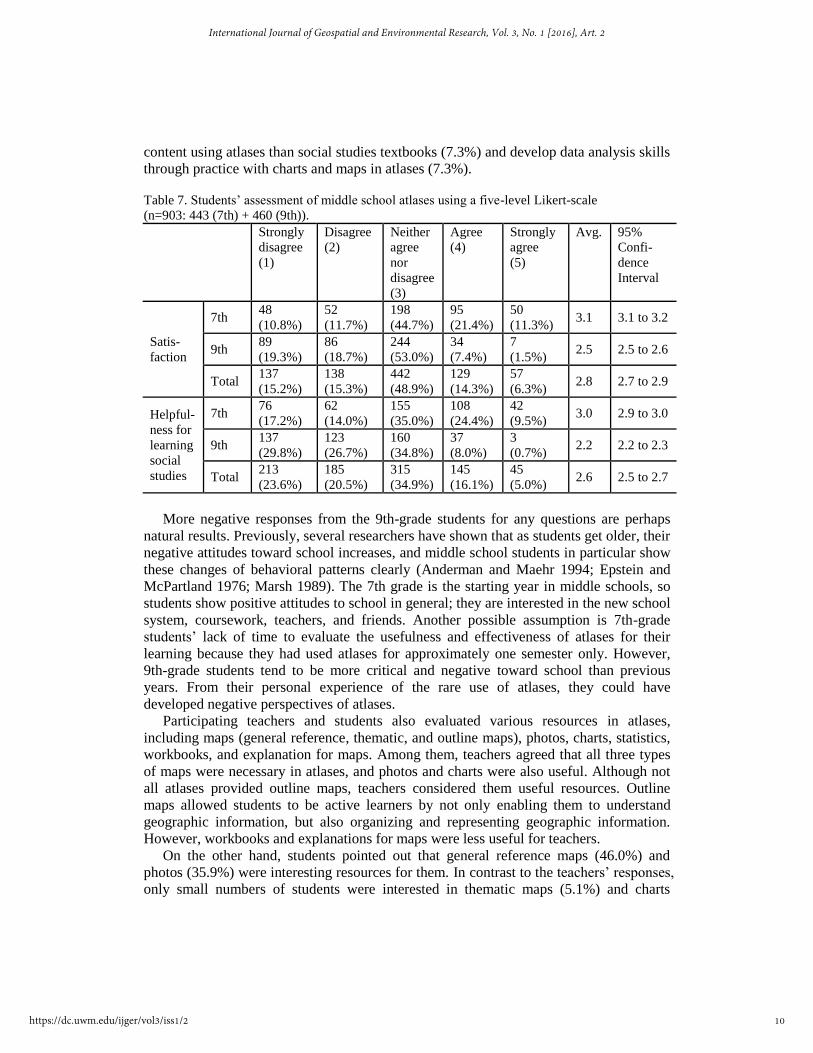
content using atlases than social studies textbooks (7.3%) and develop data analysis skills
through practice with charts and maps in atlases (7.3%).
Table 7. Students’ assessment of middle school atlases using a five-level Likert-scale
(n=903: 443 (7th) + 460 (9th)).
Strongly
disagree
(1)
Disagree
(2)
Neither
agree
nor
disagree
(3)
Agree
(4)
Strongly
agree
(5)
Avg. 95%
Confi-
dence
Interval
Satis-
faction
7th 48
(10.8%)
52
(11.7%)
198
(44.7%)
95
(21.4%)
50
(11.3%) 3.1 3.1 to 3.2
9th 89
(19.3%)
86
(18.7%)
244
(53.0%)
34
(7.4%)
7
(1.5%) 2.5 2.5 to 2.6
Total 137
(15.2%)
138
(15.3%)
442
(48.9%)
129
(14.3%)
57
(6.3%) 2.8 2.7 to 2.9
Helpful-
ness for
learning
social
studies
7th 76
(17.2%)
62
(14.0%)
155
(35.0%)
108
(24.4%)
42
(9.5%) 3.0 2.9 to 3.0
9th 137
(29.8%)
123
(26.7%)
160
(34.8%)
37
(8.0%)
3
(0.7%) 2.2 2.2 to 2.3
Total 213
(23.6%)
185
(20.5%)
315
(34.9%)
145
(16.1%)
45
(5.0%) 2.6 2.5 to 2.7
More negative responses from the 9th-grade students for any questions are perhaps
natural results. Previously, several researchers have shown that as students get older, their
negative attitudes toward school increases, and middle school students in particular show
these changes of behavioral patterns clearly (Anderman and Maehr 1994; Epstein and
McPartland 1976; Marsh 1989). The 7th grade is the starting year in middle schools, so
students show positive attitudes to school in general; they are interested in the new school
system, coursework, teachers, and friends. Another possible assumption is 7th-grade
students’ lack of time to evaluate the usefulness and effectiveness of atlases for their
learning because they had used atlases for approximately one semester only. However,
9th-grade students tend to be more critical and negative toward school than previous
years. From their personal experience of the rare use of atlases, they could have
developed negative perspectives of atlases.
Participating teachers and students also evaluated various resources in atlases,
including maps (general reference, thematic, and outline maps), photos, charts, statistics,
workbooks, and explanation for maps. Among them, teachers agreed that all three types
of maps were necessary in atlases, and photos and charts were also useful. Although not
all atlases provided outline maps, teachers considered them useful resources. Outline
maps allowed students to be active learners by not only enabling them to understand
geographic information, but also organizing and representing geographic information.
However, workbooks and explanations for maps were less useful for teachers.
On the other hand, students pointed out that general reference maps (46.0%) and
photos (35.9%) were interesting resources for them. In contrast to the teachers’ responses,
only small numbers of students were interested in thematic maps (5.1%) and charts
10
International Journal of Geospatial and Environmental Research, Vol. 3, No. 1 [2016], Art. 2
https://dc.uwm.edu/ijger/vol3/iss1/2

(4.7%). The results indicate that students were interested in easy-to-understand resources.
Students liked to use atlases to obtain location information from general reference maps
because identifying location information was relatively easier for middle school students
than understanding and analyzing the spatial distribution and patterns of the geographic
representation of a certain topic. In addition, students could understand photos easily
because most photos on atlases delivered information directly without the need for in-
depth analysis. Therefore, students were more interested in photos than thematic maps
and charts, which required analytical thinking. To increase students’ interest in atlases, it
is important to provide appropriate levels of resources and introduce resources gradually
based on their levels, from simple and straightforward to difficult and complex resources.
4.3 WHAT ARE WAYS OF IMPROVING MIDDLE SCHOOL ATLASES TO BE
USED IN CLASS MORE OFTEN?
To be necessary textbooks for social studies courses, teachers recommended that atlases
need to provide multimedia resources in a DVD format. These multimedia resources may
increase students’ interest and allow teachers to show them in the classroom easily. Some
teachers would like to see up-to-date resources to explain the most recent trends and
patterns. Since the content of atlases does not change annually, the dearth of recent
resources is problematic in this fast-changing world. Other teachers wanted to have easy-
to-understand maps for students because some maps were too difficult for middle school
students without a teacher’s explanation. As suggested by other studies, the ease of
understanding maps for middle school students would be increased by maps with small
numbers of symbols or classes, maps that do not represent multiple themes together, and
small scale-maps in a large size (Jung and Hwang 2006; Kang 2005; Lee and Kim 2000).
Additionally, teachers desired to see easy-to-follow organization and attractive design
(e.g., not providing too many resources on one page and using interesting illustrations to
increase students’ interest and motivation). They also wished to have more photos,
thematic maps, and charts in atlases. Teachers would like to see more workbooks in
atlases, although they agreed that workbooks were less useful than other types of
resources in atlases as described above.
Unlike teachers who recommended mainly content for atlases, students’
recommendations leaned too much towards the format and physical appearance of atlases.
Students would like for atlases to have interesting organization (45.6%), to be combined
with social studies textbooks (39.8%), and have reduced size (37.0%). Currently, each
publisher is free to choose the size of their atlases, so their sizes vary, from
approximately A4 (8.27 in × 11.7 in) to B4 (9.84 in × 13.9 in), and they are relatively
larger and heavier than other textbooks. Since teachers usually keep their atlases on their
desks, they do not feel uncomfortable about atlases’ large sizes and heavy weight. Instead,
teachers prefer large atlases for high legibility. However, students are dissatisfied with
the sizes and weight of atlases because some atlases do not fit in students’ desk drawers
and lockers, and they often need to bring atlases to schools. It may be better to reduce
their sizes slightly while maintaining legibility so that students can store or bring them
easily.
11
Hong and Lee: Korean middle school atlases
Published by UWM Digital Commons, 2016

Additionally, regarding content, students wished to have more easy-to-understand
maps (17.6%), up-to-date and reliable information (17.3%), and detailed maps for each
region (8.7%). Yet again, maps with appropriate levels for middle school students are
significant. Atlas publishers should consider designing maps with simple symbols,
simplifying and generalizing patterns, and not including too many themes in one map.
Several cartographic generalization methods (e.g., simplification, reclassification,
aggregation, and exaggeration) would be helpful to design proper maps for middle school
students. There were also students who needed more help with using atlases by having
additional time to learn how to use atlases and how to read maps (10.7%) and additional
explanations for maps (10.3%). Atlases briefly provide information about map symbols
and methods for searching for a location on maps. However, such brief information is not
enough for all students. A total of 27.2% of the students reported that they could not find
a region or certain information in atlases, and 43.4% of the students could not understand
maps and charts in atlases alone. Teachers also mentioned that they could not teach
students how to use atlases and read maps in detail because of limited class time and
infrequent use of atlases in class. A lack of instruction for atlases and maps in general
needs to be addressed to increase the use of atlases in class.
5. CONCLUSION
In South Korea, middle school atlases have been developed and designed for helping
students’ social studies learning, but the actual use of atlases in social studies class has
not met expectations. In this study, the authors conducted surveys with social studies
teachers and students to identify reasons for the limited use of middle school atlases in
Korean social studies classrooms. In reality, teachers’ use of atlases varied, from using
them in every class to not at all. Those teachers who did not use atlases frequently stated
that other multimedia and digital resources were more convenient and useful than atlases,
and atlases were sometimes not accessible because not all students brought them to class.
Meanwhile, students did not feel the need for atlases because atlases were rarely used in
class, so some students lost them or threw them away. Even if students kept their atlases,
it was inconvenient for them to bring atlases to school because they were large and heavy.
As a result, teachers’ infrequent classroom use of atlases and students’ negative
perspectives and opinions on atlases were closely related to each other. Thus, it is
important to think about ways of increasing the use of atlases in class by addressing both
groups’ opinions. Based on both teachers’ and students’ responses, we propose two
approaches for better use of atlases.
The first suggestion is developing a digital atlas that includes multimedia resources as
several teachers recommended. Previously, several researchers have suggested
developing a digital atlas as an alternative version of a paper-based atlas (Rystedt 1995;
Thomas et al. 1999). Specifically, Jeong and Shin (2007) developed a digital atlas for
high school geography class in South Korea using Esri’s ArcIMS, a web-based GIS
application. According to Jeong and Shin (2007), students in a class with a digital atlas
showed higher scores in tests and interest than students in a control group. In other words,
using a digital atlas can improve quality of geography learning by increasing students’
12
International Journal of Geospatial and Environmental Research, Vol. 3, No. 1 [2016], Art. 2
https://dc.uwm.edu/ijger/vol3/iss1/2

engagement in class and incorporating various spatial functions in GIS, although limited
access to computer technology may continue to be an issue (Jeong and Shin 2007). A
digital atlas can solve several identified obstacles to using current middle school atlases.
First, it can be easy to provide up-to-date information on a digital atlas, so teachers would
be able to introduce the most current information. As described earlier, one source of
teachers’ dissatisfaction was outdated resources for atlases because the content of atlases
has remained the same under the current version of the national curriculum. However, it
may be possible to update or modify information in a digital atlas when it is necessary.
Second, because there is no need to bring an atlas to the class, students would not
complain about the physical size and weight of atlases, and teachers can use it whenever
they need to. Simply converting paper-based atlases to digital ones would not solve all
the problems. For better use of digital atlases in class, it is important to provide an
appropriate level of resources for middle school students by adding input from a group of
students and teachers before publishing atlases.
The second suggestion is improving teachers’ expertise. The results of this study
showed that teachers’ lack of academic background in geography and maps can be one
factor for not using atlases frequently in their classrooms. Under the current teacher
qualification policy, both social sciences and geography majors with education training
can teach middle school social studies courses (Ministry of Education 2015). Since each
grade curriculum covers both geography and social sciences content, these teachers
should teach content knowledge areas that they have not professionally covered from
their education training. It has been serious issues in Korean middle school social studies
education (Jho 2006). The ideal solution would be the separation of geography and social
sciences into individual subjects and teaching one subject for each grade level (e.g.
geography for the 7th grade and social sciences for the 9th grade). That way, teachers can
teach their area of expertise, and it would be certainly helpful for students’ learning.
An additional solution for improving teachers’ expertise would be providing in-
service training for teachers with a social sciences background or any teachers who need
additional training. For teachers who do not have a background in maps in general,
training in basic cartographic principles and theory (e.g., scales, symbolization,
projections, and map design process) should be a priority. Such knowledge and
information is necessary when teachers teach students how to read maps and use atlases.
Once teachers learn about maps, they need to practice how to teach with maps, which
means “using maps to help students learn key social studies concepts and relationships,”
(Bednarz et al. 2006, p. 399) because knowing about maps does not guarantee effective
teaching with maps. When teachers are successful at teaching with maps, students may be
able to gain knowledge through maps and enhance their spatial thinking and problem-
solving skills (Bednarz et al. 2006).
Students are the main users of middle school atlases, and teachers can control the
actual use of atlases in classroom. Therefore, it is important to develop and design middle
school atlases based on teachers’ and students’ opinions and demands. Their suggestions
can ultimately lead to useful and effective atlases for students’ social studies learning.
REFERENCES
13
Hong and Lee: Korean middle school atlases
Published by UWM Digital Commons, 2016

Anderman, E. M. and Maehr, M. L. (1994) Motivation and schooling in the middle
grades. Review of educational Research, 64(2), 287-309.
Battersby, S. E., Mitchell, J. T. and Cutter, S. L. (2011) Development of an online
hazards atlas to improve disaster awareness. International Research in
Geographical and Environmental Education, 20(4), 297-308.
Bednarz, S. W. (2004) US world geography textbooks: Their role in education reform.
International Research in Geographical & Environmental Education, 13(3), 223-
238.
Bednarz, S. W., Acheson, G. and Bednarz, R. S. (2006) Maps and map learning in social
studies. Social Education, 70(7), 398-404, 432.
Epstein, J. L. and McPartland, J. M. (1976) The concept and measurement of the quality
of school life. American Educational Research Journal, 13(1), 15-30.
Harris, L. D. (1977) Lecturing from the atlas: An experiment in teaching. Journal of
Geography, 76(6), 211-214.
Jeong, J.-J. and Shin, E.-J. (2007) An application of the digital atlas for high school
geography class. The Geographical Journal of Korea, 41(3), 327-338.
Jho, D. (2006) The making of social studies education in Korea: Implications for
citizenship education [1]. Citizenship Teaching and Learning, 2(2), 21-36.
Jung, N.-A. and Hwang, C.-S. (2006) The analysis of thematic maps in the geography
textbook and the referenced school atlas. Journal of the Korean Cartographic
Association, 6(1), 25-33.
Kang, C.-S. (2006) The appropriateness of middle school atlas resources. Journal of the
Korean Cartographic Association, 6(1), 1-10.
———. (2005) Students’ understanding in the learning of middle school atlas resources.
Journal of the Korean Cartographic Association, 5(1), 21-29.
Keller, C. P., Hocking, D. and Wood, C. J. (1995) Planning the next generation of
regional atlases: Input from educators. Journal of Geography, 94(3), 412-418.
Klein, P. (2003) Active learning strategies and assessment in world geography classes.
Journal of Geography, 102(4), 146-157.
Koç, H. and Demir, S. B. (2014) Developing valid and reliable map literacy scale. Review
of International Geographical Education Online, 4(2), 120-137.
Korea Institute for Curriculum and Evaluation. (2011) Research reports.
http://www.kice.re.kr/resrchBoard/view.do?seq=29310&s=kice&m=030104.
Korean Statistical Information Service. (2010) Statistical database.
http://kosis.kr/eng/statisticsList/statisticsList_01List.jsp?vwcd=MT_ETITLE&pa
rmTabId=M_01_01.
Lee, J.-Y. and Kim, Y.-S. (2000) A comparative analysis of the contents and expression
system of the secondary school atlases. The Geographical Journal of Korea,
34(1), 13-25.
Lee, M.-Y. and Jung, I. (2009) The change of structure and contends of high school
student atlases responding to national curriculum. Journal of the Association of
Korean Photo-Geographers, 19(1), 97-113.
Marsh, H. W. (1989) Age and sex effects in multiple dimensions of self-concept:
Preadolescence to early adulthood. Journal of educational Psychology, 81(3),
417-430.
14
International Journal of Geospatial and Environmental Research, Vol. 3, No. 1 [2016], Art. 2
https://dc.uwm.edu/ijger/vol3/iss1/2

Ministry of Education. (2014) National academic achievement level examination results.
http://mest.go.kr/web/100026/ko/board/download.do?boardSeq=122088.
Moon, R. J. and Koo, J. W. (2011) Global citizenship and human rights: A longitudinal
analysis of social studies and ethics textbooks in the Republic of Korea.
Comparative Education Review, 55(4), 574-599.
National Curriculum Information Center. (2015) http://ncic.kice.re.kr/english.index.do.
Niedomysl, T., Elldér, E., Larsson, A., Thelin, M. and Jansund, B. (2013) Learning
benefits of using 2D versus 3D maps: Evidence from a randomized controlled
experiment. Journal of Geography, 112(3), 87-96.
Rystedt, B. (1995) Current trends in electronic atlas production. Cartographic
Perspectives, 20, 5-11.
Shin, H.-J. and Park, T.-H. (2003) An utilization analysis of middle school atlases. The
Geographical Journal of Korea, 37(3), 213-225.
Siheung City. (2013) History of Siheung. http://www.siheung.go.kr/english/History-of-
Siheung/.
Thomas, D. S., Mitchell, J. T., Scott, M. S. and Cutter, S. L. (1999) Developing a digital
atlas of environmental risks and hazards. Journal of Geography, 98(5), 201-207.
Weeden, P. (1997) Learning through maps. In Teaching and learning geography, eds. D.
Tilbury and M. Williams, pp. 168-179. London and New York: Routledge.
Wiegand, P. (2003) Educational cartography. International Research in Geographical
and Environmental Education, 12(4), 344-353.
15
Hong and Lee: Korean middle school atlases
Published by UWM Digital Commons, 2016