Embed Size (px)
Citation preview
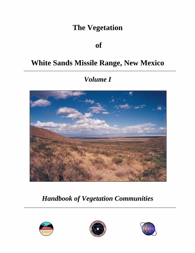
The Vegetation
of
White Sands Missile Range, New Mexico
Volume I
Handbook of Vegetation Communities
The Vegetation of White Sands Missile Range, New Mexico1
Volume I: Handbook of Vegetation Communities
Esteban Muldavin, Yvonne Chauvin, and Glenn Harper2
2000 ________________________________________________________________________________________________ SUMMARY A vegetation classification and a vegetation map from satellite imagery were developed for White Sands Missile Range of southern New Mexico to be used in environmental review (NEPA and Endangered Species Act) and for general natural resources planning. Volume I, Handbook of Vegetation Communities, outlines the vegetation classification for White Sands Missile Range and provides detailed ecological descriptions of the vegetation communities. Volume II presents a vegetation map of WSMR based on the vegetation classification along with details of map production, an annotated legend, and map unit descriptions. The vegetation classification presented in this volume is based on 1,739 ground survey points collected from 1991 through 1995. Using the species and environmental data from these plots, the classification was developed using agglomerative cluster analysis and table sorting techniques. It is structured in conformance with the National Vegetation Classification System data standard and the New Mexico Vegetation Classification. A total of 193 plant associations were described from among 52 Alliances. Of these, 71 were major associations with relatively wide distribution on White Sands Missile Range and typically were primary components or inclusions in map units presented in Volume II. An additional 122 were minor associations with limited mapped distributions. The majority of the plant associations (124) were well documented with data from White Sands Missile Range or elsewhere in the Southwest and are now considered established types in the NMNHP New Mexico Vegetation Classification. Sixty-nine remain provisional and are documented by less than five data plots, and there is little or no reference to them in the literature. Many of the provisional associations were new records for the state and Southwest. Each association was evaluated for its conservation status, and 22, mostly grassland associations were considered globally imperiled. Details of the classification are presented in handbook form with dichotomous keys for identification of associations in the field along with detailed descriptions of the vegetation composition, physical setting, and ecology. A complete list of species found during the survey is also provided along with a crosswalk to the map units of Volume II. This links the vegetation classification and vegetation map units in a comprehensive, ecology-based vegetation analysis system. The maps and vegetation classification are available in digital form and can be used in a geographic information system (GIS) as a powerful and dynamic tool for natural resources management applications. Cover: View of the Tularosa Basin from Workman Canyon (Yvonne Chauvin) 1Final Report for Cooperative Agreement No. 14-16-002-91-233 White Sands Missile Range, U.S. Fish and Wildlife Service, The Nature Conservancy, and the University of New Mexico. 2Esteban Muldavin, Principal Investigator and Ecologist, Yvonne Chauvin, Assistant Ecologist, and Glenn Harper, Assistant Ecologist are with New Mexico Natural Heritage Program (NMNHP), Biology Department, University of New Mexico, Albuquerque, New Mexico.

2
TABLE OF CONTENTS
INTRODUCTION .....................................................................................................................................3 Scope......................................................................................................................................................3 Background............................................................................................................................................3 Acknowledgements................................................................................................................................4
STUDY AREA ..........................................................................................................................................4 Location .................................................................................................................................................4 Climate...................................................................................................................................................4 Landscape ..............................................................................................................................................4 Vegetation..............................................................................................................................................6
METHODS................................................................................................................................................7 Field Sampling.......................................................................................................................................7
Sampling Strategy..............................................................................................................................7 Vegetation Plots .................................................................................................................................7
Data Processing and Analysis ................................................................................................................9 Database.............................................................................................................................................9 Vegetation Classification System ......................................................................................................9
Natural Heritage Conservation Ranking System .................................................................................10 RESULTS................................................................................................................................................12
Vegetation Community Classification .................................................................................................12 Conservation Status .........................................................................................................................13
Vegetation Keys and Descriptions.......................................................................................................25 Key to Major Sections (Classes) ......................................................................................................27
Woodlands ...........................................................................................................................................27 Oneseed Juniper Alliance ................................................................................................................29 Pinyon Pine Alliance .......................................................................................................................42 Ponderosa Pine Alliance ..................................................................................................................53
Shrublands and Dwarf Shrublands.......................................................................................................55 Montane and Chaparral Shrublands ...................................................................................................55
Gambel’s Oak Alliance....................................................................................................................56 Mountain Mahogany Alliance .........................................................................................................58 Shrub Live Oak Alliance .................................................................................................................68
Plains and Desert Shrubland and Dwarf Shrubland .............................................................................75 Catclaw Mimosa Alliance................................................................................................................77 Creosotebush Alliance .....................................................................................................................80 Fourwing Saltbush Alliance.............................................................................................................90 Hoary Rosemarymint Alliance ........................................................................................................94 Honey Mesquite Alliance ................................................................................................................96 Littleleaf Sumac Alliance ..............................................................................................................102 Mariola Alliance ............................................................................................................................105 Ocotillo Alliance............................................................................................................................107 Pickleweed Alliance ......................................................................................................................110 Sand Sagebrush Alliance ...............................................................................................................113 Tarbush Alliance............................................................................................................................118 Viscid Acacia Alliance ..................................................................................................................124
Grasslands..........................................................................................................................................128 Alkali Sacaton Alliance .................................................................................................................131 Black Grama Super Alliance .........................................................................................................134 Blue Grama SuperAlliance ............................................................................................................152 Curlyleaf Muhly Super Alliance....................................................................................................158 Gyp Dropseed Super Alliance .......................................................................................................162 Hairy Grama Super Alliance..........................................................................................................165 New Mexico Needlegrass Super Alliance .....................................................................................173 Sideoats Grama Alliance ...............................................................................................................179 Tobosagrass Alliance.....................................................................................................................183
Miscellaneous Plant Associations......................................................................................................186 REFERENCES ......................................................................................................................................188 APPENDIX A APPENDIX B
Deleted: 

3
INTRODUCTION
Scope White Sands Missile Range (WSMR) is a large military installation where the needs of many diverse and often intertwined missions must be met within the context of the nation's environmental laws. As one of the largest land withdrawals in the country (>2.14 million acres), it also harbors an exceptional degree of biological diversity—from big game herds to rare plants and fish. These biota inhabit a commensurate wide range of environments, from the dense woodlands of the mountaintops, down through wide expanses of grasslands to the desert shrublands of the arid basin floors. Size, coupled with the biodiversity, makes White Sands Missile Range an exceptional example of the biological "legacy" inherited by the Department of Defense, one that requires diligent management to ensure long-term sustainability. In an effort to fulfill baseline information needs for their natural resources management, White Sands Missile Range Environment and Safety Directorate enlisted the New Mexico Natural Heritage Program (NMNHP) to develop a vegetation classification and a map of current upland vegetation of WSMR (including San Andres National Wildlife Refuge and the NASA space center). The vegetation classification and map were designed to provide high quality biological data for use in environmental review and planning, as well as for various ongoing and future biological management projects. Specifically, the classification and map are to provide baseline data for compliance with environmental laws such as the National Environmental Policy Act (NEPA) and the Endangered Species Act (ESA), and they will also help meet inventory and classification requirements for natural resources management on US Army installations (e.g. AR 200-3 sections 2-2, 3-3 and 11-3). With this information, the White Sands Missile Range land managers will be better able to model and predict locations of sensitive species and fragile habitats, enhance wildlife management projects, and evaluate overall biodiversity status of the installation. There are two volumes to the report: Volume I, herein, is a handbook to the vegetation classification designed to provide natural resources managers information on vegetation types of White Sands Missile Range in a format that can be utilized both in field and planning applications. Not only does it contains detailed information on plant communities and habitats, but also ecological and management interpretations based on a ground survey of over 1,700 sample plots and information from the literature. Volume II is dedicated to the vegetation map and provides details of the production of the map along with map units descriptions. The map units (MUs) represent various combinations of vegetation communities described in detail below. Hence, by design, the map and classification are linked to maximize the use of ecological information in conjunction with spatial data to provide an advanced tool for natural resources management on White Sands Missile Range.
Background This was a multi-year project that ran from 1991 through 1996. Initially, a pilot study was conducted in 1991 and 1992 in which two remote sensing options were explored for developing a map of the existing vegetation of White Sands Missile Range: aerial photography and satellite imagery (Muldavin and Mehlhop 1992a & b). From results of that work, the satellite imagery approach was selected because of its analytical power and highly reduced costs (estimated 60% or more cost reduction over an aerial-photography interpreted map). In 1993, the NMNHP initiated a full-scale project to classify and map the vegetation of WSMR. The vegetation community classification and vegetation map were iteratively improved over a period of three field seasons (1993-95), as reported in various interim reports (Muldavin and Mehlhop 1994a, 1994b, 1996). A preliminary classification and vegetation map at the 1:100,000 scale were produced in July 1994 based on the data gathered from 1991 to 1993 (567 plots). Intermediate field maps at 1:24,000 scale were then derived from the preliminary 1:100,000 map to guide field sampling for the 1994 and 1995 seasons. These maps have been deposited with WSMR. A total of 1,739 vegetation plots were gathered on WSMR between 1991 and 1995. The distribution of plots against the backdrop of a Thematic Mapper satellite image is shown in Figure 1. In addition, during 1993 a vegetation map was developed for the National Park Service for White Sands National Monument that includes WSMR lands that at that time were jointly used by WSMR and the national monument (Muldavin et al. 1994). The data (243 plots) and map from that project were incorporated, where appropriate, into the development of the final classification and map of this project.
Deleted: 

4
Acknowledgements We wish to acknowledge the following individuals for their contributions: Mary Stuever, a consultant forester from Placitas, NM, made significant contributions in the first draft woodland community descriptions; Jamie Thompson, Becky Yaeger, Dave Tessler, Roby Wallace, Elizabeth Milford, and Steven Yanoff for their diligent and dedicated fieldwork; Sanam Radjy, Vince Archer, Teri Neville and Rebecca Keeshen contributed significantly to the analysis and report preparation. We are also grateful to the support of staffs at the New Mexico Natural Heritage Program and the Earth Data Analysis Center at the University of New Mexico. Lastly, we wish to thank the White Sands Missile Range for their commitment to and financial support of the project.
STUDY AREA
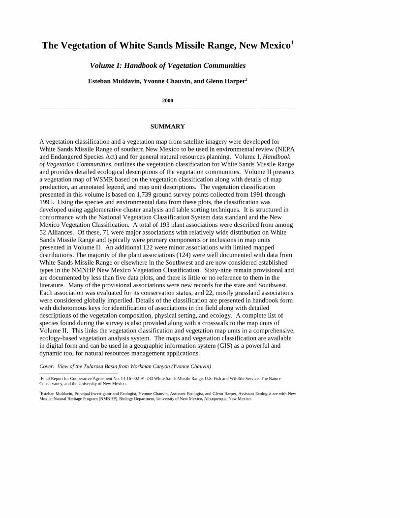
Location Located in south central New Mexico, the area encompasses 923,358 ha (2.14 million ac) of White Sands Missile Range excluding the buffer extension areas. It does include joint use and management areas of San Andres National Wildlife Refuge, the NASA Test Facility, White Sands National Monument, Holloman Air Force Base, and the USDA Jornada Experimental Range (Figure 1). The missile range forms an irregularly shaped rectangle approximately 60 km wide and 200 km long (35 by 125 miles).
Climate The climate of the study area ranges from arid high desert with less than 10 in (25 cm ) of precipitation in the basins to semi-arid conditions of 10-16 in (25 to 40 cm ) in the foothills and mountains, approaching temperate conditions at the highest elevations. The 5,000 ft (1,500 m ) elevation level generally marks the boundary between arid and semi-arid climates (Gile, Hawley, and Grossman 1981). Anderson and Taylor (1983) have summarized the climatic data for two WSMR weather stations. They report that the majority (64%) of the precipitation comes during the summer in the form of intense late-summer thunderstorms of short duration. Mean monthly temperatures range in the basins from minimums of 21° to 34°F (-6°C to 1°C ) in January to maximums of 92° to 93°F (33°C to 34°C ) in July. Extremes have been recorded at -16° F and 107°F (-26°C and 41°C ), along with diurnal fluxes of over 50°F (25°C ). Temperatures are generally cooler at the north end of the range (a degree further north in latitude). The average frost-free season is long; at the WSMR post it is about 250 days, from May 14 to November 20. Landscape The study area lies within the Bolson sub-section, Mexican Highlands section of the Basin and Range physiographic province. It is characterized by broad desert basins and discontinuous mountain ranges (Gile, Hawley, and Grossman 1981). The major mountain ranges are the San Andres and Oscuras which lie centrally and divide the study area into two major basins to the east and west. The San Andres Mountains are structurally a large west-tilted fault block that rises to a height of 8,968 ft (2733.4 m) at Salinas Peak. The mountain range is cuesta-like with precipitous escarpments facing east and long, gently dipping slopes to the west. To the east of the San Andres Mountains is the Tularosa basin, a corresponding down-faulted inter-mountain basin with a minimum elevation of 1,175 m (3,855 ft). A long piedmont slope leads from the base of the escarpment of the San Andres to the Tularosa basin floor, which is notable for its extensive alkali flats, coppice dune fields, gypsum lake deposits, and shifting dunes. The north end of the basin is partly covered by a Holocene basalt flow called the Carrizozo Malpais. To the west of the San Andres is the Jornada del Muerto basin, which is divided into two internally drained northern and southern basins with minimum elevations approaching 4,900 ft (1,495 m).
Deleted: 
5
Figure 1. Study area for the White Sands Missile Range showing distribution of sample points. Deleted: 

6
At the north end of WSMR are the smaller Oscura Mountains, which are also a cuesta-like, fault block similar to the San Andres but tilted to the east. The escarpment faces west with the corresponding long piedmont slope leading to the bottom of the northern Jornada del Muerto basin. To the east, slopes gently dip into the basin fill of the Tularosa Basin. Both ranges lie on Precambrian granites that are stratigraphically complex with intermixed limestone and sandstone strata ranging in age from Cambrian to Quaternary (Bachman 1968; Bachman and Harbour 1970). At the southern-most boundary of the study area is the northern end of the Organ Mountains, which are primarily Tertiary quartz monzonite derived from the Organ Batholith and Precambrian granites (Seager 1981). For the most part, they lack the fault-block structure and complex stratigraphy of the San Andres and Oscura ranges, but are more topographically diverse and rugged. With respect to maps, the geology of the southern third of WSMR has been mapped at the 1:125,000 scale by Seager et al. (1987). The northern San Andres and the Mockingbird Gap 15' Quadrangle have been mapped at 1:62,500 by Bachman and Harbour (1970) and Bachman (1968), respectively. Seager (1981) mapped in detail the geology of the very southern San Andres and Organ Mountains at 1:31,250. Hawley (1983) has provided detailed descriptions and maps of the geology of the Rhodes Canyon area. The soils of the study area have been mapped at the 1:100,000 scale by Neher and Bailey (1976). They identified 35 soil series mapped into 29 mapping units for the range. These delineations tend to be generalized and heterogeneous, with most soils falling into the Aridisol order from the Camborthid, Haplargid, Calciorthid, Paleorthid, and Gypsiorthid Great Groups. There were five Entisols and one Mollisol identified. Anderson and Taylor (1983) summarized the soil survey and reported that the most common series were Yesum and Holloman of gypsum flats (320,202 acres), along with 95,800 acres of gypsum duneland. There were 269,500 acres of Nikel and Tencee soils supporting desert shrublands of the alluvial fans. There are 613,035 acres of Hillslope Deama, Gilland and Lozier-Rock Outcrop Complexes plus Rockland, and an additional 40,700 acres of lava flows. Gile, Hawley, and Grossman (1981) gave an in-depth investigation of geology, geomorphology, and soils of the southern Jornada basin. Unless otherwise noted, we follow their terminology in describing landforms and geomorphic surfaces as they relate to the vegetation map units.
Vegetation Prior to this effort no systematic surveys of the vegetation had been conducted on WSMR. Vegetation information was limited to large-scale vegetation maps such as the 1:1,000,000 scale map by Donnart, Sylvester, and Hickey (1978) of the potential vegetation of New Mexico. Of the 90 association they describe for New Mexico, 11 are mapped as occurring on White Sands Missile Range: Mixed Grama-Rosette Shrub Association in the San Andres and Organ Mountains; Mixed Grama-Juniper and Mixed Grama in the Oscura Mountains; Creosotebush-Bush Muhly on the piedmont slope "bajadas"; Mixed Dropseeds-Black Grama and Black Grama-Mixed Dropseeds on lower slopes leading to the basin floors; and Sacaton-Tobosa and Fourwing Saltbush-Tobosa on the basin floors along with lava flows and gypsum dunes. Similarly, the 1:1,000,000 scale map of New Mexico Vegetation by Dick-Peddie (1993) is also generalized, but represents actual rather than potential vegetation. The San Andres Mountains are mapped as Montane Coniferous Forest, and Coniferous and Mixed Woodland; the Oscura Mountains as Juniper Savanna and Montane Scrub; the bajadas as Chihuahuan Desert Scrub and Desert Grassland; the basin bottoms as Closed Basin Scrub and Plains-Mesa Scrub, along with lava beds and gypsum dunes. The 1:1,000,000 map of Brown, Lowe, and Pase (1982) delineates similar broad categories. Comparatively, the vegetation classification and map presented below are an order of magnitude higher in resolution than the above work. The vegetation classification builds upon the vegetation types outlined by Dick-Peddie (1993) and Brown, Lowe, and Pase (1979) but provides significantly greater detail. The map in Volume II is presented at a scales of 1:100,000 and 1:50,000, rather than the 1:1,000,000 of previous work.
Deleted: 

7
METHODS
Field Sampling Sampling Strategy
The basis for development of the vegetation classification was the collection of detailed field vegetation plot data from 1991 to 1995. The goal was to cover as wide an area as possible in order to ensure that the range of variability among all habitats within White Sands Missile Range was sampled. To ensure wide coverage, 1:50,000 scale raw satellite imagery maps over the entire study area were developed and used to identify potential field plot locations based on spectral differences associated with general vegetation types, geomorphology, and soils. The preliminary vegetation classification developed during the pilot project of 1991 to 1993 over the Oscura Mountains provided the basis for subsequent intensive and comprehensive surveys over the remainder of the range. Targets were established for the number of replications of a given vegetation type depending on its distribution and abundance in the landscape. More common, widespread communities were sampled more often to capture the range of variation within a type for mapping purposes as well as classification. Minor communities were sampled less often, but with the goal of acquiring at least five quantitative plots to firmly establish a type. Field crews progressively worked through areas of the range and, as targets were met, sampling priorities were adjusted (within the constraints of range scheduling and security precautions). Vegetation Plots Following protocols laid out by Mueller-Dumbois and Ellenberg (1974) and Shimwell (1971), actual final plot selection was based on field reconnaissance and on-the-ground identification of large stands of homogeneous vegetation representing the vegetation types. In the field, sampling was often dictated by accessibility, both in terms of road condition, road blocks and range scheduling. Although many roads exist in the lowlands of the range, there are relatively few roads in the mountainous areas, particularly in the southern San Andres and northern Oscura Mountains (sampling was often achieved by extensive day hiking). Range scheduling excluded some sensitive areas from sampling; at other times the sampling targeted on a given day was in conflict with other range missions, and the resources to return to those areas were not available. Most plots are located at least 100 m away from roads or trails, and well within homogenous stands of vegetation at least one hectare or more in size. A total of 1,738 plots were established during the duration of the project, approximately 1 per 1,000 acres (Figure 1). There were three different types of plots that varied with respect to purpose and the amount of quantitative data collected: 1) Relevés (461). Circular or square 400-square-meter plots which were highly quantitative. They included a complete species list compiled not only for the plot, but for the surrounding stand as well. For species within the plot, canopy cover was visually estimated using a modified Domin-Krajina scale (Mueller-Dombois and Ellenberg 1974) that groups low-cover plants into narrower ranges than high-cover percentages (Table 1). This scale is advantageous when working in arid regions where cover values for plants are typically low, as it effects a finer resolution for low-cover plants. Several site characteristics were evaluated including slope, aspect, surficial geology, landform, percent surface soil, gravel, litter, cryptogam and plant basal area cover, disturbance evidence, landscape features, and adjacent communities and ecotones. In addition, a soil profile description was done following protocols of the National Soils Handbook (Soil Survey Staff, 1991). A general site description was written and documentary photographs taken. Relevés took a moderate amount of time (≅ 2 hours) because of the species detail, and were done to provide comprehensive floristic and soils definition to plant associations. 2) Standard plots (888). The same size and shape as relevés, but record only those species found within the plot boundary (a comprehensive species list for the remainder of the stand outside the plot was not compiled). Cover estimates were still made using the Domin-Krajina scale. Site characterization was sufficient for most mapping and plant association characterization and included the following attributes: slope shape, grade and aspect, surface soil texture and color, ground cover (percent rock, gravel, bare soil and litter and basal area), elevation, surface rock type, and erosion type along with a narrative description of the site and directions. A soil profile description was not done. Average time was 30 minutes. Deleted: 
8
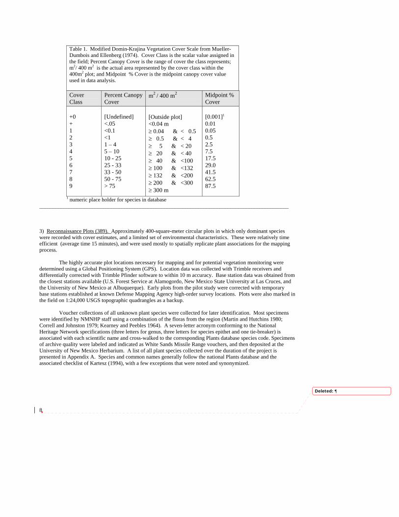
Table 1. Modified Domin-Krajina Vegetation Cover Scale from Mueller-Dumbois and Ellenberg (1974). Cover Class is the scalar value assigned in the field; Percent Canopy Cover is the range of cover the class represents; m2/ 400 m2 is the actual area represented by the cover class within the 400m2 plot; and Midpoint % Cover is the midpoint canopy cover value used in data analysis. Cover Class
Percent Canopy Cover
m2 / 400 m2
Midpoint % Cover
+0 + 1 2 3 4 5 6 7 8 9
[Undefined]
<.05 <0.1 <1 1 – 4 5 – 10 10 - 25 25 - 33 33 - 50 50 - 75 > 75
[Outside plot] <0.04 m ≥ 0.04 & < 0.5 ≥ 0.5 & < 4 ≥ 5 & < 20 ≥ 20 & < 40 ≥ 40 & <100 ≥ 100 & <132 ≥ 132 & <200 ≥ 200 & <300 ≥ 300 m
[0.001]1
0.01 0.05 0.5 2.5 7.5 17.5 29.0 41.5 62.5 87.5
1 numeric place holder for species in database ______________________________________________________________________________________________ 3) Reconnaissance Plots (389). Approximately 400-square-meter circular plots in which only dominant species were recorded with cover estimates, and a limited set of environmental characteristics. These were relatively time efficient (average time 15 minutes), and were used mostly to spatially replicate plant associations for the mapping process. The highly accurate plot locations necessary for mapping and for potential vegetation monitoring were determined using a Global Positioning System (GPS). Location data was collected with Trimble receivers and differentially corrected with Trimble Pfinder software to within 10 m accuracy. Base station data was obtained from the closest stations available (U.S. Forest Service at Alamogordo, New Mexico State University at Las Cruces, and the University of New Mexico at Albuquerque). Early plots from the pilot study were corrected with temporary base stations established at known Defense Mapping Agency high-order survey locations. Plots were also marked in the field on 1:24,000 USGS topographic quadrangles as a backup. Voucher collections of all unknown plant species were collected for later identification. Most specimens were identified by NMNHP staff using a combination of the floras from the region (Martin and Hutchins 1980; Correll and Johnston 1979; Kearney and Peebles 1964). A seven-letter acronym conforming to the National Heritage Network specifications (three letters for genus, three letters for species epithet and one tie-breaker) is associated with each scientific name and cross-walked to the corresponding Plants database species code. Specimens of archive quality were labeled and indicated as White Sands Missile Range vouchers, and then deposited at the University of New Mexico Herbarium. A list of all plant species collected over the duration of the project is presented in Appendix A. Species and common names generally follow the national Plants database and the associated checklist of Kartesz (1994), with a few exceptions that were noted and synonymized.
Deleted: 

9
Data Processing and Analysis Database All field data were entered into the NMNHP Ecology Database, which is PC-based and uses Microsoft Access relational database software. It is also linked to the National Heritage Network through the Biological and Conservation Database (BCD). The database includes tables that hold data on plot environmental and location (PLOT), species composition (PLOT FLORISTICS), and soils (SOHO), along with the vegetation classification (COMMUNITIES) and species lists (SPECIES FLORISTICS). The data was entered through customized error-checking forms and repeatedly reviewed to ensure minimum errors. Special queries and reports were developed that report this information in a readily accessible way. The database has been made available to White Sands Missile Range on an ongoing basis, and a final version is provided as a data addendum to the report on compact disk. Vegetation Classification System Each plot was classified according to the protocols and hierarchy of the International Classification of Ecological Communities and U.S. National Vegetation Classification System (Grossman et al. 1998) which is the U.S. geographic data standard (Table 2). In general, each plot was classified into an Alliance based on dominant or indicator species, and then to a particular Plant Association (PA) based on codominance and/or other groups of differential species. Phases of associations were assigned as necessary to further define the character of the plant community. Cluster analysis and canonical discriminant analysis were used to aid the identification and differentiation of communities (Ludwig and Reynolds 1988). Since the National Vegetation Classification (NVC) is intended to be part of a universal international system, it, by design, lacks regional categories such as "Chihuahuan Desert Scrub" or "Rocky Mountain Montane Coniferous Forest," which are part of regional and state classifications such as Brown, Lowe, and Pase (1979), Dick-Peddie (1993) or the U.S. Fish and Wildlife Gap Analysis Project classification for New Mexico (Thompson et al. 1996; Muldavin 1994). These regional "biomes" or "zones" are essentially floristically based and can be very useful for general analysis and planning. They conceptually reflect regional knowledge of broad vegetation types and serve as effective categories for communication among scientists, managers and the general public in the Southwest. The NMNHP, as part of the development of the statewide New Mexico Plant Community Classification, has incorporated the regional biome concept as a supplemental "Alliance Group" level in Table 2 between the Formation and Alliance of the NVC. It is based on the Gap classification Level IV with some modifications, which in turn draws upon Dick-Peddie (1993) and Brown, Lowe, and Pase (1979). Plant Associations are the fundamental unit of classification. Ecologists use the concept of plant association to help describe and recognize patterns in the way vegetation is occurs in the landscape. By grouping land areas based on the ability to support similar associations, general management observations and recommendations can be made for each grouping. In the past 30 years, resource managers have found that the classification of vegetation into plant associations has provided insight and ability to predict vegetation changes in response to various disturbance processes.
Deleted: 

10
Table 2. U.S. National Vegetation Classification physiognomic-floristic hierarchy for terrestrial vegetation (Grossman et al. 1998) with a supplemental Alliance Group level. Level Primary Basis for Classification Example Class Growth form and structure of vegetation Shrubland Subclass Growth form characteristics, e.g., leaf
phenology Deciduous Shrubland
Group Leaf types, corresponding to climate Cold-deciduous Woodland Subgroup Relative human impact Natural/Semi-natural Formation Additional physiognomic and
environmental factors Temperate Cold-deciduous Shrubland
Alliance Group Regional floristically and environmentally related Alliances
[Rocky Mountain/Great basin Montane Deciduous Scrub]
Alliance Dominant/diagnostic species of the uppermost or dominant stratum
Mountain Mahogany (Cercocarpus montanus)
Plant Association (Plant Association)
Additional dominant/diagnostic species from any stratum
Mountain Mahogany/New Mexico Muhly (Cercocarpus montanus/Muhlenbergia pauciflora )
_____________________________________________________________________________________________
Natural Heritage Conservation Ranking System
The Natural Heritage conservation status ranking system is a set of criteria used to rank species and natural communities according to their degree of vulnerability and imperilment (Grossman et al. 1998). Each species or natural community is considered an element of natural diversity, or simply an element. Developed by The Nature Conservancy in cooperation with the national Natural Heritage Network, the ranking system is used by all network data centers and all Conservancy offices, including the New Mexico Natural Heritage Program (NMNHP), as well as by various government agencies and other organizations to support the planning of conservation strategies.
Ranking is based on biological criteria and is applicable at various geographic levels (Table 5). Global element ranks are based on factors such as rarity; quality, condition and viability; size; and identifiable threats that face the community. Each element is assigned a single global (G) rank to indicate its relative degree of imperilment on a five-point scale (e.g., 1 = critically imperiled because of extreme rarity, 5 = demonstrably secure). The primary criteria for ranking community elements is the number of occurrences (the number of known distinct localities) and extant acreage. Also of importance are the size of the geographic range, trends in distribution, and the number of already protected occurrences. However, the emphasis remains on the number of occurrences, such that ranks are, in effect, an index of known biological rarity.
Each of the major Community Types in this wetland classification has been assigned a global and state conservation status rank. The Global ranks for "provisional" types are preliminary and must be reviewed by all programs in the Heritage network that report occurrences of the Community Type. However, it is up to the discretion of each Natural Heritage Program to assign state ranks (S-ranks) based on the same criteria as for the G-rank system. All final element ranks for each Community Type are then stored in the Central Databases of the Natural Heritage Network and updated annually through data exchanges with each Natural Heritage Program.
Deleted: 

11
Table 3. Conservation Status Global and State Element Ranks (G-rank/S-rank). The ranking criteria for evaluating conservation status based on Grossman et al. (1998). The global G-ranks are based on the range-wide status of a community; state ranks (S-ranks) follow the same criteria, but apply only to the within-state distribution.
Rank Definition G1 (S1) Critically Imperiled. Generally 5 or fewer occurrences, and/or very few remaining acres, or
very vulnerable to extinction throughout its range.
G2 (S2) Imperiled. Generally 6-20 occurrences and/or few remaining acres, or very vulnerable to elimination throughout its range.
G3 (S3) Vulnerable. Generally 21-100 occurrences. Either very rare and local throughout its range, or found locally, even abundantly, within a restricted range, or vulnerable to elimination throughout its range due to specific factors.
G4 (S4) Apparently Secure. Uncommon, but not rare (although possibly quite rare in parts of its range, especially at the periphery). Apparently not vulnerable in most of its range.
G5 (S5) Secure. Common, widespread and abundant. Not vulnerable in most of its range.
GH (SH) Presumed Eliminated (Historic) throughout its range, with virtually no likelihood of rediscovery, but with potential for restoration.
GX (SX) Eliminated throughout its range, with no restoration potential due to extinction of dominant or characteristic species.
GD (SD) Ruderal communities resulting from succession following significant human disturbance of an area.
GW (SW) Invasive, dominated by invasive alien species.
GM (SM) Modified/Managed communities resulting from management or modification of natural/near-natural vegetation.
GU Unrankable. Status can not be determined at this time.
G? Unranked. Status not yet determined. Modifiers and Rank Ranges ? When added to rank expresses an uncertainty about the rank in the range of 1 either way on
the 1-5 scale.
G#G# Greater uncertainty about rank is expressed by indicating the full range of ranks which may be appropriate (e.g., G1G4).
Q Denotes questionable taxonomy for the community.
______________________________________________________________________________________________
Deleted: 

12
RESULTS Vegetation Community Classification The plant communities of White Sands Missile Range are very diverse and numerous. A total of 193 plant associations were described from among 52 Alliances (Table 4). Of these, 71 were major associations with relatively wide distribution on WSMR and typically were primary components or inclusions in map units (see Appendix B for crosswalk to map units in Volume II). An additional 122 were minor types with limited mapped distributions. Primary components are commonly Major plant associations, but not necessarily. For example, a given map unit may have a limited coverage, and hence all of its primary components may be minor types in the classification. The majority of the plant associations (124) were well documented with data from WSMR or elsewhere in the Southwest and are now considered established types in the NMNHP New Mexico Vegetation Classification. Sixty-nine remain provisional and are documented by less than five data plots, and generally there is little or no reference to them in the literature. On WSMR, many of the provisional associations are new records for the state and Southwest. These provisional associations act as pointers for data gaps to be filled. Undoubtedly, in the future new associations will be found and old ones either confirmed or discarded based on new information. In this context, the classification is intended to be open-ended and flexible to allow for future modifications. Subsequent sections of this handbook provide details of the classification system outlined in Table 4. In summary, the vegetation patterns in general follow a definite elevation gradient. The upper elevations of the mountains support a combination of pinyon (Pinus edulis), juniper (Juniperus monosperma) woodlands that are representative of Rocky Mountain/Great Basin Lower Montane Foothill Conifer Woodland biome. Intermixed with the woodlands are evergreen oak (Quercus grisea and Q. turbinella) Interior Chaparral and Rocky Mountain/Great Basin Montane Deciduous Scrub represented by mountain mahogany (Cercocarpus montanus) and wavy-leaf oak (Quercus undulata) montane scrub. At the highest elevations, open ponderosa pine (Pinus ponderosa) forests and woodlands occur along with deciduous oak (Quercus gambelii) woodlands. Interspersed in the mountain valleys and on mid-elevation slopes are Plains-Mesa-Foothill grasslands dominated by blue, hairy, and sideoats grama (Bouteloua gracilis, B. hirsuta, and B. curtipendula) as well as western wheatgrass (Pascopyrum smithii), and New Mexico needlegrass (Stipa neomexicana ). These grasslands lack a significant shrub element and have strong affinities with the southern Short Grass Steppe grasslands of the Great Plains. Lower foothills and alluvial fans tend to support Chihuahuan Desert Grasslands dominated by various grama grasses, but particularly black grama (B. eriopoda) along with curlyleaf muhly (Muhlenbergia setifolia). In contrast to the former, these grasslands have a distinctive and conspicuous tall and dwarf shrub component represented by Chihuahuan Desert species such as common sotol (Dasylirion wheeleri), sacahuista (Nolina microcarpa), soaptree yucca (Yucca elata), mariola (Parthenium incanum), ocotillo (Fouquieria splendens), and Torrey's jointfir (Ephedra torreyana). Drainage ways contain some riparian forest and shrubland vegetation, particularly where water is perennially present. Interspersed among the desert grasslands of the foothills and piedmonts (bajadas) are a diversity of Chihuahuan Desert Shrublands. Viscid acacia (Acacia neomexicana) communities occur on the lower slopes of the inner canyons and escarpments. Extending away from the mountain fronts are large stands of creosotebush, acacia, and mimosa (Mimosa aculeaticarpa) intermixed with honey mesquite (Prosopis glandulosa) and tarbush (Flourensia cernua). The undergrowths of the desert scrub communities range from sparse to grassy with black grama, fluffgrass (Erioneuron pulchellus), and bush muhly (Muhlenbergia porteri). The lowest elevation basin floors also support extensive desert shrublands. There are the rolling sandy plains of the northern Jornada basin that support extensive Plains-Mesa Sandscrub dominated by sandsage (Artemisia filifolia) shrublands. There are also large depositional alluvial flats in the northern Jornada and Tularosa basin that are dominated by fourwing saltbush (Atriplex canescens) communities of Great Basin affinity. In the southern Tularosa and southern Jornada basins, honey mesquite, tarbush, and creosotebush prevail. Intermixed among the shrublands are lowland grasslands. On the heavy clay soils of basin bottoms, tobosagrass (Hilaria mutica) and alkali sacaton (Sporobolus airoides) dominate, while and mesa dropseed (Sporobolus flexulosus) and black grama dominate the sandy deposits. In the basins there are also large areas of gypsum dunes and outcrops that support unique vegetation communities dominated by gyp dropseed (Sporobolus nealleyi), gypsum grama (Bouteloua breviseta), and hairy coldenia (Tiquilia hispidissima). The waterways, springs, and wetlands of basin bottoms dominated by herbaceous wetland indicators such as American bullrush (Scirpus americanus), common reed (Phragmites australis), broadleaf cattail (Typha latifolia), salt cedar (Tamarisk ramosa), an exotic shrub from Eurasia.
Deleted: 
13
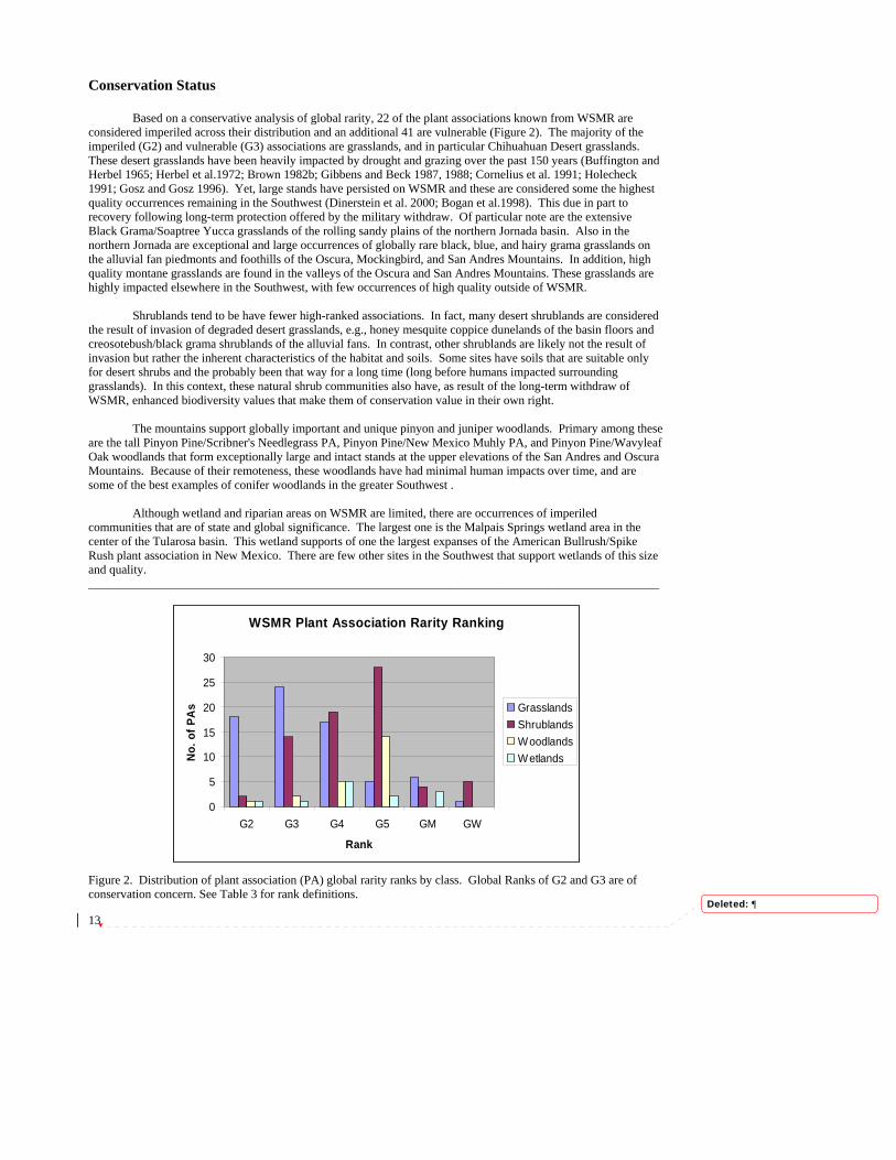
Conservation Status Based on a conservative analysis of global rarity, 22 of the plant associations known from WSMR are considered imperiled across their distribution and an additional 41 are vulnerable (Figure 2). The majority of the imperiled (G2) and vulnerable (G3) associations are grasslands, and in particular Chihuahuan Desert grasslands. These desert grasslands have been heavily impacted by drought and grazing over the past 150 years (Buffington and Herbel 1965; Herbel et al.1972; Brown 1982b; Gibbens and Beck 1987, 1988; Cornelius et al. 1991; Holecheck 1991; Gosz and Gosz 1996). Yet, large stands have persisted on WSMR and these are considered some the highest quality occurrences remaining in the Southwest (Dinerstein et al. 2000; Bogan et al.1998). This due in part to recovery following long-term protection offered by the military withdraw. Of particular note are the extensive Black Grama/Soaptree Yucca grasslands of the rolling sandy plains of the northern Jornada basin. Also in the northern Jornada are exceptional and large occurrences of globally rare black, blue, and hairy grama grasslands on the alluvial fan piedmonts and foothills of the Oscura, Mockingbird, and San Andres Mountains. In addition, high quality montane grasslands are found in the valleys of the Oscura and San Andres Mountains. These grasslands are highly impacted elsewhere in the Southwest, with few occurrences of high quality outside of WSMR.
Shrublands tend to be have fewer high-ranked associations. In fact, many desert shrublands are considered the result of invasion of degraded desert grasslands, e.g., honey mesquite coppice dunelands of the basin floors and creosotebush/black grama shrublands of the alluvial fans. In contrast, other shrublands are likely not the result of invasion but rather the inherent characteristics of the habitat and soils. Some sites have soils that are suitable only for desert shrubs and the probably been that way for a long time (long before humans impacted surrounding grasslands). In this context, these natural shrub communities also have, as result of the long-term withdraw of WSMR, enhanced biodiversity values that make them of conservation value in their own right.
The mountains support globally important and unique pinyon and juniper woodlands. Primary among these are the tall Pinyon Pine/Scribner's Needlegrass PA, Pinyon Pine/New Mexico Muhly PA, and Pinyon Pine/Wavyleaf Oak woodlands that form exceptionally large and intact stands at the upper elevations of the San Andres and Oscura Mountains. Because of their remoteness, these woodlands have had minimal human impacts over time, and are some of the best examples of conifer woodlands in the greater Southwest .
Although wetland and riparian areas on WSMR are limited, there are occurrences of imperiled communities that are of state and global significance. The largest one is the Malpais Springs wetland area in the center of the Tularosa basin. This wetland supports of one the largest expanses of the American Bullrush/Spike Rush plant association in New Mexico. There are few other sites in the Southwest that support wetlands of this size and quality. _____________________________________________________________________________________________ Figure 2. Distribution of plant association (PA) global rarity ranks by class. Global Ranks of G2 and G3 are of conservation concern. See Table 3 for rank definitions.
Deleted: 
WSMR Plant Association Rarity Ranking
0
5
10
15
20
25
30
G2 G3 G4 G5 GM GW
Rank
No.
of P
As Grasslands
ShrublandsWoodlandsWetlands

14
Table 4. Hierarchical vegetation classification for White Sands Missile Range, New Mexico. The hierarchy is based on the National Vegetation Classification System of Grossman et al. (1998) and Anderson et al. (1998). The upper four levels are Class, Subclass, Group, and Subgroup. A supplemental Regional Alliance Group level has been inserted at the fifth level. Level six is the Alliance followed by Plant Association (see text for details). The classification status (S) of each plant association is indicated as either Established (E) with at least five well-documented occurrences on WSMR or elsewhere, or as Provisional (P) and in need of further documentation. The relative importance (I) of each association on White Sands Missile Range is indicated as either Major or Minor. Rank refers to the conservation status of each plant association in terms of rarity and imperilment as specified by Anderson et al. (1998). See Table 3 for rank definitions.
VEGETATION S I Rank II WOODLAND II.A Evergreen woodland II.A.4 Temperate or subpolar needle-leaved evergreen woodland II.A.4.N.a Rounded-crowned temperate or subpolar needle-leaved evergreen woodland Rocky Mountain Lower Montane Conifer Woodland Ponderosa Pine Woodland (Forest) Alliance Ponderosa Pine/Arizona Fescue (Pinus ponderosa/Festuca arizonica: PINPON/FESARI) E Major G4 Rocky Mountain/Great Basin Lower Montane Foothill Conifer Woodland Oneseed Juniper Woodland Alliance Oneseed Juniper/Banana Yucca (Juniperus monosperma/Yucca baccata: JUNMON/YUCBAC) E Minor G5 Oneseed Juniper/Black Grama (Juniperus monosperma/Bouteloua eriopoda: JUNMON/BOUERI) E Major G4 Oneseed Juniper/Blue Grama (Juniperus monosperma/Bouteloua gracilis: JUNMON/BOUGRA) E Major G5 Oneseed Juniper/Curlyleaf Muhly (Juniperus monosperma/Muhlenbergia setifolia: JUNMON/MUHSET) E Major G4 Oneseed Juniper/Hairy Grama (Juniperus monosperma/Bouteloua hirsuta: JUNMON/BOUHIR) E Major G5 Oneseed Juniper/Mountain Mahogany (Juniperus monosperma/Cercocarpus montanus: JUNMON/CERMON) E Major G5 Oneseed Juniper/New Mexico Muhly (Juniperus monosperma/Muhlenbergia pauciflora: JUNMON/MUHPAU) E Major G5 Oneseed Juniper/New Mexico Needlegrass (Juniperus monosperma/Stipa neomexicana: JUNMON/STINEO) E Major G4 Oneseed Juniper/Prairie Junegrass (Juniperus monosperma/Koeleria macrantha: JUNMON/KOEMAC) P Minor G? Oneseed Juniper/Sand Dropseed (Juniperus monosperma/Sporobolus cryptandrus: JUNMON/SPOCRY) P Minor G? Oneseed Juniper/Shrub Live Oak (Juniperus monosperma/Quercus turbinella: JUNMON/QUETUR) P Minor G? Oneseed Juniper/Sideoats Grama (Juniperus monosperma/Bouteloua curtipendula: JUNMON/BOUCUR) E Major G5 Oneseed Juniper/Sparse Undergrowth (Juniperus monosperma/Sparse: JUNMON/SPARSE) E Minor G5 Pinyon Pine Woodland Alliance Pinyon Pine/Banana Yucca (Pinus edulis/Yucca baccata: PINEDU/YUCBAC) E Minor G5 Pinyon Pine/Blue Grama (Pinus edulis/Bouteloua gracilis: PINEDU/BOUGRA) E Major G5 Pinyon Pine/Curlyleaf Muhly (Pinus edulis/Muhlenbergia setifolia: PINEDU/MUHSET) E Minor G3G4 Pinyon Pine-Gambel's Oak (Pinus edulis-Quercus gambelii: PINEDU-QUEGAM) E Minor G5 Pinyon Pine/Mountain Mahogany (Pinus edulis/Cercocarpus montanus: PINEDU/CERMON) E Major G5

15
Table 4. Hierarchical vegetation classification for White Sands Missile Range, New Mexico (continued). VEGETATION S I Rank
Pinyon Pine/Mountain Muhly (Pinus edulis/Muhlenbergia montana: PINEDU/MUHMON) P Minor G3G4? Pinyon Pine/New Mexico Muhly (Pinus edulis/Muhlenbergia pauciflora: PINEDU/MUHPAU) E Major G4 Pinyon Pine/Scribner's Needlegrass (Pinus edulis/Stipa scribneri: PINEDU/STISCR) E Major G2 Pinyon Pine/Sideoats Grama (Pinus edulis/Bouteloua curtipendula: PINEDU/BOUCUR) P Major G5? Pinyon Pine/Sparse Undergrowth (Pinus edulis/Sparse : PINEDU/SPARSE) E Minor G5 Pinyon Pine/Wavyleaf Oak (Pinus edulis/Quercus undulata: PINEDU/QUEUND) E Major G5 II.B Deciduous woodland II.B.2 Cold-deciduous woodland II.B.2.N.b Temporarily flooded cold-deciduous woodland Lowland Interior Southwest Broad-leaved Deciduous Forested Wetland Netleaf Hackberry Woodland Alliance Netleaf Hackberry-Velvet Ash (Celtis laevigata var. reticulata-Fraxinus velutina: CELLAER-FRAVEL) P Minor G3G4? III SHRUBLAND III.A Evergreen shrubland III.A.2 Temperate broad-leaved evergreen shrubland III.A.2.N.c Sclerophyllous temperate broad-leaved evergreen shrubland Interior Chaparral Shrub Live Oak Shrubland Alliance Shrub Live Oak/Pine Muhly (Quercus turbinella/Muhlenbergia dubia: QUETUR/MUHDUB) P Minor G4? Shrub Live Oak/Prairie Junegrass (Quercus turbinella/Koeleria macrantha: QUETUR/KOEMAC) P Minor G4? Shrub Live Oak/Sideoats Grama (Quercus turbinella/Bouteloua curtipendula: QUETUR/BOUCUR) E Major G5 Shrub Live Oak/Thin Paspalum (Quercus turbinella/Paspalum setaceum: QUETUR/PASSET) P Minor G3? III.A.4 Microphyllous evergreen shrubland III.A.4.N.a Microphyllous evergreen shrubland Plains-Mesa Microphyllous Sand Scrub Broom Dalea Shrubland Alliance Broom Dalea/Mesa Dropseed (Psorothamnus scoparius/Sporobolus flexuosus: PSOSCO/SPOFLE) E Minor G5 Sand Sage Shrubland Alliance Sand Sagebrush/Alkali Sacaton (Artemisia filifolia/Sporobolus airoides: ARTFIL/SPOAIR) P Minor G4? Sand Sagebrush/Black Grama (Artemisia filifolia/Bouteloua eriopoda: ARTFIL/BOUERI) E Major G3 Sand Sagebrush/Blue Grama (Artemisia filifolia/Bouteloua gracilis: ARTFIL/BOUGRA) P Minor G3? Sand Sagebrush/Galleta (Artemisia filifolia/Hilaria jamesii: ARTFIL/HILJAM) E Minor G3

16
Table 4. Hierarchical vegetation classification for White Sands Missile Range, New Mexico (continued). VEGETATION S I Rank
Sand Sagebrush/Indian Ricegrass (Artemisia filifolia/Oryzopsis hymenoides: ARTFIL/ORYHYM) P Minor G4? Sand Sagebrush/Mesa Dropseed (Artemisia filifolia/Sporobolus flexuosus: ARTFIL/SPOFLE) E Major G3 III.A.5 Extremely xeromorphic evergreen shrubland III.A.5.N.a Broad-leaved and microphyllous evergreen extremely xeromorphic subdesert shrubland Chihuahuan Evergreen Desert Scrub Creosotebush Shrubland Alliance Creosotebush/Alkali Sacaton (Larrea tridentata/Sporobolus airoides: LARTRI/SPOAIR) E Major G5
Creosotebush/Black Grama (Larrea tridentata/Bouteloua eriopoda: LARTRI/BOUERI) E Major G3 Creosotebush/Burrograss (Larrea tridentata/Scleropogon brevifolius: LARTRI/SCLBRE) E Minor GW Creosotebush/Bush Muhly (Larrea tridentata/Muhlenbergia porteri: LARTRI/MUHPOR) E Major G3 Creosotebush/Fluffgrass (Larrea tridentata/Erioneuron pulchellum: LARTRI/ERIPUL) E Major G5 Creosotebush-Hairy Coldenia (Larrea tridentata/Tiquilia hispidissima: LARTRI-TIQHIS) P Minor G4? Creosotebush-Mariola (Larrea tridentata-Parthenium incanum: LARTRI-PARINC) E Major G5? Creosotebush/Mesa Dropseed (Larrea tridentata/Sporobolus flexuosus: LARTRI/SPOFLE) E Major G4 Creosotebush/Sparse Undergrowth (Larrea tridentata/Sparse: LARTRI/SPARSE) E Major G5 Creosotebush-Tarbush/Sparse Undergrowth (Larrea tridentata-Flourensia cernua/Sparse: LARTRI-FLOCER/SPARSE)
E Minor G5
III.A.5.N.b Facultatively deciduous extremely xeromorphic subdesert shrubland Great Basin Broad-leaved Desert Scrub Fourwing Saltbush Shrubland Alliance Fourwing Saltbush/Alkali Sacaton (Atriplex canescens/Sporobolus airoides: ATRCAN/SPOAIR) E Major G5 Fourwing Saltbush/Burrograss (Atriplex canescens/Scleropogon brevifolius: ATRCAN/SCLBRE) E Minor GW Fourwing Saltbush/Bush Muhly (Atriplex canescens/Muhlenbergia porteri: ATRCAN/MUHPOR) E Minor G4 Fourwing Saltbush/Gyp Dropseed (Atriplex canescens/Sporobolus nealleyi: ATRCAN/SPONEA) E Major G5 Fourwing Saltbush-James' Seaheath (Atriplex canescens-Frankenia jamesii: ATRCAN-FRAJAM) P Minor G? Fourwing Saltbush/Mesa Dropseed (Atriplex canescens/Sporobolus flexuosus: ATRCAN/SPOFLE) P Minor G5? Fourwing Saltbush/Sparse Undergrowth (Atriplex canescens/Sparse: ATRCAN/SPARSE) P Minor G5? III.A.5.N.c Succulent extremely xeromorphic evergreen shrubland Lowland Desert Shrubland

17
Table 4. Hierarchical vegetation classification for White Sands Missile Range, New Mexico (continued). VEGETATION S I Rank
Pickleweed Shrubland Alliance Pickleweed/Alkali Sacaton (Allenrolfea occidentalis/Sporobolus airoides: ALLOCC/SPOAIR) P Minor G5? Pickleweed-Hairy Coldenia (Allenrolfea occidentalis-Tiquilia hispidissima: ALLOCC-TIQHIS) P Minor G4? Pickleweed/Sparse Undergrowth (Allenrolfea occidentalis/Sparse: ALLOCC/SPARSE) E Major G5 Pickleweed/Spreading Alkaliweed (Allenrolfea occidentalis/Cressa truxillensis: ALLOCC/CRETRU) E Minor G4 Pickleweed/Transpecos Sealavender (Allenrolfea occidentalis/Limonium limbatum: ALLOCC/LIMLIM) P Minor G3? III.B Deciduous shrubland III.B.2 Cold-deciduous shrubland III.B.2.N.a Temperate cold-deciduous shrubland Rocky Mountain/Great Basin Montane Deciduous Scrub Gambel Oak Shrubland Alliance Gambel's Oak/Prairie Junegrass (Quercus gambelii/Koeleria macrantha: QUEGAM/KOEMAC) P Minor G3? Gambel's Oak/Whortleleaf Snowberry (Quercus gambelii/Symphoricarpos oreophilus: QUEGAM/SYMORE) E Minor G5 Mountain Mahogany Shrubland Alliance Mountain Mahogany/Black Grama (Cercocarpus montanus/Bouteloua eriopoda: CERMON/BOUERI) P Minor G? Mountain Mahogany/Blue Grama (Cercocarpus montanus/Bouteloua gracilis: CERMON/BOUGRA) E Minor G5 Mountain Mahogany/Curlyleaf Muhly (Cercocarpus montanus/Muhlenbergia setifolia: CERMON/MUHSET) E Major G4? Mountain Mahogany/New Mexico Muhly (Cercocarpus montanus/Muhlenbergia pauciflora: CERMON/MUHPAU) E Major G? Mountain Mahogany/New Mexico Needlegrass (Cercocarpus montanus/Stipa neomexicana: CERMON/STINEO) E Major G4? Mountain Mahogany/Plains Lovegrass (Cercocarpus montanus/Eragrostis intermedia: CERMON/ERAINT) E Major G? Mountain Mahogany-Sacahuista (Cercocarpus montanus-Nolina microcarpa: CERMON-NOLMIC) E Minor G5? Mountain Mahogany/Sideoats Grama (Cercocarpus montanus/Bouteloua curtipendula: CERMON/BOUCUR) E Minor G5 Mountain Mahogany-Wavyleaf Oak (Cercocarpus montanus-Quercus undulata: CERMON-QUEUND) P Minor G4 III.B.2.N.d. Temporarily Flooded Cold-deciduous Shrubland Lowland Exotic Needle-leaved Deciduous Scrub-Shrub Wetland Saltcedar Temporarily Flooded Shrubland Alliance Saltcedar/Alkali Sacaton (Tamarix ramosissima/Sporobolus airoides: TAMRAM/SPOAIR) P Minor GM Saltcedar/Pickleweed (Tamarix ramosissima/Allenrolfea occidentalis: TAMRAM/ALLOCC) P Minor GM Saltcedar/Utah Swampfire (Tamarix ramosissima/Sarcocornia utahensis: TAMRAM/SARUTA) P Minor GM III.B.3 Extremely xeromorphic deciduous shrubland III.B.3.N.a Extremely xeromorphic deciduous subdesert shrubland without succulents Chihuahuan Deciduous Desert Scrub Catclaw Mimosa Shrubland Alliance
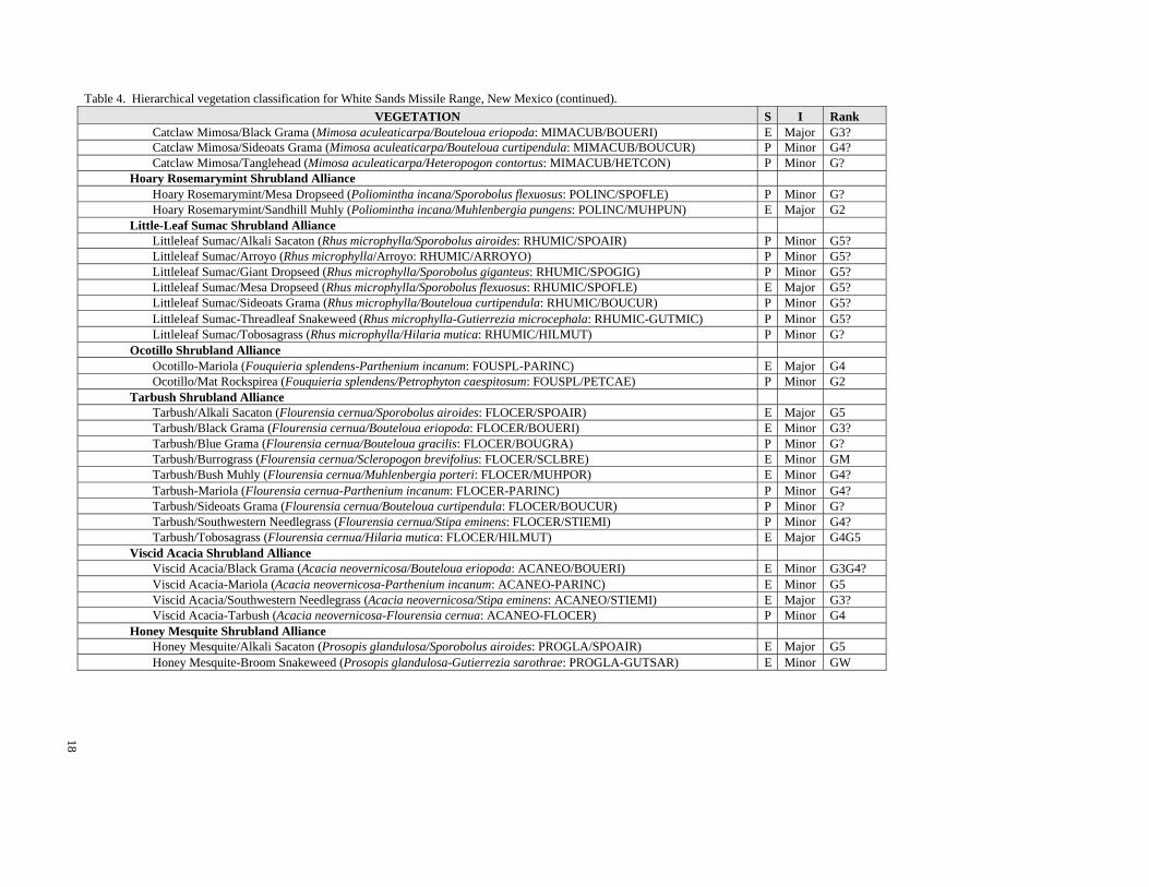
18
Table 4. Hierarchical vegetation classification for White Sands Missile Range, New Mexico (continued). VEGETATION S I Rank
Catclaw Mimosa/Black Grama (Mimosa aculeaticarpa/Bouteloua eriopoda: MIMACUB/BOUERI) E Major G3? Catclaw Mimosa/Sideoats Grama (Mimosa aculeaticarpa/Bouteloua curtipendula: MIMACUB/BOUCUR) P Minor G4? Catclaw Mimosa/Tanglehead (Mimosa aculeaticarpa/Heteropogon contortus: MIMACUB/HETCON) P Minor G? Hoary Rosemarymint Shrubland Alliance Hoary Rosemarymint/Mesa Dropseed (Poliomintha incana/Sporobolus flexuosus: POLINC/SPOFLE) P Minor G? Hoary Rosemarymint/Sandhill Muhly (Poliomintha incana/Muhlenbergia pungens: POLINC/MUHPUN) E Major G2 Little-Leaf Sumac Shrubland Alliance Littleleaf Sumac/Alkali Sacaton (Rhus microphylla/Sporobolus airoides: RHUMIC/SPOAIR) P Minor G5? Littleleaf Sumac/Arroyo (Rhus microphylla/Arroyo: RHUMIC/ARROYO) P Minor G5? Littleleaf Sumac/Giant Dropseed (Rhus microphylla/Sporobolus giganteus: RHUMIC/SPOGIG) P Minor G5? Littleleaf Sumac/Mesa Dropseed (Rhus microphylla/Sporobolus flexuosus: RHUMIC/SPOFLE) E Major G5? Littleleaf Sumac/Sideoats Grama (Rhus microphylla/Bouteloua curtipendula: RHUMIC/BOUCUR) P Minor G5? Littleleaf Sumac-Threadleaf Snakeweed (Rhus microphylla-Gutierrezia microcephala: RHUMIC-GUTMIC) P Minor G5? Littleleaf Sumac/Tobosagrass (Rhus microphylla/Hilaria mutica: RHUMIC/HILMUT) P Minor G? Ocotillo Shrubland Alliance Ocotillo-Mariola (Fouquieria splendens-Parthenium incanum: FOUSPL-PARINC) E Major G4 Ocotillo/Mat Rockspirea (Fouquieria splendens/Petrophyton caespitosum: FOUSPL/PETCAE) P Minor G2 Tarbush Shrubland Alliance Tarbush/Alkali Sacaton (Flourensia cernua/Sporobolus airoides: FLOCER/SPOAIR) E Major G5 Tarbush/Black Grama (Flourensia cernua/Bouteloua eriopoda: FLOCER/BOUERI) E Minor G3? Tarbush/Blue Grama (Flourensia cernua/Bouteloua gracilis: FLOCER/BOUGRA) P Minor G? Tarbush/Burrograss (Flourensia cernua/Scleropogon brevifolius: FLOCER/SCLBRE) E Minor GM Tarbush/Bush Muhly (Flourensia cernua/Muhlenbergia porteri: FLOCER/MUHPOR) E Minor G4? Tarbush-Mariola (Flourensia cernua-Parthenium incanum: FLOCER-PARINC) P Minor G4? Tarbush/Sideoats Grama (Flourensia cernua/Bouteloua curtipendula: FLOCER/BOUCUR) P Minor G? Tarbush/Southwestern Needlegrass (Flourensia cernua/Stipa eminens: FLOCER/STIEMI) P Minor G4? Tarbush/Tobosagrass (Flourensia cernua/Hilaria mutica: FLOCER/HILMUT) E Major G4G5 Viscid Acacia Shrubland Alliance Viscid Acacia/Black Grama (Acacia neovernicosa/Bouteloua eriopoda: ACANEO/BOUERI) E Minor G3G4? Viscid Acacia-Mariola (Acacia neovernicosa-Parthenium incanum: ACANEO-PARINC) E Minor G5 Viscid Acacia/Southwestern Needlegrass (Acacia neovernicosa/Stipa eminens: ACANEO/STIEMI) E Major G3? Viscid Acacia-Tarbush (Acacia neovernicosa-Flourensia cernua: ACANEO-FLOCER) P Minor G4 Honey Mesquite Shrubland Alliance Honey Mesquite/Alkali Sacaton (Prosopis glandulosa/Sporobolus airoides: PROGLA/SPOAIR) E Major G5 Honey Mesquite-Broom Snakeweed (Prosopis glandulosa-Gutierrezia sarothrae: PROGLA-GUTSAR) E Minor GW

19
Table 4. Hierarchical vegetation classification for White Sands Missile Range, New Mexico (continued). VEGETATION S I Rank
Honey Mesquite/Burrograss (Prosopis glandulosa/Scleropogon brevifolius: PROGLA/SCLBRE) P Minor GW Honey Mesquite/Bush Muhly (Prosopis glandulosa/Muhlenbergia porteri: PROGLA/MUHPOR) E Minor GM Honey Mesquite-Fourwing Saltbush (Prosopis glandulosa-Atriplex canescens: PROGLA-ATRCAN) E Major GM Honey Mesquite/Mesa Dropseed (Prosopis glandulosa/Sporobolus flexuosus: PROGLA/SPOFLE) E Major GM Honey Mesquite-Threadleaf Snakeweed (Prosopis glandulosa-Gutierrezia microcephala: PROGLA-GUTMIC) P Minor GW Honey Mesquite/Tobosagrass (Prosopis glandulosa/Hilaria mutica: PROGLA/HILMUT) E Minor G5 Wright's Beebrush Shrubland Alliance Wright's Beebrush/Lava (Aloysia wrightii/Lava: ALOWRI/LAVA) P Minor G? III.B.3.N.b Intermittently flooded extremely xeromorphic deciduous subdesert shrubland Southwest Arroyo Riparian Shrublands Apacheplume Shrubland Alliance Apacheplume/Arroyo (Fallugia paradoxa/Arroyo: FALPAR/ARROYO) P Minor G4 IV Dwarf-shrubland IV.A Evergreen dwarf-shrubland IV.A.2 Extremely xeromorphic evergreen dwarf-shrubland IV.A.2.N.a Extremely xeromorphic evergreen subdesert dwarf-shrubland Chihuahuan Evergreen Desert Dwarf Shrubland Mariola Shrubland Alliance Mariola-Pricklyleaf Dogweed (Parthenium incanum-Thymophylla acerosa: PARINC-THYACE) E Minor G5 Mariola/Sideoats Grama (Parthenium incanum/Bouteloua curtipendula: PARINC/BOUCUR) P Minor G3? V Herbaceous Vegetation [GRASSLAND] V.A Perennial graminoid vegetation V.A.5 Temperate or subpolar grassland V.A.5.N.b Tall bunch temperate grassland Chihuahuan Lowland/Swale Desert Grassland--Tall Grass Giant Sacaton Herbaceous Alliance Giant Sacaton/Monotypic Stand (Sporobolus wrightii/Monotypic: SPOWRI/MONTYP) E Minor G2 V.A.5.N.d Medium-tall bunch temperate or subpolar grassland Lowland/Swale Medium-tall Desert Grassland Alkali Sacaton Herbaceous Alliance Alkali Sacaton-Burrograss (Sporobolus airoides-Scleropogon brevifolius: SPOAIR-SCLBRE) E Major GM

20
Table 4. Hierarchical vegetation classification for White Sands Missile Range, New Mexico (continued). VEGETATION S I Rank
Alkali Sacaton/Monotypic Stand (Sporobolus airoides/Monotypic: SPOAIR/MONTYP) E Major G5 New Mexico Bluestem Herbaceous Alliance New Mexico Bluestem-Sandhill Muhly (Schizachyrium neomexicanus-Muhlenbergia pungens:SCHNEO-MUHPUN) P Minor G3G4? Tobosa Herbaceous Alliance Tobosagrass-Alkali Sacaton (Hilaria mutica-Sporobolus airoides: HILMUT-SPOAIR) E Major G5 Tobosagrass-Blue Grama (Hilaria mutica-Bouteloua gracilis: HILMUT-BOUGRA) E Minor G? Tobosagrass-Burrograss (Hilaria mutica-Scleropogon brevifolius: HILMUT-SCLBRE) E Minor GM Tobosagrass/Monotypic Stand (Hilaria mutica/Monotypic: HILMUT/MONTYP) E Minor G5 Plains-Mesa-Foothill Medium-tall Grassland Curlyleaf Muhly Herbaceous Alliance Curlyleaf Muhly-Black Grama (Muhlenbergia setifolia-Bouteloua eriopoda: MUHSET-BOUERI) P Minor G3? Curlyleaf Muhly-Blue Grama (Muhlenbergia setifolia-Bouteloua gracilis: MUHSET-BOUGRA) P Minor G3? Curlyleaf Muhly-Hairy Grama (Muhlenbergia setifolia-Bouteloua hirsuta: MUHSET-BOUHIR) E Minor G3? Curlyleaf Muhly-New Mexico Needlegrass (Muhlenbergia setifolia-Stipa neomexicana: MUHSET-STINEO) E Minor G3? New Mexico Needlegrass Herbaceous Alliance New Mexico Needlegrass-Black Grama (Stipa neomexicana-Bouteloua eriopoda: STINEO-BOUERI) E Major G3? New Mexico Needlegrass-Blue Grama (Stipa neomexicana-Bouteloua gracilis: STINEO-BOUGRA) E Minor G3? New Mexico Needlegrass-Hairy Grama (Stipa neomexicana-Bouteloua hirsuta: STINEO-BOUHIR) E Major G3? New Mexico Needlegrass-Sideoats Grama (Stipa neomexicana-Bouteloua curtipendula: STINEO-BOUCUR) E Major G3? Sideoats Grama Herbaceous Alliance Sideoats Grama-Cane Bluestem (Bouteloua curtipendula-Bothriochloa barbinodis: BOUCUR-BOTBAR) P Minor G4 Sideoats Grama-Prairie Junegrass (Bouteloua curtipendula-Koeleria macrantha: BOUCUR-KOEMAC) E Minor G4 V.A.5.N.e Short sod temperate or subpolar grassland Great Basin Short Grassland James' Galleta Herbaceous Alliance Galleta-Alkali Sacaton (Hilaria jamesii/Sporobolus airoides: HILJAM-SPOAIR) P Minor G3G4? V.A.5.N.f Short bunch temperate or subpolar grassland Chihuahuan Lowland/Swale Short Desert Grassland Burrograss Herbaceous Alliance Burrograss/Monotypic Stand (Scleropogon brevifolius/Monotypic: SCLBRE/MONTYP) E Minor GW Gyp Dropseed Herbaceous Alliance Gyp Dropseed-Alkali Sacaton (Sporobolus nealleyi-Sporobolus airoides: SPONEA-SPOAIR) E Minor G4? Gypsum Grama Herbaceous Alliance

21
Table 4. Hierarchical vegetation classification for White Sands Missile Range, New Mexico (continued). VEGETATION S I Rank
Gypsum Grama-New Mexico Bluestem (Bouteloua breviseta-Schizachyrium neomexicanum:BOUBRE-SCHNEO) E Minor G2G3 Plains-Mesa-Foothill Short Grassland Black Grama Herbaceous Alliance Black Grama-Alkali Sacaton (Bouteloua eriopoda-Sporobolus airoides: BOUERI-SPOAIR) P Minor G3? Black Grama-Blue Grama (Bouteloua eriopoda-Bouteloua gracilis: BOUERI-BOUGRA) E Major G2 Black Grama-Cane Bluestem (Bouteloua eriopoda-Bothriochloa barbinodis: BOUERI-BOTBAR) E Major GM Black Grama-Purple Threeawn (Bouteloua eriopoda-Aristida purpurea: BOUERI-ARIPUR) E Minor GM Black Grama-Sideoats Grama (Bouteloua eriopoda-Bouteloua curtipendula: BOUERI-BOUCUR) E Major G2 Blue Grama Herbaceous Alliance Blue Grama-Alkali Sacaton (Bouteloua gracilis-Sporobolus airoides: BOUGRA-SPOAIR) E Major G4? Blue Grama-Burrograss (Bouteloua gracilis-Scleropogon brevifolius: BOUGRA-SCLBRE) P Minor GM Blue Grama-Cane Bluestem (Bouteloua gracilis-Bothriochloa barbinodis: BOUGRA-BOTBAR) P Minor GM Blue Grama/Monotypic Stand (Bouteloua gracilis/Monotypic: BOUGRA/MONTYP) E Minor G5 Blue Grama-New Mexico Muhly (Bouteloua gracilis-Muhlenbergia pauciflora: BOUGRA-MUHPAU) P Minor G3? Blue Grama-Sideoats Grama (Bouteloua gracilis-Bouteloua curtipendula: BOUGRA-BOUCUR) E Major G5 Blue Grama-Western Wheatgrass (Bouteloua gracilis-Pascopyrum smithii: BOUGRA-PASSMI) E Major G2 Hairy Grama Herbaceous Alliance Hairy Grama-Black Grama (Bouteloua hirsuta-Bouteloua eriopoda: BOUHIR-BOUERI) E Major G2 Hairy Grama-Blue Grama (Bouteloua hirsuta-Bouteloua gracilis: BOUHIR-BOUGRA) E Minor G3G4 Hairy Grama-Sideoats Grama (Bouteloua hirsuta-Bouteloua curtipendula: BOUHIR-BOUCUR) E Major G4 V.A.5.N.j Temporarily flooded temperate or subpolar grassland Lowland Seasonally/Temporarily Flooded Grassland Common Reed Seasonally Flooded Herbaceous Alliance Common Reed-Inland Saltgrass (Phragmites australis/Distichlis spicata: PHRAUS-DISSPI) P Minor G4? Inland Saltgrass Intermittently Flooded Herbaceous Alliance Inland Saltgrass-Alkali Sacaton (Distichlis spicata-Sporobolus airoides: DISSPI-SPOAIR) P Minor G4? Inland Saltgrass/Monotype (Distichlis spicata/Monotype: DISSPI/MONTYP) E Minor G5 V.A.5.N.l Semipermanently flooded temperate or subpolar grassland Lowland Persistent Emergent Wetland, Semipermanently Flooded American Bulrush Semipermanently Flooded Herbaceous Alliance American Bulrush/Alkali Muhly (Scirpus americanus-Muhlenbergia asperifolia: SCIAME/MUHASP) P Minor G4? American Bulrush-Common Spikerush (Scirpus americanus-Eleocharis palustris: SCIAME-ELEPAL) E Minor G2G4 American Bulrush Monotypic Stand (Scirpus americanus/Monotype: SCIOLN/MONTYP) P Minor G4?

22
Table 4. Hierarchical vegetation classification for White Sands Missile Range, New Mexico (continued). VEGETATION S I Rank
Broadleaf Cattail Herbaceous Alliance Broadleaf Cattail/Monotypic Stand (Typha latifolia/Monotype: TYPLAT/MONTYP) E Minor G5 V.A.7 Temperate or subpolar grassland with a sparse shrub layer V.A.7.N.h Medium-tall temperate grassland with a sparse xeromorphic (often thorny) shrub layer Chihuahuan Desert Medium Tall Grassland with Shrubs Curlyleaf Muhly Shrub Herbaceous Alliance Curlyleaf Muhly/Bigelow's Sagebrush (Muhlenbergia setifolia/Artemisia bigelovii: MUHSET/ARTBIG) P Minor G4? Curlyleaf Muhly/Common Sotol (Muhlenbergia setifolia/Dasylirion wheeleri: MUHSET/DASWHE) E Major G4 Curlyleaf Muhly/Mariola (Muhlenbergia setifolia/Parthenium incanum: MUHSET/PARINC) P Minor G4? Curlyleaf Muhly/Ocotillo (Muhlenbergia setifolia/Fouquieria splendens: MUHSET/FOUSPL) P Minor G4? Mesa Dropseed Shrub Herbaceous Alliance Mesa Dropseed/Soaptree Yucca (Sporobolus flexuosus/Yucca elata: SPOFLE/YUCELA) E Minor G2 Mesa Dropseed-Spike Dropseed (Sporobolus flexuosus-Sporobolus contractus: SPOFLE-SPOCON) P Minor G3? Mesa Dropseed/Torrey's Jointfir (Sporobolus flexuosus/Ephedra torreyana: SPOFLE/EPHTOR) E Minor G2 New Mexico Needlegrass Shrub Herbaceous Alliance New Mexico Needlegrass/Common Sotol (Stipa neomexicana/Dasylirion wheeleri: STINEO/DASWHE) E Major G3? New Mexico Needlegrass/Sacahuista (Stipa neomexicana/Nolina microcarpa: STINEO/NOLMIC) P Minor G3? Sideoats Grama Shrub Herbaceous Alliance Sideoats Grama/Common Sotol (Bouteloua curtipendula/Dasylirion wheeleri: BOUCUR/DASWHE) E Major G3 Sideoats Grama/Ocotillo (Bouteloua curtipendula/Fouquieria splendens: BOUCUR/FOUSPL) E Minor G3 Sideoats Grama/Sacahuista (Bouteloua curtipendula/Nolina microcarpa: BOUCUR/NOLMIC) E Minor G4? V.A.7.N.m Short temperate or subpolar grassland with a sparse xeromorphic (evergreen and/or deciduous) shrub layer
Chihuahuan Desert Short Grass Grassland with Shrubs Black Grama Xeromorphic Shrub Herbaceous Alliance Black Grama/Apacheplume (Bouteloua eriopoda/Fallugia paradoxa: BOUERI/FALPAR) P Minor G? Black Grama/Banana Yucca (Bouteloua eriopoda/Yucca baccata: BOUERI/YUCBAC) E Minor G2 Black Grama-Blue Grama/Banana Yucca (Bouteloua eriopoda-Bouteloua gracilis/Yucca baccata: BOUERI-BOUGRA/YUCBAC)
E Major G2
Black Grama-Blue Grama/Soaptree Yucca (Bouteloua eriopoda-Bouteloua gracilis/Yucca elata: BOUERI-BOUGRA/YUCELA)
E Major G2
Black Grama/Common Sotol (Bouteloua eriopoda/Dasylirion wheeleri: BOUERI/DASWHE) E Major G3 Black Grama/Longleaf Jointfir (Bouteloua eriopoda/Ephedra trifurca: BOUERI/EPHTRI) E Major G2

23
Table 4. Hierarchical vegetation classification for White Sands Missile Range, New Mexico (continued). VEGETATION S I Rank
Black Grama/Ocotillo (Bouteloua eriopoda/Fouquieria splendens: BOUERI/FOUSPL) E Major G3 Black Grama/Sacahuista (Bouteloua eriopoda/Nolina microcarpa: BOUERI/NOLMIC) P Minor G4 Black Grama/Skeletonleaf Goldeneye (Bouteloua eriopoda/Viguiera stenoloba: BOUERI/VIGSTE) E Major G4? Black Grama/Soaptree Yucca (Bouteloua eriopoda/Yucca elata: BOUERI/YUCELA) E Major G2 Blue Grama Shrub Herbaceous Alliance Blue Grama/Banana Yucca (Bouteloua gracilis/Yucca baccata: BOUGRA/YUCBAC) E Minor G2? Blue Grama/Soaptree Yucca (Bouteloua gracilis/Yucca elata: BOUGRA/YUCELA) E Minor G2? Hairy Grama Shrub Herbaceous Alliance Hairy Grama/Common Sotol (Bouteloua hirsuta/Dasylirion wheeleri: BOUHIR/DASWHE) E Minor G3 Hairy Grama/Sacahuista (Bouteloua hirsuta/Nolina microcarpa: BOUHIR/NOLMIC) E Major G4? Hairy Grama/Soaptree Yucca (Bouteloua hirsuta/Yucca elata: BOUHIR/YUCELA) E Major G2? Great Basin Desert Short Grassland with Shrubs) Galleta Shrub Herbaceous Alliance Galleta/Soaptree Yucca (Hilaria jamesii/Yucca elata: HILJAM/YUCELA) P Minor G2? V.A.8 Temperate or subpolar grassland with a sparse dwarf-shrub layer V.A.8.N.a Short temperate or subpolar lowland grassland with a sparse needle-leaved or microphyllous dwarf-shrub layer
Chihuahuan Desert Short Grass Grassland with Dwarf-Shrubs Black Grama Dwarf-shrub Herbaceous Alliance Black Grama/Bigelow's Sagebrush (Bouteloua eriopoda/Artemisia bigelovii: BOUERI/ARTBIG) P Minor G? Black Grama-Blue Grama/Bigelow's Sagebrush (Bouteloua eriopoda-Bouteloua gracilis/Artemisia bigelovii: BOUERI-BOUGRA/ARTBIG)
E Minor G4?
Black Grama/Mariola (Bouteloua eriopoda/Parthenium incanum: BOUERI/PARINC) E Major G3 Black Grama/Torrey's Jointfir (Bouteloua eriopoda/Ephedra torreyana: BOUERI/EPHTOR) E Major G2 Blue Grama Dwarf-shrub Herbaceous Alliance Blue Grama/Bigelow's Sagebrush (Bouteloua gracilis/Artemisia bigelovii: BOUGRA/ARTBIG) P Minor G4? Blue Grama/Winterfat (Bouteloua gracilis/Krascheninnikovia lanata: BOUGRA/KRALAN2) E Minor G4 Gyp Dropseed Dwarf Shrub Herbaceous Alliance Gyp Dropseed/Hairy Coldenia (Sporobolus nealleyi/Tiquilia hispidissima: SPONEA/TIQHIS) E Major G3 Gyp Dropseed/Torrey's Jointfir (Sporobolus nealleyi/Ephedra torreyana: SPONEA/EPHTOR) P Minor G3? Hairy Grama Dwarf-Shrub Herbaceous Alliance Hairy Grama/Featherplume (Bouteloua hirsuta/Dalea formosa: BOUHIR/DALFOR) E Major G4 Sideoats Grama Dwarf Shrub Herbaceous Alliance Sideoats Grama/Featherplume (Bouteloua curtipendula/Dalea formosa: BOUCUR/DALFOR) E Minor G4

24
Table 4. Hierarchical vegetation classification for White Sands Missile Range, New Mexico (continued). VEGETATION S I Rank
VII Sparse Vegetation Barren (Barren: BARREN) VII.B Boulder, gravel, cobble, or talus sparse vegetation VII.C. Unconsolidated material, sparse vegetation VII.C.1 Sparsely vegetated sand dunes VII.C.1.N.a Dunes with sparse vegetation Barren Dune (Barren Dune: BARREN/DUNE) VII.C.4. Sparsely vegetated soil flats VII.C.4.N.b. Intermittently flooded mud flats Barren Flat (Barren Flat: BARREN/FLAT) VII.C.4.N.c Seasonally/temporarily flooded mud flats Barren Flat (Barren Flat: BARREN/FLAT)

25
Vegetation Keys and Descriptions The classification is described in detail below in a structured handbook format of dichotomous keys and
descriptions. This structured approach allows the utilization of classification in the field and in various management applications in a clear and concise manner. The keys represent a set of decision rules that specify the limits of each category. As with most vegetation classification systems, this classification attempts to define "typic" or modal concepts of vegetation communities, with an understanding that there will be much variation within communities, as well as "ecotones" where transitions occur between communities across the landscape. In addition, there are also "successional ecotones," where stands of vegetation progress from one association to the next through time as a function of disturbance, or lack of it. Accurate identification of the plant association is dependent on careful application of the dichotomous keys, and comparison of the plant community with the community description. Several of the plant associations are provisional or new, lacking the quantity of data to consider the description as an “established” plant association. If one is unable to key out a plant community, it is possible that association has yet to be described. When a plant association does not fit any community description, it is better to call it “unidentified” or “unknown” than to make it fit into the classification. These cases often become the basis for later modification of the classification. To use the keys, select a portion of the area that best represents the vegetation you are trying to classify. Avoid edges of the community, or areas of extreme disturbance. Community types are more confidently identified with larger homogenous areas, as small fragmented stands have less plant diversity. Identify the key indicator plant species, noting the approximate cover composition of these plants within the plant community. Although it is not necessary to identify all the species to identify the plant association, the user should be familiar with field identification of key plants mentioned in the plant associations names, the keys, and descriptions (a full species list is provided in Appendix A). Grouping plant observations into vegetation layers of trees, shrubs, and herbaceous plants aids in the use of the keys and community descriptions. The first dichotomous key breaks vegetation into the four "sections" corresponding more or less to the Class headings of Woodlands, Shrublands, and Grasslands, along with a separate sections for Wetland/Riparian communities and a Miscellaneous category that contains incidental types that do not yet merit full description as alliances or plant associations. Although woodlands and shrublands both contain woody species, the prevailing concept for woodlands is that trees generally have single (or only a few) boles, and are at least five meters high, or can achieve that in their lifespan. Shrublands have more of a thicket growth form with multi-stemmed shrubs that are generally less than three meters high. For situations in between these conditions, the key may need to be worked through both woodlands and shrublands to find the proper community description. When the specifications for tree and shrub cover are not met for either a woodland or a shrubland, then the Alliance is considered herbaceous and commonly dominated by grasses or grass-like plants (graminoids). Within each section there are keys to the alliances. To simplify presentation, alliances with the same dominant species are grouped together under one heading and key step, and are ordered alphabetically within each section (e.g., Black Grama Herbaceous Alliance without shrubs is grouped with the Black Grama Shrub Herbaceous Alliance under a single Black Grama Alliance heading with an associated key step). There is a summary description for each alliance followed by a key to the Plant Associations (PAs). Full descriptions for the major plant associations follow this key and are ordered alphabetically within the alliance. They include narratives on species composition, environmental conditions, and ecological discussions based on the stands used to develop this classification and information from the literature. The general and White Sands Missile Range distributions are addressed along with dot maps of plot locations. Tables of average, maximum, and minimum values for slope, elevation, and solar index are provided. The solar index uses the cosine transformation of aspect where 0.0 = northeast aspect and 2.0 = southwest. Summary tables of the cover values for the major species found in each plant association are provided. Soil taxons are listed based on available soil profile descriptions and follow the Soil Taxonomy (Soil Survey Staff. 1992). Minor associations have less supporting data, and descriptions are limited to brief summary paragraphs.

26
Many of the couplets in the class and alliance keys involve estimating the dominant vegetative cover using the qualitative descriptors or site characteristics, such as specific alluvial surfaces. Standardized descriptors representing percent canopy cover are defined in Table 5 and are based on Moir and Carleton (1987). Once the proper alliance key has been worked through to find the plant association, the description should be read and compared with the stand being classified to see if it is compatible with field observations. Often, several plant associations may seem reasonable in the key, but a close study of plant association descriptions will narrow the field down to the correct type. Plant associations can also be keyed and identified later if a standard vegetation plot is used following the guidelines of the NMNHP Vegetation Survey Handbook (provided as a supplement on compact disk), or similar plot data with adequate canopy cover estimates. In fact, using the plot method can help the keying process and provide a quantitative documentation for the process.
The emphasis is on the Alliance and Plant Association level with full descriptions of each major alliance
and association. Hence, within each section alliances and plant association keys and descriptions are ordered alphabetically by common name. These include information on distribution (with dot maps), composition, habitat characteristics, ecology, and management implications. Abbreviated descriptions are provided for each minor association.
_____________________________________________________________________________________________
Table 5. Text descriptors for canopy cover and density with associated quantitative ranges definitions. Descriptor Definition Absent
Individuals are not found in stand.
Present Individuals found in stand. Accidental Individuals very infrequent, occasional, or limited to special
microsites. Scarce Canopy coverage < 1%. Common Canopy coverage > 1%. Poorly Represented Canopy coverage < 5%. Well Represented Canopy coverage >5%, but less than 25%. Abundant Canopy coverage > 25%, but less than 50%. Luxuriant Canopy coverage > 50%. Dominant Cover is greater than any other species of the same life form. Codominant Cover is as great as any other species of the same life form. Regeneration Understory trees represented by established seedlings, saplings.
_____________________________________________________________________________________________
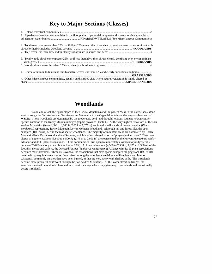
27
Key to Major Sections (Classes) 1. Upland terrestrial communities..........................................................................................................................2 1. Riparian and wetland communities in the floodplains of perennial or ephemeral streams or rivers, and in, or adjacent to, water bodies ............................ ............RIPARIAN/WETLANDS (See Miscellaneous Communities) 2. Total tree cover greater than 25%, or if 10 to 25% cover, then trees clearly dominant over, or codominant with, shrubs or herbs (includes woodland savanna) .. ............................................................................ WOODLANDS 2. Tree cover less than 10% and/or clearly subordinate to shrubs and herbs ........................................................3 3. Total woody shrub cover greater 25%, or if less than 25%, then shrubs clearly dominant over, or codominant with, grasses .............................................................................................................................SHRUBLANDS 3. Woody shrubs cover less than 25% and clearly subordinate to grasses.............................................................4 4. Grasses common to luxuriant; shrub and tree cover less than 10% and clearly subordinate to herbs .................
...............................................................................................................................................GRASSLANDS 4. Other miscellaneous communities, usually on disturbed sites where natural vegetation is highly altered or absent.....................................................................................................................................MISCELLANEOUS
Woodlands Woodlands cloak the upper slopes of the Oscura Mountains and Chupadera Mesa in the north, then extend south through the San Andres and San Augustine Mountains to the Organ Mountains at the very southern end of WSMR. These woodlands are dominated by the moderately cold- and drought-tolerant, rounded-crown conifer species common to the Rocky Mountain biogeographic province (Table 6). At the very highest elevations of the San Andres Mountains (from 6,800 to 8,760 ft; 2,075 to 2,675 m) are found small stands of ponderosa pine (Pinus ponderosa) representing Rocky Mountain Lower Montane Woodland. Although tall and forest-like, the open canopies (10% cover) define them as sparse woodlands. The majority of mountain areas are dominated by Rocky Mountain/Great Basin Woodland and Savanna, which is often referred to as the "pinyon-juniper zone." The cooler slopes of upper elevations (5,800 to 8,500 ft; 1,775 m to 2,600 m) are represented by the Pinyon Pine (Pinus edulis) Alliance and its 11 plant associations. These communities form open to moderately closed canopies (generally between 25-60% canopy cover, but as low as 10%). At lower elevations (4,500 to 7,500 ft; 1,375 to 2,300 m) of the foothills, mesas and valleys, the Oneseed Juniper (Juniperus monosperma) Alliance with its 13 plant associations becomes more prevalent. These are savanna-like associations that have sparse canopies ranging from 10% to 40% cover with grassy inter-tree spaces. Intermixed among the woodlands are Montane Shrublands and Interior Chaparral, commonly on sites that have been burned, or that are very rocky with shallow soils. The shrublands become more prevalent southward through the San Andres Mountains. At the lower elevation fringes, the woodlands extend onto alluvial fans and into interior valleys where they give way to grasslands and occasionally desert shrubland.

28
Table 6 National Vegetation Classification of woodlands.
II Woodland II.A Evergreen woodland II.A.4 Temperate or subpolar needle-leaved evergreen woodland II.A.4.N.a Rounded-crowned temperate or subpolar needle-leaved evergreen woodland Rocky Mountain Lower Montane Conifer Woodland Ponderosa Pine Woodland (Forest) Alliance Rocky Mountain/Great Basin Lower Montane Foothill Conifer Woodland Oneseed Juniper Woodland Alliance Pinyon Pine Woodland Alliance II.B Deciduous woodland II.B.2 Cold-deciduous woodland II.B.2.N.b Temporarily flooded cold-deciduous woodland Lowland Broad-leaved Deciduous Wooded Wetland Netleaf Hackberry Woodland Alliance
______________________________________________________________________________ Key to the Woodland Alliances 1. Conifers (pines and junipers) dominate the overstory canopy...........................................................................2 1. Deciduous or evergreen oaks dominate the canopy as shrubs and sometimes as small trees .................................................................................................................................................................................. (see Shrublands ) 2. Pinus ponderosa (ponderosa pine) dominant, very open canopy with a grassy understory ........................................................................................................................................................................ Ponderosa Pine Alliance 2. Pinus ponderosa (ponderosa pine) absent or accidental ...................................................................................3 3. Pinyon pine (Pinus edulis) dominant overstory tree; oneseed juniper (Juniperus monosperma) usually subdominant (occasionally codominant but not > 50% of canopy) ..................................... Pinyon Pine Alliance 3. Oneseed juniper (Juniperus monosperma) dominant; pinyon pine subdominant or absent ..................................................................................................................................................................... Oneseed Juniper Alliance
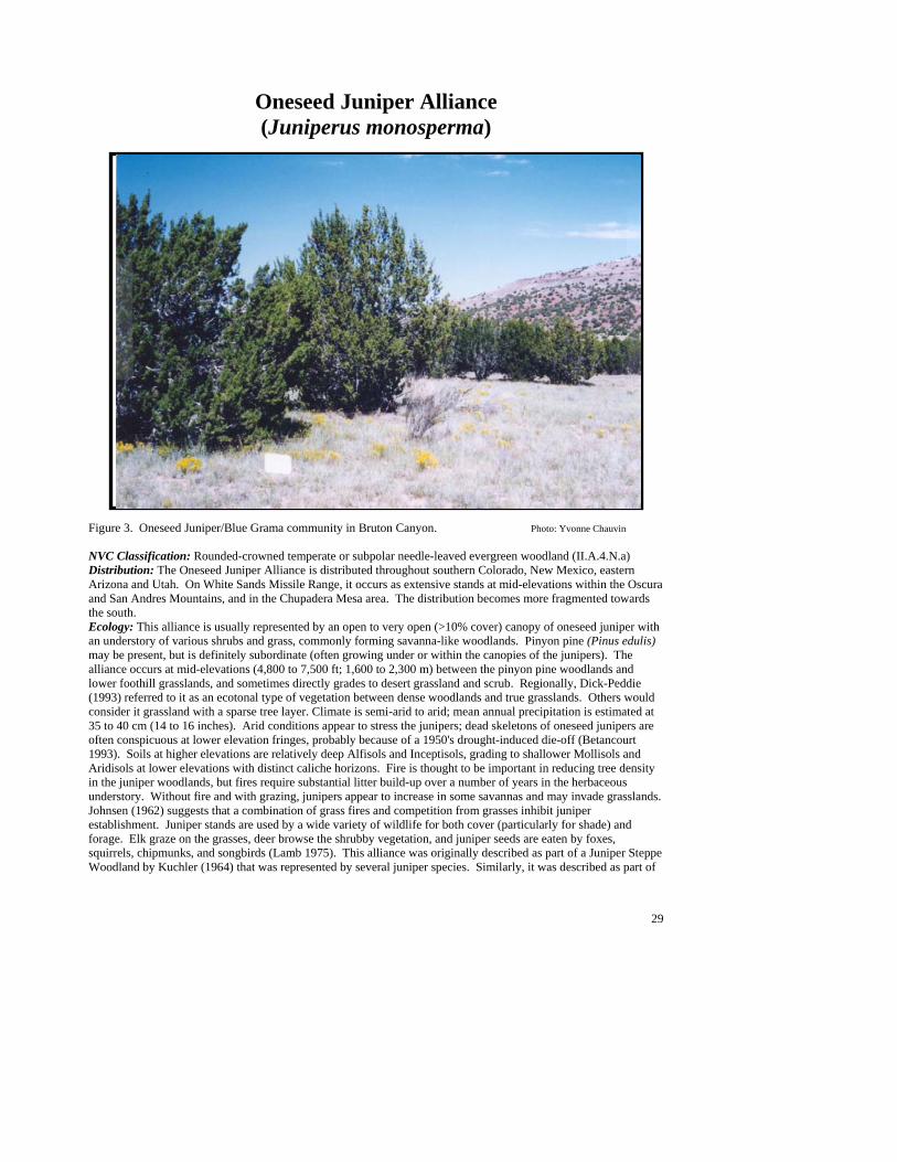
29
Oneseed Juniper Alliance (Juniperus monosperma)
Figure 3. Oneseed Juniper/Blue Grama community in Bruton Canyon. Photo: Yvonne Chauvin NVC Classification: Rounded-crowned temperate or subpolar needle-leaved evergreen woodland (II.A.4.N.a) Distribution: The Oneseed Juniper Alliance is distributed throughout southern Colorado, New Mexico, eastern Arizona and Utah. On White Sands Missile Range, it occurs as extensive stands at mid-elevations within the Oscura and San Andres Mountains, and in the Chupadera Mesa area. The distribution becomes more fragmented towards the south. Ecology: This alliance is usually represented by an open to very open (>10% cover) canopy of oneseed juniper with an understory of various shrubs and grass, commonly forming savanna-like woodlands. Pinyon pine (Pinus edulis) may be present, but is definitely subordinate (often growing under or within the canopies of the junipers). The alliance occurs at mid-elevations (4,800 to 7,500 ft; 1,600 to 2,300 m) between the pinyon pine woodlands and lower foothill grasslands, and sometimes directly grades to desert grassland and scrub. Regionally, Dick-Peddie (1993) referred to it as an ecotonal type of vegetation between dense woodlands and true grasslands. Others would consider it grassland with a sparse tree layer. Climate is semi-arid to arid; mean annual precipitation is estimated at 35 to 40 cm (14 to 16 inches). Arid conditions appear to stress the junipers; dead skeletons of oneseed junipers are often conspicuous at lower elevation fringes, probably because of a 1950's drought-induced die-off (Betancourt 1993). Soils at higher elevations are relatively deep Alfisols and Inceptisols, grading to shallower Mollisols and Aridisols at lower elevations with distinct caliche horizons. Fire is thought to be important in reducing tree density in the juniper woodlands, but fires require substantial litter build-up over a number of years in the herbaceous understory. Without fire and with grazing, junipers appear to increase in some savannas and may invade grasslands. Johnsen (1962) suggests that a combination of grass fires and competition from grasses inhibit juniper establishment. Juniper stands are used by a wide variety of wildlife for both cover (particularly for shade) and forage. Elk graze on the grasses, deer browse the shrubby vegetation, and juniper seeds are eaten by foxes, squirrels, chipmunks, and songbirds (Lamb 1975). This alliance was originally described as part of a Juniper Steppe Woodland by Kuchler (1964) that was represented by several juniper species. Similarly, it was described as part of

30
the Juniper Series of Layser and Schubert (1979), and as a Juniperus monosperma Association within the Pinyon-Juniper Series of Brown, Lowe, and Pase (1979). Later, Larson and Moir (1987) identified several specific oneseed juniper associations for southern New Mexico, and Dick-Peddie (1993) identified a Oneseed Juniper Series with eight associations. Key to the Oneseed Juniper (Juniperus monosperma) Plant Associations 1. Undergrowth sparse, usually less than 1% cover of shrubs, grasses, or forbs ........................................................................................................................................................ Oneseed Juniper/Sparse PA (See Minor Types) 1. Undergrowth cover > 1% ..................................................................................................................................2 2. Shrubs dominate the understory ........................................................................................................................3 2. Grasses dominate the understory .......................................................................................................................5 3. Shrub live-oak (Quercus turbinella), gray oak (Q. grisea), or Arizona white oak (Q. arizonica) well represented................................................................. Oneseed Juniper/Shrub Live Oak PA (See Minor Types) 3. Above oaks uncommon or absent......................................................................................................................4 4. Mountain mahogany (Cercocarpus montanus) well represented ..................................................................................................................................................................................Oneseed Juniper/Mountain Mahogany PA 4. Mountain mahogany poorly represented ................. Oneseed Juniper/Banana Yucca PA (See Minor Types) 5. Curlyleaf muhly (Muhlenbergia setifolia) well represented and the dominant grass ........................................................................................................................................................... Oneseed Juniper/Curlyleaf Muhly PA 5. Curlyleaf muhly poorly represented or absent...................................................................................................6 6. New Mexico muhly (Muhlenbergia pauciflora) well represented and/or the dominant grass .........................................................................................................................................Oneseed Juniper/New Mexico Muhly PA 6. New Mexico muhly poorly represented or absent ............................................................................................7 7. New Mexico needlegrass (Stipa neomexicana) well represented and at least a codominant grass .........................................................................................................................Oneseed Juniper/New Mexico Needlegrass PA 7. New Mexico needlegrass poorly represented ....................................................................................................8 8. Hairy grama (Bouteloua hirsuta) well represented, often abundant, and at least a codominant.................................................................................................................................................Oneseed Juniper/Hairy Grama PA 8. Hairy grama poorly represented or absent .........................................................................................................9 9. Black grama (Bouteloua eriopoda) well represented, often abundant, and at least a codominant .............................................................................................................................................Oneseed Juniper/Black Grama PA 9. Black grama poorly represented or clearly subdominant.................................................................................10 10. Blue grama (Bouteloua gracilis) well represented, often abundant, and at least a codominant .................................................................................................................................................Oneseed Juniper/Blue Grama PA 10. Blue grama poorly represented, clearly not dominant ...................................................................................11 11. Sideoats grama well represented, clearly dominant........................... Oneseed Juniper/Sideoats Grama PA 11. Sideoats grama poorly represented or absent.................................................................................................12 12. Prairie junegrass (Koeleria macrantha) well represented, clearly dominant......................................................................................................................................Oneseed Juniper/Prairie Junegrass PA (See Minor Types) 12. Sand dropseed (Sporobolus cryptandrus) present, often poorly represented.......................................................................................................................................... Oneseed Juniper/Sand Dropseed PA (See Minor Types)
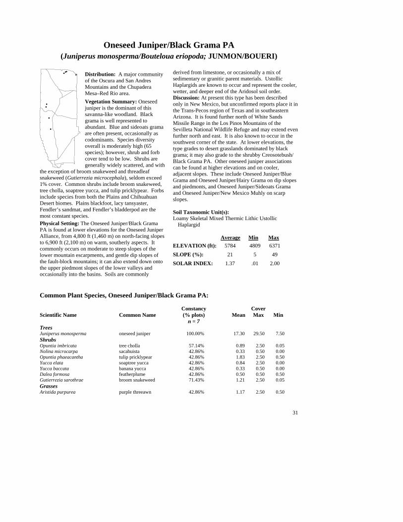
31
Oneseed Juniper/Black Grama PA (Juniperus monosperma/Bouteloua eriopoda; JUNMON/BOUERI)
Distribution: A major community of the Oscura and San Andres Mountains and the Chupadera Mesa–Red Rio area. Vegetation Summary: Oneseed juniper is the dominant of this savanna-like woodland. Black grama is well represented to abundant. Blue and sideoats grama are often present, occasionally as codominants. Species diversity overall is moderately high (65 species); however, shrub and forb cover tend to be low. Shrubs are generally widely scattered, and with
the exception of broom snakeweed and threadleaf snakeweed (Gutierrezia microcephala), seldom exceed 1% cover. Common shrubs include broom snakeweed, tree cholla, soaptree yucca, and tulip pricklypear. Forbs include species from both the Plains and Chihuahuan Desert biomes. Plains blackfoot, lacy tansyaster, Fendler’s sandmat, and Fendler’s bladderpod are the most constant species. Physical Setting: The Oneseed Juniper/Black Grama PA is found at lower elevations for the Oneseed Juniper Alliance, from 4,800 ft (1,460 m) on north-facing slopes to 6,900 ft (2,100 m) on warm, southerly aspects. It commonly occurs on moderate to steep slopes of the lower mountain escarpments, and gentle dip slopes of the fault-block mountains; it can also extend down onto the upper piedmont slopes of the lower valleys and occasionally into the basins. Soils are commonly
derived from limestone, or occasionally a mix of sedimentary or granitic parent materials. Ustollic Haplargids are known to occur and represent the cooler, wetter, and deeper end of the Aridosol soil order. Discussion: At present this type has been described only in New Mexico, but unconfirmed reports place it in the Trans-Pecos region of Texas and in southeastern Arizona. It is found further north of White Sands Missile Range in the Los Pinos Mountains of the Sevilleta National Wildlife Refuge and may extend even further north and east. It is also known to occur in the southwest corner of the state. At lower elevations, the type grades to desert grasslands dominated by black grama; it may also grade to the shrubby Creosotebush/ Black Grama PA. Other oneseed juniper associations can be found at higher elevations and on cooler, adjacent slopes. These include Oneseed Juniper/Blue Grama and Oneseed Juniper/Hairy Grama on dip slopes and piedmonts, and Oneseed Juniper/Sideoats Grama and Oneseed Juniper/New Mexico Muhly on scarp slopes. Soil Taxonomic Unit(s): Loamy Skeletal Mixed Thermic Lithic Ustollic
Haplargid Average Min Max ELEVATION (ft): 5784 4809 6371 SLOPE (%): 21 5 49 SOLAR INDEX: 1.37 .01 2.00
Common Plant Species, Oneseed Juniper/Black Grama PA:
Constancy Cover Scientific Name Common Name (% plots) Mean Max Min n = 7 Trees Juniperus monosperma oneseed juniper 100.00% 17.30 29.50 7.50 Shrubs Opuntia imbricata tree cholla 57.14% 0.89 2.50 0.05 Nolina microcarpa sacahuista 42.86% 0.33 0.50 0.00 Opuntia phaeacantha tulip pricklypear 42.86% 1.83 2.50 0.50 Yucca elata soaptree yucca 42.86% 0.84 2.50 0.00 Yucca baccata banana yucca 42.86% 0.33 0.50 0.00 Dalea formosa featherplume 42.86% 0.50 0.50 0.50 Gutierrezia sarothrae broom snakeweed 71.43% 1.21 2.50 0.05 Grasses Aristida purpurea purple threeawn 42.86% 1.17 2.50 0.50
#
##
#
#
#
#
#
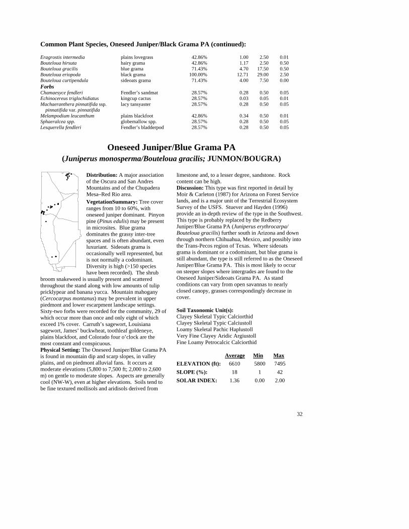
32
Common Plant Species, Oneseed Juniper/Black Grama PA (continued):
Eragrostis intermedia plains lovegrass 42.86% 1.00 2.50 0.01 Bouteloua hirsuta hairy grama 42.86% 1.17 2.50 0.50 Bouteloua gracilis blue grama 71.43% 4.70 17.50 0.50 Bouteloua eriopoda black grama 100.00% 12.71 29.00 2.50 Bouteloua curtipendula sideoats grama 71.43% 4.00 7.50 0.00 Forbs Chamaesyce fendleri Fendler’s sandmat 28.57% 0.28 0.50 0.05 Echinocereus triglochidiatus kingcup cactus 28.57% 0.03 0.05 0.01 Machaeranthera pinnatifida ssp. lacy tansyaster 28.57% 0.28 0.50 0.05
pinnatifida var. pinnatifida Melampodium leucanthum plains blackfoot 42.86% 0.34 0.50 0.01 Sphaeralcea spp. globemallow spp. 28.57% 0.28 0.50 0.05 Lesquerella fendleri Fendler’s bladderpod 28.57% 0.28 0.50 0.05
Oneseed Juniper/Blue Grama PA (Juniperus monosperma/Bouteloua gracilis; JUNMON/BOUGRA)
Distribution: A major association of the Oscura and San Andres Mountains and of the Chupadera Mesa–Red Rio area. VegetationSummary: Tree cover ranges from 10 to 60%, with oneseed juniper dominant. Pinyon pine (Pinus edulis) may be present in microsites. Blue grama dominates the grassy inter-tree spaces and is often abundant, even luxuriant. Sideoats grama is occasionally well represented, but is not normally a codominant. Diversity is high (>150 species have been recorded). The shrub
broom snakeweed is usually present and scattered throughout the stand along with low amounts of tulip pricklypear and banana yucca. Mountain mahogany (Cercocarpus montanus) may be prevalent in upper piedmont and lower escarpment landscape settings. Sixty-two forbs were recorded for the community, 29 of which occur more than once and only eight of which exceed 1% cover. Carruth’s sagewort, Louisiana sagewort, James’ buckwheat, toothleaf goldeneye, plains blackfoot, and Colorado four o’clock are the most constant and conspicuous. Physical Setting: The Oneseed Juniper/Blue Grama PA is found in mountain dip and scarp slopes, in valley plains, and on piedmont alluvial fans. It occurs at moderate elevations (5,800 to 7,500 ft; 2,000 to 2,600 m) on gentle to moderate slopes. Aspects are generally cool (NW-W), even at higher elevations. Soils tend to be fine textured mollisols and aridisols derived from
limestone and, to a lesser degree, sandstone. Rock content can be high. Discussion: This type was first reported in detail by Moir & Carleton (1987) for Arizona on Forest Service lands, and is a major unit of the Terrestrial Ecosystem Survey of the USFS. Stuever and Hayden (1996) provide an in-depth review of the type in the Southwest. This type is probably replaced by the Redberry Juniper/Blue Grama PA (Juniperus erythrocarpa/ Bouteloua gracilis) further south in Arizona and down through northern Chihuahua, Mexico, and possibly into the Trans-Pecos region of Texas. Where sideoats grama is dominant or a codominant, but blue grama is still abundant, the type is still referred to as the Oneseed Juniper/Blue Grama PA. This is most likely to occur on steeper slopes where intergrades are found to the Oneseed Juniper/Sideoats Grama PA. As stand conditions can vary from open savannas to nearly closed canopy, grasses correspondingly decrease in cover. Soil Taxonomic Unit(s): Clayey Skeletal Typic Calciorthid Clayey Skeletal Typic Calciustoll Loamy Skeletal Pachic Haplustoll Very Fine Clayey Aridic Argiustoll Fine Loamy Petrocalcic Calciorthid
Average Min Max ELEVATION (ft): 6610 5800 7495 SLOPE (%): 18 1 42 SOLAR INDEX: 1.36 0.00 2.00
#
#
#
#
#
#
#
##
##
###
#
#
#
#
#
#
##
#
#
#
#
###
#
#
#
#
#
#
# #
##
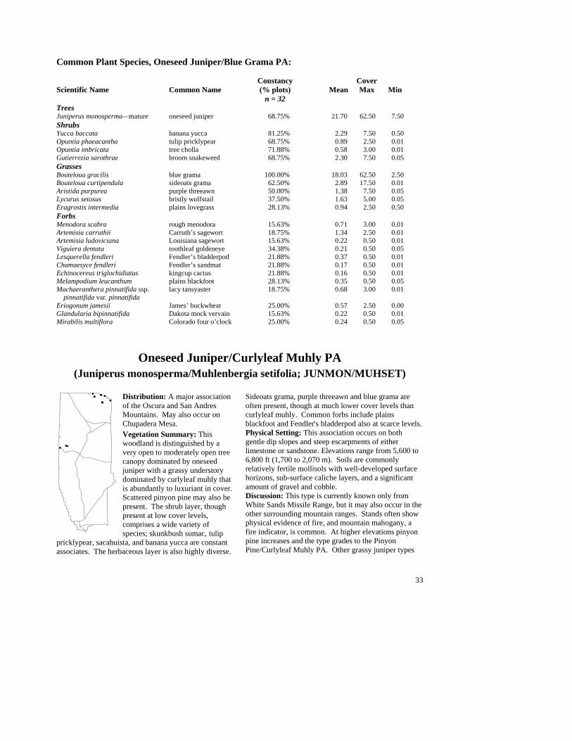
33
Common Plant Species, Oneseed Juniper/Blue Grama PA: Constancy Cover Scientific Name Common Name (% plots) Mean Max Min n = 32 Trees Juniperus monosperma—mature oneseed juniper 68.75% 21.70 62.50 7.50 Shrubs Yucca baccata banana yucca 81.25% 2.29 7.50 0.50 Opuntia phaeacantha tulip pricklypear 68.75% 0.89 2.50 0.01 Opuntia imbricata tree cholla 71.88% 0.58 3.00 0.01 Gutierrezia sarothrae broom snakeweed 68.75% 2.30 7.50 0.05 Grasses Bouteloua gracilis blue grama 100.00% 18.03 62.50 2.50 Bouteloua curtipendula sideoats grama 62.50% 2.89 17.50 0.01 Aristida purpurea purple threeawn 50.00% 1.38 7.50 0.05 Lycurus setosus bristly wolfstail 37.50% 1.63 5.00 0.05 Eragrostis intermedia plains lovegrass 28.13% 0.94 2.50 0.50 Forbs Menodora scabra rough menodora 15.63% 0.71 3.00 0.01 Artemisia carruthii Carruth’s sagewort 18.75% 1.34 2.50 0.01 Artemisia ludoviciana Louisiana sagewort 15.63% 0.22 0.50 0.01 Viguiera dentata toothleaf goldeneye 34.38% 0.21 0.50 0.05 Lesquerella fendleri Fendler’s bladderpod 21.88% 0.37 0.50 0.01 Chamaesyce fendleri Fendler’s sandmat 21.88% 0.17 0.50 0.01 Echinocereus triglochidiatus kingcup cactus 21.88% 0.16 0.50 0.01 Melampodium leucanthum plains blackfoot 28.13% 0.35 0.50 0.05 Machaeranthera pinnatifida ssp. lacy tansyaster 18.75% 0.68 3.00 0.01
pinnatifida var. pinnatifida Eriogonum jamesii James’ buckwheat 25.00% 0.57 2.50 0.00 Glandularia bipinnatifida Dakota mock vervain 15.63% 0.22 0.50 0.01 Mirabilis multiflora Colorado four o’clock 25.00% 0.24 0.50 0.05
Oneseed Juniper/Curlyleaf Muhly PA (Juniperus monosperma/Muhlenbergia setifolia; JUNMON/MUHSET)
Distribution: A major association of the Oscura and San Andres Mountains. May also occur on Chupadera Mesa. Vegetation Summary: This woodland is distinguished by a very open to moderately open tree canopy dominated by oneseed juniper with a grassy understory dominated by curlyleaf muhly that is abundantly to luxuriant in cover. Scattered pinyon pine may also be present. The shrub layer, though present at low cover levels, comprises a wide variety of species; skunkbush sumac, tulip
pricklypear, sacahuista, and banana yucca are constant associates. The herbaceous layer is also highly diverse.
Sideoats grama, purple threeawn and blue grama are often present, though at much lower cover levels than curlyleaf muhly. Common forbs include plains blackfoot and Fendler's bladderpod also at scarce levels. Physical Setting: This association occurs on both gentle dip slopes and steep escarpments of either limestone or sandstone. Elevations range from 5,600 to 6,800 ft (1,700 to 2,070 m). Soils are commonly relatively fertile mollisols with well-developed surface horizons, sub-surface caliche layers, and a significant amount of gravel and cobble. Discussion: This type is currently known only from White Sands Missile Range, but it may also occur in the other surrounding mountain ranges. Stands often show physical evidence of fire, and mountain mahogany, a fire indicator, is common. At higher elevations pinyon pine increases and the type grades to the Pinyon Pine/Curlyleaf Muhly PA. Other grassy juniper types
#
##
#
#
#
#
#
#
### #
34
are often found on adjacent slopes (Oneseed Juniper/Sideoats Grama). At lower elevations, the type typically gives way to drier juniper types (Oneseed Juniper/Black Grama), desert grassland or scrub (Curlyleaf Muhly/Ocotillo PA). Soil Taxonomic Unit(s): Loamy Skeletal Shallow Petrocalcic Calciustoll Fine Clayey Typic Calciustoll
Coarse Loamy Carbonatic Thermic Aridic Calciustoll Skeletal Carbonatic Thermic (Shallow) Lithic Ustochrept
Average Min Max ELEVATION (ft): 6231 5619 6715 SLOPE (%): 14 8 29 SOLAR INDEX: 1.53 .41 2.00
Common Plant Species, Oneseed Juniper/Curlyleaf Muhly PA:
Constancy Cover Scientific Name Common Name (% plots) Mean Max Min n = 11 Trees Pinus edulis—adv regen pinyon pine 45.45% 2.11 7.50 0.00 Juniperus monosperma—mature oneseed juniper 63.64% 19.57 29.00 7.50 Shrubs Nolina microcarpa sacahuista 72.73% 1.00 2.50 0.50 Thymophylla acerosa pricklyleaf dogweed 45.45% 0.23 0.50 0.05 Rhus trilobata skunkbush sumac 81.82% 3.28 7.50 0.50 Opuntia phaeacantha tulip pricklypear 72.73% 1.25 2.50 0.50 Opuntia imbricata tree cholla 45.45% 0.22 0.50 0.00 Yucca baccata banana yucca 72.73% 3.00 7.50 0.50 Cercocarpus montanus mountain mahogany 45.45% 3.70 7.50 0.50 Grasses Bouteloua curtipendula sideoats grama 100.00% 0.86 2.50 0.50 Bouteloua eriopoda black grama 45.45% 1.51 2.50 0.00 Bouteloua gracilis blue grama 81.82% 0.89 2.50 0.05 Aristida purpurea purple threeawn 90.91% 0.86 2.50 0.05 Muhlenbergia setifolia curlyleaf muhly 100.00% 14.14 29.00 2.50 Stipa neomexicana New Mexico needlegrass 45.45% 1.11 2.50 0.00 Forbs Lesquerella fendleri Fendler’s bladderpod 63.64% 0.45 2.50 0.01 Melampodium leucanthum plains blackfoot 81.82% 0.30 0.50 0.01
Oneseed Juniper/Hairy Grama PA (Juniperus monosperma/Bouteloua hirsuta; JUNMON/BOUHIR)
Distribution: A major association of the Oscura and San Andres Mountains. Also known northward in the Los Pinos Mountains of the Sevilleta National Wildlife Refuge Vegetation Summary: Hairy grama is the dominant grass of this juniper savanna and is usually well represented to abundant. Oneseed juniper forms an open canopy with intervening grassy areas. Oneseed juniper reproduction is common. Pinyon pine (Pinus edulis), when present, is widely scattered. Blue grama, black grama, bristly wolfstail and sideoats grama are
other common grasses of the openings with the cool-season prairie junegrass (Koeleria macrantha) under the trees. This is a distinctly grassy type both in cover and species richness (23 grass species recorded). Shrubs are sporadic in species composition and usually poorly represented in cover. The most common are sacahuista, soaptree yucca, featherplume, broom snakeweed, tree cholla and tulip pricklypear. Common sotol (Dasylirion wheeleri) is occasionally conspicuous. A wide variety of forbs are recorded for the type (60+ ), but they are very low in cover and not consistently represented. Plains blackfoot is the most constant forb associate. Physical Setting: The Oneseed Juniper/Hairy Grama association is often found on gentle hillslopes, either on toeslopes or the dip slope, and occasionally on scarp
###
#
#
#
#
##
#
#
#
#
#
#
#
##
#
#
#
###
#
#
#
#
35
slopes. Elevations are low to moderate (4,500 to 7,000 ft; 1,350 to 2,100 m) with relatively cool aspects. Soils are most commonly moderately developed alfisols (forest/woodland soils) or mollisols (grassland soils) derived from limestone or calcitic sandstone. The soils are loamy or clay loams overall, but tend to have significant amounts of gravel cobbles, particularly at the surface (25 - 50%). They tend to be relatively shallow, as shallow as 15 cm to a lithic contact and commonly under a meter. Hence, soils of this type tend to be drier than in other PAs. Calcium carbonate accumulations or caliche layers are usually present (but not always) in the lower horizons. Discussion: Evidence of past fire is usually present in stands of this association. Adjacent swales and drainages may support the Oneseed Juniper/Blue Grama PA, other more mesic savanna types, or montane shrublands. This association is included in the Juniperus monosperma/Bouteloua spp. type of Dick-
Peddie (1993). Soil Taxonomic Unit(s): Very Fine Clayey Aridic Argiustoll Fine Loamy Mixed (Carbonatic) Mesic Petrocalcic
Paleoustalf Clayey Skeletal Mixed (Nonacid) Mesic, Typic
Haplustalf Very Fine, Mixed (Nonacid) Mesic Lithic Haplustalf Loamy Skeletal Carbonatic Thermic Calciorthidic
Ustochrept Fine Carbonatic, Thermic Aridic Haplustalf Average Min Max ELEVATION (ft): 6188 4735 6847 SLOPE (%): 18 7 35 SOLAR INDEX: 1.08 .01 1.99
Common Plant Species, Oneseed Juniper/Hairy Grama PA: Constancy Cover Scientific Name Common Name (% plots) Mean Max Min n = 18 Trees Juniperus monosperma—mature oneseed juniper 77.78% 13.93 20.00 4.00 Shrubs Yucca elata soaptree yucca 61.11% 0.67 2.50 0.01 Rhus trilobata skunkbush sumac 50.00% 0.70 2.50 0.01 Opuntia phaeacantha tulip pricklypear 61.11% 0.56 2.50 0.00 Opuntia imbricata tree cholla 61.11% 0.48 2.50 0.00 Nolina microcarpa sacahuista 61.11% 0.97 2.50 0.00 Mahonia haematocarpa red barberry 50.00% 0.26 1.00 0.01 Gutierrezia sarothrae broom snakeweed 61.11% 1.33 7.50 0.10 Dalea formosa featherplume 72.22% 0.85 2.50 0.01 Grasses Lycurus setosus bristly wolfstail 50.00% 0.98 2.50 0.05 Bouteloua hirsuta hairy grama 100.00% 18.22 41.50 2.50 Bouteloua gracilis blue grama 77.78% 1.96 7.50 0.01 Bouteloua eriopoda black grama 72.22% 1.74 4.00 0.01 Bouteloua curtipendula sideoats grama 77.78% 1.80 7.50 0.10 Forbs Melampodium leucanthum plains blackfoot 50.00% 0.20 0.50 0.01
36
Oneseed Juniper/Mountain Mahogany PA (Juniperus monosperma/Cercocarpus montanus; JUNMON/CERMON)
Distribution: A major association of the Oscura and San Andres Mountains. Vegetation Summary: This open woodland has a shrubby undergrowth dominated by mountain mahogany. While oneseed juniper is the dominant tree, pinyon pine is also common. Among the many shrubs that can be present (29 species), banana yucca, skunkbush sumac, tulip pricklypear, Nevada jointfir and sacahuista are the most constant and well-represented to abundant associates. Among the grasses,
sideoats grama and purple threeawn are the most common, but grass cover is generally low. Forb species richness is moderate (27 species), but overall cover is low. James’ buckwheat (Eriogonum jamesii) and Fendler's bladderpod are the most constant species.
Physical Setting: The Oneseed Juniper/Mountain Mahogany PA typically occurs on the cool aspects of steep to very steep scarp slopes at elevations of 5,500 to 7,000 ft (1,700 to 2,150 m). Discussion: These stands are probably mid-successional following fire (mountain mahogany is a fire indicator). In the absence of further fire, and as mountain mahogany dies off, mature stands may be replaced by typical slope juniper/grass types (Oneseed Juniper/Sideoats Grama PA, Oneseed Juniper/New Mexico Muhly PA) or shrubbier types (Oneseed Juniper/Banana Yucca PA, Oneseed Juniper/Shrub Live Oak PA). On cooler sites, pinyon woodlands may prevail. This type is currently known only from White Sands Missile Range, but may occur in other surrounding mountain ranges. Average Min Max ELEVATION (ft): 6488 5991 6916 SLOPE (%): 34 15 55 SOLAR INDEX: 1.08 .03 1.97
Common Plant Species, Oneseed Juniper/Mountain Mahogany PA: Constancy Cover Scientific Name Common Name (% plots) Mean Max Min n = 6 Trees Pinus edulis—total pinyon pine 50.00% 5.17 7.50 0.50 Juniperus monosperma–total oneseed juniper 50.00% 10.83 17.50 7.50 Shrubs Yucca baccata banana yucca 66.67% 1.56 2.50 0.50 Rhus trilobata skunkbush sumac 66.67% 1.13 3.00 0.50 Opuntia phaeacantha tulip pricklypear 100.00% 0.36 0.50 0.05 Nolina microcarpa sacahuista 83.33% 1.35 2.50 0.50 Mahonia haematocarpa red barberry 50.00% 0.42 0.75 0.01 Garrya wrightii Wright’s silktassel 50.00% 0.92 2.50 0.01 Ephedra nevadensis var. aspera Nevada jointfir 66.67% 0.63 1.50 0.01 Cercocarpus montanus mountain mahogany 100.00% 5.75 7.50 2.50 Grasses Bouteloua curtipendula sideoats grama 66.67% 1.13 3.00 0.50 Aristida purpurea purple threeawn 66.67% 1.00 2.50 0.50 Forbs Lesquerella fendleri Fendler’s bladderpod 50.00% 0.19 0.50 0.01
#
#
#
#
#
#
#
#
#
#
37
Oneseed Juniper/New Mexico Muhly PA (Juniperus monosperma/Muhlenbergia pauciflora; JUNMON/MUHPAU)
Distribution: A major association of the San Andres Mountains. Vegetation Summary: This woodland is dominated by abundant oneseed juniper, with a grassy understory dominated by New Mexico muhly. Scattered mature pinyon pine may also be present. The shrub layer can be well represented by a wide variety of species (38 species), with banana yucca, skunkbush sumac and broom snakeweed being the most abundant and constant. Mountain mahogany may also be present but is not dominant.
Besides New Mexico muhly, other similar hardy grasses such as sideoats grama and curlyleaf muhly may be well represented or abundant along with slim tridens and Scribner's needlegrass. A wide variety of forbs can occur, but forb species richness and abundance on a stand-by-stand basis is low; plains blackfoot, toothleaf goldeneye and Fendler's bladderpod are most constant. Physical Setting: This community is typically found on cool aspects of steep scarp slopes at elevations from 5,500 to 7,000+ feet (1,700 to 2,150 m). Occasionally it is found on more gentle dip slopes or along the toeslopes of mountain valleys. Soils are mostly shallow Inceptisols or weakly developed Alfisols. They are usually loamy with a significant gravel, cobble and even stony component (50% or more of the profile can be made up of coarse fragments). Calcium carbonate accumulations are also common lower in the profile.
Discussion: The Oneseed Juniper/New Mexico Muhly PA is one of the more widespread types of the escarpment slopes of the San Andres and Oscura Mountains along with the Oneseed Juniper/Sideoats Grama PA. At higher elevations, it may grade into the Oneseed Juniper/New Mexico Muhly PA as pinyon increases in the stands. Rocky slopes are characteristic of the sites and the associated hardy grasses and shrubs are indicative of the type. After fire, the shrubby aspect may increase (see Oneseed Juniper/Mountain Mahogany PA). This type is currently known only from White Sands Missile Range, but may occur in the other surrounding mountain ranges. Soil Taxonomic Unit(s): Clayey Skeletal Lithic Calciustoll Loamy Skeletal Typic Calciorthid Fine Loamy Mixed (Carbonatic) Mesic Calcic
Ustochrept Coarse Loamy Mixed (Carbonatic) Mesic Calciorthidic
Ustochrept Clayey over Fragmental Mixed (Nonacid) Mesic Typic
Haplustalf Very Fine Mixed (Nonacid) Mesic Typic Haplustalf Coarse Loamy Carbonatic Thermic Lithic Ustochrept Fine Loamy Carbonatic Thermic Aridic Haplustalf
Average Min Max ELEVATION (ft): 6476 5962 6941 SLOPE (%): 36 8 61 SOLAR INDEX: 1.50 .29 2.00
Common Plant Species, Oneseed Juniper/New Mexico Muhly PA: Constancy Cover Scientific Name Common Name (% plots) Mean Max Min n = 22 Trees Juniperus monosperma oneseed juniper 100.00% 24.25 41.50 5.00 Pinus edulis pinyon pine 22.73% 7.10 17.5 0.50 Shrubs Yucca baccata banana yucca 90.91% 1.46 2.50 0.10 Rhus trilobata skunkbush sumac 90.91% 1.24 2.50 0.05 Opuntia phaeacantha tulip pricklypear 72.73% 1.39 7.50 0.05 Nolina microcarpa sacahuista 50.00% 1.74 7.50 0.10 Gutierrezia sarothrae broom snakeweed 81.82% 0.88 2.50 0.01 Ephedra nevadensis var. aspera Nevada jointfir 59.09% 1.55 2.50 0.01 Cercocarpus montanus mountain mahogany 72.73% 2.01 7.50 0.00 Grasses
##
##
#
#
#
##
#
#
#
#
#
##
#
#
####
38
Stipa scribneri Scribner’s needlegrass 54.55% 1.50 7.50 0.01 Common Plant Species, Oneseed Juniper/New Mexico Muhly PA (continued): Constancy Cover Scientific Name Common Name (% plots) Mean Max Min n = 22 Muhlenbergia pauciflora New Mexico muhly 100.00% 13.68 50.00 1.00 Muhlenbergia setifolia curlyleaf muhly 13.64% 1.00 2.50 0.00 Tridens muticus slim tridens 36.36% 1.39 7.50 0.01 Bouteloua curtipendula sideoats grama 77.27% 2.42 7.50 0.01 Forbs Viguiera dentata toothleaf goldeneye 72.73% 0.49 2.50 0.05 Melampodium leucanthum plains blackfoot 40.91 0.13 0.50 0.01 Lesquerella fendleri Fendler’s bladderpod 40.91 0.36 0.50 0.05
Oneseed Juniper/New Mexico Needlegrass PA (Juniperus monosperma/Stipa neomexicana; JUNMON/STINEO)
Distribution: A major association of the Oscura and San Andres Mountains and Chupadera Mesa. Vegetation Summary: This woodland is characterized by a very open canopy of oneseed juniper with occasional pinyon pine. The inter-tree spaces are distinctly grassy and strongly dominated by New Mexico needlegrass with a mixture of other grasses (gramas most prevalently). A wide variety of shrubs have been recorded for the type, but they are not generally conspicuous; featherplume, banana yucca, and
broom snakeweed are the most prevalent. Forb diversity is moderate with low consistency; plains blackfoot, toothleaf goldeneye, and Fendler’s sandmat are somewhat constant species. Physical Setting: The association occurs at moderate elevations (5,800 to 7,100 ft; 1,770 to 2,160 m) on both gentle sloping dip slopes and steeper scarp slopes with moderate to warm aspects. The surface geology is also variable with limestone and calcitic sandstone, and with occasional gypsum outcrops. Soils information is
limited; a shallow and rocky mollisol (grassland soil) with a strong caliche layer has been described for the type, suggesting limited water-holding capacity. Discussion: This type is noted for an abundance of juniper snags, likely the remnants of a drought die-off in the 1950s (Betancourt 1996) or of past fire. Fire evidence is readily apparent in the stands. Adjacent warmer slopes often grade to New Mexico needlegrass (see New Mexico Needlegrass Alliance), other foothill grasslands, and Oneseed Juniper/Blue Grama PA in lower slopes and valleys. Cooler slopes can grade to the Oneseed Juniper/New Mexico Muhly or Oneseed Juniper/Mountain Mahogany PAs, or to pinyon and oak woodlands. This type is currently known only from White Sands Missile Range but may occur in surrounding mountain ranges. Soil Taxonomic Unit(s): Loamy Skeletal Shallow Lithic Petrocalcic Calciustoll Average Min Max ELEVATION (ft): 6428 5867 7035 SLOPE (%): 27 7 71 SOLAR INDEX: 1.04 .20 1.96
Common Plant Species, Oneseed Juniper/New Mexico Needlegrass PA: Constancy Cover Scientific Name Common Name (% plots) Mean Max Min n = 12 Trees Juniperus monosperma—mature oneseed juniper 75.00% 9.89 17.50 7.50 Shrubs
##
#
#
#
#
#
#
####
#
##
39
Yucca baccata banana yucca 75.00% 1.61 3.00 0.00 Rhus trilobata skunkbush sumac 58.33% 0.86 2.50 0.01 Opuntia phaeacantha tulip pricklypear 66.67% 0.53 0.75 0.50 Common Plant Species, Oneseed Juniper/New Mexico Needlegrass PA (continued): Constancy Cover Scientific Name Common Name (% plots) Mean Max Min n = 12 Opuntia imbricata tree cholla 58.33% 0.33 0.50 0.01 Gutierrezia sarothrae broom snakeweed 58.33% 1.01 2.50 0.10 Dalea formosa featherplume 75.00% 2.17 6.00 0.05 Grasses Stipa neomexicana New Mexico needlegrass 100.00% 15.96 62.50 2.50 Muhlenbergia setifolia curlyleaf muhly 50.00% 0.68 2.50 0.05 Bouteloua gracilis blue grama 50.00% 2.42 6.00 0.50 Bouteloua eriopoda black grama 75.00% 1.50 4.00 0.01 Bouteloua curtipendula sideoats grama 50.00% 1.50 2.50 0.50 Bouteloua hirsuta hairy grama 25.00% 1.83 2.50 0.50 Aristida purpurea purple threeawn 58.33% 1.61 2.50 0.25 Forbs Melampodium leucanthum plains blackfoot 41.67% 0.50 1.00 0.01 Viguiera dentata toothleaf goldeneye 33.33% 0.05 0.05 0.01 Chamaesyce fendleri Fendler’s sandmat 33.33% 0.28 0.50 0.05
Oneseed Juniper/Sideoats Grama PA (Juniperus monosperma/Bouteloua curtipendula; JUNMON/BOUCUR)
Distribution: A major community of the Oscura and San Andres Mountains. Vegetation Summary: This juniper woodland is often on steep, rocky slopes. Oneseed juniper is the dominant tree in the very open to moderately open tree canopy. Pinyon pine (Pinus edulis) may be present, but it is only an occasional or minor associate. Sideoats grama is the dominant among the 29 grass species reported for the type, and is well represented to luxuriant in the grassy inter-tree spaces. Blue and hairy grama
along with purple threeawn can be abundant but not dominant; New Mexico needlegrass can occur under the tree canopies. The shrub layer is very diverse (40+ species reported), but is generally under 5% cover. Common shrub species include banana yucca, skunkbush sumac, tulip pricklypear, sacahuista and mountain mahogany. Forb diversity is likewise very high (69 species reported), but forb cover is very low and not consistent in composition from stand to stand.
Plains blackfoot, Fendler’s bladderpod, and toothleaf goldeneye are the most constant forbs and are the highest in cover . Physical Setting: The Oneseed Juniper/Sideoats Grama PA typically occurs on steep, colluvial slopes of escarpments, dip slopes of moderate slope, and occasionally on lower toeslopes and valley bottoms. Soils are loamy Inceptisols (weakly developed) and mollisols (grassland soils) derived from sedimentary limestone and calcitic sandstone. They tend to be gravelly, are often stony or rocky, and may be interrupted by rock outcrops. Elevation range is 5,000 to 7,500 ft (1,500 to 2,300 m). Mean annual precipitation is approximately 38 to 48 cm (15 to 19 inches) and mean annual air temperature is 12 to 14 ºC (55 to 57 ºF). Discussion: This is a widespread type that was first reported by Johnston (1984) for southern Colorado. It is also a major component in the Terrestrial Ecosystem Survey of the United States Forest Service. The Oneseed Juniper/Sideoats Grama PA, sacahuista phase identified on Clifton Ranger District in southwestern New Mexico is similar to the White Sands Missile Range occurrences. The type is also known from the
#
###
#
#
#
#
##
#
##
#
#
#
#
#
#
#
#
#
#
#
#
#
#
##
##
##
#
# #
##
#

40
Jemez Mountains of northern New Mexico and southern Colorado. It is included in the Juniperus monosperma/Bouteloua spp. type of Dick-Peddie (1993). The type is noted for an abundance of juniper snags. These may be remnants of a die-off during a drought in the 1950s (Betancourt 1996) or of past fires. Fire evidence is readily apparent in the stands. Adjacent warmer slopes often grade to foothill grasslands (see New Mexico Needlegrass and Sideoats Grama Alliances and Oneseed Juniper/Blue Grama PA) or blue grama grasslands on lower slopes and valleys. On cooler slopes, it can grade to the Oneseed Juniper/New Mexico Muhly PA or Oneseed Juniper/Mountain Mahogany PA, or pinyon and oak woodlands.
Soil Taxonomic Unit(s): Fine Silty Mixed (Calcareous) Mesic Petrocalcic
Paleustoll Fine Mixed (Calcareous) Mesic Calcic Ustochrept
Average Min Max ELEVATION (ft): 6323 5127 7087 SLOPE %: 25 55 SOLAR INDEX: 1.30 .05 2.00
Common Plant Species, Oneseed Juniper/Sideoats Grama PA: Constancy Cover Scientific Name Common Name (% plots) Mean Max Min n = 33 Trees Juniperus monosperma—mature oneseed juniper 66.67% 20.48 41.50 7.50 Shrubs Yucca baccata banana yucca 90.91% 1.54 7.50 0.01 Rhus trilobata skunkbush sumac 63.64% 1.28 6.00 0.01 Opuntia phaeacantha tulip pricklypear 78.79% 1.07 4.30 0.01 Opuntia imbricata tree cholla 48.48% 0.51 2.50 0.00 Nolina microcarpa sacahuista 60.61% 1.18 7.50 0.00 Mahonia haematocarpa red barberry 51.52% 0.88 2.50 0.00 Gutierrezia sarothrae broom snakeweed 60.61% 0.76 2.50 0.05 Cercocarpus montanus mountain mahogany 69.70% 1.65 4.30 0.00 Grasses Bouteloua gracilis blue grama 57.58% 2.29 30.00 0.00 Bouteloua hirsuta hairy grama 12.12% 7.00 17.50 0.50 Bouteloua curtipendula sideoats grama 100.00% 7.93 29.00 0.50 Aristida purpurea purple threeawn 60.61% 2.72 17.50 0.05 Stipa neomexicana New Mexico needlegrass 15.15% 2.12 7.50 0.10 Forbs Viguiera dentata toothleaf goldeneye 51.52% 0.31 1.00 0.01 Melampodium leucanthum plains blackfoot 66.67% 0.34 0.50 0.01 Lesquerella fendleri Fendler’s bladderpod 45.45% 0.42 2.50 0.01

41
Minor Community Types: Oneseed Juniper Alliance Oneseed Juniper/Banana Yucca PA (Juniperus monosperma/Yucca baccata; JUNMON/YUCBAC) This provisional type is known only from the San Andres Mountains and Chupadera Mesa areas of White Sands Missile Range. It occurs at higher elevations (6,500 to 7,400 ft; 1,980 to 2,250 m) on gentle northwest-facing dip slopes. This open woodland is dominated by oneseed juniper and characterized by a shrubby understory composed of banana yucca, sacahuista, Mexican orange, and mountain mahogany. Grass and forb diversity and cover are very low (four grasses and eleven forbs). Pinyon pine is a common but distinctly subordinate associate. The type is closely related to the Pinyon Pine/Sacahuista and Pinyon Pine/Banana Yucca PAs. Oneseed Juniper/Prairie Junegrass PA (Juniperus monosperma/Koeleria macrantha; JUNMON/KOEMAC)
This open oneseed juniper woodland savanna is known from Soldier Hole Canyon of the San Andres Mountains at 6,100 ft (1,860 m). The juniper canopy is very open and the grassy understory is clearly dominated by junegrass, with only a scattering of other grasses. Oneseed Juniper/Sand Dropseed PA (Juniperus monosperma/Sporobolus cryptandrus; JUNMON/SPOCRY)
This provisional type is an open oneseed juniper woodland found on isolated sand deposits within Fleck Draw in the southern San Andres Mountains at an elevation of 5,335 ft (1,626.1 m). The juniper canopy is very open (10 to 25% cover) with the hoary rosemarymint (Poliomintha incana), a sand loving shrub, common along with a scattering of grasses that include sand dropseed and Havard's threeawn (Aristida havardii). Oneseed Juniper/Shrub Live Oak PA (Juniperus monosperma/Quercus turbinella; JUNMON/QUETUR)
This is a provisional type known only from the San Andres and San Augustine Mountains. It is most often found on localized montane dunelands and occasionally on scarp slopes. It is characterized by a very open canopy of oneseed juniper and a shrub layer dominated by abundant shrub live oak. Other trees are rarely present. Overall species diversity is moderate. In the shrub layer, soaptree yucca, tulip pricklypear, Wright’s silktassel, tree cholla, and broom snakeweed are often present, though at low cover levels. Grasses are generally poorly represented, with purple threeawn and sideoats grama the most constant species. Forbs are scarce and include Colorado four o’clock, kingcup cactus, and woolly prairieclover. The type may be related to the Redberry Juniper/Shrub Live Oak type reported for Arizona (Stuever and Hayden 1996). Oneseed Juniper/Sparse PA (Juniperus monosperma /Sparse; JUNMON/SPARSE)
This is a provisional type known from the northern San Andres Mountains and Chupadera Mesa area of White Sands Missile Range. It is a moderately open woodland characterized by abundant oneseed juniper. Pinyon pine can be a subdominant associate or may be absent. Understory shrub, grass, and forb cover is very low and usually does not exceed 1 to 2% cover. Diversity is also exceptionally low, particularly among the grasses (one species) and forbs (10 species). Banana yucca and tulip pricklypear are the most constant shrub species. The association occurs at higher elevations (6,000 to 8,000 ft; 1,850 to 2,450 m) on cool aspects of gentle to moderate slopes (mostly dip slopes). At higher elevations it grades to the more prevalent Pinyon Pine/Sparse PA.
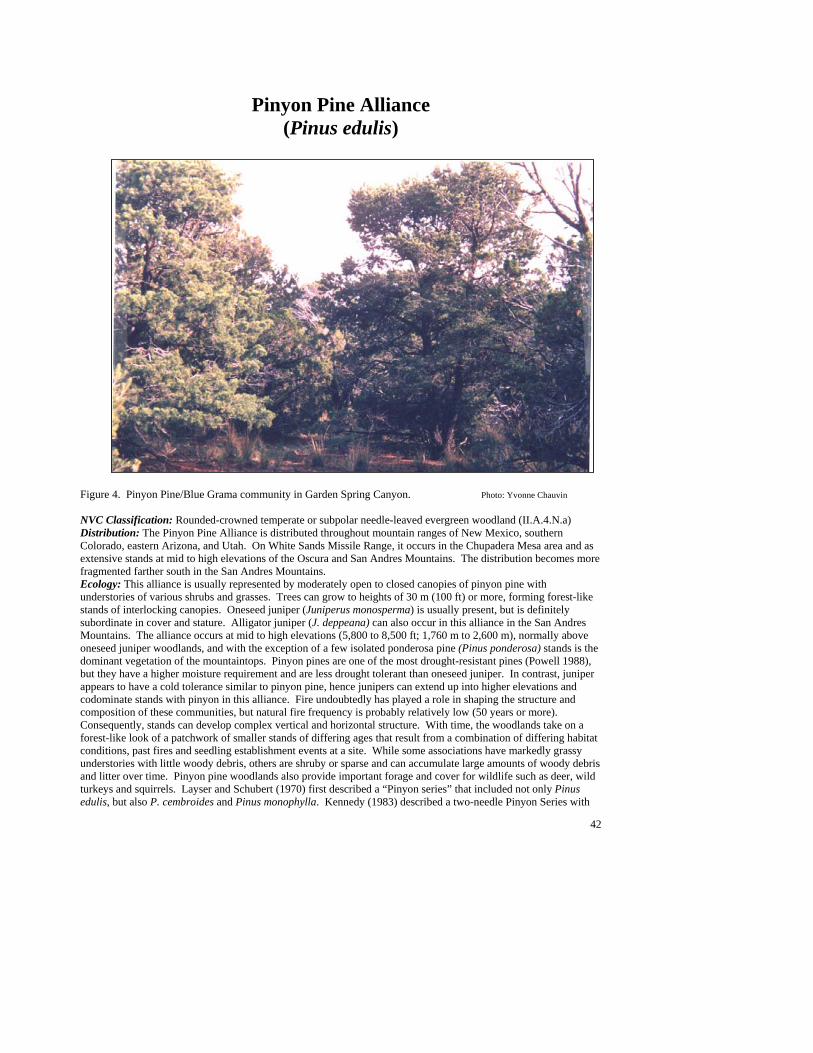
42
Pinyon Pine Alliance (Pinus edulis)
[Photo Here] Figure 4. Pinyon Pine/Blue Grama community in Garden Spring Canyon. Photo: Yvonne Chauvin NVC Classification: Rounded-crowned temperate or subpolar needle-leaved evergreen woodland (II.A.4.N.a) Distribution: The Pinyon Pine Alliance is distributed throughout mountain ranges of New Mexico, southern Colorado, eastern Arizona, and Utah. On White Sands Missile Range, it occurs in the Chupadera Mesa area and as extensive stands at mid to high elevations of the Oscura and San Andres Mountains. The distribution becomes more fragmented farther south in the San Andres Mountains. Ecology: This alliance is usually represented by moderately open to closed canopies of pinyon pine with understories of various shrubs and grasses. Trees can grow to heights of 30 m (100 ft) or more, forming forest-like stands of interlocking canopies. Oneseed juniper (Juniperus monosperma) is usually present, but is definitely subordinate in cover and stature. Alligator juniper (J. deppeana) can also occur in this alliance in the San Andres Mountains. The alliance occurs at mid to high elevations (5,800 to 8,500 ft; 1,760 m to 2,600 m), normally above oneseed juniper woodlands, and with the exception of a few isolated ponderosa pine (Pinus ponderosa) stands is the dominant vegetation of the mountaintops. Pinyon pines are one of the most drought-resistant pines (Powell 1988), but they have a higher moisture requirement and are less drought tolerant than oneseed juniper. In contrast, juniper appears to have a cold tolerance similar to pinyon pine, hence junipers can extend up into higher elevations and codominate stands with pinyon in this alliance. Fire undoubtedly has played a role in shaping the structure and composition of these communities, but natural fire frequency is probably relatively low (50 years or more). Consequently, stands can develop complex vertical and horizontal structure. With time, the woodlands take on a forest-like look of a patchwork of smaller stands of differing ages that result from a combination of differing habitat conditions, past fires and seedling establishment events at a site. While some associations have markedly grassy understories with little woody debris, others are shruby or sparse and can accumulate large amounts of woody debris and litter over time. Pinyon pine woodlands also provide important forage and cover for wildlife such as deer, wild turkeys and squirrels. Layser and Schubert (1970) first described a “Pinyon series” that included not only Pinus edulis, but also P. cembroides and Pinus monophylla. Kennedy (1983) described a two-needle Pinyon Series with

43
several pinyon habitat types. Larson and Moir (1987) also identified several specific pinyon habitat types for southern New Mexico. Brown, Lowe, and Pase (1979) list a Pinus edulis Association as part of a Pinyon-Juniper Series of the Great Basin Conifer Woodland Biome. Both they and Dick-Peddie (1993) provide excellent overviews of this alliance in the context of overall pinyon-juniper woodlands. Stuever and Hayden (1996) have amassed most of the information on specific types in the Southwest. Key to the Pinyon Pine (Pinus edulis) Plant Associations 1. Shrubs dominate the understory, and grasses are usually poorly represented ...................................................2 1. Grasses dominate the understory .......................................................................................................................6 2. Gambel’s oak (Quercus gambelii) well represented........ Pinyon Pine/Gambel’s Oak PA (See Minor Types) 2. Gambel’s oak poorly represented or absent.......................................................................................................3 3. Wavyleaf oak (Quercus undulata) well represented and dominant shrub ...... Pinyon Pine/Wavyleaf Oak PA 3. Wavyleaf oak uncommon or absent ..................................................................................................................4 4. Mountain mahogany (Cercocarpus montanus) common to abundant and dominant shrub ..................................................................................................................................................Pinyon Pine/Mountain Mahogany PA 4. Mountain mahogany poorly represented or absent ............................................................................................5 5. Banana yucca (Yucca baccata) common to abundant and undergrowth greater than 1% ................................................................................................................................. Pinyon Pine/Banana Yucca PA (See Minor Types) 5. Undergrowth sparse, usually less than 1% cover of shrubs, grasses or forbs ................................................................................................................................................................ Pinyon Pine/Sparse PA (See Minor Types) 6. Scribner’s needlegrass (Stipa scribneri) present and at least a codominant grass ..............................................................................................................................................................Pinyon Pine/Scribner’s Needlegrass PA 6. Scribner’s needlegrass not a codominant or absent ...........................................................................................7 7. Curlyleaf muhly (Muhlenbergia setifolia) well represented and the dominant grass .....................................................................................................................................Pinyon Pine/Curlyleaf Muhly PA (See Minor Types) 7. Curlyleaf muhly poorly represented or absent...................................................................................................8 8. Mountain muhly (Muhlenbergia montana) well represented and the dominant grass...................................................................................................................................Pinyon Pine/Mountain Muhly PA (See Minor Types) 8. Mountain muhly poorly represented or absent ..................................................................................................9 9. New Mexico muhly (Muhlenbergia pauciflora) common to abundant and at least a codominant grass..................................................................................................................................Pinyon Pine/New Mexico Muhly PA 9. New Mexico muhly poorly represented or absent ..........................................................................................10 10. Blue grama (Bouteloua gracilis) common to abundant and the dominant grass ................................................................................................................................................................................ Pinyon Pine/Blue Grama PA 10. Blue grama poorly represented, clearly not dominant ; Sideoats grama (Bouteloua curtipendula) common to abundant ............................................................................Pinyon Pine /Sideoats Grama PA (See Minor Types)
44
Pinyon Pine/Blue Grama PA (Pinus edulis/Bouteloua gracilis; PINEDU/BOUGRA)
Distribution: Scattered in the Oscura and San Andres Mountains and may occur on Chupadera Mesa. Vegetation Summary: This open woodland community is dominated by pinyon pine with oneseed juniper codominant or subdominant. The grassy inter-tree spaces are dominated by blue grama, with sideoats grama an occasional codominant. Prairie junegrass may occur, usually under the tree canopies. Shrubs are generally inconspicuous (less than 5% cover), but tulip pricklypear,
banana yucca, sacahuista, and mountain mahogany are often present. Forb diversity is moderate (44 species reported), and varies in composition from stand to stand. Cover is generally low. Toothleaf goldeneye, fringed sagewort, Louisiana sagewort, and James’ buckwheat are the most constant forb species. Physical Setting: The association occurs primarily in or along the edges of valleys or gently sloping dip slopes with cool to moderate aspects; it can occasionally be found on moderate scarp slopes. Elevations are moderate to high (6,400 to 8,000 ft; 1,950 to 2,440 m). Mean annual precipitation is estimated at 38 to 45 cm (15 to 18 in). Substrates vary; although limestone predominates, rhyolite and mixed alluviums are also sometimes present. Soils tend to be mollic epipedons with dark surface horizons, relatively high nutrient status, low to moderate gravel and cobble content, and occasional secondary caliche layers and calcium carbonate accumulations. Discussion: This association, with its moderate canopy and codominance of oneseed juniper, is at the warmer end of the spectrum of the Pinyon Alliance approaching the savanna types of the Oneseed Juniper Alliance. At higher elevations and more mesic sites, stands may grade to Pinyon Pine/Scribner's Needlegrass, Pinyon Pine/Mountain Mahogany, Pinyon Pine/Wavyleaf Oak or Mountain Mahogany-Wavyleaf Oak types. On steeper sites, it may adjoin Pinyon Pine/New Mexico Muhly or Pinyon Pine/Banana Yucca PAs. At lower elevations, at warmer and drier sites it can give way to juniper-dominated woodland types, such as Oneseed Juniper/Sideoats Grama or Oneseed Juniper/Blue
Grama. Adjacent valley bottoms may support blue grama grasslands (see Blue Grama/Winterfat PA). This type has been described in detail for the Southwest as Pinus edulis-Juniperus monosperma/Bouteloua gracilis or Pinus edulis-Juniperus deppeana/Bouteloua gracilis, Kennedy (1983); Dick-Peddie, et al. (1984); Francis (1986). With respect to the Terrestrial Ecosystem Survey (TES) mapping of the USFS, the type has been described as part of units 118, 159, and 195 of Edwards (1987). Stuever and Hayden (1996) reviewed the type and its nomenclature in detail. They state that throughout the Southwest, four phases have been recognized. The hillslope phase occurs on slopes >15%, and grasses may be poorly represented. Otherwise, phases are determined by the species of junipers present (alligator juniper phase, Utah juniper phase and oneseed juniper phase). The oneseed juniper phase is found on White Sands Missile Range. Fires are probably infrequent, but important in this plant association. Arnold et al. (1964) compared two sites near Flagstaff, Arizona; one, which had not burned in the last 1,000 years, and one that had burned in 1885 and 1930. On the burned site, blue grama had 35% more cover than on the unburned site. They also outlined secondary succession following fire to include six stages: 1) bare soil and dead standing trees, 2) annual plants, 3) annual and perennial plants, 4) perennial plants, grasses, and half shrubs, 5) shrubs and perennial grasses, and 6) a climax woodland.. Tress & Klopatek (1987) further developed complex concepts of succession following fires in this plant association. Kennedy (1983) found disturbance, including fire, often resulted in thick brushy understories of wavyleaf oak. Soil Taxonomic Unit(s): Fine Clayey Lithic Haplustoll Fragmental over Fine Silty Carbonatic Mesic Calcic
Ustochrept Fine Silty Mixed (Calcareous) Mesic Typic Calciustoll Fine Loamy Carbonatic Mesic Petrocalcic Paleustoll Very Fine Clayey Aridic Argiustoll Average Min Max ELEVATION (ft): 7322 6464 8002 SLOPE (%): 40 3 260 SOLAR INDEX: 1.13 .01 1.89
#
#
#
##
##
#
#
#
#
#
45
Common Plant Species, Pinyon Pine/Blue Grama PA: Constancy Cover Scientific Name Common Name (% plots) Mean Max Min n = 11 Trees Pinus edulis pinyon pine 100.00% 21.9 62.5 8.00 Juniperus monosperma oneseed juniper 90.09 8.32 25.00 0.01 Shrubs Yucca baccata banana yucca 81.82% 2.69 7.50 0.50 Rhus trilobata skunkbush sumac 45.45% 0.72 2.50 0.01 Opuntia phaeacantha tulip pricklypear 81.82% 0.90 2.50 0.10 Opuntia imbricata tree cholla 63.64% 0.59 2.50 0.01 Nolina microcarpa sacahuista 45.45% 1.90 2.50 0.01 Mahonia haematocarpa red barberry 63.64% 1.17 2.50 0.50 Cercocarpus montanus mountain mahogany 81.82% 0.90 2.50 0.10 Grasses Koeleria macrantha prairie junegrass 50.00% 2.10 7.50 0.01 Bouteloua gracilis blue grama 100.00% 15.60 29.00 3.00 Bouteloua curtipendula sideoats grama 36.36% 6.90 17.50 0.10 Forbs Artemisia frigida fringed sagewort 36.36% 0.50 0.50 0.50 Artemisia ludoviciana Louisiana sagewort 36.36% 0.66 0.50 0.05 Viguiera dentata toothleaf goldeneye 36.36% 0.40 0.50 0.10 Eriogonum jamesii James’ buckwheat 36.36% 0.14 0.50 0.01
Pinyon Pine/Mountain Mahogany PA (Pinus edulis/Cercocarpus montanus; PINEDU/CERMON)
Distribution: A major community of the Oscura and San Andres Mountains. Vegetation Summary: Pinyon pine forms very open (but greater than 10% cover) to nearly closed (70% cover) canopies. Oneseed juniper is usually present as a subdominant and sometimes as a codominant. When the canopies are open (typically after fire), pinyon pine tends to be represented by younger regeneration, and oneseed juniper by older remnants. This plant association exhibits a chaparral-like expression of dense
shrub undergrowth and low herbaceous cover. Shrub diversity is high (39 species). Mountain mahogany, a fire indicator, is characteristically dominant and usually well represented to abundant. Oaks are poorly represented. Other prevalent shrub associates include banana yucca, skunkbush sumac, tulip pricklypear, and broom snakeweed. Grasses are usually poorly represented, although plains lovegrass, an indicator of disturbance, was abundant in some stands. Overall forb
species richness is high (61 species), but inconsistent among stands and distinctively very low in cover. Physical Setting: The association generally occurs on cool aspects of gentle dip slopes to steep scarp slopes at elevations of 5,200 to 7,600 ft (1,580 to 2,320 m). Mean annual precipitation is about 45 cm (18 inches); mean annual air temperature is 12 ºC (53 ºF). Soils derive mostly from limestone and are moderately deep. They range from weakly developed aridic inceptisols to well developed mesic mollisols and alfisols. They tend to be fine loamy to clayey, but gravel and cobble content can be high at the surface (30 to 70%) and extend well into the profile with a coarse fraction range from 15 to 85%. Caliche layers of secondary calcium carbonate accumulation are also common. Discussion: This is a mid-succession association that follows fire in mature pinyon pine or juniper communities. It is similar to the early successional Mountain Mahogany/Wavyleaf Oak PA, but with a more significant overstory of pine or juniper. The association is often found adjacent to other mature pinyon pine woodland types. At lower elevations pinyon pine becomes less prevalent, and the type grades into the Oneseed Juniper/Mountain Mahogany PA. The Pinyon Pine/Mountain Mahogany PA can have a high volume of woody mass in shrubs and woodland trees,
##
#
#
#
##
#
# #
#
#
#
#
#
#
#
#
46
particularly on deeper soils. One measured site index for pinyon pine for the association is 25 ft (7.6 m) per 50 years (Stuever and Hayden 1996). Where the association occurs on steep, rocky sites, growth is predictably slower. Stuever and Hayden provide a comprehensive description of this established type in the Southwest (Stuever and Hayden 1996). Mountain mahogany can occur in many woodlands, including Pinyon Pine/Blue Grama PA, but general shrub densities are not great (Regionally, phases have been distinguished by associated oaks). Gray oak can comprise 5% of the Pinyon Pine/Mountain Mahogany PA tree canopy. Sites in which Gambel’s oak or wavyleaf oak exceed 5% canopy cover are typically identified as Pinyon Pine/Gambel’s Oak or Pinyon Pine/Wavyleaf Oak PAs. Similar associations are Pinus Edulis–Juniperus Osteosperma/Amelanchier Utahensis–Cercocarpus montanus (Johnson 1984), Pinus Edulis–Juniperus Monosperma/Cercocarpus Montanus–Andropogon Gerardii (Kennedy 1983; Dick-Peddie 1993), Terrestrial Eco System (TES) mapping unit 105 in Cuba and Coyote Ranger Districts, Santa Fe
National Forest (Gass et al. 1981; Price 1983). Other references to this type of woodland have been made by Erdman (1970), Medina (1987), Moir (1963), Moir and Carleton (1987), Price (1983) and USFS (1987a,b, 1986). Soil Taxonomic Unit(s): Fine Silty Clayey Typic Calciorthid Clayey Skeletal Mixed (Nonacid) Mesic Typic
Haplustalt Loamy Skeletal Mixed (Carbonatic) Mesic Typic
Ustochrept Fine Silty Mixed (Carbonatic) Mesic Calcic Paleustoll Clayey Skeletal Mixed (Calcareous) Mesic Typic
Hapustoll Fine Loamy Carbonic Mesic Calciorthidic Ustochrept Average Min Max ELEVATION (ft): 7068 5810 8212 SLOPE (%): 34 5 71 SOLAR INDEX: 1.24 .00 2.00
Common Plant Species, Pinyon Pine/Mountain Mahogany PA: Constancy Cover Scientific Name Common Name (% plots) Mean Max Min n = 16 Trees Pinus edulis pinyon pine 100.00% 20.22 70.00 2.00 Juniperus monosperma oneseed juniper 87.50% 12.30 20.00 0.05 Shrubs Yucca baccata banana yucca 87.50% 1.33 4.00 0.05 Rhus trilobata skunkbush sumac 56.25% 0.51 1.00 0.10 Opuntia phaeacantha tulip pricklypear 87.50% 0.97 3.00 0.00 Gutierrezia sarothrae broom snakeweed 50.00% 0.48 1.00 0.05 Cercocarpus montanus mountain mahogany 100.00% 10.09 29.00 2.00 Grasses Muhlenbergia pauciflora New Mexico muhly 56.25% 0.46 1.00 0.00 Eragrostis intermedia plains lovegrass 18.75% 10.18 30.00 0.05 Stipa scribneri Scribner’s needlegrass 37.50% 0.63 2.50 0.05 Aristida purpurea purple threeawn 43.75% 1.91 7.00 0.10 Forbs Eriogonum jamesii James’ buckwheat 37.50% 0.80 2.50 0.05 Chamaesyce fendleri Fendler’s sandmat 31.25% 0.14 0.50 0.01 Viguiera dentata toothleaf goldeneye 43.75% 0.44 1.00 0.01 Mirabilis oxybaphoides smooth spreading four o’clock 25.00% 0.06 0.10 0.01
47
Pinyon Pine/New Mexico Muhly PA (Pinus edulis/Muhlenbergia pauciflora; PINEDU/MUHPAU)
Distribution: A major community of the San Andres and Oscura Mountains. Also known from the Sacramento and Capitan Mountains that are directly east of White Sands Missile Range. Vegetation Summary: This open woodland is dominated by pinyon pine with oneseed juniper as a subdominant or codominant. Scattered patches of New Mexico muhly characterize this type along with other bunch grasses such as sideoats grama, along with Scribner’s needlegrass and prairie junegrass (usually under the trees).
Grass cover seldom exceeds 25%, and can occasionally range below 5%. Stands can have a diverse shrubby layer (33 species noted), but shrubs usually do not exceed 10% total cover. Mountain mahogany, wavyleaf oak, banana yucca, skunkbush sumac, broom snakeweed, sacahuista, and tulip pricklypear are the most consistent and abundant associates. Several forbs are possible (35+ species), but only toothleaf goldeneye is moderately constant. Physical Setting: The Pinyon Pine/New Mexico Muhly PA typically occurs on cool and steep escarpments at moderate to high elevations (6,000 to 7,900 ft; 1,830 to 2,410 m). Soils derive mostly from limestone, are moderately shallow, and range from weakly developed aridic inceptisols to more developed and mesic mollisols. Soils tend to be fine loamy, but can have 10 to 50% gravel and cobble content at the surface.
Caliche or secondary calcium carbonate accumulations are also common. Discussion: As one of the more common high escarpment types, the association and is often found intermixed with stands of Pinyon Pine/Shrub Live Oak PA, Pinyon Pine/Mountain Mahogany PA, Pinyon Pine/Gambel’s Oak PA, rock outcrop, and montane shrublands such as Mountain Mahogany/Wavyleaf Oak PA. The prevalence of New Mexico muhly is reflective of the rocky and possibly drier character of the sites. On lower slopes the association may adjoin the grassier Pinyon Pine/Blue Grama PA. Mountain mahogany is a fire indicator, and fire evidence present in the stands may indicate a frequent occurrence of low intensity fires in the association’s steep, moderately productive sites. A similar type dominated by alligator bark juniper (Juniperus deppeana) is documented by Kennedy (1983), and subsequently included in Moir and Carleton (1987), and USFS (1986), See Stuever and Hayden (1996) for a comprehensive description. Soil Taxonomic Unit(s): Fine Loamy Carbonatic Mesic Calcic Ustochrept Fine Silty Mixed (Calcareous) Mesic Typic Calciustoll Coarse Silty Carbonatic Thermic Calciorthid
Ustochrept Average Min Max ELEVATION (ft): 6640 5943 7847 SLOPE (%): 49 20 107 SOLAR INDEX: 1.68 1.12 2.00
Common Plant Species, Pinyon Pine/New Mexico Muhly PA: Constancy Cover Scientific Name Common Name (% plots) Mean Max Min n = 13 Trees Pinus edulis pinyon pine 100.00% 26.43 41.50 7.50 Juniperus monosperma oneseed juniper 92.30% 7.00 17.50 0.00 Shrubs Yucca baccata banana yucca 76.92% 1.31 2.50 0.00 Rhus trilobata skunkbush sumac 76.92% 0.39 0.50 0.01 Opuntia phaeacantha tulip pricklypear 76.92% 1.05 2.50 0.01 Gutierrezia sarothrae broom snakeweed 50.00% 0.39 0.50 0.10 Cercocarpus montanus mountain mahogany 84.62% 3.05 8.00 0.50 Quercus undulata wavyleaf oak 15.38% 1.75 3.00 0.50 Garrya wrightii Wright’s silktassel 15.38% 1.50 2.50 0.50
#
##
#
#
#
##
#
#
#
#
#
#
48
Common Plant Species, Pinyon Pine/New Mexico Muhly PA, (continued): Grasses Muhlenbergia pauciflora New Mexico muhly 100.00 5.04 17.50 1.00 Koeleria macrantha prairie junegrass 15.38% 9.00 17.50 0.50 Stipa scribneri Scribner’s needlegrass 53.85% 1.14 2.50 0.01 Bouteloua curtipendula sideoats grama 30.77% 2.00 2.50 0.50 Forbs Viguiera dentata toothleaf goldeneye 69.23% 0.82 2.50 0.05
Pinyon Pine/Scribner’s Needlegrass PA (Pinus edulis/Stipa scribneri; PINEDU/STISCR)
Distribution: Major community of the Oscura and San Andres Mountains. May also occur on Chupadera Mesa. Vegetation Summary: This tall stature woodland is characterized by a relatively dense overstory of pinyon pine (30+ ft; 9.1+ m) with oneseed juniper (or occasionally alligator juniper) scattered in the sub-canopy. Pinyon pine regeneration is usually present, juniper less so. A grassy understory of well represented to abundant Scribner’s needlegrass or little awn needlegrass is
characteristic. New Mexico muhly can be common but is clearly not the dominant. Scattered shrubs occur, but total shrub cover seldom exceeds 5%. Mountain mahogany, banana yucca, wavyleaf oak, and tulip pricklypear are the most conspicuous shrub species. Forb species richness is high (66 species), and cover reaches 5% in some stands. Tentative Alligator Juniper and Little Awn Needlegrass Phases have been identified. Physical Setting: The Pinyon Pine/Scribner’s Needlegrass PA is typically found at mid to high elevations (6,200 to 8,500 ft; 1,890 to 2,590 m), on north-facing mountain slopes. Slope positions vary from gentle dip slopes to steep escarpments. The larger stands are particularly evident on the long, gently sloping dip slopes of the major fault block mountains. Soils range from well developed mollisols or alfisols with high nutrient status to drier and more poorly developed inceptisols. Although gravel and cobble content can be high, water-holding capacity is probably moderate. Secondary calcium carbonate accumulations
can occur, including indurated petrocalcic horizons, which can limit root penetration. Discussion: This type in its fullest expression represents a closed canopy forest rather than a typical woodland. In mature stands, pinyon pine can reach exceptional heights for the species (30+ ft; 9.1+ m) and canopy cover can approach 90%. Typically, there is significant accumulation of litter and woody debris, particularly on sites that have not been burned in a while. Evidence of past fire is present in many stands. Stuever and Hayden (1996) suggest that frequent light surface fires may maintain the grassy understory and prevent destructive canopy fires by preventing catastrophic fuel buildups. Midsummer fires may be more damaging to needlegrass in the understory than early spring or fall fires. Recovery of needlegrass following a burn may be slow, up to three to five years (Tirmenstein 1987), which suggests that the needlegrasses present may be relatively fire tolerant. The Pinyon Pine/Mountain Mahogany and Mountain Mahogany/Sideoats Grama PAs may be successional stages after crown fires in this type. On rockier sites, the type grades to Pinyon Pine/Wavyleaf Oak, Pinyon Pine/Banana Yucca, Pinyon Pine/Curlyleaf Muhly, and Pinyon Pine/New Mexico Muhly PAs. On adjacent, cooler sites the Pinyon Pine/Gambel’s Oak PA is possible. Lower slopes may have Pinyon Pine/New Mexico Needlegrass, or various oneseed juniper types and possibly foothill grasslands. The type may be synonymous with the two-needle pinyon pine/Dore’s needlegrass (Pinus edulis/Stipa nelsonii var. dorei) type as defined by Stuever and Hayden (1996) based on the Stipa columbiana type of Kennedy (1983); further analysis is needed to confirm this.
#
#
#
#
#
##
#
##
#
#
#
#
#
#
#
#
#
#
#
#
#
#
##
#
#
#
#
###
#
#
#
#
49
Soil Taxonomic Unit(s): Very Fine Clayey Lithic Ustochrept Loamy Skeletal Calcic Ustochrept Coarse Loamy Calciorthidic Ustochrept Fine Clayey Lithic Ustochrept Loamy Skeletal, Mixed, Mesic Lithic Ustochrept Loamy Skeletal, Carbonatic, Mesic, Lithic Haplustalf Clayey, Shallow, Petrocalcic Paleustalf Loamy Skeletal Mixed Mesic Shallow Aridic Argiustoll
Average Min Max ELEVATION (ft): 6984 6208 8511 SLOPE (%): 32 7 70 SOLAR INDEX: 1.46 .00 2.00
Common Plant Species, Pinyon Pine/Scribner’s Needlegrass PA: Constancy Cover Scientific Name Common Name (% plots) Mean Max Min n = 36 Trees Pinus edulis pinyon pine 100.00% 40.01 87,50 12.00 Juniperus monosperma oneseed juniper 90.60% 10.33 33.00 0.05 Juniperus deppeana alligator juniper 5.5% 7.50 15.00 0.01 Shrubs Yucca baccata banana yucca 100.00% 1.46 3.00 0.01 Quercus undulata wavyleaf oak 52.78% 1.79 7.50 0.00 Opuntia phaeacantha tulip pricklypear 77.78% 1.00 2.50 0.01 Cercocarpus montanus mountain mahogany 63.89% 1.77 7.50 0.00 Grasses Stipa scribneri Scribner’s needlegrass 83.33% 7.57 29.00 0.50 Stipa lobata little awn needlegrass 16.17% 12.33 29.00 2.50 Muhlenbergia pauciflora New Mexico muhly 80.56% 3.37 7.50 0.25 Forbs Viguiera dentata toothleaf goldeneye 52.78% 0.44 1.00 0.05
Pinyon Pine/Wavyleaf Oak PA (Pinus edulis/Quercus undulata; PINEDU/QUEUND)
Distribution: A major community of the Oscura and San Andres Mountains. Widespread. Known from the Sacramento Mountains, and probably occurs in other south-central New Mexico mountain ranges. Vegetation Summary: This woodland is characterized by a moderate canopy of pinyon pine intermixed with scattered oneseed junipers and by an abundant to luxuriant cover of wavyleaf oak in the shrub layer. Pinyon pine regeneration is normally present, juniper less so. The type is
distinctly shrubby (36 species have been noted); mountain mahogany may be a codominant, and banana
yucca, skunkbush sumac, tulip pricklypear, and sacahuista commonly occur. Grass cover is generally low with scattered bunch grasses (Scribner’s needlegrass, New Mexico muhly and sideoats grama are most prevalent). Blue grama can be abundant on occasion. Over 68 forb species have been noted for the type, but species composition varies from stand to stand, and cover is generally low. Physical Setting: This type is typically found on both gentle dip slopes and steep scarp slopes with aspects that are cool to moderately warm. It occurs in the mountains at moderate to high elevations (6,200 to 8,100 ft; 1,890 to 2,470 m), usually on limestone, but occasionally on sandstone. Soils on dip slopes tend to be shallow, reaching either a petrocalcic horizon or bedrock within 50 cm (19.7 in). Soils on colluvial scarp slopes tend to be deeper, but also rockier and less stable.
#
####
#
####
#
#
#####
##
##
##
###
##
#
#

50
Discussion: This type is closely related to the Pinyon Pine/Scribner's Needlegrass PA and other grassy pinyon pine types, but shallow soils and perhaps past fire impacts have enhanced its shrubby aspect. Intergrades are often found, such as the Pinyon Pine/Mountain Mahogany PA, that may also be a successional type after fire. Wavyleaf oak is a vigorous sprouter after fire or clearing, and early successional stages of these different plant associations may be difficult to separate. Pieper and Lymbery (1987) observed the highest densities of wavyleaf oak on slopes greater than 20%. The type has been previously reported by USFS (1987a and 1986), Kennedy (1983) and is reviewed by Stuever and Hayden (1996). Naumann (1987) reports a Pinus edulis-Juniperus
monosperma/Quercus undulata, Schizachyrium scoparium phase for northeastern New Mexico. Soil Taxonomic Unit(s): Fine Clayey Mesic Lithic Haplustalf Clayey Skeletal Mesic Mixed Lithic Haplustalf Fine Loamy Carbonatic Mesic Lithic Petrocalcic
Calciustoll Clayey Skeletal Mixed Mesic Calcic Ustochrept Average Min Max ELEVATION (ft): 7026 6206 8100 SLOPE (%): 30 2 66 SOLAR INDEX: 1.33 .00 2.00
Common Plant Species, Pinyon Pine/Wavyleaf Oak PA: Constancy Cover Scientific Name Common Name (% plots) Mean Max Min n = 29 Trees Pinus edulis—mature pinyon pine 100.00% 26.09 75.00 5.00 Juniperus monosperma—mature oneseed juniper 90.00% 8.93 29.00 0.01 Shrubs Yucca baccata banana yucca 96.55% 1.70 6.00 0.50 Rhus trilobata skunkbush sumac 68.97% 1.43 12.00 0.10 Quercus undulata wavyleaf oak 100.00% 17.69 60.00 2.50 Opuntia phaeacantha tulip pricklypear 79.31% 0.50 2.50 0.05 Nolina microcarpa sacahuista 65.52% 1.26 2.50 0.25 Cercocarpus montanus mountain mahogany 79.31% 5.76 23.00 0.25 Grasses Stipa scribneri Scribner’s needlegrass 55.17% 1.58 7.50 0.01 Muhlenbergia pauciflora New Mexico muhly 48.28% 1.40 2.50 0.00 Bouteloua curtipendula sideoats grama 31.03% 2.32 7.50 0.40 Bouteloua gracilis blue grama 41.38% 3.18 25.00 0.01

51
Minor Plant Associations: Pinyon Pine Alliance Pinyon Pine/Banana Yucca PA (Pinus edulis/Yucca baccata; PINEDU/YUCBAC)
This type is currently known only from White Sands Missile Range in the Oscura and San Andres Mountains. It is an open woodland type dominated by pinyon pine (40% average cover, 15 to 87.5% range) with oneseed juniper a subdominant associate (average 15% cover). A diverse shrub layer and poorly represented herbaceous undergrowth are characteristic. Banana yucca is the most constant and conspicuous shrub; however, sacahuista, skunkbush sumac, and mountain mahogany can also be well represented. Sacahuista in particular may be abundant, and a sacahuista phase has been proposed. The community occurs on mountain slopes at elevations of 6,000 to 7,500 ft (1,850 to 2,300 m), primarily on southerly aspects. Soils are derived mostly from limestone and are of moderate depth (50 to 75 cm, or 20 to 30 in on average). They have well-developed surface horizons with accumulations of clay and calcium carbonate at depth (alfisols and mollisols). Evidence of past fire is found in most stands. Pinyon Pine/Curlyleaf Muhly PA (Pinus edulis/Muhlenbergia setifolia; PINEDU/MUHSET)
This established but minor plant association is known from the San Andres Mountains, and it also occurs on Chupadera Mesa. It is presently not known to exist elsewhere in New Mexico. This woodland has an open to moderate canopy of pinyon pine (10 to 40% cover) with oneseed juniper a subdominant and occasional codominant. The understory is characteristically grassy, often luxuriant in cover, with poor shrub and forb representation. Curlyleaf muhly is the dominant grass and is well represented to abundant (17.5% average cover, 7.5 to 30% range). New Mexico needlegrass is an occasional codominant, and other grasses such as New Mexico muhly, Scribner’s needlegrass, plains lovegrass, purple threeawn, and sideoats grama are common. Mountain mahogany, banana yucca, sacahuista, and tulip pricklypear are the most conspicuous and prevalent shrubs. Fendler’s bladderpod is the most constant of the forbs. The type is typically found on moderate aspects (mainly easterly or westerly) at middle elevations (6,400 to 6,800 ft; 1,950 to 2,070 m). Sites are usually on moderate (10 to 25%) limestone dip slopes, and occasionally (50%) steeper scarp slopes. Soils tend to have darkly colored surface horizons indicative of increased organic matter under the grass turf (mollisols), and calcium carbonate accumulations or caliche layers at 25 to 100 cm (10 to 40 in) deep. Less developed inceptisols are also possible. This type is often associated with interbedded gypsum. Most stands have evidence of past fire. Pinyon Pine/Gambel’s Oak PA (Pinus edulis/Quercus gambelii; PINEDU/QUEGAM)
his is an established, widespread plant association in the Southwest, but it is limited on White Sands Missile Range to the higher elevations of the Oscura Mountains. Regionally it is known from other mountain ranges in southern New Mexico. It becomes widespread in central and northern New Mexico, as well as north of the Mogollon Rim in Arizona. Stands are characterized by an open canopy of pinyon pine and a mesic understory dominated by shrubby Gambel’s oak, with snowberry and mountain mahogany also present. Oneseed junipers occasionally occur but their representation is generally poor. Banana yucca, New Mexico locust, and common hoptree are often present to well represented. Grass and forb diversity is low and low in cover relative to other pinyon pine types. Scribner’s needlegrass is the most abundant grass; however average cover is less than 5%. The forb Fendler’s meadowrue is well represented and indicative of mesic conditions. The Pinyon Pine/Gambel’s Oak PA usually occurs on moderate to steep mountain slopes above 8,000 ft (2,440 m), but can extend downslope in cool and moist canyons. It is typically found in north-facing coves and draws. Average annual precipitation is estimated at 45 cm (18 inches); mean annual temperature is about 8 ºC (48 ºF). This woodland can form a closed canopy (luxuriant tree cover) during prolonged cessation of disturbances such as fire (post-climax). Following a single fire, Gambel’s oak forms dense thickets by extensive root sprouting. Repeated, relatively high-severity fires may reduce Gambel’s oak (Tirmenstein 1988). Erdman (1970) noted that at Mesa Verde, Colorado, in addition to shrub proliferation, two annuals, common sunflower (Helianthus annuus) and desert goosefoot (Chenopodium pratericola), dominated the site during the first two post-fire years. This type has been reported by Stuever and Hayden (1996), USFS (1987a, 1986); Edwards (1987) in northern New Mexico; Johnston (1984) in Colorado; and by Dancker (1985) as Pinus edulis/Juniperus deppeana/Juniperus monosperma/Quercus gambelii subseries.

52
Pinyon Pine/Mountain Muhly PA (Pinus edulis/Muhlenbergia montana; PINEDU/MUHMON)
This is a provisional type in the Southwest and a minor type on White Sands Missile Range (two plots). It is an open canopied pinyon pine woodland (10 to 30% cover) with occasional oneseed juniper. The undergrowth is distinctly grassy, and mountain muhly is abundant to luxuriant. The association occurs at the higher elevations and the gentle dip slopes of Silver Top peak (7,500+ft; 2,290+m) in the San Andres Mountains. The soil has been described as shallow and rocky, but with well developed surface horizons (loamy-skeletal mixed mesic Argiustoll). It was described in northern New Mexico by Barnes (1987). Pinyon Pine/Sideoats Grama PA (Pinus edulis/Bouteloua curtipendula; PINEDU/BOUCUR)
This is a provisional type in the Southwest and a minor type on White Sands Missile Range (four plots). Stands are characterized by an open canopy of pinyon pine and oneseed juniper, with a grassy understory dominated by sideoats grama and occasionally codominated by purple threeawn. It is known from both escarpment and dip slopes of moderate to warm aspects at elevations of 5,500 to 7,500 ft (1,670 to 2,390 m). This community is from the warmer end of the Pinyon Pine Alliance, and is perhaps a transitional type to the Oneseed Juniper/Sideoats Grama PA. It is reported by Dick-Peddie (1993). Pinyon Pine/Sparse PA (Pinus edulis/Sparse; PINEDU/SPARSE)
This type is widespread in the Southwest, but often occurs locally in the landscape (i.e. not usually in large, extensive stands). It is a minor type on White Sands Missile Range and is known from the upper elevations of the Oscura and San Andres Mountains and from Chupadera Mesa (6,500 to 7, 500 ft; 1,980 to 2,290 m). This open to moderate canopied woodland is dominated by pinyon pine (30% average cover and 17.5 to 41.50% range), with oneseed juniper a subdominant. The understory is characteristically low in cover and diversity; total cover seldom exceeds 1 or 2% and most of that is attributed to shrub elements such as banana yucca, mountain mahogany, and tulip pricklypear. Only six grass species and eighteen forbs have been intermittently recorded for the type, and total herbaceous cover does not exceed 1%. The association occurs on limestone at middle to high elevations on cool aspects of both gentle dip and scarp slopes. The type is closely related to the Pinyon Pine/Banana Yucca PA and may be a low production variant of that type. It has been reported previously by Kennedy (1983), Baker et al. (1995), USFS (1986, 1987a,b) and Stuever and Hayden (1996). Kennedy (1983) noted a well developed litter layer and considered these sites to occur under more mesic conditions, which are perhaps necessary to support the closed tree canopy. Decreases in site productivity can be expected with extended exposure to wind and water erosion (Baker et al. 1995). The closed canopy and sparse understory may be relicts of extended fire exclusion. These stands generally only burn in extremely intense fires, increasing mortality among the already sparse understory. The sites are also more susceptible to establishment of annuals like cheatgrass (Bromus tectorum) (Bunting 1987).
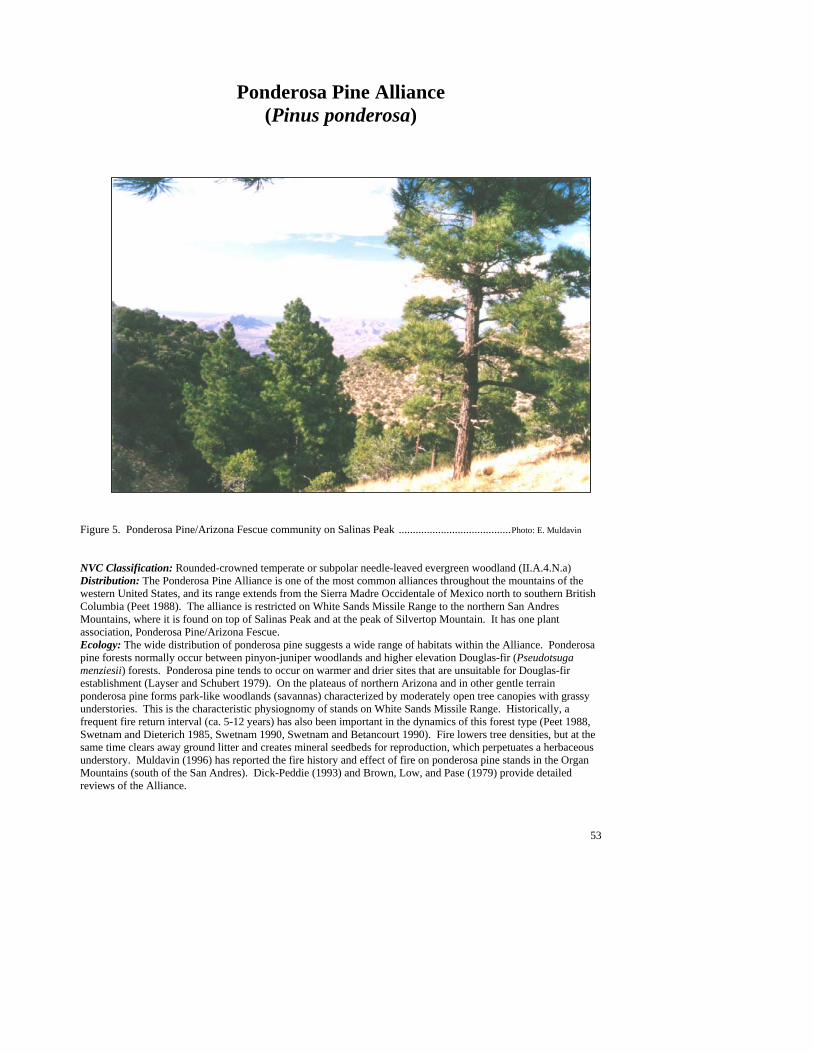
53
Ponderosa Pine Alliance (Pinus ponderosa)
Figure 5. Ponderosa Pine/Arizona Fescue community on Salinas Peak ........................................Photo: E. Muldavin NVC Classification: Rounded-crowned temperate or subpolar needle-leaved evergreen woodland (II.A.4.N.a) Distribution: The Ponderosa Pine Alliance is one of the most common alliances throughout the mountains of the western United States, and its range extends from the Sierra Madre Occidentale of Mexico north to southern British Columbia (Peet 1988). The alliance is restricted on White Sands Missile Range to the northern San Andres Mountains, where it is found on top of Salinas Peak and at the peak of Silvertop Mountain. It has one plant association, Ponderosa Pine/Arizona Fescue. Ecology: The wide distribution of ponderosa pine suggests a wide range of habitats within the Alliance. Ponderosa pine forests normally occur between pinyon-juniper woodlands and higher elevation Douglas-fir (Pseudotsuga menziesii) forests. Ponderosa pine tends to occur on warmer and drier sites that are unsuitable for Douglas-fir establishment (Layser and Schubert 1979). On the plateaus of northern Arizona and in other gentle terrain ponderosa pine forms park-like woodlands (savannas) characterized by moderately open tree canopies with grassy understories. This is the characteristic physiognomy of stands on White Sands Missile Range. Historically, a frequent fire return interval (ca. 5-12 years) has also been important in the dynamics of this forest type (Peet 1988, Swetnam and Dieterich 1985, Swetnam 1990, Swetnam and Betancourt 1990). Fire lowers tree densities, but at the same time clears away ground litter and creates mineral seedbeds for reproduction, which perpetuates a herbaceous understory. Muldavin (1996) has reported the fire history and effect of fire on ponderosa pine stands in the Organ Mountains (south of the San Andres). Dick-Peddie (1993) and Brown, Low, and Pase (1979) provide detailed reviews of the Alliance.
54
Ponderosa Pine/Arizona Fescue PA (Pinus ponderosa/Festuca arizonica; PINPON/FESARI)
Distribution: Minor association on WSMR and to the northern San Andres Mountains (Salinas Peak and Silver Top Mountain). It is widespread in mountain areas of New Mexico, northern Arizona, and southern Colorado, infrequent south of the Mogollon Rim. Vegetation Summary: These forests are characterized by an open ponderosa pine canopy with a luxuriant grassy understory dominated by Arizona fescue in association with other cool-season grasses such as pine dropseed and Rocky Mountain trisetum.
Mountain muhly and little bluestem are also occasional warm-season associates. Pinyon pine and oneseed juniper (Juniperus monosperma) can be present, but are uncommon. Shrubs are inconspicuous, but mountain mahogany is the most constant. The cool and mesic nature of the type is reflected by the occasional occurrence of sandwort, alumroot, and threepetal bedstraw. Physical Setting: Stands are found at or near the summits of Salinas Peak and Silvertop Mountain at elevations of 7,600 to 8,500 ft (2,320 to 2,590 m). At lower elevations the aspects tend to be northerly; at the highest elevations, southerly. Soils are derived from sandstone and, in the case of Salinas Peak, volcanic extrusive rhyolite. They are moderately developed
forest soils (Ustochrepts and Ustalfs), although relatively shallow. Discussion: Ponderosa pine stands on White Sands Missile Range are likely relicts of a cooler period (Late Pleistocene or mid-Holocene?) when they may have been more prevalent in the San Andres. Currently, stands are small and their long-term viability is a matter of concern, particularly in the absence of the light surface fire needed to enhance ponderosa reproduction. Historically elsewhere in the Southwest, surface fires in this plant association were frequent (every four to eight years) and often covered large areas (on average 1,214 ha [3,000 ac]) (Swetnam and Dieterich 1985). Whether this is the case on WSMR has not been investigated. DeVelice et al. (1986) suggested that fires themselves encourage heavy grass growth and increased surface fire frequency. On the more mesic sites in this plant association, western brackenfern (Pteridium aquilinum) and Kentucky bluegrass (Poa pratensis) can dominate where fires or livestock grazing have had past or repeated occurrences. Soil Taxonomic Unit(s): Loamy Skeletal Mixed, Mesic Lithic Ustochrept Loamy Skeletal Mixed Mesic Lithic Haplustalf Average Min Max ELEVATION (ft): 8111 7683 8760 SLOPE (%): 27 15 35 SOLAR INDEX: 1.34 .59 1.97
Common Plant Species, Ponderosa Pine/Arizona Fescue PA: Constancy Cover Scientific Name Common Name (% plots) Mean Max Min n = 5 Trees Pinus ponderosa ponderosa pine 100.00% 30.21 62.50 7.50 Pinus edulis pinyon pine 40.00% 12.50 17.50 7.50 Shrubs Opuntia phaeacantha tulip pricklypear 60.00% 1.17 2.50 0.50 Cercocarpus montanus true mountain mahogany 100.00% 1.65 2.50 0.25 Grasses Schizachyrium scoparium little bluestem 40.00% 4.25 7.50 1.00 Muhlenbergia montana mountain muhly 40.00% 11.25 17.50 5.00 Muhlenbergia dubia pine muhly 40.00% 0.28 0.50 0.05 Festuca arizonica Arizona fescue 100.00% 18.00 30.00 7.50 Blepharoneuron tricholepis pine dropseed 80.00% 14.13 29.00 2.50 Trisetum montanum Rocky Mountain trisetum 20.00% 5.00 5.00 5.00 Forbs Artemisia frigida fringed sagewort 40.00% 0.05 0.05 0.05 Arenaria spp. sandwort 40.00% 0.01 0.01 0.00 Galium trifidum threepetal bedstraw 20.00% 0.01 0.01 0.01 Heuchera spp. alumroot 20.00% 0.05 0.05 0.0
#####
55
Shrublands and Dwarf Shrublands Shrublands have been divided into two subsections: 1) a Montane and Chaparral Shrublands Subsection containing tall shrubland alliances from mid to upper elevation mountain areas, and 2) a Plains and Desert Shrubland Subsection with both tall and dwarf shrubland alliances from the foothills to the desert floor. Key to the Shrubland Sub-sections 1. Shrublands dominated by mesic shrubs—Gambel’s oak, Shrub live oak, or mountain mahogany .........................................................................................................................................Montane and Chaparral Shrublands 1. Gambel’s oak, Shrub live oak, or mountain mahogany absent; shrublands dominated by plains and desert species .......................................................................Plains and Desert Shrublands and Dwarf Shrublands (page 73)
Montane and Chaparral Shrublands In the mountains of White Sands Missile Range, extensive areas of deciduous montane shrublands and evergreen sclerophyllous chaparral intermix in a complex mosaic of the woodlands and grasslands communities. The mid to upper elevations (5,000 to 8,700 ft; 1,520 to 2,650 m) are dominated by Rocky Mountain/Great Basin Montane Deciduous Scrub Alliance Group represented by the Mountain Mahogany (Cercocarpus montanus) and Gambel's Oak (Quercus gambelii) Alliances (Table 7). The Gambel's Oak Alliance with its two associations occurs at the highest elevations of the northern mountains (8,300 to 8,700 ft; 2,530 to 2,650 m), either in deeply shaded canyons or on unstable scree slopes. The Mountain Mahogany Alliance, represented by nine associations, is intermixed among pinyon pine woodlands and may be associated with past fire. The other alliance group of this subsection is Broadleaf Interior Evergreen Chaparral represented by the Scrub Live Oak (Quercus turbinella) Alliance and its five associations. It is prevalent on warmer slopes at lower elevations (4,600 to 7,200 ft; 1,400 to 2,190 m). Scrub Live Oak is a drought- and fire-tolerant sclerophyllous species that may also be associated with fire among pinyon woodlands and juniper savannas. At lower elevations, the chaparral often grades into foothill grasslands.
Table 7. National Vegetation Classification of montane and chaparral shrubland alliances. III Shrubland III.A Evergreen shrubland III.A.2 Temperate broad-leaved evergreen shrubland III.A.2.N.c Sclerophyllous temperate broad-leaved evergreen shrubland Interior Chaparral Shrub Live Oak Shrubland Alliance III.B Deciduous shrubland III.B.2 Cold-deciduous shrubland III.B.2.N.a Temperate cold-deciduous shrubland Rocky Mountain/Great Basin Montane Deciduous Scrub Gambel's Oak Shrubland Alliance Mountain Mahogany Shrubland Alliance
Key to the Montane and Chaparral Shrubland Alliances 1. Gambel’s oak (Quercus gambelii) well represented as dominant tree or shrub .......... Gambel’s Oak Alliance 1. Gambel’s oak poorly represented or absent.......................................................................................................2 2. Shrub live oak (Quercus turbinella) common to well represented as dominant or codominant shrub....................................................................................................................................................... Shrub Live Oak Alliance 2. Shrub live oak poorly represented or absent, Mountain mahogany (Cercocarpus montanus) common to well represented as dominant or codominant shrub.......................................................Mountain Mahogany Alliance
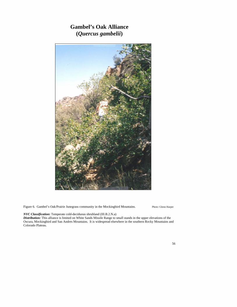
56
Gambel’s Oak Alliance (Quercus gambelii)
Figure 6. Gambel’s Oak/Prairie Junegrass community in the Mockingbird Mountains. Photo: Glenn Harper NVC Classification: Temperate cold-deciduous shrubland (III.B.2.N.a) Distribution: This alliance is limited on White Sands Missile Range to small stands in the upper elevations of the Oscura, Mockingbird and San Andres Mountains. It is widespread elsewhere in the southern Rocky Mountains and Colorado Plateau.

57
Ecology: On White Sands Missile Range, the Gambel’s Oak Alliance has been documented on the rocky soils of cool northern slopes at the highest elevations of Salinas Peak and in the Mockingbird Mountains, but is likely in the Oscura Mountains. Gambel’s oak sprouts readily after fire, and can form dense, often tall thickets that limit the establishment of conifers. On occasion, ponderosa pine and pinyon pine will become established, leading to a conifer-dominated woodland. At this time only two minor plant associations have been documented on WSMR for this alliance and they are considered minor in extent. Key to the Gambel’s Oak (Quercus gambelii) Plant Associations 1. Snowberry spp. (Symphoricarpos oreophilus, S. palmeri, or S. rotundifolius) well represented as dominant shrub................................................................................................Gambel’s Oak/Snowberry PA (See Minor Types) 1. Prairie Junegrass (Koeleria macrantha) well represented as dominant grass...........................................................................................................................................Gambel’s Oak/Prairie Junegrass PA (See Minor Types)
Minor Plant Associations: Gambel’s Oak Alliance Gambel’s Oak/Palmer’s Snowberry PA (Quercus gambelii/Symphoricarpos palmeri; QUEGAM/SYMPAL) This minor plant association is known on White Sands Missile Range from one occurrence on Salinas Peak in the San Andres Mountains. This community is found on a steep slope with a cool northern exposure at 8,720 ft (2,658 m). The type is associated with rocky talus slopes where soils are poorly developed and unstable. The clonal nature of the oaks may serve to stabilize the slopes somewhat. Adjacent to the sites are conspicuous stands of Ponderosa Pine/Arizona Fescue, usually on less steep, more stable slopes. Gambel's oak is abundant and forms dense shrubby clones intermixed with a variety of shrubs including Palmer's Snowberry, New Mexico locust (Robinia neomexicana), Fendler's brickellbush (Brickellia fendleri), tasselflower brickellbush (Brickellia grandiflora), rockspirea (Holodiscus dumosus), common hoptree (Ptelea trifoliata), and whisky currant (Ribes cereum var. pedicellare). Cool season grasses typify the understory such as fringed brome (Bromus ciliatus), prairie junegrass (Koeleria macrantha), and Porter's melicgrass (Melica porteri). The mesic conditions of this type are also indicated by the forb species: onion (Allium spp.), wormwood (Artemisia dracunculus), pink alumroot (Heuchera rubescens), smooth spreading four o'clock (Mirabilis oxybaphoides), wishbone fiddleleaf (Nama dichotomum), mountain leaftail (Pericome caudata), slimleaf plainsmustard (Schoenocrambe linearifolia), Fendler's meadowrue (Thalictrum fendleri), and nettle (Urtica spp.). Gambel’s Oak/Prairie Junegrass PA (Quercus gambelii/Koeleria macrantha; QUEGAM/KOEMAC) This minor plant association is known from two occurrences on White Sands Missile Range, one in the Mockingbird Mountains and the other on Salinas Peak in the San Andres Mountains. Both occurrences are on very steep slopes with cool northern exposures (6,740 and 8,360 ft [2,054 and 2,548 m] respectively). Gambel's ok is abundant and forms tall, shrub canopy with a grassy understory dominated by junegrass with woolly brome (Bromus lanatipes) as a common associate.
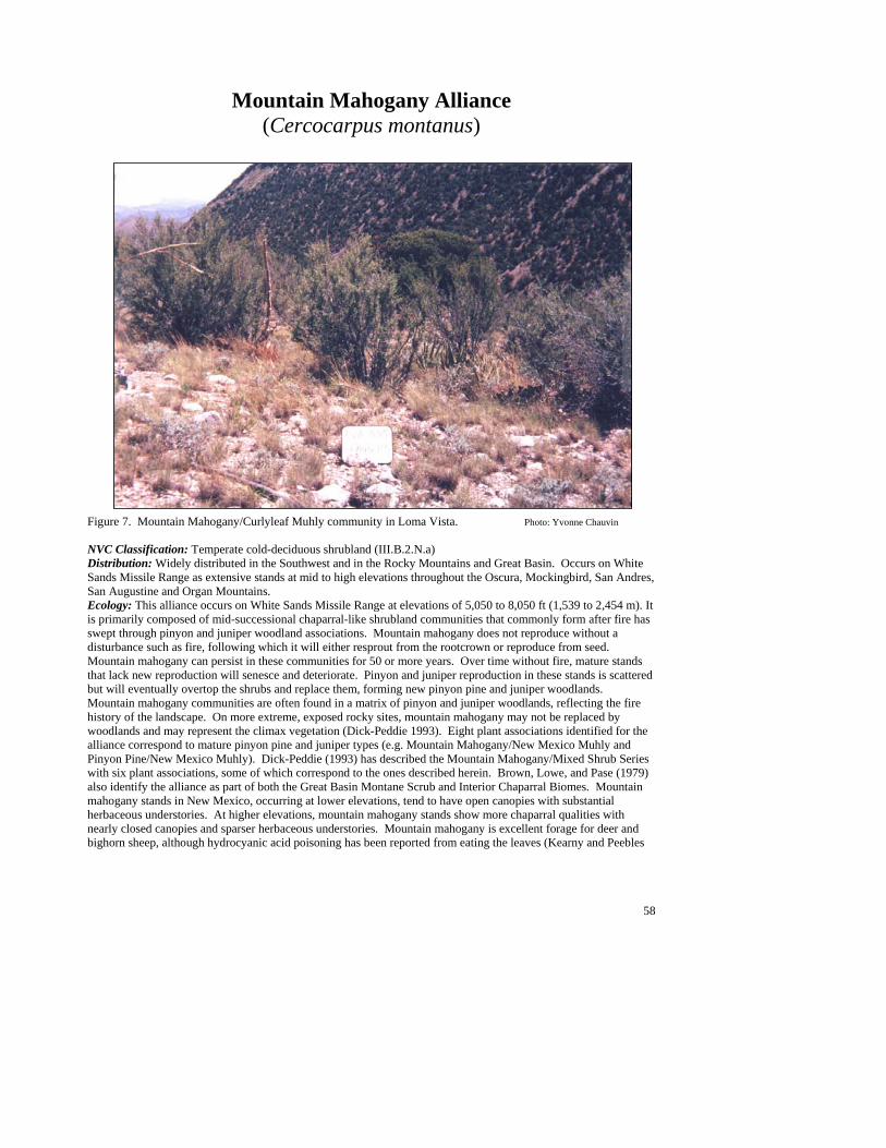
58
Mountain Mahogany Alliance (Cercocarpus montanus)
Figure 7. Mountain Mahogany/Curlyleaf Muhly community in Loma Vista. Photo: Yvonne Chauvin NVC Classification: Temperate cold-deciduous shrubland (III.B.2.N.a) Distribution: Widely distributed in the Southwest and in the Rocky Mountains and Great Basin. Occurs on White Sands Missile Range as extensive stands at mid to high elevations throughout the Oscura, Mockingbird, San Andres, San Augustine and Organ Mountains. Ecology: This alliance occurs on White Sands Missile Range at elevations of 5,050 to 8,050 ft (1,539 to 2,454 m). It is primarily composed of mid-successional chaparral-like shrubland communities that commonly form after fire has swept through pinyon and juniper woodland associations. Mountain mahogany does not reproduce without a disturbance such as fire, following which it will either resprout from the rootcrown or reproduce from seed. Mountain mahogany can persist in these communities for 50 or more years. Over time without fire, mature stands that lack new reproduction will senesce and deteriorate. Pinyon and juniper reproduction in these stands is scattered but will eventually overtop the shrubs and replace them, forming new pinyon pine and juniper woodlands. Mountain mahogany communities are often found in a matrix of pinyon and juniper woodlands, reflecting the fire history of the landscape. On more extreme, exposed rocky sites, mountain mahogany may not be replaced by woodlands and may represent the climax vegetation (Dick-Peddie 1993). Eight plant associations identified for the alliance correspond to mature pinyon pine and juniper types (e.g. Mountain Mahogany/New Mexico Muhly and Pinyon Pine/New Mexico Muhly). Dick-Peddie (1993) has described the Mountain Mahogany/Mixed Shrub Series with six plant associations, some of which correspond to the ones described herein. Brown, Lowe, and Pase (1979) also identify the alliance as part of both the Great Basin Montane Scrub and Interior Chaparral Biomes. Mountain mahogany stands in New Mexico, occurring at lower elevations, tend to have open canopies with substantial herbaceous understories. At higher elevations, mountain mahogany stands show more chaparral qualities with nearly closed canopies and sparser herbaceous understories. Mountain mahogany is excellent forage for deer and bighorn sheep, although hydrocyanic acid poisoning has been reported from eating the leaves (Kearny and Peebles

59
1964). Foraging may have impacts on community dynamics by reducing litter accumulation, and the ingestion of flowers, fruits and seeds influences the degree of reproduction and seed dispersal. Key to the Mountain Mahogany (Cercocarpus montanus) Plant Associations 1. Communities on limestone outcrops with mat rockspirea (Petrophyton caespitosum) present................................................................................................................................... See Ocotillo/Mat Rockspirea PA page. 106 1. Communities not on limestone outcrops and mat rockspirea absent .................................................................2 2. Wavyleaf oak (Quercus undulata) well represented dominant or codominant shrub......................................................................................................................... Mountain Mahogany/Wavyleaf Oak PA (See Minor Types) 2. Wavyleaf oak poorly represented to absent .......................................................................................................3 3. Sacahuista (Nolina microcarpa) common to well represented dominant or codominant shrub and equal to or more abundant than the dominant grass................................ Mountain Mahogany/Sacahuista PA (See Minor Types) 3. Sacahuista poorly represented to absent ............................................................................................................4 4. New Mexico needlegrass (Stipa neomexicana) well represented dominant or codominant grass ................................................................................................................... Mountain Mahogany/New Mexico Needlegrass PA 4. New Mexico needlegrass poorly represented to absent .....................................................................................5 5. Grama (Bouteloua) species more abundant than muhly (Muhlenbergia) species .............................................6 5. Muhly species more abundant than grama species ............................................................................................7 6 Blue grama (Bouteloua gracilis) common to well represented dominant or codominant grass .............................................................................................................Mountain Mahogany/Blue Grama PA (See Minor Types) 6. Blue grama poorly represented to absent; sideoats grama (Bouteloua curtipendula) common to well represented dominant or codominant grass........................................................... Mountain Mahogany/Sideoats Grama PA 7. New Mexico muhly (Muhlenbergia pauciflora) common to well represented dominant or codominant grass..................................................................................................... Mountain Mahogany/New Mexico Muhly PA 7. New Mexico muhly poorly represented to absent .............................................................................................8 8. Curlyleaf muhly (Muhlenbergia setifolia) common to well represented as dominant or codominant grass ................................................................................................................. Mountain Mahogany/Curlyleaf Muhly PA 8. Curlyleaf muhly poorly represented to absent ...................................................................................................9 9. Plains lovegrass (Eragrostis intermedia) common to well represented dominant or codominant grass........................................................................................................................Mountain Mahogany/Plains Lovegrass PA 9. Black Grama (Bouteloua eriopoda) common to well represented dominant or codominant grass ......................................................................................................Mountain Mahogany/Black Grama PA (See Minor Types)
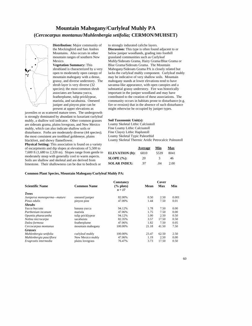
60
Mountain Mahogany/Curlyleaf Muhly PA (Cercocarpus montanus/Muhlenbergia setifolia; CERMON/MUHSET)
Distribution: Major community of the Mockingbird and San Andres Mountains. Also occurs in other mountain ranges of southern New Mexico. Vegetation Summary: This shrubland is characterized by a very open to moderately open canopy of mountain mahogany with a dense, grassy, and diverse understory. The shrub layer is very diverse (32 species); the most common shrub associates are banana yucca, featherplume, tulip pricklypear, mariola, and sacahuista. Oneseed juniper and pinyon pine can be present at upper elevations as
juveniles or as scattered mature trees. The undergrowth is strongly dominated by abundant to luxuriant curlyleaf muhly, a shallow soil indicator. Other common grasses are sideoats grama, plains lovegrass, and New Mexico muhly, which can also indicate shallow soils or disturbance. Forbs are moderately diverse (44 species); the most consistent are toothleaf goldeneye, plains blackfoot, and showy flameflower. Physical Setting: This association is found on a variety of escarpments and dip slopes at elevations of 5,500 to 7,600 ft (1,680 to 2,320 m). Slopes range from gentle to moderately steep with generally cool to warm aspects. Soils are shallow and skeletal and are derived from limestone. Their shallowness can be due to bedrock or
to strongly indurated caliche layers. Discussion: This type is often found adjacent to or below juniper woodlands, grading into foothill grassland communities such as Curlyleaf Muhly/Sideoats Grama, Hairy Grama/Blue Grama or Blue Grama/Sideoats Grama. The Mountain Mahogany/Sideoats Grama PA is closely related but lacks the curlyleaf muhly component. Curlyleaf muhly may be indicative of very shallow soils. Mountain mahogany stands at lower elevations tend to have savanna-like appearance, with open canopies and a substantial grassy understory. Fire was historically important in the juniper woodland and may have contributed to the creation of these associations. The community occurs in habitats prone to disturbance (e.g. fire or erosion) that in the absence of such disturbance might otherwise be occupied by juniper types. Soil Taxonomic Unit(s): Loamy Skeletal Lithic Calciustoll Fine Loamy Lithic Calciustoll Fine Clayey Lithic Haplustoll Loamy Skeletal Typic Paleorthid Loamy Skeletal Thermic Aridic Petrocalcic Paleustoll Average Min Max ELEVATION (ft): 6810 5539 8041 SLOPE (%): 20 3 46 SOLAR INDEX: .97 .04 2.00
Common Plant Species, Mountain Mahogany/Curlyleaf Muhly PA: Constancy Cover Scientific Name Common Name (% plots) Mean Max Min n = 17 Trees Juniperus monosperma—mature oneseed juniper 82.00% 0.50 2.50 0.001 Pinus edulis pinyon pine 47.00% 1.44 7.50 0.01 Shrubs Yucca baccata banana yucca 94.12% 1.78 7.50 0.00 Parthenium incanum mariola 47.06% 1.75 7.50 0.00 Opuntia phaeacantha tulip pricklypear 94.12% 1.00 2.50 0.50 Nolina microcarpa sacahuista 82.35% 3.57 17.50 0.50 Dalea formosa featherplume 47.06% 1.82 7.50 0.05 Cercocarpus montanus mountain mahogany 100.00% 21.18 41.50 7.50 Grasses Muhlenbergia setifolia curlyleaf muhly 100.00% 23.47 62.50 2.50 Muhlenbergia pauciflora New Mexico muhly 47.06% 1.19 2.50 0.00 Eragrostis intermedia plains lovegrass 76.47% 3.73 17.50 0.50
#
#
#
##
#
####
##
##
#
## #
#
##
61
Common Plant Species, Mountain Mahogany/Curlyleaf Muhly PA, (continued): Bouteloua gracilis blue grama 47.06% 0.69 2.50 0.05 Bouteloua curtipendula sideoats grama 70.59% 2.33 7.50 0.50 Forbs Viguiera dentata toothleaf goldeneye 58.82% 0.18 0.50 0.01 Melampodium leucanthum plains blackfoot 58.82% 0.17 0.50 0.01 Talinum pulchellum showy flameflower 41.18% 0.18 0.50 0.05
Mountain Mahogany/New Mexico Muhly PA (Cercocarpus montanus/Muhlenbergia pauciflora; CERMON/MUHPAU)
Distribution: Major community of the San Andres and Oscura Mountains. May occur elsewhere in the Southwest, the Rocky Mountains, and northern Mexico. Vegetation Summary: This community is characterized by open to moderately dense stands of mountain mahogany, with a grassy understory dominated by New Mexico muhly. Mountain mahogany is tall and evenly spaced throughout the occurrence. The shrubby, chaparral-like appearance of this type is reflected by the high shrub diversity (28 species), which
usually includes ashy silktassel, rock sage, Parry’s agave, red barberry, banana yucca, cactus apple, tulip pricklypear, sacahuista, and skunkbush sumac. Pinyon pine and oneseed juniper (standing dead or live) are sparsely scattered, with reproduction often present. The grass layer is well represented to abundant, relatively evenly distributed, and occupies both open spaces and under shrub canopies. Scribner’s needlegrass, plains lovegrass, and sideoats grama are common associates along with the dominant New Mexico muhly. Forb diversity is moderate; toothleaf goldeneye and Colorado four o’clock commonly grow under or near shrub canopies. Showy flameflower, longleaf mock thelypody, Fendler’s bladderpod, and onion are typically found in the open spaces between shrub canopies. Physical Setting: The Mountain Mahogany/New Mexico Muhly PA generally occurs on steep to very steep colluvial escarpment mountain slopes (sometimes along the very upper dip-slopes edges) at elevations of 6,300 to 7,500 ft (1,920 to 2,290 m). It is usually found
on warmer aspects at high elevations and on cooler aspects at lower elevations, generally below 7,000 ft (2,130 m). Loose rock and gravel with occasional scattered boulders characterize escarpment stands. Stands may be bound by rock outcrops. Rock and gravel cover at the surface is high and generally unstable. Loose rock and gravel overlying bedrock characterize dip slope stands. Exposed bedrock is typically high. The substrate is limestone with soils that are generally shallow, with horizons of silt loam to clay loam in a rocky matrix (loamy skeletal mollisols and aridisols). Discussion: Stands of the Mountain Mahogany/New Mexico Muhly PA are generally patchy at lower elevations, but become continuous at higher elevations. Low elevation stands are generally found on cool slopes. Adjacent and lower elevation slopes may give way to oak shrubland (Shrub Live Oak/Sideoats Grama), montane or foothill grassland (New Mexico Needlegrass/Sotol, Sideoats Grama/Ocotillo) or other mountain mahogany PAs (Mountain Mahogany/Sideoats Grama or Mountain Mahogany/New Mexico Needlegrass). Higher elevation ridges and drainages generally grade into pinyon or juniper woodland (Pinyon Pine/Wavyleaf Oak may line drainages) or other mountain mahogany (Mountain Mahogany/Curlyleaf Muhly or Mountain Mahogany/Sacahuista) PAs. High elevation stands are generally found on warm slopes and may be distributed within a matrix of pinyon (Pinyon Pine/Wavyleaf Oak) or juniper (Oneseed Juniper/New Mexico Muhly) woodlands. Mountain mahogany stands in New Mexico occurring at lower elevations tend to have open canopies with substantial herbaceous understories. They are bound by pinyon pine and juniper woodlands above and by shrubby grasslands below. At higher elevations, mountain mahogany stands show more
#
#
#
#
#
##
62
chaparral-like qualities with nearly closed canopies and herbaceous understories. Little ecological research has been conducted into this species’ distribution and ecology. Overall, this association seems to occur in habitats that are prone to disturbance (e.g., fire or erosion) and that in the absence of such disturbance would otherwise be occupied by pinyon or juniper woodlands.
Soil Taxonomic Unit(s): Fine Clayey Lithic Haplustoll Average Min Max ELEVATION (ft): 6938 5899 7583 SLOPE (%): 40 60 SOLAR INDEX: .79 .02 1.95
Common Plant Species, Mountain Mahogany/New Mexico Muhly PA: Constancy Cover Scientific Name Common Name (% plots) Mean Max Min n = 7 Trees Juniperus monosperma—mature oneseed juniper 42.86% 1.33 4.00 0.00 Pinus edulis—mature pinyon pine 42.86% 0.33 1.00 0.00 Shrubs Opuntia engelmannii cactus apple 42.86% 0.50 0.50 0.50 Cercocarpus montanus mountain mahogany 100.00% 22.21 62.50 6.50 Garrya flavescens ashy silktassel 57.14% 3.13 7.00 0.50 Mahonia haematocarpa red barberry 42.86% 2.00 4.00 0.50 Agave parryi Parry’s agave 57.14% 0.38 0.50 0.00 Nolina microcarpa sacahuista 71.43% 1.00 2.50 0.50 Yucca baccata banana yucca 100.00% 1.97 2.50 0.50 Opuntia phaeacantha tulip pricklypear 85.71% 0.79 2.50 0.25 Rhus trilobata skunkbush sumac 42.86% 2.67 5.00 0.50 Salvia pinguifolia rock sage 42.86% 1.17 2.50 0.50 Grasses Stipa scribneri Scribner’s needlegrass 57.14% 3.50 7.50 1.50 Eragrostis intermedia plains lovegrass 57.14% 2.25 7.50 0.50 Bouteloua curtipendula sideoats grama 85.71% 1.46 2.50 0.25 Muhlenbergia pauciflora New Mexico muhly 100.00% 6.79 17.50 1.50 Forbs Viguiera dentata toothleaf goldeneye 85.71% 0.63 2.00 0.05 Allium spp. onion 42.86% 0.50 0.50 0.50
Mountain Mahogany/New Mexico Needlegrass PA
(Cercocarpus montanus/Stipa neomexicana; CERMON/STINEO)
Distribution: Major community throughout the San Andres and Oscura Mountains. This type may occur elsewhere in the Southwest, the Rocky Mountains, and possibly northern Mexico. Vegetation Summary: This community is characterized by a shrub layer clearly dominated by mountain mahogany, with a grassy understory dominated by New Mexico needlegrass. The shrub canopy can be very open with mountain mahogany widely spaced
and tall and with low-lying shrubs scattered in between. Banana yucca, skeletonleaf goldeneye, skunkbush sumac, tulip pricklypear, sacahuista, winterfat, and featherplume are common associates of this diverse shrubland (36 shrubs). Pinyon pine and oneseed juniper (juvenile, mature, or standing dead) are common in higher elevation stands. The grass layer is well represented to luxuriant in cover. Sideoats grama and purple threeawn may occasionally codominate with New Mexico needlegrass. Other common grasses are plains lovegrass, curlyleaf muhly (near ridgetops), black grama, and blue grama. Forb diversity is moderate (26 species). Toothleaf goldeneye grows near shrub canopies. Plains blackfoot, Fendler’s sandmat, stemmy
#
#
#
#
#
#
#
##
#
#
#
#
#
#
#
#
###
##
#
#

63
hymenoxys, and Fendler’s bladderpod are also common, but generally grow in between shrubs. Physical Setting: The Mountain Mahogany/New Mexico Needlegrass PA occurs on moderate to steep slopes. It is commonly found on nose or sideslopes of escarpment faces, or along dip slopes. It can also occur on alluvial deposits of mountain valleys or upper portions of basin alluvial fans. It occurs predominantly on northerly aspects at elevations of 5,000 to 7,000 ft (1,520 to 2,130 m). Substrates are typically Paleozoic limestone. However, stands can occasionally occur on sandstone. Escarpment stands are characterized by loose rock and gravel with occasional scattered boulders. Dip slope stands (low to upper slopes) are characterized by loose rock and gravel overlaying bedrock; bedrock exposure is typically high. Soils are derived from limestone and are generally distributed in patchy accumulations or between fractures in the bedrock. Soils are typically shallow with horizons of silt loam to clay loam in a rocky matrix (loamy and clayey skeletal mollisols and aridisols). Surface textures generally range between sandy loam and silty clay loams. Discussion: On White Sands Missile Range, stands of the Mountain Mahogany/New Mexico Needlegrass PA occur in patches across the San Andres Mountain escarpment and become more continuous on dip slopes. In the Oscura Mountains, stands occur in bands along upper piedmonts (western slope) and become patchy in the foothills. This association can be found embedded in a matrix of pinyon and juniper associations, and may be successional to open woodlands such as the Oneseed
Juniper/New Mexico Needlegrass or Oneseed Juniper/Blue Grama PAs and, possibly, Pinyon Pine/New Mexico Needlegrass PA. It can exist near pinyon-pine-lined drainages or grade to other mountain mahogany PAs (Mountain Mahogany/Sideoats Grama or Mountain Mahogany/Plains Lovegrass). Lower elevations or adjacent warmer slopes generally grade into grasslands (Black Grama/Blue Grama, Black Grama/Blue Grama/Banana Yucca, Hairy Grama/Sideoats Grama PAs), or shrub live oak associations (Shrub Live Oak/Sideoats Grama or Shrub Live Oak/Black Grama PAs). In the San Andres Mountains, stands across foothill escarpments are generally bound by rock outcrops and thus occur in linear bands. Higher elevations or adjacent, cooler slopes support pinyon or juniper woodlands. Mountain mahogany stands in New Mexico occurring at lower elevations tend to have open canopies (this may be related to fire intensity and frequency) with substantial herbaceous understories. Soil Taxonomic Unit(s): Loamy Lithic Haplustoll Fine Clayey Typic Calciorthid Very Fine Clayey Typic Paleargid Loamy Skeletal Lithic Haplustoll Average Min Max ELEVATION (ft): 6249 5036 6971 SLOPE (%): 26 11 55 SOLAR INDEX: 1.00 .02 2.0
Common Plant Species, Mountain Mahogany/New Mexico Needlegrass PA: Constancy Cover Scientific Name Common Name (% plots) Mean Max Min n = 23 Shrubs Yucca baccata banana yucca 91.30% 1.45 2.50 0.50 Viguiera stenoloba skeletonleaf goldeneye 69.57% 2.56 17.50 0.50 Rhus trilobata skunkbush sumac 65.22% 1.53 2.50 0.00 Opuntia phaeacantha tulip pricklypear 73.91% 0.94 2.50 0.00 Nolina microcarpa sacahuista 73.91% 2.38 7.50 0.01 Krascheninnikovia lanata winterfat 60.87% 0.36 0.50 0.01 Dalea formosa featherplume 65.22% 1.24 2.50 0.01 Chrysothamnus pulchellus southwestern rabbitbrush 47.83% 1.00 2.50 0.01 Cercocarpus montanus mountain mahogany 100.00% 13.43 29.00 2.50 Grasses Stipa neomexicana New Mexico needlegrass 100.00% 18.52 62.50 2.50 Eragrostis intermedia plains lovegrass 47.83% 1.19 2.50 0.05 Bouteloua curtipendula sideoats grama 91.30% 1.64 2.50 0.50 Aristida purpurea purple threeawn 91.30% 2.83 7.50 0.50 Forbs Lesquerella fendleri Fendler’s bladderpod 60.87% 0.39 2.50 0.05
64
Mountain Mahogany/Plains Lovegrass PA (Cercocarpus montanus/Eragrostis intermedia; CERMON/ERAINT)
Distribution: A major community of the northern San Andres and Oscura Mountains. May occur elsewhere in the Southwest, the Rocky Mountains, and northern Mexico. Vegetation Summary: This montane shrubland is dominated by mountain mahogany, with plains lovegrass the characteristic dominant understory. The canopy is moderately open, but at higher elevations stands become quite dense. Mountain mahogany is tall and generally evenly spaced across the occurrence; other shrubs are subordinate and scattered. In this
diverse shrubland, banana yucca, tulip pricklypear, sacahuista, broom snakeweed, and shrub live oak may be present and at times well represented. Oneseed juniper (live or standing dead) is common but usually scattered. The understory is distinctly grassy, with bristly wolfstail, pine muhly, and New Mexico muhly (usually at higher elevations) occasional codominates with Plains love-grass. These bunch grasses are scattered and generally grow through rocky surfaces and between shrub canopies. Forb cover is poor, although species diversity is high. Louisiana sagewort and toothleaf goldeneye can be found growing under or near shrub canopies. Plains blackfoot, showy flameflower, longstalk greenthread, and kingcup cactus generally grow in the spaces between shrubs. A Shrub Live Oak Phase has been provisionally identified that may occur in transitional areas between oak shrublands and higher elevation mountain mahogany stands. Physical Setting: The Mountain Mahogany/Plains Lovegrass PA generally occurs on moderately steep to steep colluvial mountain slopes. It is commonly found
across the faces of scarp sideslopes and along dip slopes. The elevation range is wide (5,500 to 8,000 ft; 1,680 to 2,440 m). It tends to occupy hot and warm aspects at high elevations and cooler aspects at lower elevations, generally below 6,500 ft (1,980 m). Substrates, although predominantly limestone, can also be sandstone or rhyolite. Stands on rhyolite outcrops occur on high ridges within the central San Andres Mountains (areas surrounding Salinas Peak). Dip slope stands are characterized by loose rock and gravel overlying bedrock; bedrock exposure is typically high. Escarpment stands are characterized by loose rock and gravel with occasional scattered boulders, and may be bound by rock outcrops. Soils are generally shallow with surface textures ranging between silt loam and sandy loam and becoming coarser on igneous substrates. Discussion: Stands of the Mountain Mahogany/Plains Lovegrass PA are generally patchy at low elevations but become more become continuous at higher elevations. The association is often distributed within a matrix of pinyon or juniper woodland communities, likely as a result of past fire events (evidence of past fire is found in most stands). Plains lovegrass is also considered an indicator of disturbance, particularly fire. Stands are generally found on cool slopes at low elevation and on warmer slopes at higher elevations where pinyon woodlands occupy the cool slopes. Lower slopes commonly grade into temperate grassland types (New Mexico Needlegrass/Sotol, New Mexico Needlegrass/Sideoats Grama or Blue Grama/Banana Yucca) or oak shrubland types (Shrub Live Oak/Sideoats Grama). Average Min Max ELEVATION (ft): 7128 5937 7771 SLOPE (%) 29 3 52 SOLAR INDEX: .76 .00 1.92
Common Plant Species, Mountain Mahogany/Plains Lovegrass PA: Constancy Cover Scientific Name Common Name (% plots) Mean Max Min n = 11 Trees Juniperus monosperma—mature oneseed juniper 54.55% 0.59 2.50 0.00 Shrubs Yucca baccata banana yucca 81.82% 1.78 6.00 0.50 Opuntia phaeacantha tulip pricklypear 90.91% 0.93 2.50 0.05
#
##
#
#
#
#
#
#
#
#
#
65
Common Plant Species, Mountain Mahogany/Plains Lovegrass PA, (continued): Nolina microcarpa sacahuista 81.82% 1.69 7.50 0.25 Gutierrezia sarothrae broom snakeweed 45.45% 0.33 0.50 0.05 Cercocarpus montanus mountain mahogany 100.00% 20.86 41.50 2.50 Grasses Muhlenbergia pauciflora New Mexico muhly 54.55% 0.92 2.50 0.50 Lycurus setosus bristly wolfstail 63.64% 2.43 10.00 0.50 Eragrostis intermedia plains lovegrass 100.00% 5.86 17.50 2.50 Bouteloua gracilis blue grama 45.45% 0.66 2.50 0.01 Forbs Echinocereus triglochidiatus kingcup cactus 45.45% 0.03 0.05 0.01
Mountain Mahogany/Sideoats Grama PA (Cercocarpus montanus/Bouteloua curtipendula; CERMON/BOUCUR)
Distribution: Major community of the San Andres, San Augustine, Organ, and Oscura Mountains. May occur elsewhere in the Southwest, the Rocky Mountains, and northern Mexico. Vegetation Summary: This community is dominated by mountain mahogany and has an understory dominated by sideoats grama. The shrub canopy is moderately open, but at higher elevations can occur as dense stands. Mountain mahogany is tall and evenly spaced. Shrub diversity is high (45 species) with banana
yucca, skeletonleaf goldeneye, skunkbush sumac, mariola, tulip pricklypear, and sacahuista as occasional codominant associates. Ocotillo, along with common sotol, red barberry, and a variety of desert shrubs can occur and are indicative of the more arid character of this type. Pinyon pine and oneseed juniper (live or standing dead) are common but usually scattered. The grass layer is strongly dominated by sideoats grama, but plains lovegrass, purple threeawn, and New Mexico muhly (usually at higher elevations) are common associates. Overall, the bunch grasses are scattered, growing through rocky surfaces and between shrub canopies. The forb layer is low in cover, but very high in diversity (73 species). Toothleaf goldeneye grows near shrub canopies. Plains blackfoot, Fendler’s bladderpod, and kingcup cactus are common as well and grow between shrubs. Both Ocotillo and
Sacahuista Phases have been identified from the southern San Andres Mountains. Physical Setting: The association generally occurs on steep to very steep colluvial scarp slopes, but it is also found on dip slopes. It occurs on all aspects at elevations of 5,200 to 7,700 ft (1,580 to 2,350 m). There is a tendency for it to occur on hot and warm aspects at high elevations, and on cooler aspects at elevations below 6,500 ft (1,980 m). Substrates are predominantly limestone, sandstone, and some igneous granitic intrusions (along escarpment slopes and within the San Augustine and Organ Mountains). Dip slope stands are characterized by loose rock and gravel overlying bedrock; bedrock exposure is typically high. Escarpment stands are characterized by loose rock and gravel with occasional scattered boulders; they may be bound by rock outcrops. Soils are generally shallow with surface textures that range between silt loam and loam, but that are coarser on granite. Discussion: This type is closely related to the Mountain Mahogany/Plains Lovegrass PA and occupies similar habitats. It may be a later successional type where plains lovegrass is in decline and sideoats and other late-successional grass species are prominent. It is often distributed within a matrix of pinyon or juniper woodland communities, likely as a result of past fire events (evidence of past fire is found in most stands). At higher elevations, mountain mahogany stands show the nearly closed canopies and herbaceous understories of more chaparral-like associations. Lower slopes commonly grade into temperate grassland PAs (New Mexico Needlegrass/Common Sotol, New Mexico Needlegrass/Sideoats Grama, or Blue Grama/Banana
#
#
#
#
#
#
#
#
#
#
#
#
#
#
#
###
#
##
#
##
##
#
#
#

66
Yucca). Soil Taxonomic Unit(s): Clayey Skeletal Mixed (Carbonatic) Mesic Typic
Calciustoll Very Fine, Mixed (Calcareous) Mesic Typic Haplustalf Fine Loamy Mixed Thermic Lithic Haplustoll
Average Min Max ELEVATION (ft): 6525 5234 7765 SLOPE (%): 37 2 60 SOLAR INDEX: .77 .00 2.0
Common Plant Species, Mountain Mahogany Sideoats Grama PA: Constancy Cover Scientific Name Common Name (% plots) Mean Max Min n = 23 Shrubs Yucca baccata banana yucca 78.26% 1.17 2.50 0.01 Viguiera stenoloba skeletonleaf goldeneye 47.83% 1.19 2.50 0.05 Rhus trilobata skunkbush sumac 52.17% 1.45 6.00 0.01 Parthenium incanum mariola 73.91% 1.54 5.00 0.05 Opuntia phaeacantha tulip pricklypear 82.61% 0.87 2.50 0.05 Nolina microcarpa sacahuista 56.52% 1.92 7.50 0.01 Dasylirion wheeleri common sotol 56.52% 3.03 17.50 0.00 Cercocarpus montanus mountain mahogany 100.00% 16.45 37.50 2.30 Agave parryi Parry’s agave 47.83% 0.83 2.50 0.10 Grasses Muhlenbergia pauciflora New Mexico muhly 47.83% 1.68 4.00 0.50 Eragrostis intermedia plains lovegrass 78.26% 1.58 4.00 0.50 Bouteloua curtipendula sideoats grama 100.00% 8.46 37.50 0.50 Aristida purpurea purple threeawn 56.52% 1.00 2.50 0.05
Minor Plant Associations: Mountain Mahogany Alliance
Mountain Mahogany/Black Grama PA (Cercocarpus montanus/Bouteloua eriopoda; CERMON/BOUERI) On White Sands Missile Range, this minor plant association is known from three occurrences, two on the western escarpment of the Oscura Mountains and one on the east side of the Mockingbird Mountains. Elevations range from 6,300 to 6.500 ft (1,920 to 1,980 m) and slopes are steep (>60%). Shrub canopies are moderate at 10 to 30% cover, and shrub live oak can be codominant with mountain mahogany. Understories are distinctly grassy, but black grama is the clear dominant. Mountain Mahogany/Blue Grama PA (Cercocarpus montanus/Bouteloua gracilis; CERMON/BOUGRA) This is a provisional type known only from the Oscura and Mockingbird Mountains (two plots). Mountain mahogany is well represented to abundant, and the understory is codominated by blue grama and plains lovegrass, but cover is relatively sparse (seldom exceeding 10% total). It is a relatively low-elevation plant association (6,300 to 6,500 ft; 1,920 to 1,980 m) that occurs on steep lower mountain slopes with moderately warm aspects. The substrates are granite and limestone. Mountain Mahogany/Sacahuista PA (Cercocarpus montanus/Nolina microcarpa; CERMON/NOLMIC) This minor type occurs within the San Andres Mountains and may occur in the Oscura Mountains. It is characterized by an open canopy dominated by mountain mahogany, with sacahuista a codominant or subdominant associate. Other shrubs include tulip pricklypear, tree cholla, featherplume, broom snakeweed, shrub live oak, littleleaf sumac, and banana yucca. Pinyon pine is common, although generally scattered. The grasses can be well represented to abundant, but no grass clearly dominates this diverse understory. Plains lovegrass, bristly wolfstail, purple threeawn, New Mexico needlegrass, and sideoats grama can be present. Overall, the bunch grasses are

67
scattered, growing through gravel covered surfaces and between shrub canopies. The forb layer is poorly represented but is high in diversity. Toothleaf goldeneye grows near shrub canopies. Plains blackfoot, kingcup cactus, rose heath, lacy tansyaster, blue milkwort, and Fendler’s sandmat grow in the open spaces between shrubs. This association generally occurs on moderately steep to very steep colluvial scarp slopes and along upper dip slopes. It occurs on cold or warm aspects at elevations of 5,600 to 7,500 ft (1,710 to 2,290 m). This association may represent a successional stage of burned woodlands, or it may be a climax shrub grass steppe where mountain mahogany reproduces without fire. Mountain Mahogany/Wavyleaf Oak PA (Cercocarpus montanus/Quercus undulata; CERMON/QUEUND) This minor and provisional type is very chaparral-like and is codominated by mountain mahogany and wavyleaf oak. Other shrub associates usually present include sacahuista, ashy silktassel, red barberry, and skunkbush sumac. Grasses and forbs are usually poorly represented. The association occurs on steep, warm scarp slopes of moderate elevations (7,000 to 7,500 ft; 2,130 to 2,280 m). It may be a successional type to Pinyon Pine/Wavyleaf Oak following fire. This type is similar to Shrub Live Oak Alliance communities.
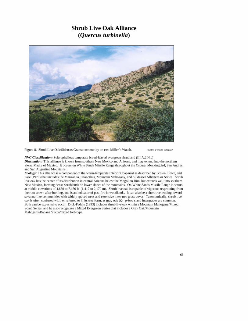
68
Shrub Live Oak Alliance (Quercus turbinella)
Figure 8. Shrub Live Oak/Sideoats Grama community on east Miller’s Watch. Photo: Yvonne Chauvin NVC Classification: Sclerophyllous temperate broad-leaved evergreen shrubland (III.A.2.N.c) Distribution: This alliance is known from southern New Mexico and Arizona, and may extend into the northern Sierra Madre of Mexico. It occurs on White Sands Missile Range throughout the Oscura, Mockingbird, San Andres, and San Augustine Mountains. Ecology: This alliance is a component of the warm-temperate Interior Chaparral as described by Brown, Lowe, and Pase (1979) that includes the Manzanita, Ceanothus, Mountain Mahogany, and Silktassel Alliances or Series. Shrub live oak has the center of its distribution in central Arizona below the Mogollon Rim, but extends well into southern New Mexico, forming dense shrublands on lower slopes of the mountains. On White Sands Missile Range it occurs at middle elevations of 4,650 to 7,150 ft (1,417 to 2,179 m). Shrub live oak is capable of vigorous resprouting from the root crown after burning, and is an indicator of past fire in woodlands. It can also be a short tree tending toward savanna-like communities with widely spaced trees and extensive inter-tree grass cover. Taxonomically, shrub live oak is often confused with, or referred to in its tree form, as gray oak (Q. grisea), and intergrades are common. Both can be expected to occur. Dick-Peddie (1993) includes shrub live oak within a Mountain Mahogany/Mixed Scrub Series, and he also recognizes a Mixed Evergreen Series that includes a Gray Oak/Mountain Mahogany/Banana Yucca/mixed forb type.

69
Key to the Shrub Live Oak (Quercus turbinella) Plant Associations 1. Pine muhly (Muhlenbergia dubia) common to well represented as dominant or codominant grass ............................................................................................................... Shrub Live Oak/Pine Muhly PA (See Minor Types) 1. Pine muhly poorly represented to absent ...........................................................................................................2 2. Thin paspalum (Paspalum setaceum) common to well represented as dominant or codominant grass..................................................................................................... Shrub Live Oak/Thin Paspalum PA (See Minor Types) 2. Thin paspalum poorly represented to absent .....................................................................................................3 3. Prairie junegrass (Koeleria macrantha) common to well represented as dominant grass ..................................................................................................................... Shrub Live Oak/Prairie Junegrass PA (See Minor Types) 3. Prairie junegrass poorly represented to absent or codominant grass .................................................................4 4. Black grama (Bouteloua eriopoda) common to well represented as dominant or codominant grass .................................................................................................. Shrub Live Oak/Sideoats Grama PA, Black Grama Phase 4. Black grama poorly represented to absent .........................................................................................................5 5. Blue grama (Bouteloua gracilis) common to well represented as dominant or codominant grass ........................................................................................................Shrub Live Oak/Sideoats Grama PA, Blue Grama Phase 5. Blue grama poorly represented to absent ..........................................................................................................6 6. Hairy grama (Bouteloua hirsuta) common to well represented as dominant or codominant grass .....................................................................................................Shrub Live Oak/Sideoats Grama PA, Hairy Grama Phase 6. Hairy grama poorly represented to absent and sideoats grama (Bouteloua curtipendula) common to well represented as dominant or codominant grass ..................... Shrub Live Oak/Sideoats Grama PA, Typic Phase
Shrub Live Oak/Sideoats Grama PA (Quercus turbinella/Bouteloua curtipendula; QUETUR/BOUCUR)
Distribution: A major community of the Oscura, Mockingbird and San Andres Mountains. It has not been described elsewhere, but is potentially present in other mountain ranges of the Southwest. Vegetation Summary: This community is characterized by a very open shrub layer dominated by shrub live oak, with a well represented grassy understory dominated by black grama. Conifers are uncommon and usually absent. The chaparral species Wright’s silktassel is a characteristic associate. Mountain mahogany can also be an abundant codominant. Overall, the shrub layer is very diverse, with common sotol, banana yucca, skunkbush sumac, featherplume, broom snakeweed, sacahuista and tulip pricklypear often present and well represented. Grasses are diverse, with black grama, hairy grama, and blue grama often codominant or even dominant over sideoats grama (see Phases below). Plains lovegrass and bristly wolfstail can also be common. The forb layer is poorly represented in cover, but high in species diversity. Louisiana sagewort is a constant species usually growing under or near shrubs. Wright’s buckwheat, plains blackfoot, James’ nailwort, Colorado four o’clock
and lacy tansyaster are more scattered and less frequent associates. Physical Setting: The Shrub Live Oak/Sideoats Grama PA generally occurs on moderately steep to very steep escarpment slopes and lower colluvial toeslopes at elevations of 4,600 to 7,100 ft (1,400 to 2,160 m). Aspects are moderate east- or west-facing slopes, and less frequently cold northeast slopes. This type is primarily associated with granite, quartz monzonite or mixed igneous Precambrian intrusions at the base of the Oscura and San Andres Mountain escarpments. Hence, soils are coarse textured (coarse sandy loam to sandy loam) and usually well drained. Large scattered boulders and rocks characterize the landscape. Boulders and exposed bedrock increase along lower slopes and drainages. Between the boulders, ground surfaces are typically covered with exposed gravel with small amounts of litter and exposed soil. When the type occurs on sandstone and siltstone (rarely limestone), the landscape lacks boulders and has more exposed soil or a gravel pavement. Discussion: This type occupies ranges from large and dense chaparral-like stands at higher elevations to
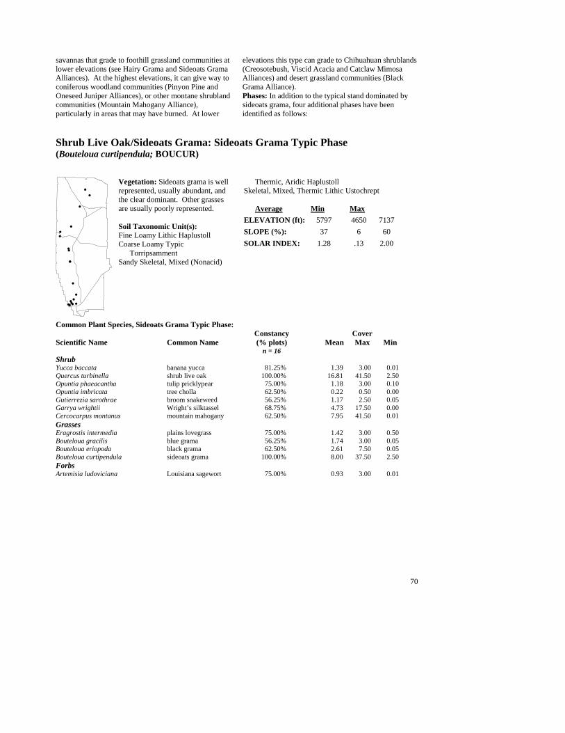
70
savannas that grade to foothill grassland communities at lower elevations (see Hairy Grama and Sideoats Grama Alliances). At the highest elevations, it can give way to coniferous woodland communities (Pinyon Pine and Oneseed Juniper Alliances), or other montane shrubland communities (Mountain Mahogany Alliance), particularly in areas that may have burned. At lower
elevations this type can grade to Chihuahuan shrublands (Creosotebush, Viscid Acacia and Catclaw Mimosa Alliances) and desert grassland communities (Black Grama Alliance). Phases: In addition to the typical stand dominated by sideoats grama, four additional phases have been identified as follows:
Shrub Live Oak/Sideoats Grama: Sideoats Grama Typic Phase (Bouteloua curtipendula; BOUCUR)
Vegetation: Sideoats grama is well represented, usually abundant, and the clear dominant. Other grasses are usually poorly represented. Soil Taxonomic Unit(s): Fine Loamy Lithic Haplustoll Coarse Loamy Typic Torripsamment Sandy Skeletal, Mixed (Nonacid)
Thermic, Aridic Haplustoll Skeletal, Mixed, Thermic Lithic Ustochrept Average Min Max ELEVATION (ft): 5797 4650 7137 SLOPE (%): 37 6 60 SOLAR INDEX: 1.28 .13 2.00
Common Plant Species, Sideoats Grama Typic Phase: Constancy Cover Scientific Name Common Name (% plots) Mean Max Min n = 16 Shrub Yucca baccata banana yucca 81.25% 1.39 3.00 0.01 Quercus turbinella shrub live oak 100.00% 16.81 41.50 2.50 Opuntia phaeacantha tulip pricklypear 75.00% 1.18 3.00 0.10 Opuntia imbricata tree cholla 62.50% 0.22 0.50 0.00 Gutierrezia sarothrae broom snakeweed 56.25% 1.17 2.50 0.05 Garrya wrightii Wright’s silktassel 68.75% 4.73 17.50 0.00 Cercocarpus montanus mountain mahogany 62.50% 7.95 41.50 0.01 Grasses Eragrostis intermedia plains lovegrass 75.00% 1.42 3.00 0.50 Bouteloua gracilis blue grama 56.25% 1.74 3.00 0.05 Bouteloua eriopoda black grama 62.50% 2.61 7.50 0.05 Bouteloua curtipendula sideoats grama 100.00% 8.00 37.50 2.50 Forbs Artemisia ludoviciana Louisiana sagewort 75.00% 0.93 3.00 0.01
##
#
#
#
#
#
#
#
#
#
#
#
#
#
##
#
#
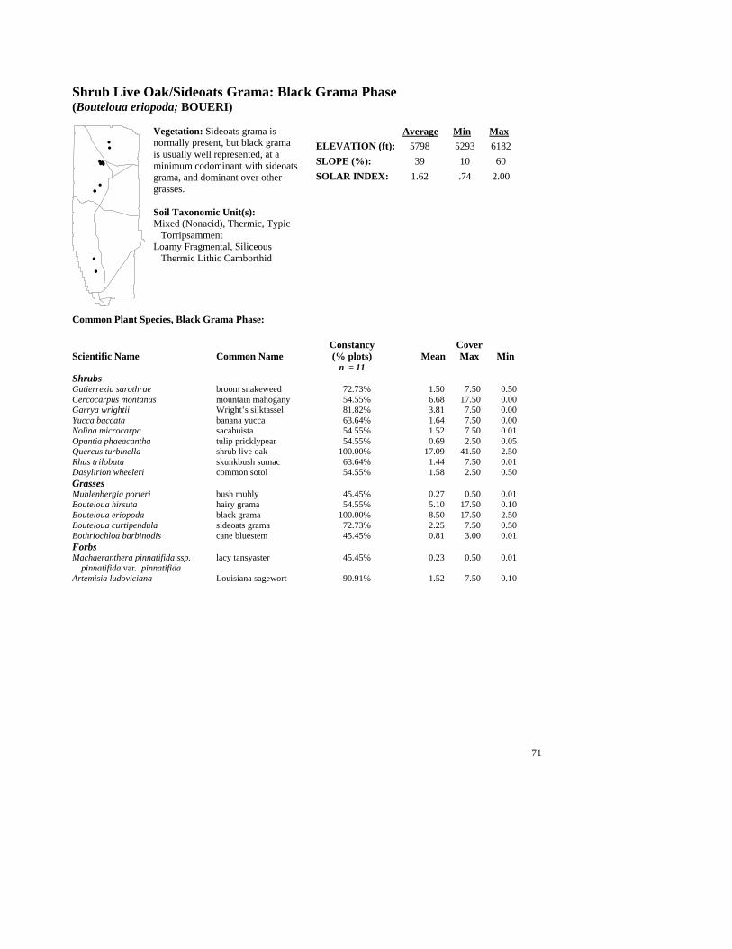
71
Shrub Live Oak/Sideoats Grama: Black Grama Phase (Bouteloua eriopoda; BOUERI)
Vegetation: Sideoats grama is normally present, but black grama is usually well represented, at a minimum codominant with sideoats grama, and dominant over other grasses. Soil Taxonomic Unit(s): Mixed (Nonacid), Thermic, Typic Torripsamment Loamy Fragmental, Siliceous Thermic Lithic Camborthid
Average Min Max ELEVATION (ft): 5798 5293 6182 SLOPE (%): 39 10 60 SOLAR INDEX: 1.62 .74 2.00
Common Plant Species, Black Grama Phase: Constancy Cover Scientific Name Common Name (% plots) Mean Max Min n = 11 Shrubs Gutierrezia sarothrae broom snakeweed 72.73% 1.50 7.50 0.50 Cercocarpus montanus mountain mahogany 54.55% 6.68 17.50 0.00 Garrya wrightii Wright’s silktassel 81.82% 3.81 7.50 0.00 Yucca baccata banana yucca 63.64% 1.64 7.50 0.00 Nolina microcarpa sacahuista 54.55% 1.52 7.50 0.01 Opuntia phaeacantha tulip pricklypear 54.55% 0.69 2.50 0.05 Quercus turbinella shrub live oak 100.00% 17.09 41.50 2.50 Rhus trilobata skunkbush sumac 63.64% 1.44 7.50 0.01 Dasylirion wheeleri common sotol 54.55% 1.58 2.50 0.50 Grasses Muhlenbergia porteri bush muhly 45.45% 0.27 0.50 0.01 Bouteloua hirsuta hairy grama 54.55% 5.10 17.50 0.10 Bouteloua eriopoda black grama 100.00% 8.50 17.50 2.50 Bouteloua curtipendula sideoats grama 72.73% 2.25 7.50 0.50 Bothriochloa barbinodis cane bluestem 45.45% 0.81 3.00 0.01 Forbs Machaeranthera pinnatifida ssp. lacy tansyaster 45.45% 0.23 0.50 0.01
pinnatifida var. pinnatifida Artemisia ludoviciana Louisiana sagewort 90.91% 1.52 7.50 0.10
#
##
#
#
#
#
###
#
#
###
#
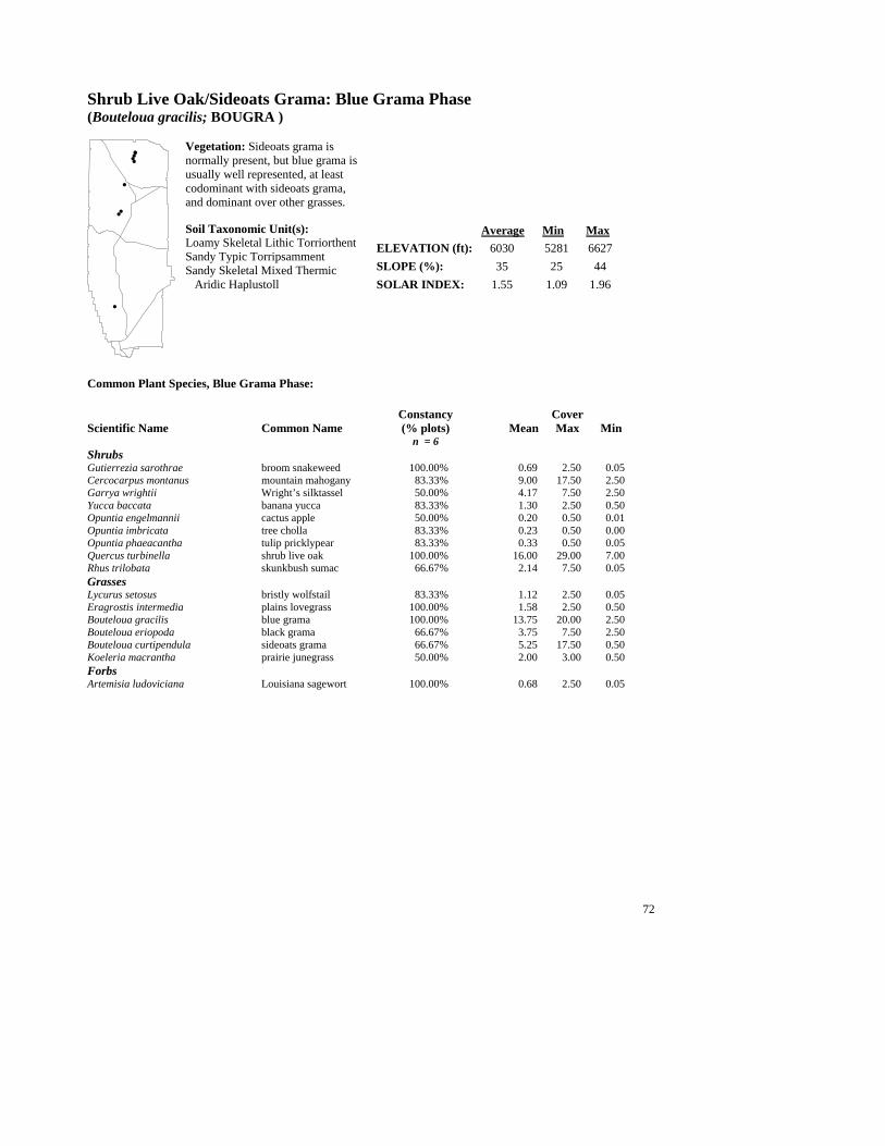
72
Shrub Live Oak/Sideoats Grama: Blue Grama Phase (Bouteloua gracilis; BOUGRA )
Vegetation: Sideoats grama is normally present, but blue grama is usually well represented, at least codominant with sideoats grama, and dominant over other grasses. Soil Taxonomic Unit(s): Loamy Skeletal Lithic Torriorthent Sandy Typic Torripsamment Sandy Skeletal Mixed Thermic Aridic Haplustoll
Average Min Max ELEVATION (ft): 6030 5281 6627 SLOPE (%): 35 25 44 SOLAR INDEX: 1.55 1.09 1.96
Common Plant Species, Blue Grama Phase: Constancy Cover Scientific Name Common Name (% plots) Mean Max Min n = 6 Shrubs Gutierrezia sarothrae broom snakeweed 100.00% 0.69 2.50 0.05 Cercocarpus montanus mountain mahogany 83.33% 9.00 17.50 2.50 Garrya wrightii Wright’s silktassel 50.00% 4.17 7.50 2.50 Yucca baccata banana yucca 83.33% 1.30 2.50 0.50 Opuntia engelmannii cactus apple 50.00% 0.20 0.50 0.01 Opuntia imbricata tree cholla 83.33% 0.23 0.50 0.00 Opuntia phaeacantha tulip pricklypear 83.33% 0.33 0.50 0.05 Quercus turbinella shrub live oak 100.00% 16.00 29.00 7.00 Rhus trilobata skunkbush sumac 66.67% 2.14 7.50 0.05 Grasses Lycurus setosus bristly wolfstail 83.33% 1.12 2.50 0.05 Eragrostis intermedia plains lovegrass 100.00% 1.58 2.50 0.50 Bouteloua gracilis blue grama 100.00% 13.75 20.00 2.50 Bouteloua eriopoda black grama 66.67% 3.75 7.50 2.50 Bouteloua curtipendula sideoats grama 66.67% 5.25 17.50 0.50 Koeleria macrantha prairie junegrass 50.00% 2.00 3.00 0.50 Forbs Artemisia ludoviciana Louisiana sagewort 100.00% 0.68 2.50 0.05
#
##
#
##
#
#
#
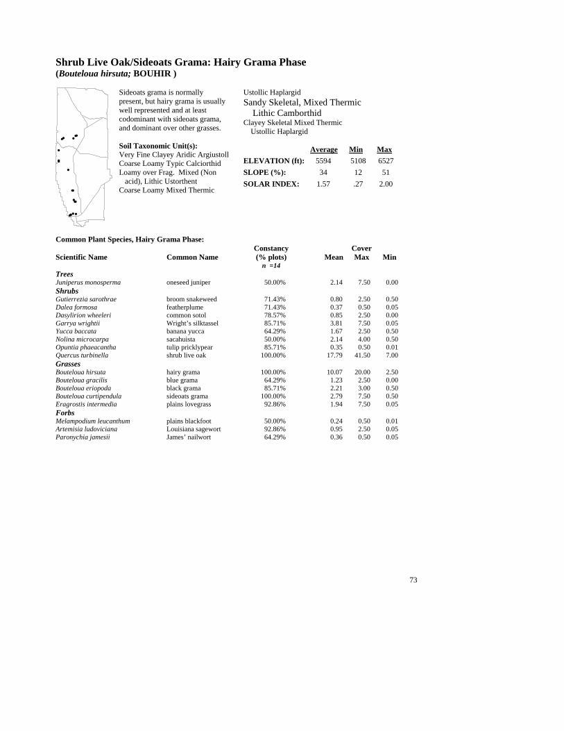
73
Shrub Live Oak/Sideoats Grama: Hairy Grama Phase (Bouteloua hirsuta; BOUHIR )
Sideoats grama is normally present, but hairy grama is usually well represented and at least codominant with sideoats grama, and dominant over other grasses. Soil Taxonomic Unit(s): Very Fine Clayey Aridic Argiustoll Coarse Loamy Typic Calciorthid Loamy over Frag. Mixed (Non acid), Lithic Ustorthent Coarse Loamy Mixed Thermic
Ustollic Haplargid Sandy Skeletal, Mixed Thermic Lithic Camborthid Clayey Skeletal Mixed Thermic
Ustollic Haplargid Average Min Max ELEVATION (ft): 5594 5108 6527 SLOPE (%): 34 12 51 SOLAR INDEX: 1.57 .27 2.00
Common Plant Species, Hairy Grama Phase: Constancy Cover Scientific Name Common Name (% plots) Mean Max Min n =14 Trees Juniperus monosperma oneseed juniper 50.00% 2.14 7.50 0.00 Shrubs Gutierrezia sarothrae broom snakeweed 71.43% 0.80 2.50 0.50 Dalea formosa featherplume 71.43% 0.37 0.50 0.05 Dasylirion wheeleri common sotol 78.57% 0.85 2.50 0.00 Garrya wrightii Wright’s silktassel 85.71% 3.81 7.50 0.05 Yucca baccata banana yucca 64.29% 1.67 2.50 0.50 Nolina microcarpa sacahuista 50.00% 2.14 4.00 0.50 Opuntia phaeacantha tulip pricklypear 85.71% 0.35 0.50 0.01 Quercus turbinella shrub live oak 100.00% 17.79 41.50 7.00 Grasses Bouteloua hirsuta hairy grama 100.00% 10.07 20.00 2.50 Bouteloua gracilis blue grama 64.29% 1.23 2.50 0.00 Bouteloua eriopoda black grama 85.71% 2.21 3.00 0.50 Bouteloua curtipendula sideoats grama 100.00% 2.79 7.50 0.50 Eragrostis intermedia plains lovegrass 92.86% 1.94 7.50 0.05 Forbs Melampodium leucanthum plains blackfoot 50.00% 0.24 0.50 0.01 Artemisia ludoviciana Louisiana sagewort 92.86% 0.95 2.50 0.05 Paronychia jamesii James’ nailwort 64.29% 0.36 0.50 0.05
#
#
##
#
#
#
#
#
#
#
##
# #
#
# #
#
##

74
Minor Plant Associations: Shrub Live Oak Alliance Shrub Live Oak/Pine Muhly PA (Quercus turbinella/Muhlenbergia dubia; QUETUR/MUHDUB) This is a minor, provisional shrubland type limited to the northern San Andres Mountains. Shrub live oak is abundant and pine muhly clearly dominates the herbaceous layer. Hairy grama can also be well represented and even codominant. It occurs on gentle to moderate dip slopes on soils derived from sandstone. Elevation range is 6,100 to 6,800 ft (1,850 to 2,050 m) and aspects are easterly or westerly. Shrub Live Oak/Prairie Junegrass PA (Quercus turbinella/Koeleria macrantha; QUETUR/KOEMAC) This is a minor, provisional shrubland type, represented by one occurrence in the southern San Andres Mountains. Shrub live oak is abundant and prairie junegrass clearly dominates the herbaceous layer. It occurs on very steep slopes, with soil derived from sandstone at 5,468 ft (1,666 m). Shrub Live Oak/Thin Paspalum PA (Quercus turbinella/Paspalum setaceum; QUETUR/PASSET) This is a very limited provisional type found on isolated sand deposits of inter-mountain valleys in the southern San Andres Mountains. Overall, vegetation cover is low. The canopy of shrub live oak is very open (<10% cover) and thin paspalum is indicative of the herbaceous layer, but cover does not exceed 5%.
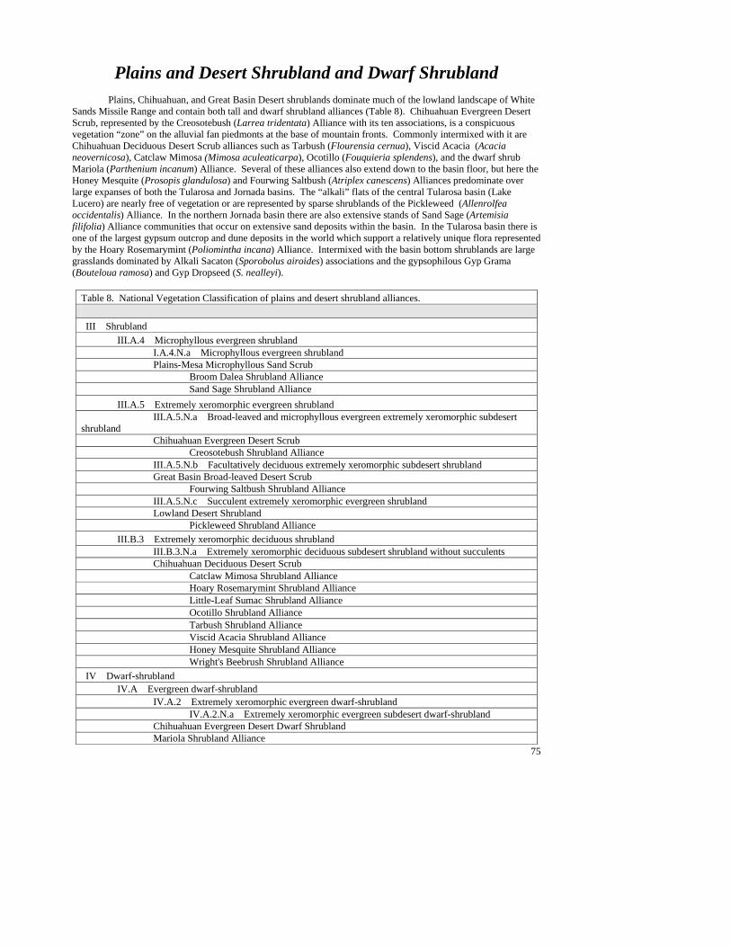
75
Plains and Desert Shrubland and Dwarf Shrubland Plains, Chihuahuan, and Great Basin Desert shrublands dominate much of the lowland landscape of White
Sands Missile Range and contain both tall and dwarf shrubland alliances (Table 8). Chihuahuan Evergreen Desert Scrub, represented by the Creosotebush (Larrea tridentata) Alliance with its ten associations, is a conspicuous vegetation “zone” on the alluvial fan piedmonts at the base of mountain fronts. Commonly intermixed with it are Chihuahuan Deciduous Desert Scrub alliances such as Tarbush (Flourensia cernua), Viscid Acacia (Acacia neovernicosa), Catclaw Mimosa (Mimosa aculeaticarpa), Ocotillo (Fouquieria splendens), and the dwarf shrub Mariola (Parthenium incanum) Alliance. Several of these alliances also extend down to the basin floor, but here the Honey Mesquite (Prosopis glandulosa) and Fourwing Saltbush (Atriplex canescens) Alliances predominate over large expanses of both the Tularosa and Jornada basins. The “alkali” flats of the central Tularosa basin (Lake Lucero) are nearly free of vegetation or are represented by sparse shrublands of the Pickleweed (Allenrolfea occidentalis) Alliance. In the northern Jornada basin there are also extensive stands of Sand Sage (Artemisia filifolia) Alliance communities that occur on extensive sand deposits within the basin. In the Tularosa basin there is one of the largest gypsum outcrop and dune deposits in the world which support a relatively unique flora represented by the Hoary Rosemarymint (Poliomintha incana) Alliance. Intermixed with the basin bottom shrublands are large grasslands dominated by Alkali Sacaton (Sporobolus airoides) associations and the gypsophilous Gyp Grama (Bouteloua ramosa) and Gyp Dropseed (S. nealleyi).
Table 8. National Vegetation Classification of plains and desert shrubland alliances. III Shrubland III.A.4 Microphyllous evergreen shrubland I.A.4.N.a Microphyllous evergreen shrubland Plains-Mesa Microphyllous Sand Scrub Broom Dalea Shrubland Alliance Sand Sage Shrubland Alliance III.A.5 Extremely xeromorphic evergreen shrubland III.A.5.N.a Broad-leaved and microphyllous evergreen extremely xeromorphic subdesert shrubland Chihuahuan Evergreen Desert Scrub Creosotebush Shrubland Alliance III.A.5.N.b Facultatively deciduous extremely xeromorphic subdesert shrubland Great Basin Broad-leaved Desert Scrub Fourwing Saltbush Shrubland Alliance III.A.5.N.c Succulent extremely xeromorphic evergreen shrubland Lowland Desert Shrubland Pickleweed Shrubland Alliance III.B.3 Extremely xeromorphic deciduous shrubland III.B.3.N.a Extremely xeromorphic deciduous subdesert shrubland without succulents Chihuahuan Deciduous Desert Scrub Catclaw Mimosa Shrubland Alliance Hoary Rosemarymint Shrubland Alliance Little-Leaf Sumac Shrubland Alliance Ocotillo Shrubland Alliance Tarbush Shrubland Alliance Viscid Acacia Shrubland Alliance Honey Mesquite Shrubland Alliance Wright's Beebrush Shrubland Alliance IV Dwarf-shrubland IV.A Evergreen dwarf-shrubland IV.A.2 Extremely xeromorphic evergreen dwarf-shrubland IV.A.2.N.a Extremely xeromorphic evergreen subdesert dwarf-shrubland Chihuahuan Evergreen Desert Dwarf Shrubland Mariola Shrubland Alliance

76
Key to Plains and Desert Shrubland and Dwarf Shrubland Alliances 1. Creosotebush (Larrea tridentata) common to well represented as dominant or codominant shrub................................................................................................................................................................Creosotebush Alliance 1. Creosotebush poorly represented to absent or not dominant or codominant shrub ...........................................2 2. Tarbush (Flourensia cernua) common to well represented as the dominant or codominant shrub......................................................................................................................................................................... Tarbush Alliance 2. Tarbush poorly represented to absent or not dominant or codominant shrub ....................................................3 3. Littleleaf sumac (Rhus microphylla) common to well represented as dominant or codominant shrub ......................................................................................................................................................Littleleaf Sumac Alliance 3. Littleleaf sumac poorly represented to absent ...................................................................................................4 4. Communities of hillslopes and alluvial fans......................................................................................................5 4. Communities of sandy plains, alluvial flats or drainages ..................................................................................8 5. Catclaw Mimosa (Mimosa aculeaticarpa var. biuncifera) well represented as dominant or codominant shrub...................................................................................................................................... Catclaw Mimosa Alliance 5. Mimosa poorly represented to absent ................................................................................................................6 6. Viscid acacia (Acacia neovernicosa) dominant or codominant shrub ...........................Viscid Acacia Alliance 6. Viscid acacia scarce to absent, not dominant shrub...........................................................................................7 7. Ocotillo (Fouquieria splendens) dominant shrub, with other shrubs usually scarce .............. Ocotillo Alliance 7. Ocotillo common to absent; mariola (Parthenium incanum) common to well represented as dominant or codominant shrub ........................................................................................................................ Mariola Alliance 8. Sand sagebrush (Artemisia filifolia) well represented as dominant shrub ................ Sand Sagebrush Alliance 8. Sand sagebrush poorly represented to absent or not dominant shrub ................................................................9 9. Broom dalea (Psorothamnus scoparius) common to well represented as dominant or codominant shrub ..................................................................... Broom Dalea Alliance (See Miscellaneous Plant Associations, page 184) 9. Broom dalea poorly represented to absent.......................................................................................................10 10. Honey mesquite (Prosopis glandulosa) common to well represented as dominant or codominant shrub................................................................................................................................................ Honey Mesquite Alliance 10. Honey mesquite poorly represented to absent or not dominant or codominant shrub ...................................11 11. Pickleweed (Allenrolfea occidentalis) common to well represented as dominant or codominant shrub...........................................................................................................................................................Pickleweed Alliance 11. Pickleweed poorly represented to absent or not dominant shrub...................................................................12 12. Fourwing saltbush (Atriplex canescens) common to well represented as dominant or codominant shrub.......................................................................................................................................... Fourwing Saltbush Alliance 12. Hoary rosemarymint (Poliomintha incana) dominant shrub ........................Hoary Rosemarymint Alliance
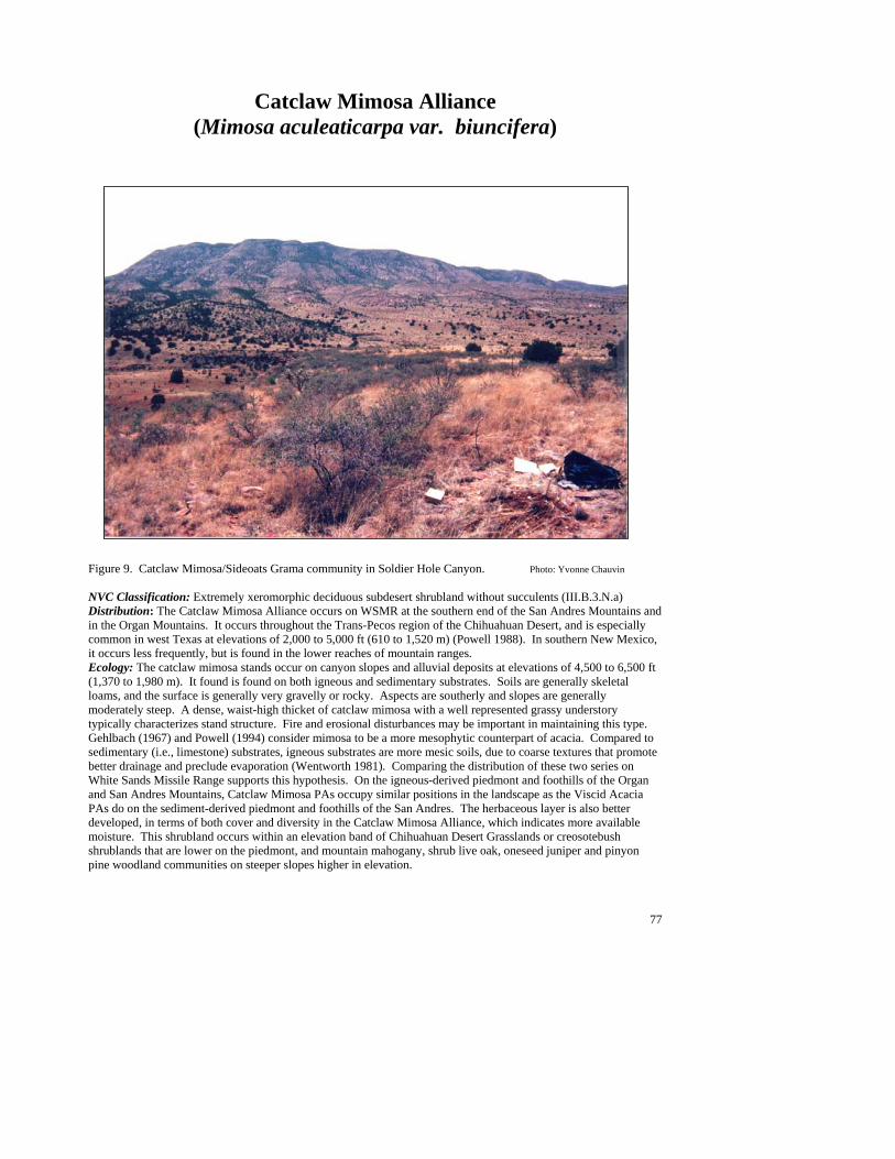
77
Catclaw Mimosa Alliance (Mimosa aculeaticarpa var. biuncifera)
Figure 9. Catclaw Mimosa/Sideoats Grama community in Soldier Hole Canyon. Photo: Yvonne Chauvin NVC Classification: Extremely xeromorphic deciduous subdesert shrubland without succulents (III.B.3.N.a) Distribution: The Catclaw Mimosa Alliance occurs on WSMR at the southern end of the San Andres Mountains and in the Organ Mountains. It occurs throughout the Trans-Pecos region of the Chihuahuan Desert, and is especially common in west Texas at elevations of 2,000 to 5,000 ft (610 to 1,520 m) (Powell 1988). In southern New Mexico, it occurs less frequently, but is found in the lower reaches of mountain ranges. Ecology: The catclaw mimosa stands occur on canyon slopes and alluvial deposits at elevations of 4,500 to 6,500 ft (1,370 to 1,980 m). It found is found on both igneous and sedimentary substrates. Soils are generally skeletal loams, and the surface is generally very gravelly or rocky. Aspects are southerly and slopes are generally moderately steep. A dense, waist-high thicket of catclaw mimosa with a well represented grassy understory typically characterizes stand structure. Fire and erosional disturbances may be important in maintaining this type. Gehlbach (1967) and Powell (1994) consider mimosa to be a more mesophytic counterpart of acacia. Compared to sedimentary (i.e., limestone) substrates, igneous substrates are more mesic soils, due to coarse textures that promote better drainage and preclude evaporation (Wentworth 1981). Comparing the distribution of these two series on White Sands Missile Range supports this hypothesis. On the igneous-derived piedmont and foothills of the Organ and San Andres Mountains, Catclaw Mimosa PAs occupy similar positions in the landscape as the Viscid Acacia PAs do on the sediment-derived piedmont and foothills of the San Andres. The herbaceous layer is also better developed, in terms of both cover and diversity in the Catclaw Mimosa Alliance, which indicates more available moisture. This shrubland occurs within an elevation band of Chihuahuan Desert Grasslands or creosotebush shrublands that are lower on the piedmont, and mountain mahogany, shrub live oak, oneseed juniper and pinyon pine woodland communities on steeper slopes higher in elevation.
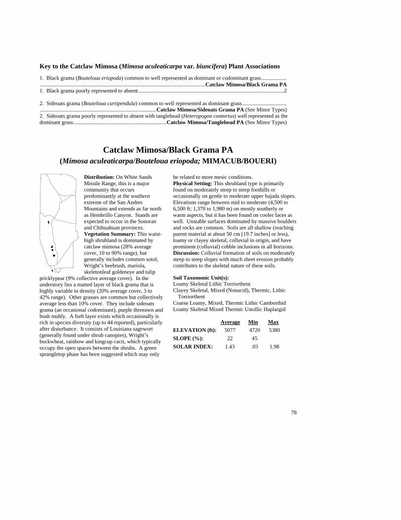
78
Key to the Catclaw Mimosa (Mimosa aculeaticarpa var. biuncifera) Plant Associations 1. Black grama (Bouteloua eriopoda) common to well represented as dominant or codominant grass .........................................................................................................................................Catclaw Mimosa/Black Grama PA 1. Black grama poorly represented to absent .........................................................................................................2 2. Sideoats grama (Bouteloua curtipendula) common to well represented as dominant grass ....................................................................................................................Catclaw Mimosa/Sideoats Grama PA (See Minor Types) 2. Sideoats grama poorly represented to absent with tanglehead (Heteropogon contortus) well represented as the dominant grass...................................................................Catclaw Mimosa/Tanglehead PA (See Minor Types)
Catclaw Mimosa/Black Grama PA (Mimosa aculeaticarpa/Bouteloua eriopoda; MIMACUB/BOUERI)
Distribution: On White Sands Missile Range, this is a major community that occurs predominantly at the southern extreme of the San Andres Mountains and extends as far north as Hembrillo Canyon. Stands are expected to occur in the Sonoran and Chihuahuan provinces. Vegetation Summary: This waist-high shrubland is dominated by catclaw mimosa (28% average cover, 10 to 90% range), but generally includes common sotol, Wright’s beebrush, mariola, skeletonleaf goldeneye and tulip
pricklypear (9% collective average cover). In the understory lies a matted layer of black grama that is highly variable in density (20% average cover, 3 to 42% range). Other grasses are common but collectively average less than 10% cover. They include sideoats grama (an occasional codominant), purple threeawn and bush muhly. A forb layer exists which occasionally is rich in species diversity (up to 44 reported), particularly after disturbance. It consists of Louisiana sagewort (generally found under shrub canopies), Wright’s buckwheat, rainbow and kingcup cacti, which typically occupy the open spaces between the shrubs. A green sprangletop phase has been suggested which may only
be related to more mesic conditions. Physical Setting: This shrubland type is primarily found on moderately steep to steep foothills or occasionally on gentle to moderate upper bajada slopes. Elevations range between mid to moderate (4,500 to 6,500 ft; 1,370 to 1,980 m) on mostly southerly or warm aspects, but it has been found on cooler faces as well. Unstable surfaces dominated by massive boulders and rocks are common. Soils are all shallow (reaching parent material at about 50 cm [19.7 inches] or less), loamy or clayey skeletal, colluvial in origin, and have prominent (colluvial) cobble inclusions in all horizons. Discussion: Colluvial formation of soils on moderately steep to steep slopes with much sheet erosion probably contributes to the skeletal nature of these soils. Soil Taxonomic Unit(s): Loamy Skeletal Lithic Torriorthent Clayey Skeletal, Mixed (Nonacid), Thermic, Lithic
Torriorthent Coarse Loamy, Mixed, Thermic Lithic Camborthid Loamy Skeletal Mixed Thermic Ustollic Haplargid Average Min Max ELEVATION (ft): 5077 4720 5380 SLOPE (%): 22 45 SOLAR INDEX: 1.43 .03 1.98
#
#
#
#
#
##
#
#
#
###
#

79
Common Plant Species, Catclaw Mimosa/Black Grama PA: Constancy Cover Scientific Name Common Name (% plots) Mean Max Min n = 14 Shrubs Viguiera stenoloba skeletonleaf goldeneye 78.57% 3.05 7.50 0.50 Parthenium incanum mariola 64.29% 1.67 7.50 0.05 Opuntia phaeacantha tulip pricklypear 71.43% 1.45 2.50 0.50 Mimosa aculeaticarpa var. biuncifera catclaw mimosa 100.00% 26.29 87.50 7.50 Dasylirion wheeleri common sotol 100.00% 0.90 2.50 0.00 Aloysia wrightii Wright’s beebrush 50.00% 2.14 7.50 0.50 Grasses Muhlenbergia porteri bush muhly 57.14% 1.00 2.50 0.50 Bouteloua eriopoda black grama 100.00% 20.93 41.50 0.50 Bouteloua curtipendula sideoats grama 92.86% 5.15 20.00 0.50 Aristida purpurea purple threeawn 57.14% 0.95 2.50 0.10
Minor Plant Associations: Catclaw Mimosa Alliance Catclaw Mimosa/Sideoats Grama (Mimosa aculeaticarpa var. biuncifera/Bouteloua curtipendula; MIMACUB/BOUCUR) Chihuahuan Desert Shrubland community characterized by a dense canopy of catclaw mimosa (35 to 40% average cover) with an understory of scattered sideoats grama (average cover is approximately 20%). Common sotol, (commonly associated with sideoats grama communities), is always present but generally is very scattered (average cover less than 5%). Additional common shrubs and grasses include snakeweed, mariola, wolfstail, green sprangletop and blue, black and hairy grama. Between the grasses are various scattered forbs; the most common include hairy five eyes, hot springs globemallow and Wright’s buckwheat. It predominantly occurs on the alluvial fans and lower footslopes the Organ and San Andres Mountains, at elevations of 5,000 to 6,400 ft (1,520 to 1,950 m). Slopes are moderately steep and generally have warm aspects (southern exposures). Parent materials are primarily granitic, but it has been found on sandstone and limestone. Soils are loamy skeletal and shallow with caliche layers usually under one meter in depth. Catclaw Mimosa/Tanglehead (Mimosa aculeaticarpa var. biuncifera/ Heteropogon contortus; MIMACUB/HETCON) This provisional type has been described as a minor type on Ft. Bliss by Wood et al. (1997b) and is also a minor type on White Sands Missile Range (1 plot). It may only represent a phase of the Catclaw Mimosa/Black Grama PA. Stands occupy coarse, shallow granitic (quartz monzonite) soils across the lower footslopes of the Organ and San Andres Mountains. Catclaw mimosa forms an abundant canopy, with common sotol as an occasional codominant. Tanglehead dominates the grass layer, but other grasses including purple threeawn and sideoats, black and hairy gramas may be present.
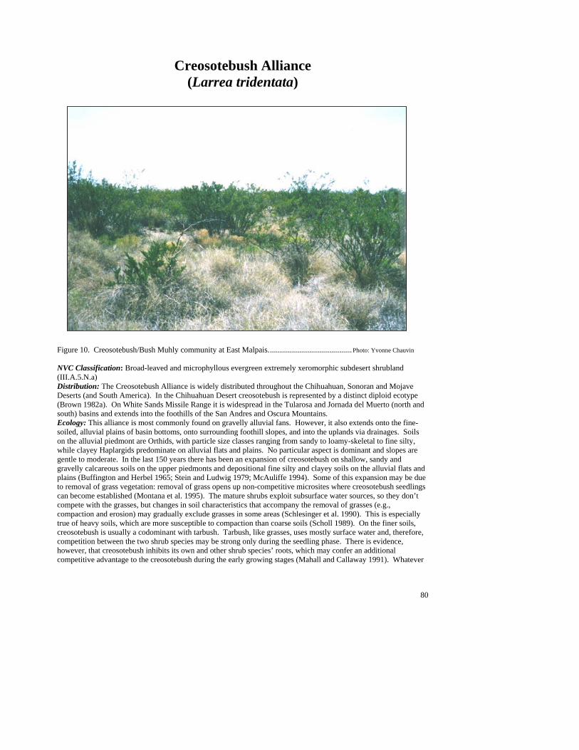
80
Creosotebush Alliance (Larrea tridentata)
Figure 10. Creosotebush/Bush Muhly community at East Malpais..........................................Photo: Yvonne Chauvin NVC Classification: Broad-leaved and microphyllous evergreen extremely xeromorphic subdesert shrubland (III.A.5.N.a) Distribution: The Creosotebush Alliance is widely distributed throughout the Chihuahuan, Sonoran and Mojave Deserts (and South America). In the Chihuahuan Desert creosotebush is represented by a distinct diploid ecotype (Brown 1982a). On White Sands Missile Range it is widespread in the Tularosa and Jornada del Muerto (north and south) basins and extends into the foothills of the San Andres and Oscura Mountains. Ecology: This alliance is most commonly found on gravelly alluvial fans. However, it also extends onto the fine-soiled, alluvial plains of basin bottoms, onto surrounding foothill slopes, and into the uplands via drainages. Soils on the alluvial piedmont are Orthids, with particle size classes ranging from sandy to loamy-skeletal to fine silty, while clayey Haplargids predominate on alluvial flats and plains. No particular aspect is dominant and slopes are gentle to moderate. In the last 150 years there has been an expansion of creosotebush on shallow, sandy and gravelly calcareous soils on the upper piedmonts and depositional fine silty and clayey soils on the alluvial flats and plains (Buffington and Herbel 1965; Stein and Ludwig 1979; McAuliffe 1994). Some of this expansion may be due to removal of grass vegetation: removal of grass opens up non-competitive microsites where creosotebush seedlings can become established (Montana et al. 1995). The mature shrubs exploit subsurface water sources, so they don’t compete with the grasses, but changes in soil characteristics that accompany the removal of grasses (e.g., compaction and erosion) may gradually exclude grasses in some areas (Schlesinger et al. 1990). This is especially true of heavy soils, which are more susceptible to compaction than coarse soils (Scholl 1989). On the finer soils, creosotebush is usually a codominant with tarbush. Tarbush, like grasses, uses mostly surface water and, therefore, competition between the two shrub species may be strong only during the seedling phase. There is evidence, however, that creosotebush inhibits its own and other shrub species’ roots, which may confer an additional competitive advantage to the creosotebush during the early growing stages (Mahall and Callaway 1991). Whatever

81
the mechanisms, increases in tarbush during the last 150 years have been accompanied by increases in creosotebush in the same areas (Buffington and Herbel 1965). Areas dominated by creosotebush have increased by about 2000% since 1858 (Buffington and Herbel 1965). As creosotebush is extremely poor forage for both wildlife and livestock, this increase has probably had substantial negative impacts on wildlife numbers and range condition (Stubbendieck et al.1992). Long-term disturbances that remove vegetation and change soil characteristics will promote shrub dominance. Key to the Creosotebush (Larrea tridentata) Plant Associations 1. Grasses well represented and dominate understory ...........................................................................................2 1. Individual grasses poorly represented to absent ................................................................................................8 2. Mesa dropseed (Sporobolus flexuosus) common to well represented as dominant or codominant grass .....................................................................................................................................Creosotebush/Mesa Dropseed PA 2. Mesa dropseed poorly represented or absent .....................................................................................................3 3. Alkali sacaton (Sporobolus airoides) common to well represented as dominant or codominant grass ......................................................................................................................................... Creosotebush/Alkali Sacaton PA 3. Alkali sacaton poorly represented to absent; .....................................................................................................4 4. Black grama (Bouteloua eriopoda) common to well represented as dominant or codominant grass .............................................................................................................................................. Creosotebush/Black Grama PA 4. Black grama poorly represented to absent .........................................................................................................5 5. Fluffgrass (Erioneuron pulchellum) common to well represented as dominant or codominant grass of the inter-shrub space ...............................................................................................................Creosotebush/Fluffgrass PA 5. Fluffgrass poorly represented to absent .............................................................................................................6 6. Bush muhly (Muhlenbergia porteri) common to well represented as dominant or codominant grass .............................................................................................................................................. Creosotebush/Bush Muhly PA 6. Bush muhly poorly represented to absent..........................................................................................................7 7. Burrograss (Scleropogon brevifolius) common to well represented as dominant grass ........................................................................................................................................Creosotebush/Burrograss PA (see Minor Types) 7. Burrograss poorly represented to absent............................................................................................................8 8. Mariola (Parthenium incanum) common to well represented as subdominant or codominant shrub....................................................................................................................................................... Creosotebush/Mariola PA 8. Mariola poorly represented to absent.................................................................................................................9 9. Tarbush (Flourensia cernua) well represented as subdominant or codominant shrub ..................................................................................................................................Creosotebush/Tarbush/Sparse PA (see Minor Types) 9. Tarbush poorly represented to absent ..............................................................................................................10 10. Hairy coldenia (Tiquilia hispidissima) common to well represented as subdominant or codominant shrub................................................................................................Creosotebush/Hairy Coldenia PA (see Minor Types) 10. Undergrowth usually less than 1% cover of grasses or forbs .................................Creosotebush/Sparse PA
82
Creosotebush/Alkali Sacaton PA (Larrea tridentata/Sporobolus airoides; LARTRI/SPOAIR)
Distribution: A major type that occurs extensively throughout the Tularosa and Jornada del Muerto basins. Vegetation Summary: This is a moderately diverse Chihuahuan shrubland that is characterized by a very open, creosotebush-dominated canopy and a grassy understory which is clearly dominated by alkali sacaton. The shrub layer frequently includes scattered fourwing saltbush, Berlandier’s wolfberry, honey mesquite (a suggested phase), and sometimes tarbush. The
understory densities are highly variable between stands, and often the bunch grasses will intermix with bare soil patches. Other species common to the herbaceous layer include bush muhly (found under
and around shrub canopies) and desert holly, which may indicate mesic microsites. Physical Setting: The Creosotebush/Alkali Sacaton PA primarily occurs at low elevations on alluvial plains and across basin flats. Because slope grades are very gentle and often flat, soils, not aspects, are probably the important determinant of community distribution. They are generally fine in texture, but may vary between loamy sand and silty loams, with occasional gravel deposits. This structure is probably maintained by the late summer monsoon runoff received from surrounding mountains. Discussion: Average Min Max ELEVATION (ft): 4443 3908 5378 SLOPE (%): 1 0 4 SOLAR INDEX: 1.09 .27 1.86
Common Plant Species, Creosote/Alkali Sacaton PA: Constancy Cover Scientific Name Common Name (% plots) Mean Max Min n = 15 Shrubs Prosopis glandulosa honey mesquite 53.33% 2.88 7.50 0.00 Lycium berlandieri Berlandier’s wolfberry 60.00% 2.17 7.50 0.50 Larrea tridentata creosotebush 100.00% 14.73 29.00 2.50 Atriplex canescens fourwing saltbush 93.33% 1.38 2.50 0.00 Grasses Sporobolus airoides alkali sacaton 100.00% 14.40 62.50 2.50 Muhlenbergia porteri bush muhly 60.00% 2.44 7.50 0.50
#
#
#
#
#
#
#
#
#
#
#
# #
#
# #
#
# #
#
#
#
#
#
#
##
83
Creosotebush/Black Grama PA (Larrea tridentata/Bouteloua eriopoda; LARTRI/BOUERI)
Distribution: Major upper piedmont community of the Jornada del Muerto and Tularosa basins. Also common in mountain drainages that occur throughout the Oscura and San Andres Mountains. Vegetation Summary: This Chihuahuan shrubland is characterized by a diverse and open shrub layer dominated by creosotebush, with a well developed grassy understory dominated by black grama. Tall shrub phases of honey mesquite, ocotillo and pricklyleaf dogweed have been proposed. Canopies also
include several other short and tall growing shrubs such as broom snakeweed, mariola, tulip pricklypear, and Christmas cactus. Species composition and diversity within the herbaceous layer varies from stand to stand, but grasses consistently found in the understory include bush muhly (under shrub canopies), fluffgrass (found growing between black grama clumps), and purple threeawn. Generally, the forbs are scattered and collectively contribute little to canopy cover. Common recurrent species are hairyseed bahia, rough menodora, devilshead, and kingcup cactus. Physical Setting: The Creosotebush/Black Grama PA typically occurs at mid elevations across moderately sloped upper piedmonts and on the surrounding and slightly steeper foothill slopes (lower escarpments and dip slopes). Here, stands occur on platform summits of remnant alluvial deposits or on newly deposited colluvial sediments on the collar of foothill slopes. Soils range from loams to loamy sands with an abundance of gravel and some rocks, and are well drained and well developed with calcic horizons less than one meter in depth. Parent material is mixed (limestone, sandstone and igneous) and aspects are generally, but not limited to, slopes which have moderate (east- and west-facing) solar incidence. Discussion: Black grama in the Chihuahuan Desert is often found on uplands with gravelly sandy soils that drain easily, and creosotebush’s historic distribution is
also on shallow, gravelly soils (Stein and Ludwig 1979; Brown 1982a; Cornelius et al. 1991). Wondzell et al. (1987) suggested that mid-piedmont positions, which have a combination of good drainage (coarse alluvium) and good water infiltration (from sediments deposited from the uplands), support a mix of shrubs and perennial grasses. These described elements are similar to those that support Creosotebush/Black Grama stands on White Sands Missile Range. Here, stands are occasionally large (up to 40 ha [98.8 acres]), but mostly occur in a patchy distribution along upper piedmonts with the Black Grama/Mariola and Creosotebush/Mariola PAs. Downslope, black grama generally fades out and gives way to other codominants such as bush muhly, fluffgrass, or sparse understories. Higher on the footslopes the creosotebush component fades, and occurrences grade into common sotol grasslands or other grama grass alliances. Stands are good habitat for a variety of desert rodents, including Merriam’s Kangaroo Rat (whose primary food source is creosotebush seeds), granivorous pocket mice who eat grass seed, and pocket gophers who eat mostly shrub roots in the desert (Chew and Chew 1965; Findley 1987). By exploiting different plant parts of both grasses and shrubs, these animals reduce the reproductive potential of both shrubs and grasses, and thus could be a major influence on the maintenance of the shrub savanna (Brown and Heske 1990). In contrast, livestock eat only the grasses, which may confer a competitive advantage to the shrubs. Other communities in which black grama and shrubs are found together on similar coarse substrates are the Viscid Acacia/Black Grama, Tarbush/Black Grama and Mimosa/Black Grama PAs. Soil Taxonomic Unit(s): Skeletal Carbonatic Thermic Ustollic Paleorthid Sandy Skeletal, Carbonatic, Thermic, Typic Paleorthid Average Min Max ELEVATION (ft): 4945 4220 5696 SLOPE (%): 11 2 32 SOLAR INDEX: .88 .03 1.97
#
#
#
#
#
#
#
#
#
#
#
#
#
#
##
#
#
#
## #
84
Common Plant Species, Creosotebush/Black Grama PA: Constancy Cover Scientific Name Common Name (% plots) Mean Max Min n = 16 Shrubs Thymophylla acerosa pricklyleaf dogweed 56.25% 4.92 29.00 0.05 Prosopis glandulosa honey mesquite 50.00% 2.60 7.50 0.00 Parthenium incanum mariola 68.75% 2.77 17.50 0.25 Opuntia phaeacantha tulip pricklypear 62.50% 1.68 7.50 0.01 Larrea tridentata creosotebush 100.00% 14.09 29.00 4.00 Gutierrezia sarothrae broom snakeweed 75.00% 1.53 7.50 0.10 Grasses Sporobolus contractus spike dropseed 50.00% 0.97 2.50 0.05 Muhlenbergia porteri bush muhly 56.25% 2.92 7.50 0.25 Erioneuron pulchellum fluffgrass 87.50% 2.12 17.50 0.05 Bouteloua eriopoda black grama 100.00% 22.47 62.50 4.00 Aristida purpurea purple threeawn 56.25% 1.17 2.50 0.05 Forbs Bahia absinthifolia hairyseed bahia 50.00% 0.24 0.50 0.05
Creosotebush/Bush Muhly PA (Larrea tridentata/Muhlenbergia porteri; LARTRI/MUHPOR)
Distribution: Major Chihuahuan Desert community occupying piedmonts extending out from the San Andres Mountains into the Tularosa basin. Additional stands are less frequent, but present on the Malpais Lava Flow and within the Jornada del Muerto basin. Regionally, occurrences are common throughout the Southwest, into west Texas, across northern Mexico, and into Arizona and probably southern California. Vegetation Summary: This open and generally tall shrubland is dominated by creosotebush and has
a characteristic distribution of bush muhly dominating underneath or within the shrub canopy. The shrub layer is diverse and may include mesquite (a suggested phase), or scattered mariola, various pad cacti, broom snakeweed, fourwing saltbush and tarbush (usually at lower elevations). The intershrub spaces are usually sparsely vegetated with scattered grasses and forbs such as fluffgrass (usually less than one percent average cover), hairyseed bahia, and desert holly. Physical Setting: This shrubland type occurs on all aspects and across various landforms at low elevations. However, it is most prevalent on gentle to moderate
slopes of remnant alluvial fan platform summits. Here the soils are often calcareous with silty to sandy loam alluvial layers overlying sandy horizons and ground surfaces consisting of near equal distributions of gravel and bare soil, with occasional scattered rocks. Discussion: The Creosotebush/Bush Muhly PA is very similar to the Creosotebush/Fluffgrass PA, which shares the same landform, but is often found higher upslope. They both share similar floristics, but the latter is differentiated by an intershrub layer clearly dominated by fluffgrass (nine percent average), with bush muhly growing underneath the shrub canopies. Further downslope, stands grade into the Creosotebush/ Sparse Undergrowth PA and eventually onto flats predominated by the Creosotebush/Alkali Sacaton PA. These differences are probably related to magnitude of deposition or erosion, which is a consequence of position on the piedmont. Soil Taxonomic Unit(s): Coarse Loamy over Sandy Mixed
(Calcareous) Thermic, Typic Calciorthid Average Min Max ELEVATION (ft): 4587 3924 5687 SLOPE (%): 5 00 2 SOLAR INDEX: 1.04 00 1.97
#
#
##
###
#
#
##
##
#
#
#
#
#
#
#
#
#
#
#
#
#
85
Common Plant Species, Creosotebush/Bush Muhly PA: Constancy Cover Scientific Name Common Name (% plots) Mean Max Min n = 17 Shrubs Prosopis glandulosa honey mesquite 70.59% 4.68 17.50 0.00 Parthenium incanum mariola 52.94% 0.63 2.00 0.05 Opuntia macrocentra purple pricklypear 58.82% 0.59 2.50 0.01 Larrea tridentata creosotebush 100.00% 16.62 29.00 4.00 Gutierrezia sarothrae broom snakeweed 52.94% 1.72 7.50 0.25 Atriplex canescens fourwing saltbush 47.06% 0.86 2.50 0.00 Grasses Muhlenbergia porteri bush muhly 100.00% 13.65 40.00 1.00 Erioneuron pulchellum fluffgrass 58.82% 0.57 3.00 0.01
Creosotebush/Fluffgrass PA (Larrea tridentata/Erioneuron pulchellum; LARTRI/ERIPUL)
Distribution: Major community occupying the midslopes of piedmont surfaces leading onto the Jornada del Muerto and Tularosa basins. Also occurs on the Malpais Lava Flow as well as on small volcanic hills located around Stallion Range Center. Vegetation Summary: This Chihuahuan Desert shrubland is characterized by a very open and tall shrub canopy that is dominated by creosotebush, with a well developed and evenly dispersed grassy understory dominated by fluffgrass. Other shrub associates
found in the diverse shrub layer include broom snakeweed and honey mesquite (suggested phases), as well as various species of pad cacti and mariola. The grass layer can also be diverse, but typically is only represented by bush muhly (a suggested phase) found under shrub canopies, scattered purple threeawn, and occasional clumps of black grama, specifically within transition areas. Forb species are somewhat variable and at low covers; hairyseed bahia, desert holly, hoary sandmat, and rough menodora are often present. Physical Setting: This shrubland type occurs predominantly on the very gentle mid to upper slopes of remnant alluvial fan platform summits. The ground
surface is gravelly, but interrupted by small, bare soil patches and occasional rocks. Within one meter in depth, soils are rocky with well-developed calcic horizons. Discussion: Stands commonly occur within a matrix with the Creosotebush/Mariola PA along the erosional mid piedmonts that have a high percentage of gravel on the surface. This areas are different from the extreme upper lower portions of alluvial fans, which have large amounts of colluvial deposition, or the lower portions that may have alluvial deposition. With elevation (and coarser soils) stands generally give way to the Creosotebush/Black Grama or Black Grama/Mariola PAs and downslope, on finer soils to the Creosotebush/Bush Muhly and Creosotebush/Alkali Sacaton PAs. Soil Taxonomic Unit(s): Coarse Loamy over Fragmental, Carbonatic,
Thermic, Typic Paleorthid Loamy Skeletal Mixed Thermic Petrogypsic
Gypsiorthid Average Min Max ELEVATION (ft): 4697 4045 5548 SLOPE (%): 3 1 5 SOLAR INDEX: .83 .00 1.99
#
#
#
#
#
#
#
#
#
#
#
# #
# #
#
#
#
86
Common Plant Species, Creosotebush/Fluffgrass PA: Constancy Cover Scientific Name Common Name (% plots) Mean Max Min n = 13 Shrubs Yucca baccata banana yucca 46.15% 2.31 7.50 0.00 Thymophylla acerosa pricklyleaf dogweed 46.15% 2.09 5.00 0.05 Prosopis glandulosa honey mesquite 69.23% 4.39 17.50 0.00 Parthenium incanum mariola 84.62% 1.55 3.00 0.01 Opuntia phaeacantha tulip pricklypear 53.85% 0.69 2.50 0.05 Opuntia macrocentra purple pricklypear 61.54% 0.59 2.50 0.05 Opuntia leptocaulis Christmas cactus 53.85% 0.28 0.50 0.05 Larrea tridentata creosotebush 100.00% 14.96 29.00 5.00 Gutierrezia sarothrae broom snakeweed 61.54% 1.63 6.00 0.05 Grasses Muhlenbergia porteri bush muhly 100.00% 9.15 29.00 0.50 Erioneuron pulchellum fluffgrass 100.00% 9.50 17.50 2.50 Bouteloua eriopoda black grama 46.15% 1.44 3.00 0.05 Aristida purpurea purple threeawn 46.15% 1.54 2.50 0.25 Forbs Bahia absinthifolia hairyseed bahia 46.15% 0.62 2.00 0.05
Creosotebush/Mariola PA (Larrea tridentata/Parthenium incanum; LARTRI/PARINC)
Distribution: Major Chihuahuan Desert community of the Tularosa and Jornada del Muerto basins. Regionally, it occurs throughout the Southwest: New Mexico, Arizona, Texas, and northern Mexico. Vegetation Summary: This shrubland is distinguished by a dominant canopy of creosotebush and mariola. A diverse collection of shrubs is also characteristic, and frequent associates include honey mesquite and pricklyleaf dogweed (suggested phases), broom snakeweed, and tulip and purple
pricklypear. Herbaceous diversity is moderately high within this type but cover is low. Fluffgrass and bush muhly are consistently a part of the grass layer while forb species include hairyseed bahia, kingcup cactus and devilshead. Physical Setting: Stands occur on predominantly on the gentle to moderate slopes of remnant alluvial fan platform summits and the slopes of low hills within the basin floors. Stands are commonly large but are dissected by arroyos. However, smaller, more
fragmented stands are common on the steep slopes of upland valleys and on foothill slopes at the base of the San Andres and Oscura Mountains. In general, soils are mostly mixed-alluvial, and are derived from surrounding sedimentary outcrops (limestone or sandstone). Ground surfaces are dominated by gravel and sometimes are rocky with occasional bare soil patches that range in texture between silty loams and loamy sands. With depth, the soils are well developed and have clay or calcic horizons interrupted by layers of gravel and rock. Discussion: Transitions within the creosotebush alliance are best exemplified on the long and gentle piedmonts leading out from the San Andres Mountains escarpment onto the Tularosa basin. Here, within an elevation band where escarpment and piedmont slopes intersect, occur the largest continuous stands of the Creosotebush/Mariola PA. In general, they are bordered upslope by the Creosotebush/Black Grama PA, intermix with the Creosotebush/Fluffgrass PA and grade into the Creosotebush/Bush Muhly PA further downslope. Furthermore, this distribution pattern is true for other occurrences, specifically the Phillips hills, the Burro Mountains and on piedmonts leading onto the Jornada del Muerto.
#
#
#
#
#
#
#
##
#
#
#
#
#
#
##
#
##
#
#
#
#
#
#
#
#
##
#
#
#
#
#
#
#
#
#
#
#
##
#
#
#
#
87
.
Soil Taxonomic Unit(s): Loamy Skeletal Typic Calciorthid Sandy, Carbonatic, Thermic, Typic Paleorthid Sandy Skeletal, Carbonatic, Thermic, Typic Paleorthid
Weak Coarse Loamy Fragmental Carbonatic Thermic Lithic Haplagid
Average Min Max ELEVATION (ft): 4646 3966 5427 SLOPE (%): 8 00 33 SOLAR INDEX: 1.35 .09 2.00
Common Plant Species, Creosotebush/Mariola PA: Constancy Cover Scientific Name Common Name (% plots) Mean Max Min n =30 Shrubs Prosopis glandulosa honey mesquite 86.67% 3.81 17.50 0.00 Parthenium incanum mariola 100.00% 7.30 17.50 0.50 Opuntia phaeacantha tulip pricklypear 50.00% 1.13 2.50 0.05 Larrea tridentata creosotebush 100.00% 10.95 37.50 0.50 Gutierrezia sarothrae broom snakeweed 53.33% 2.15 10.00 0.10 Grasses Muhlenbergia porteri bush muhly 80.00% 2.18 14.00 0.10 Erioneuron pulchellum fluffgrass 83.33% 1.15 5.00 0.05
Creosotebush/Mesa Dropseed PA (Larrea tridentata/Sporobolus flexuosus; LARTRI/SPOFLE)
Distribution: Major community of the Tularosa basin. Vegetation Summary: This Chihuahuan Desert shrubland is characterized by an open canopy of tall shrubs that is dominated by creosotebush, and has an understory dominated by scattered, waist-high mesa dropseed. Honey mesquite, broom snakeweed (suggested phases), fourwing saltbush and soaptree yucca are common shrub associates. Sand-associated species characterize the understory and include bush muhly (found under shrub canopies) and fluffgrass (scattered throughout
intershrub spaces), while hairyseed bahia is the common forb. Physical Setting: Stands are found on the basin floor at the edge of large sandsheets and on lower piedmont slopes. Surface soils are mostly loamy sands or sand, which overlay older, more developed soils with shallow indurated carbonate layers. Slope grades are low and there is little aspect differentiation.
Discussion: The Sand Sagebrush/Mesa Dropseed PA is a floristically similar (except for the dominant shrub)
sandy lowland community, but is on deeper sandy soils. Mesa dropseed grasslands are likewise on deeper sandy soils. Generally, stands are small and have a patchy distribution and are slightly lower in elevation than surrounding sandy plains. Mesa dropseed grasslands occur near this community on rolling sandy plains and sandy bottomlands. Mesquite coppice dunes predominate in the basin proper while creosotebush and tarbush stands are common on heavier soils of alluvial plains. Vegetation and soil characteristics suggest this PA is perhaps a of lower piedmont creosotebush community that has recently been inundated by historic blowsand. The topsoil is sand of recent eolian origin, but overall, soils are shallow and calcareous, which is typical of the soils creosotebush occurs on (Stein and Ludwig 1979). Mesa dropseed is a species typical of sandy soils, but as it is shallow-rooted, it does not require particularly deep sand. Sandy soils are generally mesic, which may account for species diversity (Bowers 1982).
Average Min Max ELEVATION (ft): 4195 3904 4435 SLOPE (%): 1 00 2 SOLAR INDEX: 1.32 .95 1.90
#
#
#
#
#
#
#
#
88
Common Plant Species, Creosotebush/Mesa Dropseed PA: Constancy Cover Scientific Name Common Name (% plots) Mean Max Min n = 6 Shrubs Yucca elata soaptree yucca 50.00% 0.17 0.50 0.01 Prosopis glandulosa honey mesquite 83.33% 4.60 17.50 0.00 Larrea tridentata creosotebush 100.00% 18.58 29.00 15.0 Gutierrezia sarothrae broom snakeweed 83.33% 5.20 15.00 0.50 Atriplex canescens fourwing saltbush 66.67% 4.38 7.50 0.00 Grasses Sporobolus flexuosus mesa dropseed 100.00% 10.83 17.50 2.50 Muhlenbergia porteri bush muhly 50.00% 7.50 17.50 2.50 Erioneuron pulchellum fluffgrass 50.00% 5.18 15.00 0.05
Creosotebush/Sparse Undergrowth PA (Larrea tridentata/Sparse; LARTRI/SPARSE)
Distribution: Major community of the Tularosa and Jornada del Muerto basins. Vegetation Summary: This shrubland consists of nearly pure stands of tall and evenly distributed canopies of creosotebush, that range from very open to moderately closed. Typically, other species are absent, especially those from the herbaceous layer. However, honey mesquite, broom snakeweed, and bush muhly are occasionally present, but are widely scattered and contribute very little to total cover.
Physical Setting: This community is found on sandy to silty alluvial plains of upper basin floors and lower basin piedmonts at elevations of 4,000 to 5,200 ft (1,220 to 1,580 m). Slope grades are low and there is little aspect differentiation. A gravelly desert pavement or coarse alluvium substrate is found on most sites, but drops out near the edge of the basin floor. Soils are typically coarse with sandy loam textures (Typic Camborthids) and are indicative of well-developed, calcareous soils that probably date from the early Holocene. Discussion: This community is widespread on coarse soils on piedmont slopes, which is the historic distribution for creosotebush in the Chihuahuan Desert
(Stein and Ludwig 1979). The absence of other species may be due to the long-term presence of creosotebush in these areas. Creosotebush roots can inhibit root growth of both conspecific and allospecific shrub species, which may have the effect of both regulating creosote density and preventing establishment of other shrub species (Mahall and Callawy 1991). Over the long term, creosotebush may modify the soil profile by influencing the depth at which caliche forms. This could limit shrub species that, unlike creosotebush, do not have roots that can penetrate caliche.
Soil Taxonomic Unit(s): Sandy Skeletal, Mixed (Calcareous), Thermic, Typic
Camborthid Sandy Skeletal, Mixed (Nonacid), Thermic, Typic
Camborthid Sandy Skeletal, Mixed (Nonacid), Thermic, Typic
Camborthid Fine Loamy, Mixed (Calcareous), Thermic, Typic
Haplargid Sandy Skeletal, Mixed (Calcareous), Thermic, Typic
Camborthid
Average Min Max ELEVATION (ft): 4280 3922 5158 SLOPE (%): 00 8 SOLAR INDEX: 1.29 00 2.00
#
#
#
#
#
#
#
#
#
#
#
#
#
#
#
#
#
#
#
#
#
#
#
#
#
#
#
#
#
##
#
#
#
#
#
#
##
#
#
#
#
#
#
#
#
#
#
#
#
#

89
Common Plant Species, Creosotebush/Sparse Undergrowth PA: Constancy Cover Scientific Name Common Name (% plots) Mean Max Min n = 35 Shrubs Prosopis glandulosa honey mesquite 77.14% 5.39 17.50 0.00 Larrea tridentata creosotebush 100.00% 21.13 60.00 7.50 Gutierrezia sarothrae broom snakeweed 51.43% 2.81 15.00 0.01 Grasses Muhlenbergia porteri bush muhly 48.57% 0.68 2.50 0.00
Minor Plant Associations: Creosotebush Alliance Creosotebush/Burrograss PA (Larrea tridentata/Scleropogon brevifolius; LARTRI/SCLBRE) This is a provisional type in the Southwest and a minor type on White Sands Missile Range. The creosotebush canopy is very open and burrograss dominates the understory in a patchy matrix with bare soil. It occurs at low elevation (3,900 ft; 1,190 m) east of the San Andres Mountains on a slightly sloped alluvial plain that leads onto the Tularosa basin floor. Here, the surface is devoid of rock or gravel and the soil texture is sandy loam. This association may represent a degraded expression of tobosa and alkali sacaton grasslands as a function of past grazing and other impacts. In addition, in this case it appears to be transitional between a basin bottom Burrograss/Monotypic stand and a Creosotebush/Sparse stand that occurs further upslope. Creosotebush/Hairy Coldenia PA (Larrea tridentata/Tiquilia hispidissima; LARTRI/TIQHIS) This is a provisional plant association in the Southwest and a minor type on White Sands Missile Range. It is known to occur at low elevations on gypsum soils near Mound Springs in the northern Tularosa basin. It is characterized by a very open canopy of creosotebush and honey mesquite with scattered cover of the low-growing dwarf shrub hairy coldenia. The soils are a patchwork of exposed gypsum outcrop hummocks surrounded by deflated areas that are overlain by deep layers of alluvial sediments. This PA is probably limited to areas where gypsum is exposed. Creosotebush–Tarbush/Sparse Undergrowth PA (Larrea tridentata–Flourensia cernua/Sparse; LARTRI–FLOCER/SPARSE) This established, but minor, plant association of White Sands Missile Range occurs within both the Jornada del Muerto and Tularosa basins and has been described on Fort Bliss Military Reservation (Wood et al. 1997b). Stands are characterized by a shrub layer codominated by creosotebush and tarbush. The shrubs are tall, evenly distributed and typically form a moderately open canopy. Scattered broom snakeweed, purple prickly pear and honey mesquite are often present. The grass layer is poorly represented, but can include scattered clumps of alkali sacaton between shrub canopies, or bush muhly growing underneath them. The forb layer is scattered and desert holly is most common. Stands are found on lower alluvial slopes and upper basin bottoms at elevations of 3,500 to 5,000 ft (1,070 to 1,520 m). Slopes are usually less than one percent and occasionally have scattered rock or gravel on the surface. Tarbush occurs most often on heavy, fine soils, while creosotebush is adapted to a wide range of soils (Buffington and Herbel 1965; Gehlbach 1967; Laurenroth et al. 1994; Van Devender 1995). Buffington and Herbel (1965) found that increases in tarbush were difficult to distinguish from increases in creosotebush, as creosotebush establishment often followed or quickly replaced tarbush in particular areas. Because creosotebush exploits deeper water sources than tarbush, it may not be as vulnerable to drought (Montana et al 1995).
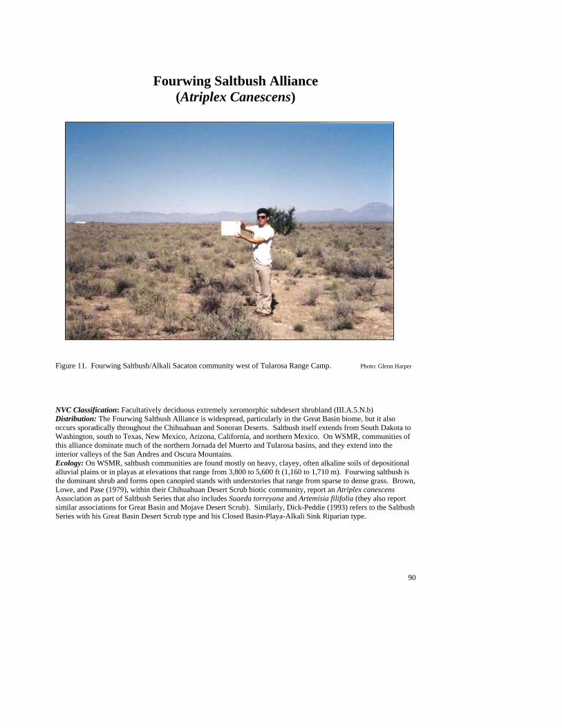
90
Fourwing Saltbush Alliance (Atriplex Canescens)
Figure 11. Fourwing Saltbush/Alkali Sacaton community west of Tularosa Range Camp. Photo: Glenn Harper NVC Classification: Facultatively deciduous extremely xeromorphic subdesert shrubland (III.A.5.N.b) Distribution: The Fourwing Saltbush Alliance is widespread, particularly in the Great Basin biome, but it also occurs sporadically throughout the Chihuahuan and Sonoran Deserts. Saltbush itself extends from South Dakota to Washington, south to Texas, New Mexico, Arizona, California, and northern Mexico. On WSMR, communities of this alliance dominate much of the northern Jornada del Muerto and Tularosa basins, and they extend into the interior valleys of the San Andres and Oscura Mountains. Ecology: On WSMR, saltbush communities are found mostly on heavy, clayey, often alkaline soils of depositional alluvial plains or in playas at elevations that range from 3,800 to 5,600 ft (1,160 to 1,710 m). Fourwing saltbush is the dominant shrub and forms open canopied stands with understories that range from sparse to dense grass. Brown, Lowe, and Pase (1979), within their Chihuahuan Desert Scrub biotic community, report an Atriplex canescens Association as part of Saltbush Series that also includes Suaeda torreyana and Artemisia filifolia (they also report similar associations for Great Basin and Mojave Desert Scrub). Similarly, Dick-Peddie (1993) refers to the Saltbush Series with his Great Basin Desert Scrub type and his Closed Basin-Playa-Alkali Sink Riparian type.
91
Key to the Fourwing Saltbush (Atriplex canescens) Plant Associations 1. James’ seaheath (Frankenia jamesii) common to well represented as subdominant shrub and undergrowth of grasses and forbs sparse.........................................Fourwing Saltbush/James’ Seaheath PA (See Minor Types) 1. James’ seaheath absent ......................................................................................................................................2 2. Bush muhly (Muhlenbergia porteri) common to well represented as dominant or codominant grass ...................................................................................................... Fourwing Saltbush/Bush Muhly PA (See Minor Types) 2. Bush muhly poorly represented to absent..........................................................................................................3 3. Mesa dropseed (Sporobolus flexuosus) well represented as dominant grass ........................................................................................................................................Fourwing Saltbush/Mesa Dropseed PA (See Minor Types) 3. Mesa dropseed poorly represented to absent .....................................................................................................4 4. Gyp dropseed (Sporobolus nealleyi) common to well represented as dominant or codominant grass ..................................................................................................................................Fourwing Saltbush/Gyp Dropseed PA 4. Gyp dropseed poorly represented to absent .......................................................................................................5 5. Alkali sacaton (Sporobolus airoides) common to well represented as dominant or codominant grass ................................................................................................................................ Fourwing Saltbush/Alkali Sacaton PA 5. Alkali sacaton poorly represented to absent ......................................................................................................6 6. Burrograss (Scleropogon brevifolius) common to well represented as dominant grass ..............................................................................................................................Fourwing Saltbush/Burrograss PA (See Minor Types) 6. Undergrowth sparse, usually less than 1% cover of grasses or forbs ..................................................................................................................................................................Fourwing Saltbush/Sparse PA (See Minor Types)
Fourwing Saltbush/Alkali Sacaton PA (Atriplex canescens/Sporobolus airoides; ATRCAN/SPOAIR )
Distribution: On White Sands Missile Range, a major community of the northern Jornada del Muerto and Tularosa basins, extending into the lower elevation interior valleys of the San Andres and Oscura Mountains. Vegetation Summary: This community is characterized by an open canopy of fourwing saltbush with a well represented to luxuriant grass understory dominated by alkali sacaton. Because fourwing saltbush cover is often just over ten percent, this type borders between being called a grassland or a shrubland. Shrubs tend to be poorly
represented, with honey mesquite, Berlandier’s wolfberry, and Christmas cactus commonly found in association. The herbaceous layer is generally scarce with low cover. Mojave seablite and prickly Russian
thistle are some of the more constant species found. Physical Setting: This type is found at elevations of 3,800 to 5,400 ft (1,160 to 1,650 m), in basin flats and broad drainage bottoms. It can extend up the lower alluvial piedmont slopes aprons (1 to 2 % slope), occurring in a patchy mosaic of more separate and distinct occurrences. Discussion: The type grades into Honey Mesquite/Alkali Sacaton and Creosotebush/Alkali Sacaton types in a mosaic-like fashion in basin bottom areas.
Soil Taxonomic Unit(s): Fine Mixed (Calcareous), Thermic, Typic Paleargid Average Min Max ELEVATION 4214 3873 5361 SLOPE (%): 2 SOLAR INDEX: .98 .25 1.26
##
#
#
#
#
##
#
# #
#
##
#
#
#
#
##
#
#
#
#
#
#
#
#
#
92
Common Plant Species, Fourwing Saltbush/Alkali Sacaton PA: Constancy Cover Scientific Name Common Name (% plots) Mean Max Min n = 22 Shrubs Prosopis glandulosa honey mesquite 50.00% 2.91 17.50 0.00 Opuntia phaeacantha tulip pricklypear 22.73% 0.60 2.00 0.01 Opuntia leptocaulis Christmas cactus 22.73% 0.60 2.50 0.00 Lycium berlandieri Berlandier’s wolfberry 22.73% 4.50 7.50 2.50 Atriplex canescens fourwing saltbush 100.00 15.70 87.50 2.50 Grasses Sporobolus nealleyi gyp dropseed 22.73% 1.70 2.50 0.50 Sporobolus airoides alkali sacaton 100.00 16.36 41.50 0.50 Forbs Suaeda moquinii Mojave seablite 36.36% 0.94 2.50 0.01 Salsola kali prickly Russian thistle 27.27% 0.14 0.50 0.05
Fourwing Saltbush/Gyp Dropseed PA (Atriplex canescens/Sporobolus nealleyi; ATRCAN/SPONEA)
Distribution: On White Sands Missile Range, this is a major type that occurs in the northern Jornada del Muerto and Tularosa basins. Vegetation Summary: This shrubland community generally has high cryptogamic crust cover and moderately abundant shrub cover dominated by fourwing saltbush. However, overall diversity of vegetation is low. Grasses are less well represented, with gyp dropseed the dominant and alkali sacaton and bush muhly sometimes present. Other common shrubs are Torrey’s jointfir, hairy coldenia,
and Christmas cactus. Forbs are sparse, but may include mountain pepperweed and dwarf mentzelia. Physical Setting: This type generally occurs in basins where gypsum outcrops are present, in depositional areas at elevations of 3,800 to 4,800 ft (1,160 to
1,460 m). Slopes are generally very gentle to flat and, therefore, aspects probably do not influence distribution. Discussion: This community is indicative of high gypsum soils and is occasionally found on the fringes of gypsum dune areas, adjacent to Alkali Sacaton Monotype and Fourwing Saltbush/Alkali Sacaton types. In basin bottoms and occasionally upland, this type forms a mosaic complex with Gyp Dropseed/Hairy Coldenia PA, which is usually found in association with hardened, exposed gypsum substrate (often recemented). Soil Taxonomic Unit(s): Fine Loamy, Mixed (Carbonatic), Thermic, Typic
Calciorthid Average Min Max ELEVATION 4307 3898 4759 SLOPE (%): 1 SOLAR INDEX: 1.26 1.26 1.26
Common Plant Species, Fourwing Saltbush/Gyp Dropseed PA: Constancy Cover Scientific Name Common Name (% plots) Mean Max Min n = 7 Shrubs Tiquilia hispidissima hairy coldenia 42.86% 0.17 0.50 0.00 Opuntia leptocaulis Christmas cactus 42.86% 0.17 0.50 0.01 Ephedra torreyana Torrey’s jointfir 57.14% 2.38 4.00 0.50 Atriplex canescens fourwing saltbush 100.00% 9.21 17.50 2.50
#
#
#
##
#
#
#
##

93
Grasses Sporobolus nealleyi gyp dropseed 100.00% 12.36 20.00 2.50 Sporobolus airoides alkali sacaton 42.86% 6.83 17.50 0.50 Muhlenbergia porteri bush muhly 42.86% 1.20 3.00 0.10 Forbs Mentzelia pumila dwarf mentzelia 42.86% 0.01 0.01 0.01 Lepidium montanum mountain pepperweed 57.14% 0.80 2.50 0.10
Minor Plant Associations: Fourwing Saltbush Alliance Fourwing Saltbush/Burrograss PA (Atriplex canescens/Scleropogon brevifolius; ATRCAN/SCLBRE)
On White Sands Missile Range, this minor type is known from five occurrences in the southern portion of the Tularosa basin. It occurs on a flat, silty clay loam plains at elevations that range from 3,870 to 4,050 ft (1,180 to 1,240 m). Stands tend to be sparsely vegetated, save for well represented fourwing saltbush and burrograss. This association may represent a degraded expression of tobosa and alkali sacaton grasslands as function of past grazing and other impacts. Fourwing Saltbush/Bush Muhly PA (Atriplex canescens/Muhlenbergia porteri; ATRCAN/MUHPOR)
On White Sands Missile Range, this minor type is known from the Tularosa basin south of US 70 in swales surrounded by coppice dunes and gypsum outcrops, and from the northern portion of the Tularosa basin and in valley bottoms leading to the Oscura Mountains. Elevations between 3,900 and 4,550 ft (1,200 and 1,400 m). Saltbush forms open canopies with grass cover ranging from 5 to 20%. Overall diversity is moderate, and may be higher that other saltbush types. Fourwing Saltbush/James’ Seaheath PA (Atriplex canescens/Frankenia jamesii; ATRCAN/FRAJAM)
On White Sands Missile Range, this minor type is known from one occurrence on the northern edge of the gypsum dunes in the Tularosa basin at an elevation of 3,935 ft (1,200m). Overall vegetation cover is sparse and diversity low. Fourwing Saltbush/Mesa Dropseed PA (Atriplex canescens/Sporobolus flexulosus; ATRCAN/SPOFLE)
On White Sands Missile Range, this minor type is known from two occurrences in the Tularosa basin south of US 70. It occurs on sandy, non-gypsum soils at around 3,900 ft (1,190 m). Overall shrub cover is low at between 5 and 10%, but grass cover is higher at around 15 to 25%. Fourwing Saltbush/Sparse Undergrowth PA (Atriplex canescens/Sparse; ATRCAN/SPARSE)
On White Sands Missile Range, this minor type is known from two occurrences, one in the northern Tularosa basin at 4,040 ft (1,230 m), and one in a valley bottom on the east side of the Little Burro Mountains at 4,840 ft (1,475 m). Saltbush is well represented to abundant, but herbaceous cover is negligible.
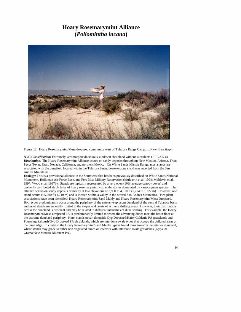
94
Hoary Rosemarymint Alliance (Poliomintha incana)
Figure 12. Hoary Rosemarymint/Mesa dropseed community west of Tularosa Range Camp. .... Photo: Glenn Harper NVC Classification: Extremely xeromorphic deciduous subdesert shrubland without succulents (III.B.3.N.a) Distribution: The Hoary Rosemarymint Alliance occurs on sandy deposits throughout New Mexico, Arizona, Trans-Pecos Texas, Utah, Nevada, California, and northern Mexico. On White Sands Missile Range, most stands are associated with the dunefield located within the Tularosa basin, however, one stand was reported from the San Andres Mountains. Ecology: This is a provisional alliance in the Southwest that has been previously described on White Sands National Monument, Holloman Air Force Base, and Fort Bliss Military Reservation (Muldavin et al. 1994; Muldavin et al. 1997; Wood et al. 1997b). Stands are typically represented by a very open (10% average canopy cover) and unevenly distributed shrub layer of hoary rosemarymint with understories dominated by various grass species. The alliance occurs on sandy deposits primarily at low elevations of 3,950 to 4,010 ft (1,204 to 1,222 m). However, one stand occurs at 5,600 ft (1,710 m) and is located within a valley in the central San Andres Mountains. Two plant associations have been identified: Hoary Rosemarymint/Sand Muhly and Hoary Rosemarymint/Mesa Dropseed. Both types predominantly occur along the periphery of the extensive gypsum duneland of the central Tularosa basin and most stands are generally limited to the slopes and crests of actively shifting areas. However, their distribution across the duneland is different and may be related to different intensities of dune shifting. For example, the Hoary Rosemarymint/Mesa Dropseed PA is predominantly limited to where the advancing dunes meet the basin floor at the extreme duneland periphery. Here, stands occur alongside Gyp Dropseed/Hairy Coldenia PA grasslands and Fourwing Saltbush/Gyp Dropseed PA shrublands, which are interdune swale types that occupy the deflated areas at the dune edge. In contrast, the Hoary Rosemarymint/Sand Muhly type is found more towards the interior duneland, where stands may grade to either non-vegetated dunes or intermix with interdune swale grasslands (Gypsum Grama/New Mexico Bluestem PA).
95
Key to the Hoary Rosemarymint (Poliomintha incana) Plant Associations 1. Sandhill muhly (Muhlenbergia pungens) common to well represented as dominant or codominant grass...................................................................................................................Hoary Rosemarymint /Sandhill Muhly PA 1. Mesa dropseed (Sporobolus flexulosus) present as the dominant or codominant grass.................................................................................................................. Hoary Rosemarymint /Mesa dropseed PA (See Minor Types)
Hoary Rosemarymint/Sandhill Muhly PA (Poliomintha incana/Muhlenbergia pungens; POLINC/MUHPUN)
Distribution: Major dunefield plant association within the central Tularosa basin. Vegetation Summary: This is a low diversity dune shrubland that is characterized by a low growing and unevenly distributed canopy of hoary rosemarymint. Individual large-diameter shrubs are often slightly elevated or coppiced along the summits of advancing dunes. Soaptree yucca, Torrey’s jointfir, skunkbush sumac, and fourwing saltbush are usually present, but, generally, are only dotted across the
landscape. In between the shrubs is a widely scattered (less than 5% average cover) bunch-grass component that is dominated by sandhill muhly, but includes Indian ricegrass and New Mexico bluestem. Physical Setting: This community is found on rolling dunefields that occur on the Tularosa basin floor. These dunes are large in area and appear to be maintained by accumulations of gypsum sediments that are blown out of Lake Lucero, a periodically inundated playa that occurs to the southwest of the dunefield. Since stands are found on different aspects and slope grades, a more determinant characteristic of distribution is probably the degree of local dune shifting.
Average Min Max ELEVATION (ft): 3965 3954 3977
Common Plant Species, Hoary Rosemarymint/Sandhill Muhly PA: Constancy Cover Scientific Name Common Name (% plots) Mean Max Min n = 2 Shrubs Yucca elata soaptree yucca 100.00% 0.50 0.50 0.50 Rhus trilobata skunkbush sumac 50.00% 2.50 2.50 2.50 Poliomintha incana hoary rosemarymint 100.00% 7.50 7.50 7.50 Ephedra torreyana Torrey’s jointfir 100.00% 0.50 0.50 0.50 Atriplex canescens fourwing saltbush 50.00% 0.00 0.00 0.00 Grasses Sporobolus giganteus giant dropseed 50.00% 0.50 0.50 0.50 Schizachyrium neomexicanum New Mexico bluestem 50.00% 0.50 0.50 0.50 Oryzopsis hymenoides Indian ricegrass 100.00% 1.50 2.50 0.50 Muhlenbergia pungens sandhill muhly 100.00% 2.50 2.50 2.50 Forbs Thelesperma megapotamicum Hopi tea greenthread 50.00% 0.50 0.50 0.50
Minor Plant Associations: Hoary Rosemarymint Alliance Hoary Rosemarymint/Mesa dropseed PA (Poliomintha incana/Sporobolus flexulosus; POLINC/SPOFLE)
This is a provisional type on White Sands Missile Range and in the Southwest that occurs on gypsum sand dunes at elevations from 3,950 to 4,000 ft (1,200 to 1,220 m). It is a very open shrubland dominated by hoary rosemarymint with a sparse grass undergrowth dominated by mesa dropseed. Other species present include giant dropseed, soaptree yucca, Torrey’s jointfir and fourwing saltbush. This association is similar to the Hoary Rosemarymint/Sandhill Muhly type, and may only be a phase of it. .
#
#
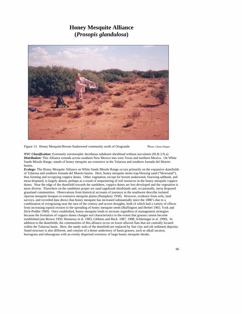
96
Honey Mesquite Alliance (Prosopis glandulosa)
Figure 13. Honey Mesquite/Broom Snakeweed community north of Orogrande Photo: Glenn Harper NVC Classification: Extremely xeromorphic deciduous subdesert shrubland without succulents (III.B.3.N.a) Distribution: This Alliance extends across southern New Mexico into west Texas and northern Mexico. On White Sands Missile Range, stands of honey mesquite are extensive in the Tularosa and southern Jornada del Muerto basins. Ecology: The Honey Mesquite Alliance on White Sands Missile Range occurs primarily on the expansive dunefields of Tularosa and southern Jornada del Muerto basins. Here, honey mesquite stems trap blowing sand (“blowsand”), thus forming and occupying coppice dunes. Other vegetation, except for broom snakeweed, fourwing saltbush, and mesa dropseed, is largely absent, perhaps as a result of sequestering of soil resources in the honey mesquite coppice dunes. Near the edge of the dunefield towards the sandsheet, coppice dunes are less developed and the vegetation is more diverse. Elsewhere on the sandsheet proper are sand sagebrush shrublands and, occasionally, mesa dropseed grassland communities. Observations from historical accounts of journeys in the southwest describe isolated riparian mesquite bosques to extensive mesquite plains (Humphrey 1958). However, evidence from soils, land surveys, and recorded data shows that honey mesquite has increased substantially since the 1880’s due to a combination of overgrazing near the turn of the century and severe droughts, both of which had a variety of effects from increasing topsoil erosion to the spreading of honey mesquite seeds (Buffington and Herbel 1965; York and Dick-Peddie 1969). Once established, honey mesquite tends to increase regardless of management strategies because the formation of coppice dunes changes soil characteristics to the extent that grasses cannot become established (see Brown 1950; Hennessy et al. 1983; Gibbens and Beck. 1987, 1988; Schlesinger et al. 1990). In addition to the dunefields, the communities of this alliance occur on lower alluvial flats that are centrally located within the Tularosa basin. Here, the sandy soils of the dunefield are replaced by fine clay and silt sediment deposits. Stand structure is also different, and consists of a dense understory of basin grasses, such as alkali sacaton, burrograss and tobosagrass with an evenly dispersed overstory of large honey mesquite shrubs.
97
Key to the Honey Mesquite (Prosopis glandulosa) Plant Associations 1. Communities primarily of alluvial piedmont slopes or basin floors..................................................................2 1. Communities primarily of sandy plains or coppice dunes.................................................................................6 2. Alkali sacaton (Sporobolus airoides) common to well represented as dominant grass .............................................................................................................................................................Honey Mesquite/Alkali Sacaton PA 2. Alkali sacaton poorly represented to absent ......................................................................................................3 3. Burrograss (Scleropogon brevifolius) common to well represented as dominant grass .................................................................................................................................. Honey Mesquite/Burrograss PA (See Minor Types) 3. Burrograss poorly represented to absent............................................................................................................4 4. Tobosagrass (Hilaria mutica) common to well represented as dominant grass............................................................................................................................................. Honey Mesquite/Tobosagrass PA (See Minor Types) 4. Tobosagrass poorly represented to absent .........................................................................................................5 5. Bush muhly (Muhlenbergia porteri) common to well represented as dominant or codominant grass ...........................................................................................................Honey Mesquite/Bush Muhly PA (See Minor Types) 5. Threadleaf snakeweed (Gutierrezia microcephala) common to well represented as dominant or codominant sub-shrub ................................................................Honey Mesquite/Threadleaf Snakeweed PA (See Minor Types) 6. Mesa dropseed (Sporobolus flexuosus) common to well represented as dominant or codominant grass ................................................................................................................................ Honey Mesquite/Mesa Dropseed PA 6. Mesa dropseed poorly represented to absent .....................................................................................................7 7. Fourwing saltbush (Atriplex canescens) common to well represented in interdune space ................................................................................................................................................ Honey Mesquite/Fourwing Saltbush PA 7. Fourwing saltbush poorly represented or absent and broom snakeweed (Gutierrezia sarothrae) common to well represented.............................................................. Honey Mesquite/Broom Snakeweed PA (See Minor Types)
Honey Mesquite/Alkali Sacaton PA (Prosopis glandulosa/Sporobolus airoides; PROGLA/SPOAIR)
Distribution: Major community of the central Tularosa basin. Vegetation Summary: This Chihuahuan Desert shrubland is distinguished by an evenly dispersed and open canopy of large honey mesquite shrubs, over a grassy understory dominated by alkali sacaton. In addition, it characteristically exhibits little floristic variability and, generally, the only associated shrub is fourwing saltbush (a suggested phase). Alkali sacaton is typically the only grass present and is found both under and around the honey
mesquite canopy. Large, open shrub interspaces are occasionally sparsely vegetated. Physical Setting: Generally, stands occur on the lowest parts of alluvial plains or flats that lead onto basin bottoms. Here, the low elevation landscape is
essentially flat with little to no aspect or slope. However, erosion around shrubs on some stands creates local relief, which at an extreme may resemble coppice dunes. In addition, this type occurs along the edges and in the sheltered coves of broad basin drainages. Soils are of alluvial origin, often calcareous with silty clays over well-developed alluvial clay horizons. Discussion: In general, honey mesquite cover remains relatively constant across occurrences, although the understory may be highly variable. Some stands may have dense grass cover while others have a sparsely scattered layer that grows between bare soil patches. Decreases in grass cover probably promote the channeling of summer monsoon runoff and soil erosion around the shrubs. In contrast, stands, which exhibit a dense grass layer, are generally flat. Here, erosion is minimized and deposition maximized, probably through a positive feedback cycle that continually enhances soil moisture and plant growth. Because of enhanced moisture conditions, dense vegetation can form on these soils, which reduces evaporation and increases water
#
#
#
#
##
##
#
#
#
#
#
#
#
98
infiltration, which contributes to heavy soil formation (Wood et al. 1987a). Soil Taxonomic Unit(s): Fine, Carbonatic, Thermic Ustollic Haplargids
Average Min Max ELEVATION (ft): 4072 3894 4308 SLOPE (%): 3 SOLAR INDEX: 1.11 1.05 1.17
Common Plant Species, Honey Mesquite/Alkali Sacaton PA: Constancy Cover Scientific Name Common Name (% plots) Mean Max Min n = 10 Shrubs Prosopis glandulosa honey mesquite 100.00% 16.80 29.00 7.50 Atriplex canescens fourwing saltbush 80.00% 3.25 10.00 0.01 Grasses Sporobolus airoides alkali sacaton 100.00% 15.65 35.00 7.50
Honey Mesquite/Fourwing Saltbush PA (Prosopis glandulosa/Atriplex canescens; PROGLA/ATRCAN)
Distribution: Major community of the Tularosa basin and occasional within the southern Jornada del Muerto. Vegetation Summary: This Chihuahuan shrubland is characterized both by stands of large diameter (30+ m) honey mesquite shrubs growing on tall and rolling coppice dunes and by stands on low elevation flats. Both sites are dominated by honey mesquite and share fourwing saltbush, which grows in the interdune or intershrub spaces, as the codominant species. Overall,
species diversity is low, but stands may occasionally include scattered broom snakeweed (a suggested phase) and mesa dropseed. Additional suggested phases include Mojave seablite, specifically on alluvial sites, and broom dalea. Physical Setting: This low elevation community occurs on alluvial or basin flats and on extensive coppice dunefields. Both stands lack significant aspect and have similar surface soils (sand to loamy sand), that overlie more developed, clayey soils (Haplargids). However, alluvial sites include sandy loams, cobble on the surface, and may sometimes have alkaline soils. Steep, tall, and rolling dunes, in contrast to alluvial sites, which are generally on flat surfaces, characterize surface topography on coppice dune sites.
Discussion: The Honey Mesquite/Broom Snakeweed PA is very similar to this type in both floristics and landform, but lacks the fourwing saltbush component growing within the interdune spaces (or deflation plains). Fourwing saltbush is present at low levels on coppice dunes, but here it dominates only the interdune spaces. Reasons for this are unclear. Like honey mesquite, it is deep rooted and is therefore decoupled from arid conditions. Unlike honey mesquite, it is not adapted to the moving soil environment, and its infrequence on the coppice dunes may be due to burial by or incorporation within a dune. Although honey mesquite is native to the Chihuahuan Desert, heavy grazing in the late 1800’s and early 1900’s caused its increase as vegetation removal caused severe erosion of the topsoil. The blowing topsoil is trapped by honey mesquite stems, which elongate rapidly in response to burial, and coppice dunes are thus formed. Soil nutrients and water become concentrated under the shrub canopy on the dunes, which limits establishment of vegetation in the interdune area. This lack of vegetation decreases water infiltration and increases runoff, thus further precluding establishment of interdune vegetation. Furthermore, because honey mesquite exploits deep water sources, it is effectively decoupled from the dry conditions it causes (Campbell 1929; Buffington and Herbel 1965; Herbel et al. 1972; Brown and Archer 1989; Schlesinger et al. 1990; Montana et al. 1995). Stands often occur adjacent to small pockets of mesa dropseed grasslands and sand sagebrush and broom dalea shrubland types, which may
#
#
##
##
#
#
##
#
#
##
#
#
#
#
#
#
#
#
#
##
#
#
#
#
##
#
#
##
#
#
99
be isolated remnants of the former conditions. However, these profound changes in soil and hydrological conditions prevent a return to them, and efforts to control or prevent expansion of honey mesquite have largely failed (Brown 1950; Gibbens et al. 1992). Soil Taxonomic Unit(s):
Mixed (Calcareous), Thermic, Typic Torripsamment Average Min Max ELEVATION (ft): 4089 3896 4877 SLOPE (%): 1 4 SOLAR INDEX: 1.43 .26 1.92
Common Plant Species, Honey Mesquite/Fourwing Saltbush PA: Constancy Cover Scientific Name Common Name (% plots) Mean Max Min n = 30 Shrubs Prosopis glandulosa honey mesquite 100.00% 20.68 41.50 5.00 Gutierrezia sarothrae broom snakeweed 80.00% 3.36 20.00 0.25 Atriplex canescens fourwing saltbush 100.00% 10.13 29.00 2.50
Honey Mesquite/Mesa Dropseed PA (Prosopis glandulosa/Sporobolus flexuosus; PROGLA/SPOFLE)
Distribution: On White Sands Missile Range, this is a major community of the Tularosa and Jornada del Muerto basins. Vegetation Summary: This open-canopied shrubland is characterized by large honey mesquite shrubs on slightly coppicing dunes with an abundant understory of waist-high mesa dropseed growing within the interdune spaces. Fourwing saltbush, soaptree yucca, and broom snakeweed are associated species that are sparsely scattered throughout most stands (less than 9% average collective cover).
Additionally, a forb layer of mostly sand-associated, late season bloomers is present and includes spectacle pod and desert marigold. A sand sagebrush phase has been suggested, particularly in areas where these PAs occur within a distribution matrix. Physical Setting: These low elevation stands are found on rolling coppice dunes that occur within both basins. The dunefield sands overlay older, developed calcareous or argillic soils. The surface topography is characterized by rolling sandy hummocks or steep dunes, but there is no overall aspect dominance.
Discussion: This association may be a degraded version of the Mesa Dropseed/Soaptree Yucca grassland PA. The Honey Mesquite/Mesa Dropseed is found near the edges of vast dunefields made up of mostly other honey mesquite associations. In the stands where honey mesquite does not exhibit strong coppicing, the flora is relatively diverse, and mesa dropseed is well represented. In stands where honey mesquite is coppicing, the flora is depauperate, and although mesa dropseed is still present in the interdunes, it is at lower cover levels. Both mesa dropseed and honey mesquite prefer sandy soils (Brown 1982a), but honey mesquite is adapted to blowing sand, responding to burial by sand with rapid meristem elongation. Mesa dropseed lacks such an adaptation and is found on more stable soils. The formation of coppice dunes promotes further unstable soil conditions as vegetation and soil resources become sequestered beneath the honey mesquite canopy, while interdune areas erode and form a hard crust that precludes the establishment of vegetation (Schlesinger et al. 1990; Wan et al. 1993). Average Min Max ELEVATION (ft): 4484 3926 5137 SLOPE (%): 1 4 SOLAR INDEX: .83 .43 1.57
#
##
#
#
##

100
Common Plant Species, Honey Mesquite/Mesa Dropseed PA: Constancy Cover Scientific Name Common Name (% plots) Mean Max Min n = 6 Shrubs Yucca elata soaptree yucca 100.00% 1.43 2.50 0.10 Prosopis glandulosa honey mesquite 100.00% 16.50 29.00 7.50 Gutierrezia sarothrae broom snakeweed 66.67% 5.13 7.50 0.50 Atriplex canescens fourwing saltbush 100.00% 2.25 3.00 0.50 Grasses Sporobolus flexuosus mesa dropseed 100.00% 7.75 17.50 2.50
Minor Plant Associations: Honey Mesquite Alliance Honey Mesquite/Broom Snakeweed PA (Prosopis glandulosa/Gutierrezia sarothrae; PROGLA/GUTSAR)
This is an established and widespread Chihuahuan shrubland community in the Southwest and is closely related to the Honey Mesquite/Fourwing saltbush PA described above. On WSMR the two associations are found in a matrix within the rolling coppice dunefields in the southern half of the Tularosa basin at elevations that range from 3,890 to 4,310 ft (1,185 to 1,310). The type also occurs around Sand Mountain in the northern Jornada basin at elevations between 4,900 and 5,150 ft (1,490 and 1,570 m). Both of these shrublands share most of the same species, but in the broom snakeweed type here, fourwing saltbush grows mostly on the dunes, while broom snakeweed is the dominant in the interdune spaces. Sagebrush (Artemisia filifolia) can also be well represented. Soaptree yucca is an additional component that is commonly found scattered across stands. Honey mesquite can form high coppice dunes with canopy cover as high as 25%. Snakeweed ranges from 3 to 10% range cover. The intershrub areas consist of mostly of exposed sand and a scattering of grasses and forbs. Honey Mesquite/Burrograss PA (Prosopis glandulosa/Scleropogon brevifolius; PROGLA/SCLBRE)
This is a provisional type in the Southwest and a minor type on White Sands Missile Range. Stands have an open and evenly distributed canopy of mostly low-growing honey mesquite, and an understory that is dominated by abundant and evenly dispersed burrograss. Diversity is characteristically low, but stands do generally include fourwing saltbush, prickly Russian thistle and additional grasses (creeping muhly, tobosagrass and sacaton). Stand structure and composition are probably related to past, and, in some cases, current human-caused disturbances. The landscape is characterized by low elevation alluvial or basin flats, that lie adjacent to the Tularosa basin floor at elevations between 4,000 and 4,200 ft (1,220 and 1,280 m). Soil surfaces are generally cracked and composed of fine silts and clays that are deposited by periodic inundation. Stands are found in a matrix with the Honey Mesquite/Alkali Sacaton PA and grasslands of the Alkali Sacaton or Tobosagrass Alliances. Honey Mesquite/Bush Muhly PA (Prosopis glandulosa/Muhlenbergia porteri; PROGLA/MUHPOR)
This is a provisional type in the Southwest (known from Fort Bliss and the Borderlands area), and a minor
type on White Sands Missile Range. It may also occur in the Trans-Pecos region of Texas as well as northern Mexico. Unlike the rest of the communities of this alliance, this association occurs both on the coarse soils (sand to loamy sand) of stabilized sand deposits of basin floors, and on granite-derived alluvial fan deposits. Elevations range from 3,925 to 5,475 ft (1,200 to 1,670 m). Stands are characterized by a moderately open (25% average cover) shrub layer dominated by honey mesquite, with bush muhly dominating both under canopies and in the intershrub spaces. Additionally, stands are relatively high in diversity (25 species reported) and commonly include fourwing saltbush, longleaf jointfir, soaptree yucca, fluffgrass, mesa dropseed, and black grama. Both species composition and geomorphology suggest an intermediate disturbance stage between more wind-eroded coppice dune types, such as the Honey Mesquite/Fourwing Saltbush PA, and stabilized mesa dropseed or black grama grasslands of the basin and bajadas.

101
Honey Mesquite/Threadleaf Snakeweed PA (Prosopis glandulosa/Gutierrezia microcephala; PROGLA/GUTMIC)
This is a provisional Chihuahuan shrubland community of the Southwest, and a minor association on White Sands Missile Range. It occurs mainly on granitic alluvial fans leading out eastward from the San Augustine and Organ Mountains and down to the Tularosa basin floor. Elevations range from 3,975 to 4,220 ft (1,210 to 1,290 m). Stand structure consists of a moderately open canopy of honey mesquite (33% average cover), with scattered soaptree yucca, and a poorly represented understory dominated by threadleaf snakeweed (3% average cover). This type is similar to the Honey Mesquite/Broom Snakeweed PA, which dominates the basin dunefields below. Both shrublands are low in diversity and share most of the same species, including fourwing saltbush, which can be well represented. However, wind, the dominant erosional force on the dunefield, is coupled here with alluvial forces. This may explain the differences in soil texture between both locations. Here, stands tend to have coarse sand and gravel surfaces, in contrast to sand dunefields. Occurrences are extensive and dominate the lower alluvial flats before giving way to grama grasslands further upslope. Lower elevations grade into creosotebush, tarbush and basin grassland types. Honey Mesquite/Tobosagrass PA (Prosopis glandulosa/Hilaria mutica; PROGLA/HILMUT)
This is a provisional type in the Southwest (known from Fort Bliss and the Gray Ranch) and a minor type
on White Sands Missile Range. It is characterized by a very open, non-coppice-forming canopy of honey mesquite (18% cover) with an understory dominated by dense patches of tobosagrass. Other species are scarce, but alkali sacaton is sometimes present. The White Sands Missile Range site occupies a swale on a low elevation alluvial flat located centrally within the Tularosa basin at an elevation of 4,040 ft (1,230 m). It occurs in a matrix with other basin grasslands and large barren alluvial flats. Soils are clayey and derived from fine textured alluvial deposits from the surrounding mountains.
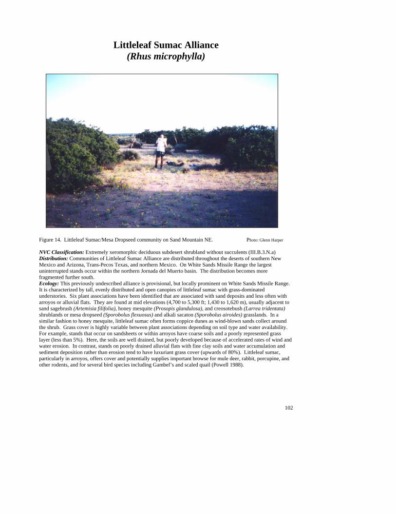
102
Littleleaf Sumac Alliance (Rhus microphylla)
Figure 14. Littleleaf Sumac/Mesa Dropseed community on Sand Mountain NE. Photo: Glenn Harper NVC Classification: Extremely xeromorphic deciduous subdesert shrubland without succulents (III.B.3.N.a) Distribution: Communities of Littleleaf Sumac Alliance are distributed throughout the deserts of southern New Mexico and Arizona, Trans-Pecos Texas, and northern Mexico. On White Sands Missile Range the largest uninterrupted stands occur within the northern Jornada del Muerto basin. The distribution becomes more fragmented further south. Ecology: This previously undescribed alliance is provisional, but locally prominent on White Sands Missile Range. It is characterized by tall, evenly distributed and open canopies of littleleaf sumac with grass-dominated understories. Six plant associations have been identified that are associated with sand deposits and less often with arroyos or alluvial flats. They are found at mid elevations (4,700 to 5,300 ft; 1,430 to 1,620 m), usually adjacent to sand sagebrush (Artemisia filifolia), honey mesquite (Prosopis glandulosa), and creosotebush (Larrea tridentata) shrublands or mesa dropseed (Sporobolus flexuosus) and alkali sacaton (Sporobolus airoides) grasslands. In a similar fashion to honey mesquite, littleleaf sumac often forms coppice dunes as wind-blown sands collect around the shrub. Grass cover is highly variable between plant associations depending on soil type and water availability. For example, stands that occur on sandsheets or within arroyos have coarse soils and a poorly represented grass layer (less than 5%). Here, the soils are well drained, but poorly developed because of accelerated rates of wind and water erosion. In contrast, stands on poorly drained alluvial flats with fine clay soils and water accumulation and sediment deposition rather than erosion tend to have luxuriant grass cover (upwards of 80%). Littleleaf sumac, particularly in arroyos, offers cover and potentially supplies important browse for mule deer, rabbit, porcupine, and other rodents, and for several bird species including Gambel’s and scaled quail (Powell 1988).
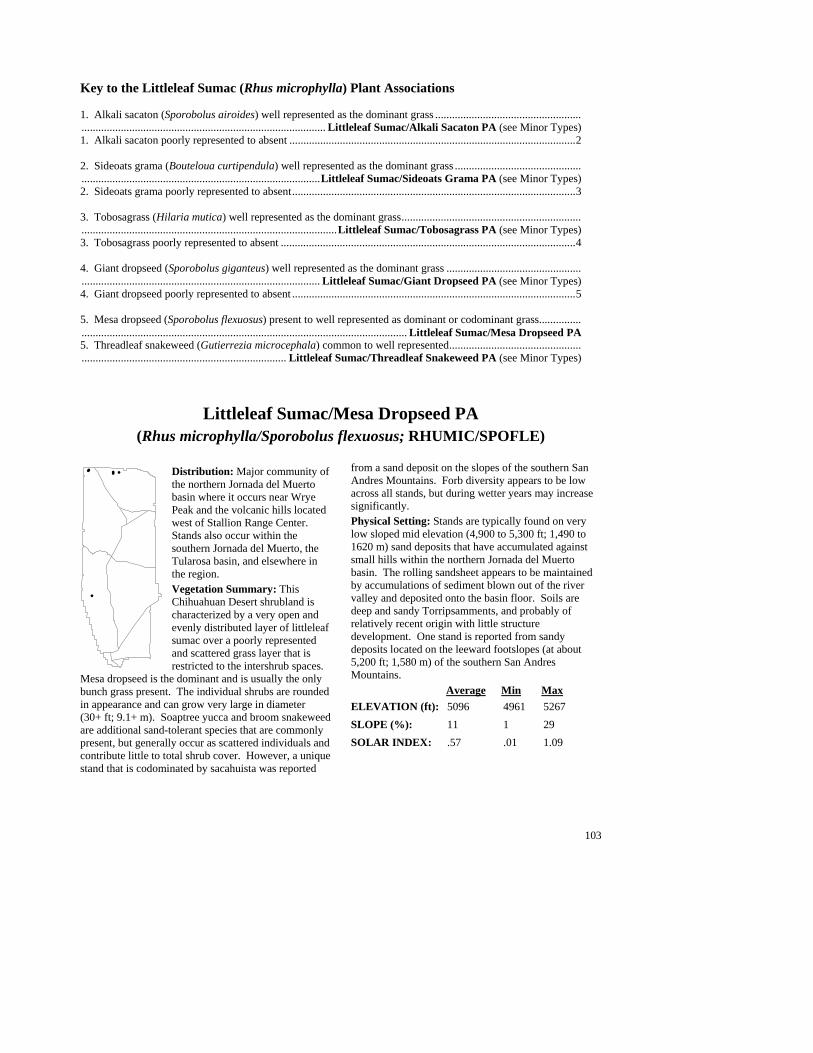
103
Key to the Littleleaf Sumac (Rhus microphylla) Plant Associations 1. Alkali sacaton (Sporobolus airoides) well represented as the dominant grass ........................................................................................................................................... Littleleaf Sumac/Alkali Sacaton PA (see Minor Types) 1. Alkali sacaton poorly represented to absent ......................................................................................................2 2. Sideoats grama (Bouteloua curtipendula) well represented as the dominant grass ..................................................................................................................................Littleleaf Sumac/Sideoats Grama PA (see Minor Types) 2. Sideoats grama poorly represented to absent.....................................................................................................3 3. Tobosagrass (Hilaria mutica) well represented as the dominant grass...........................................................................................................................................................Littleleaf Sumac/Tobosagrass PA (see Minor Types) 3. Tobosagrass poorly represented to absent .........................................................................................................4 4. Giant dropseed (Sporobolus giganteus) well represented as the dominant grass ..................................................................................................................................... Littleleaf Sumac/Giant Dropseed PA (see Minor Types) 4. Giant dropseed poorly represented to absent .....................................................................................................5 5. Mesa dropseed (Sporobolus flexuosus) present to well represented as dominant or codominant grass................................................................................................................................... Littleleaf Sumac/Mesa Dropseed PA 5. Threadleaf snakeweed (Gutierrezia microcephala) common to well represented........................................................................................................................ Littleleaf Sumac/Threadleaf Snakeweed PA (see Minor Types)
Littleleaf Sumac/Mesa Dropseed PA (Rhus microphylla/Sporobolus flexuosus; RHUMIC/SPOFLE)
Distribution: Major community of the northern Jornada del Muerto basin where it occurs near Wrye Peak and the volcanic hills located west of Stallion Range Center. Stands also occur within the southern Jornada del Muerto, the Tularosa basin, and elsewhere in the region. Vegetation Summary: This Chihuahuan Desert shrubland is characterized by a very open and evenly distributed layer of littleleaf sumac over a poorly represented and scattered grass layer that is restricted to the intershrub spaces.
Mesa dropseed is the dominant and is usually the only bunch grass present. The individual shrubs are rounded in appearance and can grow very large in diameter (30+ ft; 9.1+ m). Soaptree yucca and broom snakeweed are additional sand-tolerant species that are commonly present, but generally occur as scattered individuals and contribute little to total shrub cover. However, a unique stand that is codominated by sacahuista was reported
from a sand deposit on the slopes of the southern San Andres Mountains. Forb diversity appears to be low across all stands, but during wetter years may increase significantly. Physical Setting: Stands are typically found on very low sloped mid elevation (4,900 to 5,300 ft; 1,490 to 1620 m) sand deposits that have accumulated against small hills within the northern Jornada del Muerto basin. The rolling sandsheet appears to be maintained by accumulations of sediment blown out of the river valley and deposited onto the basin floor. Soils are deep and sandy Torripsamments, and probably of relatively recent origin with little structure development. One stand is reported from sandy deposits located on the leeward footslopes (at about 5,200 ft; 1,580 m) of the southern San Andres Mountains. Average Min Max ELEVATION (ft): 5096 4961 5267 SLOPE (%): 11 1 29 SOLAR INDEX: .57 .01 1.09
###
#
##

104
Common Plant Species, Littleleaf Sumac/Mesa Dropseed PA: Constancy Cover Scientific Name Common Name (% plots) Mean Max Min n = 4 Shrubs Yucca elata soaptree yucca 75.00% 1.67 2.50 0.01 Yucca baccata banana yucca 50.00% 1.25 2.50 0.01 Thymophylla acerosa pricklyleaf dogweed 50.00% 1.50 2.50 0.50 Rhus microphylla littleleaf sumac 100.00% 17.88 29.00 7.50 Prosopis glandulosa honey mesquite 50.00% 2.50 2.50 2.50 Larrea tridentata creosotebush 50.00% 12.50 17.50 7.50 Gutierrezia sarothrae broom snakeweed 75.00% 3.50 7.50 0.50 Grasses Sporobolus flexuosus mesa dropseed 100.00% 2.75 7.50 0.50 Erioneuron pulchellum fluffgrass 50.00% 1.27 2.50 0.05 Forbs Baileya multiradiata desert marigold 50.00% 10.00 17.50 2.50
Minor Plant Associations: Littleleaf Sumac Alliance Littleleaf Sumac/Alkali Sacaton PA (Rhus microphylla/Sporobolus airoides; RHUMIC/SPOAIR)
This is a provisional plant association in the northern Jornada basin of White Sands Missile Range. It is characterized by an evenly distributed and very open canopy of littleleaf sumac (10 to 25% cover) and a luxuriant grass cover of alkali sacaton. Diversity is very low, but Indian rushpea and vine mesquite are common associates. Stands occupy areas of water and sediment accumulation on alluvial flats at about 4,800 ft (1,460 m). The soils are derived from very fine clay alluvial deposits. Littleleaf Sumac/Giant Dropseed PA (Rhus microphylla/Sporobolus giganteus; RHUMIC/SPOGIG)
This is a provisional type in the Southwest and a minor type in the northern Jornada basin on White Sands Missile Range. Elevation has been recorded as 4,840 ft (1,475 m). The plant association is very similar to the Littleleaf Sumac/Mesa Dropseed PA, but because of deeper sand accumulations, giant dropseed replaces mesa drop seed. As with Littleleaf Sumac/Mesa Dropseed PA, the Rhus forms coppice dune-like mounds as sands collect around the base of the shrubs, and overall diversity is low. This provisional type may only represent a phase of the Littleleaf Sumac/Mesa Dropseed PA. Littleleaf Sumac/Sideoats Grama PA (Rhus microphylla/Bouteloua curtipendula; RHUMIC/BOUCUR)
This is a minor type on White Sands Missile Range, but it has been previously described from southwestern New Mexico (Muldavin et al. 1998). The association is savanna-like with a very open but tall canopy of Rhus with a luxuriant and tall grass layer (>75% cover) dominated by sideoats grama. It is known from large alluvial flats of the northern Jornada del Muerto at an elevation of 4,785 ft (1,460 m). The soils are derived from very fine clay alluvial deposits. Littleleaf Sumac/Threadleaf Snakeweed PA (Rhus microphylla/Gutierrezia microcephala; RHUMIC/GUTMIC)
This is a minor provisional plant association is known on White Sands Missile Range on from a sand deposit with scattered surface gravel near Wrye Peak in the northern Jornada del Muerto basin at an elevation of 5,290 ft (1,610 m) It is similar to the Littleleaf Sumac/Mesa Dropseed PA, but lacks a significant grass cover and mesa dropseed is absent. Rather, the dwarf shrub threadleaf snakeweed is scattered in the spaces between the tall Rhus shrubs. Littleleaf Sumac/Tobosagrass PA (Rhus microphylla/Hilaria mutica; RHUMIC/HILMUT)
This is a minor provisional plant association on White Sands Missile Range. known only from alluvial flats at about 4,800 ft (1,460 m) in northern Jornada del Muerto basin. The soils are derived from very fine clay alluvial deposits. Littleleaf sumac forms a scattered, very open canopy over luxuriant tobosagrass. Diversity is very low. It is part of a matrix that includes Alkali Sacaton/Monotypic and Tobosagrass/Alkali Sacaton grasslands and Littleleaf Sumac/Sideoats Grama, Littleleaf Sumac/Alkali Sacaton shrublands. Association level status is tentative, e.g., this type could be considered a littleleaf sumac phase of the Tobosagrass/Alkali Sacaton PA.
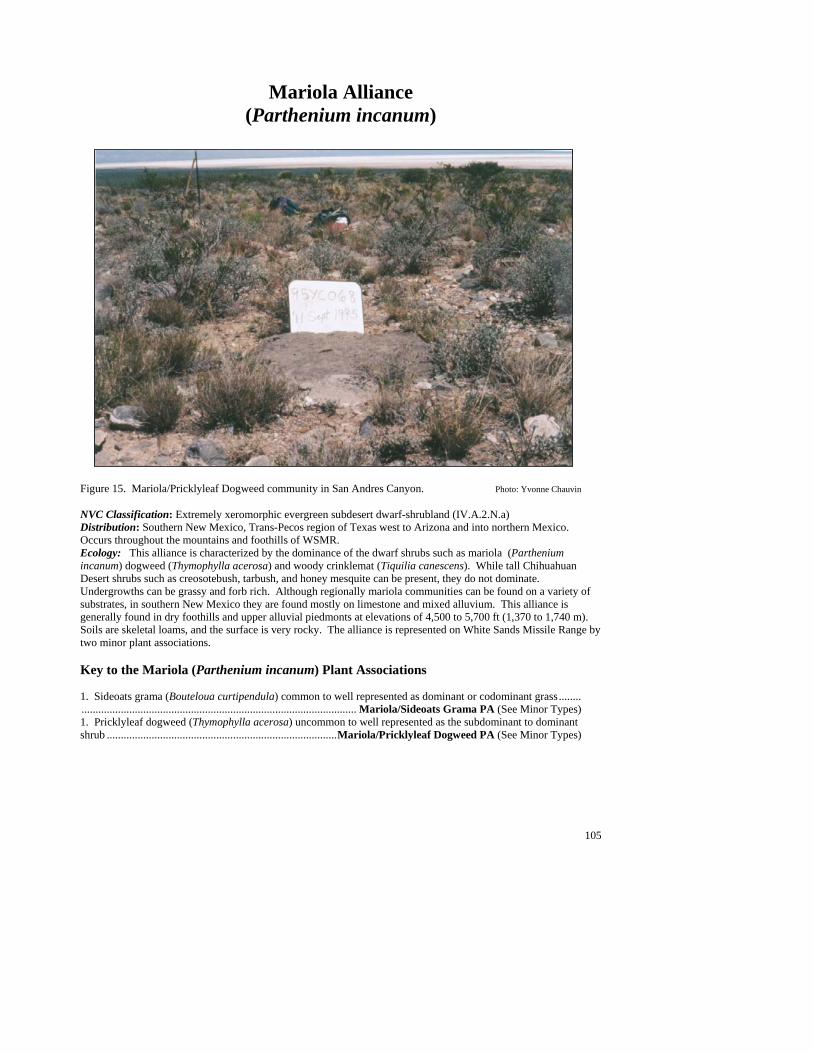
105
Mariola Alliance (Parthenium incanum)
Figure 15. Mariola/Pricklyleaf Dogweed community in San Andres Canyon. Photo: Yvonne Chauvin NVC Classification: Extremely xeromorphic evergreen subdesert dwarf-shrubland (IV.A.2.N.a) Distribution: Southern New Mexico, Trans-Pecos region of Texas west to Arizona and into northern Mexico. Occurs throughout the mountains and foothills of WSMR. Ecology: This alliance is characterized by the dominance of the dwarf shrubs such as mariola (Parthenium incanum) dogweed (Thymophylla acerosa) and woody crinklemat (Tiquilia canescens). While tall Chihuahuan Desert shrubs such as creosotebush, tarbush, and honey mesquite can be present, they do not dominate. Undergrowths can be grassy and forb rich. Although regionally mariola communities can be found on a variety of substrates, in southern New Mexico they are found mostly on limestone and mixed alluvium. This alliance is generally found in dry foothills and upper alluvial piedmonts at elevations of 4,500 to 5,700 ft (1,370 to 1,740 m). Soils are skeletal loams, and the surface is very rocky. The alliance is represented on White Sands Missile Range by two minor plant associations. Key to the Mariola (Parthenium incanum) Plant Associations 1. Sideoats grama (Bouteloua curtipendula) common to well represented as dominant or codominant grass.......................................................................................................... Mariola/Sideoats Grama PA (See Minor Types) 1. Pricklyleaf dogweed (Thymophylla acerosa) uncommon to well represented as the subdominant to dominant shrub ..................................................................................Mariola/Pricklyleaf Dogweed PA (See Minor Types)
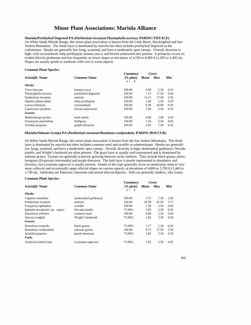
106
Minor Plant Associations: Mariola Alliance Mariola/Pricklyleaf Dogweed PA (Parthenium incanum/Thymophylla acerosa; PARINC/THYACE) On White Sands Missile Range, this minor plant association is known from the Little Burro, Mockingbird and San Andres Mountains. The shrub layer is dominated by mariola but often includes pricklyleaf dogweed as the codominant. Shrubs are generally low lying, scattered, and have a moderately open canopy. Overall, diversity is high; with creosotebush, tulip pricklypear, banana yucca, and broom snakeweed also present. It primarily occurs on eroded alluvial piedmonts and less frequently on lower slopes at elevations of 4,550 to 4,900 ft (1,385 to 1,495 m). Slopes are usually gentle to moderate with cool to warm aspects. Common Plant Species: Constancy Cover Scientific Name Common Name (% plots) Mean Max Min n = 4 Shrubs Yucca baccata banana yucca 100.00 0.90 2.50 0.10 Thymophylla acerosa pricklyleaf dogweed 100.00 7.13 17.50 0.50 Parthenium incanum mariola 100.00 13.13 17.50 2.50 Opuntia phaeacantha tulip pricklypear 100.00 1.40 2.50 0.10 Larrea tridentata creosotebush 100.00 6.38 10.00 0.50 Gutierrezia sarothrae broom snakeweed 100.00 1.90 2.50 0.10 Grasses Muhlenbergia porteri bush muhly 100.00 0.88 2.00 0.50 Erioneuron pulchellum fluffgrass 100.00 1.26 2.50 0.05 Aristida purpurea purple threeawn 100.00 2.65 7.50 0.10 Mariola/Sideoats Grama PA (Parthenium incanum/Bouteloua curtipendula; PARINC/BOUCUR) On White Sands Missile Range, this minor plant association is known from the San Andres Mountains. The shrub layer is dominated by mariola but often includes common sotol and ocotillo as subdominants. Shrubs are generally low lying, scattered, and have a moderately open canopy. Overall, diversity is high; skeletonleaf goldeneye, Nevada jointfir, and Wright’s beebrush are often present. The grass layer is usually well represented and is dominated by sideoats grama. Grasses are generally scattered, growing between rocky surfaces. They include black grama, plains lovegrass (Eragrostis intermedia) and purple threeawn. The forb layer is poorly represented in abundance and diversity, but Louisiana sagewort is usually present. Stands of this type generally occur on moderately steep to very steep colluvial and occasionally upper alluvial slopes on various aspects, at elevations of 4,800 to 5,700 ft (1,460 to 1,740 m). Substrates are Paleozoic limestone and mixed alluvial deposits. Soils are generally shallow, silty loams.
Common Plant Species: Constancy Cover Scientific Name Common Name (% plots) Mean Max Min n = 4 Shrubs Viguiera stenoloba skeletonleaf goldeneye 100.00 3.75 7.50 2.50 Parthenium incanum mariola 100.00 26.38 41.50 17.5 Fouquieria splendens ocotillo 100.00 1.38 2.50 0.00 Ephedra nevadensis var. aspera Nevada jointfir 75.00% 1.83 2.50 0.50 Dasylirion wheeleri common sotol 100.00 0.88 2.50 0.00 Aloysia wrightii Wright’s beebrush 75.00% 1.83 2.50 0.50 Grasses Bouteloua eriopoda black grama 75.00% 1.17 2.50 0.50 Bouteloua curtipendula sideoats grama 100.00 8.75 17.50 2.50 Aristida purpurea purple threeawn 75.00% 1.83 2.50 0.50 Forbs Artemisia ludoviciana Louisiana sagewort 75.00% 1.02 2.50 0.05
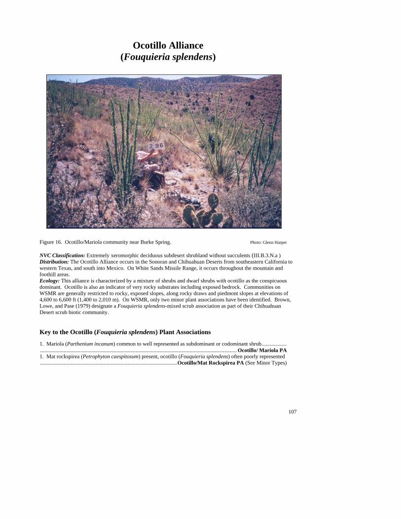
107
Ocotillo Alliance (Fouquieria splendens)
Figure 16. Ocotillo/Mariola community near Burke Spring. Photo: Glenn Harper NVC Classification: Extremely xeromorphic deciduous subdesert shrubland without succulents (III.B.3.N.a ) Distribution: The Ocotillo Alliance occurs in the Sonoran and Chihuahuan Deserts from southeastern California to western Texas, and south into Mexico. On White Sands Missile Range, it occurs throughout the mountain and foothill areas. Ecology: This alliance is characterized by a mixture of shrubs and dwarf shrubs with ocotillo as the conspicuous dominant. Ocotillo is also an indicator of very rocky substrates including exposed bedrock. Communities on WSMR are generally restricted to rocky, exposed slopes, along rocky draws and piedmont slopes at elevations of 4,600 to 6,600 ft (1,400 to 2,010 m). On WSMR, only two minor plant associations have been identified. Brown, Lowe, and Pase (1979) designate a Fouquieria splendens-mixed scrub association as part of their Chihuahuan Desert scrub biotic community. Key to the Ocotillo (Fouquieria splendens) Plant Associations 1. Mariola (Parthenium incanum) common to well represented as subdominant or codominant shrub................................................................................................................................................................ Ocotillo/ Mariola PA 1. Mat rockspirea (Petrophyton caespitosum) present, ocotillo (Fouquieria splendens) often poorly represented...................................................................................................Ocotillo/Mat Rockspirea PA (See Minor Types)
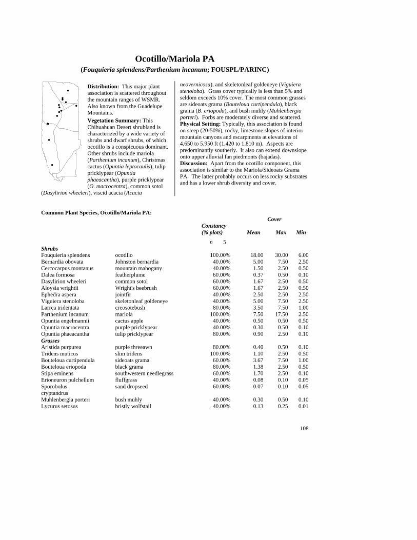
108
Ocotillo/Mariola PA
(Fouquieria splendens/Parthenium incanum; FOUSPL/PARINC)
Distribution: This major plant association is scattered throughout the mountain ranges of WSMR. Also known from the Guadelupe Mountains. Vegetation Summary: This Chihuahuan Desert shrubland is characterized by a wide variety of shrubs and dwarf shrubs, of which ocotillo is a conspicuous dominant. Other shrubs include mariola (Parthenium incanum), Christmas cactus (Opuntia leptocaulis), tulip pricklypear (Opuntia phaeacantha), purple pricklypear (O. macrocentra), common sotol
(Dasylirion wheeleri), viscid acacia (Acacia
neovernicosa), and skeletonleaf goldeneye (Viguiera stenoloba). Grass cover typically is less than 5% and seldom exceeds 10% cover. The most common grasses are sideoats grama (Bouteloua curtipendula), black grama (B. eriopoda), and bush muhly (Muhlenbergia porteri). Forbs are moderately diverse and scattered. Physical Setting: Typically, this association is found on steep (20-50%), rocky, limestone slopes of interior mountain canyons and escarpments at elevations of 4,650 to 5,950 ft (1,420 to 1,810 m). Aspects are predominantly southerly. It also can extend downslope onto upper alluvial fan piedmonts (bajadas). Discussion: Apart from the ocotillo component, this association is similar to the Mariola/Sideoats Grama PA. The latter probably occurs on less rocky substrates and has a lower shrub diversity and cover.
Common Plant Species, Ocotillo/Mariola PA: Cover Constancy (% plots) Mean Max Min
n 5 Shrubs Fouquieria splendens ocotillo 100.00% 18.00 30.00 6.00 Bernardia obovata Johnston bernardia 40.00% 5.00 7.50 2.50 Cercocarpus montanus mountain mahogany 40.00% 1.50 2.50 0.50 Dalea formosa featherplume 60.00% 0.37 0.50 0.10 Dasylirion wheeleri common sotol 60.00% 1.67 2.50 0.50 Aloysia wrightii Wright's beebrush 60.00% 1.67 2.50 0.50 Ephedra aspera jointfir 40.00% 2.50 2.50 2.50 Viguiera stenoloba skeletonleaf goldeneye 40.00% 5.00 7.50 2.50 Larrea tridentata creosotebush 80.00% 3.50 7.50 1.00 Parthenium incanum mariola 100.00% 7.50 17.50 2.50 Opuntia engelmannii cactus apple 40.00% 0.50 0.50 0.50 Opuntia macrocentra purple pricklypear 40.00% 0.30 0.50 0.10 Opuntia phaeacantha tulip pricklypear 80.00% 0.90 2.50 0.10 Grasses Aristida purpurea purple threeawn 80.00% 0.40 0.50 0.10 Tridens muticus slim tridens 100.00% 1.10 2.50 0.50 Bouteloua curtipendula sideoats grama 60.00% 3.67 7.50 1.00 Bouteloua eriopoda black grama 80.00% 1.38 2.50 0.50 Stipa eminens southwestern needlegrass 60.00% 1.70 2.50 0.10 Erioneuron pulchellum fluffgrass 40.00% 0.08 0.10 0.05 Sporobolus sand dropseed 60.00% 0.07 0.10 0.05 cryptandrus Muhlenbergia porteri bush muhly 40.00% 0.30 0.50 0.10 Lycurus setosus bristly wolfstail 40.00% 0.13 0.25 0.01
#
#
#
#
#
#
#
#
#
#
#
#
#
#

109
Forbs Menodora scabra rough menodora 40.00% 3.75 7.00 0.50 Echinocereus kingcup cactus 40.00% 0.01 0.01 0.01 triglochidiatus Bahia absinthifolia hairyseed bahia 40.00% 0.55 1.00 0.10 Echinocactus devilshead 40.00% 0.26 0.50 0.01 horizonthalonius
Minor Plant Associations: Ocotillo Alliance Ocotillo/Mat Rockspirea PA (Fouquieria splendens/Petrophyton caespitosum; FOUSPL/PETCAE)
On White Sands, this minor plant association is known from four occurrences in the San Andres (Sheep Mountain and Big Gyp Mountain) and the Oscura Mountains. It occurs at elevations of 5,400 to 6,600 ft (1,650 to 2,010 m) . It is limited to limestone outcrops with extensive areas of exposed bedrock. Mountain mahogany (Cercocarpus montanus) is often a codominant shrub. Mat rockspirea is diagnostic in the herb layer, growing among the cracks in the limestone bedrock. This is an unusual association that has a very limited distribution in the Southwest.
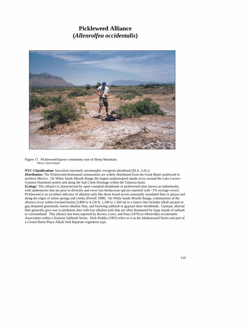
110
Pickleweed Alliance (Allenrolfea occidentalis)
Figure 17. Pickleweed/Sparse community east of Sheep Mountain. Photo: Glenn Harper NVC Classification: Succulent extremely xeromorphic evergreen shrubland (III.A .5.N.c) Distribution: The Pickleweed-dominated communities are widely distributed from the Great Basin southward to northern Mexico. On White Sands Missile Range the largest uninterrupted stands occur around the Lake Lucero–Gypsum Duneland system and along the Salt Creek Drainage within the Tularosa basin. Ecology: This alliance is characterized by open-canopied shrublands of pickleweed (also known as iodinebush), with understories that are poor in diversity and cover (six herbaceous species reported with <1% average cover). Pickleweed is an excellent indicator of alkaline soils like those found across seasonally inundated flats or playas and along the edges of saline springs and creeks (Powell 1988). On White Sands Missile Range, communities of the alliance occur within lowland basins (3,800 to 4,150 ft; 1,160 to 1,260 m) in a matrix that includes alkali sacaton or gyp dropseed grasslands, barren alkaline flats, and fourwing saltbush or gypsum dune shrublands. Upslope, alluvial flats generally give way to piedmont sites with less alkaline soils that are often dominated by large stands of tarbush or creosotebush. This alliance has been reported by Brown, Lowe, and Pase (1979) as Allenrolfea occidentalis Association within a Sonoran Saltbush Series. Dick-Peddie (1993) refers to it as the Idodineweed Series and part of a Closed Basin-Playa-Alkali Sink Riparian vegetation type.
111
Key to the Pickelweed (Allenrolfea occidentalis) Plant Associations 1. Alkali sacaton (Sporobolus airoides) well represented as the dominant grass ....................................................................................................................................................Pickleweed/Alkali Sacaton PA (See Minor Types) 1. Alkali sacaton poorly represented or absent ......................................................................................................2 2. Hairy coldenia (Tiquilia hispidissima) well represented as the dominant sub-shrub......................................................................................................................................... Pickleweed/Hairy Coldenia PA (See Minor Types) 2. Hairy coldenia poorly represented or absent .....................................................................................................3 3. Transpecos sealavender (Limonium limbatum) well represented as the dominant forb...................................................................................................................... Pickleweed/Transpecos Sealavender PA (See Minor Types) 3. Transpecos sealavender poorly represented or absent .......................................................................................4 4. Spreading alkaliweed (Cressa truxillensis) well represented as the dominant forb................................................................................................................................Pickleweed/Spreading Alkaliweed PA (See Minor Types) 4. Herbaceous understory poorly represented with occasionally scattered fourwing saltbush ............................................................................................................................................................................Pickleweed/Sparse PA
Pickleweed/Sparse PA (Allenrolfea occidentalis/Sparse; ALLOCC/SPARSE)
Distribution: Major community of the Tularosa basin. Vegetation Summary: Open desert shrubland dominated by pickleweed with a sparse to non-vegetated understory. Fourwing saltbush and Mojave seablite are the common, well-represented associate species. Diversity its low (only five additional species were recorded), but occasionally alkali sacaton or honey mesquite may dot the landscape, or saltcedar may occur along drainages that dissect playas. Vegetation occurs in a very sparse matrix of open alkaline
playa lake bottoms intermixed with areas of pickleweed establishment. Physical Setting: This community occurs at low elevations and is concentrated in the central portion of the Tularosa basin. The area can be inundated periodically and may receive large amounts of fine sediment from summer rainfall runoff from the surrounding mountain areas. Stands are intermixed
with gypsum dune complexes, or can occur in broad and shallow drainages, or on the playas of basin bottoms. Sites are flat with deep salt-crusted fine textured soils with no rocks. Discussion: On White Sands Missile Range, the Pickleweed Alliance is best exemplified by the Pickleweed/Sparse PA. Generally, stands are continuous and large, but seem to be limited in extent by the highly alkaline soils associated with the lowlands of the Tularosa basin (Lake Lucero). Most sites sampled were in good condition with little evidence of human caused disturbance. Hence, species diversity appears to be naturally low, with only a limited set of salt-tolerant species able to occupy these sites.
Average Min Max ELEVATION (ft): 4031 3839 4135 SLOPE (%): 1 SOLAR INDEX: 1.16 1.16 1.16
# ##
#
#
#
##
#

112
Common Plant Species, Pickleweed/Sparse PA: Constancy Cover Scientific Name Common Name (% plots) Mean Max Min n = 6 Shrubs Atriplex canescens fourwing saltbush 50.00% 1.67 2.50 0.00 Allenrolfea occidentalis pickleweed 100.00% 10.25 29.00 2.50 Forbs Suaeda moquinii Mojave seablite 50.00% 2.50 2.50 2.50
Minor Plant Associations: Pickleweed Alliance Pickleweed/Alkali Sacaton PA (Allenrolfea occidentalis/Sporobolus airoides; ALLOCC/SPOAIR)
This is a provisional minor type known only from the Tularosa basin on White Sands Missile Range. It is an open shrubland dominated by pickleweed that occurs within swales, along playa edges or within interdune spaces at the lowest elevations of the basin (3, 950 ft;1,200 m). The understory is dense with large clumps of alkali sacaton and additional associate shrubs including frankenia and fourwing saltbush. Stands are patchy are found adjacent to Pickleweed/Sparse shrublands (which may occupy the same swell), gypsum outcrops (that are colonized by gyp dropseed and hairy coldenia), and gypsum dune shrublands. Pickleweed/Hairy Coldenia PA (Allenrolfea occidentalis/Tiquilia hispidissima; ALLOCC/TIQHIS)
This minor type on White Sands Missile Range is known only from the western edge of Lake Lucero in the Tularosa basin at around 3,950 ft (1,200 m) and is associated with gypsum substrates. The association is characterized by an open canopy of scattered pickleweed with an understory of hairy coldenia, a dwarf shrub. Grasses and forbs are few and scattered. Other common associates are Torrey’s jointfir, hoary rosemarymint, Mojave seablite, alkali sacaton and purple threeawn. Pickleweed/Spreading Alkaliweed PA (Allenrolfea occidentalis/Cressa truxillensis; ALLOCC/CRETRU)
This is provisional minor type known only from Lumley Lake, a playa within White Sands Missile Range’s Tularosa basin at 3,875 ft (1,180 m). It is a very open shrubland dominated by knee-high pickleweed with an evenly dispersed prostrate herb layer of spreading alkaliweed. The stand occupies the southern half of the playa bottom and is bounded by a narrow stand of saltcedar at its edges. Pickleweed/Transpecos Sealavender PA (Allenrolfea occidentalis/Limonium limbatum; ALLOCC/LIMLIM)
This is also a provisional minor type known only from a stand south of Malpais Springs within the Tularosa basin at an elevation of 4,125 ft (1,250 m). Pickleweed and sea lavender are the dominant species of this open shrubland, which is found on isolated small hummocks that are surrounded by salt-crusted deflation plains. Alkali sacaton and Trans-Pecos clapberry (Pseudoclappia arenaria) are present but are also limited to these elevated microsites.
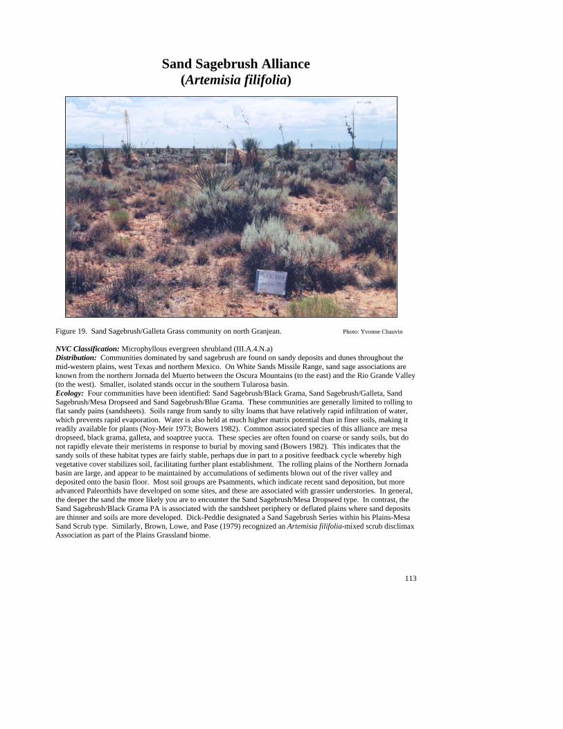
113
Sand Sagebrush Alliance (Artemisia filifolia)
Figure 19. Sand Sagebrush/Galleta Grass community on north Granjean. Photo: Yvonne Chauvin NVC Classification: Microphyllous evergreen shrubland (III.A.4.N.a) Distribution: Communities dominated by sand sagebrush are found on sandy deposits and dunes throughout the mid-western plains, west Texas and northern Mexico. On White Sands Missile Range, sand sage associations are known from the northern Jornada del Muerto between the Oscura Mountains (to the east) and the Rio Grande Valley (to the west). Smaller, isolated stands occur in the southern Tularosa basin. Ecology: Four communities have been identified: Sand Sagebrush/Black Grama, Sand Sagebrush/Galleta, Sand Sagebrush/Mesa Dropseed and Sand Sagebrush/Blue Grama. These communities are generally limited to rolling to flat sandy pains (sandsheets). Soils range from sandy to silty loams that have relatively rapid infiltration of water, which prevents rapid evaporation. Water is also held at much higher matrix potential than in finer soils, making it readily available for plants (Noy-Meir 1973; Bowers 1982). Common associated species of this alliance are mesa dropseed, black grama, galleta, and soaptree yucca. These species are often found on coarse or sandy soils, but do not rapidly elevate their meristems in response to burial by moving sand (Bowers 1982). This indicates that the sandy soils of these habitat types are fairly stable, perhaps due in part to a positive feedback cycle whereby high vegetative cover stabilizes soil, facilitating further plant establishment. The rolling plains of the Northern Jornada basin are large, and appear to be maintained by accumulations of sediments blown out of the river valley and deposited onto the basin floor. Most soil groups are Psamments, which indicate recent sand deposition, but more advanced Paleorthids have developed on some sites, and these are associated with grassier understories. In general, the deeper the sand the more likely you are to encounter the Sand Sagebrush/Mesa Dropseed type. In contrast, the Sand Sagebrush/Black Grama PA is associated with the sandsheet periphery or deflated plains where sand deposits are thinner and soils are more developed. Dick-Peddie designated a Sand Sagebrush Series within his Plains-Mesa Sand Scrub type. Similarly, Brown, Lowe, and Pase (1979) recognized an Artemisia filifolia-mixed scrub disclimax Association as part of the Plains Grassland biome.
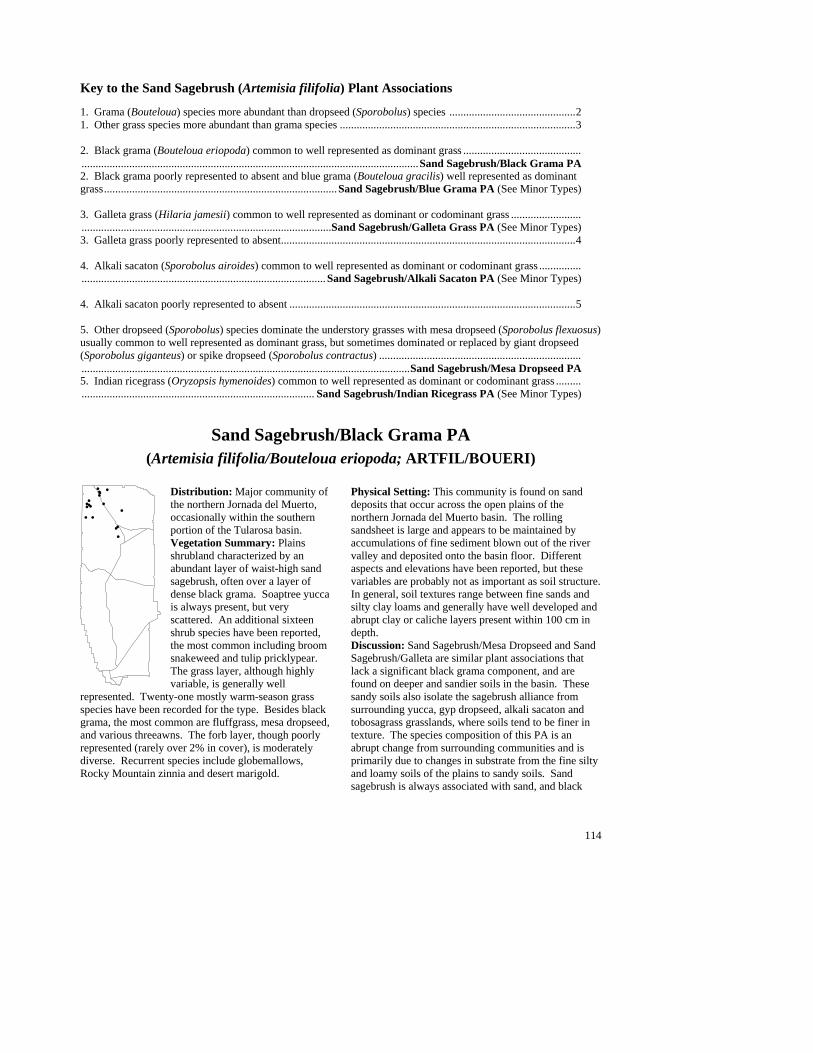
114
Key to the Sand Sagebrush (Artemisia filifolia) Plant Associations 1. Grama (Bouteloua) species more abundant than dropseed (Sporobolus) species .............................................2 1. Other grass species more abundant than grama species ....................................................................................3 2. Black grama (Bouteloua eriopoda) common to well represented as dominant grass ..................................................................................................................................................................Sand Sagebrush/Black Grama PA 2. Black grama poorly represented to absent and blue grama (Bouteloua gracilis) well represented as dominant grass...................................................................................Sand Sagebrush/Blue Grama PA (See Minor Types) 3. Galleta grass (Hilaria jamesii) common to well represented as dominant or codominant grass ..................................................................................................................Sand Sagebrush/Galleta Grass PA (See Minor Types) 3. Galleta grass poorly represented to absent.........................................................................................................4 4. Alkali sacaton (Sporobolus airoides) common to well represented as dominant or codominant grass ...................................................................................................... Sand Sagebrush/Alkali Sacaton PA (See Minor Types)
4. Alkali sacaton poorly represented to absent ......................................................................................................5 5. Other dropseed (Sporobolus) species dominate the understory grasses with mesa dropseed (Sporobolus flexuosus) usually common to well represented as dominant grass, but sometimes dominated or replaced by giant dropseed (Sporobolus giganteus) or spike dropseed (Sporobolus contractus) .............................................................................................................................................................................................Sand Sagebrush/Mesa Dropseed PA 5. Indian ricegrass (Oryzopsis hymenoides) common to well represented as dominant or codominant grass ............................................................................................ Sand Sagebrush/Indian Ricegrass PA (See Minor Types)
Sand Sagebrush/Black Grama PA
(Artemisia filifolia/Bouteloua eriopoda; ARTFIL/BOUERI) Distribution: Major community of the northern Jornada del Muerto, occasionally within the southern portion of the Tularosa basin. Vegetation Summary: Plains shrubland characterized by an abundant layer of waist-high sand sagebrush, often over a layer of dense black grama. Soaptree yucca is always present, but very scattered. An additional sixteen shrub species have been reported, the most common including broom snakeweed and tulip pricklypear. The grass layer, although highly variable, is generally well
represented. Twenty-one mostly warm-season grass species have been recorded for the type. Besides black grama, the most common are fluffgrass, mesa dropseed, and various threeawns. The forb layer, though poorly represented (rarely over 2% in cover), is moderately diverse. Recurrent species include globemallows, Rocky Mountain zinnia and desert marigold.
Physical Setting: This community is found on sand deposits that occur across the open plains of the northern Jornada del Muerto basin. The rolling sandsheet is large and appears to be maintained by accumulations of fine sediment blown out of the river valley and deposited onto the basin floor. Different aspects and elevations have been reported, but these variables are probably not as important as soil structure. In general, soil textures range between fine sands and silty clay loams and generally have well developed and abrupt clay or caliche layers present within 100 cm in depth. Discussion: Sand Sagebrush/Mesa Dropseed and Sand Sagebrush/Galleta are similar plant associations that lack a significant black grama component, and are found on deeper and sandier soils in the basin. These sandy soils also isolate the sagebrush alliance from surrounding yucca, gyp dropseed, alkali sacaton and tobosagrass grasslands, where soils tend to be finer in texture. The species composition of this PA is an abrupt change from surrounding communities and is primarily due to changes in substrate from the fine silty and loamy soils of the plains to sandy soils. Sand sagebrush is always associated with sand, and black
#
#
#
#
#
#
##
#
##
#
##
#
#
#
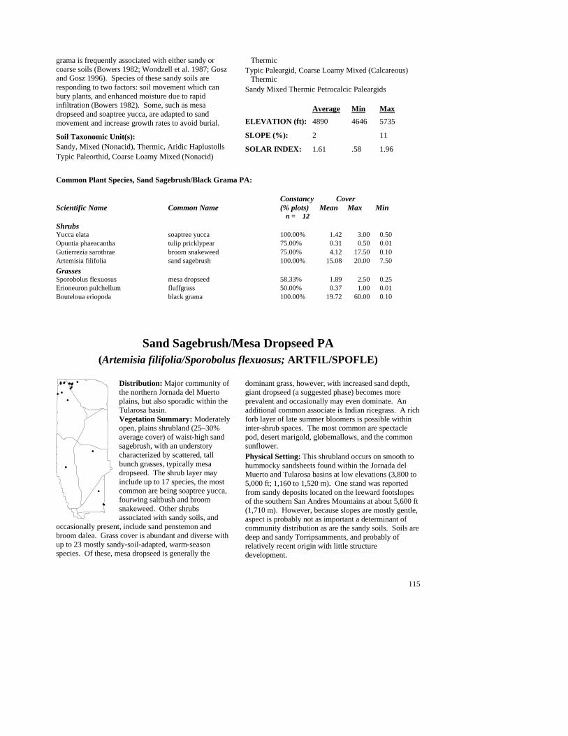
115
grama is frequently associated with either sandy or coarse soils (Bowers 1982; Wondzell et al. 1987; Gosz and Gosz 1996). Species of these sandy soils are responding to two factors: soil movement which can bury plants, and enhanced moisture due to rapid infiltration (Bowers 1982). Some, such as mesa dropseed and soaptree yucca, are adapted to sand movement and increase growth rates to avoid burial. Soil Taxonomic Unit(s): Sandy, Mixed (Nonacid), Thermic, Aridic Haplustolls Typic Paleorthid, Coarse Loamy Mixed (Nonacid)
Thermic Typic Paleargid, Coarse Loamy Mixed (Calcareous)
Thermic Sandy Mixed Thermic Petrocalcic Paleargids
Average Min Max ELEVATION (ft): 4890 4646 5735 SLOPE (%): 2 11 SOLAR INDEX: 1.61 .58 1.96
Common Plant Species, Sand Sagebrush/Black Grama PA: Constancy Cover Scientific Name Common Name (% plots) Mean Max Min n = 12 Shrubs Yucca elata soaptree yucca 100.00% 1.42 3.00 0.50 Opuntia phaeacantha tulip pricklypear 75.00% 0.31 0.50 0.01 Gutierrezia sarothrae broom snakeweed 75.00% 4.12 17.50 0.10 Artemisia filifolia sand sagebrush 100.00% 15.08 20.00 7.50 Grasses Sporobolus flexuosus mesa dropseed 58.33% 1.89 2.50 0.25 Erioneuron pulchellum fluffgrass 50.00% 0.37 1.00 0.01 Bouteloua eriopoda black grama 100.00% 19.72 60.00 0.10
Sand Sagebrush/Mesa Dropseed PA (Artemisia filifolia/Sporobolus flexuosus; ARTFIL/SPOFLE)
Distribution: Major community of the northern Jornada del Muerto plains, but also sporadic within the Tularosa basin. Vegetation Summary: Moderately open, plains shrubland (25–30% average cover) of waist-high sand sagebrush, with an understory characterized by scattered, tall bunch grasses, typically mesa dropseed. The shrub layer may include up to 17 species, the most common are being soaptree yucca, fourwing saltbush and broom snakeweed. Other shrubs associated with sandy soils, and
occasionally present, include sand penstemon and broom dalea. Grass cover is abundant and diverse with up to 23 mostly sandy-soil-adapted, warm-season species. Of these, mesa dropseed is generally the
dominant grass, however, with increased sand depth, giant dropseed (a suggested phase) becomes more prevalent and occasionally may even dominate. An additional common associate is Indian ricegrass. A rich forb layer of late summer bloomers is possible within inter-shrub spaces. The most common are spectacle pod, desert marigold, globemallows, and the common sunflower. Physical Setting: This shrubland occurs on smooth to hummocky sandsheets found within the Jornada del Muerto and Tularosa basins at low elevations (3,800 to 5,000 ft; 1,160 to 1,520 m). One stand was reported from sandy deposits located on the leeward footslopes of the southern San Andres Mountains at about 5,600 ft (1,710 m). However, because slopes are mostly gentle, aspect is probably not as important a determinant of community distribution as are the sandy soils. Soils are deep and sandy Torripsamments, and probably of relatively recent origin with little structure development.
#
#
#
#
#
#
#
#
#
#
#
#####
#
#
##
#
#

116
Discussion: Sand sagebrush/Black Grama, Sand Sagebrush/Galleta and Hoary Rosemarymint/Mesa Dropseed are shrubland communities on sandy plains. Mesa Dropseed/Soaptree Yucca grasslands are also known from sandy plains, but lack a significant shrub layer. Although sagebrush stands within the northern Jornada basin may intermix with other habitat types, this type is generally limited to the deepest accumulations of sand. It sometimes occurs on sandy deposits that have accumulated on lower alluvial fan piedmonts below creosotebush and tarbush types (commonly located on erosive surfaces rather than sand deposits). Moving sand, rather than lack of water, is the limiting factor for plants on sand (Bowers 1982). Sand sagebrush and mesa dropseed are often seen on sandy substrates, but do not grow rapidly in response to
shifting sands. Their abundant presence on these sandsheets indicates these sands are fairly stable.
Soil Taxonomic Unit(s): Sandy Typic Torripsamment Coarse Loamy Mixed Thermic Calcic Gypsiorthids Sandy, Siliceous, Thermic Typic Torripsamments Sandy, Carbonic, Thermic Petrocalcic Paleargids Average Min Max ELEVATION (ft): 4697 3888 5577 SLOPE (%): 3 40 SOLAR INDEX: 1.03 .13 2.00
Common Plant Species, Sand Sagebrush/Mesa Dropseed PA: Constancy Cover Scientific Name Common Name (% plots) Mean Max Min n = 21 Shrubs Yucca elata soaptree yucca 100.00% 1.88 3.00 0.50 Gutierrezia sarothrae broom snakeweed 47.62% 1.30 2.50 0.50 Artemisia filifolia sand sagebrush 100.00% 25.62 41.50 7.50 Grasses Sporobolus giganteus giant dropseed 57.14% 9.92 25.00 0.50 Sporobolus flexuosus mesa dropseed 85.71% 6.51 20.00 0.25 Oryzopsis hymenoides Indian ricegrass 52.38% 1.39 5.00 0.05 Forbs Baileya multiradiata desert marigold 57.14% 0.50 2.50 0.01
Minor Plant Associations: Sand Sagebrush Alliance Sand Sagebrush/Alkali Sacaton PA (Artemisia filifolia/Sporobolus airoides; ARTFIL/SPOAIR)
On White Sands Missile Range, this provisional shrubland association is known from the sandy plains and nearby alluvial flats of the northern Jornada del Muerto basin at around 4,750 ft (1,450 m). Sandsage cover ranges from 10 to 25%, but grasses seldom exceed 5%. Although alkali sacaton is always present, there can be a variety of grasses such as tobosagrass (Hilaria mutica), and Indian ricegrass (Oryzopsis hymenoides). Sand Sagebrush/Blue Grama PA (Artemisia filifolia/Bouteloua gracilis; ARTFIL/BOUGRA)
This provisional type is found on gravelly upper bajada slopes leading out from the Oscura Mountain escarpment. It is a very open shrubland dominated by sand sagebrush with an abundant (15 to 20%) understory of mostly warm-season bunch grasses dominated by blue grama. A low diversity of shrubs is typical (nine reported species), but stands may include scattered soaptree yucca, pricklyleaf dogweed, and tulip pricklypear. The grass layer is moderately diverse and includes various threeawns, fluffgrass, bush muhly, cane bluestem, black grama, sand dropseed and streambed bristlegrass. Twenty-one forb species have been reported, but they are generally very scattered, and collectively contribute little in cover. Some include rose heath, spinystar, lacy tansyaster, Rocky Mountain zinnia and globemallow. Stands occur at mid elevations (5,500 ft; 1,680 m), on southwest-facing, gentle to moderate slopes. Surface soil textures are coarse, and derived from exposed Precambrian granites at the base of

117
the Oscura Mountains. Soils are classified within the Mollisol regime, and have dark, well developed surface horizons. Sand Sagebrush/Galleta PA (Artemisia filifolia/Hilaria jamesii; ARTFIL/HILJAM)
This shrubland type is currently only known from White Sands Missile Range, where it is well established on the sandy, eolian plains of the northern Jornada del Muerto basin. It is characterized by a moderately open, waist-high canopy of sand sagebrush (19% average cover, 12 to 29% range), with an understory of scattered bunch grasses, dominated by galleta. The shrub layer is low in diversity with only eight species reported. Of these, soaptree yucca, broom snakeweed, and tulip pricklypear are the most common. Within the shrub spaces lies a grass layer that is abundant (14% average cover, ranging up to 25%) and besides galleta, typically includes purple threeawn, mesa dropseed, and occasional black grama. Forb cover can be high, especially after the summer rains, and species composition varies from stand to stand. Possible associates include woolly prairieclover, whitemargin sandmat, desert marigold, Rocky Mountain zinnia, pale evening primrose and ragwort groundsel. Stands occur inside a PA matrix (between Sand Sagebrush/Galleta and Sand Sagebrush/Black Grama) which is located within a transition zone between deeper sand types (Sand sagebrush/Mesa dropseed) and finer soils, characteristic of the Black Grama/Soaptree Yucca PA. Hence, soil pits were classified as either deep sandy Torripsamments (typical of Sand sagebrush/Mesa dropseed) or more developed, coarse loamy Paleorthids, typical of black grama grasslands. Sand Sagebrush/Indian Ricegrass PA (Artemisia filifolia/Oryzopsis hymenoides; ARTFIL/ORYHYM)
On White Sands Missile Range, this community is known from the sandy plains of the northern Jornada del Muerto basin at an elevation of 4,320 ft (1,315 m). Sandsage forms an open canopy with a scattering of grasses below that include Indian ricegrass, sand dropseed (Sporobolus cryptandrus) and bush muhly (Muhlenbergia porteri).
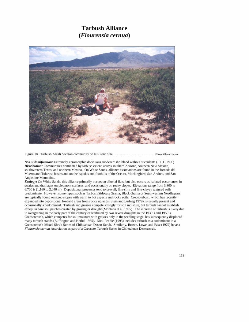
118
Tarbush Alliance (Flourensia cernua)
Figure 18. Tarbush/Alkali Sacaton community on NE Pond Site. ............................................... Photo: Glenn Harper NVC Classification: Extremely xeromorphic deciduous subdesert shrubland without succulents (III.B.3.N.a ) Distribution: Communities dominated by tarbush extend across southern Arizona, southern New Mexico, southwestern Texas, and northern Mexico. On White Sands, alliance associations are found in the Jornada del Muerto and Tularosa basins and on the bajadas and foothills of the Oscura, Mockingbird, San Andres, and San Augustine Mountains. Ecology: On White Sands, this alliance primarily occurs on alluvial flats, but also occurs as isolated occurrences in swales and drainages on piedmont surfaces, and occasionally on rocky slopes. Elevations range from 3,800 to 6,700 ft (1,160 to 2,040 m). Depositional processes tend to prevail, fine-silty and fine-clayey textured soils predominate. However, some types, such as Tarbush/Sideoats Grama, Black Grama or Southwestern Needlegrass are typically found on steep slopes with warm to hot aspects and rocky soils. Creosotebush, which has recently expanded into depositional lowland areas from rocky uplands (Stein and Ludwig 1979), is usually present and occasionally a codominant. Tarbush and grasses compete strongly for soil moisture, but tarbush cannot establish except in bare soil patches created by grazing or drought (Montana et al. 1995). The increase of tarbush is likely due to overgrazing in the early part of the century exacerbated by two severe droughts in the 1930’s and 1950’s. Creosotebush, which competes for soil moisture with grasses only in the seedling stage, has subsequently displaced many tarbush stands (Buffington and Herbel 1965). Dick-Peddie (1993) includes tarbush as a codominant in a Creosotebush-Mixed Shrub Series of Chihuahuan Desert Scrub. Similarly, Brown, Lowe, and Pase (1979) have a Flourensia cernua Association as part of a Creosote-Tarbush Series in Chihuahuan Desertscrub.

119
Key to the Tarbush (Flourensia cernua) Plant Associations 1. Black grama (Bouteloua eriopoda) common to well represented as dominant or codominant grass ........................................................................................................................Tarbush/Black Grama PA (See Minor Types) 1. Black grama poorly represented to absent .........................................................................................................2 2. Blue grama (Bouteloua gracilis) common to well represented as dominant or codominant grass ..............................................................................................................................Tarbush/Blue Grama PA (See Minor Types) 2. Blue grama poorly represented to absent...........................................................................................................2 3. Southwestern needlegrass (Stipa eminens) common to well represented as dominant or codominant grass....................................................................................... Tarbush/Southwestern Needlegrass PA (See Minor Types) 3. Southwestern needlegrass poorly represented to absent ....................................................................................4 4. Sideoats grama (Bouteloua curtipendula) common to well represented as dominant or codominant grass..........................................................................................................Tarbush/Sideoats Grama PA (See Minor Types) 4. Sideoats grama poorly represented to absent.....................................................................................................5 5. Alkali sacaton (Sporobolus airoides) common to well represented as dominant or codominant grass ..................................................................................................................................................Tarbush/Alkali Sacaton PA 5. Alkali sacaton poorly represented to absent ......................................................................................................6 6. Burrograss (Scleropogon brevifolius) common to well represented as dominant grass ................................................................................................................................................Tarbush/Burrograss PA (See Minor Types) 6. Burrograss poorly represented to absent............................................................................................................7 7. Bush muhly (Muhlenbergia porteri) common to well represented as dominant or codominant grass ........................................................................................................................Tarbush/Bush Muhly PA (See Minor Types) 7. Bush muhly poorly represented to absent..........................................................................................................8 8. Tobosagrass (Hilaria mutica) common to well represented as dominant grass........Tarbush/Tobosagrass PA 8. Tobosagrass poorly represented to absent; mariola (Parthenium incanum) common to abundant as subdominant or codominant shrub .............................................................................. Tarbush/Mariola PA (See Minor Types)
120
Tarbush/Alkali Sacaton PA (Flourensia cernua/Sporobolus airoides; FLOCER/SPOAIR )
Distribution: On White Sands, this is a major community of the Jornada del Muerto and Tularosa basins and along the alluvial piedmont slopes of the Oscura and San Andres Mountains. Vegetation Summary: This community is characterized by an open canopy of tarbush with an abundant to luxuriant grass understory. Creosotebush, fourwing saltbush and Christmas cactus are often interspersed in the shrub canopy. The understory is dominated by thick, dense patches of alkali sacaton with scattered
patches of burrograss intermixed. Desert holly, mountain pepperweed and Indian rushpea are the most consistent forbs scattered within the grasses, but a variety of other forbs may occur in individual stands. Physical Setting: Stands are commonly found in shallow swales in basins and shallow drainages of both upper and lower piedmont slopes at elevations of 3,800 to 5,400 ft (1,160 to 1,650). Soils are heavy clay loams or silty loams typical of depositional swale sites. Most
slope grades are low to flat. Discussion: This community is usually limited by the bounds of the swales or drainages where it occurs. These sites were probably dominated by pure sacaton grasslands historically, but tarbush may have invaded as a result of past grazing combined with drought, which creates openings in the grass canopy that are a prerequisite for tarbush establishment (Buffington and Herbel 1965; Montana et al. 1995). Diversity is high in these stands which is unusual for alkali sacaton communities, which are usually nearly monotypic (Francis 1986; Stubbendieck et al. 1992; Whitford et al. 1995). Soils and landforms, however, are similar to other swale types that have much less diversity. Soil Taxonomic Unit(s): Ustochreptic Paleorthid, Fine Clayey, Thermic
Average Min Max ELEVATION (ft): 4730 3867 5371 SLOPE (%): 1 2 SOLAR INDEX: 1.11 .11 1.77
Common Plant Species, Tarbush/Alkali Sacaton PA: Constancy Cover Scientific Name Common Name (% plots) Mean Max Min n = 11 Shrubs Opuntia leptocaulis Christmas cactus 45.45% 0.71 2.50 0.01 Larrea tridentata creosotebush 72.73% 0.64 2.00 0.00 Flourensia cernua tarbush 100.00% 24.05 41.50 2.00 Atriplex canescens fourwing saltbush 81.82% 4.00 15.00 0.01 Grasses Sporobolus airoides alkali sacaton 100.00% 16.50 37.00 2.50 Scleropogon brevifolius burrograss 63.64% 2.21 4.00 0.50 Forbs Acourtia nana desert holly 45.45% 1.11 3.00 0.05 Lepidium montanum mountain pepperweed 36.36% 0.29 0.50 0.05 Hoffmannseggia glauca Indian rushpea 36.36% 1.20 3.00 0.01
#
#
#
#
#
##
#
##
##
#
121
Tarbush/Tobosagrass PA (Flourensia cernua/Hilaria mutica; FLOCER/HILMUT)
Distribution: On White Sands, this is a major community in the Jornada Del Muerto and Tularosa basins. . Vegetation Summary: This community has a shrub layer dominated by tarbush with an understory dominated by tobosagrass. The shrub layer has a moderately open canopy and is evenly spaced across the landscape. Diversity is generally low with creosotebush, honey mesquite, Berlandier’s wolfberry and fourwing saltbush common associates. The grassy understory
is generally well represented to luxuriant, but can be patchy in some areas. Overall, the grass layer is moderately diverse and is occupied by large patches of tobosagrass and intermittent patches of burrograss. Other common associates include blue grama, bush muhly and alkali sacaton. The forb layer is poorly represented and scattered, growing on both barren patches and within the grasses. Desert holly, silverleaf nightshade, toothed spurge and orange flameflower are some of the forbs found in this diverse layer. A fourwing saltbush phase may occur, primarily in the southern Tularosa basin. Physical Setting: This type predominantly occurs in swales or broad drainages along lower alluvial plains and basin bottoms, at elevations of 3,800 to 6,700 ft (1,160 to 2,040 m). Generally, slopes are flat to very gentle. Soils are derived from alluvial deposits from the surrounding mountains. Typically, coarse materials are absent from soil surface. Ground surfaces are characterized by patches of bare soil and scattered litter. Surface soils range from silty loam to silty clays.
Discussion: Stands of this type are generally large and continuous over flats but become patchy when limited to swales or broad drainages. While tarbush dominates this type, the understory codominants may vary from alkali sacaton to burrograss. At least some of these stands are probably remnants of historic tobosagrass or alkali sacaton grasslands invaded by tarbush during this century (Buffington and Herbel 1965). Chihuahuan shrublands dominated by creosotebush or honey mesquite generally occur upslope. Lower elevations grade into lowland grassland communities such as Tobosagrass/Alkali Sacaton or Alkali Sacaton/Burrograss. Although tarbush and tobosagrass have similar habitat requirements (depositional, fine soils) tarbush cannot establish in a closed grass canopy, but quickly colonizes openings as it has more motile seed than tobosagrass (Buffington and Herbel 1965; Montana et al. 1995). Tarbush competes strongly with tobosagrass for water and as a result more bare soil patches are created around tarbush shrubs (Montana et al. 1995). Less grass cover decreases water infiltration that leads to drier soils (Wood et al. 1987a). Creosotebush, an occasional associate with tarbush in this community, is not limited by dry soil conditions because it exploits deeper water sources than either tarbush or tobosagrass (Buffington and Herbel 1965; Stein and Ludwig 1979; Montana et al. 1995).
Soil Taxonomic Unit(s): Very Fine Clayey Chromic Haplotorrert Fine Clayey Chromic Gypsitorrert
Average Min Max ELEVATION (ft): 4801 3892 6664 SLOPE (%): 8 36 SOLAR INDEX: 1.10 .18 2.00
Common Plant Species, Tarbush/Tobosagrass PA: Constancy Cover Scientific Name Common Name (% plots) Mean Max Min n = 5 Shrubs Prosopis glandulosa honey mesquite 80.00% 2.00 2.50 0.50 Lycium berlandieri Berlandier’s wolfberry 40.00% 2.50 2.50 2.50 Larrea tridentata creosotebush 60.00% 1.00 2.50 0.00 Flourensia cernua tarbush 100.00% 19.80 29.00 17.5 Atriplex canescens fourwing saltbush 80.00% 2.64 7.50 0.05
#
#
#
#
#
122
Grasses Sporobolus airoides alkali sacaton 40.00% 9.00 17.50 0.50 Scleropogon brevifolius burrograss 60.00% 3.33 7.50 0.00 Muhlenbergia porteri bush muhly 60.00% 1.17 2.50 0.50 Hilaria mutica tobosagrass 100.00% 21.20 41.50 0.50 Bouteloua gracilis blue grama 40.00% 2.50 2.50 2.50 Forbs Talinum aurantiacum orange flameflower 40.00% 0.28 0.50 0.05 Solanum elaeagnifolium silverleaf nightshade 40.00% 0.26 0.50 0.01 Euphorbia dentata toothed spurge 40.00% 1.25 2.50 0.01 Acourtia nana desert holly 60.00% 0.50 0.50 0.50
Minor Plant Associations: Tarbush Alliance
Tarbush/Black Grama PA (Flourensia cernua/Bouteloua eriopoda; FLOCER/BOUERI)
On White Sands, this type is represented by seven occurrences scattered throughout the foothills of the Oscura and San Andres Mountains, at elevations of 5,000 to 6,000 ft (1,520 to 1,830m). It occurs primarily on steep slopes, with warm to hot aspects. Tarbush is abundant and dominant in association, but several other Chihuahuan Desert shrubs can be well represented such fourwing saltbush (Atriplex canescens), creosotebush (Larrea tridentata), honey mesquite (Prosopis glandulosa), and mariola (Parthenium incanum). Black grama is abundant and the dominant in association with a wide variety of grasses such as sideoats grama (Bouteloua curtipendula), black grama (Bouteloua eriopoda), blue grama (Bouteloua gracilis), hairy grama (Bouteloua hirsuta), galleta (Hilaria jamesii), southwestern needlegrass (Stipa eminens), New Mexico needlegrass (Stipa neomexicana), and slim tridens (Tridens muticus). Tarbush/Blue Grama PA (Flourensia cernua/Bouteloua gracilis; FLOCER/BOUGRA)
On White Sands, this minor type is known from only two occurrences. Both occur on intermountain valley bottoms; one from the Oscura Mountains, the other from the San Andres Mountains. Elevations are 5,380 to 6,030 ft, (1,640 to 1,838 m). Tarbush is the dominant, but creosotebush (Larrea tridentata) can be well represented . Blue grama is the dominant and abundant with a scattering of other grasses. Tarbush/Burrograss PA (Flourensia cernua/Scleropogon brevifolius; FLOCER/SCLBRE) On White Sands, this minor type is known from the southern Tularosa basin. at elevations of 3,858 to 3,935 ft (1,175 to 1,200 m). It is a somewhat sparsely vegetated community characterized by scattered tarbush and Berlandier's wolfberry (Lycium berlandieri) with a patchy burrograss understory. Alkali sacaton (Sporobolus airoides) is poorly represented. Tarbush/Bush Muhly PA (Flourensia cernua/Muhlenbergia porteri; FLOCER/MUHPOR)
On White Sands, this minor type is known from three occurrences in the northern Jornada del Muerto and Tularosa basins. It occurs on alluvial plains and flats of depositional lower piedmonts, at elevations of 4,100 to 5,100 ft (1,250 to 1,550 m). Tarbush is abundant and dominant, but creosotebush (Larrea tridentata) can be well represented. Bush muhly is abundant and the dominant grass with scattered patches of alkali sacaton (Sporobolus airoides)

123
Tarbush/Mariola PA (Flourensia cernua/Parthenium incanum; FLOCER/PARINC) On White Sands, this minor type is known from three occurrences on the northern portion of the range and is found on both upper piedmont and scarp slopes, at elevations of 4,850 to 5,450 ft (1,478 to 1,661 m). Tarbush is well represented to abundant and mariola well-represented. Grass cover is poorly represented and seldom exceeds 5% Tarbush/Sideoats Grama PA (Flourensia cernua/Bouteloua curtipendula; FLOCER/BOUCUR) On White Sands, this minor type is known from only two occurrences. Both occur on steep, sandstone scarp slopes, one from the Oscura Mountains, the other from the Chalk Hills, at elevations of 5,370 and 6,400 ft (1,637 and 1,950 m), respectively. Tarbush is well represented in association with the dwarf shrubs broom snakeweed (Gutierrezia sarothrae) and featherplume (Dalea formosa). Sideoats grama is abundant and the clear dominant with a scattering other associates. Tarbush/Southwestern Needlegrass PA (Flourensia cernua/Stipa eminens; FLOCER/STIEMI)
On White Sands, this minor type is known from three occurrences in the Oscura Mountains. It occurs on hot, steep, limestone scarp slopes at elevations of 5,800 to 5,900 ft (1,770 to 1,800). Tarbush is well represented and dominant among a wide variety of shrubs and dwarf shrubs including featherplume (Dalea formosa), mariola (Parthenium incanum), and common sotol (Dasylirion wheeleri).
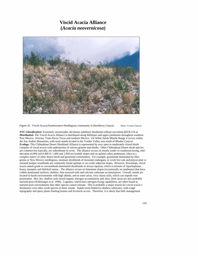
124
Viscid Acacia Alliance (Acacia neovernicosa)
Figure 20. Viscid Acacia/Southwestern Needlegrass community in Hackberry Canyon. Photo: Yvonne Chauvin NVC Classification: Extremely xeromorphic deciduous subdesert shrubland without succulents (III.B.3.N.a) Distribution: The Viscid Acacia Alliance is distributed along hillslopes and upper piedmonts throughout southern New Mexico, Arizona, Trans-Pecos Texas and northern Mexico. On White Sands Missile Range it occurs within the San Andres Mountains, with most stands located in the Yonder Valley area south of Rhodes Canyon. Ecology: This Chihuahuan Desert Shrubland Alliance is represented by very open to moderately closed shrub canopies of viscid acacia with understories of various grasses and shrubs. Other Chihuahuan Desert shrub species are common but typically, are subordinate in cover. The alliance occurs on mostly south- to southwest-facing, mid- elevation (4,900 and 6,400 ft; 1,490 and 1,950 m) foothill slopes and on upland valley piedmonts, often in a complex matrix of other desert shrub and grassland communities. For example, grasslands dominated by blue grama or New Mexico needlegrass, montane shrublands of mountain mahogany or scrub live oak and pinyon pine or oneseed juniper woodlands are commonly found upslope or on cooler adjacent slopes. However, downslope, viscid acacia stands grade to creosotebush-dominated shrublands or arroyo riparian, which is mixture of Apacheplume , honey mesquite and littleleaf sumac. The alliance occurs on limestone slopes (occasionally on sandstone) that have cobble-dominated surfaces, shallow, fine textured soils and calcium carbonate accumulations. Overall, stands are located in harsh environments with high albedo, and in some areas, very clayey soils, which can impede root penetration. Hot, dry, shallow soils retard organic nitrogen accumulation and, thus, these areas are also probably nutrient-poor (Schlesinger et al. 1990). Legumes, which have nitrogen-fixing capabilities, are often found in nutrient-poor environments that other species cannot tolerate. This is probably a major reason for viscid acacia’s dominance over other scrub species in these stands. Stands seem limited to shallow substrates, with rough topography and spiny plants limiting human and livestock access. Therefore, it is likely that little management
125
intervention is needed to maintain current conditions. Stands may be habitat for a variety of rodents and hunting territory for their coyote, kit fox, and bobcat predators. Brown, Lowe, and Pase (1979) have a Whitethorn Series dominated by A. neovernicosa as part of their Chihuahuan Desertscrub biome. Dick-Peddie (1993) includes it as part of his Creosotebush-Acacia type within the Creosotebush-Mixed Shrub Series of Chihuahuan Desert Scrub. Key to the Viscid Acacia (Acacia neovernicosa) Plant Associations 1. Southwestern needlegrass (Stipa eminens) common to well represented as the dominant or codominant grass.......................................................................................................Viscid Acacia/Southwestern Needlegrass PA 1. Southwestern needlegrass poorly represented to absent ....................................................................................2 2. Black grama (Bouteloua eriopoda) common to well represented as the dominant grass .................................................................................................................................. Viscid Acacia/Black Grama PA (see Minor Types) 2. Black grama poorly represented to absent .........................................................................................................3 3. Tarbush (Flourensia cernua) well represented with herbaceous understory poorly represented to absent ............................................................................................................... Viscid Acacia/Tarbush PA (see Minor Types) 3. Mariola (Parthenium incanum) common to well represented as the dominant, codominant or subdominant shrub....................................................................................................... Viscid Acacia/Mariola PA (see Minor Types)
Viscid Acacia/Southwestern Needlegrass PA (Acacia neovernicosa/Stipa eminens; ACANEO/STIEMI)
Distribution: Major community of the San Andres Mountains. Stands occur from Rhodes Canyon in the north, south to Hembrillo Canyon and occasionally beyond. However, most stands are located within Yonder Valley. Vegetation Summary: A Chihuahuan Desert shrubland plant association characterized by a moderately closed and tall canopy of viscid acacia with an understory dominated by abundant southwestern needlegrass. Acacia is the obvious shrub dominant on all plots, but other shrubs such as
mariola, skeletonleaf goldeneye, creosotebush and littleleaf sumac are commonly present. Typically, needlegrass grows intertwined with the shrub bases, or is at least underneath the shrub canopy. Black grama, sideoats grama, purple threeawn, and rough menodora are additional associate species that are generally found scattered in between shrub canopies but, overall, contribute less than five percent to total cover. Physical Setting: This plant association represents the highest elevation distribution within the alliance.
Stands are found at mid elevations of 5,600 to 6,300 ft (1,710 to 1,920 m) and are located on the escarpment slopes of small uplifted hills west, from the main San Andres mountain mass. The slopes are steep and usually face southwest or west, but moderate slopes and cooler exposures have been reported. Colluvial sheets of angular limestone rocks (occasionally sandstone) are extensive. The soils are shallow and well developed, and the presence of an argillic horizon indicates that they may be very old (Peterson 1981).
Soil Taxonomic Unit(s): Fine Clayey Typic Calciorthid Loamy Skeletal Typic Calciorthid Clayey Skeletal Typic Torriorthent Clayey Skeletal, Mixed (Calcareous), Thermic, Typic
Haplargid Loamy Skeletal Carbonatic Thermic Shallow Typic
Paleorthids Fine Loamy, Carbonatic, Thermic Ustochreptic
Calciorthids
Average Min Max ELEVATION(ft): 5922 5646 6277 SLOPE (%): 31 10 45 SOLAR INDEX: .39 .01 1.09
####
##
##
##
##
##
##
##
##
##
##

126
Common Plant Species, Viscid Acacia/Southwestern Needlegrass PA: Constancy Cover Scientific Name Common Name (% plots) Mean Max Min n = 8 Shrubs Larrea tridentata creosotebush 87.50% 2.23 7.50 0.01 Dasylirion wheeleri common sotol 50.00% 0.25 0.50 0.00 Ephedra nevadensis var. aspera Nevada jointfir 50.00% 1.88 2.50 0.01 Flourensia cernua tarbush 62.50% 1.40 2.50 0.50 Fouquieria splendens ocotillo 50.00% 0.75 2.50 0.00 Acacia neovernicosa viscid acacia 100.00% 56.31 87.50 30.0 Koeberlinia spinosa crown of thorns 50.00% 0.88 2.50 0.01 Yucca baccata banana yucca 62.50% 0.80 2.50 0.00 Nolina microcarpa sacahuista 62.50% 0.80 2.50 0.00 Parthenium incanum mariola 87.50% 3.14 7.50 0.50 Rhus microphylla littleleaf sumac 87.50% 1.23 2.50 0.01 Thymophylla acerosa pricklyleaf dogweed 50.00% 0.89 2.50 0.05 Viguiera stenoloba skeletonleaf goldeneye 87.50% 1.43 2.50 0.50 Gutierrezia sarothrae broom snakeweed 50.00% 0.90 2.50 0.10 Grasses Stipa eminens southwestern needlegrass 100.00% 22.88 62.50 2.50 Bouteloua eriopoda black grama 87.50% 1.10 2.50 0.00 Bouteloua curtipendula sideoats grama 75.00% 0.77 2.50 0.05 Aristida purpurea purple threeawn 75.00% 2.52 7.50 0.05 Forbs Menodora scabra rough menodora 50.00% 0.03 0.05 0.00
Minor Plant Associations: Viscid Acacia Viscid Acacia/Black Grama PA (Acacia neovernicosa/Bouteloua eriopoda; ACANEO/BOUERI)
This is a provisional type in the southwest, and a minor type on White Sands Missile Range that has also been described on Fort Bliss Military Reservation (Wood et al. 1997b) and in southwest New Mexico (Muldavin et al. 1998). Stands are characterized by very open to moderately open shrublands that are dominated by viscid acacia. High shrub diversity is common and occurs as scattered individuals throughout stands, with creosotebush, ocotillo, broom snakeweed, skeletonleaf goldeneye, littleleaf sumac, tulip pricklypear and mariola being the most constant. The understory is characterized by an abundant to luxuriant layer of black grama that is commonly interspersed with sideoats grama. This community occurs on moderate to moderately steep south-facing limestone foothill escarpment slopes and within the alluvial valleys that divide them. The ground surfaces consist of mostly rock and gravel that overlie shallow loamy soils. Viscid Acacia/Mariola PA (Acacia neovernicosa/Parthenium incanum; ACANEO/PARINC)
This is an established, widespread plant association in the Southwest that has been described on Fort Bliss Military Reservation (Wood et al. 1997b) and in southwest New Mexico (Muldavin et al. 1998). However, on White Sands Missile Range it is a minor type in the southern San Andres Mountains. These shrublands are characterized by moderately open shrub canopies of viscid acacia and mariola. Overall, shrub diversity is high with creosotebush, featherplume, banana yucca, and skeletonleaf goldeneye as the most common associates. In contrast, the herbaceous layer is low in diversity and is sparsely scattered, but includes sideoats grama and purple threeawn which are less than 3% in cover. Stands occur on the rocky, mid elevation (5,100 to 6,400 ft; 1,550 to 1,950 m) foothill slopes of the southern San Andres Mountains. These slopes are moderately steep to steep and tend to have warm exposures (southwest to west). Soils are derived from limestone.

127
Viscid Acacia/Tarbush PA (Acacia neovernicosa/Flourensia cernua; ACANEO/FLOCER) This is a provisional Chihuahuan shrubland type in the Southwest and minor type on White Sands Missile Range. The dominant vegetation is characterized by moderately open to moderately closed shrub canopies (25 to 70% cover) of viscid acacia and tarbush. A sparse understory is typical, but stands may include some (less than 1% cover) bush muhly, southwestern needlegrass, Abert’s buckwheat, hairyseed bahia or desert holly. Stands occur on red sandstone slopes that are moderately steep to steep and have warm exposures.
128
Grasslands The grasslands of White Sands Missile Range are extensive and occur throughout the foothills, escarpments and interior valleys of the mountain areas, down onto the alluvial fan piedmonts to the basin floors. The 89 grass-dominated plant associations that have so far been identified for the missile range attest to their importance and diversity. Following the National Vegetation Classification system, these associations have been grouped into seven formations and 27 alliances on the basis of grass height, growth habit and the presence of shrubs and sub-shrubs, followed by species dominance. Hence, there can be more that one alliance named after the same dominant species, but these are differentiated with respect to structure (e.g., the Black Grama Herbaceous Alliance, Black Grama Xeromorphic Shrub Herbaceous Alliance, and Black Grama Dwarf-shrub Herbaceous Alliance). To simplify matters somewhat and reduce description redundancies, the key below is based on species dominance only and leads to 16 operational “super alliances.” For example, all black grama associations with and without shrubs and dwarf shrubs will be grouped together, blue grama associations with and without shrubs will be grouped together, etc. Cross-references to the National Classification are provided in every alliance description.
Besides structure, another pattern emerges out of the classification that is based on biogeography. There are effectively three groups of plant associations related by biogeographic provinces: the more mesic Plains–Mesa–Foothill Grasslands of hillslopes, mesas, and interior valleys and dominated by species associated with the Great Plains province; and the more xerophytic Chihuahuan and Great Basin Desert Grasslands of the alluvial fan piedmonts, sandy plains and alluvial flats of the desert basins. These differences are represented in the classification at the Alliance Group level and are addressed as necessary in the alliance and plant association descriptions.
Table 9. National Vegetation Classification of grassland alliances on WSMR. V Herbaceous Vegetation V.A Perennial graminoid vegetation V.A.5 Temperate or subpolar grassland [without shrubs] V.A.5.N.b Tall bunch temperate grassland Chihuahuan Lowland/Swale Desert Grassland--Tall Grass Giant Sacaton Herbaceous Alliance V.A.5.N.d Medium-tall bunch temperate or subpolar grassland Lowland/Swale Medium-tall Desert Grassland Alkali Sacaton Herbaceous Alliance New Mexico Bluestem Herbaceous Alliance Tobosa Herbaceous Alliance Plains-Mesa-Foothill Medium-tall Grassland Curlyleaf Muhly Herbaceous Alliance New Mexico Needlegrass Herbaceous Alliance Sideoats Grama Herbaceous Alliance V.A.5.N.e Short sod temperate or subpolar grassland Great Basin Short Grassland James' Galleta Herbaceous Alliance V.A.5.N.f Short bunch temperate or subpolar grassland Chihuahuan Lowland/Swale Short Desert Grassland Burrograss Herbaceous Alliance Gyp Dropseed Herbaceous Alliance Gypsum Grama Herbaceous Alliance Plains-Mesa-Foothill Short Grassland Black Grama Herbaceous Alliance

129
Table 9. National Vegetation Classification of grassland alliances on WSMR. Blue Grama Herbaceous Alliance Hairy Grama Herbaceous Alliance V.A.7 Temperate or subpolar grassland with a sparse shrub layer V.A.7.N.h Medium-tall temperate grassland with a sparse xeromorphic (often thorny) shrub layer Chihuahuan Desert Medium Tall Grassland with Shrubs Curlyleaf Muhly Shrub Herbaceous Alliance Mesa Dropseed Shrub Herbaceous Alliance New Mexico Needlegrass Shrub Herbaceous Alliance Sideoats Grama Shrub Herbaceous Alliance V.A.7.N.m Short temperate or subpolar grassland with a sparse xeromorphic (evergreen and/or deciduous) shrub layer Chihuahuan Desert Short Grassland with Shrubs Black Grama Xeromorphic Shrub Herbaceous Alliance Blue Grama Shrub Herbaceous Alliance Hairy Grama Shrub Herbaceous Alliance Great Basin Desert Short Grassland with Shrubs Galleta Shrub Herbaceous Alliance V.A.8 Temperate or subpolar grassland with a sparse dwarf-shrub layer V.A.8.N.a Short temperate or subpolar lowland grassland with a sparse needle-leaved or microphyllous dwarf-shrub layer Chihuahuan Desert Short Grassland with Dwarf-Shrubs Black Grama Dwarf-shrub Herbaceous Alliance Blue Grama Dwarf-shrub Herbaceous Alliance Gyp Dropseed Shrub Herbaceous Alliance Hairy Grama Dwarf-Shrub Herbaceous Alliance
Key to the Grassland Alliances 1. Tobosagrass (Hilaria mutica) well represented as dominant or codominant grass .........Tobosagrass Alliance 1. Tobosagrass often present, but not dominant or codominant grass ...................................................................2 2. Gyp dropseed (Sporobolus nealleyi) common to well represented as dominant or codominant grass, ............... .......................................................................................................................................... generally on gypsic soils............................................................................................................................... Gyp Dropseed Super Alliance 2. Gyp dropseed poorly represented to absent .......................................................................................................3 3. Alkali sacaton (Sporobolus airoides) common to well represented as the dominant or codominant grass ...................................................................................................................................................Alkali Sacaton Alliance 3. Alkali sacaton poorly represented or absent ......................................................................................................4 4. Burrograss (Scleropogon brevifolius) well represented as the dominant grass....................................................................................................................................Burrograss Alliance (See Miscellaneous Plant Associations) 4. Burrograss poorly represented to absent or not the dominant grass ..................................................................5 5. Curlyleaf muhly (Muhlenbergia setifolia) common to well represented as the dominant or codominant grass, occasionally subdominant to hairy grama ......................................................... Curlyleaf Muhly Super Alliance 5. Curlyleaf muhly poorly represented to absent ...................................................................................................6

130
6. New Mexico needlegrass (Stipa neomexicana) common to well represented as the dominant or codominant ......................................................................................................................................................................... grass..............................................................................................................New Mexico Needlegrass Super Alliance 6. New Mexico needlegrass poorly represented to absent or not the dominant grass............................................7 7. Prairie junegrass (Koeleria macrantha) well represented as the dominant grass ................................................ ..............................................................................................................................Sideoats Grama Super Alliance 7. Prairie junegrass poorly represented to absent...................................................................................................8 8. Western wheatgrass (Pascopyrum smithii) well represented as the dominant grass ........................................... .....................................................................................................................................................................................................................................................................................................................Blue Grama Super Alliance 8. Western wheatgrass poorly represented to absent .............................................................................................9 9. Grama grasses (Bouteloua spp.) dominate community ...................................................................................10 9. Grama grasses do not dominate community....................................................................................................14 10. Hairy grama (Bouteloua hirsuta) common to well represented as the dominant or codominant grass...............................................................................................................................................Hairy Grama Super Alliance 10. Hairy grama poorly represented to absent or not the dominant .....................................................................11 11. Black grama (Bouteloua eriopoda) common to well represented as the dominant or codominant grass; occasionally subdominant to sideoats grama...........................................................Black Grama Super Alliance 11. Black grama poorly represented to absent or not the dominant.....................................................................12 12. Blue grama (Bouteloua gracilis) common to well represented dominant ..........Blue Grama Super Alliance 12. Blue grama poorly represented to absent or not the dominant.......................................................................13 13. Sideoats grama (Bouteloua curtipendula) common to well represented as the dominant or codominant grass............................................................................................................................ Sideoats Grama Super Alliance 13. Gyp grama (Bouteloua breviseta) common to well represented as dominant or codominant grass on gypsum dunes areas.............................................................Gyp Grama Alliance (See Miscellaneous Plant Associations) 14. New Mexico bluestem (Schizachyrium neomexicanum) well represented as the dominant grass ...................................................................................New Mexico Bluestem Alliance (See Miscellaneous Plant Associations) 14. New Mexico bluestem poorly represented to absent or not the dominant .....................................................15 15. Galleta grass (Hilaria jamesii) well represented as the dominant grass ........................................................................................................................................Galleta Grass Alliance (See Miscellaneous Plant Associations) 15. Mesa dropseed (Sporobolus flexuosus) common to well represented as the dominant or codominant grass; communities of sandy soils..............................Mesa Dropseed Alliance (See Miscellaneous Plant Associations)
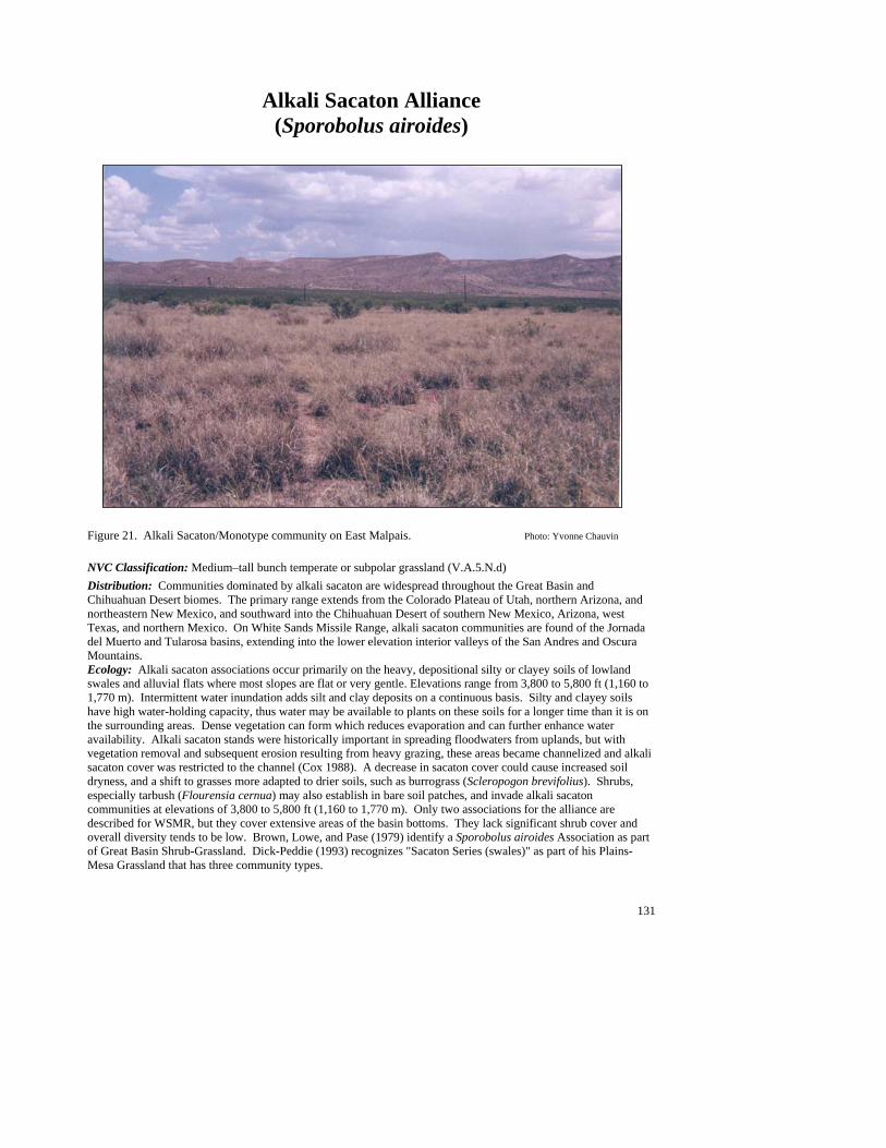
131
Alkali Sacaton Alliance (Sporobolus airoides)
Figure 21. Alkali Sacaton/Monotype community on East Malpais. Photo: Yvonne Chauvin NVC Classification: Medium–tall bunch temperate or subpolar grassland (V.A.5.N.d) Distribution: Communities dominated by alkali sacaton are widespread throughout the Great Basin and Chihuahuan Desert biomes. The primary range extends from the Colorado Plateau of Utah, northern Arizona, and northeastern New Mexico, and southward into the Chihuahuan Desert of southern New Mexico, Arizona, west Texas, and northern Mexico. On White Sands Missile Range, alkali sacaton communities are found of the Jornada del Muerto and Tularosa basins, extending into the lower elevation interior valleys of the San Andres and Oscura Mountains. Ecology: Alkali sacaton associations occur primarily on the heavy, depositional silty or clayey soils of lowland swales and alluvial flats where most slopes are flat or very gentle. Elevations range from 3,800 to 5,800 ft (1,160 to 1,770 m). Intermittent water inundation adds silt and clay deposits on a continuous basis. Silty and clayey soils have high water-holding capacity, thus water may be available to plants on these soils for a longer time than it is on the surrounding areas. Dense vegetation can form which reduces evaporation and can further enhance water availability. Alkali sacaton stands were historically important in spreading floodwaters from uplands, but with vegetation removal and subsequent erosion resulting from heavy grazing, these areas became channelized and alkali sacaton cover was restricted to the channel (Cox 1988). A decrease in sacaton cover could cause increased soil dryness, and a shift to grasses more adapted to drier soils, such as burrograss (Scleropogon brevifolius). Shrubs, especially tarbush (Flourensia cernua) may also establish in bare soil patches, and invade alkali sacaton communities at elevations of 3,800 to 5,800 ft (1,160 to 1,770 m). Only two associations for the alliance are described for WSMR, but they cover extensive areas of the basin bottoms. They lack significant shrub cover and overall diversity tends to be low. Brown, Lowe, and Pase (1979) identify a Sporobolus airoides Association as part of Great Basin Shrub-Grassland. Dick-Peddie (1993) recognizes "Sacaton Series (swales)" as part of his Plains-Mesa Grassland that has three community types.
132
Key to the Alkali Sacaton (Sporobolus airoides) Plant Associations: 1. Alkali Sacaton (Sporobolus airoides) well represented to luxuriant, with other species poorly represented to absent.......................................................................................................... Alkali Sacaton/Monotypic Stand PA 1. Burrograss (Scleropogon brevifolius) common to well represented as the subdominant grass ......................................................................................................................................................... Alkali Sacaton/Burrograss PA
Alkali Sacaton/Burrograss PA (Sporobolus airoides/Scleropogon brevifolius; SPOAIR/SCLBRE)
Distribution: On White Sands Missile Range, this is a
major community of the northern Jornada del Muerto and Tularosa basins, extending into the lower elevation interior valleys of the San Andres and Oscura Mountains. Vegetation Summary: This dense grassland is characterized by a luxuriant cover of alkali sacaton with patches of abundant burrograss, and, to a lesser extent tobosagrass, that can reach as much as 30% cover. Overall, diversity is moderate (75 species) though most species are present at very low cover. Shrubs are scarce. Fourwing saltbush may be present but seldom exceeds 5% cover. Of the 38 forbs
recorded, many are weedy ruderal species such as prickly Russian thistle. Physical Setting: This community mainly occurs in swales, drainage ways, small depressions, and alluvial flats of the basin floor and piedmont. Soils are generally heavy clays but patches of sandy soils may occur in the basin. Elevation range is 3,800 to 5,400 ft
(1,160 to 1,650 m). Discussion: Alkali Sacaton/Vine Mesquite, Tobosagrass/Alkali Sacaton, Tobosagrass/Burrograss, and Burrograss/Monotypic Stand PAs are similar, lowland grasslands on heavy soils. Surrounding upland communities are Chihuahuan Desert grasslands or shrublands. The Alkali Sacaton/Burrograss PA may represent degraded Alkali Sacaton/Montypic or Alkali Sacaton/Tobosagrass PAs that have been impacted by past heavy grazing. Burrograss is a disturbance increaser that quickly colonizes bare soil patches (Stubbendieck et al. 1992; Allred 1993; Dick-Peddie 1993), and although burrograss cover is low, the patches it occupies within the sacaton matrix are moderately extensive. In the absence of disturbance conditions that create bare soil patches, burrograss may be replaced by tobosagrass on silty soils or mesa dropseed on sandy soils (Neuenschwander et al.1975; Gibbens and Beck 1987). Average Min Max ELEVATION (ft): 4850 3879 5407 SLOPE %: 2 SOLAR INDEX: .87 .07 1.50
Common Plant Species, Alkali Sacaton/Burrograss PA Constancy Cover (%) Scientific Name Common Name (% plots) Mean Max Min n =16 Shrubs Yucca elata soaptree yucca 35.71% 0.72 2.50 0.00 Opuntia phaeacantha tulip pricklypear 28.57% 0.90 2.50 0.10 Atriplex canescens fourwing saltbush 57.14% 1.69 7.50 0.00 Grasses Sporobolus airoides alkali sacaton 100.00% 33.39 62.50 3.00 Scleropogon brevifolius burrograss 100.00% 7.64 29.00 0.50 Hilaria mutica tobosa 35.71% 2.10 7.50 0.00 Bouteloua gracilis blue grama 28.57% 2.02 5.00 0.10 Forbs Salsola kali prickly Russian thistle 28.57% 0.34 0.50 0.10 Gutierrezia sphaerocephala roundleaf snakeweed 50.00% 0.37 0.50 0.05
#
##
#
#
#
#
#
##
#
#
#
#
#
#
#
#
#
#
133
Alkali Sacaton/Monotypic Stand PA (Sporobolus airoides/Monotypic Stand; SPOAIR/MONTYP)
Distribution: On White Sands Missile Range this is a major community of the Tularosa and Jornada del Muerto basins, extending into the lower elevation interior valleys of the San Andres and Oscura Mountains. Vegetation Summary: This grassland is usually characterized by a luxuriant cover of alkali sacaton with only a scattering of other grasses such as burrograss, tobosagrass, and gyp dropseed. The Alkali sacaton can form large patches of nearly continuous cover but can also be scattered between
large patches of exposed soil. Shrub cover is limited to occasional scattered honey mesquites, pickleweed, and fourwing saltbushes and a few other desert shrubs and dwarf shrubs. Overall, diversity is moderate at 59 recorded species. The forb layer can be high in diversity, but is generally scarce and grows within and around the grasses. Mojave seablite, mountain pepperweed, prickly Russian thistle, woolly paperflower, and lacy tansyaster are often included. Phases of honey mesquite and Berlandier’s wolfberry occur in the Tularosa basin. A fourwing saltbush phase occurs within both the Tularosa and Jornada del Muerto basins. Physical Setting: This grassland type generally occurs in lowland swales, alluvial flats, and playa lake plains, or occasionally in intermountain basins at elevations of 3,800 to 5,800 ft (1,160 to 1,775 m). Slopes are
generally very gentle to flat. Soils are derived from mixed alluvium of silts or clays. These soils are well developed and often include gypsum and clay layers with depth. Surface textures are fine and range between clay to sandy clay loams. Large scattered patches of fractured surface soils are common. Surface and sub-surface rock is generally absent. Discussion: Generally, stands of this type are large and can mix across the landscape with other lowland grassland communities such as Alkali Sacaton/Burrograss, Tobosagrass/Alkali Sacaton, and Tobosagrass/Monotypic Stand. In addition, the surrounding lowlands may contain stands of Fourwing Saltbush/Gyp Grama, Gyp Grama/Hairy Coldenia, and Pickleweed/Sparse communities. Areas upslope generally grade into shrubland communities dominated by fourwing saltbush, honey mesquite, creosotebush and tarbush with alkali sacaton commonly codominating.
Soil Taxonomic Unit(s): Coarse Silty Chromic Gypsitorrert Very Fine Clayey Chromic Haplotorrert Very Fine, Mixed (Calcareous), Thermic, Typic
Haplotorrert Fine Loamy, Gypsic, Thermic Petrogypsic Gypsiorthids Fine loamy, Gypsic, Thermic Petrogypsic Gypsiorthids
Average Min Max ELEVATION (ft): 4107 3869 5822 SLOPE %: 2 SOLAR INDEX: 1.24 .29 1.98
Common Plant Species, Alkali Sacaton/Monotypic Stand PA: Constancy Cover (%) Scientific Name Common Name (% plots) Mean Max Min n = 31 Shrubs Yucca elata soaptree yucca 18.75% 0.09 0.50 0.00 Prosopis glandulosa honey mesquite 50.00% 0.88 7.50 0.00 Lycium berlandieri Berlandier's wolfberry 18.75% 1.93 7.50 0.05 Atriplex canescens fourwing saltbush 62.50% 1.75 7.50 0.00 Allenrolfea occidentalis pickleweed 12.50% 0.88 2.50 0.01 Grasses Sporobolus nealleyi gyp dropseed 12.50% 0.88 2.50 0.00 Sporobolus airoides alkali sacaton 96.88% 36.05 87.50 7.50 Scleropogon brevifolius burrograss 15.63% 0.30 0.50 0.01 Forbs Suaeda moquinii Mojave seablite 15.63% 0.33 0.50 0.05
#
#
#
#
###
#
#
#
##
##
#
##
#
#
#
#
#
##
#
##
#
#
#
#
#
#####
#
###
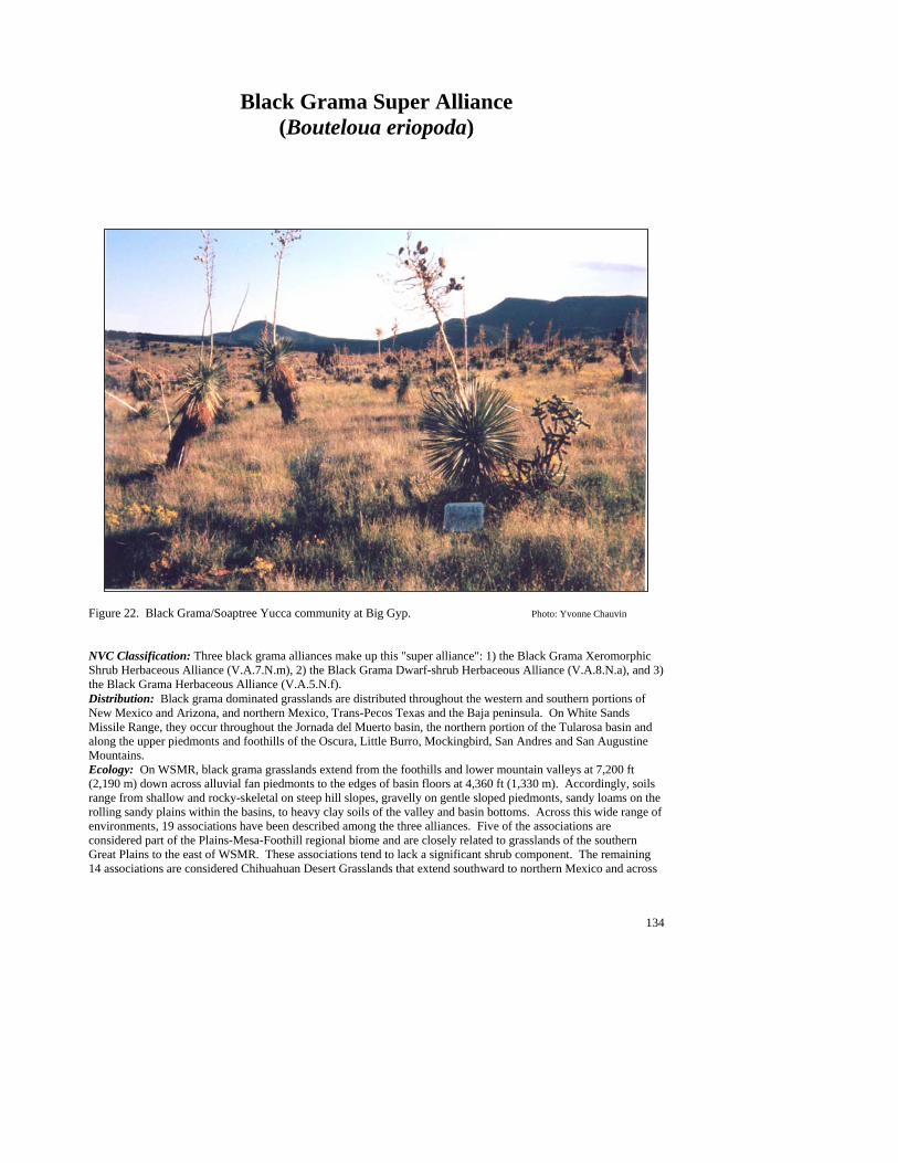
134
Black Grama Super Alliance (Bouteloua eriopoda)
Figure 22. Black Grama/Soaptree Yucca community at Big Gyp. Photo: Yvonne Chauvin NVC Classification: Three black grama alliances make up this "super alliance": 1) the Black Grama Xeromorphic Shrub Herbaceous Alliance (V.A.7.N.m), 2) the Black Grama Dwarf-shrub Herbaceous Alliance (V.A.8.N.a), and 3) the Black Grama Herbaceous Alliance (V.A.5.N.f). Distribution: Black grama dominated grasslands are distributed throughout the western and southern portions of New Mexico and Arizona, and northern Mexico, Trans-Pecos Texas and the Baja peninsula. On White Sands Missile Range, they occur throughout the Jornada del Muerto basin, the northern portion of the Tularosa basin and along the upper piedmonts and foothills of the Oscura, Little Burro, Mockingbird, San Andres and San Augustine Mountains. Ecology: On WSMR, black grama grasslands extend from the foothills and lower mountain valleys at 7,200 ft (2,190 m) down across alluvial fan piedmonts to the edges of basin floors at 4,360 ft (1,330 m). Accordingly, soils range from shallow and rocky-skeletal on steep hill slopes, gravelly on gentle sloped piedmonts, sandy loams on the rolling sandy plains within the basins, to heavy clay soils of the valley and basin bottoms. Across this wide range of environments, 19 associations have been described among the three alliances. Five of the associations are considered part of the Plains-Mesa-Foothill regional biome and are closely related to grasslands of the southern Great Plains to the east of WSMR. These associations tend to lack a significant shrub component. The remaining 14 associations are considered Chihuahuan Desert Grasslands that extend southward to northern Mexico and across

135
to Arizona. Ten of these Chihuahuan Desert Grassland associations are characterized by a significant tall shrub component, the remaining four by dwarf shrubs. These semi-desert grasslands have been heavily impacted by drought and grazing over the past 150 years (Buffington and Herbel 1965; Herbel et al.1972; Brown 1982b; Gibbens and Beck 1987, 1988; Cornelius et al. 1991; Holecheck 1991; Gosz and Gosz 1996). Yet, large stands persist on WSMR and these are considered some the highest quality occurrences remaining in the Southwest (Dinerstein et al. 1999). Key to the Black Grama (Bouteloua eriopoda) Plant Associations: 1. Black grama (Bouteloua eriopoda) codominant with other grass species .........................................................2 1. Black grama clearly the dominant grass species; mix of shrubs often present ..................................................9 2. Black grama dominant to codominant with sideoats grama (Bouteloua curtipendula) or blue grama (Bouteloua gracilis) ..................................................................................................................................................................5 2. Black grama dominant to codominant with other grass species ........................................................................3 3. Alkali sacaton (Sporobolus airoides) common to well represented as the subdominant or codominant grass................................................................................................ Black Grama/Alkali sacaton PA (See Minor Types) 3. Alkali sacaton poorly represented to absent ......................................................................................................4 4. Cane bluestem (Bothriochloa barbinodis) common to well represented as the subdominant or codominant grass..........................................................................................................................Black Grama/Cane Bluestem PA 4. Purple threeawn (Aristida purpurea) common to well represented as the subdominant or codominant ...................................................................................................Black Grama/Purple Threeawn PA (See Minor Types) 5. Black grama dominant to codominant with sideoats grama ...................... Black Grama/Sideoats Grama PA 5. Black grama dominant to codominant with blue grama ....................................................................................6 6. Shrubs poorly represented, restricted to microsites ..........................................Black Grama/Blue Grama PA 6. Shrubs common or well-represented .................................................................................................................7 7. Banana yucca (Yucca baccata) common; scattered throughout stands.................................................................................................................................................................... Black Grama–Blue Grama/Banana Yucca PA 7. Banana yucca uncommon to absent...................................................................................................................8 8. Soaptree yucca (Yucca elata) common, scattered throughout stands .................................................................................................................................................................... Black Grama–Blue Grama/Soaptree Yucca PA 8. Bigelow’s sagebrush (Artemisia bigelovii) common, scattered throughout stands........................................................................................................ Black Grama–Blue Grama/Bigelow’s Sagebrush PA (See Minor Types) 9. Yucca or jointfir species common to well represented ....................................................................................10 9. Other shrubs common to well-represented ......................................................................................................13 10. Banana yucca (Yucca baccata) common as dominant or codominant shrub.................................................................................................................................................Black Grama/Banana Yucca PA (See Minor Types) 10. Banana yucca uncommon to absent...............................................................................................................11 11. Soaptree yucca common to well represented as dominant or codominant shrub; usually sandy soils........................................................................................................................................Black Grama/Soaptree Yucca PA 11. Soaptree yucca uncommon to absent.............................................................................................................12 12. Longleaf jointfir (Ephedra trifurca) common to well-represented as dominant or codominant shrub.....................................................................................................................................Black Grama/Longleaf Jointfir PA 12. Torrey’s jointfir (Ephedra torreyi) common to well-represented as dominant or codominant shrub.......................................................................................................................................Black Grama/Torrey’s Jointfir PA
136
13. Ocotillo (Fouquieria splendens) common to well represented as dominant or codominant shrub..........................................................................................................................................................Black Grama/Ocotillo PA 13. Ocotillo poorly represented to absent ............................................................................................................14 14. Mariola (Parthenium incanum) common to well represented as dominant or codominant shrub ...........................................................................................................................................................Black Grama/Mariola PA 14. Mariola poorly represented to absent.............................................................................................................15 15. Common sotol (Dasylirion wheeleri) common to well represented as dominant or codominant shrub ...................................................................................................................................... Black Grama/Common Sotol PA 15. Common sotol poorly represented to absent..................................................................................................16 16. Skeletonleaf goldeneye (Viguiera stenoloba) common to well represented as dominant or codominant shrub............................................................................................................Black Grama/Skeletonleaf Goldeneye PA 16. Skeletonleaf goldeneye poorly represented to absent ....................................................................................17 17. Sacahuista (Nolina microcarpa) common to well represented as dominant or codominant shrub...................................................................................................................... Black Grama/Sacahuista PA (See Minor Types) 17. Sacahuista poorly represented to absent ........................................................................................................18 18. Bigelow’s sagebrush (Artemisia bigelovii) common to well represented as dominant or codominant shrub..................................................................................... Black Grama/Bigelow’s Sagebrush PA (See Minor Types) 18. Apacheplume (Fallugia paradoxa) common to well represented as dominant or codominant shrub ............................................................................................................ Black Grama/Apacheplume PA (See Minor Types)
Black Grama/Blue Grama PA
(Bouteloua eriopoda/Bouteloua gracilis; BOUERI/BOUGRA) Distribution: On WSMR, this is a major community of the Oscura, Little Burro, Mockingbird, San Andres and San Augustine Mountains. Vegetation Summary: This Plains -Mesa-Foothills Grassland association is highly diverse, but is generally characterized by an abundant to luxuriant cover of black grama with blue grama codominant or subdominant. Purple threeawn, sideoats grama and cane bluestem are usually well represented. Shrubs are common but mostly represented by dwarf shrubs such as
broom snakeweed, mariola, featherplume, and tulip pricklypear. Forb diversity can be high (84 species) but variable from stand to stand. The constant species include Rocky Mountain zinnia, lacy tansyaster, hairyseed bahia and threadleaf ragwort, common species of the shortgrass prairie. Physical Setting: This community tends to occur in relatively small patches on mid to low elevation mountain slopes and foothills, but can form more
extensive stands on the upper alluvial fan piedmonts. Elevations range from 4,900 to 6,000 ft (1,490 to 1,830 m). Slopes grade from very from gentle to steep with predominantly cool aspects. Soils are moderately deep, coarse to fine-textured skeletal loams, with indurated carbonate layers. Discussion: Black Grama/Blue Grama stands are extensive and interspersed with Black Grama–Blue Grama/Soaptree Yucca stands and Black Grama–Blue Grama/Banana Yucca. The Black Grama–Blue Grama/Soaptree Yucca PA is similar floristically, but has a conspicuous soaptree yucca component. Black Grama–Blue Grama /Banana Yucca communities occur on somewhat shallower soils. Black Grama/Soaptree Yucca PA lacks a significant blue grama component and usually occurs on sandier soils. Pure blue grama stands are more closely associated with mesic swale communities. New Mexico needlegrass communities are interspersed on the ridges of hills. Steeper, rocky hills rising out of the plains may support Sideoats Grama/Sacahuista types or, towards the foothills and escarpments, Curlyleaf Muhly/Sideoats Grama and Sideoats Grama/Common Sotol types.
Both blue grama and black grama exist as dominant grass species within their respective biomes,
#
#
#
##
#
#
##
##
##
#
#
#
##
###
#
137
but near transitional zones, their distribution becomes patchy, with neither species dominating (Gosz and Gosz 1996). It is likely that a number of interacting factors and processes contribute to this pattern of distribution: soils, climate, disturbance regimes and reproductive strategies. Blue grama occurs extensively on fine-textured soils in the Plains grasslands, but increasing aridity may limit its spread in the transitional area (Sims 1988). The mesic nature of the fine soils may also promote recovery from fire. Both black and blue grama reproduce by vegetative spread, but black grama has a higher rate of seed production, and therefore may be able to colonize bare patches more quickly than blue grama (Laurenroth et al. 1994). These grasslands persisted through the severe droughts of the 1930’s and 1950’s as well as the intense overgrazing of western rangelands around the turn of the century. A shift from grassland conditions, however, is evidenced by low grass cover (<10%) in some areas, the widespread occurrence of broom snakeweed, (which effectively reduces grass cover [McDaniel et al. 1982]), and a high incidence of other weedy shrubs and weedy forbs. Because these stands are near the mesic edge of the Chihuahuan Desert, the potential for improved conditions is good with a change in management.
Although altered grasslands have proved to be irreversible under more arid conditions in the Chihuahuan Desert (Schlesinger et al.1990), returns to higher grass cover of both black and blue gramas and a concurrent decrease in shrub cover have been accomplished with release from grazing pressure (Potter and Krenetsky 1967; Brady et al.1989; Gosz and Gosz 1996).
Soil Taxonomic Unit(s): Coarse Loamy Lithic Haplustoll Loamy Skeletal Typic Torriorthent Coarse Loamy, Mixed (Nonacid), Thermic, Typic
Haplargid Loamy Skeletal, Mixed (Carbonatic), Mesic Typic
Argiustolls Lithic Ustollic Calciorthid Loamy Skeletal Thermic Loamy Skeletal, Carbonatic Thermic Aridic Calciustolls Ustochreptic Calciorthid, Fine Silty, Thermic Average Min Max ELEVATION (ft): 5544 4903 5978 SLOPE %: 19 3 45 SOLAR INDEX: .76 .00 1.99
Common Plant Species: Constancy Cover Scientific Name Common Name (% plots) Mean Max Min n = 12 Shrubs Larrea tridentata creosotebush 58.33% 1.29 3.00 0.00 Dalea formosa featherplume 50.00% 3.23 15.00 0.10 Gutierrezia sarothrae broom snakeweed 66.67% 1.54 5.00 0.00 Opuntia imbricata tree cholla 50.00% 1.10 3.00 0.10 Opuntia phaeacantha tulip pricklypear 75.00% 1.18 4.00 0.00 Parthenium incanum mariola 66.67% 1.26 3.00 0.10 Rhus microphylla littleleaf sumac 50.00% 1.42 5.00 0.00 Yucca elata soaptree yucca 66.67% 0.58 3.00 0.01 Grasses Aristida purpurea purple threeawn 75.00% 1.16 3.00 0.01 Bouteloua gracilis blue grama 100.00% 11.42 41.50 2.00 Bouteloua eriopoda black grama 100.00% 22.82 62.50 2.50 Bouteloua curtipendula sideoats grama 75.00% 4.17 15.00 0.50 Bothriochloa barbinodis cane bluestem 50.00% 1.52 5.00 0.01 Forbs Zinnia grandiflora Rocky Mountain zinnia 50.00% 0.99 3.00 0.01 Senecio flaccidus threadleaf ragwort 66.67% 0.63 3.00 0.05 Bahia absinthifolia hairyseed bahia 50.00% 0.68 3.00 0.00 Machaeranthera pinnatifida ssp. lacy tansyaster 66.67% 0.06 0.10 0.01 pinnatifida var. pinnatifida
138
Black Grama–Blue Grama/Banana Yucca PA (Bouteloua eriopoda–Bouteloua gracilis/Yucca baccata;
BOUERI–BOUGRA/YUCBAC)
Distribution: On White Sands Missile Range, this is a major community of the Oscura, Mockingbird, and San Andres Mountains. . Vegetation Summary: This Chihuahuan Desert Grassland is characterized by alternating patches of black and blue grama with a shrub layer represented by scattered banana yuccas. Black and blue grama are usually abundant and codominants. Sideoats grama, purple threeawn, and New Mexico needlegrass are common associates. Banana yucca, a shallow soil
indicator, forms clonal groups of about eight rosettes each and is regularly interspersed within the grassland matrix. The shrub layer overall is well represented and diverse (29 species). Fourwing saltbush, broom snakeweed, winterfat and tulip pricklypear are the consistent and abundant. Forbs are conspicuous on the bare soil around and beneath the yucca plants, with lacy tansyaster, Louisiana sagewort, woolly paperflower and desert holly fairly constant species among the 45 recorded for the association. Physical Setting: This community occurs on the upper piedmont and lower mountain and foothill slopes at
elevations between 5,100 and 6,200 ft (1,550 and 1,890 m). Soils are shallow and rocky, but fine-textured silty or clayey soils may occur near the surface. Aspects are mostly northerly, with gentle to steep slope grades. Discussion: Stands of this type are in discrete patches within the larger Black Grama/Blue Grama and Black Grama–Blue Grama/Soaptree Yucca matrix. The distribution of this type coincides with shallow soils of the transitional Black Grama–Blue Grama grasslands. Banana yucca, which has a shallow fibrous root system and is common on rocky slopes at higher elevations of the pinyon–juniper zone (Smith and Ludwig 1978), replaces the deep-rooted soaptree yucca, which is common in surrounding Black Grama–Blue Grama stands on deeper soils. Shallower soils also have elevated water tables, which may account for the presence of winterfat, the higher relative cover of blue grama and overall high diversity. Soil Taxonomic Unit(s): Loamy Skeletal Mixed (Calcareous), Thermic, Typic
Calciorthid Average Min Max ELEVATION (ft): 5766 5114 6271 SLOPE %: 25 2 58 SOLAR INDEX: 1.13 .00 2.00
Common Plant Species: Constancy Cover Scientific Name Common Name (% plots) Mean Max Min n = 10 Shrubs Yucca baccata banana yucca 100.00% 3.40 7.50 1.00 Prosopis glandulosa honey mesquite 50.00% 1.25 3.00 0.00 Parthenium incanum mariola 50.00% 2.10 4.00 0.50 Opuntia phaeacantha tulip pricklypear 60.00% 0.73 3.00 0.05 Krascheninnikovia lanata winterfat 60.00% 0.34 1.30 0.01 Gutierrezia sarothrae broom snakeweed 70.00% 4.29 17.50 0.05 Atriplex canescens fourwing saltbush 80.00% 0.59 3.00 0.01 Grasses Stipa neomexicana New Mexico needlegrass 60.00% 1.19 3.00 0.05 Bouteloua gracilis blue grama 100.00% 17.25 41.50 7.50 Bouteloua eriopoda black grama 100.00% 10.35 25.00 3.00 Bouteloua curtipendula sideoats grama 80.00% 2.26 7.00 0.10 Aristida purpurea purple threeawn 80.00% 1.50 3.10 0.05 Forbs Machaeranthera pinnatifida ssp. lacy tansyaster 50.00% 0.69 3.00 0.05 pinnatifida var. pinnatifida Artemisia ludoviciana Louisiana sagewort 50.00% 0.39 0.75 0.10 Acourtia nana desert holly 50.00% 0.86 3.00 0.01
# #
#
#
##
##
#
#
#
139
Black Grama–Blue Grama/Soaptree Yucca PA (Bouteloua eriopoda–Bouteloua gracilis/Yucca elata;
BOUERI–BOUGRA/YUCELA)
Distribution: On White Sands Missile Range this is a major community of the Oscura, Mockingbird, San Andres, and San Augustine Mountains. Vegetation Summary: This Chihuahuan Desert Grassland association is generally characterized by abundant black and blue grama with a conspicuous soaptree yucca shrub layer. Black and blue grama are codominant and form extensive grasslands. Other grasses present in this moderately diverse grassland include bush muhly and cane bluestem. Among
the 33 forbs recorded for the association, nightshade, slender goldenweed, and mountain pepperweed are the most constant and are concentrated in bare soil beneath the yucca plants. Physical Setting: This community occurs in relatively small patches on mid to low elevation mountain slopes and foothills, but generally forms more extensive grasslands on the upper alluvial fan piedmonts and rolling plains. Elevations range from 5,200 to 6,300 ft (1,580 to 1,920). Slopes vary from flat to steep with predominantly cool aspects. Soils are moderately deep, medium to fine textured loams, with indurated carbonate layers.
Discussion: The Black Grama/Blue Grama PA is similar but lacks the Soaptree Yucca component and tends to occur on heavier soils with less sand. The Black Grama–Blue Grama/Banana Yucca PA occurs on shallower soils. The Black Grama/Soaptree Yucca PA has very little blue grama, and is possibly a drier type. Steeper, rocky hills rising out of the plains may support Sideoats Grama/Sacahuista or, towards the foothills, Curlyleaf Muhly/Sideoats Grama and Sideoats Grama/Common Sotol PAs. The mesic nature of the fine soils may also promote recovery from fire. Different reproductive rates and strategies may also help maintain the codominant structure of the PA in transitional areas. Both black and blue grama reproduce by vegetative spread, but black grama has a higher rate of seed production, and therefore may be able to colonize bare patches more quickly than blue grama (Laurenroth et al. 1994). Soaptree yucca is known to extend into grasslands and the regular, uniform distribution of the species in these stands reflects a fairly homogenous habitat (Smith and Ludwig 1978). Average Min Max ELEVATION (ft): 5599 5269 6029 SLOPE %: 15 5 45 SOLAR INDEX: .99 .03 1.95
Common Plant Species, Black Grama–Blue Grama/Soaptree Yucca PA: Constancy Cover Scientific Name Common Name (% plots) Mean Max Min n = 5 Shrubs Opuntia phaeacantha tulip pricklypear 40.00% 1.75 3.00 0.50 Gutierrezia sarothrae broom snakeweed 60.00% 4.17 7.50 2.50 Krascheninnikovia lanata winterfat 40.00% 1.50 2.50 0.50 Opuntia imbricata tree cholla 60.00% 1.33 3.00 0.50 Larrea tridentata creosotebush 40.00% 1.75 3.00 0.50 Parthenium incanum mariola 40.00% 1.75 3.00 0.50 Rhus microphylla littleleaf sumac 40.00% 1.50 3.00 0.01 Yucca baccata banana yucca 60.00% 0.83 2.50 0.00 Yucca elata soaptree yucca 100.00% 2.80 7.50 0.50 Grasses Bothriochloa barbinodis cane bluestem 40.00% 1.75 3.00 0.50 Bouteloua gracilis blue grama 100.00% 17.30 29.00 7.50 Bouteloua curtipendula sideoats grama 60.00% 6.67 15.00 2.50 Bouteloua eriopoda black grama 100.00% 30.60 62.50 15.00 Aristida purpurea purple threeawn 60.00% 2.00 3.00 0.50
#
#
#
# #
#
#
###
140
Muhlenbergia porteri bush muhly 60.00% 1.85 3.00 0.05 Forbs Bahia absinthifolia hairyseed bahia 60.00% 1.18 3.00 0.05 Chaetopappa ericoides rose heath 40.00% 1.52 3.00 0.05 Melampodium leucanthum plains blackfoot 40.00% 1.52 3.00 0.05 Zinnia grandiflora Rocky Mountain zinnia 60.00% 1.33 3.00 0.50 Senecio flaccidus threadleaf ragwort 40.00% 1.75 3.00 0.50 Thelesperma megapotamicum Hopi tea greenthread 40.00% 2.75 3.00 2.50 Machaeranthera pinnatifida lacy tansyaster 60.00% 1.03 2.50 0.10 .
Black Grama/Cane Bluestem PA (Bouteloua eriopoda/Bothriochloa barbinodis; BOUERI/BOTBAR )
Distribution: On White Sands Missile Range this is a major community of the Oscura, Mockingbird, San Andres, and San Augustine Mountains. Vegetation Summary: This Plains-Mesa-Foothill Grassland is characterized by abundant to luxuriant stands of black grama with well-represented cane bluestem scattered in patches. Bush muhly, blue grama, and sideoats grama are also present in this diverse grass layer (15 recorded species). Though shrub cover is
typically low, the shrub layer is still somewhat diverse (22 species) and includes honey mesquite, tulip pricklypear, common sotol, broom snakeweed, and Apacheplume. Forbs are low in cover and diversity (only 22 species reported) with threadleaf ragwort the most constant species.
Physical Setting: This community occurs in relatively small patches on moderate to steep slopes with cool to warm aspects. It occurs mostly at mid elevations from 5,000 to 6,900 ft (1,520 to 2,100 m). Substrates are primarily eroded from Precambrian intrusions (granite or quartz monzonite). Soils are generally skeletal, sandy loams. Discussion: This type can grade out to black grama piedmont grasslands, or up to oak- or Apacheplume-dominated drainages. It is often surrounded by oak shrublands. Fires may affect the low-lying shrub component, leaving a relatively open grassland type. This type may also grade into Black Grama/Sideoats Grama, Black Grama/Common Sotol, or Black Grama/Apacheplume types.
Average Min Max ELEVATION (ft): 5805 5043 6880 SLOPE %: 31 11 56 SOLAR INDEX: 1.23 .43 1.78
Common Plant Species, Black Grama/Cane Bluestem PA: Constancy Cover Scientific Name Common Name (% plots) Mean Max Min n = 5 Shrubs Gutierrezia sarothrae broom snakeweed 80.00% 1.00 2.50 0.50 Dasylirion wheeleri common sotol 60.00% 0.17 0.50 0.00 Fallugia paradoxa Apacheplume 60.00% 1.67 2.50 0.00 Prosopis glandulosa honey mesquite 60.00% 0.17 0.50 0.00 Quercus turbinella shrub live oak 60.00% 0.00 0.00 0.00 Opuntia imbricata tree cholla 60.00% 1.02 2.50 0.05 Opuntia phaeacantha tulip pricklypear 60.00% 1.17 2.50 0.50 Grasses Bothriochloa barbinodis cane bluestem 100.00% 7.10 17.50 0.50 Bouteloua eriopoda black grama 100.00% 33.40 62.50 17.50 Muhlenbergia porteri bush muhly 60.00% 0.35 0.50 0.05 Forbs Machaeranthera gracilis slender goldenweed 60.00% 0.35 0.50 0.05 Senecio flaccidus threadleaf ragwort 60.00% 0.50 0.50 0.50
#
#
###
141
Black Grama/Common Sotol PA (Bouteloua eriopoda/Dasylirion wheeleri; BOUERI/DASWHE)
Distribution: On White Sands Missile Range this is a major community of the San Andres, San Augustine, and Organ Mountains, and occurs less frequently in the Oscura Mountains. Vegetation Summary: This Chihuahuan Desert Grassland is characterized by a grass layer dominated by black grama with conspicuous but scattered sotols. Sideoats grama is a common associate and occasionally codominates. Overall, the grass layer is well represented and high in diversity (25 species). The scattered bunch grasses frequently
include Hall’s panicgrass, cane bluestem, purple threeawn, and hairy grama. The shrub layer is moderately open and diversity is relatively high at 25 species possible with Wright’s beebrush, broom snakeweed, cactus apple, and skeletonleaf goldeneye the most constant. The forb layer is poorly represented in abundance though often moderate in diversity (26 species). Louisiana sage, the most common associate, grows near or under shrub canopies. Conversely, Wright’s buckwheat and grassland croton are generally found scattered and grow in between the shrubs. Physical Setting: This type generally occurs on moderately steep to very steep colluvial slopes. Aspects range from cold to hot, at elevations between 5,000 and 6,900 ft (1,520 and 2,100 m). There is a tendency for this PA to occur on hot aspects at higher elevations and on cooler aspects at lower elevations. Substrates are
generally granitic Precambrian intrusions or mixed rock types at the base of the San Andres Mountains escarpment. Between the vegetation, ground surfaces are covered with rock and gravel with little exposed soil. Soils are shallow, well drained, and unstable, ranging in texture from loamy sand to sandy clay loams. Discussion: Stands of this type are generally patchy when occurring in dissected areas but do become continuous and large over undissected ridge sideslopes. Stands are often bounded by rock outcrops of substantial size, and are found adjacent to fire-prone vegetation types. Lower slopes generally give way to Creosotebush/Black Grama, Arroyo Riparian, Black Grama/Mariola, or Black Grama/Skeletonleaf Goldeneye communities. Areas upslope or on cooler aspects generally grade into shrub live oak or mountain mahogany communities or montane grasslands such as New Mexico Needlegrass/Sideoats Grama or Hairy Grama/Black Grama communities. This piedmont/foothill grassland type carries fire well, with black grama often producing a fire hot enough to kill a substantial portion of the shrubs present. Light fire may enhance this dense grassland, leaving stable but sparse sotol individuals. Soil Taxonomic Unit(s): Loamy Skeletal Pachic Calciustoll Average Min Max ELEVATION (ft): 5665 5043 6880 SLOPE %: 42 22 63 SOLAR INDEX: 1.27 .02 1.99
Common Plant Species, Black Grama/Common Sotol PA: Constancy Cover Scientific Name Common Name (% plots) Mean Max Min n = 6 Shrubs Viguiera stenoloba skeletonleaf goldeneye 66.67% 3.75 7.50 2.50 Parthenium incanum mariola 50.00% 1.17 2.50 0.50 Opuntia engelmannii cactus apple 66.67% 2.13 3.00 0.50 Gutierrezia sarothrae broom snakeweed 83.33% 1.70 2.50 0.50 Garrya wrightii Wright’s silktassel 50.00% 0.34 1.00 0.00 Dasylirion wheeleri common sotol 100.00% 7.42 17.50 2.00 Dalea formosa featherplume 50.00% 3.50 7.50 0.50 Aloysia wrightii Wright’s beebrush 66.67% 0.63 1.00 0.50 Grasses Panicum hallii Hall’s panicgrass 66.67% 0.39 0.50 0.05 Bouteloua hirsuta hairy grama 50.00% 1.83 2.50 0.50
#
###
#
#
142
Bouteloua eriopoda black grama 100.00% 21.25 62.50 7.50 Bouteloua curtipendula sideoats grama 83.33% 2.20 2.50 1.00 Bothriochloa barbinodis cane bluestem 66.67% 2.63 7.00 0.50 Aristida purpurea purple threeawn 50.00% 2.33 2.50 2.00 Forbs Artemisia ludoviciana Louisiana sagewort 83.33% 0.50 0.50 0.50
Black Grama/Longleaf Jointfir PA (Bouteloua eriopoda/Ephedra trifurca; BOUERI/EPHTRI )
Distribution: On White Sands Missile Range this is a major community around the Mockingbird and San Augustine Mountains. It also occurs in the southern Jornada basin. Vegetation Summary: This Chihuahuan Desert Grassland is dominated by abundant to luxuriant black grama with scattered longleaf jointfir in the overstory. Blue grama, streambed bristlegrass, spidergrass, fluffgrass, and bush muhly are often present. Occasionally, black grama is reduced in cover and purple
threeawn will codominate (Aristida purpurea Phase). Among the 14 shrub species recorded for the type, broom snakeweed, honey mesquite, tulip pricklypear, tree cholla, soaptree yucca and sand sagebrush are the most constant and abundant. The forb layer is very moderately diverse at 41 species with desert marigold, tanseyleaf aster, silverleaf nightshade, and mountain pepperweed the most constant and abundant. Physical Setting: The Black Grama/Longleaf Jointfir PA occurs on the gentle slopes of alluvial fans on moderate or cold aspects at elevations of 5,000 to 5,500 ft (1,520 to 1,680 m). Substrates are alluvial deposits eroded from Precambrian intrusions (granite or quartz monzonite) at the base of the Mockingbird and San Augustine Mountains. The landscape is characterized by broad alluvial fans, which are dissected by shallow arroyos that drain upland valleys into the basins below. Upslope, along the fan collar are scattered boulders. Soils are generally well developed and stable, and surface textures range from sandy loam to sandy clay loams. Discussion: Stands of this type are generally large but may mix with other grassland communities. The largest stands occur on the western piedmont leading out from the Mockingbird Mountains. Smaller discontinuous
stands occur on the eastern piedmont slopes leading out from the Mockingbird and San Augustine Mountains. They are generally mixed with other grasslands such as Hairy Grama/Black Grama, Black Grama–Blue Grama/Soaptree Yucca. Drainages dissecting lower stands are generally lined with Apacheplume. Upper slopes generally grade into other grasslands such as Black Grama/Common Sotol or Black Grama/Cane Bluestem or shrublands such as Shrub Live Oak/Black Grama or Shrub Live Oak/Blue Grama. Lower slopes generally give way to Chihuahuan shrublands like Creosotebush/Black Grama or Tarbush/Alkali Sacaton or other grasslands like Black Grama/Alkali Sacaton or Alkali Sacaton/Burrograss.
The purple threeawn phase is probably disturbance related. Purple threeawn is an invasive native (Allred 1993). Black grama decreases attributable to grazing and the severe drought of the 1950’s is well documented on the sandy or coarse soils of the Jornada del Muerto basin (Buffington and Herbel 1965; Hennessy et al. 1983; Gibbens and Beck 1987, 1988). Also, Herbel et al. (1972) found that drought damage to black grama was more severe on deep sandy soils because extended roots were more vulnerable to damage. In addition, Gosz and Gosz (1996) found that black grama does not recover from fire easily and that summer precipitation is important. Longleaf jointfir is also associated with deep soils but may be more tolerant of fire. Perhaps successional years of fire and/or drought may alter these climax grasslands to purple threeawn phases.
Soil Taxonomic Unit(s): Fine Clayey Aridic Argiustoll Sandy Typic Torripsamment
Average Min Max ELEVATION (ft): 5235 5049 5462 SLOPE %: 6 5 7 SOLAR INDEX: 1.47 .74 2.00
Common Plant Species, Black Grama/Longleaf Jointfir PA:
## #
##
#
#
###
#
143
Constancy Cover Scientific Name Common Name (% plots) Mean Max Min n = 5 Shrubs Prosopis glandulosa honey mesquite 60.00% 0.00 0.01 0.00 Ephedra trifurca longleaf jointfir 100.00% 3.10 7.50 0.50 Opuntia engelmannii cactus apple 40.00% 0.25 0.50 0.00 Opuntia imbricata tree cholla 80.00% 0.28 0.50 0.00 Gutierrezia sarothrae broom snakeweed 80.00% 1.50 2.50 0.50 Opuntia phaeacantha tulip pricklypear 80.00% 1.39 2.50 0.05 Artemisia filifolia sand sagebrush 60.00% 0.33 0.50 0.00 Yucca elata soaptree yucca 100.00% 0.12 0.50 0.00 Grasses Setaria leucopila streambed bristlegrass 60.00% 0.34 0.50 0.01 Muhlenbergia porteri bush muhly 60.00% 3.50 7.50 0.50 Bouteloua eriopoda black grama 100.00% 51.60 62.50 41.50 Erioneuron pulchellum fluffgrass 40.00% 0.28 0.50 0.05 Aristida ternipes spidergrass 40.00% 1.75 2.50 1.00 Bouteloua gracilis blue grama 100.00% 9.40 29.00 0.50 Forbs Baileya multiradiata desert marigold 60.00% 0.34 0.50 0.01 Lepidium montanum mountain pepperweed 100.00% 0.71 2.50 0.01 Machaeranthera tanacetifolia tanseyleaf aster 80.00% 0.88 2.50 0.00 Senna bauhinioides twinleaf senna 60.00% 0.12 0.25 0.05 Solanum elaeagnifolium silverleaf nightshade 80.00% 0.28 0.50 0.05
Black Grama/Mariola PA (Bouteloua eriopoda/Parthenium incanum; BOUERI/PARINC )
Distribution: On White Sands Missile Range, this is a major community throughout the San Andres, Mockingbird, and Oscura Mountains and may also occur in the Malpais Lava Flow. Probable in southern Arizona and New Mexico, western Texas, and northern Mexico. Vegetation Summary: Abundant and often luxuriant grass cover, with a diverse mix of low-lying Chihuahuan shrub species characterizes this Chihuahuan Desert Grassland. Black grama is well represented to luxuriant in
cover and dominates the herbaceous layer, but can be patchy. Among the 31 grasses recorded for the type, sideoats grama, fluffgrass, and purple threeawn are the most abundant and consistent. Shrubs are often abundant, diverse, and variable. The well represented to abundant mariola is diagnostic with creosotebush, tulip pricklypear, and skeletonleaf goldeneye as are occasional subdominants. Forbs are highly diverse (68 species) and variable. Hairyseed bahia is common along
with numerous cacti such as kingcup cactus. Physical Setting: This type occurs on rocky slopes of low-lying hills and mountain footslopes at elevations of 4,200 to 6,300 ft (1,280 to 1,920 m). It can also can extend onto upper alluvial fans and piedmonts. It occurs on both igneous and sedimentary substrates, with soils that are generally Orthids or Argids with coarse to fine-silty particle size classes. Slope grades are typically moderate to steep and occur on various aspects. Discussion: The Black Grama/Sideoats Grama type occurs in similar environments, but lacks a significant shrub component. The Sideoats Grama/Mariola and Ocotillo/Mariola types are on drier sites. Black Grama/Mariola is found in small patches within scrubby Chihuahuan Desert communities that occur on warmer aspects, such as Sideoats Grama/Sacahuista, Sideoats Grama/Common Sotol, or Viscid Acacia communities. Below, on progressively finer soils are creosotebush and tarbush stands.
Soil Taxonomic Unit(s): Sandy Skeletal, Mixed (Calcareous), Thermic, Typic
Haplargid Loamy Skeletal, Mixed (Calcareous), Thermic, Typic
#
#
#
#
#
#
##
#
#
#
#
#
#
##
##
#
#
#
#
#
#
#
#
#
#
#
#
#
#
#
#
#
#
#
#
#
144
Calciorthid Fine Silty, Mixed (Calcareous), Thermic, Typic
Calciorthid Loamy Skeletal Carbonatic Thermic Ustochreptic
Calciorthids Loamy Skeletal Carbonatic Thermic Ustollic
Paleorthids Coarse Loamy, Mixed, Thermic Ustochreptic
Paleorthids Loamy Skeletal, Mixed, Thermic Shallow Lithic
Haplargids (or Typic Paleorthids) Sandy Skeletal Mixed Thermic Typic Calciorthids
Loamy Skeletal Carbonatic, Thermic Shallow Petrocalcic Paleargids
Loamy Fragmental Carbonatic Thermic Lithic Haplargids
Average Min Max ELEVATION (ft): 4966 4277 6320 SLOPE %: 24 5 62 SOLAR INDEX: 1.32 .01 2.00
Common Plant Species, Black Grama/Mariola PA: Constancy Cover Scientific Name Common Name (% plots) Mean Max Min n = 31 Shrubs Larrea tridentata creosotebush 74.19% 2.47 7.50 0.00 Dalea formosa featherplume 58.06% 0.76 2.50 0.01 Dasylirion wheeleri common sotol 61.29% 0.32 2.50 0.00 Aloysia wrightii Wright’s beebrush 58.06% 0.85 2.50 0.00 Gutierrezia sarothrae broom snakeweed 58.06% 1.76 7.50 0.00 Yucca baccata banana yucca 67.74% 1.10 2.50 0.00 Opuntia phaeacantha tulip pricklypear 87.10% 1.12 2.50 0.05 Parthenium incanum mariola 100.00% 8.07 37.50 0.10 Prosopis glandulosa honey mesquite 67.74% 1.41 7.50 0.00 Viguiera stenoloba skeletonleaf goldeneye 70.97% 2.75 7.50 0.00 Fouquieria splendens ocotillo 58.06% 0.73 2.50 0.00 Grasses Muhlenbergia porteri bush muhly 54.84% 1.01 2.50 0.00 Sporobolus cryptandrus sand dropseed 51.61% 1.34 7.50 0.05 Erioneuron pulchellum fluffgrass 61.29% 0.26 1.00 0.01 Tridens muticus slim tridens 58.06% 0.93 2.50 0.05 Bouteloua eriopoda black grama 100.00% 26.48 70.00 7.50 Bouteloua curtipendula sideoats grama 67.74% 1.80 7.50 0.10 Aristida purpurea purple threeawn 58.06% 0.98 2.50 0.05 Forbs Bahia absinthifolia hairyseed bahia 58.06% 0.25 0.50 0.01 Echinocereus triglochidiatus kingcup cactus 32.14% 0.07 0.50 0.00 Artemisia ludoviciana Louisiana sagewort 17.86% 0.81 2.50 0.01 Echinocereus pectinatus rainbow cactus 17.86% 0.02 0.05 0.01 Hibiscus denudatus paleface 17.86% 1.12 2.50 0.05 Machaeranthera pinnatifida lacy tansyaster 28.57% 0.15 0.50 0.01 Menodora scabra rough menodora 17.86% 0.32 1.00 0.01 Echinocactus horizonthalonius devilshead 17.86% 0.13 0.50 0.01
145
Black Grama/Ocotillo PA (Bouteloua eriopoda/Fouquieria splendens; BOUERI/FOUSPL)
Distribution: On White Sands Missile Range this is a major community of the Oscura and San Andres Mountains. Probable in southern Arizona and New Mexico, western Texas, and northern Mexico. Vegetation Summary: The grassy understory of this Chihuahuan Desert Grassland ranges from being well represented to luxuriant in cover, with black grama as the dominant. Other common to abundant grasses include sideoats grama and purple threeawn.
Ocotillo is conspicuous and diagnostic of the strong and diverse shrub component of these grasslands. Wright’s beebrush, mariola, sotol, and goldeneye are the most abundant and consistent associates. Forbs are generally low in cover and species composition varies moderately from site to site. Of the 44 forb species recorded, kingcup cactus, hairyseed bahia and whitemouth dayflower are the most common.
Physical Setting: This community occurs on rocky exposed slopes of both scarp or dip slope landforms, and on a variety of substrates including limestone, sandstone, or igneous types. There is usually high surface rock or gravel cover, with moderate to steep slopes. It is mainly found on warm and hot southeast to
western aspects. Elevation range is 4,400 to 6,000 ft (1,340 to 1,830 m). Discussion: This community usually grades into other Chihuahuan Desert grassland types such as Black Grama/Skeltonleaf Goldeneye, Black Grama/Common Sotol and Black Grama/Mariola, all of which occur within similar landform types. At lower elevations, this type grades into piedmont shrublands. At higher elevations, this type grades into mountain mahogany or shrub live oak types. The high surface content of large rock material may prevent other types of grasses from colonizing the substrate. When on a dip slope, vegetation is usually found growing through cracks in the exposed bedrock.
Soil Taxonomic Unit(s): Loamy Skeletal, Mixed (Calcareous), Thermic Typic
Torriorthent Loamy Skeletal Carbonatic Thermic Shallow Lithic
Ustollic Calciorthids Loamy Skeletal Carbonatic Thermic Shallow
Ustochreptic Paleorthids
Average Min Max ELEVATION (ft): 5027 4461 6052 SLOPE %: 30 10 46 SOLAR INDEX: .32 .03 .66
Common Plant Species, Black Grama/Ocotillo PA: Constancy Cover Scientific Name Common Name (% plots) Mean Max Min n = 7 Shrubs Opuntia engelmannii cactus apple 57.14% 1.00 2.50 0.50 Dalea formosa featherplume 57.14% 1.38 2.50 0.50 Dasylirion wheeleri common sotol 71.43% 2.02 7.50 0.00 Agave parryi parry agave 42.86% 0.87 2.50 0.05 Larrea tridentata creosotebush 57.14% 1.29 2.50 0.05 Fouquieria splendens ocotillo 100.00% 11.79 17.50 2.50 Opuntia phaeacantha tulip pricklypear 71.43% 1.30 2.50 0.50 Parthenium incanum mariola 100.00% 7.14 17.50 0.50 Aloysia wrightii Wright’s beebrush 100.00% 1.01 2.50 0.10 Viguiera stenoloba skeletonleaf goldeneye 85.71% 3.83 15.00 0.00 Yucca baccata banana yucca 42.86% 0.87 2.50 0.00 Grasses Sporobolus cryptandrus sand dropseed 42.86% 0.67 1.00 0.50 Bouteloua curtipendula sideoats grama 85.71% 2.08 4.00 0.50 Aristida purpurea purple threeawn 71.43% 2.71 10.00 0.05 Tridens muticus slim tridens 57.14% 1.26 4.00 0.05 Bouteloua eriopoda black grama 100.00% 20.50 41.50 2.50
#
#
#
#
#
#
#
#
#
#

146
Forbs Bahia absinthifolia hairyseed bahia 42.86% 0.02 0.05 0.01 Commelina erecta whitemouth dayflower 42.86% 0.05 0.05 0.05 Echinocereus triglochidiatus kingcup cactus 57.14% 0.76 2.50 0.01
Black Grama/Sideoats Grama PA (Bouteloua eriopoda/Bouteloua curtipendula; BOUERI/BOUCUR)
Distribution: On White Sands Missile Range this is a major community of the San Andres, San Augustine, and Oscura Mountains. Vegetation Summary: This Plains-Mesa-Foothill Grassland is characterized by an abundant to luxuriant cover of black grama with sideoats grama as a codominant. Other grass species present include purple threeawn, hairy grama, and blue grama. Shrubs are scattered and diverse (42 species). Common shrubs include banana yucca, broom snakeweed, mariola, featherplume, and tulip pricklypear. The forb
layer is moderate in diversity (47 species), but highly variable and may include Louisiana sagewort, lacy tansyaster, hairyseed bahia, and threadleaf ragwort. Physical Setting: This PA occurs on colluvial rocky hills and alluvial piedmonts on a variety of substrates including limestone, sandstone, or igneous types at elevations from 4,400 to 7,200 ft (1,340 to 2,190 m). Rock and gravel make up more than half the ground cover but soil textures vary from coarse sandy loams on the piedmont to fine-textured silty loams or clay loams on the colluvial slopes. Soils may be of shallow or moderate depth with indurated carbonate layers. Slope grades are moderate to very steep with varying aspects, although there is a tendency for steeper slopes to have
cooler aspects. Discussion: This PA can be found adjacent to Black Grama/Blue Grama communities. Sideoats grama can tolerate a variety of conditions, is a moderate increaser (Allred 1993) and, thus, may have spread at the expense of black grama in these areas. Shrubby sideoats grama grasslands, such as Sideoats Grama/Sacahuista and Sideoats Grama/Common Sotol are examples of sideoats grama communities tend to occur on coarser soils upslope. Soil Taxonomic Unit(s): Coarse Loamy Typic Calciustoll Fine Silty Loamy Typic Calciorthid Clayey Skeletal, Mixed (Nonacid), Thermic, Typic
Paleargid Sandy Skeletal, Mixed (Calcareous), Thermic, Aridic
Argiustolls Typic Calciorthid, Sandy Skeletal, Mixed (Nonacid),
Thermic Loamy Skeletal, Carbonatic Ustochreptic Calciorthids
Average Min Max ELEVATION (ft): 5395 4416 7196 SLOPE %: 36 57 SOLAR INDEX: 1.46 .04 2.00
Common Plant Species, Black Grama/Sideoats Grama PA: Constancy Cover Scientific Name Common Name (% plots) Mean Max Min n = 23 Shrubs Yucca baccata banana yucca 73.91% 2.33 15.00 0.00 Parthenium incanum mariola 69.57% 0.79 2.50 0.00 Opuntia phaeacantha tulip pricklypear 60.87% 0.95 2.50 0.01 Gutierrezia sarothrae broom snakeweed 82.61% 2.51 7.50 0.10 Dalea formosa featherplume 65.22% 1.71 7.50 0.05 Grasses Bouteloua eriopoda black grama 100.00% 21.65 87.50 1.00 Bouteloua curtipendula sideoats grama 100.00% 12.78 50.00 0.05
#
#
#
##
#
#
#
#
#
#
#
#
#
#
#
#
#
#
#
#
#
#
#
#
#
#
##
#
147
Aristida purpurea purple threeawn 52.17% 3.48 17.50 0.05 Forbs Artemisia ludoviciana Louisiana sagewort 52.17% 1.26 4.50 0.01
Black Grama/Skeletonleaf Goldeneye PA (Bouteloua eriopoda/Viguiera stenoloba; BOUERI/VIGSTE)
Distribution: On White Sands Missile Range this is a major community primarily on the eastern toeslopes of the San Andres mountains, becoming more abundant towards the southern portion of the range. Probable elsewhere in southern New Mexico, west Texas, and northern Mexico. Vegetation Summary: This Chihuahuan Desert Grassland has a highly diverse and often abundant scrub component amidst an abundant to luxuriant grassy understory dominated by black grama, with sideoats grama and
purple threeawn as common codominants. The tall shrub skeletonleaf goldeneye is abundant and diagnostic with mariola and honey mesquite as common associates. Of the 24 forbs recorded for the PA, kingcup cactus and rough menodora are the most constant species. Physical Setting: This community occurs primarily on east- to south-facing escarpments (warm to hot slopes), and occasionally extends onto alluvial fans. Substrates include limestone, mixed alluvium, and granites.
Elevations range from 4,300 to 6,000 ft (1,310 to 1,830 m). Slope grades range from moderate to steep, with the majority on moderately steep slopes. Discussion: This community is generally patchy in dissected areas, but becomes continuous and large over undissected ridge sideslopes. Stands are often adjacent to fire impacted vegetation types and may be associated with fire themselves. Lower slopes generally give way to Creosotebush/Black Grama, Arroyo Riparian or Black Grama/Mariola communities. Areas upslope or on cooler aspects generally grade into shrub live oak or mountain mahogany communities or montane grasslands such as New Mexico Needlegrass/Sideoats Grama or Hairy Grama/Black Grama communities. Soil Taxonomic Unit(s): Fine Clayey Typic Haplargid
Average Min Max ELEVATION (ft): 4948 4335 5981 SLOPE %: 27 12 45 SOLAR INDEX: 1.53 .52 2.00
Common Plant Species, Black Grama/Skeletonleaf Goldeneye PA: Constancy Cover Scientific Name Common Name (% plots) Mean Max Min n = 8 Shrubs Yucca baccata banana yucca 50.00% 1.38 2.50 0.00 Viguiera stenoloba skeletonleaf goldeneye 100.00% 10.63 17.50 2.50 Rhus microphylla littleleaf sumac 50.00% 0.63 2.50 0.00 Prosopis glandulosa honey mesquite 87.50% 0.22 0.50 0.00 Parthenium incanum mariola 100.00% 1.82 7.50 0.05 Opuntia phaeacantha tulip pricklypear 75.00% 0.76 2.50 0.05 Larrea tridentata creosotebush 75.00% 0.59 2.50 0.00 Gutierrezia sarothrae broom snakeweed 75.00% 1.17 2.50 0.50 Fouquieria splendens ocotillo 62.50% 1.00 2.50 0.00 Dasylirion wheeleri common sotol 75.00% 0.25 0.50 0.00 Aloysia wrightii Wright’s beebrush 50.00% 1.00 2.50 0.50 Grasses Tridens muticus slim tridens 50.00% 0.50 0.50 0.50 Bouteloua eriopoda black grama 100.00% 24.19 62.50 0.50 Bouteloua curtipendula sideoats grama 75.00% 1.09 2.50 0.01 Aristida purpurea purple threeawn 87.50% 2.01 7.50 0.05
#
##
#
#
#
#
#
#
148
Black Grama/Soaptree Yucca PA (Bouteloua eriopoda/Yucca elata; BOUERI/YUCELA)
Distribution: On White Sands Missile Range this is a major community of the northern Jornada del Muerto basin as well as the Mockingbird, San Andres, and San Augustine Mountains. It is also known from the southern Jornada basin. Vegetation Summary: This Chihuahuan Desert Grassland consists of thick and often luxuriant black grama with regularly scattered soaptree yucca forming a conspicuous shrub layer. Other common shrub associates include broom snakeweed and tulip
pricklypear. The herbaceous layer is highly diverse. Yet, among the 30 grasses known from the PA, only mesa dropseed is an occasional codominant and well represented. A wide variety of forbs are also possible (71 species). Lacy tansyaster, threadleaf ragwort, Hopi tea greenthread and hairyseed bahia are the more constant species. Physical Setting: This community is most abundant on rolling sandy plains and scattered along the upper slopes of alluvial fans. Elevation ranges range from 4,600 to 6,400 ft (1,400 to 1,950 m). Soils are predominantly deep, coarse-textured loams, although argillic horizons may occasionally occur. Slope grades are mostly gentle, with little aspect differentiation.
Discussion: The Black Grama/Blue Grama, Black Grama–Blue Grama/Soaptree Yucca PA and Black Grama–Blue Grama/Banana Yucca PA are closely related, and may be transitional between Plains and the Chihuahuan Desert Grasslands represented by this type. The Black Grama/Torrey’s Jointfir PA is also on sandy soils, but lacks soaptree yucca. Yucca elata is also associated with deep, sandy soils (Smith and Ludwig 1978; McClaren 1995). Black grama is a dominant on coarse soils in other parts of the Chihuahuan Desert (Brown 1982a; Cornelius et al. 1991; Wondzell et al.1987) and, in this community, black grama is at much higher cover compared to the surrounding black grama–blue grama grassland. Soil Taxonomic Unit(s): Sandy Typic Torripsamment Very Fine Clayey Typic Calciustoll Sandy Skeletal, Mixed (Nonacid), Thermic, Typic
Ustollic Haplargid Coarse Silty, Mixed (Calcareous), Thermic, Typic
Haplargid Average Min Max ELEVATION (ft): 5244 4651 6360 SLOPE %: 5 20 SOLAR INDEX: 1.23 .03 1.90
Common Plant Species, Black Grama/Soaptree Yucca PA: Constancy Cover Scientific Name Common Name (% plots) Mean Max Min n = 15 Shrubs Gutierrezia sarothrae broom snakeweed 100.00% 2.91 7.50 0.05 Yucca elata soaptree yucca 100.00% 3.50 7.50 0.50 Atriplex canescens fourwing saltbush 27.27% 0.04 0.10 0.00 Prosopis glandulosa honey mesquite 36.36% 1.00 2.50 0.00 Opuntia phaeacantha tulip pricklypear 81.82% 0.53 3.00 0.00 Ephedra trifurca longleaf jointfir 36.36% 0.38 1.00 0.00 Ephedra torreyana Torrey's jointfir 45.45% 1.80 2.50 0.50 Grasses Aristida ternipes spidergrass 36.36% 3.15 7.50 0.10 Sporobolus flexuosus mesa dropseed 45.45% 1.90 7.50 0.50 Bouteloua eriopoda black grama 100.00% 42.41 62.50 17.50 Bouteloua gracilis blue grama 27.27% 3.33 5.00 2.50 Aristida purpurea purple threeawn 36.36% 3.51 7.50 0.05 Forbs Bahia absinthifolia hairyseed bahia 36.36% 0.38 0.50 0.01 Echinocereus triglochidiatus kingcup cactus 27.27% 0.22 0.50 0.05 Machaeranthera pinnatifida lacy tansyaster 45.45% 0.23 0.50 0.01
#
###
#
#
#
#
#
#
##
###
#
#
#
#
#
#
#
#
#
149
Zinnia grandiflora Rocky Mountain zinnia 27.27% 0.22 0.50 0.05 Senecio flaccidus threadleaf ragwort 36.36% 0.17 0.50 0.01 Solanum elaeagnifolium silverleaf nightshade 27.27% 0.07 0.10 0.05 Sphaeralcea hastulata spear globemallow 27.27% 0.19 0.50 0.01 Thelesperma megapotamicum Hopi tea greenthread 36.36% 0.15 0.50 0.00 Eriogonum annuum annual buckwheat 27.27% 0.34 0.50 0.01
Black Grama/Torrey’s Jointfir PA (Bouteloua eriopoda/Ephedra torreyana; BOUERI/EPHTOR)
Distribution: On White Sands Missile Range this is a major community within the northern Jornada Del Muerto basin but also occurs in valleys on the east side of the Oscura Mountains. Vegetation Summary: This Chihuahuan Desert Grassland is dominated by black grama, with a shrub layer of scattered Torrey’s jointfir. The grass layer is well represented to luxurious and may include sand dropseed, purple threeawn, mesa dropseed (on sandy soils), blue grama (on the Jornada lava flow) along with fluffgrass.
Other shrubs are scattered and include an occasional soaptree yucca along with dwarf shrubs and succulents such as broom snakeweed, threadleaf snakeweed, club cholla, and tulip pricklypear. The forb layer is moderate in diversity (41 species) and commonly includes spectacle pod, globemallow spp., silverleaf nightshade, lacy tansyaster and Rocky Mountain zinnia. Physical Setting: This type is typically found on sandy rolling plains within the northern Jornada Del Muerto basin. It occurs less frequently on the northern Jornada lava flow and within valleys on the eastern slopes of the Oscura Mountains, at elevations of 4,600 to 5,300 ft (1,400 to 1,610 m). Slopes are generally flat to gentle, with little aspect differentiation, and occur on many different substrates. Stands on the Jornada plains receive wind-blown deposits, mostly from the Rio Grande valley, while stands in the Oscura Mountains receive alluvial deposits from the surrounding Paleozoic limestone and sandstone slopes. Low rolling sandy plains broken up by occasional swales characterize the landscape on the northern Jornada plains. Lava flow stands are characterized by flat platform summits overlain by wind-blown deposits. The landscape in the Oscura Mountain valleys is characterized by large, dissected, and gently sloped alluvial fans. Soils can be poorly developed (plains stands) or well developed
(lava flows or alluvial fans). Surface textures are generally coarse but become finer on the alluvial or lava stands. Discussion: Stands of this type generally occur on the rolling sandy plains of the Jornada Del Muerto basin. They occur within a patchy grassland matrix, which includes the Black Grama/Soaptree Yucca, Galleta/Soaptree Yucca and Mesa Dropseed/Soaptree Yucca grassland PAs. Scattered throughout are swales in which the Alkali Sacaton/Burrograss, Blue Grama/Alkali Sacaton or Tobosagrass/Alkali Sacaton grasslands occur. The Gyp Dropseed/Hairy Coldenia and Fourwing Saltbush/Gyp Dropseed communities are found on gypsum outcrops, which dot the area. In addition, small patches of the Sand Sagebrush/Black Grama communities may grade in from shrublands to the north. Chihuahuan shrublands dominated by creosotebush or tarbush may be present in adjacent areas that are influenced by alluvial deposition. Coarse soils appear to be the dominant factor determining distribution of this community. Black grama is a dominant on coarse soils in other parts of the Chihuahuan Desert (Brown 1982b; Cornelius et al. 1991; Wondzell et al. 1987) and, in this community, black grama is at much higher cover compared to the surrounding gypsum or swale grasslands. Furthermore, blue grama, common on the finer soils of the Jornada lava flow, is poorly represented in sandy stands.
Soil Taxonomic Unit(s): Coarse Loamy Carbonatic Thermic Shallow Ustollic
Paleorthids Loamy Skeletal Mixed Thermic Ustochreptic
Calciorthids
Average Min Max ELEVATION (ft): 4835 4627 5292 SLOPE %: 4 12 SOLAR INDEX: 1.21 1.05 1.57
#
#
#
#
#
#
#
#
150
Common Plant Species, Black Grama/Torrey’s Jointfir PA: Constancy Cover Scientific Name Common Name (% plots) Mean Max Min n = 6 Shrubs Yucca elata soaptree yucca 83.33% 0.70 2.00 0.00 Gutierrezia sarothrae broom snakeweed 66.67% 5.25 12.00 2.50 Ephedra torreyana Torrey’s jointfir 100.00% 2.25 4.50 0.50 Grasses Sporobolus cryptandrus sand dropseed 66.67% 1.00 2.50 0.50 Bouteloua eriopoda black grama 100.00% 33.25 62.50 8.00 Aristida purpurea purple threeawn 50.00% 0.28 0.50 0.10 Forbs Sphaeralcea spp. globemallow spp. 50.00% 0.04 0.05 0.01 Solanum elaeagnifolium silverleaf nightshade 50.00% 0.03 0.05 0.00
Minor Plant Associations: Black Grama Alliance
Black Grama/Alkali sacaton PA (Bouteloua eriopoda/Sporobolus airoides; BOUERI/SPOAIR)
On White Sands Missile Range this minor plant association is known from one occurrence in the northern Jornada del Muerto basin (Pond Site) at 4,810 ft (1,470 m) along the edge of the alluvial plain of the basin bottom. Abundant black grama and alkali sacaton codominate with scattered tree cholla (Opuntia imbricata). Black Grama/Apacheplume PA (Bouteloua eriopoda/Fallugia paradoxa; BOUERI/FALPAR)
On White Sands Missile Range this minor plant association is known from five occurrences scattered throughout the foothills and upper piedmonts of the San Andres Mountains from 4,940 to 6,720 ft (1,500m to 2,050 m). Blue grama and hairy grama can be well-represented codominants with black grama. Apacheplume (Fallugia paradoxa) is common to well represented and banana yucca (Yucca baccata) is often present but not usually conspicuous. Black Grama/Banana Yucca PA (Bouteloua eriopoda/Yucca baccata; BOUERI/YUCCA)
On White Sands Missile Range this minor plant association is known from three occurrences, two from the northern Jornada del Muerto basin at 4,980 and 5,740 ft (1,520 and 1,750m), and one from the southern San Andres Mountains at 5,790 ft (1,760 m). Black grama is well represented to abundant, but other grasses are usually poorly represented. Prickly pears, chollas (Opuntia spp.) and snakeweeds (Gutierrezia spp.) are common shrub associates. Black Grama/Bigelow’s Sagebrush PA (Bouteloua eriopoda/Artemisia bigelovii; BOUERI/ARTBIG)
On White Sands Missile Range this minor plant association is known from only one occurrence in foothills near the eastern flank of the Oscura Mountains at 5,440 ft (1,660 m). Bigelow's sage, a dwarf shrub, and black grama are clear dominants among a variety of other scattered shrubs and grasses.

151
Black Grama–Blue Grama/Bigelow’s Sagebrush PA (Bouteloua eriopoda–Bouteloua gracilis/Artemisia bigelovii; BOUERI–BOUGRA/ARTBIG)
On White Sands Missile Range this minor plant association is known from two occurrences in the foothills of the Oscura Mountains at 5,440 and 6,080 ft (1,660 and 1,850 ft). Similar to the Black Grama/Bigelow’s Sagebrush PA, but blue grama codominates and there are scattered oneseed junipers. Black Grama/Purple Threeawn PA (Bouteloua eriopoda/Aristida purpurea; BOUERI/ARIPUR) On White Sands Missile Range this grassland occurs in the northern portion of the Jornada del Muerto basin and is scattered along the upper piedmonts and foothills of the Oscura and San Andres Mountains from 4,720 to 6,160 ft (1,440 to 1,875 m). This community exists in small, isolated patches and is usually bound by more extensive black grama communities. This community is associated with disturbance. Purple threeawn is an invasive native (Allred 1993), and is present at low levels in many grasslands on White Sands Missile Range. Its codominance with black grama in this type is indicative of a past or present disturbance. The other constant species, snakeweed and ring muhly, are also disturbance increasers (Stubbendieck et al. 1992). Black Grama/Sacahuista PA (Bouteloua eriopoda/Nolina microcarpa; BOUERI/NOLMIC)
On White Sands Missile Range this minor plant association is known from only one occurrence in the central San Andres Mountains at 4,750 ft (1,450 m). Black grama is a clear dominant with a scattering of shrubs of which sacahuista is diagnostic.
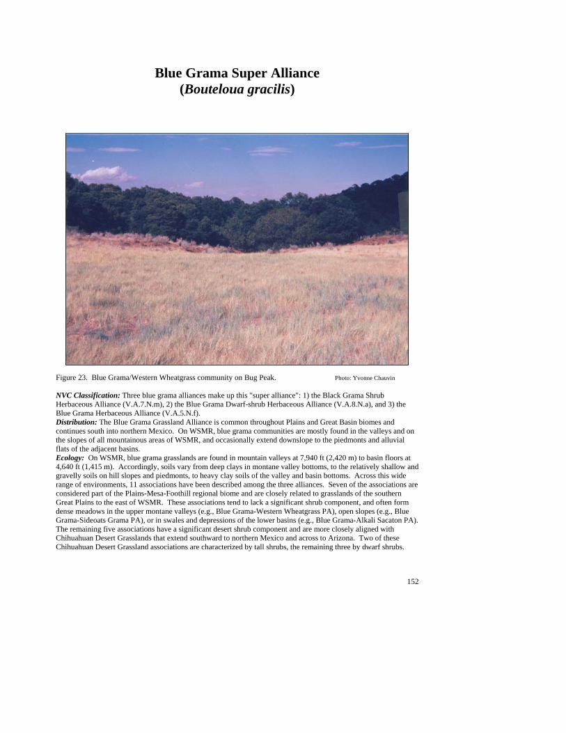
152
Blue Grama Super Alliance (Bouteloua gracilis)
Figure 23. Blue Grama/Western Wheatgrass community on Bug Peak. Photo: Yvonne Chauvin NVC Classification: Three blue grama alliances make up this "super alliance": 1) the Black Grama Shrub Herbaceous Alliance (V.A.7.N.m), 2) the Blue Grama Dwarf-shrub Herbaceous Alliance (V.A.8.N.a), and 3) the Blue Grama Herbaceous Alliance (V.A.5.N.f). Distribution: The Blue Grama Grassland Alliance is common throughout Plains and Great Basin biomes and continues south into northern Mexico. On WSMR, blue grama communities are mostly found in the valleys and on the slopes of all mountainous areas of WSMR, and occasionally extend downslope to the piedmonts and alluvial flats of the adjacent basins. Ecology: On WSMR, blue grama grasslands are found in mountain valleys at 7,940 ft (2,420 m) to basin floors at 4,640 ft (1,415 m). Accordingly, soils vary from deep clays in montane valley bottoms, to the relatively shallow and gravelly soils on hill slopes and piedmonts, to heavy clay soils of the valley and basin bottoms. Across this wide range of environments, 11 associations have been described among the three alliances. Seven of the associations are considered part of the Plains-Mesa-Foothill regional biome and are closely related to grasslands of the southern Great Plains to the east of WSMR. These associations tend to lack a significant shrub component, and often form dense meadows in the upper montane valleys (e.g., Blue Grama-Western Wheatgrass PA), open slopes (e.g., Blue Grama-Sideoats Grama PA), or in swales and depressions of the lower basins (e.g., Blue Grama-Alkali Sacaton PA). The remaining five associations have a significant desert shrub component and are more closely aligned with Chihuahuan Desert Grasslands that extend southward to northern Mexico and across to Arizona. Two of these Chihuahuan Desert Grassland associations are characterized by tall shrubs, the remaining three by dwarf shrubs.

153
Most of these communities are found on hillslopes or piedmonts (E.G. Blue Grama/Banana Yucca PA), and occasionally on sandy plains (e.g., Blue Grama/Soaptree Yucca PA) . Key to the Blue Grama (Bouteloua gracilis) Plant Associations: 1. Alkali sacaton (Sporobolus airoides) common to well represented as subdominant or codominant grass ......................................................................................................................................Blue Grama/Alkali Sacaton PA 1. Alkali sacaton poorly represented to absent ......................................................................................................2 2. Western wheatgrass (Pascopyrum smithii) well represented as subdominant to dominant grass..........................................................................................................................................Blue Grama/Western Wheatgrass PA 2. Western wheatgrass poorly represented to absent .............................................................................................3 3. Winterfat (Krascheninnikovia lanata) common to well represented as dominant or codominant shrub...................................................................................................................Blue Grama/Winterfat PA (See Minor Types) 3. Winterfat poorly represented to absent ..............................................................................................................4 4. Bigelow’s sagebrush (Artemisia bigelovii) well represented as dominant shrub.................................................................................................................................... Blue Grama/Bigelow’s Sagebrush PA (See Minor Types) 4. Bigelow’s sagebrush poorly represented to absent ............................................................................................5 5. Banana yucca (Yucca baccata) common as dominant or codominant shrub .....................................................................................................................................................Blue Grama/Banana Yucca PA (See Minor Types) 5. Banana yucca uncommon to absent...................................................................................................................6 6. Soaptree yucca (Yucca elata) present as dominant or codominant shrub ........................................................................................................................................................Blue Grama/Soaptree Yucca PA (See Minor Types) 6. Soaptree yucca uncommon to absent.................................................................................................................7 7. New Mexico muhly (Muhlenbergia pauciflora) well represented as codominant grass .......................................................................................................................... Blue Grama/New Mexico Muhly PA (See Minor Types) 7. New Mexico muhly poorly represented to absent .............................................................................................8 8. Cane bluestem (Bothriochloa barbinodis) well represented as dominant or codominant grass ....................................................................................................................... Blue Grama/Cane bluestem PA (See Minor Types) 8. Cane bluestem poorly represented to absent......................................................................................................9 9. Sideoats grama (Bouteloua curtipendula) common to well represented as subdominant or codominant grass ............................................................................................................................ Blue Grama/Sideoats Grama PA 9. Sideoats grama poorly represented to absent...................................................................................................10 10. Burrograss (Scleropogon brevifolius) present as subdominant grass ................................................................................................................................................................... Blue Grama/Burrograss PA (See Minor Types) 10. Blue Grama (Bouteloua gracilis) luxuriant, with other species poorly represented to absent.................................................................................................................... Blue Grama/Monotypic Stand PA (See Minor Types)
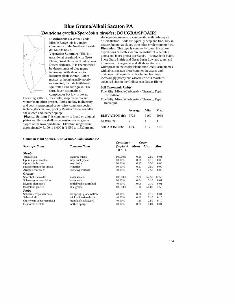
154
Blue Grama/Alkali Sacaton PA (Bouteloua gracilis/Sporobolus airoides; BOUGRA/SPOAIR)
Distribution: On White Sands Missile Range this is a major community of the Northern Jornada del Muerto basin. Vegetation Summary: This is a transitional grassland, with Great Plains, Great Basin and Chihuahuan Desert elements. It is characterized by dense stands of blue grama intermixed with abundant to luxuriant alkali sacaton. Other grasses, although usually poorly represented, include bottlebrush squirreltail and burrograss. The shrub layer is sometimes conspicuous but low in cover.
Fourwing saltbush, tree cholla, soaptree yucca and winterfat are often present. Forbs are low in diversity and poorly represented cover-wise; common species include globemallow, prickly Russian thistle, roundleaf snakeweed and toothed spurge. Physical Setting: This community is found on alluvial plains and flats in shallow depressions or on gentle slopes of the lower piedmont. Elevation ranges from approximately 5,100 to 6,000 ft (1,550 to 1,830 m) and
slope grades are mostly very gentle, with little aspect differentiation. Soils are typically deep and fine, silty in texture, but not as clayey as in other swale communities. Discussion: This type is commonly found in shallow depressions or swales within the matrix of other blue grama and black grama grasslands. It shows both Plains Short Grass Prairie and Great Basin Lowland grassland influences. Blue grama and alkali sacaton are widespread in the cooler Plains and Great Basin biomes, with alkali sacaton more common in swales and drainages. Blue grama’s distribution becomes increasingly patchy and associated with moisture-enhanced sites in the Chihuahuan Desert Biome.
Soil Taxonomic Unit(s): Fine Silty, Mixed (Carbonatic), Thermic, Typic
Torriorthent Fine Silty, Mixed (Carbonatic), Thermic, Typic
Haplargid Average Min Max ELEVATION (ft): 5725 5160 5938 SLOPE %: 2 1 4 SOLAR INDEX: 1.74 1.12 2.00
Common Plant Species, Blue Grama/Alkali Sacaton PA: Constancy Cover Scientific Name Common Name (% plots) Mean Max Min n = 5 Shrubs Yucca elata soaptree yucca 100.00% 0.55 2.50 0.01 Opuntia phaeacantha tulip pricklypear 60.00% 0.08 0.10 0.05 Opuntia imbricata tree cholla 80.00% 0.15 0.50 0.00 Krascheninnikovia lanata winterfat 60.00% 0.17 0.50 0.00 Atriplex canescens fourwing saltbush 80.00% 2.50 7.50 0.00 Grasses Sporobolus airoides alkali sacaton 100.00% 37.80 62.50 17.50 Scleropogon brevifolius burrograss 60.00% 0.04 0.10 0.01 Elymus elymoides bottlebrush squirreltail 40.00% 0.06 0.10 0.01 Bouteloua gracilis blue grama 100.00% 31.10 50.00 7.50 Forbs Sphaeralcea polychroma hot springs globemallow 40.00% 0.06 0.10 0.01 Salsola kali prickly Russian thistle 40.00% 0.10 0.10 0.10 Gutierrezia sphaerocephala roundleaf snakeweed 40.00% 1.30 2.50 0.10 Euphorbia dentata toothed spurge 40.00% 0.01 0.01 0.01
##
#
##
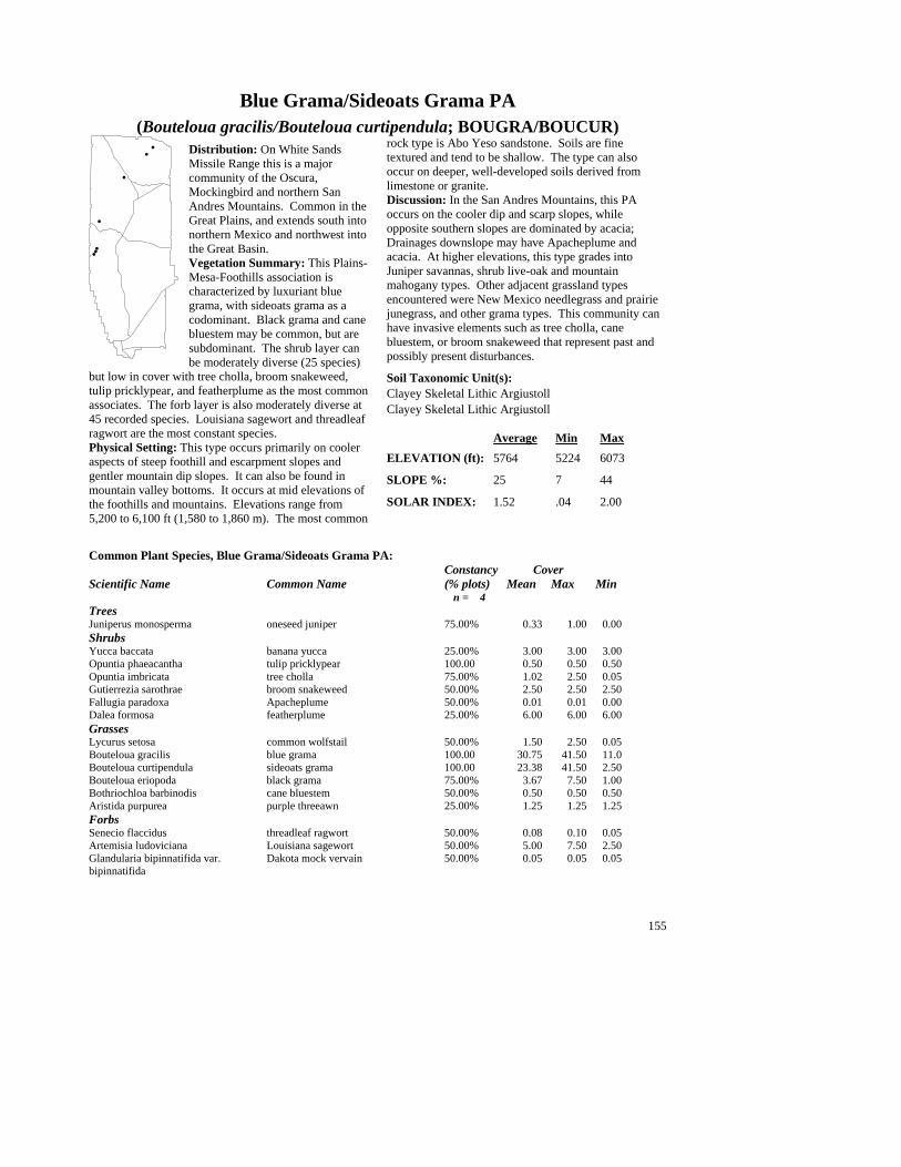
155
Blue Grama/Sideoats Grama PA (Bouteloua gracilis/Bouteloua curtipendula; BOUGRA/BOUCUR)
Distribution: On White Sands Missile Range this is a major community of the Oscura, Mockingbird and northern San Andres Mountains. Common in the Great Plains, and extends south into northern Mexico and northwest into the Great Basin. Vegetation Summary: This Plains-Mesa-Foothills association is characterized by luxuriant blue grama, with sideoats grama as a codominant. Black grama and cane bluestem may be common, but are subdominant. The shrub layer can be moderately diverse (25 species)
but low in cover with tree cholla, broom snakeweed, tulip pricklypear, and featherplume as the most common associates. The forb layer is also moderately diverse at 45 recorded species. Louisiana sagewort and threadleaf ragwort are the most constant species. Physical Setting: This type occurs primarily on cooler aspects of steep foothill and escarpment slopes and gentler mountain dip slopes. It can also be found in mountain valley bottoms. It occurs at mid elevations of the foothills and mountains. Elevations range from 5,200 to 6,100 ft (1,580 to 1,860 m). The most common
rock type is Abo Yeso sandstone. Soils are fine textured and tend to be shallow. The type can also occur on deeper, well-developed soils derived from limestone or granite. Discussion: In the San Andres Mountains, this PA occurs on the cooler dip and scarp slopes, while opposite southern slopes are dominated by acacia; Drainages downslope may have Apacheplume and acacia. At higher elevations, this type grades into Juniper savannas, shrub live-oak and mountain mahogany types. Other adjacent grassland types encountered were New Mexico needlegrass and prairie junegrass, and other grama types. This community can have invasive elements such as tree cholla, cane bluestem, or broom snakeweed that represent past and possibly present disturbances.
Soil Taxonomic Unit(s): Clayey Skeletal Lithic Argiustoll Clayey Skeletal Lithic Argiustoll Average Min Max ELEVATION (ft): 5764 5224 6073 SLOPE %: 25 7 44 SOLAR INDEX: 1.52 .04 2.00
Common Plant Species, Blue Grama/Sideoats Grama PA: Constancy Cover Scientific Name Common Name (% plots) Mean Max Min n = 4 Trees Juniperus monosperma oneseed juniper 75.00% 0.33 1.00 0.00 Shrubs Yucca baccata banana yucca 25.00% 3.00 3.00 3.00 Opuntia phaeacantha tulip pricklypear 100.00 0.50 0.50 0.50 Opuntia imbricata tree cholla 75.00% 1.02 2.50 0.05 Gutierrezia sarothrae broom snakeweed 50.00% 2.50 2.50 2.50 Fallugia paradoxa Apacheplume 50.00% 0.01 0.01 0.00 Dalea formosa featherplume 25.00% 6.00 6.00 6.00 Grasses Lycurus setosa common wolfstail 50.00% 1.50 2.50 0.05 Bouteloua gracilis blue grama 100.00 30.75 41.50 11.0 Bouteloua curtipendula sideoats grama 100.00 23.38 41.50 2.50 Bouteloua eriopoda black grama 75.00% 3.67 7.50 1.00 Bothriochloa barbinodis cane bluestem 50.00% 0.50 0.50 0.50 Aristida purpurea purple threeawn 25.00% 1.25 1.25 1.25 Forbs Senecio flaccidus threadleaf ragwort 50.00% 0.08 0.10 0.05 Artemisia ludoviciana Louisiana sagewort 50.00% 5.00 7.50 2.50 Glandularia bipinnatifida var. Dakota mock vervain 50.00% 0.05 0.05 0.05 bipinnatifida
##
#
#
#
#
#
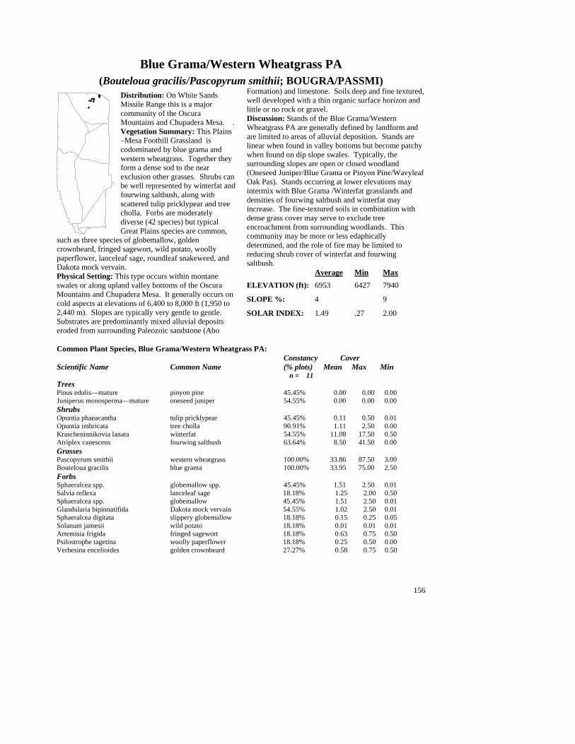
156
Blue Grama/Western Wheatgrass PA (Bouteloua gracilis/Pascopyrum smithii; BOUGRA/PASSMI)
Distribution: On White Sands Missile Range this is a major community of the Oscura Mountains and Chupadera Mesa. . Vegetation Summary: This Plains –Mesa Foothill Grassland is codominated by blue grama and western wheatgrass. Together they form a dense sod to the near exclusion other grasses. Shrubs can be well represented by winterfat and fourwing saltbush, along with scattered tulip pricklypear and tree cholla. Forbs are moderately diverse (42 species) but typical Great Plains species are common,
such as three species of globemallow, golden crownbeard, fringed sagewort, wild potato, woolly paperflower, lanceleaf sage, roundleaf snakeweed, and Dakota mock vervain. Physical Setting: This type occurs within montane swales or along upland valley bottoms of the Oscura Mountains and Chupadera Mesa. It generally occurs on cold aspects at elevations of 6,400 to 8,000 ft (1,950 to 2,440 m). Slopes are typically very gentle to gentle. Substrates are predominantly mixed alluvial deposits eroded from surrounding Paleozoic sandstone (Abo
Formation) and limestone. Soils deep and fine textured, well developed with a thin organic surface horizon and little or no rock or gravel. Discussion: Stands of the Blue Grama/Western Wheatgrass PA are generally defined by landform and are limited to areas of alluvial deposition. Stands are linear when found in valley bottoms but become patchy when found on dip slope swales. Typically, the surrounding slopes are open or closed woodland (Oneseed Juniper/Blue Grama or Pinyon Pine/Wavyleaf Oak Pas). Stands occurring at lower elevations may intermix with Blue Grama /Winterfat grasslands and densities of fourwing saltbush and winterfat may increase. The fine-textured soils in combination with dense grass cover may serve to exclude tree encroachment from surrounding woodlands. This community may be more or less edaphically determined, and the role of fire may be limited to reducing shrub cover of winterfat and fourwing saltbush. Average Min Max ELEVATION (ft): 6953 6427 7940 SLOPE %: 4 9 SOLAR INDEX: 1.49 .27 2.00
Common Plant Species, Blue Grama/Western Wheatgrass PA: Constancy Cover Scientific Name Common Name (% plots) Mean Max Min n = 11 Trees Pinus edulis—mature pinyon pine 45.45% 0.00 0.00 0.00 Juniperus monosperma—mature oneseed juniper 54.55% 0.00 0.00 0.00 Shrubs Opuntia phaeacantha tulip pricklypear 45.45% 0.11 0.50 0.01 Opuntia imbricata tree cholla 90.91% 1.11 2.50 0.00 Krascheninnikovia lanata winterfat 54.55% 11.08 17.50 0.50 Atriplex canescens fourwing saltbush 63.64% 8.50 41.50 0.00 Grasses Pascopyrum smithii western wheatgrass 100.00% 33.86 87.50 3.00 Bouteloua gracilis blue grama 100.00% 33.95 75.00 2.50 Forbs Sphaeralcea spp. globemallow spp. 45.45% 1.51 2.50 0.01 Salvia reflexa lanceleaf sage 18.18% 1.25 2.00 0.50 Sphaeralcea spp. globemallow 45.45% 1.51 2.50 0.01 Glandularia bipinnatifida Dakota mock vervain 54.55% 1.02 2.50 0.01 Sphaeralcea digitata slippery globemallow 18.18% 0.15 0.25 0.05 Solanum jamesii wild potato 18.18% 0.01 0.01 0.01 Artemisia frigida fringed sagewort 18.18% 0.63 0.75 0.50 Psilostrophe tagetina woolly paperflower 18.18% 0.25 0.50 0.00 Verbesina encelioides golden crownbeard 27.27% 0.58 0.75 0.50
##
#
###
#
#
###

157
Minor Plant Associations: Blue Grama Alliance
Blue Grama/Banana Yucca PA (Bouteloua gracilis/Yucca baccata; BOUGRA/YUCBAC)
On White Sands Missile Range this minor plant association is known from hillslopes of the Oscura and San Andres Mountains at elevations that range from 5,540 ft (1,690 m) to 7,525 ft (2,290 m). Blue grama is the clear dominant, with other grasses poorly represented. Scattered banana yuccas are diagnostic. Blue Grama/Bigelow’s Sagebrush PA (Bouteloua gracilis/Artemisia bigelovii; BOUGRA/ARTBIG)
On White Sands Missile Range this provisional and minor plant association is known from only from the Oscura Mountains at an elevation around 6,000 ft (1,830 m). Blue grama dominates with sideoats grama and New Mexico needlegrass as common associates. Bigelow's sagebrush is a dwarf shrub that is scattered throughout the stands. Blue Grama/Burrograss PA (Bouteloua gracilis/Scleropogon brevifolius; BOUGRA/SCLBRE)
This provisional plant association is a minor type on White Sands Missile Range and is known only from the northern Jornada del Muerto basin at an elevation of 4,640 (1,415 m). Occurs in swales of rolling sandy plains. Blue Grama/Cane bluestem PA (Bouteloua gracilis/Bothriochloa barbinodis; BOUGRA/BOTBAR)
On White Sands Missile Range this provisional and minor plant association is known from only one occurrence in the San Augustine Mountains at 5,560 ft (1,700 m). Blue grama and cane bluestem are abundant and codominate on gravel soils. Blue Grama/New Mexico Muhly PA (Bouteloua gracilis/Muhlenbergia pauciflora; BOUGRA/MUHPAU)
On White Sands Missile Range this provisional and minor plant association is known from only one occurrence in the Chalk Hills of the northern San Andres Mountains at an elevation of 7,600 ft (2,290 m). Blue gamma and New Mexico muhly are codominants of this Plains-Mesa-Foothill Grassland. Shrubs are insignificant. Blue Grama/Soaptree Yucca PA (Bouteloua gracilis/Yucca elata; BOUGRA/YUCELA)\
On White Sands Missile Range this minor plant association is known from the Mockingbird Mountains and the central San Andres Mountains at elevations of 5,700 to 5,650 ft (1,740 to 1,720 m). It occurs on alluvial fans with fine gravel substrates or sandsheet deposits. Blue grama is the clear dominant grass and scattered soaptree yuccas are diagnostic. Blue Grama/Winterfat PA (Bouteloua gracilis/Krascheninnikovia lanata; BOUGRA/YUCELA)
On White Sands Missile Range this minor plant association is known from twelve occurrences, nine in the Oscura Mountains and three in the San Andres Mountains at elevations of 5,360 to 6,820 ft (1,630 to 2,080 m). Blue Grama is abundant to luxuriant and the clear dominant, while the remaining 20 grass species recorded for the type tend to be poorly represented. Winterfat is diagnostic and can be well-represented to luxuriant in cover. Fourwing saltbush (Atriplex canescens) and tree cholla (Opuntia imbricata) are common associates. Forbs are diverse (44 species) but highly variable; mock vervain (Glandularia bipinnatifida) is the most constant. This type is closely related to the Blue Grama/Western Wheatgrass PA that occurs in similar mountain valley bottom habitats. Blue Grama/Monotypic Stand PA (Bouteloua gracilis/Monotype; BOUGRA/MONTYP)
On White Sands Missile Range this minor plant association is known from two occurrences in the Oscura Mountains 6,900 to 7,550 ft (2,100 to 2,300 m). Blue grama dominates to the near exclusion of other grasses and forbs and forms dense, monotypic stands within montane valley bottoms (with the exception of common wolfstail [Lycurus phleoides] that can be well represented). This PA is similar to the Blue Grama/Western Wheatgrass PA and is found in similar habitats.
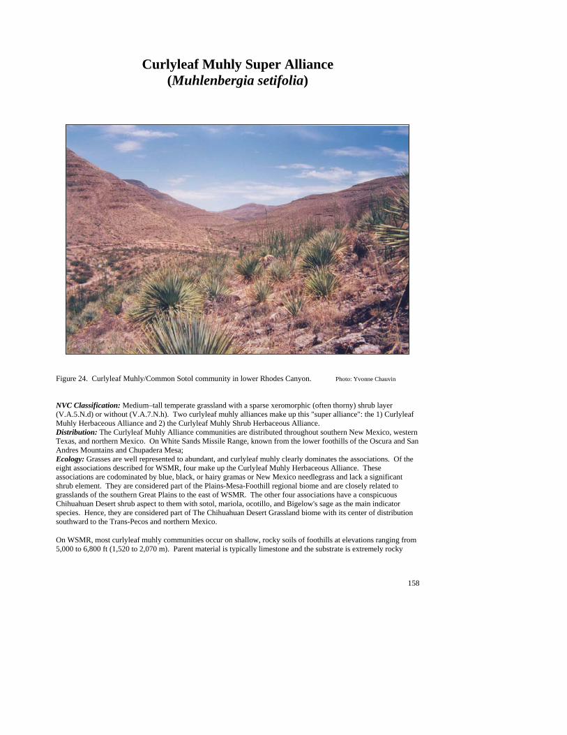
158
Curlyleaf Muhly Super Alliance (Muhlenbergia setifolia)
Figure 24. Curlyleaf Muhly/Common Sotol community in lower Rhodes Canyon. Photo: Yvonne Chauvin NVC Classification: Medium–tall temperate grassland with a sparse xeromorphic (often thorny) shrub layer (V.A.5.N.d) or without (V.A.7.N.h). Two curlyleaf muhly alliances make up this "super alliance": the 1) Curlyleaf Muhly Herbaceous Alliance and 2) the Curlyleaf Muhly Shrub Herbaceous Alliance. Distribution: The Curlyleaf Muhly Alliance communities are distributed throughout southern New Mexico, western Texas, and northern Mexico. On White Sands Missile Range, known from the lower foothills of the Oscura and San Andres Mountains and Chupadera Mesa; Ecology: Grasses are well represented to abundant, and curlyleaf muhly clearly dominates the associations. Of the eight associations described for WSMR, four make up the Curlyleaf Muhly Herbaceous Alliance. These associations are codominated by blue, black, or hairy gramas or New Mexico needlegrass and lack a significant shrub element. They are considered part of the Plains-Mesa-Foothill regional biome and are closely related to grasslands of the southern Great Plains to the east of WSMR. The other four associations have a conspicuous Chihuahuan Desert shrub aspect to them with sotol, mariola, ocotillo, and Bigelow's sage as the main indicator species. Hence, they are considered part of The Chihuahuan Desert Grassland biome with its center of distribution southward to the Trans-Pecos and northern Mexico. On WSMR, most curlyleaf muhly communities occur on shallow, rocky soils of foothills at elevations ranging from 5,000 to 6,800 ft (1,520 to 2,070 m). Parent material is typically limestone and the substrate is extremely rocky

159
(average 80% combined rock and gravel cover). Soils are rocky-skeletal loams and may be silty or clayey. Aspects are variable, but tend to be moderate to cool, on moderate to steep slopes. Curlyleaf muhly is known for its affinity for shallow soils (Correll and Johnston 1979; Powell 1994), hence the distribution of communities on the escarpments and foothills. At higher elevations, curlyleaf muhly is often associated with oneseed juniper and pinyon pine woodlands of rocky shallow slopes. Curlyleaf Alliances have not been previously described, and five of the eight PAs are still considered provisional at this time. On WSMR, only the Curlyleaf Muhly/Sotal is considered a major type. Key to the Curlyleaf Muhly (Muhlenbergia setifolia) Plant Associations: 1. New Mexico needlegrass (Stipa neomexicana) common to well represented as subdominant or codominant ......................................................................................................................................................................... grass......................................................................Curlyleaf Muhly/New Mexico Needlegrass PA (see Minor Types) 1. New Mexico needlegrass poorly represented to absent .....................................................................................2 2. Hairy grama (Bouteloua hirsuta) common to well represented as subdominant or codominant grass.........................................................................................................Curlyleaf Muhly/Hairy Grama PA (see Minor Types) 2. Hairy grama poorly represented to absent .........................................................................................................3 3. Black grama (Bouteloua eriopoda) common to well represented as subdominant or codominant grass......................................................................................................Curlyleaf Muhly/Black Grama PA (see Minor Types) 3. Black grama poorly represented to absent .........................................................................................................4 4. Blue grama (Bouteloua gracilis) common to well represented as subdominant or codominant grass ...........................................................................................................Curlyleaf Muhly/Blue Grama PA (see Minor Types) 4. Blue grama poorly represented to absent...........................................................................................................5 5. Common sotol (Dasylirion wheeleri) common to well represented as dominant or codominant shrub ...................................................................................................................................Curlyleaf Muhly/Common Sotol PA 5. Common sotol poorly represented to absent......................................................................................................6 6. Ocotillo (Fouquieria splendens) common to well represented as dominant or codominant shrub........................................................................................................................ Curlyleaf Muhly/Ocotillo PA (see Minor Types) 6. Ocotillo poorly represented to absent ................................................................................................................7 7. Mariola (Parthenium incanum) common to well represented as dominant shrub .................................................................................................................................................Curlyleaf Muhly/Mariola PA (see Minor Types) 7. Bigelow’s sagebrush (Artemisia bigelovii) common to well represented as dominant or codominant shrub.................................................................................. Curlyleaf Muhly/Bigelow’s Sagebrush PA (see Minor Types)
Curlyleaf Muhly/Common Sotol PA (Muhlenbergia setifolia/Dasylirion wheeleri; MUHSET/DASWHE)
Distribution: On White Sands Missile Range this is a major community of the San Andres Mountains, with the majority of known occurrences in the Rhodes Canyon area. Vegetation Summary: This Chihuahuan Desert Grassland is characterized by a grass layer dominated by curlyleaf muhly, with common sotol as a conspicuous and
diagnostic shrub element. Shrub diversity is moderate (23 species) with ocotillo, featherplume, mariola, tulip pricklypear, broom snakeweed, and skeletonleaf goldeneye common associates. Sideoats grama and plains lovegrass are typical associates and occasionally codominate. The forb layer is also moderately diverse (36 species). Louisiana sage, the most common associate, grows near or under shrub canopies. Conversely, rose bladderpod, broom milkwort, Cochise scaly cloakfern, and hairyseed bahia are generally scattered and tend to grow in between the shrubs.
###
#
##
160
Physical Setting: This type generally occurs on moderately steep to very steep colluvial slopes at elevations from 5,000 to 5,800 ft (1,520 to 1,770 m). Substrates are generally limestone. Between the vegetation, ground surfaces are covered with rock and gravel with little exposed soil. Soils are shallow and well drained, ranging in texture from silty clay loam to fine silty. Discussion: Stands of the community are generally patchy. They are often bounded by rock outcrops of substantial size. Lower slopes generally give way to Chihuahuan shrubland (Creosotebush/Black Grama or arroyo riparian PAs) or other desert grasslands (Black Grama/Mariola, and Black Grama/Skeleton Goldeneye PAs). Areas upslope or on cooler aspects generally grade into shrub live oak or mountain mahogany associations, or montane grassland (New Mexico
Needlegrass/Sideoats Grama or Hairy Grama/Black Grama PAs). This foothill grasslands carry fire well, often producing a fire hot enough to kill a substantial portion of the shrubs present. Fire may be partly responsible for the dominance of curlyleaf muhly in these associations. Soil Taxonomic Unit(s): Clayey Skeletal Lithic Calciustoll Clayey Skeletal Lithic Calciustoll Fine Silty, Carbonatic, Thermic Pachic Argiustolls Average Min Max ELEVATION 5300 5020 5736 SLOPE 35 7 61
Common Plant Species¸ Curlyleaf Muhly/Common Sotol PA : Constancy Cover Scientific Name Common Name (% plots) Mean Max Min n = 7 Trees Juniperus monosperma oneseed juniper 57.14% 0.63 2.50 0.00 Shrubs Gutierrezia sarothrae broom snakeweed 85.71% 0.35 0.50 0.05 Cercocarpus montanus true mountain mahogany 71.43% 0.12 0.50 0.00 Dalea formosa featherplume 85.71% 2.42 7.50 0.50 Dasylirion wheeleri common sotol 100.00 14.14 41.50 2.50 Fouquieria splendens ocotillo 71.43% 8.50 17.50 2.50 Viguiera stenoloba skeletonleaf goldeneye 71.43% 1.21 2.50 0.05 Opuntia phaeacantha tulip pricklypear 85.71% 1.02 2.50 0.05 Parthenium incanum mariola 85.71% 1.60 7.50 0.05 Fallugia paradoxa Apacheplume 57.14% 0.04 0.05 0.01 Grasses Muhlenbergia setifolia curlyleaf muhly 100.00 10.36 17.50 2.50 Aristida purpurea purple threeawn 71.43% 2.10 2.50 0.50 Eragrostis intermedia plains lovegrass 71.43% 3.72 15.00 0.10 Bouteloua curtipendula sideoats grama 100.00 4.00 15.00 0.50 Forbs Lesquerella purpurea rose bladderpod 57.14% 0.04 0.05 0.01 Polygala scoparioides broom milkwort 57.14% 0.05 0.05 0.05 Artemisia ludoviciana Louisiana sagewort 57.14% 0.65 2.50 0.01
Minor Plant Associations: Curlyleaf Muhly Alliance Curlyleaf Muhly/Bigelow’s Sagebrush PA (Muhlenbergia setifolia/Artemisia bigelovii; MUHSET/ARTBIG)
On White Sands Missile Range this community is known from one occurrence in the Oscura Mountains. It occurs on a moderate, north-facing slope on limestone substrate at 5,475 ft (1,670 m). Overall grass cover is low and seldom exceeds 10%, but curlyleaf muhly is the clear dominant. Bigelow's sagebrush is the dwarf shrub indicator species, but sacahuista (Nolina microcarpa) is also codominant.

161
Curlyleaf Muhly/Black Grama PA (Muhlenbergia setifolia/Bouteloua eriopoda; MUHSET/BOUERI) On White Sands Missile Range this Plains-Mesa Foothill community is known from one occurrence in the San Andres Mountains. It occurs on a moderately steep, north-facing slope on limestone substrate at 5,620 ft (1,713 m). Curlyleaf muhly and black grama are well represented and codominate the grass layer. Shrubs are nominal with the dwarf shrubs broom snakeweed (Gutierrezia sarothrae) and pricklyleaf dogweed (Thymophylla acerosa) the most common. Curlyleaf Muhly/Blue Grama PA (Muhlenbergia setifolia/Bouteloua gracilis; MUHSET/BOUGRA) On White Sands Missile Range this Plains-Mesa-Foothill community is known from two occurrences, one in the Oscura Mountains and one in the San Andres Mountains. It occurs on moderately steep to steep slopes on limestone substrates at elevations of 5,490 to 5,540 ft (1,670 to 1,689 m). Curlyleaf muhly and blue grama are well represented to abundant and codominate. Shrubs are generally poorly represented but winterfat (Krascheninnikovia lanata), mariola (Parthenium incanum), banana yucca (Yucca baccata), or featherplume (Dalea formosa) can be common. Curlyleaf Muhly/Hairy Grama PA (Muhlenbergia setifolia/Bouteloua hirsuta; MUHSET/BOUHIR) On White Sands Missile Range this Plains-Mesa-Foothill community is known from two occurrences, one in the Oscura Mountains and one in the Chalk Hills. It occurs on moderately steep to steep slopes on limestone substrates at elevations of 5,500 to 5,860 ft (1,680 to 1,786 m). Curlyleaf muhly and hairy grama are well represented and codominate. Blue and hairy grama can also be common to well represented, but clearly subordinate. Shrubs are nominal with the dwarf shrubs broom snakeweed (Gutierrezia sarothrae) and featherplume (Dalea formosa) the most common. Curlyleaf Muhly/Mariola PA (Muhlenbergia setifolia/Parthenium incanum; MUHSET/PARINC)
On White Sands Missile Range this Chihuahuan Desert Grassland community is known only in the San Andres Mountains. It occurs on moderately steep to steep slopes on limestone substrates at elevations of 5,220 to 6,450 ft (1,591 to 1,965 m). Curlyleaf muhly is well represented and the clear dominant; other grasses are scattered. Well represented mariola is diagnostic in the shrub layer. Curlyleaf Muhly/New Mexico Needlegrass PA (Muhlenbergia setifolia/Stipa neomexicana; MUHSET/STINEO)
This Plains-Mesa-Foothill association is known only from the central San Andres Mountains on White Sands Missile Range. Slopes are steep, soils are loams, and rock cover is high (40%). Curlyleaf muhly is well represented to abundant and dominates with New Mexico needlegrass as a common to well represented diagnostic associate. Shrub cover is moderately diverse (24 species), but seldom exceeds 5% cover. Curlyleaf Muhly/Ocotillo PA (Muhlenbergia setifolia/Fouquieria splendens; MUHSET/FOUSPL)
This type is known from a single stand in the Oscura Mountains. It occurs on a hot aspect of a moderately graded backslope, with shallow rocky soils at 5,479 ft (1,670 m). Curlyleaf muhly is well represented and ocotillo is common. Mariola (Parthenium incanum) and sideoats grama (Bouteloua curtipendula) are also present.
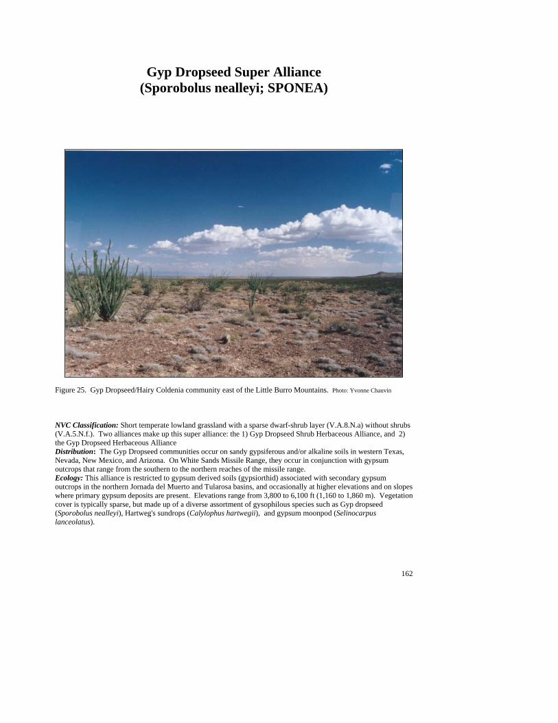
162
Gyp Dropseed Super Alliance (Sporobolus nealleyi; SPONEA)
Figure 25. Gyp Dropseed/Hairy Coldenia community east of the Little Burro Mountains. Photo: Yvonne Chauvin NVC Classification: Short temperate lowland grassland with a sparse dwarf-shrub layer (V.A.8.N.a) without shrubs (V.A.5.N.f.). Two alliances make up this super alliance: the 1) Gyp Dropseed Shrub Herbaceous Alliance, and 2) the Gyp Dropseed Herbaceous Alliance Distribution: The Gyp Dropseed communities occur on sandy gypsiferous and/or alkaline soils in western Texas, Nevada, New Mexico, and Arizona. On White Sands Missile Range, they occur in conjunction with gypsum outcrops that range from the southern to the northern reaches of the missile range. Ecology: This alliance is restricted to gypsum derived soils (gypsiorthid) associated with secondary gypsum outcrops in the northern Jornada del Muerto and Tularosa basins, and occasionally at higher elevations and on slopes where primary gypsum deposits are present. Elevations range from 3,800 to 6,100 ft (1,160 to 1,860 m). Vegetation cover is typically sparse, but made up of a diverse assortment of gysophilous species such as Gyp dropseed (Sporobolus nealleyi), Hartweg's sundrops (Calylophus hartwegii), and gypsum moonpod (Selinocarpus lanceolatus).
163
Key to the Gyp Dropseed (Sporobolus nealleyi) Plant Associations: 1. Hairy coldenia (Tiquilia hispidissima) common to well represented as dominant or codominant shrub ....................................................................................................................................Gyp Dropseed/Hairy Coldenia PA 1. Hairy coldenia poorly represented to absent......................................................................................................2 2. Torrey’s jointfir (Ephedra torreyana) common to well represented as dominant or codominant shrub ................................................................................................... Gyp Dropseed/Torrey’s Jointfir PA (See Minor Types) 2. Alkali sacaton (Sporobolus airoides) common to well represented as subdominant or codominant grass, with black cryptogamic crusts common. .................................. Gyp Dropseed/Alkali Sacaton PA (See Minor Types)
Gyp Dropseed/Hairy Coldenia PA (Sporobolus nealleyi/Tiquilia hispidissima; SPONEA/TIQHIS)
Distribution: On White Sands Missile Range this is a major community on gypsum outcrops that extend from the northern to the southern reaches of the missile range. Vegetation Summary: This gypsiferous grassland is characterized by well represented to abundant gyp dropseed in association with the dwarf shrub hairy coldenia. Among the other 28 shrubs recorded, Torrey’s jointfir and fourwing saltbush are the most prevalent and abundant. Grass diversity is relatively low (15
species) and, other than the gyp dropseed, poorly represented. Forb diversity is low (15 species), but gypsophilous species are common such as gyp moonpod and Hartweg's sundrops (Calylophus hartwegii). Physical Setting: This association occurs on gypsum outcrops over a range of elevations (3,800 to 6,100 ft; 1,160 to 1,860 m). However, most stands occur at elevations below 5,000 ft (1,520 m) adjacent to or in
basin bottom alluvial flats. It is found less frequently on upland hillslope gypsum outcrops. Discussion: This plant association is indicative of calcified gypsic soils, often recemented with moderate caliche development in upper horizons and containing softer sand or loamy sand in middle and lower horizons. These gypsiorthid soils appear to be the dominant factor governing the occurrence of this association, since this community can be found on a variety of landforms and slopes. Soil Taxonomic Unit(s):
Coarse Loamy Mixed (Gypsic) Thermic Shallow Petrogypsic Gypsiorthids
Coarse Loamy, Gypsic, Thermic Calcic Gypsiorthids Sandy, Mixed (Calcareous), Thermic Typic
Gypsiorthid
Average Min Max ELEVATION 4618 3881 6099 SLOPE 4 36 SOLAR INDEX: .76 .03 2.00
Common Plant Species, Gyp Dropseed/Hairy Coldenia PA: Constancy Cover Scientific Name Common Name (% plots) Mean Max Min n = 13 Shrubs Tiquilia hispidissima hairy coldenia 100.00 11.38 17.50 2.50 Opuntia clavata club cholla 30.77% 1.00 2.50 0.50 Larrea tridentata creosotebush 30.77% 0.88 3.00 0.00 Gutierrezia sarothrae broom snakeweed 30.77% 1.50 2.50 0.50 Ephedra torreyana Torrey’s jointfir 92.31% 1.79 7.50 0.00 Atriplex canescens fourwing saltbush 76.92% 0.66 2.50 0.00
#
#
#
#
#
#
#
#
#
#
#
##
#
#
###
#

164
Common Plant Species, Gyp Dropseed/Hairy Coldenia PA (Continued): Grasses Sporobolus nealleyi gyp dropseed 100.00 5.92 17.50 0.50 Sporobolus airoides alkali sacaton 38.46% 1.01 2.50 0.00 Forbs Selinocarpus lanceolatus gypsum moonpod 61.54% 0.88 2.50 0.01 Lepidium montanum mountain pepperweed 46.15% 0.26 0.50 0.01
Minor Plant Associations: Gyp Dropseed Alliance
Gyp Dropseed/Alkali Sacaton PA (Sporobolus nealleyi/Sporobolus airoides; SPONEA/SPOAIR)
On White Sands Missile Range this minor plant association is known from four occurrences, one in the Tularosa basin at 3,875 ft (1,181 m) and three in the northern Jornada del Muerto basin at around 4,730 ft (1,440 m). Gyp dropseed and alkali sacaton are well represented to abundant and codominate small gypsum outcrops with basin floor alluvial flats. Gyp Dropseed/Torrey’s Jointfir PA (Sporobolus nealleyi/Ephedra torreyana; SPONEA/EPHTOR)
On White Sands Missile Range this minor plant association is known from only two occurrences, one in the northern Jornada del Muerto basin at 4,610 ft (1,400 m), and the other in the Tularosa basin at 4,050 ft (1,230 m). This association is dominated by gyp dropseed, with alkali sacaton as a common associate. Hence, it is very similar to the Gyp Dropseed/Alkali Sacaton PA but with a little more shrub cover dominated by Torrey's jointfir.
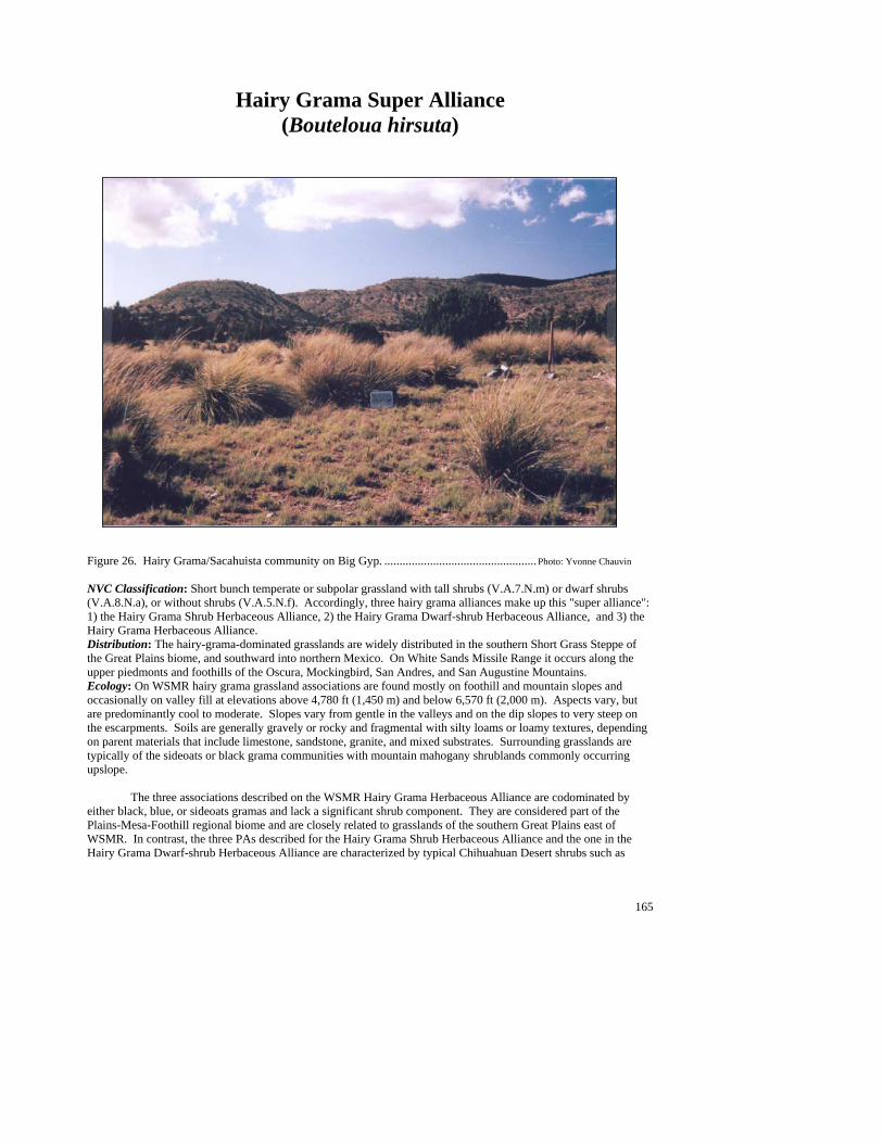
165
Hairy Grama Super Alliance (Bouteloua hirsuta)
Figure 26. Hairy Grama/Sacahuista community on Big Gyp. .................................................. Photo: Yvonne Chauvin NVC Classification: Short bunch temperate or subpolar grassland with tall shrubs (V.A.7.N.m) or dwarf shrubs (V.A.8.N.a), or without shrubs (V.A.5.N.f). Accordingly, three hairy grama alliances make up this "super alliance": 1) the Hairy Grama Shrub Herbaceous Alliance, 2) the Hairy Grama Dwarf-shrub Herbaceous Alliance, and 3) the Hairy Grama Herbaceous Alliance. Distribution: The hairy-grama-dominated grasslands are widely distributed in the southern Short Grass Steppe of the Great Plains biome, and southward into northern Mexico. On White Sands Missile Range it occurs along the upper piedmonts and foothills of the Oscura, Mockingbird, San Andres, and San Augustine Mountains. Ecology: On WSMR hairy grama grassland associations are found mostly on foothill and mountain slopes and occasionally on valley fill at elevations above 4,780 ft (1,450 m) and below 6,570 ft (2,000 m). Aspects vary, but are predominantly cool to moderate. Slopes vary from gentle in the valleys and on the dip slopes to very steep on the escarpments. Soils are generally gravely or rocky and fragmental with silty loams or loamy textures, depending on parent materials that include limestone, sandstone, granite, and mixed substrates. Surrounding grasslands are typically of the sideoats or black grama communities with mountain mahogany shrublands commonly occurring upslope. The three associations described on the WSMR Hairy Grama Herbaceous Alliance are codominated by either black, blue, or sideoats gramas and lack a significant shrub component. They are considered part of the Plains-Mesa-Foothill regional biome and are closely related to grasslands of the southern Great Plains east of WSMR. In contrast, the three PAs described for the Hairy Grama Shrub Herbaceous Alliance and the one in the Hairy Grama Dwarf-shrub Herbaceous Alliance are characterized by typical Chihuahuan Desert shrubs such as
166
sotol, sacahuista and soaptree yucca. Hence, they are considered part of the Chihuahuan Desert Grassland biome that extends southward from WSMR to northern Mexico and across to Arizona. Key to the Hairy Grama (Bouteloua hirsuta) Plant Associations: 1. Black grama (Bouteloua eriopoda) common to well represented; often a codominant grass.......................................................................................................................................................... Hairy Grama/Black Grama PA 1. Black grama poorly represented to absent .........................................................................................................2 2. Blue grama (Bouteloua gracilis) common to well represented as subdominant grass........................................................................................................................................ Hairy Grama/Blue Grama PA (See Minor Types) 2. Blue grama poorly represented to absent...........................................................................................................3 3. Sideoats grama (Bouteloua curtipendula) common to well represented as subdominant or codominant grass ..........................................................................................................................Hairy Grama/Sideoats Grama PA 3. Sideoats grama poorly represented to absent.....................................................................................................4 4. Common Sotol (Dasylirion wheeleri) common to well represented as dominant or codominant shrub ........................................................................................................ Hairy Grama/Common Sotol PA (See Minor Types) 4. Common Sotol poorly represented to absent .....................................................................................................5 5. Featherplume (Dalea formosa) common to well represented as dominant or codominant shrub................................................................................................................................................... Hairy Grama/Featherplume PA 5. Featherplume poorly represented to absent .......................................................................................................6 6. Sacahuista (Nolina microcarpa) common to well represented as dominant or codominant shrub.......................................................................................................................................................Hairy Grama/Sacahuista PA 6. Soaptree yucca (Yucca elata) common to well represented as dominant or codominant shrub ...................................................................................................................................................Hairy Grama/Soaptree Yucca PA
Hairy Grama/Black Grama PA (Bouteloua hirsuta/Bouteloua eriopoda; BOUHIR/BOUERI)
Distribution: On White Sands Missile Range this is a major community of the San Andres and San Augustine Mountains, and is found less frequently in the Oscura and Mockingbird Mountains. Vegetation Summary: This grassland is characterized by abundant to luxuriant hairy grama with black grama as a subdominant or occasionally a codominant. Shrub layer is low lying and can include scattered banana yucca, soaptree yucca, tulip pricklypear, broom snakeweed, common sotol, tree cholla, and Apacheplume. The
wide variety and abundance of shrubs (27 species) suggest that this type is transitional between Plains and Chihuahuan Desert grasslands. Among the other 18
grass species recorded for the type, sideoats grama, cane bluestem, purple threeawn, and bristly wolfstail are the most common. Forbs are scattered, but diversity is moderately high (38 species) and can include Louisiana sagewort, lacy tansyaster, globemallow spp., Rocky Mountain zinnia and Wright’s buckwheat. Physical Setting: Stands of this association occur predominantly on steep slopes on foothill escarpments and less frequently on gentle to moderate slopes on the upper piedmont. Aspects are commonly cool to moderate at elevations of 4,800 to 6,400 ft (1,460 to 1,950 m). Substrates are predominantly granite and quartz monzonite at the base of the San Andres Mountain escarpment and the San Augustine Mountains soils are coarse loamy. Stands also occur on limestone or sandstone escarpments and dip slopes where soils tend to be rocky and shallow and silty loams. In valley fill sites, soil have less gravel and rock and are finer textured.
#
#
#
#
#
#
#
#
#
##
###

167
Discussion: Higher elevation slopes commonly grade into oak shrublands and pinyon or juniper woodlands. Adjacent slopes may give way to Chihuahuan grasslands such as Black Grama/Ocotillo and Black Grama/Common Sotol. Lower slopes generally grade into Arroyo Riparian communities or Chihuahuan shrubland alliances, such as Creosotebush or Mariola. Piedmont stands are generally large but are dissected by drainages lined with Apacheplume. This type is predominantly found on Precambrian intrusions at the base of the San Andres Mountains, which suggests that its presence may be less fire-related and more soil- and substrate-determined.
Soil Taxonomic Unit(s): Coarse Loamy, Mixed (Nonacid), Thermic, Typic
Haplargid Loamy over Fragmented, Mixed (Nonacid), Mesic,
Lithic Ustiorthent Coarse Silty, Carbonatic, Thermic, Typic Calciorthid Average Min Max ELEVATION (ft): 5646 4880 6333 SLOPE %: 22 8 44 SOLAR INDEX: 1.04 .00 1.77
Common Plant Species, Hairy Grama/Black Grama PA: Constancy Cover Scientific Name Common Name (% plots) Mean Max Min n = 10 Shrubs Fallugia paradoxa Apacheplume 30.00% 2.70 7.50 0.10 Dalea formosa featherplume 30.00% 1.50 2.50 0.01 Dasylirion wheeleri common sotol 50.00% 0.62 2.50 0.00 Gutierrezia sarothrae broom snakeweed 90.00% 2.18 5.00 0.05 Larrea tridentata creosotebush 30.00% 0.17 0.50 0.00 Opuntia phaeacantha tulip pricklypear 50.00% 0.23 0.50 0.00 Prosopis glandulosa honey mesquite 50.00% 1.02 2.50 0.00 Yucca baccata banana yucca 60.00% 0.61 2.50 0.00 Yucca elata soaptree yucca 60.00% 0.26 1.00 0.00 Grasses Lycurus setosus bristly wolfstail 50.00% 0.72 2.50 0.01 Aristida purpurea purple threeawn 60.00% 2.42 7.50 0.01 Bouteloua hirsuta hairy grama 100.00 23.85 62.50 2.50 Bouteloua gracilis blue grama 30.00% 1.53 2.50 0.10 Bouteloua eriopoda black grama 100.00 10.30 17.50 2.50 Bouteloua curtipendula sideoats grama 80.00% 1.13 3.00 0.50 Bothriochloa barbinodis cane bluestem 40.00% 2.63 5.00 0.50 Forbs Machaeranthera pinnatifida ssp. lacy tansyaster 30.00% 0.17 0.50 0.01 pinnatifida var. pinnatifida Zinnia grandiflora Rocky Mountain zinnia 30.00% 0.20 0.50 0.01 Artemisia ludoviciana Louisiana sagewort 30.00% 0.20 0.50 0.01 Eriogonum wrightii Wright’s buckwheat 40.00% 1.02 2.50 0.10
168
Hairy Grama/Featherplume PA (Bouteloua hirsuta/Dalea formosa; BOUHIR/DALFOR)
Distribution: On White Sands Missile Range this is a major community in the San Andres Mountains and the Poison Hills in the northern Jornada del Muerto basin. Vegetation Summary: This grassland is dominated by hairy grama and the dwarf shrub featherplume. The grass cover ranges from well represented to luxuriant. Southwestern needlegrass, purple threeawn, slim tridens, black grama, sideoats grama, and cane bluestem are usually present but seldom reach
10% of the total grass cover. The shrub layer is very open. Featherplume can be abundant but rarely grows taller than the surrounding grasses. Of the 28 other shrubs and dwarf shrubs recorded for the association, pricklyleaf dogweed, creosotebush, broom snakeweed, skeletonleaf goldeneye, tulip pricklypear, mariola, honey mesquite, and common sotol are the most prevalent. Oneseed juniper can be present, but is very scattered. The forb layer is poorly represented but is typically high in diversity. Of the 29 forbs noted, lacy tansyaster, plains blackfoot, Fendler’s bladderpod, blue
milkwort, longstalk greenthread, and leatherweed are the most common. Physical Setting: This association generally occurs on moderately steep to very steep slopes with cool aspects at elevations between 5,400 and 5,900 ft (1,650 and 1,780 m). Soils are derived from Paleozoic limestone and metamorphic schists and tend to be rocky or gravelly and clayey to fine silty in the matrix. Discussion: Upslope, grasslands may grade to Hairy Grama/Common Sotol foothill grasslands, or if at higher elevations, oneseed juniper or pinyon woodlands, or mountain mahogany shrublands. Lower slopes give way to arroyo riparian communities or Chihuahuan shrublands. Soil Taxonomic Unit(s): Clayey Skeletal Pachic Haplustoll Clayey Fragmental, Mixed (Calcareous), Thermic, Typic Camborthid Fine Silty over Fragmental, Mixed (Carbonatic), Mesic, Typic Ustiorthent
Average Min Max ELEVATION (ft): 5631 5402 5864 SLOPE %: 37 17 54 SOLAR INDEX: 1.24 .21 1.91
Common Plant Species, Hairy Grama/Featherplume PA: Constancy Cover Scientific Name Common Name (% plots) Mean Max Min n = 5 Trees Juniperus monosperma—mature oneseed juniper 40.00% 0.00 0.00 0.00 Shrubs Opuntia imbricata tree cholla 40.00% 0.01 0.01 0.00 Dalea formosa featherplume 100.00% 6.10 17.50 0.50 Dasylirion wheeleri common sotol 80.00% 0.05 0.10 0.00 Ephedra nevadensis var. aspera Nevada jointfir 40.00% 0.30 0.50 0.10 Gutierrezia sarothrae broom snakeweed 60.00% 1.20 2.50 0.10 Larrea tridentata creosotebush 60.00% 0.67 1.00 0.50 Opuntia phaeacantha tulip pricklypear 80.00% 0.18 0.50 0.01 Parthenium incanum mariola 60.00% 0.23 0.50 0.10 Prosopis glandulosa honey mesquite 100.00% 0.14 0.50 0.01 Thymophylla acerosa pricklyleaf dogweed 80.00% 1.02 2.50 0.10 Viguiera stenoloba skeletonleaf goldeneye 60.00% 0.23 0.50 0.10 Grasses Bouteloua curtipendula sideoats grama 80.00% 2.00 4.00 0.50 Aristida purpurea purple threeawn 80.00% 1.02 2.50 0.10 Stipa eminens southwestern needlegrass 60.00% 1.03 3.00 0.00 Bothriochloa barbinodis cane bluestem 60.00% 1.33 2.50 0.50 Tridens muticus slim tridens 60.00% 0.22 0.50 0.05
#
#
##
#
#
#
169
Bouteloua hirsuta hairy grama 100.00% 28.80 62.50 7.50 Bouteloua eriopoda black grama 100.00% 2.10 3.00 0.50 Forbs Machaeranthera pinnatifida ssp. lacy tansyaster 60.00% 0.05 0.10 0.01 pinnatifida var. pinnatifida
Hairy Grama/Sacahuista PA (Bouteloua hirsuta/Nolina microcarpa; BOUHIR/NOLMIC)
Distribution: On White Sands Missile Range this is a major community of the San Andres Mountains. Vegetation Summary: In this Chihuahuan Desert Grassland hairy grama is usually well represented to abundant and dominant. Sideoats grama and purple threeawn are typically present and occasionally codominate. The shrub layer is clearly dominated by sacahuista, but other shrubs are generally poorly represented. They may include Broom snakeweed, littleleaf sumac, mariola, tulip
pricklypear, featherplume, and soaptree yucca. Forb diversity is moderate at 33 species and includes plains blackfoot, James’ nailwort, Louisiana sagewort and Fendler’s bladderpod. Physical Setting: This type occurs on moderately steep to steep colluvial and upper alluvial slopes. Aspects generally range from moderate to cold at elevations of 4,700 to 6,300 ft (1,430 to 1,920 m). Substrates are generally Paleozoic limestone and less frequently Precambrian intrusions, which occur across the slopes of the San Andres Mountain escarpment. Soils surfaces are rocky and gravelly with little exposed soil. Soils are shallow and rocky loamy matrix textures. Discussion: Stands of this type are patchy and generally occur along ridges and sideslopes of the San Andres Mountain escarpment. Lower, adjacent slopes
commonly grade to Chihuahuan Desert shrublands such as Viscid Acacia/ Black Grama or Creosotebush/Black Grama PAs. Upslope areas in the southern San Andres generally give way to Ocotillo/Mariola and Viscid Acacia associations. In the northern San Andres, transitions are more likely to grade to temperate grasslands dominated by Blue Grama and New Mexico Needlegrass, or to montane woodlands and shrublands of the Juniper and Shrub Live Oak alliances. The expression of the Hairy Grama/Sacahuista PA may be disturbance-related as indicated by disturbance increasers such as broom snakeweed, catclaw mimosa and tulip pricklypear. Sacahuista itself is a disturbance increaser (Dick-Peddie 1993; Powell 1994). Past grazing may have encouraged the spread of sacahuista while lowering grass cover. The role of fire is equivocal—possibly suppressing or encouraging sacahuista, depending on the condition of the stands and the seasonality of fire.
Soil Taxonomic Unit(s): Loamy Skeletal Typic Calciustoll Loamy Skeletal, Mixed (Calcareous), Mesic Lithic
Calciustolls Loamy over Fragmented, Mixed (Nonacid), Mesic,
Lithic Ustiorthent
Average Min Max ELEVATION (ft): 5249 4786 6258 SLOPE %: 25 11 32 SOLAR INDEX: 1.45 .88 1.90
Common Plant Species, Hairy Grama/Sacahuista PA: Constancy Cover Scientific Name Common Name (% plots) Mean Max Min n = 5 Shrubs Nolina microcarpa sacahuista 100.00% 8.30 17.50 4.00 Gutierrezia sarothrae broom snakeweed 100.00% 1.52 4.00 0.10 Dalea formosa featherplume 80.00% 2.25 2.50 2.00 Mimosa aculeaticarpa var. biuncifera catclaw mimosa 40.00% 1.25 2.50 0.01 Opuntia phaeacantha tulip pricklypear 60.00% 0.37 0.50 0.10 Parthenium incanum mariola 40.00% 0.30 0.50 0.10 Rhus microphylla littleleaf sumac 60.00% 0.05 0.10 0.01
##
##
##
170
Common Plant Species, Hairy Grama/Sacahuista PA (continued): Constancy Cover Scientific Name Common Name (% plots) Mean Max Min Yucca baccata banana yucca 40.00% 0.05 0.10 0.00 Yucca elata soaptree yucca 80.00% 0.13 0.50 0.00 Grasses Lycurus setosus bristly wolfstail 60.00% 0.20 0.50 0.01 Stipa neomexicana New Mexico needlegrass 60.00% 0.34 0.50 0.01 Eragrostis intermedia plains lovegrass 60.00% 0.34 0.50 0.01 Bouteloua eriopoda black grama 80.00% 1.52 5.00 0.10 Bouteloua gracilis blue grama 40.00% 0.30 0.50 0.10 Bouteloua hirsuta hairy grama 100.00% 14.70 40.00 2.50 Aristida purpurea purple threeawn 100.00% 1.12 2.50 0.01 Bouteloua curtipendula sideoats grama 100.00% 3.50 7.50 2.00 Forbs Artemisia ludoviciana Louisiana sagewort 80.00% 0.28 0.50 0.01 Melampodium leucanthum plains blackfoot 80.00% 0.40 0.50 0.10 Paronychia jamesii James’ nailwort 80.00% 4.65 17.50 0.10 Lesquerella fendleri Fendler’s bladderpod 60.00% 0.35 0.50 0.05
Hairy Grama/Sideoats Grama PA (Bouteloua hirsuta/Bouteloua curtipendula; BOUHIR/BOUCUR )
Distribution: On White Sands Missile Range this is a major community of the San Andres and San Augustine Mountains. Vegetation Summary: This Plains-Mesa grassland is characterized by abundant to luxuriant hairy grama cover, with sideoats grama as the main subdominant or codominant grass. Other common grasses include black grama, cane bluestem, bristly wolfstail, and purple threeawn. The shrub layer is poorly represented, yet highly diverse. Common associates include broom snakeweed, honey
mesquite, shrub live oak, featherplume, mariola, and cactus apple, which are often indicative of disturbance. Forbs are moderately fairly diverse at 37 species. Some of the more common species include plains blackfoot, lacy tansyaster, globemallow, and buckwheat.
Physical Setting: Stands are found on rocky scarp slopes of mountains and foothills at mid-elevations ranging from 4,400 to 6,600 ft (1,340 to 2,010 m). Slopes are moderate to steep, and are at moderate to cool. Soil parent materials are limestone, sandstone, and igneous substrates. Discussion: Stands of this type generally grow in patchy occurrences along mountain slopes and are interspersed with stands of Sideoats Grama/Common Sotol or Curlyleaf Muhly/Sideoats Grama. Black Grama/Blue Grama is a related community in that patches of hairy grama may be present, but not dominant. This type appears to be weakly associated with somewhat disturbed sites on rocky substrates. Average Min Max ELEVATION (ft): 5694 4460 6568 SLOPE %: 21 10 40 SOLAR INDEX: .79 .02 1.71
Common Plant Species, Hairy Grama/Sideoats Grama PA: Constancy Cover Scientific Name Common Name (% plots) Mean Max Min n = 9 Shrubs Nolina microcarpa sacahuista 44.44% 0.89 2.50 0.05 Dalea formosa featherplume 66.67% 0.83 2.50 0.25 Dasylirion wheeleri common sotol 44.44% 0.44 0.50 0.25 Gutierrezia sarothrae broom snakeweed 77.78% 2.44 7.50 0.05 Yucca baccata banana yucca 44.44% 0.65 2.50 0.00
#
#
##
#
#
#
##
#
#
#
#
171
Common Plant Species, Hairy Grama/Sideoats Grama PA (continued): Constancy Cover Scientific Name Common Name (% plots) Mean Max Min Opuntia engelmannii cactus apple 66.67% 0.43 0.50 0.10 Opuntia imbricata tree cholla 55.56% 0.42 0.50 0.10 Parthenium incanum mariola 55.56% 0.75 2.50 0.01 Prosopis glandulosa honey mesquite 55.56% 2.25 7.50 0.25 Quercus turbinella shrub live oak 44.44% 3.88 7.50 0.01 Grasses Panicum hallii Hall’s panicgrass 44.44% 0.21 0.50 0.05 Aristida purpurea purple threeawn 55.56% 1.14 2.50 0.05 Bouteloua hirsuta hairy grama 100.00% 16.56 30.00 7.50 Bouteloua eriopoda black grama 66.67% 1.06 2.50 0.10 Bouteloua curtipendula sideoats grama 100.00% 5.61 10.00 1.00 Bothriochloa barbinodis cane bluestem 66.67% 3.08 7.50 0.50 Lycurus setosus bristly wolfstail 55.56% 0.29 0.50 0.10
Hairy Grama/Soaptree Yucca PA (Bouteloua hirsuta/Yucca elata; BOUHIR/YUCELA)
Distribution: On White Sands Missile Range this is a major community of the San Andres and San Augustine Mountains. Vegetation Summary: This grassland is clearly dominated by abundant to luxuriant hairy grama cover, with scattered soaptree yuccas. Of the 22 grass species known from the association; bristly wolfstail, blue grama, black grama, sideoats grama, cane bluestem, and purple threeawn are the most common. Other that the soaptree yucca, shrubs are poorly represented. The forb layer is
highly diverse but variable. Of the 70 species recorded for the association Rocky Mountain zinnia, Wright’s buckwheat, lyreleaf greeneyes, threadleaf ragwort, plains flax, lacy tansyaster, plains blackfoot, New Mexico copperleaf, and hot springs globemallow are the most consistent. Oneseed juniper may invade the grassland in transition areas and along drainages. Physical Setting: This association occurs on gentle to moderately steep slopes, across lower dip slopes and valley alluvial fans within the central San Andres Mountains. It is found on most aspects at elevations between 5,200 and 6,600 ft (1,580 and 2,010 m). Substrates are Paleozoic limestone and sandstone from the Abo Formation, along with igneous alluvium at the base of the San Augustine Mountains. Gentle slopes dissected by drainages characterize the landscape. Soils
surfaces have abundant gravel, with some exposed soil and little rock. Soils are generally dark, well developed and stable. Surface soil textures range from loam to clays. Discussion: Stands near the San Augustine Mountains are generally limited to alluvial formations. Lower slopes can grade to other desert grasslands (Blue Grama/Soaptree Yucca or Blue Grama/Alkali Sacaton PAs). Drainages are generally lined with dense stands of Apacheplume. Relative to black grama, hairy grama seems to be associated with more mesic soils, whether they are fine silts that have high water holding capacities, or granitic substrates that drain quickly and limit evaporation. Soaptree yucca is associated with deep valley soils, like those of Yonder Valley and the San Augustine Piedmont. Fire frequency may be important in maintaining grass density, while controlling shrub and tree encroachment. Higher slopes tend to give way to open juniper woodlands, oak shrublands, or other foothill grasslands (Blue Grama/Sideoats Grama or Hairy Grama/Black Grama PAs).
Soil Taxonomic Unit(s): Very Fine Clayey Aridic Argiustoll Sandy, Mixed (Nonacid), Thermic Mesic Loamy Skeletal, Mixed, Thermic Aridic Calciustolls
Average Min Max ELEVATION (ft): 6024 5271 6550 SLOPE %: 10 5 17 SOLAR INDEX: .89 .43 1.50
#
#
#
#
#
#
#
#
172
Common Plant Species, Hairy Grama/Soaptree Yucca PA: Constancy Cover Scientific Name Common Name (% plots) Mean Max Min n = 5 Shrubs Yucca elata soaptree yucca 100.00 3.10 6.00 2.00 Opuntia phaeacantha tulip pricklypear 60.00% 0.20 0.50 0.05 Opuntia imbricata tree cholla 80.00% 0.75 2.50 0.00 Gutierrezia sarothrae broom snakeweed 60.00% 0.85 2.00 0.05 Grasses Lycurus setosus bristly wolfstail 60.00% 5.88 17.50 0.05 Bouteloua hirsuta hairy grama 100.00 36.90 41.50 30.0 Bouteloua gracilis blue grama 60.00% 1.53 2.50 0.10 Bouteloua eriopoda black grama 60.00% 2.52 5.00 0.05 Bouteloua curtipendula sideoats grama 80.00% 1.38 2.50 0.50 Bothriochloa barbinodis cane bluestem 80.00% 0.79 2.50 0.05 Forbs Zinnia grandiflora Rocky Mountain zinnia 60.00% 0.88 2.50 0.05 Eriogonum wrightii Wright’s buckwheat 60.00% 1.18 2.50 0.05 Berlandiera lyrata lyreleaf greeneyes 60.00% 0.88 2.50 0.05
Minor Plant Associations: Hairy Grama Alliance Hairy Grama/Blue Grama PA (Bouteloua hirsuta/Bouteloua gracilis; BOUHIR/BOUGRA)
On White Sands Missile Range, this minor plant association is known from the Oscura, San Andres, and Organ Mountains at elevations from 5,500 to 6,160 (1,675 to 1,875 m). Hairy grama is abundant and the clear dominant, with blue grama well represented but subordinate. Hairy Grama/Common Sotol PA (Bouteloua hirsuta/Dasylirion wheeleri; BOUHIR/DASWHE) This is a minor community of the San Andres and San Augustine Mountains. A grass layer dominated by hairy grama along with a strong shrub component dominated by common sotol characterizes this grassland. Black grama and sideoats grama can also be abundant, but not dominate. Other scattered grasses include purple threeawn, cane bluestem, blue grama and bristly wolfstail. Shrub diversity is moderate; featherplume, broom snakeweed, tulip pricklypear, skeletonleaf goldeneye, Wright’s beebrush, and banana yucca are often present but scattered. Forb diversity is only moderate (23 species) with Louisiana sagewort leatherweed (Croton pottsii) and Wright’s buckwheat the most constant. This type generally occurs on moderately steep to very steep colluvial slopes on varied aspects at elevations of 5,200 to 6,200 ft (1,580 to 1,890 m). Soils are generally shallow, cobbly and unstable and surface soil textures are generally loamy sands. Stands are patchy and can readily carry fire. Hairy grama grasslands can sustain fire hot enough to kill shrubs and lower densities.
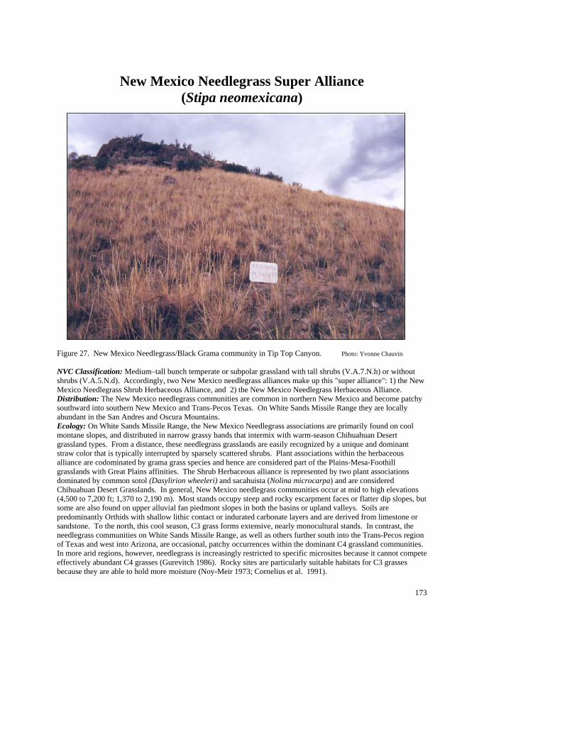
173
New Mexico Needlegrass Super Alliance (Stipa neomexicana)
Figure 27. New Mexico Needlegrass/Black Grama community in Tip Top Canyon. Photo: Yvonne Chauvin NVC Classification: Medium–tall bunch temperate or subpolar grassland with tall shrubs (V.A.7.N.h) or without shrubs (V.A.5.N.d). Accordingly, two New Mexico needlegrass alliances make up this "super alliance": 1) the New Mexico Needlegrass Shrub Herbaceous Alliance, and 2) the New Mexico Needlegrass Herbaceous Alliance. Distribution: The New Mexico needlegrass communities are common in northern New Mexico and become patchy southward into southern New Mexico and Trans-Pecos Texas. On White Sands Missile Range they are locally abundant in the San Andres and Oscura Mountains. Ecology: On White Sands Missile Range, the New Mexico Needlegrass associations are primarily found on cool montane slopes, and distributed in narrow grassy bands that intermix with warm-season Chihuahuan Desert grassland types. From a distance, these needlegrass grasslands are easily recognized by a unique and dominant straw color that is typically interrupted by sparsely scattered shrubs. Plant associations within the herbaceous alliance are codominated by grama grass species and hence are considered part of the Plains-Mesa-Foothill grasslands with Great Plains affinities. The Shrub Herbaceous alliance is represented by two plant associations dominated by common sotol (Dasylirion wheeleri) and sacahuista (Nolina microcarpa) and are considered Chihuahuan Desert Grasslands. In general, New Mexico needlegrass communities occur at mid to high elevations (4,500 to 7,200 ft; 1,370 to 2,190 m). Most stands occupy steep and rocky escarpment faces or flatter dip slopes, but some are also found on upper alluvial fan piedmont slopes in both the basins or upland valleys. Soils are predominantly Orthids with shallow lithic contact or indurated carbonate layers and are derived from limestone or sandstone. To the north, this cool season, C3 grass forms extensive, nearly monocultural stands. In contrast, the needlegrass communities on White Sands Missile Range, as well as others further south into the Trans-Pecos region of Texas and west into Arizona, are occasional, patchy occurrences within the dominant C4 grassland communities. In more arid regions, however, needlegrass is increasingly restricted to specific microsites because it cannot compete effectively abundant C4 grasses (Gurevitch 1986). Rocky sites are particularly suitable habitats for C3 grasses because they are able to hold more moisture (Noy-Meir 1973; Cornelius et al. 1991).
174
Key to the New Mexico Needlegrass (Stipa neomexicana) Plant Associations: 1. Common sotol (Dasylirion wheeleri) common to well represented as dominant or codominant shrub .............. .........................................................................................................................................................................................................................................................................................New Mexico Needlegrass/Common Sotol PA 1. Common sotol poorly represented to absent......................................................................................................2 2. Sacahuista (Nolina microcarpa) well represented as dominant or codominant shrub......................................... .................................................................................................................................................................................................................................................................New Mexico Needlegrass/Sacahuista PA (See Minor Types) 2. Sacahuista poorly represented to absent ............................................................................................................3 3. Black grama (Bouteloua eriopoda) common to well represented as subdominant or codominant grass, with other grasses often equal in cover............................................................. New Mexico Needlegrass/Black Grama PA 3. Black grama poorly represented to absent .........................................................................................................4 4. Blue grama (Bouteloua gracilis) common to well represented as subdominant or codominant grass, with other grasses occasionally equal in cover ................... New Mexico Needlegrass/Blue Grama PA (See Minor Types) 4. Blue grama poorly represented to absent...........................................................................................................5 5. Hairy grama (Bouteloua hirsuta) common to well represented as subdominant or codominant grass, with other grasses often equal in cover............................................................. New Mexico Needlegrass/Hairy Grama PA 5. Sideoats grama (Bouteloua curtipendula) common to well represented as subdominant or codominant grass, with other grasses often equal in cover.........................New Mexico Needlegrass/Sideoats Grama PA
New Mexico Needlegrass/Black Grama PA (Stipa neomexicana/Bouteloua eriopoda; STINEO/BOUERI)
Distribution: Major community of the San Andres, San Augustine, and Oscura Mountains with some occurrences on Chupadera Mesa. Vegetation Summary: This grassland is characterized by well-represented to abundant New Mexico needlegrass with black grama as the codominant. Other common grasses include other grama grasses (hairy, blue, and sideoats) that can be present, but clearly subordinate. The shrub layer consists of many different species (39), but they are widely scattered and variable. The most
common are banana yucca, tulip pricklypear and featherplume. The forbs are highly diverse (63 species) and variable with plains blackfoot being the most constant species. Oneseed juniper is present in some stands but in very low densities. Physical Setting: Stands occur mostly on cool north-facing, steep sloped escarpments and on smooth dip
slopes at elevations from 4,900 to 6,850 ft (1,490 to 2,090 m). However, some are found on the upper piedmonts that lead west from the Oscura Mountains and within upland valleys of the San Andres Mountains. Rock and gravel surfaces are dominant and parent materials consist of limestone and occasionally sandstone. Soils are predominantly shallow and are mostly medium- to coarse-textured loams and sandy loams. Soil Taxonomic Unit(s): Fine Clayey Typic Calciorthid Loamy Skeletal Carbonatic Thermic Ustochreptic
Paleorthids Loamy Skeletal Mixed Thermic Aridic Calciustolls Coarse Loamy Carbonatic Thermic Lithic Ustochrepts Average Min Max ELEVATION (ft): 5951 4931 6849 SLOPE %: 31 6 57 SOLAR INDEX: 1.18 .00 2.00
#
#
###
#
##
#
#
##
#
#
#
#
#
#
#
175
Common Plant Species, New Mexico Needlegrass/Black Grama PA: Constancy Cover Scientific Name Common Name (% plots) Mean Max Min n = 19 Trees Juniperus monosperma—mature oneseed juniper 63.16% 1.04 5.00 0.00 Shrubs Yucca baccata banana yucca 78.95% 1.22 2.50 0.00 Opuntia phaeacantha tulip pricklypear 73.68% 0.47 2.50 0.00 Gutierrezia sarothrae broom snakeweed 57.89% 1.56 7.50 0.00 Dalea formosa featherplume 73.68% 1.82 7.50 0.00 Grasses Stipa neomexicana New Mexico needlegrass 100.00% 23.13 62.50 2.50 Bouteloua gracilis blue grama 73.68% 2.82 7.50 0.50 Bouteloua eriopoda black grama 100.00% 9.32 17.50 0.50 Bouteloua curtipendula sideoats grama 78.95% 2.07 7.50 0.50 Aristida purpurea purple threeawn 63.16% 1.13 2.50 0.05 Forbs Melampodium leucanthum plains blackfoot 57.89% 0.35 2.50 0.00
New Mexico Needlegrass/Common Sotol PA (Stipa neomexicana/Dasylirion wheeleri; STINEO/DASWHE)
Distribution: Major community of the southern San Andres Mountains, but expected to occur throughout most montane areas on White Sands Missile Range. Vegetation Summary: This grassland is characterized by a grass layer dominated by New Mexico needlegrass and a strong Chihuahuan shrub component dominated by common sotol. Purple threeawn is typically present. Other associated grasses include sideoats grama, black grama, and sand dropseed. The shrub layer is very open, low lying with
featherplume, a constant associate. Diversity is high; other associates include Nevada jointfir, broom snakeweed, tulip pricklypear, skeletonleaf goldeneye, ocotillo, mariola, littleleaf sumac, and banana yucca. The forb layer is generally scattered, poorly represented and moderate in diversity. Species may include plains blackfoot, croton spp., shaggydwarf morning glory, and Cochise scaly cloakferns. Physical Setting: This New Mexico Needlegrass/Common Sotol PA typically occurs on steep to very steep colluvial slopes. Aspects are generally cool, and elevations are approximately 5,000 to 6,500 ft (1,520 to 1,980 m). Substrates are limestone
and occasionally mixed sedimentary types occurring within the San Andres and Oscura Mountains. The PA also occurs on interior valley slopes and along mountain escarpments. Overall, the landscape is characterized by steep, rocky, caprock-bounded slopes. Between the rocks, ground surfaces are usually covered with gravel, leaving little exposed soil. Soils are generally shallow and rocky with a loamy matrix. Discussion: Lower slopes generally give way to Chihuahuan shrubland (Creosotebush/Black Grama PA or arroyo riparian) or grassland (Black Grama/Mariola, Black Grama/Skeletonleaf Goldeneye) PAs. Areas upslope or on cooler aspects grade into shrub live oak or mountain mahogany shrublands, or montane grassland (New Mexico Needlegrass/Sideoats Grama or Hairy Grama/Black Grama PAs). This foothill grassland type has the potential to carry fire readily, ones hot enough to kill shrubs. Hence, fire, depending on frequency, may sustain dense, open grassland with scattered sotols. Soil Taxonomic Unit(s): Loamy Skeletal, Carbonatic, Thermic, Shallow Typic
Paleorthids Average Min Max ELEVATION (ft): 5439 4799 6262 SLOPE %: 72 38 210 SOLAR INDEX: 1.24 .05 1.99
Common Plant Species, New Mexico Needlegrass/Common Sotol PA:
#
#
##
#
#
176
Constancy Cover Scientific Name Common Name (% plots) Mean Max Min n = 6 Shrubs Yucca baccata banana yucca 66.67% 0.39 0.50 0.05 Viguiera stenoloba skeletonleaf goldeneye 83.33% 0.50 0.50 0.50 Rhus microphylla littleleaf sumac 66.67% 0.89 2.50 0.00 Parthenium incanum mariola 66.67% 0.32 0.50 0.01 Opuntia phaeacantha tulip pricklypear 83.33% 0.42 0.50 0.10 Gutierrezia sarothrae broom snakeweed 83.33% 0.95 2.50 0.50 Fouquieria splendens ocotillo 66.67% 0.75 2.50 0.01 Ephedra nevadensis var. aspera Nevada jointfir 83.33% 1.40 2.50 0.50 Dasylirion wheeleri common sotol 100.00% 3.67 7.50 2.50 Dalea formosa featherplume 100.00% 1.67 2.50 0.50 Grasses Stipa neomexicana New Mexico needlegrass 100.00% 13.58 29.00 2.50 Sporobolus cryptandrus sand dropseed 50.00% 0.35 0.50 0.05 Bouteloua eriopoda black grama 66.67% 1.89 2.50 0.05 Bouteloua curtipendula sideoats grama 83.33% 5.60 17.50 2.50 Aristida purpurea purple threeawn 100.00% 2.00 3.50 0.50
New Mexico Needlegrass/Hairy Grama PA (Stipa neomexicana/Bouteloua hirsuta; STINEO/BOUHIR)
Distribution: Major community of Chupadera Mesa and the Oscura and San Andres Mountains. Vegetation Summary: This grassland is characterized by a luxuriant grass cover of New Mexico needlegrass with hairy grama as a codominant. Sideoats grama and purple threeawn are often present and may occasionally codominate. Other Bunch grasses include black grama, plains lovegrass, curlyleaf muhly, and blue grama Shrub are common to well represented with
banana yucca, littleleaf sumac, tulip pricklypear, sacahuista, featherplume, Nevada jointfir, and skeletonleaf goldeneye are some of the most prevalent associates. At higher elevations, conifers (pinyon and juniper) are conspicuous but scattered. Forbs, when present, grows in open spaces between the grasses. Fendler’s bladderpod, grassland croton, Fendler’s sandmat, James’ nailwort, and plains blackfoot are often present. Physical Setting: Stands are found on moderately steep to steep colluvial slopes of the San Andres and Oscura Mountains at elevations between 4,500 and 7,000 ft (1,370 and 2,130 m). Aspects tend to be hot and warm at high elevations, becoming northerly and cool at lower
elevations. Substrates are generally Paleozoic limestones and/or sandstones and occasionally include igneous granitic rocks. The PA is typically bound by rock outcrops on escarpment faces and ridge sideslopes. It also occurs on the mid and upper portions of even dip slopes. The ground surfaces are gravelly with scattered rocks and little exposed soil. Soils vary from coarse loams to clays. At depth, soils can have well developed caliche layers of calcium carbonate accumulation. Discussion: Adjacent rock outcrops commonly support stands of the Ocotillo/Mariola PA. Lower elevation or adjacent slopes tend to grade into other grama grass communities. Areas upslope or on cooler aspects may give way to pinyon pine or oneseed juniper woodlands or mountain mahogany shrubland PAs.
Soil Taxonomic Unit(s): Clayey Skeletal Typic Calciorthid Clayey Skeletal Aridic Argiustoll Coarse Loamy Carbonatic Thermic Calciorthidic
Ustochept Coarse Loamy Carbonatic Thermic Ustollic Paleorthids Coarse Loamy, Carbonatic, Thermic Ustochreptic
Paleorthids Fine Loamy Carbonatic, Thermic Ustalfic Haplargids
Average Min Max ELEVATION (ft): 5841 4832 6618 SLOPE %: 32 25 46 SOLAR INDEX: 1.16 .03 1.98
#
#
#
#
#
#
#
#
#
#
# #
#
##
177
Common Plant Species, New Mexico Needlegrass/Hairy Grama PA: Constancy Cover Scientific Name Common Name (% plots) Mean Max Min n = 15 Shrubs Yucca baccata banana yucca 80.00% 1.80 2.50 0.00 Viguiera stenoloba skeletonleaf goldeneye 46.67% 1.29 2.50 0.00 Rhus microphylla littleleaf sumac 66.67% 1.06 2.50 0.00 Opuntia phaeacantha tulip pricklypear 66.67% 0.74 2.50 0.01 Nolina microcarpa sacahuista 60.00% 1.56 2.50 0.00 Ephedra nevadensis var. aspera Nevada jointfir 46.67% 1.64 2.50 0.50 Dalea formosa featherplume 73.33% 3.55 7.50 0.50 Grasses Stipa neomexicana New Mexico needlegrass 100.00% 26.07 62.50 7.50 Muhlenbergia setifolia curlyleaf muhly 46.67% 3.44 7.50 0.05 Bouteloua hirsuta hairy grama 100.00% 12.40 41.50 2.50 Bouteloua eriopoda black grama 80.00% 2.83 11.00 0.00 Bouteloua curtipendula sideoats grama 93.33% 2.25 8.00 0.50 Aristida purpurea purple threeawn 86.67% 1.89 7.50 0.00 Forbs Lesquerella fendleri Fendler’s bladderpod 53.33% 0.27 0.50 0.01
New Mexico Needlegrass/Sideoats Grama PA (Stipa neomexicana/Bouteloua curtipendula; STINEO/BOUCUR)
Distribution: Major community of Chupadera Mesa and the San Andres Mountains. Probably also occurs on the slopes of the Oscura Mountains. Vegetation Summary: This Plains-Mesa-Foothill grassland is characterized by a luxuriant cover of both New Mexico needlegrass and sideoats grama, with only occasional shrubs. The grass layer also includes other grama grasses and purple threeawn which are present in over half the stands. The shrub layer seldom exceeds 5% and consists mostly of low growing
dwarf species such as mariola, banana yucca, tulip pricklypear and featherplume. The forb layer is minimal with plains blackfoot being the most constant species. Physical Setting: This type primarily occurs on steep colluvial slopes and on the mid and upper portions of smooth dip slopes with warm to moderate aspects. Stands also occur within upland valleys that dissect the
east slopes of the Oscura Mountains. Elevations are moderate to high (4,600 to 7,200 ft; 1,400 to 2,190 m). Substrates are generally Paleozoic limestones and/or sandstones, but occasionally include igneous granitic rocks. The ground surfaces are generally gravelly, with scattered rocks and little exposed soil. Surface soils range from sandy loams to clays. With depth, soils are often have well developed caliche layers of secondary calcium carbonate accumulation.
Soil Taxonomic Unit(s): Fine Silty, Mixed (Calcareous), Mesic, Lithic
Ustorthent Loamy Skeletal, Mixed (Carbonatic), Mesic, Calcic
Ustochrept Clayey Skeletal, Mixed (Carbonatic), Mesic, Typic
Ustiorthent Loamy Skeletal, Thermic Petrocalcic Paleargid, Average Min Max ELEVATION (ft): 5996 4657 7120 SLOPE %: 33 18 50 SOLAR INDEX: .80 .00 1.96
#
#
#
#
#
###
#
#
##
##
#
#
#
#
#
#
#
#
##
#
#
#

178
Common Plant Species, New Mexico Needlegrass/Sideoats Grama PA: Constancy Cover Scientific Name Common Name (% plots) Mean Max Min n = 21 Shrubs Gutierrezia sarothrae broom snakeweed 57.14% 0.93 3.00 0.00 Viguiera stenoloba skeletonleaf goldeneye 47.62% 1.40 3.00 0.50 Parthenium incanum mariola 66.67% 1.58 15.00 0.05 Opuntia phaeacantha tulip pricklypear 76.19% 0.67 3.00 0.01 Nolina microcarpa sacahuista 47.62% 0.75 5.00 0.00 Yucca baccata banana yucca 66.67% 1.27 3.00 0.01 Cercocarpus montanus true mountain mahogany 47.62% 1.11 3.00 0.00 Dasylirion wheeleri common sotol 57.14% 0.81 3.00 0.01 Dalea formosa featherplume 90.48% 2.13 3.00 0.50 Grasses Bouteloua curtipendula sideoats grama 100.00% 6.12 25.00 0.50 Bouteloua eriopoda black grama 76.19% 0.99 3.00 0.05 Bouteloua gracilis blue grama 52.38% 1.02 3.00 0.50 Bouteloua hirsuta hairy grama 57.14% 1.46 3.00 0.50 Aristida purpurea purple threeawn 80.95% 1.08 3.00 0.10 Eragrostis intermedia plains lovegrass 47.62% 0.93 3.00 0.05 Lycurus setosa common wolfstail 47.62% 0.61 2.50 0.01 Stipa neomexicana New Mexico needlegrass 100.00% 16.10 40.00 2.50 Forbs Melampodium leucanthum plains blackfoot 57.14% 0.59 3.00 0.01 Lesquerella fendleri Fendler’s bladderpod 47.62% 0.26 0.50 0.01
Minor Plant Associations: New Mexico Needlegrass New Mexico Needlegrass/Blue Grama PA (Stipa neomexicana/Bouteloua gracilis; STINEO/BOUGRA) This is an established, widespread plant association in the Southwest and across the Short Grass Prairie states. However, on White Sands Missile Range it is a minor type that is limited to the northern San Andres Mountains (north of Rhodes Canyon) and the Oscura Mountains. Stands are characterized by a dense grass layer of both New Mexico needlegrass and blue grama, with sparsely scattered shrubs. Other grass species include black grama, sideoats grama, purple threeawn, and common wolfstail. The shrub layer contains banana yucca, tree cholla, tulip pricklypear, skunkbush sumac, sacahuista, featherplume, southwestern rabbitbrush, and pricklyleaf dogweed. Oneseed junipers (live or standing dead) are common, although usually sparsely scattered. The species composition of the forb layer can be variable and commonly includes plains blackfoot and Fendler’s bladderpod. Stands typically occur on gentle dip slopes and moderately steep escarpments. Aspects are generally cool and elevations are 5,500 to 7,000 ft (1,670 to 2,130 m). Substrates are Paleozoic limestone and/or sandstones (Abo Formation). The ground surfaces are generally gravelly, with scattered rocks and little exposed soil. Surface soils range from loam to silty clays, but can be shallow and rocky and contain caliche layers. New Mexico Needlegrass/Sacahuista PA (Stipa neomexicana/Nolina microcarpa; STINEO/NOLMIC)
This is a provisional plant association in the Southwest and a minor type on White Sands Missile Range (three plots). It is known only from, but probably not limited to, San Andrecito Canyon in the southern San Andres Mountains. Stands are characterized by a luxuriant grass layer that is interrupted by a low-growing, open canopied shrub layer predominated by sacahuista (beargrass). The shrubs are diverse and typically include banana yucca, southwestern rabbitbrush, featherplume, skeletonleaf goldeneye, and tulip pricklypear, but, collectively, they contribute little in cover (less than five percent). The grass layer is dominated by New Mexico needlegrass, but sideoats grama, plains lovegrass, and purple threeawn are generally present. Rubberweed, James’ nailwort, and hawkweed buckwheat are common forbs that occur as scattered individuals between the bunch grasses. Stands are known from moderately steep escarpment faces and along smooth dip slopes at elevations of 5,200 to 6,100 ft (1,580 to 1,860 m). Substrates are limestone and aspects range between cool and warm.
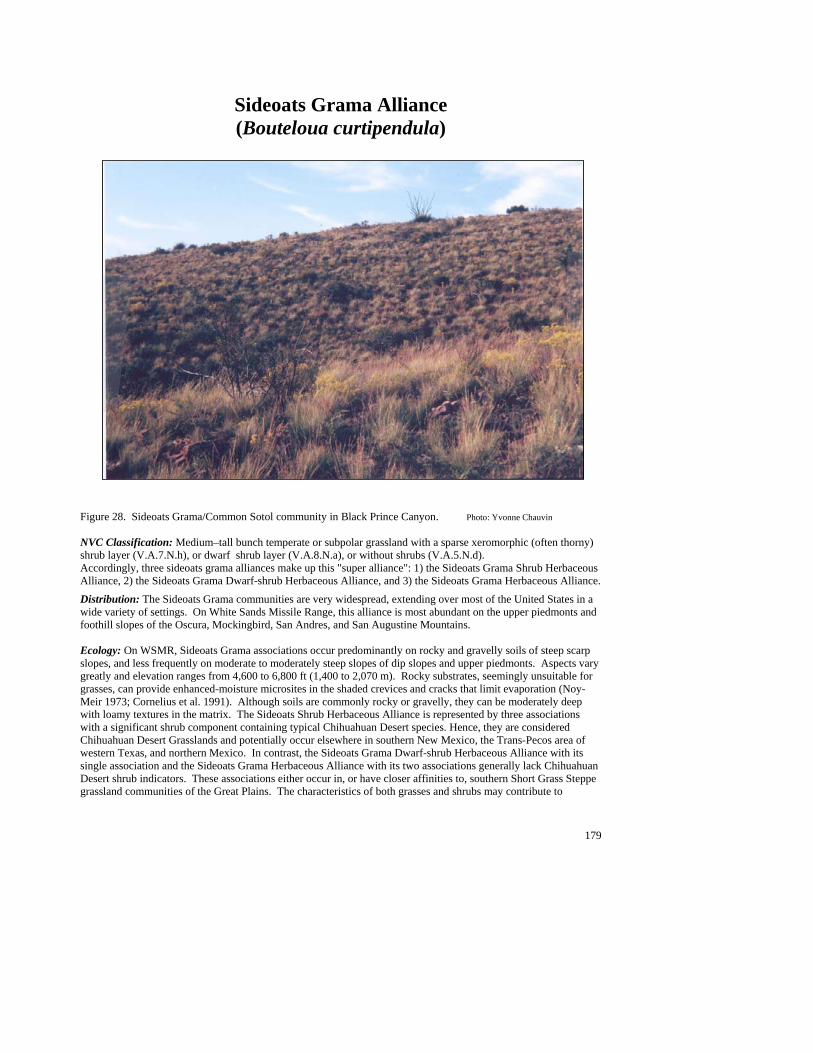
179
Sideoats Grama Alliance (Bouteloua curtipendula)
Figure 28. Sideoats Grama/Common Sotol community in Black Prince Canyon. Photo: Yvonne Chauvin NVC Classification: Medium–tall bunch temperate or subpolar grassland with a sparse xeromorphic (often thorny) shrub layer (V.A.7.N.h), or dwarf shrub layer (V.A.8.N.a), or without shrubs (V.A.5.N.d). Accordingly, three sideoats grama alliances make up this "super alliance": 1) the Sideoats Grama Shrub Herbaceous Alliance, 2) the Sideoats Grama Dwarf-shrub Herbaceous Alliance, and 3) the Sideoats Grama Herbaceous Alliance.
Distribution: The Sideoats Grama communities are very widespread, extending over most of the United States in a wide variety of settings. On White Sands Missile Range, this alliance is most abundant on the upper piedmonts and foothill slopes of the Oscura, Mockingbird, San Andres, and San Augustine Mountains. Ecology: On WSMR, Sideoats Grama associations occur predominantly on rocky and gravelly soils of steep scarp slopes, and less frequently on moderate to moderately steep slopes of dip slopes and upper piedmonts. Aspects vary greatly and elevation ranges from 4,600 to 6,800 ft (1,400 to 2,070 m). Rocky substrates, seemingly unsuitable for grasses, can provide enhanced-moisture microsites in the shaded crevices and cracks that limit evaporation (Noy-Meir 1973; Cornelius et al. 1991). Although soils are commonly rocky or gravelly, they can be moderately deep with loamy textures in the matrix. The Sideoats Shrub Herbaceous Alliance is represented by three associations with a significant shrub component containing typical Chihuahuan Desert species. Hence, they are considered Chihuahuan Desert Grasslands and potentially occur elsewhere in southern New Mexico, the Trans-Pecos area of western Texas, and northern Mexico. In contrast, the Sideoats Grama Dwarf-shrub Herbaceous Alliance with its single association and the Sideoats Grama Herbaceous Alliance with its two associations generally lack Chihuahuan Desert shrub indicators. These associations either occur in, or have closer affinities to, southern Short Grass Steppe grassland communities of the Great Plains. The characteristics of both grasses and shrubs may contribute to
180
community dynamics via the effect they have on horizontal and vertical movement of water (Noy-Meir 1973). The diversity of species with their different root systems (e.g., grasses with shallow fibrous roots vs. succulents with broad, shallow systems vs. woody species with narrow, deep roots) exploit water sources differently (Burgess 1995), thus reducing interspecific competition. Shrubby species can break up the soil, creating patches of variously textured substrates, which in turn can provide suitable microsites for grasses. Shrub roots also provide channels for water to move into the subsoil, even after the shrub dies (Walker et al. 1981; Gile et al. 1995). At higher elevations, Montane Deciduous Scrub communities and woodlands are found, while downslope are Chihuahuan Desert Scrub communities (mostly creosotebush and tarbush). Key to the Sideoats Grama (Bouteloua curtipendula) Plant Associations: 1. Prairie junegrass (Koeleria macrantha) common to well represented as dominant to subdominant grass.......... .................................................................................................................................................................................................................................................................... Sideoats Grama/Prairie Junegrass PA (See Minor Types) 1. Prairie junegrass poorly represented to absent...................................................................................................2 2. Common Sotol (Dasylirion wheeleri) common to well represented as dominant or codominant shrub ............. ........................................................................................................................................................................................................................................................................................................Sideoats Grama/Common Sotol PA 2. Common Sotol poorly represented to absent .....................................................................................................3 3. Featherplume (Dalea formosa) common to well represented as dominant or codominant shrub........................ .......................................................................................................................................................................................................................................................................... Sideoats Grama/Featherplume PA (See Minor Types) 3. Featherplume poorly represented to absent .......................................................................................................4 4. Ocotillo (Fouquieria splendens) well represented as dominant or codominant shrub......................................... .....................................................................................................................................................................................................................................................................................Sideoats Grama/Ocotillo PA (See Minor Types) 4. Ocotillo poorly represented to absent ................................................................................................................3 5. Sacahuista (Nolina microcarpa) well represented as dominant or codominant shrub......................................... ................................................................................................................................................................................................................................................................................Sideoats Grama/Sacahuista PA (See Minor Types) 5. Cane bluestem (Bothriochloa barbinodis) common to well represented as co dominant or subdominant grass....................................................................................... Sideoats Grama/Cane bluestem PA (See Minor Types)
Sideoats Grama/Common Sotol PA (Bouteloua curtipendula/Dasylirion wheeleri; BOUCUR/DASWHE)
Distribution: On White Sands Missile Range this is a major community of the Oscura, San Andres, and San Augustine Mountains.
Vegetation Summary: This Chihuahuan Desert grassland is characterized by a diverse mix of bunchgrass. Sideoats grama is well represented and dominant, while black grama, purple threeawn, hairy grama and plains lovegrass are
common to well represented and may codominate. In the shrub layer, common sotol is well represented and a conspicuous indicator. Other desert indicators include mariola, ocotillo, Wright's beebrush (Aloysia wrightii), catclaw mimosa (Mimosa aculeaticarpa var. biuncifera) and skeletonleaf goldeneye. Of the 75 forbs known from this association, Louisiana sagewort, Wright’s buckwheat, plains blackfoot, lacy tansyaster, star cloak fern, California trixis, and hairyseed bahia are the most constant. Physical Setting: This type occurs on steep rocky scarp and dip slopes at various aspects, but is more frequently found on warmer exposures. Elevations range from ##
##
#
#
##
###
#
#
#
#
#
#
#
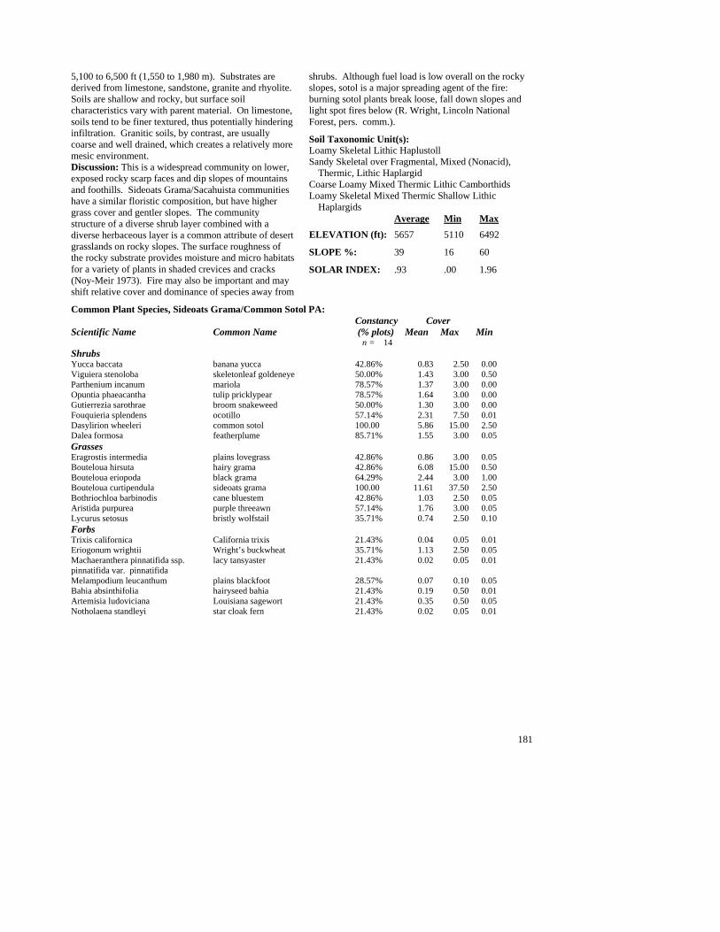
181
5,100 to 6,500 ft (1,550 to 1,980 m). Substrates are derived from limestone, sandstone, granite and rhyolite. Soils are shallow and rocky, but surface soil characteristics vary with parent material. On limestone, soils tend to be finer textured, thus potentially hindering infiltration. Granitic soils, by contrast, are usually coarse and well drained, which creates a relatively more mesic environment. Discussion: This is a widespread community on lower, exposed rocky scarp faces and dip slopes of mountains and foothills. Sideoats Grama/Sacahuista communities have a similar floristic composition, but have higher grass cover and gentler slopes. The community structure of a diverse shrub layer combined with a diverse herbaceous layer is a common attribute of desert grasslands on rocky slopes. The surface roughness of the rocky substrate provides moisture and micro habitats for a variety of plants in shaded crevices and cracks (Noy-Meir 1973). Fire may also be important and may shift relative cover and dominance of species away from
shrubs. Although fuel load is low overall on the rocky slopes, sotol is a major spreading agent of the fire: burning sotol plants break loose, fall down slopes and light spot fires below (R. Wright, Lincoln National Forest, pers. comm.).
Soil Taxonomic Unit(s): Loamy Skeletal Lithic Haplustoll Sandy Skeletal over Fragmental, Mixed (Nonacid),
Thermic, Lithic Haplargid Coarse Loamy Mixed Thermic Lithic Camborthids Loamy Skeletal Mixed Thermic Shallow Lithic
Haplargids Average Min Max ELEVATION (ft): 5657 5110 6492 SLOPE %: 39 16 60 SOLAR INDEX: .93 .00 1.96
Common Plant Species, Sideoats Grama/Common Sotol PA: Constancy Cover Scientific Name Common Name (% plots) Mean Max Min n = 14 Shrubs Yucca baccata banana yucca 42.86% 0.83 2.50 0.00 Viguiera stenoloba skeletonleaf goldeneye 50.00% 1.43 3.00 0.50 Parthenium incanum mariola 78.57% 1.37 3.00 0.00 Opuntia phaeacantha tulip pricklypear 78.57% 1.64 3.00 0.00 Gutierrezia sarothrae broom snakeweed 50.00% 1.30 3.00 0.00 Fouquieria splendens ocotillo 57.14% 2.31 7.50 0.01 Dasylirion wheeleri common sotol 100.00 5.86 15.00 2.50 Dalea formosa featherplume 85.71% 1.55 3.00 0.05 Grasses Eragrostis intermedia plains lovegrass 42.86% 0.86 3.00 0.05 Bouteloua hirsuta hairy grama 42.86% 6.08 15.00 0.50 Bouteloua eriopoda black grama 64.29% 2.44 3.00 1.00 Bouteloua curtipendula sideoats grama 100.00 11.61 37.50 2.50 Bothriochloa barbinodis cane bluestem 42.86% 1.03 2.50 0.05 Aristida purpurea purple threeawn 57.14% 1.76 3.00 0.05 Lycurus setosus bristly wolfstail 35.71% 0.74 2.50 0.10 Forbs Trixis californica California trixis 21.43% 0.04 0.05 0.01 Eriogonum wrightii Wright’s buckwheat 35.71% 1.13 2.50 0.05 Machaeranthera pinnatifida ssp. lacy tansyaster 21.43% 0.02 0.05 0.01 pinnatifida var. pinnatifida Melampodium leucanthum plains blackfoot 28.57% 0.07 0.10 0.05 Bahia absinthifolia hairyseed bahia 21.43% 0.19 0.50 0.01 Artemisia ludoviciana Louisiana sagewort 21.43% 0.35 0.50 0.05 Notholaena standleyi star cloak fern 21.43% 0.02 0.05 0.01

182
Minor Plant Associations: Sideoats Grama Alliance
Sideoats Grama/Cane bluestem PA (Bouteloua curtipendula/Bothriochloa barbinodis; BOUCUR/BOTBAR)
On White Sands Missile Range this community is known from the Oscura Mountains and from one in the San Andres Mountains. It occurs on moderately steep slopes on sandstone substrates at elevations of 6,075 to 6,200 ft (1,850 to 1,890 m). Sideoats grama and cane bluestem can both be luxuriant in cover and codominate. Shrubs are insignificant, but a wide variety of forbs is known from the association (29). Sideoats Grama/Featherplume PA (Bouteloua curtipendula/Dalea formosa; BOUCUR/DALFOR)
On White Sands Missile Range this Plains-Mesa-Foothill grassland community is scattered throughout the San Andres Mountains, and one occurring in the Oscura Mountains. It occurs on moderate to steep slopes at elevations of 5,080 to 6,790 ft (1,550 to 2,070 m). Sideoats grama is abundant to luxuriant and clearly dominates the diverse grass layer (20 species). Black, blue and hairy gramas are common associates, but seldom exceed 5% cover. The shrub layer is diverse (32 species) but featherplume is abundant and indicative of the shallow soils of the sites. Forbs are also moderately diverse but variable with 45 species recorded for the association. Sideoats Grama/Ocotillo PA (Bouteloua curtipendula/Fouquieria splendens; BOUCUR/FOUSPL)
On White Sands Missile Range this Chihuahuan Desert grassland community is known from the San
Andres and San Augustine Mountains. It occurs on moderate to steep slopes at elevations of 5,060 to 5,630 ft (1,542 to 1,716 m). Sideoats is the clear dominant among the 20 grass species recorded for the association, and it is well represented to abundant. Ocotillo is the conspicuous indicator of the rocky sites this association occurs on, but the Chihuahuan Desert indicators common sotol (Dasylirion wheeleri), mariola (Parthenium incanum), and Wright's beebrush (Aloysia wrightii) are also common. Sideoats Grama/Prairie Junegrass PA (Bouteloua curtipendula/Koeleria macrantha; BOUCUR/KOEMAC)
On White Sands Missile Range this Plains-Mesa-Foothill community occurs throughout the San Andres
Mountains and in the Oscura Mountains. It occurs on steep to very steep slopes at elevations of 5,050 to 6,300 ft (1,540 to 1,920 m). Junegrass is clearly dominant and abundant to luxuriant in cover. However, several plains species are also common to well represented: sideoats grama (Bouteloua curtipendula), blue grama (Bouteloua gracilis), plains lovegrass (Eragrostis intermedia), galleta (Hilaria jamesii), muttongrass (Poa fendleriana), and New Mexico needlegrass (Stipa neomexicana). Shrubs are limited; featherplume is the most abundant among the 21 recorded for the type. Forb diversity is moderate at 44 species. Sideoats Grama/Sacahuista PA (Bouteloua curtipendula/Nolina microcarpa; BOUCUR/NOLMIC)
On White Sands Missile Range this Chihuahuan Desert Grassland community is found in the San Andres Mountains. It occurs on moderate to very steep slopes at elevations of 4,930 to 6,790 ft (1,502 to 2,070 m). Sideoats is abundant and clearly dominant over a scattering of other grasses. Sacahuista is a conspicuous indicator of the gravelly and rocky sites, but other Chihuahuan Desert shrub indicators that can be common include common sotol (Dasylirion wheeleri), tulip pricklypear (Opuntia phaeacantha), mariola (Parthenium incanum), and banana yucca (Yucca baccata).
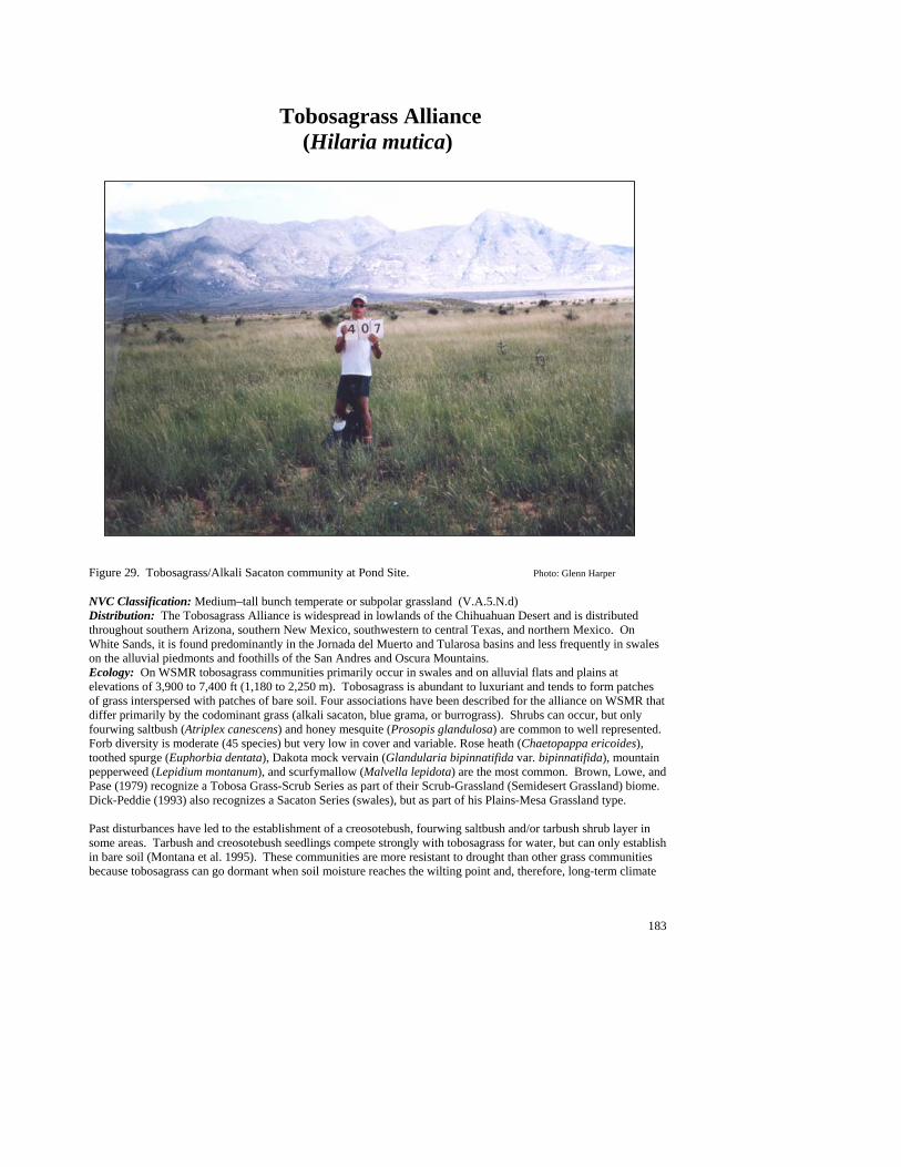
183
Tobosagrass Alliance (Hilaria mutica)
Figure 29. Tobosagrass/Alkali Sacaton community at Pond Site. Photo: Glenn Harper NVC Classification: Medium–tall bunch temperate or subpolar grassland (V.A.5.N.d) Distribution: The Tobosagrass Alliance is widespread in lowlands of the Chihuahuan Desert and is distributed throughout southern Arizona, southern New Mexico, southwestern to central Texas, and northern Mexico. On White Sands, it is found predominantly in the Jornada del Muerto and Tularosa basins and less frequently in swales on the alluvial piedmonts and foothills of the San Andres and Oscura Mountains. Ecology: On WSMR tobosagrass communities primarily occur in swales and on alluvial flats and plains at elevations of 3,900 to 7,400 ft (1,180 to 2,250 m). Tobosagrass is abundant to luxuriant and tends to form patches of grass interspersed with patches of bare soil. Four associations have been described for the alliance on WSMR that differ primarily by the codominant grass (alkali sacaton, blue grama, or burrograss). Shrubs can occur, but only fourwing saltbush (Atriplex canescens) and honey mesquite (Prosopis glandulosa) are common to well represented. Forb diversity is moderate (45 species) but very low in cover and variable. Rose heath (Chaetopappa ericoides), toothed spurge (Euphorbia dentata), Dakota mock vervain (Glandularia bipinnatifida var. bipinnatifida), mountain pepperweed (Lepidium montanum), and scurfymallow (Malvella lepidota) are the most common. Brown, Lowe, and Pase (1979) recognize a Tobosa Grass-Scrub Series as part of their Scrub-Grassland (Semidesert Grassland) biome. Dick-Peddie (1993) also recognizes a Sacaton Series (swales), but as part of his Plains-Mesa Grassland type. Past disturbances have led to the establishment of a creosotebush, fourwing saltbush and/or tarbush shrub layer in some areas. Tarbush and creosotebush seedlings compete strongly with tobosagrass for water, but can only establish in bare soil (Montana et al. 1995). These communities are more resistant to drought than other grass communities because tobosagrass can go dormant when soil moisture reaches the wilting point and, therefore, long-term climate
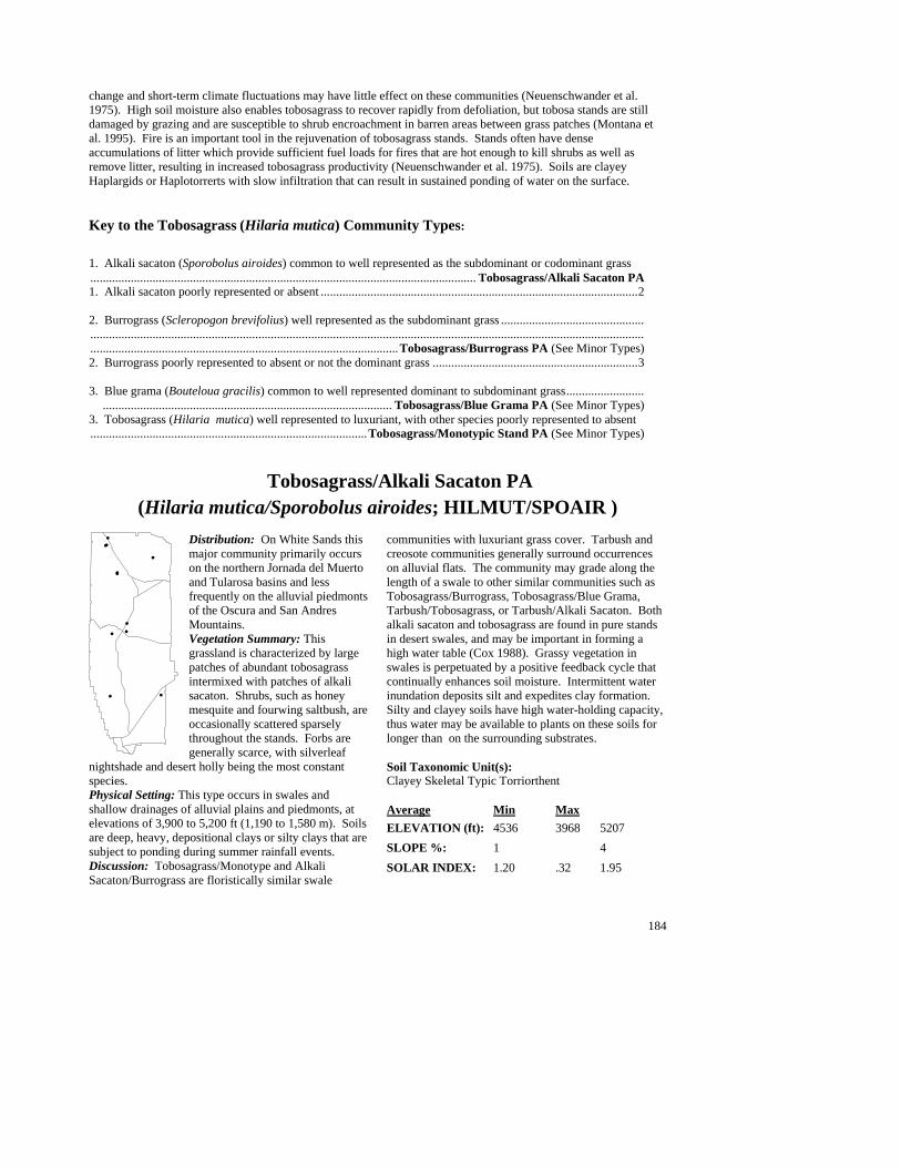
184
change and short-term climate fluctuations may have little effect on these communities (Neuenschwander et al. 1975). High soil moisture also enables tobosagrass to recover rapidly from defoliation, but tobosa stands are still damaged by grazing and are susceptible to shrub encroachment in barren areas between grass patches (Montana et al. 1995). Fire is an important tool in the rejuvenation of tobosagrass stands. Stands often have dense accumulations of litter which provide sufficient fuel loads for fires that are hot enough to kill shrubs as well as remove litter, resulting in increased tobosagrass productivity (Neuenschwander et al. 1975). Soils are clayey Haplargids or Haplotorrerts with slow infiltration that can result in sustained ponding of water on the surface. Key to the Tobosagrass (Hilaria mutica) Community Types: 1. Alkali sacaton (Sporobolus airoides) common to well represented as the subdominant or codominant grass............................................................................................................................ Tobosagrass/Alkali Sacaton PA 1. Alkali sacaton poorly represented or absent ......................................................................................................2 2. Burrograss (Scleropogon brevifolius) well represented as the subdominant grass .............................................. .....................................................................................................................................................................................................................................................................................Tobosagrass/Burrograss PA (See Minor Types) 2. Burrograss poorly represented to absent or not the dominant grass ..................................................................3 3. Blue grama (Bouteloua gracilis) common to well represented dominant to subdominant grass......................... ............................................................................................. Tobosagrass/Blue Grama PA (See Minor Types) 3. Tobosagrass (Hilaria mutica) well represented to luxuriant, with other species poorly represented to absent.........................................................................................Tobosagrass/Monotypic Stand PA (See Minor Types)
Tobosagrass/Alkali Sacaton PA (Hilaria mutica/Sporobolus airoides; HILMUT/SPOAIR )
Distribution: On White Sands this major community primarily occurs on the northern Jornada del Muerto and Tularosa basins and less frequently on the alluvial piedmonts of the Oscura and San Andres Mountains. Vegetation Summary: This grassland is characterized by large patches of abundant tobosagrass intermixed with patches of alkali sacaton. Shrubs, such as honey mesquite and fourwing saltbush, are occasionally scattered sparsely throughout the stands. Forbs are generally scarce, with silverleaf
nightshade and desert holly being the most constant species. Physical Setting: This type occurs in swales and shallow drainages of alluvial plains and piedmonts, at elevations of 3,900 to 5,200 ft (1,190 to 1,580 m). Soils are deep, heavy, depositional clays or silty clays that are subject to ponding during summer rainfall events. Discussion: Tobosagrass/Monotype and Alkali Sacaton/Burrograss are floristically similar swale
communities with luxuriant grass cover. Tarbush and creosote communities generally surround occurrences on alluvial flats. The community may grade along the length of a swale to other similar communities such as Tobosagrass/Burrograss, Tobosagrass/Blue Grama, Tarbush/Tobosagrass, or Tarbush/Alkali Sacaton. Both alkali sacaton and tobosagrass are found in pure stands in desert swales, and may be important in forming a high water table (Cox 1988). Grassy vegetation in swales is perpetuated by a positive feedback cycle that continually enhances soil moisture. Intermittent water inundation deposits silt and expedites clay formation. Silty and clayey soils have high water-holding capacity, thus water may be available to plants on these soils for longer than on the surrounding substrates. Soil Taxonomic Unit(s): Clayey Skeletal Typic Torriorthent
Average Min Max ELEVATION (ft): 4536 3968 5207 SLOPE %: 1 4 SOLAR INDEX: 1.20 .32 1.95
#
#
#
#
#
#
#
#
#
##
185
Common Plant Species, Tobosagrass/Alkali Sacaton PA: Constancy Cover Scientific Name Common Name (% plots) Mean Max Min n = 9 Shrubs Yucca elata soaptree yucca 44.44% 0.44 0.75 0.00 Prosopis glandulosa honey mesquite 44.44% 1.25 2.50 0.00 Opuntia imbricata tree cholla 55.56% 0.21 0.50 0.00 Atriplex canescens fourwing saltbush 44.44% 3.88 7.50 0.00 Grasses Sporobolus airoides alkali sacaton 100.00% 16.61 41.50 4.00 Scleropogon brevifolius burrograss 66.67% 4.92 7.50 2.00 Hilaria mutica tobosagrass 100.00% 24.17 41.50 6.50
Minor Community Types: Tobosagrass Alliance Tobosagrass/Blue Grama PA (Hilaria mutica/Bouteloua gracilis; HILMUT/BOUGRA)
This minor type is known from the northern Jornada del Muerto basin, and gentle dip slopes in the San Andres Mountains. It is characterized by abundant to luxuriant tobosagrass and blue grama cover. Elevations range from 4,600 to 7,400 ft (1,400 to 2,250 m). Shrubs are insignificant, and forb diversity is low (eight species). Tobosagrass/Burrograss PA (Hilaria mutica/Scleropogon brevifolius; HILMUT/SCLBRE)
On White Sands, this minor type is known from the southern Jornada del Muerto basin at 4,760 ft (1,450 m) and is characterized by patches of abundant tobosagrass and well-represented burrograss. Bare soil patches are often conspicuous. Tobosagrass is abundant and dominant relative to burrograss. Shrubs are insignificant, and forb diversity is low (six species). The abundance of burrograss may attest to past disturbance impacts. This type occurs commonly throughout Southwest and northern Mexico on open rangelands. Tobosagrass/Monotypic Stand PA (Hilaria mutica/Monotype; HILMUT/MONTYP)
This minor type is known from the northern Jornada del Muerto and northern Tularosa basins at elevations ranging from 4,700 to 4,800 ft (1,430 to 1,460 m). This grassland is composed of a uniform, luxuriant cover of tobosagrass to the near exclusion of other species. Alkali sacaton (Sporobolus airoides) is a common associate, but seldom exceeds 5% cover. Shrubs are insignificant, and forb diversity is low (10 species).

186
Miscellaneous Plant Associations A list of incidental plant associations with limited documentation, precluding detailed description at this time. The raw data on each association is available in the digital database accompanying the report. Many of these associations represent wetland and riparian communities that were not a target for mapping and were only minimally sampled. Many of them are described in detail in the Handbook of Wetland Vegetation Communities of New Mexico by Muldavin et al. (2000). Wetland and Riparian Communities 1. American Bulrush/Alkali Muhly PA (Scirpus americanus/Muhlenbergia asperifolia; SCIAME/MUHASP) 2. American Bulrush/Common Spikerush PA (Scirpus americanus/Eleocharis palustris; SCIAME/ELEPAL) 3. American Bulrush/Monotypic Stand PA (Scirpus americanus Monotype; SCIAME/MONTYP) 4. Apacheplume/Arroyo PA (Fallugia paradoxa/Arroyo; FALPAR/ARROYO) 5. Broadleaf Cattail/Monotypic Stand PA (Typha latifolia Monotype; TYPLAT/MONTYP) 6. Common Reed/Inland Saltgrass PA (Phragmites australis/Distichlis spicata; PHRAUS/DISSPI) 7. Inland Saltgrass/Alkali Sacaton PA (Distichlis spicata/Sporobolus airoides; DISSPI/SPOAIR) 8. Inland Saltgrass/Monotype PA (Distichlis spicata/Monotype; DISSPI/MONTYP) 9. Littleleaf Sumac/Arroyo PA (Rhus microphylla/Arroyo; RHUMIC/ARROYO) 10. Saltcedar/Alkali Sacaton PA (Tamarix ramosissima/Sporobolus airoides; TAMRAM/SPOAIR) 11. Saltcedar/Pickleweed PA (Tamarix ramosissima/Allenrolfea occidentalis; TAMRAM/ALLOCC) 12. Saltcedar/Utah Swampfire PA (Tamarix ramosissima/Sarcocornia utahensis; TAMRAM/SARUTA) Shrublands 13. Broom Dalea/Mesa Dropseed PA (Psorothamnus scoparius/Sporobolus flexuosus; PSOSCO/SPOFLE) 14. Common Hoptree/Prairie Junegrass (Ptelea trifoliata/Koeleria macrantha; PTETRI/KOEMAC)

187
15. Wright’s Beebrush/Lava (Aloysia wrightii/Lava; ALOWRI/LAVA) Grasslands 16. Burrograss/Monotypic Stand PA (Scleropogon brevifolius/Monotypic; SCLBRE/MONTYP) 17. Galleta/Alkali Sacaton PA (Hilaria jamesii/Sporobolus airoides; HILJAM/SPOAIR) 18. Galleta/Soaptree Yucca PA (Hilaria jamesii/Yucca elata; HILJAM/YUCELA) 19. Giant Sacaton/Monotypic Stand PA (Sporobolus wrightii/Monotypic; SPOWRI/MONTYP) 23. Gypsum Grama/New Mexico Bluestem PA (Bouteloua breviseta/Schizachyrium neomexicanum; BOUBRE/SCHNEO) 20. Mesa Dropseed/Soaptree Yucca PA (Sporobolus flexuosus/Yucca elata; SPOFLE/YUCELA) 21. Mesa Dropseed/Spike Dropseed PA (Sporobolus flexuosus/Sporobolus contractus; SPOFLE/SPOCON) 22. Mesa Dropseed/Torrey’s Jointfir PA (Sporobolus flexuosus/Ephedra torreyana; SPOFLE/EPHTOR) 24. New Mexico Bluestem/Sandhill Muhly PA (Schizachyrium neomexicana/Muhlenbergia pungens; SCHNEO/MUHPUN) (Schizachyrium neomexicanus/Muhlenbergia pungens:

188
REFERENCES Allred, K. W. 1993. A Field Guide to the Grasses of New Mexico. Department of Agricultural Communications,
New Mexico State University, Las Cruces, New Mexico. Anderson, M. P. Bourgeron, M.T. Bryer, R. Crawford, L. Engelking, D. Faber-Langendoen, M Gallyoun, K.
Goodin, D.H. Grossman, S. Landaal, K. Metzler, K.D. Patterson, M. Pyne, M Reid, L. Sneddon, and A.S. Weakley. 1998. International classification of ecological communities: terrestrial vegetation of the United States. Volume II. National Classification System: list of types. The Nature Conservancy, Arlington, VA
Anderson, W.D., and D.E. Taylor. 1983. Natural Resources Management, White Sands Missile Range. D.O.A., U.S.
Army White Sands Missile Range. Arnold, J.F., D.A. Jameson, and E.H. Reid. 1964. The pinyon/juniper type of Arizona. Effects of grazing, fire, and
tree control. USDA Forest Service, Production Research Report 84. Bachman, G.O. 1968. Geology of the Mockingbird Gap Quadrangle, Lincoln and Socorro counties, New Mexico.
U.S.D.I., Geological Survey Professional Paper 594-J. Bachman, G.O. and R.L. Harbour. 1970. Geologic map of the northern part of the San Andres Mountains, central
New Mexico. U.S.D.I, Geological Survey Miscellaneous Geologic Investigations Map I-600. Baker, M.B.J., L.F. Debano, and P.F. Pfolliott. 1995. Soil loss in pinon-juniper ecosystems and its influence on site
productivity and desired future condition. In: D. Shaw, E.F. Aldon, and L. Saio (Tech Coord.) Desired Future Conditions in for pinon-Juniper Ecosystems. Gen. Tech Rep. RM-258, USDA Forest Service, Rocky Mountain Forest and Range Experiment Station, Fort Collins, CO.
Barnes, F.J. 1987. Carbon and water relations across a pinyon-juniper habitat gradient. Unpublished dissertation,
New Mexico State University, Las Cruces, NM. Betancourt, J.L., E.A. Pierson, K.A. Rylander, J.A. Fairchild-Parks, and J.S. Dean. 1993. Influece of history and
climate on New Mexico pinon-juniper woodlands. Pages 42-52 In: E.F. Aldon. And D.W. Shaw. (Tech. Coord.), Managing pinon-juniper ecosystems for sustainability and social needs. USDA Forest Service Gen. Tech. Rep. RM-236. Rocky Mountain Forest and Range Experiment Station, Fort Collins, CO.
Bogan, M.A., C.D. Allen, E.H. Muldavin, S.P. Platania, J.N. Stuart, G.H. Farley, P. Mehlhop, and J. Belnap. 1998.
Southwest. Pages 543-592 in M.J. Mac, P.A. Opler, C.E. Puckett Haecker, and P.D. Doran, editors. Status and Trends of the Nation’s Biological Resources, vol. 2. U.S. Department of the Interior, U.S. Geological Survey, Reston, Virginia.
Bowers, J.E. 1982. The plant ecology of inland dunes in western North America. Journal of Arid Environments 5:
199-220 Brady, W.W., M.R. Stromberg, E.F. Aldon, C.D. Bonham and S.H. Henry. 1989. Response of a semidesert
grassland to 16 years of rest from grazing. Journal of Range Management 42(4): 284-288 Brown, A.L. 1950. Shrub invasion of southern Arizona desert grassland. Journal of Range Management 3: 172-
177. Brown, D.E. 1982. Chihuahuan desertscrub. Desert Plants 4(1-4): 169-179 Brown, D.E. 1982. Semidesert grassland. Desert Plants 4(1-4): 123-141 Brown, J.H. and E.J. Heske. 1990. Control of a desert grassland transition by a keystone rodent guild. Science
250: 1705-1707

189
Brown, J.R. and S. Archer. 1989. Woody plant invasion of grasslands: establishment of honey mesquite (Prosopis glandulosa var. glandulosa) on sites differing in herbaceous biomass and grazing history. Oecologia 80: 19-26
Buffington, L.C. and C.H. Herbel. 1965. Vegetational changes on a semidesert grassland range from 1858 to 1963.
Ecological Monographs 35(5): 139-164 Bunting, S.C. 1987. Use of prescribed burning in juniper and pinyon-juniper woodlands. In: R.L. Everett
(compiler). Proceedings-Pinyon-Juniper Conference. Gen. Tech. Rep. INT-215, USDA Forest Service Intermountain Forest and Range Experiment Station, Ogden, UT.
Burgess, T.L. 1995. Desert grassland, mixed shrub savanna, shrub steppe, or semidesert scrub? In: J.A. McClaran
and T.R.Van Devender, eds. The Desert Grassland. University of Arizona Press, Tucson, Arizona pp. 31-67
Campbell, R.S. 1929. Vegetation succession in the Prosopis sand dunes of southern New Mexico. Ecology 10(4):
392-398 Chew, R.M. and Chew, A.E. 1965. The primary productivity of a desert-shrub (Larrea tridentata) community.
Ecol. Monog. 35: 355-375 Cornelius, J.M. 1988. Fire effects on vegetation of a northern Chihuahuan Desert grassland. Ph.D. Dissertation,
New Mexico State University, Las Cruces, NM. 96 pp. Cornelius, J.M., P.R. Kemp, J.A. Ludwig and G.L. Cunningham. 1991. The distribution of vascular plant species
and guilds in space and time along a desert gradient. Journal of Vegetation Science 2: 59-72 Correll, D.S. and M.C. Johnston. 1979. Manual of the Vascular Plants of Texas. University of Texas, Austin,
Texas. Cox, J.R. 1988. Seasonal burning and mowing impacts on Sporobolus wrightii grasslands. Journal of Range
Management 41(1): 12-15 Danaker, R.C. 1985. Terrestrial Ecosystem Report for Smokey Bear Ranger District, Lincoln National Forest,
USDA Forest Service Southwestern Region, Albuquerque, NM. Dinerstein, E., D. Olson, J. Atchely, C. Loucks, S. Contreras-Balderas, R. Abell, E. Inigo, E. Enkerlin, C.E.
Williams and G. Castilleja. 2000. Ecoregion-based conservation in the Chihuahuan Desert: a biological assessment and biodiversity vision. A collaborative effort by World Wildlife Fund, Comision National para el Conocimiento y Uso de la Biodiversidad (CONABIO), The Nature Conservancy, PRONATURA Noreste and the Instituto Tecnologico y de Estudios Superiores de Monterrey (ITESM).
DeVelice, R.L. , J.A. Ludwig, W.H. Moir, and F. Ronko Jr. 1986. A classification of forest habitat types in northern
New Mexico and southern Colorado. Gen. Tech. Rep. RM-131. USDA, Forest Service, Rocky Mountain Forest and Range Experiment Station, Fort Collins, Colorado.
Dick-Peddie, W.A. 1993. New Mexico Vegetation; Past, Present and Future. University of New Mexico Press,
Albuquerque, New Mexico. 244 p. Donart, G.B., D,D. Sylvester, and W.C. Hickey. 1978. A vegetation classification system for New Mexico, U.S.A.
Proc. of the First International Rangeland Congress. Pages 488-490. Edwards, G. Miller, J. Redders, R. Stein, and K. Dunstan. 1987. Terrestrial ecosystem survey of Carson National
Forest. USDA Forest Service Southwestern Region, Albuquerque, NM.

190
Erdman, J.A., 1970 Pinyon-juniper succession after natural fires on residual soils of Mesa Verde, Colorado. Brigham Young Univ. Science Bull. Biol. Series 11:122-138.
Findley, J.S. 1987. The Natural History of New Mexican Mammals. University of New Mexico Press,
Albuquerque, New Mexico. 253 p. Francis, R.E. 1986. Phyto-edaphic communities of the Upper Rio Puerco Watershed, New Mexico. USDA Forest
Service Research Paper RM-272. Rocky Mountain Forest and Range Experiment Station, Fort Collins, Colorado. pp. 1-73
Gehlbach, F. 1967. Vegetation of the Guadalupe escarpment, New Mexico-Texas. Ecology 48(3): 404-419 Gibbens, R.P. and R.F. Beck. 1988. Changes in grass basal area and forb densities over a 64-year period on
grassland types of the Jornada Experimental Range. Journal of Range Management 41(3): 186-192 Gibbens, R.P. and R.F. Beck. 1987. Increase in number of dominant plants and dominance--classes on a grassland
in the northern Chihuahuan Desert. Journal of Range Management 40(2): 136-139 Gile, L.H., J.W. Hawley and R.B. Grossman. 1981. Soils and geomorphology in the basin and range area of
southern New Mexico; guidebook to the desert project. New Mexico Bureau of Mines and Mineral Resources. 222 p.
Gile, L.H., R.P. Gibbens and J.M. Lenz. 1995. Soils and sediments associated with remarkable, deeply-penetrating
roots of crucifixion thorn (Koeberlinia spinosa Zucc.) Journal of Arid Environments 31: 137-151 Gosz, R.J. and J.R. Gosz. 1996. Species interactions on the biome transition zone in New Mexico: response of blue
grama (Bouteloua gracilis) and black grama (Bouteloua eriopoda) to fire and herbivory. Journal of Arid Environments 34: 101-114
Grossman, D.H., D. Faber-Langendoen, A.S. Weakley, P. Bourgeron, R, Crawford, K. Goodin, S Landaal, K.
Metzler, K.D. Patterson, M. Pyne, M. Reid, and L. Sneddon. 1998. International classification of ecological communities: terrestrial vegetation of the United States. Volume I. National Classification System: development, status, and applications. The Nature Conservancy, Arlington, VA
Gurevitch, J. 1986. Competition and the local distribution of the grass Stipa Neomexicana. Ecology 67(1): 46-57 Hawley, J.W. 1983. Quaternary geology of the Rhodes Canyon (RATSCAT) site. IN: The Prehistory of Rhodes
Canyon, N.M. (P.L. Eidenbach, ed.). Human Systems Research, Las Cruces, NM. Hennessy, J.T., R.P. Gibbens, J.M. Tromble and M. Cardenas. 1983. Vegetation changes from 1935 to 1980 in
mesquite dunelands and former grasslands of Southern New Mexico. Journal of Range Management 36(3): 370-374
Herbel, C.H., F.N. Ares and R.A. Wright. 1972. Drought effects on a semidesert grassland range. Ecology 53(6): 1084-1093
Holechek, J.L. 1991. Chihuahuan desert rangeland, livestock grazing, and sustainability. Rangelands 13(3): 115-
120 Humphrey, R.R. 1958. The desert grassland; a history of vegetational change and an analysis of causes. The
Botanical Review 24(4): 193-252 Johnsen, T.N. 1962. Oneseed juniper invasion of northern Arizona grasslands, Ecol. Monogr. 32:167-207.

191
Johnston, B. C. 1984. Plant associations of Region Two. Edition 3.5. USDA Forest Service, Rocky Mountain
Region, Lakewood, Colorado. Kartesz, J.T. 1994. A synonomized checklist of the vascular flora of the United States, Canada, and Greenland.
Timber Press, Portland, Oregon. Kearney, T.H.; Peebles, R.H. 1951. Arizona flora. Berkeley: University of California Press. 1,085 p. Kennedy, K.L. 1983. A habitat classification for the pinyon-juniper woodlands of the Lincoln National Forest.
Unpubl. Thesis, New Mexico State University, Las Cruces, New Mexico. Kuchler, A.W., 1964. Potential Natural Vegetation of the conterminous United States. American Geographical
Society, NY. Larson, M., and W. H. Moir. 1987. Forest and woodland habitat types (plant associations) of southern New Mexico
and central Arizona (north of the Mogollon Rim). USDA Forest Service, Southwestern Region, Albuquerque, NM. 76 pp.
Layser, E.F., and G.H. Schubert. 1979. Preliminary classification for the coniferous forest and woodland series of
Arizona and New Mexico. USDA Forest Service, Res. Pap. RM-208. Rocky Mountain Forest and Range Experiment Station, Fort Collins, CO.
Laurenroth, W.K., D.P. Coffin, T.B. Kirchner and O.E. Sala. 1994. The importance of soil water in the recruitment
of Bouteloua gracilis in the shortgrass steppe. Ecological Applications 4: 741-749 Ludwig, J.A. and J.F. Reynolds. 1988. Statistical Ecology: A primer on methods and computing. John Wiley and
Sons, NY. Mahall, B.E. and R.M. Callaway. 1991. Root communication among desert shrubs. Ecology 88: 874-876 Martin, W.C. and C.R. Hutchins. 1980. A Flora of New Mexico. Strauss & Cramer GmbH, Hirschenberg,
Germany. 2591 p. McAuliffe, J.R. 1994. Landscape evolution, soil formation, and ecological patterns and processes in Sonoran
Desert bajadas. Ecological Monographs 64(2): 111-148 McClaren, J.A. 1995. Desert grassland and grasses. In: J.A. McClaran and T.R.Van Devender, eds. The Desert
Grassland. University of Arizona Press, Tucson, Arizona pp. 1-30 McDaniel, K.C., R.D. Pieper and G.B. Donart. 1982. Grass response following thinning of broom snakeweed.
Journal of Range Management 35(2): 219-222 Medina, A.L. 1997. Native aquatic plants and ecological condition of southwestern wetlands and riparian areas. Pp.
329–335. In: Shaw, D.W. and D.M. Finch (tech. coords.). Desired future conditions for Southwestern riparian ecosystems: bringing interests and concerns together. General Technical Report RM–GTR–272. Ft. Collins, CO: USDA Forest Service, Rocky Mountain Forest and Range Experiment Station
Moir, W.H. (1963). Vegetaional analysis of three southern New Mexico Mountain ranges. Unpublished M.S.
Thesis. New Mexico State University, Las Cruces, NM. Moir, W .H. and J. O. Carleton. 1987. Classification of pinyon-juniper (P-J) sites on national forests in the
Southwest. Pages 216-226 in Everett, R.L., ed. Proceedings--Pinyon-Juniper Conference, Reno, NV, 13-16 January 1986. USDA Forest Service General

192
Mueller-Dombois, D. and H. Ellenberg. 1974. Aims and Methods of Vegetation Ecology. John Wiley and Sons, New York, NY.
Montana, C., B.Cavagnaro and O. Briones. 1995. Soil water use by co-existing shrubs and grasses in the Southern
Chihuahuan Desert, Mexico. Journal of Arid Environments 31: 1-13 Muldavin, E.M. 1994. A vegetation map legend for application to the Gap Analysis Project. Final report to New
Mexico Fish and Wildlife Research Unit, New Mexico State University, Las Cruces, NM. Muldavin, E.H. and P. Mehlhop. 1992. A preliminary vegetation classification and test vegetation map for White
Sands Missile Range and San Andres National Wildlife Refuge, New Mexico. (Unpubl. report) New Mexico Natural Heritage Program, New Mexico.
Muldavin, E.H. and P. Mehlhop. 1994a. A vegetation classification and map for White Sands Missile Range and San
Andres National Wildlife Refuge, New Mexico. Interim report (February 1994) submitted to the Environmental Office, White Sands Missile Range, NM. New Mexico Natural Heritage Program, Albuquerque, NM.
Muldavin, E.M. and P. Mehlhop. 1994b. A vegetation classification and map for White Sands Missile Range and
San Andres National Wildlife Refuge, New Mexico. Interim Report II (December 1994) submitted to the Environmental Office, White Sands Missile Range, NM. New Mexico Natural Heritage Program, Albuquerque, NM.
Muldavin, E. H., M. Pando-Moreno, Jamie Thompson and Patricia Mehlhop. 1994. A Vegetation Map from
Satellite Imagery for White Sands National Monument. Final Report to the National Park Service, White Sands National Monument, Alamogordo, NM.
Muldavin, E.M. 1996. Spatial-temporal dynamics of Montane Forest Communities in Relation to Fire in the Organ
Mountains, Ft. Bliss, Texas and New Mexico. Intergovernmental Personnel Agreement Final Report to Directorate of Environment, Fort Bliss, Texas. 151p
Muldavin E., G. Harper, P. Neville, T. Bennett, and K. Johnson. 1997. A Vegetation Map for Holloman Air Force
Base, New Mexico. Final Report. Submitted to Holloman Air Force Base, NM Muldavin, E. , V. Archer, and P. Neville. A Vegetation Map of the Borderlands Ecosystem Management Area.
1998. Final Report submitted to the USDA Forest Service, Rocky Mountain Forest and Range Experiment Station, Flagstaff, AZ
Muldavin, E., P. Durkin, M. Bradley, M. Stuever and P. Mehlhop. 2000 Handbook of Wetland Vegetation
Communities of New Mexico. Volume I: Classification and Community Descriptions. Final Report submiited to the New Mexico Environment Department, Surface Water Quality Bureau, Santa Fe, NM.
Naumann, T.S. 1987. Canon Blanco Mesa, NM: a natural history and nature preserve proposal. Final Report to The
Nature Conservancy, NM Field Office, Santa Fe, NM. Neher, R.E. and O.F. Bailey. 1976. Soil Survey of the White Sands Missile Range, New Mexico. USDA Soil
Conservation Service. National Cooperative Soil Survey. Neuenschwander, L.F., S.H. Sharrow and H.A. Wright. 1975. Review of tobosa grass (Hilaria mutica).
Southwestern Naturalist 20(2): 255-263 Noy-Meir, I. 1973. Desert ecosystems: environment and producers. Annual Review of Ecology and Systematics
4: 25-51 Peet, R.K. 1988. Forests of the rocky mountains. In: M.G. Barbour and W.D. Billings, eds. North American
Terrestrial Vegetation. Cambridge University Press, Cambridge, Massachusetts pp. 63-101

193
Peterson, F.F. 1981. Landforms of the basin & range province - defined for soil survey. Technical Bulletin 28. Nevada Agricultural Experiment Station, University of Nevada, Reno, Nevada 52 p.
Pieper, R.D. and G.A. Lymbery, 1987, Influence of topographic features on pinyon-juniper vegetation in south-
central New Mexico. In: R.L. Everett (compiler). Proceedings-Pinyon-Juniper Conference. Gen. Tech. Rep. INT-215, USDA Forest Service Intermountain Forest and Range Experiment Station, Ogden, UT
Potter, L.D. and J.C. Krenetsky. 1967. Plant succession with released grazing on New Mexico range lands. Journal
of Range Management 20: 145-151 Powell, M.A. 1988. Trees & Shrubs of Trans-Pecos Texas, Including Big Bend and Guadalupe Mountains National
Parks. Big Bend Natural History Association, Inc., Big Bend National Park. Powell, A.M. 1994. Grasses of the Trans-Pecos and Adjacent Areas. University of Texas Press, Austin, Texas.
377 p. Schlesinger, W.H., J.F. Reynolds, G.L. Cunningham, L.F. Huenneke, W.M. Jarrell, R.A. Virginia and W.G.
Whitford. 1990. Biological feedbacks in global desertification. Science 247: 1043-1048 Scholl, D.G. 1989. Soil compaction from cattle trampling on a semiarid watershed in northwest New Mexico. New
Mexico Journal of Science 29(2): 105-112 Seager, W.R. 1981. Geology of the Organ Mountains and Southern San Andres Mountains, New Mexico. Memoir
36. New Mexico Bureau of Mines and Mineral Resources. New Mexico Institute of Mining and Technology.
Seager, W.R., J.W. Hawley, F.E. Kottlowski, and S.A. Kelly. 1987. Geology of the east half of Las Cruces and El
Paso, 1 X 2 sheets (scale 1:125,000), New Mexico. Geology Map 57, Sheet 1. New Mexico Bureau of Mines and Mineral Resources. New Mexico Institute of Mining and Technology.
Shimwell, D.W. 1971. The Description and Classification of Vegetation. Univ. of Washington Press, Seattle, WA.
322p. Sims, P.L. 1988. Grasslands. In: M.G. Barbour and W.D. Billings, eds. North American Terrestrial Vegetation.
Cambridge University Press, Cambridge, Massachusetts pp. 265-286 Smith, S.D. and J.A. Ludwig. 1978. The distribution and phytosociology of Yucca elata in Southern New Mexico.
American Midland Naturalist 100(1): 202-211 Stein, R.A. and J.A. Ludwig. 1979. Vegetation and soil patterns on a Chihuahuan desert bajada. American
Midland Naturalist 101(1): 28-37 Stubbendieck, J., S.L. Hatch and C.H Butterfield. 1992. North American Range Plants, 4th edition. University of
Nebraska Press, Lincoln, Nebraska. 493 p. Soil Survey Staff. 1991. National Soils Handbook. USDA Soil Conservation Service. Washington D.C. Soil Survey Staff. 1992. Keys to Soil Taxonomy. SMSS Tech. Monograph, Fifth Ed. Pocahontas Press, Inc.,
Blacksburg, VA. Stuever, M.C., and J.S. Hayden. 1996. Plant associations (habitat types) of forest and woodlands of Arizona and
New Mexico. Final report submitted to USDA Forest Service, Southwestern Region, Albuquerque, NM.

194
Swetnam, T.W. 1990. Fire history and climate in the southwestern United States. J. S. Krames (Tech. Coord.): Proceedings- effects of fire management of southeastern natural resources. USDA Forest Service Rocky Mountain Forest and Range Experiment Station, Fort Collins CO.
Swetnam, T. W. and J.H. Dieterich. 1985. Fire history of ponderosa pine forests in the Gila Wilderness, New
Mexico, IN: J.E. Lotan, B.M. Kilgor, W.C. Fischer, & R.W. Mutch (technical coordinators), Proceedings: Symposium and workshop on wilderness fire. Gen. Tech Rep. INT-182, USDA. Forest Service, Intermountain Research Station, Missoula Montana.
Swetnam, T.W., and J.L. Betancourt. 1999. Fire-southern oscillation relations in the southwestern United States.
Science. 249:1017-1020 Thompson, B.C., P.J. Crist, E. Muldavin. J.S. Prior-Magee, R.A. Dietner and D. Garber. 1996. Examining natural
floral heritage and management for biological diversity in New Mexico using Gap analysis. New Mexico Journal of Science. 36:327-354
Tirmenstien, D.A. 1987. Stipa columbiana. In: W.C. Fischer (compiler), The Fire Effects Information System
[database]. USDA Forest Service, Intermountain Research Station, Missoula Montana. Tirmenstien, D.A. 1988. Quercus gambeli . In: W.C. Fischer (compiler), The Fire Effects Information System
[database]. USDA Forest Service, Intermountain Research Station, Missoula Montana. Tress, J.A.Jr., and J.M. Klopateck. 1987. Successional changes in community structure of pinyon-juniper woodlands
in north-central Arizona. In: R.L. Everett (compiler). Proceedings-Pinyon-Juniper Conference. Gen. Tech. Rep. INT-215, USDA Forest Service Intermountain Forest and Range Experiment Station, Ogden, UT.
USFS. 1986. Forest and Woodland habitat types (plant associations) of southern New Mexico and central Arizona.
USDA Forest Service Southwestern Region, Albuquerque, NM USFS. 1987a. Forest and Woodland habitat types (plant associations) of northern New Mexico and northern
Arizona. USDA Forest Service Southwestern Region, Albuquerque, NM USFS 1987b. Forest and Woodland habitat types (plant associations) of Arizona south of the Mogollon Rim and
southwestern New Mexico. USDA Forest Service Southwestern Region, Albuquerque, NM Van Devender, T.R. 1995. Desert grassland history: changing climates, evolution, biogeography, and community
dynamics In: J.A. McClaran and T.R.Van Devender, eds. The Desert Grassland. University of Arizona Press, Tucson, Arizona pp. 68-99
Walker, B. H., D. Ludwig, C.S. Holling and R.M. Peterman. 1981. Stability of semi-arid savanna grazing systems.
Journal of Ecology 69: 473-498 Wan, C., R.E. Sosebee and B.L. McMichael. 1993. Soil water extraction and photosynthesis in Gutierrezia
sarothrae and Sporobolus cryptandrus. Journal of Range Management 46: 425-430 Wondzell, S.M., G.L. Cunningham and D. Bachelet. 1987. A hierarchical classification of landforms: some
implications for understanding local and regional vegetation dynamics. In: E.L. Aldon, C.E. Gonzales Vicente and W.H. Moir, eds. Strategies for Classification and Management of Native Vegetation for Food Production in Arid Zones, October 12-16, 1987. USDA Forest Service General Technical Report RM 150 pp. 15-23
Wood, J.C., M.K. Wood and J.M. Tromble. 1987a. Important factors influencing water infiltration and sediment
production on arid land in New Mexico. Journal of Arid Environments 12: 111-118

195
Wood, S., S. Yanoff, N. Douglas, S. Radjy, E. Muldavin, and P. Mehlhop. 1997b Vegetation of Fort Bliss, Texas and New Mexico: Volume I, vegetation communities. Final Report submitted to Directorate of Environment, Cultural/Natural Resources Division, Fort Bliss Military Reservation, Fort Bliss, Texas
York, J.C. and Dick-Peddie, W.A. 1969. Vegetation changes in southern New Mexico during the past hundred
years. In: W.G. McGinnis and B.J. Goldman, eds. Arid Lands in Perspective. University of Arizona Press, Tucson, Arizona pp. 157-166

A-1
APPENDIX A
Vegetation of White Sands Missile Range
Plant Species List
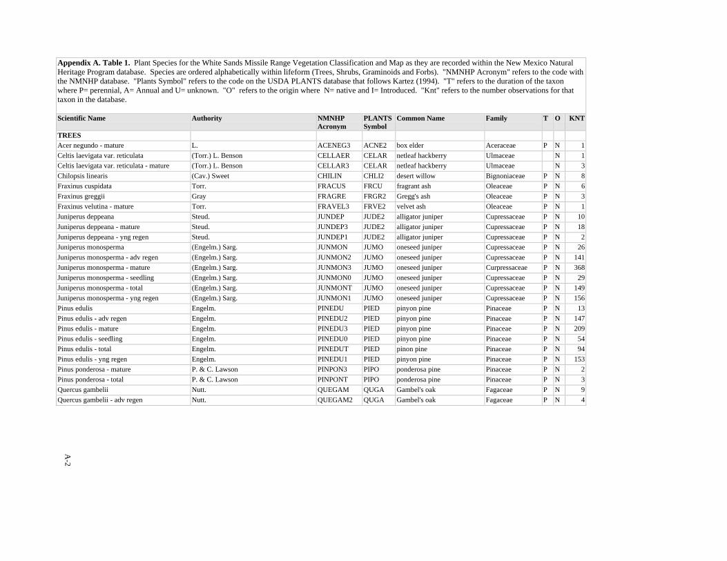
A-2
Appendix A. Table 1. Plant Species for the White Sands Missile Range Vegetation Classification and Map as they are recorded within the New Mexico Natural Heritage Program database. Species are ordered alphabetically within lifeform (Trees, Shrubs, Graminoids and Forbs). "NMNHP Acronym" refers to the code with the NMNHP database. "Plants Symbol" refers to the code on the USDA PLANTS database that follows Kartez (1994). "T" refers to the duration of the taxon where P= perennial, A= Annual and U= unknown. "O" refers to the origin where N= native and I= Introduced. "Knt" refers to the number observations for that taxon in the database. Scientific Name Authority NMNHP
Acronym PLANTSSymbol
Common Name Family T O KNT
TREES Acer negundo - mature L. ACENEG3 ACNE2 box elder Aceraceae P N 1Celtis laevigata var. reticulata (Torr.) L. Benson CELLAER CELAR netleaf hackberry Ulmaceae N 1Celtis laevigata var. reticulata - mature (Torr.) L. Benson CELLAR3 CELAR netleaf hackberry Ulmaceae N 3Chilopsis linearis (Cav.) Sweet CHILIN CHLI2 desert willow Bignoniaceae P N 8Fraxinus cuspidata Torr. FRACUS FRCU fragrant ash Oleaceae P N 6Fraxinus greggii Gray FRAGRE FRGR2 Gregg's ash Oleaceae P N 3Fraxinus velutina - mature Torr. FRAVEL3 FRVE2 velvet ash Oleaceae P N 1Juniperus deppeana Steud. JUNDEP JUDE2 alligator juniper Cupressaceae P N 10Juniperus deppeana - mature Steud. JUNDEP3 JUDE2 alligator juniper Cupressaceae P N 18Juniperus deppeana - yng regen Steud. JUNDEP1 JUDE2 alligator juniper Cupressaceae P N 2Juniperus monosperma (Engelm.) Sarg. JUNMON JUMO oneseed juniper Cupressaceae P N 26Juniperus monosperma - adv regen (Engelm.) Sarg. JUNMON2 JUMO oneseed juniper Cupressaceae P N 141Juniperus monosperma - mature (Engelm.) Sarg. JUNMON3 JUMO oneseed juniper Curpressaceae P N 368Juniperus monosperma - seedling (Engelm.) Sarg. JUNMON0 JUMO oneseed juniper Cupressaceae P N 29Juniperus monosperma - total (Engelm.) Sarg. JUNMONT JUMO oneseed juniper Cupressaceae P N 149Juniperus monosperma - yng regen (Engelm.) Sarg. JUNMON1 JUMO oneseed juniper Cupressaceae P N 156Pinus edulis Engelm. PINEDU PIED pinyon pine Pinaceae P N 13Pinus edulis - adv regen Engelm. PINEDU2 PIED pinyon pine Pinaceae P N 147Pinus edulis - mature Engelm. PINEDU3 PIED pinyon pine Pinaceae P N 209Pinus edulis - seedling Engelm. PINEDU0 PIED pinyon pine Pinaceae P N 54Pinus edulis - total Engelm. PINEDUT PIED pinon pine Pinaceae P N 94Pinus edulis - yng regen Engelm. PINEDU1 PIED pinyon pine Pinaceae P N 153Pinus ponderosa - mature P. & C. Lawson PINPON3 PIPO ponderosa pine Pinaceae P N 2Pinus ponderosa - total P. & C. Lawson PINPONT PIPO ponderosa pine Pinaceae P N 3Quercus gambelii Nutt. QUEGAM QUGA Gambel's oak Fagaceae P N 9Quercus gambelii - adv regen Nutt. QUEGAM2 QUGA Gambel's oak Fagaceae P N 4
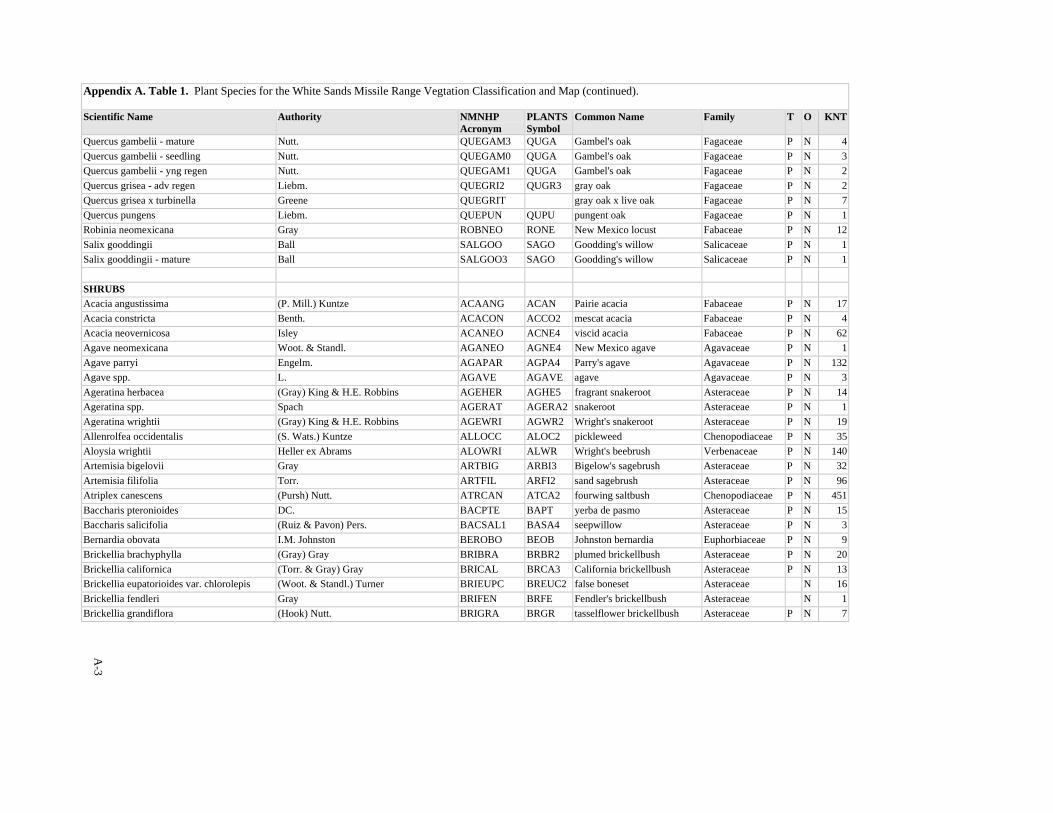
A-3
Appendix A. Table 1. Plant Species for the White Sands Missile Range Vegtation Classification and Map (continued). Scientific Name Authority NMNHP
Acronym PLANTSSymbol
Common Name Family T O KNT
Quercus gambelii - mature Nutt. QUEGAM3 QUGA Gambel's oak Fagaceae P N 4Quercus gambelii - seedling Nutt. QUEGAM0 QUGA Gambel's oak Fagaceae P N 3Quercus gambelii - yng regen Nutt. QUEGAM1 QUGA Gambel's oak Fagaceae P N 2Quercus grisea - adv regen Liebm. QUEGRI2 QUGR3 gray oak Fagaceae P N 2Quercus grisea x turbinella Greene QUEGRIT gray oak x live oak Fagaceae P N 7Quercus pungens Liebm. QUEPUN QUPU pungent oak Fagaceae P N 1Robinia neomexicana Gray ROBNEO RONE New Mexico locust Fabaceae P N 12Salix gooddingii Ball SALGOO SAGO Goodding's willow Salicaceae P N 1Salix gooddingii - mature Ball SALGOO3 SAGO Goodding's willow Salicaceae P N 1 SHRUBS Acacia angustissima (P. Mill.) Kuntze ACAANG ACAN Pairie acacia Fabaceae P N 17Acacia constricta Benth. ACACON ACCO2 mescat acacia Fabaceae P N 4Acacia neovernicosa Isley ACANEO ACNE4 viscid acacia Fabaceae P N 62Agave neomexicana Woot. & Standl. AGANEO AGNE4 New Mexico agave Agavaceae P N 1Agave parryi Engelm. AGAPAR AGPA4 Parry's agave Agavaceae P N 132Agave spp. L. AGAVE AGAVE agave Agavaceae P N 3Ageratina herbacea (Gray) King & H.E. Robbins AGEHER AGHE5 fragrant snakeroot Asteraceae P N 14Ageratina spp. Spach AGERAT AGERA2 snakeroot Asteraceae P N 1Ageratina wrightii (Gray) King & H.E. Robbins AGEWRI AGWR2 Wright's snakeroot Asteraceae P N 19Allenrolfea occidentalis (S. Wats.) Kuntze ALLOCC ALOC2 pickleweed Chenopodiaceae P N 35Aloysia wrightii Heller ex Abrams ALOWRI ALWR Wright's beebrush Verbenaceae P N 140Artemisia bigelovii Gray ARTBIG ARBI3 Bigelow's sagebrush Asteraceae P N 32Artemisia filifolia Torr. ARTFIL ARFI2 sand sagebrush Asteraceae P N 96Atriplex canescens (Pursh) Nutt. ATRCAN ATCA2 fourwing saltbush Chenopodiaceae P N 451Baccharis pteronioides DC. BACPTE BAPT yerba de pasmo Asteraceae P N 15Baccharis salicifolia (Ruiz & Pavon) Pers. BACSAL1 BASA4 seepwillow Asteraceae P N 3Bernardia obovata I.M. Johnston BEROBO BEOB Johnston bernardia Euphorbiaceae P N 9Brickellia brachyphylla (Gray) Gray BRIBRA BRBR2 plumed brickellbush Asteraceae P N 20Brickellia californica (Torr. & Gray) Gray BRICAL BRCA3 California brickellbush Asteraceae P N 13Brickellia eupatorioides var. chlorolepis (Woot. & Standl.) Turner BRIEUPC BREUC2 false boneset Asteraceae N 16Brickellia fendleri Gray BRIFEN BRFE Fendler's brickellbush Asteraceae N 1Brickellia grandiflora (Hook) Nutt. BRIGRA BRGR tasselflower brickellbush Asteraceae P N 7
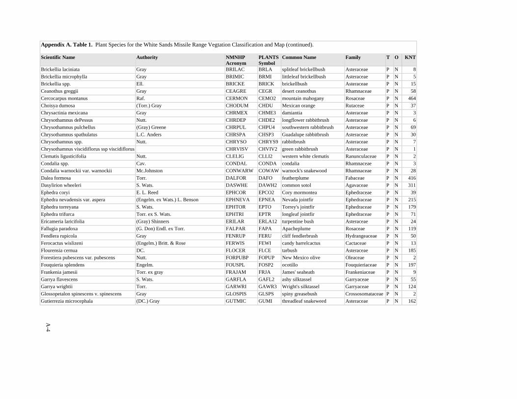
A-4
Appendix A. Table 1. Plant Species for the White Sands Missile Range Vegtation Classification and Map (continued). Scientific Name Authority NMNHP
Acronym PLANTSSymbol
Common Name Family T O KNT
Brickellia laciniata Gray BRILAC BRLA splitleaf brickellbush Asteraceae P N 8Brickellia microphylla Gray BRIMIC BRMI littleleaf brickellbush Asteraceae P N 5Brickellia spp. Ell. BRICKE BRICK brickellbush Asteraceae P N 15Ceanothus greggii Gray CEAGRE CEGR desert ceanothus Rhamnaceae P N 58Cercocarpus montanus Raf. CERMON CEMO2 mountain mahogany Rosaceae P N 464Choisya dumosa (Torr.) Gray CHODUM CHDU Mexican orange Rutaceae P N 37Chrysactinia mexicana Gray CHRMEX CHME3 damiantia Asteraceae P N 3Chrysothamnus dePessus Nutt. CHRDEP CHDE2 longflower rabbitbrush Asteraceae P N 6Chrysothamnus pulchellus (Gray) Greene CHRPUL CHPU4 southwestern rabbitbrush Asteraceae P N 69Chrysothamnus spathulatus L.C. Anders CHRSPA CHSP3 Guadalupe rabbitbrush Asteraceae P N 30Chrysothamnus spp. Nutt. CHRYSO CHRYS9 rabbitbrush Asteraceae P N 7Chrysothamnus viscidiflorus ssp viscidiflorus CHRVISV CHVIV2 green rabbitbrush Asteraceae P N 1Clematis ligusticifolia Nutt. CLELIG CLLI2 western white clematis Ranunculaceae P N 2Condalia spp. Cav. CONDAL CONDA condalia Rhamnaceae P N 3Condalia warnockii var. warnockii Mc.Johnston CONWARW COWAW warnock's snakewood Rhamnaceae P N 28Dalea formosa Torr. DALFOR DAFO featherplume Fabaceae P N 416Dasylirion wheeleri S. Wats. DASWHE DAWH2 common sotol Agavaceae P N 311Ephedra coryi E. L. Reed EPHCOR EPCO2 Cory mormontea Ephedraceae P N 39Ephedra nevadensis var. aspera (Engelm. ex Wats.) L. Benson EPHNEVA EPNEA Nevada jointfir Ephedraceae P N 215Ephedra torreyana S. Wats. EPHTOR EPTO Torrey's jointfir Ephedraceae P N 179Ephedra trifurca Torr. ex S. Wats. EPHTRI EPTR longleaf jointfir Ephedraceae P N 71Ericameria laricifolia (Gray) Shinners ERILAR ERLA12 turpentine bush Asteraceae P N 24Fallugia paradoxa (G. Don) Endl. ex Torr. FALPAR FAPA Apacheplume Rosaceae P N 119Fendlera rupicola Gray FENRUP FERU cliff fendlerbrush Hydrangeaceae P N 50Ferocactus wislizeni (Engelm.) Britt. & Rose FERWIS FEWI candy barrelcactus Cactaceae P N 13Flourensia cernua DC. FLOCER FLCE tarbush Asteraceae P N 185Forestiera pubescens var. pubescens Nutt. FORPUBP FOPUP New Mexico olive Oleaceae P N 2Fouquieria splendens Engelm. FOUSPL FOSP2 ocotillo Fouquieriaceae P N 197Frankenia jamesii Torr. ex gray FRAJAM FRJA James' seaheath Frankeniaceae P N 9Garrya flavescens S. Wats. GARFLA GAFL2 ashy silktassel Garryaceae P N 55Garrya wrightii Torr. GARWRI GAWR3 Wright's silktassel Garryaceae P N 124Glossopetalon spinescens v. spinescens Gray GLOSPIS GLSPS spiny greasebush Crossosomataceae P N 2Gutierrezia microcephala (DC.) Gray GUTMIC GUMI threadleaf snakeweed Asteraceae P N 162
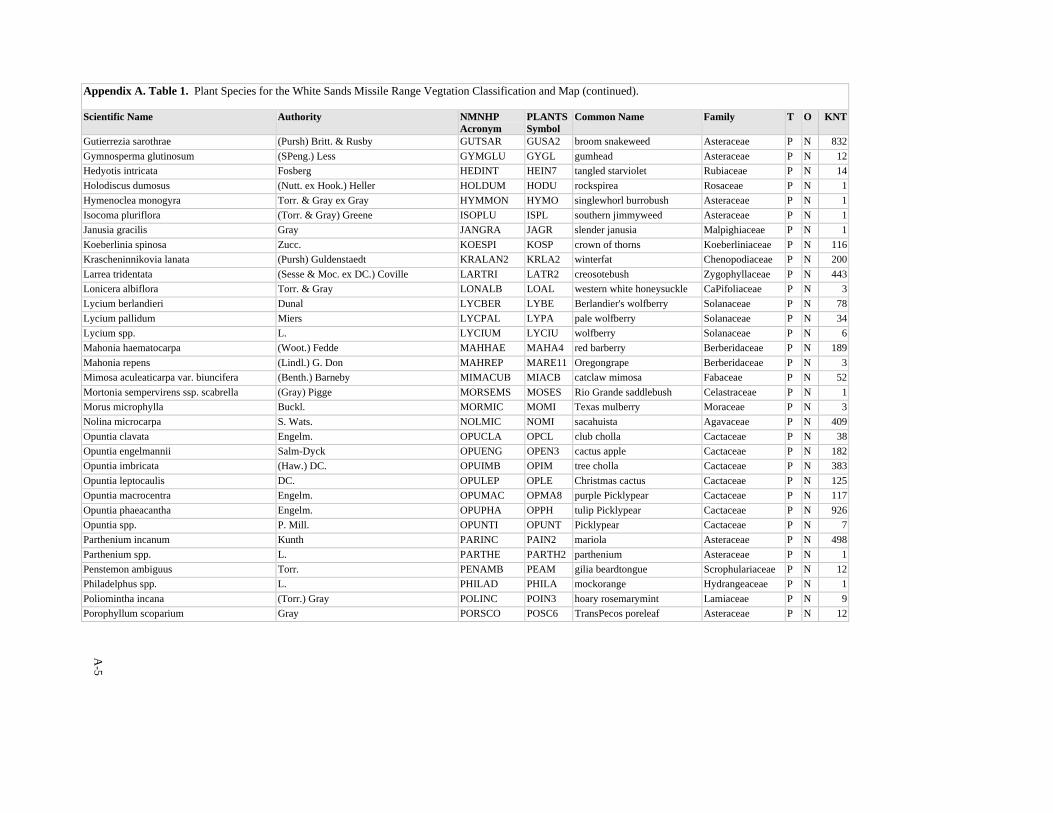
A-5
Appendix A. Table 1. Plant Species for the White Sands Missile Range Vegtation Classification and Map (continued). Scientific Name Authority NMNHP
Acronym PLANTSSymbol
Common Name Family T O KNT
Gutierrezia sarothrae (Pursh) Britt. & Rusby GUTSAR GUSA2 broom snakeweed Asteraceae P N 832Gymnosperma glutinosum (SPeng.) Less GYMGLU GYGL gumhead Asteraceae P N 12Hedyotis intricata Fosberg HEDINT HEIN7 tangled starviolet Rubiaceae P N 14Holodiscus dumosus (Nutt. ex Hook.) Heller HOLDUM HODU rockspirea Rosaceae P N 1Hymenoclea monogyra Torr. & Gray ex Gray HYMMON HYMO singlewhorl burrobush Asteraceae P N 1Isocoma pluriflora (Torr. & Gray) Greene ISOPLU ISPL southern jimmyweed Asteraceae P N 1Janusia gracilis Gray JANGRA JAGR slender janusia Malpighiaceae P N 1Koeberlinia spinosa Zucc. KOESPI KOSP crown of thorns Koeberliniaceae P N 116Krascheninnikovia lanata (Pursh) Guldenstaedt KRALAN2 KRLA2 winterfat Chenopodiaceae P N 200Larrea tridentata (Sesse & Moc. ex DC.) Coville LARTRI LATR2 creosotebush Zygophyllaceae P N 443Lonicera albiflora Torr. & Gray LONALB LOAL western white honeysuckle CaPifoliaceae P N 3Lycium berlandieri Dunal LYCBER LYBE Berlandier's wolfberry Solanaceae P N 78Lycium pallidum Miers LYCPAL LYPA pale wolfberry Solanaceae P N 34Lycium spp. L. LYCIUM LYCIU wolfberry Solanaceae P N 6Mahonia haematocarpa (Woot.) Fedde MAHHAE MAHA4 red barberry Berberidaceae P N 189Mahonia repens (Lindl.) G. Don MAHREP MARE11 Oregongrape Berberidaceae P N 3Mimosa aculeaticarpa var. biuncifera (Benth.) Barneby MIMACUB MIACB catclaw mimosa Fabaceae P N 52Mortonia sempervirens ssp. scabrella (Gray) Pigge MORSEMS MOSES Rio Grande saddlebush Celastraceae P N 1Morus microphylla Buckl. MORMIC MOMI Texas mulberry Moraceae P N 3Nolina microcarpa S. Wats. NOLMIC NOMI sacahuista Agavaceae P N 409Opuntia clavata Engelm. OPUCLA OPCL club cholla Cactaceae P N 38Opuntia engelmannii Salm-Dyck OPUENG OPEN3 cactus apple Cactaceae P N 182Opuntia imbricata (Haw.) DC. OPUIMB OPIM tree cholla Cactaceae P N 383Opuntia leptocaulis DC. OPULEP OPLE Christmas cactus Cactaceae P N 125Opuntia macrocentra Engelm. OPUMAC OPMA8 purple Picklypear Cactaceae P N 117Opuntia phaeacantha Engelm. OPUPHA OPPH tulip Picklypear Cactaceae P N 926Opuntia spp. P. Mill. OPUNTI OPUNT Picklypear Cactaceae P N 7Parthenium incanum Kunth PARINC PAIN2 mariola Asteraceae P N 498Parthenium spp. L. PARTHE PARTH2 parthenium Asteraceae P N 1Penstemon ambiguus Torr. PENAMB PEAM gilia beardtongue Scrophulariaceae P N 12Philadelphus spp. L. PHILAD PHILA mockorange Hydrangeaceae P N 1Poliomintha incana (Torr.) Gray POLINC POIN3 hoary rosemarymint Lamiaceae P N 9Porophyllum scoparium Gray PORSCO POSC6 TransPecos poreleaf Asteraceae P N 12
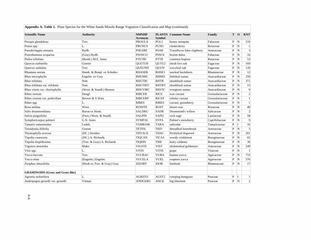
A-6
Appendix A. Table 1. Plant Species for the White Sands Missile Range Vegtation Classification and Map (continued). Scientific Name Authority NMNHP
Acronym PLANTSSymbol
Common Name Family T O KNT
Posopis glandulosa Torr. PROGLA PGL2 honey mesquite Fabaceae P N 510Punus spp. L. PRUNUS PUNU chokecherry Rosaceae P N 1Pseudoclappia arenaria Rydb. PSEARE PSAR TransPecos false clapberry Asteraceae P N 3Psorothamnus scoparius (Gray) Rydb. PSOSCO PSSC6 broom dalea Fabaceae P N 16Ptelea trifoliata (Benth.) M.E. Jones PTETRI PTTR common hoptree Rutaceae P N 53Quercus turbinella Greene QUETUR QUTU2 shrub live oak Fagaceae P N 169Quercus undulata Torr. QUEUND QUUN wavyleaf oak Fagaceae P N 120Rhamnus serrata Humb. & Bonpl. ex Schultes RHASER RHSE3 sawleaf buckthorn Rhamnaceae P N 12Rhus microphylla Engelm. ex Gray RHUMIC RHMI3 littleleaf sumac Anacardiaceae P N 259Rhus trilobata Nutt. RHUTRI RHTR skunkbush sumac Anacardiaceae P N 371Rhus trilobata var. trilobata Nutt. RHUTRIT RHTRT skunkbush sumac Anacardiaceae P N 13Rhus virens var. choriophylla (Woot. & Standl.) Benson RHUVIRC RHVIC evergreen sumac Anacardiaceae P N 9Ribes cereum Dougl. RIBCER RICE wax currant Grossulariaceae P N 2Ribes cereum var. pedicellare Brewer & S Wats. RIBCERP RICEP whisky currant Grossulariaceae P N 1Ribes spp. L. RIBES RIBES currant; gooseberry Grossulariaceae P N 1Rosa stellata Woot. ROSSTE ROST desert rose Rosaceae P N 49Salix drummondiana Barrat ex Hook. SALDRU SADR Drummond's willow Salicaceae P N 2Salvia pinguifolia (Fern.) Woot. & Standl. SALPIN SAPI2 rock sage Lamiaceae P N 58Symphoricarpos palmeri G.N. Jones SYMPAL SYPA Palmer's snowberry Caprifoliaceae P N 9Tamarix ramosissima Ledeb. TAMRAM TARA saltcedar Tamaricaceae P I 16Tetradymia filifolia Greene TETFIL TEFI threadleaf horsebrush Asteraceae P N 5Thymophylla acerosa (DC.) Strother THYACE THAC Picklyleaf dogweed Asteraceae P N 201Tiquilia canescens (DC.) A. Richards TIQCAN TICA3 woody crinklemat Boraginaceae P N 65Tiquilia hispidissima (Torr. & Gray) A. Richards TIQHIS TIHI hairy coldenia Boraginaceae P N 36Viguiera stenoloba Blake VIGSTE VIST skeletonleaf goldeneye Asteraceae P N 249Vitis spp. L. VITIS VITIS grape Vitaceae P N 1Yucca baccata Torr. YUCBAC YUBA banana yucca Agavaceae P N 733Yucca elata (Engelm.) Engelm. YUCELA YUEL soaptree yucca Agavaceae P N 376Ziziphus obtusifolia (Hook ex Torr. & Gray) Gray ZIZOBT ZIOB lotebush Rhamnaceae P N 17 GRAMINOIDS (Grass and Grass-like) Agrostis stolonifera L. AGRSTO AGST2 creeping bentgrass Poaceae P I 1Andropogon gerardii var. gerardii Vitman ANDGERG ANGE big bluestem Poaceae P N 2
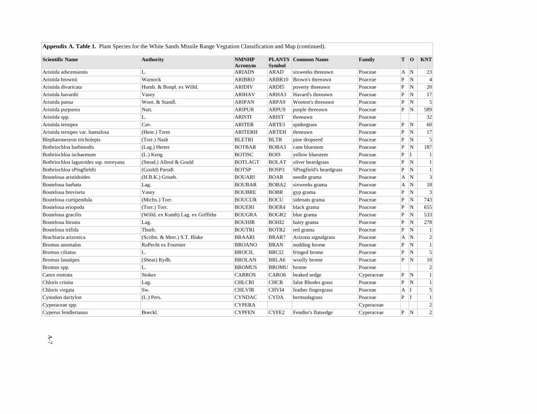
A-7
Appendix A. Table 1. Plant Species for the White Sands Missile Range Vegtation Classification and Map (continued). Scientific Name Authority NMNHP
Acronym PLANTSSymbol
Common Name Family T O KNT
Aristida adscensionis L. ARIADS ARAD sixweeks threeawn Poaceae A N 23Aristida brownii Warnock ARIBRO ARBR10 Brown's threeawn Poaceae P N 4Aristida divaricata Humb. & Bonpl. ex Willd. ARIDIV ARDI5 poverty threeawn Poaceae P N 20Aristida havardii Vasey ARIHAV ARHA3 Havard's threeawn Poaceae P N 17Aristida pansa Woot. & Standl. ARIPAN ARPA9 Wooton's threeawn Poaceae P N 5Aristida purpurea Nutt. ARIPUR ARPU9 purple threeawn Poaceae P N 589Aristida spp. L. ARISTI ARIST threeawn Poaceae 32Aristida ternipes Cav. ARITER ARTE3 spidergrass Poaceae P N 60Aristida ternipes var. hamulosa (Henr.) Trent ARITERH ARTEH threeawn Poaceae P N 17Blepharoneuron tricholepis (Torr.) Nash BLETRI BLTR pine dropseed Poaceae P N 5Bothriochloa barbinodis (Lag.) Herter BOTBAR BOBA3 cane bluestem Poaceae P N 187Bothriochloa ischaemum (L.) Keng BOTISC BOIS yellow bluestem Poaceae P I 1Bothriochloa laguroides ssp. torreyana (Steud.) Allred & Gould BOTLAGT BOLAT silver beardgrass Poaceae P N 1Bothriochloa sPingfieldii (Gould) Parodi BOTSP BOSP3 SPingfield's beardgrass Poaceae P N 1Bouteloua aristidoides (H.B.K.) Griseb. BOUARI BOAR needle grama Poaceae A N 3Bouteloua barbata Lag. BOUBAR BOBA2 sixweeks grama Poaceae A N 18Bouteloua breviseta Vasey BOUBRE BOBR gyp grama Poaceae P N 3Bouteloua curtipendula (Michx.) Torr. BOUCUR BOCU sideoats grama Poaceae P N 743Bouteloua eriopoda (Torr.) Torr. BOUERI BOER4 black grama Poaceae P N 655Bouteloua gracilis (Willd. ex Kunth) Lag. ex Griffiths BOUGRA BOGR2 blue grama Poaceae P N 533Bouteloua hirsuta Lag. BOUHIR BOHI2 hairy grama Poaceae P N 278Bouteloua trifida Thurb. BOUTRI BOTR2 red grama Poaceae P N 1Brachiaria arizonica (Scribn. & Merr.) S.T. Blake BRAARI BRAR7 Arizona signalgrass Poaceae A N 2Bromus anomalus RuPecht ex Fournier BROANO BRAN nodding brome Poaceae P N 1Bromus ciliatus L. BROCIL BRCI2 fringed brome Poaceae P N 5Bromus lanatipes (Shear) Rydb. BROLAN BRLA6 woolly brome Poaceae P N 10Bromus spp. L. BROMUS BROMU brome Poaceae 2Carex rostrata Stokes CARROS CARO6 beaked sedge Cyperaceae P N 1Chloris crinita Lag. CHLCRI CHCR false Rhodes grass Poaceae P N 1Chloris virgata Sw. CHLVIR CHVI4 feather fingergrass Poaceae A I 5Cynodon dactylon (L.) Pers. CYNDAC CYDA bermudagrass Poaceae P I 1Cyperaceae spp. CYPERA Cyperaceae 2Cyperus fendlerianus Boeckl. CYPFEN CYFE2 Fendler's flatsedge Cyperaceae P N 2
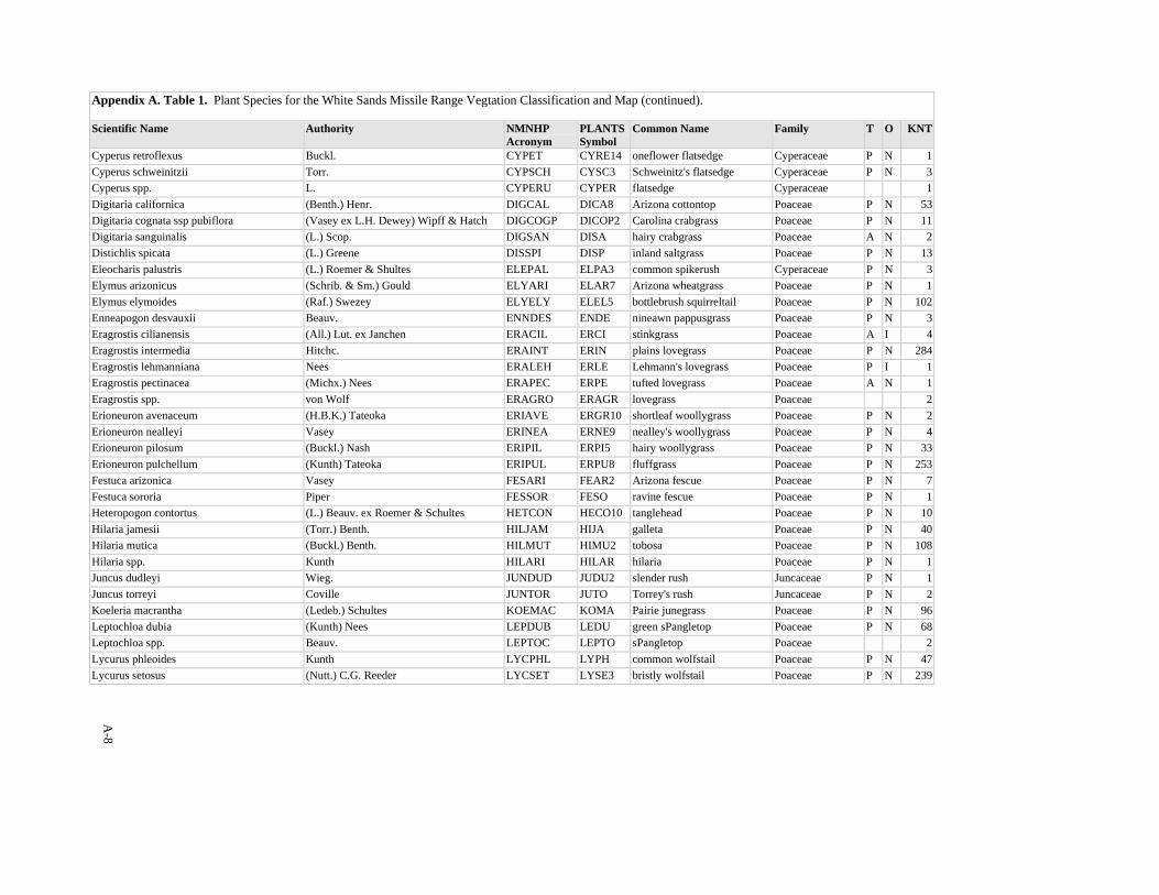
A-8
Appendix A. Table 1. Plant Species for the White Sands Missile Range Vegtation Classification and Map (continued). Scientific Name Authority NMNHP
Acronym PLANTSSymbol
Common Name Family T O KNT
Cyperus retroflexus Buckl. CYPET CYRE14 oneflower flatsedge Cyperaceae P N 1Cyperus schweinitzii Torr. CYPSCH CYSC3 Schweinitz's flatsedge Cyperaceae P N 3Cyperus spp. L. CYPERU CYPER flatsedge Cyperaceae 1Digitaria californica (Benth.) Henr. DIGCAL DICA8 Arizona cottontop Poaceae P N 53Digitaria cognata ssp pubiflora (Vasey ex L.H. Dewey) Wipff & Hatch DIGCOGP DICOP2 Carolina crabgrass Poaceae P N 11Digitaria sanguinalis (L.) Scop. DIGSAN DISA hairy crabgrass Poaceae A N 2Distichlis spicata (L.) Greene DISSPI DISP inland saltgrass Poaceae P N 13Eleocharis palustris (L.) Roemer & Shultes ELEPAL ELPA3 common spikerush Cyperaceae P N 3Elymus arizonicus (Schrib. & Sm.) Gould ELYARI ELAR7 Arizona wheatgrass Poaceae P N 1Elymus elymoides (Raf.) Swezey ELYELY ELEL5 bottlebrush squirreltail Poaceae P N 102Enneapogon desvauxii Beauv. ENNDES ENDE nineawn pappusgrass Poaceae P N 3Eragrostis cilianensis (All.) Lut. ex Janchen ERACIL ERCI stinkgrass Poaceae A I 4Eragrostis intermedia Hitchc. ERAINT ERIN plains lovegrass Poaceae P N 284Eragrostis lehmanniana Nees ERALEH ERLE Lehmann's lovegrass Poaceae P I 1Eragrostis pectinacea (Michx.) Nees ERAPEC ERPE tufted lovegrass Poaceae A N 1Eragrostis spp. von Wolf ERAGRO ERAGR lovegrass Poaceae 2Erioneuron avenaceum (H.B.K.) Tateoka ERIAVE ERGR10 shortleaf woollygrass Poaceae P N 2Erioneuron nealleyi Vasey ERINEA ERNE9 nealley's woollygrass Poaceae P N 4Erioneuron pilosum (Buckl.) Nash ERIPIL ERPI5 hairy woollygrass Poaceae P N 33Erioneuron pulchellum (Kunth) Tateoka ERIPUL ERPU8 fluffgrass Poaceae P N 253Festuca arizonica Vasey FESARI FEAR2 Arizona fescue Poaceae P N 7Festuca sororia Piper FESSOR FESO ravine fescue Poaceae P N 1Heteropogon contortus (L.) Beauv. ex Roemer & Schultes HETCON HECO10 tanglehead Poaceae P N 10Hilaria jamesii (Torr.) Benth. HILJAM HIJA galleta Poaceae P N 40Hilaria mutica (Buckl.) Benth. HILMUT HIMU2 tobosa Poaceae P N 108Hilaria spp. Kunth HILARI HILAR hilaria Poaceae P N 1Juncus dudleyi Wieg. JUNDUD JUDU2 slender rush Juncaceae P N 1Juncus torreyi Coville JUNTOR JUTO Torrey's rush Juncaceae P N 2Koeleria macrantha (Ledeb.) Schultes KOEMAC KOMA Pairie junegrass Poaceae P N 96Leptochloa dubia (Kunth) Nees LEPDUB LEDU green sPangletop Poaceae P N 68Leptochloa spp. Beauv. LEPTOC LEPTO sPangletop Poaceae 2Lycurus phleoides Kunth LYCPHL LYPH common wolfstail Poaceae P N 47Lycurus setosus (Nutt.) C.G. Reeder LYCSET LYSE3 bristly wolfstail Poaceae P N 239

A-9
Appendix A. Table 1. Plant Species for the White Sands Missile Range Vegtation Classification and Map (continued). Scientific Name Authority NMNHP
Acronym PLANTSSymbol
Common Name Family T O KNT
Melica porteri Scribn. MELPOR MEPO Porter's melicgrass Poaceae P N 2Muhlenbergia arenacea (Buckl.) Hitchc. MUHARE1 MUAR ear muhly Poaceae P N 22Muhlenbergia arenicola Buckl. MUHARE2 MUAR2 sand muhly Poaceae P N 9Muhlenbergia asperifolia (Nees & Meyen ex Trin.) Parodi MUHASP MUAS alkali muhly Poaceae P N 7Muhlenbergia depauperata Scribn. MUHDEP MUDE sixweeks muhly Poaceae A N 2Muhlenbergia dubia Fourn. ex Hemsl. MUHDUB MUDU pine muhly Poaceae P N 37Muhlenbergia emersleyi Vasey MUHEME MUEM bullgrass Poaceae P N 8Muhlenbergia fragilis Swallen MUHFRA MUFR delicate muhly Poaceae A N 3Muhlenbergia metcalfei Jones MUHMET MUME Metcalfe's muhly Poaceae P N 1Muhlenbergia montana (Nutt.) Hitchc. MUHMON MUMO mountain muhly Poaceae P N 11Muhlenbergia pauciflora Buckl. MUHPAU MUPA2 New Mexico muhly Poaceae P N 205Muhlenbergia porteri Scribn. ex Beal MUHPOR MUPO2 bush muhly Poaceae P N 356Muhlenbergia pungens Thurb. MUHPUN MUPU2 sandhill muhly Poaceae P N 3Muhlenbergia repens (Pesl) A.S. Hitchc. MUHREP MURE creeping muhly Poaceae P N 19Muhlenbergia setifolia Vasey MUHSET MUSE curlyleaf muhly Poaceae P N 173Muhlenbergia spp. Schreb. MUHLEN MUHLE muhly Poaceae 7Muhlenbergia tenuifolia (Kunth) Trin. MUHTEN MUTE4 slimflower muhly Poaceae P N 2Muhlenbergia torreyi (Kunth) Hitch. ex Bush MUHTOR MUTO2 ring muhly Poaceae P N 14Munroa squarrosa (Nutt.) Torr. MUNSQU MUSQ false buffalograss Poaceae A N 2Oryzopsis hymenoides (Roemer & Schultes) Ricker ex Piper ORYHYM ORHY Indian ricegrass Poaceae P N 35Panicum bulbosum Kunth PANBUL PABU bulb panicgrass Poaceae P N 2Panicum hallii Vasey PANHAL PAHA Hall's panicgrass Poaceae P N 94Panicum hirticaule J. Pesl. PANHIR PAHI5 Mexican panicgrass Poaceae A N 5Panicum obtusum Kunth PANOBT PAOB vine mesquite Poaceae P N 28Panicum spp. L. PANICU PANIC panicgrass Poaceae 9Pascopyrum smithii (Rydb.) Love PASSMI PASM western wheatgrass Poaceae N 14Paspalum setaceum Michx. PASSET PASE5 thin paspalum Poaceae P N 6Phragmites australis (Cav.) Trin. ex Steud. PHRAUS PHAU7 common reed Poaceae P N 1Poa bigelovii Vasey & Scribn. POABIG POBI Bigelow's bluegrass Poaceae A N 1Poa fendleriana (Steud.) Vasey POAFEN POFE muttongrass Poaceae P N 4Poa Patensis L. POAPA POP Kentucky bluegrass Poaceae P I 1Poa spp. L. POA POA bluegrass Poaceae 2Polypogon monspeliensis (L.) Desf. POLMON POMO5 annual rabbitsfoot grass Poaceae A I 1
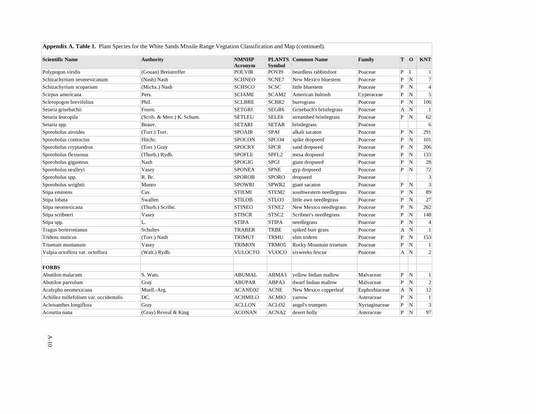
A-10
Appendix A. Table 1. Plant Species for the White Sands Missile Range Vegtation Classification and Map (continued). Scientific Name Authority NMNHP
Acronym PLANTSSymbol
Common Name Family T O KNT
Polypogon viridis (Gouan) Breistroffer POLVIR POVI9 beardless rabbitsfoot Poaceae P I 1Schizachyrium neomexicanum (Nash) Nash SCHNEO SCNE7 New Mexico bluestem Poaceae P N 7Schizachyrium scoparium (Michx.) Nash SCHSCO SCSC little bluestem Poaceae P N 4Scirpus americana Pers. SCIAME SCAM2 American bulrush Cyperaceae P N 5Scleropogon brevifolius Phil. SCLBRE SCBR2 burrograss Poaceae P N 106Setaria grisebachii Fourn. SETGRI SEGR6 Grisebach's bristlegrass Poaceae A N 1Setaria leucopila (Scrib. & Merr.) K. Schum. SETLEU SELE6 streambed bristlegrass Poaceae P N 62Setaria spp. Beauv. SETARI SETAR bristlegrass Poaceae 6Sporobolus airoides (Torr.) Torr. SPOAIR SPAI alkali sacaton Poaceae P N 291Sporobolus contractus Hitchc. SPOCON SPCO4 spike dropseed Poaceae P N 101Sporobolus cryptandrus (Torr.) Gray SPOCRY SPCR sand dropseed Poaceae P N 206Sporobolus flexuosus (Thurb.) Rydb. SPOFLE SPFL2 mesa dropseed Poaceae P N 133Sporobolus giganteus Nash SPOGIG SPGI giant dropseed Poaceae P N 28Sporobolus nealleyi Vasey SPONEA SPNE gyp dropseed Poaceae P N 72Sporobolus spp. R. Br. SPOROB SPORO dropseed Poaceae 3Sporobolus wrightii Munro SPOWRI SPWR2 giant sacaton Poaceae P N 3Stipa eminens Cav. STIEMI STEM2 southwestern needlegrass Poaceae P N 89Stipa lobata Swallen STILOB STLO3 little awn needlegrass Poaceae P N 27Stipa neomexicana (Thurb.) Scribn. STINEO STNE2 New Mexico needlegrass Poaceae P N 262Stipa scribneri Vasey STISCR STSC2 Scribner's needlegrass Poaceae P N 148Stipa spp. L. STIPA STIPA needlegrass Poaceae P N 4Tragus berteronianus Schultes TRABER TRBE spiked burr grass Poaceae A N 1Tridens muticus (Torr.) Nash TRIMUT TRMU slim tridens Poaceae P N 153Trisetum montanum Vasey TRIMON TRMO5 Rocky Mountain trisetum Poaceae P N 1Vulpia octoflora var. octoflora (Walt.) Rydb. VULOCTO VUOCO sixweeks fescue Poaceae A N 2 FORBS Abutilon malacum S. Wats. ABUMAL ABMA3 yellow Indian mallow Malvaceae P N 1Abutilon parvulum Gray ABUPAR ABPA3 dwarf Indian mallow Malvaceae P N 2Acalypha neomexicana Muell.-Arg. ACANEO2 ACNE New Mexico copperleaf Euphorbiaceae A N 12Achillea millefolium var. occidentalis DC. ACHMILO ACMIO yarrow Asteraceae P N 1Acleisanthes longiflora Gray ACLLON ACLO2 angel's trumpets Nyctaginaceae P N 3Acourtia nana (Gray) Reveal & King ACONAN ACNA2 desert holly Asteraceae P N 97
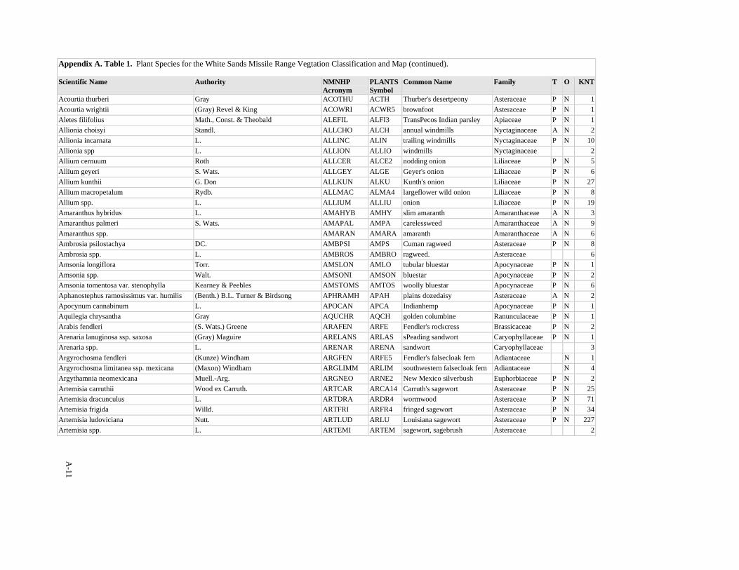
A-11
Appendix A. Table 1. Plant Species for the White Sands Missile Range Vegtation Classification and Map (continued). Scientific Name Authority NMNHP
Acronym PLANTSSymbol
Common Name Family T O KNT
Acourtia thurberi Gray ACOTHU ACTH Thurber's desertpeony Asteraceae P N 1Acourtia wrightii (Gray) Revel & King ACOWRI ACWR5 brownfoot Asteraceae P N 1Aletes filifolius Math., Const. & Theobald ALEFIL ALFI3 TransPecos Indian parsley Apiaceae P N 1Allionia choisyi Standl. ALLCHO ALCH annual windmills Nyctaginaceae A N 2Allionia incarnata L. ALLINC ALIN trailing windmills Nyctaginaceae P N 10Allionia spp L. ALLION ALLIO windmills Nyctaginaceae 2Allium cernuum Roth ALLCER ALCE2 nodding onion Liliaceae P N 5Allium geyeri S. Wats. ALLGEY ALGE Geyer's onion Liliaceae P N 6Allium kunthii G. Don ALLKUN ALKU Kunth's onion Liliaceae P N 27Allium macropetalum Rydb. ALLMAC ALMA4 largeflower wild onion Liliaceae P N 8Allium spp. L. ALLIUM ALLIU onion Liliaceae P N 19Amaranthus hybridus L. AMAHYB AMHY slim amaranth Amaranthaceae A N 3Amaranthus palmeri S. Wats. AMAPAL AMPA carelessweed Amaranthaceae A N 9Amaranthus spp. AMARAN AMARA amaranth Amaranthaceae A N 6Ambrosia psilostachya DC. AMBPSI AMPS Cuman ragweed Asteraceae P N 8Ambrosia spp. L. AMBROS AMBRO ragweed. Asteraceae 6Amsonia longiflora Torr. AMSLON AMLO tubular bluestar Apocynaceae P N 1Amsonia spp. Walt. AMSONI AMSON bluestar Apocynaceae P N 2Amsonia tomentosa var. stenophylla Kearney & Peebles AMSTOMS AMTOS woolly bluestar Apocynaceae P N 6Aphanostephus ramosissimus var. humilis (Benth.) B.L. Turner & Birdsong APHRAMH APAH plains dozedaisy Asteraceae A N 2Apocynum cannabinum L. APOCAN APCA Indianhemp Apocynaceae P N 1Aquilegia chrysantha Gray AQUCHR AQCH golden columbine Ranunculaceae P N 1Arabis fendleri (S. Wats.) Greene ARAFEN ARFE Fendler's rockcress Brassicaceae P N 2Arenaria lanuginosa ssp. saxosa (Gray) Maguire ARELANS ARLAS sPeading sandwort Caryophyllaceae P N 1Arenaria spp. L. ARENAR ARENA sandwort Caryophyllaceae 3Argyrochosma fendleri (Kunze) Windham ARGFEN ARFE5 Fendler's falsecloak fern Adiantaceae N 1Argyrochosma limitanea ssp. mexicana (Maxon) Windham ARGLIMM ARLIM southwestern falsecloak fern Adiantaceae N 4Argythamnia neomexicana Muell.-Arg. ARGNEO ARNE2 New Mexico silverbush Euphorbiaceae P N 2Artemisia carruthii Wood ex Carruth. ARTCAR ARCA14 Carruth's sagewort Asteraceae P N 25Artemisia dracunculus L. ARTDRA ARDR4 wormwood Asteraceae P N 71Artemisia frigida Willd. ARTFRI ARFR4 fringed sagewort Asteraceae P N 34Artemisia ludoviciana Nutt. ARTLUD ARLU Louisiana sagewort Asteraceae P N 227Artemisia spp. L. ARTEMI ARTEM sagewort, sagebrush Asteraceae 2
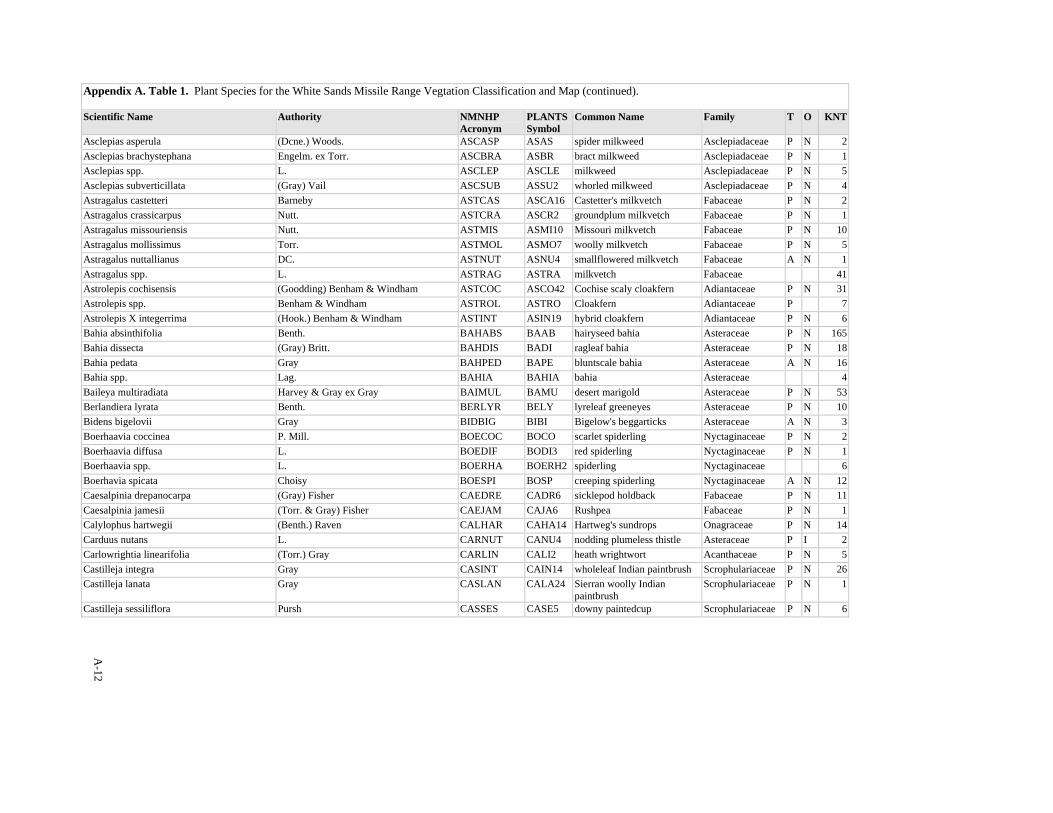
A-12
Appendix A. Table 1. Plant Species for the White Sands Missile Range Vegtation Classification and Map (continued). Scientific Name Authority NMNHP
Acronym PLANTSSymbol
Common Name Family T O KNT
Asclepias asperula (Dcne.) Woods. ASCASP ASAS spider milkweed Asclepiadaceae P N 2Asclepias brachystephana Engelm. ex Torr. ASCBRA ASBR bract milkweed Asclepiadaceae P N 1Asclepias spp. L. ASCLEP ASCLE milkweed Asclepiadaceae P N 5Asclepias subverticillata (Gray) Vail ASCSUB ASSU2 whorled milkweed Asclepiadaceae P N 4Astragalus castetteri Barneby ASTCAS ASCA16 Castetter's milkvetch Fabaceae P N 2Astragalus crassicarpus Nutt. ASTCRA ASCR2 groundplum milkvetch Fabaceae P N 1Astragalus missouriensis Nutt. ASTMIS ASMI10 Missouri milkvetch Fabaceae P N 10Astragalus mollissimus Torr. ASTMOL ASMO7 woolly milkvetch Fabaceae P N 5Astragalus nuttallianus DC. ASTNUT ASNU4 smallflowered milkvetch Fabaceae A N 1Astragalus spp. L. ASTRAG ASTRA milkvetch Fabaceae 41Astrolepis cochisensis (Goodding) Benham & Windham ASTCOC ASCO42 Cochise scaly cloakfern Adiantaceae P N 31Astrolepis spp. Benham & Windham ASTROL ASTRO Cloakfern Adiantaceae P 7Astrolepis X integerrima (Hook.) Benham & Windham ASTINT ASIN19 hybrid cloakfern Adiantaceae P N 6Bahia absinthifolia Benth. BAHABS BAAB hairyseed bahia Asteraceae P N 165Bahia dissecta (Gray) Britt. BAHDIS BADI ragleaf bahia Asteraceae P N 18Bahia pedata Gray BAHPED BAPE bluntscale bahia Asteraceae A N 16Bahia spp. Lag. BAHIA BAHIA bahia Asteraceae 4Baileya multiradiata Harvey & Gray ex Gray BAIMUL BAMU desert marigold Asteraceae P N 53Berlandiera lyrata Benth. BERLYR BELY lyreleaf greeneyes Asteraceae P N 10Bidens bigelovii Gray BIDBIG BIBI Bigelow's beggarticks Asteraceae A N 3Boerhaavia coccinea P. Mill. BOECOC BOCO scarlet spiderling Nyctaginaceae P N 2Boerhaavia diffusa L. BOEDIF BODI3 red spiderling Nyctaginaceae P N 1Boerhaavia spp. L. BOERHA BOERH2 spiderling Nyctaginaceae 6Boerhavia spicata Choisy BOESPI BOSP creeping spiderling Nyctaginaceae A N 12Caesalpinia drepanocarpa (Gray) Fisher CAEDRE CADR6 sicklepod holdback Fabaceae P N 11Caesalpinia jamesii (Torr. & Gray) Fisher CAEJAM CAJA6 Rushpea Fabaceae P N 1Calylophus hartwegii (Benth.) Raven CALHAR CAHA14 Hartweg's sundrops Onagraceae P N 14Carduus nutans L. CARNUT CANU4 nodding plumeless thistle Asteraceae P I 2Carlowrightia linearifolia (Torr.) Gray CARLIN CALI2 heath wrightwort Acanthaceae P N 5Castilleja integra Gray CASINT CAIN14 wholeleaf Indian paintbrush Scrophulariaceae P N 26Castilleja lanata Gray CASLAN CALA24 Sierran woolly Indian
paintbrush Scrophulariaceae P N 1
Castilleja sessiliflora Pursh CASSES CASE5 downy paintedcup Scrophulariaceae P N 6
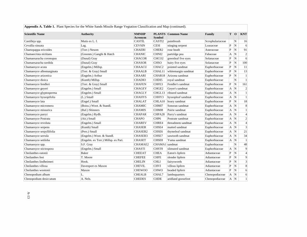
A-13
Appendix A. Table 1. Plant Species for the White Sands Missile Range Vegtation Classification and Map (continued). Scientific Name Authority NMNHP
Acronym PLANTSSymbol
Common Name Family T O KNT
Castilleja spp. Mutis ex L. f. CASTIL CASTI2 paintbrush Scrophulariaceae N 16Cevallia sinuata Lag. CEVSIN CESI stinging serpent Loasaceae P N 6Chaetopappa ericoides (Torr.) Nesom CHAERI CHER2 rose heath Asteraceae P N 91Chamaecrista nictitans (Greenm.) Ganghi & Hatch CHANIC CHNI2 partridge pea Fabaceae A N 2Chamaesaracha coronopus (Dunal) Gray CHACOR CHCO2 greenleaf five eyes Solanaceae P N 6Chamaesaracha sordida (Dunal) Gray CHASOR CHSO hairy five eyes Solanaceae P N 100Chamaesyce acuta (Engelm.) Millsp. CHAACU CHAC2 pointed sandmat Euphorbiaceae P N 11Chamaesyce albomarginata (Torr. & Gray) Small CHAALB CHAL11 whitemargin sandmat Euphorbiaceae P N 13Chamaesyce arizonica (Engelm.) Arthur CHAARI CHAR18 Arizona sandmat Euphorbiaceae P N 1Chamaesyce dioica (Kunth) Millsp. CHADIO CHDI5 royal sandmat Euphorbiaceae N 1Chamaesyce fendleri (Torr. & Gray) Small CHAFEN CHFE3 Fendler's sandmat Euphorbiaceae P N 161Chamaesyce geyeri (Engelm.) Small CHAGEY CHGE2 Geyer's sandmat Euphorbiaceae A N 2Chamaesyce glyptosperma (Engelm.) Small CHAGLY CHGL13 ribseed sandmat Euphorbiaceae A N 1Chamaesyce hyssopifolia (L.) Small CHAHYS CHHY3 hyssopleaf sandmat Euphorbiaceae A N 1Chamaesyce lata (Engel.) Small CHALAT CHLA10 hoary sandmat Euphorbiaceae P N 18Chamaesyce micromera (Boiss.) Woot. & Standl. CHAMIC CHMI7 Sonoran sandmat Euphorbiaceae A N 8Chamaesyce missurica (Raf.) Shinners CHAMIS CHMI8 Pairie sandmat Euphorbiaceae A N 1Chamaesyce parryi (Engelm.) Rydb. CHAPAR CHPA28 Parry's sandmat Euphorbiaceae A N 4Chamaesyce Postrata (Ait.) Small CHAPO CHP6 Postrate sandmat Euphorbiaceae A N 2Chamaesyce revoluta (Engelm.) Small CHAREV CHRE4 threadstem sandmat Euphorbiaceae A N 4Chamaesyce serpens (Kunth) Small CHASER CHSE4 matted sandmat Euphorbiaceae A N 3Chamaesyce serpyllifolia (Pers.) Small CHASER2 CHSE6 thymeleaf sandmat Euphorbiaceae A N 21Chamaesyce serrula (Engelm.) Woot. & Standl. CHASER3 CHSE7 sawtooth sandmat Euphorbiaceae A N 34Chamaesyce setiloba (Engelm. ex Torr.) Millsp. ex Pari. CHASET CHSE8 Yuma sandmat Euphorbiaceae A N 1Chamaesyce spp. S.F. Gray CHAMAE2 CHAMA1 sandmat Euphorbiaceae N 48Chamaesyce stictospora (Engelm.) Small CHASTI CHST8 slimseed sandmat Euphorbiaceae A N 9Cheilanthes eatonii Baker CHEEAT CHEA Eaton's lipfern Adiantaceae P N 4Cheilanthes feei T. Moore CHEFEE CHFE slender lipfern Adiantaceae P N 9Cheilanthes lindheimeri Hook. CHELIN CHLI fairyswords Adiantaceae P N 3Cheilanthes villosa Davenport ex Maxon CHEVIL CHVI villous lipfern Adiantaceae P N 8Cheilanthes wootonii Maxon CHEWOO CHWO beaded lipfern Adiantaceae P N 6Chenopodium album L. CHEALB CHAL7 lambsquarters Chenopodiaceae A N 6Chenopodium desiccatum A. Nels. CHEDES CHDE aridland goosefoot Chenopodiaceae A N 1
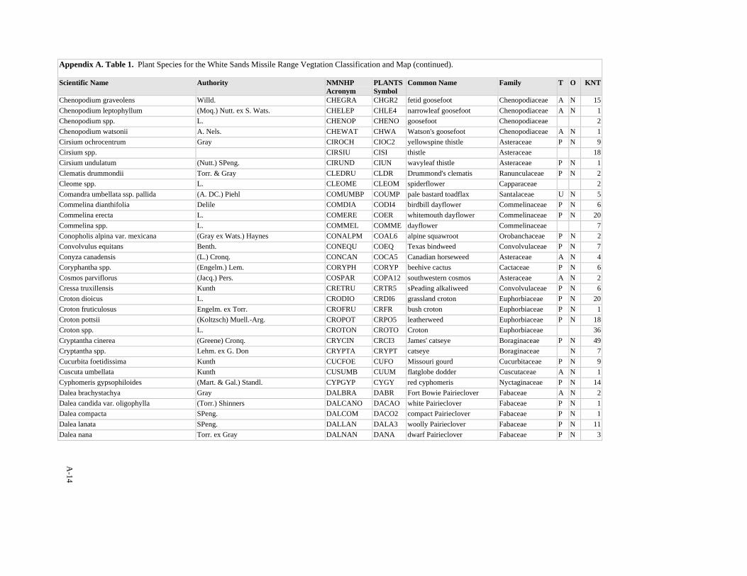
A-14
Appendix A. Table 1. Plant Species for the White Sands Missile Range Vegtation Classification and Map (continued). Scientific Name Authority NMNHP
Acronym PLANTSSymbol
Common Name Family T O KNT
Chenopodium graveolens Willd. CHEGRA CHGR2 fetid goosefoot Chenopodiaceae A N 15Chenopodium leptophyllum (Moq.) Nutt. ex S. Wats. CHELEP CHLE4 narrowleaf goosefoot Chenopodiaceae A N 1Chenopodium spp. L. CHENOP CHENO goosefoot Chenopodiaceae 2Chenopodium watsonii A. Nels. CHEWAT CHWA Watson's goosefoot Chenopodiaceae A N 1Cirsium ochrocentrum Gray CIROCH CIOC2 yellowspine thistle Asteraceae P N 9Cirsium spp. CIRSIU CISI thistle Asteraceae 18Cirsium undulatum (Nutt.) SPeng. CIRUND CIUN wavyleaf thistle Asteraceae P N 1Clematis drummondii Torr. & Gray CLEDRU CLDR Drummond's clematis Ranunculaceae P N 2Cleome spp. L. CLEOME CLEOM spiderflower Capparaceae 2Comandra umbellata ssp. pallida (A. DC.) Piehl COMUMBP COUMP pale bastard toadflax Santalaceae U N 5Commelina dianthifolia Delile COMDIA CODI4 birdbill dayflower Commelinaceae P N 6Commelina erecta L. COMERE COER whitemouth dayflower Commelinaceae P N 20Commelina spp. L. COMMEL COMME dayflower Commelinaceae 7Conopholis alpina var. mexicana (Gray ex Wats.) Haynes CONALPM COAL6 alpine squawroot Orobanchaceae P N 2Convolvulus equitans Benth. CONEQU COEQ Texas bindweed Convolvulaceae P N 7Conyza canadensis (L.) Cronq. CONCAN COCA5 Canadian horseweed Asteraceae A N 4Coryphantha spp. (Engelm.) Lem. CORYPH CORYP beehive cactus Cactaceae P N 6Cosmos parviflorus (Jacq.) Pers. COSPAR COPA12 southwestern cosmos Asteraceae A N 2Cressa truxillensis Kunth CRETRU CRTR5 sPeading alkaliweed Convolvulaceae P N 6Croton dioicus L. CRODIO CRDI6 grassland croton Euphorbiaceae P N 20Croton fruticulosus Engelm. ex Torr. CROFRU CRFR bush croton Euphorbiaceae P N 1Croton pottsii (Koltzsch) Muell.-Arg. CROPOT CRPO5 leatherweed Euphorbiaceae P N 18Croton spp. L. CROTON CROTO Croton Euphorbiaceae 36Cryptantha cinerea (Greene) Cronq. CRYCIN CRCI3 James' catseye Boraginaceae P N 49Cryptantha spp. Lehm. ex G. Don CRYPTA CRYPT catseye Boraginaceae N 7Cucurbita foetidissima Kunth CUCFOE CUFO Missouri gourd Cucurbitaceae P N 9Cuscuta umbellata Kunth CUSUMB CUUM flatglobe dodder Cuscutaceae A N 1Cyphomeris gypsophiloides (Mart. & Gal.) Standl. CYPGYP CYGY red cyphomeris Nyctaginaceae P N 14Dalea brachystachya Gray DALBRA DABR Fort Bowie Pairieclover Fabaceae A N 2Dalea candida var. oligophylla (Torr.) Shinners DALCANO DACAO white Pairieclover Fabaceae P N 1Dalea compacta SPeng. DALCOM DACO2 compact Pairieclover Fabaceae P N 1Dalea lanata SPeng. DALLAN DALA3 woolly Pairieclover Fabaceae P N 11Dalea nana Torr. ex Gray DALNAN DANA dwarf Pairieclover Fabaceae P N 3
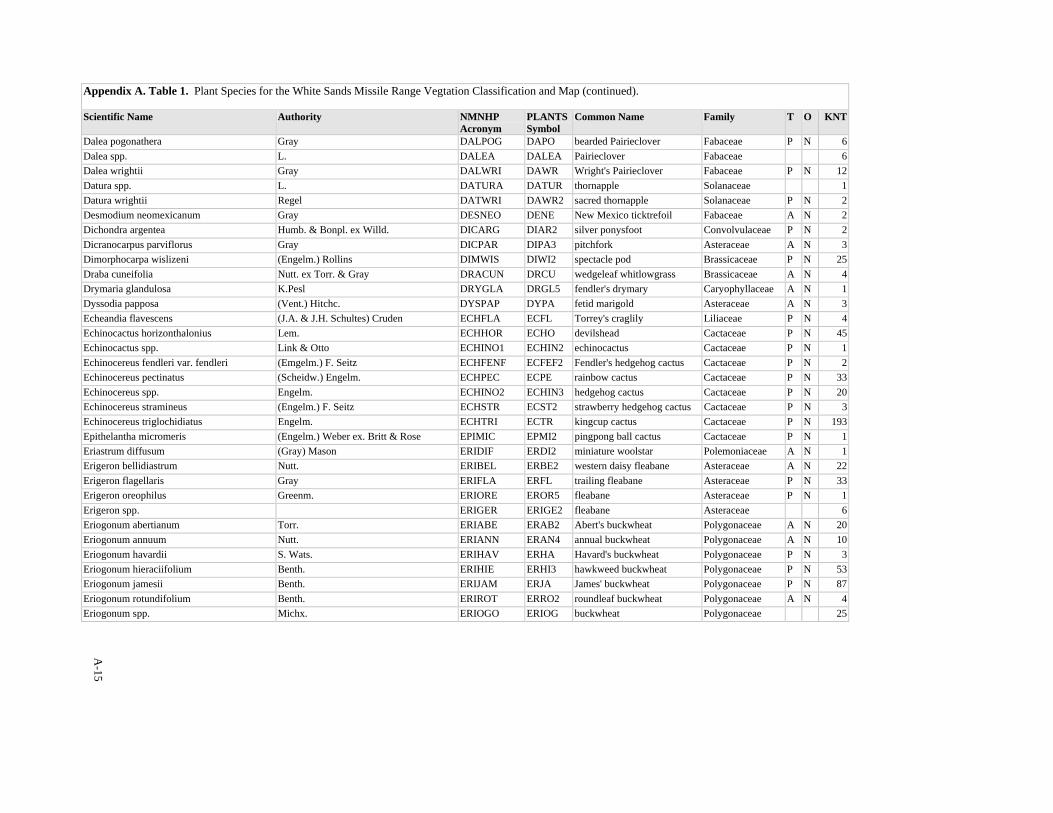
A-15
Appendix A. Table 1. Plant Species for the White Sands Missile Range Vegtation Classification and Map (continued). Scientific Name Authority NMNHP
Acronym PLANTSSymbol
Common Name Family T O KNT
Dalea pogonathera Gray DALPOG DAPO bearded Pairieclover Fabaceae P N 6Dalea spp. L. DALEA DALEA Pairieclover Fabaceae 6Dalea wrightii Gray DALWRI DAWR Wright's Pairieclover Fabaceae P N 12Datura spp. L. DATURA DATUR thornapple Solanaceae 1Datura wrightii Regel DATWRI DAWR2 sacred thornapple Solanaceae P N 2Desmodium neomexicanum Gray DESNEO DENE New Mexico ticktrefoil Fabaceae A N 2Dichondra argentea Humb. & Bonpl. ex Willd. DICARG DIAR2 silver ponysfoot Convolvulaceae P N 2Dicranocarpus parviflorus Gray DICPAR DIPA3 pitchfork Asteraceae A N 3Dimorphocarpa wislizeni (Engelm.) Rollins DIMWIS DIWI2 spectacle pod Brassicaceae P N 25Draba cuneifolia Nutt. ex Torr. & Gray DRACUN DRCU wedgeleaf whitlowgrass Brassicaceae A N 4Drymaria glandulosa K.Pesl DRYGLA DRGL5 fendler's drymary Caryophyllaceae A N 1Dyssodia papposa (Vent.) Hitchc. DYSPAP DYPA fetid marigold Asteraceae A N 3Echeandia flavescens (J.A. & J.H. Schultes) Cruden ECHFLA ECFL Torrey's craglily Liliaceae P N 4Echinocactus horizonthalonius Lem. ECHHOR ECHO devilshead Cactaceae P N 45Echinocactus spp. Link & Otto ECHINO1 ECHIN2 echinocactus Cactaceae P N 1Echinocereus fendleri var. fendleri (Emgelm.) F. Seitz ECHFENF ECFEF2 Fendler's hedgehog cactus Cactaceae P N 2Echinocereus pectinatus (Scheidw.) Engelm. ECHPEC ECPE rainbow cactus Cactaceae P N 33Echinocereus spp. Engelm. ECHINO2 ECHIN3 hedgehog cactus Cactaceae P N 20Echinocereus stramineus (Engelm.) F. Seitz ECHSTR ECST2 strawberry hedgehog cactus Cactaceae P N 3Echinocereus triglochidiatus Engelm. ECHTRI ECTR kingcup cactus Cactaceae P N 193Epithelantha micromeris (Engelm.) Weber ex. Britt & Rose EPIMIC EPMI2 pingpong ball cactus Cactaceae P N 1Eriastrum diffusum (Gray) Mason ERIDIF ERDI2 miniature woolstar Polemoniaceae A N 1Erigeron bellidiastrum Nutt. ERIBEL ERBE2 western daisy fleabane Asteraceae A N 22Erigeron flagellaris Gray ERIFLA ERFL trailing fleabane Asteraceae P N 33Erigeron oreophilus Greenm. ERIORE EROR5 fleabane Asteraceae P N 1Erigeron spp. ERIGER ERIGE2 fleabane Asteraceae 6Eriogonum abertianum Torr. ERIABE ERAB2 Abert's buckwheat Polygonaceae A N 20Eriogonum annuum Nutt. ERIANN ERAN4 annual buckwheat Polygonaceae A N 10Eriogonum havardii S. Wats. ERIHAV ERHA Havard's buckwheat Polygonaceae P N 3Eriogonum hieraciifolium Benth. ERIHIE ERHI3 hawkweed buckwheat Polygonaceae P N 53Eriogonum jamesii Benth. ERIJAM ERJA James' buckwheat Polygonaceae P N 87Eriogonum rotundifolium Benth. ERIROT ERRO2 roundleaf buckwheat Polygonaceae A N 4Eriogonum spp. Michx. ERIOGO ERIOG buckwheat Polygonaceae 25
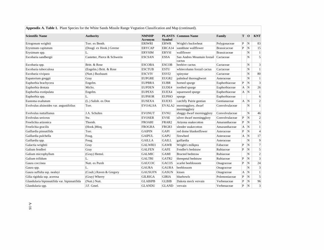
A-16
Appendix A. Table 1. Plant Species for the White Sands Missile Range Vegtation Classification and Map (continued). Scientific Name Authority NMNHP
Acronym PLANTSSymbol
Common Name Family T O KNT
Eriogonum wrightii Torr. ex Benth. ERIWRI ERWR Wright's buckwheat Polygonaceae P N 83Erysimum capitatum (Dougl. ex Hook.) Greene ERYCAP ERCA14 sanddune wallflower Brassicaceae P N 15Erysimum spp. L. ERYSIM ERYSI wallflower Brassicaceae N 1Escobaria sandbergii Castetter, Pierce & Schwerin ESCSAN ESSA San Andres Mountain foxtail
cactus Cactaceae N 5
Escobaria spp. Britt. & Rose ESCOBA ESCOB beehive cactus Cactaceae N 3Escobaria tuberculosa (Engelm.) Britt. & Rose ESCTUB ESTU whitecolumn foxtail cactus Cactaceae N 1Escobaria vivipara (Nutt.) Buxbaum ESCVIV ESVI2 spinystar Cactaceae N 80Eupatorium greggii Gray EUPGRE EUGR2 palmleaf thoroughwort Asteraceae N 1Euphorbia brachycera Engelm. EUPBRA EUBR horned spurge Euphorbiaceae P N 3Euphorbia dentata Michx. EUPDEN EUDE4 toothed spurge Euphorbiaceae A N 26Euphorbia exstipulata Engelm. EUPEXS EUEX4 squareseed spurge Euphorbiaceae A N 1Euphorbia spp. L. EUPHOR EUPHO spurge Euphorbiaceae 6Eustoma exaltatum (L.) Salisb. ex Don EUSEXA EUEX5 catchfly Pairie gentian Gentianaceae A N 2Evolvulus alsinoides var. angustifolius Torr. EVOALSA EVALA2 morningglory, dwarf
morningglory Convolvulaceae N 1
Evolvulus nuttallianus J.A. Schultes EVONUT EVNU shaggy dwarf morningglory Convolvulaceae N 46Evolvulus sericeus Sw. EVOSER EVSE silver dwarf morningglory Convolvulaceae P N 2Froelichia arizonica Thornb. FROARI FRAR2 Arizona snakecotton Amaranthaceae P N 5Froelichia gracilis (Hook.)Moq. FROGRA FRGR3 slender snakecotton Amaranthaceae A N 1Gaillardia pinnatifida Torr. GAIPIN GAPI red dome blanketflower Asteraceae P N 4Gaillardia pulchella Foug. GAIPUL GAPU firewheel Asteraceae A N 17Gaillardia spp. Foug. GAILLA GAILL gaillardia Asteraceae N 9Galactia wrightii Gray GALWRI1 GAWR Wright's milkpea Fabaceae P N 7Galium fendleri Gray GALFEN GAFE Fendler's bedstraw Rubiaceae P N 5Galium microphyllum (Gray) Hemsl. GALMIC GAMI Bracted bedstraw Rubiaceae N 2Galium trifidum L. GALTRI GATR2 threepetal bedstraw Rubiaceae P N 3Gaura coccinea Nutt. ex Pursh GAUCOC GACO5 scarlet beeblossom Onagraceae P N 24Gaura spp. L. GAURA GAURA beeblossom Onagraceae N 3Gaura suffulta ssp. nealeyi (Coult.) Raven & Gregory GAUSUFN GASUN kisses Onagraceae A N 1Gilia rigidula ssp. acerosa (Gray) Wherry GILRIGA GIRIA bluebowls Polemoniaceae P N 5Glandularia bipinnatifida var. bipinnatifida (Nutt.) Nutt. GLABIPB GLBIB Dakota mock vervain Verbenaceae P N 96Glandularia spp. J.F. Gmel. GLANDU GLAND vervain Verbenaceae P N 3
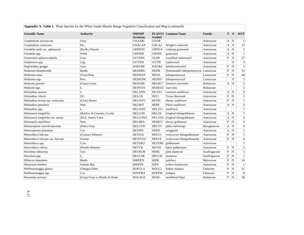
A-17
Appendix A. Table 1. Plant Species for the White Sands Missile Range Vegtation Classification and Map (continued). Scientific Name Authority NMNHP
Acronym PLANTSSymbol
Common Name Family T O KNT
Gnaphalium arizonicum Gray GNAARI GNAR Asteraceae A N 1Gnaphalium canescens DC. GNACAN GNCA2 Wright's cudweed Asteraceae A N 13Grindelia nuda var. aphanactis (Rydb.) Nesom GRINUD GRNUA curlytop gumweed Asteraceae A N 2Grindelia spp. Willd. GRINDE GRIND gumweed Asteraceae A N 1Gutierrezia sphaerocephala Gray GUTSPH GUSP roundleaf snakeweed Asteraceae P N 27Gutierrezia spp. Lag. GUTIER GUTIE snakeweed Asteraceae N 5Haploesthes greggii Gray HAPGRE HAGR4 falsebroomweed Asteraceae P N 2Hedeoma drummondii Benth. HEDDRU HEDR Drummond's falsepennyroyal Lamiaceae P N 33Hedeoma nana (Torr) Briq. HEDNAN HENA falsepennyroyal Lamiaceae P N 48Hedeoma spp. Pers. HEDEOM HEDEO falsepennyroyal Lamiaceae N 3Hedyotis greenei (Gray) Lewis HEDGRE HEGR17 Greene's starviolet Rubiaceae A N 2Hedyotis spp. L. HEDYOT HEDEO2 starviolet Rubiaceae 2Helianthus annuus L. HELANN HEAN3 common sunflower Asteraceae A N 9Helianthus ciliaris DC. HELCIL HECI Texas blueweed Asteraceae P N 2Helianthus niveus ssp. canescens (Gray) Heiser HELNIVC HENIC showy sunflower Asteraceae P N 1Helianthus petiolaris Nutt. HELPET HEPE Pairie sunflower Asteraceae A N 3Helianthus spp. L. HELIAN2 HELIA3 sunflower Asteraceae 1Heliomeris longifolia (Robins. & Greenm.) Cocke. HELLON HELO6 longleaf falsegoldeneye Asteraceae A N 7Heliomeris longifolia var. annua (M.E. Jones) Yates HELLONA HELOA2 longleaf falsegoldeneye Asteraceae A N 4Heliomeris multiflora Nutt. HELMUL HEMU3 showy goldeneye Asteraceae P N 4Heliotropium convolvulaceum (Nutt.) Gray HELCON HECO5 phlox heliotrope Boraginaceae A N 4Heterosperma pinnatum Cav. HETPIN HEPI2 wingpetal Asteraceae A N 1Heterotheca fulcrata (Greene) Shinners HETFUL HEFU3 rockyscree falsegoldenaster Asteraceae P N 1Heterotheca fulcrata var. fulcrata Greene HETFULF HEFUF rockyscree falsegoldenaster Asteraceae P N 6Heterotheca spp. Cass. HETERO HETER8 goldenaster Asteraceae 1Heterotheca villosa (Pursh) Shinners HETVIL HEVI4 hairy goldenaster Asteraceae P N 3Heuchera rubescens Torr. HEURUB HERU pink alumroot Saxifragaceae P N 1Heuchera spp. L. HEUCHE HEUCH alumroot Saxifragaceae P N 1Hibiscus denudatus Benth. HIBDEN HIDE paleface Malvaceae P N 14Hieracium fendleri Schultz-Bip HIEFEN HIFE yellow hawkweed Asteraceae P N 1Hoffmannseggia glauca (Ortega) Eifert HOFGLA HOGL2 Indian rushpea Fabaceae P N 31Hoffmannseggia spp. Cav. HOFFMA HOFFM rushpea Fabaceae P N 8Houstonia acerosa (Gray) Gray ex Benth. & Hook. HOUACE HOAC needleleaf bluet Rubiaceae P N 38
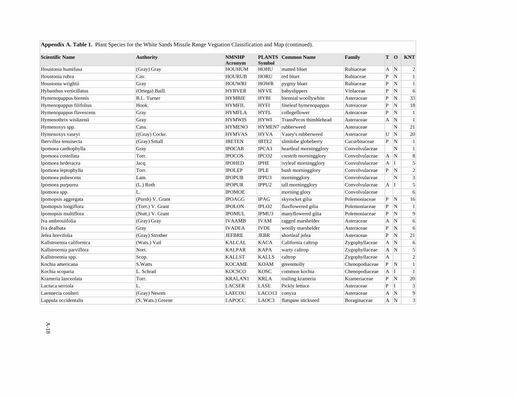
A-18
Appendix A. Table 1. Plant Species for the White Sands Missile Range Vegtation Classification and Map (continued). Scientific Name Authority NMNHP
Acronym PLANTSSymbol
Common Name Family T O KNT
Houstonia humifusa (Gray) Gray HOUHUM HOHU matted bluet Rubiaceae A N 2Houstonia rubra Cav. HOURUB HORU red bluet Rubiaceae P N 1Houstonia wrightii Gray HOUWRI HOWR pygmy bluet Rubiaceae P N 1Hybanthus verticillatus (Ortega) Baill. HYBVER HYVE babyslippers Violaceae P N 6Hymenopappus biennis B.L. Turner HYMBIE HYBI biennial woollywhite Asteraceae P N 33Hymenopappus filifolius Hook. HYMFIL HYFI fineleaf hymenopappus Asteraceae P N 18Hymenopappus flavescens Gray HYMFLA HYFL collegeflower Asteraceae P N 1Hymenothrix wislizenii Gray HYMWIS HYWI TransPecos thimblehead Asteraceae A N 1Hymenoxys spp. Cass. HYMENO HYMEN7 rubberweed Asteraceae N 21Hymenoxys vaseyi ((Gray) Cocke. HYMVAS HYVA Vasey's rubberweed Asteraceae U N 20Ibervillea tenuisecta (Gray) Small IBETEN IBTE2 slimlobe globeberry Cucurbitaceae P N 1Ipomoea cardiophylla Gray IPOCAR IPCA3 heartleaf morningglory Convolvulaceae N 1Ipomoea costellata Torr. IPOCOS IPCO2 crestrib morningglory Convolvulaceae A N 8Ipomoea hederacea Jacq. IPOHED IPHE ivyleaf morningglory Convolvulaceae A I 5Ipomoea leptophylla Torr. IPOLEP IPLE bush morningglory Convolvulaceae P N 2Ipomoea pubescens Lam. IPOPUB IPPU3 morningglory Convolvulaceae N 3Ipomoea purpurea (L.) Roth IPOPUR IPPU2 tall morningglory Convolvulaceae A I 5Ipomoea spp. L. IPOMOE morning glory Convolvulaceae 6Ipomopsis aggregata (Pursh) V. Grant IPOAGG IPAG skyrocket gilia Polemoniaceae P N 16Ipomopsis longiflora (Torr.) V. Grant IPOLON IPLO2 flaxflowered gilia Polemoniaceae P N 1Ipomopsis multiflora (Nutt.) V. Grant IPOMUL IPMU3 manyflowered gilia Polemoniaceae P N 9Iva ambrosiifolia (Gray) Gray IVAAMB IVAM ragged marshelder Asteraceae A N 6Iva dealbata Gray IVADEA IVDE woolly marshelder Asteraceae P N 6Jefea brevifolia (Gray) Strother JEFBRE JEBR shortleaf jefea Asteraceae P N 21Kallstroemia californica (Wats.) Vail KALCAL KACA California caltrop Zygophyllaceae A N 6Kallstroemia parviflora Nort. KALPAR KAPA warty caltrop Zygophyllaceae A N 5Kallstroemia spp. Scop. KALLST KALLS caltrop Zygophyllaceae A 2Kochia americana S.Watts KOCAME KOAM greenmolly Chenopodiaceae P N 1Kochia scoparia L. Schrad KOCSCO KOSC common kochia Chenopodiaceae A I 1Krameria lanceolata Torr. KRALAN1 KRLA trailing krameria Krameriaceae P N 20Lactuca serriola L. LACSER LASE Pickly lettuce Asteraceae P I 3Laennecia coulteri (Gray) Nesom LAECOU LACO13 conyza Asteraceae A N 9Lappula occidentalis (S. Wats.) Greene LAPOCC LAOC3 flatspine stickseed Boraginaceae A N 3
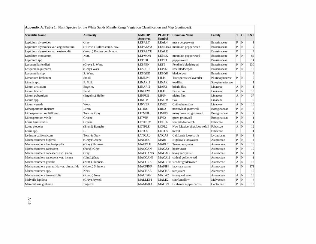
A-19
Appendix A. Table 1. Plant Species for the White Sands Missile Range Vegtation Classification and Map (continued). Scientific Name Authority NMNHP
Acronym PLANTSSymbol
Common Name Family T O KNT
Lepidium alyssoides Gray LEPALY LEAL4 mesa pepperwort Brassicaceae P N 1Lepidium alyssoides var. angustifolium (Hitchc.) Rollins comb. nov. LEPALYA LEMOA3 mountain pepperweed Brassicaceae P N 2Lepidium alyssoides var. eastwoodii (Woot.) Rollins comb. nov. LEPALYE LEALE Brassicaceae P 4Lepidium montanum Nutt. LEPMON LEMO2 mountain pepperweed Brassicaceae P N 66Lepidium spp. L. LEPIDI LEPID pepperweed Brassicaceae 14Lesquerella fendleri (Gray) S. Wats. LESFEN LEFE Fendler's bladderpod Brassicaceae P N 230Lesquerella purpurea (Gray) Wats. LESPUR LEPU2 rose bladderpod Brassicaceae P N 18Lesquerella spp. S. Wats. LESQUE LESQU bladderpod Brassicaceae 6Limonium limbatum Small LIMLIM LILI4 Transpecos sealavender Plumbaginaceae P N 7Linaria spp. P. Mill. LINARI1 LINAR toadflax Scrophulariaceae 1Linum aristatum Engelm. LINARI2 LIAR3 bristle flax Linaceae A N 1Linum lewisii Pursh LINLEW LILE3 Pairie flax Linaceae P N 13Linum puberulum (Engelm.) Heller LINPUB LIPU4 plains flax Linaceae A N 37Linum spp. L. LINUM LINUM flax Linaceae 5Linum vernale Woot. LINVER LIVE2 Chihuahuan flax Linaceae A N 10Lithospermum incisum Lehm. LITINC LIIN2 narrowleaf gromwell Boraginaceae P N 8Lithospermum multiflorum Torr. ex Gray LITMUL LIMU3 manyflowered gromwell Boraginaceae P N 4Lithospermum viride Greene LITVIR LIVI2 green gromwell Boraginaceae P N 1Lotus humistratus Greene LOTHUM LOHU2 foothill deervetch Fabaceae A N 1Lotus plebeius (Brand) Barneby LOTPLE LOPL2 New Mexico birdsfoot trefoil Fabaceae A N 12Lotus spp. L. LOTUS LOTUS trefoil Fabaceae 1Lythrum californicum Torr. & Gray LYTCAL LYCA4 California loosestrife Lythraceae P N 1Machaeranthera biglovii (Gray) Greene MACBIG MABI Bigelow's tansyaster Asteraceae P N 4Machaeranthera blephariphylla (Gray) Shinners MACBLE MABL2 Texas tansyaster Asteraceae P N 16Machaeranthera canescens (Pursh) Gray MACCAN MACA2 hoary aster Asteraceae P N 10Machaeranthera canescens ssp. glabra Gray MACCANG MACAG hoary tansyaster Asteraceae P N 1Machaeranthera canescens var. incana (Lindl.)Gray MACCANI MACAI2 cutleaf goldenweed Asteraceae P N 1Machaeranthera gracilis (Nutt.) Shinners MACGRA MAGR10 slender goldenweed Asteraceae A N 13Machaeranthera pinnatifida var. pinnatifida (Hook.) Shinners MACPINP MAPIP4 lacy tansyaster Asteraceae P N 171Machaeranthera spp. Nees MACHAE MACHA tansyaster Asteraceae 10Machaeranthera tanacetifolia (Kunth) Nees MACTAN MATA2 tanseyleaf aster Asteraceae A N 18Malvella lepidota (Gray) Fryxell MALLEP1 MALE2 scurfymallow Malvaceae P N 4Mammillaria grahamii Engelm. MAMGRA MAGR9 Graham's nipple cactus Cactaceae P N 13
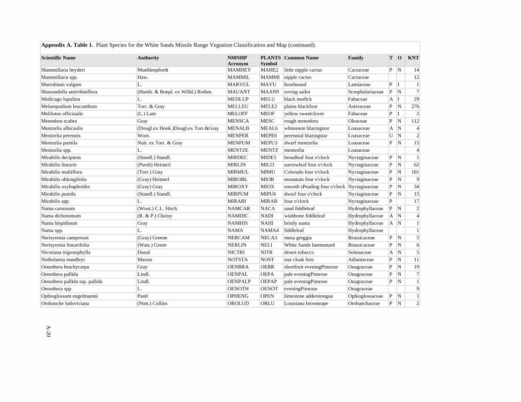
A-20
Appendix A. Table 1. Plant Species for the White Sands Missile Range Vegtation Classification and Map (continued). Scientific Name Authority NMNHP
Acronym PLANTSSymbol
Common Name Family T O KNT
Mammillaria heyderi Muehlenpfordt MAMHEY MAHE2 little nipple cactus Cactaceae P N 14Mammillaria spp. Haw. MAMMIL MAMMI nipple cactus Cactaceae 12Marrubium vulgare L. MARVUL MAVU horehound Lamiaceae P I 1Maurandella antirrhiniflora (Humb. & Bonpl. ex Willd.) Rothm. MAUANT MAAN9 roving sailor Scrophulariaceae P N 7Medicago lupulina L. MEDLUP MELU black medick Fabaceae A I 29Melampodium leucanthum Torr. & Gray MELLEU MELE2 plains blackfoot Asteraceae P N 276Melilotus officinalis (L.) Lam MELOFF MEOF yellow sweetclover Fabaceae P I 2Menodora scabra Gray MENSCA MESC rough menodora Oleaceae P N 112Mentzelia albicaulis (Dougl.ex Hook.)Dougl.ex Torr.&Gray MENALB MEAL6 whitestem blazingstar Loasaceae A N 4Mentzelia perennis Woot. MENPER MEPE6 perennial blazingstar Loasaceae U N 2Mentzelia pumila Nutt. ex Torr. & Gray MENPUM MEPU3 dwarf mentzelia Loasaceae P N 15Mentzelia spp. L. MENTZE MENTZ mentzelia Loasaceae 4Mirabilis decipiens (Standl.) Standl. MIRDEC MIDE5 broadleaf four o'clock Nyctaginaceae P N 1Mirabilis linearis (Pursh) Heimerl MIRLIN MILI3 narrowleaf four o'clock Nyctaginaceae P N 62Mirabilis multiflora (Torr.) Gray MIRMUL MIMU Colorado four o'clock Nyctaginaceae P N 101Mirabilis oblongifolia (Gray) Heimerl MIROBL MIOB mountain four o'clock Nyctaginaceae P N 9Mirabilis oxybaphoides (Gray) Gray MIROXY MIOX smooth sPeading four o'clock Nyctaginaceae P N 34Mirabilis pumila (Standl.) Standl. MIRPUM MIPU6 dwarf four o'clock Nyctaginaceae P N 15Mirabilis spp. L. MIRABI MIRAB four o'clock Nyctaginaceae P 17Nama carnosum (Woot.) C.L. Hitch. NAMCAR NACA sand fiddleleaf Hydrophyllaceae P N 2Nama dichotomum (R. & P.) Choisy NAMDIC NADI wishbone fiddleleaf Hydrophyllaceae A N 4Nama hispidisum Gray NAMHIS NAHI bristly nama Hydrophyllaceae A N 1Nama spp. L. NAMA NAMA4 fiddleleaf Hydrophyllaceae 1Nerisyrenia camporum (Gray) Greene NERCAM NECA3 mesa greggia Brassicaceae P N 5Nerisyrenia linearifolia (Wats.) Green NERLIN NELI White Sands fanmustard Brassicaceae P N 6Nicotiana trigonophylla Dunal NICTRI NITR desert tobacco Solanaceae A N 5Notholaena standleyi Maxon NOTSTA NOST star cloak fern Adiantaceae P N 11Oenothera brachycarpa Gray OENBRA OEBR shortfruit eveningPimrose Onagraceae P N 19Oenothera pallida Lindl. OENPAL OEPA pale eveningPimrose Onagraceae P N 7Oenothera pallida ssp. pallida Lindl. OENPALP OEPAP pale eveningPimrose Onagraceae P N 1Oenothera spp. L. OENOTH OENOT eveningPimrose Onagraceae 9Ophioglossum engelmannii Pantl OPHENG OPEN limestone adderstongue Ophioglossaceae P N 1Orobanche ludoviciana (Nutt.) Collins OROLUD ORLU Louisiana broomrape Orobanchaceae P N 2

A-21
Appendix A. Table 1. Plant Species for the White Sands Missile Range Vegtation Classification and Map (continued). Scientific Name Authority NMNHP
Acronym PLANTSSymbol
Common Name Family T O KNT
Oxalis decaphylla (Rose) R. Kunth. OXADEC OXDE4 woodsorrel Oxalidaceae P N 4Oxalis spp. L. OXALIS OXALI woodsorrel Oxalidaceae P 12Packera neomxicanus var. neomexicanus (Gray) Weber & Love PACNEON PANEN New Mexico groundsel Asteraceae 1Palafoxia sphacelata (Nutt. ex Torr.) Cory PALSPH PASP othake Asteraceae A N 3Paronychia jamesii Torr. & Gray PARJAM PAJA James' nailwort Caryophyllaceae P N 46Parthenium confertum var. lyratum (Gray) Rollins PARCONL PACOL Gray's feverfew Asteraceae P N 13Pectis angustifolia Torr. PECANG PEAN narrowleaf pectis Asteraceae P N 8Pectis filipes Harvey & Gray PECFIL PEFI fivebract cinchweed Asteraceae A N 1Pectis papposa Harvey & Gray PECPAP PEPA2 cinchweed fetidmarigold Asteraceae A N 5Pectis spp. L. PECTIS PECTI cinchweed Asteraceae 4Pellaea atropurpurea (L) Link PELATR PEAT2 purple cliffbrake Adiantaceae P N 5Pellaea intermedia Mett. ex Kuhn PELINT PEIN intermediate cliffbrake Adiantaceae P N 1Pellaea truncata Gooding PELTRU PETR3 cliffbrake Adiantaceae P N 3Pellaea wrightiana Hook. PELWRI PEWR Wright's cliffbrake Adiantaceae P N 5Peniocereus greggii var. greggii (Engelm.) Britt. & Rose PENGREG PEGRG desert night-blooming cereus Cactaceae N 2Pennellia longifolia (Benth.) Rollins PENLON PELO3 longleaf mock thelypody Brassicaceae P N 13Penstemon barbatus (Cav.) Roth. PENBAR PEBA2 beardlip penstemon Scrophulariaceae P N 11Penstemon fendleri Torr. & Gray PENFEN PEFE Fendler's penstemon Scrophulariaceae P N 16Penstemon linarioides Gray PENLIN PELI2 toadflax penstemon Scrophulariaceae P N 10Penstemon spp. Schmidel PENSTE PENST beardtongue Scrophulariaceae P 15Pericome caudata Gray PERCAU PECA10 mountain leaftail Asteraceae P N 1Perityle staurophylla var homoflora T.K. Todsen PERSTAH PESTH San Andres rockdaisy Asteraceae P N 1Perityle staurophylla var staurophylla (Barneby) Shinners PERSTAS PESTS2 New Mexico rockdaisy Asteraceae P N 3Peteria scoparia Gray PETSCO PESC3 rush peteria Fabaceae P N 1Petrophytum caespitosum (Nutt.) Rydb. PETCAE PECA12 mat rockspirea Rosaceae P N 5Phacelia crenulata var. corrugata (A. Nels.) Brand PHACREC PHCRC cleftleaf wildheliotrope Hydrophyllaceae A N 1Phacelia integrifolia Torr. PHAINT PHIN gypsum scorpionweed Hydrophyllaceae P N 2Phacelia sp. PHACEL PHACE Hydrophyllaceae 5Phaseolus angustissimus Gray PHAANG PHAN3 slimleaf bean Fabaceae P N 1Phlox spp. L. PHLOX PHLOX phlox Polemoniaceae P 1Phlox triovulata Thurb. ex Torr. PHLTRI PHTR threeseed phlox Polemoniaceae P N 3Phoradendron juniperinum Engelm. PHOJUN PHJU juniper mistletoe Viscaceae P N 2Phorodendron villosum ssp. coryae (Trel.) Wiens PHOVILC PHVIC2 oak mistletoe Viscaceae P N 3
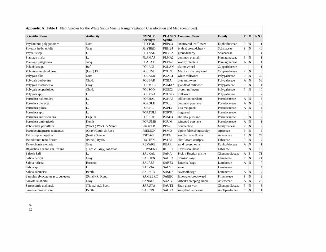
A-22
Appendix A. Table 1. Plant Species for the White Sands Missile Range Vegtation Classification and Map (continued). Scientific Name Authority NMNHP
Acronym PLANTSSymbol
Common Name Family T O KNT
Phyllanthus polygonoides Nutt. PHYPOL PHPO3 smartweed leafflower Euphorbiaceae P N 1Physalis hederaefolia Gray PHYHED PHHE4 ivyleaf groundcherry Solanaceae P N 48Physalis spp. L. PHYSAL PHYSA groundcherry Solanaceae 4Plantago major L. PLAMAJ PLMA2 common plantain Plantaginaceae P N 1Plantago patagonica Jacq. PLAPAT PLPA2 woolly plantain Plantaginaceae A N 1Polanisia spp. Raf. POLANI POLAN clammyweed Capparidaceae 1Polanisia uniglandulosa (Cav.) DC. POLUNI POUN3 Mexican clammyweed Capparidaceae P N 5Polygala alba Nutt. POLALB POAL4 white milkwort Polygalaceae P N 38Polygala barbeyana Chod. POLBAR POBA blue milkwort Polygalaceae A N 58Polygala macradenia Gray POLMAC POMA7 glandleaf milkwort Polygalaceae P N 4Polygala scoparioides Chod. POLSCO POSC2 broom milkwort Polygalaceae P N 10Polygala spp. L. POLYGA POLYG milkwort Polygalaceae 7Portulaca halimoides L. PORHAL POHA5 silkcotton purslane Portulacaceae A N 3Portulaca oleracea L. POROLE POOL common purslane Portulacaceae A N 13Portulaca pilosa L. PORPIL POPI3 kiss me quick Portulacaceae A N 4Portulaca spp. L. PORTUL1 PORTU hogweed Portulacaceae 4Portulaca suffrutescens Engelm PORSUF POSU3 shrubby purslane Portulacaceae P N 2Portulaca umbraticola Kunth PORUMB POUM wingpod purslane Portulacaceae A N 1Poboscidea parviflora (Woot.) Woot. & Standl. PROPAR PPA2 doubleclaw Martyniaceae P N 2Pseudocymopterus montanus (Gray) Coult. & Rose PSEMON PSMO alpine false sPingparsley Apiaceae P N 6Psilostrophe tagetina (Nutt.) Greene PSITAG PSTA woolly paperflower Asteraceae P N 73Psoralidium tenuiflorum (Pursh.) Rydb. PSOTEN PSTE5 slimflower scurfpea Fabaceae P N 2Reverchonia arenaria Gray REVARE REAR sand reverchonia Euphorbiaceae A N 1Rhynchosia senna var. texana (Torr. & Gray) Johnston RHYSENT RHSET Texas snoutbean Fabaceae P N 12Salsola kali L. SALKAL SAKA Pickly Russian thistle Chenopodiaceae A I 71Salvia henryi Gray SALHEN SAHE3 crimson sage Lamiaceae P N 24Salvia reflexa Hornem. SALREF SARE3 lanceleaf sage Lamiaceae A N 7Salvia spp. L. SALVIA SALVI sage Lamiaceae 4Salvia subincisa Benth. SALSUB SASU7 sawtooth sage Lamiaceae A N 7Samolus ebracteatus ssp. cuneatus (Small) R. Kunth SAMEBRC SAEBC limewater brookweed Pimulaceae P N 2Sanvitalia abertii Gray SANABE SAAB Albert's creeping zinnia Asteraceae A N 23Sarcocornia utahensis (Tides.) A.J. Scott SARUTA SAUT2 Utah glasswort Chenopodiaceae P N 3Sarcostemma crispum Benth. SARCRI SACR3 wavyleaf twinevine Asclepiadaceae P N 11
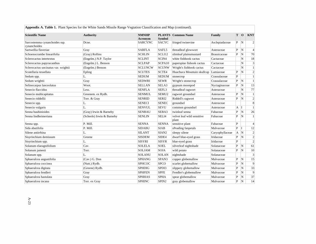
A-23
Appendix A. Table 1. Plant Species for the White Sands Missile Range Vegtation Classification and Map (continued). Scientific Name Authority NMNHP
Acronym PLANTSSymbol
Common Name Family T O KNT
Sarcostemma cynanchoides ssp. cynanchoides
Dcne. SARCYNC SACYC fringed twinevine Asclepiadaceae P N 2
Sartwellia flaveriae Gray SARFLA SAFL5 threadleaf glowwort Asteraceae P N 4Schoenocrambe linearifolia (Gray) Rollins SCHLIN SCLI12 slimleaf plainsmustard Brassicaceae P N 70Sclerocactus intertextus (Engelm.) N.P. Taylor SCLINT SCIN4 white fishhook cactus Cactaceae N 18Sclerocactus papyracanthus (Engelm.) L. Benson SCLPAP SCPA10 paperspine fishook cactus Cactaceae N 3Sclerocactus uncinatus var. wrightii (Engelm.) Benson SCLUNCW SCUNW Wright's fishhook cactus Cactaceae N 1Scutellaria tessellata Epling SCUTES SCTE4 Huachuca Mountain skullcap Lamiaceae P N 2Sedum spp. L. SEDUM SEDUM stonecrop Crassulaceae P 1Sedum wrightii Gray SEDWRI SEWR Wright's stonecrop Crassulaceae P N 1Selinocarpus lanceolatus Woot. SELLAN SELA3 gypsum moonpod Nyctaginaceae P N 13Senecio flaccidus Less. SENFLA SEFL3 threadleaf ragwort Asteraceae N 77Senecio multicapitatus Greenem. ex Rydb. SENMUL SEMU2 ragwort groundsel Asteraceae P N 1Senecio riddellii Torr. & Gray SENRID SERI2 Riddell's ragwort Asteraceae P N 2Senecio spp. L. SENECI SENEC groundsel Asteraceae 8Senecio vulgaris L. SENVUL SEVU common groundsel Asteraceae A I 1Senna bauhinioides (Gray) Irwin & Barneby SENBAU SEBA3 twinleaf senna Fabaceae P N 26Senna lindheimeriana (Scheele) Irwin & Barneby SENLIN SELI4 velvet leaf wild sensitive
plant Fabaceae P N 1
Senna spp. P. Mill. SENNA SENNA sensitive plant Fabaceae P 4Sida abutifolia P. Mill. SIDABU SIAB sPeading fanpetals Malvaceae P I 12Silene antirrhina L. SILANT SIAN2 sleepy silene Caryophyllaceae A N 2Sisyrinchium demissum Greene SISDEM SIDE4 dwarf blue-eyed grass Iridaceae P N 2Sisyrinchium spp. L. SISYRI SISYR blue-eyed grass Iridaceae P 2Solanum elaeagnifolium Cav. SOLELA SOEL silverleaf nightshade Solanaceae P N 61Solanum jamesii Torr. SOLJAM SOJA wild potato Solanaceae P N 10Solanum spp. L. SOLANU SOLAN nightshade Solanaceae 3Sphaeralcea angustifolia (Cav.) G. Don SPHANG SPAN3 copper globemallow Malvaceae P N 15Sphaeralcea coccinea (Nutt.) Rydb. SPHCOC SPCO scarlet globemallow Malvaceae P N 9Sphaeralcea digitata (Greene) Rydb. SPHDIG SPDI3 slippery globemallow Malvaceae P N 33Sphaeralcea fendleri Gray SPHFEN SPFE Fendler's globemallow Malvaceae P N 9Sphaeralcea hastulata Gray SPHHAS SPHA spear globemallow Malvaceae P N 37Sphaeralcea incana Torr. ex Gray SPHINC SPIN2 gray globemallow Malvaceae P N 14
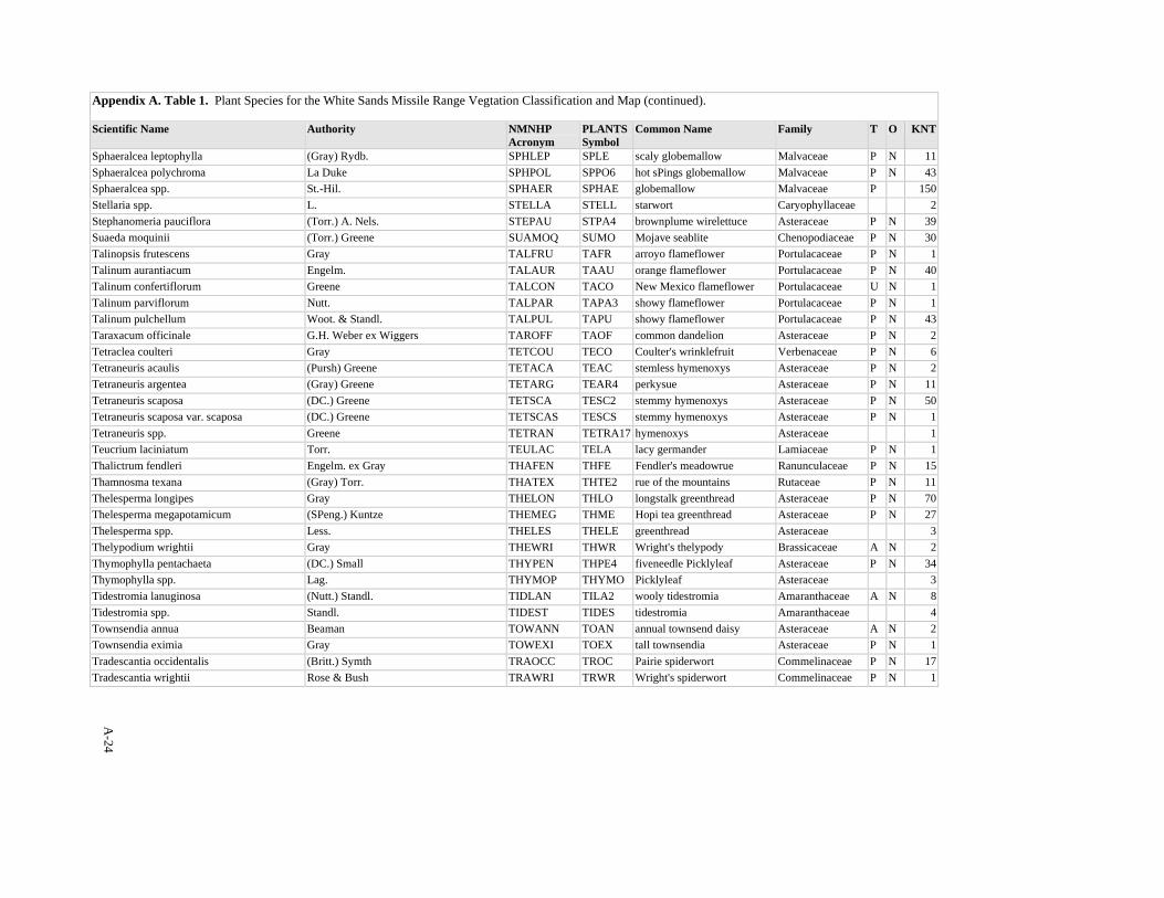
A-24
Appendix A. Table 1. Plant Species for the White Sands Missile Range Vegtation Classification and Map (continued). Scientific Name Authority NMNHP
Acronym PLANTSSymbol
Common Name Family T O KNT
Sphaeralcea leptophylla (Gray) Rydb. SPHLEP SPLE scaly globemallow Malvaceae P N 11Sphaeralcea polychroma La Duke SPHPOL SPPO6 hot sPings globemallow Malvaceae P N 43Sphaeralcea spp. St.-Hil. SPHAER SPHAE globemallow Malvaceae P 150Stellaria spp. L. STELLA STELL starwort Caryophyllaceae 2Stephanomeria pauciflora (Torr.) A. Nels. STEPAU STPA4 brownplume wirelettuce Asteraceae P N 39Suaeda moquinii (Torr.) Greene SUAMOQ SUMO Mojave seablite Chenopodiaceae P N 30Talinopsis frutescens Gray TALFRU TAFR arroyo flameflower Portulacaceae P N 1Talinum aurantiacum Engelm. TALAUR TAAU orange flameflower Portulacaceae P N 40Talinum confertiflorum Greene TALCON TACO New Mexico flameflower Portulacaceae U N 1Talinum parviflorum Nutt. TALPAR TAPA3 showy flameflower Portulacaceae P N 1Talinum pulchellum Woot. & Standl. TALPUL TAPU showy flameflower Portulacaceae P N 43Taraxacum officinale G.H. Weber ex Wiggers TAROFF TAOF common dandelion Asteraceae P N 2Tetraclea coulteri Gray TETCOU TECO Coulter's wrinklefruit Verbenaceae P N 6Tetraneuris acaulis (Pursh) Greene TETACA TEAC stemless hymenoxys Asteraceae P N 2Tetraneuris argentea (Gray) Greene TETARG TEAR4 perkysue Asteraceae P N 11Tetraneuris scaposa (DC.) Greene TETSCA TESC2 stemmy hymenoxys Asteraceae P N 50Tetraneuris scaposa var. scaposa (DC.) Greene TETSCAS TESCS stemmy hymenoxys Asteraceae P N 1Tetraneuris spp. Greene TETRAN TETRA17 hymenoxys Asteraceae 1Teucrium laciniatum Torr. TEULAC TELA lacy germander Lamiaceae P N 1Thalictrum fendleri Engelm. ex Gray THAFEN THFE Fendler's meadowrue Ranunculaceae P N 15Thamnosma texana (Gray) Torr. THATEX THTE2 rue of the mountains Rutaceae P N 11Thelesperma longipes Gray THELON THLO longstalk greenthread Asteraceae P N 70Thelesperma megapotamicum (SPeng.) Kuntze THEMEG THME Hopi tea greenthread Asteraceae P N 27Thelesperma spp. Less. THELES THELE greenthread Asteraceae 3Thelypodium wrightii Gray THEWRI THWR Wright's thelypody Brassicaceae A N 2Thymophylla pentachaeta (DC.) Small THYPEN THPE4 fiveneedle Picklyleaf Asteraceae P N 34Thymophylla spp. Lag. THYMOP THYMO Picklyleaf Asteraceae 3Tidestromia lanuginosa (Nutt.) Standl. TIDLAN TILA2 wooly tidestromia Amaranthaceae A N 8Tidestromia spp. Standl. TIDEST TIDES tidestromia Amaranthaceae 4Townsendia annua Beaman TOWANN TOAN annual townsend daisy Asteraceae A N 2Townsendia eximia Gray TOWEXI TOEX tall townsendia Asteraceae P N 1Tradescantia occidentalis (Britt.) Symth TRAOCC TROC Pairie spiderwort Commelinaceae P N 17Tradescantia wrightii Rose & Bush TRAWRI TRWR Wright's spiderwort Commelinaceae P N 1
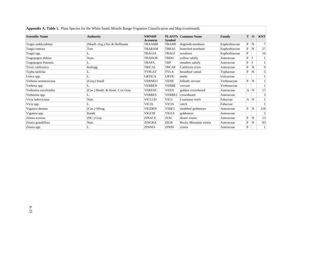
A-25
Appendix A. Table 1. Plant Species for the White Sands Missile Range Vegtation Classification and Map (continued). Scientific Name Authority NMNHP
Acronym PLANTSSymbol
Common Name Family T O KNT
Tragia amblyodonta (Muell.-Arg.) Pax & Hoffmann TRAAMB TRAM9 dogtooth noseburn Euphorbiaceae P N 7Tragia ramosa Torr. TRARAM TRRA5 branched noseburn Euphorbiaceae P N 27Tragia spp. L. TRAGIA TRAGI noseburn Euphorbiaceae P 16Tragopogon dubius Scpo. TRADUB TRDU yellow salsify Asteraceae P I 1Tragopogon Patensis L. TRAPA TRP meadow salsify Asteraceae P I 1Trixis californica Kellogg TRICAL TRCA8 California trixis Asteraceae P N 9Typha latifolia L. TYPLAT TYLA broadleaf cattail Typhaceae P N 5Urtica spp. L. URTICA URTIC nettle Urticaceae 1Verbena neomexicana (Gray) Small VERNEO VENE hillside vervain Verbenaceae P N 1Verbena spp. L. VERBEN VERBE vervain Verbenaceae 1Verbesina encelioides (Cav.) Benth. & Hook. f. ex Gray VERENC VEEN golden crownbeard Asteraceae A N 17Verbesina spp. L. VERBES VERBE2 crownbeard Asteraceae 3Vicia ludoviciana Nutt. VICLUD VILU Louisiana vetch Fabaceae A N 1Vicia spp. L. VICIA VICIA vetch Fabaceae 1Viguiera dentata (Cav.) SPeng. VIGDEN VIDE3 toothleaf goldeneye Asteraceae P N 218Viguiera spp. Kunth VIGUIE VIGUI goldeneye Asteraceae 5Zinnia acerosa (DC.) Gray ZINACE ZIAC desert zinnia Asteraceae P N 13Zinnia grandiflora Nutt. ZINGRA ZIGR Rocky Mountain zinnia Asteraceae P N 93Zinnia spp. L. ZINNIA ZINNI zinnia Asteraceae P 1

B-1
APPENDIX B
Vegetation of White Sands Missile Range
Vegetation Plant Associations to Map Units Crosswalk Vegetation plant associations from the White Sands Missile Range vegetation classification in Volume I crosswalked to the map units in Volume II. The table is hierarchically ordered by plant association common name followed by major map units and map sub-units that the community can be found in. The importance of a community type in a map sub-unit is also indicated by whether it is a "Primary" component of the unit (>10% of the unit coverage) or an "Inclusion" (<10% of the unit coverage). Map unit descriptions corresponding to the map unit names and numbers can be found in Volume II.
_______________________________________________________________________________________ Alkali Sacaton-Burrograss PA 19 Lowland Basin Grasslands 108 Alkali Sacaton or Tobosagrass Basin Grasslands and Honey Mesquite/Alkali Sacaton Basin Shrubland Inclusion 6 Alkali Sacaton-Burrograss or Tobosagrass Basin Grasslands, and Fourwing Saltbush/Alkali Sacaton Primary
Alkali Sacaton/Monotypic Stand PA 19 Lowland Basin Grasslands 108 Alkali Sacaton or Tobosagrass Basin Grasslands and Honey Mesquite/Alkali Sacaton Basin Shrubland Primary 6 Alkali Sacaton-Burrograss or Tobosagrass Basin Grasslands, and Fourwing Saltbush/Alkali Sacaton Inclusion 16 Piedmont Desert Grasslands 156 Blue Grama-Alkali Sacaton Grassland Inclusion
Black Grama-Alkali Sacaton PA 16 Piedmont Desert Grasslands 24 Black Grama/Longleaf Jointfir Piedmont Grassland Inclusion
Black Grama-Blue Grama PA 29 Black Grama Lava Grassland 127 Black Grama/Torrey's Jointfir Lava Grassland Inclusion 12 Mixed Foothill-Piedmont Desert Grasslands 138 Black Grama-Blue Grama or Sideoats Grama and Blue Grama/Banana Yucca Foothill Grasslands Primary 184 Black grama-Blue grama, and Black grama/Torrey's Jointfir Foothill Grasslands Primary 122 Black Grama-Blue Grama, Sideoats Grama or Hairy Grama Foothill Grasslands Primary 171 Curlyleaf Muhly-Hairy Grama or Blue Grama, and Black Grama-Blue Grama Foothill Grasslands Primary 117 Mixed Grama Foothill Grasslands Primary 16 Piedmont Desert Grasslands 27 Black Grama and Blue Grama/Soaptree Yucca Piedmont Grasslands Inclusion 17 Black Grama and Blue Grama/Yucca Piedmont Grasslands Inclusion
Black Grama-Blue Grama/Bigelow's Sagebrush PA 12 Mixed Foothill-Piedmont Desert Grasslands 179 Black Grama or Blue Grama/Bigelow's Sagebrush Foothill Grasslands Primary

Appendix B (continued).
B-2
Black Grama-Blue Grama/Soaptree Yucca PA 12 Mixed Foothill-Piedmont Desert Grasslands 184 Black grama-Blue grama, and Black grama/Torrey's Jointfir Foothill Grasslands Primary 16 Piedmont Desert Grasslands 27 Black Grama and Blue Grama/Soaptree Yucca Piedmont Grasslands Primary 17 Black Grama and Blue Grama/Yucca Piedmont Grasslands Primary Black Grama-Sideoats Grama PA 12 Mixed Foothill-Piedmont Desert Grasslands 138 Black Grama-Blue Grama or Sideoats Grama and Blue Grama/Banana Yucca Foothill Grasslands Primary 122 Black Grama-Blue Grama, Sideoats Grama or Hairy Grama Foothill Grasslands Primary 103 Black Grama/Mariola or Sideoats Grama Foothill Grasslands and Ocotillo/Mariola Shrublands Primary Black Grama/Banana Yucca PA 16 Piedmont Desert Grasslands 17 Black Grama and Blue Grama/Yucca Piedmont Grasslands Primary Black Grama/Bigelow's Sagebrush PA 12 Mixed Foothill-Piedmont Desert Grasslands 179 Black Grama or Blue Grama/Bigelow's Sagebrush Foothill Grasslands Primary Black Grama/Common Sotol PA 12 Mixed Foothill-Piedmont Desert Grasslands 145 Sideoats, Black or Hairy Grama/Sotol Foothill Grasslands Primary Black Grama/Longleaf Jointfir PA 16 Piedmont Desert Grasslands 24 Black Grama/Longleaf Jointfir Piedmont Grassland Primary 147 Hairy Grama-Black Grama, and Hairy Grama or Black Grama/Soaptree Yucca Piedmont Grasslands Inclusion Black Grama/Mariola PA 12 Mixed Foothill-Piedmont Desert Grasslands 144 Black Grama/Mariola Foothill Grassland Primary 103 Black Grama/Mariola or Sideoats Grama Foothill Grasslands and Ocotillo/Mariola Shrublands Primary 20 Black Grama/Mariola Piedmont and Foothill Grassland Primary 134 Creosotebush/Black Grama Shrublands, and Black Grama/Mariola or Hairy Grama Grasslands Primary 171 Curlyleaf Muhly-Hairy Grama or Blue Grama, and Black Grama-Blue Grama Foothill Grasslands Inclusion Black Grama/Ocotillo PA 12 Mixed Foothill-Piedmont Desert Grasslands 144 Black Grama/Mariola Foothill Grassland Inclusion Black Grama/Soaptree Yucca PA 18 Desert Plains Grasslands 5 Black Grama, Galleta or Mesa Dropseed/Soaptree Yucca Sandy Plains Grassland Primary 16 Piedmont Desert Grasslands 27 Black Grama and Blue Grama/Soaptree Yucca Piedmont Grasslands Primary 147 Hairy Grama-Black Grama, and Hairy Grama or Black Grama/Soaptree Yucca Piedmont Grasslands Primary 17 Piedmont Temperate Grasslands 118 Blue Grama-Sideoats Grama or Winterfat, and Black Grama/Soaptree Yucca Montane Valley Primary

Appendix B (continued).
B-3
Black Grama/Torrey's Jointfir PA 29 Black Grama Lava Grassland 127 Black Grama/Torrey's Jointfir Lava Grassland Primary 12 Mixed Foothill-Piedmont Desert Grasslands 184 Black grama-Blue grama, and Black grama/Torrey's Jointfir Foothill Grasslands Primary 134 Creosotebush/Black Grama Shrublands, and Black Grama/Mariola or Hairy Grama Grasslands Inclusion Blue Grama-Alkali Sacaton PA 16 Piedmont Desert Grasslands 156 Blue Grama-Alkali Sacaton Grassland Primary Blue Grama-Sideoats Grama PA 15 Foothill-Montane Temperate Grasslands 183 Blue Grama/ Banana Yucca and Blue Grama-Sideoats Grama Montane Grasslands Primary 12 Mixed Foothill-Piedmont Desert Grasslands 122 Black Grama-Blue Grama, Sideoats Grama or Hairy Grama Foothill Grasslands Inclusion 117 Mixed Grama Foothill Grasslands Primary 17 Piedmont Temperate Grasslands 118 Blue Grama-Sideoats Grama or Winterfat, and Black Grama/Soaptree Yucca Montane Valley Primary Blue Grama-Western Wheatgrass PA 15 Foothill-Montane Temperate Grasslands 128 Blue Grama/Winterfat, Western Wheatgrass or Soaptree Yucca Montane Grasslands Primary Blue Grama/Banana Yucca PA 15 Foothill-Montane Temperate Grasslands 183 Blue Grama/ Banana Yucca and Blue Grama-Sideoats Grama Montane Grasslands Primary 12 Mixed Foothill-Piedmont Desert Grasslands 138 Black Grama-Blue Grama or Sideoats Grama and Blue Grama/Banana Yucca Foothill Grasslands Primary Blue Grama/Bigelow's Sagebrush PA 12 Mixed Foothill-Piedmont Desert Grasslands 179 Black Grama or Blue Grama/Bigelow's Sagebrush Foothill Grasslands Primary Blue Grama/Monotypic Stand PA 15 Foothill-Montane Temperate Grasslands 128 Blue Grama/Winterfat, Western Wheatgrass or Soaptree Yucca Montane Grasslands Inclusion Blue Grama/Soaptree Yucca PA 15 Foothill-Montane Temperate Grasslands 128 Blue Grama/Winterfat, Western Wheatgrass or Soaptree Yucca Montane Grasslands Primary Blue Grama/Winterfat PA 15 Foothill-Montane Temperate Grasslands 128 Blue Grama/Winterfat, Western Wheatgrass or Soaptree Yucca Montane Grasslands Primary 17 Piedmont Temperate Grasslands 118 Blue Grama-Sideoats Grama or Winterfat, and Black Grama/Soaptree Yucca Montane Valley Primary Broom Dalea/Mesa Dropseed PA 18 Desert Plains Grasslands 186 Mesa Dropseed/Soaptree Yucca Sandy Plains Grassland Inclusion 22 Gypsum Duneland -- Vegetated 168 Broom Dalea Dune Shrublands Primary 11 Mesquite Shrubland 101 Honey Mesquite-Fourwing Saltbush, Snakeweed or Mesa Dropseed Coppice Dune Shrublands Inclusion 4 Littleleaf Sumac/Dropseed Coppice Dune Shrublands Inclusion
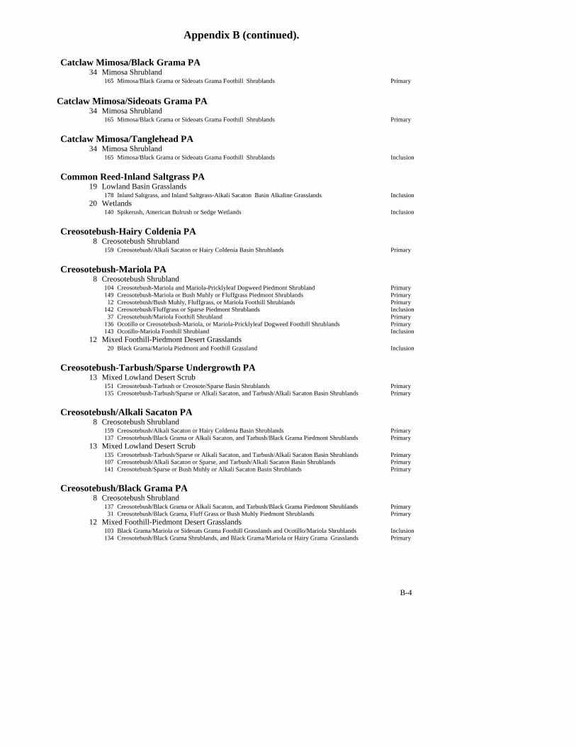
Appendix B (continued).
B-4
Catclaw Mimosa/Black Grama PA 34 Mimosa Shrubland 165 Mimosa/Black Grama or Sideoats Grama Foothill Shrublands Primary Catclaw Mimosa/Sideoats Grama PA 34 Mimosa Shrubland 165 Mimosa/Black Grama or Sideoats Grama Foothill Shrublands Primary Catclaw Mimosa/Tanglehead PA 34 Mimosa Shrubland 165 Mimosa/Black Grama or Sideoats Grama Foothill Shrublands Inclusion Common Reed-Inland Saltgrass PA 19 Lowland Basin Grasslands 178 Inland Saltgrass, and Inland Saltgrass-Alkali Sacaton Basin Alkaline Grasslands Inclusion 20 Wetlands 140 Spikerush, American Bulrush or Sedge Wetlands Inclusion Creosotebush-Hairy Coldenia PA 8 Creosotebush Shrubland 159 Creosotebush/Alkali Sacaton or Hairy Coldenia Basin Shrublands Primary Creosotebush-Mariola PA 8 Creosotebush Shrubland 104 Creosotebush-Mariola and Mariola-Pricklyleaf Dogweed Piedmont Shrubland Primary 149 Creosotebush-Mariola or Bush Muhly or Fluffgrass Piedmont Shrublands Primary 12 Creosotebush/Bush Muhly, Fluffgrass, or Mariola Foothill Shrublands Primary 142 Creosotebush/Fluffgrass or Sparse Piedmont Shrublands Inclusion 37 Creosotebush/Mariola Foothill Shrubland Primary 136 Ocotillo or Creosotebush-Mariola, or Mariola-Pricklyleaf Dogweed Foothill Shrublands Primary 143 Ocotillo-Mariola Foothill Shrubland Inclusion 12 Mixed Foothill-Piedmont Desert Grasslands 20 Black Grama/Mariola Piedmont and Foothill Grassland Inclusion Creosotebush-Tarbush/Sparse Undergrowth PA 13 Mixed Lowland Desert Scrub 151 Creosotebush-Tarbush or Creosote/Sparse Basin Shrublands Primary 135 Creosotebush-Tarbush/Sparse or Alkali Sacaton, and Tarbush/Alkali Sacaton Basin Shrublands Primary Creosotebush/Alkali Sacaton PA 8 Creosotebush Shrubland 159 Creosotebush/Alkali Sacaton or Hairy Coldenia Basin Shrublands Primary 137 Creosotebush/Black Grama or Alkali Sacaton, and Tarbush/Black Grama Piedmont Shrublands Primary 13 Mixed Lowland Desert Scrub 135 Creosotebush-Tarbush/Sparse or Alkali Sacaton, and Tarbush/Alkali Sacaton Basin Shrublands Primary 107 Creosotebush/Alkali Sacaton or Sparse, and Tarbush/Alkali Sacaton Basin Shrublands Primary 141 Creosotebush/Sparse or Bush Muhly or Alkali Sacaton Basin Shrublands Primary Creosotebush/Black Grama PA 8 Creosotebush Shrubland 137 Creosotebush/Black Grama or Alkali Sacaton, and Tarbush/Black Grama Piedmont Shrublands Primary 31 Creosotebush/Black Grama, Fluff Grass or Bush Muhly Piedmont Shrublands Primary 12 Mixed Foothill-Piedmont Desert Grasslands 103 Black Grama/Mariola or Sideoats Grama Foothill Grasslands and Ocotillo/Mariola Shrublands Inclusion 134 Creosotebush/Black Grama Shrublands, and Black Grama/Mariola or Hairy Grama Grasslands Primary
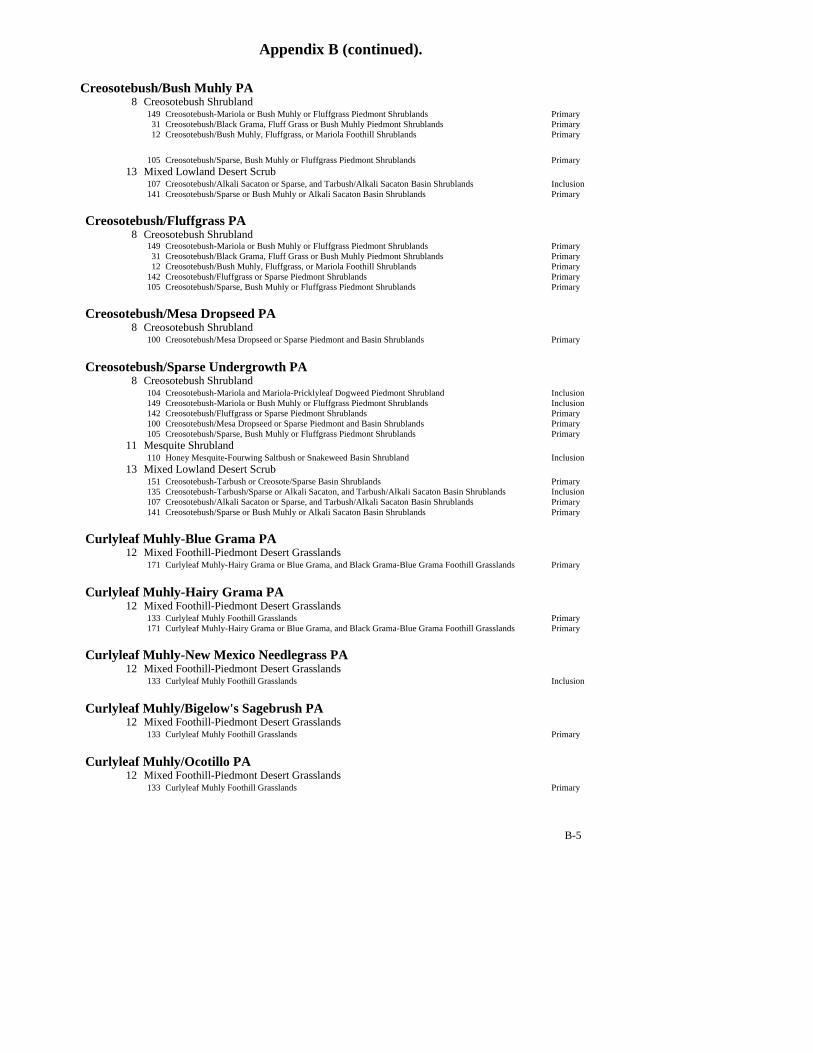
Appendix B (continued).
B-5
Creosotebush/Bush Muhly PA 8 Creosotebush Shrubland 149 Creosotebush-Mariola or Bush Muhly or Fluffgrass Piedmont Shrublands Primary 31 Creosotebush/Black Grama, Fluff Grass or Bush Muhly Piedmont Shrublands Primary 12 Creosotebush/Bush Muhly, Fluffgrass, or Mariola Foothill Shrublands Primary 105 Creosotebush/Sparse, Bush Muhly or Fluffgrass Piedmont Shrublands Primary 13 Mixed Lowland Desert Scrub 107 Creosotebush/Alkali Sacaton or Sparse, and Tarbush/Alkali Sacaton Basin Shrublands Inclusion 141 Creosotebush/Sparse or Bush Muhly or Alkali Sacaton Basin Shrublands Primary Creosotebush/Fluffgrass PA 8 Creosotebush Shrubland 149 Creosotebush-Mariola or Bush Muhly or Fluffgrass Piedmont Shrublands Primary 31 Creosotebush/Black Grama, Fluff Grass or Bush Muhly Piedmont Shrublands Primary 12 Creosotebush/Bush Muhly, Fluffgrass, or Mariola Foothill Shrublands Primary 142 Creosotebush/Fluffgrass or Sparse Piedmont Shrublands Primary 105 Creosotebush/Sparse, Bush Muhly or Fluffgrass Piedmont Shrublands Primary Creosotebush/Mesa Dropseed PA 8 Creosotebush Shrubland 100 Creosotebush/Mesa Dropseed or Sparse Piedmont and Basin Shrublands Primary Creosotebush/Sparse Undergrowth PA 8 Creosotebush Shrubland 104 Creosotebush-Mariola and Mariola-Pricklyleaf Dogweed Piedmont Shrubland Inclusion 149 Creosotebush-Mariola or Bush Muhly or Fluffgrass Piedmont Shrublands Inclusion 142 Creosotebush/Fluffgrass or Sparse Piedmont Shrublands Primary 100 Creosotebush/Mesa Dropseed or Sparse Piedmont and Basin Shrublands Primary 105 Creosotebush/Sparse, Bush Muhly or Fluffgrass Piedmont Shrublands Primary 11 Mesquite Shrubland 110 Honey Mesquite-Fourwing Saltbush or Snakeweed Basin Shrubland Inclusion 13 Mixed Lowland Desert Scrub 151 Creosotebush-Tarbush or Creosote/Sparse Basin Shrublands Primary 135 Creosotebush-Tarbush/Sparse or Alkali Sacaton, and Tarbush/Alkali Sacaton Basin Shrublands Inclusion 107 Creosotebush/Alkali Sacaton or Sparse, and Tarbush/Alkali Sacaton Basin Shrublands Primary 141 Creosotebush/Sparse or Bush Muhly or Alkali Sacaton Basin Shrublands Primary Curlyleaf Muhly-Blue Grama PA 12 Mixed Foothill-Piedmont Desert Grasslands 171 Curlyleaf Muhly-Hairy Grama or Blue Grama, and Black Grama-Blue Grama Foothill Grasslands Primary Curlyleaf Muhly-Hairy Grama PA 12 Mixed Foothill-Piedmont Desert Grasslands 133 Curlyleaf Muhly Foothill Grasslands Primary 171 Curlyleaf Muhly-Hairy Grama or Blue Grama, and Black Grama-Blue Grama Foothill Grasslands Primary Curlyleaf Muhly-New Mexico Needlegrass PA 12 Mixed Foothill-Piedmont Desert Grasslands 133 Curlyleaf Muhly Foothill Grasslands Inclusion Curlyleaf Muhly/Bigelow's Sagebrush PA 12 Mixed Foothill-Piedmont Desert Grasslands 133 Curlyleaf Muhly Foothill Grasslands Primary Curlyleaf Muhly/Ocotillo PA 12 Mixed Foothill-Piedmont Desert Grasslands 133 Curlyleaf Muhly Foothill Grasslands Primary

Appendix B (continued).
B-6
Fourwing Saltbush/Alkali Sacaton PA 7 Fourwing Saltbush Shrubland 109 Fourwing Saltbush/Alkali Sacaton or Mesa Dropseed Basin Shrublands and Alkali Sacaton Basin Primary 19 Lowland Basin Grasslands 6 Alkali Sacaton-Burrograss or Tobosagrass Basin Grasslands, and Fourwing Saltbush/Alkali Sacaton Primary 11 Mesquite Shrubland 155 Honey Mesquite-Fourwing Saltbush Basin Shrubland Inclusion 13 Mixed Lowland Desert Scrub 175 Tarbush or Fourwing Saltbush/Alkali Sacaton Basin Shrublands Primary Fourwing Saltbush/Burrograss PA 13 Mixed Lowland Desert Scrub 174 Fourwing Saltbush or Tarbush/Burrograss, and Tarbush/Alkali Sacaton Basin Shrublands Primary Fourwing Saltbush/Bush Muhly PA 13 Mixed Lowland Desert Scrub 174 Fourwing Saltbush or Tarbush/Burrograss, and Tarbush/Alkali Sacaton Basin Shrublands Primary Fourwing Saltbush/Gyp Dropseed PA 30 Vegetated Gypsum Outcrop 154 Gyp Dropseed/Hairy Coldenia or Alkali Sacaton Basin Grasslands and Fourwing Saltbush/Gyp Primary Fourwing Saltbush/Mesa Dropseed PA 7 Fourwing Saltbush Shrubland 109 Fourwing Saltbush/Alkali Sacaton or Mesa Dropseed Basin Shrublands and Alkali Sacaton Basin Primary Fourwing Saltbush/Sparse Undergrowth PA 7 Fourwing Saltbush Shrubland 109 Fourwing Saltbush/Alkali Sacaton or Mesa Dropseed Basin Shrublands and Alkali Sacaton Basin Inclusion Galleta/Soaptree Yucca PA 18 Desert Plains Grasslands 5 Black Grama, Galleta or Mesa Dropseed/Soaptree Yucca Sandy Plains Grassland Primary Gambel's Oak/Prairie Junegrass PA 1 Ponderosa Pine Forest 166 Ponderosa Pine/Arizona Fescue Forest and Gambel's Oak-Whortleleaf Snowberry or Prairie Junegrass Primary Gambel's Oak/Whortleleaf Snowberry PA 1 Ponderosa Pine Forest 166 Ponderosa Pine/Arizona Fescue Forest and Gambel's Oak-Whortleleaf Snowberry or Prairie Junegrass Primary Giant Sacaton/Monotypic Stand PA 13 Mixed Lowland Desert Scrub 175 Tarbush or Fourwing Saltbush/Alkali Sacaton Basin Shrublands Inclusion Gyp Dropseed-Alkali Sacaton PA 30 Vegetated Gypsum Outcrop 154 Gyp Dropseed/Hairy Coldenia or Alkali Sacaton Basin Grasslands and Fourwing Saltbush/Gyp Primary Gyp Dropseed/Hairy Coldenia PA 159 Creosotebush/Alkali Sacaton or Hairy Coldenia Basin Shrublands Inclusion 3 Juniper Woodland

Appendix B (continued).
B-7
181 Oneseed Juniper/New Mexico Needlegrass Gypsum Outcrop Montane Woodland Inclusion 30 Vegetated Gypsum Outcrop 9 Gyp Dropseed/Hairy Coldenia Foothill Grassland Primary 154 Gyp Dropseed/Hairy Coldenia or Alkali Sacaton Basin Grasslands and Fourwing Saltbush/Gyp Primary Gyp Dropseed/Torrey's Jointfir PA 30 Vegetated Gypsum Outcrop 154 Gyp Dropseed/Hairy Coldenia or Alkali Sacaton Basin Grasslands and Fourwing Saltbush/Gyp Inclusion Gypsum Grama-New Mexico Bluestem PA 33 Gypsum Interdune Swale Grassland 164 Gypsum Grama-New Mexico Bluestem Interdune Swale Grassland Primary Hairy Grama-Black Grama PA 12 Mixed Foothill-Piedmont Desert Grasslands 122 Black Grama-Blue Grama, Sideoats Grama or Hairy Grama Foothill Grasslands Primary 134 Creosotebush/Black Grama Shrublands, and Black Grama/Mariola or Hairy Grama Grasslands Primary 170 Hairy Grama-Black Grama, Sideoats Grama, or Sacahuista Foothill Grasslands Primary 30 Hairy Grama/Featherplume Foothill Grassland Inclusion 117 Mixed Grama Foothill Grasslands Primary 16 Piedmont Desert Grasslands 147 Hairy Grama-Black Grama, and Hairy Grama or Black Grama/Soaptree Yucca Piedmont Grasslands Primary Hairy Grama-Blue Grama PA 12 Mixed Foothill-Piedmont Desert Grasslands 138 Black Grama-Blue Grama or Sideoats Grama and Blue Grama/Banana Yucca Foothill Grasslands Inclusion 170 Hairy Grama-Black Grama, Sideoats Grama, or Sacahuista Foothill Grasslands Inclusion Hairy Grama-Sideoats Grama PA 12 Mixed Foothill-Piedmont Desert Grasslands 170 Hairy Grama-Black Grama, Sideoats Grama, or Sacahuista Foothill Grasslands Primary 117 Mixed Grama Foothill Grasslands Inclusion Hairy Grama/Common Sotol PA 12 Mixed Foothill-Piedmont Desert Grasslands 145 Sideoats, Black or Hairy Grama/Sotol Foothill Grasslands Primary Hairy Grama/Featherplume PA 12 Mixed Foothill-Piedmont Desert Grasslands 30 Hairy Grama/Featherplume Foothill Grassland Primary Hairy Grama/Sacahuista PA 12 Mixed Foothill-Piedmont Desert Grasslands 170 Hairy Grama-Black Grama, Sideoats Grama, or Sacahuista Foothill Grasslands Primary 17 Piedmont Temperate Grasslands 118 Blue Grama-Sideoats Grama or Winterfat, and Black Grama/Soaptree Yucca Montane Valley Inclusion Hairy Grama/Soaptree Yucca PA 16 Piedmont Desert Grasslands 147 Hairy Grama-Black Grama, and Hairy Grama or Black Grama/Soaptree Yucca Piedmont Grasslands Primary Hoary Rosemarymint/Mesa Dropseed PA 22 Gypsum Duneland -- Vegetated 160 Hoary Rosemarymint/Sandhill Muhly or Mesa Dropseed Gypsum Dune Shrubland Primary

Appendix B (continued).
B-8
Hoary Rosemarymint/Sandhill Muhly PA 22 Gypsum Duneland -- Vegetated 160 Hoary Rosemarymint/Sandhill Muhly or Mesa Dropseed Gypsum Dune Shrubland Primary
Honey Mesquite-Broom Snakeweed PA 11 Mesquite Shrubland 110 Honey Mesquite-Fourwing Saltbush or Snakeweed Basin Shrubland Primary 101 Honey Mesquite-Fourwing Saltbush, Snakeweed or Mesa Dropseed Coppice Dune Shrublands Primary 7 Honey Mesquite-Snakeweed or Mesa Dropseed Coppice Dune Shrublands Primary 150 Honey Mesquite/Fourwing Saltbush or Snakeweed Coppice Dune Shrublands Primary Honey Mesquite-Fourwing Saltbush PA 11 Mesquite Shrubland 155 Honey Mesquite-Fourwing Saltbush Basin Shrubland Primary 102 Honey Mesquite-Fourwing Saltbush or Mesa Dropseed Coppice Dune Shrublands Primary 110 Honey Mesquite-Fourwing Saltbush or Snakeweed Basin Shrubland Primary 101 Honey Mesquite-Fourwing Saltbush, Snakeweed or Mesa Dropseed Coppice Dune Shrublands Primary 150 Honey Mesquite/Fourwing Saltbush or Snakeweed Coppice Dune Shrublands Primary Honey Mesquite-Threadleaf Snakeweed PA 11 Mesquite Shrubland 148 Honey Mesquite-Snakeweed Coppice Dune Shrublands Primary Honey Mesquite/Alkali Sacaton PA 19 Lowland Basin Grasslands 108 Alkali Sacaton or Tobosagrass Basin Grasslands and Honey Mesquite/Alkali Sacaton Basin Shrubland Primary Honey Mesquite/Mesa Dropseed PA 11 Mesquite Shrubland 102 Honey Mesquite-Fourwing Saltbush or Mesa Dropseed Coppice Dune Shrublands Primary 101 Honey Mesquite-Fourwing Saltbush, Snakeweed or Mesa Dropseed Coppice Dune Shrublands Primary 7 Honey Mesquite-Snakeweed or Mesa Dropseed Coppice Dune Shrublands Primary Honey Mesquite/Sand Dropseed PA 11 Mesquite Shrubland 102 Honey Mesquite-Fourwing Saltbush or Mesa Dropseed Coppice Dune Shrublands Inclusion Inland Saltgrass-Alkali Sacaton PA 19 Lowland Basin Grasslands 178 Inland Saltgrass, and Inland Saltgrass-Alkali Sacaton Basin Alkaline Grasslands Primary Inland Saltgrass/Monotypic Stand PA 19 Lowland Basin Grasslands 178 Inland Saltgrass, and Inland Saltgrass-Alkali Sacaton Basin Alkaline Grasslands Primary Littleleaf Sumac/Alkali Sacaton PA 13 Mixed Lowland Desert Scrub 29 Littleleaf Sumac/Sideoats Grama or Alkali Sacaton Basin Shrublands Primary Littleleaf Sumac/Arroyo PA 8 Creosotebush Shrubland 12 Creosotebush/Bush Muhly, Fluffgrass, or Mariola Foothill Shrublands Inclusion Littleleaf Sumac/Giant Dropseed PA 11 Mesquite Shrubland 4 Littleleaf Sumac/Dropseed Coppice Dune Shrublands Primary

Appendix B (continued).
B-9
Littleleaf Sumac/Mesa Dropseed PA 11 Mesquite Shrubland 7 Honey Mesquite-Snakeweed or Mesa Dropseed Coppice Dune Shrublands Inclusion 150 Honey Mesquite/Fourwing Saltbush or Snakeweed Coppice Dune Shrublands Inclusion 4 Littleleaf Sumac/Dropseed Coppice Dune Shrublands Primary Littleleaf Sumac/Sideoats Grama PA 13 Mixed Lowland Desert Scrub 29 Littleleaf Sumac/Sideoats Grama or Alkali Sacaton Basin Shrublands Primary Littleleaf Sumac/Tobosagrass PA 13 Mixed Lowland Desert Scrub 29 Littleleaf Sumac/Sideoats Grama or Alkali Sacaton Basin Shrublands Inclusion Mariola-Pricklyleaf Dogweed PA 8 Creosotebush Shrubland 104 Creosotebush-Mariola and Mariola-Pricklyleaf Dogweed Piedmont Shrubland Primary 136 Ocotillo or Creosotebush-Mariola, or Mariola-Pricklyleaf Dogweed Foothill Shrublands Primary Mesa Dropseed-Spike Dropseed PA 6 Sandsage Shrubland 2 Sandsage/Dropseed Low Dune Shrublands Inclusion Mesa Dropseed/Soaptree Yucca PA 18 Desert Plains Grasslands 5 Black Grama, Galleta or Mesa Dropseed/Soaptree Yucca Sandy Plains Grassland Primary 186 Mesa Dropseed/Soaptree Yucca Sandy Plains Grassland Primary Mountain Mahogany/Black Grama PA 4 Montane Scrub 22 Mountain Mahogany/Blue Grama, Sideoats Grama, or Plains Lovegrass Montane Shrublands Inclusion Mountain Mahogany/Blue Grama PA 4 Montane Scrub 124 Mountain Mahogany/Blue Grama or Curlyleaf Muhly Montane Shrublands Primary 22 Mountain Mahogany/Blue Grama, Sideoats Grama, or Plains Lovegrass Montane Shrublands Primary Mountain Mahogany/Curlyleaf Muhly PA 4 Montane Scrub 124 Mountain Mahogany/Blue Grama or Curlyleaf Muhly Montane Shrublands Primary 113 Mountain Mahogany/Sideoats Grama or Curlyleaf Muhly Montane Shrubland Primary Mountain Mahogany/New Mexico Needlegrass PA 15 Foothill-Montane Temperate Grasslands 132 New Mexico Needlegrass Montane Grasslands and Mountain Mahogany/New Mexico Needlegrass Primary 119 New Mexico Needlegrass-Grama Grass Montane Grasslands Inclusion Mountain Mahogany/Plains Lovegrass PA 4 Montane Scrub 22 Mountain Mahogany/Blue Grama, Sideoats Grama, or Plains Lovegrass Montane Shrublands Primary 113 Mountain Mahogany/Sideoats Grama or Curlyleaf Muhly Montane Shrubland Inclusion Mountain Mahogany/Sideoats Grama PA 4 Montane Scrub 22 Mountain Mahogany/Blue Grama, Sideoats Grama, or Plains Lovegrass Montane Shrublands Primary 113 Mountain Mahogany/Sideoats Grama or Curlyleaf Muhly Montane Shrubland Primary

Appendix B (continued).
B-10
New Mexico Bluestem-Sandhill Muhly PA 33 Gypsum Interdune Swale Grassland 164 Gypsum Grama-New Mexico Bluestem Interdune Swale Grassland Inclusion New Mexico Needlegrass-Black Grama PA 15 Foothill-Montane Temperate Grasslands 132 New Mexico Needlegrass Montane Grasslands and Mountain Mahogany/New Mexico Needlegrass Primary 119 New Mexico Needlegrass-Grama Grass Montane Grasslands Primary New Mexico Needlegrass-Blue Grama PA 15 Foothill-Montane Temperate Grasslands 132 New Mexico Needlegrass Montane Grasslands and Mountain Mahogany/New Mexico Needlegrass Inclusion New Mexico Needlegrass-Hairy Grama PA 15 Foothill-Montane Temperate Grasslands 119 New Mexico Needlegrass-Grama Grass Montane Grasslands Primary New Mexico Needlegrass-Sideoats Grama PA 15 Foothill-Montane Temperate Grasslands 132 New Mexico Needlegrass Montane Grasslands and Mountain Mahogany/New Mexico Needlegrass Primary 119 New Mexico Needlegrass-Grama Grass Montane Grasslands Primary New Mexico Needlegrass/Common Sotol PA 12 Mixed Foothill-Piedmont Desert Grasslands 145 Sideoats, Black or Hairy Grama/Sotol Foothill Grasslands Inclusion Ocotillo-Mariola PA 8 Creosotebush Shrubland 136 Ocotillo or Creosotebush-Mariola, or Mariola-Pricklyleaf Dogweed Foothill Shrublands Primary 12 Mixed Foothill-Piedmont Desert Grasslands 103 Black Grama/Mariola or Sideoats Grama Foothill Grasslands and Ocotillo/Mariola Shrublands Primary Oneseed Juniper/Banana Yucca PA 3 Juniper Woodland 146 Oneseed Juniper/Blue Grama, New Mexico Muhly or New Mexico Needlegrass Montane Inclusion Oneseed Juniper/Blue Grama PA 3 Juniper Woodland 131 One-Seed Juniper/New Mexico Needlegrass, Curlyleaf Muhly or Blue Grama Montane Woodlands Primary 146 Oneseed Juniper/Blue Grama, New Mexico Muhly or New Mexico Needlegrass Montane Primary Oneseed Juniper/Curlyleaf Muhly PA 3 Juniper Woodland 131 One-Seed Juniper/New Mexico Needlegrass, Curlyleaf Muhly or Blue Grama Montane Woodlands Primary 115 One-Seed Juniper/Sideoats Grama or Hairy Grama Montane Woodlands Inclusion Oneseed Juniper/Hairy Grama PA 3 Juniper Woodland 115 One-Seed Juniper/Sideoats Grama or Hairy Grama Montane Woodlands Primary Oneseed Juniper/New Mexico Muhly PA 3 Juniper Woodland 146 Oneseed Juniper/Blue Grama, New Mexico Muhly or New Mexico Needlegrass Montane Primary

Appendix B (continued).
B-11
Oneseed Juniper/New Mexico Needlegrass PA 3 Juniper Woodland 131 One-Seed Juniper/New Mexico Needlegrass, Curlyleaf Muhly or Blue Grama Montane Woodlands Primary 146 Oneseed Juniper/Blue Grama, New Mexico Muhly or New Mexico Needlegrass Montane Primary 181 Oneseed Juniper/New Mexico Needlegrass Gypsum Outcrop Montane Woodland Primary 30 Vegetated Gypsum Outcrop 9 Gyp Dropseed/Hairy Coldenia Foothill Grassland Inclusion Oneseed Juniper/Sand Dropseed PA 36 Montane Valley Dune Woodland 177Oneseed Juniper/Shrub Live Oak or Sand Dropseed Montane Valley Dune Woodland Primary Oneseed Juniper/Shrub Live Oak PA 36 Montane Valley Dune Woodland 177Oneseed Juniper/Shrub Live Oak or Sand Dropseed Montane Valley Dune Woodland Primary Oneseed Juniper/Sideoats Grama PA 3 Juniper Woodland 131 One-Seed Juniper/New Mexico Needlegrass, Curlyleaf Muhly or Blue Grama Montane Woodlands Inclusion 115 One-Seed Juniper/Sideoats Grama or Hairy Grama Montane Woodlands Primary Pickleweed-Hairy Coldenia PA 27 Pickleweed Shrubland 120 Pickleweed Alkaline Basin Shrubland Primary Pickleweed/Alkali Sacaton PA 27 Pickleweed Shrubland 120 Pickleweed Alkaline Basin Shrubland Inclusion Pickleweed/Sparse Undergrowth PA 27 Pickleweed Shrubland 120 Pickleweed Alkaline Basin Shrubland Primary Pinyon Pine-Gambel's Oak PA 2 Pinyon Pine Woodland 129 Pinyon Pine-Gambel's Oak Montane Woodland Primary Pinyon Pine/Blue Grama PA 2 Pinyon Pine Woodland 114 Pinyon Pine/Scribner's Needlegrass, New Mexico Muhly, or Blue Grama Montane Woodlands Primary Pinyon Pine/Mountain Mahogany PA 2 Pinyon Pine Woodland 130 Pinyon Pine/Wavyleaf Oak, Scribner's Needlegrass, or Sacahuista Montane Woodlands Inclusion Pinyon Pine/New Mexico Muhly PA 2 Pinyon Pine Woodland 114 Pinyon Pine/Scribner's Needlegrass, New Mexico Muhly, or Blue Grama Montane Woodlands Primary Pinyon Pine/Scribner's Needlegrass PA 2 Pinyon Pine Woodland 114 Pinyon Pine/Scribner's Needlegrass, New Mexico Muhly, or Blue Grama Montane Woodlands Primary 130 Pinyon Pine/Wavyleaf Oak, Scribner's Needlegrass, or Sacahuista Montane Woodlands Primary

Appendix B (continued).
B-12
Pinyon Pine/Wavyleaf Oak PA 2 Pinyon Pine Woodland 114 Pinyon Pine/Scribner's Needlegrass, New Mexico Muhly, or Blue Grama Montane Woodlands Inclusion 116 Pinyon Pine/Wavyleaf Oak Montane Woodland Primary 130 Pinyon Pine/Wavyleaf Oak, Scribner's Needlegrass, or Sacahuista Montane Woodlands Primary Ponderosa Pine/Arizona Fescue PA 1 Ponderosa Pine Forest 166 Ponderosa Pine/Arizona Fescue Forest and Gambel's Oak-Whortleleaf Snowberry or Prairie Junegrass Primary Saltcedar/Pickleweed PA 31 Tamarisk Shrubland 161 Tamarisk-Pickleweed or Alkali Sacaton Basin Shrublands Primary Saltcedar/Utah Swampfire PA 31 Tamarisk Shrubland 161 Tamarisk-Pickleweed or Alkali Sacaton Basin Shrublands Inclusion Sand Sagebrush/Alkali Sacaton PA 6 Sandsage Shrubland 2 Sandsage/Dropseed Low Dune Shrublands Primary Sand Sagebrush/Black Grama PA 18 Desert Plains Grasslands 5 Black Grama, Galleta or Mesa Dropseed/Soaptree Yucca Sandy Plains Grassland Inclusion 6 Sandsage Shrubland 125 Sand Sagebrush/Black Grama or Blue Grama Piedmont Shrublands Primary 8 Sand Sagebrush/Black Grama, Galleta or Indian Ricegrass Sandy Plains Shrublands Primary Sand Sagebrush/Blue Grama PA 6 Sandsage Shrubland 125 Sand Sagebrush/Black Grama or Blue Grama Piedmont Shrublands Primary Sand Sagebrush/Galleta PA 6 Sandsage Shrubland 8 Sand Sagebrush/Black Grama, Galleta or Indian Ricegrass Sandy Plains Shrublands Primary Sand Sagebrush/Indian Ricegrass PA 6 Sandsage Shrubland 8 Sand Sagebrush/Black Grama, Galleta or Indian Ricegrass Sandy Plains Shrublands Primary Sand Sagebrush/Mesa Dropseed PA 8 Creosotebush Shrubland 100 Creosotebush/Mesa Dropseed or Sparse Piedmont and Basin Shrublands Inclusion 36 Montane Valley Dune Woodland 177Oneseed Juniper/Shrub Live Oak or Sand Dropseed Montane Valley Dune Woodland Inclusion 6 Sandsage Shrubland 2 Sandsage/Dropseed Low Dune Shrublands Primary Sand Sagebrush/Spike Dropseed PA 6 Sandsage Shrubland 2 Sandsage/Dropseed Low Dune Shrublands Primary

Appendix B (continued).
B-13
Sedge Spp.-Alkali Muhly PA 20 Wetlands 140 Spikerush, American Bulrush or Sedge Wetlands Primary Shrub Live Oak-Mountain Mahogany PA 5 Interior Chaparral 123 Shrub Live Oak/Black, Blue, or Sideoats Grama Montane Shrublands Inclusion 23 Shrub Live Oak/Blue Grama, Black Grama or Mountain Mahogany Montane Shrublands Primary 153 Shrub Live Oak/Sideoats Grama, Hairy Grama or Black Grama Montane Shrublands Inclusion Shrub Live Oak/Black Grama PA 5 Interior Chaparral 123 Shrub Live Oak/Black, Blue, or Sideoats Grama Montane Shrublands Primary 23 Shrub Live Oak/Blue Grama, Black Grama or Mountain Mahogany Montane Shrublands Primary 153 Shrub Live Oak/Sideoats Grama, Hairy Grama or Black Grama Montane Shrublands Primary Shrub Live Oak/Blue Grama PA 5 Interior Chaparral 123 Shrub Live Oak/Black, Blue, or Sideoats Grama Montane Shrublands Primary 23 Shrub Live Oak/Blue Grama, Black Grama or Mountain Mahogany Montane Shrublands Primary Shrub Live Oak/Hairy Grama PA 5 Interior Chaparral 153 Shrub Live Oak/Sideoats Grama, Hairy Grama or Black Grama Montane Shrublands Primary Shrub Live Oak/Sideoats Grama PA 5 Interior Chaparral 123 Shrub Live Oak/Black, Blue, or Sideoats Grama Montane Shrublands Primary 153 Shrub Live Oak/Sideoats Grama, Hairy Grama or Black Grama Montane Shrublands Primary Sideoats Grama/Common Sotol PA 12 Mixed Foothill-Piedmont Desert Grasslands 145 Sideoats, Black or Hairy Grama/Sotol Foothill Grasslands Primary Sideoats Grama/Mariola PA 9 Tarbush Shrubland 180 Tarbush/Southwestern Needlegrass or Sideoats Grama Foothill Shrublands Inclusion American Bulrush-Common Spikerush PA 20 Wetlands 140 Spikerush, American Bulrush or Sedge Wetlands Primary Tarbush-Mariola PA 8 Creosotebush Shrubland 105 Creosotebush/Sparse, Bush Muhly or Fluffgrass Piedmont Shrublands Inclusion 136 Ocotillo or Creosotebush-Mariola, or Mariola-Pricklyleaf Dogweed Foothill Shrublands Inclusion Tarbush/Alkali Sacaton PA 13 Mixed Lowland Desert Scrub 135 Creosotebush-Tarbush/Sparse or Alkali Sacaton, and Tarbush/Alkali Sacaton Basin Shrublands Primary 107 Creosotebush/Alkali Sacaton or Sparse, and Tarbush/Alkali Sacaton Basin Shrublands Primary 175 Tarbush or Fourwing Saltbush/Alkali Sacaton Basin Shrublands Primary 9 Tarbush Shrubland 172Tarbush/Alkali Sacaton Basin Shrubland Primary
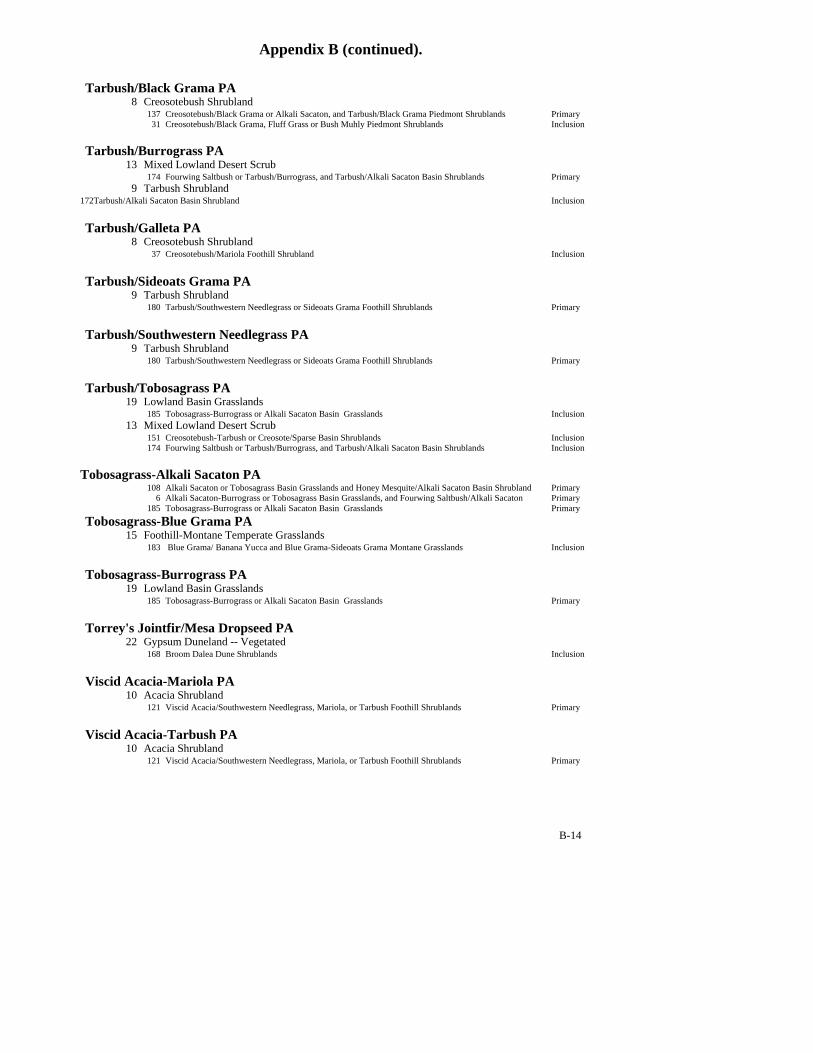
Appendix B (continued).
B-14
Tarbush/Black Grama PA 8 Creosotebush Shrubland 137 Creosotebush/Black Grama or Alkali Sacaton, and Tarbush/Black Grama Piedmont Shrublands Primary 31 Creosotebush/Black Grama, Fluff Grass or Bush Muhly Piedmont Shrublands Inclusion Tarbush/Burrograss PA 13 Mixed Lowland Desert Scrub 174 Fourwing Saltbush or Tarbush/Burrograss, and Tarbush/Alkali Sacaton Basin Shrublands Primary 9 Tarbush Shrubland 172Tarbush/Alkali Sacaton Basin Shrubland Inclusion Tarbush/Galleta PA 8 Creosotebush Shrubland 37 Creosotebush/Mariola Foothill Shrubland Inclusion Tarbush/Sideoats Grama PA 9 Tarbush Shrubland 180 Tarbush/Southwestern Needlegrass or Sideoats Grama Foothill Shrublands Primary Tarbush/Southwestern Needlegrass PA 9 Tarbush Shrubland 180 Tarbush/Southwestern Needlegrass or Sideoats Grama Foothill Shrublands Primary Tarbush/Tobosagrass PA 19 Lowland Basin Grasslands 185 Tobosagrass-Burrograss or Alkali Sacaton Basin Grasslands Inclusion 13 Mixed Lowland Desert Scrub 151 Creosotebush-Tarbush or Creosote/Sparse Basin Shrublands Inclusion 174 Fourwing Saltbush or Tarbush/Burrograss, and Tarbush/Alkali Sacaton Basin Shrublands Inclusion Tobosagrass-Alkali Sacaton PA 108 Alkali Sacaton or Tobosagrass Basin Grasslands and Honey Mesquite/Alkali Sacaton Basin Shrubland Primary 6 Alkali Sacaton-Burrograss or Tobosagrass Basin Grasslands, and Fourwing Saltbush/Alkali Sacaton Primary 185 Tobosagrass-Burrograss or Alkali Sacaton Basin Grasslands Primary Tobosagrass-Blue Grama PA 15 Foothill-Montane Temperate Grasslands 183 Blue Grama/ Banana Yucca and Blue Grama-Sideoats Grama Montane Grasslands Inclusion Tobosagrass-Burrograss PA 19 Lowland Basin Grasslands 185 Tobosagrass-Burrograss or Alkali Sacaton Basin Grasslands Primary Torrey's Jointfir/Mesa Dropseed PA 22 Gypsum Duneland -- Vegetated 168 Broom Dalea Dune Shrublands Inclusion Viscid Acacia-Mariola PA 10 Acacia Shrubland 121 Viscid Acacia/Southwestern Needlegrass, Mariola, or Tarbush Foothill Shrublands Primary Viscid Acacia-Tarbush PA 10 Acacia Shrubland 121 Viscid Acacia/Southwestern Needlegrass, Mariola, or Tarbush Foothill Shrublands Primary

Appendix B (continued).
B-15
Viscid Acacia/Black Grama PA 10 Acacia Shrubland 121 Viscid Acacia/Southwestern Needlegrass, Mariola, or Tarbush Foothill Shrublands Inclusion Viscid Acacia/Southwestern Needlegrass PA 10 Acacia Shrubland 121 Viscid Acacia/Southwestern Needlegrass, Mariola, or Tarbush Foothill Shrublands Primary