Embed Size (px)
Citation preview

Stephen Malys, Robert Wong, Scott A. True8 November 2016
The WGS 84 Terrestrial Reference Frame in 2016
Presented at ICG-11, Sochi Russia
Approved for Public Release, 17-046

2
Outline
• NGA Contributes to and Benefits from the IGS
• WGS 84 (G1762) vs. ITRF2008- The 7-Parameter Transformation
o Based on GPS Monitor Stationso Based on GPS Orbit Comparisons
• Conclusions
Approved for Public Release, 17-046

3
NGA GPS Tracking Data at the IGS
• Since November 2015, NGA has been providing the International GNSS Service (IGS) with it’s GPS tracking data in the form of daily 30 second RINEX files.
• Since 1 January 2016, these data are combined with the rest of the IGS data for daily position estimates within the International Terrestrial Reference Frame 2008 (ITRF08).
- ITRF2014 became available in January 2016 but is not yet implemented at IGS Analysis Centers
• Results of the coordinate adjustments are published in the IGS SINEX files available at
ftp://cddis.gsfc.nasa.gov/pub/gps/products/
Approved for Public Release, 17-046

4
The USAF and NGA GPS Monitor Station Network
Approved for Public Release, 17-046
GPS Monitor Stations
NGA Site (10)
NGA Test Site (2)
USAF Site (6)
South Africa
Bahrain
United Kingdom
Australia
New Zealand
South Korea
Ascension Diego Garcia
Kwajalein
Alaska
Austin, TX
St. Louis, MO
USNO
Ecuador
Uruguay
Hawaii
ColoradoSprings
Cape Canaveral
USAF and NGA have separate, but complementary, missions in GPSUSAF and NGA have separate, but complementary, missions in GPSUSAF and NGA have separate, but complementary, missions in GPSUSAF and NGA have separate, but complementary, missions in GPS

5
World Geodetic System 1984 (WGS 84)
Approved for Public Release, 17-046
NGA Predecessor Agencies – Developed the First (1958) Global Reference Frame and Geophysical Models for Modern Geospatial Information including WGS 60, 66, 72
Recent WGS 84
Frame Realizations
ZZ
YY
XX
0,0,00,0,0
Z
Y
X
0,0,0
RealizationAbsolute Accuracy Date
Original
(TRANSIT)
1-2 m Jan 1987
G730 10 cm Jun 1994
G873 5 cm Jun 1997
G1150 2 cm Jan 2002
G1674 1 cm Feb 2012
G1762 1 cm Oct 2013
Origin for ALL modern Geospatial Data is at Earth’s Center of Mass
Known in 3-D with uncertainty smaller than the size of a postage Stamp

6
NGA GPS Station Updates
Last Full WGS 84 Network Update Performed in 2012:Ref: Wong, R.F., C.M. Rollins, and C.F. Minter (2012), Recent Updates to the WGS 84 Reference Frame, Proceedings of the 25th International Technical Meeting of the Satellite Division of the Institution of Navigation (ION GNSS 2012), pp. 1164–1172.Reference Frame Realization: WGS 84 (G1762)
Since then, NGA station moves and antennaswaps required individual station position updates
Resulting Reference Frame Realization: WGS 84 (G1762’)
Approved for Public Release, 17-046
NGA IDNGA IDNGA IDNGA ID Date MovedDate MovedDate MovedDate Moved
URUGM Nov 2014
ENGLM May 2013
BAHRM Apr 2015
ECUADM May 2015
USNOM Aug 2014
ALASKM June 2015
NEWZM Sept 2012
SOAFRM Feb 2015
OSANM Sept 2014

7
Station Coordinate Comparisons
• IGS solutions for the NGA stations are pulled from .snxfiles resulting in time series of X, Y, and Z for each site.
• A weighted linear fit of each series gives an estimate of the 2016.00 positions and velocities.
• The IGS coordinates (ITRF2008) of the nine NGA stations are compared to NGA’s own coordinates (WGS 84 G1762’) at the 2016.00 epoch
- Comparison of Cartesian ECEF X,Y,Z components- Comparison of East, North, Up components- Comparison in a best-fit 7-parameter transformation
Approved for Public Release, 17-046

8
E
N
U
Sample of Daily IGS Position Estimates – NGA Station BAHRM
Approved for Public Release, 17-046

9
E
N
U
Sample of Daily IGS Position Estimates – NGA Station ALASKM
Approved for Public Release, 17-046
10
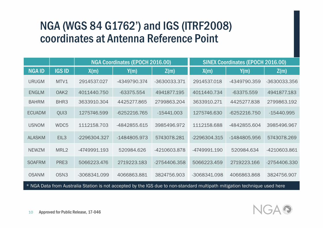
NGA Coordinates (EPOCH 2016.00) SINEX Coordinates (EPOCH 2016.00)
NGA ID IGS ID X(m) Y(m) Z(m) X(m) Y(m) Z(m)
URUGM MTV1 2914537.027 -4349790.374 -3630033.371 2914537.018 -4349790.359 -3630033.356
ENGLM OAK2 4011440.750 -63375.554 4941877.195 4011440.734 -63375.559 4941877.183
BAHRM BHR3 3633910.304 4425277.865 2799863.204 3633910.271 4425277.838 2799863.192
ECUADM QUI3 1275746.599 -6252216.765 -15441.003 1275746.630 -6252216.750 -15440.995
USNOM WDC5 1112158.703 -4842855.615 3985496.972 1112158.688 -4842855.604 3985496.967
ALASKM EIL3 -2296304.327 -1484805.973 5743078.281 -2296304.315 -1484805.956 5743078.269
NEWZM MRL2 -4749991.193 520984.626 -4210603.878 -4749991.190 520984.634 -4210603.861
SOAFRM PRE3 5066223.476 2719223.183 -2754406.358 5066223.459 2719223.166 -2754406.330
OSANM OSN3 -3068341.099 4066863.881 3824756.903 -3068341.098 4066863.868 3824756.907
NGA (WGS 84 G1762’) and IGS (ITRF2008) coordinates at Antenna Reference Point
Approved for Public Release, 17-046
* NGA Data from Australia Station is not accepted by the IGS due to non-standard multipath mitigation technique used here

11
∆∆∆∆XYZ (NGA-to-SINEX)
NGA ID IGS ID ∆∆∆∆X(cm) ∆∆∆∆Y(cm) ∆∆∆∆Z(cm)URUGM MTV1 0.9 -1.5 -1.5
ENGLM OAK2 1.6 0.5 1.2
BAHRM BHR3 3.3 2.7 1.2
ECUADM QUI3 -3.1 -1.5 -0.8
USNOM WDC5 1.5 -1.1 0.5
ALASKM EIL3 -1.2 -1.7 1.2
NEWZM MRL2 -0.3 -0.8 -1.7
SOAFRM PRE3 1.7 1.7 -2.8
OSANM OSN3 -0.1 1.3 -0.4
∆∆∆∆X(cm) ∆∆∆∆Y(cm) ∆∆∆∆Z(cm)
Mean 0.5 0.0 -0.3
σ 1.9 1.6 1.5
∆∆∆∆ENU (NGA-to-SINEX)
NGA ID IGS ID ∆∆∆∆E(cm) ∆∆∆∆N(cm) ∆∆∆∆U(cm)URUGM MTV1 0.2 0.1 -2.3
ENGLM OAK2 0.5 -0.5 -1.9
BAHRM BHR3 0.8 0.8 -4.3
ECUADM QUI3 0.8 3.3 -0.9
USNOM WDC5 0.5 -1.2 -1.4
ALASKM EIL3 1.2 -0.8 -1.9
NEWZM MRL2 1.1 -0.9 -1.3
SOAFRM PRE3 1.5 -0.7 -3.3
OSANM OSN3 1.0 0.7 -0.6
∆∆∆∆E(cm) ∆∆∆∆N(cm) ∆∆∆∆U(cm)
Mean 0.9 0.1 ----2.02.02.02.0
σ 0.4 1.4 1.2
∆∆∆∆XYZ
Approved for Public Release, 17-046
∆∆∆∆ENU

12
7 Parameter Transformation
Approved for Public Release, 17-046

13
7 Parameter Transformation (NGA-to-SINEX)
∆x -0.2 σ= 0.4 cm
∆y -0.2 σ= 0.4 cm
∆z 0.7 σ= 0.4 cm
Rx -0.009 σ= 0.037 milli-arcseconds
Ry 0.009 σ= 0.039 milli-arcseconds
Rz -0.030 σ= 0.039 milli-arcseconds
scale -3.317 σ= 0.644 ppb
At mean Earth Radius, -3.317 ppb = -2.1 cm
σ = 0.644 ppb = 0.4 cm
Using Antenna Reference Point at 9 Monitor Stations
Approved for Public Release, 17-046

14
NGA-IGS GPS Orbit Comparisons
• NGA GPS precise ephemerides are referenced to the WGS 84 Terrestrial Reference Frame (G1762’)
• IGS GPS precise ephemerides are referenced to the International Terrestrial Reference Frame (ITRF 2008)
• 7-Parameter Transformations between NGA and IGS precise ephemerides are calculated daily by NGA along with various orbit statistics – Since 1995
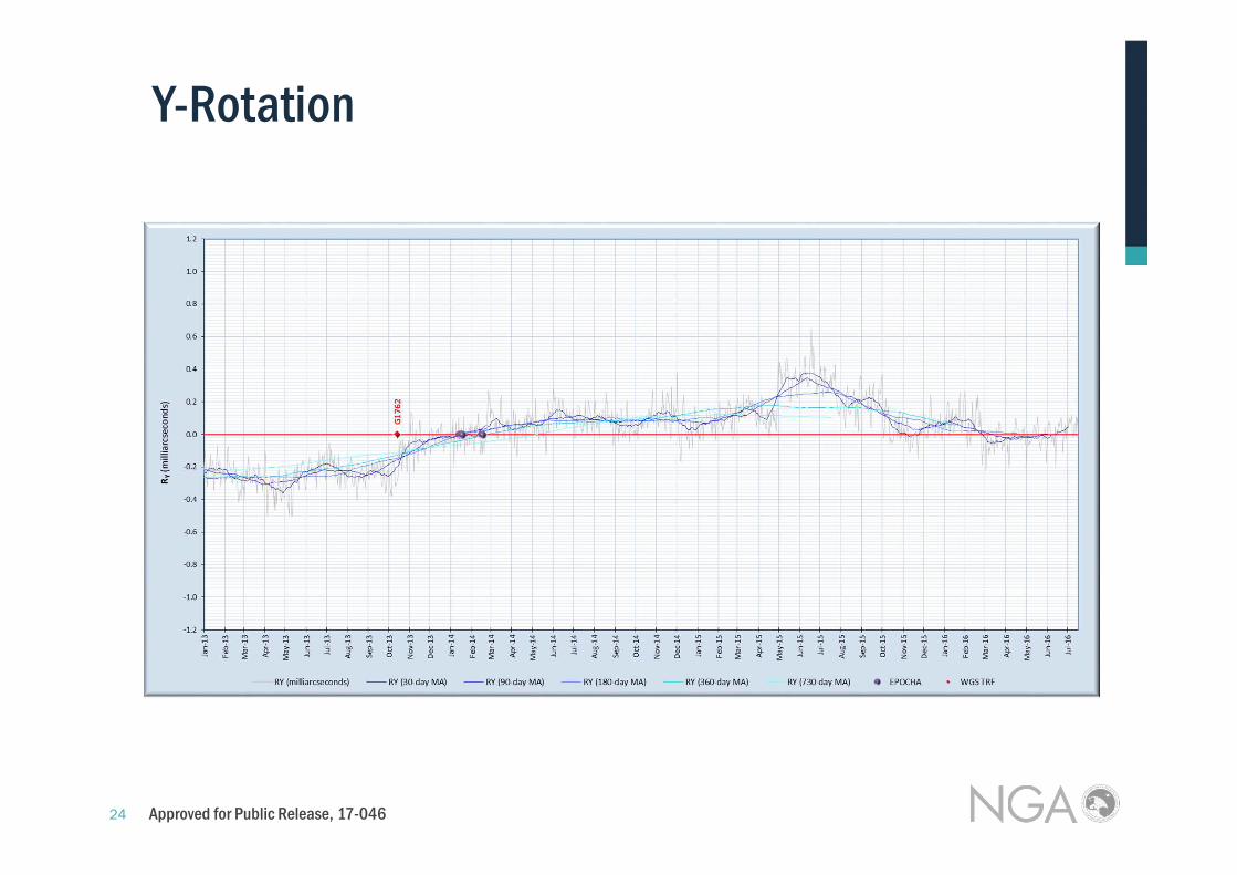
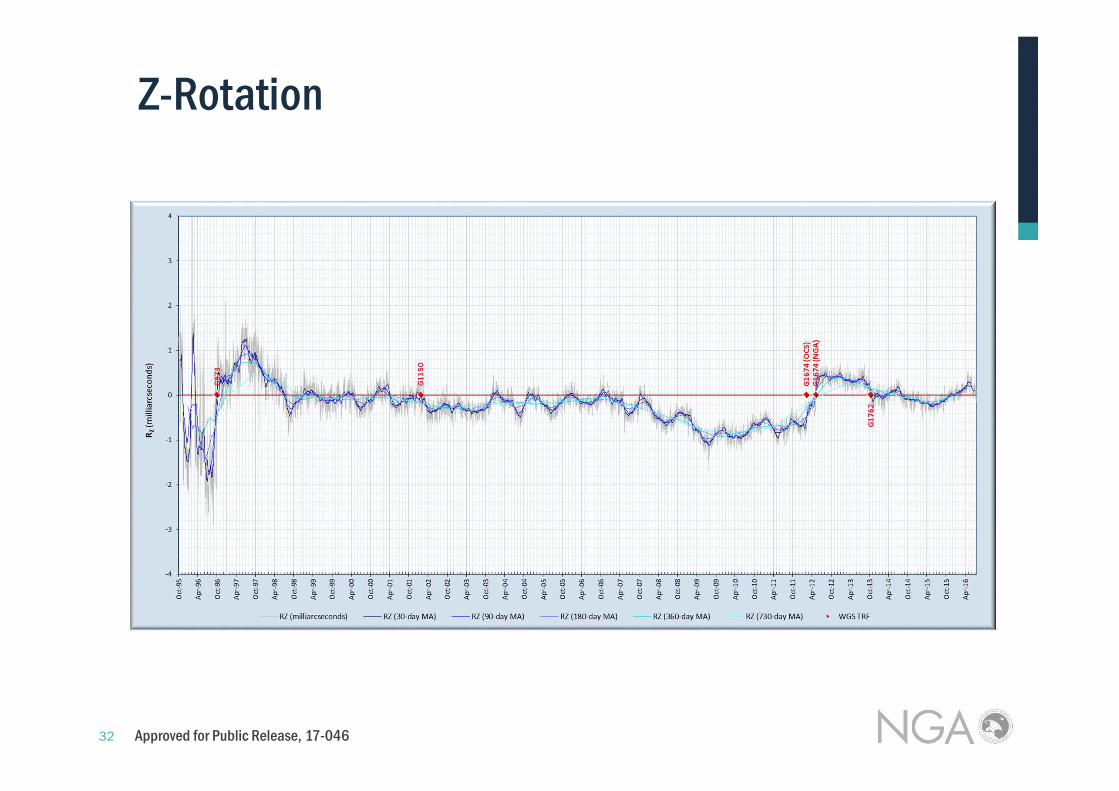
• The following slides provide graphs of these parameters that illustrate the long-term and short-term trends
• The graphs include the daily values along with 30-, 90-, 180-, 360-, and 730-day moving averages
Approved for Public Release, 17-046

15
October 1995 to Present
Long-Term Trends
Approved for Public Release, 17-046

16
X-Translation
Approved for Public Release, 17-046

17
Y-Translation
Approved for Public Release, 17-046

18
Z-Translation
Approved for Public Release, 17-046

19
January 2013 to Present
Short-Term Trends
Approved for Public Release, 17-046

20
X-Translation
Approved for Public Release, 17-046

21
Y-Translation
Approved for Public Release, 17-046

22
Z-Translation
Approved for Public Release, 17-046

23
X-Rotation
Approved for Public Release, 17-046
24
Y-Rotation
Approved for Public Release, 17-046

25
Z-Rotation
Approved for Public Release, 17-046

26
Scale
Approved for Public Release, 17-046

27
Mean of Daily Constellation-wide values from first 198 Days of 2016
7 Parameter Transformation (WGS84 (1762’) to ITRF2008)
∆x -0.3 σ= 0.4 cm
∆y -0.3 σ= 0.4 cm
∆z -0.8 σ= 0.6 cm
Rx -0.104 σ= 0.090 milli-arcseconds
Ry 0.014 σ=0.088 milli-arcseconds
Rz -0.142 σ= 0.135 milli-arcseconds
scale -0.176 σ= 0.093 ppb
Rotations and scale < 1cm at/near Earth surface
7 Parameter Transformation Using Orbits 2016201620162016
NGA (WGS 84) vs. IGS (ITRF2008)
Approved for Public Release, 17-046

28
Notable Results: WGS 84 (G1762’) vs ITRF 2008
Station Comparisons • Small Number of Stations used (9) (Small Sample Size)• 6 of 7 Transformation parameter values <1cm • 2 cm (σ=0.4) Scale difference at mean Earth Radius• 2 cm (σ=1.2) Vertical offset seen in ENU Comparisons
Orbit Comparisons • Very Large Sample size over many years using full GPS constellation• For 2016: All values <1 cm at or near Earth • Rz Rotation can amount to 1.8 cm at GPS Altitude
Overall Conclusion• Origin and Orientation difference all < 1cm• Small (2 cm) scale difference in WGS 84 (G1762’) Station Coordinates • Contributing factors include
- Knowledge of Satellite and Station phase center locations- Proper handling of phase center variations- Compensating Satellite and Station Clock offset estimates
Approved for Public Release, 17-046

Approved for Public Release, 17-046

30
X-Rotation
Approved for Public Release, 17-046

31
Y-Rotation
Approved for Public Release, 17-046
32
Z-Rotation
Approved for Public Release, 17-046

33
Scale
Approved for Public Release, 17-046