Embed Size (px)
Citation preview
THE WRISTEN OF THE PERMIAN BASIN:
EFFECT OF TECTONICS ON PATTERNS OF DEPOSITION, DIAGENESIS, AND
RESERVOIR DEVELOPMENT IN THE LATE SILURIAN
Stephen C. Ruppel
Bureau of Economic Geology Jackson School of Geosciences
The University of Texas at Austin Austin, Texas
ABSTRACT
Rocks of the Upper Silurian Wristen Group display a range in facies and depositional
style that contrasts markedly with the more homogeneous character of the underlying Middle to
Lower Silurian Fusselman Formation. The Wristen contains distinct (1) shallow-water platform
(Fasken Formation) and (2) deeper water, outer platform to slope carbonate facies (Frame and
Wink Formations) that document crustal downwarping of the southern margin of the Laurentian
paleocontinent during the Middle Silurian.
Deeper water facies of the Frame and Wink Formations dominate the more southerly
areas of the Wristen subcrop in the Permian Basin and consist of nodular mudstones and
wackestones (Wink) and carbonate debris flows and shales (Frame). Wristen platform facies are
assigned to the Fasken Formation and include platform-margin carbonate buildup successions
and a complex variety of middle to inner platform facies ranging from small carbonate buildup
facies to skeletal wackestones and packstones to tidal-flat complexes.
Hydrocarbon reservoirs are restricted to the Fasken Formation; more than 1.2 billion
barrels of oil has been produced. A large volume of oil (more than 1.8 billion barrels) remains as
a target for improved characterization of reservoir facies and architecture. The models and data
presented here provide an important basis for better understanding of this complex depositional
system.
1
INTRODUCTION
The Silurian of the Permian Basin constitutes a thick section (as much as 2,000 ft) of
carbonate platform, platform-margin, and slope rocks. Most of this section (locally as much as
1,800 ft) is assigned to the Upper Silurian Wristen Group (fig.1), from which more than 1.2
billion barrels of oil had been produced as of 2000 (Dutton and others, 2005). Despite the
economic significance of this reservoir play, relatively little detailed information exists regarding
its stratigraphy, lithology, and reservoir character. This report documents the depositional and
diagenetic history of the Wristen on the basis of available data and describes the controls on
reservoir development, distribution, and heterogeneity.
PREVIOUS WORK
Early stratigraphic studies of Silurian rocks in West Texas (Jones, 1953; Galley, 1958)
generally subdivided the Silurian and Devonian section in the Permian Basin into three parts: a
lower Fusselman Formation, an overlying, unnamed “Silurian/Devonian” (or “Siluro-Devonian”)
carbonate section, and an uppermost Woodford Formation. Wilson and Majewske (1960)
recognized some the distinctive differences between Silurian and Devonian depositional units,
and McGlasson (1967) published a very accurate characterization of the basic architecture and
character of these units. Hills and Hoenig (1979) formally named the component depositional
units within the Siluro-Devonian. They assigned the term “Wristen” for the post-Fusselman/pre-
Devonian part of the section. They further subdivided the interval locally into an upper Frame
Member and a lower Wink Member. Ruppel and Holtz (1994) elevated the Wristen to group rank
and the Frame and Wink to formation status. They also defined the Fasken Formation to
represent the extensive oil-bearing succession of platform carbonates in the Wristen Group (fig.
1). Canfield (1985) presented an excellent analysis of the Frame and Wink facies. Barrick (1995)
demonstrated, on the basis of conodont biostratigraphy, that the Wristen Group is dominantly
Wenlockian to Pridolian (Late Silurian) (fig. 1). Ruppel and Holtz (1994) also provided detailed
documentation on the extent and geological character of the Wristen, along with information on
the reservoir attributes of producing Wristen fields in the Permian Basin.
2

REGIONAL SETTING
The Late Silurian (Wenlockian to Pridolian) was a period of significant global variability
in terms of climate, sea level, and ocean chemistry. During the Late Ordovician and Early
Silurian, icehouse conditions, caused by episodic advance and retreat of glacial ice in Gondwana
(what is now Africa and South America), prevailed. This setting is well documented by
numerous globally correlative unconformities in Early Silurian platform deposits (Caputo, 1998).
Glaciation diminished during the Middle Silurian, and by the end of the period a greenhouse
climate appears to have prevailed. Global paleogeographic reconstructions indicate that during
the Silurian the U.S. Midcontinent was part of a broad, subtropical platform that occupied much
of the western part of the Laurentian paleocontinent (fig. 2). In the Early Silurian, the area of the
Permian Basin was bordered on the south by the Iapetus Ocean. Continuing collision between
the Baltic and Laurentian plates along this margin during the Late Silurian resulted in closure of
the Iapetus by the beginning of the Devonian. Deposits of the Wristen Group reflect the interplay
between climatic, eustatic, and global tectonic drivers in the Permian Basin area during the
Middle and Late Silurian.
In contrast to the underlying Late Ordovician to Early Silurian Fusselman Formation,
which displays relatively widespread facies continuity indicating deposition on a regionally
extensive, more-or-less flat platform, Wristen Group rocks display regional systematic variations
in facies that document major tectonic downwarping and drowning of the platform in the
Permian Basin area (Ruppel and Holtz, 1994; Ruppel and Hovorka, 1995). This downwarping of
the distal part of the platform appears to have begun during the early Wenlockian (fig. 3B).
Drowning is indicated by the shift from extensive shallow-water platform deposition reflected in
the underlying Fusselman. A tectonic mechanism is implicated by the absence of evidence of a
major world-wide eustatic rise event at this time (McKerrow, 1979; Johnson and others, 1998).
Differential subsidence is documented by the rapid shift to outer platform and slope deposition in
the southern part of the Permian Basin area while shallow-water platform conditions were
maintained in the north. Successions in Oklahoma and the Illinois Basin show similar facies and
subsidence patterns (Becker and Droste, 1978; Amsden and Barrick, 1988; Droste and Shaver,
1987). Further support for a tectonic subsidence event comes from a subsidence analysis of the
Illinois Basin succession by Heidlauff and others (1986). Downwarping of the Fusselman
platform in Texas, and equivalent successions in Oklahoma and the Illinois Basin, may have
3
been a product of foreland deformation along the southern margin of the North American plate
associated with plate convergence and the closing of the Iapetus Ocean. Walper (1977) suggested
that convergence of the North American and South American/African plates began as early as
the Late Ordovician.
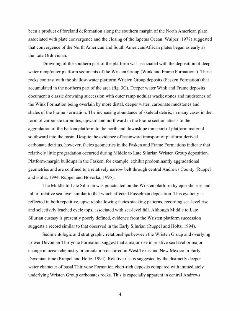
Drowning of the southern part of the platform was associated with the deposition of deep-
water ramp/outer platform sediments of the Wristen Group (Wink and Frame Formations). These
rocks contrast with the shallow-water platform Wristen Group deposits (Fasken Formation) that
accumulated in the northern part of the area (fig. 3C). Deeper water Wink and Frame deposits
document a classic drowning succession with outer ramp nodular wackestones and mudstones of
the Wink Formation being overlain by more distal, deeper water, carbonate mudstones and
shales of the Frame Formation. The increasing abundance of skeletal debris, in many cases in the
form of carbonate turbidites, upward and northward in the Frame section attests to the
aggradation of the Fasken platform to the north and downslope transport of platform material
southward into the basin. Despite the evidence of basinward transport of platform-derived
carbonate detritus, however, facies geometries in the Fasken and Frame Formations indicate that
relatively little progradation occurred during Middle to Late Silurian Wristen Group deposition.
Platform-margin buildups in the Fasken, for example, exhibit predominantly aggradational
geometries and are confined to a relatively narrow belt through central Andrews County (Ruppel
and Holtz, 1994; Ruppel and Hovorka, 1995).
The Middle to Late Silurian was punctuated on the Wristen platform by episodic rise and
fall of relative sea level similar to that which affected Fusselman deposition. This cyclicity is
reflected in both repetitive, upward-shallowing facies stacking patterns, recording sea-level rise
and selectively leached cycle tops, associated with sea-level fall. Although Middle to Late
Silurian eustasy is presently poorly defined, evidence from the Wristen platform succession
suggests a record similar to that observed in the Early Silurian (Ruppel and Holtz, 1994).
Sedimentologic and stratigraphic relationships between the Wristen Group and overlying
Lower Devonian Thirtyone Formation suggest that a major rise in relative sea level or major
change in ocean chemistry or circulation occurred in West Texas and New Mexico in Early
Devonian time (Ruppel and Holtz, 1994). Relative rise is suggested by the distinctly deeper
water character of basal Thirtyone Formation chert-rich deposits compared with immediately
underlying Wristen Group carbonates rocks. This is especially apparent in central Andrews
4
County (Andrews South field, for example), where deeper water Thirtyone chert deposits overlie
Fasken reef successions (F. J. Lucia, personal communication, 1992; Canter and others, 1992; D.
Entzminger, personal communication, 2005). A similar relationship is observed farther
basinward where basal Thirtyone shales, and carbonate-chert mudstones of pelagic origin,
sharply overlie more proximal deep-water deposits of the Frame Formation. The causes of this
relative rise in sea level are uncertain. Evidence of global sea-level rise at this time is equivocal
(cf., Vail and others, 1977; McKerrow, 1979). It seems more likely that deepening at the
Silurian-Devonian boundary in West Texas may be in part related to a second pulse of foreland
deformation associated with the continued convergence of the Laurentian and Gondwanan plates
and the closure of the Iapetus Ocean.
FACIES AND SEDIMENTOLOGY OF THE WRISTEN GROUP
The Wristen Formation was designated by Hills and Hoenig (1979) for Silurian rocks
overlying the Fusselman and underlying Devonian rocks assigned to the Thirtyone Formation
(fig. 1). Hills and Hoenig (1979) divided the formation into a basal Wink Member, an overlying
Frame Member, and an unnamed “carbonate facies” (which is laterally equivalent to the Wink
and Frame). Because of the importance of the unnamed carbonate unit in terms of its thickness
and importance as a major hydrocarbon-producing reservoir interval, Ruppel and Holtz (1994)
assigned the name Fasken Formation to this unit. They also elevated the Wink and Frame
Members to formation status and the Wristen to group status (fig. 1).
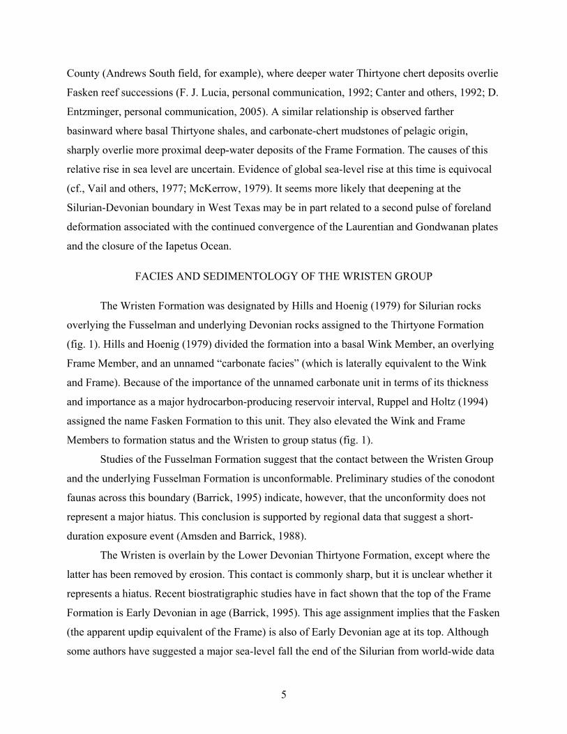
Studies of the Fusselman Formation suggest that the contact between the Wristen Group
and the underlying Fusselman Formation is unconformable. Preliminary studies of the conodont
faunas across this boundary (Barrick, 1995) indicate, however, that the unconformity does not
represent a major hiatus. This conclusion is supported by regional data that suggest a short-
duration exposure event (Amsden and Barrick, 1988).
The Wristen is overlain by the Lower Devonian Thirtyone Formation, except where the
latter has been removed by erosion. This contact is commonly sharp, but it is unclear whether it
represents a hiatus. Recent biostratigraphic studies have in fact shown that the top of the Frame
Formation is Early Devonian in age (Barrick, 1995). This age assignment implies that the Fasken
(the apparent updip equivalent of the Frame) is also of Early Devonian age at its top. Although
some authors have suggested a major sea-level fall the end of the Silurian from world-wide data
5
(for example, Vail and others, 1977; Johnson and others, 1998), data from the Frame appear to
contradict this notion. There is abundant evidence of karsting within the Fasken, but these
features are usually developed where the Thirtyone has been removed. So it seems more likely
that karsting of the Fasken is a younger event (perhaps Middle Devonian).
The Wristen subcrop margins are controlled by postdepositional erosion on the west
(Baldonado and Broadhead, 2002), north, and probably east. Wristen rocks are thickest in
western Gaines and Andrews Counties, Texas, and southeastern Lea County, New Mexico.
According to Canter and others (1992) the Wristen reaches a maximum thickness of more than
1,500 ft in southeastern Lea County, New Mexico (fig. 4).
Wink Formation
Distribution and Age
The Wink Formation overlies the Fusselman across most of the southern half of the
Silurian subcrop area (fig. 5). The Wink is relatively easily definable using gamma-ray wireline
logs in this area where it and the Frame Formation underlie the Thirtyone Formation (Hills and
Hoenig, 1979). Northward in central Andrews County, the Wink is difficult to distinguish from
the Fasken Formation (fig. 5). In the mapped area (fig. 6) the Wink ranges from less than 50 ft in
the southeastern part of the area to about 300 ft in the north where it grades into the Fasken.
On the basis of conodonts, Barrick (1995) showed that the Wink is Early Upper Silurian
(Wenlockian) in age and equivalent to the Clarita Formation in Oklahoma (Amsden, 1980).
Facies
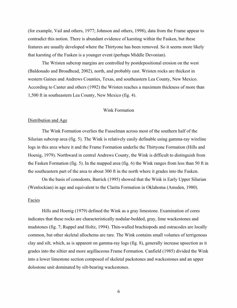
Hills and Hoenig (1979) defined the Wink as a gray limestone. Examination of cores
indicates that these rocks are characteristically nodular-bedded, gray, lime wackestones and
mudstones (fig. 7; Ruppel and Holtz, 1994). Thin-walled brachiopods and ostracodes are locally
common, but other skeletal allochems are rare. The Wink contains small volumes of terrigenous
clay and silt, which, as is apparent on gamma-ray logs (fig. 8), generally increase upsection as it
grades into the siltier and more argillaceous Frame Formation. Canfield (1985) divided the Wink
into a lower limestone section composed of skeletal packstones and wackestones and an upper
dolostone unit dominated by silt-bearing wackestones.
6
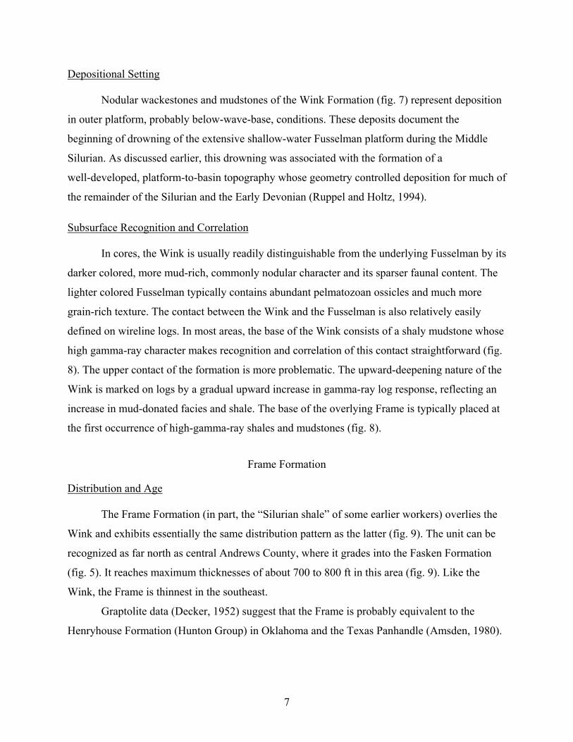
Depositional Setting
Nodular wackestones and mudstones of the Wink Formation (fig. 7) represent deposition
in outer platform, probably below-wave-base, conditions. These deposits document the
beginning of drowning of the extensive shallow-water Fusselman platform during the Middle
Silurian. As discussed earlier, this drowning was associated with the formation of a
well-developed, platform-to-basin topography whose geometry controlled deposition for much of
the remainder of the Silurian and the Early Devonian (Ruppel and Holtz, 1994).
Subsurface Recognition and Correlation
In cores, the Wink is usually readily distinguishable from the underlying Fusselman by its
darker colored, more mud-rich, commonly nodular character and its sparser faunal content. The
lighter colored Fusselman typically contains abundant pelmatozoan ossicles and much more
grain-rich texture. The contact between the Wink and the Fusselman is also relatively easily
defined on wireline logs. In most areas, the base of the Wink consists of a shaly mudstone whose
high gamma-ray character makes recognition and correlation of this contact straightforward (fig.
8). The upper contact of the formation is more problematic. The upward-deepening nature of the
Wink is marked on logs by a gradual upward increase in gamma-ray log response, reflecting an
increase in mud-donated facies and shale. The base of the overlying Frame is typically placed at
the first occurrence of high-gamma-ray shales and mudstones (fig. 8).
Frame Formation
Distribution and Age
The Frame Formation (in part, the “Silurian shale” of some earlier workers) overlies the
Wink and exhibits essentially the same distribution pattern as the latter (fig. 9). The unit can be
recognized as far north as central Andrews County, where it grades into the Fasken Formation
(fig. 5). It reaches maximum thicknesses of about 700 to 800 ft in this area (fig. 9). Like the
Wink, the Frame is thinnest in the southeast.
Graptolite data (Decker, 1952) suggest that the Frame is probably equivalent to the
Henryhouse Formation (Hunton Group) in Oklahoma and the Texas Panhandle (Amsden, 1980).
7
As mentioned, new conodont data (Barrick, 1995) show that the Frame ranges in age from Late
Silurian to Early Devonian (Ludlovian-Lochkovian) (fig. 1).
Facies
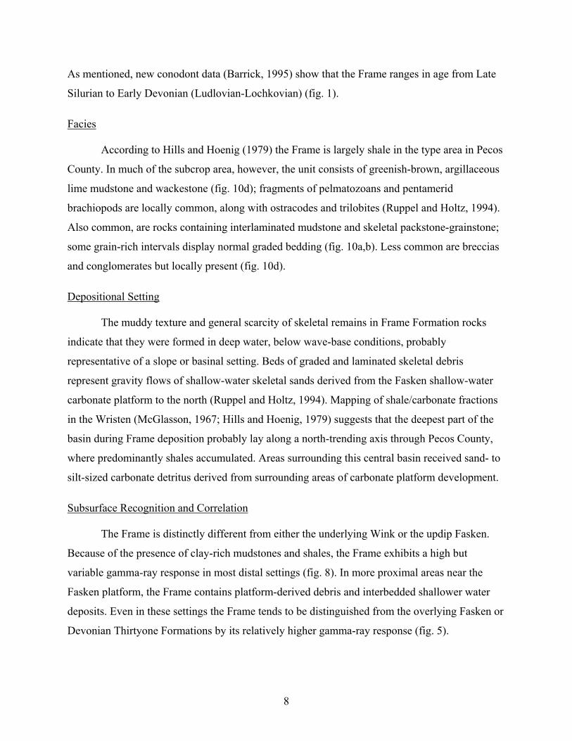
According to Hills and Hoenig (1979) the Frame is largely shale in the type area in Pecos
County. In much of the subcrop area, however, the unit consists of greenish-brown, argillaceous
lime mudstone and wackestone (fig. 10d); fragments of pelmatozoans and pentamerid
brachiopods are locally common, along with ostracodes and trilobites (Ruppel and Holtz, 1994).
Also common, are rocks containing interlaminated mudstone and skeletal packstone-grainstone;
some grain-rich intervals display normal graded bedding (fig. 10a,b). Less common are breccias
and conglomerates but locally present (fig. 10d).
Depositional Setting
The muddy texture and general scarcity of skeletal remains in Frame Formation rocks
indicate that they were formed in deep water, below wave-base conditions, probably
representative of a slope or basinal setting. Beds of graded and laminated skeletal debris
represent gravity flows of shallow-water skeletal sands derived from the Fasken shallow-water
carbonate platform to the north (Ruppel and Holtz, 1994). Mapping of shale/carbonate fractions
in the Wristen (McGlasson, 1967; Hills and Hoenig, 1979) suggests that the deepest part of the
basin during Frame deposition probably lay along a north-trending axis through Pecos County,
where predominantly shales accumulated. Areas surrounding this central basin received sand- to
silt-sized carbonate detritus derived from surrounding areas of carbonate platform development.
Subsurface Recognition and Correlation
The Frame is distinctly different from either the underlying Wink or the updip Fasken.
Because of the presence of clay-rich mudstones and shales, the Frame exhibits a high but
variable gamma-ray response in most distal settings (fig. 8). In more proximal areas near the
Fasken platform, the Frame contains platform-derived debris and interbedded shallower water
deposits. Even in these settings the Frame tends to be distinguished from the overlying Fasken or
Devonian Thirtyone Formations by its relatively higher gamma-ray response (fig. 5).
8
Fasken Formation
In their original definition of the Wristen Formation, Hills and Hoenig (1979) referred to
the thick, predominantly carbonate unit that constitutes the post-Fusselman Silurian in the
northern part of West Texas and New Mexico as simply the “carbonate facies” of the Wristen
Formation. Recognizing the importance of this unit, which contains all of the known
hydrocarbon resources in the Wristen, Ruppel and Holtz (1994) named this unit the Fasken
Formation. They designated three co-type sections for the Fasken in wells in Andrews County,
Texas. All of these wells have long cored intervals and comprehensive suites of wireline logs
that illustrate some of the significant lithologic diversity that characterizes this rock unit.
Distribution and Age
The Fasken, as defined by Ruppel and Holtz (1994), consists of most of what has
historically been referred to as the Siluro-Devonian carbonate section in the Permian Basin. The
Fasken is typically underlain by the Frame Formation but also represents the northern, updip,
shallow-water platform facies equivalent of the Frame Formation (fig. 5). The gradational lateral
contact between the two units runs generally east-west through central Andrews County, Texas
(fig. 4). Ruppel and Holtz (1994) showed that the Wink undergoes similar facies change to the
north and may also be best considered in part a deeper water facies equivalent of the Fasken (fig.
5).
Where separable from the underlying Fusselman, the Fasken exhibits an east-to-west
thickening trend. The unit reaches thicknesses of more than 1,500 ft in extreme western Andrews
County and eastern Lea County, New Mexico (Canter and others, 1992; Ruppel and Holtz, 1994)
and thins to less than 200 ft in Dawson County. Thickening trends are clearly defined by the total
Fasken isopach map (fig. 11). Throughout most of the region, the Fasken is overlain by the
Woodford Formation. Locally, where the Woodford has been removed by late Paleozoic erosion,
the Fasken is overlain by Pennsylvanian/Permian clastics and carbonates.
The age of the Fasken Formation is imprecisely known. Recent conodont studies have
shown that the Wristen Group ranges from Middle Silurian (Wenlockian) to Early Devonian
(Barrick, 1995). This is consistent with previous interpretations that the Fasken
(“Siluro-Devonian” of many earlier workers) contains a Middle Silurian–age (Niagaran) fauna.
Part of the shallow-water platform succession that is assigned to the Fasken in this report has
9
also yielded Lower and Middle Devonian fossils (Wilson and Majewske, 1960). These isolated
occurrences apparently document outliers or remnants of the eroded Thirtyone Formation
carbonate platform facies. The shallow-water platform Fasken succession is probably
represented in part by the Henryhouse Formation in Oklahoma. Although much of the
Henryhouse is interpreted as deeper water (Barrick, 1995), the shallower water Kirkidium facies
of the Henryhouse contains facies very similar to those of the Fasken, as does the Bois D’Arc
Formation (a facies of the overlying dominantly deep-water Haragan Formation) A strikingly
similar succession of Late Silurian–age (Ludlovian to Pridolian) platform and platform-margin
carbonates also exists in the Illinois Basin (Becker and Droste, 1978; Droste and Shaver, 1982,
1987).
Facies
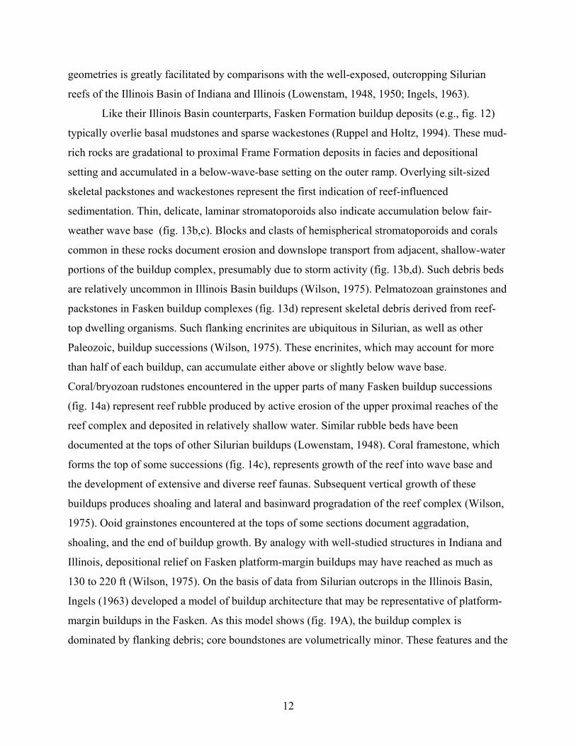
The Fasken Formation comprises a highly diverse assemblage of carbonate lithofacies.
The unit can be subdivided into two general facies complexes: (1) platform-margin skeletal
wackestones to grainstones and boundstones and (2) interior platform mudstones to pellet and
skeletal wackestones to grainstones (Ruppel and Holtz, 1994).
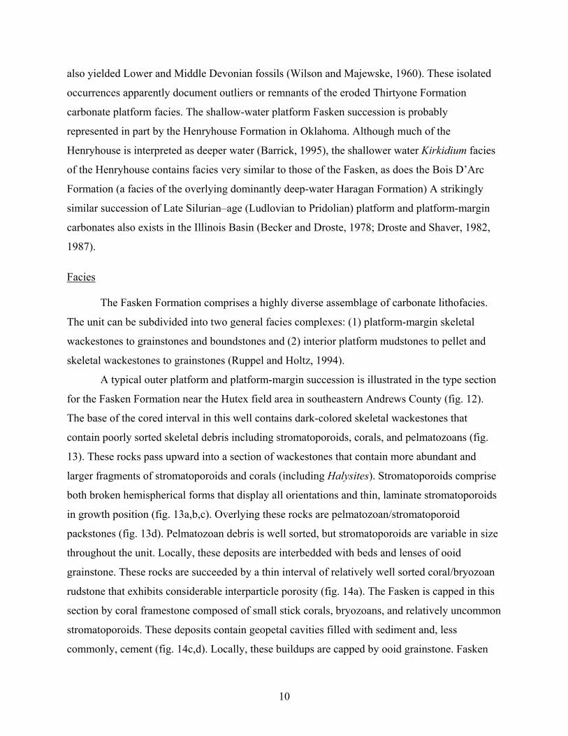
A typical outer platform and platform-margin succession is illustrated in the type section
for the Fasken Formation near the Hutex field area in southeastern Andrews County (fig. 12).
The base of the cored interval in this well contains dark-colored skeletal wackestones that
contain poorly sorted skeletal debris including stromatoporoids, corals, and pelmatozoans (fig.
13). These rocks pass upward into a section of wackestones that contain more abundant and
larger fragments of stromatoporoids and corals (including Halysites). Stromatoporoids comprise
both broken hemispherical forms that display all orientations and thin, laminate stromatoporoids
in growth position (fig. 13a,b,c). Overlying these rocks are pelmatozoan/stromatoporoid
packstones (fig. 13d). Pelmatozoan debris is well sorted, but stromatoporoids are variable in size
throughout the unit. Locally, these deposits are interbedded with beds and lenses of ooid
grainstone. These rocks are succeeded by a thin interval of relatively well sorted coral/bryozoan
rudstone that exhibits considerable interparticle porosity (fig. 14a). The Fasken is capped in this
section by coral framestone composed of small stick corals, bryozoans, and relatively uncommon
stromatoporoids. These deposits contain geopetal cavities filled with sediment and, less
commonly, cement (fig. 14c,d). Locally, these buildups are capped by ooid grainstone. Fasken
10
platform-margin buildups in Texas and New Mexico are similar to well-described outcropping
Silurian buildups in the Illinois Basin in terms of both facies patterns and fauna (Lowenstam,
1948, 1950; Ingels, 1963; Wilson, 1975).
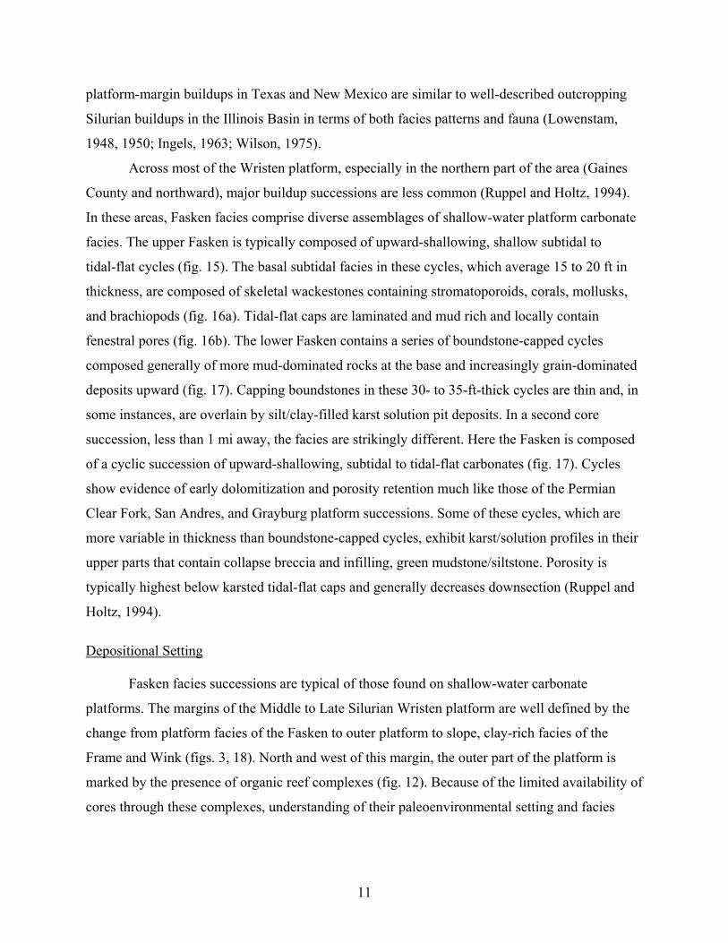
Across most of the Wristen platform, especially in the northern part of the area (Gaines
County and northward), major buildup successions are less common (Ruppel and Holtz, 1994).
In these areas, Fasken facies comprise diverse assemblages of shallow-water platform carbonate
facies. The upper Fasken is typically composed of upward-shallowing, shallow subtidal to
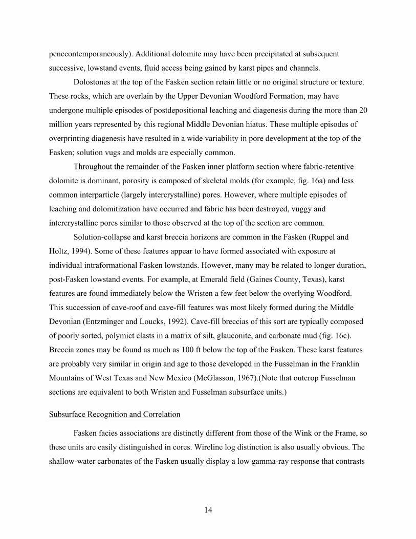
tidal-flat cycles (fig. 15). The basal subtidal facies in these cycles, which average 15 to 20 ft in
thickness, are composed of skeletal wackestones containing stromatoporoids, corals, mollusks,
and brachiopods (fig. 16a). Tidal-flat caps are laminated and mud rich and locally contain
fenestral pores (fig. 16b). The lower Fasken contains a series of boundstone-capped cycles
composed generally of more mud-dominated rocks at the base and increasingly grain-dominated
deposits upward (fig. 17). Capping boundstones in these 30- to 35-ft-thick cycles are thin and, in
some instances, are overlain by silt/clay-filled karst solution pit deposits. In a second core
succession, less than 1 mi away, the facies are strikingly different. Here the Fasken is composed
of a cyclic succession of upward-shallowing, subtidal to tidal-flat carbonates (fig. 17). Cycles
show evidence of early dolomitization and porosity retention much like those of the Permian
Clear Fork, San Andres, and Grayburg platform successions. Some of these cycles, which are
more variable in thickness than boundstone-capped cycles, exhibit karst/solution profiles in their
upper parts that contain collapse breccia and infilling, green mudstone/siltstone. Porosity is
typically highest below karsted tidal-flat caps and generally decreases downsection (Ruppel and
Holtz, 1994).
Depositional Setting
Fasken facies successions are typical of those found on shallow-water carbonate
platforms. The margins of the Middle to Late Silurian Wristen platform are well defined by the
change from platform facies of the Fasken to outer platform to slope, clay-rich facies of the
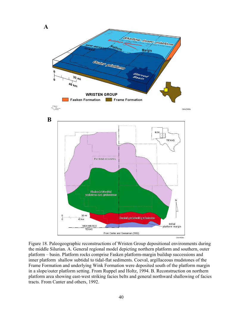
Frame and Wink (figs. 3, 18). North and west of this margin, the outer part of the platform is
marked by the presence of organic reef complexes (fig. 12). Because of the limited availability of
cores through these complexes, understanding of their paleoenvironmental setting and facies
11
geometries is greatly facilitated by comparisons with the well-exposed, outcropping Silurian
reefs of the Illinois Basin of Indiana and Illinois (Lowenstam, 1948, 1950; Ingels, 1963).
Like their Illinois Basin counterparts, Fasken Formation buildup deposits (e.g., fig. 12)
typically overlie basal mudstones and sparse wackestones (Ruppel and Holtz, 1994). These mud-
rich rocks are gradational to proximal Frame Formation deposits in facies and depositional
setting and accumulated in a below-wave-base setting on the outer ramp. Overlying silt-sized
skeletal packstones and wackestones represent the first indication of reef-influenced
sedimentation. Thin, delicate, laminar stromatoporoids also indicate accumulation below fair-
weather wave base (fig. 13b,c). Blocks and clasts of hemispherical stromatoporoids and corals
common in these rocks document erosion and downslope transport from adjacent, shallow-water
portions of the buildup complex, presumably due to storm activity (fig. 13b,d). Such debris beds
are relatively uncommon in Illinois Basin buildups (Wilson, 1975). Pelmatozoan grainstones and
packstones in Fasken buildup complexes (fig. 13d) represent skeletal debris derived from reef-
top dwelling organisms. Such flanking encrinites are ubiquitous in Silurian, as well as other
Paleozoic, buildup successions (Wilson, 1975). These encrinites, which may account for more
than half of each buildup, can accumulate either above or slightly below wave base.
Coral/bryozoan rudstones encountered in the upper parts of many Fasken buildup successions
(fig. 14a) represent reef rubble produced by active erosion of the upper proximal reaches of the
reef complex and deposited in relatively shallow water. Similar rubble beds have been
documented at the tops of other Silurian buildups (Lowenstam, 1948). Coral framestone, which
forms the top of some successions (fig. 14c), represents growth of the reef into wave base and
the development of extensive and diverse reef faunas. Subsequent vertical growth of these
buildups produces shoaling and lateral and basinward progradation of the reef complex (Wilson,
1975). Ooid grainstones encountered at the tops of some sections document aggradation,
shoaling, and the end of buildup growth. By analogy with well-studied structures in Indiana and
Illinois, depositional relief on Fasken platform-margin buildups may have reached as much as
130 to 220 ft (Wilson, 1975). On the basis of data from Silurian outcrops in the Illinois Basin,
Ingels (1963) developed a model of buildup architecture that may be representative of platform-
margin buildups in the Fasken. As this model shows (fig. 19A), the buildup complex is
dominated by flanking debris; core boundstones are volumetrically minor. These features and the
12
general dimensions of this model seem to fit well with the known data on Fasken platform-
margin successions like those in the Magutex and Hutex field areas (fig. 12).
Buildups are also common in the Wristen inner platform. However, these features are
smaller in terms of both vertical relief and lateral dimensions (Ruppel and Holtz, 1994). Like
smaller, inner platform buildups in the Illinois Basin (fig. 19B), Fasken shallow-platform
buildups rarely contain framestone but are more typically dominated by skeletal wackestone.
These rocks reflect lower energy deposition on the inner platform and suggest that platform-
margin buildups acted as a partial baffle to wave energy. It should be emphasized, however, that
there is no indication that any continuous shelf-margin rim was developed along the platform
margin. Tidal-flat successions are locally developed across the platform probably associated with
local paleotopographic highs. Sedimentation in the inner platform was in part controlled by
episodic rise and fall of relative sea level. This is apparent from patterns of facies stacking and
diagenesis (see below) in both tidal-flat and shallow-water subtidal sequences and somewhat
deeper water, more grain-rich, buildup-associated sequences developed on the outer parts of the
platform (figs. 15 and 17).
Diagenesis
The most apparent products of diagenetic alteration of the Fasken Formation are (1)
dolomite and (2) karst-related, solution features. Examination of these features in the Fasken
suggests that these two products are process related.
Previously published maps displaying the distribution of limestone versus dolostone in
the Fasken Formation suggest the section is entirely dolostone (McGlasson, 1967, his fig. 8;
Wright, 1979, his fig. 10). This interpretation is misleading, for although dolostone is present
throughout most of the Fasken, limestone is also present in many sections (for example, figs. 12,
15, and 17). Because virtually all of the hydrocarbon production from the Fasken comes from
dolomitized intervals, an appreciation of the distribution and origins of dolomite in these rocks is
critical. Both matrix-replacive dolomite and pore-filling dolomite cement are common. Much of
the dolomite is associated with hiatuses caused by relative-sea-level lowstand. Dolostone is most
abundant below cycle tops, especially those that display solution or karst features, and decreases
downsection (fig. 15). Although the timing of dolomitization cannot be unequivocally
demonstrated, much of the dolomite may have formed soon after leaching (that is,
13
penecontemporaneously). Additional dolomite may have been precipitated at subsequent
successive, lowstand events, fluid access being gained by karst pipes and channels.
Dolostones at the top of the Fasken section retain little or no original structure or texture.
These rocks, which are overlain by the Upper Devonian Woodford Formation, may have
undergone multiple episodes of postdepositional leaching and diagenesis during the more than 20
million years represented by this regional Middle Devonian hiatus. These multiple episodes of
overprinting diagenesis have resulted in a wide variability in pore development at the top of the
Fasken; solution vugs and molds are especially common.
Throughout the remainder of the Fasken inner platform section where fabric-retentive
dolomite is dominant, porosity is composed of skeletal molds (for example, fig. 16a) and less
common interparticle (largely intercrystalline) pores. However, where multiple episodes of
leaching and dolomitization have occurred and fabric has been destroyed, vuggy and
intercrystalline pores similar to those observed at the top of the section are common.
Solution-collapse and karst breccia horizons are common in the Fasken (Ruppel and
Holtz, 1994). Some of these features appear to have formed associated with exposure at
individual intraformational Fasken lowstands. However, many may be related to longer duration,
post-Fasken lowstand events. For example, at Emerald field (Gaines County, Texas), karst
features are found immediately below the Wristen a few feet below the overlying Woodford.
This succession of cave-roof and cave-fill features was most likely formed during the Middle
Devonian (Entzminger and Loucks, 1992). Cave-fill breccias of this sort are typically composed
of poorly sorted, polymict clasts in a matrix of silt, glauconite, and carbonate mud (fig. 16c).
Breccia zones may be found as much as 100 ft below the top of the Fasken. These karst features
are probably very similar in origin and age to those developed in the Fusselman in the Franklin
Mountains of West Texas and New Mexico (McGlasson, 1967).(Note that outcrop Fusselman
sections are equivalent to both Wristen and Fusselman subsurface units.)
Subsurface Recognition and Correlation
Fasken facies associations are distinctly different from those of the Wink or the Frame, so
these units are easily distinguished in cores. Wireline log distinction is also usually obvious. The
shallow-water carbonates of the Fasken usually display a low gamma-ray response that contrasts
14
with the typically much higher gamma-ray values in the laterally equivalent Frame and
underlying Wink caused by the presence of clay-rich carbonate mud (fig. 5).
Distinction of the Fasken from the Devonian Thirtyone Formation is locally problematic,
especially along the updip subcrop limit of the latter where chert is relatively minor. Gamma-ray
signatures in both are generally low, making distinction problematic. An understanding of the
areal extent of the two formations is perhaps the best guide to their separation. In actuality, the
two only coexist along a narrow band in southern Andrews County.
Where the Wink and Frame are absent (north and west of the Fasken/Frame facies
transition area), the Fusselman is difficult to distinguish from the overlying Fasken Formation
(fig. 5).
Sequence Stratigraphy of the Wristen Group
Core studies demonstrate that the Wristen Group in the Permian Basin is at least locally
cyclic. As discussed above, some Fasken core successions reveal patterns of cyclicity and facies
stacking that resemble middle Permian carbonate platform successions, which were also formed
in transitional icehouse-greenhouse conditions, in terms of cyclicity and facies stacking patterns.
However, documentation of the cycle- and sequence-scale stratigraphy of the Wristen remains
scanty.
Two efforts have been made to develop a subregional sequence-stratigraphic framework
for the Wristen (Canter others, 1992; Baldonado and Broadhead, 2002). However, both of these
studies relied on wireline log correlations, none of which was supported by rigorous log
calibration to cores, seismic, outcrops, or other depositional models. Experience with the Wristen
and other carbonate platform successions in the Permian Basin illustrates that wireline logs are
not a reliable basis for correlation unless used in conjunction with and closely calibrated to cores
and outcrop models. Further work is needed before a useable sequence stratigraphy of the
Wristen can be developed. Global studies of Middle and Upper Silurian stratigraphy suggest that
the Wristen Group may constitute as many as four depositional sequences (fig. 4). Considering
the potential impact of sea-level rise/fall events on depositional facies architecture and
diagenesis, an improved understanding of the sequence stratigraphy of the Fasken is crucial to
developing improved models for reservoir development in the Permian Basin.
15
Reservoir Development
Wristen platform reservoirs are assigned to the Wristen Buildups and Platform Carbonate
play (Dutton and others, 2005). All of these reservoirs are productive from carbonates of the
Fasken Formation of the Wristen Group. According to Dutton and others (2005), 85 reservoirs
have produced more than 1 million barrels from this play through 2002. Total production from
the play, as of 2000, stands at 889 million barrels (Dutton and others, 2005).
Reservoir Distribution
Wristen Group reservoirs are restricted to the northern part of the area where the Fasken
Formation subcrops (fig. 20); the deeper water equivalent Frame and Wink Formations of the
Wristen are not productive. The Woodford forms the top seal and probable source for nearly all
of these reservoirs. Reservoirs are developed in two settings: (1) in platform-margin buildup
successions along the Wristen platform margin in central Andrews County (for example,
Magutex, Hutex, and Fullerton fields) and (2) in highly diverse shallow-water facies in the
interior of the Wristen platform. In both instances, the reservoirs are predominantly localized
over structural traps and sealed by the Woodford Formation.
Porosity Development
Porosity in Fasken Formation reservoirs is a function of both original depositional setting
and diagenesis. In platform-margin buildups (for example, at Magutex and Hutex fields), two
main styles of porosity development exist. Primary, intergranular porosity is observed locally in
buildup grainstones (both skeletal and ooid grainstones) on the outer platform (fig. 14a,b). In
inner platform, nonbuildup successions, porosity is typically moldic and intercrystalline,
associated with leaching of allochem-rich intervals. As is the case with the Fusselman, leaching
seems to be due to multiple exposure events both during and after Fasken deposition. Porosity
development in many reservoirs is clearly related to these exposure events (for example,
Fullerton field), as probably is dolomitization. Porosity in such reservoirs is commonly
composed of moldic and intercrystalline pores whose distribution is in most cases controlled by
original depositional facies.
The Fasken is also productive from reservoirs that exhibit more fabric-destructive
diagenesis similar to that which is common at the top of the Fusselman Formation. Like the
16
Fusselman, porosity in these reservoirs is typically composed of vugs and intercrystalline pores
in dolomite. This type of reservoir development is usually restricted to the top of the Fasken
section (e.g., Little Lucky Lake field, Chaves County, New Mexico). These leached zones are the
result of exposure, and in most cases later dolomitization, following Fasken deposition and are
locally developed in both platform-margin buildup successions and inner platform sequences. In
some cases, dissolution associated with the post-Wristen unconformity affects the Fasken to
depths of many tens to hundreds of feet (for example, Fullerton field). In many instances the
result of this dissolution is the development of solution-cavity and cave successions similar to
those documented in Lower Ordovician Ellenburger reservoirs (Kerans, 1988; 1989; Loucks,
1999, 2003). Reservoirs in which dissolution has penetrated deep in the section are commonly
those situated on major structural highs.
Traps, Seals, and Sources
Most Wristen reservoirs are formed by simple or fault-modified anticlinal closure.
Examples of this structure include essentially all of the larger fields—for example, Fullerton,
Hutex, Magutex, and Breedlove. In nearly all documented cases, productive Fasken reservoirs
are overlain by the Upper Devonian Woodford Shale. This finding suggests that where the
Woodford has been removed by erosion, younger strata have proved ineffective top seals.
Studies of source rocks and reservoir oil character suggest that Fasken reservoir oil was sourced
from the overlying Woodford (Williams, 1977). This interpretation also implies that Fasken
productivity is tied directly to the presence of the Woodford.
Opportunities for additional resource recovery
Ruppel and Holtz (1994) determined that Fasken (Wristen Group) reservoirs contain
more than 750 million barrels of remaining mobile oil. This large remaining oil resource is a
function of the low average recovery efficiency (28%) characteristic of the play and the fact that
the Fasken is one of the most poorly known carbonate reservoir successions in the Permian
Basin. The low recovery efficiency indicates that the Fasken possesses a great deal of geological
heterogeneity. Unfortunately, the data needed to define this heterogeneity are severely limited.
The relative scarcity of cores and the absence of detailed outcrop or reservoir studies make
construction of effective models for the distribution, geometry, and character of reservoir facies
17
difficult. There is great potential for markedly increasing the hydrocarbon recovery from existing
Fasken fields and defining areas of probable untapped accumulation once detailed geological
studies become available. The Fasken succession represents perhaps the most ignored plays in
the Permian Basin. As such, it offers possibly the highest potential return on characterization and
investment of all the reservoir plays in the basin.
SUMMARY AND CONCLUSIONS
The Wristen Group of the Permian Basin comprises a diverse assemblage of dominantly
carbonate facies that reflect (1) the reshaping of the southern margin of the Laurentian
paleocontinent by forces associated with the closing of the Iapetus Ocean and (2) high-frequency
sea-level rise and fall events associated with waning but still active glaciation in Gondwana. The
Wristen consists of two broad paleotopographic realms: a southern region characterized by fine-
grained, deeper water carbonate mudstones and shales (Wink and Frame Formations), and (2) a
northern shallow-water platform carbonate (Fasken Formation). All of the known hydrocarbon
production in the Permian Basin has come from shallow-water platform facies of the Fasken
Formation. Fasken rocks display considerable diversity ranging from platform-margin carbonate-
buildup successions to interior platform tidal flats. Porosity development is a function of
depositional textures and overprinting diagenesis, including dolomitization and karsting.
Although the basic elements of Fasken facies and rock-fabric diversity can be defined from
existing core investigations, additional, more detailed, rock-based studies are needed to
adequately characterize reservoir architecture and controls of porosity and permeability
development if more effective methods for the recovery of the remaining oil in these reservoirs
are to be developed.
18
REFERENCES
Amsden, T. W., 1980, Hunton Group (Late Ordovician, Silurian, and Early Devonian) in the
Arkoma Basin of Oklahoma: Oklahoma Geological Survey Bulletin 129, 136 p.
Amsden, T. W., and Barrick, J. E., 1988, Late Ordovician through Early Devonian annotated
correlation chart and brachiopod range charts for the southern Midcontinent region,
U.S.A., with a discussion of Silurian and Devonian conodont faunas: Oklahoma
Geological Survey Bulletin 143, 66 p.
Baldonado, D., and Broadhead, R., 2002, Preliminary investigation of the regional stratigraphy
of Siluro-Devonian carbonates, Tobosa Basin, New Mexico, in Hunt, T. J., and Lufholm,
P. H., eds., The Permian Basin: Preserving our past—securing our future: West Texas
Geological Society, Publication 02-111, p. 55–69.
Barrick, J. E., 1995, Biostratigraphy of uppermost Ordovician through Devonian depositional
sequences in the Permian Basin, West Texas and Southeastern New Mexico, in Pausé,
P. H., and Candelaria, M. P., eds., Carbonate facies and sequence stratigraphy: practical
applications of carbonate models: Permian Basin Section–SEPM Publication 95-36,
p. 207–216.
Barton, J. M., 1945, Pre-Permian axes of maximum deposition in West Texas: American
Association of Petroleum Geologists Bulletin v. 29, no. 9, p. 1336–1348.
Becker, L. E. and Droste, J. B., 1978, Late Silurian and Early Devonian sedimentological history
of southwestern Indiana: Indiana Department of Natural Resources, Geological Survey
Occasional Paper 24, 11 p.
Blakey, R., 2004, Plate tectonics and continental drift: regional paleogeographic views of Earth
history: http://jan.ucc.nau.edu/~rcb7/450NAt.jpg and
http://jan.ucc.nau.edu/~rcb7/430NAt.jpg
Canfield, B. A,, 1985, Deposition, diagenesis, and porosity evolution of the Silurian carbonates
in the Permian Basin: Texas Tech University, unpublished MS thesis, 138 p.
Canter, K. L., Wheeler, D. M., and Geesaman, R. C., 1992, Sequence stratigraphy and
depositional facies of the Siluro-Devonian interval of the northern Permian Basin, in
19
Candelaria, M. P., and Reed, C. L., eds., Paleokarst, karst-related diagenesis, and
reservoir development: examples from Ordovician-Devonian age strata of West Texas
and the Mid-Continent: Permian Basin Section-SEPM, Field Trip Guidebook, Publication
No. 92-19, p. 93–109.
Caputo, M. V., 1998, Ordovician-Silurian glaciations and global sea-level changes, in Silurian
cycles; linkages of dynamic stratigraphy with atmospheric, oceanic, and tectonic changes:
New York State Museum Bulletin, v. 491, p. 15–25.
Decker, C. E., 1952, Texas graptolites change supposed Devonian zone to Silurian: American
Association of Petroleum Geologists Bulletin, v. 36, p. 1639–1641.
Droste, J. B. and Shaver, R. H., 1982, The Salina Group (Middle and Upper Silurian) of Indiana:
Indiana Department of Natural Resources, Geological Survey Special Report 24, 41 p.
Droste, J. B. and Shaver, R. H., 1987, Upper Silurian and Lower Devonian stratigraphy of the
Central Illinois Basin: Indiana Department of Natural Resources, Geological Survey
Special Report 39, 23 p.
Dutton, S. P., Kim, E. M., Broadhead, R. F., Breton, C. L., Raatz, W. D., Ruppel, S. C., and
Kerans, Charles, 2005, Play analysis and digital portfolio of major oil reservoirs in the
Permian Basin: The University of Texas at Austin, Bureau of Economic Geology Report
of Investigations No. 271, 287 p., CD-ROM.
Entzminger, D. J. and Loucks, R. G., 1992, Paleocave reservoirs in the Wristen Formation at
Emerald Field, Gaines and Yoakum Counties, Texas, in Candelaria, M. C., and Reed,
C. L., eds., Paleokarst, karst-related diagenesis and reservoir development: examples
from Ordovician-Devonian age strata of West Texas and the Mid-Continent: Permian
Basin Section of SEPM, Publication 92-33, p.126–130.
Galley, J. E., 1958, Oil and geology in the Permian Basin of Texas and New Mexico, in Weeks,
L. G., ed., Habit of oil—a symposium: American Association of Petroleum Geologists,
Special Publication, p. 395–446.
Heidlauff, D. T., Hsui, A. T., and Klein, G. de V., 1986, Tectonic subsidence analysis of the
Illinois Basin: Journal of Geology, v. 94, p. 779–794.
20
Hills, J. M., and Hoenig, M. A., 1979, Proposed type sections for Upper Silurian and Lower
Devonian subsurface units in Permian Basin, West Texas: American Association of
Petroleum Geologists Bulletin v. 63, no. 9, p. 1510–1521.
Ingels, J. J. C., 1963, Geometry, paleontology, and petrography of Thornton Reef Complex,
Silurian of northeastern Illinois: American Association of Petroleum Geologists Bulletin,
v. 47, p. 405–440
International Commission on Stratigraphy, 2004, International stratigraphic chart:
http://www.stratigraphy.org/.
Johnson, M. E., Jiayu, R., and Kershaw, S., 1998, Calibrating Silurian eustasy against the erosion
and burial of coastal paleotopography, in Silurian cycles; linkages of dynamic
stratigraphy with atmospheric, oceanic, and tectonic changes: New York State Museum
Bulletin, v. 491, p. 3–13.
Jones, T. S., 1953, Stratigraphy of the Permian Basin of West Texas: West Texas Geological
Society, 57 p.
Kerans, Charles, 1988, Karst-controlled reservoir heterogeneity in the Ellenburger Group
carbonates of West Texas: Association of Petroleum Geologists Bulletin, v. 72, p. 1160–
1183.
Kerans, Charles, 1989, Karst-controlled reservoir heterogeneity and an example from the
Ellenburger Group (Lower Ordovician) of West Texas: The University of Texas at
Austin, Bureau of Economic Geology Report of Investigations No. 186, 40 p.
Loucks, R. G., 1999, Paleocave carbonate reservoirs: origins, burial-depth modifications, spatial
complexity, and reservoir implications: American Association of Petroleum Geologists
Bulletin, v. 83, p. 1795–1834.
Loucks, R. G., 2003, Understanding the development of breccias and fractures in Ordovician
carbonate reservoirs, in Hunt, T. J., and Lufholm, P. H., The Permian Basin: back to
basics: West Texas Geological Society Fall Symposium: West Texas Geological Society
Publication #03-112, p. 231–252.
Lowenstam, H. A., 1948, Marine pool, Madison County, Illinois, Silurian reef producer, in
Howell, J. V., ed., Structure of typical American oil fields: p.153–188.
21

Lowenstam, H. A., 1950, Niagaran reefs of the Great Lakes area: Journal of Geology, v. 58,
p. 430–487
McGlasson, E. H., 1967, The Siluro-Devonian of West Texas and southeast New Mexico, in
Oswald, D., H., ed., International Symposium on the Devonian System, v. II: Alberta
Society of Petroleum Geologists, Calgary, Alberta, p. 937–948.
McKerrow, W. S., 1979, Ordovician and Silurian changes in sea level: Journal of the Geological
Society of London, v. 136, p. 137–145,
Ruppel, S. C., and Holtz, M. H., 1994, Depositional and diagenetic facies patterns and reservoir
development in Silurian and Devonian rocks of the Permian Basin: The University of
Texas at Austin, Bureau of Economic Geology Report of Investigations No. 216, 89 p.
Ruppel, S. C. and Hovorka, S. D., 1995, Chert reservoir development in the Devonian chert:
Permian Basin, Texas: American Association of Petroleum Geologists Bulletin v. 79,
p. 1757–1785.
Vail, P. R., Mitchum, R. M., and Thompson, S., III, 1977, Global cycles of relative changes of
sea level, in Payton, C. E., ed., Seismic stratigraphy—applications to hydrocarbon
exploration: American Association of Petroleum Geologists, Memoir 26, p. 83–98.
Walper, J. L., 1977, Paleozoic tectonics of the southern margin of North America: Gulf Coast
Association of Geological Societies Transactions, v. 27, p. 230–241.
Williams, J. A., 1977, Characterization of oil types in the Permian Basin: Southwest Section
American Association of Petroleum Geologists, Abilene, Texas, unpublished text from
oral presentation, 38 p.
Wilson, J. L., 1975, Carbonate facies in geologic history: New York, Springer-Verlag, 471 p.
Wilson, J. L., and Majewske, O. P., 1960, Conjectured Middle Paleozoic history of Central and
West Texas, in Aspects of the geology of Texas: a symposium: The University of Texas,
Austin, Bureau of Economic Geology Publication 6017, p. 65–86.
Wright, W. F., 1979, Petroleum geology of the Permian Basin: West Texas Geological Society
Publication No. 79-71, 98 p.
22
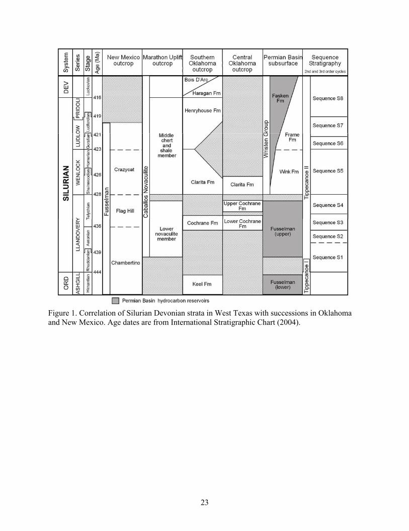
Figure 1. Correlation of Silurian Devonian strata in West Texas with successions in Oklahoma and New Mexico. Age dates are from International Stratigraphic Chart (2004).
23
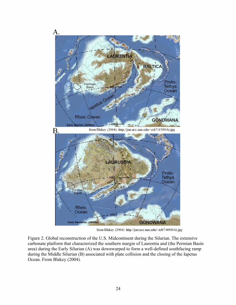
Figure 2. Global reconstruction of the U.S. Midcontinent during the Silurian. The extensive carbonate platform that characterized the southern margin of Laurentia and (the Permian Basin area) during the Early Silurian (A) was downwarped to form a well-defined southfacing ramp during the Middle Silurian (B) associated with plate collision and the closing of the Iapetus Ocean. From Blakey (2004).
24
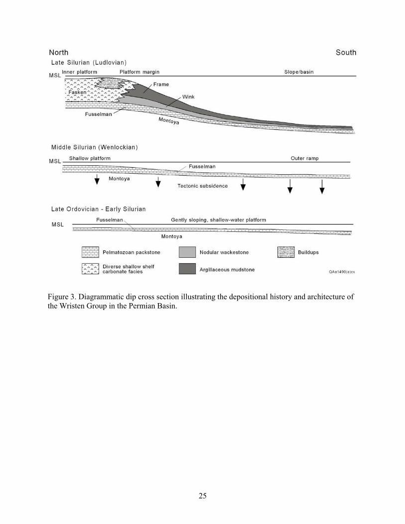
Figure 3. Diagrammatic dip cross section illustrating the depositional history and architecture of the Wristen Group in the Permian Basin.
25
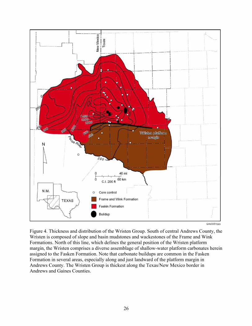
Figure 4. Thickness and distribution of the Wristen Group. South of central Andrews County, the Wristen is composed of slope and basin mudstones and wackestones of the Frame and Wink Formations. North of this line, which defines the general position of the Wristen platform margin, the Wristen comprises a diverse assemblage of shallow-water platform carbonates herein assigned to the Fasken Formation. Note that carbonate buildups are common in the Fasken Formation in several areas, especially along and just landward of the platform margin in Andrews County. The Wristen Group is thickest along the Texas/New Mexico border in Andrews and Gaines Counties.
26
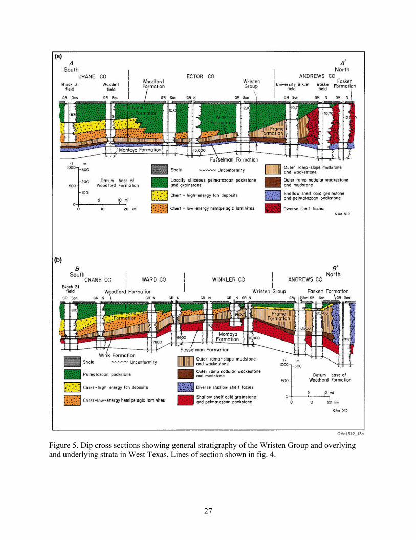
Figure 5. Dip cross sections showing general stratigraphy of the Wristen Group and overlying and underlying strata in West Texas. Lines of section shown in fig. 4.
27
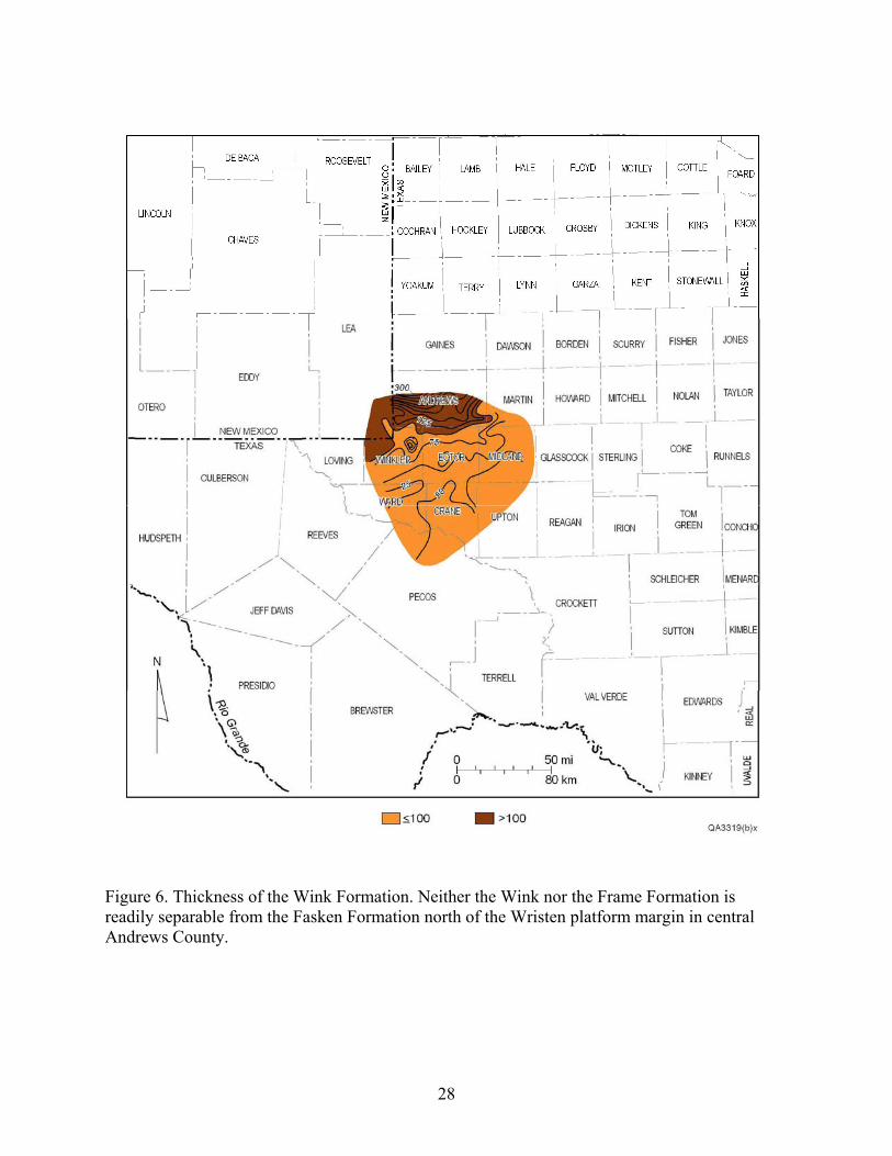
Figure 6. Thickness of the Wink Formation. Neither the Wink nor the Frame Formation is readily separable from the Fasken Formation north of the Wristen platform margin in central Andrews County.
28
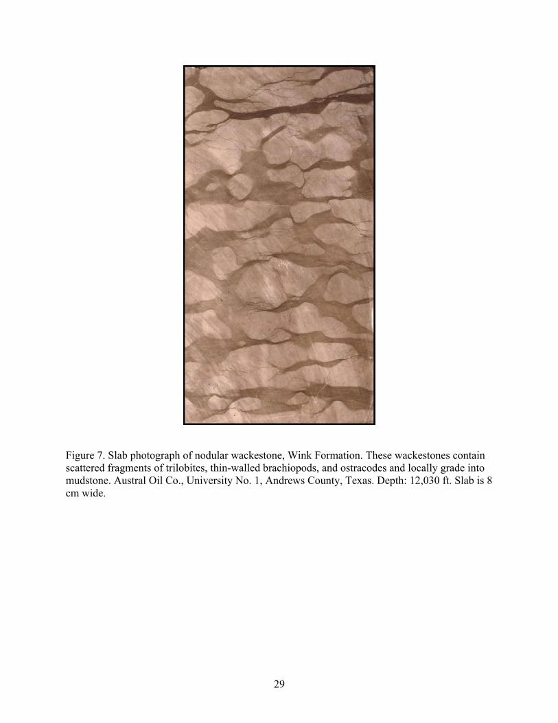
Figure 7. Slab photograph of nodular wackestone, Wink Formation. These wackestones contain scattered fragments of trilobites, thin-walled brachiopods, and ostracodes and locally grade into mudstone. Austral Oil Co., University No. 1, Andrews County, Texas. Depth: 12,030 ft. Slab is 8 cm wide.
29
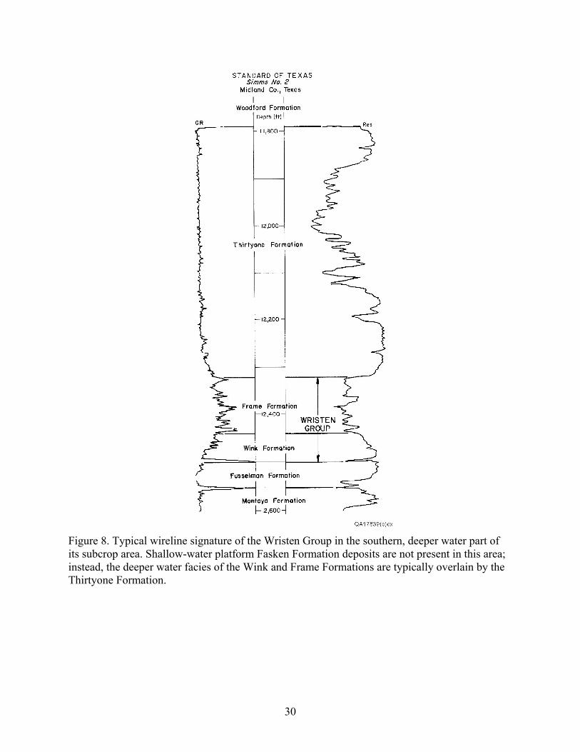
Figure 8. Typical wireline signature of the Wristen Group in the southern, deeper water part of its subcrop area. Shallow-water platform Fasken Formation deposits are not present in this area; instead, the deeper water facies of the Wink and Frame Formations are typically overlain by the Thirtyone Formation.
30
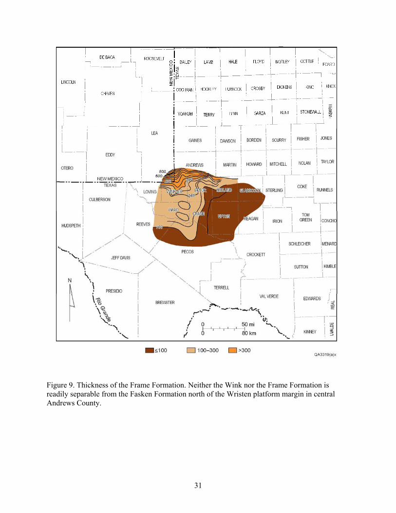
Figure 9. Thickness of the Frame Formation. Neither the Wink nor the Frame Formation is readily separable from the Fasken Formation north of the Wristen platform margin in central Andrews County.
31
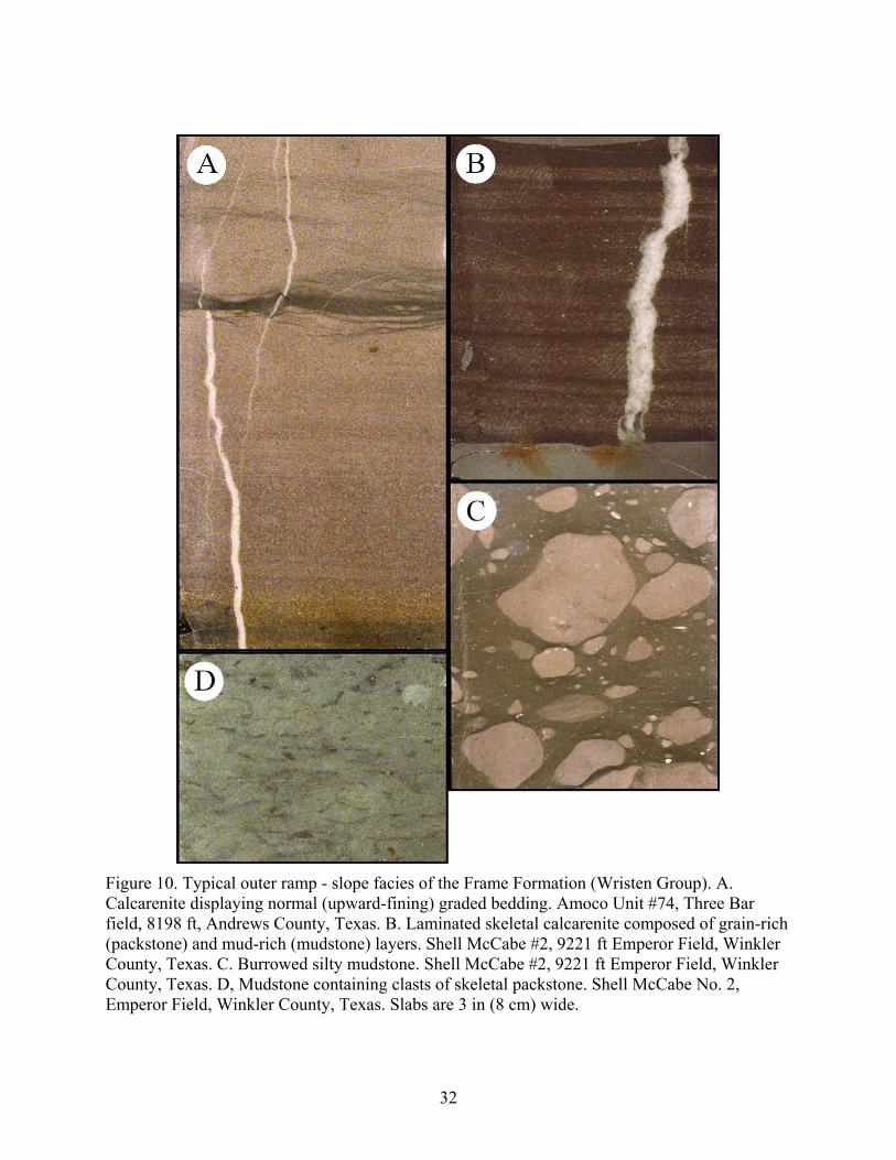
Figure 10. Typical outer ramp - slope facies of the Frame Formation (Wristen Group). A. Calcarenite displaying normal (upward-fining) graded bedding. Amoco Unit #74, Three Bar field, 8198 ft, Andrews County, Texas. B. Laminated skeletal calcarenite composed of grain-rich (packstone) and mud-rich (mudstone) layers. Shell McCabe #2, 9221 ft Emperor Field, Winkler County, Texas. C. Burrowed silty mudstone. Shell McCabe #2, 9221 ft Emperor Field, Winkler County, Texas. D, Mudstone containing clasts of skeletal packstone. Shell McCabe No. 2, Emperor Field, Winkler County, Texas. Slabs are 3 in (8 cm) wide.
32
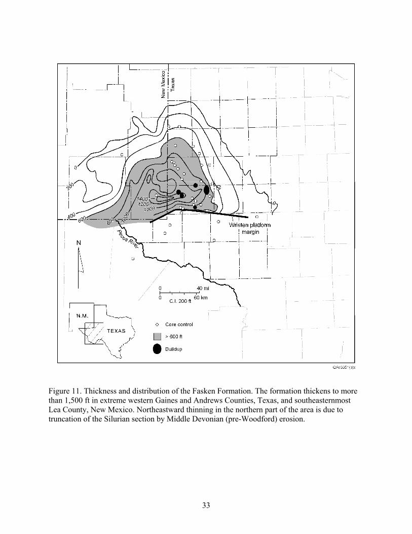
Figure 11. Thickness and distribution of the Fasken Formation. The formation thickens to more than 1,500 ft in extreme western Gaines and Andrews Counties, Texas, and southeasternmost Lea County, New Mexico. Northeastward thinning in the northern part of the area is due to truncation of the Silurian section by Middle Devonian (pre-Woodford) erosion.
33
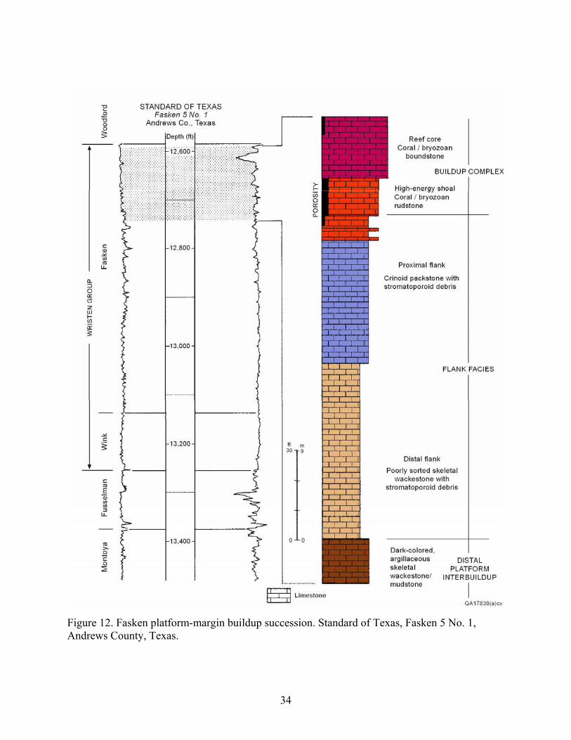
Figure 12. Fasken platform-margin buildup succession. Standard of Texas, Fasken 5 No. 1, Andrews County, Texas.
34
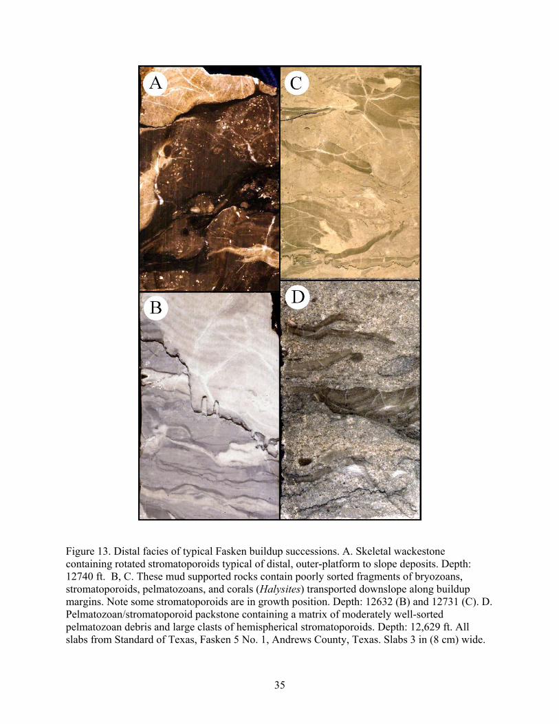
Figure 13. Distal facies of typical Fasken buildup successions. A. Skeletal wackestone containing rotated stromatoporoids typical of distal, outer-platform to slope deposits. Depth: 12740 ft. B, C. These mud supported rocks contain poorly sorted fragments of bryozoans, stromatoporoids, pelmatozoans, and corals (Halysites) transported downslope along buildup margins. Note some stromatoporoids are in growth position. Depth: 12632 (B) and 12731 (C). D. Pelmatozoan/stromatoporoid packstone containing a matrix of moderately well-sorted pelmatozoan debris and large clasts of hemispherical stromatoporoids. Depth: 12,629 ft. All slabs from Standard of Texas, Fasken 5 No. 1, Andrews County, Texas. Slabs 3 in (8 cm) wide.
35
Figure 14. Proximal facies of typical Fasken buildup successions. A. Coral/bryozoan rudstone, Fasken Formation. These stick corals and ramose bryozoans were deposited as a coarse, high energy lag, at the tops of Fasken carbonate buildup successions. Depth: 12,620 ft. B. Thin section photomicrograph of A. Note the well-developed primary, intergranular porosity. C. Coral boundstone. Fauna is dominated by ramose corals and stromatoporoids. These deposits commonly exhibit numerous sediment-filled geopetals but are generally are non-porous. Depth: 12,597 ft. D. Bryozoan boundstone. Note local shelter porosity. Depth: 12 599. All slabs from Standard of Texas, Fasken 5 No. 1, Andrews County, Texas. Slabs 3 in (8 cm) wide.
36
Figure 15. Upper Fasken Formation tidal flat succession, Fullerton field. In this well, the Fasken comprises a succession of tidal flat deposits punctuated by exposure and karsting. Note that porosity is most commonly developed beneath karst fills suggesting that porosity formation is controlled by leaching due to punctuated sea level fall. Amoco, University Consolidated, V, No. 12, Andrews County, Texas.
37
Figure 16. Facies of the Fasken inner platform. A. Subtidal skeletal wackestone. Skeletal debris consists principally of brachiopods, corals, and mollusks. Skeletal moldic pores like these typify the Fasken of the inner platform. Tex-Sin field, Texas. Texas Crude Oil Company, Chilton “B,” No. 9-1, Gaines County, Texas. Slab is 8 cm wide. B. Laminated peritidal facies. These rocks define cycle tops and are typically dolomitized. Amoco University Consolidated V # 12, Fullerton field, Andrews County, Texas. Depth 8490 ft. C. Karst breccia. North Robertson field, Texas. Exxon Co., USA, Fee B-14, Gaines County, Texas. Depth: 9,748 ft. All slabs are 3 in (8 cm) wide.
38
Figure 17. Lower Fasken Formation, buildup-capped, middle platform successions, Fullerton field. In this well, the Fasken is composed of a succession of aggradational, upward-shallowing sequences capped by carbonate buildups. The tops of many cycles exhibit evidence of exposure and dissolution or karsting. Very little porosity is evident. Amoco, University Consolidated, VII, No. 20, Andrews County, Texas
39
A
B
Figure 18. Paleogeographic reconstructions of Wristen Group depositional environments during the middle Silurian. A. General regional model depicting northern platform and southern, outer platform – basin. Platform rocks comprise Fasken platform-margin buildup successions and inner platform shallow subtidal to tidal-flat sediments. Coeval, argillaceous mudstones of the Frame Formation and underlying Wink Formation were deposited south of the platform margin in a slope/outer platform setting. From Ruppel and Holtz, 1994. B. Reconstruction on northern platform area showing east-west striking facies belts and general northward shallowing of facies tracts. From Canter and others, 1992.
40
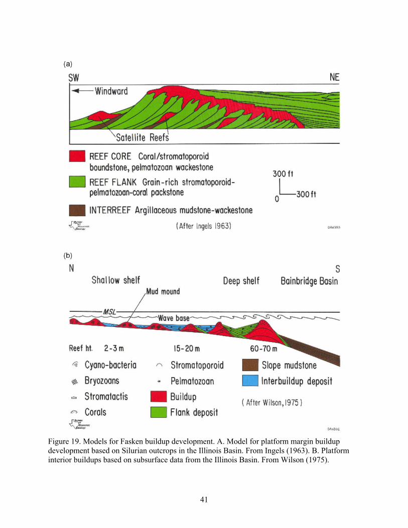
Figure 19. Models for Fasken buildup development. A. Model for platform margin buildup development based on Silurian outcrops in the Illinois Basin. From Ingels (1963). B. Platform interior buildups based on subsurface data from the Illinois Basin. From Wilson (1975).
41
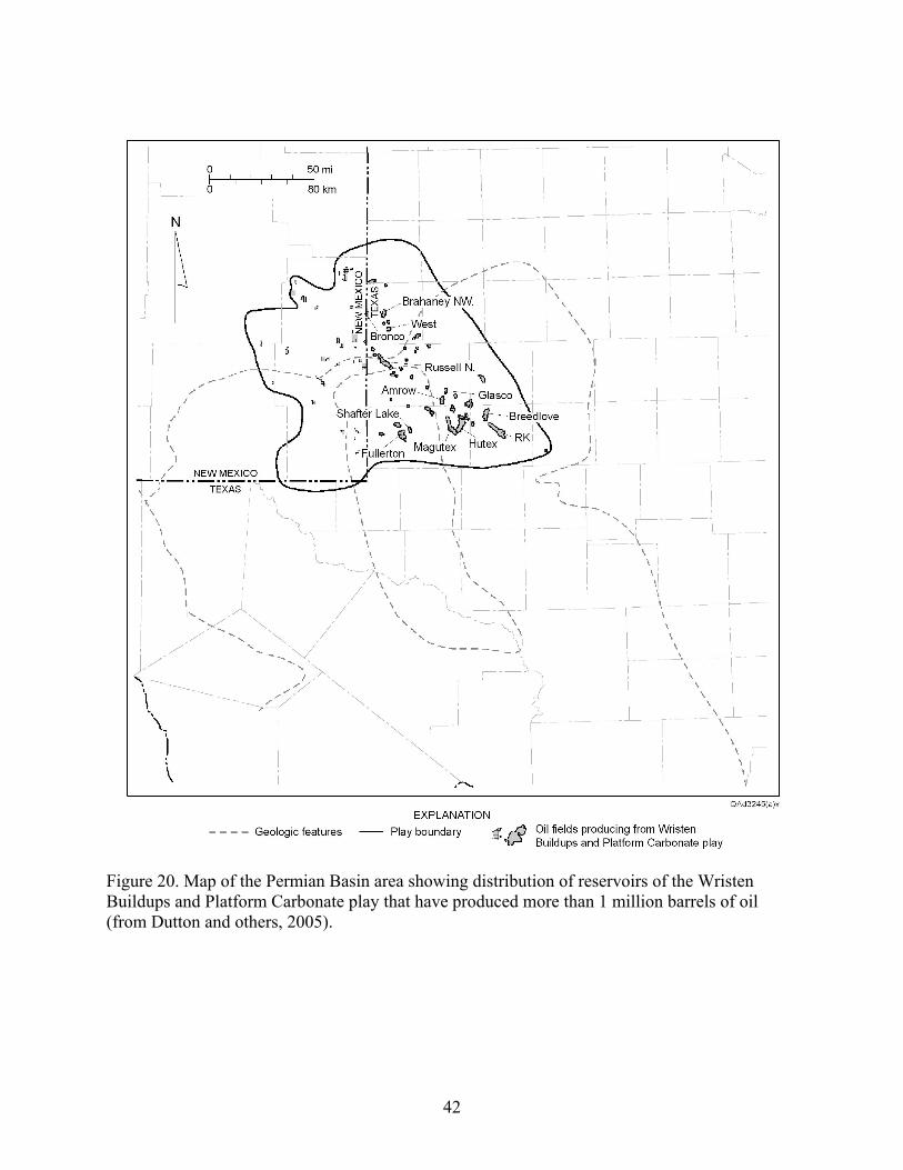
Figure 20. Map of the Permian Basin area showing distribution of reservoirs of the Wristen Buildups and Platform Carbonate play that have produced more than 1 million barrels of oil (from Dutton and others, 2005).
42