Embed Size (px)
Citation preview

The cohesive Naranjo debris-£ow deposit (10 km3):A dam breakout £ow derived from thePleistocene debris-avalanche deposit ofNevado de Colima Volcano (Me¤xico)
L. Capra �, J.L. Mac|¤asInstituto de Geograf|¤a, Universidad Nacional Auto¤noma de Me¤xico, Circuito Exterior, Ciudad Universitaria, Coyoaca¤n 04510,
Distrito Federal, Mexico
Received 15 October 2000; accepted 25 July 2001
Abstract
Mass movement processes on volcanic terrains such as landslides and debris avalanches can cause the obstructionof main drainages producing the formation of temporary dams. A good example of this occurred 18.5 ka ago whenthe eastern flank of the Nevado de Colima Volcano collapsed producing a debris-avalanche deposit that waspreviously described as one of the largest in the world. The deposit extended from the volcanic summit as far as thePacific coast, 120 km away. New stratigraphic, sedimentological, and componentry data suggest that the volcaniccollapse of Nevado de Colima resulted in a debris avalanche that traveled 20 km southeast to the Naranjo River.There it crashed against a topographic barrier consisting of Cretaceous limestones (Cerro la Carbonera) and the flowdirection was diverted to the south down the Naranjo River channel for another 25 km before the avalanche came toa halt. The obstruction of the drainage produced a temporary dam that stored ca. 1 km3 of water and depositedfluvial and slack-water sediments. Some time after the damming, the accumulated water-sediment load was able toovertop the obstructing material and to release a breakout flow with a calculated initial flow discharge of 3.5 millionm3/s. The resulting flood (cohesive debris flow) followed the channel of the Naranjo River and, due to the higherodibility of the channel and introduction of substrate material, the debris flow progressively increased its volume upto 10 km3, six times its initial volume. This study highlights the relevance of evaluating the potential remobilization ofdebris-avalanche deposits to initiate large magnitude cohesive debris flows. Therefore, the hazard and risk analysis offuture potential events of this nature must consider the pre-eruption conditions and the topography surrounding avolcano. 7 2002 Elsevier Science B.V. All rights reserved.
Keywords: debris avalanche; cohesive debris £ow; dam breakout; Colima Volcanic Complex; Mexico
1. Introduction
The collapse of a volcanic edi¢ce has been rec-ognized as a common event at numerous volca-noes around the world (Ui et al., 1986; Siebert et
0377-0273 / 02 / $ ^ see front matter 7 2002 Elsevier Science B.V. All rights reserved.PII: S 0 3 7 7 - 0 2 7 3 ( 0 2 ) 0 0 2 4 5 - 7
* Corresponding author. Tel. : +5-6224335;Fax: +5-502486.
E-mail address: [email protected] (L. Capra).
VOLGEO 2481 16-9-02
Journal of Volcanology and Geothermal Research 117 (2002) 213^235
www.elsevier.com/locate/jvolgeores

al., 1987; Vallance et al., 1995) as well as in theTrans-Mexican Volcanic Belt (TMVB) (e.g. Robinand Boudal, 1987; Siebe et al., 1992; Carrasco-Nun‹ez et al., 1993; Nelson and Lighthart, 1997;Rodriguez-Elizarrara¤s and Komorowski, 1997;Gardun‹o-Monroy et al., 1999; Capra et al.,2002; Fig. 1a). This type of event involves thepartial disruption of a volcano £ank initiating agravitational mass £ow capable of moving manykilometers before coming to rest : the resultingmaterials are widely described as debris-avalanchedeposits. These deposits are commonly associatedwith thick sequences of debris-£ow deposits,which extend beyond the limits of the debris-ava-lanche deposits.Debris £ows originate from: (1) direct transfor-
mation of a debris avalanche during its transport(Scott et al., 2002a); (2) transformation of thedistal portion of a water-saturated debris ava-lanche (Palmer and Neall, 1989); (3) post-deposi-tional remobilization of water-saturated portionsof a debris avalanche (Glicken, 1998; Pulgarin etal., 1999); and (4) rupture of natural damsformed by the obstruction of drainages duringthe emplacement of a debris-avalanche deposit
(Costa, 1988; Costa and Shuster, 1988). Gener-ally, the ¢rst two cases are processes that takeplace during the related collapse event or somehours later. In contrast, the last two cases canoccur following an indeterminate lapse of time,which can range from hours to years withoutany premonitory sign (Costa and Shuster, 1988).The 1980 collapse of Mount St. Helens repre-
sents the best known example of the formation ofnatural dams after the emplacement of a debris-avalanche deposit. Engineering work there pre-vented the rupture and collapse of these naturaldams, which otherwise would have produced gi-gantic debris £ows downstream (Sager and Cham-bers, 1986).The emplacement of a debris avalanche gener-
ally modi¢es the topography of the area aroundthe volcanic edi¢ce resulting in the interruptionand deviation of the hydrological network. There-fore, the formation of natural impoundments byblocking the drainage system and their subsequentbreakout should be a common process in volcanicterrains.In this work we present new ¢eld evidence for
the generation of a huge cohesive debris £ow de-
Fig. 1. (a) Sketch map of the TMVB showing the location of the volcanoes which have su¡ered a sector collapse (after Capra etal., 2002). Abbreviations: CVC, Colima Volcanic Complex; Ta, Tanc|¤taro; Zi, Zirahuato; Jo, Jocotitla¤n; NT, Nevado de Tolu-ca; Iz, Iztaccihuatl ; Po, Popocate¤petl; Cn, Cerro Las Navajas; PdO, Pico de Orizaba; De, Las Derrumbadas; CdP, Cofre delPerote; TVF, Tuxtla Volcanic Field; SM, Santa Martha. (b) Tectonic location of the Colima Volcanic Complex in the ColimaGraben.
VOLGEO 2481 16-9-02
L. Capra, J.L. Mac|¤as / Journal of Volcanology and Geothermal Research 117 (2002) 213^235214
rived from the rupture of a natural dam formedby the Pleistocene debris-avalanche deposit fromthe Nevado de Colima Volcano. The debris-ava-lanche and debris-£ow deposits studied here werepreviously described by Stoopes and Sheridan(1992) as a single debris-avalanche deposit thatextends for 120 km from the edi¢ce. Our newstratigraphic and sedimentological data provideuseful information to di¡erentiate two types ofdeposits involved in this complex event. In thelight of these new data we propose a new sequen-tial model for the collapse, drainage damming,and generation of a gigantic debris £ow by rup-ture of the dam. Finally, we discuss the impor-tance of recognizing such types of events aroundvolcanic areas since they can be responsible forthe £ooding of immense zones at even furtherdistances from the collapse area.
2. Terminology
The terminology used in this text (Table 1) ismodi¢ed mainly from the works of Palmer et al.(1991) and Glicken (1991). Common doubts aregenerally expressed in the literature concerningthe distinction between a debris-avalanche depositand a debris-£ow deposit, which forms a keytopic for this study. As stated in the followingsection, the textural and sedimentological charac-
teristics of these two types of deposits can be dis-criminated because their sedimentological param-eters, the porosity of the matrix, and the presenceor absence of imbricated clasts can be used todistinguish sediment-water transport for debris£ows versus granular transport for debris ava-lanches.
3. Previous work
The Colima Volcanic Complex (CVC) is lo-cated in the western TMVB, at the southern limitof the Colima Graben (Fig. 1a and b). It consistsof three andesitic composite cones, Cantaro, Ne-vado de Colima, and Volca¤n de Colima. The lasttwo volcanoes have been the locus of several sec-tor collapses (Luhr and Prestegaard, 1985; Robinet al., 1987; Luhr and Prestegaard, 1988; Stoopesand Sheridan, 1992; Komorowski et al., 1994,1997). The source area, the extension of the de-posits, and the number of collapse events havebeen the subject of controversy among many au-thors during the past 15 years.Nevado de Colima Volcano (4240 masl) began
to grow V600 ka with the youngest dated activityoccurring V8.1 ka (Robin et al., 1990). Accord-ing to these authors, the volcanic activity of Ne-vado can be divided in three main episodes (Ne-vado I, II and III; Robin et al., 1987). The
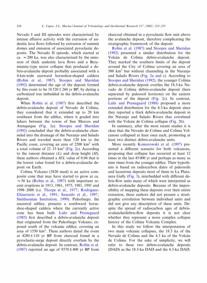
Table 1Terminology
Term Explanation
Debris avalanche Rapid movement of an incoherent, unsorted mass of rock and soil mobilized by gravity (Schuster andCrandell, 1984).
Block facies Texture of a debris-avalanche deposit that mainly consists of debris-avalanche blocks (an unconsolidatedpiece of the old mountain transported to its place of deposition) with practically no matrix.
Mixed facies The mixed facies (interclast matrix and clasts) de¢nes the texture of a debris-avalanche deposit that iscompletely mixed. It may contain clasts of all rock types and sizes from microns to meters.
Matrix All components of the deposit comprising material 6 2 mm in diameter.Clast Fragment with dimensions from 2 mm to 1 meter.Megaclast All components of the deposit s 1 m that show an internal lithological homogeneity.Debris £ow Flowing mixture of debris and water having a sediment concentration between 70 and 90% by weight
(Pierson and Costa, 1987). When the content of clay fraction is s 3^5% in weight, they are de¢ned ascohesive debris £ows (Scott et al., 1995).
Lahar General term for rapidly £owing water-saturated mixture of rock debris and water from a volcano (Smithand Fritz, 1989).
VOLGEO 2481 16-9-02
L. Capra, J.L. Mac|¤as / Journal of Volcanology and Geothermal Research 117 (2002) 213^235 215
Nevado I and III episodes were characterized byintense e¡usive activity with the extrusion of an-desitic lava £ows followed by extrusion of summitdomes and emission of associated pyroclastic de-posits. The Nevado II episode, which started atca. V200 ka, was also characterized by the emis-sion of thick andesitic lava £ows and a Bezy-mianny-type sector collapse that produced a de-bris-avalanche deposit probably associated with a4-km-wide eastward horseshoe-shaped caldera(Robin et al., 1987). Stoopes and Sheridan(1992) determined the age of the deposit formedby this event to be 18 520Q 260 yr BP, by dating acarbonized tree imbedded in the debris-avalanchedeposit.When Robin et al. (1987) ¢rst described the
debris-avalanche deposit of Nevado de Colima,they considered that it extended up to 20 kmsoutheast from the edi¢ce, where it graded intolahars between the towns of San Marcos andAtenquique (Fig. 2a). Stoopes and Sheridan(1992) concluded that the debris-avalanche chan-neled into the drainage of the Naranjo and SaladoRivers and traveled more than 120 km to thePaci¢c coast, covering an area of 2200 km2 witha total volume of 22^33 km3 (Fig. 2c). Accordingto the runout distance (L) and drop height (H),these authors obtained a H/L value of 0.04 that isthe lowest value found for a debris-avalanche de-posit on Earth.Colima Volcano (3820 masl) is an active com-
posite cone that may have started to grow at ca.V50 ka (Robin et al., 1987) with important re-cent eruptions in 1913, 1961, 1975, 1981, 1991 and1998^2000 (i.e. Thorpe et al., 1977; Rodriguez-Elizarrara¤s et al., 1991; Saucedo et al., 1997;Smithsonian Institution, 1999). Paleofuego, theancestral edi¢ce, presents a southward horse-shoe-shaped caldera where the currently activecone has been built. Luhr and Prestegaard(1985) ¢rst described a debris-avalanche depositthat originated from the Paleofuego Volcano, ex-posed south of the volcanic edi¢ce, covering anarea of 1550 km2. These authors dated the eventat 4280Q 110 yr BP from charcoal found in apyroclastic-surge deposit directly overlain by thedebris-avalanche deposit. In contrast, Robin et al.(1987) reported an age of 9370Q 400 yr BP from
charcoal obtained in a pyroclastic £ow unit abovethe avalanche deposit, therefore complicating thestratigraphic framework of the deposit.Robin et al. (1987) and Stoopes and Sheridan
(1992) presented a similar distribution for theVolca¤n de Colima debris-avalanche deposit.They marked the southern limits of the depositaround the City of Colima covering an area of500 km2 but without channeling in the Naranjoand Salado Rivers (Fig. 2a and c). According toStoopes and Sheridan (1992), the younger Colimadebris-avalanche deposit overlies the 18.5-ka Ne-vado de Colima debris-avalanche deposit (hereseparated by paleosoil horizons) on the easternportions of the deposit (Fig. 2c). In contrast,Luhr and Prestegaard (1988) proposed a moreextended distribution for the 4.3-ka deposit sincethey reported a thick debris-avalanche deposit inthe Naranjo and Salado Rivers that correlatedwith the Volca¤n de Colima collapse (Fig. 2b).In summary, after the most recent studies it is
clear that the Nevado de Colima and Colima Vol-canoes collapsed at least once each, promoting atleast two distinct debris-avalanche units.More recently Komorowski et al. (1997) pre-
sented a di¡erent scenario for both volcanoes,proposing that collapse has occurred at least 12times in the last 45 000 yr and perhaps as many asnine times from the younger edi¢ce. Their hypoth-esis is based on radiocarbon dates of paleosoilsand lacustrine deposits most of them in La Plata-nera Gully (Fig. 3), interbedded with di¡erent de-bris-£ow units many of which were interpreted asdebris-avalanche deposits. Because of the impos-sibility of mapping these deposits over their entireextension, these authors did not present a strati-graphic correlation between individual units anddid not give any description of these units. De-spite the spread of radiocarbon ages of debris-avalanche/debris-£ow deposits it is not clearwhether they represent a more complex collapsehistory of the Colima Volcanic Complex.In this study we follow the interpretation of
two main volcanic collapses, the 18.5 ka of theNevado de Colima and the 4.3 ka of the Volca¤nde Colima. For the sake of simplicity, we willrefer to these two debris-avalanche deposits(DAD) as the 18.5-ka DAD and the 4.3-ka DAD.
VOLGEO 2481 16-9-02
L. Capra, J.L. Mac|¤as / Journal of Volcanology and Geothermal Research 117 (2002) 213^235216

The distribution of the deposits here describedis consistent with that proposed for the 18.5-kaDAD by Stoopes and Sheridan (1992). However,as described below, we divided the later depositinto two di¡erent units, which represent discreteevents.The 18.5-ka collapse, de¢ned as a Bezymianny-
type event, will be not described in this work be-cause it has been discussed already extensively
(Robin et al., 1987, 1990; Stoopes and Sheridan,1992).
4. Morphology and hydrological conditions of thearea
The CVC is located in the southern part of theColima Rift Zone, a N^S structure that joins two
Fig. 2. Distribution of the CVC debris-avalanche deposits according to: (a) Robin et al. (1987); (b) Luhr and Prestegaard(1988); (c) Stoopes and Sheridan (1992), where the stratigraphic relation between the 4300-yr-BP and 18 500-yr-BP debris-ava-lanches deposits is shown.
VOLGEO 2481 16-9-02
L. Capra, J.L. Mac|¤as / Journal of Volcanology and Geothermal Research 117 (2002) 213^235 217

others to the north in a tectonic triple junction(Luhr et al., 1985; Gardun‹o and Tibaldi, 1991)and is crossed at the position of the active volca-no by the proposed NE^SW Tamazula fault sys-tem (Garduno et al., 1998). The volcanic edi¢cesof the CVC lie within these major structures,which in turn have a remarkable control on thedrainage pattern of the Naranjo, Armeria, andSalado Rivers, which appear as long linear seg-ments oriented N^S in satellite imagery (Fig. 3).A large volcaniclastic apron £anks the CVC, on
top of which many important towns are located,including San Marcos, Cuauhtemoc, and the cap-ital city Colima. This sedimentary apron has beenincised by a radial drainage (e.g. Barrancas LosLobos, El Muerto, and Platanar) whose tributa-ries debouch into the main rivers. Particularly,Platanar Creek drains towards the El Naranjo
River where it forms an alluvial fan that corre-sponds to the zone where the 18.5-ka Nevado deColima debris-avalanche deposit obstructed theNaranjo River (Fig. 3). Cretaceous limestonesand metamorphic rocks form the major escarp-ments in the southern portion of the ColimaRift Zone walls. Some limestone hills constitutemorphological barriers on the east and west sidesof the CVC including Cerro la Carbonera, locatedabout 20 km from the eastern £ank of Nevado deColima and rising 500 m above the surroundingarea (Fig. 3).
5. Deposit distribution and stratigraphic relationswith younger units
In this work two main deposits are associated
Fig. 3. Landsat image of the CVC showing the morphology of the area and the hydrographic network. Main rivers are labeledin the image.
VOLGEO 2481 16-9-02
L. Capra, J.L. Mac|¤as / Journal of Volcanology and Geothermal Research 117 (2002) 213^235218

with the 18.5-ka edi¢ce collapse of Nevado deColima. The boundary of the area covered bythese two deposits corresponds with the limitspresented by Stoopes and Sheridan (1992) for
the debris-avalanche deposit, but instead of con-sidering this as a single unit, we distinguish a de-bris-avalanche deposit with secondary debris-£owdeposits and a huge cohesive debris-£ow deposit
Fig. 4. Distribution of debris-avalanche and debris-£ow deposits as interpreted in this study. The total distribution conforms withthat presented by Stoopes and Sheridan (1992). Black arrows indicate the £ow paths of secondary lahars remobilized from thedebris-avalanche deposit. Numbered triangles mark the locations of studied sections.
VOLGEO 2481 16-9-02
L. Capra, J.L. Mac|¤as / Journal of Volcanology and Geothermal Research 117 (2002) 213^235 219

Fig. 5. Stratigraphic correlation of selected sections of the 18.5-ka DAD, its derivative debris-£ow deposit along the Salado River, the 4.3-ka DAD, the younger de-bris-£ow deposits, and interbedded paleosoils (column width represents erosive pro¢le). The granulometric histograms refer to the 18.5-ka DAD and to the second-ary debris-£ow deposit along the Salado River. For section location see Fig. 4.
VOLGEO2481
16-9-02
L.Capra,
J.L.Mac| ¤as/Journal
ofVolcanology
andGeotherm
alResearch
117(2002)
213^235220
emplaced along the Naranjo River, here infor-mally named the Naranjo Debris-Flow Deposit(NDFD) (Fig. 4).
5.1. 18.5-ka Debris-Avalanche Deposit
The 18.5-ka DAD crops out from the aprons ofNevado de Colima Volcano to Cerro la Carbon-era (Fig. 3), some 20 km from the summit, and tothe south forms the upper terraces of the NaranjoRiver to a distance of V45 km (Fig. 4). In prox-imal outcrops the deposit is directly overlain byco-magmatic pyroclastic-£ow and -fall deposits(Robin et al., 1990). Elsewhere, it rests close tothe top of the terraces along the Naranjo River,directly overlying the Atenquique Formation, avolcaniclastic sequence composed of £uvial con-glomerates, massive debris-£ow deposits and la-custrine horizons (total thickness of up to 200m). The latter formation has an age range from0.38Q 0.10 Ma (Robin et al., 1987) to V40 ka(see below). Above an intervening paleosoil, the18.5-ka DAD is capped by the 4.3-ka DAD, andup to two younger debris-£ow deposits separatedby paleosoils (section Col-21; Fig. 5). Between thetowns of Tonila and San Marcos a 40-cm-thickpaleosoil and the 4.3-ka DAD cover the 18.5-kaDAD (section Col-13; Fig. 5). The younger de-bris-£ow deposits likely represent the products ofpost-depositional remobilization of the 4.3-kaDAD or a younger event of similar origin (Ko-morowski et al., 1997).The exposed thickness of the 18.5-ka DAD
varies from a maximum of 50 m (but probablyup to 150 m thick where it obstructed the NaranjoRiver) to a minimum of 4 m on the left side of theNaranjo River near the town of Buen Pa|¤s (sec-tion Col-29; Fig. 4). It covers an approximatearea of 600 km2 and taking a mean thickness of16 m a total volume of ca. 10 km3 is obtained.In summary, the 18.5-ka DAD is bracketed be-
tween the older Atenquique Formation and the4.3-ka DAD from Colima Volcano. These strati-graphic relations were used to follow the lateraltransition of the 18.5-ka deposit to a debris-£owsequence dispersed on the southern plain and far-ther downstream on the Salado River (Fig. 5).In distal areas, the identi¢cation of the second-
ary 18.5-ka debris-£ow deposits is more problem-atic due to the lack of the overlying 4.3-ka DAD.However, in the Salado River a debris-£ow depos-it lying at the same stratigraphic level has beenidenti¢ed and correlated with the 18.5-ka DAD.The debris-£ow deposit along the Salado Riverconsists of a single unit which forms a terracedeposited directly on top of basement conglomer-ates and metasediments.The secondary debris-£ow deposits may repre-
sent a single laharic event, or a series of laharsremobilized from the marginal portions of the18.5-ka DAD that were later channeled into sep-arated downstream drainages depositing di¡erentlaterally separated units.These secondary debris-£ow deposits cover an
approximate area of 800 km2 ; by considering anaverage thickness of 3 m in the £at areas and 10 min the channeled zones, we calculated a volume of3.5 km3. It is worth noting that the younger de-posits are very similar in component compositionand texture, and we do not exclude the possibilitythat the sequence described here could be con-fused with younger units in some sections wherethe stratigraphic relations are not clear.
5.2. Naranjo Debris-Flow Deposit
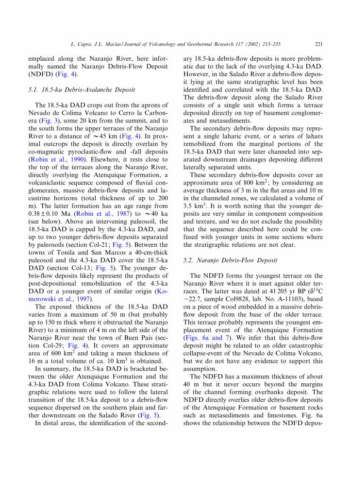
The NDFD forms the youngest terrace on theNaranjo River where it is inset against older ter-races. The latter was dated at 41 205 yr BP (N13C322.7, sample Col9828, lab. No. A-11103), basedon a piece of wood embedded in a massive debris-£ow deposit from the base of the older terrace.This terrace probably represents the youngest em-placement event of the Atenquique Formation(Figs. 6a and 7). We infer that this debris-£owdeposit might be related to an older catastrophiccollapse-event of the Nevado de Colima Volcano,but we do not have any evidence to support thisassumption.The NDFD has a maximum thickness of about
40 m but it never occurs beyond the marginsof the channel forming overbanks deposit. TheNDFD directly overlies older debris-£ow depositsof the Atenquique Formation or basement rockssuch as metasediments and limestones. Fig. 6ashows the relationship between the NDFD depos-
VOLGEO 2481 16-9-02
L. Capra, J.L. Mac|¤as / Journal of Volcanology and Geothermal Research 117 (2002) 213^235 221
Fig. 6. (a) Section through the Naranjo River showing the general stratigraphic relationship between the 18.5-ka DAD and the NDFD. (b) Selected stratigraphicsections of the NDFD showing its textural variation downstream and relative granulometric histograms. Column width represents erosive pro¢le.
VOLGEO2481
16-9-02
L.Capra,
J.L.Mac| ¤as/Journal
ofVolcanology
andGeotherm
alResearch
117(2002)
213^235222
it, the associated debris-avalanche deposit, andthe rocks of the basement along the Naranjo Riv-er. The NDFD deposit extends 90 km from theproximal zone close to the town of Platanar up tothe Paci¢c coast where it constitutes a fan thatforms the coastal plain (Fig. 4). It covers anarea of 650 km2 with a conservative mean thick-ness of 15 m. This yields a total volume of ap-proximately 10 km3.
6. Textural and sedimentological characteristics ofthe deposits
6.1. The 18.5-ka DAD and its secondarydebris-£ow sequence
The 18.5-ka DAD has both block and mixedfacies (see Table 1 for terminology). The blockfacies forms a hummocky morphology and has adominant lithology of plagioclase-porphyritic an-desite megaclasts associated with fragments up10 m in diameter of a yellow ash-£ow deposit.Normal faults are common; they intersect themegablocks and cause the displacement of pri-mary sedimentary contacts. The mixed facies con-sists of a massive mixture of angular to sub-
angular clasts varying in diameter from a fewcentimeters to 1.5 m, in a silty matrix. All clastsare black plagioclase-rich porphyritic andesiticscoria and lava fragments, and gray-reddish ande-site. Hydrothermal alteration a¡ected both clastsand matrix although the deposit itself does nothave a high degree of cementation.The clasts show a well-developed jigsaw puzzle
texture with open fractures ¢lled with interclastmatrix. Where the fragmentation is higher, clastdomains are still recognizable. The sedimentolog-ical analyses of the mixed facies indicate a poly-modal distribution, typical of debris-avalanchedeposits, with modes at 34P, 3P, and 7P. Thematrix is sandy with up to 5.6% of clay fraction(Table 2 and Fig. 5).The secondary debris-£ow deposits directly as-
sociated with the 18.5-ka DAD are generally ma-trix supported, either massive or with a crude in-verse gradation of sub-angular clasts in a sandy-silty matrix that presents a porosity with millimet-ric cavities. These deposits are sometimes partiallycemented. The fragments vary in diameter from60 cm down to a few cm but generally the dom-inant diameter is between 10 and 20 cm. Plagio-clase-porphyritic andesitic scoriae and lavas arethe principal components and are associated
Fig. 7. Panoramic view of the Naranjo River showing the NDFD forming the younger terrace (section Col-46). View toward thenorthwest.
VOLGEO 2481 16-9-02
L. Capra, J.L. Mac|¤as / Journal of Volcanology and Geothermal Research 117 (2002) 213^235 223
with the secondary clasts of non-volcanic origin,such as £uvial sediments and limestone fragments,mostly accumulated at the base of the deposit.Locally, the volcanic components still preserve ajigsaw texture. Sedimentological analyses show abimodal distribution with peaks at 33P and 3P(Table 2 and Fig. 5).
6.2. The Naranjo Debris-Flow Deposit
The NDFD is a massive, matrix-supported het-erolithologic unit. The components mainly consistof plagioclase^porphyritic andesitic scoria andlava fragments and secondary components ofthe basement such as limestone, igneous, andmetasedimentary rocks. In general, the volcaniccomponents are angular in shape and are mostcommon towards the upper portion of the depos-it. In contrast, the exotic components are sub-
rounded and are concentrated towards the baseforming imbricated clasts trains (trending down£ow, with the a-axis dipping up£ow) or in lenseswith cross-bed strati¢cation. At the base of sec-tion Col-25 is a 2-m-thick layer consisting oflenses of grain-supported, imbricated sub-roundedclasts (Figs. 6b and 8). The maximum diameter ofthe clasts reaches 5 m, although clast sizes gener-ally range from 20 to 40 cm. In several sites, thelargest clasts constitute the nucleus of hummockstypical of distal exposures of the deposit on thecoastal plain. The hummocks are usually coredwith fragments of conglomerates belonging tothe Atenquique Formation (Section Col-09; Fig.6b).In the proximal zone the deposit shows a hy-
brid facies with characteristics between debris-£ow and debris-avalanche deposits (Section Col-46; Fig. 6b). In fact, here the deposit contains
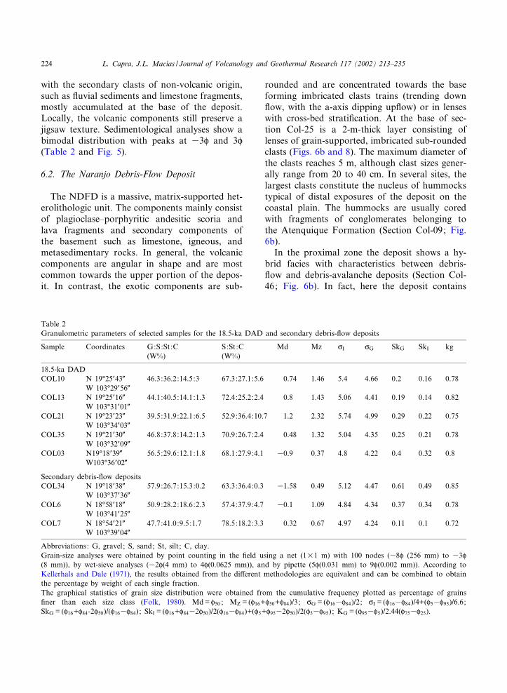
Table 2Granulometric parameters of selected samples for the 18.5-ka DAD and secondary debris-£ow deposits
Sample Coordinates G:S:St:C S:St:C Md Mz cI cG SkG SkI kg(W%) (W%)
18.5-ka DADCOL10 N 19‡25P43Q 46.3:36.2:14.5:3 67.3:27.1:5.6 0.74 1.46 5.4 4.66 0.2 0.16 0.78
W 103‡29P56QCOL13 N 19‡25P16Q 44.1:40.5:14.1:1.3 72.4:25.2:2.4 0.8 1.43 5.06 4.41 0.19 0.14 0.82
W 103‡31P01QCOL21 N 19‡23P23Q 39.5:31.9:22.1:6.5 52.9:36.4:10.7 1.2 2.32 5.74 4.99 0.29 0.22 0.75
W 103‡34P03QCOL35 N 19‡21P30Q 46.8:37.8:14.2:1.3 70.9:26.7:2.4 0.48 1.32 5.04 4.35 0.25 0.21 0.78
W 103‡32P09QCOL03 N19‡18P39Q 56.5:29.6:12.1:1.8 68.1:27.9:4.1 30.9 0.37 4.8 4.22 0.4 0.32 0.8
W103‡36P02Q
Secondary debris-£ow depositsCOL34 N 19‡18P38Q 57.9:26.7:15.3:0.2 63.3:36.4:0.3 31.58 0.49 5.12 4.47 0.61 0.49 0.85
W 103‡37P36QCOL6 N 18‡58P18Q 50.9:28.2:18.6:2.3 57.4:37.9:4.7 30.1 1.09 4.84 4.34 0.37 0.34 0.78
W 103‡41P25QCOL7 N 18‡54P21Q 47.7:41.0:9.5:1.7 78.5:18.2:3.3 0.32 0.67 4.97 4.24 0.11 0.1 0.72
W 103‡39P04Q
Abbreviations: G, gravel; S, sand; St, silt ; C, clay.Grain-size analyses were obtained by point counting in the ¢eld using a net (1U1 m) with 100 nodes (38P (256 mm) to 33P(8 mm)), by wet-sieve analyses (32P(4 mm) to 4P(0.0625 mm)), and by pipette (5P(0.031 mm) to 9P(0.002 mm)). According toKellerhals and Dale (1971), the results obtained from the di¡erent methodologies are equivalent and can be combined to obtainthe percentage by weight of each single fraction.The graphical statistics of grain size distribution were obtained from the cumulative frequency plotted as percentage of grains¢ner than each size class (Folk, 1980). Md= P50 ; MZ = (P16+P50+P84)/3; cG = (P163P84)/2; cI = (P163P84)/4+(P53P95)/6.6;SkG = (P16+P84-2P50)/(P163P84) ; SkI = (P16+P8432P50)/2(P163P84)+(P5+P9532P50)/2(P53P95) ; KG = (P953P5)/2.44(P753P25).
VOLGEO 2481 16-9-02
L. Capra, J.L. Mac|¤as / Journal of Volcanology and Geothermal Research 117 (2002) 213^235224
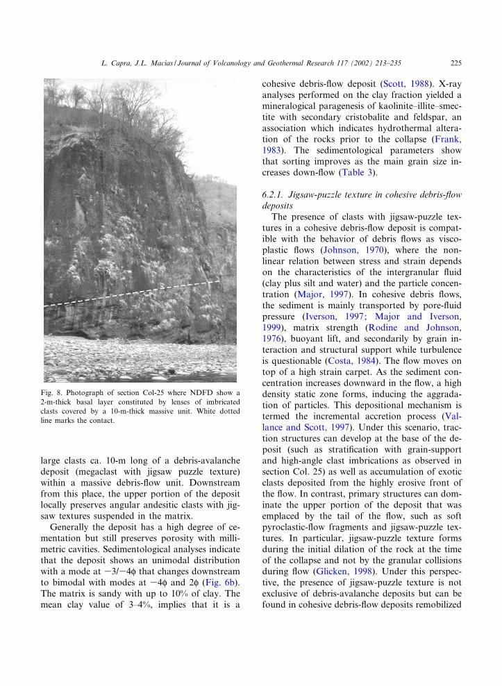
large clasts ca. 10-m long of a debris-avalanchedeposit (megaclast with jigsaw puzzle texture)within a massive debris-£ow unit. Downstreamfrom this place, the upper portion of the depositlocally preserves angular andesitic clasts with jig-saw textures suspended in the matrix.Generally the deposit has a high degree of ce-
mentation but still preserves porosity with milli-metric cavities. Sedimentological analyses indicatethat the deposit shows an unimodal distributionwith a mode at 33/34P that changes downstreamto bimodal with modes at 34P and 2P (Fig. 6b).The matrix is sandy with up to 10% of clay. Themean clay value of 3^4%, implies that it is a
cohesive debris-£ow deposit (Scott, 1988). X-rayanalyses performed on the clay fraction yielded amineralogical paragenesis of kaolinite^illite^smec-tite with secondary cristobalite and feldspar, anassociation which indicates hydrothermal altera-tion of the rocks prior to the collapse (Frank,1983). The sedimentological parameters showthat sorting improves as the main grain size in-creases down-£ow (Table 3).
6.2.1. Jigsaw-puzzle texture in cohesive debris-£owdepositsThe presence of clasts with jigsaw-puzzle tex-
tures in a cohesive debris-£ow deposit is compat-ible with the behavior of debris £ows as visco-plastic £ows (Johnson, 1970), where the non-linear relation between stress and strain dependson the characteristics of the intergranular £uid(clay plus silt and water) and the particle concen-tration (Major, 1997). In cohesive debris £ows,the sediment is mainly transported by pore-£uidpressure (Iverson, 1997; Major and Iverson,1999), matrix strength (Rodine and Johnson,1976), buoyant lift, and secondarily by grain in-teraction and structural support while turbulenceis questionable (Costa, 1984). The £ow moves ontop of a high strain carpet. As the sediment con-centration increases downward in the £ow, a highdensity static zone forms, inducing the aggrada-tion of particles. This depositional mechanism istermed the incremental accretion process (Val-lance and Scott, 1997). Under this scenario, trac-tion structures can develop at the base of the de-posit (such as strati¢cation with grain-supportand high-angle clast imbrications as observed insection Col. 25) as well as accumulation of exoticclasts deposited from the highly erosive front ofthe £ow. In contrast, primary structures can dom-inate the upper portion of the deposit that wasemplaced by the tail of the £ow, such as softpyroclastic-£ow fragments and jigsaw-puzzle tex-tures. In particular, jigsaw-puzzle texture formsduring the initial dilation of the rock at the timeof the collapse and not by the granular collisionsduring £ow (Glicken, 1998). Under this perspec-tive, the presence of jigsaw-puzzle texture is notexclusive of debris-avalanche deposits but can befound in cohesive debris-£ow deposits remobilized
Fig. 8. Photograph of section Col-25 where NDFD show a2-m-thick basal layer constituted by lenses of imbricatedclasts covered by a 10-m-thick massive unit. White dottedline marks the contact.
VOLGEO 2481 16-9-02
L. Capra, J.L. Mac|¤as / Journal of Volcanology and Geothermal Research 117 (2002) 213^235 225
from them, as was observed in the Pilcaya cohe-sive debris-£ow deposit of Nevado de Toluca Vol-cano (Capra and Macias, 2000). These observa-tions support the hypothesis that the NDFDformed by remobilization of a debris-avalanchedeposit.
7. Discussion
7.1. River blockage: dam extension and relatedsediments
According to the distribution of the debris-ava-
Table 3Sedimentological parameters of selected samples for the NDFD
Sample Coordinates G:S:St:C S:St:C Md Mz cI cG SkG SkI kg(W%) (W%)
COL22 N 19‡27P02Q 56.7:29.7:12.13:1.3 68.8:28.1:3.1 31.08 0.54 5.05 4.46 0.48 0.42 0.83W 103‡28P54Q
COL46 N 19‡22P46Q 68:21.9:9.9:0.2 68.5:30.8:0.7 32.55 30.39 5.16 4.5 0.63 0.57 0.95W 103‡33P24Q
COL24 N 19‡10P03Q 45.1:40.1:13.8:0.4 74.1:25.2:0.7 0.4 1.28 4.4 3.76 0.3 0.3 0.74W 103‡30P06Q
COL32 N 18‡46P26Q 43.6:44.9:11.2:0.3 79.6:19.9:0.5 0.77 0.84 4.92 4.3 0.02 0 0.78W 103‡44P24Q
COL8 N 18‡49P34Q 63:28.8:6.9:1.4 77.8:18.5:3.7 32.18 30.58 4.48 4.17 0.5 0.45 0.83W 103‡42P03Q
COL9 N 18‡45P20Q 32.9:53.7:11.9:1.5 80.1:17.7:2.2 1.64 1.67 4.27 3.74 0.01 30.02 0.83W 103‡43P32Q
See Table 2 for legend explanation.
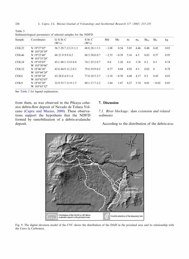
Fig. 9. The digital elevation model of the CVC shows the distribution of the DAD in the proximal area and its relationship withthe Cerro la Carbonera.
VOLGEO 2481 16-9-02
L. Capra, J.L. Mac|¤as / Journal of Volcanology and Geothermal Research 117 (2002) 213^235226

lanche deposit and the particular morphology ofthe southeastern side of Nevado de Colima Vol-cano, the debris avalanche must have obstructedthe Naranjo River during its emplacement. Thedebris avalanche £owed southeast to Cerro laCarbonera where it was diverted towards thesouth and followed the main channel of the Nar-anjo River, partially covering the river’s lateralterraces (Fig. 9). We infer that the debris-ava-lanche deposit obstructed the water £ow of theNaranjo River producing a temporary lake (atthe present site of the Platanar alluvial fan) thewater level of which gradually increased with time(Fig. 10). Considering the present depth of theNaranjo River channel (ca. 100 m) and the rela-tive position of the debris-avalanche deposit, thedam had to have an approximate height of 150 m.The present morphology of the dammed area andthe lake sediments associated with this processsuggest that the extension of the lake wouldhave covered an area of approximately 7 km2,which gives an approximate volume of storedwater of 1 km3.Fig. 11 shows two stratigraphic sections of the
sequence that forms the Platanar alluvial fan. Itsbasal portion consists of a conglomeratic se-quence up to 100 m thick of several units com-posed of rounded clasts and cut by channels and
erosive surfaces. A 5-cm-thick layer of induratedsoil separates this lower sequence from a 2-m unitcomposed of massive or cross-bedded centimetrichorizons rich in silt^sand particles (Fig. 12). An 8-cm massive clayey layer lies on top of this ¢ne-layered sequence. This ¢ne-grained succession iscapped by a massive debris-£ow deposit that hasa maximum thickness of 4 m composed of at leasttwo units consisting of sub-angular clasts im-bedded in a silty matrix (Fig. 13). This same¢ne-grained sequence that rests on top of the Pla-tanar fan, occurs upstream in Platanar Canyonand at the northern edge of the terrace (sectionsCol-36 and Col-41; Fig. 11). The ¢ne-laminatedlayers are interpreted as slack-water type sedi-ments deposited during the inundation of the tem-porary lake to its maximum level. These types ofsediments have been used in the literature to de-¢ne the maximum inundation level during river£ooding as a procedure of paleo£ood analysis(Kochel and Baker, 1987). Surges of sediment-la-den water move up towards tributary canyonsand deposit sediments in the mouth of mainstreams. The basal layer is typically a coarse-grained tributary alluvium that is usually overlainby ¢ner-grained slack-water sediments derivedfrom the main stream (Kochel and Baker, 1982).Based on this description, we interpret that the
Fig. 10. Panoramic view to the SSE of the Platanar alluvial fan and the location of the dam.
VOLGEO 2481 16-9-02
L. Capra, J.L. Mac|¤as / Journal of Volcanology and Geothermal Research 117 (2002) 213^235 227

Fig.11.Geologicalsectionof
thePlatanaralluvialfanandstratigraphiccolumns
ofthesedimentary
sequences.
VOLGEO 2481 16-9-02
L. Capra, J.L. Mac|¤as / Journal of Volcanology and Geothermal Research 117 (2002) 213^235228
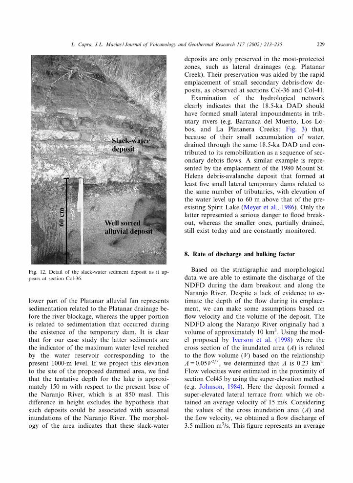
lower part of the Platanar alluvial fan representssedimentation related to the Platanar drainage be-fore the river blockage, whereas the upper portionis related to sedimentation that occurred duringthe existence of the temporary dam. It is clearthat for our case study the latter sediments arethe indicator of the maximum water level reachedby the water reservoir corresponding to thepresent 1000-m level. If we project this elevationto the site of the proposed dammed area, we ¢ndthat the tentative depth for the lake is approxi-mately 150 m with respect to the present base ofthe Naranjo River, which is at 850 masl. Thisdi¡erence in height excludes the hypothesis thatsuch deposits could be associated with seasonalinundations of the Naranjo River. The morphol-ogy of the area indicates that these slack-water
deposits are only preserved in the most-protectedzones, such as lateral drainages (e.g. PlatanarCreek). Their preservation was aided by the rapidemplacement of small secondary debris-£ow de-posits, as observed at sections Col-36 and Col-41.Examination of the hydrological network
clearly indicates that the 18.5-ka DAD shouldhave formed small lateral impoundments in trib-utary rivers (e.g. Barranca del Muerto, Los Lo-bos, and La Platanera Creeks; Fig. 3) that,because of their small accumulation of water,drained through the same 18.5-ka DAD and con-tributed to its remobilization as a sequence of sec-ondary debris £ows. A similar example is repre-sented by the emplacement of the 1980 Mount St.Helens debris-avalanche deposit that formed atleast ¢ve small lateral temporary dams related tothe same number of tributaries, with elevation ofthe water level up to 60 m above that of the pre-existing Spirit Lake (Meyer et al., 1986). Only thelatter represented a serious danger to £ood break-out, whereas the smaller ones, partially drained,still exist today and are constantly monitored.
8. Rate of discharge and bulking factor
Based on the stratigraphic and morphologicaldata we are able to estimate the discharge of theNDFD during the dam breakout and along theNaranjo River. Despite a lack of evidence to es-timate the depth of the £ow during its emplace-ment, we can make some assumptions based on£ow velocity and the volume of the deposit. TheNDFD along the Naranjo River originally had avolume of approximately 10 km3. Using the mod-el proposed by Iverson et al. (1998) where thecross section of the inundated area (A) is relatedto the £ow volume (V) based on the relationshipA=0.05V2=3, we determined that A is 0.23 km2.Flow velocities were estimated in the proximity ofsection Col45 by using the super-elevation method(e.g. Johnson, 1984). Here the deposit formed asuper-elevated lateral terrace from which we ob-tained an average velocity of 15 m/s. Consideringthe values of the cross inundation area (A) andthe £ow velocity, we obtained a £ow discharge of3.5 million m3/s. This ¢gure represents an average
Fig. 12. Detail of the slack-water sediment deposit as it ap-pears at section Col-36.
VOLGEO 2481 16-9-02
L. Capra, J.L. Mac|¤as / Journal of Volcanology and Geothermal Research 117 (2002) 213^235 229

computed value for the extension of the deposit,characteristic of extremely large £ows (s 1 mil-lion m3/s; Pierson, 1998). Such a discharge iscomparable with the Osceola cohesive debris£ows at Mount Rainier for which a discharge ofup to 23 million m3/s was calculated (Vallanceand Scott, 1997).If we consider the volume of the water, stored
in the temporary dam, we can obtain the initialdischarge, assuming that the dam broke during asingle event. By using the relation proposed byMizuyama et al. (1992), where the discharge isobtained by the relationship Qp=0.0188 V0:790,where, in case of water release, V is the watervolume (in this case 1 km3) multiplied by a totalbulking factor of 3 (Pierson and Costa, 1987), anapproximate discharge of 0.57 million m3/s is ob-tained. Comparison with the average discharge(3.5 million m3/s) indicates a bulking factor ofabout 6. This means that the £ow introduced anamount of sediment six times its initial volume,probably derived from water-saturated sedimentsin the river bed. These values are also con¢rmedconsidering that the removed volume of debristhat formed the temporary dam was approxi-mately 1.5 km3 (calculated for the area alongthe Naranjo River where the 18.5-ka DAD is
now absent; Fig. 4), which in e¡ect correspondsto 1/6 of the NDFD volume. This value repre-sents a large ¢gure for a bulking process, whichnormally has been found to be 80% of the initialvolume (Scott et al., 1995). The only other studiedcases in which such a large bulking factor hasbeen reported are the debris-£ow deposit formedat Casita Volcano (Nicaragua) in 1998, whichunderwent an increase of up to 4.2 times its initialvolume (Scott et al., 2002b), and the Nevado delHuila cohesive debris-£ow deposit, which had abulking factor of 3.2 (Pulgarin et al., 1999). Boththe abundance of exotic materials accumulatedtowards the base of the deposit (bedrock orrounded sediment clasts) and the increase of thesand fraction with distance (Fig. 6b), re£ect theincorporation of well-sorted sediments in accordwith the large bulking factor calculated for the£ow.
9. Reconstruction of the event
Some 18,500 yr ago a Bezymianny-type eventoccurred on the eastern £ank of Nevado de Co-lima Volcano producing a gravity-driven debrisavalanche that £owed 20 km to the Naranjo River
Fig. 13. Massive debris-£ow deposit on top of the slack-water sediment sequence (Section Col-36).
VOLGEO 2481 16-9-02
L. Capra, J.L. Mac|¤as / Journal of Volcanology and Geothermal Research 117 (2002) 213^235230

where it smashed against Cerro la Carbonera(Figs. 4 and 9). The £ow, after its collision, con-tinued to progress downstream along the NaranjoRiver to a distance of 45 km from the summitwhere it dispersed on the plain near Cuauhtemoctown. The resulting deposit ¢lled the NaranjoRiver channel for about 25 km blocking its drain-age and forming a large dam impoundment onthe Platanar alluvial fan. The emplacement ofthe 18.5-ka DAD favored the formation of smallimpoundments in lateral tributaries of the Naran-jo River. The topography of the site with highlateral terraces within the Naranjo River and thelocation of the dam at an enlargement of the riverwhere Platanar Creek had deposited an alluvialfan, facilitated the accumulation and con¢nementof water (Fig. 9). The water reservoir had an ap-proximate depth of 150 m. During the existenceof the dam on the Naranjo River, dewatering ofthe debris-avalanche deposit, super¢cial drainage,and water accumulated in the smaller lateral im-poundments rapidly eroded the 18.5-ka DAD.Secondary lahars then started to £ow onto thesouthwestern plain, meeting in the Salado Riversince the Naranjo drainage was probably still par-tially obstructed by the 18.5-ka DAD.At this point two di¡erent scenarios can be hy-
pothesized. According to the ¢rst scenario, £uvialerosion provoked headward-cutting at the frontof the dam on the Naranjo River and progres-sively moved upstream to the lake. The erosiondiminished the thickness of the temporary dam,which broke because its reduced size could notsustain the water pressure from the lake. Accord-ing to the second scenario, the in£ow rate of theNaranjo River was so high that the water over-topped the dam causing its erosion from the sur-face. Based on the present day maximum andminimum £ow discharge of the Naranjo Riverof 1266 m3/s and 30 m3/s, respectively (INEGI,1981), a 1-km3 temporary lake would ¢ll in aperiod of time between 9 days and 1 yr. The pres-ence of slack-water sediments on the marginalportions of the dam extension supports the sec-ond hypothesis, indicating that the lake reached amaximum level during which it inundated lateralzones and overtopped the dam. In other studiedcases the overtopping modality of rupture is the
more frequent. This is because a debris-avalanchedam consists of large or cohesive particles thatcan better resist failure, allowing the high riverin£ow to form a lake that overtops the dam (Cos-ta and Shuster, 1988). Independently of these twotypes of scenarios, we consider that even if theerosion of the deposit occurred gradually, produc-ing small debris £ows from the over-saturatedzone, the main rupture of the dam took placerapidly, forming a debris £ow that reincorporatedprevious small deposits. This seems to be the caseof the NDFD since we observed a single massiveunit of debris £ow for more than 90 km along theNaranjo River to the Paci¢c coast. The observeddebris-avalanche/debris-£ow hybrid facies in theproximal zone and the presence of clasts with jig-saw texture all along the deposit are also evidencethat the material was remobilized from a debris-avalanche deposit, con¢rming our reconstructionof the event.
10. Hazard assessment
Several examples of similar phenomena con¢rmthe importance of evaluating the possible interac-tion of a debris avalanche with the surroundingtopography. The best-known examples are the1888 phreatic Bandai eruption where a 1.5-km3
debris avalanche blocked river drainages forming¢ve new lakes (Sekiya and Kikuchi, 1889) and the1980 Mount St. Helens debris avalanche thatformed ¢ve lateral impoundments (Meyer et al.,1986). Other examples are the prehistoric andmodern dam formations that occurred along RioPaez, Colombia. During Pleistocene time, a seis-mogenic sector collapse of the Nevado del HuilaVolcano (Colombia) initiated a 5.4-km3 debris-avalanche deposit that dammed Rio Paez (Pulgar-in et al., 1999). The lake ¢lled in approximatelythree days and the dam breakout formed a cohe-sive debris £ow that traveled at least 70 km fromthe source and deposited a single unit with a min-imum volume of 4 km3 (with a bulking factor of3.2). This Pleistocene event repeated in 1994 whena M6.4 tectonic earthquake, located 10 km south-west from the summit of Nevado del Huila Vol-cano, provoked the failure of hydrothermally al-
VOLGEO 2481 16-9-02
L. Capra, J.L. Mac|¤as / Journal of Volcanology and Geothermal Research 117 (2002) 213^235 231

tered bedrock, previously saturated by recentrainfall (Avila et al., 1995; Ingeominas, 1995).During this event, 3000 discrete slope failures co-alesced along the Rio Paez, damming the riverwhose breakout formed a huge cohesive debris£ow that traveled for 130 km from the source(Scott et al., 2002a) with 2000 deaths.By using the model proposed by Iverson et al.
(1998) for delimiting hazard inundation zones incase of lahars, we constructed a hazard map forthe Naranjo River simulating the dam ruptureand the formation of a 10-km3 debris £ow. Pre-vious authors used the same methodology to esti-mate lahar hazard zones at Volca¤n de Colima(Paul and Sheridan, 1998; Sheridan et al., 1999).The method is based on the relation mentionedabove, A=0.05 V2=3, which permits calculation ofthe cross-sectional inundation area used to delimitthe hazard zone. The other relation, B=200 V2=3,is used to obtain the total inundated area (B)which, considering a volume of 10 km3, resultedto be 1000 km2. We applied this method manuallyby tracing 50 sections along the river and incor-porated the limit into a digital elevation model ofthe area. Fig. 14 shows the limit of the hazardzone and several towns that might be a¡ectedby the inundation of the debris £ow. In case ofa similar event to that of 18.5-ka BP, a populationof approximately 10 000 could be threatened. Thiscalculation does not consider the area a¡ected bythe direct emplacement of the debris-avalanchedeposit, which in the case of the 18.5-ka eventinundated an area of 800 km2, including thepresent location of the City of Colima (200 000inhabitants).
11. Conclusions
The volcanic collapse of the Nevado de ColimaVolcano, which occurred some 18.5 ka ago, pro-duced a 45-km long debris avalanche that com-pletely blocked the drainage of the Naranjo River
Fig. 14. Hazard zonation map for debris £ows along theNaranjo River considering a scenario similar to the 18.5-ka-BP debris £ow.
VOLGEO 2481 16-9-02
L. Capra, J.L. Mac|¤as / Journal of Volcanology and Geothermal Research 117 (2002) 213^235232

causing the formation of a natural dam and smalllateral impoundments of tributaries. Initial remo-bilization of the 18.5-ka DAD produced a se-quence of debris £ows that inundated areas tothe south and channelized in the Salado River,covering an area of 800 km2 with deposits totaling3.5 km3 in volume. After an interval of time, be-tween 9 days and 1 yr, the in£ow of the NaranjoRiver ¢lled the temporary lake causing overtop-ping and erosion of the dam and its subsequentbreakout. A water mass of V1 km3 eroded andremobilized approximately 1.5 km3 of the 18.5-kaDAD by forming a 10-km3 cohesive debris £owthat traveled 90 km down the Naranjo River tothe Paci¢c coast. The enormous increase in vol-ume was caused by bulking of the £ow and byintroduction of exotic material, causing an in-crease of six times the original remobilized massof the 18.5-ka DAD.This event is an example of the interaction be-
tween topography and gravity-driven £ows, inparticular debris avalanches. A debris avalancheis a rapid £ow that can quickly obstruct drainageswhere the stream water is not capable of erodingthe large sudden mass blocking its passage. AtColima, the emplacement of the 10 km3 DADled to the formation of a sequence of debris-£ow deposits, including the NDFD, for a totalvolume of 13.5 km3, 30% more voluminous thatthe 18.5-ka DAD, and they inundated an area ofat least 2.5 times the surface covered by the DAD.On the basis of this study and examples at Ban-
dai, Mount St. Helens, and Rio Paez (Colombia),it is clear that the interaction between debris ava-lanches and the topography around active volca-noes can completely modify the hazard zonationmap by producing secondary events that can bemore voluminous and extensive than the primarydebris-avalanche deposit, and therefore com-pletely modifying the contingency plans by civilauthorities.
Acknowledgements
This work was supported by Grants DGAPA^UNAM (102297), CONACYT 27993-T to J.L.M.,GSA 6199-98 to L.C. M. Abrams from the Jet
Propulsion Laboratory, Caltech, provided Land-sat imagery. This work bene¢ted from several dis-cussions with K.M. Scott, J.M. Esp|¤ndola, A.Garc|¤a-Palomo, J.L. Arce, and S. Hughes. C.Eastoe performed C-14 dating at the Universityof Arizona, Tucson. L. Siebert, M.F. Sheridan, J.Luhr and an anonymous reviewer provided usefulcomments that improved the manuscript.
References
Avila, G.E., Caro, P.E., Cepeda, H., Moreno, M., Torres, P.,Angudelo, A., 1995. Zoni¢cacio¤n para uso del suelo en lacuenca del R|¤o Paez. Jornadas Geotecto¤nicas, VIII, Socie-dad Colombiana de Ingenieros y Sociedad Colombiana deGeotecnica, pp. 6.79^6.102.
Capra, L., Macias, J.L., 2000. Pleistocene cohesive debris £owsat Nevado de Toluca Volcano, central Mexico. J. Volcanol.Geotherm. Res. 102, 149^168.
Capra, L., Mac|¤as, J.L., Scott, K.M., Abrams, M., Gardun‹o-Monroy, V.H., 2002. Debris avalanches and debris £owstransformed from collapses in the Trans-Mexican VolcanicBelt, Mexico ^ Behavior, and implications for hazard assess-ment. J. Volcanol. Geotherm. Res. 113, 81^110.
Carrasco-Nun‹ez, G., Vallance, J.W., Rose, W.I., 1993. A vol-uminous avalanche-induced lahar from Citlaltepetl volcano,Mexico: Implications for hazard assessment. J. Volcanol.Geotherm. Res. 59, 35^46.
Costa, J.E., 1984. The physical geomorphology of debris £ow.In: Costa, J.E., Fleisher, P.J. (Eds.), Developments and Ap-plications of Geomorphology. Springer, Berlin, pp. 268^317.
Costa, J.E., 1988. Floods from dam failures. In: Baker, V.R.,Kochel, R.C., Patton, P.C. (Eds.), Flood Geomorphology.Wiley, pp. 439^463.
Costa, J.E., Shuster, R.L., 1988. The formation and failure ofnatural dams. Geol. Soc. Am. Bull. 100, 1054^1068.
Folk, R.L., 1980. Petrology of Sedimentary Rocks. Hemphill,Austin, TX, 182 pp.
Frank, D., 1983. Origin, distribution and rapid removal ofhydrothermally formed clay at Mount Baker, Washington.US Geological Survey Professional Paper 1022-E, 31 pp.
Gardun‹o, V.H., Tibaldi, A., 1991. Kinematic evolution of thecontinental active triple junction of the western MexicanVolcanic Belt. C.R. Acad. Sci. (Paris) 312, 135^142.
Garduno, V.H., Saucedo, R., Jimenez, S., Gavilanes, J.C.,Cortes, A., Uribe, R.M., 1998. La Falla Tamazula, limitesuroriental del bloque Jalisco, y sus relaciones con el com-plejo volca¤nico de Colima, Me¤xico. Rev. Mex. Cienc. Geol.15, 132^144.
Gardun‹o-Monroy, V.H., Corona-Chave¤z, P., Israde-Alcan-tara, I., Mennella, L., Arreygue, E., Bigioggero, B., Chiesa,S., 1999. Carta Geolo¤gica de Michoaca¤n. Universidad Mi-choacana de San Nicola¤s de Hidalgo, Mexico.
VOLGEO 2481 16-9-02
L. Capra, J.L. Mac|¤as / Journal of Volcanology and Geothermal Research 117 (2002) 213^235 233

Glicken, H., 1991. Sedimentary architecture of large volcanic-debris avalanches. In: Smith, G.A., Fisher, R.V. (Eds.), Sed-imentation in Volcanic Settings, pp. 99^106.
Glicken, H., 1998. Rockslide-debris avalanche of May 18,1980, Mount St. Helens Volcano, Washington. Bull. Geol.Surv. Jpn. 49, 55^106.
INEGI, 1981. Colima: hidrolog|¤a de aguas super¢ciales, Mex-ico. 1:250 000 map sheet No. E13-3.
Ingeominas, 1995. El sismo del 6 de junio de 1994. I Seminariode Sismotecto¤nica de Colombia Mem., Bogota¤, 5 pp.
Iverson, R.M., 1997. The physics of debris £ows. Rev. Geo-phys. 35, 245^296.
Iverson, R.M., Schilling, S.P., Vallance, J.W., 1998. Objectivedelineation of lahar-inundation hazard zones. Geol. Soc.Am. Bull. 110, 972^984.
Johnson, A.M., 1970. Physical Processes in Geology. Freeman,New York, 557 pp.
Johnson, A.M., 1984. Debris £ow. In: Brunsden, D., Prior,D.B. (Eds.), Slope Instability. Wiley, Chichester, pp. 257^361.
Kellerhals, B., Dale, J.B., 1971. Sampling procedures forcoarse £uvial sediments. J. Hydraul. Div. 97 (HY8), 1165^1180.
Kochel, R.C., Baker, V.R., 1982. Paleo£ood hydrology. Sci-ence 215, 353^361.
Kochel, R.C., Baker, V.R., 1987. Paleo£ood analysis usingslackwater deposits. In: Baker, V.R., Kochel, R.C., Patton,P.C. (Eds.), Flood Geomorphology. Wiley, New York, pp.357^375.
Komorowski, J.C., Navarro, C., Cortes, A., Siebe, C., 1994.The repetitive collapsing nature of Colima volcanoes (Mex-ico), Problems related to the distinction of multiple depositsand the interpretation of 14C ages with implications for fu-ture hazards. Colima Volcano Fourth International Meet-ing, Mexico, pp. 12^18.
Komorowski, J.C., Navarro, C., Cortes, A., Saucedo, R., Ga-vilanes, J.C., Siebe, C., Esp|¤ndola, J.M., Rodriguez-Elizar-rara¤s, S.R., 1997. The Colima Volcanic Complex. Fieldguide 3, Int. Assoc. Volcanol. Chem. Earth’s Inter., GeneralAssembly, Puerto Vallarta.
Luhr, J.F., Prestegaard, K.L., 1985. Caldera formation at Vol-ca¤n de Colima, Me¤xico: a large Mount St. Helens-type ava-lanche event 4300 yr ago. American Geophysical Union,Fall Meeting. Eos, Trans. Am. Geophys. Union, San Fran-cisco, CA, p. 411.
Luhr, J.F., Prestegaard, K.L., 1988. Caldera formation at Vol-ca¤n de Colima, Mexico, by a large Holocene volcanic debrisavalanche. J. Volcanol. Geotherm. Res. 35, 335^348.
Luhr, J.F., Nelson, S.A., Allan, J.F., Carmichael, I.S.E., 1985.Active rifting in southwestern Mexico: Manifestation of anincipient eastward spreading-ridge jump. Geology 13, 54^57.
Major, J.J., 1997. Depositional processes in large-scale debris-£ow experiments. J. Geol. 105, 345^366.
Major, J.J., Iverson, R.M., 1999. Debris-£ow deposition: e¡ectof pore-£uid pressure and friction concentrated at £ow mar-gins. Geol. Soc. Am. Bull. 111, 1424^1434.
Meyer, W., Sabol, M.A., Schuster, R.L., 1986. Landslide
dammed lakes at Mount St. Helens, Washington. In: Schus-ter, R.L. (Ed.), Landslide Dams ^ Process, Risk, and Miti-gation. American Society of Civil Engineers GeotechnicalSpec. Publ. 3, pp. 21^41.
Mizuyama, T., Kobashi, S., Ou, G., 1992. Prediction of debris£ow peak discharge, Proc. Interprevent Int. Symp., Bern,pp. 99^108.
Nelson, S.A., Lighthart, A., 1997. An ancient buried debrisavalanche deposit from Sierra Las Navajas, Hidalgo, Mex-ico. Int. Assoc. Volcanol. Chem. Earth’s Inter. General As-sembly, Puerto Vallarta, Me¤xico, Abstr., p. 158.
Palmer, B.A., Neall, V.E., 1989. The Murimotu Formation ^9500 year old deposits of a debris avalanche and associatedlahars, Mount Ruapehu, North Island, New Zealand. N.Z.J. Geol. Geophys. 32, 477^486.
Palmer, B.A., Alloway, B.V., Neall, V.E., 1991. Volcanic-de-bris-avalanche deposits in New Zealand ^ lithofacies orga-nization in uncon¢ned, wet-avalanche £ows. In: Smith,G.A., Fisher, R.V. (Eds.), Sedimentation in Volcanic Set-tings, pp. 89^98.
Paul, Y., Sheridan, M.F., 1998. Estimated lahar hazard zonesat Volcan Colima, Mexico. Geological Society of AmericaAnnual Meeting, p. 389.
Pierson, T.C., 1998. An empirical method for estimating traveltimes for wet volcanic mass £ows. Bull. Volcanol. 60, 98^109.
Pierson, T.C., Costa, J.E., 1987. A rheologic classi¢cation ofsubaerial sediment^water £ows. In: Costa, J.E., Wieczorek,G.F. (Eds.), Debris £ows/Avalanches: Process, Recognition,and Mitigation. Geol. Soc. Am. Rev. Eng. Geol., pp. 1^12.
Pulgarin, B., Mac|¤as, J.L., Cepeda, H., 1999. Secondary debris£ow originated from the dam failure of a Pleistocene debrisavalanche deposit, Nevado del Huila Volcanic Complex,Colombia. Am. Geophys. Union Fall Meeting. Eos, Trans.Am. Geophys. Union, San Francisco, CA, p. V31D-02.
Robin, C., Boudal, C., 1987. A gigantic Bezymianni-type eventat the beginning of modern volcan Popocate¤petl. J. Volca-nol. Geotherm. Res. 31, 115^130.
Robin, C., Mossand, P., Camus, G., Cantagrel, J.-M., Gour-gaud, A., Vincent, P.M., 1987. Eruptive history of the Co-lima volcanic complex (Mexico). J. Volcanol. Geotherm.Res. 31, 99^113.
Robin, C., Komorowski, J.C., Boudal, C., Mossand, P., 1990.Mixed-magma pyroclastic surge deposits associated with de-bris avalanche deposits at Colima volcanoes, Mexico. Bull.Volcanol. 52, 391^403.
Rodine, J.D., Johnson, A.M., 1976. The ability of debris heav-ily freighted with coarse clastic materials to £ow on gentleslopes. Sedimentology 23, 213^224.
Rodriguez-Elizarrara¤s, S.R., Komorowski, J.C., 1997. LasCumbres volcanic complex, eastern Trans-Mexican VolcanicBelt (TMVB) geological evolution and characteristics of themain pyroclastic deposits. 1997 Int. Assoc. Volcanol. Chem.Earth’s Inter. General Assembly, Puerto Vallarta, p. 154.
Rodriguez-Elizarrara¤s, S.R., Siebe, C., Komorowski, J.C., Es-p|¤ndola, J.M., Saucedo, R., 1991. Field observation of pris-tine block-and-ash-£ow deposits emplaced April 16^17, 1991
VOLGEO 2481 16-9-02
L. Capra, J.L. Mac|¤as / Journal of Volcanology and Geothermal Research 117 (2002) 213^235234
at Volca¤n de Colima, Me¤xico. J. Volcanol. Geotherm. Res.48, 399^412.
Sager, J.W., Chambers, D.R., 1986. Design and constructionof the Spirit Lake outlet tunnel, Mount St. Helens, Wash-ington. In: Schuster, R.L. (Ed.), Landslide Dam ^ Process,Risk and Mitigation. American Society of Civil EngineersGeotechnical Spec. Publ., pp. 42^58.
Saucedo, R., Komorowski, J.C., Macias, J.L., Sheridan, M.F.,1997. Modeling of pyroclastic £ows generated during the1913 eruption of Colima Volcano, Me¤xico, Am. Geophys.Union Fall Meeting. Eos, Trans. Am. Geophys. Union, SanFrancisco, CA, p. 823.
Schuster, R.L., Crandell, D.R., 1984. Catastrophic debris ava-lanches from volcanoes. Proc. IV International Symposiumon Landslides 1, 567^572.
Scott, K.M., 1988. Origin, behavior, and sedimentology oflahars and lahar-runout £ows in the Toutle^Cowlitz RiverSystem. US Geological Survey Professional Paper, 1447-A(74).
Scott, K.M., Vallance, J.W., Pringle, P.T., 1995. Sedimentol-ogy, behavior and hazards of debris £ows at Mount Rainier,Washington. US Geological Survey Professional Paper,1547, 56 pp.
Scott, K.M., Macias, J.L., Vallance, J.W., Naranjo, J.A., Ro-driguez-Elizarrara¤s, S.R., McGeehin, J.P., 2002a. Cata-strophic debris £ows transformed from landslides in volcanicterrains: mobility, hazard assessment, and mitigation strat-egies. US Geological Survey Professional Paper, 1630.
Scott, K.M., Kerle, N., Mac|¤as, J.L., Strauch, W., Devoli, G.,2002b. Catastrophic, precipitation-triggered lahars at Casitavolcano, Nicaragua ^ £ow transformations, £ow bulking,and future mitigation strategies. Geol. Soc. Am. Bull., underrevision.
Sekiya, B.V., Kikuchi, Y., 1889. The eruption of Bandai-san.Tokyo Imp. Univ. Coll. Sci. J. 3, 91^172.
Sheridan, M.F., Hubbard, B., Hooper, D., Abrams, M., 1999.Hazard zones demarking inundation limits for debris £owand debris avalanche at volcan Colima, Mexico. Eos Trans.Am. Geophys. Union, p. 1141.
Siebe, C., Komorowski, J.C., Sheridan, M.F., 1992. Morphol-ogy and emplacement collapse of an unusual debris ava-lanche deposit at Jocotitla¤n Volcano, Central Mexico.Bull. Volcanol. 54, 573^589.
Siebert, L., Glicken, H., Ui, T., 1987. Volcanic hazards fromBezymianny- and Bandai-type eruptions. Bull. Volcanol. 49,435^459.
Smith, G.A., Fritz, W.J., 1989. Volcanic in£uences on terres-trial sedimentation. Geology 17, 375^376.
Smithsonian Institution, 1999. Summary of recent volcanicactivity. Bull. Volcanol. 61, 423^424.
Stoopes, G.R., Sheridan, M.F., 1992. Giant debris avalanchesfrom the Colima Volcanic Complex, Mexico: Implicationfor long-runout landslides (s 100 km). Geology 20, 299^302.
Thorpe, R.S., Gibson, I.L., Vizca|¤no, J.S., 1977. Andesitic py-roclastic £ows from Colima Volcano. Nature 256, 724^725.
Ui, T., Yamamoto, H., Suzuki-Kamata, K., 1986. Character-ization of debris avalanche deposits in Japan. J. Volcanol.Geotherm. Res. 29, 231^243.
Vallance, J.V., Scott, K.M., 1997. The Osceola Mud£ow fromMount Rainier: Sedimentological and hazard implication ofa huge clay-rich debris £ow. Geol. Soc. Am. Bull. 109, 143^163.
Vallance, J.V., Siebert, L., Rose, W.I., Giro¤n, J.R., Banks,N.G., 1995. Edi¢ce collapse and related hazard in Guatema-la. J. Volcanol. Geotherm. Res. 66, 337^355.
VOLGEO 2481 16-9-02
L. Capra, J.L. Mac|¤as / Journal of Volcanology and Geothermal Research 117 (2002) 213^235 235