Embed Size (px)
Citation preview
NAVAL POSTGRADUATE SCHOOL
Monterey, California
THESIS
Approved for public release; distribution is unlimited.
VRML TERRAIN MODELING FOR THE MONTEREY
BAY NATIONAL MARINE SANCTUARY (MBNMS)
by
R. Greg Leaver
September 1998
Thesis Advisor: Don Brutzman Associate-Advisor: Rex Buddenberg
i
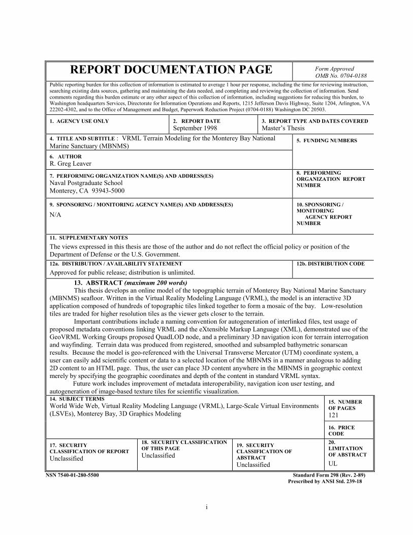
REPORT DOCUMENTATION PAGE Form Approved OMB No. 0704-0188
Public reporting burden for this collection of information is estimated to average 1 hour per response, including the time for reviewing instruction, searching existing data sources, gathering and maintaining the data needed, and completing and reviewing the collection of information. Send comments regarding this burden estimate or any other aspect of this collection of information, including suggestions for reducing this burden, to Washington headquarters Services, Directorate for Information Operations and Reports, 1215 Jefferson Davis Highway, Suite 1204, Arlington, VA 22202-4302, and to the Office of Management and Budget, Paperwork Reduction Project (0704-0188) Washington DC 20503.
1. AGENCY USE ONLY
2. REPORT DATE September 1998
3. REPORT TYPE AND DATES COVERED Master’s Thesis
4. TITLE AND SUBTITLE : VRML Terrain Modeling for the Monterey Bay National Marine Sanctuary (MBNMS)
5. FUNDING NUMBERS
6. AUTHOR R. Greg Leaver
7. PERFORMING ORGANIZATION NAME(S) AND ADDRESS(ES) Naval Postgraduate School Monterey, CA 93943-5000
8. PERFORMING ORGANIZATION REPORT NUMBER
9. SPONSORING / MONITORING AGENCY NAME(S) AND ADDRESS(ES)
N/A 10. SPONSORING / MONITORING AGENCY REPORT NUMBER
11. SUPPLEMENTARY NOTES The views expressed in this thesis are those of the author and do not reflect the official policy or position of the Department of Defense or the U.S. Government. 12a. DISTRIBUTION / AVAILABILITY STATEMENT Approved for public release; distribution is unlimited.
12b. DISTRIBUTION CODE
13. ABSTRACT (maximum 200 words) This thesis develops an online model of the topographic terrain of Monterey Bay National Marine Sanctuary
(MBNMS) seafloor. Written in the Virtual Reality Modeling Language (VRML), the model is an interactive 3D application composed of hundreds of topographic tiles linked together to form a mosaic of the bay. Low-resolution tiles are traded for higher resolution tiles as the viewer gets closer to the terrain.
Important contributions include a naming convention for autogeneration of interlinked files, test usage of proposed metadata conventions linking VRML and the eXtensible Markup Language (XML), demonstrated use of the GeoVRML Working Groups proposed QuadLOD node, and a preliminary 3D navigation icon for terrain interrogation and wayfinding. Terrain data was produced from registered, smoothed and subsampled bathymetric sonarscan results. Because the model is geo-referenced with the Universal Transverse Mercator (UTM) coordinate system, a user can easily add scientific content or data to a selected location of the MBNMS in a manner analogous to adding 2D content to an HTML page. Thus, the user can place 3D content anywhere in the MBNMS in geographic context merely by specifying the geographic coordinates and depth of the content in standard VRML syntax.
Future work includes improvement of metadata interoperability, navigation icon user testing, and autogeneration of image-based texture tiles for scientific visualization. 14. SUBJECT TERMS World Wide Web, Virtual Reality Modeling Language (VRML), Large-Scale Virtual Environments (LSVEs), Monterey Bay, 3D Graphics Modeling
15. NUMBER OF PAGES 121
16. PRICE CODE
17. SECURITY CLASSIFICATION OF REPORT Unclassified
18. SECURITY CLASSIFICATION OF THIS PAGE Unclassified
19. SECURITY CLASSIFICATION OF ABSTRACT Unclassified
20. LIMITATION OF ABSTRACT UL
NSN 7540-01-280-5500 Standard Form 298 (Rev. 2-89) Prescribed by ANSI Std. 239-18

ii

iii
Approved for public release; distribution is unlimited
VRML TERRAIN MODELING FOR THE MONTEREY BAY NATIONAL MARINE SANCTUARY (MBNMS)
R. Greg Leaver
Lieutenant, United States Navy B.S., Oklahoma State University, 1987
Submitted in partial fulfillment of the
requirements for the degree of
MASTER OF SCIENCE IN INFORMATION TECHNOLOGY MANAGEMENT
from the
NAVAL POSTGRADUATE SCHOOL September 1998
Author:
Approved by:
Rex Buddenburg, Associate Advisor
Don Brutzman, Thesis Advisor
R. Greg Leaver
Reuben T. Harris, Chair Department of Systems Management

iv
v
ABSTRACT
This thesis develops an online model of the topographic terrain of Monterey Bay
National Marine Sanctuary (MBNMS) seafloor. Written in the Virtual Reality Modeling
Language (VRML), the model is an interactive 3D application composed of hundreds of
topographic tiles linked together to form a mosaic of the bay. Low-resolution tiles are
traded for higher resolution tiles as the viewer gets closer to the terrain.
Important contributions include a naming convention for autogeneration of
interlinked files, test usage of proposed metadata conventions linking VRML and the
eXtensible Markup Language (XML), demonstrated use of the GeoVRML Working
Groups proposed QuadLOD node, and a preliminary 3D navigation icon for terrain
interrogation and wayfinding. Terrain data was produced from registered, smoothed and
subsampled bathymetric sonarscan results. Because the model is geo-referenced with the
Universal Transverse Mercator (UTM) coordinate system, a user can easily add scientific
content or data to a selected location of the MBNMS in a manner analogous to adding 2D
content to an HTML page. Thus, the user can place 3D content anywhere in the
MBNMS in geographic context merely by specifying the geographic coordinates and
depth of the content in standard VRML syntax.
Future work includes improvement of metadata interoperability, navigation icon
user testing, and autogeneration of image-based texture tiles for scientific visualization.

vi

vii
TABLE OF CONTENTS
I. INTRODUCTION ............................................................................................. 1
A. BACKGROUND........................................................................................... 1
B. MOTIVATION.............................................................................................. 1
C. OBJECTIVES................................................................................................ 1
D. THESIS ORGANIZATION ........................................................................... 2
II. BACKGROUND AND RELATED WORK .................................................. 3
A. INTRODUCTION ........................................................................................ 3
B. BACKGROUND ........................................................................................... 3
1. Monterey Bay National Marine Sanctuary......................................... 3
2. Monterey Bay Modeling Group ......................................................... 5
3. Coordinate Systems Used................................................................... 5
4. What is VRML? ................................................................................. 6
C. RELATED WORK........................................................................................ 7
1. GeoVRML Working Group ............................................................... 7
2 Seamless Solution's Terrain Navigator .............................................. 8
3. SIGGRAPH CARTO Project ............................................................. 8
4. VRML Terrain Generators ................................................................. 8
5. Synthetic Environment Data Representation & Interchange
Specification (SEDRIS)....................................................................... 9
6. Other Existing VRML Terrain Models .............................................. 10
D. SUMMARY .................................................................................................. 10
III. PROBLEM STATEMENT............................................................................... 13
viii
A. INTRODUCTION......................................................................................... 13
B. RESEARCH FOCUS ................................................................................... 13
C. DESIGN CONSIDERATIONS ..................................................................... 14
1. Transitions Considered....................................................................... 15
a. "SwapTile" Transition ............................................................ 16
b. "QuadTile" Transition ............................................................ 16
c. "QuadSwapTile" Transition ................................................... 16
2. Transition Chosen .............................................................................. 17
D. SUMMARY .................................................................................................. 18
IV. BATHYMETRIC TERRAIN DATA............................................................... 19
A. INTRODUCTION......................................................................................... 19
B. DATA PROCESSING................................................................................... 19
1. Data Source and Gridding Process ...................................................... 19
2. Partioning the Datasets ........................................................................ 20
3. How Resolutions Were Determined.................................................... 21
C. FILE NAMING CONVENTION................................................................... 22
D. METADATA................................................................................................. 22
E. SUMMARY................................................................................................... 23
V. JAVA PROGRAMS FOR DATAFILE CONVERSION TO VRML............ 25
A. INTRODUCTION......................................................................................... 25
B. CREATEVRMLTILE PROGRAM: GENERATING INDIVIDUAL
VRML TERRAIN TREES............................................................................ 25
1. Read Data File Name........................................................................... 26
2. Read Metadata .................................................................................... 26
ix
3. Read Elevation Data........................................................................... 28
4. Geographically Position Tile.............................................................. 28
5. Write VRML Syntax .......................................................................... 28
C. CREATEVRMLTREE PROGRAM: GENERATING LINKING
VRML TERRAIN TREES............................................................................ 28
1. Read Children File Names................................................................... 29
2. Construct Parent and Children Relationship ....................................... 29
3. Write VRML Syntax ........................................................................... 29
D. SUMMARY .................................................................................................. 29
VI. VRML SCENE DETAILS ............................................................................... 31
A. INTRODUCTION.......................................................................................... 31
B TERRAIN TILES ........................................................................................... 31
1. Metadata .............................................................................................. 31
2. Positioning........................................................................................... 33
3. Navigation Icons.................................................................................. 34
4. Elevation Grids.................................................................................... 35
5. Textures............................................................................................... 36
C. TERRAIN TREES......................................................................................... 36
1. Switching............................................................................................. 36
2. Viewpoints .......................................................................................... 37
D. SUMMARY .................................................................................................. 38
VII. EXPERIMENTAL RESULTS ......................................................................... 39
A. INTRODUCTION......................................................................................... 39
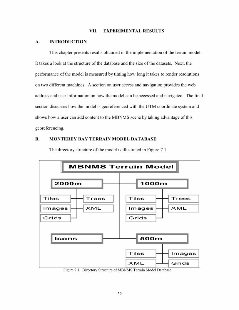
B. MONTEREY BAY TERRAIN MODEL DATABASE................................ 39
x
C. PERFORMANCE RESULTS AND USABILITY TESTING ...................... 40
1. Performance Aids ................................................................................ 41
a. Vertical Exaggeration ..................................................................... 41
b. Reducing File Size by Rounding.................................................... 42
2. Performance Results............................................................................ 42
D. USER ACCESS AND NAVIGATION.......................................................... 43
E. EXAMPLE INTEGRATION OF CONTENT............................................... 45
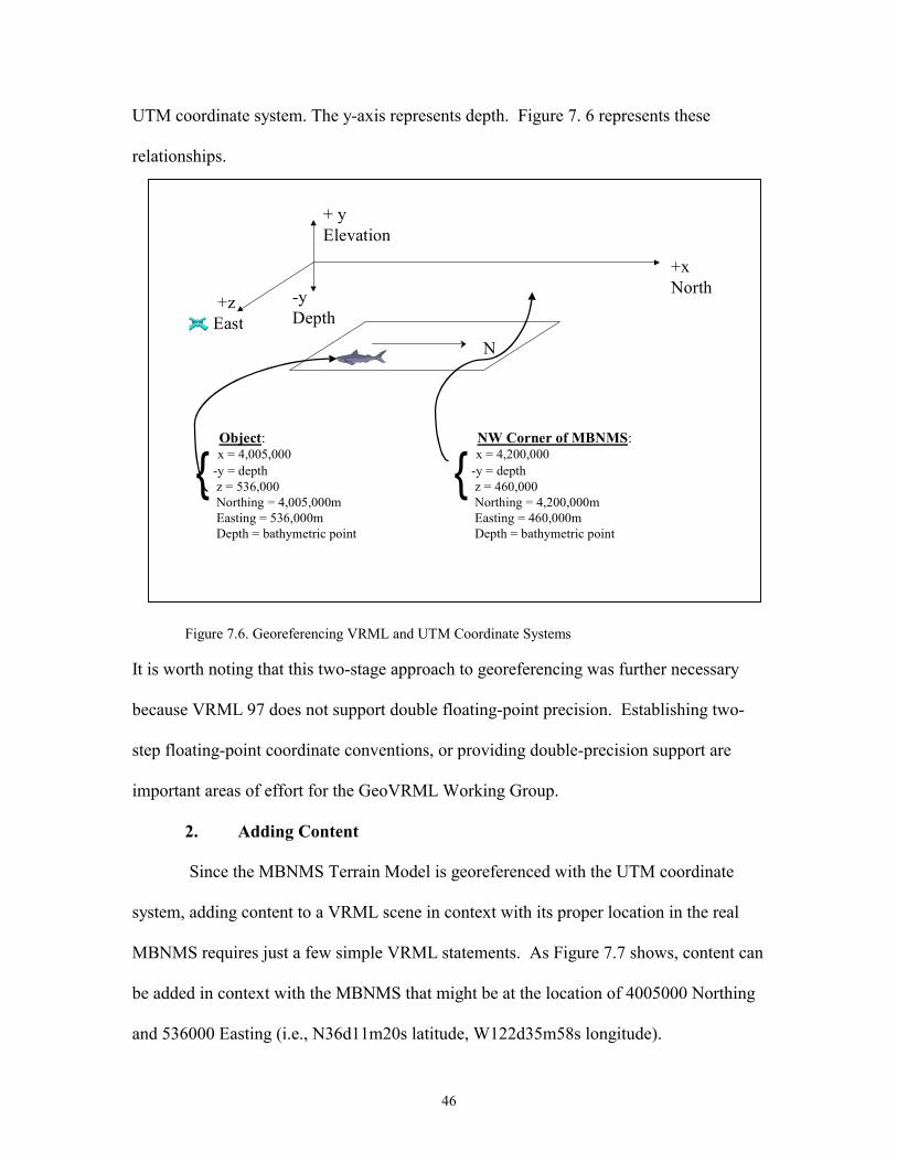
1. Georeferencing .................................................................................... 45
2. Adding Content ................................................................................... 46
F. SUMMARY................................................................................................... 47
VIII. CONCLUSIONS AND RECOMMENDATIONS .......................................... 49
A. RESEARCH CONCLUSIONS ..................................................................... 49
1. Generating VRML Syntax................................................................... 49
2. Viewpoints........................................................................................... 49
3. Rendering ............................................................................................ 50
4. Georeferencing and Content................................................................ 51
B. RECOMMENDATIONS FOR FUTURE MBNMS TERRAIN
MODEL WORK ............................................................................................ 51
1. Normals to Eliminate Tile Seams........................................................ 51
2. Modified QuadLOD Node................................................................... 52
3. Navigation Icons to Control Other Transitions ................................... 53
4. Return of the Navigation Icons............................................................ 54
5. Other MBNMS Model Future Work .................................................. 54
C. OTHER LSVE FUTURE WORK ................................................................. 54
xi
APPENDIX A: SCRIPTS USEDTO GRID DATA SETS ........................................ 57
APPENDIX B: SCRIPT USED TO PARTITION DATA SETS ............................ 61
APPENDIX C: CREATEVRMLTILE JAVA PROGRAM..................................... 63
APPENDIX D: CREATEVRMLTREE JAVA PROGRAM.................................... 77
APPENDIX E: EXAMPLE VRML TERRAIN TILE FILE STRUCTURE .......... 81
APPENDIX F: EXAMPLE VRML TERRAIN TILE SCENE GRAPH................. 89
APPENDIX G: EXAMPLE XML FILE .................................................................... 93
APPENDIX H: EXAMPLE VRML TERRAIN TREE FILE STRUCTURE ........ 95
APPENDIX I: EXAMPLE VRML TERRAIN TREE SCENE GRAPH ............... 97
LIST OF REFERENCES ............................................................................................. 99
INITIAL DISTRIBUTION LIST ............................................................................... 101

xii
2.1 Monterey Bay National M
2.2 Focus of GeoVRML Wor
3.1 Tile Transitions ..............
3.2 Tile Transition Types. ....
3.3 Implementation of QuadS
4.1 File Naming Convention .
5.1 Typical Metadata Excert
6.1 Example XML Keys and
6.2 A Navigation Icon ..........
6.3 A Single Elevation Grid (
6.4 QuadLOD Excerpt (File N
7.1 Directory Structure of M
7.2 Applying Vertical Exagge
7.3 3:1 Scaling Example (File
7.4 1:1 Scaling Example (File
7.5 Entry Viewpoint of MBN
7.6 Georeferencing VRML an
LIST OF FIGURES
xiii
arine Sanctuary. ............................................................ 4
king Group .................................................................... 7
........................................................................................ 15
........................................................................................ 17
wapTile Transition....................................................... 18
....................................................................................... 22
From Gridded Text Data File......................................... 27
Key Values Used in Metadata Node.............................. 33
........................................................................................ 35
File N353610.W1232629.070.051.1000.seabeam.wrl). 35
353610.W1232629.070.051.1000.tree.wrl)................. 37
BNMS Terrain Model Database. ................................... 39
ration............................................................................. 41
N353611.W1223609.070.051.1000.seabeam.wrl) ...... 41
N353611.W1223609.070.051.1000.seabeam.wrl). ..... 42
MS Terrain Model......................................................... 44
d UTM Coordinate Systems ......................................... 46

xiv
xv
LIST OF TABLES
4.1 File Partition Characteristics by Resolution for Entire MBMNMS Footprint .......... 21
6.1 Quadlod Node Proximity Sensor Values................................................................... 37
7.1 Terrain Tile Dataset Characteristiics......................................................................... 40
7.2 Terrain Tree Dataset Characteristics ......................................................................... 40
7.3 Rendering Time for Resolutions ............................................................................... 43
7.4 Tile Switching Values (depth)................................................................................... 45

xvi

xvii
ACKNOWLEDGEMENTS
To my wife Sandra, my daughter Lauren, and my son Chase, thank you all for
supporting me in this endeavor. I love and treasure each of you more than mere words
can say. To Don Brutzman, I offer my thanks for your contagious inspiration,
enthusiasm, and guidance. To Ray McClain, I am indebted to you for your assistance in
this project. I couldn’t have done it without your help.
1
I. INTRODUCTION
A. BACKGROUND
This thesis investigates how the Virtual Reality Modeling Language (VRML) can
be used to model the seafloor topography of the Monterey Bay National Marine
Sanctuary (MBNMS). By creating a topographic model of the MBNMS using VRML, a
three-dimensional representation of the sanctuary can be accessed over the World-Wide-
Web (Web) by anyone using a VRML-enabled web browser or standalone VRML
viewer. A VRML-enabled browser means a browser configured with a VRML plug in
such as Cosmo Player for PCs (Silicon Graphics, 98). Rapid recent progress in this field
means that many new opportunities are available.
B. MOTIVATION
Numerous scientists and researchers are collecting data and building
environmental models about Monterey Bay. Regional research partnerships using a
Large Scale Virtual Environment (LSVE) for Monterey Bay will make it easy for
scientific content about Monterey Bay to be placed and accessed online. Building a
Monterey Bay terrain model is a dramatic way to encourage scientists to their work in
three-dimensional (3D) space and on the Web. New insights and new research
collaborations are likely. A new paradigm for publication of scientific data and analytic
results is possible.
C. OBJECTIVES
The goal is to make the addition of a user-selected portion of MBNMS terrain in a
3D VRML scene as easy as adding a background image to a 2D HTML page. Thus, it is
2
hoped that this effort will make it easy for scientific content about Monterey Bay to be
placed and accessed online, in a 3D geographic context.
Although many scientists are conducting research in Monterey Bay, bathymetric
terrain scenery is not easily available. VRML makes 3D graphics accessible to any
desktop. Constructing a LSVE for Monterey Bay may dramatically enhance ongoing
regional research collaborations. An additional objective is for the model to support
variable resolutions of gridded data. "Variable resolutions" essentially means that as a
viewer gets closer to terrain, the resolution of the terrain increases to provide superior
granularity.
D. THESIS ORGANIZATION
The remaining chapters of this thesis are organized as follows. Chapter II
provides the background for the effort, introduces a few cartographic concepts, and
touches on some related work being done. Chapter III presents the problem statement
and covers design considerations for a feasible solution. Chapter IV provides a look at
bathymetric data sources and describes the gridding process used to create simple gridded
text data files. Chapter V shows how these elevation grid terrain text files can be
processed by a Java program to produced VRML world files. Chapter VI discusses the
specific VRML constructs produced by the Java programs that implement the MBNMS
terrain model, including 3D navigation/information icons. Chapter VII considers
experimental results, examines user access, and shows how users can integrate their 3D
content and MBNMS terrain. Chapter VIII presents thesis conclusions and provides
recommendations for future work.

3
II. BACKGROUND AND RELATED WORK
A. INTRODUCTION
This chapter examines pertinent background work that motivated the construction
of a terrain model for the MBNMS and introduces the basic concepts of VRML. It also
discusses other work being done to produce 3D topographic models, and provides a quick
look at a tool evaluated by the author that creates 3D topographic scenery in VRML from
elevation data sets.
B. BACKGROUND
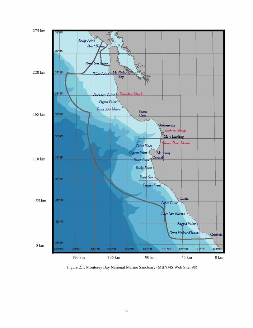
1. Monterey Bay National Marine Sanctuary
Beginning 11 km north of San Francisco's Golden Gate Bridge, the MBNMS1
extends 260 km south along the California coast to Cambria Rock in San Luis Obispo
County. The Monterey Bay National Marine Sanctuary contains the nations greatest
diversity of marine life and habitat. East to west, the sanctuary stretches 152 km and
holds one of the world's largest ocean canyons: the 10,663 ft. deep Monterey Canyon.
Thus, this area provides unparalleled opportunities for marine scientists based at nearby
research institutions such as Moss Landing Marine Laboratories (MLML), Monterey Bay
Aquarium Research Institute (MBARI), and NPS. Figure 2.1 illustrates the MBNMS
region. The sanctuary was established to enhance resource protection and preserve the
natural beauty within its boundaries.
1 More information on the MBNMS is available at http://bonita.mbnms.nos.noaa.gov/
4
Figure 2.1. Monterey Bay National Marine Sanctuary (MBNMS Web Site, 98)
0 km
170 km 135 km 90 km 45 km 0 km
220 km
165 km
55 km
110 km
275 km

5
2. Monterey Bay Modeling Group
Interest in developing computerized processes and models to assist with studying
and managing the sanctuary led to the formation of the Monterey Bay Modeling Group.
In 1993, the MBNMS Research Advisory Committee, under the sponsorship of the
National Oceanic and Atmospheric Administration (NOAA), prepared a research plan
which outlined the research priorities and management goals for the sanctuary. This plan
outlined the objectives of the Monterey Bay Modeling Group, an ad hoc group of
individuals interested in computer modeling and affiliated with various MBNMS research
organizations, including NPS. Listed among the objectives was the goal for the
development of a computerized model of the sanctuary (NOAA, 93). The model, it was
hoped, would ultimately function as an oceanographic scientific database archival and
retrieval system, which could be overlain on a 3D physiographic representation of the
MBNMS. The model would be networked for use by scientists, engineers, planners,
managers, and the general public. Unfortunately this group was only active for two
years. Recent discussions indicate that technology has advanced sufficiently to enable
further scientific collaborations.
3. Coordinate Systems Used
In terms of latitude and longitude, the MBNMS occupies a square region between
35°30' North and 38° North latitude, and 123°15' East and 121° East longitude. Since
latitude and longitude are commonly used measures, they are included in the model's
metadata and file-naming convention. Universal Transverse Mercator2 (UTM)
coordinates, which specify a location as a distance north (Northing) and east (Easting)
2 A good explanation of the UTM coordinate system is available at: http://geography.tqnm/msub14.htm
6
from a zone's meridian measured in meters, are also frequently used in cartography. In
terms of the UTM system, the MBNMS lies between Northing coordinates of
3,940,000m to 4,200,000m, and Easting coordinates of 460,000m to 612,000m. Because
UTM coordinates are in meters rather than degrees, UTM measurements can easily be
converted to VRML coordinates that are default units in meters. This capability allows
gridded elevation data and scientific content to be positioned relative to their real world
location in the MBNMS model.
4. What is VRML?
VRML - the Virtual Reality Modeling Language - is a 3D graphics scene
description language that enables a scene builder to create dynamic worlds and sensor
rich virtual environments on the Internet. VRML enables users to animate objects in
worlds, making them move; it also enables users to play sounds within worlds, interact
with worlds and, control and enhance worlds with scripts, or small programs (Ames, et.
al., 97). VRML provides a standardized, portable, and platform-independent way to
render dynamic, interactive, 3D scenes across the Internet (Brutzman, 97).
A VRML file generally ends with extension ".wrl". This file is a textual
description of a 3D world. A VRML file contains nodes that describe shapes and their
properties in the virtual world. These nodes make up the building blocks - VRML
constructs - which create the 3D scenery in a virtual world. For cartographic models
such as this project, one of the principal VRML constructs is the ElevationGrid node,
which can be used to create a 3D representation of the terrain. The terrain itself is
described by a data set containing bathymetric depth values. Each sampled depth value is
7
associated with a pair of gridded 2D coordinates. An excellent overview of how VRML
can be applied to cartography can be found in Fairborn and Parsley (97).
C. RELATED WORK
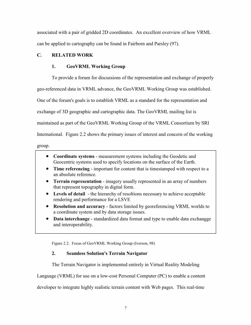
1. GeoVRML Working Group
To provide a forum for discussions of the representation and exchange of properly
geo-referenced data in VRML advance, the GeoVRML Working Group was established.
One of the forum's goals is to establish VRML as a standard for the representation and
exchange of 3D geographic and cartographic data. The GeoVRML mailing list is
maintained as part of the GeoVRML Working Group of the VRML Consortium by SRI
International. Figure 2.2 shows the primary issues of interest and concern of the working
group.
Figure 2.2. Focus of GeoVRML Working Group (Iverson, 98)
2. Seamless Solution's Terrain Navigator
The Terrain Navigator is implemented entirely in Virtual Reality Modeling
Language (VRML) for use on a low-cost Personal Computer (PC) to enable a content
developer to integrate highly realistic terrain content with Web pages. This real-time
• Coordinate systems - measurement systems including the Geodetic and Geocentric systems used to specify locations on the surface of the Earth.
• Time referencing - important for content that is timestamped with respect to a an absolute reference.
• Terrain representation - imagery usually represented in an array of numbers that represent topography in digital form.
• Levels of detail - the hierarchy of resoltions necessary to achieve acceptable rendering and performance for a LSVE
• Resolution and accuracy - factors limited by georeferencing VRML worlds to a coordinate system and by data storage issues.
• Data interchange - standardized data format and type to enable data exchangge and interoperability.
8
interactive visualization software is especially useful for collaborative review of database
development throughout the design cycle or for entertainment purposes. (Seamless
Solutions, 98).
3. SIGGRAPH CARTO Project
The "Carto Project" began in 1996 as a cross-organizational collaboration
between the activities of the Association for Computing Machinery's Special Interest
Group on Graphics (ACM SIGGRAPH) and the International Cartographic Association's
(ICA) Commission on Visualization. The Carto Project explores how viewpoints and
techniques from the computer graphics community can be effectively applied to
cartographic and spatial data sets. This includes exploring how viewpoints and methods
from cartography can enhance developments in computer graphics; especially those
associated with the representation of geographic phenomena. These efforts will continue
into 1999, in conjunction with the time frame of the ICA's Commission on Visualization
(Rhyne, 98).
4. VRML Terrain Generators
Several commercial products exist that can automatically generate VRML terrain.
To do so, generally these products import a dataset in a prescribed format such as Digital
Elevation Model3 (DEM) and produce export a VRML file via a filter. Rapid Imaging
Software offers a product called LandForm Gold (RIS, 98) that works like this. A copy of
this software was evaluated by this author, courtesy of Mike Abernathy at RIS.
LandForm Gold is a powerful 3D real-time terrain viewer for the Windows NT/95
platform. This product allows a user to view geographical data in a three-dimensional
3 DEM files contain data of the elevation of the terrain over a specified area, usually at a fixed grid
9
representation and move through the data in a natural and intuitive manner. The program
accepts numerous file types and allows the user to superimpose an image of the area over
the terrain. This effect of the image overlay combined with 3D data creates a strikingly
realistic representation of the terrain, as landmarks and topographical features are
dramatically revealed in 3D. As mentioned earlier, LandForm Gold also enables the user
to create VRML models based upon the dataset read by the viewer. Other tools, such as
Cybertrek (98) and Coryphaeus (98) are also available to create VRML terrain models,
but were not evaluated by this author.
5. Synthetic Environment Data Representation & Interchange
Specification (SEDRIS)
The SEDRIS Geographic Reference Model (GRM) has been proposed by the
GeoVRML Working Group (discussed later) as a standard for VRML coordinate
systems. SEDRIS is a reference model and software package that currently supports 12
different commonly used world coordinate system convention, as well as tools to
automatically convert reference marks between them. Coordinate system standards
supported include Geodetic (GDC or latitude/longitude), Geocentric (earth centered
Cartesian), Universal Transverse Mercator (UTM), and Lambert Conformal Conic
(LCC). The proposal (GeoVRML, 98) was drafted by SRI International and is
summarized here. It proposes two levels to employ VRML constructs that implement the
SEDRIS standards. Level 1 consists of a means of entering geographical coordinates into
VRML files so that the Cartesian VRML coordinates are generated with respect to a
geographically referenced local coordinate system. Its use depends only on the
interval, such as 1 arc-degree or 7.5 arc-minutes. DEM files are avilable (for a fee) from the U.S. Geological Survey at: http://edcwww.cr.usgs.gov/webglis
10
availability of a library for converting from geographical coordinates in the GRM into a
local Cartesian frame. Level 2 consists of an attempt to establish a means for
automatically managing the relationships between the local Cartesian frames defined in
Level 1. It is intended as the enabling technology for seamlessly integrating accurately
georeferenced worlds from a wide variety of sources. Since the constructs contained in
the proposal are experimental at this time, they were not employed in the MBNMS
Model. Nevertheless they remain an important area for future work.
6. Other Existing VRML Terrain Models
SRI International has developed a VRML terrain model of the Fort Irwin,
California area. This terrain model has been distributed on CD-ROM and is also
viewable on the Web (SRI, 98). It uses multiple levels of detail to change the terrain's
resolution based upon the viewer's distance to the scenery. In 1997 RIS produced a
model of the San Francisco Bay area (Abernathy, 98). This model was produced to
convey topographical information to participants in the San Francisco Relay. By
integrating Global Positioning Satellite elevation data with satellite and aerial imagery,
the model displayed the terrain the event's course and scenery from a runner's point of
view.
A simple textured model of Monterey regional terrain is also available at
http://ece.uwaterloo.ca/vrml98. It provides background for the VRML 98 Symposium
3D website
D. SUMMARY
This chapter explores the related work that preceded or motivated the creation of
a model for the MBNMS. It places the sanctuary in a geographical context and presents
11
the goals of the Monterey Bay Modeling Group. A brief overview of VRML provides
some basic concepts of this scene-description language. Work related to VRML terrain
development is considered and VRML terrain authoring tools are introduced - one of
which is evaluated by the author. Additionally, some existing VRML terrain models are
identified.

12
13
III. PROBLEM STATEMENT
A. INTRODUCTION
Although excellent commercial software exists for professional development of
topographic models (both VRML and non-VRML) in 3D, these tools can be expensive
and may require data sets to be in a proprietary format. Furthermore, the tools are not
only necessary to generate the topographic models; they are also often required to be
present on a user's console in order to view the models. By representing the model in
VRML, an open solution to the problem of generating topographic data sets and
subsequently viewing them is obtained. Anyone with a web browser and WWW access
can potentially interact with the model. This chapter covers the problem of developing
such an application. It then discusses the advantages of VRML as the basis for
implementing a solution. Much of the chapter is devoted to an examination of the design
issues considered in the development of a model solution.
B. RESEARCH FOCUS
In the last few years, advances in 3D modeling languages have made it feasible to
develop the foundation for a 3D model of the MBNMS. VRML in particular enables the
development of a model that can be viewed over the WWW on any platform with
Internet access and a VRML enabled browser. In order to place arbitrary research
information about the MBNMS in a geographic context, a user needs to be able to relate
MBNMS data with the location the data describes or pertains to in the sanctuary. By
constructing the model in VRML, a background of the appropriate geographic location
can be added in a manner analogous to adding a background texture to a 2D HTML page.
VRML can be geo-referenced with a cartographic coordinated system to support the
14
addition of the terrain to a scene. The goal of this thesis is the development of a VRML-
based model of the MBNMS that is accessible over the Web which can enable a user to
select a portion of Monterey Bay National Marine Sanctuary (MBNMS) terrain and
easily add scientific content or data to the selected scenery. Thus, the end product will
allow the user to place 3D content in a geographic MBNMS context. Of primary concern
when attempting to construct such a model is the methodology by which low-resolution
3D scenery is exchanged for higher resolution scenery, all the while maintaining the
overarching context of the MBNMS environment with the content added. Because
bathymetric data of the MBNMS seafloor is available and that data can be gridded to
various resolutions, and because the model needs to be based upon open-standard VRML
that is directly authorable, commercial development tools are not required for this effort.
C. DESIGN CONSIDERATIONS
In addition to being accessible via the Web, a VRML model of the MBNMS
needs to be navigable and geographically accurate. The units of measurement should be
in meters and coordinates specified where possible to foster cartographic relation and
interpretation. The process of switching between resolutions is an important
consideration that leads to the introduction of two important terms: tiles and transitions.
The term tiles refers to a VRML file covering a certain sized horizontal area that can be
exchanged for another tile or group of tiles at a different resolution. The term transition
describes the method of the actual change, i.e., the mechanics of the switch. Thus a tile
undergoes a transition from one resolution to another. The method used for transiting
between resolutions has dramatic performance implications.
15
•Large area tiles•Small area tiles
•highspatialresolution
•high filesize
•lowspatialresolution
•low filesize
Tile Area
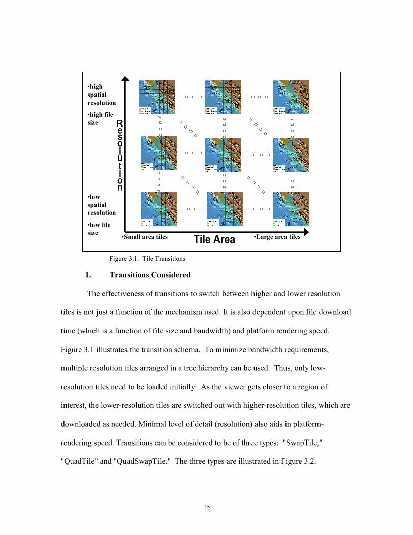
Figure 3.1. Tile Transitions
1. Transitions Considered
The effectiveness of transitions to switch between higher and lower resolution
tiles is not just a function of the mechanism used. It is also dependent upon file download
time (which is a function of file size and bandwidth) and platform rendering speed.
Figure 3.1 illustrates the transition schema. To minimize bandwidth requirements,
multiple resolution tiles arranged in a tree hierarchy can be used. Thus, only low-
resolution tiles need to be loaded initially. As the viewer gets closer to a region of
interest, the lower-resolution tiles are switched out with higher-resolution tiles, which are
downloaded as needed. Minimal level of detail (resolution) also aids in platform-
rendering speed. Transitions can be considered to be of three types: "SwapTile,"
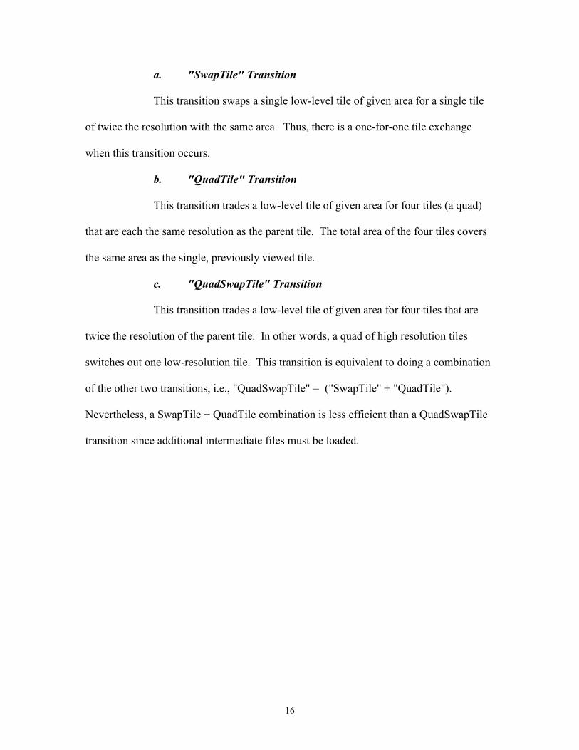
"QuadTile" and "QuadSwapTile." The three types are illustrated in Figure 3.2.
16
a. "SwapTile" Transition
This transition swaps a single low-level tile of given area for a single tile
of twice the resolution with the same area. Thus, there is a one-for-one tile exchange
when this transition occurs.
b. "QuadTile" Transition
This transition trades a low-level tile of given area for four tiles (a quad)
that are each the same resolution as the parent tile. The total area of the four tiles covers
the same area as the single, previously viewed tile.
c. "QuadSwapTile" Transition
This transition trades a low-level tile of given area for four tiles that are
twice the resolution of the parent tile. In other words, a quad of high resolution tiles
switches out one low-resolution tile. This transition is equivalent to doing a combination
of the other two transitions, i.e., "QuadSwapTile" = ("SwapTile" + "QuadTile").
Nevertheless, a SwapTile + QuadTile combination is less efficient than a QuadSwapTile
transition since additional intermediate files must be loaded.
17
Figure 3.2. Tile Transition Types
If the user's goal is to gain successively higher resolution, note that the direction
of the transitions is important. As a region of interest is approached, transitions will tend
to be toward higher grid/file resolution in combination with smaller tile subdivisions, i.e.,
upward and leftward on the above two charts. Alternatively, as a region of interest is
exited, transitions will be downward and rightward as a region of interest is exited.
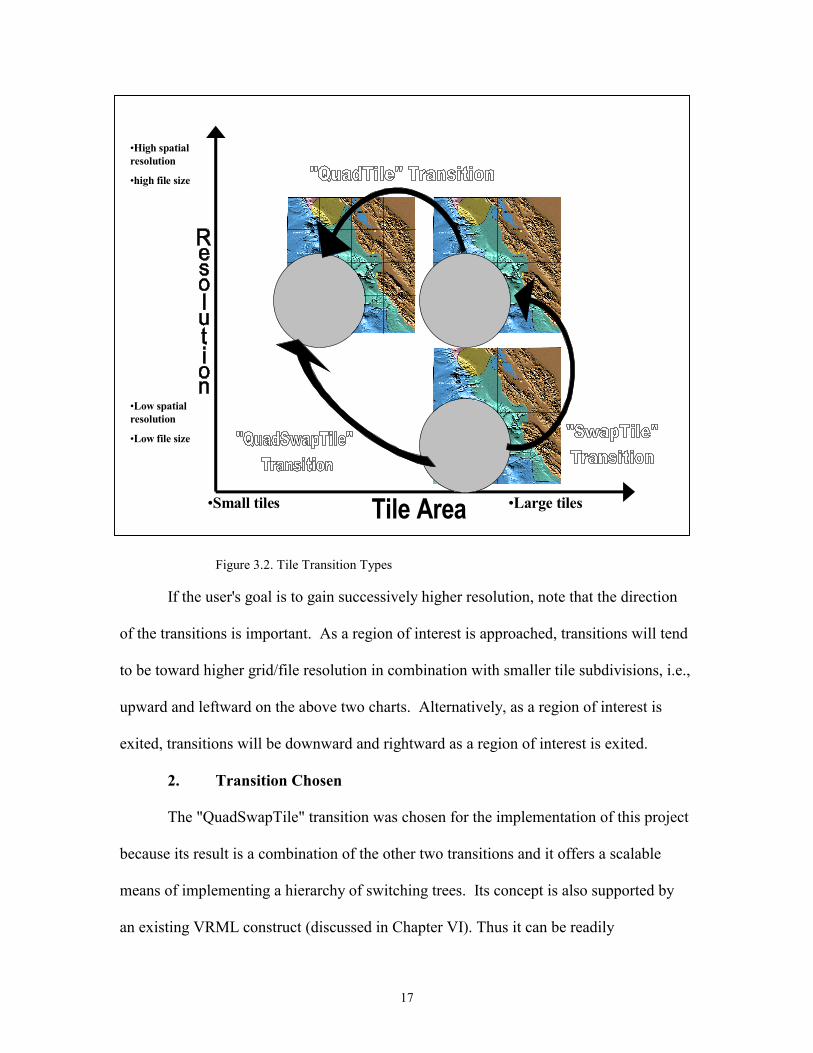
2. Transition Chosen
The "QuadSwapTile" transition was chosen for the implementation of this project
because its result is a combination of the other two transitions and it offers a scalable
means of implementing a hierarchy of switching trees. Its concept is also supported by
an existing VRML construct (discussed in Chapter VI). Thus it can be readily
•Large tiles•Small tiles
•High spatialresolution
•high file size
•Low spatialresolution
•Low file size
Tile Area
18
implemented once the terrain tiles are developed. Figure 3.3 displays the design of the
project using the "QuadSwitch" transition. Nevertheless, the other two transitions, the
QuadTile and the SwitchTile, remain useful (at least theoretically) to support higher-
resolution rendering on higher-performance machines, with the dataset quickly
retrievable via dedicated Internet connections or local disk availability. Future work to
integrate all three transitions is discussed in Chapter VIII.
Figure 3.3. Implementation of QuadSwapTile Transition
D. SUMMARY
This chapter describes the nature of the problem that this thesis addresses. It
discusses some of the advantages to using VRML as the scene description language to
implement a solution and some of the reasons why existing tools are not required. It
examines terrain tile-swapping characteristics of design in detail.
•Large tiles’ area•Small tiles’ area
•highspatialresolution
•high filesize
•lowspatialresolution
•low filesize Tile Area
19
IV. BATHYMETRIC TERRAIN DATA
A. INTRODUCTION
This chapter discusses the data used in the MBNMS Terrain Model. It covers the
source and processing of the data. It explains how raw, ungridded, topographic data is
gridded to desired resolutions and how monolithic grids are partitioned into smaller
sections. It describes how file names are built for gridded data files and explains the
metadata included with those files.
B. DATA PROCESSING
1. Data Source and Gridding Process
Ungridded bathymetry data, which is simply raw elevation data of the seafloor
topography, has data points at intervals determined by the sampling rate of various
oceanographic surveys. The data points equal the depth of the ocean at that sampled
spot. The database containing the ungridded bathymetric is maintained by the U.S.
Geological Survey (USGS). The USGS obtained the data by way of the Seabeam-sonar
oceanographic survey done by the National Oceanic and Atmospheric Administration.
Moss Landing Marine Laboratories (MLML) obtained a copy of the data (MLML, 98)
which is now public domain (USGS, 98).
In order to be useable for a MBNMS Terrain Model, the raw data needs to be
gridded at an evenly spaced interval (post-spacing) such that each data point is a fixed
distance from each neighbor. Posts refer to the notion that elevation heights at regular
intervals are similar to posts of different heights spaced throughout a flat field. Thus, the
data points form a grid at a given resolution. The closer the points are to one another, the
higher the resolution of the grid. The raw, ungridded dataset for MBNMS comprises one
20
large 40 MB file. This dataset can be gridded to various resolutions using the Kriging
Algorithm.4 Using this algorithm as implemented in a GIS program named "Surfer for
Windows," (Golden Software, 98). Ray McClain of MLML gridded the entire dataset at
post-spacing-interval resolutions of 2000, 1000, and 500 meters, respectively. Appendix
A contains scripts for batch files that accomplish this. This effort effectively created three
new datasets, each describing the entire seafloor topography of the MBNMS at the
respective resolutions (McClain, 98).
2. Partitioning the Datasets
Each of the five gridded datasets can be divided into partitions. Each partition
contains bathymetric data describing a piece of the MBNMS at the gridded resolution.
The original coordinate system used in Seabeam Survey data is in decimal degrees
(latitude/longitude) format. However, the coordinate system needed in the final
partitioned files is UTM. To perform this conversion, MLML developed a script
(Appendix B) that creates a batch file to input into a geographic information system
(McClain, 98). This GIS, called "TNTmips" (MicroImages, 98) used the batch file to
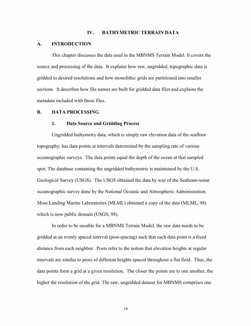
perform the coordinate system conversion and partitioned the datasets as necessary. Table
4.1 shows the outcome of the partitioning process.
4 Kriging is a method of interpolation which predicts unknown values from data observed at known locations. This method minimizes the error of predicted values which are estimated by spatial distribution of the predicted values. MLML used a Linear Variogram model with no anisotropy, no drift, and a zero nugget effect.
21
Resolution (Post-
spacing) of dataset
Number of partitions in dataset
Number of posts in
partition
Partition file-size in
kilobytes (KB)
Aggregate MBNMS Data Set Size in
Kilobytes (KB)
2000m
1 10,087
90KB
90KB
1000m
4
10,087
90KB
360KB
500m
16
10,087
90KB
1,440KB
Totals
21
All have 10,887 posts
All file sizes are 90 KB
1,890 KB
Table 4.1. File Partition Characteristics by Resolution for Entire MBMNMS Footprint
3. How Resolutions Were Determined
The three resolutions (2000m, 1000m, and 500m) were determined by considering
the interplay between file size, maximum dataset size and post-spacing resolution
intervals. Note in that in Table 4.1, above, the file size for any one partition is constant
since the number of posts in all partitions is the same. This occurs because as
postspacing is halved, the surface area covered by a partition drops to one-fourth the area
of the previous, higher resolution partition, keeping the number of posts and thus the file
size constant. The desired top-level (lowest) resolution partition was determined by
considering download time and area covered by a partition. The maximum acceptable
download wait for a file was judged to be 30 seconds. On a low bandwidth connection
then, such as a dial up 28.8 kilobit per second modem, and allowing for throughput
reduction resulting from data control overhead, the maximum file size could not exceed
100 KB. Due to the area of the MBNMS, this results in a 2,000m post-spacing top-level
file, with resolution doubling at each step.
22
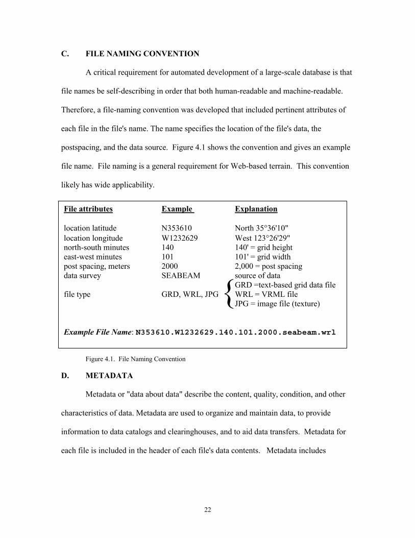
File attributes Example Explanation location latitude N353610 North 35°36'10" location longitude W1232629 West 123°26'29" north-south minutes 140 140' = grid height east-west minutes 101 101' = grid width post spacing, meters 2000 2,000 = post spacing data survey SEABEAM source of data
GRD =text-based grid data file file type GRD, WRL, JPG WRL = VRML file JPG = image file (texture)
Example File Name: N353610.W1232629.140.101.2000.seabeam.wrl
C. FILE NAMING CONVENTION
A critical requirement for automated development of a large-scale database is that
file names be self-describing in order that both human-readable and machine-readable.
Therefore, a file-naming convention was developed that included pertinent attributes of
each file in the file's name. The name specifies the location of the file's data, the
postspacing, and the data source. Figure 4.1 shows the convention and gives an example
file name. File naming is a general requirement for Web-based terrain. This convention
likely has wide applicability.
Figure 4.1. File Naming Convention
D. METADATA
Metadata or "data about data" describe the content, quality, condition, and other
characteristics of data. Metadata are used to organize and maintain data, to provide
information to data catalogs and clearinghouses, and to aid data transfers. Metadata for
each file is included in the header of each file's data contents. Metadata includes
{
23
information about filename, post spacing, grid coordinate parameters, and data processes
used. A VRML construct developed to encapsulate metadata is explained in Chapter VI.
E. SUMMARY
This chapter provides information about the data used that forms the foundation
of the MBNMS Terrain Model. The origin of the raw data is covered, and the processes
of gridding and partitioning the data are explained. Also discussed is the reasoning used
to determine the grid resolutions. The file-naming convention is described, and an
example file name given. Finally, metadata considerations are noted.

24
25
V. JAVA PROGRAMS FOR DATAFILE CONVERSION TO VRML
A. INTRODUCTION
Two Java programs were written to produce two types of VRML files that
represent the MBNMS as a 3D model. The first program uses gridded data files provided
by Moss Landing Marine Laboratories to create the necessary VRML terrain syntax. This
Java program also automates the tile-positioning process, whereby tiles are aligned to
correspond with their real-world geographic locations. To link together the terrain tiles, a
second Java program generates VRML scenes that contain embedded VRML trees which
select the level of detail appropriate for the scene relative to the viewer's location.
B. CREATEVRMLTILE PROGRAM: GENERATING INDIVIDUUAL
VRML TERRAIN TILES
As noted in Table 4.1, MLML generated a total of 21 gridded data files. For each
gridded data file, one VRML tile is required. Thus, 21 VRML tiles needed to be
produced. An automated solution to importing the gridded text data and exporting
VRML files was produced by writing a Java program. Each VRML tile needed to
contain certain cross-linking constructs; these constructs are explained in detail in
Chapter VI. Furthermore, VRML tiles need to be offset, or translated, by the distance (in
meters) corresponding to the real-world area described by the tile's data. By translating
each tile by the correct value, each of the five resolution datasets will appear as a nearly
seamless mosaic. For each resolution, a Java class was produced. Appendix C is a
CreateVRMLTile Java class that generates terrain tiles using partitions with 1000 meter
post spacing. Before running the program, a list is constructed which contains the names
of the gridded data files at a given resolution, with one file name on each line. For a

26
given resolution, the partitions that make up the dataset are essentially simple rectangular
pieces of the MBNMS; they can be assembled in the correct order to make a complete
representation of the topography at that resolution. In the case of the 500m resolution,
there are 16 gridded data files in a 4x4 arrangement that comprise the area of the
MBNMS in a two-dimensional (2D) array. The 16 files can be lined up, one after the
other, in order of location. For each of the five datasets, with each dataset at a different
post-spacing, the CreateVRMLTile program does the following:
1. Read Data File Name
One at a time, names of gridded data files are obtained and operations to produce
output based upon that file's data are performed. After getting the name of the first
gridded data file in the array, that data file is opened so that its contents may be read.
2. Read Metadata
Next, the program reads the metadata contained in the gridded data file's header.
A typical excerpt appears in Figure 5.1.
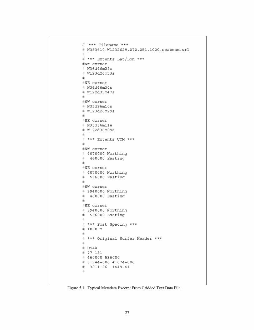
27
# *** Filename ***# N353610.W1232629.070.051.1000.seabeam.wrl## *** Extents Lat/Lon ***#NW corner# N36d46m29s# W123d26m53s##NE corner# N36d46m30s# W122d35m47s##SW corner# N35d36m10s# W123d26m29s##SE corner# N35d36m11s# W122d36m09s## *** Extents UTM ***##NW corner# 4070000 Northing# 460000 Easting##NE corner# 4070000 Northing# 536000 Easting##SW corner# 3940000 Northing# 460000 Easting##SE corner# 3940000 Northing# 536000 Easting## *** Post Spacing ***# 1000 m## *** Original Surfer Header ***## DSAA# 77 131# 460000 536000# 3.94e+006 4.07e+006# -3811.36 -1449.41#
Figure 5.1. Typical Metadata Excerpt From Gridded Text Data File
28
3. Read Elevation Data
The program reads the elevation posts which are used to construct a VRML
elevation grid.
4. Geographically Position Tile
The program computes, in meters, the necessary distance to translate the VRML
tile. This distance is used to geographically position the tile in the MBNMS mosaic.
Also computed and written to file is the center coordinate of the tile, to be used later in
the second type of Java program, described later in this chapter.
5. Write VRML Syntax
The file-naming convention is observed throughout this process. The program
writes VRML syntax to a file whose name corresponds to the gridded data file. A VRML
header is produced along with a VRML construct to recreate the metadata of the data file.
The program then produces VRML constructs that create a navigation icon, an elevation
grid, and local viewpoints that are tied to the navigation icon. The viewpoints are
exported to a separate file that is inlined into the top-level scene.
As each individual terrain tile files is completed, the name of the next gridded
data file is obtained and the above process repeated until there are no more gridded data
files to import.
C. CREATEVRMLTREE PROGRAM: GENERATING LINKING VRML
TERRAIN TREES
The VRML construct that performs the switching between resolutions requires a
tree structure whereby a parent tile can be exchanged for four children tiles. These trees
are then nested to produce the switching architecture. Two tree levels are required for the
29
overall application, corresponding to the two top-most resolutions, i.e., 2000m and
1000m. Trees do not need to be generated for the highest-resolution tiles, i.e., the 16 500
m tiles. A Java program was developed to automate the process of generating the trees.
Appendix D is a CreateVRMLTree Java class that generates four 1,000 m-resolution
trees. The works in the following manner:
1. Read Children File Names
For each of parent generated in the tree, the program reads in the names of the
files that become the children of that parent and stores those names in an array.
2. Construct Parent and Children Relationship
The program builds the tree structure by extracting from the array the proper
children for that tree and computes the parent's name based upon child1's name. The
program then reads the center VRML coordinates of the parent tile, which were exported
to file as a result of running the tiling program described in section B of this chapter.
3. Write VRML Syntax
Using the information stored from the above procedures, the program then writes
the VRML syntax that creates the file that contains the tree that corresponds to the tile for
that level of resolution and location. One tree consists of one parent and four children.
The process is then repeated until there are no trees left to create for the given resolution.
The overall process is repeated again at the next post-spacing resolution.
D. SUMMARY
This chapter describes the process of generating VRML syntax. Two Java
programs are introduces that automate the process of generating VRML syntax. The first
program reads gridded data files, selects the proper latitude-longitude area, and exports

30
VRML terrain syntax to create the tile structure of the MBNMS mosaic. The second
program creates VRML syntax to create files that contain VRML constructs, which select
a level of detail appropriate for the scene relative to the viewer's location.
31
VI. VRML SCENE DETAILS
A. INTRODUCTION
This chapter describes the VRML constructs contained in the two sets of VRML
files that together comprise the MBNMS Terrain Model. The first set of files, the terrain
tiles, contain the VRML nodes that create the actual geometry of the shapes in the scene.
The second set of VRML files, the terrain trees, contain the VRML nodes that acts as a
switch to trade a low-resolution parent tile for a group of higher resolution children tiles.
B. TERRAIN TILES
For a given resolution, many terrain tiles make up the entire MBNMS. Table 4.1
summarizes tile file size and inventory. Terrain tiles are a textual description of a virtual
seafloor region. Appendixes E and F are an example terrain tile and scene graph,
respectively, for file N353610.W1232629.070.051.1000.seabeam.wrl. Terrain tile
constructs are explained below.
1. Metadata
A Metadata prototype node has been proposed (Lipkin, 98) which contains
pertinent information relating to the contents of a VRML scene. For this project,
metadata includes authorship, data origin, geographic coordinates covered by tile, and
other relevant tile-specific information. Implemented using VRML's EXTERNPROTO
facility, the node permits the Metadata node information to be contained in a string
written in Extensible Markup Language (XML) format (XML, 98). Since this exposed
field contains XML code in-line as well as the location of an XML document (containing
the same metadata) the Metadata node allows easy access to the metadata contents.
32
As far as possible, the XML keys and key values used correspond to the Dublin
Core Metadata Element Set, a 15-element set intended to facilitate discovery of
bibliographic information and electronic resources (Weibel, 98). Also considered in
determining the key/key value pairs was the Federal Geographic Data Committee
Metadata Standard which requires federal agencies to document the data that they
produce beginning in 1995 (FGDC, 94).5 Using these references as a guide, the XML
keys for the MBNMS model were developed. The keys (with example key values) are
shown in Figure 6.1. These key/key value pairs also appear inlined in the final VRML
file (e.g., N353610.W1232629.070.051.1000.seabeam.wrl. in Appendix E) and in the
corresponding (XML file N353610.W1232629.070.051.1000.seabeam.xml) in Appendix
G). Because of the Metadata node's recent availability, it is not a functioning node in the
MBNMS model. However, the syntax for a potential functioning node is provided in
each terrain tile along with the actual metadata. Extensive additional work is expected in
the funtionality of Metadata nodes, as well as in widespread application of metadata
key/key value conventions in terrain data files.
5 An excellent example of a NOAA implementation of the FGDC standard can be found at http://www.csc.noaa.gov/metadata/text/seaview_metadata.html
33
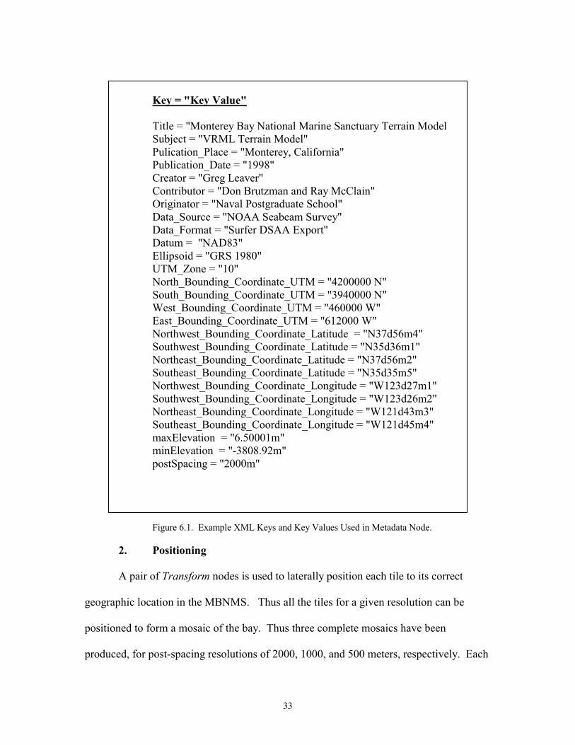
Key = "Key Value"
Title = "Monterey Bay National Marine Sanctuary Terrain Model Subject = "VRML Terrain Model" Pulication_Place = "Monterey, California" Publication_Date = "1998" Creator = "Greg Leaver" Contributor = "Don Brutzman and Ray McClain" Originator = "Naval Postgraduate School" Data_Source = "NOAA Seabeam Survey" Data_Format = "Surfer DSAA Export" Datum = "NAD83" Ellipsoid = "GRS 1980" UTM_Zone = "10" North_Bounding_Coordinate_UTM = "4200000 N" South_Bounding_Coordinate_UTM = "3940000 N" West_Bounding_Coordinate_UTM = "460000 W" East_Bounding_Coordinate_UTM = "612000 W" Northwest_Bounding_Coordinate_Latitude = "N37d56m4" Southwest_Bounding_Coordinate_Latitude = "N35d36m1" Northeast_Bounding_Coordinate_Latitude = "N37d56m2" Southeast_Bounding_Coordinate_Latitude = "N35d35m5" Northwest_Bounding_Coordinate_Longitude = "W123d27m1" Southwest_Bounding_Coordinate_Longitude = "W123d26m2" Northeast_Bounding_Coordinate_Longitude = "W121d43m3" Southeast_Bounding_Coordinate_Longitude = "W121d45m4" maxElevation = "6.50001m" minElevation = "-3808.92m" postSpacing = "2000m"
Figure 6.1. Example XML Keys and Key Values Used in Metadata Node.
2. Positioning
A pair of Transform nodes is used to laterally position each tile to its correct
geographic location in the MBNMS. Thus all the tiles for a given resolution can be
positioned to form a mosaic of the bay. Thus three complete mosaics have been
produced, for post-spacing resolutions of 2000, 1000, and 500 meters, respectively. Each
34
tile file has a single corresponding Transform node referenced to the local origin of the
UTM coordinate system, which occurs at the northwest corner of the MBNMS. The
topmost linking file has the transform that moves the entire geometry set to the proper
UTM coordinates of the northwest-corner of the origin, i.e., 4,200,000 meters Northing,
460,000 meters Easting.
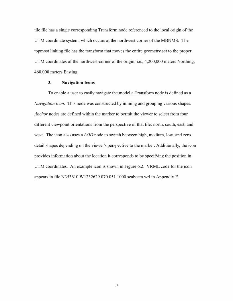
3. Navigation Icons
To enable a user to easily navigate the model a Transform node is defined as a
Navigation Icon. This node was constructed by inlining and grouping various shapes.
Anchor nodes are defined within the marker to permit the viewer to select from four
different viewpoint orientations from the perspective of that tile: north, south, east, and
west. The icon also uses a LOD node to switch between high, medium, low, and zero
detail shapes depending on the viewer's perspective to the marker. Additionally, the icon
provides information about the location it corresponds to by specifying the position in
UTM coordinates. An example icon is shown in Figure 6.2. VRML code for the icon
appears in file N353610.W1232629.070.051.1000.seabeam.wrl in Appendix E.
35
Figure 6.2. A Navigation Icon.
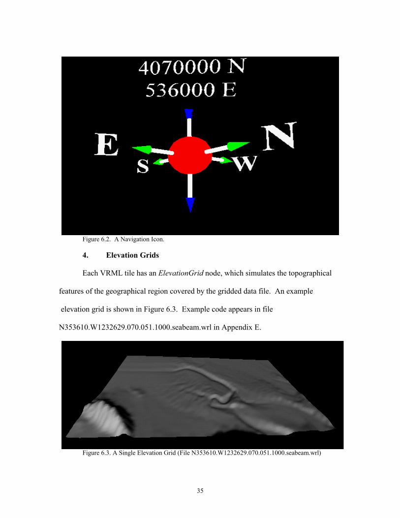
4. Elevation Grids
Each VRML tile has an ElevationGrid node, which simulates the topographical
features of the geographical region covered by the gridded data file. An example
elevation grid is shown in Figure 6.3. Example code appears in file
N353610.W1232629.070.051.1000.seabeam.wrl in Appendix E.
Figure 6.3. A Single Elevation Grid (File N353610.W1232629.070.051.1000.seabeam.wrl)
36
5. Textures
Each VRML tile has a corresponding JPEG image for a texture. The textures
were generated by MLML (McClain, 98) along with the gridded data files. Each image's
area corresponds precisely with the area covered by the grids and follows the file-naming
convention. Example code appears in file.
N353610.W1232629.070.051.1000.seabeam.wrl l in Appendix E. These particular
textures use a false-coloring technique that maps depth to pixel color. Alternate texture
images might easily be substituted. This is an important area for future work.
C. TERRAIN TREES
Terrain trees contain the framework for switching between a low-resolution
parent tile and four higher-resolution children tiles. These files do the mechanical work
of switching but contain no constructs to create scenery. Appendixes H and I are an
example terrain tree and scene graph, respectively, for file
N353610.W1232629.070.051.1000.seabeam.wrl. Terrain tile constructs are explained
below.
1. Switching
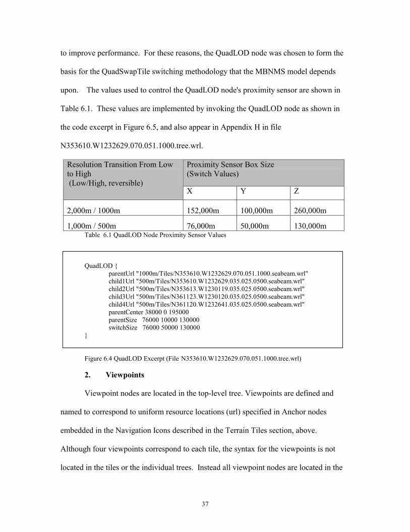
To switch between different tile resolutions, the EXTERNPROTO QuadLOD
node (Reddy, 98) is employed. A detailed description of the QuadLOD node is beyond
the scope of this thesis, but a general overview is provided here. In short, Reddy's node
uses a location-to-camera proximity sensor to control the switching between a parent tile
and four (quad) children tiles. Additionally, the quad is not fetched until the proximity
sensor fires, conserving bandwidth. Also, tiles not within a certain bounding box are not
drawn, improving browser-rendering speed. File caching and release has also been added
37
to improve performance. For these reasons, the QuadLOD node was chosen to form the
basis for the QuadSwapTile switching methodology that the MBNMS model depends
upon. The values used to control the QuadLOD node's proximity sensor are shown in
Table 6.1. These values are implemented by invoking the QuadLOD node as shown in
the code excerpt in Figure 6.5, and also appear in Appendix H in file
N353610.W1232629.070.051.1000.tree.wrl.
Proximity Sensor Box Size (Switch Values)
Resolution Transition From Low to High (Low/High, reversible)
X Y Z
2,000m / 1000m 152,000m 100,000m 260,000m
1,000m / 500m 76,000m 50,000m 130,000m Table 6.1 QuadLOD Node Proximity Sensor Values
QuadLOD { parentUrl "1000m/Tiles/N353610.W1232629.070.051.1000.seabeam.wrl" child1Url "500m/Tiles/N353610.W1232629.035.025.0500.seabeam.wrl" child2Url "500m/Tiles/N353613.W1230119.035.025.0500.seabeam.wrl" child3Url "500m/Tiles/N361123.W1230120.035.025.0500.seabeam.wrl" child4Url "500m/Tiles/N361120.W1232641.035.025.0500.seabeam.wrl" parentCenter 38000 0 195000 parentSize 76000 10000 130000 switchSize 76000 50000 130000 }
Figure 6.4 QuadLOD Excerpt (File N353610.W1232629.070.051.1000.tree.wrl)
2. Viewpoints
Viewpoint nodes are located in the top-level tree. Viewpoints are defined and
named to correspond to uniform resource locations (url) specified in Anchor nodes
embedded in the Navigation Icons described in the Terrain Tiles section, above.
Although four viewpoints correspond to each tile, the syntax for the viewpoints is not
located in the tiles or the individual trees. Instead all viewpoint nodes are located in the
38
top-level 2000m terrain tree file, (i.e., file mbnms.wrl). This is because in order to
maintain the switching integrity of the nested trees, the top-level file must always be
specified as the url in the browser's netsite window.
D. SUMMARY
This chapter explains the structure of the VRML files that make up the MBNMS
Terrain Model. The terrain tiles are gridded adjacent scenes that contain VRML
constructs to enable navigation, tile translation, and elevation grid and texture rendering.
The terrain trees provide the mechanism needed to switch between levels of detail. The
top-level tree contains viewpoints, while the Navigation Icons point to those viewpoints.
39
VII. EXPERIMENTAL RESULTS
A. INTRODUCTION
This chapter presents results obtained in the implementation of the terrain model.
It takes a look at the structure of the database and the size of the datasets. Next, the
performance of the model is measured by timing how long it takes to render resolutions
on two different machines. A section on user access and navigation provides the web
address and user information on how the model can be accessed and navigated. The final
section discusses how the model is georeferenced with the UTM coordinate system and
shows how a user can add content to the MBNMS scene by taking advantage of this
georeferencing.
B. MONTEREY BAY TERRAIN MODEL DATABASE
The directory structure of the model is illustrated in Figure 7.1.
Figure 7.1. Directory Structure of MBNMS Terrain Model Database
Tiles Trees
Images XML
Grids
2000m
Tiles Trees
Images XML
Grids
1000m
Icons
Tiles Images
XML Grids
500m
MBNMS Terrain Model
40
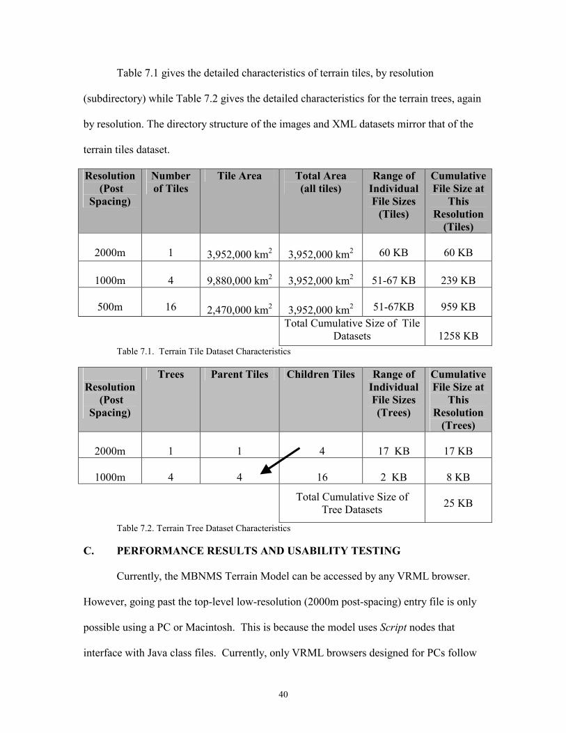
Table 7.1 gives the detailed characteristics of terrain tiles, by resolution
(subdirectory) while Table 7.2 gives the detailed characteristics for the terrain trees, again
by resolution. The directory structure of the images and XML datasets mirror that of the
terrain tiles dataset.
Resolution (Post
Spacing)
Number of Tiles
Tile Area Total Area (all tiles)
Range of Individual File Sizes
(Tiles)
Cumulative File Size at
This Resolution
(Tiles)
2000m
1 3,952,000 km2
3,952,000 km2
60 KB
60 KB
1000m
4
9,880,000 km2 3,952,000 km2
51-67 KB
239 KB
500m
16
2,470,000 km2 3,952,000 km2
51-67KB
959 KB Total Cumulative Size of Tile
Datasets
1258 KB Table 7.1. Terrain Tile Dataset Characteristics
Resolution
(Post Spacing)
Trees Parent Tiles Children Tiles Range of Individual File Sizes (Trees)
Cumulative File Size at
This Resolution
(Trees)
2000m
1
1
4
17 KB
17 KB
1000m
4
4
16
2 KB
8 KB
Total Cumulative Size of Tree Datasets
25 KB
Table 7.2. Terrain Tree Dataset Characteristics
C. PERFORMANCE RESULTS AND USABILITY TESTING
Currently, the MBNMS Terrain Model can be accessed by any VRML browser.
However, going past the top-level low-resolution (2000m post-spacing) entry file is only
possible using a PC or Macintosh. This is because the model uses Script nodes that
interface with Java class files. Currently, only VRML browsers designed for PCs follow
41
the VRML 97 specification as it pertains to Java in Script nodes (Brutzman, 98).
Therefore, the model currently does not show higher-resolution tiles with Cosmo Player
under IRIX (SGI) because it does not support Java in the Script node. This limitation is
expected to be temporary since all VRML used in the MBNMS model is compliant with
the VRML 97 specification (VRML 97, 97)
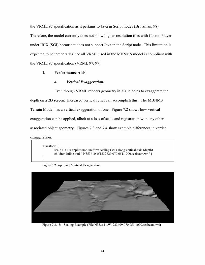
1. Performance Aids
a. Vertical Exaggeration.
Even though VRML renders geometry in 3D, it helps to exaggerate the
depth on a 2D screen. Increased vertical relief can accomplish this. The MBNMS
Terrain Model has a vertical exaggeration of one. Figure 7.2 shows how vertical
exaggeration can be applied, albeit at a loss of scale and registration with any other
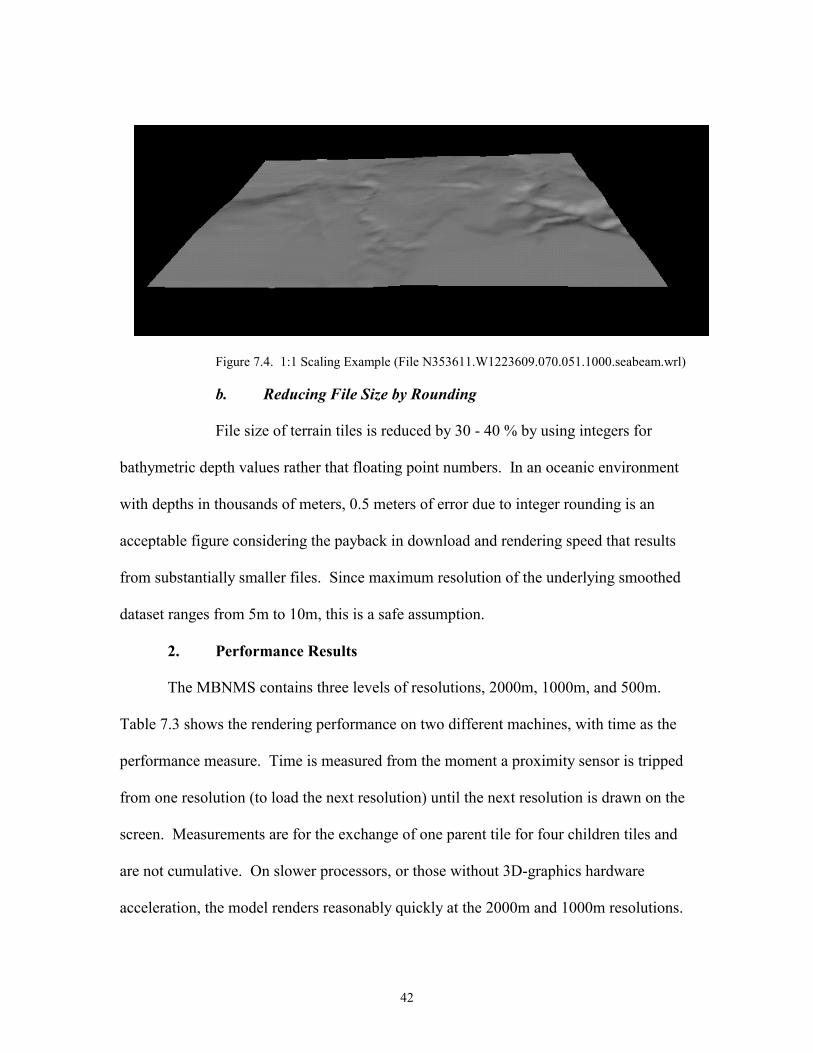
associated object geometry. Figures 7.3 and 7.4 show example differences in vertical
exaggeration.
Transform { scale 1 3 1 # applies non-uniform scaling (3:1) along vertical-axis (depth)
children Inline {url " N353610.W1232629.070.051.1000.seabeam.wrl" } } Figure 7.2 Applying Vertical Exaggeration
Figure 7.3. 3:1 Scaling Example (File N353611.W1223609.070.051.1000.seabeam.wrl)
42
Figure 7.4. 1:1 Scaling Example (File N353611.W1223609.070.051.1000.seabeam.wrl)
b. Reducing File Size by Rounding
File size of terrain tiles is reduced by 30 - 40 % by using integers for
bathymetric depth values rather that floating point numbers. In an oceanic environment
with depths in thousands of meters, 0.5 meters of error due to integer rounding is an
acceptable figure considering the payback in download and rendering speed that results
from substantially smaller files. Since maximum resolution of the underlying smoothed
dataset ranges from 5m to 10m, this is a safe assumption.
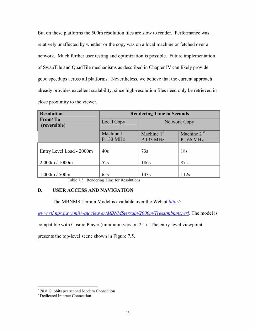
2. Performance Results
The MBNMS contains three levels of resolutions, 2000m, 1000m, and 500m.
Table 7.3 shows the rendering performance on two different machines, with time as the
performance measure. Time is measured from the moment a proximity sensor is tripped
from one resolution (to load the next resolution) until the next resolution is drawn on the
screen. Measurements are for the exchange of one parent tile for four children tiles and
are not cumulative. On slower processors, or those without 3D-graphics hardware
acceleration, the model renders reasonably quickly at the 2000m and 1000m resolutions.
43
But on these platforms the 500m resolution tiles are slow to render. Performance was
relatively unaffected by whether or the copy was on a local machine or fetched over a
network. Much further user testing and optimization is possible. Future implementation
of SwapTile and QuadTile mechanisms as described in Chapter IV can likely provide
good speedups across all platforms. Nevertheless, we believe that the current approach
already provides excellent scalability, since high-resolution files need only be retrieved in
close proximity to the viewer.
Rendering Time in Seconds Local Copy
Network Copy Resolution From/ To (reversible)
Machine 1 P 133 MHz
Machine 1∗ P 133 MHz
Machine 2 # P 166 MHz
Entry Level Load - 2000m 40s 73s 18s
2,000m / 1000m 52s 186s 87s
1,000m / 500m 65s 143s 112s Table 7.3. Rendering Time for Resolutions
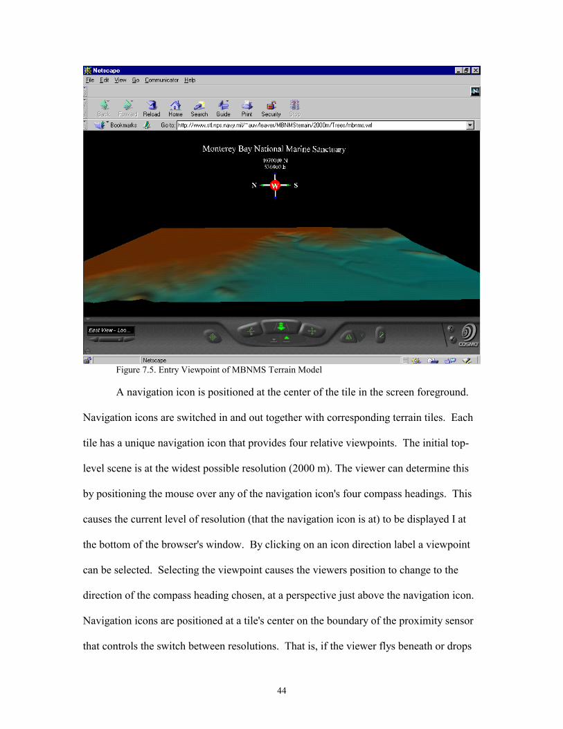
D. USER ACCESS AND NAVIGATION
The MBNMS Terrain Model is available over the Web at http://
www.stl.nps.navy.mil/~auv/leaver/MBNMSterrain/2000m/Trees/mbnms.wrl. The model is
compatible with Cosmo Player (minimum version 2.1). The entry-level viewpoint
presents the top-level scene shown in Figure 7.5.
∗ 28.8 Kilobits per second Modem Connection # Dedicated Internet Connection
44
Figure 7.5. Entry Viewpoint of MBNMS Terrain Model
A navigation icon is positioned at the center of the tile in the screen foreground.
Navigation icons are switched in and out together with corresponding terrain tiles. Each
tile has a unique navigation icon that provides four relative viewpoints. The initial top-
level scene is at the widest possible resolution (2000 m). The viewer can determine this
by positioning the mouse over any of the navigation icon's four compass headings. This
causes the current level of resolution (that the navigation icon is at) to be displayed I at
the bottom of the browser's window. By clicking on an icon direction label a viewpoint
can be selected. Selecting the viewpoint causes the viewers position to change to the
direction of the compass heading chosen, at a perspective just above the navigation icon.
Navigation icons are positioned at a tile's center on the boundary of the proximity sensor
that controls the switch between resolutions. That is, if the viewer flys beneath or drops
45
below a navigation icon, the next resolution for that tile will be switched in. Thus, a low-
resolution tile (and the tile's navigation icon) is replaced with four higher resolution tiles
(and their corresponding navigation icons). An icon can be made to disappear by
clicking on its sphere. Icons which have been made to disappear can be restored by
zooming out to a lower-resolution level and then zooming back in to reload the higher-
resolution level. The icons and switching occurs at the values shown in Table 7.3.
Resolution Switching Event (Reversible)
Switch Value (Icon Elevation)
2000m to 1000m 50,000m
1000m to 500m 25,000m Table 7. 4 Tile Switching Values (depth)
E. EXAMPLE INTEGRATION OF CONTENT
1. Georeferencing
The MBNMS Terrain Model's coordinate system is georeferenced to the UTM
coordinate system. The model is built with the VRML coordinate system origin (the
point 0,0,0 of the root node) corresponding to the baseline position of Zone 10 of the
UTM coordinate system, i.e., 0 m North, 0 m East of Zone 10. The northwest corner of
the real MBNMS is located at 4,200,000 m north and 460,000 m east (in UTM,
4,200,000N, 460,000E) of the zone 10 baseline. In VRML, the Terrain Model is
designed so that North is in the positive x direction, and East is in the positive z
direction. So, the northwest corner of the Terrain Model is located 4,200,000 units in the
positive x direction, and 460,000 units in the positive z direction. Thus, in the x-z plane,
the coordinates of the Terrain Model correspond to the real life sanctuary in terms of the
46
UTM coordinate system. The y-axis represents depth. Figure 7. 6 represents these
relationships.
Figure 7.6. Georeferencing VRML and UTM Coordinate Systems
It is worth noting that this two-stage approach to georeferencing was further necessary
because VRML 97 does not support double floating-point precision. Establishing two-
step floating-point coordinate conventions, or providing double-precision support are
important areas of effort for the GeoVRML Working Group.
2. Adding Content
Since the MBNMS Terrain Model is georeferenced with the UTM coordinate
system, adding content to a VRML scene in context with its proper location in the real
MBNMS requires just a few simple VRML statements. As Figure 7.7 shows, content can
be added in context with the MBNMS that might be at the location of 4005000 Northing
and 536000 Easting (i.e., N36d11m20s latitude, W122d35m58s longitude).
+zEast
+xNorth
+ yElevation
N
x = 4,200,000-y = depth z = 460,000 Northing = 4,200,000m Easting = 460,000m Depth = bathymetric point
{
-yDepth
NW Corner of MBNMS: x = 4,005,000 -y = depth z = 536,000 Northing = 4,005,000m Easting = 536,000m Depth = bathymetric point
{Object:

47
F. SUMMARY
This chapter describes the detailed VRML construction of the MBNMS database
and also examines the structure and the size of the datasets. A section on performance
measures how long it takes for the model to render on two different machines. Also, a
section on user access and navigation provides the web address to enable a user access
the model and information on how the model can be navigated. Finally, by
georeferencing the model with the UTM coordinate system, an example is provided to
show the user how content to the MBNMS scene can be added.

48
49
VIII. CONCLUSIONS AND RECOMMENDATIONS
A. RESEARCH CONCLUSIONS
The VRML terrain model of the Monterey Bay National Marine Sanctuary
consists of numerous terrain tiles, terrain trees, and jpg images to support three levels of
topographic resolution. Different VRML mechanisms for switching between resolutions
have been considered, with the QuadLOD selected as the primary mechanism of choice.
Relevant findings on issues regarding VRML creation, viewpoints, rendering, and
georeferencing with content are amplified below.
1. Generating VRML Syntax
To build the MBNMS model, preprocessed bathymetric data files are imported by
a Java program which positions the terrain tiles and terrain trees and exports VRML
syntax. A prerequisite effort was access to a large GIS database engine (MLML, 98).
This approach proved to be an effective method of creating VRML files for a large-scale
virtual environment.
2. Viewpoints
Extensive experimental efforts to embed native VRML viewpoints in the
individual tiles failed, for two reasons: self-describing viewpoint names are too long, and
viewpoints continued to accumulate far past any usable number.
The current model uses a navigation icon to select viewpoints and to mark
locations in the VRML world that correspond to real-life locations (e.g., the center of
each tile). One of the benefits of using navigation icons is that they can be inlined with
the tile geometry. This allows them to be switched in and out with terrain tiles;
automatically culling unneeded icons from view along with the icon's corresponding
50
terrain tile. Another benefit is that four viewpoints are attached to the icon to enable easy
viewer navigation of the model. The viewpoint nodes, while defined in the top-level
scene, are pointed to from navigation icons that are located in the terrain tiles.
The viewpoint nodes in the top-level scene contain empty description fields. If
the description field is empty, viewpoints aren't listed in the browser window.
Ordinarily, viewpoint descriptions are listed, but with the QuadLOD switching scheme
utilized by the model, four viewpoints would be listed each time a tile is switched in.
Unfortunately, the viewpoint list is not culled when tiles are dropped from view or
switched out, causing the viewpoint menu to be quickly overloaded. The navigation icon
method solves this problem since the empty description field in the viewpoint node
prevents the viewpoints from ever appearing in the viewpoint menu. It also frees up the
viewpoint menu for an author's content-related use.
3. Rendering
The MBNMS contains three levels of resolutions: 2000m, 1000m,and 500. On
slower processors, or those without hardware acceleration, the model renders reasonably
quickly at the 2,000m and 1,000m resolutions (one or two frames per second). But, on
these platforms, the 500m resolution is slow to render. This does not seem to be related
to file size of the terrain tiles or file download delays, but instead seems to be a result of
too many polygons in the scene. The QuadLOD node does cull tiles that are not visible,
so it seems the problem lies with too-high resolution tiles in the scene, given the area
covered by the scene. In other words, there are too few resolution steps nested in the tree
hierarchy. This probably might be further diagnosed and solved by starting with a lower-
51
resolution top-level scene than the 2000m spacing used, such as 4000 m spacing.
Resolution can then be increased again by a factor of two each time.
4. Georeferencing and Content
The MBNMS Terrain Model, built in the VRML coordinate system, is
georeferenced to the real sanctuary when mapped in a UTM system. By aligning the
model to the UTM coordinate system, users are able to place content in context with a
terrain environment. A few simple VRML statements added to the user's scenes are all
that's necessary to integrate geometry. However, this content is most likely at a depth
encapsulated by a high-resolution proximity sensor. As a result, if a user attempts to get
close to the object to view it in detail, the sensor will trigger, and as mentioned above,
this high resolution scenery is slow to render on some machines, making accessibility to
the object problematic.
B. RECOMMENDATIONS FOR FUTURE MBNMS TERRAIN MODEL
WORK
1. Normal Vectors to Eliminate Tile Seams
When a quad of higher resolution child tiles replaces a lower resolution parent tile
seams between the quad of tiles are sometimes noticeable. Although this is expected
when tiles of different resolutions abut one another, the seams occur even within the
quad. These tiles - and neighboring tiles of the same resolution - are in fact coplanar
because they were designed to have the same elevation points at the seams. The problem
is that normals 6 (normal vectors) for the two adjoining tile's edges are computed
differently and so the edges are shaded differently. This occurs because while the edge
6 Unless explicity specified, normals are computed by the browser. Normals are like arrows pointing straight out from a face or an edge, and determine shading.
52
for one tile might face the viewer, the edge for its neighbor might be facing away from
the viewer. Since each tile has no information about the other, the normals are computed
independently. To resolve this inconsistency, normals can be preprocessed and explicitly
included in the node's geometry for a scene. Explicitly specifying normals might also aid
in rendering speed, as it relieves the browser from the computational effort during initial
rendering. However, it will increase download time. Note that normals also have a
visible effect if texture imagery is included. A possible optimization for the next-
generation VRML specification is to allow definition solely for normals of the edge
vertices, allowing browsers to calculate internal normals.
2. Modified QuadLOD Node
The QuadLOD Node is a remarkable node - an efficient algorithm for switching
tiles that the MBNMS Terrain Model must have for proper operation. However, one
drawback from employing the current node is that when a viewer exits and re-enters the
node's proximity sensor box, the node reloads tiles already in memory. This causes
delays in rendering and another fetch for four tiles - whether they are local or over the
network. Browsers don't seem to be smart enough to yet know the difference, so a
solution might be a smarter QuadLOD node that turns off its proximity sensor when the
viewer exits the sensor's box. Such an approach could be coded using static (persistent)
classes. This would prevent the quad from being reloaded, and would allow a developer
to include descriptive viewpoints with the tiles that would not be redundantly loaded and
cumulatively bound to the scene. A separate drawback to using the QuadLOD node is
that it binds all geometry to the top-level node. For example, to include content in the
MBNMS, the content must be inlined or nested with the file containing the top-level
53
QuadLOD node. This author was unsuccessful in finding a way to do the reverse - i.e.,
inlining the MBNMS file containing the QuadLOD node with the content. This is a high
priority shortcoming which needs correction.
3. Navigation Icons to Control Other Transitions
This thesis discusses three types of switching. The first is the QuadSwapTile
method implemented by the QuadLOD node to perform switches automatically. The
other two (SwapTile and QuadTile) might be good ways for a user to decompose the
combined functionality of the QuadLOD node by allowing a user to either break a parent
tile into four children, or to simply trade a low resolution tile for a high resolution tile. If
the user might control transitions between these two alternatives, perhaps by using a
control panel attached to the navigation icon that was brought in and out with the tile, the
user might navigate and transition more easily to the desired resolution. It would also be
more efficient since the QuadTile switch might let a user continually segment a low-
resolution tile until the destination is approached and the desired locale needs to be
"blown up" to a higher-resolution tile. At this time a SwapTile transition could complete
the transitions to high-resolution local small-area tiles, saving all the download and
rendering overhead that comes with the middle resolutions in the nested hierarchy
approach. Either or both transition triggers might be attached sensors or anchors on the
navigation icon already available for user selection. A triggered QuadLOD node could
be used for the QuadTile transition, while the VisibliiyInline node (Reddy, 98) could
might be employed to switch tiles in the SwapTile transition.
54
4. Return of the Navigation Icons
Currently, a viewer can cause navigation icons to disappear by clicking on a
certain part of them. They disappear by scaling to near zero. The problem with this
approach is that the viewer can't get them back unless the tile that contains them is
reloaded. To offer a means of retrieving them, it might be better instead for them to
become nearly transparent upon user selection rather than to scale down, so that the icons
are still visible (barely) in the scene. The problem with putting a control panel elsewhere
(out of the immediate scene) is that the current scene and its geometry will be disrupted
as QuadLOD node proximity sensors are tripped and new geometry is loaded when
moving to the viewpoint.
5. Other MBNMS Model Future Work
Because the maximum resolution of the underlying smoothed dataset ranges from
five meters to 10m, it is possible to construct higher-resolution gridded datasets than the
2000m, 1000m, and 500m datasets generated for this project. Future work includes
generating higher-resolution datasets from which terrain tiles with post-spacings of 250m
and 125m tiles can be created. Even higher resolution terrain tiles might be developed as
well.
Additional work is also needed to provide functionality for the Metadata node as
applied in the MBNMS Terrain Model and to improve metadata interoperability.
C. OTHER LSVE FUTURE WORK
With the amount of digital elevation data available it may soon be possible to map
the United States as a VRML LSVE. Future work includes an automated mapping of the
entire DEM database to produce a VRML model of the continental United States.
55
Another item ripe for future efforts is the development or evaluation of tools for
converting latitude/longitude coordinates into UTM. Still more possibilities exist in
developing conventions for texture mapping, especially autogenerated textures. Finally,
future work includes establishing SEDRIS interoperability with VRML terrain models.
We forsee the day when georeferenced terrain is an expected context for all real-world
3D scenes on the Web.

56
57
APPENDIX A: SCRIPTS USED TO GRID DATA SETS
Surfer Script 1:
' *************************************' * makegrid.bas *' * Grids a bathymetric data set *' * Runs under the Surfer environment *' * Programmer: Ray McClain *' * Created: 6/98 *' *************************************
' ***** Initialize input and output data files *****DataFile$=InputBox$("Enter the data file name","MakeGrid","C:\public\vrml\batch")OutPath$="c:\public\vrml\batch\oututm.grd"
' ***** Initialize Windows app variables *****Set Surf=CreateObject("Surfer.App")
' ***** Initialize process variables *****Method=1
' ***** Grid the data *****ifSurf.GridData(DataFile$,GridMethod=1,xSize=250,ySize=250,OutGrid=OutPath$,OutFmt=2)=0 then end
58
Surfer Script 2:
' *************************************' * plotgrid.bas *' * Extracts tiles from a grid file *' * Runs under the Surfer environment *' * Programmer: Ray McClain *' * Created: 7/98 *' *************************************
printprint
' ***** Initialize the external files *****InDataFile$="C:\public\vrml\rev250.grd"DataFile$=InputBox$("Enter the data file name","Ray'sTest","C:\public\vrml\batch")
' ***** Initialize the Windows system variables *****Set Surf=CreateObject("Surfer.App")
' ****** Initialize the loop variables *****FirstRow=1LastRow=131fn = 1
' ***** Extract tiles by rows and columns *****for rows=1 to 8
FirstCol=1LastCol=77
for cols= 1 to 8
' ***** Create tile filename *****fn$=ltrim$(str$(fn))OutPath$=DataFile$+"\"+fn$+"ray250"
print OutPath$print "FirstCol = ", FirstColprint "LastCol = ", LastColprint "FirstRow = ", FirstRowprint "LastRow = ", LastRow
' ***** Extract the tile *****
59
ifSurf.GridExtract(InGrid=InDataFile$,r1=FirstRow,c1=FirstCol,r2=LastRow,c2=LastCol,OutGrid=OutPath$,OutFmt=2)=0 then end
FirstCol=LastColLastCol=LastCol+76
fn = fn +1next
FirstRow=LastRowLastRow=LastRow+130
next

60
61
APPENDIX B: SCRIPT USED TO PARTITION DATA SETS
TNTMips Script:
# *******************************************# * ll2utm.sml *# * Converts bathymetry from Lat/Lon to UTM *# * Runs under TNTMips SML environment *# * Programmer: Ray McClain *# * Created: 5/98 *# *******************************************
clear()
# ***** Open external files *****f = fopen("c:/public/vrml/sbll.asc","r")g = fopen("c:/public/vrml/sbutm.dat","w")
# ***** Select georeference parameters for source data *****print("Choose the source parameters.")source = GeorefGetParms()
print()print()
# ***** Select georeference parameters for output data *****print("Choose the destination parameters.")dest = GeorefGetParms()
print();print()
# ***** Initialize loop variables *****a = 0totalcount = 1count1 = 1
# ***** Process until end-of-file *****while(a==0) begin
# ***** Read input data file *****depth = fgetnum(f)lat= fgetnum(f)lon= fgetnum(f)
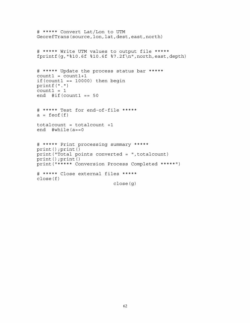
62
# ***** Convert Lat/Lon to UTMGeorefTrans(source,lon,lat,dest,east,north)
# ***** Write UTM values to output file *****fprintf(g,"%10.6f %10.6f %7.2f\n",north,east,depth)
# ***** Update the process status bar *****count1 = count1+1if(count1 == 10000) then beginprintf(".")count1 = 1end #if(count1 == 50
# ***** Test for end-of-file *****a = feof(f)
totalcount = totalcount +1end #while(a==0
# ***** Print processing summary *****print();print()print("Total points converted = ",totalcount)print();print()print("***** Conversion Process Completed *****")
# ***** Close external files *****close(f)
close(g)
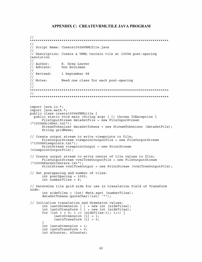
63
APPENDIX C: CREATEVRMLTILE JAVA PROGRAM
////********************************************************************************************************************************************//////// SSccrriipptt NNaammee:: CCrreeaattee11000000mmVVRRMMLLTTiillee..jjaavvaa//////// DDeessccrriippttiioonn:: CCrreeaattee aa VVRRMMLL tteerrrraaiinn ttiillee aatt 11000000mm ppoosstt--ssppaacciinnggrreessoolluuttiioonn//////// AAuutthhoorr:: RR.. GGrreegg LLeeaavveerr//// AAddvviissoorr:: DDoonn BBrruuttzzmmaann//////// RReevviisseedd:: 11 SSeepptteemmbbeerr 9988//////// NNootteess:: NNeeeedd oonnee ccllaassss ffoorr eeaacchh ppoosstt--ssppaacciinngg////////********************************************************************************************************************************************////********************************************************************************************************************************************
iimmppoorrtt jjaavvaa..iioo..**;;iimmppoorrtt jjaavvaa..mmaatthh..**;;ppuubblliicc ccllaassss ccrreeaattee11000000mmVVRRMMLLttiillee {{
ppuubblliicc ssttaattiicc vvooiidd mmaaiinn ((SSttrriinngg aarrggvv [[ ]])) tthhrroowwss IIOOEExxcceeppttiioonn {{FFiilleeIInnppuuttSSttrreeaamm ddaattaaSSeettFFiillee == nneeww FFiilleeIInnppuuttSSttrreeaamm
((""11000000mmGGrriiddSSeett..ttxxtt""));;SSttrreeaammTTookkeenniizzeerr ddaattaaSSeettTTookkeennss == nneeww SSttrreeaammTTookkeenniizzeerr ((ddaattaaSSeettFFiillee));;SSttrriinngg ggrriiddNNaammee;;
//// CCrreeaattee oouuttppuutt ssttrreeaamm ttoo wwrriittee vviieewwppooiinnttss ttoo ffiillee;;FFiilleeOOuuttppuuttSSttrreeaamm vviieewwppooiinnttOOuuttppuuttFFiillee == nneeww FFiilleeOOuuttppuuttSSttrreeaamm
((""11000000mmVViieewwppooiinnttss..ttxxtt""));;PPrriinnttSSttrreeaamm vviieewwppooiinnttOOuuttppuutt == nneeww PPrriinnttSSttrreeaamm
((vviieewwppooiinnttOOuuttppuuttFFiillee));;
//// CCrreeaattee oouuttppuutt ssttrreeaamm ttoo wwrriittee cceenntteerr ooff ttiillee vvaalluueess ttoo ffiillee;;FFiilleeOOuuttppuuttSSttrreeaamm vvrrmmllTTrreeeeOOuuttppuuttFFiillee == nneeww FFiilleeOOuuttppuuttSSttrreeaamm
((""11000000mmPPaarreennttCCeenntteerrss..ttxxtt""));;PPrriinnttSSttrreeaamm vvrrmmllTTrreeeeOOuuttppuutt == nneeww PPrriinnttSSttrreeaamm ((vvrrmmllTTrreeeeOOuuttppuuttFFiillee));;
//// SSeett ppoossttssppaacciinngg aanndd nnuummbbeerr ooff ttiilleess::iinntt ppoossttSSppaacciinngg == 11000000;;iinntt nnuummbbeerrTTiilleess == 44;;
//// DDeetteerrmmiinnee ttiillee ggrriidd ssiiddee ffoorr uussee iinn ttrraannssllaattiioonn ffiieelldd ooff TTrraannssffoorrmmnnooddee::
iinntt ssiiddeeTTiilleess == ((iinntt)) MMaatthh..ssqqrrtt ((nnuummbbeerrTTiilleess));;ddaattaaSSeettTTookkeennss..qquuootteeCChhaarr((((iinntt)) ''""''));;
//// IInniittiiaalliizzee ttrraannssllaattiioonn aanndd ddiimmeennssiioonn vvaalluueess::iinntt llaassttzzDDiimmeennssiioonn [[ ]] == nneeww iinntt [[ssiiddeeTTiilleess]];;iinntt llaassttzzTTrraannssffoorrmm [[ ]] == nneeww iinntt [[ssiiddeeTTiilleess]];;ffoorr ((iinntt ii == 00;; ii <<== ((ssiiddeeTTiilleess--11));; ii++++)) {{
llaassttzzDDiimmeennssiioonn [[ii]] == 11;;llaassttzzTTrraannssffoorrmm [[ii]] == 00;;
}}iinntt llaassttxxDDiimmeennssiioonn == 11;;iinntt llaassttxxTTrraannssffoorrmm == 00;;iinntt xxCCoouunntteerr,, zzCCoouunntteerr;;
64
iinntt xxDDiimmeennssiioonn == 00;;iinntt xxTTrraannssffoorrmm == 00;;iinntt zzTTrraannssffoorrmm == 00;;iinntt zzDDiimmeennssiioonn == 00;;
//// LLoooopp ffoorr sseettttiinngg zz ttrraannssllaattiioonn vvaalluuee::ffoorr ((zzCCoouunntteerr == 11;; zzCCoouunntteerr <<== ssiiddeeTTiilleess;; ++++ zzCCoouunntteerr)) {{
//// LLoooopp ffoorr sseettttiinngg xx ttrraannssllaattiioonn vvaalluuee::ffoorr ((xxCCoouunntteerr == 11;; xxCCoouunntteerr <<== ssiiddeeTTiilleess;; ++++ xxCCoouunntteerr)) {{ddaattaaSSeettTTookkeennss..nneexxttTTookkeenn (( ));;
//// GGeett ddaattaa ffiillee nnaammeess oonnee aatt aa ttiimmee::ggrriiddNNaammee == ddaattaaSSeettTTookkeennss..ssvvaall;;
//// PPaassss ddaattaa ffiillee nnaammee ttoo iinnppuutt ssttrreeaamm::FFiilleeIInnppuuttSSttrreeaamm ddaattaaIInnppuuttFFiillee == nneeww FFiilleeIInnppuuttSSttrreeaamm ((ggrriiddNNaammee));;SSttrreeaammTTookkeenniizzeerr ddaattaaIInnppuuttTTookkeennss == nneeww SSttrreeaammTTookkeenniizzeerr
((ddaattaaIInnppuuttFFiillee));;
//// VVaarriiaabblleess ffoorr ddaattaa iinnppuutt::ddoouubbllee mmiinnDDeepptthh,, mmaaxxDDeepptthh,, lloowweerrUUTTMMNN,, uuppppeerrUUTTMMNN,, lleeffttUUTTMMEE,,
rriigghhttUUTTMMEE,,cceenntteerrUUTTMMNN,, cceenntteerrUUTTMMEE;;SSttrriinngg ffiilleeNNaammee,, vviieewwppooiinnttNNaammee,,uulleeffttLLoonngg,, uulleeffttLLaatt,, uurriigghhttLLoonngg,, uurriigghhttLLaatt,,lllleeffttLLoonngg,, lllleeffttLLaatt,, llrriigghhttLLoonngg,, llrriigghhttLLaatt,,uulleeffttUUTTMMNN,, uulleeffttUUTTMMEE,, uurriigghhttUUTTMMNN,, uurriigghhttUUTTMMEE,,lllleeffttUUTTMMNN,, lllleeffttUUTTMMEE,, llrriigghhttUUTTMMNN,, llrriigghhttUUTTMMEE,,nnoorrtthhiinngg,, eeaassttiinngg;;
//// SSeett ppaarrsseerr ffllaagg ttoo ## aanndd bbeeggiinn ppaarrssiinngg ddaattaa ffiillee::ddaattaaIInnppuuttTTookkeennss..qquuootteeCChhaarr((((iinntt)) ''##''));;ddaattaaIInnppuuttTTookkeennss..nneexxttTTookkeenn(( ));;ddaattaaIInnppuuttTTookkeennss..nneexxttTTookkeenn(( ));;ffiilleeNNaammee == ((SSttrriinngg))ddaattaaIInnppuuttTTookkeennss..ssvvaall..ssuubbssttrriinngg((11,,4422));;ddaattaaIInnppuuttTTookkeennss..nneexxttTTookkeenn(( ));;ddaattaaIInnppuuttTTookkeennss..nneexxttTTookkeenn(( ));;ddaattaaIInnppuuttTTookkeennss..nneexxttTTookkeenn(( ));;ddaattaaIInnppuuttTTookkeennss..nneexxttTTookkeenn(( ));; uulleeffttLLaatt ==
((SSttrriinngg))ddaattaaIInnppuuttTTookkeennss..ssvvaall..ssuubbssttrriinngg((11,,99));;ddaattaaIInnppuuttTTookkeennss..nneexxttTTookkeenn(( ));; uulleeffttLLoonngg ==
((SSttrriinngg))ddaattaaIInnppuuttTTookkeennss..ssvvaall..ssuubbssttrriinngg((11,,1100));;ddaattaaIInnppuuttTTookkeennss..nneexxttTTookkeenn(( ));;ddaattaaIInnppuuttTTookkeennss..nneexxttTTookkeenn(( ));;ddaattaaIInnppuuttTTookkeennss..nneexxttTTookkeenn(( ));; uurriigghhttLLaatt ==
((SSttrriinngg))ddaattaaIInnppuuttTTookkeennss..ssvvaall..ssuubbssttrriinngg((11,,99));;ddaattaaIInnppuuttTTookkeennss..nneexxttTTookkeenn(( ));; uurriigghhttLLoonngg ==
((SSttrriinngg))ddaattaaIInnppuuttTTookkeennss..ssvvaall..ssuubbssttrriinngg((11,,1100));;ddaattaaIInnppuuttTTookkeennss..nneexxttTTookkeenn(( ));;ddaattaaIInnppuuttTTookkeennss..nneexxttTTookkeenn(( ));;ddaattaaIInnppuuttTTookkeennss..nneexxttTTookkeenn(( ));; lllleeffttLLaatt ==
((SSttrriinngg))ddaattaaIInnppuuttTTookkeennss..ssvvaall..ssuubbssttrriinngg((11,,99));;ddaattaaIInnppuuttTTookkeennss..nneexxttTTookkeenn(( ));; lllleeffttLLoonngg ==
((SSttrriinngg))ddaattaaIInnppuuttTTookkeennss..ssvvaall..ssuubbssttrriinngg((11,,1100));;ddaattaaIInnppuuttTTookkeennss..nneexxttTTookkeenn(( ));;ddaattaaIInnppuuttTTookkeennss..nneexxttTTookkeenn(( ));;ddaattaaIInnppuuttTTookkeennss..nneexxttTTookkeenn(( ));; llrriigghhttLLaatt ==
((SSttrriinngg))ddaattaaIInnppuuttTTookkeennss..ssvvaall..ssuubbssttrriinngg((11,,99));;ddaattaaIInnppuuttTTookkeennss..nneexxttTTookkeenn(( ));; llrriigghhttLLoonngg ==
((SSttrriinngg))ddaattaaIInnppuuttTTookkeennss..ssvvaall..ssuubbssttrriinngg((11,,1100));;ddaattaaIInnppuuttTTookkeennss..nneexxttTTookkeenn(( ));;ddaattaaIInnppuuttTTookkeennss..nneexxttTTookkeenn(( ));;
65
ddaattaaIInnppuuttTTookkeennss..nneexxttTTookkeenn(( ));;ddaattaaIInnppuuttTTookkeennss..nneexxttTTookkeenn(( ));;ddaattaaIInnppuuttTTookkeennss..nneexxttTTookkeenn(( ));; uulleeffttUUTTMMNN ==
((SSttrriinngg))ddaattaaIInnppuuttTTookkeennss..ssvvaall..ssuubbssttrriinngg((11,,88));;ddaattaaIInnppuuttTTookkeennss..nneexxttTTookkeenn(( ));; uulleeffttUUTTMMEE ==
((SSttrriinngg))ddaattaaIInnppuuttTTookkeennss..ssvvaall..ssuubbssttrriinngg((22,,88));;ddaattaaIInnppuuttTTookkeennss..nneexxttTTookkeenn(( ));;ddaattaaIInnppuuttTTookkeennss..nneexxttTTookkeenn(( ));;ddaattaaIInnppuuttTTookkeennss..nneexxttTTookkeenn(( ));; uurriigghhttUUTTMMNN ==
((SSttrriinngg))ddaattaaIInnppuuttTTookkeennss..ssvvaall..ssuubbssttrriinngg((11,,88));;ddaattaaIInnppuuttTTookkeennss..nneexxttTTookkeenn(( ));; uurriigghhttUUTTMMEE ==
((SSttrriinngg))ddaattaaIInnppuuttTTookkeennss..ssvvaall..ssuubbssttrriinngg((22,,88));;ddaattaaIInnppuuttTTookkeennss..nneexxttTTookkeenn(( ));;ddaattaaIInnppuuttTTookkeennss..nneexxttTTookkeenn(( ));;ddaattaaIInnppuuttTTookkeennss..nneexxttTTookkeenn(( ));; lllleeffttUUTTMMNN ==
((SSttrriinngg))ddaattaaIInnppuuttTTookkeennss..ssvvaall..ssuubbssttrriinngg((11,,88));;ddaattaaIInnppuuttTTookkeennss..nneexxttTTookkeenn(( ));; lllleeffttUUTTMMEE ==
((SSttrriinngg))ddaattaaIInnppuuttTTookkeennss..ssvvaall..ssuubbssttrriinngg((22,,88));;ddaattaaIInnppuuttTTookkeennss..nneexxttTTookkeenn(( ));;ddaattaaIInnppuuttTTookkeennss..nneexxttTTookkeenn(( ));;ddaattaaIInnppuuttTTookkeennss..nneexxttTTookkeenn(( ));; llrriigghhttUUTTMMNN ==
((SSttrriinngg))ddaattaaIInnppuuttTTookkeennss..ssvvaall..ssuubbssttrriinngg((11,,88));;ddaattaaIInnppuuttTTookkeennss..nneexxttTTookkeenn(( ));; llrriigghhttUUTTMMEE ==
((SSttrriinngg))ddaattaaIInnppuuttTTookkeennss..ssvvaall..ssuubbssttrriinngg((22,,88));;ddaattaaIInnppuuttTTookkeennss..nneexxttTTookkeenn(( ));;ddaattaaIInnppuuttTTookkeennss..nneexxttTTookkeenn(( ));;ddaattaaIInnppuuttTTookkeennss..nneexxttTTookkeenn(( ));;ddaattaaIInnppuuttTTookkeennss..nneexxttTTookkeenn(( ));;ddaattaaIInnppuuttTTookkeennss..nneexxttTTookkeenn(( ));;ddaattaaIInnppuuttTTookkeennss..nneexxttTTookkeenn(( ));;ddaattaaIInnppuuttTTookkeennss..nneexxttTTookkeenn(( ));;
//// UUnnsseett ppaarrsseerr ffllaagg::ddaattaaIInnppuuttTTookkeennss..oorrddiinnaarryyCChhaarr((((iinntt)) ''##''));;ddaattaaIInnppuuttTTookkeennss..nneexxttTTookkeenn(( ));;ddaattaaIInnppuuttTTookkeennss..nneexxttTTookkeenn(( ));; xxDDiimmeennssiioonn ==
((iinntt))ddaattaaIInnppuuttTTookkeennss..nnvvaall;;ddaattaaIInnppuuttTTookkeennss..nneexxttTTookkeenn(( ));; zzDDiimmeennssiioonn ==
((iinntt))ddaattaaIInnppuuttTTookkeennss..nnvvaall;;ddaattaaIInnppuuttTTookkeennss..nneexxttTTookkeenn(( ));;ddaattaaIInnppuuttTTookkeennss..nneexxttTTookkeenn(( ));; lleeffttUUTTMMEE == ddaattaaIInnppuuttTTookkeennss..nnvvaall;;ddaattaaIInnppuuttTTookkeennss..nneexxttTTookkeenn(( ));; rriigghhttUUTTMMEE == ddaattaaIInnppuuttTTookkeennss..nnvvaall;;ddaattaaIInnppuuttTTookkeennss..nneexxttTTookkeenn(( ));;ddaattaaIInnppuuttTTookkeennss..nneexxttTTookkeenn(( ));; uuppppeerrUUTTMMNN == ddaattaaIInnppuuttTTookkeennss..nnvvaall;;ddaattaaIInnppuuttTTookkeennss..nneexxttTTookkeenn(( ));;ddaattaaIInnppuuttTTookkeennss..nneexxttTTookkeenn(( ));;ddaattaaIInnppuuttTTookkeennss..nneexxttTTookkeenn(( ));;ddaattaaIInnppuuttTTookkeennss..nneexxttTTookkeenn(( ));; lloowweerrUUTTMMNN == ddaattaaIInnppuuttTTookkeennss..nnvvaall;;ddaattaaIInnppuuttTTookkeennss..nneexxttTTookkeenn(( ));;ddaattaaIInnppuuttTTookkeennss..nneexxttTTookkeenn(( ));;ddaattaaIInnppuuttTTookkeennss..nneexxttTTookkeenn(( ));;ddaattaaIInnppuuttTTookkeennss..nneexxttTTookkeenn(( ));;ddaattaaIInnppuuttTTookkeennss..nneexxttTTookkeenn(( ));; mmiinnDDeepptthh == ddaattaaIInnppuuttTTookkeennss..nnvvaall;;ddaattaaIInnppuuttTTookkeennss..nneexxttTTookkeenn(( ));; mmaaxxDDeepptthh == ddaattaaIInnppuuttTTookkeennss..nnvvaall;;ddaattaaIInnppuuttTTookkeennss..nneexxttTTookkeenn(( ));;
//// CCoommppuuttee cceenntteerr UUTTMM vvaalluueess::cceenntteerrUUTTMMNN == ((11000000000000))**((((uuppppeerrUUTTMMNN ++ lloowweerrUUTTMMNN))//22));;cceenntteerrUUTTMMEE == ((lleeffttUUTTMMEE ++ rriigghhttUUTTMMEE))//22;;nnoorrtthhiinngg == SSttrriinngg..vvaalluueeOOff((cceenntteerrUUTTMMNN))..ssuubbssttrriinngg((00,,77));;eeaassttiinngg == SSttrriinngg..vvaalluueeOOff((cceenntteerrUUTTMMEE))..ssuubbssttrriinngg((00,,66));;
//// RReeaadd ddaattaa aanndd ccoonnssttrruucctt iinniittiiaall aarrrraayy ffrroomm SSuurrffeerr pprrooggrraamm eexxppoorrtt::iinntt ii,, jj;;
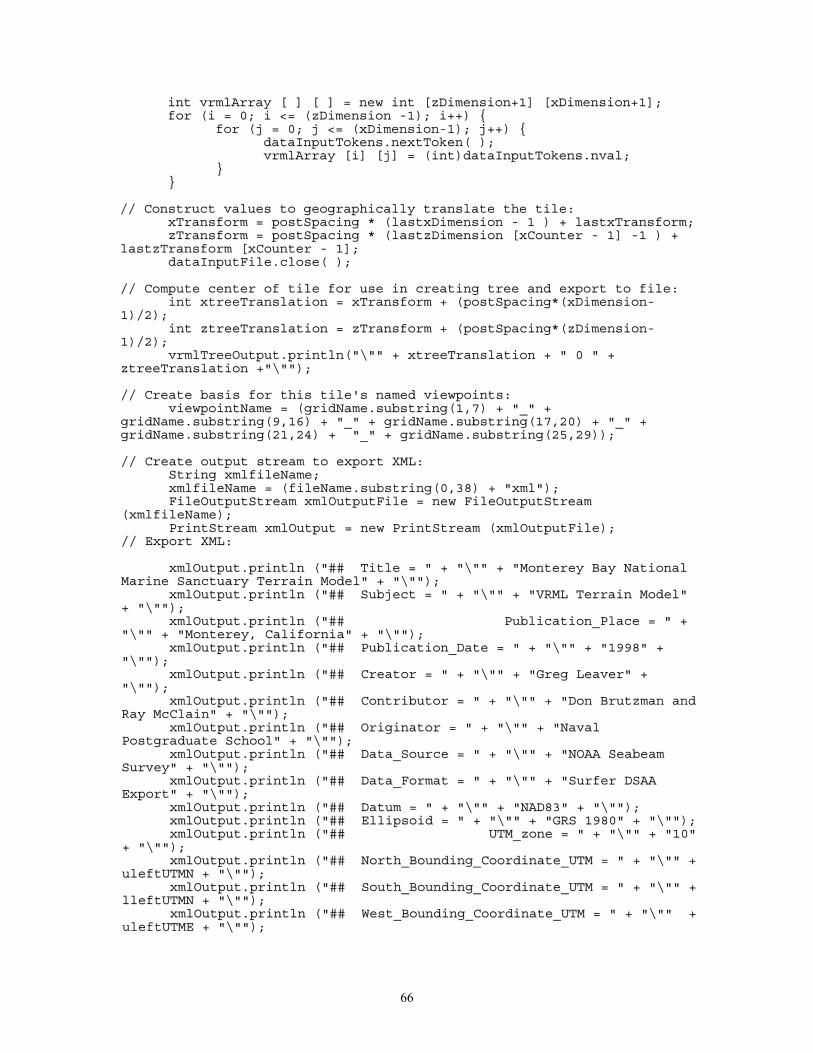
66
iinntt vvrrmmllAArrrraayy [[ ]] [[ ]] == nneeww iinntt [[zzDDiimmeennssiioonn++11]] [[xxDDiimmeennssiioonn++11]];;ffoorr ((ii == 00;; ii <<== ((zzDDiimmeennssiioonn --11));; ii++++)) {{
ffoorr ((jj == 00;; jj <<== ((xxDDiimmeennssiioonn--11));; jj++++)) {{ddaattaaIInnppuuttTTookkeennss..nneexxttTTookkeenn(( ));;vvrrmmllAArrrraayy [[ii]] [[jj]] == ((iinntt))ddaattaaIInnppuuttTTookkeennss..nnvvaall;;
}}}}
//// CCoonnssttrruucctt vvaalluueess ttoo ggeeooggrraapphhiiccaallllyy ttrraannssllaattee tthhee ttiillee::xxTTrraannssffoorrmm == ppoossttSSppaacciinngg ** ((llaassttxxDDiimmeennssiioonn -- 11 )) ++ llaassttxxTTrraannssffoorrmm;;zzTTrraannssffoorrmm == ppoossttSSppaacciinngg ** ((llaassttzzDDiimmeennssiioonn [[xxCCoouunntteerr -- 11]] --11 )) ++
llaassttzzTTrraannssffoorrmm [[xxCCoouunntteerr -- 11]];;ddaattaaIInnppuuttFFiillee..cclloossee(( ));;
//// CCoommppuuttee cceenntteerr ooff ttiillee ffoorr uussee iinn ccrreeaattiinngg ttrreeee aanndd eexxppoorrtt ttoo ffiillee::iinntt xxttrreeeeTTrraannssllaattiioonn == xxTTrraannssffoorrmm ++ ((ppoossttSSppaacciinngg**((xxDDiimmeennssiioonn--
11))//22));;iinntt zzttrreeeeTTrraannssllaattiioonn == zzTTrraannssffoorrmm ++ ((ppoossttSSppaacciinngg**((zzDDiimmeennssiioonn--
11))//22));;vvrrmmllTTrreeeeOOuuttppuutt..pprriinnttllnn((""\\"""" ++ xxttrreeeeTTrraannssllaattiioonn ++ "" 00 "" ++
zzttrreeeeTTrraannssllaattiioonn ++""\\""""));;
//// CCrreeaattee bbaassiiss ffoorr tthhiiss ttiillee''ss nnaammeedd vviieewwppooiinnttss::vviieewwppooiinnttNNaammee == ((ggrriiddNNaammee..ssuubbssttrriinngg((11,,77)) ++ ""__"" ++
ggrriiddNNaammee..ssuubbssttrriinngg((99,,1166)) ++ ""__"" ++ ggrriiddNNaammee..ssuubbssttrriinngg((1177,,2200)) ++ ""__"" ++ggrriiddNNaammee..ssuubbssttrriinngg((2211,,2244)) ++ ""__"" ++ ggrriiddNNaammee..ssuubbssttrriinngg((2255,,2299))));;
//// CCrreeaattee oouuttppuutt ssttrreeaamm ttoo eexxppoorrtt XXMMLL::SSttrriinngg xxmmllffiilleeNNaammee;;xxmmllffiilleeNNaammee == ((ffiilleeNNaammee..ssuubbssttrriinngg((00,,3388)) ++ ""xxmmll""));;FFiilleeOOuuttppuuttSSttrreeaamm xxmmllOOuuttppuuttFFiillee == nneeww FFiilleeOOuuttppuuttSSttrreeaamm
((xxmmllffiilleeNNaammee));;PPrriinnttSSttrreeaamm xxmmllOOuuttppuutt == nneeww PPrriinnttSSttrreeaamm ((xxmmllOOuuttppuuttFFiillee));;
//// EExxppoorrtt XXMMLL::
xxmmllOOuuttppuutt..pprriinnttllnn ((""#### TTiittllee == "" ++ ""\\"""" ++ ""MMoonntteerreeyy BBaayy NNaattiioonnaallMMaarriinnee SSaannccttuuaarryy TTeerrrraaiinn MMooddeell"" ++ ""\\""""));;
xxmmllOOuuttppuutt..pprriinnttllnn ((""#### SSuubbjjeecctt == "" ++ ""\\"""" ++ ""VVRRMMLL TTeerrrraaiinn MMooddeell""++ ""\\""""));;
xxmmllOOuuttppuutt..pprriinnttllnn ((""#### PPuubblliiccaattiioonn__PPllaaccee == "" ++""\\"""" ++ ""MMoonntteerreeyy,, CCaalliiffoorrnniiaa"" ++ ""\\""""));;
xxmmllOOuuttppuutt..pprriinnttllnn ((""#### PPuubblliiccaattiioonn__DDaattee == "" ++ ""\\"""" ++ ""11999988"" ++""\\""""));;
xxmmllOOuuttppuutt..pprriinnttllnn ((""#### CCrreeaattoorr == "" ++ ""\\"""" ++ ""GGrreegg LLeeaavveerr"" ++""\\""""));;
xxmmllOOuuttppuutt..pprriinnttllnn ((""#### CCoonnttrriibbuuttoorr == "" ++ ""\\"""" ++ ""DDoonn BBrruuttzzmmaann aannddRRaayy MMccCCllaaiinn"" ++ ""\\""""));;
xxmmllOOuuttppuutt..pprriinnttllnn ((""#### OOrriiggiinnaattoorr == "" ++ ""\\"""" ++ ""NNaavvaallPPoossttggrraadduuaattee SScchhooooll"" ++ ""\\""""));;
xxmmllOOuuttppuutt..pprriinnttllnn ((""#### DDaattaa__SSoouurrccee == "" ++ ""\\"""" ++ ""NNOOAAAA SSeeaabbeeaammSSuurrvveeyy"" ++ ""\\""""));;
xxmmllOOuuttppuutt..pprriinnttllnn ((""#### DDaattaa__FFoorrmmaatt == "" ++ ""\\"""" ++ ""SSuurrffeerr DDSSAAAAEExxppoorrtt"" ++ ""\\""""));;
xxmmllOOuuttppuutt..pprriinnttllnn ((""#### DDaattuumm == "" ++ ""\\"""" ++ ""NNAADD8833"" ++ ""\\""""));;xxmmllOOuuttppuutt..pprriinnttllnn ((""#### EElllliippssooiidd == "" ++ ""\\"""" ++ ""GGRRSS 11998800"" ++ ""\\""""));;xxmmllOOuuttppuutt..pprriinnttllnn ((""#### UUTTMM__zzoonnee == "" ++ ""\\"""" ++ ""1100""
++ ""\\""""));;xxmmllOOuuttppuutt..pprriinnttllnn ((""#### NNoorrtthh__BBoouunnddiinngg__CCoooorrddiinnaattee__UUTTMM == "" ++ ""\\"""" ++
uulleeffttUUTTMMNN ++ ""\\""""));;xxmmllOOuuttppuutt..pprriinnttllnn ((""#### SSoouutthh__BBoouunnddiinngg__CCoooorrddiinnaattee__UUTTMM == "" ++ ""\\"""" ++
lllleeffttUUTTMMNN ++ ""\\""""));;xxmmllOOuuttppuutt..pprriinnttllnn ((""#### WWeesstt__BBoouunnddiinngg__CCoooorrddiinnaattee__UUTTMM == "" ++ ""\\"""" ++
uulleeffttUUTTMMEE ++ ""\\""""));;
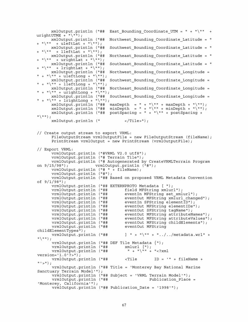
67
xxmmllOOuuttppuutt..pprriinnttllnn ((""#### EEaasstt__BBoouunnddiinngg__CCoooorrddiinnaattee__UUTTMM == "" ++ ""\\"""" ++uurriigghhttUUTTMMEE ++ ""\\""""));;
xxmmllOOuuttppuutt..pprriinnttllnn ((""#### NNoorrtthhwweesstt__BBoouunnddiinngg__CCoooorrddiinnaattee__LLaattiittuuddee == ""++ ""\\"""" ++ uulleeffttLLaatt ++ ""\\""""));;
xxmmllOOuuttppuutt..pprriinnttllnn ((""#### SSoouutthhwweesstt__BBoouunnddiinngg__CCoooorrddiinnaattee__LLaattiittuuddee == ""++ ""\\"""" ++ lllleeffttLLaatt ++ ""\\""""));;
xxmmllOOuuttppuutt..pprriinnttllnn ((""#### NNoorrtthheeaasstt__BBoouunnddiinngg__CCoooorrddiinnaattee__LLaattiittuuddee == ""++ ""\\"""" ++ uurriigghhttLLaatt ++ ""\\""""));;
xxmmllOOuuttppuutt..pprriinnttllnn ((""#### SSoouutthheeaasstt__BBoouunnddiinngg__CCoooorrddiinnaattee__LLaattiittuuddee == ""++ ""\\"""" ++ llrriigghhttLLaatt ++ ""\\""""));;
xxmmllOOuuttppuutt..pprriinnttllnn ((""#### NNoorrtthhwweesstt__BBoouunnddiinngg__CCoooorrddiinnaattee__LLoonnggiittuuddee =="" ++ ""\\"""" ++ uulleeffttLLoonngg ++ ""\\""""));;
xxmmllOOuuttppuutt..pprriinnttllnn ((""#### SSoouutthhwweesstt__BBoouunnddiinngg__CCoooorrddiinnaattee__LLoonnggiittuuddee =="" ++ ""\\"""" ++ lllleeffttLLoonngg ++ ""\\""""));;
xxmmllOOuuttppuutt..pprriinnttllnn ((""#### NNoorrtthheeaasstt__BBoouunnddiinngg__CCoooorrddiinnaattee__LLoonnggiittuuddee =="" ++ ""\\"""" ++ uurriigghhttLLoonngg ++ ""\\""""));;
xxmmllOOuuttppuutt..pprriinnttllnn ((""#### SSoouutthheeaasstt__BBoouunnddiinngg__CCoooorrddiinnaattee__LLoonnggiittuuddee =="" ++ ""\\"""" ++ llrriigghhttLLoonngg ++ ""\\""""));;
xxmmllOOuuttppuutt..pprriinnttllnn ((""#### mmaaxxDDeepptthh == "" ++ ""\\"""" ++ mmaaxxDDeepptthh ++ ""\\""""));;xxmmllOOuuttppuutt..pprriinnttllnn ((""#### mmiinnDDeepptthh == "" ++ ""\\"""" ++ mmiinnDDeepptthh ++ ""\\""""));;xxmmllOOuuttppuutt..pprriinnttllnn ((""#### ppoossttSSppaacciinngg == "" ++ ""\\"""" ++ ppoossttSSppaacciinngg ++
""\\""""));;xxmmllOOuuttppuutt..pprriinnttllnn (("" <<//TTiillee>>""));;
//// CCrreeaattee oouuttppuutt ssttrreeaamm ttoo eexxppoorrtt VVRRMMLL::FFiilleeOOuuttppuuttSSttrreeaamm vvrrmmllOOuuttppuuttFFiillee == nneeww FFiilleeOOuuttppuuttSSttrreeaamm ((ffiilleeNNaammee));;PPrriinnttSSttrreeaamm vvrrmmllOOuuttppuutt == nneeww PPrriinnttSSttrreeaamm ((vvrrmmllOOuuttppuuttFFiillee));;
//// EExxppoorrtt VVRRMMLL::vvrrmmllOOuuttppuutt..pprriinnttllnn ((""##VVRRMMLL VV22..00 uuttff88""));;vvrrmmllOOuuttppuutt..pprriinnttllnn ((""## TTeerrrraaiinn TTiillee""));;vvrrmmllOOuuttppuutt..pprriinnttllnn ((""## AAuuttooggeenneerraatteedd bbyy CCrreeaatteeVVRRMMLLTTeerrrraaiinn PPrrooggrraamm
oonn 99//1155//9988""));; vvrrmmllOOuuttppuutt..pprriinnttllnn ((""##""));;vvrrmmllOOuuttppuutt..pprriinnttllnn ((""## "" ++ ffiilleeNNaammee));;vvrrmmllOOuuttppuutt..pprriinnttllnn ((""##""));;vvrrmmllOOuuttppuutt..pprriinnttllnn ((""#### BBaasseedd oonn pprrooppoosseedd VVRRMMLL MMeettaaddaattaa CCoonnvveennttiioonn
ooff 99//11//9988""));;vvrrmmllOOuuttppuutt..pprriinnttllnn ((""#### EEXXTTEERRNNPPRROOTTOO MMeettaaddaattaa [[ ""));;vvrrmmllOOuuttppuutt..pprriinnttllnn ((""#### ffiieelldd MMFFSSttrriinngg xxmmlluurrll""));;vvrrmmllOOuuttppuutt..pprriinnttllnn ((""#### eevveennttIInn MMFFSSttrriinngg sseett__xxmmlluurrll""));;vvrrmmllOOuuttppuutt..pprriinnttllnn ((""#### eevveennttOOuutt MMFFSSttrriinngg xxmmlluurrll__cchhaannggeedd""));;vvrrmmllOOuuttppuutt..pprriinnttllnn ((""#### eevveennttIInn SSFFSSttrriinngg eelleemmeennttIIDD""));;vvrrmmllOOuuttppuutt..pprriinnttllnn ((""#### eevveennttOOuutt MMFFSSttrriinngg eelleemmeennttIIDDss""));;vvrrmmllOOuuttppuutt..pprriinnttllnn ((""#### eevveennttOOuutt SSFFSSttrriinngg ttaaggNNaammee""));;vvrrmmllOOuuttppuutt..pprriinnttllnn ((""#### eevveennttOOuutt MMFFSSttrriinngg aattttrriibbuutteeNNaammeess""));;vvrrmmllOOuuttppuutt..pprriinnttllnn ((""#### eevveennttOOuutt MMFFSSttrriinngg aattttrriibbuutteeVVaalluueess""));;vvrrmmllOOuuttppuutt..pprriinnttllnn ((""#### eevveennttOOuutt MMFFSSttrriinngg cchhiillddEElleemmeennttss""));;vvrrmmllOOuuttppuutt..pprriinnttllnn ((""#### eevveennttOOuutt MMFFSSttrriinngg
cchhiillddEElleemmeennttTTyyppeess""));;vvrrmmllOOuuttppuutt..pprriinnttllnn ((""#### ]] "" ++ ""\\"""" ++ ""....//....//mmeettaaddaattaa..wwrrll"" ++
""\\""""));;vvrrmmllOOuuttppuutt..pprriinnttllnn ((""#### DDEEFF TTiillee MMeettaaddaattaa {{""));;vvrrmmllOOuuttppuutt..pprriinnttllnn ((""#### xxmmlluurrll [[""));;vvrrmmllOOuuttppuutt..pprriinnttllnn ((""#### "" ++ ""\\"""" ++ ""<<??xxmmll
vveerrssiioonn==''11..00''??>>""));;vvrrmmllOOuuttppuutt..pprriinnttllnn ((""#### <<TTiillee IIDD == ''"" ++ ffiilleeNNaammee ++
""''>>""));;vvrrmmllOOuuttppuutt..pprriinnttllnn ((""#### TTiittllee == ''MMoonntteerreeyy BBaayy NNaattiioonnaall MMaarriinnee
SSaannccttuuaarryy TTeerrrraaiinn MMooddeell''""));;vvrrmmllOOuuttppuutt..pprriinnttllnn ((""#### SSuubbjjeecctt == ''VVRRMMLL TTeerrrraaiinn MMooddeell''""));;vvrrmmllOOuuttppuutt..pprriinnttllnn ((""#### PPuubblliiccaattiioonn__PPllaaccee ==
''MMoonntteerreeyy,, CCaalliiffoorrnniiaa''""));;vvrrmmllOOuuttppuutt..pprriinnttllnn ((""#### PPuubblliiccaattiioonn__DDaattee == ''11999988''""));;
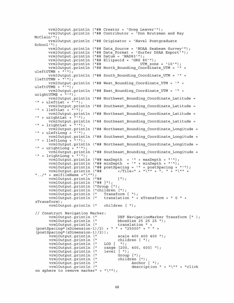
68
vvrrmmllOOuuttppuutt..pprriinnttllnn ((""#### CCrreeaattoorr == ''GGrreegg LLeeaavveerr''""));;vvrrmmllOOuuttppuutt..pprriinnttllnn ((""#### CCoonnttrriibbuuttoorr == ''DDoonn BBrruuttzzmmaann aanndd RRaayy
MMccCCllaaiinn''""));;vvrrmmllOOuuttppuutt..pprriinnttllnn ((""#### OOrriiggiinnaattoorr == ''NNaavvaall PPoossttggrraadduuaattee
SScchhooooll''""));;vvrrmmllOOuuttppuutt..pprriinnttllnn ((""#### DDaattaa__SSoouurrccee == ''NNOOAAAA SSeeaabbeeaamm SSuurrvveeyy''""));;vvrrmmllOOuuttppuutt..pprriinnttllnn ((""#### DDaattaa__FFoorrmmaatt == ''SSuurrffeerr DDSSAAAA EExxppoorrtt''""));;vvrrmmllOOuuttppuutt..pprriinnttllnn ((""#### DDaattuumm == ''NNAADD8833''""));;vvrrmmllOOuuttppuutt..pprriinnttllnn ((""#### EElllliippssooiidd == ''GGRRSS 8800''""));;vvrrmmllOOuuttppuutt..pprriinnttllnn ((""#### UUTTMM__zzoonnee == ''1100''""));;vvrrmmllOOuuttppuutt..pprriinnttllnn ((""#### NNoorrtthh__BBoouunnddiinngg__CCoooorrddiinnaattee__UUTTMM == ''"" ++
uulleeffttUUTTMMNN ++ ""''""));;vvrrmmllOOuuttppuutt..pprriinnttllnn ((""#### SSoouutthh__BBoouunnddiinngg__CCoooorrddiinnaattee__UUTTMM == ''"" ++
lllleeffttUUTTMMNN ++ ""''""));;vvrrmmllOOuuttppuutt..pprriinnttllnn ((""#### WWeesstt__BBoouunnddiinngg__CCoooorrddiinnaattee__UUTTMM == ''"" ++
uulleeffttUUTTMMEE ++ ""''""));;vvrrmmllOOuuttppuutt..pprriinnttllnn ((""#### EEaasstt__BBoouunnddiinngg__CCoooorrddiinnaattee__UUTTMM == ''"" ++
uurriigghhttUUTTMMEE ++ ""''""));;vvrrmmllOOuuttppuutt..pprriinnttllnn ((""#### NNoorrtthhwweesstt__BBoouunnddiinngg__CCoooorrddiinnaattee__LLaattiittuuddee ==
''"" ++ uulleeffttLLaatt ++ ""''""));;vvrrmmllOOuuttppuutt..pprriinnttllnn ((""#### SSoouutthhwweesstt__BBoouunnddiinngg__CCoooorrddiinnaattee__LLaattiittuuddee ==
''"" ++ lllleeffttLLaatt ++ ""''""));;vvrrmmllOOuuttppuutt..pprriinnttllnn ((""#### NNoorrtthheeaasstt__BBoouunnddiinngg__CCoooorrddiinnaattee__LLaattiittuuddee ==
''"" ++ uurriigghhttLLaatt ++ ""''""));;vvrrmmllOOuuttppuutt..pprriinnttllnn ((""#### SSoouutthheeaasstt__BBoouunnddiinngg__CCoooorrddiinnaattee__LLaattiittuuddee ==
''"" ++ llrriigghhttLLaatt ++ ""''""));;vvrrmmllOOuuttppuutt..pprriinnttllnn ((""#### NNoorrtthhwweesstt__BBoouunnddiinngg__CCoooorrddiinnaattee__LLoonnggiittuuddee ==
''"" ++ uulleeffttLLoonngg ++ ""''""));;vvrrmmllOOuuttppuutt..pprriinnttllnn ((""#### SSoouutthhwweesstt__BBoouunnddiinngg__CCoooorrddiinnaattee__LLoonnggiittuuddee ==
''"" ++ lllleeffttLLoonngg ++ ""''""));;vvrrmmllOOuuttppuutt..pprriinnttllnn ((""#### NNoorrtthheeaasstt__BBoouunnddiinngg__CCoooorrddiinnaattee__LLoonnggiittuuddee ==
''"" ++ uurriigghhttLLoonngg ++ ""''""));;vvrrmmllOOuuttppuutt..pprriinnttllnn ((""#### SSoouutthheeaasstt__BBoouunnddiinngg__CCoooorrddiinnaattee__LLoonnggiittuuddee ==
''"" ++ llrriigghhttLLoonngg ++ ""''""));;vvrrmmllOOuuttppuutt..pprriinnttllnn ((""#### mmaaxxDDeepptthh == ''"" ++ mmaaxxDDeepptthh ++ ""''""));;vvrrmmllOOuuttppuutt..pprriinnttllnn ((""#### mmiinnDDeepptthh == ''"" ++ mmiinnDDeepptthh ++ ""''""));;vvrrmmllOOuuttppuutt..pprriinnttllnn ((""#### ppoossttSSppaacciinngg == ''"" ++ ppoossttSSppaacciinngg ++ ""''""));;vvrrmmllOOuuttppuutt..pprriinnttllnn ((""#### <<//TTiillee>>"" ++ ""\\"""" ++ "",, "" ++ ""\\"""" ++
""....//"" ++ xxmmllffiilleeNNaammee ++""\\""""));;vvrrmmllOOuuttppuutt..pprriinnttllnn ((""#### ]]""));;vvrrmmllOOuuttppuutt..pprriinnttllnn ((""#### }}""));;vvrrmmllOOuuttppuutt..pprriinnttllnn ((""GGrroouupp {{""));;vvrrmmllOOuuttppuutt..pprriinnttllnn ((""cchhiillddrreenn [[""));;vvrrmmllOOuuttppuutt..pprriinnttllnn (("" TTrraannssffoorrmm {{ ""));;vvrrmmllOOuuttppuutt..pprriinnttllnn (("" ttrraannssllaattiioonn "" ++ xxTTrraannssffoorrmm ++ "" 00 "" ++
zzTTrraannssffoorrmm));;vvrrmmllOOuuttppuutt..pprriinnttllnn (("" cchhiillddrreenn [[ ""));;
//// CCoonnssttrruucctt NNaavviiggaattiioonn MMaarrkkeerr::vvrrmmllOOuuttppuutt..pprriinnttllnn (("" DDEEFF NNaavviiggaattiioonnMMaarrkkeerr TTrraannssffoorrmm {{"" ));;vvrrmmllOOuuttppuutt..pprriinnttllnn (("" bbbbooxxSSiizzee 2255 2255 2255 ""));;vvrrmmllOOuuttppuutt..pprriinnttllnn (("" ttrraannssllaattiioonn "" ++
((ppoossttSSppaacciinngg**((xxDDiimmeennssiioonn--11))//22)) ++ "" "" ++ ""2255000000"" ++ "" "" ++((ppoossttSSppaacciinngg**((zzDDiimmeennssiioonn--11))//22))));;
vvrrmmllOOuuttppuutt..pprriinnttllnn (("" ssccaallee 440000 440000 440000 ""));;vvrrmmllOOuuttppuutt..pprriinnttllnn (("" cchhiillddrreenn [[ ""));;vvrrmmllOOuuttppuutt..pprriinnttllnn (("" LLOODD {{ ""));;vvrrmmllOOuuttppuutt..pprriinnttllnn (("" rraannggee [[220000,, 440000,, 660000]] ""));;vvrrmmllOOuuttppuutt..pprriinnttllnn (("" lleevveell [[ ""));;vvrrmmllOOuuttppuutt..pprriinnttllnn (("" GGrroouupp {{""));;vvrrmmllOOuuttppuutt..pprriinnttllnn (("" cchhiillddrreenn [[""));;vvrrmmllOOuuttppuutt..pprriinnttllnn (("" AAnncchhoorr {{ ""));;vvrrmmllOOuuttppuutt..pprriinnttllnn (("" ddeessccrriippttiioonn "" ++ ""\\"""" ++ ""cclliicckk
oonn sspphheerree ttoo rreemmoovvee mmaarrkkeerr"" ++ ""\\""""));;
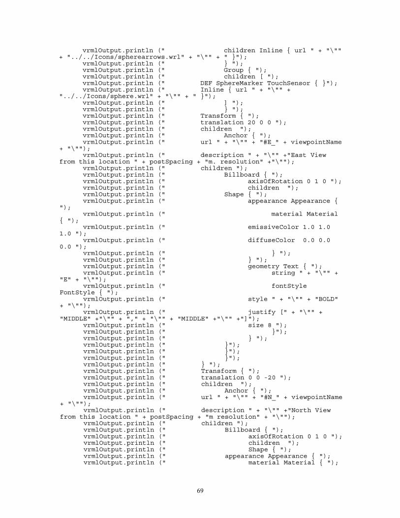
69
vvrrmmllOOuuttppuutt..pprriinnttllnn (("" cchhiillddrreenn IInnlliinnee {{ uurrll "" ++ ""\\""""++ ""....//....//IIccoonnss//sspphheerreeaarrrroowwss..wwrrll"" ++ ""\\"""" ++ "" }}""));;
vvrrmmllOOuuttppuutt..pprriinnttllnn (("" }} ""));;vvrrmmllOOuuttppuutt..pprriinnttllnn (("" GGrroouupp {{ ""));;vvrrmmllOOuuttppuutt..pprriinnttllnn (("" cchhiillddrreenn [[ ""));;vvrrmmllOOuuttppuutt..pprriinnttllnn (("" DDEEFF SSpphheerreeMMaarrkkeerr TToouucchhSSeennssoorr {{ }}""));;vvrrmmllOOuuttppuutt..pprriinnttllnn (("" IInnlliinnee {{ uurrll "" ++ ""\\"""" ++
""....//....//IIccoonnss//sspphheerree..wwrrll"" ++ ""\\"""" ++ "" }}""));;vvrrmmllOOuuttppuutt..pprriinnttllnn (("" ]] ""));;vvrrmmllOOuuttppuutt..pprriinnttllnn (("" }} ""));;vvrrmmllOOuuttppuutt..pprriinnttllnn (("" TTrraannssffoorrmm {{ ""));;vvrrmmllOOuuttppuutt..pprriinnttllnn (("" ttrraannssllaattiioonn 2200 00 00 ""));;vvrrmmllOOuuttppuutt..pprriinnttllnn (("" cchhiillddrreenn ""));;vvrrmmllOOuuttppuutt..pprriinnttllnn (("" AAnncchhoorr {{ ""));;vvrrmmllOOuuttppuutt..pprriinnttllnn (("" uurrll "" ++ ""\\"""" ++ ""##EE__"" ++ vviieewwppooiinnttNNaammee
++ ""\\""""));;vvrrmmllOOuuttppuutt..pprriinnttllnn (("" ddeessccrriippttiioonn "" ++ ""\\"""" ++""EEaasstt VViieeww
ffrroomm tthhiiss llooccaattiioonn "" ++ ppoossttSSppaacciinngg ++ ""mm.. rreessoolluuttiioonn"" ++""\\""""));;vvrrmmllOOuuttppuutt..pprriinnttllnn (("" cchhiillddrreenn ""));;vvrrmmllOOuuttppuutt..pprriinnttllnn (("" BBiillllbbooaarrdd {{ ""));;vvrrmmllOOuuttppuutt..pprriinnttllnn (("" aaxxiissOOffRRoottaattiioonn 00 11 00 ""));;vvrrmmllOOuuttppuutt..pprriinnttllnn (("" cchhiillddrreenn ""));;vvrrmmllOOuuttppuutt..pprriinnttllnn (("" SShhaappee {{ ""));;vvrrmmllOOuuttppuutt..pprriinnttllnn (("" aappppeeaarraannccee AAppppeeaarraannccee {{
""));;vvrrmmllOOuuttppuutt..pprriinnttllnn (("" mmaatteerriiaall MMaatteerriiaall
{{ ""));;vvrrmmllOOuuttppuutt..pprriinnttllnn (("" eemmiissssiivveeCCoolloorr 11..00 11..00
11..00 ""));;vvrrmmllOOuuttppuutt..pprriinnttllnn (("" ddiiffffuusseeCCoolloorr 00..00 00..00
00..00 ""));;vvrrmmllOOuuttppuutt..pprriinnttllnn (("" }} ""));;vvrrmmllOOuuttppuutt..pprriinnttllnn (("" }} ""));;vvrrmmllOOuuttppuutt..pprriinnttllnn (("" ggeeoommeettrryy TTeexxtt {{ ""));;vvrrmmllOOuuttppuutt..pprriinnttllnn (("" ssttrriinngg "" ++ ""\\"""" ++
""EE"" ++ ""\\""""));;vvrrmmllOOuuttppuutt..pprriinnttllnn (("" ffoonnttSSttyyllee
FFoonnttSSttyyllee {{ ""));;vvrrmmllOOuuttppuutt..pprriinnttllnn (("" ssttyyllee "" ++ ""\\"""" ++ ""BBOOLLDD""
++ ""\\""""));;vvrrmmllOOuuttppuutt..pprriinnttllnn (("" jjuussttiiffyy [["" ++ ""\\"""" ++
""MMIIDDDDLLEE"" ++""\\"""" ++ "",,"" ++ ""\\"""" ++ ""MMIIDDDDLLEE"" ++""\\"""" ++""]]""));;vvrrmmllOOuuttppuutt..pprriinnttllnn (("" ssiizzee 88 ""));;vvrrmmllOOuuttppuutt..pprriinnttllnn (("" }}""));;vvrrmmllOOuuttppuutt..pprriinnttllnn (("" }} ""));;vvrrmmllOOuuttppuutt..pprriinnttllnn (("" }}""));;vvrrmmllOOuuttppuutt..pprriinnttllnn (("" }}""));;vvrrmmllOOuuttppuutt..pprriinnttllnn (("" }}""));;vvrrmmllOOuuttppuutt..pprriinnttllnn (("" }} ""));;vvrrmmllOOuuttppuutt..pprriinnttllnn (("" TTrraannssffoorrmm {{ ""));;vvrrmmllOOuuttppuutt..pprriinnttllnn (("" ttrraannssllaattiioonn 00 00 --2200 ""));;vvrrmmllOOuuttppuutt..pprriinnttllnn (("" cchhiillddrreenn ""));;vvrrmmllOOuuttppuutt..pprriinnttllnn (("" AAnncchhoorr {{ ""));;vvrrmmllOOuuttppuutt..pprriinnttllnn (("" uurrll "" ++ ""\\"""" ++ ""##NN__"" ++ vviieewwppooiinnttNNaammee
++ ""\\""""));;vvrrmmllOOuuttppuutt..pprriinnttllnn (("" ddeessccrriippttiioonn "" ++ ""\\"""" ++""NNoorrtthh VViieeww
ffrroomm tthhiiss llooccaattiioonn "" ++ ppoossttSSppaacciinngg ++ ""mm rreessoolluuttiioonn"" ++ ""\\""""));;vvrrmmllOOuuttppuutt..pprriinnttllnn (("" cchhiillddrreenn ""));;vvrrmmllOOuuttppuutt..pprriinnttllnn (("" BBiillllbbooaarrdd {{ ""));;vvrrmmllOOuuttppuutt..pprriinnttllnn (("" aaxxiissOOffRRoottaattiioonn 00 11 00 ""));;vvrrmmllOOuuttppuutt..pprriinnttllnn (("" cchhiillddrreenn ""));;vvrrmmllOOuuttppuutt..pprriinnttllnn (("" SShhaappee {{ ""));;vvrrmmllOOuuttppuutt..pprriinnttllnn (("" aappppeeaarraannccee AAppppeeaarraannccee {{ ""));;vvrrmmllOOuuttppuutt..pprriinnttllnn (("" mmaatteerriiaall MMaatteerriiaall {{ ""));;
70
vvrrmmllOOuuttppuutt..pprriinnttllnn (("" eemmiissssiivveeCCoolloorr 11..0011..00 11..00 ""));;
vvrrmmllOOuuttppuutt..pprriinnttllnn (("" ddiiffffuusseeCCoolloorr 00..0000..00 00..00 ""));;
vvrrmmllOOuuttppuutt..pprriinnttllnn (("" }} ""));;vvrrmmllOOuuttppuutt..pprriinnttllnn (("" }} ""));;vvrrmmllOOuuttppuutt..pprriinnttllnn (("" ggeeoommeettrryy TTeexxtt {{ ""));;vvrrmmllOOuuttppuutt..pprriinnttllnn (("" ssttrriinngg "" ++ ""\\"""" ++ ""NN"" ++
""\\""""));;vvrrmmllOOuuttppuutt..pprriinnttllnn (("" ffoonnttSSttyyllee FFoonnttSSttyyllee {{
""));;vvrrmmllOOuuttppuutt..pprriinnttllnn (("" ssttyyllee "" ++ ""\\"""" ++
""BBOOLLDD"" ++ ""\\""""));;vvrrmmllOOuuttppuutt..pprriinnttllnn (("" jjuussttiiffyy [["" ++ ""\\""""
++ ""MMIIDDDDLLEE"" ++""\\"""" ++ "",,"" ++ ""\\"""" ++ ""MMIIDDDDLLEE"" ++""\\"""" ++""]]""));;vvrrmmllOOuuttppuutt..pprriinnttllnn (("" ssiizzee 88 ""));;vvrrmmllOOuuttppuutt..pprriinnttllnn (("" }} ""));;vvrrmmllOOuuttppuutt..pprriinnttllnn (("" }} ""));;vvrrmmllOOuuttppuutt..pprriinnttllnn (("" }} ""));;vvrrmmllOOuuttppuutt..pprriinnttllnn (("" }} ""));;vvrrmmllOOuuttppuutt..pprriinnttllnn (("" }} ""));;vvrrmmllOOuuttppuutt..pprriinnttllnn (("" }} ""));;vvrrmmllOOuuttppuutt..pprriinnttllnn (("" TTrraannssffoorrmm {{ ""));;vvrrmmllOOuuttppuutt..pprriinnttllnn (("" ttrraannssllaattiioonn 00 00 2200 ""));;vvrrmmllOOuuttppuutt..pprriinnttllnn (("" cchhiillddrreenn ""));;vvrrmmllOOuuttppuutt..pprriinnttllnn (("" AAnncchhoorr {{ ""));;vvrrmmllOOuuttppuutt..pprriinnttllnn (("" uurrll "" ++ ""\\"""" ++ ""##SS__"" ++
vviieewwppooiinnttNNaammee ++ ""\\""""));;vvrrmmllOOuuttppuutt..pprriinnttllnn (("" ddeessccrriippttiioonn "" ++ ""\\"""" ++""SSoouutthh VViieeww
ffrroomm tthhiiss llooccaattiioonn "" ++ ppoossttSSppaacciinngg ++ ""mm rreessoolluuttiioonn"" ++ ""\\""""));;vvrrmmllOOuuttppuutt..pprriinnttllnn (("" cchhiillddrreenn ""));;vvrrmmllOOuuttppuutt..pprriinnttllnn (("" BBiillllbbooaarrdd {{ ""));;vvrrmmllOOuuttppuutt..pprriinnttllnn (("" aaxxiissOOffRRoottaattiioonn 00 11 00 ""));;vvrrmmllOOuuttppuutt..pprriinnttllnn (("" cchhiillddrreenn ""));;vvrrmmllOOuuttppuutt..pprriinnttllnn (("" SShhaappee {{ ""));;vvrrmmllOOuuttppuutt..pprriinnttllnn (("" aappppeeaarraannccee AAppppeeaarraannccee {{
""));;vvrrmmllOOuuttppuutt..pprriinnttllnn (("" mmaatteerriiaall MMaatteerriiaall
{{ ""));;vvrrmmllOOuuttppuutt..pprriinnttllnn (("" eemmiissssiivveeCCoolloorr 11..00 11..00
11..00 ""));;vvrrmmllOOuuttppuutt..pprriinnttllnn (("" ddiiffffuusseeCCoolloorr 00..00 00..00
00..00 ""));;vvrrmmllOOuuttppuutt..pprriinnttllnn (("" }} ""));;vvrrmmllOOuuttppuutt..pprriinnttllnn (("" }} ""));;vvrrmmllOOuuttppuutt..pprriinnttllnn (("" ggeeoommeettrryy TTeexxtt {{ ""));;vvrrmmllOOuuttppuutt..pprriinnttllnn (("" ssttrriinngg "" ++ ""\\"""" ++
""SS"" ++ ""\\""""));;vvrrmmllOOuuttppuutt..pprriinnttllnn (("" ffoonnttSSttyyllee FFoonnttSSttyyllee {{
""));;vvrrmmllOOuuttppuutt..pprriinnttllnn (("" ssttyyllee "" ++ ""\\"""" ++ ""BBOOLLDD""
++ ""\\""""));;vvrrmmllOOuuttppuutt..pprriinnttllnn (("" jjuussttiiffyy [["" ++ ""\\"""" ++
""MMIIDDDDLLEE"" ++""\\"""" ++ "",,"" ++ ""\\"""" ++ ""MMIIDDDDLLEE"" ++""\\"""" ++""]]""));;vvrrmmllOOuuttppuutt..pprriinnttllnn (("" ssiizzee 88 ""));;vvrrmmllOOuuttppuutt..pprriinnttllnn (("" }} ""));;vvrrmmllOOuuttppuutt..pprriinnttllnn (("" }} ""));;vvrrmmllOOuuttppuutt..pprriinnttllnn (("" }} ""));;vvrrmmllOOuuttppuutt..pprriinnttllnn (("" }} ""));;vvrrmmllOOuuttppuutt..pprriinnttllnn (("" }} ""));;vvrrmmllOOuuttppuutt..pprriinnttllnn (("" }} ""));;vvrrmmllOOuuttppuutt..pprriinnttllnn (("" TTrraannssffoorrmm {{ ""));;vvrrmmllOOuuttppuutt..pprriinnttllnn (("" ttrraannssllaattiioonn --2200 00 00 ""));;vvrrmmllOOuuttppuutt..pprriinnttllnn (("" cchhiillddrreenn ""));;
71
vvrrmmllOOuuttppuutt..pprriinnttllnn (("" AAnncchhoorr {{ ""));;vvrrmmllOOuuttppuutt..pprriinnttllnn (("" uurrll "" ++ ""\\"""" ++ ""##WW__"" ++ vviieewwppooiinnttNNaammee
++ ""\\""""));;vvrrmmllOOuuttppuutt..pprriinnttllnn (("" ddeessccrriippttiioonn "" ++ ""\\"""" ++ ""WWeesstt VViieeww
ffrroomm tthhiiss llooccaattiioonn "" ++ ppoossttSSppaacciinngg ++ ""mm rreessoolluuttiioonn"" ++""\\""""));;vvrrmmllOOuuttppuutt..pprriinnttllnn (("" cchhiillddrreenn ""));;vvrrmmllOOuuttppuutt..pprriinnttllnn (("" BBiillllbbooaarrdd {{ ""));;vvrrmmllOOuuttppuutt..pprriinnttllnn (("" aaxxiissOOffRRoottaattiioonn 00 11 00 ""));;vvrrmmllOOuuttppuutt..pprriinnttllnn (("" cchhiillddrreenn ""));;vvrrmmllOOuuttppuutt..pprriinnttllnn (("" SShhaappee {{ ""));;vvrrmmllOOuuttppuutt..pprriinnttllnn (("" aappppeeaarraannccee AAppppeeaarraannccee {{
""));;vvrrmmllOOuuttppuutt..pprriinnttllnn (("" mmaatteerriiaall MMaatteerriiaall
{{ ""));;vvrrmmllOOuuttppuutt..pprriinnttllnn (("" eemmiissssiivveeCCoolloorr 11..00 11..00
11..00 ""));;vvrrmmllOOuuttppuutt..pprriinnttllnn (("" ddiiffffuusseeCCoolloorr 00..00 00..00
00..00 ""));;vvrrmmllOOuuttppuutt..pprriinnttllnn (("" }} ""));;vvrrmmllOOuuttppuutt..pprriinnttllnn (("" }} ""));;vvrrmmllOOuuttppuutt..pprriinnttllnn (("" ggeeoommeettrryy TTeexxtt {{ ""));;vvrrmmllOOuuttppuutt..pprriinnttllnn (("" ssttrriinngg "" ++ ""\\"""" ++
""WW"" ++ ""\\""""));;vvrrmmllOOuuttppuutt..pprriinnttllnn (("" ffoonnttSSttyyllee
FFoonnttSSttyyllee {{ ""));;vvrrmmllOOuuttppuutt..pprriinnttllnn (("" ssttyyllee "" ++ ""\\"""" ++ ""BBOOLLDD""
++ ""\\""""));;vvrrmmllOOuuttppuutt..pprriinnttllnn (("" jjuussttiiffyy [["" ++ ""\\"""" ++
""MMIIDDDDLLEE"" ++""\\"""" ++ "",,"" ++ ""\\"""" ++ ""MMIIDDDDLLEE"" ++""\\"""" ++""]]""));;vvrrmmllOOuuttppuutt..pprriinnttllnn (("" ssiizzee 88 ""));;vvrrmmllOOuuttppuutt..pprriinnttllnn (("" }} ""));;vvrrmmllOOuuttppuutt..pprriinnttllnn (("" }} ""));;vvrrmmllOOuuttppuutt..pprriinnttllnn (("" }} ""));;vvrrmmllOOuuttppuutt..pprriinnttllnn (("" }} ""));;vvrrmmllOOuuttppuutt..pprriinnttllnn (("" }} ""));;vvrrmmllOOuuttppuutt..pprriinnttllnn (("" }} ""));;vvrrmmllOOuuttppuutt..pprriinnttllnn (("" TTrraannssffoorrmm {{""));;vvrrmmllOOuuttppuutt..pprriinnttllnn (("" ttrraannssllaattiioonn 00 1188 00 ""));;vvrrmmllOOuuttppuutt..pprriinnttllnn (("" cchhiillddrreenn ""));;vvrrmmllOOuuttppuutt..pprriinnttllnn (("" BBiillllbbooaarrdd {{ ""));;vvrrmmllOOuuttppuutt..pprriinnttllnn (("" aaxxiissOOffRRoottaattiioonn 00 11 00 ""));;vvrrmmllOOuuttppuutt..pprriinnttllnn (("" cchhiillddrreenn ""));;vvrrmmllOOuuttppuutt..pprriinnttllnn (("" SShhaappee {{ ""));;vvrrmmllOOuuttppuutt..pprriinnttllnn (("" aappppeeaarraannccee AAppppeeaarraannccee {{
""));;vvrrmmllOOuuttppuutt..pprriinnttllnn (("" mmaatteerriiaall MMaatteerriiaall {{ ""));;vvrrmmllOOuuttppuutt..pprriinnttllnn (("" eemmiissssiivveeCCoolloorr 11..00 11..00
11..00 ""));;vvrrmmllOOuuttppuutt..pprriinnttllnn (("" ddiiffffuusseeCCoolloorr 00..00 00..00
00..00 ""));;vvrrmmllOOuuttppuutt..pprriinnttllnn (("" }} ""));;vvrrmmllOOuuttppuutt..pprriinnttllnn (("" }} ""));;vvrrmmllOOuuttppuutt..pprriinnttllnn (("" ggeeoommeettrryy TTeexxtt {{ ""));;vvrrmmllOOuuttppuutt..pprriinnttllnn (("" ssttrriinngg [["" ++ ""\\"""" ++
nnoorrtthhiinngg ++ "" NN"" ++ ""\\"""" ++ "",,"" ++ ""\\"""" ++ eeaassttiinngg ++ "" EE"" ++ ""\\"""" ++""]]""));;vvrrmmllOOuuttppuutt..pprriinnttllnn (("" ffoonnttSSttyyllee FFoonnttSSttyyllee {{
""));;vvrrmmllOOuuttppuutt..pprriinnttllnn (("" jjuussttiiffyy [["" ++ ""\\""""
++ ""MMIIDDDDLLEE"" ++""\\"""" ++ "",,"" ++ ""\\"""" ++ ""MMIIDDDDLLEE"" ++""\\"""" ++""]]""));;vvrrmmllOOuuttppuutt..pprriinnttllnn (("" ssiizzee 66 ""));;vvrrmmllOOuuttppuutt..pprriinnttllnn (("" }} ""));;vvrrmmllOOuuttppuutt..pprriinnttllnn (("" }} ""));;vvrrmmllOOuuttppuutt..pprriinnttllnn (("" }} ""));;vvrrmmllOOuuttppuutt..pprriinnttllnn (("" }} ""));;
72
vvrrmmllOOuuttppuutt..pprriinnttllnn (("" }} ""));;vvrrmmllOOuuttppuutt..pprriinnttllnn (("" ]] ""));;vvrrmmllOOuuttppuutt..pprriinnttllnn (("" }} ""));;vvrrmmllOOuuttppuutt..pprriinnttllnn (("" GGrroouupp {{""));;vvrrmmllOOuuttppuutt..pprriinnttllnn (("" cchhiillddrreenn [[""));;vvrrmmllOOuuttppuutt..pprriinnttllnn (("" AAnncchhoorr {{ ""));;vvrrmmllOOuuttppuutt..pprriinnttllnn (("" ddeessccrriippttiioonn "" ++ ""\\"""" ++ ""cclliicckk oonn bbooxx
ttoo rreemmoovvee mmaarrkkeerr"" ++ ""\\""""));;vvrrmmllOOuuttppuutt..pprriinnttllnn (("" cchhiillddrreenn IInnlliinnee {{ uurrll "" ++ ""\\""""
++""....//....//IIccoonnss//bbooxxaarrrroowwss..wwrrll"" ++ ""\\"""" ++ "" }}""));;vvrrmmllOOuuttppuutt..pprriinnttllnn (("" }} ""));;vvrrmmllOOuuttppuutt..pprriinnttllnn (("" GGrroouupp {{ ""));;vvrrmmllOOuuttppuutt..pprriinnttllnn (("" cchhiillddrreenn [[ ""));;vvrrmmllOOuuttppuutt..pprriinnttllnn (("" DDEEFF BBooxxMMaarrkkeerr TToouucchhSSeennssoorr {{
}}""));;vvrrmmllOOuuttppuutt..pprriinnttllnn (("" IInnlliinnee {{ uurrll "" ++ ""\\""""
++""//....//....//IIccoonnss//bbooxx..wwrrll"" ++ ""\\"""" ++ "" }}""));;vvrrmmllOOuuttppuutt..pprriinnttllnn (("" ]] ""));;vvrrmmllOOuuttppuutt..pprriinnttllnn (("" }} ""));;vvrrmmllOOuuttppuutt..pprriinnttllnn (("" ]] ""));;vvrrmmllOOuuttppuutt..pprriinnttllnn (("" }} ""));;vvrrmmllOOuuttppuutt..pprriinnttllnn (("" GGrroouupp {{ ""));;vvrrmmllOOuuttppuutt..pprriinnttllnn (("" cchhiillddrreenn [[ ""));;vvrrmmllOOuuttppuutt..pprriinnttllnn (("" UUSSEE BBooxxMMaarrkkeerr ""));;vvrrmmllOOuuttppuutt..pprriinnttllnn (("" IInnlliinnee {{ uurrll "" ++ ""\\""""
++""....//....//IIccoonnss//bbooxx..wwrrll"" ++ ""\\"""" ++ "" }}""));;vvrrmmllOOuuttppuutt..pprriinnttllnn (("" ]] ""));;vvrrmmllOOuuttppuutt..pprriinnttllnn (("" }} ""));;vvrrmmllOOuuttppuutt..pprriinnttllnn (("" GGrroouupp {{ }}""));;vvrrmmllOOuuttppuutt..pprriinnttllnn (("" ]] ""));;vvrrmmllOOuuttppuutt..pprriinnttllnn (("" }} ""));;vvrrmmllOOuuttppuutt..pprriinnttllnn (("" ]] ""));;vvrrmmllOOuuttppuutt..pprriinnttllnn (("" }} ""));;
//// CCoonnssttrruucctt TTooppooggrraapphhyy::vvrrmmllOOuuttppuutt..pprriinnttllnn (("" DDEEFF TTooppooggrraapphhyy TTrraannssffoorrmm {{"" ));;vvrrmmllOOuuttppuutt..pprriinnttllnn (("" ssccaallee 11 11 11""));;vvrrmmllOOuuttppuutt..pprriinnttllnn (("" cchhiillddrreenn [[ ""));;vvrrmmllOOuuttppuutt..pprriinnttllnn (("" SShhaappee {{ ""));;vvrrmmllOOuuttppuutt..pprriinnttllnn (("" aappppeeaarraannccee AAppppeeaarraannccee {{""));;vvrrmmllOOuuttppuutt..pprriinnttllnn (("" mmaatteerriiaall MMaatteerriiaall {{ }}""));;vvrrmmllOOuuttppuutt..pprriinnttllnn (("" tteexxttuurree IImmaaggeeTTeexxttuurree {{""));;vvrrmmllOOuuttppuutt..pprriinnttllnn (("" uurrll "" ++ ""\\"""" ++ ""....//IImmaaggeess//"" ++
ggrriiddNNaammee..ssuubbssttrriinngg((00,,3388)) ++ ""jjppgg"" ++ ""\\"""" ));;vvrrmmllOOuuttppuutt..pprriinnttllnn (("" }}""));;vvrrmmllOOuuttppuutt..pprriinnttllnn (("" }}""));;vvrrmmllOOuuttppuutt..pprriinnttllnn (("" ggeeoommeettrryy EElleevvaattiioonnGGrriidd {{""));;vvrrmmllOOuuttppuutt..pprriinnttllnn (("" xxDDiimmeennssiioonn "" ++ xxDDiimmeennssiioonn));;vvrrmmllOOuuttppuutt..pprriinnttllnn (("" zzDDiimmeennssiioonn "" ++ zzDDiimmeennssiioonn));;vvrrmmllOOuuttppuutt..pprriinnttllnn (("" xxSSppaacciinngg "" ++ ppoossttSSppaacciinngg));;vvrrmmllOOuuttppuutt..pprriinnttllnn (("" zzSSppaacciinngg "" ++ ppoossttSSppaacciinngg));;vvrrmmllOOuuttppuutt..pprriinnttllnn (("" ssoolliidd FFAALLSSEE""));;vvrrmmllOOuuttppuutt..pprriinnttllnn (("" ccrreeaasseeAAnnggllee 00..778855""));;vvrrmmllOOuuttppuutt..pprriinnttllnn (("" hheeiigghhtt [[""));;ffoorr ((jj == 00;; jj <<== ((zzDDiimmeennssiioonn --11));; jj++++)) {{
ffoorr ((ii == 00;; ii <<== ((xxDDiimmeennssiioonn--11));; ii++++)) {{vvrrmmllOOuuttppuutt..pprriinntt ((vvrrmmllAArrrraayy [[jj]] [[ii]] ++ "" ""));;
}}vvrrmmllOOuuttppuutt..pprriinnttllnn (());;
}}vvrrmmllOOuuttppuutt..pprriinnttllnn (("" ]]""));;vvrrmmllOOuuttppuutt..pprriinnttllnn (("" }}""));;vvrrmmllOOuuttppuutt..pprriinnttllnn (("" }}""));;vvrrmmllOOuuttppuutt..pprriinnttllnn (("" ]]""));;
73
vvrrmmllOOuuttppuutt..pprriinnttllnn (("" }}""));;vvrrmmllOOuuttppuutt..pprriinnttllnn (("" ]]""));;vvrrmmllOOuuttppuutt..pprriinnttllnn (("" }}""));;vvrrmmllOOuuttppuutt..pprriinnttllnn ((""]]""));;vvrrmmllOOuuttppuutt..pprriinnttllnn ((""}}""));;vvrrmmllOOuuttppuutt..pprriinnttllnn ((""DDEEFF TTiimmeeMMaarrkkeerr TTiimmeeSSeennssoorr {{ ""));;vvrrmmllOOuuttppuutt..pprriinnttllnn (("" ccyycclleeIInntteerrvvaall 11..00 ""));;vvrrmmllOOuuttppuutt..pprriinnttllnn (("" lloooopp FFAALLSSEE ""));;vvrrmmllOOuuttppuutt..pprriinnttllnn (("" ssttaarrttTTiimmee 00..00 ""));;vvrrmmllOOuuttppuutt..pprriinnttllnn (("" ssttooppTTiimmee 11..00 ""));;vvrrmmllOOuuttppuutt..pprriinnttllnn ((""}},, ""));;vvrrmmllOOuuttppuutt..pprriinnttllnn ((""DDEEFF SSccaalleeMMaarrkkeerr PPoossiittiioonnIInntteerrppoollaattoorr {{ ""));;vvrrmmllOOuuttppuutt..pprriinnttllnn (("" kkeeyy [[00..00 11..00]] ""));;vvrrmmllOOuuttppuutt..pprriinnttllnn (("" kkeeyyVVaalluuee [[00..0011 00..0011 00..0011,, 00..0011 00..0011 00..0011]]
""));;vvrrmmllOOuuttppuutt..pprriinnttllnn ((""}} ""));;vvrrmmllOOuuttppuutt..pprriinnttllnn ((""RROOUUTTEE BBooxxMMaarrkkeerr..ttoouucchhTTiimmee TTOO
TTiimmeeMMaarrkkeerr..sseett__ssttaarrttTTiimmee""));;vvrrmmllOOuuttppuutt..pprriinnttllnn ((""RROOUUTTEE SSpphheerreeMMaarrkkeerr..ttoouucchhTTiimmee TTOO
TTiimmeeMMaarrkkeerr..sseett__ssttaarrttTTiimmee""));;vvrrmmllOOuuttppuutt..pprriinnttllnn ((""RROOUUTTEE TTiimmeeMMaarrkkeerr..ffrraaccttiioonn__cchhaannggeedd TTOO
SSccaalleeMMaarrkkeerr..sseett__ffrraaccttiioonn""));;vvrrmmllOOuuttppuutt..pprriinnttllnn ((""RROOUUTTEE SSccaalleeMMaarrkkeerr..vvaalluuee__cchhaannggeedd TTOO
NNaavviiggaattiioonnMMaarrkkeerr..sseett__ssccaallee""));;
//// CCoonnssttrruucctt VViieewwppooiinntt llooookkiinngg NNoorrtthh::vviieewwppooiinnttOOuuttppuutt..pprriinnttllnn (("" TTrraannssffoorrmm {{""));;vviieewwppooiinnttOOuuttppuutt..pprriinnttllnn (("" rroottaattiioonn 00 11 00 00""));;vviieewwppooiinnttOOuuttppuutt..pprriinnttllnn (("" ttrraannssllaattiioonn "" ++ xxttrreeeeTTrraannssllaattiioonn ++
"" 3377550000 "" ++ zzttrreeeeTTrraannssllaattiioonn));;vviieewwppooiinnttOOuuttppuutt..pprriinnttllnn (("" cchhiillddrreenn""));;vviieewwppooiinnttOOuuttppuutt..pprriinnttllnn (("" DDEEFF NN__"" ++ vviieewwppooiinnttNNaammee ++ ""
VViieewwppooiinntt {{""));;vviieewwppooiinnttOOuuttppuutt..pprriinnttllnn (("" oorriieennttaattiioonn 11 00 00 --..3355""));;vviieewwppooiinnttOOuuttppuutt..pprriinnttllnn (("" }}""));;vviieewwppooiinnttOOuuttppuutt..pprriinnttllnn (("" }}""));;
//// CCoonnssttrruucctt VViieewwppooiinntt llooookkiinngg SSoouutthh::vviieewwppooiinnttOOuuttppuutt..pprriinnttllnn (("" TTrraannssffoorrmm {{""));;vviieewwppooiinnttOOuuttppuutt..pprriinnttllnn (("" rroottaattiioonn 00 11 00 33..1144""));;vviieewwppooiinnttOOuuttppuutt..pprriinnttllnn (("" ttrraannssllaattiioonn "" ++ xxttrreeeeTTrraannssllaattiioonn ++ ""
3377550000 "" ++ zzttrreeeeTTrraannssllaattiioonn));;vviieewwppooiinnttOOuuttppuutt..pprriinnttllnn (("" cchhiillddrreenn""));;vviieewwppooiinnttOOuuttppuutt..pprriinnttllnn (("" DDEEFF SS__"" ++ vviieewwppooiinnttNNaammee ++ ""
VViieewwppooiinntt {{""));;vviieewwppooiinnttOOuuttppuutt..pprriinnttllnn (("" oorriieennttaattiioonn 11 00 00 --..3355""));;vviieewwppooiinnttOOuuttppuutt..pprriinnttllnn (("" }}""));;vviieewwppooiinnttOOuuttppuutt..pprriinnttllnn (("" }}""));;
//// CCoonnssttrruucctt VViieewwppooiinntt llooookkiinngg EEaasstt::vviieewwppooiinnttOOuuttppuutt..pprriinnttllnn (("" TTrraannssffoorrmm {{""));;vviieewwppooiinnttOOuuttppuutt..pprriinnttllnn (("" rroottaattiioonn 00 11 00 --11..5577""));;vviieewwppooiinnttOOuuttppuutt..pprriinnttllnn (("" ttrraannssllaattiioonn "" ++ xxttrreeeeTTrraannssllaattiioonn ++ ""
3377550000 "" ++ zzttrreeeeTTrraannssllaattiioonn));;vviieewwppooiinnttOOuuttppuutt..pprriinnttllnn (("" cchhiillddrreenn""));;vviieewwppooiinnttOOuuttppuutt..pprriinnttllnn (("" DDEEFF EE__"" ++ vviieewwppooiinnttNNaammee ++ ""
VViieewwppooiinntt {{""));;vviieewwppooiinnttOOuuttppuutt..pprriinnttllnn (("" oorriieennttaattiioonn 11 00 00 --..3355""));;vviieewwppooiinnttOOuuttppuutt..pprriinnttllnn (("" }}""));;vviieewwppooiinnttOOuuttppuutt..pprriinnttllnn (("" }}""));;
//// CCoonnssttrruucctt VViieewwppooiinntt llooookkiinngg WWeesstt::vviieewwppooiinnttOOuuttppuutt..pprriinnttllnn (("" TTrraannssffoorrmm {{""));;vviieewwppooiinnttOOuuttppuutt..pprriinnttllnn (("" rroottaattiioonn 00 11 00 11..5577""));;
74
vviieewwppooiinnttOOuuttppuutt..pprriinnttllnn (("" ttrraannssllaattiioonn "" ++ xxttrreeeeTTrraannssllaattiioonn ++"" 3377550000 "" ++ zzttrreeeeTTrraannssllaattiioonn));;
vviieewwppooiinnttOOuuttppuutt..pprriinnttllnn (("" cchhiillddrreenn""));;vviieewwppooiinnttOOuuttppuutt..pprriinnttllnn (("" DDEEFF WW__"" ++ vviieewwppooiinnttNNaammee ++ ""
VViieewwppooiinntt {{""));;vviieewwppooiinnttOOuuttppuutt..pprriinnttllnn (("" oorriieennttaattiioonn 11 00 00 --..3355""));;vviieewwppooiinnttOOuuttppuutt..pprriinnttllnn (("" }}""));;vviieewwppooiinnttOOuuttppuutt..pprriinnttllnn (("" }}""));;
vvrrmmllOOuuttppuuttFFiillee..cclloossee(( ));;llaassttxxDDiimmeennssiioonn == xxDDiimmeennssiioonn;;llaassttxxTTrraannssffoorrmm == xxTTrraannssffoorrmm;;llaassttzzDDiimmeennssiioonn [[xxCCoouunntteerr -- 11]] == zzDDiimmeennssiioonn;;llaassttzzTTrraannssffoorrmm [[xxCCoouunntteerr -- 11]] == zzTTrraannssffoorrmm;;
}}llaassttxxTTrraannssffoorrmm == 00;;llaassttxxDDiimmeennssiioonn == 11;;
}}vviieewwppooiinnttOOuuttppuuttFFiillee..cclloossee(( ));;}}
}}
75
APPENDIX D: CREATEVRMLTREE JAVA PROGRAM
////********************************************************************************************************************************************//////// SSccrriipptt NNaammee:: CCrreeaattee11000000mmVVRRMMLLTTrreeee..jjaavvaa//////// DDeessccrriippttiioonn:: CCrreeaattee aa VVRRMMLL tteerrrraaiinn ttrreeee aatt 11000000mm ppoosstt--ssppaacciinnggrreessoolluuttiioonn//////// AAuutthhoorr:: RR.. GGrreegg LLeeaavveerr//// AAddvviissoorr:: DDoonn BBrruuttzzmmaann//////// RReevviisseedd:: 11 SSeepptteemmbbeerr 9988//////// NNootteess:: NNeeeedd oonnee ccllaassss ffoorr eeaacchh ppoosstt--ssppaacciinngg////////********************************************************************************************************************************************////********************************************************************************************************************************************
import java.io.*;
public class create1000mVRMLtree {public static void main (String argv [ ]) throws IOException {
// Input stream to get 500m gridded data files to create children intree:
FileInputStream dataSetFile = new FileInputStream("500mGridSet.txt");
StreamTokenizer dataSetTokens = new StreamTokenizer (dataSetFile);
// Input stream to get 1000m parent centers:FileInputStream treeSetFile = new FileInputStream
("1000mParentCenters.txt");StreamTokenizer treeSetTokens = new StreamTokenizer (treeSetFile);
// Construct and initialize array:String childArray [] = new String [16];for (int i = 0; i <=15; i++) {
dataSetTokens.nextToken( );childArray [i] = dataSetTokens.sval;
}
// Make QuadLOD children:String child1, child2, child3, child4, parent, parentCenter;int n = 4;for (int i = 1; i <=4; i++) {
child1 = (childArray [n]).substring(0,29) + ".seabeam.wrl";child2 = (childArray [n +1]).substring(0,29) +
".seabeam.wrl";child3 = (childArray [n-3]).substring(0,29) +
".seabeam.wrl";child4 = (childArray [n-4]).substring(0,29) +
".seabeam.wrl";parent = child1.substring(0,16) +
".070.051.1000.seabeam.wrl";if (i == 1 || i == 3)
n = n+2;else if (i == 2 || i == 4)
n = n+6;
76
// Obtain parentCenter from file:treeSetTokens.nextToken( );parentCenter = treeSetTokens.sval;
// Create QuadLOd tree EXTERNPROTOSString treeName;treeName = child1.substring(0,16) +
".070.051.1000.tree.wrl";FileOutputStream vrmlOutputFile = new FileOutputStream
(treeName);PrintStream vrmlOutput = new PrintStream (vrmlOutputFile);vrmlOutput.println("#VRML V2.0 utf8");vrmlOutput.println("# Terrain Tree");vrmlOutput.println("");vrmlOutput.println("EXTERNPROTO QuadLOD [ ");vrmlOutput.println("field MFString parentUrl ");vrmlOutput.println("field MFString child1Url ");vrmlOutput.println("field MFString child2Url ");vrmlOutput.println("field MFString child3Url ");vrmlOutput.println("field MFString child4Url ");vrmlOutput.println("field SFVec3f parentCenter ");vrmlOutput.println("field SFVec3f parentSize ");vrmlOutput.println("field SFVec3f switchSize ");
vrmlOutput.println("eventOut MFNode children ");vrmlOutput.println("field SFBool enabled ");vrmlOutput.println("eventIn SFBool set_enabled ");vrmlOutput.println("eventOut SFBool enabled_changed
");vrmlOutput.println("] " + "\"" + "../../QuadLOD.wrl#QuadLOD"
+ "\"");vrmlOutput.println();vrmlOutput.println("Group { ");vrmlOutput.println(" children [ ");vrmlOutput.println(" WorldInfo { title " + "\"" + "Tree
World for QuadLOD PROTO" + "\"" +"}");vrmlOutput.println(" QuadLOD { ");vrmlOutput.println(" parentUrl " + "\"" +
"1000m/Tiles/" + parent + "\"");vrmlOutput.println(" child1Url " + "\"" +
"500m/Tiles/" + child1 + "\"");vrmlOutput.println(" child2Url " + "\"" +
"500m/Tiles/" + child2 + "\"");vrmlOutput.println(" child3Url " + "\"" +
"500m/Tiles/" + child3 + "\"");vrmlOutput.println(" child4Url " + "\"" +
"500m/Tiles/" + child4 + "\"");vrmlOutput.println(" parentCenter " +
parentCenter);vrmlOutput.println(" parentSize 76000 50000
130000 ");vrmlOutput.println(" switchSize 76000 50000
130000 ");vrmlOutput.println(" } ");vrmlOutput.println(" ] ");vrmlOutput.println("} ");vrmlOutputFile.close( );
}}
}

77
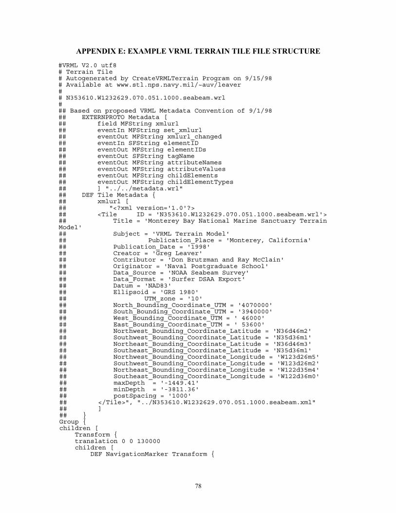
78
APPENDIX E: EXAMPLE VRML TERRAIN TILE FILE STRUCTURE
##VVRRMMLL VV22..00 uuttff88## TTeerrrraaiinn TTiillee## AAuuttooggeenneerraatteedd bbyy CCrreeaatteeVVRRMMLLTTeerrrraaiinn PPrrooggrraamm oonn 99//1155//9988## AAvvaaiillaabbllee aatt wwwwww..ssttll..nnppss..nnaavvyy..mmiill//~~aauuvv//lleeaavveerr#### NN335533661100..WW11223322662299..007700..005511..11000000..sseeaabbeeaamm..wwrrll###### BBaasseedd oonn pprrooppoosseedd VVRRMMLL MMeettaaddaattaa CCoonnvveennttiioonn ooff 99//11//9988#### EEXXTTEERRNNPPRROOTTOO MMeettaaddaattaa [[#### ffiieelldd MMFFSSttrriinngg xxmmlluurrll#### eevveennttIInn MMFFSSttrriinngg sseett__xxmmlluurrll#### eevveennttOOuutt MMFFSSttrriinngg xxmmlluurrll__cchhaannggeedd#### eevveennttIInn SSFFSSttrriinngg eelleemmeennttIIDD#### eevveennttOOuutt MMFFSSttrriinngg eelleemmeennttIIDDss#### eevveennttOOuutt SSFFSSttrriinngg ttaaggNNaammee#### eevveennttOOuutt MMFFSSttrriinngg aattttrriibbuutteeNNaammeess#### eevveennttOOuutt MMFFSSttrriinngg aattttrriibbuutteeVVaalluueess#### eevveennttOOuutt MMFFSSttrriinngg cchhiillddEElleemmeennttss#### eevveennttOOuutt MMFFSSttrriinngg cchhiillddEElleemmeennttTTyyppeess#### ]] ""....//....//mmeettaaddaattaa..wwrrll""#### DDEEFF TTiillee MMeettaaddaattaa {{#### xxmmlluurrll [[#### ""<<??xxmmll vveerrssiioonn==''11..00''??>>#### <<TTiillee IIDD == ''NN335533661100..WW11223322662299..007700..005511..11000000..sseeaabbeeaamm..wwrrll''>>#### TTiittllee == ''MMoonntteerreeyy BBaayy NNaattiioonnaall MMaarriinnee SSaannccttuuaarryy TTeerrrraaiinnMMooddeell''#### SSuubbjjeecctt == ''VVRRMMLL TTeerrrraaiinn MMooddeell''#### PPuubblliiccaattiioonn__PPllaaccee == ''MMoonntteerreeyy,, CCaalliiffoorrnniiaa''#### PPuubblliiccaattiioonn__DDaattee == ''11999988''#### CCrreeaattoorr == ''GGrreegg LLeeaavveerr''#### CCoonnttrriibbuuttoorr == ''DDoonn BBrruuttzzmmaann aanndd RRaayy MMccCCllaaiinn''#### OOrriiggiinnaattoorr == ''NNaavvaall PPoossttggrraadduuaattee SScchhooooll''#### DDaattaa__SSoouurrccee == ''NNOOAAAA SSeeaabbeeaamm SSuurrvveeyy''#### DDaattaa__FFoorrmmaatt == ''SSuurrffeerr DDSSAAAA EExxppoorrtt''#### DDaattuumm == ''NNAADD8833''#### EElllliippssooiidd == ''GGRRSS 11998800''#### UUTTMM__zzoonnee == ''1100''#### NNoorrtthh__BBoouunnddiinngg__CCoooorrddiinnaattee__UUTTMM == ''44007700000000''#### SSoouutthh__BBoouunnddiinngg__CCoooorrddiinnaattee__UUTTMM == ''33994400000000''#### WWeesstt__BBoouunnddiinngg__CCoooorrddiinnaattee__UUTTMM == '' 4466000000''#### EEaasstt__BBoouunnddiinngg__CCoooorrddiinnaattee__UUTTMM == '' 5533660000''#### NNoorrtthhwweesstt__BBoouunnddiinngg__CCoooorrddiinnaattee__LLaattiittuuddee == ''NN3366dd4466mm22''#### SSoouutthhwweesstt__BBoouunnddiinngg__CCoooorrddiinnaattee__LLaattiittuuddee == ''NN3355dd3366mm11''#### NNoorrtthheeaasstt__BBoouunnddiinngg__CCoooorrddiinnaattee__LLaattiittuuddee == ''NN3366dd4466mm33''#### SSoouutthheeaasstt__BBoouunnddiinngg__CCoooorrddiinnaattee__LLaattiittuuddee == ''NN3355dd3366mm11''#### NNoorrtthhwweesstt__BBoouunnddiinngg__CCoooorrddiinnaattee__LLoonnggiittuuddee == ''WW112233dd2266mm55''#### SSoouutthhwweesstt__BBoouunnddiinngg__CCoooorrddiinnaattee__LLoonnggiittuuddee == ''WW112233dd2266mm22''#### NNoorrtthheeaasstt__BBoouunnddiinngg__CCoooorrddiinnaattee__LLoonnggiittuuddee == ''WW112222dd3355mm44''#### SSoouutthheeaasstt__BBoouunnddiinngg__CCoooorrddiinnaattee__LLoonnggiittuuddee == ''WW112222dd3366mm00''#### mmaaxxDDeepptthh == ''--11444499..4411''#### mmiinnDDeepptthh == ''--33881111..3366''#### ppoossttSSppaacciinngg == ''11000000''#### <<//TTiillee>>"",, ""....//NN335533661100..WW11223322662299..007700..005511..11000000..sseeaabbeeaamm..xxmmll""#### ]]#### }}GGrroouupp {{cchhiillddrreenn [[
TTrraannssffoorrmm {{ttrraannssllaattiioonn 00 00 113300000000cchhiillddrreenn [[
DDEEFF NNaavviiggaattiioonnMMaarrkkeerr TTrraannssffoorrmm {{
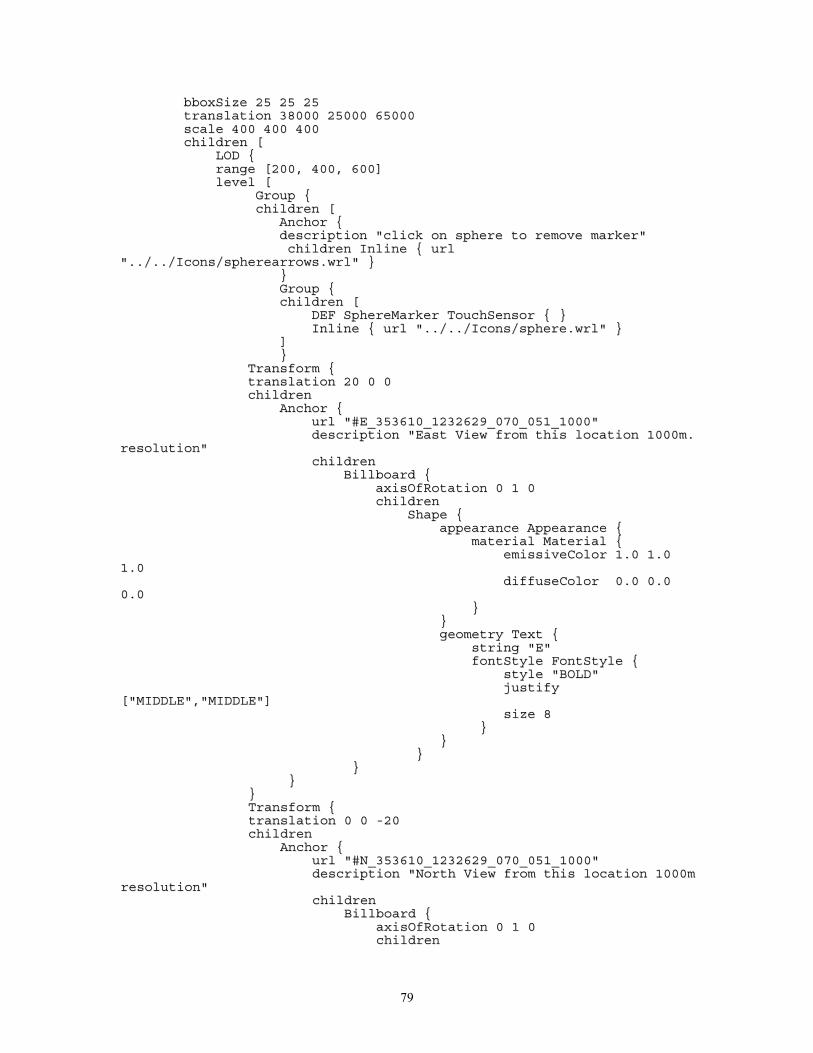
79
bbbbooxxSSiizzee 2255 2255 2255ttrraannssllaattiioonn 3388000000 2255000000 6655000000ssccaallee 440000 440000 440000cchhiillddrreenn [[
LLOODD {{rraannggee [[220000,, 440000,, 660000]]lleevveell [[
GGrroouupp {{cchhiillddrreenn [[
AAnncchhoorr {{ddeessccrriippttiioonn ""cclliicckk oonn sspphheerree ttoo rreemmoovvee mmaarrkkeerr""cchhiillddrreenn IInnlliinnee {{ uurrll
""....//....//IIccoonnss//sspphheerreeaarrrroowwss..wwrrll"" }}}}GGrroouupp {{cchhiillddrreenn [[
DDEEFF SSpphheerreeMMaarrkkeerr TToouucchhSSeennssoorr {{ }}IInnlliinnee {{ uurrll ""....//....//IIccoonnss//sspphheerree..wwrrll"" }}
]]}}
TTrraannssffoorrmm {{ttrraannssllaattiioonn 2200 00 00cchhiillddrreenn
AAnncchhoorr {{uurrll ""##EE__335533661100__11223322662299__007700__005511__11000000""ddeessccrriippttiioonn ""EEaasstt VViieeww ffrroomm tthhiiss llooccaattiioonn 11000000mm..
rreessoolluuttiioonn""cchhiillddrreenn
BBiillllbbooaarrdd {{aaxxiissOOffRRoottaattiioonn 00 11 00cchhiillddrreenn
SShhaappee {{aappppeeaarraannccee AAppppeeaarraannccee {{
mmaatteerriiaall MMaatteerriiaall {{eemmiissssiivveeCCoolloorr 11..00 11..00
11..00ddiiffffuusseeCCoolloorr 00..00 00..00
00..00}}
}}ggeeoommeettrryy TTeexxtt {{
ssttrriinngg ""EE""ffoonnttSSttyyllee FFoonnttSSttyyllee {{
ssttyyllee ""BBOOLLDD""jjuussttiiffyy
[[""MMIIDDDDLLEE"",,""MMIIDDDDLLEE""]]ssiizzee 88
}}}}
}}}}
}}}}TTrraannssffoorrmm {{ttrraannssllaattiioonn 00 00 --2200cchhiillddrreenn
AAnncchhoorr {{uurrll ""##NN__335533661100__11223322662299__007700__005511__11000000""ddeessccrriippttiioonn ""NNoorrtthh VViieeww ffrroomm tthhiiss llooccaattiioonn 11000000mm
rreessoolluuttiioonn""cchhiillddrreenn
BBiillllbbooaarrdd {{aaxxiissOOffRRoottaattiioonn 00 11 00cchhiillddrreenn
80
SShhaappee {{aappppeeaarraannccee AAppppeeaarraannccee {{
mmaatteerriiaall MMaatteerriiaall {{eemmiissssiivveeCCoolloorr 11..00 11..00 11..00ddiiffffuusseeCCoolloorr 00..00 00..00 00..00
}}}}ggeeoommeettrryy TTeexxtt {{
ssttrriinngg ""NN""ffoonnttSSttyyllee FFoonnttSSttyyllee {{
ssttyyllee ""BBOOLLDD""jjuussttiiffyy [[""MMIIDDDDLLEE"",,""MMIIDDDDLLEE""]]ssiizzee 88
}}}}
}}}}
}}}}TTrraannssffoorrmm {{ttrraannssllaattiioonn 00 00 2200cchhiillddrreenn
AAnncchhoorr {{uurrll ""##SS__335533661100__11223322662299__007700__005511__11000000""
ddeessccrriippttiioonn ""SSoouutthh VViieeww ffrroomm tthhiiss llooccaattiioonn 11000000mmrreessoolluuttiioonn""
cchhiillddrreennBBiillllbbooaarrdd {{
aaxxiissOOffRRoottaattiioonn 00 11 00cchhiillddrreenn
SShhaappee {{aappppeeaarraannccee AAppppeeaarraannccee {{
mmaatteerriiaall MMaatteerriiaall {{eemmiissssiivveeCCoolloorr 11..00 11..00
11..00ddiiffffuusseeCCoolloorr 00..00 00..00
00..00}}
}}ggeeoommeettrryy TTeexxtt {{
ssttrriinngg ""SS""ffoonnttSSttyyllee FFoonnttSSttyyllee {{ssttyyllee ""BBOOLLDD""jjuussttiiffyy
[[""MMIIDDDDLLEE"",,""MMIIDDDDLLEE""]]ssiizzee 88
}}}}
}}}}
}}}}TTrraannssffoorrmm {{ttrraannssllaattiioonn --2200 00 00cchhiillddrreenn
AAnncchhoorr {{uurrll ""##WW__335533661100__11223322662299__007700__005511__11000000""ddeessccrriippttiioonn ""WWeesstt VViieeww ffrroomm tthhiiss llooccaattiioonn 11000000mm
rreessoolluuttiioonn""cchhiillddrreenn
BBiillllbbooaarrdd {{aaxxiissOOffRRoottaattiioonn 00 11 00cchhiillddrreenn
SShhaappee {{
81
aappppeeaarraannccee AAppppeeaarraannccee {{mmaatteerriiaall MMaatteerriiaall {{
eemmiissssiivveeCCoolloorr 11..00 11..0011..00
ddiiffffuusseeCCoolloorr 00..00 00..0000..00
}}}}ggeeoommeettrryy TTeexxtt {{
ssttrriinngg ""WW""ffoonnttSSttyyllee FFoonnttSSttyyllee {{
ssttyyllee ""BBOOLLDD""jjuussttiiffyy
[[""MMIIDDDDLLEE"",,""MMIIDDDDLLEE""]]ssiizzee 88
}}}}
}}}}
}}}}TTrraannssffoorrmm {{
ttrraannssllaattiioonn 00 1188 00cchhiillddrreenn
BBiillllbbooaarrdd {{aaxxiissOOffRRoottaattiioonn 00 11 00cchhiillddrreenn
SShhaappee {{aappppeeaarraannccee AAppppeeaarraannccee {{
mmaatteerriiaall MMaatteerriiaall {{eemmiissssiivveeCCoolloorr 11..00 11..00 11..00ddiiffffuusseeCCoolloorr 00..00 00..00 00..00
}}}}ggeeoommeettrryy TTeexxtt {{
ssttrriinngg [[""44000055000000 NN"",,""449988000000 EE""]]ffoonnttSSttyyllee FFoonnttSSttyyllee {{
jjuussttiiffyy [[""MMIIDDDDLLEE"",,""MMIIDDDDLLEE""]]ssiizzee 66
}}}}
}}}}
}}]]}}
GGrroouupp {{cchhiillddrreenn [[
AAnncchhoorr {{ddeessccrriippttiioonn ""cclliicckk oonn bbooxx ttoo rreemmoovvee mmaarrkkeerr""cchhiillddrreenn IInnlliinnee {{ uurrll ""....//....//IIccoonnss//bbooxxaarrrroowwss..wwrrll"" }}}}GGrroouupp {{cchhiillddrreenn [[
DDEEFF BBooxxMMaarrkkeerr TToouucchhSSeennssoorr {{ }}IInnlliinnee {{ uurrll ""//....//....//IIccoonnss//bbooxx..wwrrll"" }}
]]}}
]]}}GGrroouupp {{cchhiillddrreenn [[
UUSSEE BBooxxMMaarrkkeerrIInnlliinnee {{ uurrll ""....//....//IIccoonnss//bbooxx..wwrrll"" }}
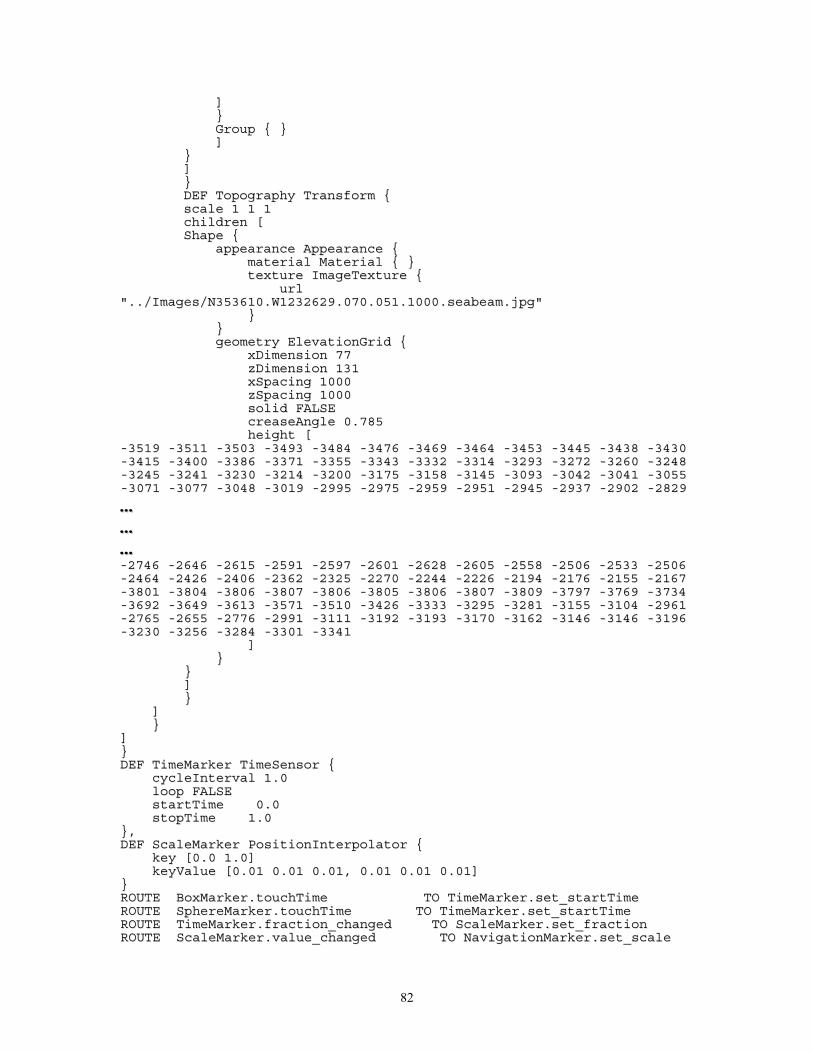
82
]]}}GGrroouupp {{ }}]]
}}]]}}DDEEFF TTooppooggrraapphhyy TTrraannssffoorrmm {{ssccaallee 11 11 11cchhiillddrreenn [[SShhaappee {{
aappppeeaarraannccee AAppppeeaarraannccee {{mmaatteerriiaall MMaatteerriiaall {{ }}tteexxttuurree IImmaaggeeTTeexxttuurree {{
uurrll""....//IImmaaggeess//NN335533661100..WW11223322662299..007700..005511..11000000..sseeaabbeeaamm..jjppgg""
}}}}ggeeoommeettrryy EElleevvaattiioonnGGrriidd {{
xxDDiimmeennssiioonn 7777zzDDiimmeennssiioonn 113311xxSSppaacciinngg 11000000zzSSppaacciinngg 11000000ssoolliidd FFAALLSSEEccrreeaasseeAAnnggllee 00..778855hheeiigghhtt [[
--33551199 --33551111 --33550033 --33449933 --33448844 --33447766 --33446699 --33446644 --33445533 --33444455 --33443388 --33443300--33441155 --33440000 --33338866 --33337711 --33335555 --33334433 --33333322 --33331144 --33229933 --33227722 --33226600 --33224488--33224455 --33224411 --33223300 --33221144 --33220000 --33117755 --33115588 --33114455 --33009933 --33004422 --33004411 --33005555--33007711 --33007777 --33004488 --33001199 --22999955 --22997755 --22995599 --22995511 --22994455 --22993377 --22990022 --22882299
………………--22774466 --22664466 --22661155 --22559911 --22559977 --22660011 --22662288 --22660055 --22555588 --22550066 --22553333 --22550066--22446644 --22442266 --22440066 --22336622 --22332255 --22227700 --22224444 --22222266 --22119944 --22117766 --22115555 --22116677--33880011 --33880044 --33880066 --33880077 --33880066 --33880055 --33880066 --33880077 --33880099 --33779977 --33776699 --33773344--33669922 --33664499 --33661133 --33557711 --33551100 --33442266 --33333333 --33229955 --33228811 --33115555 --33110044 --22996611--22776655 --22665555 --22777766 --22999911 --33111111 --33119922 --33119933 --33117700 --33116622 --33114466 --33114466 --33119966--33223300 --33225566 --33228844 --33330011 --33334411
]]}}
}}]]}}
]]}}
]]}}DDEEFF TTiimmeeMMaarrkkeerr TTiimmeeSSeennssoorr {{
ccyycclleeIInntteerrvvaall 11..00lloooopp FFAALLSSEEssttaarrttTTiimmee 00..00ssttooppTTiimmee 11..00
}},,DDEEFF SSccaalleeMMaarrkkeerr PPoossiittiioonnIInntteerrppoollaattoorr {{
kkeeyy [[00..00 11..00]]kkeeyyVVaalluuee [[00..0011 00..0011 00..0011,, 00..0011 00..0011 00..0011]]
}}RROOUUTTEE BBooxxMMaarrkkeerr..ttoouucchhTTiimmee TTOO TTiimmeeMMaarrkkeerr..sseett__ssttaarrttTTiimmeeRROOUUTTEE SSpphheerreeMMaarrkkeerr..ttoouucchhTTiimmee TTOO TTiimmeeMMaarrkkeerr..sseett__ssttaarrttTTiimmeeRROOUUTTEE TTiimmeeMMaarrkkeerr..ffrraaccttiioonn__cchhaannggeedd TTOO SSccaalleeMMaarrkkeerr..sseett__ffrraaccttiioonnRROOUUTTEE SSccaalleeMMaarrkkeerr..vvaalluuee__cchhaannggeedd TTOO NNaavviiggaattiioonnMMaarrkkeerr..sseett__ssccaallee

83
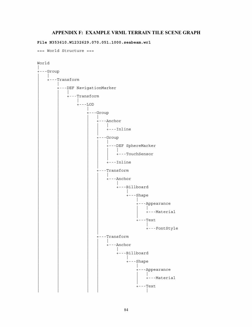
84
APPENDIX F: EXAMPLE VRML TERRAIN TILE SCENE GRAPH
File N353610.W1232629.070.051.1000.seabeam.wrl
=== World Structure ===
World|+---Group| || +---Transform| || +---DEF NavigationMarker| | || | +---Transform| | || | +---LOD| | || | +---Group| | | || | | +---Anchor| | | | || | | | +---Inline| | | || | | +---Group| | | | || | | | +---DEF SphereMarker| | | | | || | | | | +---TouchSensor| | | | || | | | +---Inline| | | || | | +---Transform| | | | || | | | +---Anchor| | | | || | | | +---Billboard| | | | || | | | +---Shape| | | | || | | | +---Appearance| | | | | || | | | | +---Material| | | | || | | | +---Text| | | | || | | | +---FontStyle| | | || | | +---Transform| | | | || | | | +---Anchor| | | | || | | | +---Billboard| | | | || | | | +---Shape| | | | || | | | +---Appearance| | | | | || | | | | +---Material| | | | || | | | +---Text| | | | |
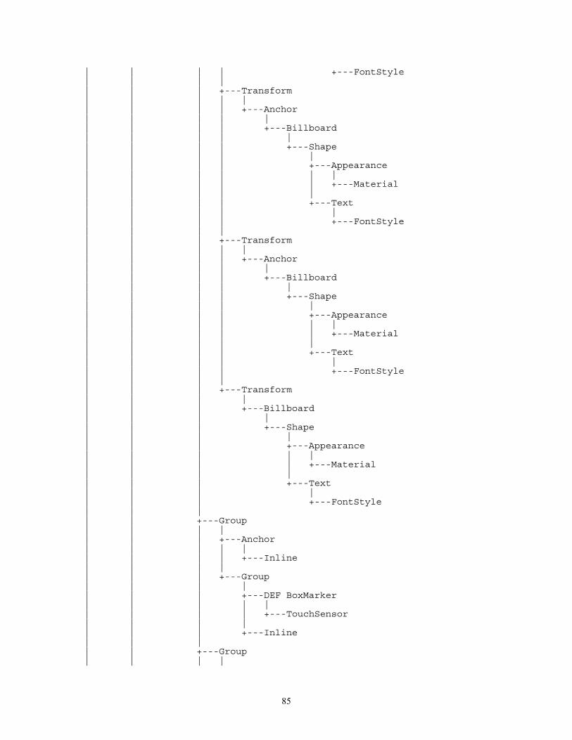
85
| | | | +---FontStyle| | | || | | +---Transform| | | | || | | | +---Anchor| | | | || | | | +---Billboard| | | | || | | | +---Shape| | | | || | | | +---Appearance| | | | | || | | | | +---Material| | | | || | | | +---Text| | | | || | | | +---FontStyle| | | || | | +---Transform| | | | || | | | +---Anchor| | | | || | | | +---Billboard| | | | || | | | +---Shape| | | | || | | | +---Appearance| | | | | || | | | | +---Material| | | | || | | | +---Text| | | | || | | | +---FontStyle| | | || | | +---Transform| | | || | | +---Billboard| | | || | | +---Shape| | | || | | +---Appearance| | | | || | | | +---Material| | | || | | +---Text| | | || | | +---FontStyle| | || | +---Group| | | || | | +---Anchor| | | | || | | | +---Inline| | | || | | +---Group| | | || | | +---DEF BoxMarker| | | | || | | | +---TouchSensor| | | || | | +---Inline| | || | +---Group| | | |
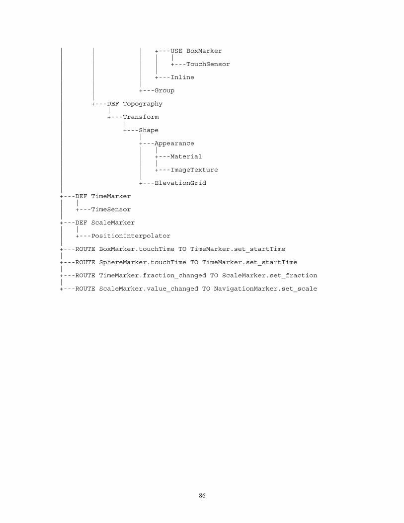
86
| | | +---USE BoxMarker| | | | || | | | +---TouchSensor| | | || | | +---Inline| | || | +---Group| || +---DEF Topography| || +---Transform| || +---Shape| || +---Appearance| | || | +---Material| | || | +---ImageTexture| || +---ElevationGrid|+---DEF TimeMarker| || +---TimeSensor|+---DEF ScaleMarker| || +---PositionInterpolator|+---ROUTE BoxMarker.touchTime TO TimeMarker.set_startTime|+---ROUTE SphereMarker.touchTime TO TimeMarker.set_startTime|+---ROUTE TimeMarker.fraction_changed TO ScaleMarker.set_fraction|+---ROUTE ScaleMarker.value_changed TO NavigationMarker.set_scale
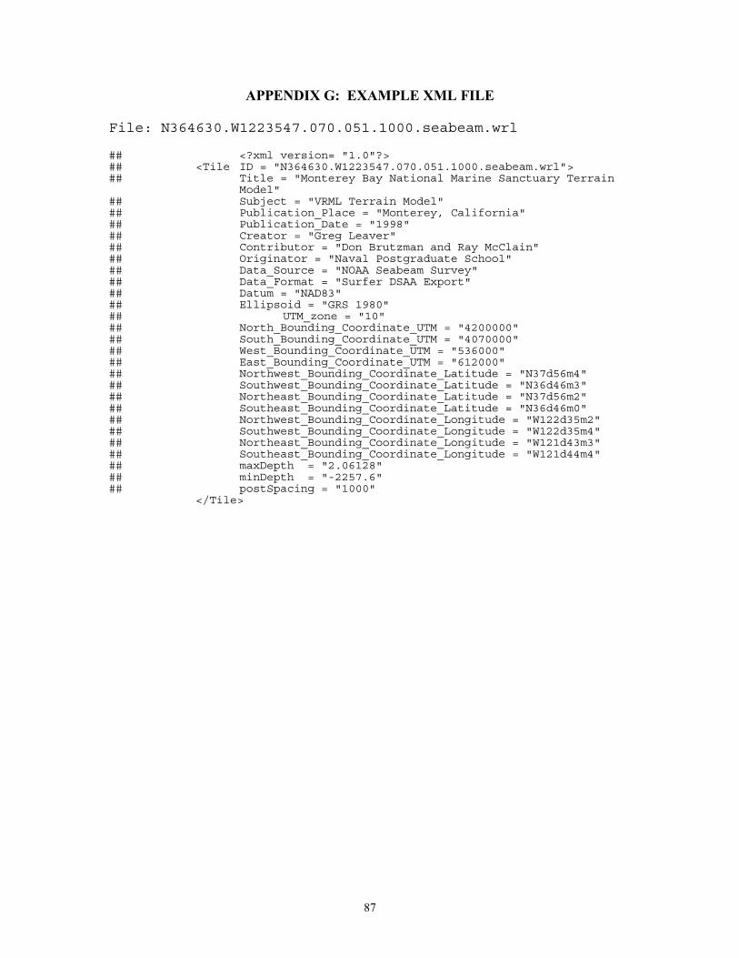
87
APPENDIX G: EXAMPLE XML FILE
File: N364630.W1223547.070.051.1000.seabeam.wrl
## <?xml version= "1.0"?>## <Tile ID = "N364630.W1223547.070.051.1000.seabeam.wrl">## Title = "Monterey Bay National Marine Sanctuary Terrain
Model"## Subject = "VRML Terrain Model"## Publication_Place = "Monterey, California"## Publication_Date = "1998"## Creator = "Greg Leaver"## Contributor = "Don Brutzman and Ray McClain"## Originator = "Naval Postgraduate School"## Data_Source = "NOAA Seabeam Survey"## Data_Format = "Surfer DSAA Export"## Datum = "NAD83"## Ellipsoid = "GRS 1980"## UTM_zone = "10"## North_Bounding_Coordinate_UTM = "4200000"## South_Bounding_Coordinate_UTM = "4070000"## West_Bounding_Coordinate_UTM = "536000"## East_Bounding_Coordinate_UTM = "612000"## Northwest_Bounding_Coordinate_Latitude = "N37d56m4"## Southwest_Bounding_Coordinate_Latitude = "N36d46m3"## Northeast_Bounding_Coordinate_Latitude = "N37d56m2"## Southeast_Bounding_Coordinate_Latitude = "N36d46m0"## Northwest_Bounding_Coordinate_Longitude = "W122d35m2"## Southwest_Bounding_Coordinate_Longitude = "W122d35m4"## Northeast_Bounding_Coordinate_Longitude = "W121d43m3"## Southeast_Bounding_Coordinate_Longitude = "W121d44m4"## maxDepth = "2.06128"## minDepth = "-2257.6"## postSpacing = "1000"
</Tile>

88
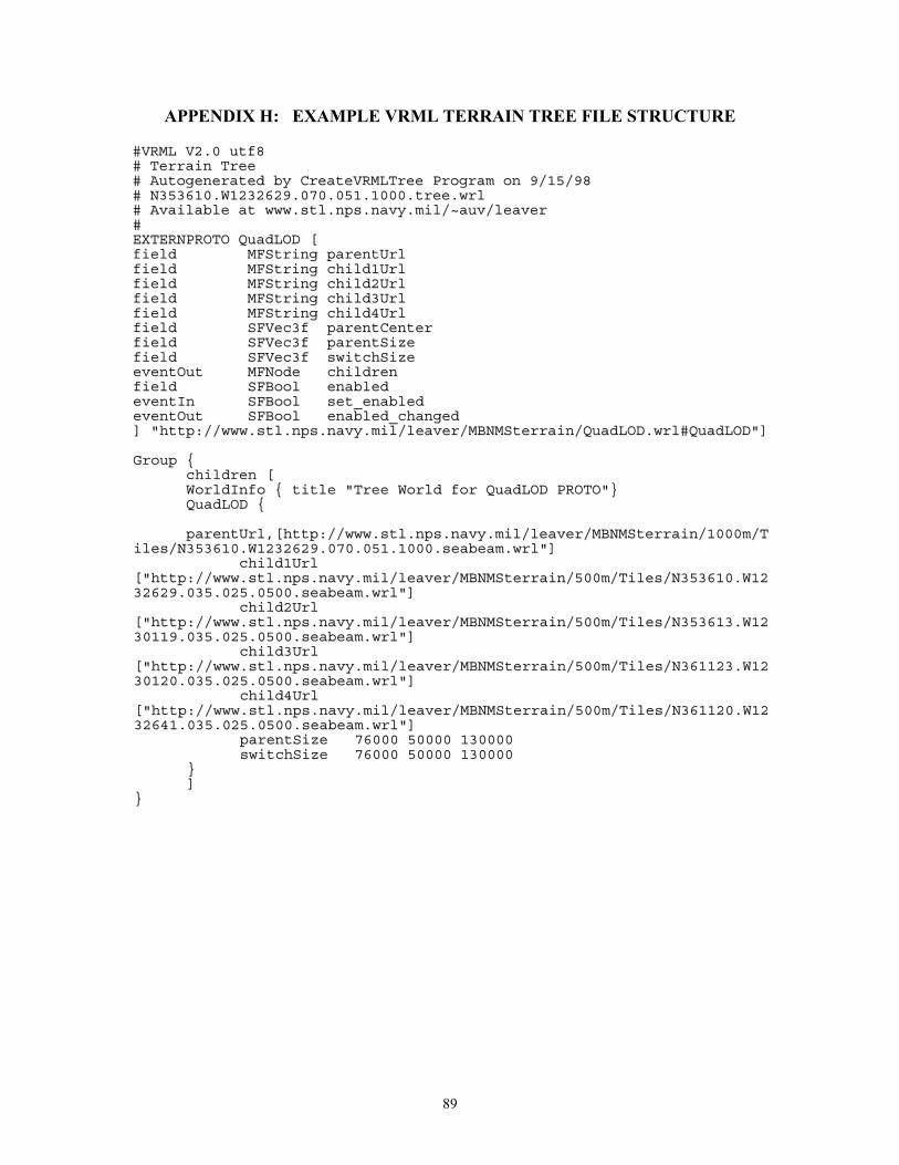
89
APPENDIX H: EXAMPLE VRML TERRAIN TREE FILE STRUCTURE
##VVRRMMLL VV22..00 uuttff88## TTeerrrraaiinn TTrreeee## AAuuttooggeenneerraatteedd bbyy CCrreeaatteeVVRRMMLLTTrreeee PPrrooggrraamm oonn 99//1155//9988## NN335533661100..WW11223322662299..007700..005511..11000000..ttrreeee..wwrrll## AAvvaaiillaabbllee aatt wwwwww..ssttll..nnppss..nnaavvyy..mmiill//~~aauuvv//lleeaavveerr##EEXXTTEERRNNPPRROOTTOO QQuuaaddLLOODD [[ffiieelldd MMFFSSttrriinngg ppaarreennttUUrrllffiieelldd MMFFSSttrriinngg cchhiilldd11UUrrllffiieelldd MMFFSSttrriinngg cchhiilldd22UUrrllffiieelldd MMFFSSttrriinngg cchhiilldd33UUrrllffiieelldd MMFFSSttrriinngg cchhiilldd44UUrrllffiieelldd SSFFVVeecc33ff ppaarreennttCCeenntteerrffiieelldd SSFFVVeecc33ff ppaarreennttSSiizzeeffiieelldd SSFFVVeecc33ff sswwiittcchhSSiizzeeeevveennttOOuutt MMFFNNooddee cchhiillddrreennffiieelldd SSFFBBooooll eennaabblleeddeevveennttIInn SSFFBBooooll sseett__eennaabblleeddeevveennttOOuutt SSFFBBooooll eennaabblleedd__cchhaannggeedd]] ""hhttttpp::////wwwwww..ssttll..nnppss..nnaavvyy..mmiill//lleeaavveerr//MMBBNNMMSStteerrrraaiinn//QQuuaaddLLOODD..wwrrll##QQuuaaddLLOODD""]]
GGrroouupp {{cchhiillddrreenn [[WWoorrllddIInnffoo {{ ttiittllee ""TTrreeee WWoorrlldd ffoorr QQuuaaddLLOODD PPRROOTTOO""}}QQuuaaddLLOODD {{
ppaarreennttUUrrll,,[[hhttttpp::////wwwwww..ssttll..nnppss..nnaavvyy..mmiill//lleeaavveerr//MMBBNNMMSStteerrrraaiinn//11000000mm//TTiilleess//NN335533661100..WW11223322662299..007700..005511..11000000..sseeaabbeeaamm..wwrrll""]]
cchhiilldd11UUrrll[[""hhttttpp::////wwwwww..ssttll..nnppss..nnaavvyy..mmiill//lleeaavveerr//MMBBNNMMSStteerrrraaiinn//550000mm//TTiilleess//NN335533661100..WW11223322662299..003355..002255..00550000..sseeaabbeeaamm..wwrrll""]]
cchhiilldd22UUrrll[[""hhttttpp::////wwwwww..ssttll..nnppss..nnaavvyy..mmiill//lleeaavveerr//MMBBNNMMSStteerrrraaiinn//550000mm//TTiilleess//NN335533661133..WW11223300111199..003355..002255..00550000..sseeaabbeeaamm..wwrrll""]]
cchhiilldd33UUrrll[[""hhttttpp::////wwwwww..ssttll..nnppss..nnaavvyy..mmiill//lleeaavveerr//MMBBNNMMSStteerrrraaiinn//550000mm//TTiilleess//NN336611112233..WW11223300112200..003355..002255..00550000..sseeaabbeeaamm..wwrrll""]]
cchhiilldd44UUrrll[[""hhttttpp::////wwwwww..ssttll..nnppss..nnaavvyy..mmiill//lleeaavveerr//MMBBNNMMSStteerrrraaiinn//550000mm//TTiilleess//NN336611112200..WW11223322664411..003355..002255..00550000..sseeaabbeeaamm..wwrrll""]]
ppaarreennttSSiizzee 7766000000 5500000000 113300000000sswwiittcchhSSiizzee 7766000000 5500000000 113300000000
}}]]
}}

90
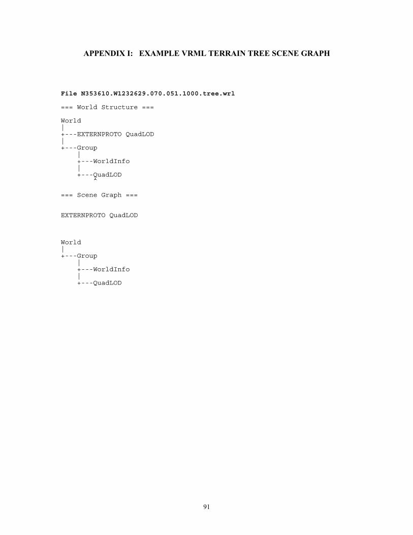
91
APPENDIX I: EXAMPLE VRML TERRAIN TREE SCENE GRAPH
File N353610.W1232629.070.051.1000.tree.wrl
=== World Structure ===
World|+---EXTERNPROTO QuadLOD|+---Group
|+---WorldInfo|+---QuadLOD
^
=== Scene Graph ===
EXTERNPROTO QuadLOD
World|+---Group
|+---WorldInfo|+---QuadLOD

92
93
LIST OF REFERENCES
Abernathy, M. and Shaw, S., "Integrating Geographic Information in VRML Worlds, " Proceedings VRML 98: Third Symposium of the Virtual Reality Modeling Language, Monterey, California, February 16-19, 1998, pp. 107-114. Available at: http://ece.uwaterloo.ca/vrml98/cdrom/papers/abernath/abernath.pdf
Ames, L.A., Nadieau, D.R., and Moreland, J.L., The VRML 2.0 Sourcebook, John Wiley & Sons, NewYork, 1997. Information available at: http://www.wiley.com/compbooks/vrml2sbk/cover/cover.htm
Brutzman, Don, "The Virtual Reality Modeling Language and Java," Communications of the ACM, vol. 41 no. 6, June 1998, pp. 57-64. Available at http://ww.stl.nps.navy.mil/~brutzman/vrml/vrmljava.pdf
Coryphaeus, 3D World Viewer/Generation Software, August 28, 1998. Information available at at http://www.coryphaeus.com
Cybertrek, 3D World Viewer/Generation Software, July 29, 1998. Information available at http://www.c-trek.com
Fairborn, David, and Parsley, Scott, "The Use of VRML for Cartographic Presentation," Computers and Geosciences, vol. 23, no. 4, May 1997, pp 475-481
FGDC - Federal Geographic Data Committee, "FGDC Content Standard for Digital Metadata," June 8, 1994. Availableat: http://fgdc.er.usgs.gov/ GeoVRMLWorking Group, 1998, "GeoVRML RFC 1: Coordinate Systems Version 1," July 21, 1998, Available at: http://www.ai.sri.com/geovrml/rfc1.html Iverson, Lee, "GeoVRML Working Group Home Page," July 21, 1998. Available at http://www.ai.sri.com/~leei/geovrml Lipkin, Daniel, 1998. "Metadata Node Specification," September 1, 1998. Available at http://www.vrml.org/WorkingGroups/dbwork/metadata.html MLML - Moss Landing Marine Laboratories, Bathymetric Data Sets, USGS 8mm Archives Extraction, circa 1985. Monterey Bay National Marine Santurary Home Page, August 25, 1998. Available at http://bonita.mbnms.nos.noaa.gov/ McClain, Ray, Gridded Bathymetric Data Sets, Moss Landing Marine Laboratories, 1998.

94
NOAA - National Oceanic and Atmospheric Administration, Scientific Research Plan for the Monterey Bay National Marine Sanctuary, September, 1993 Reddy, Martin. "The QuadLOD node for VRML," June 13, 1998. Available at http://www.ai.sri.com/~reddy/geovrml/new_lod/ Reddy, Martin, "The VisibilityInline node for VRML," May 4, 1998. Available at http://www.ai.sri.com/~reddy/geovrml/new_inline/ Rhyne, Theresa Marie. "Integrating the Assocation for Computing Machinery's Special Interest on Computer Graphics (ACM - SIGGRAPH) Activities with the International Cartographic Association's (ICA) Commission on Visualization." Available at: http://www.geog.psu.edu/ica/icavis/vis-acm.html RIS - Rapid Imaging Software Home Page, 3D Terrain Modeling Tool, May 24, 1998. Available at http://www.landform.com/vrml.htm Seamless Solutions Inc., VRML Terrain Navigator, 1998. Information available at: http://www.seamless-solutions.com/ Silicon Graphics, Cosmo Player Version 2.1 VRML Browser, 1998. Available at: http://vrml.sgi.com. Surfer for Windows, 3D Map Generation Program, Golden Software, 1998. Information available at: http://www.goldensoftware.com/ Terry Jr., N.T. " How to Read the Universal Transverse Mercator (UTM) Grid," GPS World, p. 32, April 1996, Available at http://geography.tqn.com/msub14.htm TNTmips, Map and Image Processing System, MicroImages, Inc., 1998. Information available at: http://www.microimages.com/ USGS - United States Geological Survey, Bathymetric Data Set Archives, 1998. Available at: http://woodshole.er.usgs.gov/data1/CDROMS/monterey/ and http://walrus.wr.usgs.gov/docs/infobank/bear/programs/html/main/infohome.html VRML -Virtual Reality Modeling Language, International Standard ISO/IEC 14772-1:1997. Available at: http://www.vrml.org/VRML97/ Weibel, Stuart, 1998. "Dublin Core Metadata," November 2, 1998. Available at: http://purl.org/metadata/dublin_core XML - Extensible Markup Language, REC-xml-19980210 W3C Recommendation, 10-February-1998. Available at: http://www.w3.org/TR/REC-xml.html
95
INITIAL DISTRIBUITON LIST No. Copies 1. Defense Technical Information Center ............................................................... 2
8725 John Kingman Rd., STE 0944 Ft. Belvoir, Virginia 22060-6218
2. Dudley Knox Library........................................................................................... 2 Naval Postgraduate School Monterey, California 93943-5101
3. Dr. Don Brutzman, Code UW/Br........................................................................ 2
Naval Postgraduate School Monterey, California 93943-5101
4. Ray McClain........................................................................................................ 1
Network and Computing Services Moss Landing Marine Laboratories P.O. Box 450 Moss Landing, California 95039
5. Dr. Michael R. Macedonia .................................................................................. 1 Chief Scientist and Technical Director US Army STRICOM 12350 Research Parkway Orlando, Florida 32826-3276
6. Michael McCann ................................................................................................. 1
Monterey Bay Aquarium Research Institute (MBARI) P.O. Box 628 Moss Landing, California 95039-0628
7. Dr. Michael J. Zyda, Chair, Code CS/Zk ............................................................ 1 Modeling Virtual Environments and Simulation (MOVES) Naval Postgraduate School Monterey, California 93943-5101
8. Rex Buddenberg, Code SM/Bu........................................................................... 1 Naval Postgraduate School Monterey, California 93943-5101
96
9. Dr. Jim Eagle, Chair, Code UW.......................................................................... 1 Naval Postgraduate School Monterey, California 93943-5101
10. Dr. Marcia McNutt (MBARI) ............................................................................ 1
Monterey Bay Aquarium Research Instiute P.O. Box 628 Moss Landing, California 95039-0628
11. Brian Blau ........................................................................................................... 1 Intervista Software 181 Fremont, Suite 200 San Francisco, California 94015
12. Toni Parisi ........................................................................................................... 1 Intervista Software 181 Fremont, Suite 200 San Francisco, California 94015
13. Mike Abernathy................................................................................................... 1
Rapid Imaging Software P.O. Box 8219 Albuquerqe, New Mexico, 87198
14. Martin Reddy....................................................................................................... 1 SRI International 333 Ravenswood Ave. Menlo Park, California 94025
15. Theresa-Marie Rhyne .......................................................................................... 1 Lockheed Martin Technical Services US EPA Scientific Visualization Center 86 Alexander Drive Research Triangle Park, North Carolina 27711
16. Carol Wideman ................................................................................................... 1 President Seamless Solutions, Inc. 3504 Lake Lynda Drive, Suite 390 Orlando, Florida 32817 17. Greg Leaver ......................................................................................................... 1
2921 N. Downing Bethany, Oklahoma 73008
97
18. Dr. Gary Greene .................................................................................................. 1 Moss Landing Marine Laboratories P.O. Box 450 Moss Landing, California 95039
19. Lee Iverson .......................................................................................................... 1
SRI International 333 Ravenswood Ave. Menlo Park, California 94025


![THESIS TITLE A THESIS SUBMITTED TO THE MIDDLE EAST ...ii.metu.edu.tr/system/files/documents/thesis... · [SAMPLE 1] Approval of the thesis: THESIS TITLE Submitted by STUDENT NAME](https://img.pdfslide.net/doc/110x75/6019035f39977162fc4f0b03/thesis-title-a-thesis-submitted-to-the-middle-east-iimetuedutrsystemfilesdocumentsthesis.jpg)