Embed Size (px)
Citation preview

www.tutbury.org Page 1 of 7
This downloadable leaflet describes and guides the reader around the Tutbury Heritage Walk. It comprises a full page map, a general description of the project, 5 pages describing the walk
anti – clockwise from the Tutbury Mill Site and finally two illustrations.
The Tutbury Park Pale Recovery Project was conceived and managed by
With the support of:

www.tutbury.org Page 2 of 7 PAGE 2 of 7

www.tutbury.org Page 3 of 7
TUTBURY HERITAGE WALK
This circular walk was devised by the Tutbury Civic Society, whose members
have long felt that the ancient earthworks known as the Park Pale have
suffered from a lack of appreciation. In part this was because there has been
little serious study of the history, origins and use of the Monument. To try to
rectify this situation, in 2007 the Society successfully sought a grant from the
Heritage Lottery Fund in order to fund a research project carried out by a team
from Birmingham Archaeology.
Most of the walk uses existing public rights of way, and quiet roads, to follow
the route of the Park Pale. Tutbury Civic Society is very grateful to the Duchy
of Lancaster who authorised two lengths of permissive footpaths to complete
the circuit. There is no need to complete the 4 km (approx.) walk all at once,
at various points you have access to car parks, Tutbury & Hatton Railway
station and the rest of Tutbury. It is easy to reach Tutbury by train either
from Derby to the east, or from Crewe and the Potteries to the west. The
station is just north of the River Dove and gives easy access to one of the
walk’s information panels situated at the Tutbury Mill Site, a picnic site with
car park, playgrounds for both teenagers and younger visitors and, in summer,
a chance to watch a cricket match at the very scenic ground just below
Tutbury Castle.
There are four information panels about the Monument, at points D,E,F and G.
There are other points of interest around the walk. These information boards
give brief extracts from the full report provided by Birmingham Archaeology.
The report itself can be seen at Tutbury Museum, which is in the Charity House
situated in Duke Street, Tutbury almost adjacent to the central car park and
toilets. The Museum is open Good Friday to the end of September 1.30 - 4.00
p.m., Monday - Saturday, plus Saturday morning, 10.30 a.m. - 1.00 p.m.
Please note that there are stiles at points A,B,C and D as shown on the map
and the use of appropriate footwear for field walking is suggested between
points E and D.
Most of the Park Pale is a scheduled Ancient Monument coming under the
jurisdiction of English Heritage and as such enjoys the protection afforded by
such scheduling. Much of the monument was covered by trees and dense
vegetation which was removed as part of the Civic Society’s project, rendering
the monument more visible to the public and less prone to further erosion
damage from tree roots. English Heritage together with the Principal
Archaeologist (Environment and Countryside) at Staffordshire County Council
gave the specification for the clearance of vegetation from the Monument and
advised on a programme for on-going maintenance.

www.tutbury.org Page 4 of 7
Information about the history of the Mill - first built for cotton working and
then altered to process gypsum from the nearby Fauld mines - is given on the
adjacent notice board at point E. Tutbury’s own gasworks were here too, and a
racquets court. The watercourse known as the Fleam initially powered the old
Cornmill (mentioned in the 1086 Domesday survey) which is some half mile
downstream from central Tutbury. The Fleam was altered in the late 1700s to
power the cotton mill, and then again in 1831 to improve the water flow at the
mill. It was during the 1831 alterations that the famous Tutbury Hoard of
coins was discovered in the River Dove. It is possible to see the remains of the
railway which connected the Mills to the main line, crossing the River Dove just
upstream of the road bridge. Small relics mark the position of the turbine
house.
South of the mill area is the Priory Church of St. Mary, which was established
in 1089. After the Reformation, the monastic buildings were demolished and
no trace remains. The size of the Church was greatly reduced, but it continues
in use as the Parish Church. One of its most famous features is the Great West
Doorway, with its seven orders of sculptured mouldings, the second rim
uniquely being made of alabaster, which has long been an important product
of the Tutbury area.
The Tutbury Heritage walk (if followed in an anticlockwise direction) goes
through the ‘kissing gate’ adjacent to the Tutbury Cricket Field (point E on the
map) and follows the Fleam, or Little Dove, upstream to the weir on the River.
Dove. Tutbury Castle is high up on your left.
After crossing the Fleam on a footbridge near the Weir, a 300 metre length of
the Park Pale can be seen up the hill ahead of you in the fields to the right of
the Castle. At this part of the walk documentary evidence suggests that you
are traversing part of the Castle’s 67 acre Deer Park established in the 1300s.
The Park is shown, coloured green on information panel E at the Tutbury Mill
Site.
Following well used public/permissive footpaths across grass fields one arrives
at the Monument. A brief description of the results of the relevant part of the
2007 Archaeological investigation can be found on the adjacent information
board there on the adjacent information panel D.
The most massive part of the Park Pale is parallel to and behind the houses on
Park Lane, with access from Park Lane via a stile. It consists of an internal
bank approximately 16 metres wide rising over 2 metres above the base of an
8 metre wide outer ditch. Within the earthwork there are traces of parallel
undulations which are the remains of ridge and furrow ploughing which show
up well on the earth resistance survey illustrated here. Fine views up the valley
of the River Dove and towards the Weaver Hills (South end of the Pennines)
can be seen from here.

www.tutbury.org Page 5 of 7
Features exposed by the earth resistance survey of this area include a more
compacted strip some 5 metres wide which was a headland or boundary line
associated with the use of the area for arable farming. Confirmed by an aerial
photograph this is evidence that the agricultural/arable land use post-dates
the construction of the monument. Visible on the ground is a change of
vegetation which confirms mapping evidence of the existence of the Deer Park
boundary. This is shown as point J on the survey. Looking west from the Pale
near Park Lane, the woods on the skyline are remains of the Forest of
Needwood which was so important to the local economy prior to its
disafforestation in 1801.
The next evident part of the Park Pale, to the south east between Ferrers
Avenue and the modern road The Park Pale, does not align with the part
beside Park Lane, a change of direction occurring at point H where the
footpath (off the east side of Park Lane) meets Wakefield Avenue. This shows
that the Park Pale actually was two separate earthworks which met at this
point H. Twentieth century building has obliterated any evidence of both the
Pale(s) at this junction, and the ancient fishpond, which formerly was used by
the monks at the Priory. The fishpond is recorded in the old street name,
Fishpond Lane, at the lower end of Wakefield Avenue.
Continuing the circuit as shown on the map - easier to follow the map than
written instructions here - climb the stile shown at point D on the map, cross
Park Lane and bear left. In just a few metres, turn right down the footway to
Wakefield Avenue. Cross diagonally towards the left and proceed up the slope
to Holts Lane. following Holts Lane to the right. Turn left into Ferrers Avenue
where, bearing left again, one comes to another well defined part of the Park
Pale (Scheduled Ancient Monument 238b). This stretch of the Pale, adjacent
to the ESBC-owned open space and playground, is considerably less massive
that those parts surviving off Park Lane near point D. Like the change of
direction shown at point H on the map this indicates that the Pale was a multi-
phase monument. Archaeological evidence suggests that there was Roman
occupation of the Castle site. Tutbury’s name is thought to be a combination of
Tutta or Stut (Old English personal names) and burh (Old English ‘fortified
place’) Local road names commemorate the history of the village, such as The
Park Pale, Ferrers Avenue and Norman Road. The Norman family of de Ferrers
owned the Castle.
The archaeological survey shows that this part of the Park Pale extends for
some 151 metres and consists of an internal bank some 10 metres in width
with parallel external ditch over 13 metres in width. The internal bank stands
up to 1.16 metres above modern ground level, whilst the ditch is around 1.9
metres deep. The outer slope of the ditch is noticeably steeper than the inner
slope as shown on the profiles illustrated on the adjacent panel F on the map.

www.tutbury.org Page 6 of 7
A typical deer park boundary had an internal ditch and an external bank,
aiming at preventing the deer from escaping from the enclosure. The
earthworks in Tutbury display the opposite arrangement, with external ditch
and internal bank, thus constructed to prevent entry rather than inhibiting
escape. This supports the theory that the Park Pale was a defensive earthwork,
as does its location in relation to the mediaeval settlement. The earthworks’
origins could all have been as the defences of an Iron Age hillfort, however
such forts are not common features in Staffordshire.
Walking alongside the Monument to notice board F and then on downhill one
comes to Ludgate Street the name being a reference to a postern gate to the
settlement of Tutbury, controlling access from the south. Beyond the line of
the Park Pale, older maps show the continuation of Ludgate Street as Forest
Road rather than the more modern Belmot or Belmont Road. Turning left
down Ludgate Street brings the pedestrian to a flight of steps on the right
hand side. Ascending these takes one up via Scheduled Ancient Monument
(238a) to Chatsworth Drive. This point can also be reached by crossing
Ludgate Street and ascending the steep hill of Ironwalls Lane bearing left at
the top of the hill until its junction with Chatsworth Drive along which another
information panel (G) is to be found, describing this part of the earthwork
which aligns well with the part to be seen near Ferrers Avenue/The Park Pale.
The earthwork bank (Monument 238a) can be traced for 89 metres along the
eastern edge of the public footpath from Ludgate Street to Chatsworth Drive,
the corresponding external ditch being located inside private property.
Across Chatsworth Drive, 38 metres of earthwork can be seen displaying the
full profile of the earthwork’s bank, although the ditch is now in-filled and
marked by the line of the footpath leading to the Richard Wakefield School.
Within the School boundary, landscaping work when the School was built has
resulted in the mound being laterally displaced apart from a short stretch near
to the School buildings.
Continuing round the walk, opposite the end of Ironwalls Lane, is Cornmill
Balk, an old boundary of Mill Field, one of the common fields of the Middle
Ages. The Balk leads down to near the Cornmill (noted at the information
board at the Mill Site car park/picnic place); however this is not the footpath
to use on this route.
To complete the circuit, one should go left along Burton Street to Close Bank
Walk (opposite the main School gates) down to Cornmill Lane on the footpath
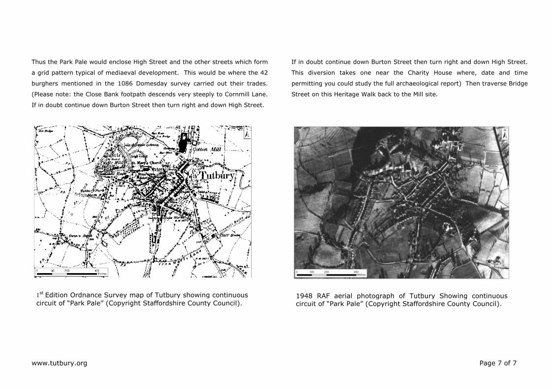
adjacent to the aptly named Dove View private road. 1st edition 1887
Ordnance Survey map (from the Staffordshire County Record Office’s
collection) illustrated here shows field boundaries as a feature continuing in
the line of the Park Pale across the School playing field and reaching Burton
Street near to the point where Close Bank walk descends towards the river
valley. This is confirmed by the 1940s RAF aerial photograph (next page).
www.tutbury.org Page 7 of 7
Thus the Park Pale would enclose High Street and the other streets which form
a grid pattern typical of mediaeval development. This would be where the 42
burghers mentioned in the 1086 Domesday survey carried out their trades.
(Please note: the Close Bank footpath descends very steeply to Cornmill Lane.
If in doubt continue down Burton Street then turn right and down High Street.
If in doubt continue down Burton Street then turn right and down High Street.
This diversion takes one near the Charity House where, date and time
permitting you could study the full archaeological report) Then traverse Bridge
Street on this Heritage Walk back to the Mill site.
1948 RAF aerial photograph of Tutbury Showing continuous circuit of “Park Pale” (Copyright Staffordshire County Council).
1st Edition Ordnance Survey map of Tutbury showing continuous
circuit of “Park Pale” (Copyright Staffordshire County Council).