Embed Size (px)
Citation preview

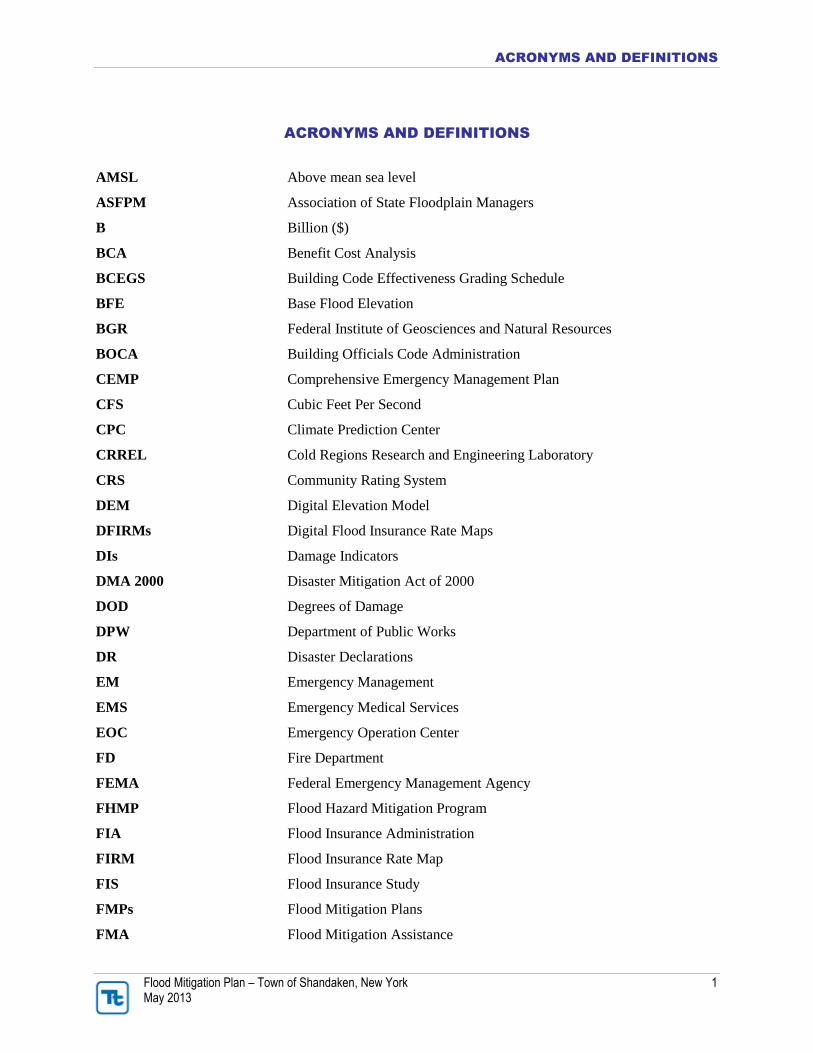
ACRONYMS AND DEFINITIONS
Flood Mitigation Plan – Town of Shandaken, New York 1 May 2013
This section provides acronym descriptions and definitions to terms used within the Town of Shandaken
Flood Mitigation Plan.
ACRONYMS AND DEFINITIONS
Flood Mitigation Plan – Town of Shandaken, New York 1 May 2013
ACRONYMS AND DEFINITIONS
AMSL Above mean sea level
ASFPM Association of State Floodplain Managers
B Billion ($)
BCA Benefit Cost Analysis
BCEGS Building Code Effectiveness Grading Schedule
BFE Base Flood Elevation
BGR Federal Institute of Geosciences and Natural Resources
BOCA Building Officials Code Administration
CEMP Comprehensive Emergency Management Plan
CFS Cubic Feet Per Second
CPC Climate Prediction Center
CRREL Cold Regions Research and Engineering Laboratory
CRS Community Rating System
DEM Digital Elevation Model
DFIRMs Digital Flood Insurance Rate Maps
DIs Damage Indicators
DMA 2000 Disaster Mitigation Act of 2000
DOD Degrees of Damage
DPW Department of Public Works
DR Disaster Declarations
EM Emergency Management
EMS Emergency Medical Services
EOC Emergency Operation Center
FD Fire Department
FEMA Federal Emergency Management Agency
FHMP Flood Hazard Mitigation Program
FIA Flood Insurance Administration
FIRM Flood Insurance Rate Map
FIS Flood Insurance Study
FMPs Flood Mitigation Plans
FMA Flood Mitigation Assistance

ACRONYMS AND DEFINITIONS
Flood Mitigation Plan – Town of Shandaken, New York 2 May 2013
GeoMAC Geospatial Multi-Agency Coordination
GIS Geographic Information System
GPM Gallons Per Minute
HA Housing Program (FEMA)
HAZUS Hazards U.S.
HAZUS-MH Hazards U.S. Multi-Hazard
HAZMAT Hazardous Material
HAZNY Hazards New York
HMGP Hazard Mitigation Grant Program
HMP Hazard Mitigation Plan
HPC Hydrometeorological Prediction center
HPDE Earth Dam (HAZUS Defined)
HPDG Gravity Dam (HAZUS Defined)
HPDM Masonry Dam (HAZUS Defined)
HPDR Rockfill Dam (HAZUS Defined)
HQ Headquarters
HS High School
HVCD Hudson Valley Climate Division
IA Individual Assistance (FEMA grant)
IFG Individual and Family Grants
IPCC Intergovernmental Panel of Climate Change
K Thousands ($)
LIDAR Light Detection and Ranging
M Million ($)
MARFC Middle Atlantic River Forecast Center
MESO Multi-County Environmental Storm Observatory
MGD Million Gallons per Day
MMI Modified Mercalli Scale
MPC Mitigation Planning Community
Mph Miles per Hour
MS Middle School
MRP Mean Return Period
NA Not Available/Not Applicable
NCDC National Climate Data Center

ACRONYMS AND DEFINITIONS
Flood Mitigation Plan – Town of Shandaken, New York 3 May 2013
NFIP National Flood Insurance Program
NID National Inventory of Dams
NOAA National Oceanic and Atmospheric Administration
NPDP National Performance of Dams Program
NR Not Required
NRCC Northeast Regional Climate Center
NRCS Natural Resource Conservation Service
NSF National Science Foundation
NSSL National Severe Storms Laboratory
NWIS National Water Information System
NWS National Weather Service
NY New York
NYS New York State
NYSC New York State Climate
NYSDEC New York State Department of Environmental Conservation
NYSDOT New York State Department of Transportation
NYSDPC New York State Disaster Preparedness Commission
NYSOEM New York State Office of Emergency Management
PA Public Assistance (FEMA grant)
PD Police Department
PDM Pre-Disaster Mitigation Program
RL(P) Repetitive Loss (Property)
RCV Replacement Cost Value
RR Railroad
RV Replacement Value
SAFARI Shandaken Area Flood Assessment and Remediation Initiative
SBA Small Business Association
SFHA Special Flood Hazard Area
SHELDUS Spatial Hazard Events and Losses Database for United States
SPI Standard Precipitation Index
SRL(P) Severe Repetitive Loss (Property)
SWOO Strengths, Weaknesses, Obstacles and Opportunities
SWSI Surface Water Supply Index
TBA To Be Announced

ACRONYMS AND DEFINITIONS
Flood Mitigation Plan – Town of Shandaken, New York 4 May 2013
TBD To Be Determined
TSTM Thunderstorm
U.S. United States
USACE U.S. Army Corps of Engineers
USD U.S. Dollar
USEPA U.S. Environmental Protection Agency
USFWS U.S. Fish and Wildlife Service
USGS U.S. Geological Survey
WWPS Wastewater Pump Station
WWTP Wastewater Treatment Plant
DEFINITIONS
100-Year Flood: The term “100-year flood” can be misleading. The 100-year flood does not
necessarily occur once every 100 years. Rather, it is the flood that has a 1 percent chance of
being equaled or exceeded in any given year. Thus, the 100-year flood could occur more than
once in a relatively short period of time. The Federal Emergency Management Agency (FEMA)
defines it as the 1 percent annual chance flood, which is now the standard definition used by
most federal and state agencies and by the National Flood Insurance Program.
Acre-Foot: An acre-foot is the amount of water it takes to cover 1 acre to a depth of 1 foot. This
measure is used to describe the quantity of storage in a water reservoir. An acre-foot is a unit of
volume. One acre foot equals 7,758 barrels; 325,829 gallons; or 43,560 cubic feet. An average
household of four will use approximately 1 acre-foot of water per year.
Asset: An asset is any man-made or natural feature that has value, including, but not limited to,
people; buildings; infrastructure, such as bridges, roads, sewers, and water systems; lifelines,
such as electricity and communication resources; and environmental, cultural, or recreational
features such as parks, wetlands, and landmarks.
Base Flood: The flood having a 1% chance of being equaled or exceeded in any given year, also
known as the “100-year” or “1% chance” flood. The base flood is a statistical concept used to
ensure that all properties subject to the National Flood Insurance Program are protected to the
same degree against flooding.
Basin: A basin is the area within which all surface water—whether from rainfall, snowmelt,
springs, or other sources—flows to a single water body or watercourse. The boundary of a river
basin is defined by natural topography, such as hills, mountains, and ridges. Basins are also
referred to as “watersheds” and “drainage basins.”
Benefit: A benefit is a net project outcome and is usually defined in monetary terms. Benefits
may include direct and indirect effects. For the purposes of benefit-cost analysis of proposed

ACRONYMS AND DEFINITIONS
Flood Mitigation Plan – Town of Shandaken, New York 5 May 2013
mitigation initiatives, benefits are limited to specific, measurable, risk reduction factors,
including reduction in expected property losses (buildings, contents, and functions) and
protection of human life.
Benefit/Cost Analysis: A benefit/cost analysis is a systematic, quantitative method of comparing
projected benefits to projected costs of a project or policy. It is used as a measure of cost
effectiveness.
Building: A building is defined as a structure that is walled and roofed, principally aboveground,
and permanently fixed to a site. The term includes manufactured homes on permanent
foundations on which the wheels and axles carry no weight.
Capability Assessment: A capability assessment provides a description and analysis of a
community’s current capacity to address threats associated with flooding. The assessment
includes two components: an inventory of an agency’s mission, programs, and policies, and an
analysis of its capacity to carry them out. A capability assessment is an integral part of the
planning process in which a community’s actions to reduce losses are identified, reviewed, and
analyzed, and the framework for implementation is identified. The following capabilities were
reviewed under this assessment: • Legal and regulatory capability
• Administrative and technical capability
• Fiscal capability
Community Rating System (CRS): The CRS is a voluntary program under the NFIP that
rewards participating communities (provides incentives) for exceeding the minimum
requirements of the NFIP and completing activities that reduce flood hazard risk by providing
flood insurance premium discounts.
Critical Area: An area defined by state or local regulations as deserving special protection
because of unique natural features or its value as habitat for a wide range of species of flora and
fauna. A sensitive/critical area is usually subject to more restrictive development regulations.
Critical Facility: A critical facility is one that is deemed vital to the Thurston County planning
area’s ability to provide essential services while protecting life and property. A critical facility
may be a system or an asset, either physical or virtual, the loss of which would have a profound
impact on the security, economy, public health or safety, environment, or any combination of
thereof, across the planning area. For the purposes of the Thurston County Flood Hazard
Mitigation Plan, the following types of systems and assets are defined as critical facilities: • Police stations, fire stations, paramedic stations, emergency vehicle and equipment storage
facilities, and emergency operations and communications centers needed for disaster response
before, during, and after hazard events.
• Public and private utilities and infrastructure vital to maintaining or restoring normal services
to areas damaged by hazard events. These include water (potable, wastewater, storm water,
drainage and irrigation), utilities (transmission and distribution facilities for natural gas,
power, geothermal) and communications (land-based telephone, cell phone, the internet
emergency broadcast facilities and emergency radios).

ACRONYMS AND DEFINITIONS
Flood Mitigation Plan – Town of Shandaken, New York 6 May 2013
• Public gathering places that could be utilized as evacuation centers during large scale
disasters.
• Hospitals, extended care facilities, urgent care facilities and housing that may contain
occupants not sufficiently mobile to avoid death or injury during a hazard event
• Transportation systems that convey vital supplies and services to, through and throughout the
community. These include roads, bridges, railways, airports and pipelines
• Government and educational facilities central to governance and quality of life along with
response and recovery actions taken as a result of a hazard event
• Structures or facilities that produce, use, or store highly volatile, flammable, explosive, toxic,
and/or water-reactive materials.
• Infrastructure designed to help safely convey high water events from the event source to the
perimeter of the planning area including but not limited to; dams, revetments and stormwater
drainage facilities.
• Debris management and solid waste facilities
Drainage Basin: A basin is the area within which all surface water—whether from rainfall,
snowmelt, springs or other sources—flows to a single water body or watercourse. The boundary
of a river basin is defined by natural topography, such as hills, mountains and ridges. Drainage
basins are also referred to as watersheds or basins.
Economically Disadvantaged Populations: Households with household incomes of $15,000 or
less.
Exposure: Exposure is defined as the number and dollar value of assets considered to be at risk
during the occurrence of a specific hazard.
Extent: The extent is the size of an area affected by a hazard.
Flash Flood: A flash flood occurs with little or no warning when water levels rise at an
extremely fast rate
Flood Insurance Rate Map (FIRM): FIRMs are the official maps on which the Federal
Emergency Management Agency (FEMA) has delineated the Special Flood Hazard Area.
Flood Insurance Study: A report published by the Federal Insurance and Mitigation
Administration for a community in conjunction with the community’s Flood Insurance rate Map.
The study contains such background data as the base flood discharges and water surface
elevations that were used to prepare the FIRM. In most cases, a community FIRM with detailed
mapping will have a corresponding flood insurance study.
Floodplain: Any land area susceptible to being inundated by flood waters from any source. A
flood insurance rate map identifies most, but not necessarily all, of a community’s floodplain as
the Special Flood Hazard Area.
Floodway: Floodways are areas within a floodplain that are reserved for the purpose of
conveying flood discharge without increasing the base flood elevation more than 1 foot.

ACRONYMS AND DEFINITIONS
Flood Mitigation Plan – Town of Shandaken, New York 7 May 2013
Generally speaking, no development is allowed in floodways, as any structures located there
would block the flow of floodwaters.
Floodway Fringe: Floodway fringe areas are located in the floodplain but outside of the
floodway. Some development is generally allowed in these areas, with a variety of restrictions.
On maps that have identified and delineated a floodway, this would be the area beyond the
floodway boundary that can be subject to different regulations.
Freeboard: Freeboard is the margin of safety added to the base flood elevation.
Frequency: For the purposes of this plan, frequency refers to how often a hazard of specific
magnitude, duration, and/or extent is expected to occur on average. Statistically, a hazard with a
100-year frequency is expected to occur about once every 100 years on average and has a 1
percent chance of occurring any given year. Frequency reliability varies depending on the type of
hazard considered.
Goal: A goal is a general guideline that explains what is to be achieved. Goals are usually broad-
based, long-term, policy-type statements and represent global visions. Goals help define the
benefits that a plan is trying to achieve. The success of a flood hazard mitigation plan is
measured by the degree to which its goals have been met (that is, by the actual benefits in terms
of actual hazard mitigation).
Geographic Information System (GIS): GIS is a computer software application that relates
data regarding physical and other features on the earth to a database for mapping and analysis.
Hazard: A hazard is a source of potential danger or adverse condition that could harm people
and/or cause property damage.
Hazard Mitigation Grant Program (HMGP): Authorized under Section 202 of the Robert T.
Stafford Disaster Relief and Emergency Assistance Act, the HMGP is administered by FEMA
and provides grants to states, tribes, and local governments to implement hazard mitigation
initiatives after a major disaster declaration. The purpose of the program is to reduce the loss of
life and property due to disasters and to enable mitigation activities to be implemented as a
community recovers from a disaster
Hazards U.S. Multi-Hazard (HAZUS-MH) Loss Estimation Program: HAZUS-MH is a
GIS-based program used to support the development of risk assessments as required under the
DMA. The HAZUS-MH software program assesses risk in a quantitative manner to estimate
damage and losses associated with natural hazards. HAZUS-MH is FEMA’s nationally
applicable, standardized methodology and software program and contains modules for estimating
potential losses from earthquakes, floods, and wind hazards. HAZUS-MH has also been used to
assess vulnerability (exposure) for other hazards.
Hydraulics: Hydraulics is the branch of science or engineering that addresses fluids (especially
water) in motion in rivers or canals, works and machinery for conducting or raising water, the
use of water as a prime mover, and other fluid-related areas.

ACRONYMS AND DEFINITIONS
Flood Mitigation Plan – Town of Shandaken, New York 8 May 2013
Hydrology: Hydrology is the analysis of waters of the earth. For example, a flood discharge
estimate is developed by conducting a hydrologic study.
Intensity: For the purposes of this plan, intensity refers to the measure of the effects of a hazard.
Inventory: The assets identified in a study region comprise an inventory. Inventories include
assets that could be lost when a disaster occurs and community resources are at risk. Assets
include people, buildings, transportation, and other valued community resources.
Local Government: Any county, municipality, city, town, township, public authority, school
district, special district, intrastate district, council of governments (regardless of whether the
council of governments is incorporated as a nonprofit corporation under State law), regional or
interstate government entity, or agency or instrumentality of a local government; any Indian tribe
or authorized tribal organization, or Alaska Native village or organization; and any rural
community, unincorporated town or village, or other public entity.
Mitigation: A preventive action that can be taken in advance of an event that will reduce or
eliminate the risk to life or property.
Mitigation Initiatives: Mitigation initiatives are specific actions to achieve goals and objectives
that minimize the effects from a disaster and reduce the loss of life and property.
Objective: For the purposes of this plan, an objective is defined as a short-term aim that, when
combined with other objectives, forms a strategy or course of action to meet a goal. Unlike goals,
objectives are specific and measurable.
Preparedness: Preparedness refers to actions that strengthen the capability of government,
citizens, and communities to respond to disasters.
Presidential Disaster Declaration: These declarations are typically made for events that cause
more damage than state and local governments and resources can handle without federal
government assistance. Generally, no specific dollar loss threshold has been established for such
declarations. A Presidential Disaster Declaration puts into motion long-term federal recovery
programs, some of which are matched by state programs, designed to help disaster victims,
businesses, and public entities.
Probability of Occurrence: The probability of occurrence is a statistical measure or estimate of
the likelihood that a hazard will occur. This probability is generally based on past hazard events
in the area and a forecast of events that could occur in the future. A probability factor based on
yearly values of occurrence is used to estimate probability of occurrence.
Repetitive Loss Property: Any NFIP-insured property that, since 1978 and regardless of any
changes of ownership during that period, has experienced: • Four or more paid flood losses in excess of $1000.00; or
• Two paid flood losses in excess of $1000.00 within any 10-year period since 1978 or

ACRONYMS AND DEFINITIONS
Flood Mitigation Plan – Town of Shandaken, New York 9 May 2013
• Three or more paid losses that equal or exceed the current value of the insured property.
Return Period (or Mean Return Period): This term refers to the average period of time in
years between occurrences of a particular hazard (equal to the inverse of the annual frequency of
occurrence).
Riverine: Of or produced by a river. Riverine floodplains have readily identifiable channels.
Floodway maps can only be prepared for riverine floodplains.
Risk: Risk is the estimated impact that a hazard would have on people, services, facilities, and
structures in a community. Risk measures the likelihood of a hazard occurring and resulting in an
adverse condition that causes injury or damage. Risk is often expressed in relative terms such as
a high, moderate, or low likelihood of sustaining damage above a particular threshold due to
occurrence of a specific type of hazard. Risk also can be expressed in terms of potential
monetary losses associated with the intensity of the hazard.
Risk Assessment: Risk assessment is the process of measuring potential loss of life, personal
injury, economic injury, and property damage resulting from hazards. This process assesses the
vulnerability of people, buildings, and infrastructure to hazards and focuses on (1) hazard
identification; (2) impacts of hazards on physical, social, and economic assets; (3) vulnerability
identification; and (4) estimates of the cost of damage or costs that could be avoided through
mitigation.
Robert T. Stafford Act: The Robert T. Stafford Disaster Relief and Emergency Assistance Act,
Public Law 100-107, was signed into law on November 23, 1988. This law amended the Disaster
Relief Act of 1974, Public Law 93-288. The Stafford Act is the statutory authority for most
federal disaster response activities, especially as they pertain to FEMA and its programs.
Special Flood Hazard Area: The base floodplain delineated on a Flood Insurance Rate Map.
The SFHA is mapped as a Zone A in riverine situations and zone V in coastal situations. The
SFHA may or may not encompass all of a community’s flood problems
Stakeholder: Business leaders, civic groups, academia, non-profit organizations, major
employers, managers of critical facilities, farmers, developers, special purpose districts, and
others whose actions could impact hazard mitigation.
Stream Bank Erosion: Stream bank erosion is common along rivers, streams and drains where
banks have been eroded, sloughed or undercut. However, it is important to remember that a
stream is a dynamic and constantly changing system. It is natural for a stream to want to
meander, so not all eroding banks are “bad” and in need of repair. Generally, stream bank
erosion becomes a problem where development has limited the meandering nature of streams,
where streams have been channelized, or where stream bank structures (like bridges, culverts,
etc.) are located in places where they can actually cause damage to downstream areas. Stabilizing
these areas can help protect watercourses from continued sedimentation, damage to adjacent land
uses, control unwanted meander, and improvement of habitat for fish and wildlife.

ACRONYMS AND DEFINITIONS
Flood Mitigation Plan – Town of Shandaken, New York 10 May 2013
Steep Slope: Different communities and agencies define it differently, depending on what it is
being applied to, but generally a steep slope is a slope in which the percent slope equals or
exceeds 25%. For this study, steep slope is defined as slopes greater than 33%.
Vulnerability: Vulnerability describes how exposed or susceptible an asset is to damage.
Vulnerability depends on an asset’s construction, contents, and the economic value of its
functions. Like indirect damage, the vulnerability of one element of the community is often
related to the vulnerability of another. For example, many businesses depend on uninterrupted
electrical power. Flooding of an electric substation would affect not only the substation itself but
businesses as well. Often, indirect effects can be much more widespread and damaging than
direct effects.
Watershed: A watershed is an area that drains down-gradient from areas of higher land to areas
of lower land to the lowest point, a common drainage basin.
Zoning Ordinance: The zoning ordinance designates allowable land use and intensities for a
local jurisdiction. Zoning ordinances consist of two components: a zoning text and a zoning map.

APPENDIX B: CRS PLANNING REQUIREMENTS
Flood Mitigation Plan –Town of Shandaken, New York B-1 May 2013
This appendix includes the CRS Guidelines for Flood Planning, including the following:
Community Rating System Planning Process Guidelines
Repetitive Loss Area Analysis
Habitat Conservation Plan

APPENDIX B: CRS PLANNING REQUIREMENTS
Flood Mitigation Plan –Town of Shandaken, New York B-2 May 2013
COMMUNITY RATING SYSTEM PLANNING PROCESS GUIDELINES
A. FLOODPLAIN MANAGEMENT PLANNING
1. Organize to prepare the plan (Maximum credit: 10 points). The credit for this step is the
total of the following points, which are based on how the community organizes to prepare
its floodplain management plan:
(a) if the planning process is under the supervision or direction of a professional planner;
(b) if the planning process is conducted through a committee composed of staff from
those community departments that will be implementing the majority of the plan’s
recommendations;
(c) if the planning process and/or the committee are formally created or recognized by
action of the community’s governing board.
The plan document must discuss how it was prepared, who was involved in the planning process,
and how the public was involved during the planning process. (REQUIRED) When a multi-
jurisdictional plan is prepared, at least one representative from each community seeking CRS
credit must be involved on the planning committee that is credited under item (b).
2. Involve the public (Maximum credit: 85 points). The planning process must include an
opportunity for the public to comment on the plan during the drafting stage and before
plan approval (REQUIRED). The term “public” includes residents, businesses, property
owners, and tenants in the floodplain and other known hazard areas as well as other
stakeholders in the community, such as business leaders, civic groups, academia, non-profit
organizations, and major employers. The credit for this step is the total of the following
points based on how the community involves the public during the planning process. • (a) if the planning process is conducted through a planning committee that includes members
of the public. If this is the same planning committee credited under step 1, items (b) and (c),
at least one half of the members must be representatives of the public, including residents,
businesses, or property owners from the flood-prone areas. The committee must hold a
sufficient number of meetings that involve the members in planning steps 4 through 9 (e.g., at
least one meeting on each step).
• (b) if one or more public information meetings are held in the affected area(s) at the
beginning of the planning process to obtain public input on the natural hazards, problems, and
possible solutions. At least one meeting must be held separate from the planning committee
meetings in item (a).
• (c) for holding at least one public meeting to obtain input on the draft plan. The meeting must
be at the end of the planning process, at least two weeks before submittal of the
recommended plan to the community’s governing body.
• (d) if questionnaires are distributed asking the public for information on their natural hazards,
problems, and possible solutions. The questionnaires must be distributed to at least 90% of
the floodplain residents.
• (e) if written comments and recommendations are solicited from neighborhood advisory
groups, homeowners’ associations, parent-teacher organizations, the Chamber of Commerce,
or similar organizations that represent the public in the affected area(s).

APPENDIX B: CRS PLANNING REQUIREMENTS
Flood Mitigation Plan –Town of Shandaken, New York B-3 May 2013
• (f) if other public information activities are implemented to explain the planning process and
encourage input to the planner or planning committee.
3. Coordinate (Maximum credit: 25 points). Other agencies and organizations must be
contacted to see if they are doing anything that may affect the community’s program and
to see if they could support the community’s efforts.
Examples of “other agencies and organizations” include neighboring communities; local,
regional, state, and federal agencies; and businesses, academia, and other private and non-profit
organizations affected by the hazards or involved in hazard mitigation or floodplain
management. The credit for this step is the total of the following points. To receive credit for this
step, the coordination must include items (a) and (b). • (a) if the planning includes a review of existing studies, reports, and technical information
and of the community’s needs, goals, and plans for the area. (REQUIRED)
• (b) if neighboring communities, local and regional agencies involved in hazard mitigation
activities, and agencies that have the authority to regulate development, as well as businesses,
academia, and other private and non-profit interests are given an opportunity to be involved
in the planning process. (REQUIRED)
• (c) if neighboring communities, the state NFIP Coordinator, the state water resources agency,
the county and state emergency management agency, the FEMA Regional Office, and (where
appropriate) the state’s coastal zone management agency are contacted at the beginning of the
planning process to see if they are doing anything that may affect the community's program
and to see how they can support the community's efforts.
• (d) if other governmental and nongovernmental organizations, such as the National Weather
Service, Red Cross, homebuilders association, and environmental groups are contacted at the
beginning of the planning process to see if they are doing anything that may affect the
community's program and to see how they can support the community's efforts.
• (e) if the coordination effort includes holding meetings with representatives of the other
agencies and organizations to review common problems, development policies, mitigation
strategies, inconsistencies, and conflicts in policies, plans, programs, and regulations.
• (f) for sending the draft action plan to the other agencies and organizations contacted under
items (b), (c), (d), and (e) and asking them to comment by a certain date.
4. Assess the hazard (Maximum credit: 20 points). The credit for this step is the total of the
following points based on what the community includes in its assessment of the hazard. To
receive CRS credit for this step, the assessment must include item (a). If the community
wants the plan to also qualify as a FEMA multi-hazard mitigation plan, item (b) must also
be completed. • (a) for including an assessment of the flood hazard in the plan. If the community is a
Category B or C repetitive loss community, this step must cover all of its repetitive loss areas
(REQUIRED). The assessment must include at least one of the following items:
– (1) a map of the known flood hazards. “Known flood hazards” means the floodplain
shown on the Flood Insurance Rate Map (FIRM), repetitive loss areas, areas not mapped
on the FIRM that have flooded in the past, and surface flooding identified in existing
studies. No new studies need to be conducted for this assessment.

APPENDIX B: CRS PLANNING REQUIREMENTS
Flood Mitigation Plan –Town of Shandaken, New York B-4 May 2013
– (2) a description of the known flood hazards, including source of water, depth of
flooding, velocities, and warning time.
– (3) a discussion of past floods.
• (b) if the plan includes a map, description of the magnitude or severity, history, and
probability of future events for other natural hazards, such as erosion, tsunamis, earthquakes,
and hurricanes. The plan should include all natural hazards that affect the community. At a
minimum, it should include those hazards identified by the state’s hazard mitigation plan.
(REQUIRED FOR PLANS TO BE CREDITED UNDER THE DISASTER MITIGATION
ACT OF 2000)
5. Assess the problem (Maximum credit: 35 points) The credit for this step is the total of
the following points, based on what is included in the assessment of the vulnerability of the
community to the hazards identified in the previous hazard assessment step. To receive
credit for this step, the assessment must include item (a) and must evaluate the hazard data
in light of their impact on the community. Simply listing data, such as the names of the
critical facilities or the number of flood insurance claims, will not suffice for credit. • (a) if the plan includes an overall summary of the jurisdiction’s vulnerability to each hazard
identified in the hazard assessment (step 4) and the impact on the community. (required)
• (b) if the plan includes a description of the impact that the hazards identified in the hazard
assessment (step 4) have on: (1) life, safety, and health and the need and procedures for
warning and evacuating residents and visitors. (5 points) (2) critical facilities and
infrastructure. (5 points) (3) the community’s economy and tax base. (5 points)
• (c) for including the number and types of buildings subject to the hazards identified in the
hazard assessment.
• (d) if the assessment includes a review of all properties that have received flood insurance
claims (in addition to the repetitive loss properties) or an estimate of the potential dollar
losses to vulnerable structures.
• (e) if the plan describes areas that provide natural and beneficial functions, such as wetlands,
riparian areas, sensitive areas, and habitat for rare or endangered species.
• (f) if the plan includes a description of development, redevelopment, and population trends
and a discussion of what the future brings for development and redevelopment in the
community, the watershed, and natural resource areas.
When a multi-jurisdictional plan is prepared, the critical facilities, building counts, and similar
data must be presented for each community.
6. Set goals (Maximum credit: 2 points). The two credit points for this step are provided if
the plan includes a statement of the goals of the community’s floodplain management or
hazard mitigation program. (REQUIRED)
7. Review possible activities (Maximum credit: 30 points) The plan must describe those
activities that were considered and note why they were or were not recommended (e.g.,
they were not cost-effective or they did not support the community’s goals). (REQUIRED)
If an activity is currently being implemented, the plan must note whether it should be modified.
The discussion of each activity needs to be detailed enough to be useful to the lay reader. The

APPENDIX B: CRS PLANNING REQUIREMENTS
Flood Mitigation Plan –Town of Shandaken, New York B-5 May 2013
credit for this step is the total of the following points based on which floodplain management or
hazard mitigation activities are reviewed in the plan. • (a) if the plan reviews preventive activities, such as zoning, stormwater management
regulations, building codes, and preservation of open space and the effectiveness of current
regulatory and preventive standards and programs;
• (b) if the plan reviews property protection activities, such as acquisition, retrofitting, and
flood insurance;
• (c) if the plan reviews activities to protect the natural and beneficial functions of the
floodplain, such as wetlands protection;
• (d) if the plan reviews emergency services activities, such as warning and sandbagging;
• (e) if the plan reviews structural projects, such as reservoirs and channel modifications; and
• (f) if the plan reviews public information activities, such as outreach projects and
environmental education programs.
8. Draft an action plan (Maximum credit: 70 points). The action plan specifies those
activities appropriate to the community’s resources, hazards, and vulnerable properties.
For each recommendation, the action plan must identify who does what, when it will be done,
and how it will be financed. The actions must be prioritized and include a review of the benefits
of the proposed projects and their associated costs. (REQUIRED) A multi-hazard mitigation plan
must identify actions that address both existing and new infrastructure and buildings. The credit
for this step is based on what is included in the action plan. Credit is provided for a
recommendation on floodplain regulations, provided it recommends a regulatory standard that
exceeds the minimum requirements of the NFIP. • (a) if the action plan includes flood-related recommendations for activities from two of the
six categories credited in step 7, Review possible activities.
• (b) if the action plan includes flood-related recommendations for activities from three of the
six categories credited in step 7, Review possible activities.
• (c) if the action plan includes flood-related recommendations for activities from four of the
six categories credited in step 7, Review possible activities.
• (d) if the action plan includes flood-related recommendations for activities from five of the
six categories credited in step 7, Review possible activities.
• (e) additional points are provided if the action plan establishes post-disaster mitigation
policies and procedures.
• (f) additional points are provided if the action plan’s recommended natural resource
protection activities include recommendations from a Regional Habitat Conservation Plan as
credited under Section 511.c.
• (g) additional points are provided if the plan includes action items (other than public
information activities) to mitigate the effects of the other natural hazards identified in the
hazard assessment (step 4, item (b)).
If the plan calls for acquiring properties, there must be a discussion of how the project(s) will be
managed and how the land will be reused. When a multi-jurisdictional plan is prepared, it must
have action items from at least two of the six categories that directly benefit each community
seeking CRS credit.

APPENDIX B: CRS PLANNING REQUIREMENTS
Flood Mitigation Plan –Town of Shandaken, New York B-6 May 2013
9. Adopt the plan (Maximum credit: 2 points) The 2 credit points for this step are provided
if the plan and later amendments are officially adopted by the community’s governing
body. (REQUIRED)
When a multi-jurisdictional plan is prepared, it must be adopted by the governing board of each
community seeking CRS or multi-hazard mitigation plan credit.
10. Implement, evaluate, and revise (Maximum credit: 15 points) The credit for this step is
the total of the following points based on how the community monitors and evaluates its
plan. • (a) if the community has procedures for monitoring implementation, reviewing progress, and
recommending revisions to the plan in an annual evaluation report. The report must be
submitted to the governing body, released to the media and made available to the public.
(REQUIRED)
• (b) if the evaluation report is prepared by the same planning committee that prepared the plan
that is credited in step 2(a) or by a successor committee with a similar membership that was
created to replace the planning committee and charged with monitoring and evaluating
implementation of the plan.
To maintain this credit, the community must submit a copy of its annual evaluation report with
its recertification each year and update the plan at least every five years.
B. REPETITIVE LOSS AREA ANALYSIS
Up to 50 points are provided for conducting area analyses of all of the community’s repetitive
loss areas. An area analysis is prepared according to the following criteria: • 1. All repetitive loss areas must be mapped as described in Section 503.b. If the community
does not conduct an analysis of all the areas, it will be reflected through the impact
adjustment in Section 512.
• 2. Data must be collected on each building in the area(s) using the “limited data view” of the
National Flood Mitigation Data Collection Tool. The database file created by the National
Flood Mitigation Data Collection Tool must be made available to FEMA and the state, upon
request.
• 3. A five-step process must be followed. The steps do not have to be done in the order listed.
– Step 1. Advise all the property owners in the repetitive loss areas that the analysis will be
conducted. This must be sent directly to each property owner and cannot be done via a
newspaper or newsletter notice or article.
– Step 2. Collect data on each building and determine the cause(s) of the repetitive damage.
– Step 3. Review alternative approaches and determine whether any property protection
measures or drainage improvements are feasible. The review must look at all of the
property protection measures listed in Figure 510-2 that are appropriate for the types of
buildings affected.

APPENDIX B: CRS PLANNING REQUIREMENTS
Flood Mitigation Plan –Town of Shandaken, New York B-7 May 2013
– Step 4. Contact agencies or organizations that may have plans that could affect the cause
or impacts of the flooding.
– Step 5. Document the findings, including a map showing all parcels in the area,
recommendations, and how the recommendations will be funded.
• 4. Each area analysis document must be approved by the head of the appropriate community
department. It does not have to be circulated to or adopted by the community’s governing
board, but it does have to be made available to any inquirer, including residents of the
repetitive loss area(s).
• 5. The community must prepare an annual report on progress toward implementing the
recommendations.
C. HABITAT CONSERVATION PLAN
If the community has adopted a regional Habitat Conservation Plan or other plan that explains
and recommends actions to protect rare, threatened, or endangered aquatic or riparian species.
The plan must have been adopted by the community’s governing board and there must be
documentation that the plan is being implemented. The plan must identify: • the species in need of protection,
• the impact of new development on their habitat,
• alternative actions that could be taken to protect that habitat,
• what actions are recommended to protect that habitat and why they were selected from the
alternatives, and
• how the recommendations will be funded.
• If the plan has also been accepted as a Habitat Conservation Plan by the U.S. Fish and
Wildlife Service or the National Marine Fisheries Service.

APPENDIX C: PUBLIC OUTREACH INFORMATION
Flood Mitigation Plan – Town of Shandaken, New York C-1 May 2013
This appendix provides public outreach information including the questionnaire responses and
documentation of meetings as available for the Town of Shandaken Flood Mitigation Plan.

1 of 35
Town of Shandaken Flood Preparedness and
Planning Survey
1. Please indicate your age range:
Response
Percent
Response
Count
18 to 30 2.5% 2
31 to 40 5.0% 4
41 to 50 16.3% 13
51 to 60 33.8% 27
60 or over 42.5% 34
answered question 80
skipped question 8

2 of 35
2. Please indicate the hamlet in the Town of Shandaken in which you live:
Response
Percent
Response
Count
Mt. Tremper 6.8% 6
Mt. Pleasant 4.5% 4
Phoenicia 27.3% 24
Chichester 4.5% 4
Woodland Valley 4.5% 4
Allaben 4.5% 4
Shandaken 8.0% 7
Bushnellsville 0.0% 0
Big Indian 9.1% 8
Oliveria 22.7% 20
Pine Hill 5.7% 5
Highmount 2.3% 2
answered question 88
skipped question 0

3 of 35
3. How long have you lived in the Town of Shandaken?
Response
Percent
Response
Count
Less than 1 year 7.4% 6
1 to 5 years 8.6% 7
6 to 9 years 8.6% 7
10 to 19 years 29.6% 24
20 years or more 45.7% 37
answered question 81
skipped question 7
4. Do you currently own or rent your home in Shandaken?
Response
Percent
Response
Count
Own 94.9% 75
Rent 5.1% 4
answered question 79
skipped question 9
5. What is your Shandaken address? (optional, will be kept confidential - only used to
identify homes in flood-prone areas)
Response
Count
55
answered question 55
skipped question 33
4 of 35
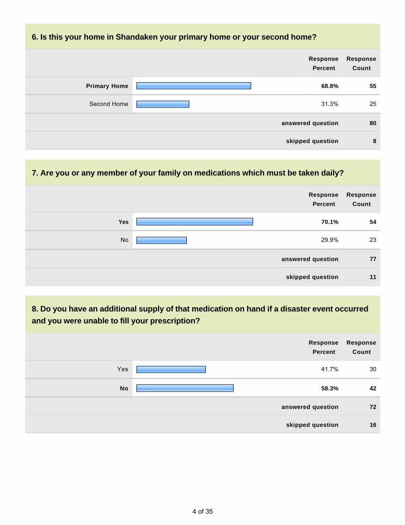
6. Is this your home in Shandaken your primary home or your second home?
Response
Percent
Response
Count
Primary Home 68.8% 55
Second Home 31.3% 25
answered question 80
skipped question 8
7. Are you or any member of your family on medications which must be taken daily?
Response
Percent
Response
Count
Yes 70.1% 54
No 29.9% 23
answered question 77
skipped question 11
8. Do you have an additional supply of that medication on hand if a disaster event occurred
and you were unable to fill your prescription?
Response
Percent
Response
Count
Yes 41.7% 30
No 58.3% 42
answered question 72
skipped question 16

5 of 35
9. Do you have an elderly person or person with disabilities residing in your residence (or
for whom you are responsible) that requires assistance should an evacuation occur?
Response
Percent
Response
Count
Yes 12.0% 9
No 88.0% 66
answered question 75
skipped question 13
10. Have arrangements been made for assistance for that individual if evacuation is
necessary?
Response
Percent
Response
Count
Yes 8.2% 4
No 91.8% 45
answered question 49
skipped question 39
11. Do you know where your closest shelter is to your home if an evacuation occurs?
Response
Percent
Response
Count
Yes 46.8% 36
No 53.2% 41
answered question 77
skipped question 11
6 of 35
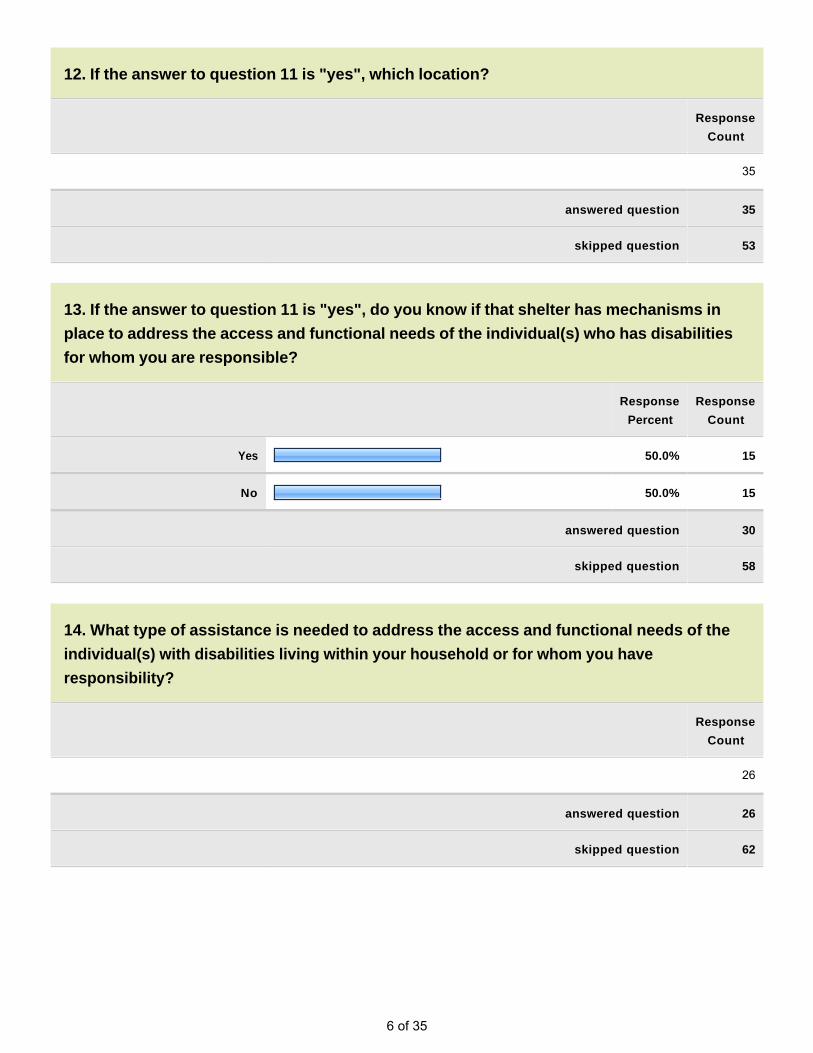
12. If the answer to question 11 is "yes", which location?
Response
Count
35
answered question 35
skipped question 53
13. If the answer to question 11 is "yes", do you know if that shelter has mechanisms in
place to address the access and functional needs of the individual(s) who has disabilities
for whom you are responsible?
Response
Percent
Response
Count
Yes 50.0% 15
No 50.0% 15
answered question 30
skipped question 58
14. What type of assistance is needed to address the access and functional needs of the
individual(s) with disabilities living within your household or for whom you have
responsibility?
Response
Count
26
answered question 26
skipped question 62

7 of 35
15. Please rank how prepared you think you and those who live with you are for the floods
that are likely to occur within the Town of Shandaken. Rank on a scale of 1 to 5, with 5
representing the most prepared.
Response
Percent
Response
Count
1 (Not Prepared) 8.6% 6
2 14.3% 10
3 31.4% 22
4 31.4% 22
5 (Fully Prepared) 14.3% 10
answered question 70
skipped question 18
8 of 35
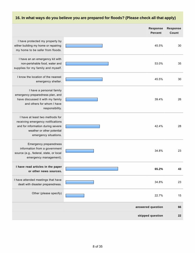
16. In what ways do you believe you are prepared for floods? (Please check all that apply)
Response
Percent
Response
Count
I have protected my property by either building my home or repairing my home to be safer from floods.
45.5% 30
I have an an emergency kit with non-perishable food, water and
supplies for my family and myself.53.0% 35
I know the location of the nearest emergency shelter.
45.5% 30
I have a personal family emergency preparedness plan, and
have discussed it with my family and others for whom I have
responsibility.
39.4% 26
I have at least two methods for receiving emergency notifications and for information during severe
weather or other potential emergency situations.
42.4% 28
Emergency preparedness information from a government
source (e.g., federal, state, or local emergency management).
34.8% 23
I have read articles in the paper
or other news sources.65.2% 43
I have attended meetings that have dealt with disaster preparedness.
34.8% 23
Other (please specify)
22.7% 15
answered question 66
skipped question 22

9 of 35
17. In the past 10 years, which of the following types of events have you or someone in your
household experienced? How concerned are you about each type of flooding?
Have
Experienced
Not
Concerned
Somewhat
Concerned
Very
Concerned
Extremely
Concerned
Rating
Count
Flooding - Property 64.6% (42) 15.4% (10) 9.2% (6) 13.8% (9) 26.2% (17) 65
Flooding - Basement 52.6% (30) 26.3% (15) 24.6% (14) 10.5% (6) 19.3% (11) 57
Flooding - 1st Floor 16.0% (8) 40.0% (20) 16.0% (8) 14.0% (7) 24.0% (12) 50
Flooding - Above 1st Floor 0.0% (0) 78.4% (29) 10.8% (4) 0.0% (0) 10.8% (4) 37
Flooding - Street 60.7% (34) 10.7% (6) 16.1% (9) 16.1% (9) 26.8% (15) 56
Dam Failure 15.2% (5) 51.5% (17) 18.2% (6) 12.1% (4) 6.1% (2) 33
Beaver Dam 3.3% (1) 80.0% (24) 10.0% (3) 3.3% (1) 3.3% (1) 30
Other 56.5% (13) 17.4% (4) 0.0% (0) 4.3% (1) 43.5% (10) 23
answered question 70
skipped question 18

10 of 35
18. Information on how to prepare for floods can be given to the public in various ways. Of
the information sources below, please identify the top three (3) that are MOST EFFECTIVE in
providing you with information to make your home safer and better able to withstand the
impact of floods.
Response
Percent
Response
Count
Newspaper 22.4% 15
Newspaper - 7.5% 5
County and/or Local Gov't. Websites
41.8% 28
Local Government E-Mail 23.9% 16
Police, Fire, EMS, 9 -1-1 17.9% 12
Telephone Book 3.0% 2
Informational Brochures 14.9% 10
Public Meetings 17.9% 12
Workshops 9.0% 6
Schools 4.5% 3
TV News 28.4% 19
TV Advertising 1.5% 1
Radio News 13.4% 9
Radio Advertisements 1.5% 1
Outdoor Advertisements 3.0% 2
Internet 52.2% 35
Chamber of Commerce 3.0% 2
Fire Department/EMS Agency 22.4% 15
Academic Institutions 1.5% 1
Public Awareness Event 10.4% 7

11 of 35
Books 1.5% 1
Public Library 7.5% 5
Other (please specify)
14.9% 10
answered question 67
skipped question 21
19. To the best of your knowledge is your property located in a floodplain?
Response
Percent
Response
Count
Yes 41.4% 29
No 42.9% 30
Not Sure 15.7% 11
answered question 70
skipped question 18
20. Do you have flood insurance?
Response
Percent
Response
Count
Yes 30.4% 21
No 69.6% 48
answered question 69
skipped question 19

12 of 35
21. If you do NOT have flood insurance, what is the primary reason?
Response
Percent
Response
Count
I don't need it/my property has never flooded
15.6% 7
Don't need it/located on high
ground35.6% 16
It is too expensive 26.7% 12
Not familiar with it/don't know about it
13.3% 6
Insurance company will not provide 4.4% 2
My homeowners insurance will cover me
2.2% 1
It is not worth it 2.2% 1
answered question 45
skipped question 43
22. Do you or did you have problems getting homeowners/renters insurance due to floods?
Response
Percent
Response
Count
Yes 6.7% 4
No 93.3% 56
answered question 60
skipped question 28

13 of 35
23. Did you consider the impact a flood could have on your home before you
purchased/moved into your home?
Response
Percent
Response
Count
Yes 43.5% 27
No 56.5% 35
answered question 62
skipped question 26
24. Was the presence of a flood hazard risk zone disclosed to you by a real estate agent,
seller, or landlord before you purchased/moved into your home?
Response
Percent
Response
Count
Yes 28.1% 16
No 71.9% 41
answered question 57
skipped question 31
25. Would the disclosure of this type of information have influenced your decision to
purchase/move into a home?
Response
Percent
Response
Count
Yes 67.3% 37
No 32.7% 18
answered question 55
skipped question 33

14 of 35
26. How much money would you be willing to spend on your current home to make changes
to it that would reduce the impacts of potential future flood disasters? Examples of
improvements are: Elevating a flood-prone home (above the base flood elevation) and
elevating utilities in flood-prone basements.
Response
Percent
Response
Count
$5,000 or above 11.7% 7
$2,500 to $4,999 6.7% 4
$1,000 to $2,499 11.7% 7
$500 to $999 6.7% 4
$100 to $499 5.0% 3
Less than $100 0.0% 0
Nothing 11.7% 7
Don't know 46.7% 28
answered question 60
skipped question 28
27. If your property is located in a floodplain area, or had received repeated damages from
flooding events, would you consider a "buyout" (selling your property and moving),
elevation of the structure (above the base flood height), or relocation offered by a public
agency should it be made available?
Response
Percent
Response
Count
Yes 60.9% 28
No 39.1% 18
answered question 46
skipped question 42

15 of 35
28. Have you made any changes to your property in the past to reduce the damage from
floods? What have you done to your home or business to prevent future damages?
Response
Count
36
answered question 36
skipped question 52
29. If you have been flooded and have had damages to your home or business and you have
not done anything to reduce future damages, why have you not done anything?
Response
Percent
Response
Count
I cannot get a loan to do this. 8.7% 2
It is too expensive. 34.8% 8
It is too much trouble. 8.7% 2
I do not plan to stay in the house long enough to justify the expense.
8.7% 2
There are not any bchanges that
can be made to reduce my risk.43.5% 10
I do not know what changes to make.
26.1% 6
Other (please specify)
16
answered question 23
skipped question 65

16 of 35
30. What incentives would help to encourage you to spend money to retrofit your home to
avoid flood damages?
Response
Count
36
answered question 36
skipped question 52
17 of 35
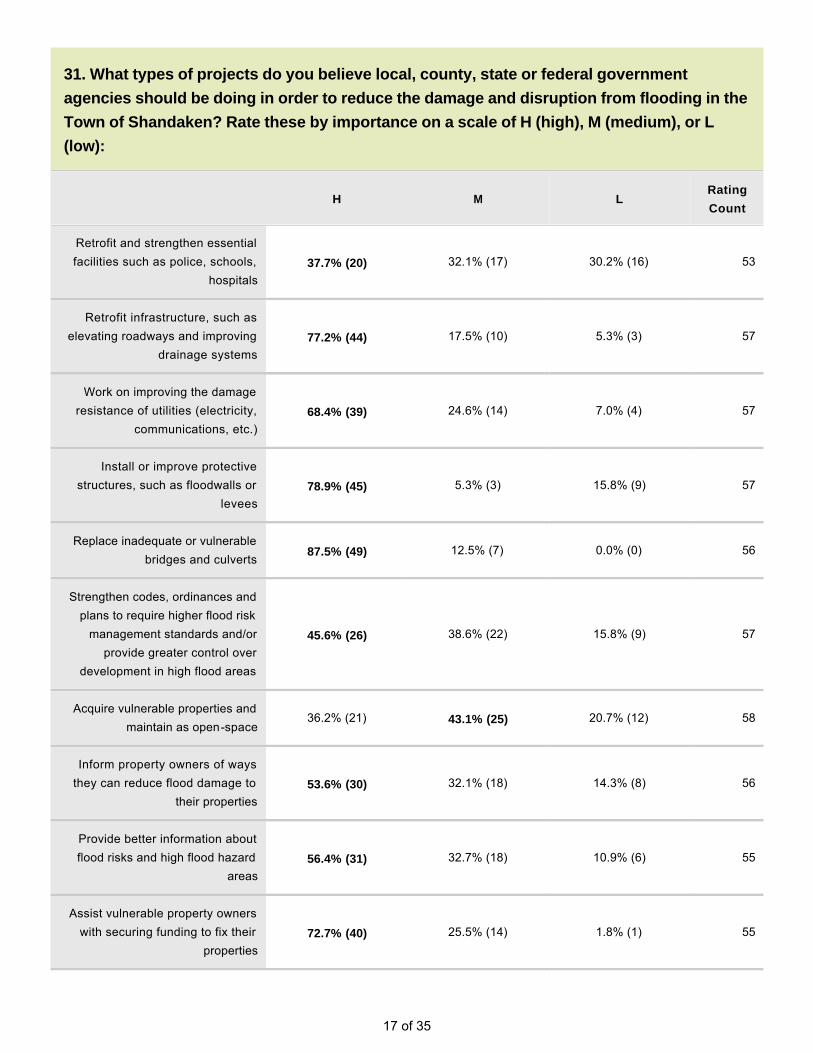
31. What types of projects do you believe local, county, state or federal government
agencies should be doing in order to reduce the damage and disruption from flooding in the
Town of Shandaken? Rate these by importance on a scale of H (high), M (medium), or L
(low):
H M LRating
Count
Retrofit and strengthen essential facilities such as police, schools,
hospitals37.7% (20) 32.1% (17) 30.2% (16) 53
Retrofit infrastructure, such as elevating roadways and improving
drainage systems77.2% (44) 17.5% (10) 5.3% (3) 57
Work on improving the damage resistance of utilities (electricity,
communications, etc.)68.4% (39) 24.6% (14) 7.0% (4) 57
Install or improve protective structures, such as floodwalls or
levees78.9% (45) 5.3% (3) 15.8% (9) 57
Replace inadequate or vulnerable bridges and culverts
87.5% (49) 12.5% (7) 0.0% (0) 56
Strengthen codes, ordinances and plans to require higher flood risk
management standards and/or provide greater control over
development in high flood areas
45.6% (26) 38.6% (22) 15.8% (9) 57
Acquire vulnerable properties and maintain as open-space
36.2% (21) 43.1% (25) 20.7% (12) 58
Inform property owners of ways they can reduce flood damage to
their properties53.6% (30) 32.1% (18) 14.3% (8) 56
Provide better information about flood risks and high flood hazard
areas56.4% (31) 32.7% (18) 10.9% (6) 55
Assist vulnerable property owners with securing funding to fix their
properties72.7% (40) 25.5% (14) 1.8% (1) 55

18 of 35
Other (please specify)
16
answered question 61
skipped question 27
32. Please use the space below to include any other comments that you may have.
Response
Count
37
answered question 37
skipped question 51

19 of 35
Page 2, Q5. What is your Shandaken address? (optional, will be kept confidential - only used to identify homes inflood-prone areas)
55 when are the homeowners along 28 and 212 in mt tremper going to pick up theirtrash and garbage on their lawns and tear down damaged buildings?
Apr 10, 2012 8:11 PM

20 of 35
Page 3, Q12. If the answer to question 11 is "yes", which location?
1 MT TREMPER FIRE HOUSE May 5, 2013 10:57 PM
2 the firehouse and bellayre Apr 26, 2013 11:12 AM
3 Belleayre Feb 18, 2013 12:49 PM
4 Shandaken fire station? Dec 8, 2012 11:07 PM
5 Bellaryre Oct 30, 2012 8:06 AM
6 Bellayre Mt Oct 29, 2012 10:05 PM
7 Mt. Tremper Fire House Sep 27, 2012 8:24 PM
8 Bellayre Sep 21, 2012 11:01 AM
9 Belleayre? Sep 19, 2012 10:22 AM
10 Bellyaire Mountain Jul 8, 2012 6:56 AM
11 Bellarye Jul 1, 2012 9:06 PM
12 Belleayre (they take dogs) Jun 28, 2012 9:48 AM
13 have never had to evacuate Jun 28, 2012 9:43 AM
14 Fire house Jun 28, 2012 9:35 AM
15 Belleayre Jun 28, 2012 9:28 AM
16 Belleayre Mountain Jun 21, 2012 6:06 PM
17 Zen Monastery Jun 20, 2012 9:15 AM
18 Belleayre Mountain Jun 18, 2012 1:58 PM
19 Bellayre Jun 14, 2012 12:56 PM
20 Fire House; Belleayre Jun 14, 2012 12:16 PM
21 Firehouse on Rte 214 Jun 14, 2012 12:03 PM
22 Belleayre Jun 6, 2012 10:30 AM
23 Zen monastery! South plank Jun 5, 2012 5:56 PM
24 Big Indian-Oliverea Fire House Jun 5, 2012 5:28 PM
25 BIOFD Jun 5, 2012 2:10 PM
26 My guess is the Fire Station up on Main Street in Pine Hill. Jun 5, 2012 1:13 PM
27 belleayre mountain? Jun 3, 2012 2:57 PM

21 of 35
Page 3, Q12. If the answer to question 11 is "yes", which location?
28 Belleayre May 31, 2012 10:29 PM
29 Belleayre May 31, 2012 7:14 PM
30 big indian oliverea fire house May 7, 2012 12:30 PM
31 BELLYAIRE MOUNTAIN SKI RESORT Apr 19, 2012 3:05 PM
32 Phoenicia School Apr 16, 2012 11:34 AM
33 mt tremper looks like hell with all the trash in people's yards. They got insurancemoney they should be made to tear down and clean up
Apr 10, 2012 8:13 PM
34 firehouse that has no supplies Apr 10, 2012 8:03 PM
35 Pine Hill Firehouse or Belleayre Mountain Ski Center Apr 10, 2012 1:01 PM

22 of 35
Page 3, Q14. What type of assistance is needed to address the access and functional needs of the individual(s)with disabilities living within your household or for whom you have responsibility?
1 N/A May 5, 2013 10:57 PM
2 NA Oct 30, 2012 8:06 AM
3 Does not apply Oct 29, 2012 10:05 PM
4 Bridge may be down. Oct 17, 2012 8:04 PM
5 No one is disabled but takes blood pressure medicine and insurance will not payfor extra in case of emergency.
Sep 19, 2012 10:22 AM
6 none Aug 22, 2012 8:24 PM
7 none Jul 24, 2012 7:39 AM
8 Occasionally 88-year-old mother joins us there. No particular disability (exceptAlzheimer's). She's frail, though. In severe weather I'd not have her there.
Jul 10, 2012 8:31 PM
9 Not sure. Jul 8, 2012 6:56 AM
10 na Jun 28, 2012 9:48 AM
11 Blood pressure and other monitoring; mobility assistance Jun 28, 2012 9:35 AM
12 NA Jun 28, 2012 9:28 AM
13 medical doctor. housing Jun 20, 2012 9:15 AM
14 NA Jun 14, 2012 12:56 PM
15 NA Jun 14, 2012 12:16 PM
16 NA Jun 14, 2012 12:03 PM
17 None Jun 6, 2012 7:50 AM
18 Needs meds Handicap toilet Jun 5, 2012 5:56 PM
19 Wheelchair, medications cane blankets books glasses adult diapers way to gether up the stairs or out the back door - need people to assist. Thanks for makingme think about this.
Jun 5, 2012 1:13 PM
20 evacuation and transportation Jun 1, 2012 8:48 AM
21 Special toileting facilities May 31, 2012 10:29 PM
22 N/A May 31, 2012 7:14 PM
23 ADVANCE WARNING TO POSSIBLE FLOODS Apr 19, 2012 3:05 PM
24 n/a Apr 16, 2012 8:09 PM
25 What is the town doiung about cleaning up the mess in mount tremper????? Apr 10, 2012 8:13 PM

23 of 35
Page 3, Q14. What type of assistance is needed to address the access and functional needs of the individual(s)with disabilities living within your household or for whom you have responsibility?
26 food, water, bed Apr 10, 2012 8:03 PM

24 of 35
Page 4, Q16. In what ways do you believe you are prepared for floods? (Please check all that apply)
1 PREVIOUS EXPERIENCE Sep 27, 2012 8:28 PM
2 you must be kidding Sep 21, 2012 11:04 AM
3 my home does not flood and I have a generator Jul 24, 2012 7:43 AM
4 OK, so I'll back down to (2). Jul 10, 2012 8:34 PM
5 I have a primary residence Jul 2, 2012 11:26 AM
6 I'm not an idoit from NYC, I know this a WILDERNESS (not the suburbs) and Iam always prepared with proper clothing, gear, and knowledge about trails,animals, and nature.
Jul 1, 2012 9:09 PM
7 pay attention to weather reports Jun 28, 2012 9:50 AM
8 try to keep fuel tank anchored down with enough fuel during flood risk times Jun 14, 2012 12:18 PM
9 If given enough notice, will leave for Florida (home) which is what we did duringIrene.
Jun 6, 2012 7:54 AM
10 I need to prepare, the next time I am offered this quiz I hope to pass. I can helpmy aunt fine day to day but in a disaster I would lose precious time trying toassemble a plan and a kit.,I just moved here in November, from San Diegowhere I lived alone.
Jun 5, 2012 1:18 PM
11 Have emergency equipment and resources (generator, spring) May 31, 2012 7:16 PM
12 PHOENICIA FIRE DEPT Apr 19, 2012 3:09 PM
13 have not used property since Irene damaged it Apr 16, 2012 8:13 PM
14 Generator Apr 16, 2012 11:37 AM
15 I bought a house on the side of a mountian Apr 10, 2012 1:08 PM

25 of 35
Page 4, Q18. Information on how to prepare for floods can be given to the public in various ways. Of theinformation sources below, please identify the top three (3) that are MOST EFFECTIVE in providing you withinformation to make your home safer and better able to withstand the impact of floods.
1 door to door Nov 2, 2012 6:24 AM
2 Cold Brook gage and weather radio provided by Town Jun 28, 2012 9:50 AM
3 Check Stream gage at Cold Brook Jun 28, 2012 9:36 AM
4 flood risk awareness Jun 28, 2012 9:29 AM
5 top3 are Fire House; TV news and EMS Jun 14, 2012 12:58 PM
6 experience living here Jun 14, 2012 12:18 PM
7 Emergency call alert Jun 1, 2012 1:31 AM
8 There is no way to prepare for what happened here May 31, 2012 10:50 PM
9 why is mount tremper full of trash and garbage? this town is a sham Apr 10, 2012 8:14 PM
10 no power no news other than radio which gave false info Apr 10, 2012 8:06 PM

26 of 35
Page 5, Q28. Have you made any changes to your property in the past to reduce the damage from floods? Whathave you done to your home or business to prevent future damages?
1 YES. RAISE ELEVATION OF HOME. May 5, 2013 11:14 PM
2 Raised storage items off the garage floor. Feb 18, 2013 12:53 PM
3 Installed French drain and swales to divert hillside runoff; stream-side plantingsto stabilize banks; avoiding stream-side flooding areas on property (not nearbuildings); slab design-no basement
Feb 15, 2013 3:13 PM
4 Added more soil Jan 28, 2013 4:39 PM
5 The areas that got flooded in Irene were leisure structures. I rebuilt with somemitigation in mind, am prepared to reinforce and rebuild if needed. Residence iswell above sub-Biblical flood plain.
Dec 8, 2012 11:19 PM
6 Our primary problem is the flooding and compromise of our roads and bridges,both our private road and the town roads of rte 47 and Burnham Hollow Rd.
Oct 29, 2012 10:13 PM
7 I've installed riprap walls along the stream side and upstream side of my home Oct 17, 2012 8:42 PM
8 Can't afford to Oct 17, 2012 8:11 PM
9 Removed debris from culvert under road, starting to build berm to protect housefrom road flooding, improved drainage around house
Oct 5, 2012 12:20 PM
10 Our property, not our homes, have flooded several times; and we have tried toget the DEC to repair the channel blocker to prevent future flooding. So far theyhave refused.,
Sep 27, 2012 8:35 PM
11 Reinforced basement walls Sep 21, 2012 11:07 AM
12 Elevated the driveway and made a stone wall to elevate the ground on theupstream side.
Sep 19, 2012 10:30 AM
13 Uphill swales; substantial drainage piping to remove water runoff from high rainevents; minor landscaping/plantings along streamside areas to make them moreflood resistant
Sep 12, 2012 9:43 PM
14 added two pumps..now have three Aug 22, 2012 8:28 PM
15 Installed propane fired generator --totally updated house--windows, metal roof,new oil burner--am in flood plain but do not flood
Jul 24, 2012 7:50 AM
16 Rip-rap along stream. Will do same further upstream this summer. Jul 10, 2012 8:39 PM
17 Applied for a DEP permit to remove rocks that are creating a berm between ourproperty and the creek we are up against.
Jul 8, 2012 7:02 AM
18 Not What I did its what the DEP/DEC should have done/do to maintain the Creekbed from building up to an ineffective elevation vs the dike elevation.
Jul 2, 2012 11:33 AM
19 retaining wale, swale (curtain drain), berm, spray foam instead of batting in crawlspace.
Jul 1, 2012 9:13 PM

27 of 35
Page 5, Q28. Have you made any changes to your property in the past to reduce the damage from floods? Whathave you done to your home or business to prevent future damages?
20 no Jun 28, 2012 9:51 AM
21 no Jun 28, 2012 9:45 AM
22 No. would not help. Jun 28, 2012 9:39 AM
23 moved utilities out of basement, poured concrete tro replace cinderblockfoundation; mildew and mold-resistant drywall throughout; raise hot tub and poolequipment
Jun 28, 2012 9:31 AM
24 yes Jun 21, 2012 6:10 PM
25 no Jun 20, 2012 9:19 AM
26 bought generator; upgraded electric to increase amperage; Jun 14, 2012 1:00 PM
27 i rent Jun 14, 2012 12:06 PM
28 Yes, upgraded culverts on my property. This prevented water from getting in mygarage.
Jun 8, 2012 10:07 PM
29 We replaced a culvert with a larger one. We replaced the entire private roadfrom mountain gate to our driveway at an extreme cost. Very upsetting as thearmy core of engineers replaced the road below the mountain gate and allculverts but we had to pay our own. We don't pay less in taxes but were givenno support for this.
Jun 6, 2012 8:00 AM
30 none Jun 3, 2012 3:12 PM
31 no Jun 1, 2012 8:54 AM
32 I repaired my home ,but you do not get money to fix your property and withinsurance deduct. an the things they do not pay for it is limited as to what onecan do.
Jun 1, 2012 1:56 AM
33 Paid $35,000 to build a rock wall May 31, 2012 11:02 PM
34 IRENE WAS THE FIRST FLOOD TO ENTER MY HOME. Apr 19, 2012 3:14 PM
35 2007 - elevated furnace and mechanical systems above basement floor Apr 16, 2012 8:24 PM
36 tear them down and attach the cost to the properties Apr 10, 2012 8:16 PM

28 of 35
Page 5, Q29. If you have been flooded and have had damages to your home or business and you have not doneanything to reduce future damages, why have you not done anything?
1 We are restricted by the DEP. Jan 28, 2013 4:39 PM
2 NA Oct 30, 2012 8:14 AM
3 ..if something isn't done to shore the banks below McKenley Hollow Bridge Sep 19, 2012 10:30 AM
4 flooding on property is far from structures and is nuisance only Sep 12, 2012 9:43 PM
5 I do not flood Jul 24, 2012 7:50 AM
6 House has not been flooded. Jul 10, 2012 8:39 PM
7 I paid $240,000 in 07 for my house now worth $78,000. Im bankrupt and thestorm left me in debt to contractors
Jul 1, 2012 9:13 PM
8 would have to elevate at least 12 feet - can't afford Jun 28, 2012 9:51 AM
9 only basement has been flooded Jun 28, 2012 9:45 AM
10 NA Jun 28, 2012 9:31 AM
11 management strategies sufficient Jun 14, 2012 12:20 PM
12 i rent Jun 14, 2012 12:06 PM
13 house already washed away Jun 5, 2012 6:27 PM
14 EXTREMELY LIMITED INCOME-RETIRED Apr 19, 2012 3:14 PM
15 Floodplain code compliance not practical for my property Apr 16, 2012 8:24 PM
16 clean it up Apr 10, 2012 8:16 PM

29 of 35
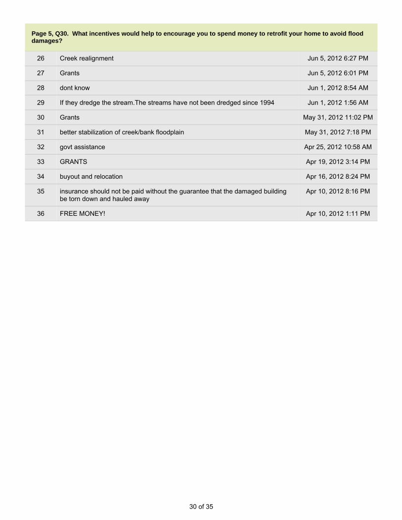
Page 5, Q30. What incentives would help to encourage you to spend money to retrofit your home to avoid flooddamages?
1 FINANCIAL AND TECHNICAL ASSISTANCE May 5, 2013 11:14 PM
2 Help figuring how to elevate my house and money to contribute towards doing it. Feb 18, 2013 12:53 PM
3 low interest loan; tax incentives; expedited permitting Feb 15, 2013 3:13 PM
4 Grants, tax breaks, inexpensive reputable help. Jan 28, 2013 4:39 PM
5 help from govt to pay for improvements; grants or low interest/no interest loans Nov 26, 2012 10:30 AM
6 NA Oct 30, 2012 8:14 AM
7 Tax breaks/ rebates Oct 17, 2012 8:42 PM
8 Significant rebates Oct 17, 2012 8:11 PM
9 Financial aid from a state, county or federal agency. Sep 27, 2012 8:35 PM
10 Grants for design review and evaluation; free evaluation (e.g. Cornell Extensioinfollowup to stream surveys; waiver periods for easy permitting of improvementslike landslide mitigation
Sep 12, 2012 9:43 PM
11 Expert advice on how to do it. Jul 30, 2012 7:38 PM
12 none Jul 24, 2012 7:50 AM
13 Am spending money on stream; not much can do about home. Jul 10, 2012 8:39 PM
14 I have no money and maybe soon, no house to worry about. Jul 1, 2012 9:13 PM
15 full grant for entire cost Jun 28, 2012 9:51 AM
16 Free money and materials. But, what can i do? town rules prohibit any effectiveaction such as building a wall around my home
Jun 28, 2012 9:39 AM
17 COVER COSTS TO ELEVATE STRUCTURE Jun 28, 2012 9:31 AM
18 tax breaks, grants, etc Jun 20, 2012 9:19 AM
19 I would be willing to spend the money if I knew what to do. Jun 18, 2012 2:07 PM
20 depends on program Jun 14, 2012 1:00 PM
21 would depend Jun 14, 2012 12:20 PM
22 i rent Jun 14, 2012 12:06 PM
23 ??? Jun 8, 2012 6:48 AM
24 Grants, tax incentives. Take over our private road and have the town pave it andtake care of it.
Jun 6, 2012 8:00 AM
25 Engineer's evaluation Jun 5, 2012 11:51 PM
30 of 35
Page 5, Q30. What incentives would help to encourage you to spend money to retrofit your home to avoid flooddamages?
26 Creek realignment Jun 5, 2012 6:27 PM
27 Grants Jun 5, 2012 6:01 PM
28 dont know Jun 1, 2012 8:54 AM
29 If they dredge the stream.The streams have not been dredged since 1994 Jun 1, 2012 1:56 AM
30 Grants May 31, 2012 11:02 PM
31 better stabilization of creek/bank floodplain May 31, 2012 7:18 PM
32 govt assistance Apr 25, 2012 10:58 AM
33 GRANTS Apr 19, 2012 3:14 PM
34 buyout and relocation Apr 16, 2012 8:24 PM
35 insurance should not be paid without the guarantee that the damaged buildingbe torn down and hauled away
Apr 10, 2012 8:16 PM
36 FREE MONEY! Apr 10, 2012 1:11 PM
31 of 35
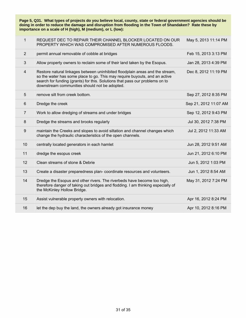
Page 5, Q31. What types of projects do you believe local, county, state or federal government agencies should bedoing in order to reduce the damage and disruption from flooding in the Town of Shandaken? Rate these byimportance on a scale of H (high), M (medium), or L (low):
1 REQUEST DEC TO REPAIR THEIR CHANNEL BLOCKER LOCATED ON OURPROPERTY WHICH WAS COMPROMISED AFTER NUMEROUS FLOODS.
May 5, 2013 11:14 PM
2 permit annual removable of cobble at bridges Feb 15, 2013 3:13 PM
3 Allow property owners to reclaim some of their land taken by the Esopus. Jan 28, 2013 4:39 PM
4 Restore natural linkages between uninhibited floodplain areas and the stream,so the water has some place to go. This may require buyouts, and an activesearch for funding (grants) for this. Solutions that pass our problems on todownstream communities should not be adopted.
Dec 8, 2012 11:19 PM
5 remove silt from creek bottom. Sep 27, 2012 8:35 PM
6 Dredge the creek Sep 21, 2012 11:07 AM
7 Work to allow dredging of streams and under bridges Sep 12, 2012 9:43 PM
8 Dredge the streams and brooks regularly Jul 30, 2012 7:38 PM
9 maintain the Creeks and slopes to avoid siltation and channel changes whichchange the hydraulic characteristics of the open channels.
Jul 2, 2012 11:33 AM
10 centrally located generators in each hamlet Jun 28, 2012 9:51 AM
11 dredge the esopus creek Jun 21, 2012 6:10 PM
12 Clean streams of stone & Debrie Jun 5, 2012 1:03 PM
13 Create a disaster preparedness plan- coordinate resources and volunteers. Jun 1, 2012 8:54 AM
14 Dredge the Esopus and other rivers. The riverbeds have become too high,therefore danger of taking out bridges and flodding. I am thinking especially ofthe McKinley Hollow Bridge.
May 31, 2012 7:24 PM
15 Assist vulnerable property owners with relocation. Apr 16, 2012 8:24 PM
16 let the dep buy the land, the owners already got insurance money Apr 10, 2012 8:16 PM

32 of 35
Page 6, Q32. Please use the space below to include any other comments that you may have.
1 THERE IS AN URGENT NEED FOR REPAIRS TO THIS CHANNEL BLOCKER!! May 5, 2013 11:18 PM
2 I filled this survey out a few months ago, but when I clicked "done", I got amessage saying it didn't go through. I hope that doesn't happen this time.Thanks for your help.
Feb 18, 2013 12:54 PM
3 Strengthen cell phone coverage for emergency response; advise residents onpreparing emergency "bug out bags" with shelter supplies in case of floodingevacuation
Feb 15, 2013 3:15 PM
4 Remove sediment from creek beds so high water has a place to flow. Theshallow creeks appear to be the biggest problem and most cost effective. Thereare contractors willing and ready to remove sediment as they have done manyyears ago...why did this life/property saving practice stop??? It doesn't cost thecity or towns any money...the contractors remove the material to have thematerial on hand for future projects.
Oct 30, 2012 8:17 AM
5 We now have a chronic flood problem in Oliverea valley. Despite town efforts torepair damaged roads and bridges, it seems that stream engineering strategiesshould be considered. The town keeps repairing the same washout areaswithout any real mitigation of flooding streams.
Oct 29, 2012 10:16 PM
6 You should consider re-paving Woodland Valley Rd and reinforcing the streambanks all the way upstream.
Oct 17, 2012 8:43 PM
7 I live on Woodland Valley rd. It may very well be one of the worst maintainedroads in the area! It desperately needs to be re paved or re surfaced along theentire upper 2/3 of the road! It's full of potholes and I consider it to be dangerousin storm conditions. I pay a lot of taxes and get unsafe roads for my money.Please consider re paving tis road all the way up, not just where it washed out orby the wealthier houses before the spring melts! Please!
Oct 17, 2012 8:36 PM
8 We were one of four homes each 150 years old, without flood problems untilIrene killed two and left us other two damaged. We never had flood problemsbefore they started dredging above the McKenley Hollow Bridge to protectBrown Rd. Now all the stone they've used to reshape south of the bridge haswashed down and filled in under the bridge so the water comes up onto anddown the road. The creek below the bridge (at the actual McKenley Hollowoutlet) used to cut back (west) toward the mountain and away from the homesand road. Now that curve is gone and the water comes straight down the westside of the road and across to threaten what is left of our homes. Noise has beenmade but nothing is being done to dredge below the bridge and now we floodedagain last night (9/18/12.) What a shame to lose these historic houses (andtaxpayers) and have to keep putting the road back because no one will fix thestream. Furthermore, acres and acres of land has been lost which will no longerbe taxable. Please help save our home.
Sep 19, 2012 10:43 AM
9 Broadstreet Hollow Rd is subject to two flooding problems: rain-inducedlandslides that increase turbidity or potentially dam the stream, and bridgedamming by debris and accumulated stone cobble that should be dredgedperiodically. Bridge damming has been the cause of road flooding and washoutsin most storms. Post-Irene dredging at 2nd bridge was good.
Sep 12, 2012 9:46 PM

33 of 35
Page 6, Q32. Please use the space below to include any other comments that you may have.
10 Our road and stream were among the hardest hit and after a year look forgottenand raw. Other towns have been fixed up.
Jul 30, 2012 7:42 PM
11 Flooding is so powerful that we have to learn to adapt to it rather than avoid it--I've lived here 45 yrs and seen 4 major floods--keep the streams deep enough tocarry the excess water away from the town--this must be done every so manyyears as the streams eventually refill with stone and gravel over time--if the DECdoes not understand this and refuses access to the streams then we must go toa higher court or if refused say the hell with it and do it anyway-if not history willrepeat itself again and again------
Jul 24, 2012 7:58 AM
12 Need cell phone service. Town & townspeople did great job in and afteremergency. THANK YOU.
Jul 10, 2012 8:41 PM
13 Maintain the creeks gravel deposits and the debri in and around the creeks tothe high water marks. Maintain eroision control along the creeks. Steep slopeset.
Jul 2, 2012 11:35 AM
14 Since the flood hikers are lost all over the place. They try to camp on myproperty on McKinley Hollow where I have a private drive. There needs to besigns! Signs would change my life! Everyday hikers park in the large turnaroundat the dead-end of McKinley Hollow instead of parking in the designated parkinglot. Today I saw one car in the designated lot, and enough room for four morecars but two cars were parked in the turnaround which is specifically there forfiretrucks, trash collection, town trucks and emergencies. This emergencyturnaround is abused and blocked constantly. The road I had to pay $12,000 forwith my neighbors PLUS 8,000 for the driveway which is only in front of myhouse. Every day hikers are on my $20,00 road speeding, lost, nowhere to turn,almost going over the edge of the driveway/road which is narrow with a sharpdrop. I beg the town of Shandaken: we need signs. Signs that say it is a DeadEnd BEFORE our drivway, signs that say NO PARKING in the emergencyturnaround. I pay as much taxes as all the rich weekend city people who got newroads, driveways, culverts, drainage and I got nothing. I owe my contractor$8,000 or I would be homeless. I understand Shandaken has little funds and cannot repave McKinley Hollow. I don't mind. But signs are cheap and desperatelyneeded. My house is ten feet from the driveway. I have two dogs and peoplewith NJ plates drive 50mph past my house while lost. I've been to the cops, theysay I can't regulate the speed on a private driveway but this driveway is long, atleast 1/4 mile, we paid for it when no one else would and I live in a 500 squarefoot cabin, I have nothing. The storm completely destroyed me financially andyet today, I had two turn arounds in my front yard and three lost hikers walkingthrough my property. This is annoying and it's dangerous.
Jul 1, 2012 9:27 PM
15 Buy-outs only good if they arre for the full market value, don't want to have to golive in an apt because $ is not enough to get another house. can't get medsahead of time because of Medicaid rules and procedures. Cleanup volunteerswere absolutely wonderful. you are in such shock and you don't realize it.Bridge Street causes flooding downstream
Jun 28, 2012 9:53 AM
16 dredge the stream; dredge further up Stony Clove. when they put the telephonelines underground it changed the water patterns on the street, folks who didntget wet basements now do and maybe vice versa
Jun 28, 2012 9:47 AM

34 of 35
Page 6, Q32. Please use the space below to include any other comments that you may have.
17 Buy-out and property acquisition good only if receive fair market price. dredgethe stream. spend money on solutions instead of lots of studies and plans. fixproblem before it turns into a larger problem. city should be contributing moneysince they are taking the water. 28 years ago this house was not next to thestream. town should fix bank where rr tracks washed out by Bridge Street in1996. FD announced evacuation but did not stick around to assist - have no car.
Jun 28, 2012 9:42 AM
18 Flood risk was dowbplayed by realtor; buy-outs would have to be at marketvalue, not useful if offer is very low; town should dredge stream; financialassistance in form of grants or a loan with decent terms; there was an outpouringof help for cleanup from the community, Rotary Club was extremely helpful.
Jun 28, 2012 9:33 AM
19 Climate change; Env Sci teach at HS. Flooded in 2005. Evcuated in 2010, butcame back. Left during Irene/ Lee in 2011. leave as soon as water is on SouthStreet. believe in need to move town. how many times can you keep passingthe buck? Do not believe Phoenicia will be a community in the coming years,will be flooded due to climate change.
Jun 20, 2012 9:21 AM
20 Thank you for your assistance with this matter. We look forward to seeingcertain changes in the future - please do let us know how these changes will bemade.
Jun 18, 2012 2:11 PM
21 Do more dredging. in past they used to clear out streams. used to clear gravelout. used gravel for construction. believe in most cases it works (to mitigateflooding). Stream in Oliverea needs to be rechannelized. State is too restrictivein permitting
Jun 14, 2012 1:02 PM
22 These river valley towns have cultural and economic importance to region. theyprovide amenities, habitation and community centers. People should be verycautious about overreacting to floods and overestimating community impacts.Overreaction to Main Street flooding: certain areas were deeply impacted butmuch of the Town was not. it was ver manageable. Want to protect our townsnot abandon them. "don't throw out the baby with the floodwater"
Jun 14, 2012 12:23 PM
23 i think there should be a better evacuation plan because when it floods it is likean island here, we are trapped from all ways, could not get out for days; noelectricity
Jun 14, 2012 12:07 PM
24 The Bridge St bridge in Phoenicia needs to be REPLACED and the Esopusdredged in that location to protect the town.
Jun 8, 2012 10:09 PM
25 Improve emergency communications (cell phone service), & install warningsirens in each hamlet for flooding (or other weather emergencies, such astornados)
Jun 8, 2012 12:08 PM
26 The town should be responsible for the entire McKinley Hollow road. Not just thelower parts. We replaced our own road but the town has yet to change the trailsigns. As a result we have hikers driving up our PRIVATE road and causingwear and tear. In addition, people try to park on our road and hike our property.We need better signage!
Jun 6, 2012 8:02 AM
27 Would like a study showing likelihood of future flooding to my street after repairraised the street level three feet at least.
Jun 5, 2012 11:52 PM

35 of 35
Page 6, Q32. Please use the space below to include any other comments that you may have.
28 thanks Jun 5, 2012 2:15 PM
29 I just wanted to thank you again for this invaluable survey and lesson andreminder. I will go and prepare in the following weeks for future big storms. I'mfrom So. Calif so I have never lived through a flood before.
Jun 5, 2012 1:25 PM
30 concern about mud slides should be considered and use of the USGS streamflow guages to be a warning system could be helpful
Jun 3, 2012 3:16 PM
31 Because there was no coordination of resources and volunteers in local hamletsin the aftermath of the flooding last August, residents turned to Shandaken TownHall for help. I know the officials and staff at town hall were inundated withrequests but the unprofessional manner in which residents were treated onlyserved to make matters worse and create an atmosphere of fear anduncertainty. Should there ever be another catastrophic event like TS Irene, oneperson or one team - specifically trained to deal with the fear and stress ofvictims- should man the phones in order to calm people down and prioritizeneed.
Jun 1, 2012 9:06 AM
32 Need cell service! Back in Fox Hollow we have poor radio reception and no cellreception. When the utilities cut out we had no way to receive or give informationoutside of our hollow...it was uncomfortable and not safe.
Jun 1, 2012 8:47 AM
33 The ripp rapp along Oliverea Rd ,past the Mc Kinnly hollow bridge is falling intothe Esopus and nothing is being done about it and i have notified the town anhighway dept.
Jun 1, 2012 1:56 AM
34 BUY OUTS SHOULD PROVIDE ENOUGH MONIES TO ENABLE A PERSONTO PURCHASE ANOTHER PRIVATE HOME
Apr 19, 2012 3:15 PM
35 Enact mandatory disclosure of flood plain zoning restrictions upon sale ortransfer of affected properties.
Apr 16, 2012 8:28 PM
36 devrease property taxes in mount tremper until the mess is cleaned up they aredevaluing everybody's property with their trash and boarded up windows
Apr 10, 2012 8:18 PM
37 The Town should be digging the streams and remove the gravel bars thatcaused the flooding. The DEC should pay for this if they want to save their fish!
Apr 10, 2012 1:12 PM

Presented by Tetra Tech EM Inc.
Town of ShandakenFlood Mitigation Plan
22
Town of Shandaken Flood Mitigation Plan
“Mitigation” -
Sustained action taken to reduce or eliminate
long-term risk to life and property from a hazard event
-Or –
Any action taken to reduce future disaster losses
What is Hazard Mitigation?

33
Town of Shandaken Flood Mitigation Plan
An increased understanding of flooding that the Town faces.
Reduced long-term impacts and damages (human health and structures)
Development of a more sustainable and disaster-resistant community.
Reduced flood insurance premiums. [Community Rating System (CRS) compliant]
A Local Flood Mitigation Plan demonstrates a commitment to reducing risks from flooding and serves as a guide for decision makers as they commit
resources to minimize the effects of flood hazards.
Why are we Preparing this Plan?
44
Town of Shandaken Flood Mitigation Plan
What does the Flood Mitigation Plan provide?
A detailed action plan the Town will implement to reduce risk to floods
A comprehensive, factual assessment of risk to support why proposed mitigation strategies are appropriate
Better coordination of mitigation efforts with other local, county, regional, state and federal entities
“provides the blueprint for reducing the potential losses identified in the risk assessment, based on existing authorities, policies,
programs and resources, and local ability…” (CFR).

55
Town of Shandaken Flood Mitigation Plan
The Shandaken Flood Mitigation Plan
A Flood Mitigation Plan (FMP) is a living document that communities use to reduce their vulnerability to flooding.
An FMP is a “subset” of a Hazard Mitigation Plan (HMP).
As part of the 2009 Ulster County HMP, the Town of Shandakenhas an approved plan so it is eligible for mitigation funding.
66
Town of Shandaken Flood Mitigation Plan
Purpose
The Town wishes to re-examine its vulnerability to the flood hazard, create more detailed flood hazard analyses, evaluate progress on the mitigation strategies identified in the original plan.
The Town will add new mitigation actions/projects/initiatives so that it can continue to lower its flood hazard risk.
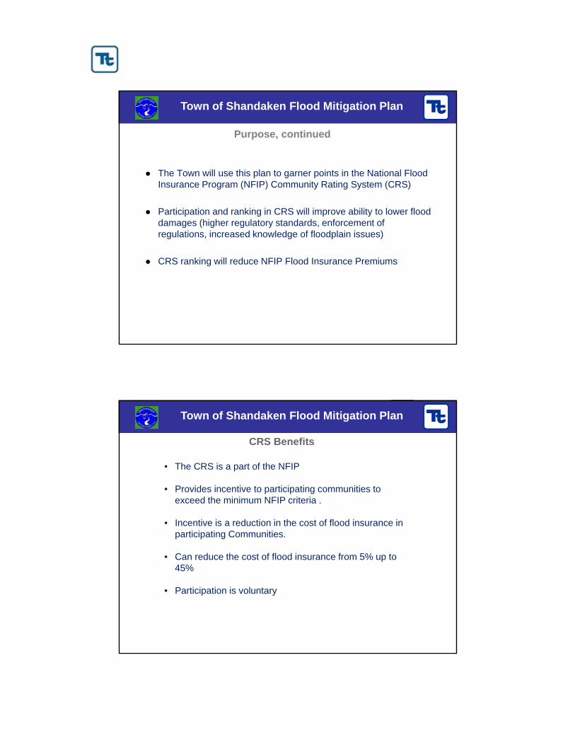
77
Town of Shandaken Flood Mitigation Plan
Purpose, continued
The Town will use this plan to garner points in the National Flood Insurance Program (NFIP) Community Rating System (CRS)
Participation and ranking in CRS will improve ability to lower flood damages (higher regulatory standards, enforcement of regulations, increased knowledge of floodplain issues)
CRS ranking will reduce NFIP Flood Insurance Premiums
88
Town of Shandaken Flood Mitigation Plan
CRS Benefits
• The CRS is a part of the NFIP
• Provides incentive to participating communities to exceed the minimum NFIP criteria .
• Incentive is a reduction in the cost of flood insurance in participating Communities.
• Can reduce the cost of flood insurance from 5% up to 45%
• Participation is voluntary

99
Town of Shandaken Flood Mitigation Plan
• The Office of the Supervisor of the Town of Shandaken is managing this effort.
• It is supported by the Shandaken Area Flood Assessment and Remediation Initiative (SAFARI).
• Members of the committee include representatives from
The Planning Committee
• Town of Shandaken
• Cornell Cooperative Extension
• of Ulster County
• RCAP Solutions
• Ulster County Emergency Management
• NYS DOT
• NYCDEP
• NYDEC
• USDA NRCS
• Ulster County Soil and Water Conservation District
• Landowners
• S.O.S (Save our Shandaken) Representative
1010
Town of Shandaken Flood Mitigation Plan
Project Schedule
Tasks Submittal Date
Flood Emergency Response Plan 2/28/12
Draft Risk AssessmentCRS Summary 5/31/12
Complete Risk AssessmentDraft Flood Mitigation Plan 8/31/12
Complete Flood Mitigation PlanCRS Application 10/31/12

1111
Town of Shandaken Flood Mitigation Plan
Organize Resources
Re-Assess the Risk
Review and Update the Mitigation Plan
Develop Procedures for Plan Implementation, Monitoring and Update
Adopt the Plan
Engage a Wide Range of
“Stakeholders”
Federal, State, Regional and Local Agencies
Business and Civic Groups
Academic Institutions
Other “local governments”
The Public
Plan Update Process Steps
1212
Town of Shandaken Flood Mitigation Plan
Assess the Risk – Flood Hazard Profiling
Flood Hazards will be profiled (characterized) according to:
– Background and local conditions – Historic frequency and probability of occurrence– Severity– Historic losses and impacts– Designated hazard areas
What Flood events have occurred since the 2009 Plan?
What Losses/Damages have occurred as a result of these events?

1313
Town of Shandaken Flood Mitigation Plan
Assess the Risk - Inventory of Assets
What is at risk? People, Property, Economy, Environment
Population and Demographics – Has this changed since 2009?
Building Stock (Residential, Commercial, Industrial, Educational, etc.)
Critical Facilities (essential facilities, utilities, transportation features, high-potential loss facilities and user-defined facilities)
– Police, Fire, Emergency Services– Hospitals and Medical Care Facilities– Schools and Care Facilities– Sheltering Facilities– Infrastructure (Transportation Systems, Utilities)– High-Potential Loss Facilities (Dams, Military Installations, Haz-Mat)
1414
Town of Shandaken Flood Mitigation Plan
Assess the Risk – Vulnerability Assessment
Vulnerability Assessment - What do we predict our suffering to be if we do nothing to mitigate our risk:
– Given current conditions, which have changed since 2009?– Given our improved understanding of risk, and tools to assess
that risk, which have changed since 2009?
Hazard Community Assets
Vulnerability

1515
Town of Shandaken Flood Mitigation Plan
Sample Mission Statement
The mission of the Town of Shandaken Flood Mitigation Plan is to
-identify and reduce the Town’s vulnerability to floods and to implement actions to reduce the risk of floods to residents and businesses.
-and seek to create a well-informed and prepared community while protecting the quality of life of the community.
1616
Town of Shandaken Flood Mitigation Plan
Goals and Objectives
Goals: General guidelines that state what we want to achieve. Should be consistent with the State goals and other local goals.
Example: “Protect existing properties.”
Objectives: Define strategies or implementation steps to attain a stated goal.
Example: “Enact or enforce regulatory measures that ensure new development will not increase flood threats to existing properties.”
Actions: Specific activities that will achieve our goals and objectives and manage natural hazard risk

1717
Town of Shandaken Flood Mitigation Plan
Capability Assessments
What resources do we have at our disposal to Mitigate Risk?
“Proposed mitigation actions will be evaluated against the backdrop of what is feasible in terms of your government’s legal, administrative, fiscal and technical capacities” (FEMA 386-3)
– Serve to identify legal authority and administrative, technical and fiscal capabilities in the state, county and jurisdictions that will facilitate or hinder hazard mitigation goals and objectives.
– Part of this Planning Process is to build Local Mitigation Capabilities
– Training, Workshops and Seminars
1818
Town of Shandaken Flood Mitigation Plan
Identification and Analysis of Mitigation Actions
Mitigation actions need to be realistic, achievable and action-oriented.
Will include both regional actions, as well as jurisdiction-specific.
Will address both public and private property.
For each proposed mitigation strategy, the following will be identified:
– Implementation timeline
– Estimated cost
– Estimated benefits (avoided losses)
– Potential funding sources
– Lead agency or department
– Supporting agencies

1919
Town of Shandaken Flood Mitigation Plan
Prevention. Measures such as planning and zoning, open space preservation, land development regulations, building codes, storm water management.
Property Protection. Measures such as acquisition, relocation, storm shutters, rebuilding, barriers, floodproofing, insurance, and structural retrofits for high winds.
Public Education and Awareness. Measures such as outreach projects, real estate disclosure, hazard information centers, technical assistance.
Natural Resource Protection. Measures such as erosion and sediment control, stream corridor protection, vegetative management, and wetlands preservation.
Emergency Services. Measures such as hazard threat recognition, hazard warning systems, emergency response, protection of critical facilities, and health and safety maintenance.
Structural Projects. Measures such as dams, levees, seawalls, bulkheads, retaining walls, channel modifications, storm sewers, and retrofitted buildings and elevated roadways.
Mitigation Actions? Like What?
2020
Town of Shandaken Flood Mitigation Plan
Other Planning Tasks
Assuring wide involvement and public participation– Notices and new releases on planning effort – FMP Webpage detailing effort, providing downloadable drafts of the
plan, and providing a way for public input (local contact information and email link)
– Public presentations and meetings– Public access to draft and final plan documents (incl. libraries, town
halls)– Questionnaire (on-line and/or hard copy)
Documentation of the Planning Process
Plan implementation and maintenance procedures
Adoption by local governments

2121
Town of Shandaken Flood Mitigation Plan
Plan Implementation
Your mitigation strategy section provides a “blueprint” to follow for progressively reducing your community’s natural hazard risk.
It will includes two type of initiatives/projects – those that your community can “self fund”, and those that will require outside (e.g. grant) funding.
Mitigation grant opportunities open regularly:– The annual HMA grant window opens in June of each year.
– HMGP funding comes in the wake of Declared Disasters in the State.
2222
Town of Shandaken Flood Mitigation Plan
Why do I want to do this again?…show me the money
Grant applications across all mitigation programs are similar (almost identical) and can be submitted through e-Grants to more than one program (with the exception of HMGP), and re-submitted if not awarded the first time.
The grant process starts with a simple “Letter Of Intent” (LOI). SOEM will review the LOI and advise the community whether they should move forward with their application.
Projects often address private property (e.g. residential, commercial), however the town or county must apply on their behalf as the “sub-applicant”.
Grants typically require a 25% local match…for private property projects, the property owner is typically responsible for fronting the 75% reimbursable portion, along with providing the 25% local match.

2323
Town of Shandaken Flood Mitigation Plan
Example: Consider a $200,000 storm water improvement projectin your 5-year Capital Budget for FY13
No Grant With GrantBase Project Cost: $ 200,000 Project cost with grant support: $ 220,000 Less 75% FEMA reimbursement: ($ 165,000)
Net Project cost to Town: $ 200,000 $ 55,000
Savings: $ 145,000 (73%)
…and this doesn’t consider long term cost benefits
Here’s how it works…
2424
Town of Shandaken Flood Mitigation Plan
General Questions,Issues and Concerns

11
Town of Shandaken - Flood Mitigation Plan
TOWN OF SHANDAKENFLOOD MITIGATION PLAN
PUBLIC MEETING | FEBRUARY 4, 2013
Presented by Tetra Tech, Inc.
22
Town of Shandaken - Flood Mitigation Plan
OUR TOPICS TONIGHT
The Problem
Why do a Flood Mitigation Plan?
The Objectives
Project Deliverables
Shandaken Vulnerability Assessment

33
Town of Shandaken - Flood Mitigation Plan
HISTORY OF FLOODING
Shandaken – “land of rapid waters”
Riverine and Flash Flooding
18 Presidentially Declared Flood Disasters since 1950.
Massive Damages to homesand infrastructure
Evacuations
Historic Flood Discharges in Ashokan Reservoir Watershed At Coldbrook Gage)
Rank DatePeak Discharges
(cfs)1 August 28, 2011 75,800 (~24’)
2 March 21, 1980 65,300 (~22’)
3 March 30, 1951 59,600
4 April, 3, 2005 55,200
5 August 24, 1933 55,000
6 October 15, 1955 54,000
7 January 19, 1996 53,600
8 April 4, 1987 51,700
9 December 21, 1957 46,900
10 March 12, 1936 38,500
11 April 5, 1984 37,400 (~18’)
44
Town of Shandaken - Flood Mitigation Plan
WHY??
Proactive vs. Reactive (Save $4 for every $1 in Mitigation)
Can act as a keyway to funding
The Community Rating System
Blueprint for Flood Reduction
Support other planning mechanisms
Watershed Plans
Land Use Plans
Codes and Ordinances

55
Town of Shandaken - Flood Mitigation Plan
WHAT IS HAZARD MITIGATION
“Mitigation” -
Sustained action taken to
reduce or eliminate
long-term risk to life and property
from a hazard event
Or –
Any action taken to
reduce future disaster losses
66
Town of Shandaken - Flood Mitigation Plan
MISSION STATEMENT
The mission of the Town of Shandaken Flood Mitigation Plan is to:
– develop and promote appropriate Town policy and practices
– to protect the residents, private property, public essential facilities and the environment
– from probable flood hazards.

77
Town of Shandaken - Flood Mitigation Plan
OVERALL GOAL
The overall goal of the Plan is to improve the Town’s capability to prepare for, respond to, recover from,
mitigate against and reduce vulnerability to flooding.
The plan identifies and encourages partnerships for coordinated implementation, funding, public
awareness and the development of strategies for carefully planned mitigation efforts designed to
protect the health, safety, quality of life, environment and economy of the Town of Shandaken.
88
Town of Shandaken - Flood Mitigation Plan
COMMUNITY RATING SYSTEM
Participation and ranking in CRS will improve ability to lower flood damages (higher regulatory standards, enforcement of regulations, increased knowledge of floodplain issues)
CRS ranking will reduce NFIP Flood Insurance Premiums

99
Town of Shandaken - Flood Mitigation Plan
CRS BENEFITS
Provides incentive to participating communities to exceed the minimum NFIP criteria .
Incentive is a reduction in the cost of flood insurance in participating Communities.
Can reduce the cost of flood insurance from 5% up to 45%
Participation is voluntary
1010
Town of Shandaken - Flood Mitigation Plan
CRS OBJECTIVES
Three Primary Objectives
– Reduce losses caused by flood related hazards
– Support accurate insurance rating
– Promote awareness of flood insurance

1111
Town of Shandaken - Flood Mitigation Plan
THE PLANNING COMMITTEE
The Office of the Supervisor of the Town of Shandaken is managing this effort.
It is supported by the Shandaken Area Flood Assessment and Remediation Initiative (SAFARI).
Members of the committee include representatives from• Town of Shandaken
• Cornell Cooperative Extension of Ulster County
• RCAP Solutions
• Ulster County Emergency Management
• NYS DOT
• NYCDEP
• NYDEC
• USDA NRCS
• Ulster County Soil and Water Conservation District
• Landowners
• S.O.S (Save our Shandaken) Representative
1212
Town of Shandaken - Flood Mitigation Plan
DELIVERABLES
Flood Mitigation Plan
Flood Warning and Response Plan
CRS Application Support

1313
Town of Shandaken - Flood Mitigation Plan
THE FLOOD HAZARD RISK ASSESSMENT
1414
Town of Shandaken - Flood Mitigation Plan
WHAT IS RISK?
Risk is defined as a function of: Hazard
– Source of potential danger or adverse condition
Exposure– Manmade or natural features that are exposed
to the hazard
Vulnerability, and– Damage susceptibility of the exposed features
Capability– Regulatory Capability– Technical Capability– Financial Capability

1515
Town of Shandaken - Flood Mitigation Plan
ASSESS THE RISK - INVENTORY OF ASSETS
What is at risk? People, Property, Economy, Environment Population and Demographics – Has this changed since 2009?
Building Stock (Residential, Commercial, Industrial, Educational, etc.)
Critical Facilities (essential facilities, utilities, transportation features, high-potential loss facilities and user-defined facilities)
– Police, Fire, Emergency Services
– Hospitals and Medical Care Facilities
– Schools and Care Facilities
– Sheltering Facilities
– Infrastructure (Transportation Systems, Utilities)
– High-Potential Loss Facilities (Dams, Military Installations, Haz-Mat)
1616
Town of Shandaken - Flood Mitigation Plan
RISK REDUCTION
To reduce Risk: Manipulate the Hazard:
– structural flood control
Reduce Exposure: – property acquisition
Reduce Vulnerability: – retrofitting
Increase capability: – $, preparation, technical assistance, planning

1717
Town of Shandaken - Flood Mitigation Plan
RISK ASSESSMENT METHODOLOGY
Assess hazard– Past events– Areas most affected– Frequency– Severity – Warning time for response
Determine Exposure Assess Vulnerability
– Loss Estimation
1818
Town of Shandaken - Flood Mitigation Plan
WHAT IS HAZUS?
HAZUS-MH is a powerful risk assessment methodology for analyzing potential losses from floods, hurricane winds and earthquakes.
Current scientific and engineering knowledge is coupled with the latest geographic information systems (GIS) technology to produce estimates of hazard-related damage before, or after, a disaster occurs.

1919
Town of Shandaken - Flood Mitigation Plan
Hazus is an ARC GIS Extension
INTRODUCTION TO GIS & HAZUS MH
5. Estimate Losses
4. Determine Damage
3. Define and Overlay Inventory
2. Define Hazard. Flood surface
1. Define terrain
2020
Town of Shandaken - Flood Mitigation Plan
FLOOD MODEL OVERVIEW
Subtract ground surface from flood surface to determine flood depth throughout the study area
Datum
GroundElevation
Flood Elevation
WATER DEPTH DAMAGE FUNCTION

2121
Town of Shandaken - Flood Mitigation Plan
REPETITIVE LOSS PROPERTIES
2222
Town of Shandaken - Flood Mitigation Plan
TOWN NFIP POLICIES AND CLAIMS (PRE-IRENE)
• Number of Building: 2,381• Number of Buildings in 1% Flood Boundary: 320 (13.4% of
total)• Number of Buildings in 0.2% Flood Boundary: 471 (19.8%
of total)• Number of Policies: 181• Number of Claims (losses): 127• Number of Repetitive Loss Properties: 12• Number of Severe Repetitive Loss Properties: 1• Number of Policies in 1% Flood Boundary: 96• Number of Policies in 0.2% Flood Boundary: 104• Number of Policies outside the o.2% Flood Boundary: 77

2323
Town of Shandaken - Flood Mitigation Plan
ESTIMATED POPULATION VULNERABLE TO THE 1% AND 0.2% FLOOD EVENTS
Zip Code
Total Population
(U.S. Census 2010)Population in 1%
Hazard AreaPercent
Population
Population in 0.2% Hazard
Area Percent Population
Big Indian 457 69 15.1 69 15.1
Chichester 345 8 2.3 8 2.3
Mt Tremper 478 41 8.6 98 20.5
Phoenicia 1,021 140 13.7 163 16.0
Pine Hill 242 4 1.7 4 1.7
Shandaken 542 62 11.4 73 13.5
Town of Shandaken 3,085 324 10.5 415 13.5
Source: Census, 2010Note: Census Block 361119553001065, located entirely in the Town of Shandaken, has two zipcodes: Phoenicia and Boiceville. For the purposes of this analysis, the entire block is considered within the Phoenicia zip code.
2424
Town of Shandaken - Flood Mitigation Plan
AREA LOCATED IN THE 1-PERCENT AND 0.2-PERCENT ANNUAL CHANCE FLOODBOUNDARIES
Zip CodeTotal Area(sq. mi.)
1% Annual Chance Event 0.2% Annual Chance Event
Area Exposed(sq. mi.) % of Total
Area Exposed(sq. mi.) % of Total
Big Indian 42.7 0.72 1.7 0.84 2.0
Chichester 4.9 0.18 3.7 0.23 4.7
Mt Tremper 4.2 0.94 22.4 1.02 24.3
Phoenicia 51.3 1.41 2.7 1.64 3.2
Pine Hill 2 0.03 1.5 0.04 2.0
Shandaken 13.8 0.48 3.5 0.58 4.2
Town of Shandaken 118.9 3.76 3.2 4.35 3.7
Source: Tetra Tech, 2012Note: sq.mi. = Square miles; % = Percent

2525
Town of Shandaken - Flood Mitigation Plan
ESTIMATED GENERAL BUILDING STOCK REPLACEMENT VALUE (STRUCTURE ANDCONTENTS) LOCATED IN THE 1-PERCENT ANNUAL CHANCE FLOOD BOUNDARY
Zip Code
Total Buildings (All Occupancy Classes)
1% Event % Total 0.2% Event % Total
Big Indian $15,385,739 10.2 $19,436,674 12.9
Chichester $5,096,270 7.0 $9,516,681 13.1
Mt Tremper $24,432,339 26.9 $29,039,894 32.0
Phoenicia $69,055,747 23.8 $94,006,610 32.4
Pine Hill $2,887,916 3.0 $3,808,642 3.9
Shandaken $14,339,876 12.5 $20,532,504 17.8
Town of Shandaken $131,197,887 16.1 $176,341,005 21.6
2626
Town of Shandaken - Flood Mitigation Plan
FLOOD DEPTH GRID-PHOENICIA (FOR PLANNING PURPOSES ONLY)

2727
Town of Shandaken - Flood Mitigation Plan
CAPABILITY ASSESSMENTS
What resources do we have at our disposal to Mitigate Risk?“Proposed mitigation actions will be evaluated against the backdrop of what is feasible in terms of your government’s legal, administrative, fiscal and technical capacities” (FEMA 386-3)
– Serve to identify legal authority and administrative, technical and fiscal capabilities in the state, county and jurisdictions that will facilitate or hinder hazard mitigation goals and objectives.
2828
Town of Shandaken - Flood Mitigation Plan
IDENTIFICATION AND ANALYSIS OF MITIGATION ACTIONS
Mitigation actions need to be realistic, achievable and action-oriented.
Will include both regional actions, as well as jurisdiction-specific.
Will address both public and private property.
For each proposed mitigation strategy, the following will be identified:
– Implementation timeline
– Estimated cost
– Estimated benefits (avoided losses)
– Potential funding sources
– Lead agency or department
– Supporting agencies

2929
Town of Shandaken - Flood Mitigation Plan
Prevention. Measures such as planning and zoning, open space preservation, land development regulations, building codes, storm water management.
Property Protection. Measures such as acquisition, relocation, storm shutters, rebuilding, barriers, floodproofing, insurance, and structural retrofits for high winds.
Public Education and Awareness. Measures such as outreach projects, real estate disclosure, hazard information centers, technical assistance.
Natural Resource Protection. Measures such as erosion and sediment control, stream corridor protection, vegetative management, and wetlands preservation.
Emergency Services. Measures such as hazard threat recognition, hazard warning systems, emergency response, protection of critical facilities, and health and safety maintenance.
Structural Projects. Measures such as dams, levees, seawalls, bulkheads, retaining walls, channel modifications, storm sewers, and retrofitted buildings and elevated roadways.
MITIGATION ACTIONS? LIKE WHAT?
3030
Town of Shandaken - Flood Mitigation Plan
GENERAL QUESTIONS,ISSUES AND CONCERNS

3131
Town of Shandaken - Flood Mitigation Plan
HOW DOES CRS WORK?
Has Application Pre-Requisites– Must be in NFIP Compliance
– Elevation Certificates
– Address Repetitive Loss Properties
Community activities are scored
Performance of activities is verified
Classification assigned (1 - 10)
5% reduction of insurance per class
3232
Town of Shandaken - Flood Mitigation Plan
PLAN UPDATE PROCESS STEPS
Organize Resources
Re-Assess the Risk
Review and Update the Mitigation Plan
Develop Procedures for Plan Implementation, Monitoring and Update
NYSEMO / FEMA Approval
Adopt the Plan
Engage a Wide Range of
“Stakeholders”
Federal, State, Regional and Local Agencies
Business and Civic Groups
Academic Institutions
Other “local governments”
The Public

3333
Town of Shandaken - Flood Mitigation Plan
OTHER PLANNING TASKS
Public Participation– Notices on planning effort – FMP Webpage detailing effort, providing downloadable drafts of the
plan, and providing a way for public input (local contact information and email link)
– Public presentations and meetings– Public access to draft and final plan documents (incl. libraries, town
halls)– Questionnaire (on-line and/or hard copy)
Documentation of the Planning Process Plan implementation and maintenance procedures Adoption by local government
3434
Town of Shandaken - Flood Mitigation Plan
PLAN IMPLEMENTATION
Your mitigation strategy section provides a “blueprint” to follow for progressively reducing your community’s natural hazard risk.
It will includes two type of initiatives/projects – those that your community can “self fund”, and those that will require outside (e.g. grant) funding.
Mitigation grant opportunities open regularly:– The annual HMA grant window opens in June of each year.
– HMGP funding comes in the wake of Declared Disasters in the State.
– EWP grants
– Watershed grants

Town of Shandaken - Flood Mitigation Plan
Town of ShandakenFlood Mitigation Plan
PUBLIC MEETING | MAY 23, 2013Presented by Tetra Tech, Inc.
Town of Shandaken - Flood Mitigation Plan
Our Topics Tonight
• The Problem• Why do a Flood Mitigation Plan?• The Objectives• Shandaken Vulnerability Assessment• Mitigation Strategy

Town of Shandaken - Flood Mitigation Plan
History of Flooding
• Riverine and Flash Flooding• 18 Presidentially Declared
Flood Disasters since 1950.• Massive Damages to homes
and infrastructure• Evacuations
Historic Flood Discharges in Ashokan Reservoir Watershed
At Coldbrook Gage)
Rank Date Peak Discharges (cfs)1 August 28, 2011 75,800 (~24’)
2 March 21, 1980 65,300 (~22’)
3 March 30, 1951 59,600
4 April, 3, 2005 55,200
5 August 24, 1933 55,000
6 October 15, 1955 54,000
7 January 19, 1996 53,600
8 April 4, 1987 51,700
9 December 21, 1957 46,900
10 March 12, 1936 38,500
11 April 5, 1984 37,400 (~18’)
Town of Shandaken - Flood Mitigation Plan
WHAT IS HAZARD MITIGATION
“Mitigation” -
Sustained action taken to
reduce or eliminate
long-term risk to life and property
from a hazard event
Or –
Any action taken to
reduce future disaster losses
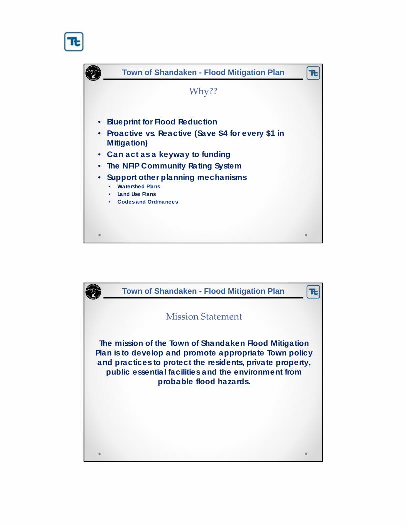
Town of Shandaken - Flood Mitigation Plan
Why??
• Blueprint for Flood Reduction• Proactive vs. Reactive (Save $4 for every $1 in
Mitigation)• Can act as a keyway to funding• The NFIP Community Rating System• Support other planning mechanisms
• Watershed Plans• Land Use Plans• Codes and Ordinances
Town of Shandaken - Flood Mitigation Plan
Mission Statement
The mission of the Town of Shandaken Flood Mitigation Plan is to develop and promote appropriate Town policy and practices to protect the residents, private property,
public essential facilities and the environment from probable flood hazards.

Town of Shandaken - Flood Mitigation Plan
Overall Goal
The overall goal of the Plan is to improve the Town’s capability to prepare for, respond to, recover from, mitigate against and reduce
vulnerability to flooding.
The plan identifies and encourages partnerships for coordinated implementation, funding, public awareness and the development of strategies for carefully planned mitigation efforts designed to protect
the health, safety, quality of life, environment and economy of the Town of Shandaken.
Town of Shandaken - Flood Mitigation Plan
Plan Goals
• Goal 1. Protect Life and Property
• Goal 2. Increase Public Awareness and Preparedness
• Goal 3. Enhance Disaster Preparedness, Response and Recovery
• Goal 4. Protect the Environment and Natural Resources
• Goal 5. Promote Mitigation Efforts through Existing Programs and Partnerships

Town of Shandaken - Flood Mitigation Plan
PLAN PROCESS STEPS
• Organize Resources
• Assess the Risk
• Review and Update the Mitigation Plan
• Develop Procedures for Plan Implementation, Monitoring and Update
• Adopt the Plan
Engage “Stakeholders
Federal, State, Regional and Local Agencies
Business and Civic Groups
The Public
Town of Shandaken - Flood Mitigation Plan
Other Planning Tasks
• Public Participation• Notices on planning effort • FMP Webpage detailing effort, providing downloadable drafts
of the plan, and providing a way for public input (local contact information and email link
• Public presentations and meetings• Public access to draft and final plan documents• Questionnaire (on-line and/or hard copy)
• Documentation of the Planning Process
• Plan implementation and maintenance procedures

Town of Shandaken - Flood Mitigation Plan
Plan Benefit ‐ Community Rating System
• Participation and ranking in CRS will improve ability to lower flood damages (higher regulatory standards, enforcement of regulations, increased knowledge of floodplain issues)
• CRS ranking will reduce NFIP Flood Insurance Premiums
Town of Shandaken - Flood Mitigation Plan
The Planning Committee
• The Office of the Supervisor of the Town of Shandaken is managing this effort.
• It is supported by the Shandaken Area Flood Assessment and Remediation Initiative (SAFARI). Members of the committee include representatives from
• Town of Shandaken
• Cornell Cooperative Extension of Ulster County
• RCAP Solutions
• Ulster County Emergency Management
• NYSDOT
• NYCDEP
• NYSDEC
• USDA NRCS
• Ulster County Soil and Water Conservation District
• Landowners
• S.O.S (Save our Shandaken) Representative

Town of Shandaken - Flood Mitigation Plan
The Flood Hazard Risk Assessment
Town of Shandaken - Flood Mitigation Plan
What is Risk?
Risk is defined as a function of:
• Hazard– Source of potential danger or adverse
condition• Exposure
– Manmade or natural features that are exposed to the hazard
• Vulnerability, and– Damage susceptibility of the exposed
features• Capability
– Regulatory Capability– Technical Capability– Financial Capability

Town of Shandaken - Flood Mitigation Plan
Assess the Risk ‐ Inventory of Assets
What is at risk? People, Property, Economy, Environment• Population • Building Stock (Residential, Commercial, Industrial,
Educational, etc.)• Critical Facilities (essential facilities, utilities, transportation
features, high-potential loss facilities and user-defined facilities)o Police, Fire, Emergency Serviceso Medical Care Facilitieso Schools and Care Facilitieso Sheltering Facilitieso Infrastructure (Transportation Systems, Utilities)o High-Potential Loss Facilities (Dams)
Town of Shandaken - Flood Mitigation Plan
Risk Assessment Methodology
• Assess hazard– Past events– Areas most affected– Frequency– Severity – Warning time for response
• Determine Exposure
• Assess Vulnerability, incl. Loss Estimation

Town of Shandaken - Flood Mitigation Plan
What is HAZUS?
• HAZUS-MH is a powerful risk assessment methodology for analyzing potential losses from floods, hurricane winds and earthquakes.
• Current scientific and engineering knowledge is coupled with the latest geographic information systems (GIS) technology to produce estimates of hazard-related damage before, or after, a disaster occurs.
Town of Shandaken - Flood Mitigation Plan
Flood Model Overview
Subtract ground surface from flood surface to determine flood depth throughout the study area
Datum
GroundElevation
Flood Elevation
WATER DEPTH DAMAGE FUNCTION

Town of Shandaken - Flood Mitigation Plan
Flood Depth Grid‐Phoenicia (for planning purposes only)
Town of Shandaken - Flood Mitigation Plan
Repetitive Loss Properties

Town of Shandaken - Flood Mitigation Plan
Town NFIP Policies and Claims (post‐Irene)
• % Buildings in 1% Flood Boundary: (16.1%)• Number of Buildings in 0.2% Flood Boundary: 471 (21.6%)• Number of Policies: 204• Number of Claims (losses): 214• Number of Repetitive Loss Properties: 22• Number of Severe Repetitive Loss Properties: 2• Number of Policies in 1% Flood Boundary: 123• Number of Policies in 0.2% Flood Boundary: 128• Number of Policies outside the 0.2% Flood Boundary: 76
Town of Shandaken - Flood Mitigation Plan
% Buildings in 1% Flood Boundary
Hamlet %
Big Indian 10.2
Chichester 7.0
Mt. Tremper 26.9
Phoenicia 23.8
Pine Hill 3.0
Shandaken 12.5

Town of Shandaken - Flood Mitigation Plan
Estimated Population Vulnerable to the 1% and 0.2% Flood Events
Zip Code
Total Population
(U.S. Census 2010)Population in 1% Hazard Area
Percent Population in 1% Hazard Area
Population in 0.2% Hazard Area
Percent Population In 0.2% Hazard
Area
Big Indian 457 69 15.1 69 15.1
Chichester 345 8 2.3 8 2.3
Mt Tremper 478 41 8.6 98 20.5
Phoenicia 1,021 140 13.7 163 16.0
Pine Hill 242 4 1.7 4 1.7
Shandaken 542 62 11.4 73 13.5
Town of Shandaken 3,085 324 10.5 415 13.5
Source: Census, 2010Note: Census Block 361119553001065, located entirely in the Town of Shandaken, has two zipcodes: Phoenicia and Boiceville. For the purposes of this analysis, the entire block is considered within the Phoenicia zip code.
Town of Shandaken - Flood Mitigation Plan
Area Located in the 1‐Percent and 0.2‐Percent Annual Chance Flood Boundaries
Zip CodeTotal Area(sq. mi.)
1% Annual Chance Event 0.2% Annual Chance Event
Area Exposed(sq. mi.) % of Total
Area Exposed(sq. mi.) % of Total
Big Indian 42.7 0.72 1.7 0.84 2.0
Chichester 4.9 0.18 3.7 0.23 4.7
Mt Tremper 4.2 0.94 22.4 1.02 24.3
Phoenicia 51.3 1.41 2.7 1.64 3.2
Pine Hill 2 0.03 1.5 0.04 2.0
Shandaken 13.8 0.48 3.5 0.58 4.2
Town of Shandaken 118.9 3.76 3.2 4.35 3.7
Source: Tetra Tech, 2012Note: sq.mi. = Square miles; % = Percent
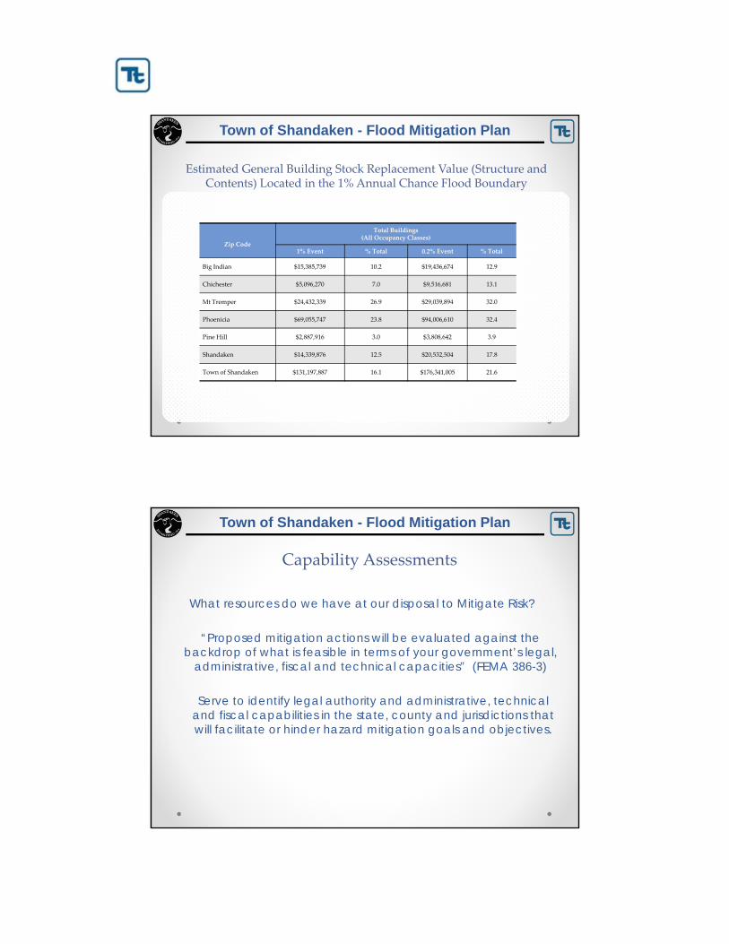
Town of Shandaken - Flood Mitigation Plan
Zip Code
Total Buildings (All Occupancy Classes)
1% Event % Total 0.2% Event % Total
Big Indian $15,385,739 10.2 $19,436,674 12.9
Chichester $5,096,270 7.0 $9,516,681 13.1
Mt Tremper $24,432,339 26.9 $29,039,894 32.0
Phoenicia $69,055,747 23.8 $94,006,610 32.4
Pine Hill $2,887,916 3.0 $3,808,642 3.9
Shandaken $14,339,876 12.5 $20,532,504 17.8
Town of Shandaken $131,197,887 16.1 $176,341,005 21.6
Estimated General Building Stock Replacement Value (Structure and Contents) Located in the 1% Annual Chance Flood Boundary
Town of Shandaken - Flood Mitigation Plan
Capability Assessments
What resources do we have at our disposal to Mitigate Risk?
“Proposed mitigation actions will be evaluated against the backdrop of what is feasible in terms of your government’s legal,
administrative, fiscal and technical capacities” (FEMA 386-3)
Serve to identify legal authority and administrative, technical and fiscal capabilities in the state, county and jurisdictions that will facilitate or hinder hazard mitigation goals and objectives.

Town of Shandaken - Flood Mitigation Plan
Risk Reduction
To reduce Risk:
• Manipulate the Hazard: – structural flood control
• Reduce Exposure: – property acquisition
• Reduce Vulnerability: – Retrofitting
• Increase capability: – $, preparation, technical assistance, planning and regulation
Town of Shandaken - Flood Mitigation Plan
Identification and Analysis of Mitigation Actions
• Mitigation actions need to be realistic, achievable and action-oriented.
• Will include both regional actions, as well as jurisdiction-specific.
• Will address both public and private property.
• For each proposed mitigation strategy, the following will be identified:o Implementation timelineo Estimated costo Estimated benefits (avoided losses)o Potential funding sourceso Lead agency or departmento Supporting agencies

Town of Shandaken - Flood Mitigation Plan
Mitigation Actions? Like What?
• Prevention. Measures such as planning and zoning, open space preservation, land development regulations, building codes, storm water management.
• Property Protection. Measures such as acquisition, relocation, storm shutters, rebuilding, barriers, floodproofing, insurance, and structural retrofits for high winds.
• Public Education and Awareness. Measures such as outreach projects, real estate disclosure, hazard information centers, technical assistance.
• Natural Resource Protection. Measures such as erosion and sediment control, stream corridor protection, vegetative management, and wetlands preservation.
• Emergency Services. Measures such as hazard threat recognition, hazard warning systems, emergency response, protection of critical facilities, and health and safety maintenance.
• Structural Projects. Measures such as dams, levees, seawalls, bulkheads, retaining walls, channel modifications, storm sewers, and retrofitted buildings and elevated roadways.
Town of Shandaken - Flood Mitigation Plan
Mitigation Alternatives
• Use information obtained from the public involvement strategy;
• Use information provided in the risk and vulnerability assessment;
• Seek mitigation actions consistent with the goals and objectives of this local Plan;
• Identify mitigation actions that are within the capabilities of the Town.

Town of Shandaken - Flood Mitigation Plan
Mitigation Initiatives
• 86 Initiatives included in the planIncluding:
• Expansion and improvement of Flood Warning System-locations, automation, precipitation monitoring
• Development of new codes and standards to reduce flood risk• Develop new codes and standards for bridges and culverts to
reduce flood risk• Create an inventory of culverts and prioritize replacement• Evaluate options to alleviate aggregation of sediment at the
Bridge Street bridge in Phoenicia. Options to include economic impact of loss of bridge to local economy.
Town of Shandaken - Flood Mitigation Plan
Mitigation Initiatives
• Join CRS• Undertake a repetitive loss analysis• Provide increased public outreach and education of available
flood mitigation programs and alternatives• Adopt Flood Warning and Response Plan• Support Property acquisition or elevation of structures for
interested parties.

Town of Shandaken - Flood Mitigation Plan
Plan Implementation
• Your mitigation strategy section provides a “blueprint” to follow for progressively reducing your community’s natural hazard risk.
• It will includes two type of initiatives/projects – those that your community can “self fund”, and those that will require outside (e.g. grant) funding.
• Mitigation grant opportunities open regularly:• The annual HMA grant window opens in June of each year.• HMGP funding comes in the wake of Declared Disasters in the
State.• Emergency Watershed Protection grants• Watershed grants• Homeland Security/Emergency Management grants
Town of Shandaken - Flood Mitigation Plan
GENERAL QUESTIONS,ISSUES AND CONCERNS
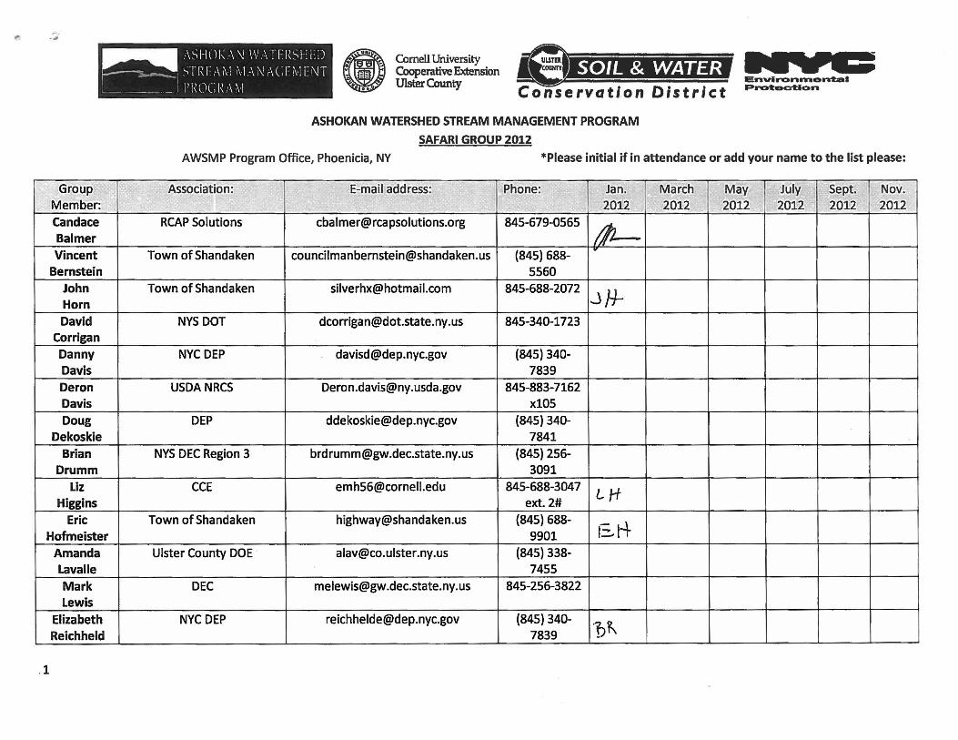
Group Member:
candace Balmer
Vincent Bernstein
John Horn
David Corrigan
Danny Davis
Deron Davis
Doug Dekoskie
Brian Drumm
Liz Higgins
Eric Hofmeister
Amanda Lavalle
Mark Lewis
Elizabeth Reichheld
.1
1)-Cornell University ~ ~ Cooperative Extension • Ulster County
ASHOKAN WATERSHED STREAM MANAGEMENT PROGRAM
SAFARI GROUP 2012
EnvlronlTllontal Protac::tlon
AWSMP Program Office, Phoenicia, NY *Please initial if in attendance or add your name to the list please:
Association: E-mail address: Iii IIloPhone: ~ ilfl Jan. I ~ March I ~r;; May In, JUlyl 1 ill 1 Sept. Nov. II!
~ 2012 1"<iIi 2012 2012 2012 2012 ., 2012
RCAP Solutions [email protected] 845-679-0565
41-Town of Shandaken [email protected] (845) 688-
r
5560 Town of Shandaken [email protected] 845-688-2072
.J}i-NYS DOT [email protected] 845-340-1723
NYC DEP [email protected] (845) 340-7839
USDA NRCS [email protected] 845-883-7162 x105
DEP [email protected] (845) 340-7841
NYS DEC Region 3 [email protected] (845) 256-3091
CCE [email protected] 845-688-3047 LH ext. 2#
Town of Shandaken [email protected] (845) 688-bH· 9901
Ulster County DOE ' [email protected] (845) 338-7455
DEC [email protected] 845-256-3822
NYC DEP [email protected] (845) 340-~~ 7839
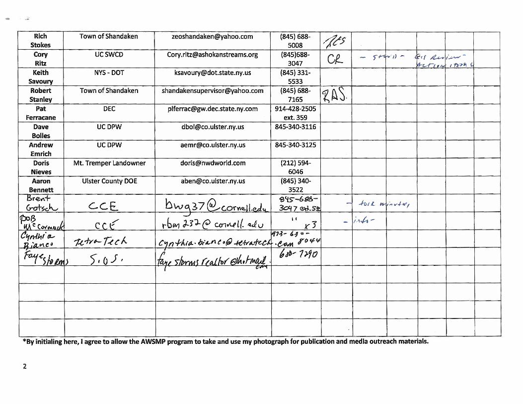
.. .. .. Rich Town of Shandaken [email protected] (845) 688- ,fr5 Stokes 5008 Cory UCSWCD [email protected] (845)688- Cf- - f.y-t. r--iJ - l~ (( ~ I~-Ritz 3047 ~rl ' A. / n-rlt f,
Keith NYS- DOT [email protected] (845) 331-Savoury 5533 Robert Town of Shandaken [email protected] (845) 688- ~~S-Stanley 7165
Pat DEC [email protected] 914-428-2505 Ferracane ext. 359
Dave UCDPW [email protected] 845-340-3116 Bolles
Andrew UCDPW [email protected] 845-340-3125 Emrich Doris Mt. Tremper Landowner [email protected] (212) 594-
Nieves 6046
Aaron , Ulster County DOE [email protected] (845) 340-Bennett 3522
I:Sr-eV\+ ceE.. bwq37 ~C.Of~Q.ll.cJ.",-
'S lts'-6'98,- - .-h I £. Wi ,-" v..J-.r1 &ot~(j~ 3o'f7 ~.S:tt ~B
..J II i.,., ..t. -
"iA C C"",,.,.a.ck Cet r6 WJ J,:{'J--e CC1v\.f l (. .~ V J(J -~",tt/h" fI-
'1..(,..fy#- U C f... ~H- '1 0
-
~;4V1.(!" C'1n -rAit).· 1;;£1'1 t /If) -I<t~~1-~c,/.. • e,..,hI r {J 'f-~
Ftut.(S h lrt1 > ! 6,t6, 7).?o )t (J J, 1£/ )/ornli (Lai.lJl, Elhtf-w.tJ. . I c.,..,
*By initialing here, I agree to allow the AWSMP program to take and use my photograph for publication and media outreach materials.
2


Town of Shandaken
County of Ulster
State of New York
Monday March 5, 2012
The Town Board met this date for a Public Hearing -Phoenicia Water District Bylaws - &
Regular Monthly meeting, as per Resolution #2. Minutes of the Monthly Regular Town
Board Meeting held in Shandaken on Monday, March 5, 2012 at 7:00 pm at the Town
Meeting Hall, Rt. 28 Shandaken, NY.
Pledge of Allegiance
Roll Call
Members Present: Robert Stanley, Supervisor
Doris Bartlett, Board Member
Vincent Bernstein, Board Member
Alfred Higley Jr., Board Member
Members Absent: Jack Jordan, Board Member
Recording Secretary: Joyce Grant, Town Clerk
On a Stanley/Bernstein motion the Town Board unanimously approved the minutes of the
February meetings as submitted by the Town Clerk.
PHOENICIA WATER DISTRICT BYLAWS PUBLIC HEARING
Water District Bylaws Public Hearing
Prior to next month’s regularly scheduled Town Board Meeting on Monday, March 5th, 7pm, the
Town Board will hold a public hearing to hear arguments for or against adopting proposed amendments to
the Phoenicia Water District Bylaws. The proposed amendment specifically addresses Article 18-
Grievance Procedures. The Phoenicia Water Committee is proposing these changes in order to clarify
procedures for filing disputes over water billing.
The Public Hearing is scheduled for 6:30pm on March 5th.

Town of Shandaken Town Board Meeting Agenda
Regular Monthly Meeting
Monday, March 5, 2012
1. Pledge of Allegiance 2. Roll Call
3. Approval of previous T/B Meeting minutes
4. Supervisor’s Financial Report
5. Communications a. Terry Bernardo, Chair – Ulster County Legislature
b. Cynthia Bianco, Tetra Tech – Shandaken Flood Mitigation Plan
6. Committee Reports:
a. Ambulance
b. Museum
c. Police
d. Phoenicia Water
e. Pine Hill Water
f. Recreation 7. Public Comments on Resolutions
8. Motions:
9. Resolutions:
70) Pay all Bills
71) Phoenicia Water – Adoption of Bylaw Amendments
72) Assessor – Hire Independent Appraiser – Lawsuit
73) Planning – Support Pine Hill Historic District Designation
74) Planning – Appoint Art Christie (term ends 12/31/16)
75) Town Hall Septic – Advertise for Bids for Electrical/Plumbing Work
76) Supervisor – Auth. Supervisor as Marriage Officer
77) Highway- Purchase of Excavator
78) Smart Growth – Hiring Artist for Kiosk Panels
10. Open Public Comment
11. Meeting Adjournment - IN MEMORY OF: Catherine Aspinall – Connie Betz – Ronald Fogelberg - Mary Alice Hummell - Ruth Lindsay- Robert Michko- Eleanor Monachelli – Elizabeth Kerns
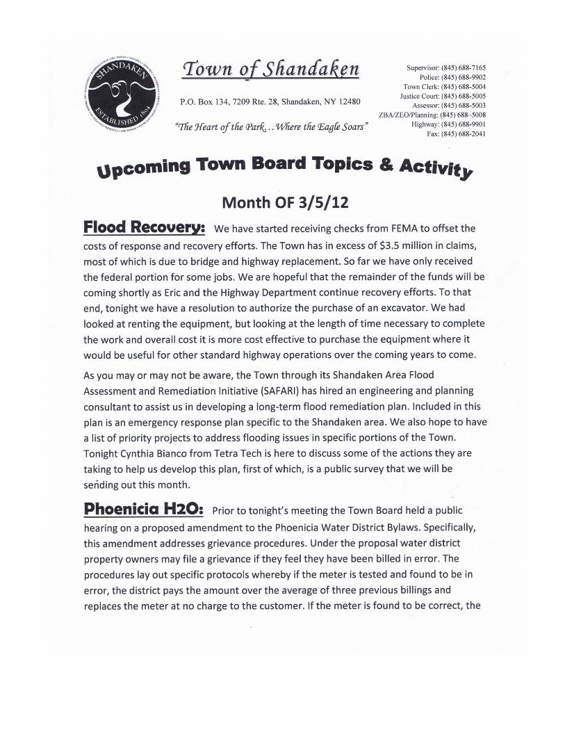


RESOLUTION #70-12 OFFERED BY: Bernstein
RESOLUTION TO PAY ALL BILLS

WHEREAS, The Department of Audit and Control require Town Boards to sign and inspect all vouchers
coming into the town for payment, to number and total amounts from each fund.
THEREFORE BE IT RESOLVED, that the Town Board authorize the following vouchers paid:
General $57,784.24
Highway 212,082.95
Phoenicia Water 7,414.63
Pine Hill Water 88.98
Phoenicia Lights 1,109.96
Chichester Lights 149.57
Pine Hill Lights 616.19
AND MOVES ITS ADOPTION
Seconded by: Higley
ROLL CALL 4 Ayes, 1 Absent
Phoenicia Water District By-Laws Amendments - March 2012
TOWN OF SHANDAKEN AMENDEMENTS TO THE PHOENICIA WATER DISTRICT BY-LAWS BE IT ENACTED by the Town Board of the Town of Shandaken as follows:
ARTICLE 18 . GRIEVANCE PROCEDURES In the event a property owner disputes the accuracy of a water bill said property owner will have a period of
sixty (60) calendar days from the mailing date of the bill to do the following:
A. File a written complaint with the Town Clerk/ Tax Collector requesting an inspection of the relevant parts
of the property owner’s premises being served by the meter in question. If the property’s water system appears
to be normal (no leaks, etc.) the investigation will progress to Article 18 Section B.
B. The meter will be removed, by a plumber assigned by the Water District Superintendent, replaced with a
temporary meter and sent for testing. Should the meter test “fast,” (recording more than designed
guidelines/actual flow) the Water District will bear all of the costs incurred for the removal, shipping, testing,
and inspection of the meter, and for the installation of a new meter and shall also credit to the property owner
the charges incurred by said owner on the challenged bill to the extent that said charges exceed the average of
the three billings immediately prior to the date of the water bill that was disputed. Should the meter run “slow”
(recording less than designed guidelines/ actual flow) or accurate, the property owner will be responsible for
all expenses (removal, shipping, testing, calibration, reinstallation, parts and labor) incurred by the Water
District, in addition to the water bill being questioned and any late fees accrued. These charges, if not paid
prior to the next bill being sent, will be added to the relevant property’s next water bill.
C. In the event that a property owner fails to file a written complaint within sixty (60) days of the date the
water bill was mailed, the bill shall be deemed valid and the property owner(s) shall have waived his/her/their
right to challenge the bill.
RESOLUTION #71-12 OFFERED BY: Stanley
RESOLUTION APPROVING AMENDMENTS TO PHOENICIA WATER DISTRICT BYLAWS
WHEREAS, the Town of Shandaken Town Board oversees the Phoenicia Water District, and
WHEREAS, the Phoenicia Water District Committee has provided suggested amendments to the existing
Phoenicia Water District Bylaws in order to simplify grievance procedures (Article 18), and
WHEREAS, the Town Board of Shandaken held a public hearing on said proposed by laws at 6:30pm on
Monday, March 5, 2012 to hear all comments for and against said bylaw amendments;

THEREFORE, BE IT RESOLVED, that the Town Board of the Town of Shandaken hereby does approve
the amendments to Article 18 of the Phoenicia Water District Bylaws.
AND MOVES ITS ADOPTION
Seconded by: Bernstein
ROLL CALL 4 Ayes, 1 Absent
RESOLUTION #72 -12 OFFERED BY: Higley
RESOLUTION APPROVING HIRING OF INDEPENDENT APPRAISAL CONSUTANT
WHEREAS, the Town of Shandaken is involved in litigation pursuant to a property tax grievance, and
WHEREAS, the Attorneys representing the Town in this matter, Van DeWater and Van DeWater, LLP, are in
need of the services of an independent appraisal consultant in order to defend the Town in the case, and
WHEREAS, the Attorneys have made a recommendation for said appraisal consultant;
THEREFORE, BE IT RESOLVED, that Barry M. Herbold, ASA, of Empire State Appraisal Consultants,
Inc., Kinderhook, NY is appointed and retained as the Town of Shandaken’s appraiser in the case of Jo-Mary
Realty Corp. v. Town of Shandaken, Ulster County Index No. 11-3298
AND MOVES ITS ADOPTION
Seconded by: Stanley
ROLL CALL 4 Ayes, 1 Absent
RESOLUTION #73 -12 OFFERED BY: Bartlett
SUPPORTING HAMLET OF PINE HILL’S HISTORIC DISTRICT DESIGNATION
WHEREAS, the Hamlet of Pine Hill in the Town of Shandaken has a number of structures already recognized
as Historic including several buildings and bridges, and
WHEREAS, the Hamlet of Pine Hill has been nominated to be designated as a “Historic District” in the
National Registry of Historic Places through both the National Park Service and the State Historic
Preservation Office,
THEREFORE, BE IT RESOLVED the Town of Shandaken Town Board supports the nomination of Pine
Hill, New York as an Historic Community in order to help further the efforts of the Town, local businesses
and residential owners to re-invigorate interest in the Hamlet and the Town of Shandaken.
AND MOVES ITS ADOPTION
Seconded by: Stanley
ROLL CALL 4 Ayes, 1 Absent
RESOLUTION # 74 -12 OFFERED BY Bernstein
RESOLUTION APPOINTING PLANNING BOARD MEMBER
WHEREAS pursuant to § 20 of the Town Law it is the duty of the Town Board to appoint all Boards and
Commissions
THEREFORE BE IT RESOLVED that Art Christie be appointed to the Shandaken Planning Board with
his term to expire on December 31, 2016.
AND MOVES ITS ADOPTION Seconded by: Bartlett
ROLL CALL 4 Ayes, 1 Absent
RESOLUTION # 75 -12 OFFERED BY Stanley
RESOLUTION ADVERTISING FOR ELECTRICAL AND PLUMBING BIDS
FOR TOWN HALL SEPTIC

WHEREAS the Town of Shandaken septic was deemed to be in failure in 2010, and
WHEREAS the Town needs to complete work on the septic in order to be in compliance,
THEREFORE BE IT RESOLVED that the Town of Shandaken advertise for bids to be received for the
electrical and plumbing portions of this work, and
BE IT FURTHER RESOLVED that the specifications for this work can be picked up from the Supervisor’s
Office and that all bids must have written in block letters on the outside of the envelope “Town Hall Septic
Bid,” must be received by the Town Clerk’s Office (PO Box 67, Shandaken, NY 12480) no later than 3p.m.
Monday, April 2, 2012 and that all bids will be opened and reviewed at the regularly scheduled Shandaken
Town Board meeting at 7pm on Monday April 2, 2012. The Town Board reserves the right to reject any and
all bids
AND MOVES ITS ADOPTION Seconded by: Higley
ROLL CALL 4 Ayes, 1 Absent
RESOLUTION # 76 -12 OFFERED BY Higley
RESOLUTION APPOINTING SUPERVISOR AS MARRIAGE OFFICER
WHEREAS pursuant to Article 3 Section 11c of the New York State Domestic Relations Law, a Public
Official may be appointed as a Marriage Officer, and
WHEREAS Supervisor Stanley has a special request to perform a marriage ceremony between Kristine Marie
O’Donnell and Jennifer Sutherland
THEREFORE BE IT RESOLVED that the Town Board appoint Supervisor Robert A. Stanley as a
temporary Marriage Officer, and that he may perform marriages within the jurisdictional bounds of the Town
of Shandaken.
AND MOVES ITS ADOPTION Seconded by: Bartlett
ROLL CALL 3 Ayes, 1 Absent, 1 Abstain (Bernstein)


RESOLUTION #77 - 12 OFFERED BY Bartlett
RESOLUTION APPROVING HIGHWAY DEPARTMENT
EQUIPMENT PURCHASE
WHEREAS, the Town of Shandaken Highway Department is in need of an excavator in order to expedite
flood recovery work and standard operating work, and
WHEREAS, the Highway Superintendent has selected an excavator for purchase by the Town,
THEREFORE BE IT RESOLVED, that the Town of Shandaken Town Board, advertise for the bids for a
Crawler Hydraulic Excavator following the Specification Sheet provided with this resolution, and
BE IT FURTHER RESOLVED, all bids will be accepted until 3 p.m. on Monday, April 2, 2012. The bids
will be opened and publicly read aloud at the regular Shandaken Town Board Meeting scheduled for 7 p.m. on
Monday, April 2, 2012. The Town of Shandaken retains the right to reject any and all bids.
AND MOVES ITS ADOPTION Seconded by: Stanley
ROLL CALL 4 Ayes, 1 Absent
Town of Shandaken Smart Growth Agreement - Information Kiosk Artist PREAMBLE The Town of Shandaken has been awarded a grant from the NYS Department of Conservation for “Smart Growth” Initiatives.
Included in this grant is the proposal for four (4) “X –Shaped Information Kiosks to be placed throughout the Town of
Shandaken. It is the intent of this contract to hire the artist for the development, creation and installation of eight (8)
information panels to be installed in each of these kiosks for a total of thirty-two (32) panels.
Project Description Dave Channon of 247 Broadstreet Hollow Rd., Shandaken, NY 12480 (herein after referred to as the ARTIST ) shall
provide for the Town of Shandaken, 7209 Rte. 28, PO Box 134, Shandaken, NY 12480 (herein after referred to as the
SHANDAKEN), collectively referred to as the “PARTIES,” a total of thirty-two (32) three foot high by two foot wide (3’h X
2’w) plastic-aluminum laminate information panels, painted with weatherproof exterior paint and provided with additional UV
barrier protection containing the information as approved by the Town of Shandaken Kiosk Committee. Payments and
Deliverables will be presented using the Schedule of Tasks and Schedule of Payments included and agreed to in this
Agreement.
Price is all inclusive. The ARTIST will secure all materials and supplies and provide all labor for the contract price. There will
be no additional compensation whatsoever without a written change order signed by the ARTIST and SHANDAKEN.
No laborer or material liens or mechanic liens whatsoever shall be allowed and if any are filed, the ARTIST will either
discharge same or post a bond to indemnify SHANDAKEN within 15 days of the filing.
Project Duration The required completion date of the Information Kiosk Plan is March 1, 2013. This will enable the ARTIST time to accrue all
available information required, attend meetings of the Kiosk Committee, create the necessary panels and install them into the
kiosks.
This Agreement shall be effective when a fully executed Agreement is in the hands of both PARTIES. This Agreement shall
terminate on March 1, 2013 unless an extension approved in writing by SHANDAKEN. This Agreement may be extended,
renewed, or terminated at any time. Any extension, renewal or termination must be upon approval of the Town Board of
Shandaken.
Non-Performance In the event that the ARTIST does not complete the contract, the ARTIST shall surrender all materials collected and
constructed available to date of default to SHANDAKEN. Furthermore, ARTIST shall not be entitled to any further payment
under this contract.
Definitions For the purposes of this contract the following terms shall apply:
Hamlet Regions: Four Kiosks are planned, each Kiosk is to represent a region within the Town of
Shandaken. These are the regions and locations for the Kiosks:
Phoenicia, Chichester Woodland Valley: Main St., Phoenicia

Allaben, Bushnellsville, Shandaken: Intersection of State Rtes 28 & 42, Shandaken
Big Indian, Oliverea : Big Indian Park, Big Indian
Highmount, Pine Hill: Main St., Pine Hill
General Panels: All panels reflecting the general nature and assets and any other pertinent generalized
overview information concerning the Catskill Forest Preserve, NYC Watershed or Ulster
County, as deemed by the Shandaken Kiosk Committee. Town of Shandaken Kiosk Artist Contract Town Panels: All panels reflecting the general nature and assets and any other pertinent overview
information concerning the entire Town of Shandaken, as deemed by the Shandaken
Kiosk Committee.
Hamlet Panels: All panels reflecting the general nature and assets and any other pertinent information
specific to the Hamlet Region to which the kiosk is to be placed, as deemed by the
Shandaken Kiosk Committee.
Schedule of Tasks (w/deliverables)
ARTIST Shall: Task 1 –
Meet with the Shandaken Kiosk Committee
Designate one (1) contact person for each kiosk
Gather input on content from Kiosk Committee
Provide rough guideline of possible artistic layouts
Begin compiling information for panels
Task 2 – Draft General Panels
Meet with Kiosk Committee
Make Possible Recommendations and Alternatives
Task 3 – Draft Town Panels
Meet with Kiosk Committee
Meet with Town Board publicly to obtain input
Finalize & Construct General Panels
Task 4 – Draft Hamlet Panels
Meet with Kiosk Committee
Meet with Town Board publicly to obtain input
Finalize & Construct Town Panels
Task 5 – Meet with Kiosk Committee
Finalize Hamlet Panels
Meet with Town Board publicly to obtain approval
Construct Hamlet Panels
Install All Panels
Supply all waivers of liens from all materialmen and laborers certifying that no liens shall be filed
TOWN Shall: Provide access to any maps, logos or information to be included in panels
Provide Town Historical, Recreational or Tourism related Materials
Ease Of Access, as best can be provided, to any other agencies or organizations information necessary for the kiosk panels
Have Town Supervisor review work completed for each task and report progress to Town Board
Make payments along Schedule of Payments for tasks completed
Review all work upon written request for Final Payment by the ARTIST and if all requisites are met to the Town Board’s
satisfaction, Final Payment will be forwarded to ARTIST, as specified in this contract.
Schedule of Payments Payments shall be made on the completion of each task based on a total of payments of $13,600, as follows:
Task 1 – 20% of total contracted price
Task 2 – 10% of total contracted price
Task 3 – 15% of total contracted price
Task 4 – 25% of total contracted price
Task 5 – 30% of total contracted price
Authority and Possession All drawings, drafts, models and materials are the sole and exclusive property of the Town and all must be delivered to the
Town upon the completion of each task and upon default of the contract by the ARTIST and upon completion of this contract.
Additional Information Questions regarding the project may be directed to Supervisor Robert A. Stanley at:
Town of Shandaken
P.O. Box 134,
Shandaken, New York 12480
(845) 688 – 7165
AGREEMENT
The undersigned do hereby approve and accept all the terms and
conditions of this agreement signed and dated this 7th day of February, 2012
________________________ ___________ Supervisor, Robert A. Stanley Date
________________________ __________ Artist, Dave Channon Date
RESOLUTION #78 - 12 (61 -12) OFFERED BY: Bernstein
RESOLUTION HIRING ARTIST FOR SHANDAKEN KIOSK
WHEREAS, the Town of Shandaken is in receipt of a Smart Growth Grant through the New York State
Department of Environmental Conservation (DEC), and
WHEREAS, a portion of this grant is for the placement of four (4) information kiosks throughout the Town,
and
WHEREAS, Dave Channon of Esopus Creek Enterprises (Artist), has provided this service previously to the
DEC using similar materials and content, and
WHEREAS, a contract exists for the completion and installation of thirty-two (32) information panels with
eight (8) each to be placed in each community kiosk and for involvement and coordination with the kiosk
committee;
THEREFORE, BE IT RESOLVED, that the Town Board of the Town of Shandaken approves the
Supervisor entering into contract with the Artist for a total price of $13,600 to be paid in installments as per
the contract
AND MOVES ITS ADOPTION
Seconded by: Higley
ROLL CALL 4 Ayes, 1 Absent
All business pertinent having been discussed, the Town Board adjourned at 8:12 on a Stanley/Bernstein
motion.
Signed this 6th day of March, 2012
____________________________
Joyce Grant, Town Clerk

SAFARI Meeting Minutes
Date: May 31, 2012
Time: 1:00 PM-3:30 PM
Location: AWSMP Office, Phoenicia, NY 12464
In attendance:*
Candace Balmer, RCAP Solutions
John Horn, Shandaken Planning Board
Beth Reichheld, NYC DEP
Rich Stokes, Town of Shandaken Code Enforcement Officer/Building Inspector
Cory Ritz, Ulster County Soil & Water Conservation District
Rob Stanley, Town of Shandaken Supervisor
Brent Gotsch, Cornell Cooperative Extension of Ulster County
Aaron Bennett, Ulster County Department of the Environment
Gretchen Rae, Cornell Cooperative Extension of Ulster County
Doris Nieves, Mount Tremper Resident
*(Rob will review list of SAFARI committee members and notify Gretchen of “active”
members)
Updates:
EWP (Emergency Watershed Protection) – Cory
1. In Shandaken - there are 4 sediment related (turbidity control, property loss and
potential infrastructure threat) projects in the queue
A. All sites are in Chichester along the Stony Clove and Warner creeks
B. Rough estimates for each project site have been compiled, approximately in
excess of $4million. Formal estimates will be made as designs are finalized and as
actual construction bids are submitted
C. The first project Chichester Site #1, should begin construction sometime in mid-
June 2012
D. Rob has signed town support with formal agreements with NRCS. Agreements
have been sent to Albany NRCS offices for final signoff.
2. In addition to sediment related sites, there three other EWP sites. The county has 1
infrastructure project in Oliverea, and Town has 2 sites (Fox Hollow bridge and water
treatment plant) planned for 2012 The Town’s EWP sites are:
A. Muller Road along Fox Hollow
B. High Street, Phoenicia Water District Station
3. NRCS has asked for additional paperwork from the Town which show that they have
property for access to the sites. Sample letters were delivered to Rob.
FEMA – Rob
1. Eric has a list of 77 sites, minor to major, listed as FEMA sites for the Town.
A. Rob will ask Eric to provide the list and overview map to Cynthia (Tetra Tech)
B. The town has hired engineers Brinnier & Larios in Kingston for consult on the
sites with a focus on slope failures and bridges

C. The Town is planning 3 sites for construction in 2012
D. 4 sites are planned for construction in 2013
E. Update on Flood Control Systems and Dams in the Hudson Valley: Governor
Cuomo’s Press Release (see attachment at end of this document).
Tetra Tech Update – Cynthia
1. Emergency Response Plan
A. A document which outlines personnel and lines of authority in the event of a
Town emergency.
B. Cynthia will send link to Flood inundation mapper – allows Town to upload the
upload the output of HAZUS, and interactively slide a scale relative to discharge
stage at gages, to show resultant inundation at different discharge stages.
C. Updates to the Emergency Response Plan have been made since the draft was
provided. Feedback comments are being integrated and an updated version will
be provided shortly. Liz, Rob and Candace still need to discuss with Cynthia the
specifics regarding appendices for the document; such as what is the list of people
& their associated organizations for the “Command Team”.
1. Command team: ensure that a stream representative is included.
2. Red flag with CRS if the same person wears too many hats; see NIMS for
substructures of command, and relief hours needed for the personnel.
2. Risk Assessment and Vulnerability Update, due August 31, 2012 and on schedule
A. Have completed flood profile of area, but the new FIRM Maps from FEMA
would be helpful – Can Phil Eskeli provide any updates to Tetra Tech?
B. Google Maps since Oct. 2011– for updated aerial photos?
C. Aaron will ask Art Snyder for the aerial photos Mike Hein and Art took in the
flyover a few days after the flood
3. Complete Flood Hazard Plan is due Oct. 2012 and is on track
A. Tetra Tech’s recommendations for CRS (Community Rating System) will be
based on the 2007 manual even though a new manual is due out in 2013
4. Candace will continue to work with Rob on getting the Flood Hazard Mitigation
Resident Surveys distributed to targeted audiences. Brent and Doris have volunteered
their time to assist with door to door attempts. Aaron will e-mail the link from the
Town’s webpage to the Big Indian / Oliverea community e-mail group:
http://www.shandaken.us/disaster-prep-response/flood-mitigation-plan/
Other:
1. Liz has accepted a new position with Sullivan County CCE. Brent is the new Floodplain
Manager point-person for the AWSMP office
2. Cory stated no stream data is being collected at this time near the Phoenicia Main Street
Bridge, due to continued low water conditions.
3. Rob will check in with Art Snyder at UC on the status of the repetitive loss property buy-
out list.
4. New structure of the AWSMP Stakeholder Council, 2 representatives from SAFARI need
to be appointed to serve on the Stakeholder Council as SAFARI committee reps. Next
Stakeholder meeting is Friday June 29th
1-4pm.
Next SAFARI Meeting date/time: July 19th
, 2012 (1:00-3:00PM, at AWSMP Office)


SAFARI Meeting Minutes
July 19, 2012
1-3pm
AWSMP Office
In attendance:
Cynthia Bianco, TetraTech
Allison Miskerman, TetraTech
Brent Gotsch, CCE Ulster County
Cory Ritz, UCSWCD
Rob Stanley, Town of Shandaken Supervisor
Dany Davis, NYCDEP
John Horn, Town of Shandaken Planning Board
Candace Balmer, RCAP Solutions
Aaron Bennett, UC Department of the Environment
Eric Hofmeister, Shandaken Highway Superintendent
Doris Nieves, Save Our Shandaken, Mt. Tremper Resident
Gretchen Rae, CCE Ulster County
Richie Stokes, Town of Shandaken Code Enforcement Officer
Welcome
Brief introductions of attendees were made.
Approval of Previous SAFARI Meeting Minutes
Minutes were approved unanimously.
Old Business
Status of Flood Mitigation Plan (TetraTech)
The next milestone will be the complete risk assessment which is due August 31.
Status of Deliverables:
1. Create draft of Emergency Response Plan [COMPLETE]
2. Distribute and analyze resident survey [COMPLETE]
3. Draft Table of Contents [IN PROGRESS—sample available at meeting]
4. Town Profile (demographics, climate, population, building inventory, etc.) [IN
PROGRESS—sample available at meeting]
All comments related to the draft of the plan should be sent to Rob Stanely. Rob will then give to
Candace Balmer to compile. Candace will then send comments to Cynthia at TetraTech. Please
do this ASAP.

In the plan there was a reference multiple times to “Olive.” What is Olive? Must be mistaken
with Town of Olive or similar. Recommended that this be removed or determine if Olive means
something else.
There was also a reference to 10 USGS gages. Review to ensure proper amount of gages.
Consider gages that are in other towns whose water flows into or out of Shandaken. Coldbrook
Gage (which is technically in Olive) is the most important for this area.
There was a question about what to do with private levies or dams. Should it be based on cubic
feet? TetraTech says if in doubt include it! It is always easier to take something out than it is to
add in later.
Flood Assessment
-No preliminary data until January 2013. DFIRMS not available yet.
Depth Grids: digital grid, every cell represents 3 meters and shows depth of water during
inundation.
Q3 floodplain data-recurrence intervals are changing. New maps will most likely change the
current return interval for 50-year, 100-year storms, etc. TetraTech can tweak the data to reflect
new realities of climate change and post-Irene experiences.
Flood Inundation Mapper (USGS & NWS online tool): Uses precipitation data to show
floodwashed areas in real-time. You have to upload the data to the site and participate in it to
determine inundation levels. It’s somewhat similar to Stream Stats.
Group recommends that we add this as one of the recommendations to our program. Suggests
that we get an intern to upload data to site. http://water.usgs.gov/osw/flood_inundation/focus-rtmap.html
Table 5.4-14 needs further review (located on page 5.4-28). Some locations are listed twice with
different values. Some are flooded in 100-year event and some are depicted as not.
Cynthia needs comprehensive list of these comments in ASAP.
Community Rating System Impact Analysis Report
TetraTech provided documents advising what activities the Town of Shandaken can do to
increase their score on the NFIP Community Rating System (CRS). The higher the Town scores
on the CRS the lower flood insurance premiums are for Town residents. Currently, if the Town
does all of the recommendations on the list (such as filing elevation certificates) then Town
residents stand to save between 10%-15% on their flood insurance premiums.
Status of EWP Projects throughout Town (Ulster County Soil & Water)
Kathy Capella (NRCS) has reported that the Phoenicia Pump Station and Fox Hollow below
Muller Road will be sponsored through EWP.
Flood Hazard Working Group has asked for a 440 day extension which would allow them to
continue with EWP projects through the summer of 2013. As it stands, the potential for EWP
funded projects only goes until November 2012. If the extension is not granted then any project
that is not completed this year will not receive funding through EWP.
Site Updates/Status
Chichester Site 1: Construction has begun. 90% of construction is expected to be done by mid-
August 2012.
Warner Creek Site 5: Getting permits, Army Corps of Engineers permits, drafting letter to one
out-of-state landowner who has not signed a landowner agreement. The plans for this project will
be needed by the next Town board meeting on August 16. There may be the possibility of
holding a special session on August 17 for bid openings if the need arises. Stream work should
be done around September 30, 2012. The rest of the project should be completed around October
30. It does not need to go to public comment. It will need to be out to bid for two week.
Silver Hollow on Warner Creek: This project needs everything all ready to go to bid by August
6 in order for it to be completed this year. This one will need to go to public comment. The
original cost estimate for this project was about $1.5 million. The revised cost estimate is now
considerably higher. The stream is threatening the road and will eventually become a severe
public safety issue. The project proposes using 8 sheet-piling cross-vanes to control the large
headcut in this section of stream. There is an alternate plan that would cost less but this would
require that the road be moved which is politically very difficult at this time. Cory Ritz
(UCSWCD) needs to write an Article 15 DEC permit. DEC has a permission form that needs to
be signed before project can commence. Town needs to make sure that the bid gets out to the
newspapers at the appropriate time.
Local Priorities
Stony Clove Lane: hillslope failure; medium priority
Kurtz Property: Woodland Valley, hillslope failure; medium priority. DEP has agreed to pay the
25% match for this project.
Brown Road—Yarkin Property Update:
Mr. Yarkin has withdrawn from the buyout program and will sell the property to his neighbors.
There was a question about whether this changes the Cost-Benefit Score for the project? This
will require an official letter from the Town saying that the property is being sold and explaining
how it may affect the proposed stream work in that area. Mr. Yarkin will also have to sign a
letter stating that he has sold his property.
Update on FEMA work throughout Town (Town of Shandaken Highway Department)
See list provided by Eric Hofmeister that was handed out at meeting.

New Business
Formalization of SAFARI Membership
Rob Stanley and Richie Stokes will be the SAFARI representatives to the AWSMP
Stakeholders’ Council.
There was discussion about who the regular members of SAFARI should be. There was concern
that the only County representatives who show up with any frequency are Aaron Bennett and
Amanda LaValle (both of UC Department of the Environment). UC Emergency Management
really needs to have a stronger presence as does the Department of Public Works and even the
NYS DOT. Will continue to reach out to these agencies/individuals to encourage attendance.
Gretchen Rae will update committee list with changes as approved by Rob Stanley.
Recognition of the impact of Elizabeth Higgins
The members of the SAFARI group and the Town of Shandaken Supervisor wish to make it
known that AWSMP Program Coordinator Elizabeth Higgins (formerly of Cornell Cooperative
Extension of Ulster County, now of Cornell Cooperative Extension of Sullivan County) has been
instrumental in the development and in guiding SAFARI in its formative years. She has also
been an asset to the Town of Shandaken on numerous occasions but particularly during the
aftermath of Tropical Storm Irene. The SAFARI group thanks her for her service and wishes her
the best in her new position.
Next Meeting Time
Thursday, October 18, 2012 at 1:00PM, AWSMP Office.
Meeting Adjournment

1
SAFARI Meeting Notes
November 1, 2012
Ashokan Watershed Stream Management Program Office, Phoenicia, NY
1:00-3:00pm
In attendance:
Cory Ritz, UCSWCD
Leslie Zucker, CCEUC
Brent Gotsch, CCEUC
Gretchen Rae, CCEUC
Beth Reichheld, NYC DEP
Dennis Dempsey, NYC DEP
John Horn, Town of Shandaken Planning Board
Candace Balmer, RCAP Solutions
Aaron Bennett, UC Dept. of Environment
Cynthia Bianco, Tetra Tech (via phone)
Welcome/Check-in and Introductions
Update from Cynthia Bianco (Tetra Tech)
C. Bianco provided a progress report on development of a Flood Hazard Mitigation Plan for the
Town. The current schedule for deliverables ended yesterday (October 31, 2012). R. Stanley and
C. Bianco have been informed of proposed schedule modifications. Data gathering and turn-
around time on comments has taken longer than expected. Would like SAFARI group to try and
be more proactive about giving comments to C. Balmer/C. Bianco and Tetra Tech. Tetra Tech
has updated list of critical facilities and re-run HAZUS. They have estimated that Town of
Shandaken will be able to enter the Community Rating System (CRS) for reduced flood
insurance premiums at a level 8. The Town may qualify for a lower score in the future if
Mitigation Plan recommendations are implemented.
C. Ritz, B. Taylor and E. Hofmeister can help to refine the list of flood mitigation projects for the
town and create priority projects. Tentative deadline for supplying additional known projects to
C. Bianco is November 15.
C. Bianco would like to hold a Strengths Weaknesses Obstacles and Opportunities (SWOO)
workshop. The SWOO would be attended by representatives from SAFARI, local and county
transportation departments, fire and police chiefs, etc. The SWOO workshop will help us to
identify technical needs, barriers, and additional flood mitigation projects. R. Stanley should
schedule this meeting and send out invites for those who he would like to see attend.
A. Bennett will provide C. Bianco with a shapefile of the Ulster County flood buy-outs. There
may be privacy concerns related with these files. Would have to show only general locations
(such as street names only and not tax map numbers). R. Stanley should make the decision on
how he wants to proceed with this situation.

2
R. Stanley and C. Balmer have had difficulties obtaining post-Irene NFIP claims data from
FEMA. It was suggested that Art Schneider might facilitate access to this data through his
position with Ulster County Emergency Management.
Elevation Certificates: Tetra Tech has included a requirement for certificates in a new permit
application for all future construction and substantial improvements to existing structures. This
will help to improve the Town’s CRS score.
Tetra Tech has completed maps of repetitive loss areas.
FIRM maps are currently being updated. Draft maps will be available in spring 2013. Question
was raised on whether we should wait until new flood maps are available before adopting certain
ordinances. The answer was that the Town should not wait because these ordinances are for
public safety purposes.
Tetra Tech will work with Town on preparing a CRS application.
Tetra Tech reviewed existing studies and incorporated them into a flood profile. They extracted
flood mitigation recommendations which they turned over to SAFARI group to review and got
very limited feedback. R. Stanley and C. Balmer went through the list and refined it. SAFARI
will receive an updated copy and review the list at its next meeting.
Tetra Tech has run HAZUS and hopes to re-run the model again (using new data). They hope to
have results in a couple of weeks. They have developed a flood profile for the town with details
on Phoenicia and Mount Tremper.
Deliverables from Tetra Tech
Emergency Response Plan: Town currently does not have procedures written down and the final
product will go beyond the typical “snapshot” summary. Currently working on draft of
procedures which anyone can pick up and understand what to do during a flood event or natural
disaster.
Appendixes: 4 appendixes are currently in draft form. Appendixes include a call-out list, EOC
staffing plan (who works what shift, their title, etc.), and suggested community advisory
protocols tied to stream gage data.
Additional discussion is needed about use of stream gage levels as advisory triggers. Discussion
items include how to determine a warning level where streams aggrade and degrade so rapidly
that flow elevations may fluctuate from storm event to storm event. SAFARI group will
brainstorm more on this. Suggested that group reach out to Delaware County SWCD as they are
thinking along similar lines. It was suggested that a low-tech way to educate citizens about flood
advisory levels would be to paint a line on a bridge. One line would be a flood advisory, the next
one up would be for flood warning, etc. This is an interesting idea, however, the problems
mentioned above must be discussed.
Tetra Tech has agreed the Mitigation Plan will provide a “roadmap” to help the Town reduce its
CRS score. Right now the Town is expected to receive a score of 8. CRS analysis does have

3
specific activities to help improve that score. If the Town wants to move from a score of 8 to 7 or
a 6 that will require significant additional effort on the part of the Town. Each step down in the
CRS score results in a 5% reduction of flood insurance premiums. So going from a 10 to an 8
would result in a 10% savings. Although a lower score will result in reduced flood insurance
premiums the major focus of the Plan is public safety.
Working Meeting (Candace Balmer)
Group reviewed the draft mission statement for the Town of Shandaken Multi-Hazard Mitigation
Plan and agreed that it was good.
Group began reviewing the Mitigation Plan’s draft goals and objectives. The goals/objectives
came from other hazard management plans in the state and elsewhere. Group was unable to
complete this work as time ran-out. Approved draft goals and objectives for now, but will come
back and review again at a later date.
Other Information
Art Christie is the interim code enforcement officer for the Town of Shandaken.
Next Steps
R. Stanley will schedule the SWOO meeting. It was suggested that SAFARI members be invited
to the SWOO workshop without obligation to attend, but it will ultimately be up to R. Stanley to
determine who is invited to SWOO. Suggested that SAFARI members be CC’d on SWOO
results.
C. Ritz and E. Hofmeister will finalize a list of priority projects for the Town of Shandaken by
November 15 is possible.
A. Bennett will provide C. Bianco with a shape file of the Ulster County Flood Buy-out
Program. R. Stanley will make a decision on how this information should be made available and
determine privacy concerns.
R. Stanley and C. Balmer will contact Art Schneider (Director, Ulster County Emergency
Management/Communications) for help obtaining post-Irene NFIP information.
SAFARI members should review project list results, flood mitigation topics and information, and
Mitigation Plan goals and objectives and come prepared with comments to the next meeting.
These documents will be provided for review.
Next meeting for SAFARI scheduled for December 4th
8:30am-12:30pm. This meeting will
be for 4 hours in order to get through all of the business that needs to be completed before
the end of the year.


APPENDIX F: EXAMPLE PROGRESS REPORT
Flood Mitigation Plan – Town of Shandaken, New York F-1 May 2013
This appendix provides an example progress report with the purpose to provide an annual update on the
implementation of the Town of Shandaken Flood Mitigation Plan.

Flood Mitigation Plan – Town of Shandaken, New York F-1 May 2013
EXAMPLE PROGRESS REPORT
Town of Shandaken, NY
Flood Hazard Mitigation Plan
Annual Progress Report
Reporting Period: (Insert reporting period)
Background: The Town of Shandaken developed a flood hazard mitigation plan to reduce risk
from flooding by identifying resources, information, and strategies for risk reduction. To prepare
the plan, the Town of Shandaken organized resources, assessed risks from flooding, developed
planning goals and objectives, reviewed mitigation alternatives, and developed an action plan to
address probable impacts from floods. The plan can be viewed on-line at:
http://www.shandaken.us/flood-mitigation-plan/flood-mitigation-plan-post/ Summary Overview of the Plan’s Progress: The performance period for the Hazard
Mitigation Plan became effective on ____, 2013, with the final approval of the plan by FEMA.
The initial performance period for this plan will be 5 years, with an anticipated update to the plan
to occur before ______, 2018. As of this reporting period, the performance period for this plan is
considered to be __% complete. The Flood Hazard Mitigation Plan has targeted 32 flood hazard
mitigation initiatives to be pursued during the 5-year performance period. As of the reporting
period, the following overall progress can be reported: • __ out of __ initiatives (__%) reported ongoing action toward completion.
• __ out of __ initiatives (__%) were reported as being complete.
• __ out of __ initiatives (___%) reported no action taken.
Purpose: The purpose of this report is to provide an annual update on the implementation of
the action plan identified in the Town of Shandaken Flood Hazard Mitigation Plan. The objective
is to ensure that there is a continuing and responsive planning process that will keep the Hazard
Mitigation Plan dynamic and responsive to the needs and capabilities of the Town of Shandaken
and stakeholders. This report discusses the following: • Flood events that have occurred within the last year
• Changes in risk exposure within the planning area
• Mitigation success stories
• Review of the action plan
• Changes in capabilities that could impact plan implementation
• Recommendations for changes/enhancement.
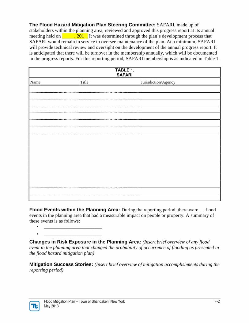
Flood Mitigation Plan – Town of Shandaken, New York F-2 May 2013
The Flood Hazard Mitigation Plan Steering Committee: SAFARI, made up of
stakeholders within the planning area, reviewed and approved this progress report at its annual
meeting held on _____, 201_. It was determined through the plan’s development process that
SAFARI would remain in service to oversee maintenance of the plan. At a minimum, SAFARI
will provide technical review and oversight on the development of the annual progress report. It
is anticipated that there will be turnover in the membership annually, which will be documented
in the progress reports. For this reporting period, SAFARI membership is as indicated in Table 1.
TABLE 1. SAFARI
Name Title Jurisdiction/Agency
Flood Events within the Planning Area: During the reporting period, there were __ flood
events in the planning area that had a measurable impact on people or property. A summary of
these events is as follows: • __________________________
• __________________________
Changes in Risk Exposure in the Planning Area: (Insert brief overview of any flood
event in the planning area that changed the probability of occurrence of flooding as presented in
the flood hazard mitigation plan)
Mitigation Success Stories: (Insert brief overview of mitigation accomplishments during the
reporting period)
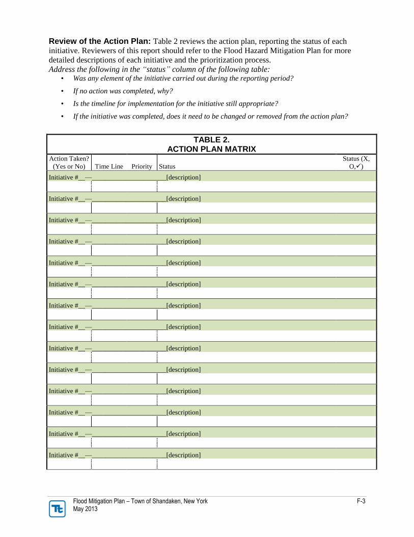
Flood Mitigation Plan – Town of Shandaken, New York F-3 May 2013
Review of the Action Plan: Table 2 reviews the action plan, reporting the status of each
initiative. Reviewers of this report should refer to the Flood Hazard Mitigation Plan for more
detailed descriptions of each initiative and the prioritization process.
Address the following in the “status” column of the following table: • Was any element of the initiative carried out during the reporting period?
• If no action was completed, why?
• Is the timeline for implementation for the initiative still appropriate?
• If the initiative was completed, does it need to be changed or removed from the action plan?
TABLE 2. ACTION PLAN MATRIX
Action Taken?
(Yes or No) Time Line Priority Status
Status (X,
O,)
Initiative #__—______________________[description]
Initiative #__—______________________[description]
Initiative #__—______________________[description]
Initiative #__—______________________[description]
Initiative #__—______________________[description]
Initiative #__—______________________[description]
Initiative #__—______________________[description]
Initiative #__—______________________[description]
Initiative #__—______________________[description]
Initiative #__—______________________[description]
Initiative #__—______________________[description]
Initiative #__—______________________[description]
Initiative #__—______________________[description]
Initiative #__—______________________[description]
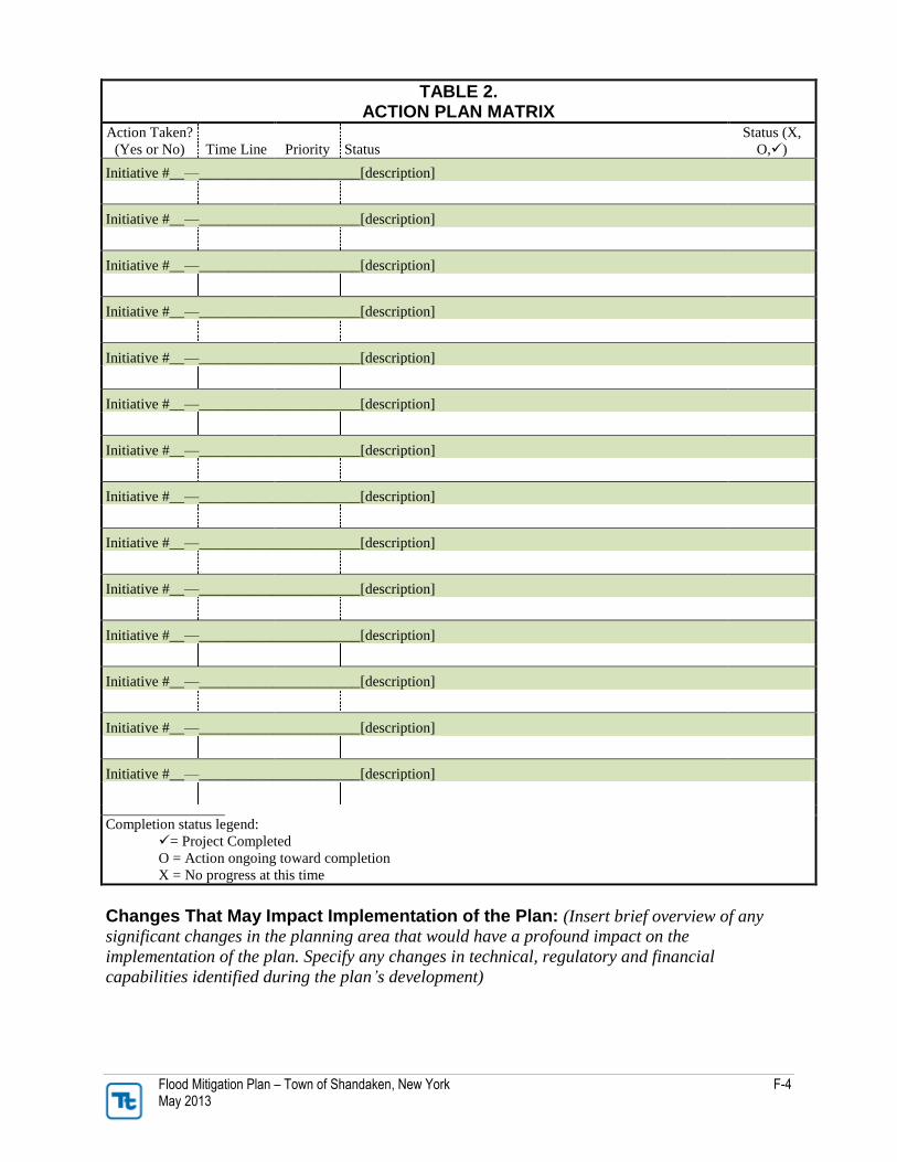
Flood Mitigation Plan – Town of Shandaken, New York F-4 May 2013
TABLE 2. ACTION PLAN MATRIX
Action Taken?
(Yes or No) Time Line Priority Status
Status (X,
O,)
Initiative #__—______________________[description]
Initiative #__—______________________[description]
Initiative #__—______________________[description]
Initiative #__—______________________[description]
Initiative #__—______________________[description]
Initiative #__—______________________[description]
Initiative #__—______________________[description]
Initiative #__—______________________[description]
Initiative #__—______________________[description]
Initiative #__—______________________[description]
Initiative #__—______________________[description]
Initiative #__—______________________[description]
Initiative #__—______________________[description]
Initiative #__—______________________[description]
Completion status legend:
= Project Completed
O = Action ongoing toward completion
X = No progress at this time
Changes That May Impact Implementation of the Plan: (Insert brief overview of any
significant changes in the planning area that would have a profound impact on the
implementation of the plan. Specify any changes in technical, regulatory and financial
capabilities identified during the plan’s development)

Flood Mitigation Plan – Town of Shandaken, New York F-5 May 2013
Recommendations for Changes or Enhancements: Based on the review of this report
by SAFARI, the following recommendations will be noted for future updates or revisions to the
plan: • __________________________
• __________________________
• __________________________
• __________________________
• __________________________
• __________________________
Public review notice: The contents of this report are considered to be public knowledge and
have been prepared for total public disclosure. Copies of the report have been provided to the
Town of Shandaken governing board and to local media outlets and the report is posted on the
Town of Shandaken Flood Hazard Mitigation Plan website. Any questions or comments
regarding the contents of this report should be directed to:
Robert Stanley, Supervisor
Town of Shandaken
P.O. Box 134,
7209 Rte. 28
Shandaken, NY 12480
Telephone: (845) 688-7165
Email: [email protected]