Embed Size (px)
DESCRIPTION
A summary of OSE and OSSE activities at ECMWF . Erik Andersson, Graeme Kelly, Jean-Noël Thépaut, Gabor Radnoti, Peter Bauer and Sean Healy Acknowledgements: EUCOS, EUMETSAT, JCSDA/NCEP. Three major sets of OSEs - PowerPoint PPT Presentation
Citation preview

ECMWFWMO Workshop19-21 May 2008: ECMWF OSEs Slide 1
A summary of OSE and OSSE activities at ECMWF.
Erik Andersson, Graeme Kelly, Jean-Noël Thépaut, Gabor Radnoti, Peter Bauer and Sean Healy
Acknowledgements:EUCOS, EUMETSAT, JCSDA/NCEP
Three major sets of OSEs Investigating the complementarity between space based and terrestrial observing systems The impact of MetOP instruments Impact of GPS Radio Occultation data The Joint-OSSE, followed by Conclusions

ECMWFWMO Workshop19-21 May 2008: ECMWF OSEs Slide 2
1: The Space-Terrestrial StudyInitiated and funded by EUCOS.
i. BASELINE: all satellite observations currently used in NWP (radiances, cloud-drift winds, scatt winds) + GUAN R/S + GSN surface land data + buoys (no ship data)
ii. BASELINE + aircraft data
iii. BASELINE + non-GUAN R/S wind profiles
iv. BASELINE + non-GUAN R/S wind and temp profiles
v. BASELINE + wind-profiler data
vi. (iv) + aircraft data
vii. BASELINE + non-GUAN R/S wind, temp and humidity profiles
viii.CONTROL: the combined observing system ix. BASELINE + non-GUAN R/S temperature profiles (winter)
x. BASELINE + aircraft temperature data (winter)

ECMWFWMO Workshop19-21 May 2008: ECMWF OSEs Slide 3
OSE assimilation system configuration
Resolutions:Model resolution T511 (50 km), L60Analysis at T511/T159 L60,12-hour 4D-Var
Winter Experiments:20041204-00 to 20050125-12 (including 10 day warm up)Model cycle 29R1
Summer experiments:20050715-00 to 20050915-12 (including 10 day warm up)Model cycle 29R2NOAA18 included (AMSU-A and MHS)

ECMWFWMO Workshop19-21 May 2008: ECMWF OSEs Slide 4
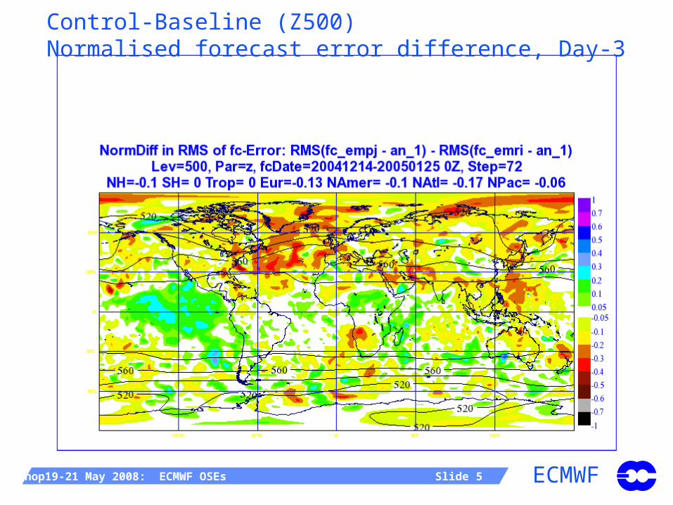
Winter results: Baseline – Control (Z500)Impact of terrestrial, non-climate, observations
NH
EUR
ECMWFWMO Workshop19-21 May 2008: ECMWF OSEs Slide 5
Control-Baseline (Z500)Normalised forecast error difference, Day-3

ECMWFWMO Workshop19-21 May 2008: ECMWF OSEs Slide 6
Z scores: Impact of R/S
NH
EUR
1000 hPa 500 hPa

ECMWFWMO Workshop19-21 May 2008: ECMWF OSEs Slide 9
Baseline – [ Baseline + aircraft]Z500 Impact of aircraft data
NH
EUR

ECMWFWMO Workshop19-21 May 2008: ECMWF OSEs Slide 10
[Baseline + aircraft] - Baseline (Z500)Normalised forecast error difference FC+12h

ECMWFWMO Workshop19-21 May 2008: ECMWF OSEs Slide 11
Z scores: Impact of aircraft
NH
EUR
1000 hPa 500 hPa
ECMWFWMO Workshop19-21 May 2008: ECMWF OSEs Slide 12
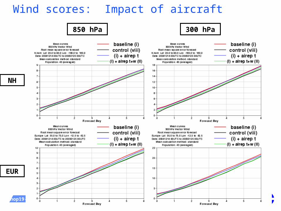
Wind scores: Impact of aircraft
NH
EUR
850 hPa 300 hPa

ECMWFWMO Workshop19-21 May 2008: ECMWF OSEs Slide 13
[(i) + R/S T+W] – [ (i) + R/S T+W + aircraft]Z500 Impact of aircraft in the presence of R/S
NH
EUR
ECMWFWMO Workshop19-21 May 2008: ECMWF OSEs Slide 14
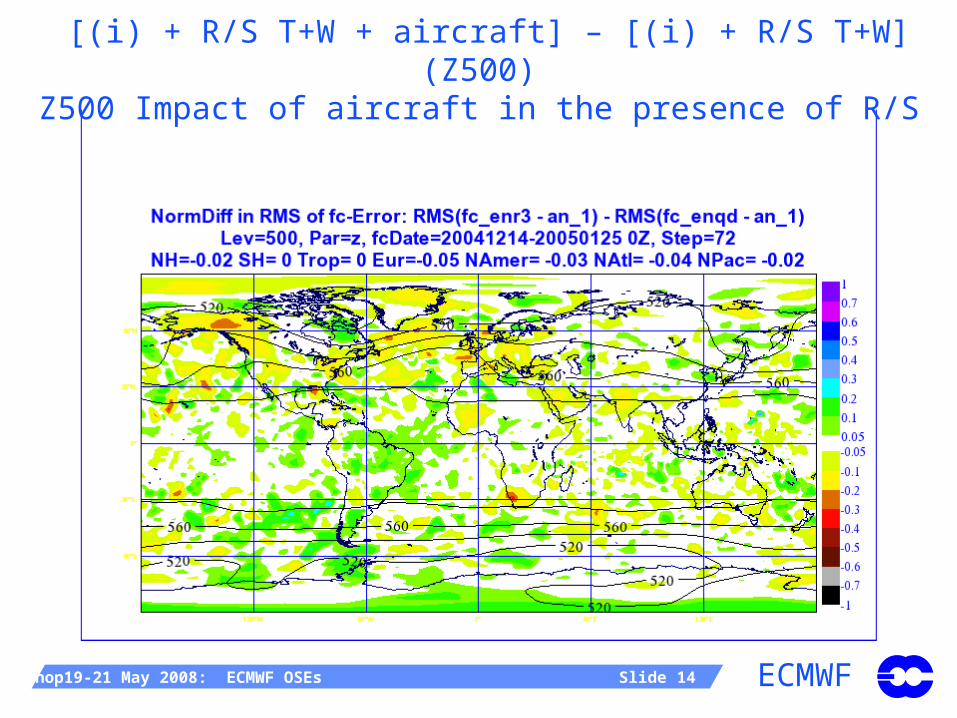
[(i) + R/S T+W + aircraft] – [(i) + R/S T+W] (Z500)Z500 Impact of aircraft in the presence of R/S
ECMWFWMO Workshop19-21 May 2008: ECMWF OSEs Slide 15
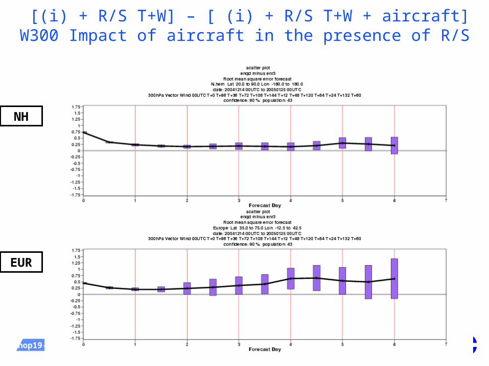
[(i) + R/S T+W] – [ (i) + R/S T+W + aircraft]W300 Impact of aircraft in the presence of R/S
NH
EUR
ECMWFWMO Workshop19-21 May 2008: ECMWF OSEs Slide 16
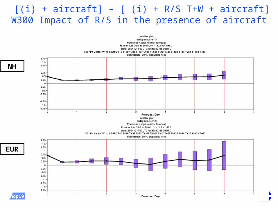
[(i) + aircraft] – [ (i) + R/S T+W + aircraft]W300 Impact of R/S in the presence of aircraft
NH
EUR

ECMWFWMO Workshop19-21 May 2008: ECMWF OSEs Slide 17
[(i) + R/S T+W] – [ (i) + R/S T+W+Q]RH700 Impact of R/S humidity
NH
EUR

ECMWFWMO Workshop19-21 May 2008: ECMWF OSEs Slide 18
EUCOS Space-Terrestrial, Conclusions (1)
Even in presence of satellite observations, degrading the current terrestrial Observing System has a significant negative impact on the forecast skill.
Starting from the degraded baseline (GUAN+GSN+…):
Additional R/S (T+Wind) and aircraft (T+Wind) contribute more or less equally to the Observing System (slight advantage for R/S)
These two Observing Systems are complementary
Aircraft add forecast skill to R/SR/S add forecast skill to Aircraft

ECMWFWMO Workshop19-21 May 2008: ECMWF OSEs Slide 19
EUCOS Space-Terrestrial, Conclusions (2)
R/S impact:
R/S winds contribute little on their own
Radiosonde T contribute marginally more
This is the combination of wind/T which really provides the impact of the RS on the forecast skill
Aircraft impact:
The results are consistent with that of R/S. Aircraft-T alone bring relatively little. Combination of T/Wind makes a big impact

ECMWFWMO Workshop19-21 May 2008: ECMWF OSEs Slide 20
EUCOS Space-Terrestrial, Conclusions (3)
Humidity from R/S add very little in terms of scoresNoticeable but small impact on relative humidity
scores up to day 3
Impact of wind profilers:Winter impact:
The short range forecasts are improved by the US and japanese profilers
The signal blurs away after day 4-5 and large scale interactions appear
European profilers do not bring much
In summer, the impact is smaller than during the winter period (in absolute but also relative terms)

ECMWFWMO Workshop19-21 May 2008: ECMWF OSEs Slide 21
2a: Assessment of the space component of the GOSInitiated and funded by EUMETSAT
Winter period: 20041204-20050125, Summer period: 20050715-20050915 (cycle 29r1)
BASELINE all conventional observations used in NWP (radiosonde + aircraft + profiler network + surface land data + buoy observations + ship data)
REFERENCE= BASELINE + AMVs from GEO+MODIS REFERENCE + HIRS radiances REFERENCE + AMSUA radiances REFERENCE + AMSUB radiances REFERENCE + SSMI radiances REFERENCE + GEO Clear Sky Radiances (CSRs) REFERENCE + AIRS radiances REFERENCE + SCAT winds BASELINE + GEO AMVs (no MODIS)
ECMWFWMO Workshop19-21 May 2008: ECMWF OSEs Slide 22
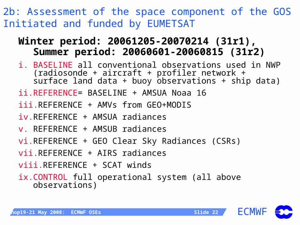
2b: Assessment of the space component of the GOSInitiated and funded by EUMETSAT
Winter period: 20061205-20070214 (31r1), Summer period: 20060601-20060815 (31r2)
i. BASELINE all conventional observations used in NWP (radiosonde + aircraft + profiler network + surface land data + buoy observations + ship data)
ii. REFERENCE= BASELINE + AMSUA Noaa 16
iii. REFERENCE + AMVs from GEO+MODIS
iv. REFERENCE + AMSUA radiances
v. REFERENCE + AMSUB radiances
vi. REFERENCE + GEO Clear Sky Radiances (CSRs)
vii. REFERENCE + AIRS radiances
viii. REFERENCE + SCAT winds
ix. CONTROL full operational system (all above observations)

ECMWFWMO Workshop19-21 May 2008: ECMWF OSEs Slide 23
Average Z 500 anomaly correlation scoresThe AMV reference and the AMSU-A reference
All AMVs ref All AMVs ref
One AMSU_A ref One AMSUA_ ref
S.Hem
N.Hem
N.Hem
S.Hem

ECMWFWMO Workshop19-21 May 2008: ECMWF OSEs Slide 24
Z500 impacts, S.Hem (REFERENCE_AMV)
HIRS, AMSU-A, AIRS
AMSU-B, SSMI, GEO_CSR
Scat, GEO_AMV, GEO_CSR

ECMWFWMO Workshop19-21 May 2008: ECMWF OSEs Slide 25
Relative Humidity 850hPa impacts, S.Hem (REFERENCE_AMV)
HIRS, AMSU-A, AIRS
AMSU-B, SSMI, GEO_CSR
Scat, GEO_AMV, GEO_CSR

ECMWFWMO Workshop19-21 May 2008: ECMWF OSEs Slide 26
Vector wind 200 hPa impacts, S.Hem (REFERENCE_AMV)
HIRS, AMSU-A, AIRS
AMSU-B, SSMI, GEO_CSR
Scat, GEO_AMV, GEO_CSR

ECMWFWMO Workshop19-21 May 2008: ECMWF OSEs Slide 27
Impact of removing MODIS from the REFERENCE_AMV

ECMWFWMO Workshop19-21 May 2008: ECMWF OSEs Slide 31
Space component, Summary
Very encouraging that all the space base sensors contribute in a positive way to the overall performance of the ECMWF forecast system. Sensors like AMSU-A, AIRS and HIRS are the most important.
The humidity analysis requires AMSUB (also MHS), GEO CSRs and SSMI.
Amongst the wind data, SCAT has a clear positive impact on the surface wind in the Southern Hemisphere, and a clear beneficial impact of AMVs and MODIS winds has been demonstrated.

ECMWFWMO Workshop19-21 May 2008: ECMWF OSEs Slide 32
3: OSEs for the evaluation of degraded EPS/Post-EPS instrument scenarios (EUMETSAT)
The objective is to assess the detrimental impact of potential loss of the main EUMETSAT Polar System (EPS) instruments on global NWP.
REFERENCE: All conventional data + 2*AMSU-A, 2* DMSP, AIRS and IASI, ASCAT and QuikSCAT.
REFERENCE – HIRS REFERENCE – AMSU REFERENCE – MHS REFERENCE – SOUNDERS REFERENCE – IASI REFERENCE – ASCAT REFERENCE – METOP

ECMWFWMO Workshop19-21 May 2008: ECMWF OSEs Slide 33
METOP forecast impact500 hPa geopotential height RMS error difference
when METOP data withdrawn
[%/100]
T+12 hours
T+24 hours

ECMWFWMO Workshop19-21 May 2008: ECMWF OSEs Slide 34
Preliminary results on Metop (ongoing study)
The fit to temperature-sounding instruments (e.g. NOAA-18 AMSU-A) is improved when Metop instruments are present.
The fit to moisture-sounding instruments (e.g. AIRS, MHS, GOES) is improved when Metop MHS, all Metop sounders or IASI are present
The presence of ASCAT data slightly improves the fit to QuikSCAT wind data, and products from Envisat and Jason altimeters
The synergy of Metop instruments produces a much stronger impact than its individual instruments

ECMWFWMO Workshop19-21 May 2008: ECMWF OSEs Slide 35
GPS radio-occultation. Current 6-hour data coverage.

ECMWFWMO Workshop19-21 May 2008: ECMWF OSEs Slide 36
December 2006: Assimilation of RO data at ECMWF
All 6 satellites
Wave-like bias disappeared

ECMWFWMO Workshop19-21 May 2008: ECMWF OSEs Slide 37
Population: 66Confidence: 95%
1000hPa Geopotential 00UTCDate: 20061215 00UTC to 20070218 00UTC
S.hem Lat -90.0 to -20.0 Lon -180.0 to 180.0Root mean square error forecast
control normalised beuwz minus beuwy
0 1 2 3 4 5 6 7 8 9 10 11Forecast Day
-0.05
0
0.05
0.1
0.15Population: 66
Confidence: 95%500hPa Geopotential 00UTC
Date: 20061215 00UTC to 20070218 00UTCS.hem Lat -90.0 to -20.0 Lon -180.0 to 180.0
Root mean square error forecastcontrol normalised beuwz minus beuwy
0 1 2 3 4 5 6 7 8 9 10 11Forecast Day
-0.05
0
0.05
0.1
0.15
Population: 66Confidence: 95%
200hPa Geopotential 00UTCDate: 20061215 00UTC to 20070218 00UTC
S.hem Lat -90.0 to -20.0 Lon -180.0 to 180.0Root mean square error forecast
control normalised beuwz minus beuwy
0 1 2 3 4 5 6 7 8 9 10 11Forecast Day
-0.05
0
0.05
0.1
0.15Population: 66
Confidence: 95%100hPa Geopotential 00UTC
Date: 20061215 00UTC to 20070218 00UTCS.hem Lat -90.0 to -20.0 Lon -180.0 to 180.0
Root mean square error forecastcontrol normalised beuwz minus beuwy
0 1 2 3 4 5 6 7 8 9 10 11Forecast Day
-0.05
0
0.05
0.1
0.15
GPSRO impact on Southern hemisphere geopotential height forecasts
6 COSMICs+CHAMP+GRACE-A (setting only, z > 5 km) – no GPSRO1100 observations/day, 66 cases, winter 2006/2007, own analyses
1000 hPa 500 hPa
200 hPa 100 hPa
(Sean Healy)

ECMWFWMO Workshop19-21 May 2008: ECMWF OSEs Slide 38
Population: 66Confidence: 95%
1000hPa Geopotential 00UTCDate: 20061215 00UTC to 20070218 00UTC
S.hem Lat -90.0 to -20.0 Lon -180.0 to 180.0Root mean square error forecast
control normalised beuwy minus beux1
0 1 2 3 4 5 6 7 8 9 10 11Forecast Day
-0.05
0
0.05
0.1
0.15Population: 66
Confidence: 95%500hPa Geopotential 00UTC
Date: 20061215 00UTC to 20070218 00UTCS.hem Lat -90.0 to -20.0 Lon -180.0 to 180.0
Root mean square error forecastcontrol normalised beuwy minus beux1
0 1 2 3 4 5 6 7 8 9 10 11Forecast Day
-0.05
0
0.05
0.1
0.15
Population: 66Confidence: 95%
200hPa Geopotential 00UTCDate: 20061215 00UTC to 20070218 00UTC
S.hem Lat -90.0 to -20.0 Lon -180.0 to 180.0Root mean square error forecast
control normalised beuwy minus beux1
0 1 2 3 4 5 6 7 8 9 10 11Forecast Day
-0.05
0
0.05
0.1
0.15Population: 66
Confidence: 95%100hPa Geopotential 00UTC
Date: 20061215 00UTC to 20070218 00UTCS.hem Lat -90.0 to -20.0 Lon -180.0 to 180.0
Root mean square error forecastcontrol normalised beuwy minus beux1
0 1 2 3 4 5 6 7 8 9 10 11Forecast Day
-0.05
0
0.05
0.1
0.15
GPSRO impact on Southern hemisphere geopotential height forecasts
6 COSMICs+CHAMP+GRACE-A (setting+rising, z > 5 km) – no GPSRO1600 observations/day, 66 cases, winter 2006/2007, own analyses
1000 hPa 500 hPa
200 hPa 100 hPa
(Sean Healy)

ECMWFWMO Workshop19-21 May 2008: ECMWF OSEs Slide 41
Advanced infrared sounders: AIRS and IASI
AIRS Operational at ECMWF since
October 2003. 324 channels received in NRT. One FOV in nine used. Up to 155 channels may be
assimilated (CO2 and H2O bands).
IASI Operational at ECMWF since June
2007. 8461 channels received in NRT. All FOVS received; only 1-in-4 used. 366 Channels routinely monitored. Up to 168 channels may be
assimilated (CO2 band only).

ECMWFWMO Workshop19-21 May 2008: ECMWF OSEs Slide 42
IASIbetterIASI
worse
IASIbetterIASI
worseSH
NH
500 hPa geopotential anomaly correlation (56 cases, spring 2007, normalized RMSE difference, own analysis)
Mean error difference uncertainty
IASI forecast impact
ECMWFWMO Workshop19-21 May 2008: ECMWF OSEs Slide 43
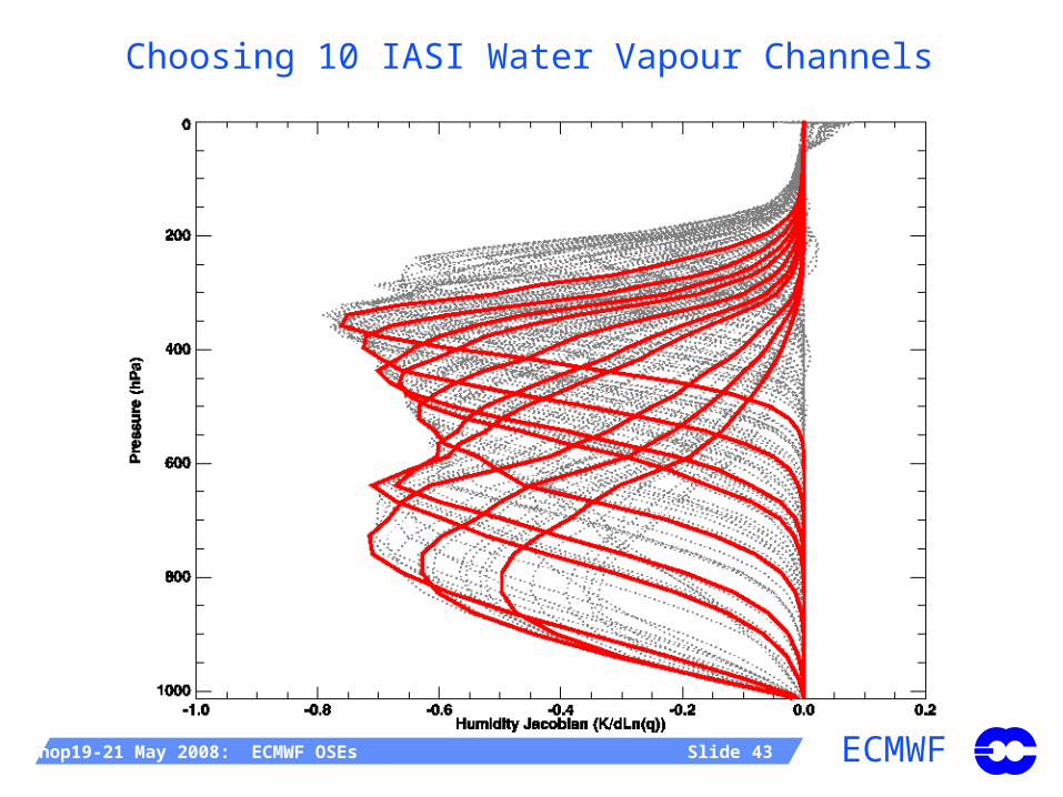
Choosing 10 IASI Water Vapour Channels

ECMWFWMO Workshop19-21 May 2008: ECMWF OSEs Slide 44
Fit to other observations
Increasing assumed IASI H2O channels’ error
No
rmal
ized
An
aly
sis
De
par
ture
Std
. De
v.
Best value at 1.5K
∞

ECMWFWMO Workshop19-21 May 2008: ECMWF OSEs Slide 45
The Joint OSSE Nature RunCollaboration with NCEP (Michiko Masutani) to plan,
produce, deliver and evaluate the NR. Consultation with the Joint-OSSE group in the US, EUCOS, ESA, EUMETSAT and ECMWF
T511 NR: 13 months T511/L91.
Data set size ~2.5 Tbyte. Shipping to the US on 4 disks
Yearly, quarterly and monthly comparison with climate and observations = 831 plots. Posted on NCEP web site
Extensive evaluation of the NR by US partners
T799 NR: Two 6-week periods have been run at T799/L91 with hourly post processing: TC-season, Convective season

ECMWFWMO Workshop19-21 May 2008: ECMWF OSEs Slide 47
Nature Run, 12-month total cloud cover
35
65 65
65
65
65
65
65
65
65
95
60°S60°S
30°S 30°S
0°0°
30°N 30°N
60°N60°N
135°W
135°W 90°W
90°W 45°W
45°W 0°
0° 45°E
45°E 90°E
90°E 135°E
135°E
Total Cloud Cover eskb June 2005 nmon=12 nens=1 Global Mean: 62.6 50N-S Mean: 57.8
[percent]
5.165
20
35
50
65
80
95
97.71
35
65
6565
65
65
6565
95 959595
60°S60°S
30°S 30°S
0°0°
30°N 30°N
60°N60°N
135°W
135°W 90°W
90°W 45°W
45°W 0°
0° 45°E
45°E 90°E
90°E 135°E
135°E
Total Cloud Cover MODIS June 2005 nmo2001-2001 climatology 50N-S Mean: 68.9
[percent]
5
20
35
50
65
80
95
101.2
10
50
60°S60°S
30°S 30°S
0°0°
30°N 30°N
60°N60°N
135°W
135°W 90°W
90°W 45°W
45°W 0°
0° 45°E
45°E 90°E
90°E 135°E
135°E
Difference eskb - MODIS 50N-S Mean err -11.1 50N-S rms 13.7[percent]
-53.03
-50
-40
-30
-20
-10
10
20
30
40
50
57.29
80 60 40 20 0 -20 -40 -60 -80
latitude (deg)
50
60
70
80
90
Zonal Meanmodel obs
-180 -120 -60 0 60 120 180
longitude (deg)
60
70
80
Extra-Tropics: Lat20
model obs
-180 -120 -60 0 60 120 180
longitude (deg)
50
60
70
80
Tropics: Lat20m odel obs
ECMWFWMO Workshop19-21 May 2008: ECMWF OSEs Slide 48
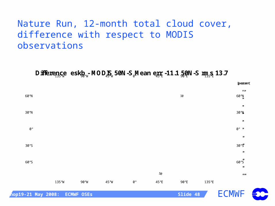
Nature Run, 12-month total cloud cover, difference with respect to MODIS observations
35
65 65
65
65
65
65
65
65
65
95
60°S60°S
30°S 30°S
0°0°
30°N 30°N
60°N60°N
135°W
135°W 90°W
90°W 45°W
45°W 0°
0° 45°E
45°E 90°E
90°E 135°E
135°E
Total Cloud Cover eskb June 2005 nmon=12 nens=1 Global Mean: 62.6 50N-S Mean: 57.8
[percent]
5.165
20
35
50
65
80
95
97.71
35
65
6565
65
65
6565
95 959595
60°S60°S
30°S 30°S
0°0°
30°N 30°N
60°N60°N
135°W
135°W 90°W
90°W 45°W
45°W 0°
0° 45°E
45°E 90°E
90°E 135°E
135°E
Total Cloud Cover MODIS June 2005 nmo2001-2001 climatology 50N-S Mean: 68.9
[percent]
5
20
35
50
65
80
95
101.2
10
50
60°S60°S
30°S 30°S
0°0°
30°N 30°N
60°N60°N
135°W
135°W 90°W
90°W 45°W
45°W 0°
0° 45°E
45°E 90°E
90°E 135°E
135°E
Difference eskb - MODIS 50N-S Mean err -11.1 50N-S rms 13.7[percent]
-53.03
-50
-40
-30
-20
-10
10
20
30
40
50
57.29
80 60 40 20 0 -20 -40 -60 -80
latitude (deg)
50
60
70
80
90
Zonal Meanmodel obs
-180 -120 -60 0 60 120 180
longitude (deg)
60
70
80
Extra-Tropics: Lat20
model obs
-180 -120 -60 0 60 120 180
longitude (deg)
50
60
70
80
Tropics: Lat20m odel obs

ECMWFWMO Workshop19-21 May 2008: ECMWF OSEs Slide 49
Comparison of extra-tropical cyclones in the NR against cyclones in the NCEP analyses for 5 recent years (green bars), showing central pressure (hPa, left) and life span (days, right panel). Courtesy Joe Terry (NASA).
18. 5.

ECMWFWMO Workshop19-21 May 2008: ECMWF OSEs Slide 50
OSEs and OSSE activities at ECMWFConclusions
Space-terrestrial study (EUCOS) completed
Assessment of space-component of the GOS (EUMETSAT) completed
Assessment of Metop impact (EUMETSAT) is ongoing
Comprehensive reports are available
ECMWF Newsletter No 113, page 16-28 (Kelly and Thépaut)
Metop-IASI and GPS-RO constitute significant new additions to the GOS
Joint-OSSE framework being developed, attracting a lot of interest, generating wide-spread collaboration