Embed Size (px)
Citation preview
THUNDERSTOM PRIMER
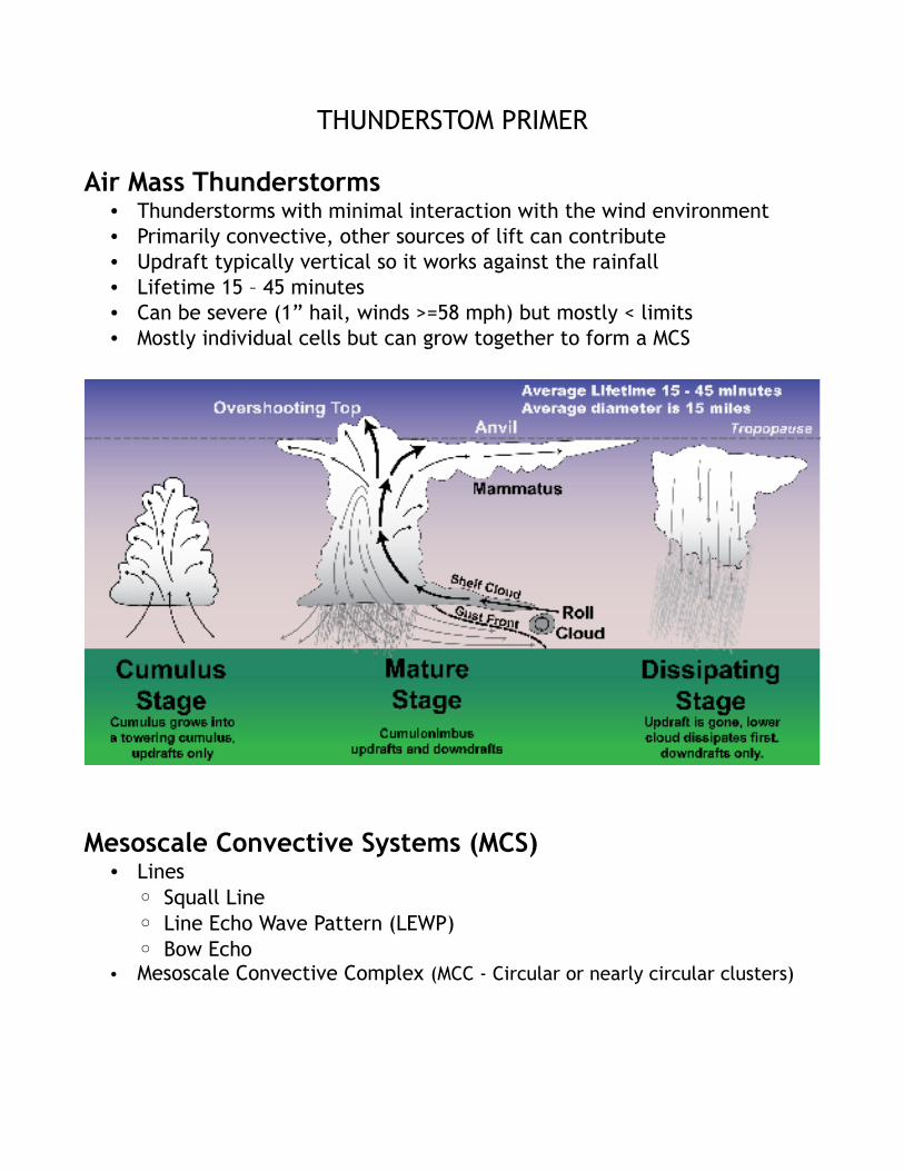
Air Mass Thunderstorms • Thunderstorms with minimal interaction with the wind environment• Primarily convective, other sources of lift can contribute• Updraft typically vertical so it works against the rainfall• Lifetime 15 – 45 minutes• Can be severe (1” hail, winds >=58 mph) but mostly < limits• Mostly individual cells but can grow together to form a MCS
Mesoscale Convective Systems (MCS)• Lines
◦ Squall Line◦ Line Echo Wave Pattern (LEWP)◦ Bow Echo
• Mesoscale Convective Complex (MCC - Circular or nearly circular clusters)
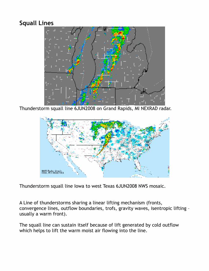
Squall Lines
Thunderstorm squall line 6JUN2008 on Grand Rapids, MI NEXRAD radar.
Thunderstorm squall line Iowa to west Texas 6JUN2008 NWS mosaic.
A Line of thunderstorms sharing a linear lifting mechanism (fronts, convergence lines, outflow boundaries, trofs, gravity waves, isentropic lifting – usually a warm front).
The squall line can sustain itself because of lift generated by cold outflow which helps to lift the warm moist air flowing into the line.
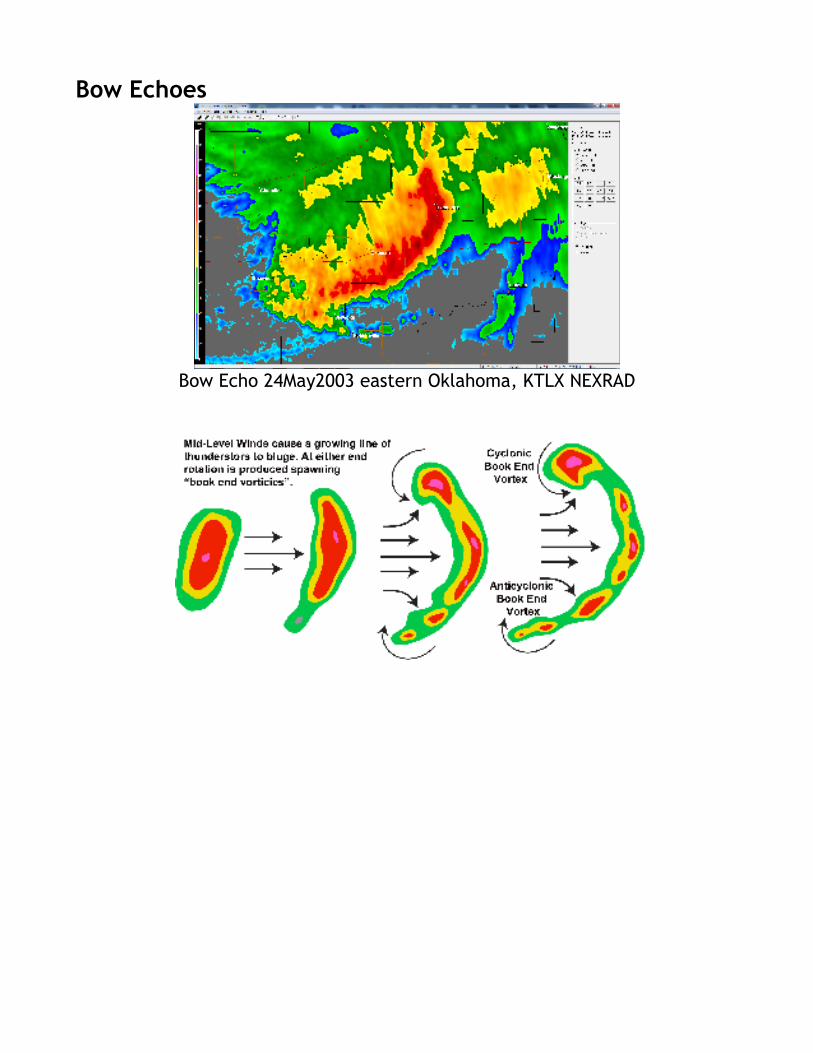
Bow Echoes
Bow Echo 24May2003 eastern Oklahoma, KTLX NEXRAD
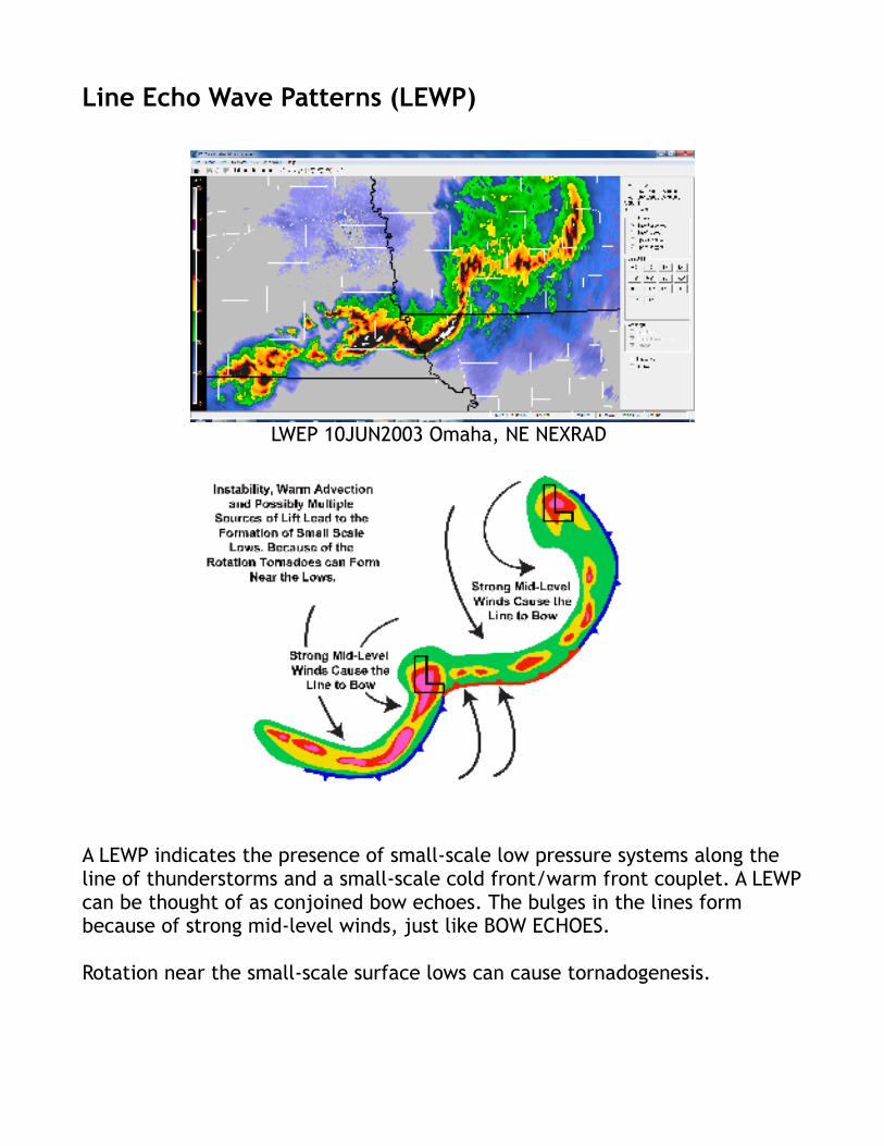
Line Echo Wave Patterns (LEWP)
LWEP 10JUN2003 Omaha, NE NEXRAD
A LEWP indicates the presence of small-scale low pressure systems along the line of thunderstorms and a small-scale cold front/warm front couplet. A LEWP can be thought of as conjoined bow echoes. The bulges in the lines form because of strong mid-level winds, just like BOW ECHOES.
Rotation near the small-scale surface lows can cause tornadogenesis.
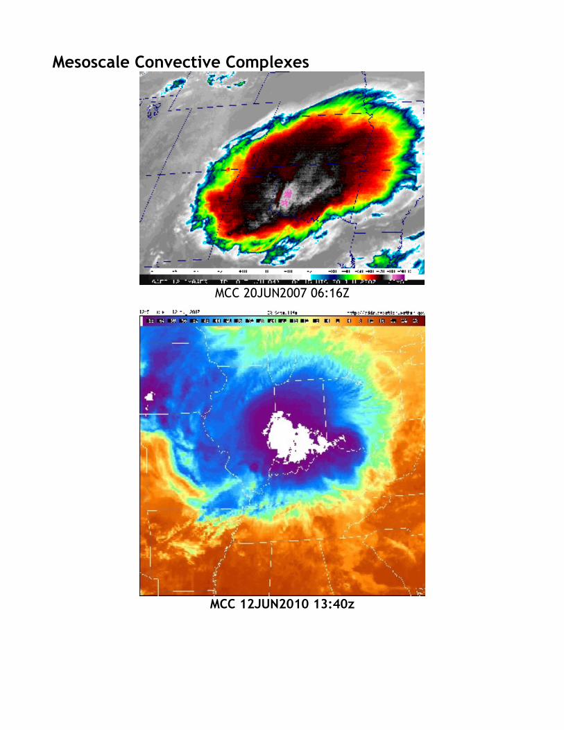
Mesoscale Convective Complexes
MCC 20JUN2007 06:16Z
MCC 12JUN2010 13:40z
MCC Definition Criteria: • Either an area of cloud top >= 100k km² with temperature <= -32 °C,
• an area of cloud top of 50k km² with temperature <= -52 °C.
• Criteria must be met for 6 hours or greater.
MCCs are not well understood but generally form in two w ays:
• Afternoon thunderstorms merge into a cooperative cluster in an area of strong warm air and moisture advection in the Great Plains. This often occurs north of a warm front and ahead of (east of) an upper trof. The MCC then propagates eastward/southeastward along the warm front overnight. As dawn approaches the complex weakens quickly and abruptly turns right and travels southward as it dissipates.
• The origin of some MCCs can be traced back to the high plains and eastern slopes of the Rocky Mountains. Thunderstorms that form on the slopes of the Rockies due to the convective and orographic lift become organized into a cooperative, self sustaining cluster and travel like the case above.
• Flooding rains, damaging winds, intense and frequent lightning and tornadoes can result.
• Remnants of the MCC can persist and spawn additional thunderstorms laeter in the day.
Supercell Thunderstorms
Like air mass thunderstorms the stereotypical super cell is a discrete cell, that travels in a straight line, a few degrees to the right of the mean tropospheric flow. It can travel hundreds of miles and last for 4 to 10 hours. Like all classifications of natural phenomena there are many variations of supercell form. Supercells have a strong, tilted and rotating updraft.
On March 2,2012 super cells formed in the Ohio River Valley and travelled for oveer 400 miles dropping numerous tornadoes and at least 2 EF4s (see picture).
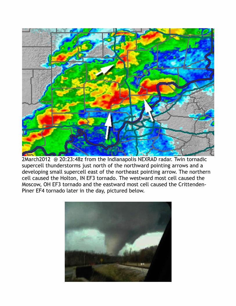
2March2012 @ 20:23:48z from the Indianapolis NEXRAD radar. Twin tornadic supercell thunderstorms just north of the northward pointing arrows and a developing small supercell east of the northeast pointing arrow. The northern cell caused the Holton, IN EF3 tornado. The westward most cell caused the Moscow, OH EF3 tornado and the eastward most cell caused the Crittenden-Piner EF4 tornado later in the day, pictured below.
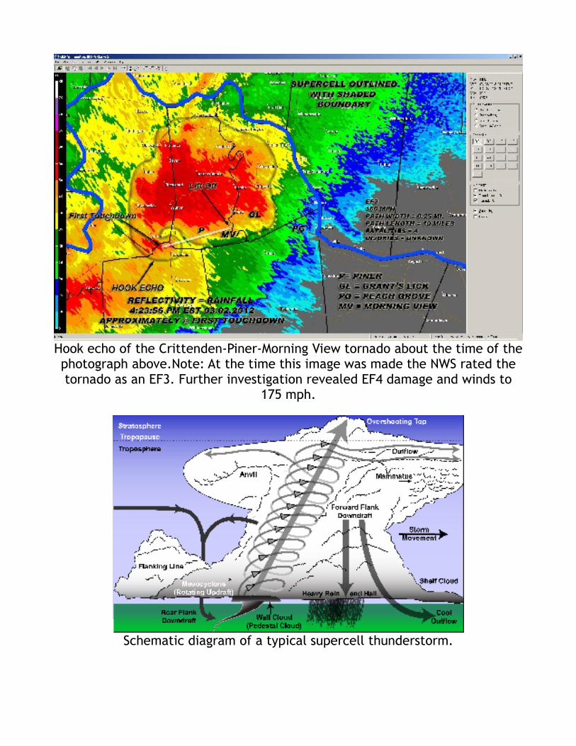
Hook echo of the Crittenden-Piner-Morning View tornado about the time of the photograph above.Note: At the time this image was made the NWS rated the tornado as an EF3. Further investigation revealed EF4 damage and winds to
175 mph.
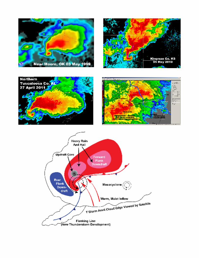
Schematic diagram of a typical supercell thunderstorm.
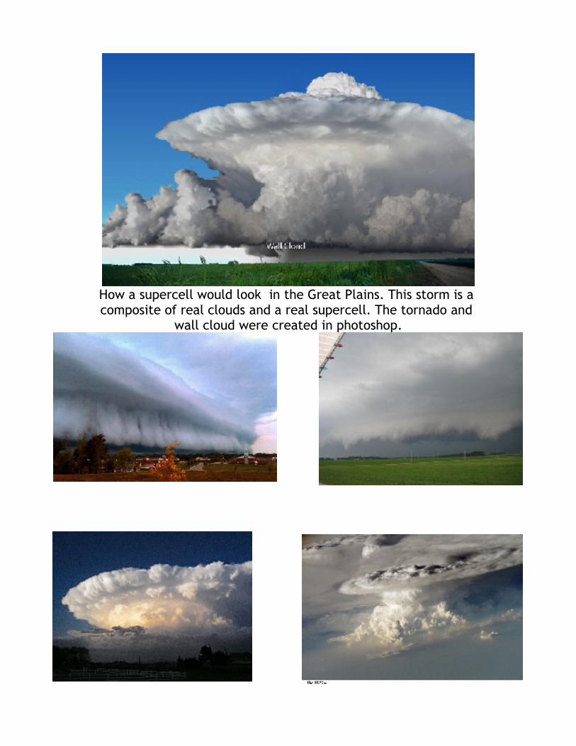
How a supercell would look in the Great Plains. This storm is a composite of real clouds and a real supercell. The tornado and
wall cloud were created in photoshop.
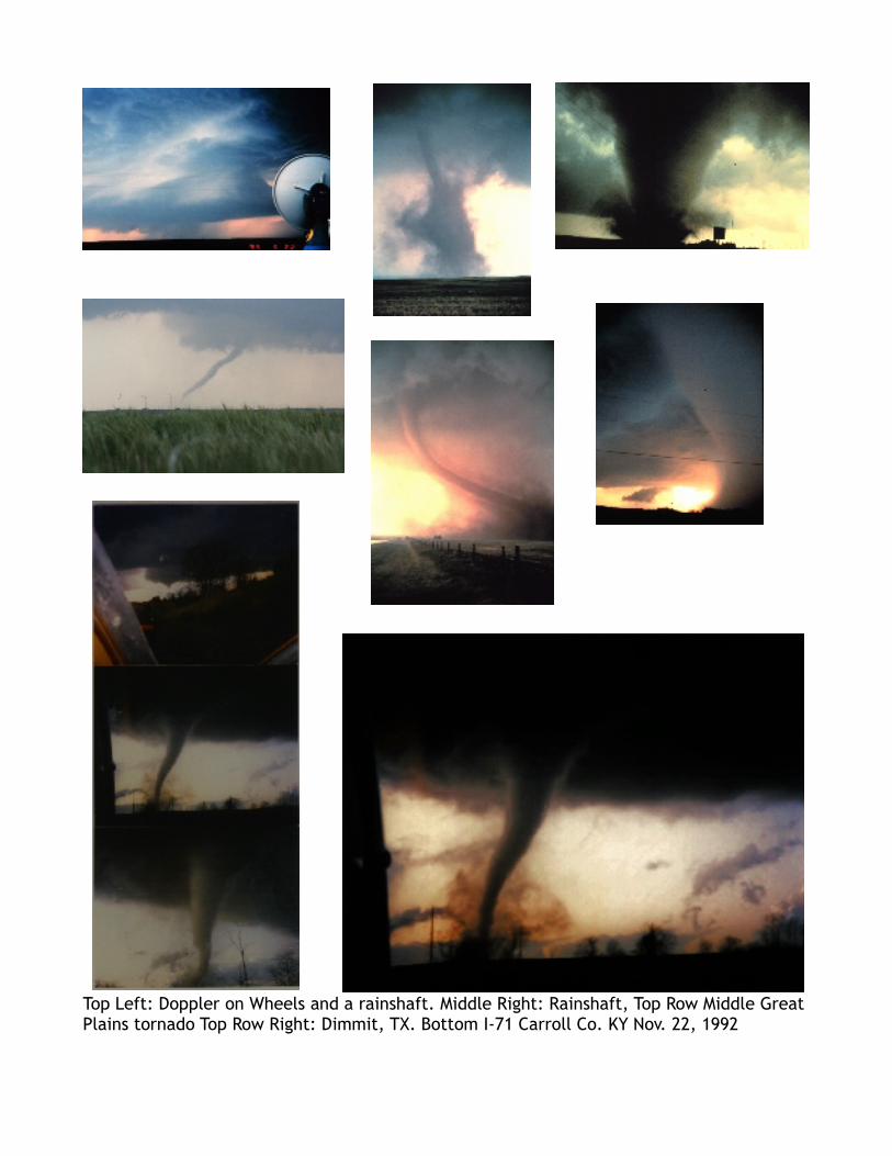
Top Left: Doppler on Wheels and a rainshaft. Middle Right: Rainshaft, Top Row Middle Great Plains tornado Top Row Right: Dimmit, TX. Bottom I-71 Carroll Co. KY Nov. 22, 1992
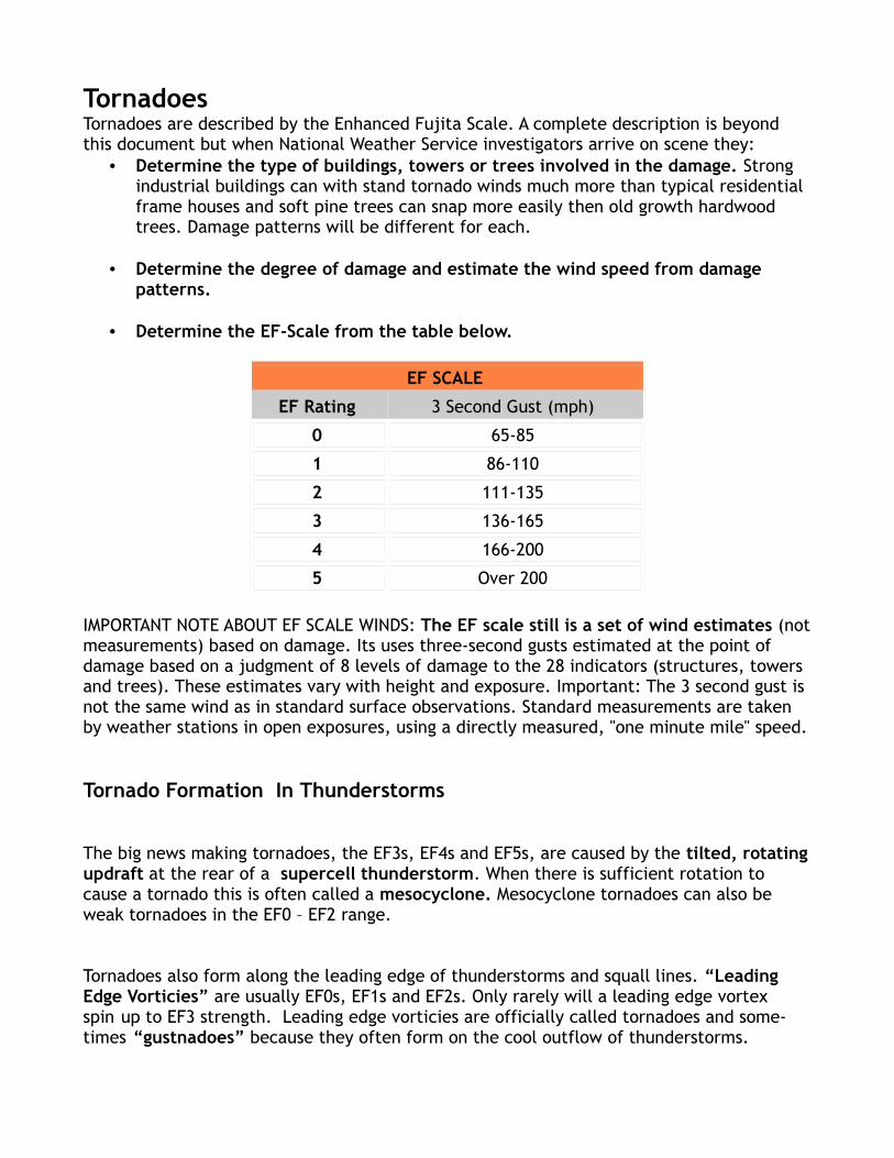
TornadoesTornadoes are described by the Enhanced Fujita Scale. A complete description is beyond this document but when National Weather Service investigators arrive on scene they:
• Determine the type of buildings, towers or trees involved in the damage. Strong industrial buildings can with stand tornado winds much more than typical residential frame houses and soft pine trees can snap more easily then old growth hardwood trees. Damage patterns will be different for each.
• Determine the degree of damage and estimate the wind speed from damage patterns.
• Determine the EF-Scale from the table below.
EF SCALE
EF Rating 3 Second Gust (mph)
0 65-85
1 86-110
2 111-135
3 136-165
4 166-200
5 Over 200
IMPORTANT NOTE ABOUT EF SCALE WINDS: The EF scale still is a set of wind estimates (not measurements) based on damage. Its uses three-second gusts estimated at the point of damage based on a judgment of 8 levels of damage to the 28 indicators (structures, towers and trees). These estimates vary with height and exposure. Important: The 3 second gust is not the same wind as in standard surface observations. Standard measurements are taken by weather stations in open exposures, using a directly measured, "one minute mile" speed.
Tornado Formation In Thunderstorms
The big news making tornadoes, the EF3s, EF4s and EF5s, are caused by the tilted, rotating updraft at the rear of a supercell thunderstorm. When there is sufficient rotation to cause a tornado this is often called a mesocyclone. Mesocyclone tornadoes can also be weak tornadoes in the EF0 – EF2 range.
Tornadoes also form along the leading edge of thunderstorms and squall lines. “Leading Edge Vorticies” are usually EF0s, EF1s and EF2s. Only rarely will a leading edge vortex spin up to EF3 strength. Leading edge vorticies are officially called tornadoes and some-times “gustnadoes” because they often form on the cool outflow of thunderstorms.
At present (April 2012) there is no distinction between the two and the weak, sometimes barely noticed leading edge vorticies get the same treatment as the big ones. This is bound to change in the future as warning systems and technologies evolve.
Tornado Formation Mechanisms
Rotation, Rotation Intensification and Funnel Formation
As more is learned about tornadogenesis the more it becomes apparent that:
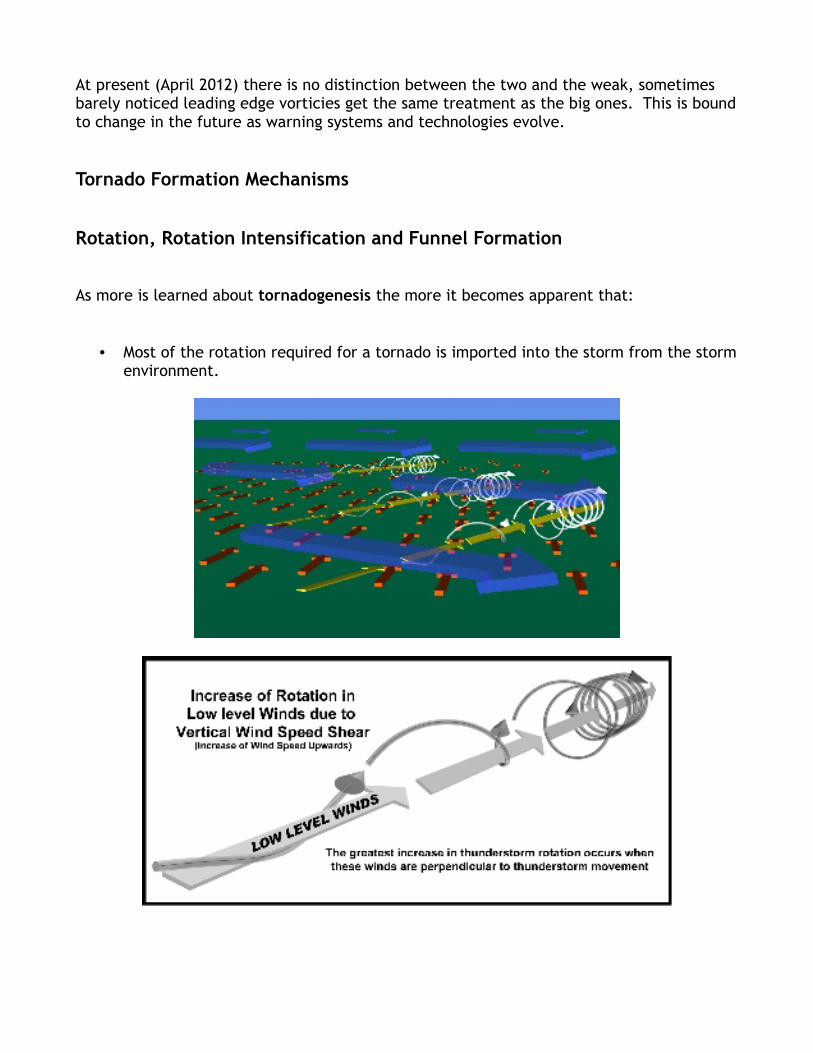
• Most of the rotation required for a tornado is imported into the storm from the storm environment.
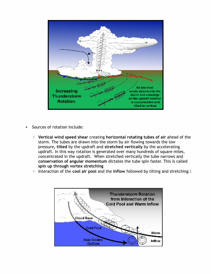
• Sources of rotation include:
◦ Vertical wind speed shear creating horizontal rotating tubes of air ahead of the storm. The tubes are drawn into the storm by air flowing towards the low pressure, tilted by the updraft and stretched vertically by the accelerating updraft. In this way rotation is generated over many hundreds of square miles, concentrated in the updraft. When stretched vertically the tube narrows and conservation of angular momentum dictates the tube spin faster. This is called spin up through vortex stretching
◦ Interaction of the cool air pool and the inflow followed by tilting and stretching.\

• Rotation is likely pushed to the tornado threshold when the rear flank downdraft (RFD) develops and begins to wrap around the lower portion of the rotating updraft. This helps confine and concentrate the rotation. A local intensification of the RFD, called the occlusion downdraft (OD) in the vicinity of the tornado may concentrate the rotation even more, increase the vertical pressure gradient and accelerate the upward motion further stretching the vortex.
• The Dynamic Pipe Effect: When vortex stretching takes place and the rotation rate increases cyclostrophic balance may be attained in the lower part of the thunderstorm and just below cloud base. This means that the outward directed centrifugal force is balanced by the inward directed pressure gradient force and the movement of air into the vortex is restricted. With less air flowing into the upper part of the developing tornado aloft, mass in the vortex just below cloud base decreases because air continues to be removed by the updraft. As a result the pressure drops in the higher part of the vortex increasing the vertical pressure gradient and the updraft accelerates. When the updraft accelerates spin increases because of increased vortex stretching and the faster rotation works downwards twards the ground.
• The Surface Cool Pool of Air can be a source of rotation
• Swirl Ratio the ration of upward velocity in the funnel to tangential flow at the edge of the vortex is termed swirl ratio. Technically this is a simplification but the rate of rotation as indicated by the tangential velocity is a measure of the inflow of air the the circulation of mass.
Swirl ratio = Tangential velocity / Updraft Velocity
If the upward vertical velocity is >> than the tangential velocity it is termed a low swirl condition and the inflowing air is easily evacuated by the updraft. Well defined funnels form in low swirl condition as long as the low swirl is not due to near zero tangential velocity.
A large swirl ratio ( >1 sometimes 3 to 5 means) that mass is accumulating and the updraft cannot keep up with the inflow. The funnel may fatten or break down into smaller funnels rotating around one another as the central downdraft pushes closer to the ground.
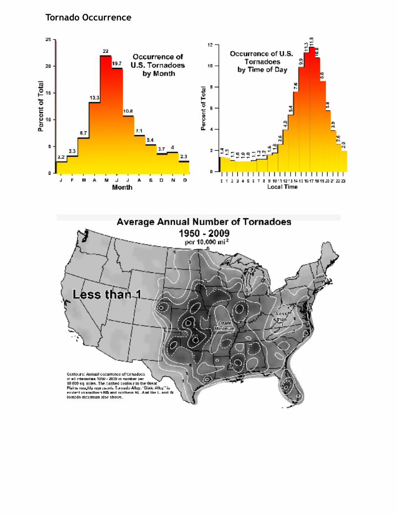
Tornado Occurrence
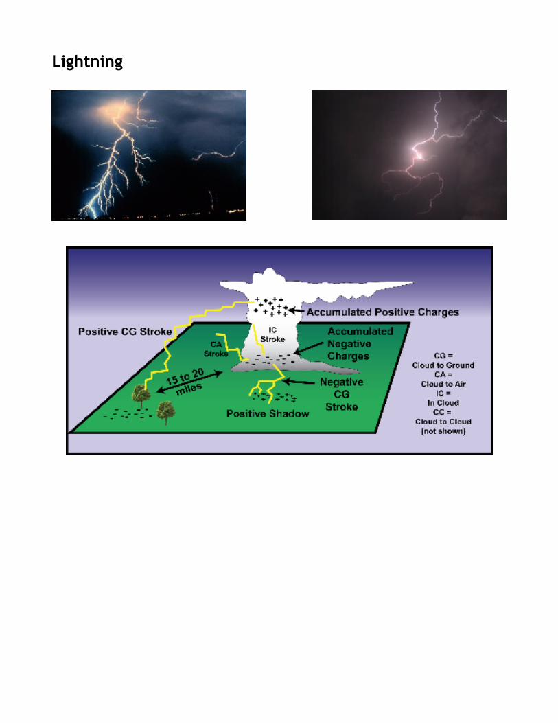
Lightning