Embed Size (px)
Citation preview

1
A N O U T S TA N D I N G P R E S E N TA T I O N T E M P L A T E
Alternatives Public MeetingThursday, June 4, 2020
This script accompanies the PowerPoint slides for the 5th Street Alternatives Public Meeting. The 5th Street Alternatives Public meeting will be held on June 4, 2020 between 6 p.m. – 7 p.m. EDT. The presentation will begin at 6 p.m., followed by a question and answer session from 6:30 p.m. to 7 p.m. The meeting requires preregistration at bit.ly/5thstreetwebinar
1

2
Charles ProctorPlanning Manager
VDOT Culpeper District
Patty HurdProject Manager
Kittelson & Associates, Inc.
Mateo Van ThienenModerator
Kittelson & Associates, Inc.
Meredyth SandersTransportation Planner
Kittelson & Associates, Inc.
Today’s Speakers
�
INTRO WHY 5TH STREET? 5TH STREET TODAYTRANSPORTATION OPTIONS
FOR 5TH STREETNEXT STEPS
Today’s speakers include members of the 5th Street Corridor study team. Charles Proctor is available to answer questions during the question and answer portion of the meeting. Patty Hurd is the project manager, and Meredyth Sanders is a transportation planner on the study team. Mateo Van Thienen is a transportation analyst on the study team and will serve as the moderator during the question and answer portion of the meeting.
2
3
Meeting Goals• To share:
• Why the study is happening• What has been learned so far• Preliminary Alternatives• Next steps
• To answer your questions
�
INTRO WHY 5TH STREET? 5TH STREET TODAYTRANSPORTATION OPTIONS
FOR 5TH STREETNEXT STEPS
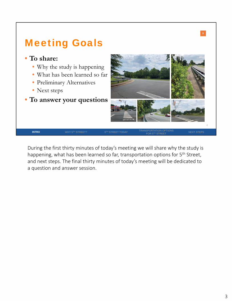
During the first thirty minutes of today’s meeting we will share why the study is happening, what has been learned so far, transportation options for 5th Street, and next steps. The final thirty minutes of today’s meeting will be dedicated to a question and answer session.
3

4
Navigating GoToWebinar
�
INTRO WHY 5TH STREET? 5TH STREET TODAYTRANSPORTATION OPTIONS
FOR 5TH STREETNEXT STEPS
VDOT 5th Street Corridor Study Alternatives Public Meeting
+X (XXX) XXX‐XXXXXXX‐XXX‐XXX
Patty Hurd
Send questions about the presentation and project through “Questions” Box
To ask questions at any time during today’s meeting, please post them in the “Questions Box” in your GoToWebinar window. Mateo will review questions received throughout the presentation and will read them out loud during the question and answer session.
4

5
Why is the study happening?
First, we will share why VDOT decided to conduct the 5th Street Corridor Study.
5
6
�
Study Area
INTRO WHY 5TH STREET? 5TH STREET TODAYTRANSPORTATION OPTIONS
FOR 5TH STREETNEXT STEPS
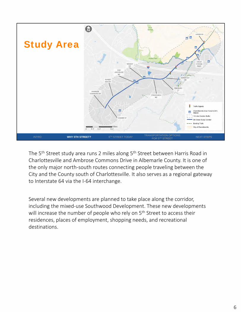
The 5th Street study area runs 2 miles along 5th Street between Harris Road in Charlottesville and Ambrose Commons Drive in Albemarle County. It is one of the only major north‐south routes connecting people traveling between the City and the County south of Charlottesville. It also serves as a regional gateway to Interstate 64 via the I‐64 interchange.
Several new developments are planned to take place along the corridor, including the mixed‐use Southwood Development. These new developments will increase the number of people who rely on 5th Street to access their residences, places of employment, shopping needs, and recreational destinations.
6

7
Study Purpose• Evaluate existing automobile, transit, bicycle, and pedestrian
conditions• Assess future travel projections and development patterns• Generate alternatives • Evaluate alternatives against goals and through community
input• Recommend a system of investments
�
INTRO WHY 5TH STREET? 5TH STREET TODAYTRANSPORTATION OPTIONS
FOR 5TH STREETNEXT STEPS
VDOT decided to conduct the 5th Street study to understand if and how the 5th
Street corridor should evolve to meet the changing needs of corridor uses and users. The study will evaluate existing automobile, transit, bicycle, and pedestrian conditions, assess future travel projections and development patterns, generate a range of multimodal solutions to address the study goals and objectives, and test the application and relevance of multimodal solutions through community input.
7

8
�
5th Street is a Complete Street that supports development and provides safe and comfortable travel
for all uses and users of the roadway
INTRO WHY 5TH STREET? 5TH STREET TODAYTRANSPORTATION OPTIONS
FOR 5TH STREETNEXT STEPS
Vision and Goals
Improve Safety and Comfort Support Economic Development
Manage Congestion Environmental Sustainability andCommunity Health
The study vision is for 5th Street to become a complete street that supports development and provides safe and comfortable travel for all uses and users of the roadway.
The study team established four goals to help meet the study vision. These goals were vetted with the study stakeholder group and members of the community. They include:
1. Improve safety and comfort
2. Manage congestion
3. Support economic development
4. Environmental sustainability and community health.
For more information about Complete Streets: https://www.transportation.gov/mission/health/complete‐streets
8
9
�
1 – Evaluate Existing and
Future Traffic, Safety, and
Development
2 – Develop Goals/
Objectives
3 - Develop Alternatives
4 - Evaluate Alternatives
5 - Revise Alternatives
Stakeholder Group Meeting #1
Community MeetingsSurvey #1
Public Meeting #1Survey #2
Stakeholder Group Meeting #2
Stakeholder Group Meeting #3
INTRO WHY 5TH STREET? 5TH STREET TODAYTRANSPORTATION OPTIONS
FOR 5TH STREETNEXT STEPS
Project Process
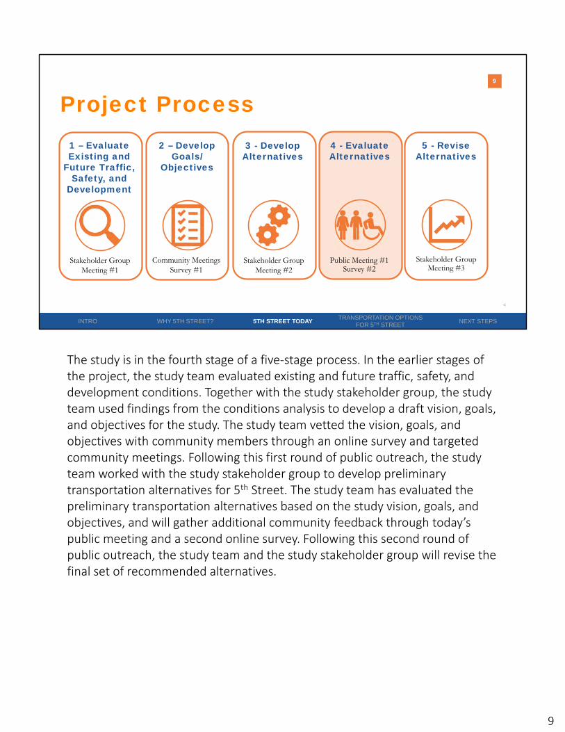
The study is in the fourth stage of a five‐stage process. In the earlier stages of the project, the study team evaluated existing and future traffic, safety, and development conditions. Together with the study stakeholder group, the study team used findings from the conditions analysis to develop a draft vision, goals, and objectives for the study. The study team vetted the vision, goals, and objectives with community members through an online survey and targeted community meetings. Following this first round of public outreach, the study team worked with the study stakeholder group to develop preliminary transportation alternatives for 5th Street. The study team has evaluated the preliminary transportation alternatives based on the study vision, goals, and objectives, and will gather additional community feedback through today’s public meeting and a second online survey. Following this second round of public outreach, the study team and the study stakeholder group will revise the final set of recommended alternatives.
9

10
What has been learned so far?
These slides summarize what has been learned from the study so far.
10

11
INTRO WHY 5TH STREET? 5TH STREET TODAYTRANSPORTATION OPTIONS
FOR 5TH STREETNEXT STEPS
Existing Bicycle and Pedestrian Facilities
5th Street is characterized by inconsistent, incomplete bicycle and pedestrian facilities. Existing pedestrian facilities include a mix of sidewalks and substandard paved or gravel paths. Existing bike lanes end south of 5th Street Station Parkway and are unlikely to attract most potential cyclists due to the high posted speed limit and roadway volumes on 5th Street. There are just two intersections with designated pedestrian crosswalks on the corridor – both located north of I‐64.
11

12
�
INTRO WHY 5TH STREET? 5TH STREET TODAYTRANSPORTATION OPTIONS
FOR 5TH STREETNEXT STEPS
Existing Transit Facilities
Every transit trip begins with a walking or biking trip, so the incomplete bicycle and pedestrian facilities on 5th Street make it difficult for people to access transit stops along the corridor.
12

13
�
INTRO WHY 5TH STREET? 5TH STREET TODAYTRANSPORTATION OPTIONS
FOR 5TH STREETNEXT STEPS
Crash Analysis
AMBROSE COMMONS DR
STAGECOACH RD
HICKORY ST
PINEHURST CT
WINDFIELD CIR
HARRIS RD
WAHOO WY
SUNSET AVE EXT
OLD LYNCHBURG RD
5TH ST STATION PKWY
of crashesoccur atintersections
9 6%
2
2
pedestrian-involved crashes
bicycle-involved crashes
The study team reviewed five years of crash data along the study corridor and found that a vast majority of corridor crashes occurred at intersections. Intersections with the most corridor crashes include 5th Street Station Parkway, Harris Road, the I‐64 interchange ramps, and Old Lynchburg Road.
13

14
�
INTRO WHY 5TH STREET? 5TH STREET TODAYTRANSPORTATION OPTIONS
FOR 5TH STREETNEXT STEPS
Existing Traffic ConditionsAM and PM Rush Hours
The study team evaluated existing traffic conditions during the morning and evening rush hours to understand the typical amount of congestion that motorists experience at corridor intersections. Most study intersections perform near capacity in both time periods, which is what traffic engineers aim for. A few intersections perform at or over capacity during either the morning or evening rush hour, which means that more vehicles are accessing the intersection than can be processed in one light cycle. One intersection, 5th
Street and 5th Street Station Parkway, performs at or over capacity during both the morning and evening rush hour. This intersection typically experiences unstable operations and significant delays, resulting in a stressful experience for motorists.
14
15
INTRO WHY 5TH STREET? 5TH STREET TODAYTRANSPORTATION OPTIONS
FOR 5TH STREETNEXT STEPS
Future Traffic Conditions2040 AM and PM Rush Hours
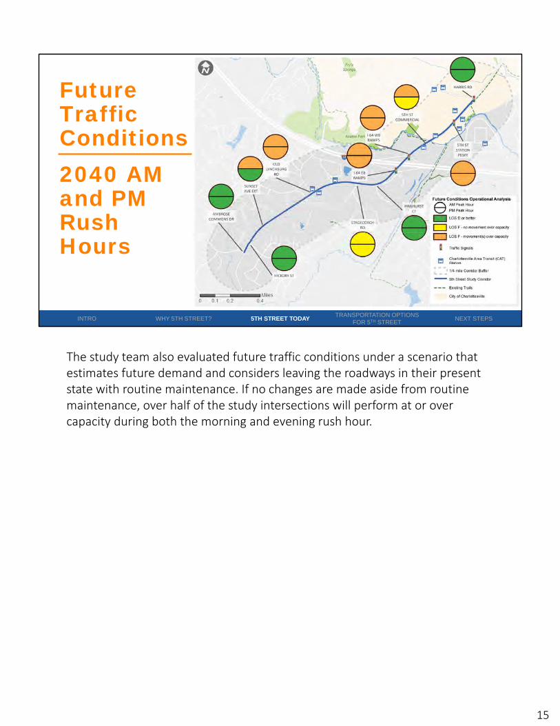
The study team also evaluated future traffic conditions under a scenario that estimates future demand and considers leaving the roadways in their present state with routine maintenance. If no changes are made aside from routine maintenance, over half of the study intersections will perform at or over capacity during both the morning and evening rush hour.
15
16
�
Community Engagement
INTRO WHY 5TH STREET? 5TH STREET TODAYTRANSPORTATION OPTIONS
FOR 5TH STREETNEXT STEPS
1,200+Survey Responses
2Community Meetings
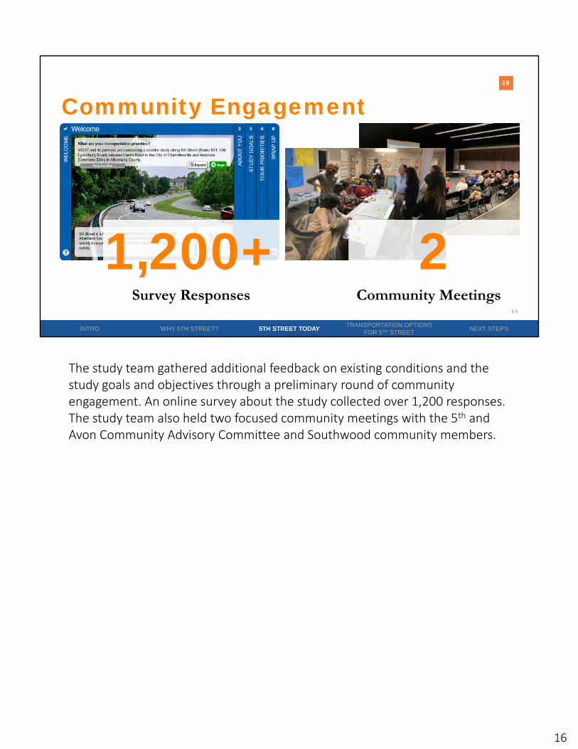
The study team gathered additional feedback on existing conditions and the study goals and objectives through a preliminary round of community engagement. An online survey about the study collected over 1,200 responses. The study team also held two focused community meetings with the 5th and Avon Community Advisory Committee and Southwood community members.
16

17
�
Community Engagement
INTRO WHY 5TH STREET? 5TH STREET TODAYTRANSPORTATION OPTIONS
FOR 5TH STREETNEXT STEPS
187
188
200
227
232
303
419
546
555
561
969
0 400 800 1200
Frequency of bus service
School traffic
Quality of bus stops
Streetscaping/landscaping
Access to properties along the corriodor
Roadway lighting
Location and quality of bicycle facilities
Location of pedestrian crossings (crosswalks)
Speeding
Location and quality of sidewalks
Traffic congestion
What transportation problems have you observed along the study corridor?
34%of survey participants walk and/or bike on 5th
Street
The preliminary community engagement revealed that 34% of survey participants walk and/or bike on 5th Street. The top four transportation issues identified by survey participants include traffic congestion, the location and quality of sidewalks, speeding, and the location of pedestrian crosswalks.
17

18
What are the preliminary alternatives?
Together with the stakeholder group, the study team developed a series of transportation options for 5th Street.
18

19
�
INTRO WHY 5TH STREET? 5TH STREET TODAYTRANSPORTATION OPTIONS
FOR 5TH STREETNEXT STEPS
1. North of I-64
2. 5th Street and I-64 Interchange
3. South of I-64
Corridor Sections
AMBROSE COMMONS DR
STAGECOACH RD
HICKORY ST
PINEHURST CT
WINDFIELD CIR
HARRIS RD
WAHOO WY
SUNSET AVE EXT
OLD LYNCHBURG RD
5TH ST STATION PKWY
12
3
The 5th Street corridor can be divided into three different sections based on changes in the corridor transportation and land use context. The sections include 5th Street north of I‐64, 5th Street at the I‐64 interchange, and 5th Street south of I‐64. The following slides outline different transportation options for each section.
19

20
��
INTRO WHY 5TH STREET? 5TH STREET TODAYTRANSPORTATION OPTIONS
FOR 5TH STREETNEXT STEPS
North of I-64 –Issues and Opportunities
Safety Issue
Congestion Issue
“Motorists block the box at 5th Street Station Parkway and 5th Street” –Southwood Community Meeting
“…Many families walking with small children who cross 5th Street at Harris Road to get to Jackson Via…” – Survey 1
“Bike lanes terminate at the city line leaving the rider exposed” – Survey 1
5th Street north of I‐64 experiences safety challenges at signalized intersections related to turning vehicles and long vehicle queues. It also experiences some congestion challenges related to high delay and long vehicle queues. Pedestrians experience long waits to cross at intersections, and bicycle and pedestrian facilities end south of 5th Street Station Parkway. There is currently no buffer between bicycle and pedestrian facilities and the roadway.
20

21
�
INTRO WHY 5TH STREET? 5TH STREET TODAYTRANSPORTATION OPTIONS
FOR 5TH STREETNEXT STEPS
Harris Road – No Change
If no changes are made to the signalized intersection of 5th Street and Harris Road, the intersection will continue to experience safety challenges for motorized and non‐motorized modes. The intersection will continue to experience acceptable travel times for cars and buses, while pedestrians will continue to experience delay at crossings.
21
22
��
Harris Road – Intersection Modification
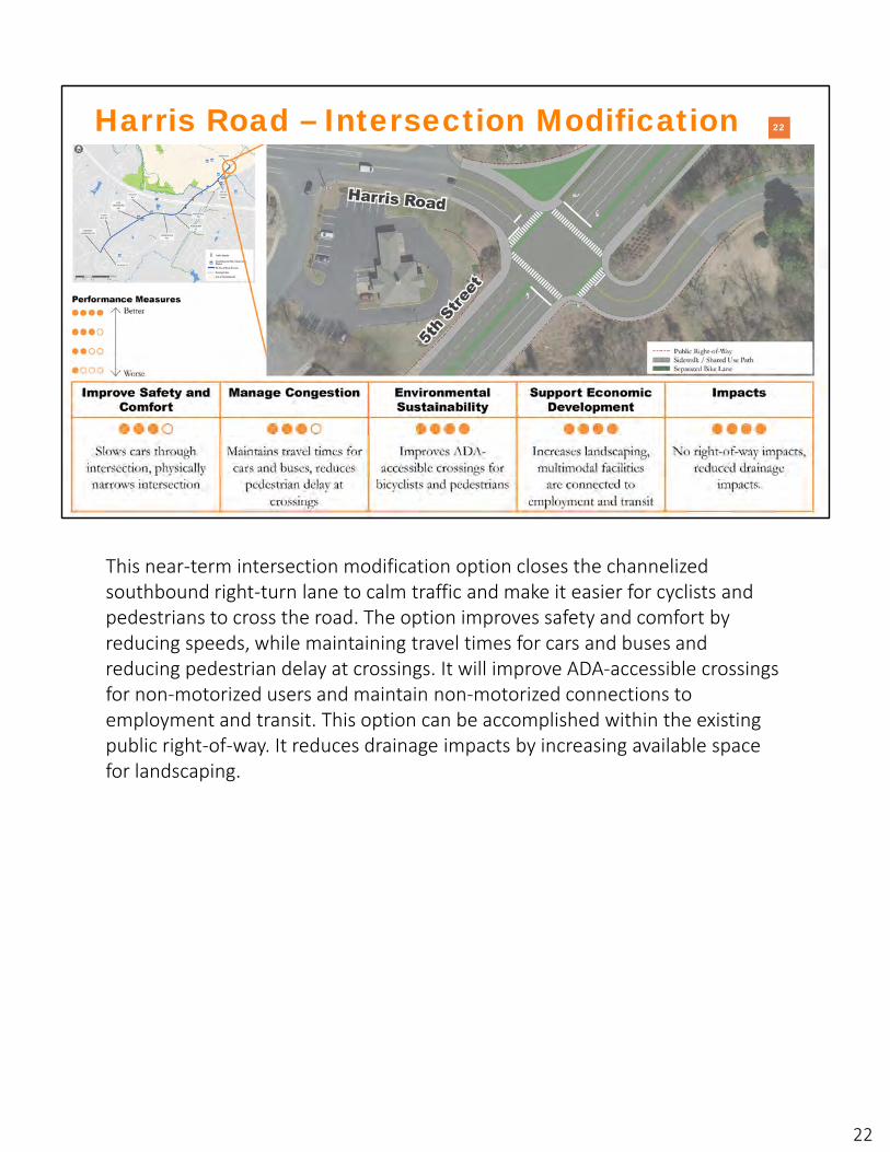
This near‐term intersection modification option closes the channelized southbound right‐turn lane to calm traffic and make it easier for cyclists and pedestrians to cross the road. The option improves safety and comfort by reducing speeds, while maintaining travel times for cars and buses and reducing pedestrian delay at crossings. It will improve ADA‐accessible crossings for non‐motorized users and maintain non‐motorized connections to employment and transit. This option can be accomplished within the existing public right‐of‐way. It reduces drainage impacts by increasing available space for landscaping.
22

23
��
INTRO WHY 5TH STREET? 5TH STREET TODAYTRANSPORTATION OPTIONS
FOR 5TH STREETNEXT STEPS
5th Street Station Parkway – No Change
If no changes are made to the signalized intersection of 5th Street and 5th Street Station Parkway, the intersection will continue to experience safety and congestion challenges related to turning vehicles and long queues. Pedestrians will continue to experience delay at crossings.
23
24
��
INTRO WHY 5TH STREET? 5TH STREET TODAYTRANSPORTATION OPTIONS
FOR 5TH STREETNEXT STEPS
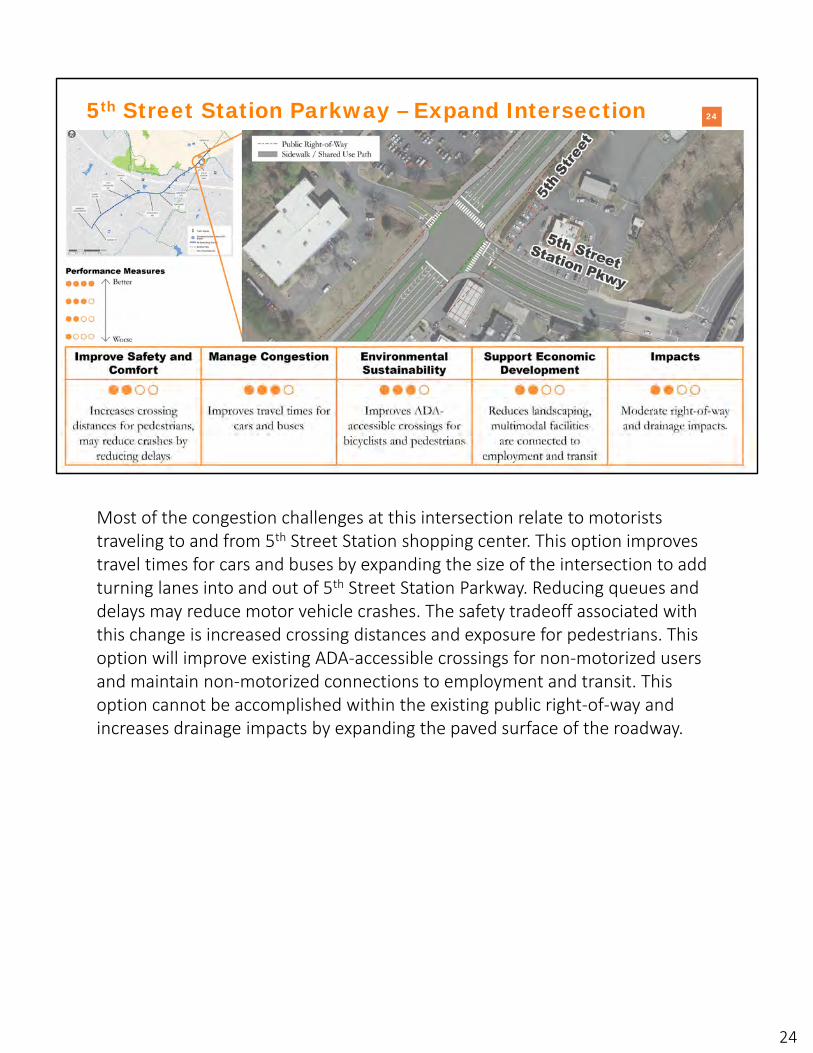
5th Street Station Parkway – Expand Intersection
Most of the congestion challenges at this intersection relate to motorists traveling to and from 5th Street Station shopping center. This option improves travel times for cars and buses by expanding the size of the intersection to add turning lanes into and out of 5th Street Station Parkway. Reducing queues and delays may reduce motor vehicle crashes. The safety tradeoff associated with this change is increased crossing distances and exposure for pedestrians. This option will improve existing ADA‐accessible crossings for non‐motorized users and maintain non‐motorized connections to employment and transit. This option cannot be accomplished within the existing public right‐of‐way and increases drainage impacts by expanding the paved surface of the roadway.
24

25
�
INTRO WHY 5TH STREET? 5TH STREET TODAYTRANSPORTATION OPTIONS
FOR 5TH STREETNEXT STEPS
5th Street Station Parkway – Left-Turn RestrictionsNorthbound vehicles exit Shopping Center at
Harris Road
This option improves travel times for cars and buses by restricting left‐turn access into and out of Willoughby Square Shopping Center from 5th Street and 5th Street Station Parkway. Motorists who want to access Willoughby Square Shopping Center from the south can do so through a new median opening north of 5th Street Station Parkway. Motorists who wish to exist Willoughby Square Shopping Center and travel north on 5th Street can do so via the Harris Road intersection. This option improves travel times for cars and buses. It reduces vehicle conflict points and may further reduce crashes by reducing delays. This option will improve existing ADA‐accessible crossings for non‐motorized users and maintain non‐motorized connections to employment and transit. This option can be accomplished within the existing public right‐of‐way, and slightly increases drainage impacts by opening the median north of 5th
Street Station Parkway.
25

26
��
INTRO WHY 5TH STREET? 5TH STREET TODAYTRANSPORTATION OPTIONS
FOR 5TH STREETNEXT STEPS
Along 5th Street - North of I-64
Today, sidewalks and bike lanes end south of 5th Street Station Parkway. The incomplete bicycle and pedestrian network is disconnected from trails, employment, and transit, discouraging bicycle and pedestrian use. Existing sidewalk and bike lanes do not include a buffer separating non‐motorized users and motorists, further reducing comfort for non‐motorized users.
The following options would implement continuous, consistent walking and biking facilities on 5th Street.
26
27
��
INTRO WHY 5TH STREET? 5TH STREET TODAYTRANSPORTATION OPTIONS
FOR 5TH STREETNEXT STEPS
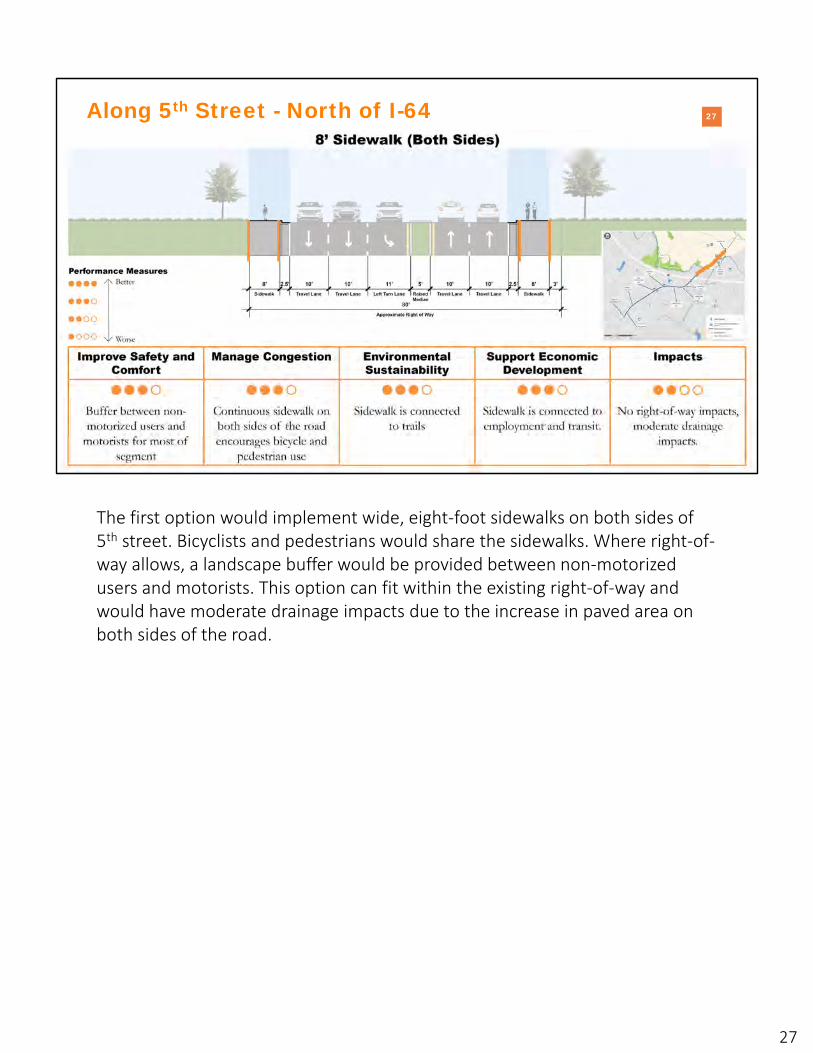
Along 5th Street - North of I-64
The first option would implement wide, eight‐foot sidewalks on both sides of 5th street. Bicyclists and pedestrians would share the sidewalks. Where right‐of‐way allows, a landscape buffer would be provided between non‐motorized users and motorists. This option can fit within the existing right‐of‐way and would have moderate drainage impacts due to the increase in paved area on both sides of the road.
27

28
��
INTRO WHY 5TH STREET? 5TH STREET TODAYTRANSPORTATION OPTIONS
FOR 5TH STREETNEXT STEPS
Along 5th Street - North of I-64
The second option would implement a multi‐use path on one side of 5th Street. Bicyclists and pedestrians would share the path. Where right‐of‐way allows, a landscape buffer would be provided between non‐motorized users and motorists. This option can fit within the existing right‐of‐way and would have some drainage impacts due to the increase in paved area on one side of the road.
28

29
��
INTRO WHY 5TH STREET? 5TH STREET TODAYTRANSPORTATION OPTIONS
FOR 5TH STREETNEXT STEPS
Along 5th Street - North of I-64
The third option would implement a six‐foot sidewalk and six‐foot buffered bike lane on both sides of 5th Street. This is the only option that fully separates bicyclists, pedestrians, and motorists. Where right‐of‐way allows, a landscape buffer would be provided between non‐motorized users and motorists. This option can only fit within the existing right‐of‐way south of 5th Street Station Parkway and would need to transition to eight‐foot sidewalks or a multi‐use path between 5th Street Station Parkway and Harris Road. It would have substantial drainage impacts due to the increase in paved area on both sides of the road.
29

30
��
INTRO WHY 5TH STREET? 5TH STREET TODAYTRANSPORTATION OPTIONS
FOR 5TH STREETNEXT STEPS
Along 5th Street -North of I-64
The fourth option would implement a six‐foot sidewalk on one side of 5th Street and a multi‐use path on the other side of 5th Street. Bicyclists and pedestrians would share the sidewalk and path. Where right‐of‐way allows, a landscape buffer would be provided between non‐motorized users and motorists. This option can only fit within the existing right‐of‐way south of 5th Street Station Parkway and would need to transition to eight‐foot sidewalks or a shared use path between 5th Street Station Parkway and Harris Road. It would have substantial drainage impacts due to the increase in paved area on both sides of the road.
30

31
�
INTRO WHY 5TH STREET? 5TH STREET TODAYTRANSPORTATION OPTIONS
FOR 5TH STREETNEXT STEPS
I-64 Interchange –Issues and Opportunities
Safety Issue
Congestion Issue
“The single biggest improvement needed is crossing I-64” – Survey 1
“Vehicles running red lights, especially at the 64 eastbound traffic light. Numerous accidents there, including our family” – Survey 1
5th Street at the I‐64 interchange experiences safety challenges at both signalized ramp intersections related to turning vehicles and long vehicle queues. It also experiences congestion challenges at the 5th Street and the I‐64 eastbound ramp. A narrow concrete walkway on the bridge is the only non‐motorized accommodation, so bicyclists and pedestrians have trouble safely and comfortably crossing over I‐64.
31
32
��
INTRO WHY 5TH STREET? 5TH STREET TODAYTRANSPORTATION OPTIONS
FOR 5TH STREETNEXT STEPS
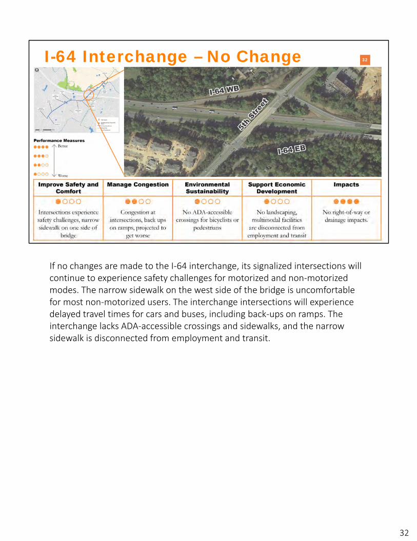
I-64 Interchange – No Change
If no changes are made to the I‐64 interchange, its signalized intersections will continue to experience safety challenges for motorized and non‐motorized modes. The narrow sidewalk on the west side of the bridge is uncomfortable for most non‐motorized users. The interchange intersections will experience delayed travel times for cars and buses, including back‐ups on ramps. The interchange lacks ADA‐accessible crossings and sidewalks, and the narrow sidewalk is disconnected from employment and transit.
32

33
��
INTRO WHY 5TH STREET? 5TH STREET TODAYTRANSPORTATION OPTIONS
FOR 5TH STREETNEXT STEPS
I-64 Interchange – Near Term
This near‐term option focuses on adding crosswalks at intersections and wider sidewalks on both sides of the bridge to improve non‐motorized safety and comfort. If paired with bicycle and pedestrian facilities north and south of I‐64, this option would increase multimodal connections to employment and transit.
This option would not change travel times for cars and buses.
33

34
��
INTRO WHY 5TH STREET? 5TH STREET TODAYTRANSPORTATION OPTIONS
FOR 5TH STREETNEXT STEPS
I-64 Interchange – Long Term
This long‐term option would convert the I‐64 interchange into a diverging diamond interchange (DDI). A DDI is a grade‐separated interchange design where the major road, 5th Street, crosses to the other side of the roadway between freeway ramps. This design reduces vehicle conflict points and separates vehicle travel from bicycle and pedestrian travel to improve safety and comfort. The DDI would improve travel times for cars and buses, add ADA‐accessible crossings for bicyclists and pedestrians, and increase multimodal connections to employment and transit. This option would have substantial right‐of‐way and drainage impacts. The example shown on this slide is the DDI at Zions Crossroads.
Visit VDOT’s Innovative Intersections Website for more information on DDIs: https://www.virginiadot.org/info/innovative_intersections_and_interchanges/ddi.asp
34
35
�
INTRO WHY 5TH STREET? 5TH STREET TODAYTRANSPORTATION OPTIONS
FOR 5TH STREETNEXT STEPS
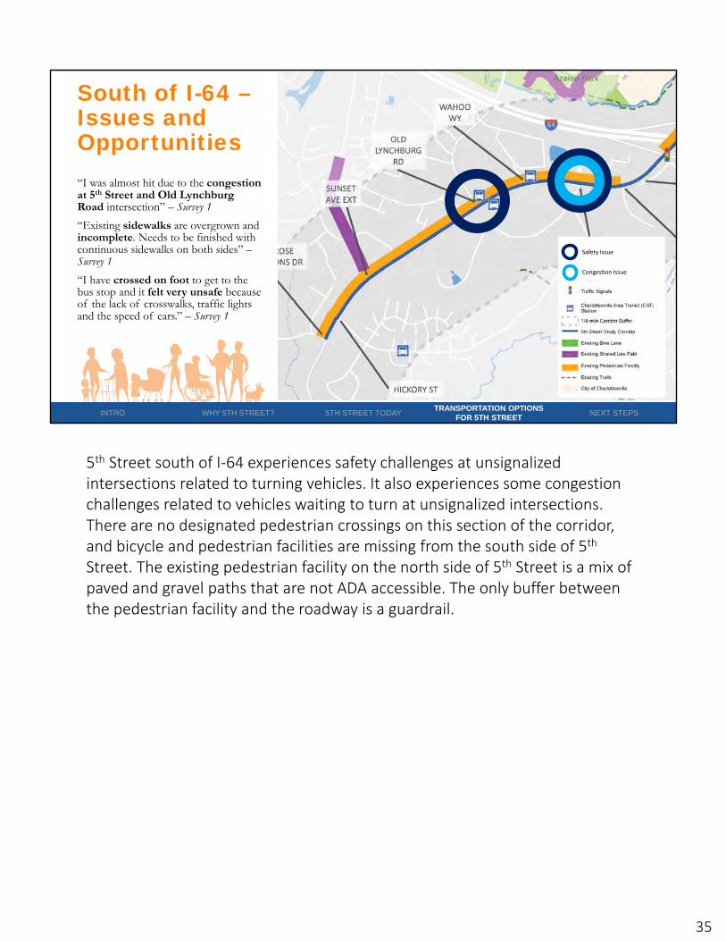
South of I-64 –Issues and Opportunities
Safety Issue
Congestion Issue
“I was almost hit due to the congestion at 5th Street and Old Lynchburg Road intersection” – Survey 1
“Existing sidewalks are overgrown and incomplete. Needs to be finished with continuous sidewalks on both sides” –Survey 1
“I have crossed on foot to get to the bus stop and it felt very unsafe because of the lack of crosswalks, traffic lights and the speed of cars.” – Survey 1
5th Street south of I‐64 experiences safety challenges at unsignalized intersections related to turning vehicles. It also experiences some congestion challenges related to vehicles waiting to turn at unsignalized intersections. There are no designated pedestrian crossings on this section of the corridor, and bicycle and pedestrian facilities are missing from the south side of 5th
Street. The existing pedestrian facility on the north side of 5th Street is a mix of paved and gravel paths that are not ADA accessible. The only buffer between the pedestrian facility and the roadway is a guardrail.
35

36
��
INTRO WHY 5TH STREET? 5TH STREET TODAYTRANSPORTATION OPTIONS
FOR 5TH STREETNEXT STEPS
Stagecoach Road – No Change
If no changes are made to the unsignalized intersection of 5th Street and Stagecoach Road, the intersection will continue to experience safety and congestion challenges related to turning vehicles. Pedestrians will not have designated, ADA‐accessible crossings, and multimodal facilities will remain disconnected from employment and transit opportunities.
36

37
��
INTRO WHY 5TH STREET? 5TH STREET TODAYTRANSPORTATION OPTIONS
FOR 5TH STREETNEXT STEPS
Stagecoach Road – Roundabout
This option replaces the unsignalized intersection with a roundabout. Roundabouts improve safety by calming traffic, reducing vehicle conflict points, and adding ADA‐accessible pedestrian crossing opportunities. This option would also slightly improve travel times for cars and buses and connect multimodal facilities to employment and transit opportunities. The roundabout would have no right‐of‐way impacts and reduced drainage impacts by increasing available space for landscaping.
Visit VDOT’s Innovative Intersections Website for more information on roundabouts: https://www.virginiadot.org/info/innovative_intersections_and_interchanges/roundabout.asp
37

38
��
INTRO WHY 5TH STREET? 5TH STREET TODAYTRANSPORTATION OPTIONS
FOR 5TH STREETNEXT STEPS
Stagecoach Road – Restricted Crossing U-Turn
This option replaces the unsignalized intersection with an unsignalized Restricted Crossing U‐Turn (RCUT). RCUTs are intersection designs where all side street movements begin with a right turn. Side street left‐turn and through vehicles turn right and make a U‐turn at a dedicated downstream median opening to complete the desired movement. This option would improve safety by reducing vehicle conflict points and adding ADA‐accessible pedestrian crossing opportunities. This option would also slightly improve travel times for cars and buses on 5th Street, while slightly increasing travel times for cars and buses turning left onto 5th Street from Stagecoach Road/Afton Pond Court. It would connect multimodal facilities to employment and transit opportunities. The RCUT would have minor right‐of‐way and drainage impacts by opening the median west of Stagecoach Road.
Visit VDOT’s Innovative Intersections Website for more information on Restricted Crossing U‐Turns: https://www.virginiadot.org/info/innovative_intersections_and_interchanges/rcut.asp
38
39
��
INTRO WHY 5TH STREET? 5TH STREET TODAYTRANSPORTATION OPTIONS
FOR 5TH STREETNEXT STEPS
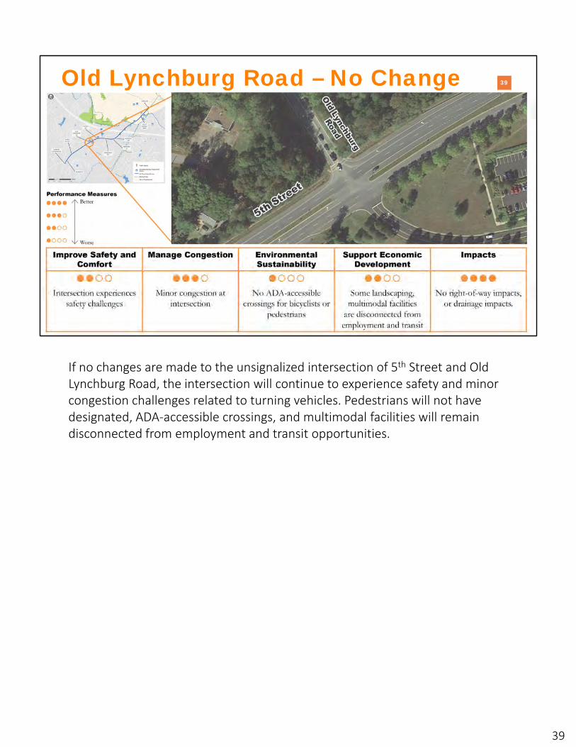
Old Lynchburg Road – No Change
If no changes are made to the unsignalized intersection of 5th Street and Old Lynchburg Road, the intersection will continue to experience safety and minor congestion challenges related to turning vehicles. Pedestrians will not have designated, ADA‐accessible crossings, and multimodal facilities will remain disconnected from employment and transit opportunities.
39
40
��
INTRO WHY 5TH STREET? 5TH STREET TODAYTRANSPORTATION OPTIONS
FOR 5TH STREETNEXT STEPS
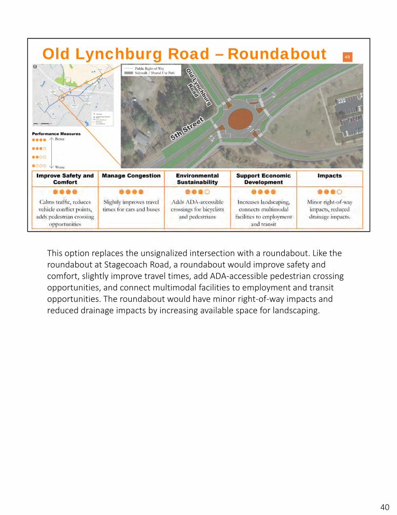
Old Lynchburg Road – Roundabout
This option replaces the unsignalized intersection with a roundabout. Like the roundabout at Stagecoach Road, a roundabout would improve safety and comfort, slightly improve travel times, add ADA‐accessible pedestrian crossing opportunities, and connect multimodal facilities to employment and transit opportunities. The roundabout would have minor right‐of‐way impacts and reduced drainage impacts by increasing available space for landscaping.
40
41
�
INTRO WHY 5TH STREET? 5TH STREET TODAYTRANSPORTATION OPTIONS
FOR 5TH STREETNEXT STEPS
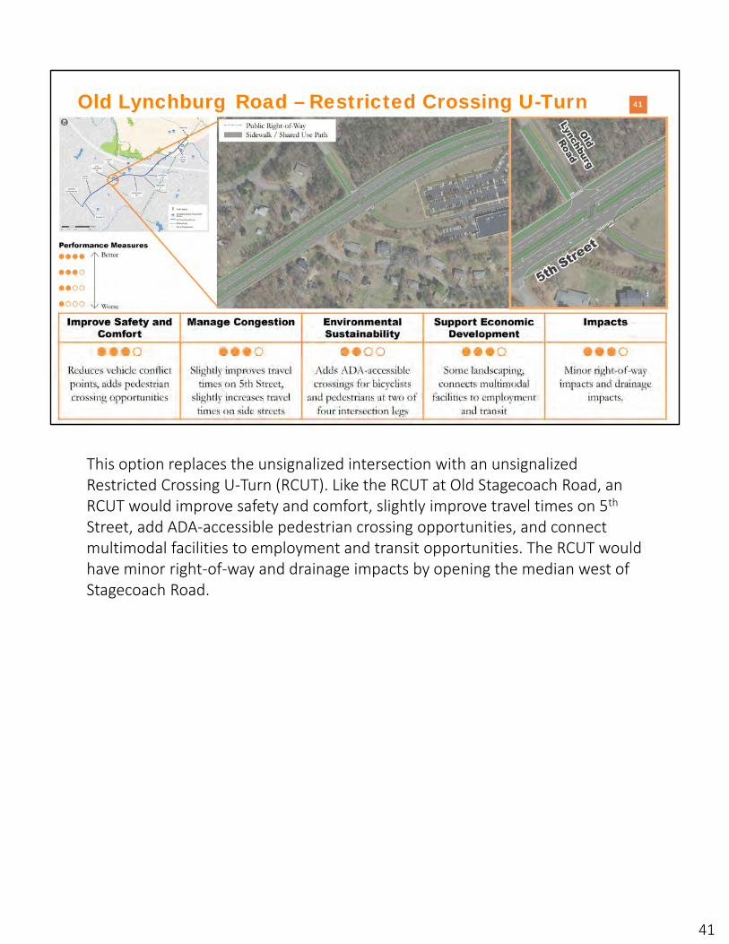
Old Lynchburg Road – Restricted Crossing U-Turn
This option replaces the unsignalized intersection with an unsignalized Restricted Crossing U‐Turn (RCUT). Like the RCUT at Old Stagecoach Road, an RCUT would improve safety and comfort, slightly improve travel times on 5th
Street, add ADA‐accessible pedestrian crossing opportunities, and connect multimodal facilities to employment and transit opportunities. The RCUT would have minor right‐of‐way and drainage impacts by opening the median west of Stagecoach Road.
41

42
��
INTRO WHY 5TH STREET? 5TH STREET TODAYTRANSPORTATION OPTIONS
FOR 5TH STREETNEXT STEPS
Along 5th Street – South of I-64
Today, 5th street south of I‐64 has a mix of paved and gravel paths on one side of the street. The incomplete bicycle and pedestrian network is disconnected from trails, employment, and transit, discouraging bicycle and pedestrian use. The existing pedestrian network does not include a buffer separating non‐motorized users and motorists, further reducing comfort for non‐motorized users.
42
43
��
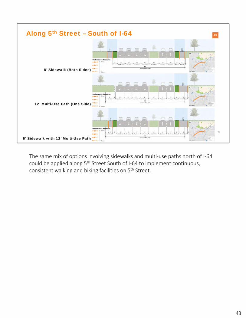
Along 5th Street – South of I-64
8’ Sidewalk (Both Sides)
12’ Multi-Use Path (One Side)
6’ Sidewalk with 12’ Multi-Use Path
The same mix of options involving sidewalks and multi‐use paths north of I‐64 could be applied along 5th Street South of I‐64 to implement continuous, consistent walking and biking facilities on 5th Street.
43
44
What are the next steps?
The following slides outline next steps for you, the project team, and the 5th
Street corridor.
44

45
�
Share your input
INTRO WHY 5TH STREET? 5TH STREET TODAYTRANSPORTATION OPTIONS
FOR 5TH STREETNEXT STEPS
• Alternatives Survey: https://vdot5thstreetstudy.metroquest.com
• Study Website: https://www.virginiadot.org/projects/culpeper/5th-st-corridor-study.asp
Now that you have had a chance to learn about the different transportation alternatives for 5th Street, please share your input via the alternatives survey! The survey, which can be accessed at https://vdot5thstreetstudy.metroquest.com, will be open until June 26, 2020. You will be able to weigh in on all of the alternatives shared today.
Once you take the survey, please share it widely with your fellow community members so that they can share their input.
Finally, if you are interested in seeing the results of the survey and next steps, please keep an eye on the study website. The study team will update it with the results of the survey and the final report and recommendations.
45

46Project Schedule1 – Evaluate Existing Traffic,
Safety, and Development
2 – Develop Goals and Objectives
3 – Develop Alternatives
4 – Evaluate Alternatives
5 – Revise Alternatives
2019 2020Winter Spring Summer
Stakeholder Group Meeting
Public Engagement
Community Engagement – Web Site
INTRO WHY 5TH STREET? 5TH STREET TODAYTRANSPORTATION OPTIONS
FOR 5TH STREETNEXT STEPS
The 5th Street Corridor Study kicked off by evaluating existing traffic, safety, and development in Winter 2019. Refined transportation alternatives and planning‐level cost estimates will be completed by the end of Summer 2020.
46

47
1. Secure funding for project(s)• Available VDOT funds• SMART SCALE program
2. Alternative refinement• Design• Environmental analysis• Community engagement
3. Construction (timeline varies)
After the 5th Street Study
��
INTRO WHY 5TH STREET? 5TH STREET TODAYTRANSPORTATION OPTIONS
FOR 5TH STREETNEXT STEPS
SMART SCALE Biennial Cycle
The next step after the completion of this study is to secure funding for the recommended project(s). After funding is secured, VDOT will take the concepts developed through this study and further refine alternatives, determine the environmental impacts of the alternatives, and engage the community to get more feedback on the alternatives. The refined and funded alternatives will then move to construction. Each of the projects identified through this study will have a different timeline for construction, which will depend on the priority given to project by the local governments, cost of the project, the amount of land needed for the project, and the environmental impacts.
47

48
Question & Answer
��
VDOT 5th Street Corridor Study Alternatives Public Meeting
+X (XXX) XXX‐XXXXXXX‐XXX‐XXX
Patty Hurd
We will now conduct our thirty minute question and answer session. To ask questions at any time during the Question and Answer session, please post them in the “Questions Box” in your GoToWebinar window. We will post a record of key questions and responses to the study website after today’s meeting in the form of an updated FAQs document.
48
49
Chuck ProctorDistrict Planning ManagerVDOT Culpeper [email protected]
Fo r m o r e i n fo r m a t i o n
Contact
Thank you!S tu d y Web s i te
https://www.virginiadot.org/projects/culpeper/5th-st-corridor-study.asp
S tu d y S u r ve y
https://vdot5thstreetstudy.metroquest.com
Thank you for participating in this Alternatives Public Meeting for the 5th Street Corridor Study! Please remember to take the study survey and stay in touch through the study website:
• Survey: https://www.virginiadot.org/projects/culpeper/5th‐st‐corridor‐study.asp
• Website: https://vdot5thstreetstudy.metroquest.com
49