Embed Size (px)
Citation preview

Title Author/Publisher Date Scale Catalogued Map Case Drawer Folder Condition Series or I.D.# Notes
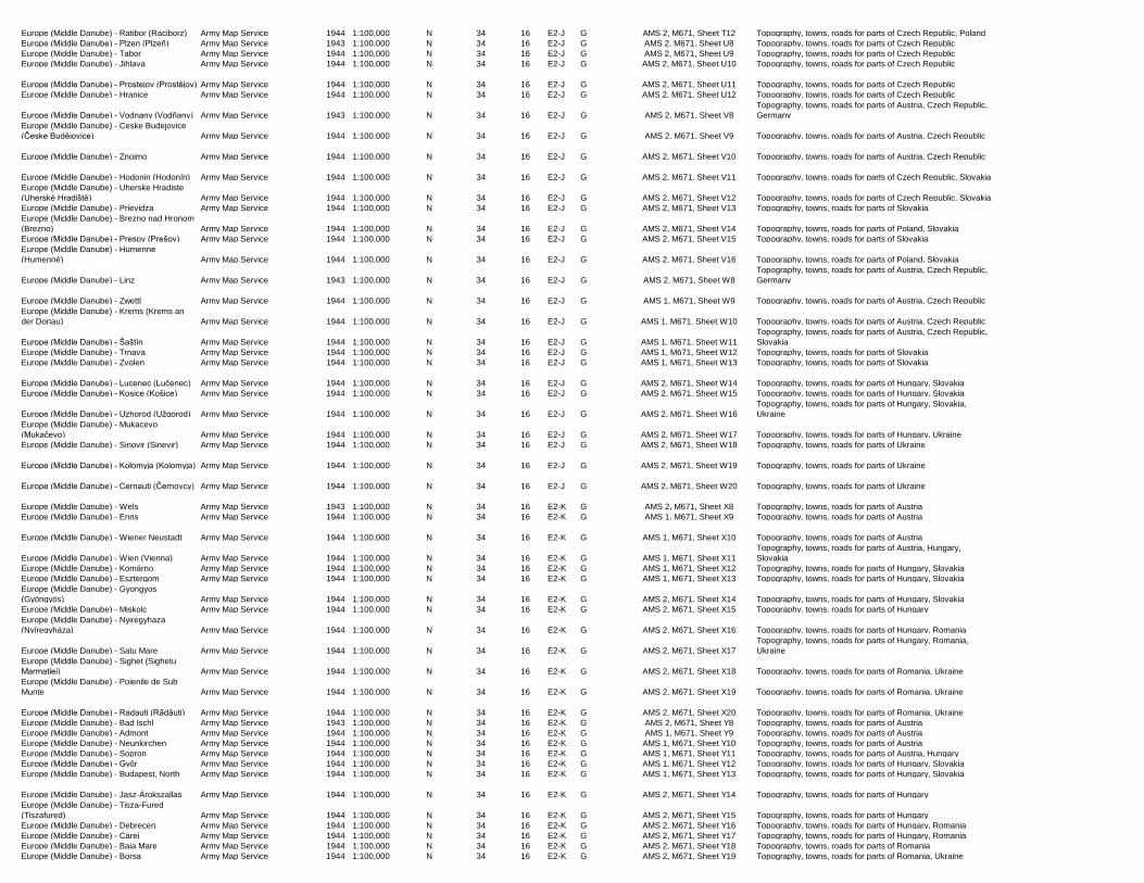
East Asia - Japan, Korea, Northeast China U.S. Geological Survey 2000 1:2,500,000 N 34 15 E1-A G E. Asia Geog. Series, Sheet 1 Topography, towns for Japan, Korea, Northeast China
East Asia - Southeast China U.S. Geological Survey 2000 1:2,500,000 N 34 15 E1-A G E. Asia Geog. Series, Sheet 2 Topography, towns for Southeast China, Taiwan
East Asia - Southeast Asia U.S. Geological Survey 2000 1:2,500,000 N 34 15 E1-A G E. Asia Geog. Series, Sheet 3
Topography, towns for Burma (Myanmar), Cambodia, southern
China, Laos, Thailand, Vietnam
East Asia - Philippines U.S. Geological Survey 2000 1:2,500,000 N 34 15 E1-A G E. Asia Geog. Series, Sheet 4
Topography, towns for Philippines, part of Malaysia, part of
Vietnam
East Asia - Papua New Guinea and Solomon
Islands U.S. Geological Survey 2000 1:2,500,000 N 34 15 E1-A G E. Asia Geog. Series, Sheet 7 Topography, towns for Papua New Guinea, Solomon Islands
East Asia - Western Pacific Islands U.S. Geological Survey 2000 1:2,500,000 N 34 15 E1-A G E. Asia Geog. Series, Sheet 8
Topography, towns for Guam, Mariana Islands, Palau, part of
Micronesia
East Asia & North Pacific - Central China Army Map Service 1955 1:4,350,000 N 34 15 E1-B G AMS 3, 1201, Sheet 1
Topography, towns, railroads for parts of China, Mongolia,
Russia
East Asia & North Pacific - Japan Army Map Service 1955 1:4,350,000 N 34 15 E1-B G AMS 3, 1201, Sheet 2
Topography, towns, railroads for Japan, North Korea, South
Korea, part of Russia
East Asia & North Pacific - Chishima - Retto Army Map Service 1955 1:4,350,000 N 34 15 E1-B G AMS 3, 1201, Sheet 3 Topography, towns for parts of Russia, Alaska (Aleutian Islands)
East Asia & North Pacific - Aleutian Islands Army Map Service 1945 1:4,350,000 N 34 15 E1-B G AMS 2, 1201, Sheet 4
Topography, towns for parts of Alaska (Aleutian Islands),
Midway Island
East Asia & North Pacific - San Francisco Army Map Service 1944 1:4,350,000 N 34 15 E1-B G AMS 2, 1201, Sheet 5
Topography, towns, railroads for parts of Pacific coast of
Canada, U.S.
East Asia & North Pacific - South China Sea Army Map Service 1955 1:4,350,000 N 34 15 E1-B G AMS 3, 1201, Sheet 6
Topography, towns, railroads for parts of China, Southeast Asia,
Indonesia
East Asia & North Pacific - Philippines Army Map Service 1955 1:4,350,000 N 34 15 E1-B G AMS 3, 1201, Sheet 7
Topography, towns, railroads for Papua New Guinea,
Philippines, parts of Indonesia
East Asia & North Pacific - Marshall Islands Army Map Service 1955 1:4,350,000 N 34 15 E1-B G AMS 3, 1201, Sheet 8
Topography, towns for Marshall Islands, Solomon Islands,
southwestern Pacific region
East Asia & North Pacific - Hawaiian Islands Army Map Service 1945 1:4,350,000 N 34 15 E1-B G AMS 2, 1201, Sheet 9
Topography, towns for Hawaiian Islands, Tokelau, south central
Pacific region
East Asia & North Pacific - Marquesas Islands Army Map Service 1945 1:4,350,000 N 34 15 E1-B G AMS 2, 1201, Sheet 10 Topography, towns for Marquesas Islands, south Pacific region
East Indies - Medan Army Map Service 1941 1:1,000,000 N 34 15 E1-C G AMS 2, 9306, Sheet NA-47
Topography, towns, roads, political boundaries, aeronautical
data for parts of Indonesia, Malaysia
East Indies - Singapore Army Map Service 1942 1:1,000,000 N 34 15 E1-C G AMS 3, 9306, Sheet NA-48
Topography, towns, roads, political boundaries, aeronautical
data for parts of Indonesia, Malaysia, Singapore
East Indies - Sarawak Army Map Service 1942 1:1,000,000 N 34 15 E1-C G AMS 2, 9306, Sheet NA-49
Topography, towns, roads, political boundaries, aeronautical
data for parts of Indonesia, Malaysia
East Indies - Oost (East) Borneo Army Map Service 1944 1:1,000,000 N 34 15 E1-C G AMS 3, 9306, Sheet NA-50
Topography, towns, roads, political boundaries, aeronautical
data for parts of Indonesia, Malaysia
East Indies - Manado Army Map Service 1944 1:1,000,000 N 34 15 E1-C G AMS 3, 9306, Sheet NA-51
Topography, towns, roads, political boundaries, aeronautical
data for parts of Indonesia
East Indies - Ternate Army Map Service 1944 1:1,000,000 N 34 15 E1-C G AMS 3, 9306, Sheet NA-52
Topography, towns, roads, political boundaries, aeronautical
data for parts of Indonesia
East Indies - Padang Army Map Service 1942 1:1,000,000 N 34 15 E1-C G AMS 2, 9306, Sheet SA-47
Topography, towns, roads, political boundaries, aeronautical
data for parts of Indonesia
East Indies - Palembang Army Map Service 1942 1:1,000,000 N 34 15 E1-C G AMS 2, 9306, Sheet SA-48
Topography, towns, roads, political boundaries, aeronautical
data for parts of Indonesia
East Indies - Pontianak Army Map Service 1944 1:1,000,000 N 34 15 E1-C G AMS 2, 9306, Sheet SA-49
Topography, towns, roads, political boundaries, aeronautical
data for parts of Indonesia
East Indies - Bandjermasin (Banjarmasin) Army Map Service 1944 1:1,000,000 N 34 15 E1-C G AMS 3, 9306, Sheet SA-50
Topography, towns, roads, political boundaries, aeronautical
data for parts of Indonesia
East Indies - Midden (Middle) Celebes Army Map Service 1944 1:1,000,000 N 34 15 E1-C G AMS 3, 9306, Sheet SA-51
Topography, towns, roads, political boundaries, aeronautical
data for parts of Indonesia
East Indies - Ceram (Seram) Army Map Service 1944 1:1,000,000 N 34 15 E1-C G AMS 2, 9306, Sheet SA-52
Topography, towns, roads, political boundaries, aeronautical
data for parts of Indonesia
East Indies - Geelvink Baai (Cenderawasih
Bay) Army Map Service 1944 1:1,000,000 N 34 15 E1-C G AMS 3, 9306, Sheet SA-53
Topography, towns, roads, political boundaries, aeronautical
data for parts of Indonesia
East Indies - Aitape Army Map Service 1943 1:1,000,000 N 34 15 E1-C G AMS 1, 9306, Sheet SA-54
Topography, towns, roads, political boundaries, aeronautical
data for parts of Indonesia, Papua New Guinea
East Indies - Admiralty Islands Army Map Service 1943 1:1,000,000 N 34 15 E1-C G AMS 1, 9306, Sheet SA-55
Topography, towns, roads, political boundaries, aeronautical
data for parts of Indonesia, Papua New Guinea
East Indies - Batavia (Jakarta) Army Map Service 1942 1:1,000,000 N 34 15 E1-C G AMS 2, 9306, Sheet SB-48
Topography, towns, roads, political boundaries, aeronautical
data for parts of Indonesia
East Indies - Soerabaja (Surabaya) Army Map Service 1944 1:1,000,000 N 34 15 E1-C G AMS 3, 9306, Sheet SB-49
Topography, towns, roads, political boundaries, aeronautical
data for parts of Indonesia
East Indies - Makassar (Ujungpandang) Army Map Service 1944 1:1,000,000 N 34 15 E1-C G AMS 3, 9306, Sheet SB-50
Topography, towns, roads, political boundaries, aeronautical
data for parts of Indonesia
East Indies - Boetueng (Baubau) Army Map Service 1944 1:1,000,000 N 34 15 E1-C G AMS 3, 9306, Sheet SB-51
Topography, towns, roads, political boundaries, aeronautical
data for parts of Indonesia
East Indies - Banda Army Map Service 1944 1:1,000,000 N 34 15 E1-C G AMS 2, 9306, Sheet SB-52
Topography, towns, roads, political boundaries, aeronautical
data for parts of Indonesia
East Indies - Aroe Eilanden (Aru Island) Army Map Service 1944 1:1,000,000 N 34 15 E1-C G AMS 3, 9306, Sheet SB-53
Topography, towns, roads, political boundaries, aeronautical
data for parts of Indonesia

East Indies - Ambunti Army Map Service 1943 1:1,000,000 N 34 15 E1-C G AMS 2, 9306, Sheet SB-54
Topography, towns, roads, political boundaries, aeronautical
data for parts of Indonesia, Papua New Guinea
East Indies - Madang Army Map Service 1943 1:1,000,000 N 34 15 E1-C G AMS 1, 9306, Sheet SB-55
Topography, towns, roads, political boundaries, aeronautical
data for parts of Papua New Guinea
East Indies - Blitar Army Map Service 1944 1:1,000,000 N 34 15 E1-C G AMS 3, 9306, Sheet SC-49
Topography, towns, roads, political boundaries, aeronautical
data for parts of Indonesia
East Indies - Singaradja (Singaraja) Army Map Service 1944 1:1,000,000 N 34 15 E1-C G AMS 3, 9306, Sheet SC-50
Topography, towns, roads, political boundaries, aeronautical
data for parts of Indonesia
East Indies - Koepang (Kupang) Army Map Service 1944 1:1,000,000 N 34 15 E1-C G AMS 3, 9306, Sheet SC-51
Topography, towns, roads, political boundaries, aeronautical
data for parts of East Timor, Indonesia
East Indies - Timor Sea Army Map Service 1944 1:1,000,000 N 34 15 E1-C G AMS 2, 9306, Sheet SC-52
Topography, towns, roads, political boundaries, aeronautical
data for parts of East Timor, Indonesia
East Indies - Daru Army Map Service 1943 1:1,000,000 N 34 15 E1-C G AMS 1, 9306, Sheet SC-54
Topography, towns, roads, political boundaries, aeronautical
data for parts of Australia, Papua New Guinea
East Indies - Port Moresby Army Map Service 1943 1:1,000,000 N 34 15 E1-C G AMS 1, 9306, Sheet SC-55
Topography, towns, roads, political boundaries, aeronautical
data for parts of Papua New Guinea
Ecuador - Map of Ecuador Geographic Military Institute 1974 1:1,000,000 N 34 15 E1-D G One sheet
Topography, towns, roads, political boundaries for nation of
Ecuador
Ecuador - Ecuador Mapa Vial-Turistico (Road-
Tourist Map) Geographic Military Institute 1986 1:1,000,000 N 34 15 E1-D G One sheet
Towns, roads, political boundaries, points of interest for
Ecuador. Incl. inset of Galapagos Islands. Visitor information on
reverse
Ecuador - Guia General del Ecuador (General
Guide of Ecuador) Publicistas Sudamericanos 1959 1:1,000,000 N 34 15 E1-D G One sheet
Towns, roads, political boundaries for western Ecuador. Incl.
insets of Quito, Guayaquil, eight smaller towns
Ecuador - Mapa Vial del Ecuador (Road Map) Anglo 1969 1:1,500,000 N 34 15 E1-D G One sheet
Topography, towns, roads for Ecuador. Incl. insets of downtown
Quito and Guayaquil, visitor information on reverse
Ecuador - City Map - Plano Guia de Quito (Plan
of Quito) Geographic Military Institute 1977 1:15,000 N 34 15 E1-D G Booklet
Topography, streets, major buildings, points of interest. Incl.
insets of Quito area political boundaries, neighborhoods
Egypt - Alexandria (Al-Iskandarīyah) (city map) -
Agami Fort Egypt Survey Department 1916 1:5,000 N 34 15 E1-E G one sheet Streets, major buildings for part of Alexandria
Egypt - Alexandria (Al-Iskandarīyah) (city map) -
Dekheila Egypt Survey Department 1916 1:5,000 N 34 15 E1-E G one sheet Streets, major buildings for part of Alexandria
Egypt - Alexandria (Al-Iskandarīyah) (city map) -
Mex Egypt Survey Department 1910 1:5,000 N 34 15 E1-E G Sheet I-II
Streets, major buildings for part of Alexandria. Incl. index of the
Alexandria map series on reverse
Egypt - Alexandria (Al-Iskandarīyah) (city map) -
Wardian Egypt Survey Department 1910 1:5,000 N 34 15 E1-E G Sheet II-II
Streets, major buildings for part of Alexandria. Incl. index of the
Alexandria map series on reverse
Egypt - Alexandria (Al-Iskandarīyah) (city map) -
Gabbâri Egypt Survey Department 1910 1:5,000 N 34 15 E1-E G Sheet II-III
Streets, major buildings for part of Alexandria. Incl. index of the
Alexandria map series on reverse
Egypt - Alexandria (Al-Iskandarīyah) (city map) -
Gabbâri Egypt Survey Department 1910 1:5,000 N 34 15 E1-E G Sheet II-III
Streets, major buildings for part of Alexandria. Incl. index of the
Alexandria map series on reverse
Egypt - Alexandria (Al-Iskandarīyah) (city map) -
(no title) Egypt Survey Department NA 1:5,000 N 34 15 E1-E G Sheet II-IV
Small coastal area along Alexandria's Lake Maryut. Incl. index
of the Alexandria map series on reverse
Egypt - Alexandria (Al-Iskandarīyah) (city map) -
Breakwater Egypt Survey Department 1910 1:5,000 N 34 15 E1-E G Sheet III-II
Breakwater along Alexandria's Mediterranean coast. Incl. index
of the Alexandria map series on reverse
Egypt - Alexandria (Al-Iskandarīyah) (city map) -
Breakwater Egypt Survey Department 1910 1:5,000 N 34 15 E1-E G Sheet III-II
Breakwater along Alexandria's Mediterranean coast. Incl. index
of the Alexandria map series on reverse
Egypt - Alexandria (Al-Iskandarīyah) (city map) -
Western Harbour Egypt Survey Department 1910 1:5,000 N 34 15 E1-E G Sheet III-III
Streets, major buildings, port area for part of Alexandria. Incl.
index of the Alexandria map series on reverse
Egypt - Alexandria (Al-Iskandarīyah) (city map) -
Minet El Bassal Egypt Survey Department 1910 1:5,000 N 34 15 E1-E G Sheet III-IV
Streets, major buildings for part of Alexandria. Incl. index of the
Alexandria map series on reverse
Egypt - Alexandria (Al-Iskandarīyah) (city map) -
Moharrem Bey Egypt Survey Department 1910 1:5,000 N 34 15 E1-E G Sheet III-V
Streets, major buildings for part of Alexandria. Incl. index of the
Alexandria map series on reverse
Egypt - Alexandria (Al-Iskandarīyah) (city map) -
(no title) Egypt Survey Department NA 1:5,000 N 34 15 E1-E G Sheet III-VI Small coastal area along Alexandria's Lake Maryut
Egypt - Alexandria (Al-Iskandarīyah) (city map) -
Hadra Egypt Survey Department 1910 1:5,000 N 34 15 E1-E G Sheet IV-V
Streets, major buildings for part of Alexandria. Incl. index of the
Alexandria map series on reverse
Egypt - Alexandria (Al-Iskandarīyah) (city map) -
Nuzha Egypt Survey Department 1910 1:5,000 N 34 15 E1-E G Sheet IV-VI
Streets, major buildings for part of Alexandria. Incl. index of the
Alexandria map series on reverse
Egypt - Alexandria (Al-Iskandarīyah) (city map) -
(no title) Egypt Survey Department NA 1:5,000 N 34 15 E1-E G Sheet IV-VII
Small coastal area along Alexandria's Lake Maryut. Incl. index
of the Alexandria map series on reverse
Egypt - Alexandria (Al-Iskandarīyah) (city map) -
Ibrahimia Egypt Survey Department 1910 1:5,000 N 34 15 E1-E G Sheet V-V
Streets, major buildings for part of Alexandria. Incl. index of the
Alexandria map series on reverse
Egypt - Alexandria (Al-Iskandarīyah) (city map) -
Bacos Egypt Survey Department 1910 1:5,000 N 34 15 E1-E G Sheet V-VII
Streets, major buildings for part of Alexandria. Incl. index of the
Alexandria map series on reverse
Egypt - Alexandria (Al-Iskandarīyah) (city map) -
Glymenopoulo Egypt Survey Department 1910 1:5,000 N 34 15 E1-E G Sheet V-VI
Streets, major buildings for part of Alexandria. Incl. index of the
Alexandria map series on reverse
Egypt - Silwa Bahari (Salwa Bahri) Army Map Service 1942 1:100,000 N 34 15 E1-F G AMS 1, P671, Sheet 20/78 Topography, towns, roads for parts of Egypt
Egypt - El Khârga (Al-Kharijah) Army Map Service 1935 1:100,000 N 34 15 E1-F G AMS 1, P671, Sheet 28/54 Topography, towns, roads for parts of Egypt
Egypt - Isna Army Map Service 1942 1:100,000 N 34 15 E1-F G AMS 1, P671, Sheet 28/72, 28/78 Topography, towns, roads for parts of Egypt
Egypt - El Mahârīq (Al-Mahâriq) Army Map Service 1935 1:100,000 N 34 15 E1-F G AMS 1, P671, Sheet 32/54 Topography, towns, roads for parts of Egypt
Egypt - Luxor (Al-Uqşur) Army Map Service 1942 1:100,000 N 34 15 E1-F G AMS 1, P671, Sheet 32/72, 32/78 Topography, towns, roads for parts of Egypt
Egypt - Nag' Hammadi (Naj' Hannadi) Army Map Service 1941 1:100,000 N 34 15 E1-F G AMS 1, P671, Sheet 36/66, 36/72 Topography, towns, roads for parts of Egypt
Egypt - Sohâg (Sawhāj Army Map Service 1948 1:100,000 N 34 15 E1-F G AMS 1, P671, Sheet 40/66 Topography, towns, roads for parts of Egypt

Egypt - Tahta (Tahtā) Army Map Service 1941 1:100,000 N 34 15 E1-F G AMS 1, P671, Sheet 44/60, 44/66 Topography, towns, roads for parts of Egypt
Egypt - Monfalût (Monfalūt) Army Map Service 1949 1:100,000 N 34 15 E1-F G AMS 1, P671, Sheet 48/54, 48/60 Topography, towns, roads for parts of Egypt
Egypt - Asyût (Asyūt) Army Map Service 1948 1:100,000 N 34 15 E1-F G AMS 1, P671, Sheet 48/60, 48/66 Topography, towns, roads for parts of Egypt
Egypt - Dairût (Dayrūt) Army Map Service 1948 1:100,000 N 34 15 E1-F G AMS 1, P671, Sheet 52/54, 52/60 Topography, towns, roads for parts of Egypt
Egypt - El-Minja (Al-Minyā) Army Map Service 1949 1:100,000 N 34 15 E1-F G AMS 1, P671, Sheet 56/54, 56/60 Topography, towns, roads for parts of Egypt
Egypt - Samalût (Samālūt) Army Map Service 1949 1:100,000 N 34 15 E1-F G AMS 1, P671, Sheet 60/54, 60/60 Topography, towns, roads for parts of Egypt
Egypt - Maghâgha (Maghāghah) Army Map Service 1948 1:100,000 N 34 15 E1-F G AMS 1, P671, Sheet 64/54, 64/60 Topography, towns, roads for parts of Egypt
Egypt - Qusûr El-'Arab Army Map Service 1948 1:100,000 N 34 15 E1-F G AMS 1, P671, Sheet 68/48 Topography, towns, roads for parts of Egypt
Egypt - El Gharaq El Sultâni (Al-Gharaq As-
Sultānī) Army Map Service 1949 1:100,000 N 34 15 E1-F G AMS 1, P671, Sheet 68/54 Topography, towns, roads for parts of Egypt
Egypt - Beni Suêf (Banī Suwayf) Army Map Service 1949 1:100,000 N 34 15 E1-F G AMS 1, P671, Sheet 68/60 Topography, towns, roads for parts of Egypt
Egypt - El Faiyûm (Al-Fayyūm) Army Map Service 1948 1:100,000 N 34 15 E1-F G AMS 1, P671, Sheet 72/54 Topography, towns, roads for parts of Egypt
Egypt - El Wâsta (Al-Wāsitah) Army Map Service 1948 1:100,000 N 34 15 E1-F G AMS 1, P671, Sheet 72/60 Topography, towns, roads for parts of Egypt
Egypt - Gebel Qatrâni (Jabal Qatrānī) Army Map Service 1943 1:100,000 N 34 15 E1-F G AMS 1, P671, Sheet 76/54 Topography, towns, roads for parts of Egypt
Egypt - Helwân (Hulwān) Army Map Service 1948 1:100,000 N 34 15 E1-F G AMS 2, P671, Sheet 76/60 Topography, towns, roads for parts of Egypt
Egypt - Wâdi El Fârigh Army Map Service 1941 1:100,000 N 34 15 E1-F G AMS 1, P671, Sheet 80/54 Topography, towns, roads for parts of Egypt
Egypt - Cairo (Al-Qāhirah) Army Map Service 1941 1:100,000 N 34 15 E1-F G AMS 1, P671, Sheet 80/60 Topography, towns, roads for parts of Egypt
Egypt - Suez Road Army Map Service 1941 1:100,000 N 34 15 E1-F G AMS 1, P671, Sheet 80/66 Topography, towns, roads for parts of Egypt
Egypt - Suez (As-Suways) Army Map Service 1941 1:100,000 N 34 15 E1-F G AMS 1, P671, Sheet 80/72 Topography, towns, roads for parts of Egypt
Egypt - Maghra (Al-Maghrah) Army Map Service 1942 1:100,000 N 34 15 E1-F G AMS 1, P671, Sheet 84/36 Topography, towns, roads for parts of Egypt
Egypt - Qâret Somâra Army Map Service 1942 1:100,000 N 34 15 E1-F G AMS 1, P671, Sheet 84/42 Topography, towns, roads for parts of Egypt
Egypt - Wâdi El Natrun (NW portion) (Wādi an-
Natrūn) Army Map Service 1941 1:100,000 N 34 15 E1-F G AMS 1, P671, Sheet 84/48 Topography, towns, roads for parts of Egypt
Egypt - Wadi El Natrun Army Map Service 1943 1:100,000 N 34 15 E1-F G AMS 2, P671, Sheet 84/54 Topography, towns, roads for parts of Egypt
Egypt - Benha (Banhā) Army Map Service 1941 1:100,000 N 34 15 E1-F G AMS 1, P671, Sheet 84/60 Topography, towns, roads for parts of Egypt
Egypt - Zagazig (Az-Zaqāzīq) Army Map Service 1941 1:100,000 N 34 15 E1-F G AMS 1, P671, Sheet 84/66 Topography, towns, roads for parts of Egypt
Egypt - Ismailia (Al-Ismā'īlīyah) Army Map Service 1941 1:100,000 N 34 15 E1-F G AMS 1, P671, Sheet 84/72 Topography, towns, roads for parts of Egypt
Egypt - El Hammâm (Al-Hammām) Army Map Service 1942 1:100,000 N 34 15 E1-F G AMS 1, P671, Sheet 88/42 Topography, towns, roads for parts of Egypt
Egypt - El Ghayata (Al-Ghayatah) Army Map Service 1942 1:100,000 N 34 15 E1-F G AMS 1, P671, Sheet 88/48 Topography, towns, roads for parts of Egypt
Egypt - Kafr El Zaiyât (Kafr az-Zayyāt) Army Map Service 1942 1:100,000 N 34 15 E1-F G AMS 2, P671, Sheet 88/54 Topography, towns, roads for parts of Egypt
Egypt - Tanta (Tantā) Army Map Service 1941 1:100,000 N 34 15 E1-F G AMS 1, P671, Sheet 88/60 Topography, towns, roads for parts of Egypt
Egypt - Fâqûs (Fāqūs) Army Map Service 1941 1:100,000 N 34 15 E1-F G AMS 1, P671, Sheet 88/66 Topography, towns, roads for parts of Egypt
Egypt - El Qantara (Al-Qantarah) Army Map Service 1948 1:100,000 N 34 15 E1-F G AMS 2, P671, Sheet 88/72 Topography, towns, roads for parts of Egypt
Egypt - Alexandria (Al-Iskandarīyah) Army Map Service 1941 1:100,000 N 34 15 E1-F G AMS 1, P671, Sheet 92/48 Topography, towns, roads for parts of Egypt
Egypt - Damanhûr Army Map Service 1941 1:100,000 N 34 15 E1-F G AMS 1, P671, Sheet 92/54 Topography, towns, roads for parts of Egypt
Egypt - El Mansura (Al-Mansūrah) Army Map Service 1941 1:100,000 N 34 15 E1-F G AMS 1, P671, Sheet 92/60 Topography, towns, roads for parts of Egypt
Egypt - Shirbîn (Shirbīn) Army Map Service 1941 1:100,000 N 34 15 E1-F G AMS 2, P671, Sheet 92/66 Topography, towns, roads for parts of Egypt
Egypt - Port Said (Būr Sa'īd) Army Map Service 1941 1:100,000 N 34 15 E1-F G AMS 1, P671, Sheet 92/72 Topography, towns, roads for parts of Egypt
Egypt - Rosetta (Rashīd) Army Map Service 1941 1:100,000 N 34 15 E1-F G AMS 1, P671, Sheet 96/54 Topography, towns, roads for parts of Egypt
Egypt - Baltîm Army Map Service 1943 1:100,000 N 34 15 E1-F G AMS 2, P671, Sheet 96/60 Topography, towns, roads for parts of Egypt
Egypt - Damietta (Dumyāt) Army Map Service 1941 1:100,000 N 34 15 E1-F G AMS 1, P671, Sheet 96/66 Topography, towns, roads for parts of Egypt
Egypt - Aswân (Aswān) (city map) Survey of Egypt 1938 1:1,000 N 34 16 E2-A G
Egypt town series, Sheet 148-35-
9/4 Streets, major buildings. Map is in Arabic
Egypt - Port Said (Būr Sa'īd) Survey of Egypt 1925 1:5,000 N 34 16 E2-A G Egypt town series, Sheet 944/738 Suez Canal region
Egypt - Port Said (Būr Sa'īd) Survey of Egypt 1925 1:5,000 N 34 16 E2-A G Egypt town series, Sheet 944/741 Suez Canal region
Egypt - Port Said (Būr Sa'īd) Survey of Egypt 1925 1:5,000 N 34 16 E2-A G Egypt town series, Sheet 946/735 Lake Manzala (Manzilah) area
Egypt - General Map of Alexandria (Al-
Iskandarīyah) (city map) Army Map Service 1933 1:10,000 N 34 16 E2-A G AMS 1, P971, Sheet 3 Streets, major buildings
Egypt - General Map of Cairo (Al-Qāhirah) (city
map) Army Map Service 1920 1:15,000 N 34 16 E2-A G AMS 1, P971, Map No. 4 Streets, major buildings
Egypt - Suez and Port Taufîq (As-Suways and
Būr Tawfiq) (city map) Army Map Service 1942 1:15,000 N 34 16 E2-A G one sheet Streets, major buildings
Egypt - Qalyûb (Qalyūb) Survey of Egypt 1945 1:25,000 N 34 16 E2-A G Sheet 82/630 Topography, towns, roads for parts of Egypt
Egypt - 'Ilw El-Azyâr Army Map Service 1959 1:100,000 N 34 16 E2-A G AMS 1, P677, Sheet 5382 Topography, towns, roads for parts of Egypt
Egypt - Wâdi Abu Rimth Army Map Service 1959 1:100,000 N 34 16 E2-A G AMS 1, P677, Sheet 5683 Topography, towns, roads for parts of Egypt
Egypt - Abu Zenima (Abū Zanīmah) Army Map Service 1959 1:100,000 N 34 16 E2-A G AMS 1, P677, Sheet 5983 Topography, towns, roads for parts of Egypt
Egypt - Rosette Lac Burlos (Rosetta (Rashīd)
Lake Burullus) French War Dept. 1882 1:100,000 N 34 16 E2-A G Sheet 40 Topography, towns, roads for parts of Egypt
Egypt - Damiette (Damietta (Dumyāt) French War Dept. 1882 1:100,000 N 34 16 E2-A G Sheet 41 Topography, towns, roads for parts of Egypt
Egypt - G. Katherina Survey of Egypt 1934 1:100,000 N 34 16 E2-A G Sheet 9 Topography, towns, roads for parts of Egypt
Egypt - Sudrand der Kattara-Senke (Qattara
Depression) Dept. of Survey and Mines 1940 1:100,000 N 34 16 E2-A G Sheet 24-102 Topography for parts of Egypt. Map is in German
Egypt - Suez Canal (Qanat as-Suways) Army Map Service 1938 1:250,000 N 34 16 E2-A G AMS 1, P572, one sheet
Topography, towns, roads for parts of Egypt along the length of
the Suez Canal
Egypt - Matrûh (Marsā Matrūh) Survey of Egypt 1935 1:500,000 N 34 16 E2-B F Sheet 1 Topography, towns, roads for parts of Egypt
Egypt - Cairo (Al-Qāhirah) Survey of Egypt 1935 1:500,000 N 34 16 E2-B F Sheet 2 Topography, towns, roads for parts of Egypt
Egypt - North Sinai Survey of Egypt 1934 1:500,000 N 34 16 E2-B F Sheet 3 Topography, towns, roads for parts of Egypt, Israel, Jordan

Egypt - Qena (Qinā) Survey of Egypt 1946 1:500,000 N 34 16 E2-B F Sheet 8 Topography, towns, roads for parts of Egypt
Egypt - 'Elba (Cape Al-Hadaribah) Survey of Egypt 1945 1:500,000 N 34 16 E2-B F Sheet 12 Topography, towns, roads for parts of Egypt, Sudan
Egypt - Matrûh (Marsā Matrūh) Army Map Service 1942 1:500,000 N 34 16 E2-B G AMS 2, P472, Sheet 1 Topography, towns, roads for parts of Egypt
Egypt - North Sinai Army Map Service 1943 1:500,000 N 34 16 E2-B G AMS 1, P472, Sheet 3 Topography, towns, roads for parts of Egypt, Israel, Jordan
Egypt - Asyût (Asyūt) Army Map Service 1938 1:500,000 N 34 16 E2-B G AMS 2, P472, Sheet 5 Topography, towns, roads for parts of Egypt
Egypt - South Sinai Army Map Service 1941 1:500,000 N 34 16 E2-B G AMS 1, P472, Sheet 6 Topography, towns, roads for parts of Egypt
Egypt - 'Uweinât (Jabal 'Uwaynāt) Army Map Service 1942 1:500,000 N 34 16 E2-B G AMS 1, P472, Sheet 10 Topography, towns, roads for parts of Egypt, Libya, Sudan
Egypt - United Arab Republic Army Map Service 1962 1:1,000,000 N 34 16 E2-C G AMS 2, World Map Series Sheet 1
Topography, towns, roads for Egypt. Incl. insets of larger cities.
Descriptions of Egyptian regions on reverse
Egypt - Road Map of Lower Egypt Automobile Club of Egypt 1954
1:750,000
approx. N 34 16 E2-C G One sheet Towns, roads, mileages for lower Egypt (Nile Delta)
Egypt - City Map - Alexandria Cairo Drafting Office NA
1:16,500
approx. N 34 16 E2-C G One sheet Streets, major buildings, points of interest
Egypt - City Map - Cairo (Tourist Map) Lehnert & Landrock 1983?
1:15,000
approx. N 34 16 E2-C G One sheet
Pictorial map with streets, major buildings, points of interest, bus
routes for central Cairo. Incl. insets of pyramid areas, Heliopolis
Egypt - City Map - Cairo (Tourist Map) Automobile Club of Egypt 1955 NA N 34 16 E2-C G One sheet Streets, major buildings, points of interest for central Cairo
El Salvador - El Salvador Road Map Gousha/Chevron 1961 1:450,000 N 34 16 E2-D G One sheet
Topography, towns, roads, political boundaries for El Salvador.
Incl. insets of Central America, San Salvador on reverse
Eritrea - Travel Map of Eritrea International Travel Maps 2000 1:900,000 N 34 16 E2-E G One sheet
Topography, towns, roads, mileages, points of interest for
Eritrea. Incl. inset of Asmara, visitor information
Eritrea - Travel Map of Eritrea International Travel Maps 1997 1:900,000 N 34 16 E2-E G One sheet
Topography, towns, roads, mileages, points of interest for
Eritrea. Incl. inset of Asmara, visitor information
Eritrea - Port of Massaua (Massawa, Mitsiwa)
(city map) S.A. Survey Co. 1939 1:5,000 N 34 16 E2-E G One sheet Streets, major buildings, port facilities
Eritrea - International Boundary between Eritrea
and Ethiopia United Nations 2006 1:1,000,000 N 34 16 E2-E G One sheet
Satellite image showing towns, roads, international boundary
highlighted
Ethiopia - Managesha Awraja (Addis Ababa
region)
Min. of Education and Point
Four 1954 NA N 34 16 E2-F G One sheet Towns, roads in the Addis Ababa region
Ethiopia - International Boundary between
Eritrea and Ethiopia United Nations 2006 1:1,000,000 N 34 16 E2-F G One sheet
Satellite image showing towns, roads, international boundary
highlighted
Ethiopia - Ethiopia, Eritrea, Somalia, Djibouti
Map Reise 2003 1:1,800,000 N 34 16 E2-F G One sheet
Topography, towns, roads, political boundaries, points of
interest for Ethiopia. Incl. Eritrea, and Somalia, Djibouti on
reverse
Ethiopia - Ethiopia International Travel Maps 2003 1:2,000,000 N 34 16 E2-F G One sheet
Topography, towns, roads, points of interest for Ethiopia. Incl.
inset of Addis Ababa
Ethiopia - Ethiopia Road Map
Mobil/Ethiopian Tourist
Organization 1974 1:2,800,000 N 34 16 E2-F G One sheet
Topography, towns, roads, political boundaries for Ethiopia. Incl.
inset of Addis Ababa on reverse
Ethiopia - Addis Ababa (Visitor's Map) Ethiopian Airlines 1962? NA N 34 16 E2-F G One sheet
Pictorial map of major streets, major buildings, points of interest.
Incl. airline route maps, visitor information on reverse
Eurasia Planning Map - (part of Canada, North
Atlantic Ocean) Army Map Service 1955 1:5,000,000 N 34 16 E2-G G AMS 1, 1127, Sheet 1
Topography, towns, roads, airports for parts of Canada,
Bermuda
Eurasia Planning Map - (part of North Atlantic
Ocean) Army Map Service 1955 1:5,000,000 N 34 16 E2-G G AMS 1, 1127, Sheet 2 Part of the North Atlantic Ocean
Eurasia Planning Map - (part of Northwest
Africa, Cape Verde Islands) Army Map Service 1956 1:5,000,000 N 34 16 E2-G G AMS 1, 1127, Sheet 3
Topography, towns, roads, airports for Cape Verde Islands,
parts of Guinea, Mauritania, Senegal, Sierra Leone
Eurasia Planning Map - (part of West Africa,
eastern Atlantic Ocean) Army Map Service 1956 1:5,000,000 N 34 16 E2-G G AMS 1, 1127, Sheet 4
Topography, towns, roads, airports for parts of Liberia, Cote d'
Ivoire, St. Helena Island
Eurasia Planning Map - (part of Canada,
Greenland, Iceland) Army Map Service 1955 1:5,000,000 N 34 16 E2-G G AMS 1, 1127, Sheet 5
Topography, towns, roads, airports for parts of Canada,
Greenland, Iceland
Eurasia Planning Map - (part of northwest
Europe, Azores Islands) Army Map Service 1955 1:5,000,000 N 34 16 E2-G G AMS 1, 1127, Sheet 6
Topography, towns, roads, airports for parts of Azores Islands,
British Isles, France, Portugal, Spain
Eurasia Planning Map - (northern Africa, Spain,
Italy) Army Map Service 1955 1:5,000,000 N 34 16 E2-G G AMS 2, 1127, Sheet 7
Topography, towns, roads, airports for parts of Algeria, Libya,
Morocco, Tunisia, Italy, Spain
Eurasia Planning Map - (part of west central
Africa) Army Map Service 1964 1:5,000,000 N 34 16 E2-G G AMS 2, 1127, Sheet 8
Topography, towns, roads, airports for parts of Benin,
Cameroon, Chad, Ghana, Niger, Nigeria, etc.
Eurasia Planning Map - (part of the Arctic
Ocean, Norwegian Sea) Army Map Service 1955 1:5,000,000 N 34 16 E2-G G AMS 1, 1127, Sheet 9
Topography, towns, roads, airports for parts of Greenland,
Iceland, Norway, Russia
Eurasia Planning Map - (northern Europe, part
of Russia) Army Map Service 1955 1:5,000,000 N 34 16 E2-G G AMS 1, 1127, Sheet 10
Topography, towns, roads, airports for parts of Scandinavia,
Baltic region, Germany, Poland, Russia
Eurasia Planning Map - (eastern
Mediterranean, Black, Caspian Seas) Army Map Service 1955 1:5,000,000 N 34 16 E2-G G AMS 1, 1127, Sheet 11
Topography, towns, roads, airports for parts of northeast Africa,
Middle East, Turkey, Bulgaria, Greece, Ukraine
Eurasia Planning Map - (Red Sea region) Army Map Service 1955 1:5,000,000 N 34 16 E2-G G AMS 1, 1127, Sheet 12
Topography, towns, roads, airports for Eritrea, Yemen, parts of
Egypt, Ethiopia, Sudan, Saudi Arabia
Eurasia Planning Map - (north central Russia,
part of Arctic Ocean) Army Map Service 1955 1:5,000,000 N 34 16 E2-G G AMS 1, 1127, Sheet 13 Topography, towns, roads, airports for parts of Russia
Eurasia Planning Map - (central Asia) Army Map Service 1955 1:5,000,000 N 34 16 E2-G G AMS 1, 1127, Sheet 14
Topography, towns, roads, airports for parts of China,
Kazakhstan, Mongolia, Russia
Eurasia Planning Map - (south central Asia) Army Map Service 1955 1:5,000,000 N 34 16 E2-G G AMS 1, 1127, Sheet 15
Topography, towns, roads, airports for Afghanistan, Nepal, parts
of China, India, Iran, Pakistan, Russia, etc.

Eurasia Planning Map - (Arabian Sea region) Army Map Service 1955 1:5,000,000 N 34 16 E2-G G AMS 1, 1127, Sheet 16
Topography, towns, roads, airports for parts of India, Iran,
Oman, Pakistan
Eurasia Planning Map - (northeast Asia) Army Map Service 1955 1:5,000,000 N 34 16 E2-G G AMS 1, 1127, Sheet 17
Topography, towns, roads, airports for parts of China, Japan,
Russia
Eurasia Planning Map - (eastern Asia) Army Map Service 1955 1:5,000,000 N 34 16 E2-G G AMS 1, 1127, Sheet 18
Topography, towns, roads, airports for North Korea, South
Korea, Taiwan, parts of China, Japan, Mongolia
Eurasia Planning Map - (southeast Asia) Army Map Service 1955 1:5,000,000 N 34 16 E2-G G AMS 1, 1127, Sheet 19
Topography, towns, roads, airports for Bangladesh, Burma
(Myanmar), Cambodia, Laos, Thailand, Vietnam, etc.
Eurasia Planning Map - (Indian Ocean region) Army Map Service 1955 1:5,000,000 N 34 16 E2-G G AMS 1, 1127, Sheet 20
Topography, towns, roads, airports for Sri Lanka, parts of India,
Indonesia, Malaysia
Eurasia Planning Map - (part of north Pacific
Ocean) Army Map Service 1955 1:5,000,000 N 34 16 E2-G G AMS 1, 1127, Sheet 21 Topography for the Marshall Island region
Eurasia Planning Map - (part of southwest
Pacific Ocean) Army Map Service 1955 1:5,000,000 N 34 16 E2-G G AMS 1, 1127, Sheet 22
Topography, towns, roads, airports for Guam, Palau, parts of
Micronesia, Indonesia, Papua New Guinea
Eurasia Planning Map - (southeast Asia) Army Map Service 1955 1:5,000,000 N 34 16 E2-G G AMS 1, 1127, Sheet 23
Topography, towns, roads, airports for parts of Australia,
Indonesia, Philippines
Eurasia Planning Map - (eastern Indian Ocean
region) Army Map Service 1955 1:5,000,000 N 34 16 E2-G G AMS 1, 1127, Sheet 24
Topography, towns, roads, airports for parts of Australia,
Indonesia
Eurasia Planning Map - (part of central Pacific
Ocean) Army Map Service 1957 1:5,000,000 N 34 16 E2-G G AMS 1, 1127, Sheet 25
Topography for Kiribati, Nauru, Tuvalu, part of Fiji, other Pacific
island regions
Eurasia Planning Map - (part of southwest
Pacific Ocean) Army Map Service 1957 1:5,000,000 N 34 16 E2-G G AMS 1, 1127, Sheet 26
Topography, towns, roads, airports for New Caledonia,
Vanuatu, Solomon Islands, part of Fiji
Eurasia Planning Map - (central and eastern
Australia) Army Map Service 1957 1:5,000,000 N 34 16 E2-G G AMS 1, 1127, Sheet 27
Topography, towns, roads, airports for parts of central and
eastern Australia
Eurasia Planning Map - (southwestern
Australia) Army Map Service 1957 1:5,000,000 N 34 16 E2-G G AMS 1, 1127, Sheet 28
Topography, towns, roads, airports for parts of southwestern
Australia
Europe (Central Europe) - Husum Army Map Service 1948 1:100,000 N 34 16 E2-H G AMS 2, M641, Sheet J3 Topography, towns, roads for parts of Germany
Europe (Central Europe) - Kiel Army Map Service 1943 1:100,000 N 34 16 E2-H G AMS 1, M641, Sheet J4 Topography, towns, roads for parts of Germany
Europe (Central Europe) - Heiligenhafen Army Map Service 1944 1:100,000 N 34 16 E2-H G AMS 1, M641, Sheet J5 Topography, towns, roads for parts of Germany
Europe (Central Europe) - Cuxhaven Army Map Service 1944 1:100,000 N 34 16 E2-H G AMS 1, M641, Sheet K3 Topography, towns, roads for parts of Germany
Europe (Central Europe) - Neumünster Army Map Service 1943 1:100,000 N 34 16 E2-H G AMS 1, M641, Sheet K4 Topography, towns, roads for parts of Germany
Europe (Central Europe) - Lübeck Army Map Service 1948 1:100,000 N 34 16 E2-H G AMS 2, M641, Sheet K5 Topography, towns, roads for parts of Germany
Europe (Central Europe) - Rostock Army Map Service 1948 1:100,000 N 34 16 E2-H G AMS 2, M641, Sheet K6 Topography, towns, roads for parts of Germany
Europe (Central Europe) - Swinemünde
(Świnoujście) Army Map Service 1944 1:100,000 N 34 16 E2-H G AMS 2, M641, Sheet K8 Topography, towns, roads for parts of Germany, Poland
Europe (Central Europe) - Rummelsburg
(Miastko) Army Map Service 1944 1:100,000 N 34 16 E2-H G AMS 2, M641, Sheet K11 Topography, towns, roads for parts of Poland
Europe (Central Europe) - Emden Army Map Service 1943 1:100,000 N 34 16 E2-H G AMS 1, M641, Sheet L1 Topography, towns, roads for parts of Germany
Europe (Central Europe) - Wilhelmshaven Army Map Service 1943 1:100,000 N 34 16 E2-H G AMS 1, M641, Sheet L2 Topography, towns, roads for parts of Germany
Europe (Central Europe) - Bremerhaven Army Map Service 1943 1:100,000 N 34 16 E2-H G AMS 1, M641, Sheet L3 Topography, towns, roads for parts of Germany
Europe (Central Europe) - Hamburg Army Map Service 1948 1:100,000 N 34 16 E2-H G AMS 2, M641, Sheet L4 Topography, towns, roads for parts of Germany
Europe (Central Europe) - Schwerin Army Map Service 1944 1:100,000 N 34 16 E2-H G AMS 1, M641, Sheet L6 Topography, towns, roads for parts of Germany
Europe (Central Europe) - Groningen Army Map Service 1943 1:100,000 N 34 16 E2-H G AMS 1, M641, Sheet M1 Topography, towns, roads for parts of Germany, Netherlands
Europe (Central Europe) - Oldenburg Army Map Service 1948 1:100,000 N 34 16 E2-H G AMS 2, M641, Sheet M2 Topography, towns, roads for parts of Germany
Europe (Central Europe) - Bremen Army Map Service 1944 1:100,000 N 34 16 E2-H G AMS 1, M641, Sheet M3 Topography, towns, roads for parts of Germany
Europe (Central Europe) - Soltau Army Map Service 1943 1:100,000 N 34 16 E2-H G AMS 1, M641, Sheet M4 Topography, towns, roads for parts of Germany
Europe (Central Europe) - Salzwedel Army Map Service 1948 1:100,000 N 34 16 E2-H G AMS 2, M641, Sheet M5 Topography, towns, roads for parts of Germany
Europe (Central Europe) - Wittenberge Army Map Service 1948 1:100,000 N 34 16 E2-H G AMS 2, M641, Sheet M6 Topography, towns, roads for parts of Germany
Europe (Central Europe) - Angermünde Army Map Service 1944 1:100,000 N 34 16 E2-H G AMS 1, M641, Sheet M8 Topography, towns, roads for parts of Germany, Poland
Europe (Central Europe) - Almelo Army Map Service 1948 1:100,000 N 34 16 E2-H G AMS 2, M641, Sheet N1 Topography, towns, roads for parts of Germany, Netherlands
Europe (Central Europe) - Osnabrück Army Map Service 1948 1:100,000 N 34 16 E2-H G AMS 2, M641, Sheet N2 Topography, towns, roads for parts of Germany
Europe (Central Europe) - Braunschweig Army Map Service 1944 1:100,000 N 34 16 E2-H G AMS 1, M641, Sheet N5 Topography, towns, roads for parts of Germany
Europe (Central Europe) - Stendal Army Map Service 1944 1:100,000 N 34 16 E2-H G AMS 1, M641, Sheet N6 Topography, towns, roads for parts of Germany
Europe (Central Europe) - Berlin West Army Map Service 1944 1:100,000 N 34 16 E2-H G AMS 1, M641, Sheet N7 Topography, towns, roads for parts of Germany
Europe (Central Europe) - Berlin East Army Map Service 1944 1:100,000 N 34 16 E2-H G AMS 1, M641, Sheet N8 Topography, towns, roads for parts of Germany
Europe (Central Europe) - Bocholt Army Map Service 1944 1:100,000 N 34 16 E2-H G AMS 1, M641, Sheet P1 Topography, towns, roads for parts of Germany, Netherlands
Europe (Central Europe) - Münster Army Map Service 1944 1:100,000 N 34 16 E2-H G AMS 1, M641, Sheet P2 Topography, towns, roads for parts of Germany
Europe (Central Europe) - Halberstadt Army Map Service 1944 1:100,000 N 34 16 E2-H G AMS 1, M641, Sheet P5 Topography, towns, roads for parts of Germany
Europe (Central Europe) - Magdeburg Army Map Service 1944 1:100,000 N 34 16 E2-H G AMS 1, M641, Sheet P6 Topography, towns, roads for parts of Germany
Europe (Central Europe) - Essen Army Map Service 1944 1:100,000 N 34 16 E2-H G AMS 1, M641, Sheet Q1 Topography, towns, roads for parts of Germany, Netherlands
Europe (Central Europe) - Dortmund Army Map Service 1944 1:100,000 N 34 16 E2-H G AMS 1, M641, Sheet Q2 Topography, towns, roads for parts of Germany
Europe (Central Europe) - Nordhausen Army Map Service 1944 1:100,000 N 34 16 E2-H G AMS 1, M641, Sheet Q5 Topography, towns, roads for parts of Germany
Europe (Central Europe) - Halle Army Map Service 1944 1:100,000 N 34 16 E2-H G AMS 1, M641, Sheet Q6 Topography, towns, roads for parts of Germany
Europe (Central Europe) - Leipzig Army Map Service 1944 1:100,000 N 34 16 E2-H G AMS 1, M641, Sheet Q7 Topography, towns, roads for parts of Germany
Europe (Central Europe) - Finsterwalde Army Map Service 1944 1:100,000 N 34 16 E2-H G AMS 2, M641, Sheet Q8 Topography, towns, roads for parts of Germany
Europe (Central Europe) - Spremberg Army Map Service 1944 1:100,000 N 34 16 E2-H G AMS 2, M641, Sheet Q9 Topography, towns, roads for parts of Germany, Poland
Europe (Central Europe) - Bunzlau
(Bolesławiec) Army Map Service 1944 1:100,000 N 34 16 E2-H G AMS 1, M641, Sheet Q10 Topography, towns, roads for parts of Poland
Europe (Central Europe) - Wohlau (Wolow) Army Map Service 1944 1:100,000 N 34 16 E2-H G AMS 2, M641, Sheet Q11 Topography, towns, roads for parts of Poland
Europe (Central Europe) - Siegen Army Map Service 1944 1:100,000 N 34 16 E2-I G AMS 1, M641, Sheet R2 Topography, towns, roads for parts of Germany
Europe (Central Europe) - Erfurt Army Map Service 1944 1:100,000 N 34 16 E2-I G AMS 1, M641, Sheet R5 Topography, towns, roads for parts of Germany
Europe (Central Europe) - Jena Army Map Service 1944 1:100,000 N 34 16 E2-I G AMS 1, M641, Sheet R6 Topography, towns, roads for parts of Germany
Europe (Central Europe) - Chemnitz Army Map Service 1944 1:100,000 N 34 16 E2-I G AMS 1, M641, Sheet R7 Topography, towns, roads for parts of Germany
Europe (Central Europe) - Dresden Army Map Service 1944 1:100,000 N 34 16 E2-I G AMS 1, M641, Sheet R8 Topography, towns, roads for parts of Germany

Europe (Central Europe) - Görlitz Army Map Service 1944 1:100,000 N 34 16 E2-I G AMS 2, M641, Sheet R9
Topography, towns, roads for parts of Czech Republic,
Germany, Poland
Europe (Central Europe) - Liegnitz (Legnica) Army Map Service 1944 1:100,000 N 34 16 E2-I G AMS 2, M641, Sheet R10 Topography, towns, roads for parts of Czech Republic, Poland
Europe (Central Europe) - Breslau (Wrocław) Army Map Service 1944 1:100,000 N 34 16 E2-I G AMS 2, M641, Sheet R11 Topography, towns, roads for parts of Poland
Europe (Central Europe) - Brieg (Brzeg) Army Map Service 1944 1:100,000 N 34 16 E2-I G AMS 1, M641, Sheet R12 Topography, towns, roads for parts of Poland
Europe (Central Europe) - Bonn Army Map Service 1943 1:100,000 N 34 16 E2-I G AMS 1, M641, Sheet S1 Topography, towns, roads for parts of Belgium, Germany
Europe (Central Europe) - Koblenz Army Map Service 1944 1:100,000 N 34 16 E2-I G AMS 1, M641, Sheet S2 Topography, towns, roads for parts of Germany
Europe (Central Europe) - Coburg Army Map Service 1944 1:100,000 N 34 16 E2-I G AMS 1, M641, Sheet S5 Topography, towns, roads for parts of Germany
Europe (Central Europe) - Hof Army Map Service 1944 1:100,000 N 34 16 E2-I G AMS 1, M641, Sheet S6
Topography, towns, roads for parts of Czech Republic,
Germany
Europe (Central Europe) - Zwickau Army Map Service 1944 1:100,000 N 34 16 E2-I G AMS 1, M641, Sheet S7
Topography, towns, roads for parts of Czech Republic,
Germany
Europe (Central Europe) - Teplitz-Schönau
(Teplice) Army Map Service 1944 1:100,000 N 34 16 E2-I G AMS 1, M641, Sheet S8
Topography, towns, roads for parts of Czech Republic,
Germany
Europe (Central Europe) - Mlada Boleslav Army Map Service 1944 1:100,000 N 34 16 E2-I G AMS 2, M641, Sheet S9 Topography, towns, roads for parts of Czech Republic
Europe (Central Europe) - Friedland
(Mieroszow) Army Map Service 1944 1:100,000 N 34 16 E2-I G AMS 2, M641, Sheet S10 Topography, towns, roads for parts of Czech Republic, Poland
Europe (Central Europe) - Glatz (Klodzko) Army Map Service 1944 1:100,000 N 34 16 E2-I G AMS 2, M641, Sheet S11 Topography, towns, roads for parts of Czech Republic, Poland
Europe (Central Europe) - Oppeln (Opole) Army Map Service 1944 1:100,000 N 34 16 E2-I G AMS 2, M641, Sheet S12 Topography, towns, roads for parts of Czech Republic, Poland
Europe (Central Europe) - Trier Army Map Service 1944 1:100,000 N 34 16 E2-I G AMS 1, M641, Sheet T1 Topography, towns, roads for parts of Germany, Luxembourg
Europe (Central Europe) - Bamberg Army Map Service 1943 1:100,000 N 34 16 E2-I G AMS 2, M641, Sheet T5 Topography, towns, roads for parts of Germany
Europe (Central Europe) - Bayreuth Army Map Service 1943 1:100,000 N 34 16 E2-I G AMS 2, M641, Sheet T6
Topography, towns, roads for parts of Czech Republic,
Germany
Europe (Central Europe) - Tirschenreuth Army Map Service 1943 1:100,000 N 34 16 E2-I G AMS 2, M641, Sheet T7
Topography, towns, roads for parts of Czech Republic,
Germany
Europe (Central Europe) - Neunkirchen Army Map Service 1943 1:100,000 N 34 16 E2-I G AMS 1, M641, Sheet U1
Topography, towns, roads for parts of France, Germany,
Luxembourg
Europe (Central Europe) - Kaiserslautern Army Map Service 1944 1:100,000 N 34 16 E2-I G AMS 1, M641, Sheet U2 Topography, towns, roads for parts of Germany
Europe (Central Europe) - Amberg Army Map Service 1944 1:100,000 N 34 16 E2-I G AMS 3, M641, Sheet U6 Topography, towns, roads for parts of Germany
Europe (Central Europe) - Furth (Furth im
Wald) Army Map Service 1943 1:100,000 N 34 16 E2-I G AMS 2, M641, Sheet U7
Topography, towns, roads for parts of Czech Republic,
Germany
Europe (Central Europe) - Wissembourg Army Map Service 1944 1:100,000 N 34 16 E2-I G AMS 1, M641, Sheet V2 Topography, towns, roads for parts of France, Germany
Europe (Central Europe) - Karlsruhe Army Map Service 1943 1:100,000 N 34 16 E2-I G AMS 2, M641, Sheet V3 Topography, towns, roads for parts of Germany
Europe (Central Europe) - Ellwangen Army Map Service 1943 1:100,000 N 34 16 E2-I G AMS 2, M641, Sheet V4 Topography, towns, roads for parts of Germany
Europe (Central Europe) - Nördlingen Army Map Service 1943 1:100,000 N 34 16 E2-I G AMS 3, M641, Sheet V5 Topography, towns, roads for parts of Germany
Europe (Central Europe) - Regensburg Army Map Service 1943 1:100,000 N 34 16 E2-I G AMS 2, M641, Sheet V6 Topography, towns, roads for parts of Germany
Europe (Central Europe) - Straubing Army Map Service 1943 1:100,000 N 34 16 E2-I G AMS 2, M641, Sheet V7
Topography, towns, roads for parts of Czech Republic,
Germany
Europe (Central Europe) - Strasbourg Army Map Service 1944 1:100,000 N 34 16 E2-I G AMS 1, M641, Sheet W2
Topography, towns, roads for parts of France, Germany.
Reverse side is map of region near Zaragoza, Spain
Europe (Central Europe) - Reutlingen Army Map Service 1943 1:100,000 N 34 16 E2-I G AMS 2, M641, Sheet W3 Topography, towns, roads for parts of Germany
Europe (Central Europe) - Ulm Army Map Service 1943 1:100,000 N 34 16 E2-I G AMS 2, M641, Sheet W4 Topography, towns, roads for parts of Germany
Europe (Central Europe) - Augsburg Army Map Service 1943 1:100,000 N 34 16 E2-I G AMS 2, M641, Sheet W5 Topography, towns, roads for parts of Germany
Europe (Central Europe) - Landshut Army Map Service 1943 1:100,000 N 34 16 E2-I G AMS 2, M641, Sheet W6 Topography, towns, roads for parts of Germany
Europe (Central Europe) - Braunau (Braunau
am Inn) Army Map Service 1943 1:100,000 N 34 16 E2-I G AMS 2, M641, Sheet W7 Topography, towns, roads for parts of Austria, Germany
Europe (Central Europe) - Freiburg (Freiburg
im Breisgau) Army Map Service 1944 1:100,000 N 34 16 E2-I G AMS 1, M641, Sheet X2 Topography, towns, roads for parts of France, Germany
Europe (Central Europe) - Schwenningen
(Villingen-Schwenningen) Army Map Service 1943 1:100,000 N 34 16 E2-I G AMS 2, M641, Sheet X3 Topography, towns, roads for parts of Germany, Switzerland
Europe (Central Europe) - Ravensburg Army Map Service 1943 1:100,000 N 34 16 E2-I G AMS 2, M641, Sheet X4 Topography, towns, roads for parts of Germany
Europe (Central Europe) - Weilheim Army Map Service 1943 1:100,000 N 34 16 E2-I G AMS 2, M641, Sheet X5 Topography, towns, roads for parts of Germany
Europe (Central Europe) - München (Munich) Army Map Service 1943 1:100,000 N 34 16 E2-I G AMS 2, M641, Sheet X6 Topography, towns, roads for parts of Germany
Europe (Central Europe) - Salzburg Army Map Service 1943 1:100,000 N 34 16 E2-I G AMS 2, M641, Sheet X7 Topography, towns, roads for parts of Austria, Germany
Europe (Central Europe) - Basel Army Map Service 1944 1:100,000 N 34 16 E2-I G AMS 1, M641, Sheet Y2
Topography, towns, roads for parts of France, Germany,
Switzerland. Reverse side is map of region near Ulverston,
England
Europe (Central Europe) - Konstanz Army Map Service 1943 1:100,000 N 34 16 E2-I G AMS 2, M641, Sheet Y3 Topography, towns, roads for parts of Germany, Switzerland
Europe (Central Europe) - Kempten Army Map Service 1943 1:100,000 N 34 16 E2-I G AMS 2, M641, Sheet Y4
Topography, towns, roads for parts of Austria, Germany,
Switzerland
Europe (Central Europe) - Schliersee Army Map Service 1943 1:100,000 N 34 16 E2-I G AMS 2, M641, Sheet Y6 Topography, towns, roads for parts of Austria, Germany
Europe (Central Europe) - Bad Reichenhall Army Map Service 1943 1:100,000 N 34 16 E2-I G AMS 2, M641, Sheet Y7 Topography, towns, roads for parts of Austria, Germany
Europe (Central Europe) - Zürich Army Map Service 1943 1:100,000 N 34 16 E2-I G AMS 2, M641, Sheet Z3 Topography, towns, roads for parts of Switzerland
Europe (Central Europe) - St. Gallen (Sankt
Gallen) Army Map Service 1943 1:100,000 N 34 16 E2-I G AMS 2, M641, Sheet Z4
Topography, towns, roads for parts of Austria, Germany,
Switzerland
Europe (Central Europe) - Imst Army Map Service 1943 1:100,000 N 34 16 E2-I G AMS 2, M641, Sheet Z5 Topography, towns, roads for parts of Austria, Germany
Europe (Central Europe) - Innsbruck Army Map Service 1943 1:100,000 N 34 16 E2-I G AMS 2, M641, Sheet Z6 Topography, towns, roads for parts of Austria, Germany, Italy
Europe (Central Europe) - Bruck Army Map Service 1943 1:100,000 N 34 16 E2-I G AMS 2, M641, Sheet Z7 Topography, towns, roads for parts of Austria, Germany
Europe (Middle Danube) - Kladno Army Map Service 1944 1:100,000 N 34 16 E2-J G AMS 3, M671, Sheet T8 Topography, towns, roads for parts of Czech Republic
Europe (Middle Danube) - Praha (Prague) Army Map Service 1944 1:100,000 N 34 16 E2-J G AMS 2, M671, Sheet T9 Topography, towns, roads for parts of Czech Republic
Europe (Middle Danube) - Ceska Trebova
(Ceská Trebová) Army Map Service 1944 1:100,000 N 34 16 E2-J G AMS 1, M671, Sheet T11 Topography, towns, roads for parts of Czech Republic, Poland
Europe (Middle Danube) - Ratibor (Raciborz) Army Map Service 1944 1:100,000 N 34 16 E2-J G AMS 2, M671, Sheet T12 Topography, towns, roads for parts of Czech Republic, Poland
Europe (Middle Danube) - Plzen (Plzeň) Army Map Service 1943 1:100,000 N 34 16 E2-J G AMS 2, M671, Sheet U8 Topography, towns, roads for parts of Czech Republic
Europe (Middle Danube) - Tabor Army Map Service 1944 1:100,000 N 34 16 E2-J G AMS 2, M671, Sheet U9 Topography, towns, roads for parts of Czech Republic
Europe (Middle Danube) - Jihlava Army Map Service 1944 1:100,000 N 34 16 E2-J G AMS 2, M671, Sheet U10 Topography, towns, roads for parts of Czech Republic
Europe (Middle Danube) - Prostejov (Prostějov) Army Map Service 1944 1:100,000 N 34 16 E2-J G AMS 2, M671, Sheet U11 Topography, towns, roads for parts of Czech Republic
Europe (Middle Danube) - Hranice Army Map Service 1944 1:100,000 N 34 16 E2-J G AMS 2, M671, Sheet U12 Topography, towns, roads for parts of Czech Republic
Europe (Middle Danube) - Vodnany (Vodňany) Army Map Service 1943 1:100,000 N 34 16 E2-J G AMS 2, M671, Sheet V8
Topography, towns, roads for parts of Austria, Czech Republic,
Germany
Europe (Middle Danube) - Ceske Budejovice
(Česke Budĕjovice) Army Map Service 1944 1:100,000 N 34 16 E2-J G AMS 2, M671, Sheet V9 Topography, towns, roads for parts of Austria, Czech Republic
Europe (Middle Danube) - Znojmo Army Map Service 1944 1:100,000 N 34 16 E2-J G AMS 2, M671, Sheet V10 Topography, towns, roads for parts of Austria, Czech Republic
Europe (Middle Danube) - Hodonin (Hodonín) Army Map Service 1944 1:100,000 N 34 16 E2-J G AMS 2, M671, Sheet V11 Topography, towns, roads for parts of Czech Republic, Slovakia
Europe (Middle Danube) - Uherske Hradiste
(Uherské Hradištĕ) Army Map Service 1944 1:100,000 N 34 16 E2-J G AMS 2, M671, Sheet V12 Topography, towns, roads for parts of Czech Republic, Slovakia
Europe (Middle Danube) - Prievidza Army Map Service 1944 1:100,000 N 34 16 E2-J G AMS 2, M671, Sheet V13 Topography, towns, roads for parts of Slovakia
Europe (Middle Danube) - Brezno nad Hronom
(Brezno) Army Map Service 1944 1:100,000 N 34 16 E2-J G AMS 2, M671, Sheet V14 Topography, towns, roads for parts of Poland, Slovakia
Europe (Middle Danube) - Presov (Prešov) Army Map Service 1944 1:100,000 N 34 16 E2-J G AMS 2, M671, Sheet V15 Topography, towns, roads for parts of Slovakia
Europe (Middle Danube) - Humenne
(Humenné) Army Map Service 1944 1:100,000 N 34 16 E2-J G AMS 2, M671, Sheet V16 Topography, towns, roads for parts of Poland, Slovakia
Europe (Middle Danube) - Linz Army Map Service 1943 1:100,000 N 34 16 E2-J G AMS 2, M671, Sheet W8
Topography, towns, roads for parts of Austria, Czech Republic,
Germany
Europe (Middle Danube) - Zwettl Army Map Service 1944 1:100,000 N 34 16 E2-J G AMS 1, M671, Sheet W9 Topography, towns, roads for parts of Austria, Czech Republic
Europe (Middle Danube) - Krems (Krems an
der Donau) Army Map Service 1944 1:100,000 N 34 16 E2-J G AMS 1, M671, Sheet W10 Topography, towns, roads for parts of Austria, Czech Republic
Europe (Middle Danube) - Šaštín Army Map Service 1944 1:100,000 N 34 16 E2-J G AMS 1, M671, Sheet W11
Topography, towns, roads for parts of Austria, Czech Republic,
Slovakia
Europe (Middle Danube) - Trnava Army Map Service 1944 1:100,000 N 34 16 E2-J G AMS 1, M671, Sheet W12 Topography, towns, roads for parts of Slovakia
Europe (Middle Danube) - Zvolen Army Map Service 1944 1:100,000 N 34 16 E2-J G AMS 1, M671, Sheet W13 Topography, towns, roads for parts of Slovakia
Europe (Middle Danube) - Lucenec (Lučenec) Army Map Service 1944 1:100,000 N 34 16 E2-J G AMS 2, M671, Sheet W14 Topography, towns, roads for parts of Hungary, Slovakia
Europe (Middle Danube) - Kosice (Košice) Army Map Service 1944 1:100,000 N 34 16 E2-J G AMS 2, M671, Sheet W15 Topography, towns, roads for parts of Hungary, Slovakia
Europe (Middle Danube) - Uzhorod (Užgorod) Army Map Service 1944 1:100,000 N 34 16 E2-J G AMS 2, M671, Sheet W16
Topography, towns, roads for parts of Hungary, Slovakia,
Ukraine
Europe (Middle Danube) - Mukacevo
(Mukačevo) Army Map Service 1944 1:100,000 N 34 16 E2-J G AMS 2, M671, Sheet W17 Topography, towns, roads for parts of Hungary, Ukraine
Europe (Middle Danube) - Sinovir (Sinevir) Army Map Service 1944 1:100,000 N 34 16 E2-J G AMS 2, M671, Sheet W18 Topography, towns, roads for parts of Ukraine
Europe (Middle Danube) - Kołomyja (Kolomyja) Army Map Service 1944 1:100,000 N 34 16 E2-J G AMS 2, M671, Sheet W19 Topography, towns, roads for parts of Ukraine
Europe (Middle Danube) - Cernauti (Černovcy) Army Map Service 1944 1:100,000 N 34 16 E2-J G AMS 2, M671, Sheet W20 Topography, towns, roads for parts of Ukraine
Europe (Middle Danube) - Wels Army Map Service 1943 1:100,000 N 34 16 E2-K G AMS 2, M671, Sheet X8 Topography, towns, roads for parts of Austria
Europe (Middle Danube) - Enns Army Map Service 1944 1:100,000 N 34 16 E2-K G AMS 1, M671, Sheet X9 Topography, towns, roads for parts of Austria
Europe (Middle Danube) - Wiener Neustadt Army Map Service 1944 1:100,000 N 34 16 E2-K G AMS 1, M671, Sheet X10 Topography, towns, roads for parts of Austria
Europe (Middle Danube) - Wien (Vienna) Army Map Service 1944 1:100,000 N 34 16 E2-K G AMS 1, M671, Sheet X11
Topography, towns, roads for parts of Austria, Hungary,
Slovakia
Europe (Middle Danube) - Komárno Army Map Service 1944 1:100,000 N 34 16 E2-K G AMS 1, M671, Sheet X12 Topography, towns, roads for parts of Hungary, Slovakia
Europe (Middle Danube) - Esztergom Army Map Service 1944 1:100,000 N 34 16 E2-K G AMS 1, M671, Sheet X13 Topography, towns, roads for parts of Hungary, Slovakia
Europe (Middle Danube) - Gyongyos
(Gyöngyös) Army Map Service 1944 1:100,000 N 34 16 E2-K G AMS 2, M671, Sheet X14 Topography, towns, roads for parts of Hungary, Slovakia
Europe (Middle Danube) - Miskolc Army Map Service 1944 1:100,000 N 34 16 E2-K G AMS 2, M671, Sheet X15 Topography, towns, roads for parts of Hungary
Europe (Middle Danube) - Nyiregyhaza
(Nyíregyháza) Army Map Service 1944 1:100,000 N 34 16 E2-K G AMS 2, M671, Sheet X16 Topography, towns, roads for parts of Hungary, Romania
Europe (Middle Danube) - Satu Mare Army Map Service 1944 1:100,000 N 34 16 E2-K G AMS 2, M671, Sheet X17
Topography, towns, roads for parts of Hungary, Romania,
Ukraine
Europe (Middle Danube) - Sighet (Sighetu
Marmaţiei) Army Map Service 1944 1:100,000 N 34 16 E2-K G AMS 2, M671, Sheet X18 Topography, towns, roads for parts of Romania, Ukraine
Europe (Middle Danube) - Poienile de Sub
Munte Army Map Service 1944 1:100,000 N 34 16 E2-K G AMS 2, M671, Sheet X19 Topography, towns, roads for parts of Romania, Ukraine
Europe (Middle Danube) - Radauti (Rǎdǎuti) Army Map Service 1944 1:100,000 N 34 16 E2-K G AMS 2, M671, Sheet X20 Topography, towns, roads for parts of Romania, Ukraine
Europe (Middle Danube) - Bad Ischl Army Map Service 1943 1:100,000 N 34 16 E2-K G AMS 2, M671, Sheet Y8 Topography, towns, roads for parts of Austria
Europe (Middle Danube) - Admont Army Map Service 1944 1:100,000 N 34 16 E2-K G AMS 1, M671, Sheet Y9 Topography, towns, roads for parts of Austria
Europe (Middle Danube) - Neunkirchen Army Map Service 1944 1:100,000 N 34 16 E2-K G AMS 1, M671, Sheet Y10 Topography, towns, roads for parts of Austria
Europe (Middle Danube) - Sopron Army Map Service 1944 1:100,000 N 34 16 E2-K G AMS 1, M671, Sheet Y11 Topography, towns, roads for parts of Austria, Hungary
Europe (Middle Danube) - Győr Army Map Service 1944 1:100,000 N 34 16 E2-K G AMS 1, M671, Sheet Y12 Topography, towns, roads for parts of Hungary, Slovakia
Europe (Middle Danube) - Budapest, North Army Map Service 1944 1:100,000 N 34 16 E2-K G AMS 1, M671, Sheet Y13 Topography, towns, roads for parts of Hungary, Slovakia
Europe (Middle Danube) - Jasz-Árokszallas Army Map Service 1944 1:100,000 N 34 16 E2-K G AMS 2, M671, Sheet Y14 Topography, towns, roads for parts of Hungary
Europe (Middle Danube) - Tisza-Fured
(Tiszafured) Army Map Service 1944 1:100,000 N 34 16 E2-K G AMS 2, M671, Sheet Y15 Topography, towns, roads for parts of Hungary
Europe (Middle Danube) - Debrecen Army Map Service 1944 1:100,000 N 34 16 E2-K G AMS 2, M671, Sheet Y16 Topography, towns, roads for parts of Hungary, Romania
Europe (Middle Danube) - Carei Army Map Service 1944 1:100,000 N 34 16 E2-K G AMS 2, M671, Sheet Y17 Topography, towns, roads for parts of Hungary, Romania
Europe (Middle Danube) - Baia Mare Army Map Service 1944 1:100,000 N 34 16 E2-K G AMS 2, M671, Sheet Y18 Topography, towns, roads for parts of Romania
Europe (Middle Danube) - Borsa Army Map Service 1944 1:100,000 N 34 16 E2-K G AMS 2, M671, Sheet Y19 Topography, towns, roads for parts of Romania, Ukraine
Europe (Middle Danube) - Campulung
(Cimpulung) -Moldovenese Army Map Service 1944 1:100,000 N 34 16 E2-K G AMS 2, M671, Sheet Y20 Topography, towns, roads for parts of Romania
Europe (Middle Danube) - Murau Army Map Service 1943 1:100,000 N 34 16 E2-K G AMS 2, M671, Sheet Z8 Topography, towns, roads for parts of Austria
Europe (Middle Danube) - Leoben Army Map Service 1944 1:100,000 N 34 16 E2-K G AMS 1, M671, Sheet Z9 Topography, towns, roads for parts of Austria
Europe (Middle Danube) - Graz Army Map Service 1944 1:100,000 N 34 16 E2-K G AMS 1, M671, Sheet Z10 Topography, towns, roads for parts of Austria
Europe (Middle Danube) - Szombathely Army Map Service 1944 1:100,000 N 34 16 E2-K G AMS 1, M671, Sheet Z11 Topography, towns, roads for parts of Austria, Hungary
Europe (Middle Danube) - Pápa Army Map Service 1944 1:100,000 N 34 16 E2-K G AMS 1, M671, Sheet Z12 Topography, towns, roads for parts of Hungary
Europe (Middle Danube) - Budapest, South Army Map Service 1944 1:100,000 N 34 16 E2-K G AMS 1, M671, Sheet Z13 Topography, towns, roads for parts of Hungary
Europe (Middle Danube) - Czegled (Cegléd) Army Map Service 1944 1:100,000 N 34 16 E2-K G AMS 2, M671, Sheet Z14 Topography, towns, roads for parts of Hungary
Europe (Middle Danube) - Karcag Army Map Service 1944 1:100,000 N 34 16 E2-K G AMS 2, M671, Sheet Z15 Topography, towns, roads for parts of Hungary
Europe (Middle Danube) - Oradea Army Map Service 1944 1:100,000 N 34 16 E2-K G AMS 2, M671, Sheet Z16 Topography, towns, roads for parts of Hungary, Romania
Europe (Middle Danube) - Simleul-Silvaniei
(Şimleu-Silvaniei) Army Map Service 1944 1:100,000 N 34 16 E2-K G AMS 2, M671, Sheet Z17 Topography, towns, roads for parts of Romania
Europe (Middle Danube) - Dej Army Map Service 1944 1:100,000 N 34 16 E2-K G AMS 2, M671, Sheet Z18 Topography, towns, roads for parts of Romania
Europe (Middle Danube) - Bistrita Army Map Service 1944 1:100,000 N 34 16 E2-K G AMS 2, M671, Sheet Z19 Topography, towns, roads for parts of Romania
Europe (Middle Danube) - Falticeni (Fǎlticeni) Army Map Service 1944 1:100,000 N 34 16 E2-K G AMS 2, M671, Sheet Z20 Topography, towns, roads for parts of Romania
Europe (Central Europe-Germany - Army/Air) -
Basel Army Map Service 1943 1:250,000 N 34 17 E3-A G AMS 1, M508, Sheet K48
Topography, towns, roads for parts of France, Germany,
Switzerland
Europe (Central Europe-Germany - Army/Air) -
Düsseldorf Army Map Service 1947 1:250,000 N 34 17 E3-A G AMS 2, M508, Sheet K52 Topography, towns, roads for parts of Germany, Netherlands
Europe (Central Europe-Germany - Army/Air) -
Osnabrück Army Map Service 1943 1:250,000 N 34 17 E3-A G AMS 1, M508, Sheet K53 Topography, towns, roads for parts of Germany, Netherlands
Europe (Central Europe-Germany - Army/Air) -
Oldenburg Army Map Service 1943 1:250,000 N 34 17 E3-A G AMS 1, M508, Sheet K54 Topography, towns, roads for parts of Germany, Netherlands
Europe (Central Europe-Germany - Army/Air) -
Stuttgart Army Map Service 1943 1:250,000 N 34 17 E3-A G AMS 1, M508, Sheet L49 Topography, towns, roads for parts of Germany
Europe (Central Europe-Germany - Army/Air) -
Darmstadt Army Map Service 1943 1:250,000 N 34 17 E3-A G AMS 1, M508, Sheet L50 Topography, towns, roads for parts of Germany
Europe (Central Europe-Germany - Army/Air) -
Frankfurt am Main Army Map Service 1943 1:250,000 N 34 17 E3-A G AMS 1, M508, Sheet L51 Topography, towns, roads for parts of Germany
Europe (Central Europe-Germany - Army/Air) -
Hannover Army Map Service 1943 1:250,000 N 34 17 E3-A G AMS 1, M508, Sheet L53 Topography, towns, roads for parts of Germany
Europe (Central Europe-Germany - Army/Air) -
Kiel Army Map Service 1944 1:250,000 N 34 17 E3-A G AMS 1, M508, Sheet L55 Topography, towns, roads for parts of Denmark, Germany
Europe (Central Europe-Germany - Army/Air) -
München (Munich) Army Map Service 1943 1:250,000 N 34 17 E3-A G AMS 1, M508, Sheet M49 Topography, towns, roads for parts of Germany
Europe (Central Europe-Germany - Army/Air) -
Nürnberg Army Map Service 1943 1:250,000 N 34 17 E3-A G AMS 1, M508, Sheet M50 Topography, towns, roads for parts of Germany
Europe (Central Europe-Germany - Army/Air) -
Erfurt Army Map Service 1943 1:250,000 N 34 17 E3-A G AMS 1, M508, Sheet M51
Topography, towns, roads for parts of Czech Republic,
Germany
Europe (Central Europe-Germany - Army/Air) -
Halle Army Map Service 1943 1:250,000 N 34 17 E3-A G AMS 1, M508, Sheet M52 Topography, towns, roads for parts of Germany
Europe (Central Europe-Germany - Army/Air) -
Magdeburg Army Map Service 1943 1:250,000 N 34 17 E3-A G AMS 1, M508, Sheet M53 Topography, towns, roads for parts of Germany
Europe (Central Europe-Germany - Army/Air) -
Schwerin Army Map Service 1943 1:250,000 N 34 17 E3-A G AMS 1, M508, Sheet M54 Topography, towns, roads for parts of Germany
Europe (Central Europe-Germany - Army/Air) -
Rostock Army Map Service 1943 1:250,000 N 34 17 E3-A G AMS 1, M508, Sheet M55 Topography, towns, roads for parts of Denmark, Germany
Europe (Central Europe-Germany - Army/Air) -
Passau Army Map Service 1943 1:250,000 N 34 17 E3-A G AMS 1, M508, Sheet N49
Topography, towns, roads for parts of Austria, Czech Republic,
Germany
Europe (Central Europe-Germany - Army/Air) -
Plzen (Pilsen) (Plzeň) Army Map Service 1943 1:250,000 N 34 17 E3-A G AMS 1, M508, Sheet N50
Topography, towns, roads for parts of Czech Republic,
Germany
Europe (Central Europe-Germany - Army/Air) -
Chemnitz Army Map Service 1943 1:250,000 N 34 17 E3-A G AMS 1, M508, Sheet N51
Topography, towns, roads for parts of Czech Republic,
Germany
Europe (Central Europe-Germany - Army/Air) -
Dresden Army Map Service 1943 1:250,000 N 34 17 E3-A G AMS 1, M508, Sheet N52
Topography, towns, roads for parts of Czech Republic,
Germany
Europe (Central Europe-Germany - Army/Air) -
Berlin Army Map Service 1943 1:250,000 N 34 17 E3-A G AMS 1, M508, Sheet N53 Topography, towns, roads for parts of Germany, Poland
Europe (Central Europe-Germany - Army/Air) -
Neustrelitz Army Map Service 1943 1:250,000 N 34 17 E3-A G AMS 1, M508, Sheet N54 Topography, towns, roads for parts of Germany, Poland
Europe (Central Europe-Germany - Army/Air) -
Stralsund Army Map Service 1943 1:250,000 N 34 17 E3-A G AMS 1, M508, Sheet N55 Topography, towns, roads for parts of Germany
Europe (Central Europe-Germany - Army/Air) -
Graz Army Map Service 1944 1:250,000 N 34 17 E3-A G AMS 1, M508, Sheet O48 Topography, towns, roads for parts of Austria
Europe (Central Europe-Germany - Army/Air) -
Č. (Českĕ) Budĕjovice Army Map Service 1944 1:250,000 N 34 17 E3-A G AMS 1, M508, Sheet O49 Topography, towns, roads for parts of Austria, Czech Republic
Europe (Central Europe-Germany - Army/Air) -
Jihlava (Iglau) Army Map Service 1944 1:250,000 N 34 17 E3-A G AMS 1, M508, Sheet O50 Topography, towns, roads for parts of Austria, Czech Republic
Europe (Central Europe-Germany - Army/Air) -
(Prague) Praha Army Map Service 1943 1:250,000 N 34 17 E3-A G AMS 1, M508, Sheet O51
Topography, towns, roads for parts of Czech Republic,
Germany, Poland
Europe (Central Europe-Germany - Army/Air) -
Gorlitz (Görlitz) Army Map Service 1943 1:250,000 N 34 17 E3-A G AMS 1, M508, Sheet O52
Topography, towns, roads for parts of Czech Republic,
Germany, Poland
Europe (Central Europe-Germany - Army/Air) -
Frankfurt-am (an der)-Oder Army Map Service 1943 1:250,000 N 34 17 E3-A G AMS 1, M508, Sheet O53 Topography, towns, roads for parts of Germany, Poland
Europe (Central Europe-Germany - Army/Air) -
Stettin (Szczecin) Army Map Service 1943 1:250,000 N 34 17 E3-A G AMS 1, M508, Sheet O54 Topography, towns, roads for parts of Poland

Europe (Central Europe-Germany - Army/Air) -
Kolberg (Kołobrzeg) Army Map Service 1943 1:250,000 N 34 17 E3-A G AMS 1, M508, Sheet O55 Topography, towns, roads for parts of Poland
Europe (Central Europe-Germany - Army/Air) -
Komárno Army Map Service 1944 1:250,000 N 34 17 E3-A G AMS 1, M508, Sheet P48
Topography, towns, roads for parts of Austria, Hungary,
Slovakia
Europe (Central Europe-Germany - Army/Air) -
Wien (Vienna) Army Map Service 1944 1:250,000 N 34 17 E3-A G AMS 1, M508, Sheet P49
Topography, towns, roads for parts of Austria, Czech Republic,
Slovakia
Europe (Central Europe-Germany - Army/Air) -
Brno Army Map Service 1944 1:250,000 N 34 17 E3-A G AMS 1, M508, Sheet P50 Topography, towns, roads for parts of Czech Republic, Poland
Europe (Central Europe-Germany - Army/Air) -
Oppeln (Opole) Army Map Service 1944 1:250,000 N 34 17 E3-A G AMS 1, M508, Sheet P51 Topography, towns, roads for parts of Czech Republic, Poland
Europe (Central Europe-Germany - Army/Air) -
Breslau (Wrocław) Army Map Service 1944 1:250,000 N 34 17 E3-A G AMS 1, M508, Sheet P52 Topography, towns, roads for parts of Poland
Europe (Central Europe-Germany - Army/Air) -
Poznan (Poznań) Army Map Service 1944 1:250,000 N 34 17 E3-A G AMS 1, M508, Sheet P53 Topography, towns, roads for parts of Poland
Europe (Central Europe-Germany - Army/Air) -
Bydgoszcz (Bromberg) Army Map Service 1944 1:250,000 N 34 17 E3-A G AMS 1, M508, Sheet P54 Topography, towns, roads for parts of Poland
Europe (Central Europe-Germany - Army/Air) -
Stolp (Słupsk) Army Map Service 1944 1:250,000 N 34 17 E3-A G AMS 1, M508, Sheet P55 Topography, towns, roads for parts of Poland
Europe (Central Europe-Germany - Army/Air) -
Budapest Army Map Service 1944 1:250,000 N 34 17 E3-A G AMS 1, M508, Sheet Q48 Topography, towns, roads for parts of Hungary, Slovakia
Europe (Central Europe-Germany - Army/Air) -
Banska Bystrica Army Map Service 1944 1:250,000 N 34 17 E3-A G AMS 1, M508, Sheet Q49 Topography, towns, roads for parts of Hungary, Slovakia
Europe (Central Europe-Germany - Army/Air) -
Cieszyn Army Map Service 1944 1:250,000 N 34 17 E3-A G AMS 1, M508, Sheet Q50
Topography, towns, roads for parts of Czech Republic, Poland,
Slovakia
Europe (Central Europe-Germany - Army/Air) -
Gleiwitz (Gliwice) Army Map Service 1944 1:250,000 N 34 17 E3-A G AMS 1, M508, Sheet Q51 Topography, towns, roads for parts of Poland
Europe (Central Europe-Germany - Army/Air) -
Łódź Army Map Service 1944 1:250,000 N 34 17 E3-A G AMS 1, M508, Sheet Q52 Topography, towns, roads for parts of Poland
Europe (Central Europe-Germany - Army/Air) -
Płock Army Map Service 1944 1:250,000 N 34 17 E3-A G AMS 1, M508, Sheet Q53 Topography, towns, roads for parts of Poland
Europe (Central Europe-Germany - Army/Air) -
Marienwerder (Kwidzyn) Army Map Service 1944 1:250,000 N 34 17 E3-A G AMS 1, M508, Sheet Q54 Topography, towns, roads for parts of Poland
Europe (Central Europe-Germany - Army/Air) -
Danzig (Gdańsk) Army Map Service 1944 1:250,000 N 34 17 E3-A G AMS 1, M508, Sheet Q55 Topography, towns, roads for parts of Poland
Europe (Central Europe-Germany - Army/Air) -
Košice Army Map Service 1944 1:250,000 N 34 17 E3-A G AMS 1, M508, Sheet R49 Topography, towns, roads for parts of Hungary, Slovakia
Europe (Central Europe-Germany - Army/Air) -
Nowy Sacz Army Map Service 1944 1:250,000 N 34 17 E3-A G AMS 1, M508, Sheet R50 Topography, towns, roads for parts of Poland, Slovakia
Europe (Central Europe-Germany - Army/Air) -
Kielce Army Map Service 1944 1:250,000 N 34 17 E3-A G AMS 1, M508, Sheet R51 Topography, towns, roads for parts of Poland
Europe (Central Europe-Germany - Army/Air) -
Radom Army Map Service 1944 1:250,000 N 34 17 E3-A G AMS 1, M508, Sheet R52 Topography, towns, roads for parts of Poland
Europe (Central Europe-Germany - Army/Air) -
Warszawa (Warsaw) Army Map Service 1944 1:250,000 N 34 17 E3-A G AMS 1, M508, Sheet R53 Topography, towns, roads for parts of Poland
Europe (Central Europe-Germany - Army/Air) -
Allenstein (Olsztyn) Army Map Service 1944 1:250,000 N 34 17 E3-A G AMS 1, M508, Sheet R54 Topography, towns, roads for parts of Poland
Europe (Central Europe-Germany - Army/Air) -
Königsberg (Kaliningrad) Army Map Service 1944 1:250,000 N 34 17 E3-A G AMS 1, M508, Sheet R55 Topography, towns, roads for parts of Poland, Russia
Europe (Central Europe-Germany - Army/Air) -
Tilsit (Sovetsk) Army Map Service 1944 1:250,000 N 34 17 E3-A G AMS 1, M508, Sheet R56 Topography, towns, roads for parts of Lithuania, Russia
Europe (Central Europe-Germany - Army/Air) -
Satu Mare Army Map Service 1947 1:250,000 N 34 17 E3-A G AMS 2, M508, Sheet S48
Topography, towns, roads for parts of Hungary, Romania,
Ukraine
Europe (Central Europe-Germany - Army/Air) -
Dolina Army Map Service 1947 1:250,000 N 34 17 E3-A G AMS 1, M508, Sheet S49 Topography, towns, roads for parts of Romania, Ukraine
Europe (Central Europe-Germany - Army/Air) -
Lublin Army Map Service 1947 1:250,000 N 34 17 E3-A G AMS 1, M508, Sheet S52 Topography, towns, roads for parts of Belarus, Poland, Ukraine
Europe (Central Europe-Germany - Army/Air) -
Brześć nad Bugiem (Brest) Army Map Service 1947 1:250,000 N 34 17 E3-A G AMS 1, M508, Sheet S53 Topography, towns, roads for parts of Belarus, Poland
Europe (Central Europe-Germany - Army/Air) -
Białystok Army Map Service 1947 1:250,000 N 34 17 E3-A G AMS 1, M508, Sheet S54
Topography, towns, roads for parts of Belarus, Lithuania,
Poland
Europe (Central Europe-Germany - Army/Air) -
Kaunas Army Map Service 1947 1:250,000 N 34 17 E3-A G AMS 1, M508, Sheet S55 Topography, towns, roads for parts of Lithuania, Poland, Russia
Europe (Eastern Europe) - Nakhichevan'
(Nakhičevan') Army Map Service 1960 1:250,000 N 34 17 E3-B G AMS 3, N501, Sheet NJ 38-3
Topography, towns, roads, political boundaries for parts of
Armenia, Azerbaijan, Russia
Europe (Eastern Europe) - Stepanakert Army Map Service 1960 1:250,000 N 34 17 E3-B G AMS 3, N501, Sheet NJ 38-4
Topography, towns, roads, political boundaries for parts of
Armenia, Azerbaijan, Russia
Europe (Eastern Europe) - Sal'yany (Saljany) Army Map Service 1954 1:250,000 N 34 17 E3-B G AMS 2, N501, Sheet NJ 39-1
Topography, towns, roads, political boundaries for parts of
Azerbaijan, Iran
Europe (Eastern Europe) - Sochi (Soči) Army Map Service 1956 1:250,000 N 34 17 E3-B G AMS 2, N501, Sheet NK 37-2
Topography, towns, roads, political boundaries for parts of
Russia
Europe (Eastern Europe) - Gagra Army Map Service 1950 1:250,000 N 34 17 E3-B G AMS 2, N501, Sheet NK 37-3
Topography, towns, roads, political boundaries for parts of
Georgia, Russia
Europe (Eastern Europe) - Poti Army Map Service 1950 1:250,000 N 34 17 E3-B G AMS 2, N501, Sheet NK 37-6
Topography, towns, roads, political boundaries for parts of
Georgia
Europe (Eastern Europe) - Nal'chik (Nal'čik) Army Map Service 1953 1:250,000 N 34 17 E3-B G AMS 2, N501, Sheet NK 38-1
Topography, towns, roads, political boundaries for parts of
Georgia, Russia
Europe (Eastern Europe) - Groznyy (Groznyi) Army Map Service 1953 1:250,000 N 34 17 E3-B G AMS 2, N501, Sheet NK 38-2
Topography, towns, roads, political boundaries for parts of
Russia. Incl. inset of Groznyi on reverse
Europe (Eastern Europe) - Khasavyurt
(Chasav'urt) Army Map Service 1953 1:250,000 N 34 17 E3-B G AMS 2, N501, Sheet NK 38-3
Topography, towns, roads, political boundaries for parts of
Russia

Europe (Eastern Europe) - Kutaisi Army Map Service 1953 1:250,000 N 34 17 E3-B G AMS 2, N501, Sheet NK 38-4
Topography, towns, roads, political boundaries for parts of
Georgia, Russia
Europe (Eastern Europe) - Kirovabad (Gəncə)
(Gjandža) Army Map Service 1954 1:250,000 N 34 17 E3-B G AMS 2, N501, Sheet NK 38-12
Topography, towns, roads, political boundaries for parts of
Azerbaijan
Europe (Eastern Europe) - Derbent Army Map Service 1953 1:250,000 N 34 17 E3-B G AMS 2, N501, Sheet NK 39-4
Topography, towns, roads, political boundaries for parts of
Azerbaijan
Europe (Eastern Europe) - Kuba Army Map Service 1954 1:250,000 N 34 17 E3-B G AMS 2, N501, Sheet NK 39-7
Topography, towns, roads, political boundaries for parts of
Azerbaijan, Russia
Europe (Eastern Europe) - Baku Army Map Service 1954 1:250,000 N 34 17 E3-B G AMS 2, N501, Sheet NK 39-10
Topography, towns, roads, political boundaries for parts of
Azerbaijan
Europe (Eastern Europe) - Buzovny (Buzovna) Army Map Service 1954 1:250,000 N 34 17 E3-B G AMS 2, N501, Sheet NK 39-11
Topography, towns, roads, political boundaries for parts of
Azerbaijan
Europe (Eastern Europe) - Câmpulung
(Cimpulung Moldovenesc) Army Map Service 1956 1:250,000 N 34 17 E3-C G AMS 2, N501, Sheet NL 35-1
Topography, towns, roads, political boundaries for parts of
Romania, Ukraine
Europe (Eastern Europe) - Iaşi Army Map Service 1956 1:250,000 N 34 17 E3-C G AMS 2, N501, Sheet NL 35-2
Topography, towns, roads, political boundaries for parts of
Moldova, Romania. Incl. inset of Iaşi on reverse
Europe (Eastern Europe) - Kishinev (Chisinǎu) Army Map Service 1956 1:250,000 N 34 17 E3-C G AMS 2, N501, Sheet NL 35-3
Topography, towns, roads, political boundaries for parts of
Moldova, Romania, Ukraine
Europe (Eastern Europe) - Tiraspol' Army Map Service 1954 1:250,000 N 34 17 E3-C G AMS 1, N501, Sheet NL 35-6
Topography, towns, roads, political boundaries for parts of
Moldova, Romania, Ukraine
Europe (Eastern Europe) - Tulcea Army Map Service 1954 1:250,000 N 34 17 E3-C G AMS 1, N501, Sheet NL 35-9
Topography, towns, roads, political boundaries for parts of
Moldova, Romania, Ukraine. Incl. inset of Galati on reverse
Europe (Eastern Europe) - Vosnesensk Army Map Service 1956 1:250,000 N 34 17 E3-C G AMS 5, N501, Sheet NL 36-1
Topography, towns, roads, political boundaries for parts of
Ukraine
Europe (Eastern Europe) - Krivoy Rog (Krivoj
Rog) Army Map Service 1954 1:250,000 N 34 17 E3-C G AMS 2, N501, Sheet NL 36-2
Topography, towns, roads, political boundaries for parts of
Ukraine
Europe (Eastern Europe) - Zaporozh'ye
(Zaporožje) Army Map Service 1953 1:250,000 N 34 17 E3-C G AMS 4, N501, Sheet NL 36-3
Topography, towns, roads, political boundaries for parts of
Ukraine. Incl. inset of Zaporožje on reverse
Europe (Eastern Europe) - Odessa Army Map Service 1953 1:250,000 N 34 17 E3-C G AMS 2, N501, Sheet NL 36-4
Topography, towns, roads, political boundaries for parts of
Moldova, Ukraine. Incl. insets of Odessa, Nikolajev on reverse
Europe (Eastern Europe) - Kherson (Cherson) Army Map Service 1954 1:250,000 N 34 17 E3-C G AMS 2, N501, Sheet NL 36-5
Topography, towns, roads, political boundaries for parts of
Ukraine. Incl. insets of Cherson, Nikolajev on reverse
Europe (Eastern Europe) - Melitopol' Army Map Service 1954 1:250,000 N 34 17 E3-C G AMS 2, N501, Sheet NL 36-6
Topography, towns, roads, political boundaries for parts of
Ukraine
Europe (Eastern Europe) - Tuzly Army Map Service 1954 1:250,000 N 34 17 E3-C G AMS 1, N501, Sheet NL 36-7
Topography, towns, roads, political boundaries for parts of
Ukraine
Europe (Eastern Europe) - Yevpatoriya
(Jevpatorija) Army Map Service 1946 1:250,000 N 34 17 E3-C G AMS 1, N501, Sheet NL 36-8
Topography, towns, roads, political boundaries for parts of
Ukraine
Europe (Eastern Europe) - Feodosiya
(Feodosija) Army Map Service 1954 1:250,000 N 34 17 E3-C G AMS 2, N501, Sheet NL 36-9
Topography, towns, roads, political boundaries for parts of
Ukraine
Europe (Eastern Europe) - Sevastopol' Army Map Service 1954 1:250,000 N 34 17 E3-C G AMS 2, N501, Sheet NL 36-11
Topography, towns, roads, political boundaries for parts of
Ukraine. Incl. inset of Sevastopol' on reverse
Europe (Eastern Europe) - Simferopol' Army Map Service 1954 1:250,000 N 34 17 E3-C G AMS 3, N501, Sheet NL 36-12
Topography, towns, roads, political boundaries for parts of
Ukraine
Europe (Eastern Europe) - Zhdanov (Mariupol') Army Map Service 1954 1:250,000 N 34 17 E3-C G AMS 2, N501, Sheet NL 37-1
Topography, towns, roads, political boundaries for parts of
Ukraine. Incl. insets of Donetsk, Makejevka, Mariupol' on
reverse
Europe (Eastern Europe) - Rostov-na-Donu Army Map Service 1954 1:250,000 N 34 17 E3-C G AMS 2, N501, Sheet NL 37-2
Topography, towns, roads, political boundaries for parts of
Russia, Ukraine. Incl. insets of Rostov-na-Donu, Taganrog on
reverse
Europe (Eastern Europe) - Shakhty (Šachty) Army Map Service 1954 1:250,000 N 34 17 E3-C G AMS 2, N501, Sheet NL 37-3
Topography, towns, roads, political boundaries for parts of
Russia. Incl. inset of Šachty on reverse
Europe (Eastern Europe) - Osipenko
(Berd'ansk) Army Map Service 1954 1:250,000 N 34 17 E3-C G AMS 2, N501, Sheet NL 37-4
Topography, towns, roads, political boundaries for parts of
Russia, Ukraine
Europe (Eastern Europe) - Yeysk (Jejsk) Army Map Service 1954 1:250,000 N 34 17 E3-C G AMS 2, N501, Sheet NL 37-5
Topography, towns, roads, political boundaries for parts of
Russia
Europe (Eastern Europe) - Sal'sk Army Map Service 1954 1:250,000 N 34 17 E3-C G AMS 2, N501, Sheet NL 37-6
Topography, towns, roads, political boundaries for parts of
Russia
Europe (Eastern Europe) - Kerch' (Kerč') Army Map Service 1954 1:250,000 N 34 17 E3-C G AMS 3, N501, Sheet NL 37-7
Topography, towns, roads, political boundaries for parts of
Russia, Ukraine
Europe (Eastern Europe) - Krasnodar Army Map Service 1954 1:250,000 N 34 17 E3-C G AMS 2, N501, Sheet NL 37-8
Topography, towns, roads, political boundaries for parts of
Russia. Incl. inset of Krasnodar on reverse
Europe (Eastern Europe) - Kropotkin Army Map Service 1954 1:250,000 N 34 17 E3-C G AMS 2, N501, Sheet NL 37-9
Topography, towns, roads, political boundaries for parts of
Russia. Incl. insets of Stavropol', Tichoreck on reverse
Europe (Eastern Europe) - Novorossiysk
(Novorossijsk) Army Map Service 1954 1:250,000 N 34 17 E3-C G AMS 3, N501, Sheet NL 37-10
Topography, towns, roads, political boundaries for parts of
Russia. Incl. inset of Novorossijsk on reverse
Europe (Eastern Europe) - Tuapse Army Map Service 1954 1:250,000 N 34 17 E3-C G AMS 3, N501, Sheet NL 37-11
Topography, towns, roads, political boundaries for parts of
Russia
Europe (Eastern Europe) - Maykop (Majkop) Army Map Service 1954 1:250,000 N 34 17 E3-C G AMS 3, N501, Sheet NL 37-12
Topography, towns, roads, political boundaries for parts of
Russia. Incl. insets of Armavir, Majkop on reverse
Europe (Eastern Europe) - Kotel'nikovskiy
(Kotel'nikovo) Army Map Service 1953 1:250,000 N 34 17 E3-C G AMS 2, N501, Sheet NL 38-1
Topography, towns, roads, political boundaries for parts of
Russia
Europe (Eastern Europe) - Sadovoye
(Sadavoje) Army Map Service 1953 1:250,000 N 34 17 E3-C G AMS 2, N501, Sheet NL 38-2
Topography, towns, roads, political boundaries for parts of
Russia
Europe (Eastern Europe) - Kharabali (Charbali) Army Map Service 1953 1:250,000 N 34 17 E3-C G AMS 2, N501, Sheet NL 38-3
Topography, towns, roads, political boundaries for parts of
Kazahkstan, Russia
Europe (Eastern Europe) - Remontnoye
(Remontnoje) Army Map Service 1953 1:250,000 N 34 17 E3-C G AMS 2, N501, Sheet NL 38-4
Topography, towns, roads, political boundaries for parts of
Russia

Europe (Eastern Europe) - Stepnoy (Elista) Army Map Service 1953 1:250,000 N 34 17 E3-C G AMS 2, N501, Sheet NL 38-5
Topography, towns, roads, political boundaries for parts of
Russia
Europe (Eastern Europe) - Basy Army Map Service 1953 1:250,000 N 34 17 E3-C G AMS 3, N501, Sheet NL 38-6
Topography, towns, roads, political boundaries for parts of
Russia
Europe (Eastern Europe) - Petrovskoye
(Svetlograd) Army Map Service 1953 1:250,000 N 34 17 E3-C G AMS 3, N501, Sheet NL 38-7
Topography, towns, roads, political boundaries for parts of
Russia
Europe (Eastern Europe) - Arzgir Army Map Service 1953 1:250,000 N 34 17 E3-C G AMS 2, N501, Sheet NL 38-8
Topography, towns, roads, political boundaries for parts of
Russia
Europe (Eastern Europe) - Kaspiyskiy Army Map Service 1953 1:250,000 N 34 17 E3-C G AMS 3, N501, Sheet NL 38-9
Topography, towns, roads, political boundaries for parts of
Russia
Europe (Eastern Europe) - Pyatigorsk
(P'atigorsk) Army Map Service 1953 1:250,000 N 34 17 E3-C G AMS 2, N501, Sheet NL 38-10
Topography, towns, roads, political boundaries for parts of
Russia
Europe (Eastern Europe) - Budennovsk
(Bud'onnovsk) Army Map Service 1953 1:250,000 N 34 17 E3-C G AMS 2, N501, Sheet NL 38-11
Topography, towns, roads, political boundaries for parts of
Russia
Europe (Eastern Europe) - Talovka Army Map Service 1953 1:250,000 N 34 17 E3-C G AMS 3, N501, Sheet NL 38-12
Topography, towns, roads, political boundaries for parts of
Russia
Europe (Eastern Europe) - Lublin Army Map Service 1954 1:250,000 N 34 17 E3-D G AMS 4, N501, Sheet NM 34-3
Topography, towns, roads, political boundaries for parts of
Belarus, Poland, Ukraine
Europe (Eastern Europe) - Jarosław Army Map Service 1954 1:250,000 N 34 17 E3-D G AMS 1, N501, Sheet NM 34-6
Topography, towns, roads, political boundaries for parts of
Poland, Ukraine
Europe (Eastern Europe) - Drogobych
(Drogobyč) Army Map Service 1954 1:250,000 N 34 17 E3-D G AMS 1, N501, Sheet NM 34-9
Topography, towns, roads, political boundaries for parts of
Poland, Slovakia, Ukraine
Europe (Eastern Europe) - Kovel' Army Map Service 1954 1:250,000 N 34 17 E3-D G AMS 4, N501, Sheet NM 35-1
Topography, towns, roads, political boundaries for parts of
Belarus, Ukraine
Europe (Eastern Europe) - Olevsk Army Map Service 1953 1:250,000 N 34 17 E3-D G AMS 4, N501, Sheet NM 35-2
Topography, towns, roads, political boundaries for parts of
Belarus, Ukraine
Europe (Eastern Europe) - Ovruch (Ovruč) Army Map Service 1954 1:250,000 N 34 17 E3-D G AMS 4, N501, Sheet NM 35-3
Topography, towns, roads, political boundaries for parts of
Belarus, Ukraine
Europe (Eastern Europe) - Lutsk (Luck) Army Map Service 1954 1:250,000 N 34 17 E3-D G AMS 4, N501, Sheet NM 35-4
Topography, towns, roads, political boundaries for parts of
Poland, Ukraine
Europe (Eastern Europe) - Novograd-Volynskiy
(Novograd-Volynskij) Army Map Service 1953 1:250,000 N 34 17 E3-D G AMS 4, N501, Sheet NM 35-5
Topography, towns, roads, political boundaries for parts of
Ukraine
Europe (Eastern Europe) - Zhitomir (Žitomir) Army Map Service 1954 1:250,000 N 34 17 E3-D G AMS 4, N501, Sheet NM 35-6
Topography, towns, roads, political boundaries for parts of
Ukraine
Europe (Eastern Europe) - L'vov Army Map Service 1953 1:250,000 N 34 17 E3-D G AMS 4, N501, Sheet NM 35-7
Topography, towns, roads, political boundaries for parts of
Ukraine
Europe (Eastern Europe) - Khmel'nitsjiy
(Chmel'nickij) Army Map Service 1953 1:250,000 N 34 17 E3-D G AMS 4, N501, Sheet NM 35-8
Topography, towns, roads, political boundaries for parts of
Ukraine
Europe (Eastern Europe) - Berdichev
(Berdičev) Army Map Service 1953 1:250,000 N 34 17 E3-D G AMS 4, N501, Sheet NM 35-9
Topography, towns, roads, political boundaries for parts of
Ukraine
Europe (Eastern Europe) - Chernovtsy
(Černovcy) Army Map Service 1954 1:250,000 N 34 17 E3-D G AMS 3, N501, Sheet NM 35-10
Topography, towns, roads, political boundaries for parts of
Ukraine. Incl. inset of Černovcy on reverse
Europe (Eastern Europe) - Kamenets-
Podol'skiy (Kamenec-Podol'skij) Army Map Service 1953 1:250,000 N 34 17 E3-D G AMS 4, N501, Sheet NM 35-11
Topography, towns, roads, political boundaries for parts of
Moldova, Romania, Ukraine
Europe (Eastern Europe) - Tul'chin (Tul'čin) Army Map Service 1954 1:250,000 N 34 17 E3-D G AMS 4, N501, Sheet NM 35-12
Topography, towns, roads, political boundaries for parts of
Moldova, Ukraine
Europe (Eastern Europe) - Chernigov
(Černigov) Army Map Service 1953 1:250,000 N 34 17 E3-D G AMS 2, N501, Sheet NM 36-1
Topography, towns, roads, political boundaries for parts of
Belarus, Ukraine
Europe (Eastern Europe) - Konotop Army Map Service 1953 1:250,000 N 34 17 E3-D G AMS 2, N501, Sheet NM 36-2
Topography, towns, roads, political boundaries for parts of
Ukraine
Europe (Eastern Europe) - Korenevo
(Koren'ovo) Army Map Service 1953 1:250,000 N 34 17 E3-D G AMS 2, N501, Sheet NM 36-3
Topography, towns, roads, political boundaries for parts of
Russia, Ukraine
Europe (Eastern Europe) - Kiev Army Map Service 1953 1:250,000 N 34 17 E3-D G AMS 2, N501, Sheet NM 36-4
Topography, towns, roads, political boundaries for parts of
Ukraine. Incl. inset of Kiev on reverse
Europe (Eastern Europe) - Priluki Army Map Service 1953 1:250,000 N 34 17 E3-D G AMS 2, N501, Sheet NM 36-5
Topography, towns, roads, political boundaries for parts of
Ukraine
Europe (Eastern Europe) - Sumy Army Map Service 1953 1:250,000 N 34 17 E3-D G AMS 2, N501, Sheet NM 36-6
Topography, towns, roads, political boundaries for parts of
Russia, Ukraine
Europe (Eastern Europe) - Belaya Tserkov'
(Belaja Cerkov') Army Map Service 1953 1:250,000 N 34 17 E3-D G AMS 2, N501, Sheet NM 36-7
Topography, towns, roads, political boundaries for parts of
Ukraine
Europe (Eastern Europe) - Cherkassy
(Čerkassy) Army Map Service 1953 1:250,000 N 34 17 E3-D G AMS 2, N501, Sheet NM 36-8
Topography, towns, roads, political boundaries for parts of
Ukraine. Incl. inset of Kremenčug on reverse
Europe (Eastern Europe) - Poltava Army Map Service 1953 1:250,000 N 34 17 E3-D G AMS 2, N501, Sheet NM 36-9
Topography, towns, roads, political boundaries for parts of
Ukraine
Europe (Eastern Europe) - Uman' Army Map Service 1953 1:250,000 N 34 17 E3-D G AMS 2, N501, Sheet NM 36-10
Topography, towns, roads, political boundaries for parts of
Ukraine. Incl. inset of Uman' on reverse
Europe (Eastern Europe) - Kirovograd Army Map Service 1953 1:250,000 N 34 17 E3-D G AMS 2, N501, Sheet NM 36-11
Topography, towns, roads, political boundaries for parts of
Ukraine
Europe (Eastern Europe) - Dnepropetrovsk Army Map Service 1954 1:250,000 N 34 17 E3-D G AMS 3, N501, Sheet NM 36-12
Topography, towns, roads, political boundaries for parts of
Ukraine. Incl. inset of Dnepropetrovsk on reverse
Europe (Eastern Europe) - Kursk Army Map Service 1953 1:250,000 N 34 17 E3-D G AMS 2, N501, Sheet NM 37-1
Topography, towns, roads, political boundaries for parts of
Russia. Incl. inset of Kursk on reverse
Europe (Eastern Europe) - Voronezh (Voronež) Army Map Service 1953 1:250,000 N 34 17 E3-D G AMS 2, N501, Sheet NM 37-2
Topography, towns, roads, political boundaries for parts of
Russia
Europe (Eastern Europe) - Yelan'-Kolenovskiy
(Jelan--Kolenovskij) Army Map Service 1953 1:250,000 N 34 17 E3-D G AMS 2, N501, Sheet NM 37-3
Topography, towns, roads, political boundaries for parts of
Russia
Europe (Eastern Europe) - Buturlinovka Army Map Service 1953 1:250,000 N 34 17 E3-D G AMS 2, N501, Sheet NM 37-6
Topography, towns, roads, political boundaries for parts of
Russia
Europe (Eastern Europe) - Veshenskaya
(Vešenskaja) Army Map Service 1953 1:250,000 N 34 17 E3-D G AMS 2, N501, Sheet NM 37-9
Topography, towns, roads, political boundaries for parts of
Russia, Ukraine

Europe (Eastern Europe) - Millerovo Army Map Service 1953 1:250,000 N 34 17 E3-D G AMS 2, N501, Sheet NM 37-12
Topography, towns, roads, political boundaries for parts of
Russia
Europe (Eastern Europe) - Balashov (Balašov) Army Map Service 1954 1:250,000 N 34 17 E3-D G AMS 2, N501, Sheet NM 38-1
Topography, towns, roads, political boundaries for parts of
Russia
Europe (Eastern Europe) - Atkarsk Army Map Service 1954 1:250,000 N 34 17 E3-D G AMS 2, N501, Sheet NM 38-2
Topography, towns, roads, political boundaries for parts of
Russia
Europe (Eastern Europe) - Saratov Army Map Service 1954 1:250,000 N 34 17 E3-D G AMS 2, N501, Sheet NM 38-3
Topography, towns, roads, political boundaries for parts of
Russia
Europe (Eastern Europe) - Mikhaylovka
(Michajlovka) Army Map Service 1954 1:250,000 N 34 17 E3-D G AMS 2, N501, Sheet NM 38-4
Topography, towns, roads, political boundaries for parts of
Russia
Europe (Eastern Europe) - Kamyshin
(Kamyšin) Army Map Service 1954 1:250,000 N 34 17 E3-D G AMS 2, N501, Sheet NM 38-5
Topography, towns, roads, political boundaries for parts of
Russia
Europe (Eastern Europe) - Krasnyy Kut
(Krasnyj Kut) Army Map Service 1954 1:250,000 N 34 17 E3-D G AMS 2, N501, Sheet NM 38-6
Topography, towns, roads, political boundaries for parts of
Kazakhstan, Russia
Europe (Eastern Europe) - Frolovo Army Map Service 1953 1:250,000 N 34 17 E3-D G AMS 2, N501, Sheet NM 38-7
Topography, towns, roads, political boundaries for parts of
Russia
Europe (Eastern Europe) - Dubovka Army Map Service 1953 1:250,000 N 34 17 E3-D G AMS 2, N501, Sheet NM 38-8
Topography, towns, roads, political boundaries for parts of
Russia
Europe (Eastern Europe) - El'ton Army Map Service 1954 1:250,000 N 34 17 E3-D G AMS 2, N501, Sheet NM 38-9
Topography, towns, roads, political boundaries for parts of
Kazakhstan, Russia
Europe (Eastern Europe) - Oblivskaya
(Oblivskaja) Army Map Service 1954 1:250,000 N 34 17 E3-D G AMS 2, N501, Sheet NM 38-10
Topography, towns, roads, political boundaries for parts of
Russia
Europe (Eastern Europe) - Stalingrad
(Volgograd) Army Map Service 1954 1:250,000 N 34 17 E3-D G AMS 3, N501, Sheet NM 38-11
Topography, towns, roads, political boundaries for parts of
Russia. Incl. inset of Volgograd on reverse
Europe (Eastern Europe) - Petropavlovskyy
(Achtubinsk) Army Map Service 1954 1:250,000 N 34 17 E3-D G AMS 2, N501, Sheet NM 38-12
Topography, towns, roads, political boundaries for parts of
Kazakhstan, Russia
Europe (Eastern Europe) - Klaipėda Army Map Service 1953 1:250,000 N 34 17 E3-E G AMS 1, N501, Sheet NN 34-2
Topography, towns, roads, political boundaries for parts of
Lithuania, Russia
Europe (Eastern Europe) - Šiauliai Army Map Service 1953 1:250,000 N 34 17 E3-E G AMS 1, N501, Sheet NN 34-3
Topography, towns, roads, political boundaries for parts of
Lithuania, Russia
Europe (Eastern Europe) - Kaunas Army Map Service 1953 1:250,000 N 34 17 E3-E G AMS 4, N501, Sheet NN 34-6
Topography, towns, roads, political boundaries for parts of
Lithuania, Poland, Russia. Incl. inset of Kaunas on reverse
Europe (Eastern Europe) - Białystok Army Map Service 1954 1:250,000 N 34 17 E3-E G AMS 4, N501, Sheet NN 34-9
Topography, towns, roads, political boundaries for parts of
Belarus, Lithuania, Poland
Europe (Eastern Europe) - Brest Army Map Service 1954 1:250,000 N 34 17 E3-E G AMS 4, N501, Sheet NN 34-12
Topography, towns, roads, political boundaries for parts of
Belarus, Poland
Europe (Eastern Europe) - Ukmergė Army Map Service 1953 1:250,000 N 34 17 E3-E G AMS 3, N501, Sheet NN 35-1
Topography, towns, roads, political boundaries for parts of
Latvia, Lithuania
Europe (Eastern Europe) - Daugavpils Army Map Service 1954 1:250,000 N 34 17 E3-E G AMS 4, N501, Sheet NN 35-2
Topography, towns, roads, political boundaries for parts of
Belarus, Latvia, Lithuania. Incl. inset of Daugavpils on reverse
Europe (Eastern Europe) - Polotsk (Polock) Army Map Service 1954 1:250,000 N 34 17 E3-E G AMS 4, N501, Sheet NN 35-3
Topography, towns, roads, political boundaries for parts of
Belarus, Russia. Incl. inset of Polock on reverse
Europe (Eastern Europe) - Vil'nyus (Vilnius) Army Map Service 1954 1:250,000 N 34 17 E3-E G AMS 3, N501, Sheet NN 35-4
Topography, towns, roads, political boundaries for parts of
Belarus, Lithuania. Incl. inset of Vilnius on reverse
Europe (Eastern Europe) - Molodechno
(Molodečno) Army Map Service 1954 1:250,000 N 34 17 E3-E G AMS 3, N501, Sheet NN 35-5
Topography, towns, roads, political boundaries for parts of
Belarus, Lithuania
Europe (Eastern Europe) - Borisov Army Map Service 1954 1:250,000 N 34 17 E3-E G AMS 4, N501, Sheet NN 35-6
Topography, towns, roads, political boundaries for parts of
Belarus. Incl. inset of Borisov on reverse.
Europe (Eastern Europe) - Lida Army Map Service 1954 1:250,000 N 34 17 E3-E G AMS 4, N501, Sheet NN 35-7
Topography, towns, roads, political boundaries for parts of
Belarus, Lithuania
Europe (Eastern Europe) - Minsk Army Map Service 1954 1:250,000 N 34 17 E3-E G AMS 4, N501, Sheet NN 35-8
Topography, towns, roads, political boundaries for parts of
Belarus. Incl. inset of Minsk on reverse
Europe (Eastern Europe) - Bobruysk (Bobrujsk) Army Map Service 1954 1:250,000 N 34 17 E3-E G AMS 4, N501, Sheet NN 35-9
Topography, towns, roads, political boundaries for parts of
Belarus
Europe (Eastern Europe) - Kobrin Army Map Service 1954 1:250,000 N 34 17 E3-E G AMS 4, N501, Sheet NN 35-10
Topography, towns, roads, political boundaries for parts of
Belarus
Europe (Eastern Europe) - Luninets (Luninec) Army Map Service 1954 1:250,000 N 34 17 E3-E G AMS 4, N501, Sheet NN 35-11
Topography, towns, roads, political boundaries for parts of
Belarus
Europe (Eastern Europe) - Mozyr' Army Map Service 1954 1:250,000 N 34 17 E3-E G AMS 4, N501, Sheet NN 35-12
Topography, towns, roads, political boundaries for parts of
Belarus
Europe (Eastern Europe) - Gomel' Army Map Service 1953 1:250,000 N 34 17 E3-E G AMS 2, N501, Sheet NN 36-10
Topography, towns, roads, political boundaries for parts of
Belarus, Russia. Incl. inset of Gomel' on reverse
Europe (Eastern Europe) - Klintsy (Klincy) Army Map Service 1953 1:250,000 N 34 17 E3-E G AMS 2, N501, Sheet NN 36-11
Topography, towns, roads, political boundaries for parts of
Russia, Ukraine
Europe (Eastern Europe) - Lokot' Army Map Service 1953 1:250,000 N 34 17 E3-E G AMS 2, N501, Sheet NN 36-12
Topography, towns, roads, political boundaries for parts of
Russia, Ukraine
Europe (Eastern Europe) - Gus'-Khrustan'nyy
(Gus'-Chrustal'nyj) Army Map Service 1954 1:250,000 N 34 17 E3-E G AMS 3, N501, Sheet NN 37-3
Topography, towns, roads, political boundaries for parts of
Russia
Europe (Eastern Europe) - Kasimov Army Map Service 1953 1:250,000 N 34 17 E3-E G AMS 3, N501, Sheet NN 37-6
Topography, towns, roads, political boundaries for parts of
Russia
Europe (Eastern Europe) - Morshansk
(Moršansk) Army Map Service 1953 1:250,000 N 34 17 E3-E G AMS 2, N501, Sheet NN 37-9
Topography, towns, roads, political boundaries for parts of
Russia
Europe (Eastern Europe) - Orel Army Map Service 1952 1:250,000 N 34 17 E3-E G AMS 3, N501, Sheet NN 37-10
Topography, towns, roads, political boundaries for parts of
Russia. Incl. inset of Orel on reverse
Europe (Eastern Europe) - Yelets (Jelec) Army Map Service 1953 1:250,000 N 34 17 E3-E G AMS 3, N501, Sheet NN 37-11
Topography, towns, roads, political boundaries for parts of
Russia
Europe (Eastern Europe) - Tambov Army Map Service 1953 1:250,000 N 34 17 E3-E G AMS 3, N501, Sheet NN 37-12
Topography, towns, roads, political boundaries for parts of
Russia. Incl. insets of Mičurinsk, Tambov on reverse
Europe (Eastern Europe) - Arzamas Army Map Service 1954 1:250,000 N 34 17 E3-E G AMS 2, N501, Sheet NN 38-1
Topography, towns, roads, political boundaries for parts of
Russia
Europe (Eastern Europe) - Sergach (Sergač) Army Map Service 1954 1:250,000 N 34 17 E3-E G AMS 2, N501, Sheet NN 38-2
Topography, towns, roads, political boundaries for parts of
Russia
Europe (Eastern Europe) - Kanash (Kanaš) Army Map Service 1954 1:250,000 N 34 17 E3-E G AMS 2, N501, Sheet NN 38-3
Topography, towns, roads, political boundaries for parts of
Russia
Europe (Eastern Europe) - Temnikov Army Map Service 1954 1:250,000 N 34 17 E3-E G AMS 2, N501, Sheet NN 38-4
Topography, towns, roads, political boundaries for parts of
Russia
Europe (Eastern Europe) - Saransk Army Map Service 1954 1:250,000 N 34 17 E3-E G AMS 2, N501, Sheet NN 38-5
Topography, towns, roads, political boundaries for parts of
Russia
Europe (Eastern Europe) - Alatyr' Army Map Service 1954 1:250,000 N 34 17 E3-E G AMS 2, N501, Sheet NN 38-6
Topography, towns, roads, political boundaries for parts of
Russia
Europe (Eastern Europe) - Nizhniy Lomov
(Nižnij Lomov) Army Map Service 1954 1:250,000 N 34 17 E3-E G AMS 2, N501, Sheet NN 38-7
Topography, towns, roads, political boundaries for parts of
Russia
Europe (Eastern Europe) - Penza Army Map Service 1954 1:250,000 N 34 17 E3-E G AMS 2, N501, Sheet NN 38-8
Topography, towns, roads, political boundaries for parts of
Russia
Europe (Eastern Europe) - Kuznetsk (Kuzneck) Army Map Service 1954 1:250,000 N 34 17 E3-E G AMS 2, N501, Sheet NN 38-9
Topography, towns, roads, political boundaries for parts of
Russia
Europe (Eastern Europe) - Kirsanov Army Map Service 1954 1:250,000 N 34 17 E3-E G AMS 2, N501, Sheet NN 38-10
Topography, towns, roads, political boundaries for parts of
Russia
Europe (Eastern Europe) - Petrovsk Army Map Service 1954 1:250,000 N 34 17 E3-E G AMS 2, N501, Sheet NN 38-11
Topography, towns, roads, political boundaries for parts of
Russia
Europe (Eastern Europe) - Vol'sk Army Map Service 1954 1:250,000 N 34 17 E3-E G AMS 2, N501, Sheet NN 38-12
Topography, towns, roads, political boundaries for parts of
Russia
Europe (Eastern Europe) - Kazan' Army Map Service 1954 1:250,000 N 34 17 E3-E G AMS 2, N501, Sheet NN 39-1
Topography, towns, roads, political boundaries for parts of
Russia. Incl. inset of Kazan' on reverse
Europe (Eastern Europe) - Chistopol' (Čistopol') Army Map Service 1954 1:250,000 N 34 17 E3-E G AMS 2, N501, Sheet NN 39-2
Topography, towns, roads, political boundaries for parts of
Russia
Europe (Eastern Europe) - Menzelinsk Army Map Service 1954 1:250,000 N 34 17 E3-E G AMS 2, N501, Sheet NN 39-3
Topography, towns, roads, political boundaries for parts of
Russia
Europe (Eastern Europe) - Ul'yanovsk
(Uljanovsk) Army Map Service 1954 1:250,000 N 34 17 E3-E G AMS 2, N501, Sheet NN 39-4
Topography, towns, roads, political boundaries for parts of
Russia
Europe (Eastern Europe) - Nurlat Army Map Service 1954 1:250,000 N 34 17 E3-E G AMS 3, N501, Sheet NN 39-5
Topography, towns, roads, political boundaries for parts of
Russia
Europe (Eastern Europe) - Bugul'ma Army Map Service 1954 1:250,000 N 34 17 E3-E G AMS 3, N501, Sheet NN 39-6
Topography, towns, roads, political boundaries for parts of
Russia
Europe (Eastern Europe) - Syzran' Army Map Service 1954 1:250,000 N 34 17 E3-E G AMS 3, N501, Sheet NN 39-7
Topography, towns, roads, political boundaries for parts of
Russia
Europe (Eastern Europe) - Kuybyshev
(Samara) Army Map Service 1954 1:250,000 N 34 17 E3-E G AMS 3, N501, Sheet NN 39-8
Topography, towns, roads, political boundaries for parts of
Russia
Europe (Eastern Europe) - Buguruslan Army Map Service 1954 1:250,000 N 34 17 E3-E G AMS 3, N501, Sheet NN 39-9
Topography, towns, roads, political boundaries for parts of
Russia
Europe (Eastern Europe) - Chapayevsk
(Capajevsk) Army Map Service 1954 1:250,000 N 34 17 E3-E G AMS 3, N501, Sheet NN 39-10
Topography, towns, roads, political boundaries for parts of
Russia
Europe (Eastern Europe) - Bol'shaya Glushitsa
(Bol'šaja Glušica) Army Map Service 1954 1:250,000 N 34 17 E3-E G AMS 3, N501, Sheet NN 39-11
Topography, towns, roads, political boundaries for parts of
Russia
Europe (Eastern Europe) - Buzuluk Army Map Service 1954 1:250,000 N 34 17 E3-E G AMS 2, N501, Sheet NN 39-12
Topography, towns, roads, political boundaries for parts of
Russia
Europe (Eastern Europe) - Birsk Army Map Service 1954 1:250,000 N 34 17 E3-E G AMS 1, N501, Sheet NN 40-1
Topography, towns, roads, political boundaries for parts of
Russia
Europe (Eastern Europe) - Asha (Aša) Army Map Service 1953 1:250,000 N 34 17 E3-E G AMS 1, N501, Sheet NN 40-2
Topography, towns, roads, political boundaries for parts of
Russia
Europe (Eastern Europe) - Zlatoust Army Map Service 1953 1:250,000 N 34 17 E3-E G AMS 1, N501, Sheet NN 40-3
Topography, towns, roads, political boundaries for parts of
Russia
Europe (Eastern Europe) - Ufa Army Map Service 1954 1:250,000 N 34 17 E3-E G AMS 1, N501, Sheet NN 40-4
Topography, towns, roads, political boundaries for parts of
Russia. Incl. inset of Ufa on reverse
Europe (Eastern Europe) - Chernikovsk Army Map Service 1954 1:250,000 N 34 17 E3-E G AMS 1, N501, Sheet NN 40-5
Topography, towns, roads, political boundaries for parts of
Russia. Incl. inset of Ufa on reverse
Europe (Eastern Europe) - Yuryuzan'
(Jur'uzan') Army Map Service 1953 1:250,000 N 34 17 E3-E G AMS 1, N501, Sheet NN 40-6
Topography, towns, roads, political boundaries for parts of
Russia
Europe (Eastern Europe) - Sterlitamak Army Map Service 1954 1:250,000 N 34 17 E3-E G AMS 1, N501, Sheet NN 40-7
Topography, towns, roads, political boundaries for parts of
Russia
Europe (Eastern Europe) - Ishimbay (Išimbaj) Army Map Service 1954 1:250,000 N 34 17 E3-E G AMS 1, N501, Sheet NN 40-8
Topography, towns, roads, political boundaries for parts of
Russia
Europe (Eastern Europe) - Magnitogorsk Army Map Service 1953 1:250,000 N 34 17 E3-E G AMS 1, N501, Sheet NN 40-9
Topography, towns, roads, political boundaries for parts of
Russia
Europe (Eastern Europe) - Bulanovo Army Map Service 1953 1:250,000 N 34 17 E3-E G AMS 1, N501, Sheet NN 40-10
Topography, towns, roads, political boundaries for parts of
Russia
Europe (Eastern Europe) - Isyangulovo Army Map Service 1953 1:250,000 N 34 17 E3-E G AMS 1, N501, Sheet NN 40-11
Topography, towns, roads, political boundaries for parts of
Russia
Europe (Eastern Europe) - Baymak (Bajmak) Army Map Service 1953 1:250,000 N 34 17 E3-E G AMS 1, N501, Sheet NN 40-12
Topography, towns, roads, political boundaries for parts of
Russia
Europe (Eastern Europe) - Hangö (Hanko) Army Map Service 1954 1:250,000 N 34 17 E3-F G AMS 4, N501, Sheet NO 34-3
Topography, towns, roads, political boundaries for parts of
Estonia, Finland
Europe (Eastern Europe) - Haapsalu Army Map Service 1953 1:250,000 N 34 17 E3-F G AMS 4, N501, Sheet NO 34-6
Topography, towns, roads, political boundaries for parts of
Estonia
Europe (Eastern Europe) - Ventspils Army Map Service 1953 1:250,000 N 34 17 E3-F G AMS 5, N501, Sheet NO 34-8
Topography, towns, roads, political boundaries for parts of
Estonia, Latvia
Europe (Eastern Europe) - Talsi Army Map Service 1954 1:250,000 N 34 17 E3-F G AMS 3, N501, Sheet NO 34-9
Topography, towns, roads, political boundaries for parts of
Estonia, Latvia

Europe (Eastern Europe) - Liepāja Army Map Service 1953 1:250,000 N 34 17 E3-F G AMS 4, N501, Sheet NO 34-11
Topography, towns, roads, political boundaries for parts of
Latvia, Lithuania. Incl. inset of Liepāja on reverse
Europe (Eastern Europe) - Jelgava Army Map Service 1954 1:250,000 N 34 17 E3-F G AMS 2, N501, Sheet NO 34-12
Topography, towns, roads, political boundaries for parts of
Latvia, Lithuania
Europe (Eastern Europe) - Tallinn Army Map Service 1953 1:250,000 N 34 17 E3-F G AMS 2, N501, Sheet NO 35-1
Topography, towns, roads, political boundaries for parts of
Estonia. Incl. inset of Tallinn on reverse
Europe (Eastern Europe) - Rakvere Army Map Service 1953 1:250,000 N 34 17 E3-F G AMS 2, N501, Sheet NO 35-2
Topography, towns, roads, political boundaries for parts of
Estonia, Russia
Europe (Eastern Europe) - Narva Army Map Service 1953 1:250,000 N 34 17 E3-F G AMS 2, N501, Sheet NO 35-3
Topography, towns, roads, political boundaries for parts of
Estonia, Russia
Europe (Eastern Europe) - Pärnu Army Map Service 1953 1:250,000 N 34 17 E3-F G AMS 3, N501, Sheet NO 35-4
Topography, towns, roads, political boundaries for parts of
Estonia, Latvia. Incl. inset of Pärnu on reverse
Europe (Eastern Europe) - Tartu Army Map Service 1953 1:250,000 N 34 17 E3-F G AMS 3, N501, Sheet NO 35-5
Topography, towns, roads, political boundaries for parts of
Estonia, Russia
Europe (Eastern Europe) - Luga Army Map Service 1953 1:250,000 N 34 17 E3-F G AMS 3, N501, Sheet NO 35-6
Topography, towns, roads, political boundaries for parts of
Russia
Europe (Eastern Europe) - Valmiera Army Map Service 1953 1:250,000 N 34 17 E3-F G AMS 2, N501, Sheet NO 35-7
Topography, towns, roads, political boundaries for parts of
Estonia, Latvia
Europe (Eastern Europe) - Valga Army Map Service 1953 1:250,000 N 34 17 E3-F G AMS 3, N501, Sheet NO 35-8
Topography, towns, roads, political boundaries for parts of
Estonia, Latvia
Europe (Eastern Europe) - Pskov Army Map Service 1953 1:250,000 N 34 17 E3-F G AMS 3, N501, Sheet NO 35-9
Topography, towns, roads, political boundaries for parts of
Estonia, Latvia, Russia
Europe (Eastern Europe) - Rīga Army Map Service 1954 1:250,000 N 34 17 E3-F G AMS 3, N501, Sheet NO 35-10
Topography, towns, roads, political boundaries for parts of
Latvia, Lithuania. Incl. inset of Rīga on reverse
Europe (Eastern Europe) - Rēzekne Army Map Service 1953 1:250,000 N 34 17 E3-F G AMS 3, N501, Sheet NO 35-11
Topography, towns, roads, political boundaries for parts of
Belarus, Latvia, Russia
Europe (Eastern Europe) - Nevel' Army Map Service 1954 1:250,000 N 34 17 E3-F G AMS 3, N501, Sheet NO 35-12
Topography, towns, roads, political boundaries for parts of
Belarus, Latvia, Russia
Europe (Eastern Europe) - Babayevo
(Babajevo) Army Map Service 1954 1:250,000 N 34 17 E3-F G AMS 2, N501, Sheet NO 36-3
Topography, towns, roads, political boundaries for parts of
Russia
Europe (Eastern Europe) - Pestovo Army Map Service 1954 1:250,000 N 34 17 E3-F G AMS 2, N501, Sheet NO 36-6
Topography, towns, roads, political boundaries for parts of
Russia
Europe (Eastern Europe) - Cherepovets
(Čerepovec) Army Map Service 1953 1:250,000 N 34 17 E3-F G AMS 2, N501, Sheet NO 37-1
Topography, towns, roads, political boundaries for parts of
Russia
Europe (Eastern Europe) - Vologda Army Map Service 1953 1:250,000 N 34 17 E3-F G AMS 2, N501, Sheet NO 37-2
Topography, towns, roads, political boundaries for parts of
Russia. Incl. inset of Vologda on reverse
Europe (Eastern Europe) - Sokol Army Map Service 1953 1:250,000 N 34 17 E3-F G AMS 2, N501, Sheet NO 37-3
Topography, towns, roads, political boundaries for parts of
Russia
Europe (Eastern Europe) - Krasnyy Kholm
(Krasnyj Cholm) Army Map Service 1954 1:250,000 N 34 17 E3-F G AMS 2, N501, Sheet NO 37-4
Topography, towns, roads, political boundaries for parts of
Russia
Europe (Eastern Europe) - Shcherbakov
(Rybinsk) Army Map Service 1953 1:250,000 N 34 17 E3-F G AMS 2, N501, Sheet NO 37-5
Topography, towns, roads, political boundaries for parts of
Russia
Europe (Eastern Europe) - Danilov Army Map Service 1953 1:250,000 N 34 17 E3-F G AMS 2, N501, Sheet NO 37-6
Topography, towns, roads, political boundaries for parts of
Russia
Europe (Eastern Europe) - Yaroslavl'
(Jaroslavl') Army Map Service 1953 1:250,000 N 34 17 E3-F G AMS 2, N501, Sheet NO 37-8
Topography, towns, roads, political boundaries for parts of
Russia. Incl. inset of Jaroslavl' on reverse
Europe (Eastern Europe) - Kostroma Army Map Service 1953 1:250,000 N 34 17 E3-F G AMS 2, N501, Sheet NO 37-9
Topography, towns, roads, political boundaries for parts of
Russia. Incl. insets of Ivanovo, Kostroma on reverse
Europe (Eastern Europe) - Aleksandrov Army Map Service 1953 1:250,000 N 34 17 E3-F G AMS 2, N501, Sheet NO 37-11
Topography, towns, roads, political boundaries for parts of
Russia
Europe (Eastern Europe) - Vladimir Army Map Service 1953 1:250,000 N 34 17 E3-F G AMS 2, N501, Sheet NO 37-12
Topography, towns, roads, political boundaries for parts of
Russia
Europe (Eastern Europe) - Soligalich (Soligalič) Army Map Service 1953 1:250,000 N 34 17 E3-F G AMS 2, N501, Sheet NO 38-1
Topography, towns, roads, political boundaries for parts of
Russia
Europe (Eastern Europe) - Nikol'sk Army Map Service 1953 1:250,000 N 34 17 E3-F G AMS 2, N501, Sheet NO 38-2
Topography, towns, roads, political boundaries for parts of
Russia
Europe (Eastern Europe) - Strel'skaya
(Strel'skaja) Army Map Service 1953 1:250,000 N 34 17 E3-F G AMS 2, N501, Sheet NO 38-3
Topography, towns, roads, political boundaries for parts of
Russia
Europe (Eastern Europe) - Galich (Galič) Army Map Service 1953 1:250,000 N 34 17 E3-F G AMS 3, N501, Sheet NO 38-4
Topography, towns, roads, political boundaries for parts of
Russia
Europe (Eastern Europe) - Shar'ya (Sarja) Army Map Service 1953 1:250,000 N 34 17 E3-F G AMS 3, N501, Sheet NO 38-5
Topography, towns, roads, political boundaries for parts of
Russia
Europe (Eastern Europe) - Vokhma Army Map Service 1953 1:250,000 N 34 17 E3-F G AMS 3, N501, Sheet NO 38-6
Topography, towns, roads, political boundaries for parts of
Russia
Europe (Eastern Europe) - Kineshma
(Kinešma) Army Map Service 1953 1:250,000 N 34 17 E3-F G AMS 3, N501, Sheet NO 38-7
Topography, towns, roads, political boundaries for parts of
Russia
Europe (Eastern Europe) - Vetluga Army Map Service 1953 1:250,000 N 34 17 E3-F G AMS 3, N501, Sheet NO 38-8
Topography, towns, roads, political boundaries for parts of
Russia
Europe (Eastern Europe) - Shakhun'ya
(Shakhunja) Army Map Service 1953 1:250,000 N 34 17 E3-F G AMS 3, N501, Sheet NO 38-9
Topography, towns, roads, political boundaries for parts of
Russia
Europe (Eastern Europe) - Gor'kiy (Nižnij
Novgorod) Army Map Service 1953 1:250,000 N 34 17 E3-F G AMS 2, N501, Sheet NO 38-10
Topography, towns, roads, political boundaries for parts of
Russia. Incl. inset of Nižnij Novgorod on reverse
Europe (Eastern Europe) - Semenov
(Sem'onov) Army Map Service 1953 1:250,000 N 34 17 E3-F G AMS 2, N501, Sheet NO 38-11
Topography, towns, roads, political boundaries for parts of
Russia
Europe (Eastern Europe) - Koz'modem'yansk
(Koz'modemjansk) Army Map Service 1953 1:250,000 N 34 17 E3-F G AMS 2, N501, Sheet NO 38-12
Topography, towns, roads, political boundaries for parts of
Russia
Europe (Eastern Europe) - Murashi (Muraši) Army Map Service 1954 1:250,000 N 34 17 E3-F G AMS 2, N501, Sheet NO 39-1
Topography, towns, roads, political boundaries for parts of
Russia
Europe (Eastern Europe) - Nagorskoye
(Nagorsk) Army Map Service 1954 1:250,000 N 34 17 E3-F G AMS 2, N501, Sheet NO 39-2
Topography, towns, roads, political boundaries for parts of
Russia
Europe (Eastern Europe) - Kirs Army Map Service 1954 1:250,000 N 34 17 E3-F G AMS 2, N501, Sheet NO 39-3
Topography, towns, roads, political boundaries for parts of
Russia
Europe (Eastern Europe) - Kirov Army Map Service 1954 1:250,000 N 34 17 E3-F G AMS 2, N501, Sheet NO 39-4
Topography, towns, roads, political boundaries for parts of
Russia
Europe (Eastern Europe) - Slobodskoy
(Slobodskoj) Army Map Service 1954 1:250,000 N 34 17 E3-F G AMS 2, N501, Sheet NO 39-5
Topography, towns, roads, political boundaries for parts of
Russia
Europe (Eastern Europe) - Glazov Army Map Service 1954 1:250,000 N 34 17 E3-F G AMS 2, N501, Sheet NO 39-6
Topography, towns, roads, political boundaries for parts of
Russia
Europe (Eastern Europe) - Sovetsk Army Map Service 1954 1:250,000 N 34 17 E3-F G AMS 2, N501, Sheet NO 39-7
Topography, towns, roads, political boundaries for parts of
Russia
Europe (Eastern Europe) - Urzhum (Uržum) Army Map Service 1954 1:250,000 N 34 17 E3-F G AMS 2, N501, Sheet NO 39-8
Topography, towns, roads, political boundaries for parts of
Russia
Europe (Eastern Europe) - Votkinsk Army Map Service 1954 1:250,000 N 34 17 E3-F G AMS 2, N501, Sheet NO 39-9
Topography, towns, roads, political boundaries for parts of
Russia
Europe (Eastern Europe) - Sernur Army Map Service 1954 1:250,000 N 34 17 E3-F G AMS 2, N501, Sheet NO 39-10
Topography, towns, roads, political boundaries for parts of
Russia
Europe (Eastern Europe) - Vyatskiye Polyany
(V'atskije Pol'any) Army Map Service 1954 1:250,000 N 34 17 E3-F G AMS 2, N501, Sheet NO 39-11
Topography, towns, roads, political boundaries for parts of
Russia
Europe (Eastern Europe) - Izhevsk (Iževsk) Army Map Service 1954 1:250,000 N 34 17 E3-F G AMS 2, N501, Sheet NO 39-12
Topography, towns, roads, political boundaries for parts of
Russia
Europe (Eastern Europe) - Kudymkar Army Map Service 1954 1:250,000 N 34 17 E3-F G AMS 1, N501, Sheet NO 40-1
Topography, towns, roads, political boundaries for parts of
Russia
Europe (Eastern Europe) - Berezniki Army Map Service 1954 1:250,000 N 34 17 E3-F G AMS 1, N501, Sheet NO 40-2
Topography, towns, roads, political boundaries for parts of
Russia
Europe (Eastern Europe) - Kytlym Army Map Service 1954 1:250,000 N 34 17 E3-F G AMS 1, N501, Sheet NO 40-3
Topography, towns, roads, political boundaries for parts of
Russia
Europe (Eastern Europe) - Krasnokamsk Army Map Service 1954 1:250,000 N 34 17 E3-F G AMS 1, N501, Sheet NO 40-4
Topography, towns, roads, political boundaries for parts of
Russia
Europe (Eastern Europe) - Molotov (Perm') Army Map Service 1954 1:250,000 N 34 17 E3-F G AMS 1, N501, Sheet NO 40-5
Topography, towns, roads, political boundaries for parts of
Russia. Incl. inset of Perm' on reverse
Europe (Eastern Europe) - Kushva (Kušva) Army Map Service 1953 1:250,000 N 34 17 E3-F G AMS 1, N501, Sheet NO 40-6
Topography, towns, roads, political boundaries for parts of
Russia
Europe (Eastern Europe) - Osa Army Map Service 1954 1:250,000 N 34 17 E3-F G AMS 1, N501, Sheet NO 40-7
Topography, towns, roads, political boundaries for parts of
Russia
Europe (Eastern Europe) - Kungur Army Map Service 1954 1:250,000 N 34 17 E3-F G AMS 1, N501, Sheet NO 40-8
Topography, towns, roads, political boundaries for parts of
Russia. Incl. inset of Perm' on reverse
Europe (Eastern Europe) - Nizhniy Tagil (Nižnij
Tagil) Army Map Service 1953 1:250,000 N 34 17 E3-F G AMS 1, N501, Sheet NO 40-9
Topography, towns, roads, political boundaries for parts of
Russia. Incl. inset of Nižnij Tagil on reverse
Europe (Eastern Europe) - Yanaul (Janaul) Army Map Service 1954 1:250,000 N 34 17 E3-F G AMS 1, N501, Sheet NO 40-10
Topography, towns, roads, political boundaries for parts of
Russia
Europe (Eastern Europe) - Krasnoufimsk Army Map Service 1954 1:250,000 N 34 17 E3-F G AMS 1, N501, Sheet NO 40-11
Topography, towns, roads, political boundaries for parts of
Russia
Europe (Eastern Europe) - Revda Army Map Service 1953 1:250,000 N 34 17 E3-F G AMS 1, N501, Sheet NO 40-12
Topography, towns, roads, political boundaries for parts of
Russia
Europe (Eastern Europe) - Lendery Army Map Service 1955 1:250,000 N 34 18 E4-A G AMS 2, N501, Sheet NP 35,36-3
Topography, towns, roads, political boundaries for parts of
Finland, Russia
Europe (Eastern Europe) - Masel'skaya
(Masel'gskaya) Army Map Service 1949 1:250,000 N 34 18 E4-A G AMS 2, N501, Sheet NP 35,36-4
Topography, towns, roads, political boundaries for parts of
Russia
Europe (Eastern Europe) - Vyartsilya (V'artsil'a) Army Map Service 1950 1:250,000 N 34 18 E4-A G AMS 2, N501, Sheet NP 35,36-7
Topography, towns, roads, political boundaries for parts of
Finland, Russia
Europe (Eastern Europe) - Kondopoga Army Map Service 1948 1:250,000 N 34 18 E4-A G AMS 2, N501, Sheet NP 35,36-8
Topography, towns, roads, political boundaries for parts of
Russia
Europe (Eastern Europe) - Sortavala Army Map Service 1950 1:250,000 N 34 18 E4-A G AMS 2, N501, Sheet NP 35,36-11
Topography, towns, roads, political boundaries for parts of
Finland, Russia
Europe (Eastern Europe) - Petrozavodsk Army Map Service 1948 1:250,000 N 34 18 E4-A G AMS 2, N501, Sheet NP 35,36-12
Topography, towns, roads, political boundaries for parts of
Russia
Europe (Eastern Europe) - Shuvalovo
(Šuvalovo) Army Map Service 1955 1:250,000 N 34 18 E4-A G AMS 2, N501, Sheet NP 35,36-15
Topography, towns, roads, political boundaries for parts of
Russia
Europe (Eastern Europe) - Lodeynoye Pole
(Lodejnoje Polje) Army Map Service 1955 1:250,000 N 34 18 E4-A G AMS 2, N501, Sheet NP 35,36-16
Topography, towns, roads, political boundaries for parts of
Russia
Europe (Eastern Europe) - Onega Army Map Service 1955 1:250,000 N 34 18 E4-A G AMS 2, N501, Sheet NP 37,38-1
Topography, towns, roads, political boundaries for parts of
Russia
Europe (Eastern Europe) - Samoded Army Map Service 1955 1:250,000 N 34 18 E4-A G AMS 2, N501, Sheet NP 37,38-2
Topography, towns, roads, political boundaries for parts of
Russia
Europe (Eastern Europe) - Karpogory Army Map Service 1955 1:250,000 N 34 18 E4-A G AMS 2, N501, Sheet NP 37,38-3
Topography, towns, roads, political boundaries for parts of
Russia
Europe (Eastern Europe) - Sura Army Map Service 1955 1:250,000 N 34 18 E4-A G AMS 2, N501, Sheet NP 37,38-4
Topography, towns, roads, political boundaries for parts of
Russia
Europe (Eastern Europe) - Poga Army Map Service 1955 1:250,000 N 34 18 E4-A G AMS 2, N501, Sheet NP 37,38-5
Topography, towns, roads, political boundaries for parts of
Russia
Europe (Eastern Europe) - Plesetsk (Pleseck) Army Map Service 1955 1:250,000 N 34 18 E4-A G AMS 2, N501, Sheet NP 37,38-6
Topography, towns, roads, political boundaries for parts of
Russia
Europe (Eastern Europe) - Shenkursk
(Šenkursk) Army Map Service 1955 1:250,000 N 34 18 E4-A G AMS 2, N501, Sheet NP 37,38-7
Topography, towns, roads, political boundaries for parts of
Russia
Europe (Eastern Europe) - Verkhnyaya Toyma
(Verchn'aya Tojma) Army Map Service 1955 1:250,000 N 34 18 E4-A G AMS 2, N501, Sheet NP 37,38-8
Topography, towns, roads, political boundaries for parts of
Russia
Europe (Eastern Europe) - Kargopol' Army Map Service 1955 1:250,000 N 34 18 E4-A G AMS 2, N501, Sheet NP 37,38-9
Topography, towns, roads, political boundaries for parts of
Russia
Europe (Eastern Europe) - Nyandoma
(N'andoma) Army Map Service 1955 1:250,000 N 34 18 E4-A G AMS 2, N501, Sheet NP 37,38-10
Topography, towns, roads, political boundaries for parts of
Russia

Europe (Eastern Europe) - Shangaly (Šangaly) Army Map Service 1955 1:250,000 N 34 18 E4-A G AMS 2, N501, Sheet NP 37,38-11
Topography, towns, roads, political boundaries for parts of
Russia
Europe (Eastern Europe) - Kotlas Army Map Service 1955 1:250,000 N 34 18 E4-A G AMS 2, N501, Sheet NP 37,38-12
Topography, towns, roads, political boundaries for parts of
Russia
Europe (Eastern Europe) - Belozersk
(Beloz'orsk) Army Map Service 1955 1:250,000 N 34 18 E4-A G AMS 2, N501, Sheet NP 37,38-13
Topography, towns, roads, political boundaries for parts of
Russia
Europe (Eastern Europe) - Konosha (Konoša) Army Map Service 1955 1:250,000 N 34 18 E4-A G AMS 2, N501, Sheet NP 37,38-14
Topography, towns, roads, political boundaries for parts of
Russia
Europe (Eastern Europe) - Kamchuga Army Map Service 1955 1:250,000 N 34 18 E4-A G AMS 2, N501, Sheet NP 37,38-15
Topography, towns, roads, political boundaries for parts of
Russia
Europe (Eastern Europe) - Velikiy Ustyug
(Velikij Ust'ug) Army Map Service 1955 1:250,000 N 34 18 E4-A G AMS 2, N501, Sheet NP 37,38-16
Topography, towns, roads, political boundaries for parts of
Russia
Europe (Eastern Europe) - Kandalaksha
(Kandalakša) Army Map Service 1955 1:250,000 N 34 18 E4-A G AMS 2, N501, Sheet NQ 35,36-3
Topography, towns, roads, political boundaries for parts of
Russia
Europe (Eastern Europe) - Kirovsk Army Map Service 1955 1:250,000 N 34 18 E4-A G AMS 2, N501, Sheet NQ 35,36-4
Topography, towns, roads, political boundaries for parts of
Russia
Europe (Eastern Europe) - Olanga Army Map Service 1955 1:250,000 N 34 18 E4-A G AMS 2, N501, Sheet NQ 35,36-7
Topography, towns, roads, political boundaries for parts of
Russia
Europe (Eastern Europe) - Lesnoy (Umba) Army Map Service 1955 1:250,000 N 34 18 E4-A G AMS 2, N501, Sheet NQ 35,36-8
Topography, towns, roads, political boundaries for parts of
Russia
Europe (Eastern Europe) - Ukhta (Kalevala) Army Map Service 1955 1:250,000 N 34 18 E4-A G AMS 2, N501, Sheet NQ 35,36-11
Topography, towns, roads, political boundaries for parts of
Finland, Russia
Europe (Eastern Europe) - Solovetskiye
Ostrova (Soloveckije Island) Army Map Service 1955 1:250,000 N 34 18 E4-A G AMS 2, N501, Sheet NQ 35,36-12
Topography, towns, roads, political boundaries for parts of
Russia
Europe (Eastern Europe) - Kimasozero Army Map Service 1955 1:250,000 N 34 18 E4-A G AMS 2, N501, Sheet NQ 35,36-15
Topography, towns, roads, political boundaries for parts of
Finland, Russia
Europe (Eastern Europe) - Kem' Army Map Service 1955 1:250,000 N 34 18 E4-A G AMS 2, N501, Sheet NQ 35,36-16
Topography, towns, roads, political boundaries for parts of
Russia
Europe (Eastern Europe) - Ozero Vuliyarv
(Lake Vuliyarv) Army Map Service 1955 1:250,000 N 34 18 E4-A G AMS 2, N501, Sheet NQ 37,38-1
Topography, towns, roads, political boundaries for parts of
Russia
Europe (Eastern Europe) - Lumbovka Army Map Service 1955 1:250,000 N 34 18 E4-A G AMS 2, N501, Sheet NQ 37,38-2
Topography, towns, roads, political boundaries for parts of
Russia
Europe (Eastern Europe) - Shoyna (Šojda) Army Map Service 1955 1:250,000 N 34 18 E4-A G AMS 2, N501, Sheet NQ 37,38-3
Topography, towns, roads, political boundaries for parts of
Russia
Europe (Eastern Europe) - Cheshkaya Guba
(Češskaia Guba) Army Map Service 1955 1:250,000 N 34 18 E4-A G AMS 2, N501, Sheet NQ 37,38-4
Topography, towns, roads, political boundaries for parts of
Russia
Europe (Eastern Europe) - Varzuga Army Map Service 1955 1:250,000 N 34 18 E4-A G AMS 2, N501, Sheet NQ 37,38-5
Topography, towns, roads, political boundaries for parts of
Russia
Europe (Eastern Europe) - Sosnovka Army Map Service 1955 1:250,000 N 34 18 E4-A G AMS 2, N501, Sheet NQ 37,38-6
Topography, towns, roads, political boundaries for parts of
Russia
Europe (Eastern Europe) - Koyda Army Map Service 1955 1:250,000 N 34 18 E4-A G AMS 2, N501, Sheet NQ 37,38-7
Topography, towns, roads, political boundaries for parts of
Russia
Europe (Eastern Europe) - Nizhnyaya Pesha
(Nižn'aja Peša) Army Map Service 1955 1:250,000 N 34 18 E4-A G AMS 2, N501, Sheet NQ 37,38-8
Topography, towns, roads, political boundaries for parts of
Russia
Europe (Eastern Europe) - Ostrov Zhizhgin
(Zhizhginskiy Island) Army Map Service 1955 1:250,000 N 34 18 E4-A G AMS 2, N501, Sheet NQ 37,38-9
Topography, towns, roads, political boundaries for parts of
Russia
Europe (Eastern Europe) - Ozero Gavrilovo
(Lake Gavrilovo) Army Map Service 1955 1:250,000 N 34 18 E4-A G AMS 2, N501, Sheet NQ 37,38-10
Topography, towns, roads, political boundaries for parts of
Russia
Europe (Eastern Europe) - Mezen' Army Map Service 1955 1:250,000 N 34 18 E4-A G AMS 2, N501, Sheet NQ 37,38-11
Topography, towns, roads, political boundaries for parts of
Russia
Europe (Eastern Europe) - Yuroma Army Map Service 1955 1:250,000 N 34 18 E4-A G AMS 2, N501, Sheet NQ 37,38-12
Topography, towns, roads, political boundaries for parts of
Russia
Europe (Eastern Europe) - Luda Army Map Service 1955 1:250,000 N 34 18 E4-A G AMS 2, N501, Sheet NQ 37,38-13
Topography, towns, roads, political boundaries for parts of
Russia
Europe (Eastern Europe) - Arkhangel'sk
(Archangel'sk) Army Map Service 1955 1:250,000 N 34 18 E4-A G AMS 2, N501, Sheet NQ 37,38-14
Topography, towns, roads, political boundaries for parts of
Russia
Europe (Eastern Europe) - Pinega Army Map Service 1955 1:250,000 N 34 18 E4-A G AMS 2, N501, Sheet NQ 37,38-15
Topography, towns, roads, political boundaries for parts of
Russia
Europe (Eastern Europe) - Leshukonskoye
(Lešukonskoje) Army Map Service 1955 1:250,000 N 34 18 E4-A G AMS 2, N501, Sheet NQ 37,38-16
Topography, towns, roads, political boundaries for parts of
Russia
Europe (Eastern Europe) - Ostrov Kil'din (Kil'din
Island) Army Map Service 1955 1:250,000 N 34 18 E4-A G AMS 2, N501, Sheet NR 35,36-9
Topography, towns, roads, political boundaries for parts of
Russia
Europe (Eastern Europe) - Murmansk Army Map Service 1955 1:250,000 N 34 18 E4-A G AMS 2, N501, Sheet NR 35,36-12
Topography, towns, roads, political boundaries for parts of
Russia
Europe (Eastern Europe) - Zakhrebetnoye
(Zachrebetnoje) Army Map Service 1955 1:250,000 N 34 18 E4-A G AMS 2, N501, Sheet NR 37,38-7
Topography, towns, roads, political boundaries for parts of
Russia
Europe (Eastern Europe) - Mys Svyatoy Nos
(Mys Sv'atoj Nos) Army Map Service 1955 1:250,000 N 34 18 E4-A G AMS 2, N501, Sheet NR 37,38-10
Topography, towns, roads, political boundaries for parts of
Russia
Europe (Eastern Europe) - Poluostrov Kanin Army Map Service 1955 1:250,000 N 34 18 E4-A G AMS 2, N501, Sheet NR 37,38-12
Topography, towns, roads, political boundaries for parts of
Russia
Note: The Army Map Service's M515 series of
maps includes some labeled "Finland-
Scandinavia" and others labeled "Northern
Europe", interchangeably.
Europe (Northern Europe) - Esbjerg Army Map Service 1952 1:250,000 N 34 18 E4-B G AMS 1, M515, Sheet NN 32-2
Topography, towns, roads, political boundaries for parts of
Denmark. Incl. insets of Esbjerg, Horsens, Kolding, Vejle on
reverse
Europe (Northern Europe) - Odense Army Map Service 1954 1:250,000 N 34 18 E4-B G AMS 1, M515, Sheet NN 32-3
Topography, towns, roads, political boundaries for parts of
Denmark. Incl. insets of Odense, Slagelse, Svendborg on
reverse

Europe (Northern Europe) - København
(Copenhagen) Army Map Service 1952 1:250,000 N 34 18 E4-B G AMS 2, M515, Sheet NN 33-1
Topography, towns, roads, political boundaries for parts of
Denmark, Sweden. Incl. insets of Copenhagen, Malmo on
reverse
Europe (Northern Europe) - Bornholm Army Map Service 1952 1:250,000 N 34 18 E4-B G AMS 2, M515, Sheet NN 33-2
Topography, towns, roads, political boundaries for parts of
Denmark, Sweden
Europe (Finland-Scandinavia) - Haugesund Army Map Service 1949 1:250,000 N 34 18 E4-B G AMS 1, M515, Sheet NO 31-3
Topography, towns, roads, political boundaries for parts of
Norway
Europe (Finland-Scandinavia) - Stavanger Army Map Service 1949 1:250,000 N 34 18 E4-B G AMS 1, M515, Sheet NO 31-6
Topography, towns, roads, political boundaries for parts of
Norway
Europe (Finland-Scandinavia) - Sauda Army Map Service 1949 1:250,000 N 34 18 E4-B G AMS 1, M515, Sheet NO 32-1
Topography, towns, roads, political boundaries for parts of
Norway
Europe (Finland-Scandinavia) - Skien Army Map Service 1950 1:250,000 N 34 18 E4-B G AMS 1, M515, Sheet NO 32-2
Topography, towns, roads, political boundaries for parts of
Norway
Europe (Finland-Scandinavia) - Oslo Army Map Service 1953 1:250,000 N 34 18 E4-B G AMS 2, M515, Sheet NO 32-3
Topography, towns, roads, political boundaries for parts of
Norway. Incl. inset of Oslo on reverse
Europe (Northern Europe) - Mandal Army Map Service 1957 1:250,000 N 34 18 E4-B G AMS 2, M515, Sheet NO 32-4
Topography, towns, roads, political boundaries for parts of
Norway
Europe (Finland-Scandinavia) - Kristiansand Army Map Service 1949 1:250,000 N 34 18 E4-B G AMS 1, M515, Sheet NO 32-5
Topography, towns, roads, political boundaries for parts of
Norway
Europe (Finland-Scandinavia) - Uddevalla Army Map Service 1952 1:250,000 N 34 18 E4-B G AMS 2, M515, Sheet NO 32-6
Topography, towns, roads, political boundaries for parts of
Norway, Sweden
Europe (Northern Europe) - Ålborg Army Map Service 1954 1:250,000 N 34 18 E4-B G AMS 1, M515, Sheet NO 32-8
Topography, towns, roads, political boundaries for parts of
Denmark. Incl. inset of Ålborg on reverse
Europe (Northern Europe) - Göteborg
(Gothenburg) Army Map Service 1959 1:250,000 N 34 18 E4-B G AMS 3, M515, Sheet NO 32-9
Topography, towns, roads, political boundaries for parts of
Denmark, Sweden. Incl. inset of Göteborg on reverse
Europe (Northern Europe) - Viborg Army Map Service 1956 1:250,000 N 34 18 E4-B G AMS 1, M515, Sheet NO 32-11
Topography, towns, roads, political boundaries for parts of
Denmark
Europe (Northern Europe) - Århus Army Map Service 1958 1:250,000 N 34 18 E4-B G AMS 2, M515, Sheet NO 32-12
Topography, towns, roads, political boundaries for parts of
Denmark. Incl. insets of Århus, Randers on reverse
Europe (Finland-Scandinavia) - Karlstad Army Map Service 1949 1:250,000 N 34 18 E4-B G AMS 1, M515, Sheet NO 33-1
Topography, towns, roads, political boundaries for parts of
Norway, Sweden. Incl. inset of Karlstad on reverse
Europe (Northern Europe) - Örebro Army Map Service 1958 1:250,000 N 34 18 E4-B G AMS 3, M515, Sheet NO 33-2
Topography, towns, roads, political boundaries for parts of
Sweden
Europe (Northern Europe) - Uppsala Army Map Service 1958 1:250,000 N 34 18 E4-B G AMS 3, M515, Sheet NO 33-3
Topography, towns, roads, political boundaries for parts of
Sweden
Europe (Northern Europe) - Trollhättan Army Map Service 1958 1:250,000 N 34 18 E4-B G AMS 3, M515, Sheet NO 33-4
Topography, towns, roads, political boundaries for parts of
Sweden
Europe (Northern Europe) - Linköping Army Map Service 1958 1:250,000 N 34 18 E4-B G AMS 3, M515, Sheet NO 33-5
Topography, towns, roads, political boundaries for parts of
Sweden
Europe (Northern Europe) - Norrköping Army Map Service 1958 1:250,000 N 34 18 E4-B G AMS 3, M515, Sheet NO 33-6
Topography, towns, roads, political boundaries for parts of
Sweden
Europe (Northern Europe) - Borås Army Map Service 1958 1:250,000 N 34 18 E4-B G AMS 3, M515, Sheet NO 33-7
Topography, towns, roads, political boundaries for parts of
Sweden
Europe (Northern Europe) - Jönköping Army Map Service 1958 1:250,000 N 34 18 E4-B G AMS 3, M515, Sheet NO 33-8
Topography, towns, roads, political boundaries for parts of
Sweden
Europe (Northern Europe) - Västervik Army Map Service 1958 1:250,000 N 34 18 E4-B G AMS 3, M515, Sheet NO 33-9
Topography, towns, roads, political boundaries for parts of
Sweden
Europe (Northern Europe) - Hälsingborg
(Helsingborg) Army Map Service 1952 1:250,000 N 34 18 E4-B G AMS 2, M515, Sheet NO 33-10
Topography, towns, roads, political boundaries for parts of
Denmark, Sweden
Europe (Northern Europe) - Karlskrona Army Map Service 1958 1:250,000 N 34 18 E4-B G AMS 3, M515, Sheet NO 33-11
Topography, towns, roads, political boundaries for parts of
Sweden
Europe (Northern Europe) - Kalmar Army Map Service 1958 1:250,000 N 34 18 E4-B G AMS 3, M515, Sheet NO 33-12
Topography, towns, roads, political boundaries for parts of
Sweden
Europe (Finland-Scandinavia) - Stockholm Army Map Service 1949 1:250,000 N 34 18 E4-B G AMS 1, M515, Sheet NO 34-1
Topography, towns, roads, political boundaries for parts of
Finland, Sweden. Incl. inset of Stockholm on reverse
Europe (Finland-Scandinavia) - Kökar Army Map Service 1952 1:250,000 N 34 18 E4-B G AMS 2, M515, Sheet NO 34-2
Topography, towns, roads, political boundaries for parts of
Finland
Europe (Finland-Scandinavia) - Gotland Army Map Service 1958 1:250,000 N 34 18 E4-B G AMS 3, M515, Sheet NO 34-7
Topography, towns, roads, political boundaries for parts of
Sweden
Europe (Northern Europe) - Trondheim Army Map Service 1959 1:250,000 N 34 18 E4-C G AMS 2, M515, Sheet NP 31,32-4
Topography, towns, roads, political boundaries for parts of
Norway, Sweden. Incl. inset of Trondheim
Europe (Northern Europe) - Ulstein Army Map Service 1957 1:250,000 N 34 18 E4-C G AMS 3, M515, Sheet NP 31,32-6
Topography, towns, roads, political boundaries for parts of
Norway
Europe (Northern Europe) - Ålesund Army Map Service 1960 1:250,000 N 34 18 E4-C G AMS 2, M515, Sheet NP 31,32-7
Topography, towns, roads, political boundaries for parts of
Norway
Europe (Northern Europe) - Röros Army Map Service 1960 1:250,000 N 34 18 E4-C G AMS 2, M515, Sheet NP 31,32-8
Topography, towns, roads, political boundaries for parts of
Norway
Europe (Northern Europe) - Årdal Army Map Service 1961 1:250,000 N 34 18 E4-C G AMS 2, M515, Sheet NP 31,32-11
Topography, towns, roads, political boundaries for parts of
Norway
Europe (Finland-Scandinavia) - Vega Army Map Service 1949 1:250,000 N 34 18 E4-C G AMS 1, M515, Sheet NQ 31,32-12
Topography, towns, roads, political boundaries for parts of
Norway
Europe (Finland-Scandinavia) - Namsos Army Map Service 1950 1:250,000 N 34 18 E4-C G AMS 1, M515, Sheet NQ 31,32-16
Topography, towns, roads, political boundaries for parts of
Norway
Europe (Finland-Scandinavia) - Bodø Army Map Service 1949 1:250,000 N 34 18 E4-C G AMS 1, M515, Sheet NQ 33,34-1
Topography, towns, roads, political boundaries for parts of
Norway
Europe (Finland-Scandinavia) - Sulitjelma Army Map Service 1949 1:250,000 N 34 18 E4-C G AMS 1, M515, Sheet NQ 33,34-2
Topography, towns, roads, political boundaries for parts of
Norway, Sweden
Europe (Finland-Scandinavia) - Kiruna Army Map Service 1952 1:250,000 N 34 18 E4-C G AMS 2, M515, Sheet NQ 33,34-3
Topography, towns, roads, political boundaries for parts of
Sweden
Europe (Finland-Scandinavia) - Vittangi Army Map Service 1952 1:250,000 N 34 18 E4-C G AMS 2, M515, Sheet NQ 33,34-4
Topography, towns, roads, political boundaries for parts of
Finland, Sweden

Europe (Finland-Scandinavia) - Hemnesberget Army Map Service 1949 1:250,000 N 34 18 E4-C G AMS 1, M515, Sheet NQ 33,34-5
Topography, towns, roads, political boundaries for parts of
Norway, Sweden
Europe (Finland-Scandinavia) - Kvikkjokks
Kapell (Kvikkjokk) Army Map Service 1949 1:250,000 N 34 18 E4-C G AMS 1, M515, Sheet NQ 33,34-6
Topography, towns, roads, political boundaries for parts of
Norway, Sweden
Europe (Northern Europe) - Jokkmokk Army Map Service 1959 1:250,000 N 34 18 E4-C G AMS 3, M515, Sheet NQ 33,34-7
Topography, towns, roads, political boundaries for parts of
Sweden
Europe (Finland-Scandinavia) - Övertorneå Army Map Service 1952 1:250,000 N 34 18 E4-C G AMS 2, M515, Sheet NQ 33,34-8
Topography, towns, roads, political boundaries for parts of
Finland, Sweden
Europe (Finland-Scandinavia) - Mosjøen Army Map Service 1949 1:250,000 N 34 18 E4-C G AMS 1, M515, Sheet NQ 33,34-9
Topography, towns, roads, political boundaries for parts of
Norway, Sweden
Europe (Finland-Scandinavia) -Tärna (Tärnaby) Army Map Service 1952 1:250,000 N 34 18 E4-C G AMS 2, M515, Sheet NQ 33,34-10
Topography, towns, roads, political boundaries for parts of
Sweden
Europe (Northern Europe) - Arvidsjaur Army Map Service 1959 1:250,000 N 34 18 E4-C G AMS 3, M515, Sheet NQ 33,34-11
Topography, towns, roads, political boundaries for parts of
Sweden
Europe (Northern Europe) - Luleå Army Map Service 1952 1:250,000 N 34 18 E4-C G AMS 2, M515, Sheet NQ 33,34-12
Topography, towns, roads, political boundaries for parts of
Sweden
Europe (Finland-Scandinavia) - Grong Army Map Service 1950 1:250,000 N 34 18 E4-C G AMS 1, M515, Sheet NQ 33,34-13
Topography, towns, roads, political boundaries for parts of
Norway, Sweden
Europe (Finland-Scandinavia) - Vilhelmina Army Map Service 1950 1:250,000 N 34 18 E4-C G AMS 1, M515, Sheet NQ 33,34-14
Topography, towns, roads, political boundaries for parts of
Sweden
Europe (Finland-Scandinavia) - Skellefteå Army Map Service 1949 1:250,000 N 34 18 E4-C G AMS 1, M515, Sheet NQ 33,34-15
Topography, towns, roads, political boundaries for parts of
Sweden
Europe (Northern Europe) - Kalajoki Army Map Service 1959 1:250,000 N 34 18 E4-C G AMS 3, M515, Sheet NQ 33,34-16
Topography, towns, roads, political boundaries for parts of
Finland, Sweden
Europe (Finland-Scandinavia) - Sodankylä Army Map Service 1949 1:250,000 N 34 18 E4-C G AMS 1, M515, Sheet NQ 35,36-1
Topography, towns, roads, political boundaries for parts of
Finland
Europe (Finland-Scandinavia) - Savukoski Army Map Service 1949 1:250,000 N 34 18 E4-C G AMS 1, M515, Sheet NQ 35,36-2
Topography, towns, roads, political boundaries for parts of
Finland, Russia
Europe (Finland-Scandinavia) - Rovaniemi Army Map Service 1949 1:250,000 N 34 18 E4-C G AMS 1, M515, Sheet NQ 35,36-5
Topography, towns, roads, political boundaries for parts of
Finland, Sweden
Europe (Northern Europe) - Kuolayarvi
(Kuolajarvi) Army Map Service 1949 1:250,000 N 34 18 E4-C G AMS 1, M515, Sheet NQ 35,36-6
Topography, towns, roads, political boundaries for parts of
Finland, Russia
Europe (Northern Europe) - Oulu Army Map Service 1950 1:250,000 N 34 18 E4-C G AMS 1, M515, Sheet NQ 35,36-9
Topography, towns, roads, political boundaries for parts of
Finland, Sweden
Europe (Finland-Scandinavia) - Kuusamo Army Map Service 1950 1:250,000 N 34 18 E4-C G AMS 1, M515, Sheet NQ 35,36-10
Topography, towns, roads, political boundaries for parts of
Finland, Russia
Europe (Finland-Scandinavia) - Oulainen Army Map Service 1949 1:250,000 N 34 18 E4-C G AMS 1, M515, Sheet NQ 35,36-13
Topography, towns, roads, political boundaries for parts of
Finland
Europe (Finland-Scandinavia) - Sotkamo Army Map Service 1949 1:250,000 N 34 18 E4-C G AMS 1, M515, Sheet NQ 35,36-14
Topography, towns, roads, political boundaries for parts of
Finland, Russia
Europe (Northern Europe) - Nordkapp (North
Cape) Army Map Service 1959 1:250,000 N 34 18 E4-C G AMS 3, M515, Sheet NR 35,36-1
Topography, towns, roads, political boundaries for parts of
Norway
Europe (Western Europe) - Setúbal Army Map Service 1953 1:250,000 N 34 18 E4-D G AMS 1, M501, Sheet NJ 29-7
Topography, towns, roads, political boundaries for parts of
Portugal
Europe (Western Europe) - Coimbra Army Map Service 1954 1:250,000 N 34 18 E4-D G AMS 1, M501, Sheet NK 29-11
Topography, towns, roads, political boundaries for parts of
Portugal
Europe (Western Europe) - Firenze (Florence) Army Map Service 1960 1:250,000 N 34 18 E4-D G AMS 1, M501, Sheet NK 32-3
Topography, towns, roads, political boundaries for parts of Italy.
Incl. inset of Florence on reverse
Europe (Western Europe) - Bastia Army Map Service 1957 1:250,000 N 34 18 E4-D G AMS 1, M501, Sheet NK 32-5
Topography, towns, roads, political boundaries for parts of
France
Europe (Western Europe) - Grosseto Army Map Service 1960 1:250,000 N 34 18 E4-D G AMS 1, M501, Sheet NK 32-6 Topography, towns, roads, political boundaries for parts of Italy
Europe (Western Europe) - Ajaccio Army Map Service 1957 1:250,000 N 34 18 E4-D G AMS 1, M501, Sheet NK 32-8
Topography, towns, roads, political boundaries for parts of
France, Italy
Europe (Western Europe) - Perugia Army Map Service 1960 1:250,000 N 34 18 E4-D G AMS 1, M501, Sheet NK 33-1 Topography, towns, roads, political boundaries for parts of Italy
Europe (Western Europe) - Šibenik Army Map Service 1955 1:250,000 N 34 18 E4-D G AMS 1, M501, Sheet NK 33-2
Topography, towns, roads, political boundaries for parts of
Croatia
Europe (Western Europe) - Split Army Map Service 1954 1:250,000 N 34 18 E4-D G AMS 1, M501, Sheet NK 33-3
Topography, towns, roads, political boundaries for parts of
Bosnia and Herzegovina, Croatia. Incl. inset of Split on reverse
Europe (Western Europe) - Terni Army Map Service 1960 1:250,000 N 34 18 E4-D G AMS 1, M501, Sheet NK 33-4 Topography, towns, roads, political boundaries for parts of Italy
Europe (Western Europe) - Pescara Army Map Service 1960 1:250,000 N 34 18 E4-D G AMS 1, M501, Sheet NK 33-5 Topography, towns, roads, political boundaries for parts of Italy
Europe (Western Europe) - Korčula Army Map Service 1955 1:250,000 N 34 18 E4-D G AMS 1, M501, Sheet NK 33-6
Topography, towns, roads, political boundaries for parts of
Croatia
Europe (Western Europe) - Isola D'Ischia Army Map Service 1958 1:250,000 N 34 18 E4-D G AMS 1, M501, Sheet NK 33-10 Topography, towns, roads, political boundaries for parts of Italy
Europe (Western Europe) - Sarajevo Army Map Service 1954 1:250,000 N 34 18 E4-D G AMS 1, M501, Sheet NK 34-1
Topography, towns, roads, political boundaries for parts of
Bosnia and Herzegovina, Montenegro, Serbia. Incl. inset of
Sarajevo on reverse
Europe (Western Europe) - Niš Army Map Service 1954 1:250,000 N 34 18 E4-D G AMS 1, M501, Sheet NK 34-2
Topography, towns, roads, political boundaries for parts of
Kosovo, Serbia
Europe (Western Europe) - Vratsa (Vraca) Army Map Service 1954 1:250,000 N 34 18 E4-D G AMS 1, M501, Sheet NK 34-3
Topography, towns, roads, political boundaries for parts of
Bulgaria, Romania, Serbia
Europe (Western Europe) - Titograd
(Podgorica) Army Map Service 1954 1:250,000 N 34 18 E4-D G AMS 1, M501, Sheet NK 34-4
Topography, towns, roads, political boundaries for parts of
Albania, Croatia, Montenegro
Europe (Western Europe) - Priština Army Map Service 1954 1:250,000 N 34 18 E4-D G AMS 1, M501, Sheet NK 34-5
Topography, towns, roads, political boundaries for parts of
Albania, Kosovo, Macedonia, Montenegro, Serbia. Incl. inset of
Skopje on reverse

Europe (Western Europe) - Sofiya (Sofia) Army Map Service 1954 1:250,000 N 34 18 E4-D G AMS 1, M501, Sheet NK 34-6
Topography, towns, roads, political boundaries for parts of
Bulgaria, Macedonia, Serbia. Incl. inset of Sofia on reverse
Europe (Western Europe) - Tiranë (Tirana) Army Map Service 1954 1:250,000 N 34 18 E4-D G AMS 1, M501, Sheet NK 34-7
Topography, towns, roads, political boundaries for parts of
Albania, Montenegro. Incl. inset of Tirana on reverse
Europe (Western Europe) - Prilep Army Map Service 1954 1:250,000 N 34 18 E4-D G AMS 1, M501, Sheet NK 34-8
Topography, towns, roads, political boundaries for parts of
Albania, Kosovo, Macedonia. Incl. inset of Skopje on reverse
Europe (Western Europe) - Sérrai Army Map Service 1954 1:250,000 N 34 18 E4-D G AMS 1, M501, Sheet NK 34-9
Topography, towns, roads, political boundaries for parts of
Bulgaria, Greece, Macedonia
Europe (Western Europe) - Pleven Army Map Service 1954 1:250,000 N 34 18 E4-D G AMS 1, M501, Sheet NK 35-1
Topography, towns, roads, political boundaries for parts of
Bulgaria, Romania
Europe (Western Europe) - Varna Army Map Service 1954 1:250,000 N 34 18 E4-D G AMS 1, M501, Sheet NK 35-2
Topography, towns, roads, political boundaries for parts of
Bulgaria, Romania. Incl. inset of Varna on reverse
Europe (Western Europe) - Balchik (Balčik) Army Map Service 1954 1:250,000 N 34 18 E4-D G AMS 1, M501, Sheet NK 35-3
Topography, towns, roads, political boundaries for parts of
Bulgaria, Romania
Europe (Western Europe) - Plovdiv Army Map Service 1954 1:250,000 N 34 18 E4-D G AMS 1, M501, Sheet NK 35-4
Topography, towns, roads, political boundaries for parts of
Bulgaria. Incl. inset of Plovdiv on reverse
Europe (Western Europe) - Burgas Army Map Service 1954 1:250,000 N 34 18 E4-D G AMS 1, M501, Sheet NK 35-5
Topography, towns, roads, political boundaries for parts of
Bulgaria, Turkey
Europe (Western Europe) - Khaskovo
(Haskovo) Army Map Service 1954 1:250,000 N 34 18 E4-D G AMS 1, M501, Sheet NK 35-7
Topography, towns, roads, political boundaries for parts of
Bulgaria, Greece, Macedonia. Incl. insets of Dráma, Komotiní
on reverse
Europe (Western Europe) - Dijon Army Map Service 1962 1:250,000 N 34 18 E4-E G AMS 2, M501, Sheet NL 31-3
Topography, towns, roads, political boundaries for parts of
France
Europe (Western Europe) - Lyon Army Map Service 1965 1:250,000 N 34 18 E4-E G AMS 2, M501, Sheet NL 31-9
Topography, towns, roads, political boundaries for parts of
France
Europe (Western Europe) - Agen Army Map Service 1964 1:250,000 N 34 18 E4-E G AMS 2, M501, Sheet NL 31-10
Topography, towns, roads, political boundaries for parts of
France
Europe (Western Europe) - Basel Army Map Service 1958 1:250,000 N 34 18 E4-E G AMS 1, M501, Sheet NL 32-1
Topography, towns, roads, political boundaries for parts of
France, Germany, Switzerland. Incl. insets of Basel, Freiburg,
Mulhouse on reverse
Europe (Western Europe) - Zürich Army Map Service 1956 1:250,000 N 34 18 E4-E G AMS 1, M501, Sheet NL 32-2
Topography, towns, roads, political boundaries for parts of
Austria, Germany, Switzerland. Incl. insets of Luzern,
Winterthur, Zürich on reverse
Europe (Western Europe) - Innsbruck Army Map Service 1959 1:250,000 N 34 18 E4-E G AMS 1, M501, Sheet NL 32-3
Topography, towns, roads, political boundaries for parts of
Austria, Germany, Italy, Switzerland. Incl. inset of Innsbruck on
reverse
Europe (Western Europe) - Genève (Geneva) Army Map Service 1959 1:250,000 N 34 18 E4-E G AMS 1, M501, Sheet NL 32-4
Topography, towns, roads, political boundaries for parts of
France, Italy, Switzerland
Europe (Western Europe) - Lugano Army Map Service 1957 1:250,000 N 34 18 E4-E G AMS 1, M501, Sheet NL 32-5
Topography, towns, roads, political boundaries for parts of
Austria, Italy, Switzerland
Europe (Western Europe) - Salzburg Army Map Service 1959 1:250,000 N 34 18 E4-E G AMS 1, M501, Sheet NL 33-1
Topography, towns, roads, political boundaries for parts of
Austria, Germany, Italy
Europe (Western Europe) - Graz Army Map Service 1956 1:250,000 N 34 18 E4-E G AMS 1, M501, Sheet NL 33-2
Topography, towns, roads, political boundaries for parts of
Austria. Incl. inset of Graz on reverse
Europe (Western Europe) - Sopron Army Map Service 1955 1:250,000 N 34 18 E4-E G AMS 1, M501, Sheet NL 33-3
Topography, towns, roads, political boundaries for parts of
Austria, Hungary, Slovakia. Incl. insets of Győr, Wiener
Neustadt on reverse
Europe (Western Europe) - Ljubljana Army Map Service 1955 1:250,000 N 34 18 E4-E G AMS 1, M501, Sheet NL 33-5
Topography, towns, roads, political boundaries for parts of
Austria, Slovenia. Incl. insets of Klagenfurt, Ljubljana, Maribor
on reverse
Europe (Western Europe) - Kaposvár Army Map Service 1954 1:250,000 N 34 18 E4-E G AMS 1, M501, Sheet NL 33-6
Topography, towns, roads, political boundaries for parts of
Austria, Croatia, Hungary
Europe (Western Europe) - Zagreb Army Map Service 1955 1:250,000 N 34 18 E4-E G AMS 1, M501, Sheet NL 33-8
Topography, towns, roads, political boundaries for parts of
Croatia, Slovenia. Incl. insets of Rijeka, Zagreb on reverse
Europe (Western Europe) - Sisak Army Map Service 1954 1:250,000 N 34 18 E4-E G AMS 1, M501, Sheet NL 33-9
Topography, towns, roads, political boundaries for parts of
Bosnia and Herzegovina, Croatia, Hungary. Incl. inset of Zagreb
on reverse
Europe (Western Europe) - Bihać Army Map Service 1955 1:250,000 N 34 18 E4-E G AMS 1, M501, Sheet NL 33-11
Topography, towns, roads, political boundaries for parts of
Bosnia and Herzegovina, Croatia
Europe (Western Europe) - Banja Luka Army Map Service 1954 1:250,000 N 34 18 E4-E G AMS 1, M501, Sheet NL 33-12
Topography, towns, roads, political boundaries for parts of
Bosnia and Herzegovina, Croatia
Europe (Western Europe) - Budapest Army Map Service 1955 1:250,000 N 34 18 E4-E G AMS 1, M501, Sheet NL 34-1
Topography, towns, roads, political boundaries for parts of
Hungary, Slovakia. Incl. inset of Budapest on reverse
Europe (Western Europe) - Debrecen Army Map Service 1954 1:250,000 N 34 18 E4-E G AMS 1, M501, Sheet NL 34-2
Topography, towns, roads, political boundaries for parts of
Hungary, Romania. Incl. inset of Debrecen on reverse
Europe (Western Europe) - Satu-Mare (Satu
Mare) Army Map Service 1955 1:250,000 N 34 18 E4-E G AMS 1, M501, Sheet NL 34-3
Topography, towns, roads, political boundaries for parts of
Hungary, Romania, Ukraine
Europe (Western Europe) - Pécs Army Map Service 1954 1:250,000 N 34 18 E4-E G AMS 1, M501, Sheet NL 34-4
Topography, towns, roads, political boundaries for parts of
Hungary, Serbia. Incl. insets of Kecskemét, Subotica on reverse
Europe (Western Europe) - Cluj (Cluj-Napoca) Army Map Service 1955 1:250,000 N 34 18 E4-E G AMS 1, M501, Sheet NL 34-6
Topography, towns, roads, political boundaries for parts of
Hungary, Romania. Incl. inset of Cluj-Napoca on reverse
Europe (Western Europe) - Novi Sad Army Map Service 1954 1:250,000 N 34 18 E4-E G AMS 1, M501, Sheet NL 34-7
Topography, towns, roads, political boundaries for parts of
Bosnia and Herzegovina, Croatia, Hungary, Serbia. Incl. inset of
Novi Sad on reverse

Europe (Western Europe) - Timişoara Army Map Service 1955 1:250,000 N 34 18 E4-E G AMS 1, M501, Sheet NL 34-8
Topography, towns, roads, political boundaries for parts of
Hungary, Romania, Serbia. Incl. inset of Timişoara on reverse
Europe (Western Europe) - Deva Army Map Service 1955 1:250,000 N 34 18 E4-E G AMS 1, M501, Sheet NL 34-9
Topography, towns, roads, political boundaries for parts of
Romania
Europe (Western Europe) - Tuzla Army Map Service 1955 1:250,000 N 34 18 E4-E G AMS 1, M501, Sheet NL 34-10
Topography, towns, roads, political boundaries for parts of
Bosnia and Herzegovina, Croatia, Serbia
Europe (Western Europe) - Beograd
(Belgrade) Army Map Service 1955 1:250,000 N 34 18 E4-E G AMS 1, M501, Sheet NL 34-11
Topography, towns, roads, political boundaries for parts of
Romania, Serbia. Incl. inset of Belgrade on reverse
Europe (Western Europe) - Craiova Army Map Service 1955 1:250,000 N 34 18 E4-E G AMS 1, M501, Sheet NL 34-12
Topography, towns, roads, political boundaries for parts of
Bulgaria, Romania, Serbia
Europe (Western Europe) - Târgu-Mureş (Tirgu-
Mureş) Army Map Service 1954 1:250,000 N 34 18 E4-E G AMS 1, M501, Sheet NL 35-4
Topography, towns, roads, political boundaries for parts of
Romania
Europe (Western Europe) - Bacău Army Map Service 1954 1:250,000 N 34 18 E4-E G AMS 1, M501, Sheet NL 35-5
Topography, towns, roads, political boundaries for parts of
Romania
Europe (Western Europe) - Oraşul Stalin
(Braşov) Army Map Service 1954 1:250,000 N 34 18 E4-E G AMS 1, M501, Sheet NL 35-7
Topography, towns, roads, political boundaries for parts of
Romania. Incl. insets of Braşov, Sibiu on reverse
Europe (Western Europe) - Brăila Army Map Service 1954 1:250,000 N 34 18 E4-E G AMS 1, M501, Sheet NL 35-8
Topography, towns, roads, political boundaries for parts of
Romania. Incl. inset of Brăila on reverse
Europe (Western Europe) - Piteşti Army Map Service 1954 1:250,000 N 34 18 E4-E G AMS 1, M501, Sheet NL 35-10
Topography, towns, roads, political boundaries for parts of
Romania
Europe (Western Europe) - Bucueşti
(Bucharest) Army Map Service 1954 1:250,000 N 34 18 E4-E G AMS 1, M501, Sheet NL 35-11
Topography, towns, roads, political boundaries for parts of
Bulgaria, Romania. Incl. insets of Bucharest, Ploiesti on reverse
Europe (Western Europe) - Constanţa Army Map Service 1954 1:250,000 N 34 18 E4-E G AMS 1, M501, Sheet NL 35-12
Topography, towns, roads, political boundaries for parts of
Romania. Incl. inset of Constanţa on reverse
Europe (Western Europe) - Caen Army Map Service 1961 1:250,000 N 34 18 E4-F G AMS 2, M501, Sheet NM 30-9
Topography, towns, roads, political boundaries for parts of
France, Channel Islands
Europe (Western Europe) - Rennes Army Map Service 1961 1:250,000 N 34 18 E4-F G AMS 2, M501, Sheet NM 30-12
Topography, towns, roads, political boundaries for parts of
France
Europe (Western Europe) - Gent Army Map Service 1954 1:250,000 N 34 18 E4-F G AMS 1, M501, Sheet NM 31-2
Topography, towns, roads, political boundaries for parts of
Belgium, France, Netherlands. Incl. inset of Gent on reverse
Europe (Western Europe) - Rotterdam Army Map Service 1954 1:250,000 N 34 18 E4-F G AMS 1, M501, Sheet NM 31-3
Topography, towns, roads, political boundaries for parts of
Belgium, Germany, Netherlands. Incl. insets of Antwerpen,
Rotterdam on reverse
Europe (Western Europe) - Calais Army Map Service 1953 1:250,000 N 34 18 E4-F G AMS 1, M501, Sheet NM 31-4
Topography, towns, roads, political boundaries for parts of
France
Europe (Western Europe) - Lille Army Map Service 1953 1:250,000 N 34 18 E4-F G AMS 1, M501, Sheet NM 31-5
Topography, towns, roads, political boundaries for parts of
Belgium, France. Incl. insets of Lille, Tourcoing-Roubaix on
reverse
Europe (Western Europe) - Bruxelles
(Brussels) Army Map Service 1953 1:250,000 N 34 18 E4-F G AMS 1, M501, Sheet NM 31-6
Topography, towns, roads, political boundaries for parts of
Belgium, France, Luxembourg, Netherlands. Incl. insets of
Brussels, Liège on reverse
Europe (Western Europe) - Troyes Army Map Service 1961 1:250,000 N 34 18 E4-F G AMS 2, M501, Sheet NM 31-12
Topography, towns, roads, political boundaries for parts of
France
Europe (Western Europe) - Essen Army Map Service 1959 1:250,000 N 34 18 E4-F G AMS 1, M501, Sheet NM 32-1
Topography, towns, roads, political boundaries for parts of
Germany, Netherlands. Incl. insets of Essen, Dortmund,
Düsseldorf, etc. on reverse
Europe (Western Europe) - Kassel Army Map Service 1963 1:250,000 N 34 18 E4-F G AMS 2, M501, Sheet NM 32-2
Topography, towns, roads, political boundaries for parts of
Germany
Europe (Western Europe) - Halle Army Map Service 1959 1:250,000 N 34 18 E4-F G AMS 1, M501, Sheet NM 32-3
Topography, towns, roads, political boundaries for parts of
Germany. Incl. insets of Halle, Nordhausen, Halberstadt, etc. on
reverse
Europe (Western Europe) - Köln (Cologne) Army Map Service 1959 1:250,000 N 34 18 E4-F G AMS 1, M501, Sheet NM 32-4
Topography, towns, roads, political boundaries for parts of
Belgium, Germany, Luxembourg. Incl. insets of Cologne, Bonn,
etc. on reverse
Europe (Western Europe) - Frankfurt Army Map Service 1959 1:250,000 N 34 18 E4-F G AMS 1, M501, Sheet NM 32-5
Topography, towns, roads, political boundaries for parts of
Germany. Incl. insets of Frankfurt, Wiesbaden, Mainz, etc. on
reverse
Europe (Western Europe) - Erfurt Army Map Service 1964 1:250,000 N 34 18 E4-F G AMS 2, M501, Sheet NM 32-6
Topography, towns, roads, political boundaries for parts of
Germany
Europe (Western Europe) - Saarbrücken Army Map Service 1959 1:250,000 N 34 18 E4-F G AMS 1, M501, Sheet NM 32-7
Topography, towns, roads, political boundaries for parts of
France, Germany, Luxembourg. Incl. insets of Saarbrücken,
Luxembourg, etc. on reverse
Europe (Western Europe) - Mannheim Army Map Service 1963 1:250,000 N 34 18 E4-F G AMS 2, M501, Sheet NM 32-8
Topography, towns, roads, political boundaries for parts of
France, Germany
Europe (Western Europe) - Nürnberg Army Map Service 1964 1:250,000 N 34 18 E4-F G AMS 2, M501, Sheet NM 32-9
Topography, towns, roads, political boundaries for parts of
Germany
Europe (Western Europe) - Strasbourg Army Map Service 1958 1:250,000 N 34 18 E4-F G AMS 2, M501, Sheet NM 32-10
Topography, towns, roads, political boundaries for parts of
France, Germany
Europe (Western Europe) - Stuttgart Army Map Service 1964 1:250,000 N 34 18 E4-F G AMS 2, M501, Sheet NM 32-11
Topography, towns, roads, political boundaries for parts of
France, Germany
Europe (Western Europe) - Munchen (Munich) Army Map Service 1959 1:250,000 N 34 18 E4-F G AMS1, M501, Sheet NM 32-12
Topography, towns, roads, political boundaries for parts of
Germany. Incl. insets of Augsburg, Munich on reverse
Europe (Western Europe) - Leipzig Army Map Service 1953 1:250,000 N 34 18 E4-F G AMS1, M501, Sheet NM 33-1
Topography, towns, roads, political boundaries for parts of
Germany. Incl. insets of Dessau, Dresden, Leipzig on reverse
Europe (Western Europe) - Görlitz Army Map Service 1952 1:250,000 N 34 18 E4-F G AMS1, M501, Sheet NM 33-2
Topography, towns, roads, political boundaries for parts of
Czech Republic, Germany, Poland

Europe (Western Europe) - Wrocław Army Map Service 1959 1:250,000 N 34 18 E4-F G AMS1, M501, Sheet NM 33-3
Topography, towns, roads, political boundaries for parts of
Poland. Incl. insets of Wrocław, Legnica on reverse
Europe (Western Europe) - Karl-Marx-Stadt
(Chemnitz) Army Map Service 1959 1:250,000 N 34 18 E4-F G AMS1, M501, Sheet NM 33-4
Topography, towns, roads, political boundaries for parts of
Czech Republic, Germany. Incl. insets of Chemnitz, Zwickau,
Gera, etc. on reverse
Europe (Western Europe) - Praha (Prague) Army Map Service 1955 1:250,000 N 34 18 E4-F G AMS1, M501, Sheet NM 33-5
Topography, towns, roads, political boundaries for parts of
Czech Republic, Germany, Poland. Incl. inset of Prague on
reverse
Europe (Western Europe) - Świdnica Army Map Service 1955 1:250,000 N 34 18 E4-F G AMS1, M501, Sheet NM 33-6
Topography, towns, roads, political boundaries for parts of
Czech Republic, Poland
Europe (Western Europe) - Plzeň (Pilsen) Army Map Service 1959 1:250,000 N 34 18 E4-F G AMS1, M501, Sheet NM 33-7
Topography, towns, roads, political boundaries for parts of
Czech Republic, Germany. Incl. insets of Plzeň, Regensburg on
reverse
Europe (Western Europe) - Jihlava Army Map Service 1954 1:250,000 N 34 18 E4-F G AMS1, M501, Sheet NM 33-8
Topography, towns, roads, political boundaries for parts of
Austria, Czech Republic
Europe (Western Europe) - Brno Army Map Service 1954 1:250,000 N 34 18 E4-F G AMS1, M501, Sheet NM 33-9
Topography, towns, roads, political boundaries for parts of
Czech Republic, Germany. Incl. insets of Brno, Olomouc on
reverse
Europe (Western Europe) - Landshut Army Map Service 1959 1:250,000 N 34 18 E4-F G AMS1, M501, Sheet NM 33-10
Topography, towns, roads, political boundaries for parts of
Austria, Czech Republic, Germany. Incl. insets of Landshut,
Passau on reverse
Europe (Western Europe) - Linz Army Map Service 1954 1:250,000 N 34 18 E4-F G AMS1, M501, Sheet NM 33-11
Topography, towns, roads, political boundaries for parts of
Austria, Czech Republic. Incl. insets of Linz, České Budéjovice
on reverse
Europe (Western Europe) - Wien (Vienna) Army Map Service 1955 1:250,000 N 34 18 E4-F G AMS1, M501, Sheet NM 33-12
Topography, towns, roads, political boundaries for parts of
Austria, Czech Republic, Hungary, Slovakia. Incl. insets of
Vienna, Bratislava on reverse
Europe (Western Europe) - Łódź Army Map Service 1960 1:250,000 N 34 18 E4-F G AMS1, M501, Sheet NM 34-1
Topography, towns, roads, political boundaries for parts of
Poland. Incl. inset of Łódź on reverse
Europe (Western Europe) - Kraków Army Map Service 1960 1:250,000 N 34 18 E4-F G AMS1, M501, Sheet NM 34-4
Topography, towns, roads, political boundaries for parts of
Czech Republic, Poland. Incl. insets of Bytom, Katowice,
Kraków, etc. on reverse
Europe (Western Europe) - Kielce Army Map Service 1958 1:250,000 N 34 18 E4-F G AMS1, M501, Sheet NM 34-5
Topography, towns, roads, political boundaries for parts of
Poland. Incl. inset of Kielce on reverse
Europe (Western Europe) - Ostrava Army Map Service 1959 1:250,000 N 34 18 E4-F G AMS1, M501, Sheet NM 34-7
Topography, towns, roads, political boundaries for parts of
Czech Republic, Poland, Slovakia
Europe (Western Europe) - Nowy Sącz Army Map Service 1960 1:250,000 N 34 18 E4-F G AMS1, M501, Sheet NM 34-8
Topography, towns, roads, political boundaries for parts of
Poland, Slovakia
Europe (Western Europe) - Banská Bystrica Army Map Service 1955 1:250,000 N 34 18 E4-F G AMS1, M501, Sheet NM 34-10
Topography, towns, roads, political boundaries for parts of
Hungary, Slovakia
Europe (Western Europe) - Miskolc Army Map Service 1955 1:250,000 N 34 18 E4-F G AMS1, M501, Sheet NM 34-11
Topography, towns, roads, political boundaries for parts of
Hungary, Slovakia. Incl. insets of Košice, Miskolc on reverse
Europe (Western Europe) - Mukachevo
(Mukačevo) Army Map Service 1955 1:250,000 N 34 18 E4-F G AMS1, M501, Sheet NM 34-12
Topography, towns, roads, political boundaries for parts of
Hungary, Romania, Slovakia, Ukraine
Europe (Western Europe) - Leeuwarden Army Map Service 1962 1:250,000 N 34 18 E4-G G AMS 2, M501, Sheet NN 31-9
Topography, towns, roads, political boundaries for parts of
Netherlands
Europe (Western Europe) - Amsterdam Army Map Service 1964 1:250,000 N 34 18 E4-G G AMS 3, M501, Sheet NN 31-12
Topography, towns, roads, political boundaries for parts of
Netherlands
Europe (Western Europe) - Flensburg Army Map Service 1964 1:250,000 N 34 18 E4-G G AMS 2, M501, Sheet NN 32-5
Topography, towns, roads, political boundaries for parts of
Denmark, Germany
Europe (Western Europe) - Kiel Army Map Service 1964 1:250,000 N 34 18 E4-G G AMS 2, M501, Sheet NN 32-6
Topography, towns, roads, political boundaries for parts of
Denmark, Germany
Europe (Western Europe) - Groningen Army Map Service 1959 1:250,000 N 34 18 E4-G G AMS 1, M501, Sheet NN 32-7
Topography, towns, roads, political boundaries for parts of
Germany, Netherlands. Incl. insets of Groningen, Emden on
reverse
Europe (Western Europe) - Bremen Army Map Service 1953 1:250,000 N 34 18 E4-G G AMS 2, M501, Sheet NN 32-8
Topography, towns, roads, political boundaries for parts of
Germany. Incl. insets of Bremen, Hamburg, Bremerhaven,
Oldenburg, etc. on reverse
Europe (Western Europe) - Hamburg Army Map Service 1959 1:250,000 N 34 18 E4-G G AMS 1, M501, Sheet NN 32-9
Topography, towns, roads, political boundaries for parts of
Germany. Incl. insets of Hamburg, Lubeck, Lüneburg, Schwerin,
Wismar, etc. on reverse
Europe (Western Europe) - Enschede Army Map Service 1959 1:250,000 N 34 18 E4-G G AMS 1, M501, Sheet NN 32-10
Topography, towns, roads, political boundaries for parts of
Germany, Netherlands. Incl. insets of Enschede, Rheine on
reverse
Europe (Western Europe) - Hannover Army Map Service 1963 1:250,000 N 34 18 E4-G G AMS 2, M501, Sheet NN 32-11
Topography, towns, roads, political boundaries for parts of
Germany
Europe (Western Europe) - Magdeburg Army Map Service 1964 1:250,000 N 34 18 E4-G G AMS 2, M501, Sheet NN 32-12
Topography, towns, roads, political boundaries for parts of
Germany
Europe (Western Europe) - Rostock Army Map Service 1952 1:250,000 N 34 18 E4-G G AMS 1, M501, Sheet NN 33-4
Topography, towns, roads, political boundaries for parts of
Denmark, Germany. Incl. insets of Rostock, Greifswald,
Stralsund on reverse
Europe (Western Europe) - Kołobrzeg Army Map Service 1953 1:250,000 N 34 18 E4-G G AMS 1, M501, Sheet NN 33-5
Topography, towns, roads, political boundaries for parts of
Germany, Poland
Europe (Western Europe) - Słupsk Army Map Service 1952 1:250,000 N 34 18 E4-G G AMS 1, M501, Sheet NN 33-6
Topography, towns, roads, political boundaries for parts of
Poland
Europe (Western Europe) - Neustrelitz Army Map Service 1953 1:250,000 N 34 18 E4-G G AMS 1, M501, Sheet NN 33-7
Topography, towns, roads, political boundaries for parts of
Germany
Europe (Western Europe) - Szczecin Army Map Service 1953 1:250,000 N 34 18 E4-G G AMS 1, M501, Sheet NN 33-8
Topography, towns, roads, political boundaries for parts of
Germany, Poland. Incl. insets of Sczcecin, Stargard Sczceciński
on reverse

Europe (Western Europe) - Piła Army Map Service 1954 1:250,000 N 34 18 E4-G G AMS 1, M501, Sheet NN 33-9
Topography, towns, roads, political boundaries for parts of
Poland
Europe (Western Europe) - Berlin Army Map Service 1953 1:250,000 N 34 18 E4-G G AMS 1, M501, Sheet NN 33-10
Topography, towns, roads, political boundaries for parts of
Germany. Incl. inset of Berlin-Potsdam on reverse
Europe (Western Europe) - Fürstenwalde Army Map Service 1953 1:250,000 N 34 18 E4-G G AMS 1, M501, Sheet NN 33-11
Topography, towns, roads, political boundaries for parts of
Germany, Poland. Incl. insets of Fürstenwalde, Frankfurt an der
Oder on reverse
Europe (Western Europe) - Poznań Army Map Service 1960 1:250,000 N 34 18 E4-G G AMS 1, M501, Sheet NN 33-12
Topography, towns, roads, political boundaries for parts of
Poland. Incl. inset of Poznań on reverse
Europe (Western Europe) - Gdańsk Army Map Service 1959 1:250,000 N 34 18 E4-G G AMS 1, M501, Sheet NN 34-4
Topography, towns, roads, political boundaries for parts of
Poland. Incl. inset of Gdańsk on reverse
Europe (Western Europe) - Kaliningrad Army Map Service 1954 1:250,000 N 34 18 E4-G G AMS 1, M501, Sheet NN 34-5
Topography, towns, roads, political boundaries for parts of
Poland, Russia. Incl. inset of Kaliningrad on reverse
Europe (Western Europe) - Bydgoszcz Army Map Service 1961 1:250,000 N 34 18 E4-G G AMS 1, M501, Sheet NN 34-7
Topography, towns, roads, political boundaries for parts of
Poland
Europe (Western Europe) - Olsztyn Army Map Service 1959 1:250,000 N 34 18 E4-G G AMS 1, M501, Sheet NN 34-8
Topography, towns, roads, political boundaries for parts of
Poland
Europe (Western Europe) - Włocławek Army Map Service 1960 1:250,000 N 34 18 E4-G G AMS 1, M501, Sheet NN 34-10
Topography, towns, roads, political boundaries for parts of
Poland
Europe (Western Europe) - Warszawa
(Warsaw) Army Map Service 1960 1:250,000 N 34 18 E4-G G AMS 1, M501, Sheet NN 34-11
Topography, towns, roads, political boundaries for parts of
Poland
Europe (Northwest Europe Army/Air) -
Folkestone - Boulogne Army Map Service 1943 1:250,000 N 34 19 E5-A G AMS 2, M503, Sheet 1 Topography, towns, roads for parts of France, United Kingdom
Europe (Northwest Europe Army/Air) - Lille -
Ghent (Gent) Army Map Service 1943 1:250,000 N 34 19 E5-A G AMS 2, M503, Sheet 2
Topography, towns, roads for parts of Belgium, France,
Netherlands
Europe (Northwest Europe Army/Air) -
Walcheren - Amsterdam Army Map Service 1947 1:250,000 N 34 19 E5-A G AMS 3, M503, Sheet 2A, 3A
Topography, towns, roads for parts of Belgium, Germany,
Netherlands
Europe (Northwest Europe Army/Air) -
Leeuwarden Army Map Service 1942 1:250,000 N 34 19 E5-A G AMS 2, M503, Sheet 3B Topography, towns, roads for parts of Netherlands
Europe (Northwest Europe Army/Air) - Havre
(Le Havre) - Amiens Army Map Service 1943 1:250,000 N 34 19 E5-A G AMS 3, M503, Sheet 4 Topography, towns, roads for parts of France
Europe (Northwest Europe Army/Air) - Amiens -
Mons Army Map Service 1943 1:250,000 N 34 19 E5-A G AMS 3, M503, Sheet 5 Topography, towns, roads for parts of Belgium, France
Europe (Northwest Europe Army/Air) - Namur -
Luxembourg Army Map Service 1944 1:250,000 N 34 19 E5-A G AMS 2, M503, Sheet 6
Topography, towns, roads for parts of Belgium, France,
Germany, Luxembourg
Europe (Northwest Europe Army/Air) - Rouen -
Paris Army Map Service 1943 1:250,000 N 34 19 E5-A G AMS 3, M503, Sheet 7 Topography, towns, roads for parts of France
Europe (Northwest Europe Army/Air) - Paris -
Reims Army Map Service 1943 1:250,000 N 34 19 E5-A G AMS 3, M503, Sheet 8 Topography, towns, roads for parts of France
Europe (Northwest Europe Army/Air) - Chalons -
Nancy Army Map Service 1943 1:250,000 N 34 19 E5-A G AMS 2, M503, Sheet 9
Topography, towns, roads for parts of Belgium, France,
Germany, Luxembourg
Europe (Air) - Crete Army Map Service 1942 1:500,000 N 34 19 E5-B G AMS 2, M404, Sheet NE 34/23⅓ Topography, towns, roads, airports for parts of Greece
Europe (Air) - Zakynthos (Zakinthos) Army Map Service 1942 1:500,000 N 34 19 E5-B G AMS 3, M404, Sheet NE 36/18 Topography, towns, roads, airports for parts of Greece
Europe (Air) - Athinai (Athens) Army Map Service 1943 1:500,000 N 34 19 E5-B G AMS 3, M404, Sheet NE 36/22 Topography, towns, roads, airports for parts of Greece
Europe (Air) - Rodi (Ródos) (Rhodes) Army Map Service 1942 1:500,000 N 34 19 E5-B G AMS 2, M404, Sheet NE 36/26 Topography, towns, roads, airports for parts of Greece, Turkey
Europe (Air) - Mallorca Army Map Service 1942 1:500,000 N 34 19 E5-B G AMS 1, M404, Sheet NE 38/2 Topography, towns, roads, airports for parts of Spain
Europe (Air) - Cagliari Army Map Service 1941 1:500,000 N 34 19 E5-B G AMS 2, M404, Sheet NE 38/6 Topography, towns, roads, airports for parts of Italy
Europe (Air) - Messina Army Map Service 1942 1:500,000 N 34 19 E5-B G AMS 3, M404, Sheet NE 38/14 Topography, towns, roads, airports for parts of Italy
Europe (Air) - Kerkyra (Kerkira) (Corfu) Army Map Service 1942 1:500,000 N 34 19 E5-B G AMS 2, M404, Sheet NE 38/18
Topography, towns, roads, airports for parts of Albania, Greece,
Italy
Europe (Air) - Volos Army Map Service 1943 1:500,000 N 34 19 E5-B G AMS 2, M404, Sheet NE 38/22 Topography, towns, roads, airports for parts of Greece, Turkey
Europe (Air) - Ismir (Izmir) (Smyrna) Army Map Service 1943 1:500,000 N 34 19 E5-B G AMS 2, M404, Sheet NE 38/26 Topography, towns, roads, airports for parts of Greece, Turkey
Europe (Air) - Barcelona Army Map Service 1942 1:500,000 N 34 19 E5-B G AMS 2, M404, Sheet NE 40/2 Topography, towns, roads, airports for parts of Spain
Europe (Air) - Ajaccio Army Map Service 1943 1:500,000 N 34 19 E5-B G AMS 3, M404, Sheet NE 40/6 Topography, towns, roads, airports for parts of France, Italy
Europe (Air) - Roma (Rome) Army Map Service 1943 1:500,000 N 34 19 E5-B G AMS 3, M404, Sheet NE 40/10 Topography, towns, roads, airports for parts of Italy
Europe (Air) - Nápoli (Naples) Army Map Service 1942 1:500,000 N 34 19 E5-B G AMS 3, M404, Sheet NE 40/14 Topography, towns, roads, airports for parts of Italy
Europe (Air) - Tirana (Tiranë) Army Map Service 1942 1:500,000 N 34 19 E5-B G AMS 3, M404, Sheet NE 40/18
Topography, towns, roads, airports for parts of Albania, Greece,
Italy, Kosovo, Macedonia
Europe (Air) - Thessalonike (Salonika) Army Map Service 1942 1:500,000 N 34 19 E5-B G AMS 3, M404, Sheet NE 40/22
Topography, towns, roads, airports for parts of Bulgaria,
Greece, Macedonia
Europe (Air) - Istanbul Army Map Service 1942 1:500,000 N 34 19 E5-B G AMS 3, M404, Sheet NE 40/26
Topography, towns, roads, airports for parts of Bulgaria,
Greece, Turkey
Europe (Air) - Marseille Army Map Service 1942 1:500,000 N 34 19 E5-B G AMS 2, M404, Sheet NE 42/2 Topography, towns, roads, airports for parts of France, Spain
Europe (Air) - Nice Army Map Service 1941 1:500,000 N 34 19 E5-B G AMS 3, M404, Sheet NE 42/6 Topography, towns, roads, airports for parts of France, Italy
Europe (Air) - Firenze (Florence) Army Map Service 1941 1:500,000 N 34 19 E5-B G AMS 1, M404, Sheet NE 42/10 Topography, towns, roads, airports for parts of Italy
Europe (Air) - Chieti Army Map Service 1942 1:500,000 N 34 19 E5-B G AMS 3, M404, Sheet NE 42/14
Topography, towns, roads, airports for parts of Bosnia and
Herzegovina, Croatia, Italy
Europe (Air) - Shkodra (Shkodër) Army Map Service 1942 1:500,000 N 34 19 E5-B G AMS 3, M404, Sheet NE 42/18
Topography, towns, roads, airports for parts of Albania, Kosovo,
Macedonia, Montenegro, Serbia
Europe (Air) - Sofia Army Map Service 1942 1:500,000 N 34 19 E5-B G AMS 2, M404, Sheet NE 42/22
Topography, towns, roads, airports for parts of Bulgaria,
Macedonia, Romania, Serbia

Europe (Air) - Varna Army Map Service 1942 1:500,000 N 34 19 E5-B G AMS 2, M404, Sheet NE 42/26
Topography, towns, roads, airports for parts of Bulgaria,
Romania, Turkey
Europe (Air) - Lyon Army Map Service 1941 1:500,000 N 34 19 E5-B G AMS 2, M404, Sheet NE 44/2
Topography, towns, roads, airports for parts of France,
Switzerland
Europe (Air) - Venézia (Venice) Army Map Service 1941 1:500,000 N 34 19 E5-B G AMS 2, M404, Sheet NE 44/10 Topography, towns, roads, airports for parts of Croatia, Italy
Europe (Air) - Fiume (Rijeka) Army Map Service 1945 1:500,000 N 34 19 E5-B G AMS 3, M404, Sheet NE 44/14
Topography, towns, roads, airports for parts of Bosnia and
Herzegovina, Croatia, Hungary, Slovenia
Europe (Air) - Beograd (Belgrade) Army Map Service 1945 1:500,000 N 34 19 E5-B G AMS 3, M404, Sheet NE 44/18
Topography, towns, roads, airports for parts of Croatia,
Hungary, Romania, Serbia
Europe (Air) - Braşov Army Map Service 1945 1:500,000 N 34 19 E5-B G AMS 3, M404, Sheet NE 44/22
Topography, towns, roads, airports for parts of Bulgaria,
Romania, Serbia
Europe (Air) - Sevastopol Army Map Service 1945 1:500,000 N 34 19 E5-B G AMS 1, M404, Sheet NE 44/30 Topography, towns, roads, airports for parts of Ukraine
Europe (Air) - Kerch (Kerč') Army Map Service 1945 1:500,000 N 34 19 E5-B G AMS 1, M404, Sheet NE 44/34 Topography, towns, roads, airports for parts of Russia, Ukraine
Europe (Air) - Dijon Army Map Service 1943 1:500,000 N 34 19 E5-C G AMS 3, M404, Sheet NE 46/2
Topography, towns, roads, airports for parts of France,
Switzerland
Europe (Air) - Berne Army Map Service 1941 1:500,000 N 34 19 E5-C G AMS 2, M404, Sheet NE 46/6
Topography, towns, roads, airports for parts of Austria, France,
Germany, Italy, Liechtenstein, Switzerland
Europe (Air) - Bolzano Army Map Service 1941 1:500,000 N 34 19 E5-C G AMS 2, M404, Sheet NE 46/10
Topography, towns, roads, airports for parts of Austria,
Germany, Italy, Slovenia, Switzerland
Europe (Air) - Graz Army Map Service 1941 1:500,000 N 34 19 E5-C G AMS 2, M404, Sheet NE 46/14
Topography, towns, roads, airports for parts of Austria, Croatia,
Hungary, Slovakia, Slovenia
Europe (Air) - Budapest Army Map Service 1945 1:500,000 N 34 19 E5-C G AMS 3, M404, Sheet NE 46/18
Topography, towns, roads, airports for parts of Hungary,
Romania, Serbia, Slovakia
Europe (Air) - Cluj (Cluj-Napoca) Army Map Service 1944 1:500,000 N 34 19 E5-C G AMS 1, M404, Sheet NE 46/22
Topography, towns, roads, airports for parts of Hungary,
Romania, Ukraine
Europe (Air) - Chisinău (Kishinev) (Kišin'ov) Army Map Service 1944 1:500,000 N 34 19 E5-C G AMS 1, M404, Sheet NE 46/26
Topography, towns, roads, airports for parts of Moldova,
Romania, Ukraine
Europe (Air) - Odessa Army Map Service 1945 1:500,000 N 34 19 E5-C G AMS 1, M404, Sheet NE 46/30
Topography, towns, roads, airports for parts of Moldova,
Ukraine
Europe (Air) - Stalino (Doneck) (Donets'k) Army Map Service 1945 1:500,000 N 34 19 E5-C G AMS 1, M404, Sheet NE 46/34 Topography, towns, roads, airports for parts of Russia, Ukraine
Europe (Air) - Paris Army Map Service 1944 1:500,000 N 34 19 E5-C G AMS 3, M404, Sheet NE 48/2
Topography, towns, roads, airports for parts of Belgium, France,
Germany, Luxembourg
Europe (Air) - Wien (Vienna) Army Map Service 1942 1:500,000 N 34 19 E5-C G AMS 2, M404, Sheet NE 48/14
Topography, towns, roads, airports for parts of Austria, Czech
Republic, Hungary, Poland, Slovakia
Europe (Air) - Tatry (Tatra Mountains) Army Map Service 1945 1:500,000 N 34 19 E5-C G AMS 4, M404, Sheet NE 48/18
Topography, towns, roads, airports for parts of Czech Republic,
Hungary, Poland, Slovakia
Europe (Air) - Lwów (L'vov) Army Map Service 1944 1:500,000 N 34 19 E5-C G AMS 1, M404, Sheet NE 48/22
Topography, towns, roads, airports for parts of Hungary,
Poland, Romania, Slovakia, Ukraine
Europe (Air) - Vinnitsa (Vinnica) Army Map Service 1943 1:500,000 N 34 19 E5-C G AMS 1, M404, Sheet NE 48/26
Topography, towns, roads, airports for parts of Moldova,
Romania, Ukraine
Europe (Air) - Kirovograd Army Map Service 1945 1:500,000 N 34 19 E5-C G AMS 1, M404, Sheet NE 48/30 Topography, towns, roads, airports for parts of Ukraine
Europe (Air) - Kharkov (Char'kov) Army Map Service 1945 1:500,000 N 34 19 E5-C G AMS 1, M404, Sheet NE 48/34 Topography, towns, roads, airports for parts of Russia, Ukraine
Europe (Air) - Frankfurt Army Map Service 1944 1:500,000 N 34 19 E5-C G AMS 3, M404, Sheet NE 50/6
Topography, towns, roads, airports for parts of Belgium,
Germany, Luxembourg, Netherlands
Europe (Air) - Leipzig Army Map Service 1943 1:500,000 N 34 19 E5-C G AMS 2, M404, Sheet NE 50/10
Topography, towns, roads, airports for parts of Czech Republic,
Germany
Europe (Air) - Praha (Prague) Army Map Service 1942 1:500,000 N 34 19 E5-C G AMS 2, M404, Sheet NE 50/14
Topography, towns, roads, airports for parts of Czech Republic,
Germany, Poland
Europe (Air) - Kraków Army Map Service 1945 1:500,000 N 34 19 E5-C G AMS 4, M404, Sheet NE 50/18
Topography, towns, roads, airports for parts of Czech Republic,
Poland
Europe (Air) - Lublin Army Map Service 1945 1:500,000 N 34 19 E5-C G AMS 2, M404, Sheet NE 50/22
Topography, towns, roads, airports for parts of Belarus, Poland,
Ukraine
Europe (Air) - Zhitomir (Žitomir) Army Map Service 1943 1:500,000 N 34 19 E5-C G AMS 1, M404, Sheet NE 50/26 Topography, towns, roads, airports for parts of Belarus, Ukraine
Europe (Air) - Kiev Army Map Service 1945 1:500,000 N 34 19 E5-C G AMS 1, M404, Sheet NE 50/30
Topography, towns, roads, airports for parts of Belarus, Russia,
Ukraine
Europe (Air) - Kursk Army Map Service 1945 1:500,000 N 34 19 E5-C G AMS 1, M404, Sheet NE 50/34 Topography, towns, roads, airports for parts of Russia, Ukraine
Europe (Air) - Bremen Army Map Service 1943 1:500,000 N 34 19 E5-C G AMS 2, M404, Sheet NE 52/6
Topography, towns, roads, airports for parts of Germany,
Netherlands
Europe (Air) - Berlin Army Map Service 1943 1:500,000 N 34 19 E5-C G AMS 4, M404, Sheet NE 52/10
Topography, towns, roads, airports for parts of Germany,
Poland
Europe (Air) - Stettin (Szczecin) Army Map Service 1940 1:500,000 N 34 19 E5-C G AMS 3, M404, Sheet NE 52/14
Topography, towns, roads, airports for parts of Germany,
Poland
Europe (Air) - Warszawa (Warsaw) Army Map Service 1945 1:500,000 N 34 19 E5-C G AMS 3, M404, Sheet NE 52/18 Topography, towns, roads, airports for parts of Poland
Europe (Air) - Bialystok Army Map Service 1945 1:500,000 N 34 19 E5-C G AMS 2, M404, Sheet NE 52/22
Topography, towns, roads, airports for parts of Belarus,
Lithuania, Poland
Europe (Air) - Minsk Army Map Service 1943 1:500,000 N 34 19 E5-C G AMS 1, M404, Sheet NE 52/26 Topography, towns, roads, airports for parts of Belarus
Europe (Air) - Gomel (Gomel') Army Map Service 1945 1:500,000 N 34 19 E5-C F AMS 1, M404, Sheet NE 52/30 Topography, towns, roads, airports for parts of Belarus, Russia
Europe (Air) - Bryansk (Br'ansk) Army Map Service 1945 1:500,000 N 34 19 E5-C F AMS 1, M404, Sheet NE 52/34 Topography, towns, roads, airports for parts of Russia, Ukraine
Europe (Air) - Flensburg Army Map Service 1945 1:500,000 N 34 19 E5-D G AMS 4, M404, Sheet NE 54/6
Topography, towns, roads, airports for parts of Denmark,
Germany
Europe (Air) - Kiel Army Map Service 1943 1:500,000 N 34 19 E5-D G AMS 2, M404, Sheet NE 54/10
Topography, towns, roads, airports for parts of Denmark,
Germany, Sweden

Europe (Air) - Kolberg (Kołobrzeg) Army Map Service 1945 1:500,000 N 34 19 E5-D G AMS 4, M404, Sheet NE 54/14
Topography, towns, roads, airports for parts of Denmark,
Poland, Sweden
Europe (Air) - Danzig (Gdánsk) Army Map Service 1942 1:500,000 N 34 19 E5-D G AMS 2, M404, Sheet NE 54/18
Topography, towns, roads, airports for parts of Lithuania,
Poland, Russia
Europe (Air) - Kaunas Army Map Service 1945 1:500,000 N 34 19 E5-D G AMS 2, M404, Sheet NE 54/22
Topography, towns, roads, airports for parts of Belarus, Latvia,
Lithuania, Poland, Russia
Europe (Air) - Polotsk (Polock) Army Map Service 1943 1:500,000 N 34 19 E5-D G AMS 1, M404, Sheet NE 54/26
Topography, towns, roads, airports for parts of Belarus, Latvia,
Lithuania, Russia
Europe (Air) - Vitebsk Army Map Service 1945 1:500,000 N 34 19 E5-D G AMS 1, M404, Sheet NE 54/30 Topography, towns, roads, airports for parts of Belarus, Russia
Europe (Air) - Moscow (Moskva) Army Map Service 1945 1:500,000 N 34 19 E5-D G AMS 1, M404, Sheet NE 54/34 Topography, towns, roads, airports for parts of Russia
Europe (Air) - Aalborg (Alborg) Army Map Service 1945 1:500,000 N 34 19 E5-D G AMS 4, M404, Sheet NE 56/8
Topography, towns, roads, airports for parts of Denmark,
Norway, Sweden
Europe (Air) - Karlskrona Army Map Service 1942 1:500,000 N 34 19 E5-D G AMS 2, M404, Sheet NE 56/14 Topography, towns, roads, airports for parts of Sweden
Europe (Air) - Riga Army Map Service 1944 1:500,000 N 34 19 E5-D G AMS 1, M404, Sheet NE 56/20
Topography, towns, roads, airports for parts of Estonia, Latvia,
Lithuania
Europe (Air) - Pskov Army Map Service 1944 1:500,000 N 34 19 E5-D G AMS 1, M404, Sheet NE 56/26
Topography, towns, roads, airports for parts of Belarus, Estonia,
Latvia, Russia
Europe (Air) - Stavanger Army Map Service 1944 1:500,000 N 34 19 E5-D G AMS 3, M404, Sheet NE 58/4 Topography, towns, roads, airports for parts of Norway
Europe (Air) - Oslo Army Map Service 1943 1:500,000 N 34 19 E5-D G AMS 4, M404, Sheet NE 58/10 Topography, towns, roads, airports for parts of Norway, Sweden
Europe (Air) - Stockholm Army Map Service 1944 1:500,000 N 34 19 E5-D G AMS 1, M404, Sheet NE 58/16
Topography, towns, roads, airports for parts of Estonia, Finland,
Sweden
Europe (Air) - Tallinn Army Map Service 1944 1:500,000 N 34 19 E5-D G AMS 1, M404, Sheet NE 58/22
Topography, towns, roads, airports for parts of Estonia, Finland,
Latvia, Russia
Europe (Air) - Bergen Army Map Service 1945 1:500,000 N 34 19 E5-D G AMS 4, M404, Sheet NE 60/4 Topography, towns, roads, airports for parts of Norway
Europe (Air) - Trondjem (Trondheim) Army Map Service 1945 1:500,000 N 34 19 E5-D G AMS 3, M404, Sheet NE 62/5 Topography, towns, roads, airports for parts of Norway, Sweden
Europe (Air) - Namsos Army Map Service 1943 1:500,000 N 34 19 E5-D G AMS 4, M404, Sheet NE 64/9 Topography, towns, roads, airports for parts of Norway, Sweden
Europe (Air) - Bodö (Bodø) Army Map Service 1943 1:500,000 N 34 19 E5-D G AMS 3, M404, Sheet NE 66/11 Topography, towns, roads, airports for parts of Norway, Sweden
Europe (Air) - Narvik Army Map Service 1944 1:500,000 N 34 19 E5-D G AMS 3, M404, Sheet NE 68/12 Topography, towns, roads, airports for parts of Norway, Sweden
Europe (Air) - Nordkap (Nordkapp) (North
Cape) Army Map Service 1945 1:500,000 N 34 19 E5-D G AMS 3, M404, Sheet NE 69/20
Topography, towns, roads, airports for parts of Finland, Norway,
Russia, Sweden
Europe (Air) - Cartagena Army Map Service 1942 1:500,000 N 34 19 E5-E G AMS 2, M404, Sheet NW 36/2 Topography, towns, roads, airports for parts of Algeria, Spain
Europe (Air) - Gibraltar Army Map Service 1942 1:500,000 N 34 19 E5-E G AMS 2, M404, Sheet NW 36/6 Topography, towns, roads, airports for Gibraltar, parts of Spain
Europe (Air) - Cadiz Army Map Service 1942 1:500,000 N 34 19 E5-E G AMS 2, M404, Sheet NW 36/10 Topography, towns, roads, airports for parts of Portugal, Spain
Europe (Air) - Valencia Army Map Service 1940 1:500,000 N 34 19 E5-E G AMS 1, M404, Sheet NW 38/2 Topography, towns, roads, airports for parts of Spain
Europe (Air) - Toledo Army Map Service 1942 1:500,000 N 34 19 E5-E G AMS 2, M404, Sheet NW 38/6 Topography, towns, roads, airports for parts of Spain
Europe (Air) - Lisboa (Lisbon) Army Map Service 1944 1:500,000 N 34 19 E5-E G AMS 3, M404, Sheet NW 38/10 Topography, towns, roads, airports for parts of Portugal, Spain
Europe (Air) - Zaragoza Army Map Service 1942 1:500,000 N 34 19 E5-E G AMS 2, M404, Sheet NW 40/2 Topography, towns, roads, airports for parts of Spain
Europe (Air) - Madrid Army Map Service 1942 1:500,000 N 34 19 E5-E G AMS 2, M404, Sheet NW 40/6 Topography, towns, roads, airports for parts of Spain
Europe (Air) - Porto Army Map Service 1943 1:500,000 N 34 19 E5-E G AMS 3, M404, Sheet NW 40/10 Topography, towns, roads, airports for parts of Portugal, Spain
Europe (Air) - Toulouse Army Map Service 1942 1:500,000 N 34 19 E5-E G AMS 2, M404, Sheet NW 42/2
Topography, towns, roads, airports for parts of Andorra, France,
Spain
Europe (Air) - Bilbao Army Map Service 1943 1:500,000 N 34 19 E5-E G AMS 4, M404, Sheet NW 42/6 Topography, towns, roads, airports for parts of Spain
Europe (Air) - La Coruña Army Map Service 1943 1:500,000 N 34 19 E5-E G AMS 3, M404, Sheet NW 42/10 Topography, towns, roads, airports for parts of Portugal, Spain
Europe (Air) - Bordeaux Army Map Service 1942 1:500,000 N 34 19 E5-E G AMS 3, M404, Sheet NW 44/2 Topography, towns, roads, airports for parts of France
Europe (Air) - Nantes Army Map Service 1941 1:500,000 N 34 19 E5-E G AMS 3, M404, Sheet NW 46/2 Topography, towns, roads, airports for parts of France
Europe (Air) - Brest Army Map Service 1940 1:500,000 N 34 19 E5-E G AMS 2, M404, Sheet NW 46⅓/5½
Topography, towns, roads, airports for parts of France, Channel
Islands
Europe (Air) - Le Havre Army Map Service 1942 1:500,000 N 34 19 E5-E G AMS 2, M404, Sheet NW 48/2 Topography, towns, roads, airports for parts of France
Europe (Air) - Ireland North Army Map Service 1943 1:500,000 N 34 19 E5-E G AMS 3, M404, Sheet NW 53½/11
Topography, towns, roads, airports for parts of Ireland, United
Kingdom
Europe (Road Map for Allied Forces) - The Low
Countries Army Map Service 1959 1:500,000 N 34 19 E5-F G AMS 2, M406, Sheet 1
Topography, towns, roads for parts of Belgium, France,
Germany, Luxembourg, Netherlands
Europe (Road Map for Allied Forces) - North-
East France Army Map Service 1953 1:500,000 N 34 19 E5-F G AMS 1, M406, Sheet 2
Topography, towns, roads for parts of Belgium, France,
Germany, Luxembourg
Europe (Road Map for Allied Forces) - North-
West France Army Map Service 1953 1:500,000 N 34 19 E5-F G AMS 1, M406, Sheet 3 Topography, towns, roads for parts of France, Channel Islands
Europe (Road Map for Allied Forces) - South-
West France Army Map Service 1953 1:500,000 N 34 19 E5-F G AMS 1, M406, Sheet 4 Topography, towns, roads for parts of Andorra, France, Spain
Europe (Road Map for Allied Forces) - South-
East France Army Map Service 1953 1:500,000 N 34 19 E5-F G AMS 1, M406, Sheet 5
Topography, towns, roads for parts of France, Italy, Monaco,
Switzerland
Europe (Road Map for Allied Forces) -
Southern Germany Army Map Service 1961 1:500,000 N 34 19 E5-F G AMS 8, M406, Sheet 6
Topography, towns, roads for parts of Austria, Belgium, Czech
Republic, France, Germany, Italy, Luxembourg, Switzerland
Europe (Road Map for Allied Forces) - Northern
Germany Army Map Service 1959 1:500,000 N 34 19 E5-F G AMS 5, M406, Sheet 7
Topography, towns, roads for parts of Denmark, Germany,
Netherlands
Europe (Road Map for Allied Forces) - Spain
and Portugal Army Map Service 1958 1:500,000 N 34 19 E5-F G AMS 1, M406, Sheet 8
Topography, towns, roads for parts of Portugal, Spain
(northwestern section)

Europe (Road Map for Allied Forces) - Spain
and Portugal Army Map Service 1958 1:500,000 N 34 19 E5-F G AMS 1, M406, Sheet 9
Topography, towns, roads for parts of Andorra, France, Spain
(northeastern section)
Europe (Road Map for Allied Forces) - Spain
and Portugal Army Map Service 1958 1:500,000 N 34 19 E5-F G AMS 1, M406, Sheet 11
Topography, towns, roads for parts of Spain (southeastern
section)
Europe (Miscellaneous) - Europe Map n' Facts Friendship Press 1981 NA N 34 20 E6-A G One sheet
Map of Europe, Middle East, North Africa showing major cities,
religious sites, etc.
Europe (Miscellaneous) - Jura Central Advanced Satellite Products 1986 1:165,000 N 34 20 E6-A G One sheet Satellite image of parts of France, Germany, Switzerland
Europe (Miscellaneous) - East Europe as seen
from West Europe R. Lenz 1987 NA N 34 20 E6-A G One sheet Europe as viewed with east at the top of map
Europe (Miscellaneous) - ERS-1 European Space Agency 1990 NA N 34 20 E6-A G One sheet Satellite image of parts of North Sea coast
Europe (Miscellaneous) - Europa Strassenkarte
(Europe Road Map) Kümmerly and Frey NA 1:4,320,000 N 34 20 E6-A G One sheet Towns, roads of Europe (in German)
Europe (Miscellaneous) - Europe - High Roads Recta-Foldex NA 1:5,000,000 N 34 20 E6-A G One sheet Topography, towns, roads for Europe (laminated)
Europe (Miscellaneous) - The European Union European Commission 1999
1:10,000,00
0 N 34 20 E6-A G One sheet Towns, political boundaries for Europe
Europe (Miscellaneous) - Europa Panstwowego 1989
1:12,000,00
0 N 34 20 E6-A G One sheet, two-sided
Physical and political map of Europe, Middle East, North Africa
(in Polish)
Europe (Miscellaneous) - Europe American Geographical Society 1940 Varies N 34 20 E6-A G One sheet
Maps showing topography, towns, roads of Europe,
demography, languages, resources, climate, etc., of the
continent
Europe (Miscellaneous) - Europe Road Map Mair/Shell NA 1:4,500,000 N 34 20 E6-A G One sheet
Topography, towns, roads for Europe and parts of the Middle
East and North Africa
Europe (Miscellaneous) - Eastern Europe Road
Map Hallwag 1983 1:3,000,000 N 34 20 E6-A G One sheet Towns, roads for eastern Europe
Europe (Miscellaneous) - Northern Europe
Road Map Hallwag 1983 1:3,000,000 N 34 20 E6-A G One sheet Towns, roads for northern Europe
Europe (Miscellaneous) - Europe
(Southeastern) Raod Map Cartographia 1983 1:1,300,000 N 34 20 E6-A G One sheet
Topography, towns, roads for Albania, Greece, Cyprus, western
Turkey and nearby areas. Incl. insets of Athens, Istanbul
Europe and Western Asia - Alger - Bizerte
(Algiers - Bizerte) Army Map Service 1943 1:1,000,000 N 34 20 E6-B G
AMS 2, 5302, North J-31, part J-
32
Topography, towns, roads, political boundaries for parts of
Algeria, Italy, Spain, Tunisia
Europe and Western Asia - Marseille - Nice Army Map Service 1944 1:1,000,000 N 34 20 E6-B G
AMS 2, 5302, North K-31, part K-
32
Topography, towns, roads, political boundaries for parts of
France, Italy, Monaco, Spain
Europe and Western Asia - Khiva (Khiwa)
(Chiwa) Army Map Service 1943 1:1,000,000 N 34 20 E6-B G AMS 1, 5302, North K-41
Topography, towns, roads, political boundaries for parts of
Kazakhstan, Turkmenistan, Uzbekistan
Europe and Western Asia - Alma-Ata (Almaty) Army Map Service 1942 1:1,000,000 N 34 20 E6-B G AMS 1, 5302, North K-43
Topography, towns, roads, political boundaries for parts of
China, Kazakhstan, Kyrgyzstan, Uzbekistan
Europe and Western Asia - Kul'ja (Yining) Army Map Service 1942 1:1,000,000 N 34 20 E6-B G AMS 1, 5302, North K-44
Topography, towns, roads, political boundaries for parts of
China, Kazakhstan, Kyrgyzstan
Europe and Western Asia - Odessa Army Map Service 1942 1:1,000,000 N 34 20 E6-B G AMS 3, 5302, North L-36
Topography, towns, roads, political boundaries for parts of
Ukraine
Europe and Western Asia - Rostov Army Map Service 1942 1:1,000,000 N 34 20 E6-B G AMS 2, 5302, North L-37
Topography, towns, roads, political boundaries for parts of
Russia, Ukraine
Europe and Western Asia - Elista Army Map Service 1944 1:1,000,000 N 34 20 E6-B G AMS 3, 5302, North L-38
Topography, towns, roads, political boundaries for parts of
Kazakhstan, Russia
Europe and Western Asia - Chelkar (Čelkar) Army Map Service 1943 1:1,000,000 N 34 20 E6-B G AMS 2, 5302, North L-40
Topography, towns, roads, political boundaries for parts of
Kazakhstan, Uzbekistan
Europe and Western Asia - Balkhash Army Map Service 1942 1:1,000,000 N 34 20 E6-B G AMS 1, 5302, North L-43
Topography, towns, roads, political boundaries for parts of
Kazakhstan
Europe and Western Asia - Jarkent (Zharkent)
(Panfilov) Army Map Service 1942 1:1,000,000 N 34 20 E6-B G AMS 1, 5302, North L-44
Topography, towns, roads, political boundaries for parts of
China, Kazakhstan
Europe and Western Asia - Kiev Army Map Service 1943 1:1,000,000 N 34 20 E6-B G AMS 2, 5302, North M-36
Topography, towns, roads, political boundaries for parts of
Belarus, Russia, Ukraine
Europe and Western Asia - Kharkov Army Map Service 1943 1:1,000,000 N 34 20 E6-B G AMS 2, 5302, North M-37
Topography, towns, roads, political boundaries for parts of
Russia, Ukraine
Europe and Western Asia - Stalingrad
(Volgograd) Army Map Service 1944 1:1,000,000 N 34 20 E6-B G AMS 2, 5302, North M-38
Topography, towns, roads, political boundaries for parts of
Kazakhstan, Russia
Europe and Western Asia - Uralsk (Ural'sk) Army Map Service 1944 1:1,000,000 N 34 20 E6-B G AMS 3, 5302, North M-39
Topography, towns, roads, political boundaries for parts of
Kazakhstan, Russia
Europe and Western Asia - Edinburgh Army Map Service 1936 1:1,000,000 N 34 20 E6-B G AMS 2, 5302, North N-30
Topography, towns, roads, political boundaries for parts of
United Kingdom
Europe and Western Asia - Smolensk Army Map Service 1942 1:1,000,000 N 34 20 E6-B G AMS 1, 5302, North N-36
Topography, towns, roads, political boundaries for parts of
Belarus, Russia, Ukraine
Europe and Western Asia - Moskva (Moscow) Army Map Service 1942 1:1,000,000 N 34 20 E6-B G AMS 1, 5302, North N-37
Topography, towns, roads, political boundaries for parts of
Russia
Europe and Western Asia - The Hebrides Army Map Service 1924 1:1,000,000 N 34 20 E6-B G AMS 1, 5302, North O-29
Topography, towns, roads, political boundaries for parts of
United Kingdom
Europe and Western Asia - Aberdeen Army Map Service 1937 1:1,000,000 N 34 20 E6-B G
AMS 2, 5302, North O-30, parts O-
29,P-29,P-30
Topography, towns, roads, political boundaries for parts of
United Kingdom
Europe and Western Asia - Leningrad (St.
Petersburg) Army Map Service 1943 1:1,000,000 N 34 20 E6-B G AMS 2, 5302, North O-36
Topography, towns, roads, political boundaries for parts of
Russia
Europe and Western Asia - Ivanovo Army Map Service 1944 1:1,000,000 N 34 20 E6-B G AMS 2, 5302, North O-37
Topography, towns, roads, political boundaries for parts of
Russia
Europe and Western Asia - Gor'kiy (Nižnij
Novgorod) Army Map Service 1944 1:1,000,000 N 34 20 E6-B G AMS 2, 5302, North O-38
Topography, towns, roads, political boundaries for parts of
Russia
Europe and Western Asia - Kirov - Izhevsk
(Iževsk) Army Map Service 1944 1:1,000,000 N 34 20 E6-B G AMS 2, 5302, North O-39
Topography, towns, roads, political boundaries for parts of
Russia

Europe and Western Asia - Perm (Perm') Army Map Service 1942 1:1,000,000 N 34 20 E6-B G AMS 1, 5302, North O-40
Topography, towns, roads, political boundaries for parts of
Russia
Europe and Western Asia - Tara Army Map Service 1944 1:1,000,000 N 34 20 E6-B G AMS 1, 5302, North O-43
Topography, towns, roads, political boundaries for parts of
Russia
Europe and Western Asia - Krasnoyarsk
(Krasnojarsk) Army Map Service 1944 1:1,000,000 N 34 20 E6-B G AMS 1, 5302, North O-46
Topography, towns, roads, political boundaries for parts of
Russia
Europe and Western Asia - Thorshavn
(Tórshavn) and Lerwick Army Map Service 1917 1:1,000,000 N 34 20 E6-B G AMS 1, 5302, North P-29, P-30
Topography, towns, roads, political boundaries for Faeroe
Islands, parts of United Kingdom
Europe and Western Asia - Trondhjem
(Trondheim) Army Map Service 1944 1:1,000,000 N 34 20 E6-B G
AMS 4, 5302, North P-31,P-32,P-
33, part P-34
Topography, towns, roads, political boundaries for parts of
Norway, Sweden
Europe and Western Asia - Kargopol and
Ustyug Army Map Service 1919 1:1,000,000 N 34 20 E6-B G AMS 2, 5302, North P-37, P-38
Topography, towns, roads, political boundaries for parts of
Russia
Europe and Western Asia - Ust-Sisolk and
Cherdin (Čerdyn) Army Map Service 1943 1:1,000,000 N 34 20 E6-B G AMS 2, 5302, North P-39, P-40
Topography, towns, roads, political boundaries for parts of
Russia
Europe and Western Asia - Archangel
(Archangel'sk) Army Map Service 1945 1:1,000,000 N 34 20 E6-B G
AMS 2, 5302, North Q-36,Q-37,Q-
38
Topography, towns, roads, political boundaries for parts of
Finland, Russia
Europe and Western Asia - Murmansk Army Map Service 1942 1:1,000,000 N 34 20 E6-B G
AMS 2, 5302, North R-35,R-36,R-
37
Topography, towns, roads, political boundaries for parts of
Finland, Norway, Russia
Europe - Faeroe Islands Army Map Service 1954 1:2,000,000 N 34 20 E6-C G AMS 2, 6203, Sheet A 1
Topography, towns, roads for Faeroe Islands, parts of Norway,
United Kingdom
Europe - Scandinavia Army Map Service 1954 1:2,000,000 N 34 20 E6-C G AMS 2, 6203, Sheet A 2
Topography, towns, roads for parts of Estonia, Finland, Norway,
Russia, Sweden
Europe - North West Russia Army Map Service 1954 1:2,000,000 N 34 20 E6-C G AMS 2, 6203, Sheet A 3 Topography, towns, roads for parts of Finland, Norway, Russia
Europe - Great Britain & France Army Map Service 1954 1:2,000,000 N 34 20 E6-C G AMS 2, 6203, Sheet B 1
Topography, towns, roads for Belgium, Ireland, Netherlands,
parts of France, Germany, Italy, Switzerland, United Kingdom
Europe - Central Europe Army Map Service 1964 1:2,000,000 N 34 20 E6-C G AMS 3, 6203, Sheet B 2
Topography, towns, roads for Austria, Czech Republic,
Denmark, Hungary, Latvia, Lithuania, Poland, Slovakia, parts of
all surrounding countries
Europe - West Central Russia Army Map Service 1954 1:2,000,000 N 34 20 E6-C G AMS 2, 6203, Sheet B 3
Topography, towns, roads for parts of Kazakhstan, Russia,
Ukraine
Europe - West Mediterranean Army Map Service 1964 1:2,000,000 N 34 20 E6-C G AMS 3, 6203, Sheet C 1
Topography, towns, roads for Andorra, Monaco, Portugal,
Spain, parts of Algeria, France, Italy, Morocco, Tunisia
Europe - Central Mediterranean Army Map Service 1954 1:2,000,000 N 34 20 E6-C G AMS 2, 6203, Sheet C 2
Topography, towns, roads for Albania, Bulgaria, Greece,
Kosovo, Malta, Montenegro, parts of Algeria, Egypt, France,
Italy, Libya, Tunisia
Europe - East Mediterranean Army Map Service 1964 1:2,000,000 N 34 20 E6-C G AMS 3, 6203, Sheet C 3
Topography, towns, roads for Armenia, Cyprus, Georgia,
Lebanon, Syria, parts of Egypt, Iran, Iraq, Israel, Jordan, Russia,
Saudi Arabia, Turkey
Europe Road Maps - Holland Centre Army Map Service 1941 1:200,000 N 34 20 E6-D G AMS 2, M505, Holland Centre
Towns, roads, political boundaries for parts of Germany,
Netherlands
Europe Road Maps - Holland North Army Map Service 1941 1:200,000 N 34 20 E6-D G AMS 2, M505, Holland North
Towns, roads, political boundaries for parts of Germany,
Netherlands
Europe Road Maps - Antwerpen (Antwerp) -
Rotterdam Army Map Service 1941 1:200,000 N 34 20 E6-D G AMS 2, M505, Sheet 1
Towns, roads, political boundaries for parts of Belgium,
Netherlands
Europe Road Maps - Bruxelles (Brussels) -
Oostende Army Map Service 1941 1:200,000 N 34 20 E6-D G AMS 2, M505, Sheet 2 Towns, roads, political boundaries for parts of Belgium, France
Europe Road Maps - Bruxelles (Brussels) -
Liege Army Map Service 1942 1:200,000 N 34 20 E6-D G AMS 1, M505, Sheet 3
Towns, roads, political boundaries for parts of Belgium,
Germany
Europe Road Maps - Mons-Luxembourg Army Map Service 1942 1:200,000 N 34 20 E6-D G AMS 1, M505, Sheet 4
Towns, roads, political boundaries for Luxembourg, parts of
Belgium, France, Germany
Europe Road Maps - Le Havre-Rouen Army Map Service 1942 1:200,000 N 34 20 E6-D G AMS 2, M505, Sheet 52 Towns, roads, political boundaries for parts of France
Europe Road Maps - Arras-Mézières Army Map Service 1941 1:200,000 N 34 20 E6-D G AMS 1, M505, Sheet 53 Towns, roads, political boundaries for parts of Belgium, France
Europe Road Maps - Caen-Paris Army Map Service 1941 1:200,000 N 34 20 E6-D G AMS 2, M505, Sheet 55 Towns, roads, political boundaries for parts of France
Europe Road Maps - Paris-Reims Army Map Service 1941 1:200,000 N 34 20 E6-D G AMS 1, M505, Sheet 56 Towns, roads, political boundaries for parts of France
Europe Road Maps - Verdun (Verdun-sur-
Meuse) - Wissembourg Army Map Service 1943 1:200,000 N 34 20 E6-D G AMS 1, M505, Sheet 57 Towns, roads, political boundaries for parts of France, Germany
Europe Road Maps - Brest-Quimper Army Map Service 1941 1:200,000 N 34 20 E6-D G AMS 1, M505, Sheet 58 Towns, roads, political boundaries for parts of France
Europe Road Maps - St. Brieuc-Rennes Army Map Service 1941 1:200,000 N 34 20 E6-D G AMS 1, M505, Sheet 59 Towns, roads, political boundaries for parts of France
Europe Road Maps - Le Mans Army Map Service 1941 1:200,000 N 34 20 E6-D G AMS 2, M505, Sheet 60 Towns, roads, political boundaries for parts of France
Europe Road Maps - Melun-Chaumont Army Map Service 1942 1:200,000 N 34 20 E6-D G AMS 2, M505, Sheet 61 Towns, roads, political boundaries for parts of France
Europe Road Maps - Chaumont-Strasbourg Army Map Service 1943 1:200,000 N 34 20 E6-D G AMS 1, M505, Sheet 62 Towns, roads, political boundaries for parts of France, Germany
Europe Road Maps - Vannes-Angers Army Map Service 1941 1:200,000 N 34 20 E6-D G AMS 2, M505, Sheet 63 Towns, roads, political boundaries for parts of France
Europe Road Maps - Angers-Orleans Army Map Service 1941 1:200,000 N 34 20 E6-D G AMS 2, M505, Sheet 64 Towns, roads, political boundaries for parts of France
Europe Road Maps - Auxerre-Dijon Army Map Service 1943 1:200,000 N 34 20 E6-D G AMS 1, M505, Sheet 65 Towns, roads, political boundaries for parts of France
Europe Road Maps - Dijon-Mulhouse Army Map Service 1943 1:200,000 N 34 20 E6-D G AMS 1, M505, Sheet 66
Towns, roads, political boundaries for parts of France,
Switzerland
Europe Road Maps - Nantes-Poitiers Army Map Service 1941 1:200,000 N 34 20 E6-D G AMS 1, M505, Sheet 67 Towns, roads, political boundaries for parts of France
Europe Road Maps - Niort-Chateauroux Army Map Service 1943 1:200,000 N 34 20 E6-D G AMS 1, M505, Sheet 68 Towns, roads, political boundaries for parts of France
Europe Road Maps - Bourges-Macon Army Map Service 1943 1:200,000 N 34 20 E6-D G AMS 1, M505, Sheet 69 Towns, roads, political boundaries for parts of France
Europe Road Maps - Beaune-Evian (Évian-les-
Bains) Army Map Service 1943 1:200,000 N 34 20 E6-D G AMS 1, M505, Sheet 70
Towns, roads, political boundaries for parts of France,
Switzerland
Europe Road Maps - La Rochelle-Bordeaux Army Map Service 1942 1:200,000 N 34 20 E6-D G AMS 1, M505, Sheet 71 Towns, roads, political boundaries for parts of France
Europe Road Maps - Angouleme-Limoges Army Map Service 1943 1:200,000 N 34 20 E6-D G AMS 1, M505, Sheet 72 Towns, roads, political boundaries for parts of France
Europe Road Maps - Clermont FD (Clermont-
Ferrand) - Lyon Army Map Service 1943 1:200,000 N 34 20 E6-D G AMS 1, M505, Sheet 73 Towns, roads, political boundaries for parts of France

Europe Road Maps - Lyon - Geneve (Geneva) Army Map Service 1943 1:200,000 N 34 20 E6-D G AMS 2, M505, Sheet 74
Towns, roads, political boundaries for parts of France, Italy,
Switzerland
Europe Road Maps - Bordeaux-Tulle Army Map Service 1943 1:200,000 N 34 20 E6-D G AMS 1, M505, Sheet 75 Towns, roads, political boundaries for parts of France
Europe Road Maps - Aurillac-St. Etienne Army Map Service 1943 1:200,000 N 34 20 E6-D G AMS 1, M505, Sheet 76 Towns, roads, political boundaries for parts of France
Europe Road Maps - Valence-Grenoble Army Map Service 1943 1:200,000 N 34 20 E6-D G AMS 1, M505, Sheet 77 Towns, roads, political boundaries for parts of France, Italy
Europe Road Maps - Bordeaux-Biarritz Army Map Service 1943 1:200,000 N 34 20 E6-D G AMS 1, M505, Sheet 78 Towns, roads, political boundaries for parts of France, Spain
Europe Road Maps - Bordeaux-Montauban Army Map Service 1943 1:200,000 N 34 20 E6-D G AMS 1, M505, Sheet 79 Towns, roads, political boundaries for parts of France
Europe Road Maps - Rodez-Nimes Army Map Service 1943 1:200,000 N 34 20 E6-D G AMS 1, M505, Sheet 80 Towns, roads, political boundaries for parts of France
Europe Road Maps - Avignon-Digne Army Map Service 1943 1:200,000 N 34 20 E6-D G AMS 1, M505, Sheet 81 Towns, roads, political boundaries for parts of France, Italy
Europe Road Maps - Pau-Toulouse Army Map Service 1943 1:200,000 N 34 20 E6-D G AMS 1, M505, Sheet 82 Towns, roads, political boundaries for parts of France
Europe Road Maps - Carcassonne-Nimes Army Map Service 1943 1:200,000 N 34 20 E6-D G AMS 1, M505, Sheet 83 Towns, roads, political boundaries for parts of France
Europe Road Maps - Marseille-Menton Army Map Service 1943 1:200,000 N 34 20 E6-D G AMS 1, M505, Sheet 84
Towns, roads, political boundaries for Monaco, parts of France,
Italy
Europe Road Maps - Biarritz-Luchon
(Bagnères-de-Luchon) Army Map Service 1943 1:200,000 N 34 20 E6-D G AMS 1, M505, Sheet 85 Towns, roads, political boundaries for parts of France, Spain
Europe Road Maps - Luchon (Bagnères-de-
Luchon) - Perpignan Army Map Service 1943 1:200,000 N 34 20 E6-D G AMS 1, M505, Sheet 86
Towns, roads, political boundaries for Andorra, parts of France,
Spain
Europe Road Maps - Strasbourg-Basel Army Map Service 1943 1:200,000 N 34 20 E6-D G AMS 1, M505, Sheet 87 Towns, roads, political boundaries for parts of France, Germany
Europe Road Maps - Paris Army Map Service 1942 1:50,000 N 34 20 E6-D G AMS 2, M505, Sheet 100 Towns, roads, political boundaries for greater Paris region
Europe (Central Europe Road Maps) - Stuttgart Army Map Service 1952 1:300,000 N 34 20 E6-E G AMS 1, M405, Sheet 22 Towns, roads for parts of Austria, France, Germany, Switzerland
Europe (Central Europe Road Maps) -
München (Munich) Army Map Service 1952 1:300,000 N 34 20 E6-E G AMS 1, M405, Sheet 23 Towns, roads for parts of Austria, Germany
Europe (Central Europe Road Maps) - Linz-
Salzburg Army Map Service 1952 1:300,000 N 34 20 E6-E G AMS 1, M405, Sheet 24 Towns, roads for parts of Austria, Czech Republic, Germany
Europe (Central Europe Road Maps) - Wien
(Vienna) Army Map Service 1952 1:300,000 N 34 20 E6-E G AMS 1, M405, Sheet 25
Towns, roads for parts of Austria, Czech Republic, Hungary,
Slovakia
Europe (Central Europe Road Maps) - Chur-
Innsbruck-Bolzano Army Map Service 1952 1:300,000 N 34 20 E6-E G AMS 1, M405, Sheet 26
Towns, roads for Liechtenstein, parts of Austria, Germany, Italy,
Switzerland
Europe (Central Europe Road Maps) -
Innsbruck-Villach-Bolzano Army Map Service 1952 1:300,000 N 34 20 E6-E G AMS 2, M405, Sheet 27 Towns, roads for parts of Austria, Germany, Italy, Slovenia
Europe (Central Europe Road Maps) - Graz-
Varaždin Army Map Service 1952 1:300,000 N 34 20 E6-E G AMS 1, M405, Sheet 28 Towns, roads for parts of Austria, Croatia, Hungary, Slovenia
Europe (Central Europe Road Maps) - Verona Army Map Service 1952 1:300,000 N 34 20 E6-E G AMS 1, M405, Sheet 29 Towns, roads for parts of Italy, Switzerland
Europe (Central Europe Road Maps) - Trieste Army Map Service 1954 1:300,000 N 34 20 E6-E G AMS 2, M405, Sheet 30 Towns, roads for parts of Austria, Croatia, Italy, Slovenia
Europe (Central Europe Road Maps) - Zagreb-
Fiume (Rijeka) Army Map Service 1951 1:300,000 N 34 20 E6-E G AMS 2, M405, Sheet 30A
Towns, roads for parts of Bosnia and Herzegovina, Croatia,
Slovenia
Europe (Central Europe Road Maps) - Zagreb-
Fiume (Rijeka) Army Map Service 1951 1:300,000 N 34 20 E6-E G AMS 2, M405, Sheet 30A
Towns, roads for parts of Bosnia and Herzegovina, Croatia,
Slovenia (2nd copy)
Europe (Central Europe Road Maps) - Genève
(Geneva) - Zürich Army Map Service 1952 1:300,000 N 34 20 E6-E G AMS 1, M405, Sheet 39 Towns, roads for parts of France, Italy, Switzerland
Europe (Central Europe Road Maps) - Milano Army Map Service 1955 1:300,000 N 34 20 E6-E G AMS 2, M405, Sheet 40 Towns, roads for parts of Italy, Switzerland
Europe (Central Europe Road Maps) - Genova
(Genoa) - Nice-Marseille Army Map Service 1952 1:300,000 N 34 20 E6-E G AMS 1, M405, Sheet 41 Towns, roads for Monaco, parts of France, Italy
Europe (Central Europe Road Maps) - Firenze
(Florence) Army Map Service 1952 1:300,000 N 34 20 E6-E G AMS 1, M405, Sheet 42 Towns, roads for San Marino, parts Italy
Europe (Official Road Map for Allied Forces) -
France Army Map Service 1953 1:1,000,000 N 34 20 E6-F G AMS 1, M305, one sheet Towns, roads for France, bordering countries
Europe (Official Road Map for Allied Forces) -
Spain and Portugal Army Map Service 1956 1:1,000,000 N 34 20 E6-F G AMS 1, M305, one sheet Towns, roads for Andorra, Portugal, Spain, parts of France
Europe (Official Road Map for Allied Forces) -
Scandinavia, Sheet 1 Army Map Service 1958 1:1,000,000 N 34 20 E6-F G AMS 1, M305, Sheet 1 Towns, roads for parts of Finland, Norway, Russia, Sweden
Europe (Official Road Map for Allied Forces) -
Scandinavia, Sheet 2 Army Map Service 1967 1:1,000,000 N 34 20 E6-F G AMS 4, M305, Sheet 2 Towns, roads for Denmark, parts of Germany, Norway, Sweden
Europe (Official Road Map for Allied Forces) -
Italy and Sicily, Sheet 1 Army Map Service 1966 1:1,000,000 N 34 20 E6-F G AMS 3, M305, Sheet 1
Towns, roads for Monaco, Switzerland, parts of Austria, Croatia,
France, Germany, Italy, Slovenia
Europe (Official Road Map for Allied Forces) -
Italy and Sicily, Sheet 2 Army Map Service 1957 1:1,000,000 N 34 20 E6-F G AMS 2, M305, Sheet 2 Towns, roads for parts of France, Italy
Europe (Special Strategic Maps) - Normandy
Peninsula Army Map Service 1943 1:500,000 N 34 21 E7-A G AMS 1, 6201, one sheet Towns, roads for Channel Islands, northwestern part of France
Europe (Special Strategic Maps) - The
Lowlands Army Map Service 1943 1:1,000,000 N 34 21 E7-A G AMS 1, 6201, one sheet
Topography, towns, roads for Belgium, Luxembourg,
Netherlands, parts of France, Germany
Europe - European Community European Community NA 1:2,000,000 N 34 21 E7-B G One sheet
Towns, political boundaries for Belgium, France, Germany, Italy,
Luxembourg, Netherlands
Europe - European Community - Energy European Community 1968? 1:2,000,000 N 34 21 E7-B G One sheet
Towns, coal fields, nuclear and hydro power plants, refineries,
etc., for much of Central Europe

Europe - Climate Zones, January Army Map Service 1943
1:18,600,00
0 N 34 21 E7-C G AMS 1, 1105, Sheet CZ6-1 Monthly average continental climatic conditions
Europe - Climate Zones, February Army Map Service 1943
1:18,600,00
0 N 34 21 E7-C G AMS 1, 1105, Sheet CZ6-2 Monthly average continental climatic conditions
Europe - Climate Zones, March Army Map Service 1943
1:18,600,00
0 N 34 21 E7-C G AMS 1, 1105, Sheet CZ6-3 Monthly average continental climatic conditions
Europe - Climate Zones, April Army Map Service 1943
1:18,600,00
0 N 34 21 E7-C G AMS 1, 1105, Sheet CZ6-4 Monthly average continental climatic conditions
Europe - Climate Zones, May Army Map Service 1943
1:18,600,00
0 N 34 21 E7-C G AMS 1, 1105, Sheet CZ6-5 Monthly average continental climatic conditions
Europe - Climate Zones, June Army Map Service 1943
1:18,600,00
0 N 34 21 E7-C G AMS 1, 1105, Sheet CZ6-6 Monthly average continental climatic conditions
Europe - Climate Zones, July Army Map Service 1943
1:18,600,00
0 N 34 21 E7-C G AMS 1, 1105, Sheet CZ6-7 Monthly average continental climatic conditions
Europe - Climate Zones, August Army Map Service 1943
1:18,600,00
0 N 34 21 E7-C G AMS 1, 1105, Sheet CZ6-8 Monthly average continental climatic conditions
Europe - Climate Zones, September Army Map Service 1943
1:18,600,00
0 N 34 21 E7-C G AMS 1, 1105, Sheet CZ6-9 Monthly average continental climatic conditions
Europe - Climate Zones, October Army Map Service 1943
1:18,600,00
0 N 34 21 E7-C G AMS 1, 1105, Sheet CZ6-10 Monthly average continental climatic conditions
Europe - Climate Zones, November Army Map Service 1943
1:18,600,00
0 N 34 21 E7-C G AMS 1, 1105, Sheet CZ6-11 Monthly average continental climatic conditions
Europe - Climate Zones, December Army Map Service 1943
1:18,600,00
0 N 34 21 E7-C G AMS 1, 1105, Sheet CZ6-12 Monthly average continental climatic conditions
Europe - Geological Map of Europe (West) Bodenforschung and UNESCO 1971 1:5,000,000 N 34 21 E7-D G Western Europe sheet Geology, rock types for Western Europe
Europe - Geological Map of Europe (East) Bodenforschung and UNESCO 1971 1:5,000,000 N 34 21 E7-D G Eastern Europe sheet Geology, rock types for Eastern Europe
Europe - Physiographic Diagram of Europe Geographical Press/Hammond 1923 1:9,000,000 N 34 21 E7-D G One sheet map, extra page data
Physiography of Europe, including descriptive information for
each region
Europe (Geological Maps of Europe,
Mediterranean) - Ísafjördhur
Intl. Geological
Congress/UNESCO 1977 1:500,000 N 34 21 E7-E G 2nd Edition, Sheet A 1 Geology, rock types for parts of Greenland, Iceland
Europe (Geological Maps of Europe,
Mediterranean) - Reykjavík
Intl. Geological
Congress/UNESCO 1978 1:500,000 N 34 21 E7-E G 2nd Edition, Sheet A 2 Geology, rock types for parts of Iceland
Europe (Geological Maps of Europe,
Mediterranean) - (no title)
Intl. Geological
Congress/UNESCO 1964 1:500,000 N 34 21 E7-E G 2nd Edition, Sheet A 3 Geology, rock types for parts of United Kingdom
Europe (Geological Maps of Europe,
Mediterranean) - La Coruña
Intl. Geological
Congress/UNESCO 1974 1:500,000 N 34 21 E7-E G 3rd Edition, Sheet A 5 Geology, rock types for parts of Portugal, Spain
Europe (Geological Maps of Europe,
Mediterranean) - Scoresby Sund
Intl. Geological
Congress/UNESCO 1977 1:500,000 N 34 21 E7-E G 2nd Edition, Sheet B 1 Geology, rock types for parts of Greenland, Iceland, Norway
Europe (Geological Maps of Europe,
Mediterranean) - Akureyi
Intl. Geological
Congress/UNESCO 1978 1:500,000 N 34 21 E7-E G 2nd Edition, Sheet B 2 Geology, rock types for parts of Iceland, Faeroe Islands
Europe (Geological Maps of Europe,
Mediterranean) - (no title)
Intl. Geological
Congress/UNESCO 1966 1:500,000 N 34 21 E7-E G 2nd Edition, Sheet B 3 Geology, rock types for parts of Ireland, United Kingdom
Europe (Geological Maps of Europe,
Mediterranean) - London
Intl. Geological
Congress/UNESCO 1971 1:500,000 N 34 21 E7-E G 3rd Edition, Sheet B 4
Geology, rock types for parts of Belgium, France, Ireland,
United Kingdom
Europe (Geological Maps of Europe,
Mediterranean) - Paris-Sud (South)
Intl. Geological
Congress/UNESCO 1973 1:500,000 N 34 21 E7-E G 3rd Edition, Sheet B 5 Geology, rock types for Andorra, parts of France, Spain
Europe (Geological Maps of Europe,
Mediterranean) - (no title)
Intl. Geological
Congress/UNESCO 1964 1:500,000 N 34 21 E7-E G 2nd Edition, Sheet C 1 Geology, rock types for parts of Arctic Ocean
Europe (Geological Maps of Europe,
Mediterranean) - (no title)
Intl. Geological
Congress/UNESCO 1964 1:500,000 N 34 21 E7-E G 2nd Edition, Sheet C 2 Geology, rock types for parts of Norway, Sweden
Europe (Geological Maps of Europe,
Mediterranean) - (no title)
Intl. Geological
Congress/UNESCO 1966 1:500,000 N 34 21 E7-E G 2nd Edition, Sheet C 3 Geology, rock types for parts of Denmark, Norway, Sweden
Europe (Geological Maps of Europe,
Mediterranean) - Berlin
Intl. Geological
Congress/UNESCO 1972 1:500,000 N 34 21 E7-E G 3rd Edition, Sheet C 4
Geology, rock types for Luxembourg, Netherlands, parts of
Denmark, France, Germany, Poland, Sweden
Europe (Geological Maps of Europe,
Mediterranean) - Bern
Intl. Geological
Congress/UNESCO 1972 1:500,000 N 34 21 E7-E G 3rd Edition, Sheet C 5
Geology, rock types for Switzerland, parts of Austria, Czech
Republic, Croatia, France, Italy, Slovenia
Europe (Geological Maps of Europe,
Mediterranean) - Roma (Rome)
Intl. Geological
Congress/UNESCO 1983 1:500,000 N 34 21 E7-E G 3rd Edition, Sheet C 6
Geology, rock types for Malta, parts of Algeria, France, Italy,
Tunisia
Europe (Geological Maps of Europe,
Mediterranean) - (no title)
Intl. Geological
Congress/UNESCO 1964 1:500,000 N 34 21 E7-E G 2nd Edition, Sheet D 1 Geology, rock types for parts of Finland, Norway, Russia
Europe (Geological Maps of Europe,
Mediterranean) - (no title)
Intl. Geological
Congress/UNESCO 1966 1:500,000 N 34 21 E7-E G 2nd Edition, Sheet D 2
Geology, rock types for parts of Finland, Norway, Russia,
Sweden
Europe (Geological Maps of Europe,
Mediterranean) - (no title)
Intl. Geological
Congress/UNESCO 1966 1:500,000 N 34 21 E7-E G 2nd Edition, Sheet D 3
Geology, rock types for Estonia, Latvia, parts of Finland,
Lithuania, Russia, Sweden
Europe (Geological Maps of Europe,
Mediterranean) - Warszawa (Warsaw)
Intl. Geological
Congress/UNESCO 1971 1:500,000 N 34 21 E7-E G 3rd Edition, Sheet D 4
Geology, rock types for parts of Belarus, Czech Republic,
Lithuania, Poland, Ukraine
Europe (Geological Maps of Europe,
Mediterranean) - Budapest
Intl. Geological
Congress/UNESCO 1969 1:500,000 N 34 21 E7-E G 3rd Edition, Sheet D 5
Geology, rock types for parts of Austria, Bosnia and
Herzegovina, Bulgaria, Croatia, Czech Republic, Hungary,
Romania, Serbia, Slovakia, Slovenia
Europe (Geological Maps of Europe,
Mediterranean) - Banghāzi (Benghāzi)
Intl. Geological
Congress/UNESCO 1979 1:500,000 N 34 21 E7-E G 2nd Edition, Sheet D 7 Geology, rock types for parts of Greece, Libya
Europe (Geological Maps of Europe,
Mediterranean) - Kanin
Intl. Geological
Congress/UNESCO 1971 1:500,000 N 34 21 E7-E G 2nd Edition, Sheet E 1 Geology, rock types for parts of Russia
Europe (Geological Maps of Europe,
Mediterranean) - Archangel'sk
Intl. Geological
Congress/UNESCO 1971 1:500,000 N 34 21 E7-E G 2nd Edition, Sheet E 2 Geology, rock types for parts of Russia
Europe (Geological Maps of Europe,
Mediterranean) - Moskva (Moscow)
Intl. Geological
Congress/UNESCO 1973 1:500,000 N 34 21 E7-E G 2nd Edition, Sheet E 3 Geology, rock types for parts of Russia

Europe (Geological Maps of Europe,
Mediterranean) - Kijev (Kiev)
Intl. Geological
Congress/UNESCO 1974 1:500,000 N 34 21 E7-E G 2nd Edition, Sheet E 4 Geology, rock types for parts of Belarus, Russia, Ukraine
Europe (Geological Maps of Europe,
Mediterranean) - Bucuresţi (Bucharest)
Intl. Geological
Congress/UNESCO 1983 1:500,000 N 34 21 E7-E G 2nd Edition, Sheet E 5
Geology, rock types for Moldova, parts of Bulgaria, Romania,
Turkey, Ukraine
Europe (Geological Maps of Europe,
Mediterranean) - El-Qāhira (Cairo)
Intl. Geological
Congress/UNESCO 1979 1:500,000 N 34 21 E7-E G 2nd Edition, Sheet E 7 Geology, rock types for parts of Egypt, Greece, Libya
Europe (Geological Maps of Europe,
Mediterranean) - Vorkuta
Intl. Geological
Congress/UNESCO 1974 1:500,000 N 34 21 E7-E G 2nd Edition, Sheet F 1 Geology, rock types for parts of Russia
Europe (Geological Maps of Europe,
Mediterranean) - Kirov
Intl. Geological
Congress/UNESCO 1974 1:500,000 N 34 21 E7-E G 2nd Edition, Sheet F 2 Geology, rock types for parts of Russia
Europe (Geological Maps of Europe,
Mediterranean) - Kazan
Intl. Geological
Congress/UNESCO 1973 1:500,000 N 34 21 E7-E G 2nd Edition, Sheet F 3 Geology, rock types for parts of Kazakhstan, Russia
Europe (Geological Maps of Europe,
Mediterranean) - Astrachan'
Intl. Geological
Congress/UNESCO 1974 1:500,000 N 34 21 E7-E G 2nd Edition, Sheet F 4 Geology, rock types for parts of Kazakhstan, Russia, Ukraine
Europe (Geological Maps of Europe,
Mediterranean) - Chanty-Mansijsk
Intl. Geological
Congress/UNESCO 1974 1:500,000 N 34 21 E7-E G 2nd Edition, Sheet G 1 Geology, rock types for parts of Russia
Europe (Geological Maps of Europe,
Mediterranean) - Sverdlovsk (Yekaterinburg)
Intl. Geological
Congress/UNESCO 1974 1:500,000 N 34 21 E7-E G 2nd Edition, Sheet G 2 Geology, rock types for parts of Kazakhstan, Russia
Europe (Geological Maps of Europe,
Mediterranean) - Magnitogorsk
Intl. Geological
Congress/UNESCO 1976 1:500,000 N 34 21 E7-E G 2nd Edition, Sheet G 3 Geology, rock types for parts of Kazakhstan, Russia
Europe (Geological Maps of Europe,
Mediterranean) - Gurjev (Aterau)
Intl. Geological
Congress/UNESCO 1975 1:500,000 N 34 21 E7-E G 2nd Edition, Sheet G 4 Geology, rock types for parts of Kazakhstan, Uzbekistan
(Folder E7-E also includes booklet with map
explanatory notes)
Europe (Hydrogeological Maps) - Island
(Iceland)
Intl. Assoc.
Hydrogeologists/UNESCO 1980 1:1,500,000 N 34 21 E7-F G Sheet B 2
Streams, lakes, springs, dams, groundwater for Iceland, Faeroe
Islands
Europe (Hydrogeological Maps) - Edinburgh
Intl. Assoc.
Hydrogeologists/UNESCO 1980 1:1,500,000 N 34 21 E7-F G Sheet B 3
Streams, lakes, springs, dams, groundwater for parts of Ireland,
United Kingdom
Europe (Hydrogeological Maps) - London
Intl. Assoc.
Hydrogeologists/UNESCO 1976 1:1,500,000 N 34 21 E7-F G Sheet B 4
Streams, lakes, springs, dams, groundwater for parts of
Belgium, France, Ireland, United Kingdom
Europe (Hydrogeological Maps) - Paris-Sud
(South)
Intl. Assoc.
Hydrogeologists/UNESCO 1975 1:1,500,000 N 34 21 E7-F G Sheet B 5
Streams, lakes, springs, dams, groundwater for Andorra, parts
of France, Spain
Europe (Hydrogeological Maps) - Oslo
Intl. Assoc.
Hydrogeologists/UNESCO 1979 1:1,500,000 N 34 21 E7-F G Sheet C 3
Streams, lakes, springs, dams, groundwater for parts of
Denmark, Norway, Sweden
Europe (Hydrogeological Maps) - Berlin
Intl. Assoc.
Hydrogeologists/UNESCO 1977 1:1,500,000 N 34 21 E7-F G Sheet C 4
Streams, lakes, springs, dams, groundwater for Luxembourg,
Netherlands, parts of Belgium, Denmark, France, Germany,
Poland, Sweden
Europe (Hydrogeological Maps) - Bern
Intl. Assoc.
Hydrogeologists/UNESCO 1970 1:1,500,000 N 34 21 E7-F G Sheet C 5
Streams, lakes, springs, dams, groundwater for Switzerland,
parts of Austria, Croatia, France, Germany, Italy, Slovenia
Europe (Hydrogeological Maps) - Stockholm
Intl. Assoc.
Hydrogeologists/UNESCO 1981 1:1,500,000 N 34 21 E7-F G Sheet D 3
Streams, lakes, springs, dams, groundwater for Estonia, Latvia,
parts of Finland, Lithuania, Russia, Sweden
Europe (Hydrogeological Maps) - Moskva
(Moscow)
Intl. Assoc.
Hydrogeologists/UNESCO 1979 1:1,500,000 N 34 21 E7-F G Sheet E 3 Streams, lakes, springs, dams, groundwater for parts of Russia
Europe (Metal Bearing Areas) - Europe N.O.
(Northwest)
Bureau Recherches
Géologique/UNESCO 1970 1:2,500,000 N 34 22 E8-A G Sheet 1
Mineral deposits, strata layers for Iceland, Faeroe Islands, parts
of United Kingdom
Europe (Metal Bearing Areas) - Europe N.
(North)
Bureau Recherches
Géologique/UNESCO 1970 1:2,500,000 N 34 22 E8-A G Sheet 2
Mineral deposits, strata layers for Finland, Norway, parts of
Russia, Sweden
Europe (Metal Bearing Areas) - Europe N.E.
(Northeast)
Bureau Recherches
Géologique/UNESCO 1973 1:2,500,000 N 34 22 E8-A G Sheet 3 Mineral deposits, strata layers for parts of Russia
Europe (Metal Bearing Areas) - Europe O.
(West)
Bureau Recherches
Géologique/UNESCO 1970 1:2,500,000 N 34 22 E8-A G Sheet 4
Mineral deposits, strata layers for Andorra, parts of Belgium,
France, Ireland, Spain, United Kingdom
Europe (Metal Bearing Areas) - Prague -
Europe Centre (Central)
Bureau Recherches
Géologique/UNESCO 1982 1:2,500,000 N 34 22 E8-A G Sheet 5
Mineral deposits, strata layers for Austria, Czech Republic,
Denmark, Germany, Hungary, Luxembourg, Poland,
Switzerland, parts of Russia
Europe (Metal Bearing Areas) - Europe E.
(East)
Bureau Recherches
Géologique/UNESCO 1971 1:2,500,000 N 34 22 E8-A G Sheet 6
Mineral deposits, strata layers for parts of Azerbaijan, Georgia,
Kazakhstan, Russia, Turkmenistan, Ukraine
Europe (Metal Bearing Areas) - Europe Sud-
Ouest (Southwest), Afrique Nord
Bureau Recherches
Géologique/UNESCO 1974 1:2,500,000 N 34 22 E8-A G Sheet 7
Mineral deposits, strata layers for parts of Algeria, Morocco,
Portugal, Spain
Europe (Metal Bearing Areas) - Athènes -
Europe Sud (South),Sahara Mediterranean
Bureau Recherches
Géologique/UNESCO 1982 1:2,500,000 N 34 22 E8-A G Sheet 8
Mineral deposits, strata layers for parts of Albania, Bulgaria,
Egypt, Greece, Italy, Libya, Tunisia, Turkey
Europe (Metal Bearing Areas) - Ankara -
Proche-Orient (Near East)
Bureau Recherches
Géologique/UNESCO 1982 1:2,500,000 N 34 22 E8-A G Sheet 9
Mineral deposits, strata layers for Cyprus, Iraq, Israel, Jordan,
Kuwait, Lebanon, Syria, parts of Egypt, Iran, Saudi Arabia,
Turkey
Europe (Metamorphic Maps) - Sheet 1
Cartography of Metamorphic
Belts/UNESCO 1973 1:2,500,000 N 34 22 E8-B G Sheet 1 Geology, mineral deposits for parts of Greenland
Europe (Metamorphic Maps) - Sheet 2
Cartography of Metamorphic
Belts/UNESCO 1973 1:2,500,000 N 34 22 E8-B G Sheet 2 Geology, mineral deposits for parts of Greenland, Norway
Europe (Metamorphic Maps) - Sheet 3
Cartography of Metamorphic
Belts/UNESCO 1973 1:2,500,000 N 34 22 E8-B G Sheet 3 Geology, mineral deposits for parts of Norway, Russia
Europe (Metamorphic Maps) - Sheet 4
Cartography of Metamorphic
Belts/UNESCO 1973 1:2,500,000 N 34 22 E8-B G Sheet 4 Geology, mineral deposits for parts of Russia
Europe (Metamorphic Maps) - Sheet 5
Cartography of Metamorphic
Belts/UNESCO 1973 1:2,500,000 N 34 22 E8-B G Sheet 5 Geology, mineral deposits for Iceland, parts of United Kingdom
Europe (Metamorphic Maps) - Sheet 6
Cartography of Metamorphic
Belts/UNESCO 1973 1:2,500,000 N 34 22 E8-B G Sheet 6
Geology, mineral deposits for parts of Norway, Sweden, United
Kingdom

Europe (Metamorphic Maps) - Sheet 7
Cartography of Metamorphic
Belts/UNESCO 1973 1:2,500,000 N 34 22 E8-B G Sheet 7
Geology, mineral deposits for parts of Estonia, Finland, Norway,
Russia, Sweden
Europe (Metamorphic Maps) - Sheet 8
Cartography of Metamorphic
Belts/UNESCO 1973 1:2,500,000 N 34 22 E8-B G Sheet 8 Geology, mineral deposits for parts of Russia
Europe (Metamorphic Maps) - Sheet 9
Cartography of Metamorphic
Belts/UNESCO 1973 1:2,500,000 N 34 22 E8-B G Sheet 9
Geology, mineral deposits for Ireland, parts of France, Portugal,
Spain, United Kingdom
Europe (Metamorphic Maps) - Sheet 10
Cartography of Metamorphic
Belts/UNESCO 1973 1:2,500,000 N 34 22 E8-B G Sheet 10
Geology, mineral deposits for Austria, Belgium, Denmark,
Germany, Netherlands, Switzerland, parts of France, Hungary,
Italy, Poland, United Kingdom
Europe (Metamorphic Maps) - Sheet 11
Cartography of Metamorphic
Belts/UNESCO 1973 1:2,500,000 N 34 22 E8-B G Sheet 11
Geology, mineral deposits for Moldova, parts of Hungary,
Poland, Romania, Russia, Slovakia, Ukraine
Europe (Metamorphic Maps) - Sheet 12
Cartography of Metamorphic
Belts/UNESCO 1973 1:2,500,000 N 34 22 E8-B G Sheet 12
Geology, mineral deposits for parts of Azerbaijan, Georgia,
Kazakhstan, Russia
Europe (Metamorphic Maps) - Sheet 13
Cartography of Metamorphic
Belts/UNESCO 1973 1:2,500,000 N 34 22 E8-B G Sheet 13
Geology, mineral deposits for parts of Algeria, Morocco,
Portugal, Spain
Europe (Metamorphic Maps) - Sheet 14
Cartography of Metamorphic
Belts/UNESCO 1973 1:2,500,000 N 34 22 E8-B G Sheet 14
Geology, mineral deposits for Tunisia, parts of Albania, Bosnia
and Herzegovina, Croatia, France, Italy, Kosovo
Europe (Metamorphic Maps) - Sheet 15
Cartography of Metamorphic
Belts/UNESCO 1973 1:2,500,000 N 34 22 E8-B G Sheet 15
Geology, mineral deposits for parts of Bulgaria, Cyprus, Greece,
Turkey
Europe (Metamorphic Maps) - Sheet 16
Cartography of Metamorphic
Belts/UNESCO 1973 1:2,500,000 N 34 22 E8-B G Sheet 16
Geology, mineral deposits for parts of Armenia, Azerbaijan,
Turkey
Metamorphic Map of the Alps
Cartography of Metamorphic
Belts/UNESCO 1973 1:1,000,000 N 34 22 E8-B One sheet Geology, mineral deposits for Alps mountain range
Europe - International Quaternary Map of
Europe - Sheet 1
Comm. Intl. Quaternary
Maps/UNESCO 1967 1:2,500,000 N 34 22 E8-C G Sheet 1 Geology for Iceland, parts of Greenland
Europe - International Quaternary Map of
Europe - Sheet 2
Comm. Intl. Quaternary
Maps/UNESCO 1967 1:2,500,000 N 34 22 E8-C G Sheet 2 Geology for parts of Norway, Sweden
Europe - International Quaternary Map of
Europe - Sheet 3 - Nordkapp
Comm. Intl. Quaternary
Maps/UNESCO 1971 1:2,500,000 N 34 22 E8-C G Sheet 3 Geology for parts of Finland, Russia
Europe - International Quaternary Map of
Europe - Sheet 4 - Vorkuta
Comm. Intl. Quaternary
Maps/UNESCO 1971 1:2,500,000 N 34 22 E8-C G Sheet 4 Geology for parts of Russia
Europe - International Quaternary Map of
Europe - Sheet 5
Comm. Intl. Quaternary
Maps/UNESCO 1967 1:2,500,000 N 34 22 E8-C G Sheet 5 Geology for Ireland, parts of United Kingdom
Europe - International Quaternary Map of
Europe - Sheet 6 - København (Copenhagen)
Comm. Intl. Quaternary
Maps/UNESCO 1970 1:2,500,000 N 34 22 E8-C G Sheet 6
Geology for Denmark, parts of Germany, Netherlands, Norway,
Sweden, United Kingdom
Europe - International Quaternary Map of
Europe - Sheet 7 - Moskva (Moscow)
Comm. Intl. Quaternary
Maps/UNESCO 1971 1:2,500,000 N 34 22 E8-C G Sheet 7 Geology for Estonia, Latvia, Lithuania, parts of Finland, Russia
Europe - International Quaternary Map of
Europe - Sheet 8 - Magnitogorsk
Comm. Intl. Quaternary
Maps/UNESCO 1971 1:2,500,000 N 34 22 E8-C G Sheet 8 Geology for parts of Kazakhstan, Russia
Europe - International Quaternary Map of
Europe - Sheet 9 - Madrid
Comm. Intl. Quaternary
Maps/UNESCO 1980 1:2,500,000 N 34 22 E8-C G Sheet 9 Geology for Portugal, parts of France, Spain
Europe - International Quaternary Map of
Europe - Sheet 11 - Bucuresţi (Bucharest)
Comm. Intl. Quaternary
Maps/UNESCO 1975 1:2,500,000 N 34 22 E8-C G Sheet 11
Geology for Bulgaria, Moldova, Romania, parts of Serbia,
Russia, Turkey, Ukraine
Europe - International Quaternary Map of
Europe - Sheet 12 - Tbilisi
Comm. Intl. Quaternary
Maps/UNESCO 1974 1:2,500,000 N 34 22 E8-C G Sheet 12
Geology for Armenia, Azerbaijan, Georgia, parts of Kazakhstan,
Russia, Turkey, Turkmenistan
Europe - International Quaternary Map of
Europe - Sheet 13 - Rabat
Comm. Intl. Quaternary
Maps/UNESCO 1979 1:2,500,000 N 34 22 E8-C G Sheet 13 Geology for parts of Algeria, Morocco, Spain
(Folder E8-C also includes booklet with map
explanatory notes)
Europe - Tectonic Map of Europe - Sheet 1
Intl. Geological
Congress/UNESCO 1980 1:2,500,000 N 34 22 E8-D G Sheet 1
Surface geology, tectonics, volcanoes, etc., for parts of
Greenland
Europe - Tectonic Map of Europe - Sheet 2
Intl. Geological
Congress/UNESCO 1980 1:2,500,000 N 34 22 E8-D G Sheet 2
Surface geology, tectonics, volcanoes, etc., for parts of
Greenland, Norway
Europe - Tectonic Map of Europe - Sheet 3
Intl. Geological
Congress/UNESCO 1980 1:2,500,000 N 34 22 E8-D G Sheet 3 Surface geology, tectonics, volcanoes, etc., for parts of Russia
Europe - Tectonic Map of Europe - Sheet 4
Intl. Geological
Congress/UNESCO 1980 1:2,500,000 N 34 22 E8-D G Sheet 4 Surface geology, tectonics, volcanoes, etc., for parts of Russia
Europe - Tectonic Map of Europe - Sheet 5
Intl. Geological
Congress/UNESCO 1980 1:2,500,000 N 34 22 E8-D G Sheet 5
Surface geology, tectonics, volcanoes, etc., for Iceland, parts of
United Kingdom
Europe - Tectonic Map of Europe - Sheet 6
Intl. Geological
Congress/UNESCO 1981 1:2,500,000 N 34 22 E8-D G Sheet 6
Surface geology, tectonics, volcanoes, etc., for parts of Norway,
Sweden, United Kingdom
Europe - Tectonic Map of Europe - Sheet 7
Intl. Geological
Congress/UNESCO 1981 1:2,500,000 N 34 22 E8-D G Sheet 7
Surface geology, tectonics, volcanoes, etc., for Finland, parts of
Estonia, Norway, Russia, Sweden
Europe - Tectonic Map of Europe - Sheet 8
Intl. Geological
Congress/UNESCO 1981 1:2,500,000 N 34 22 E8-D G Sheet 8 Surface geology, tectonics, volcanoes, etc., for parts of Russia
Europe - Tectonic Map of Europe - Sheet 9
Intl. Geological
Congress/UNESCO 1981 1:2,500,000 N 34 22 E8-D G Sheet 9
Surface geology, tectonics, volcanoes, etc., for Ireland, parts of
France, Portugal, Spain, United Kingdom
Europe - Tectonic Map of Europe - Sheet 10
Intl. Geological
Congress/UNESCO 1981 1:2,500,000 N 34 22 E8-D G Sheet 10
Surface geology, tectonics, volcanoes, etc., for Austria,
Belgium, Czech Rep., Denmark, Germany, Luxembourg,
Netherlands, parts of France, Italy, Poland
Europe - Tectonic Map of Europe - Sheet 11
Intl. Geological
Congress/UNESCO 1981 1:2,500,000 N 34 22 E8-D G Sheet 11
Surface geology, tectonics, volcanoes, etc., for Belarus, Latvia,
Lithuania, Moldova, Ukraine, parts of Hungary, Romania,
Russia
Europe - Tectonic Map of Europe - Sheet 12
Intl. Geological
Congress/UNESCO 1981 1:2,500,000 N 34 22 E8-D G Sheet 12
Surface geology, tectonics, volcanoes, etc., for parts of Georgia,
Kazakhstan, Russia
Europe - Tectonic Map of Europe - Sheet 13
Intl. Geological
Congress/UNESCO 1981 1:2,500,000 N 34 22 E8-D G Sheet 13
Surface geology, tectonics, volcanoes, etc., for parts of Algeria,
Morocco, Portugal, Spain
Europe - Tectonic Map of Europe - Sheet 14
Intl. Geological
Congress/UNESCO 1981 1:2,500,000 N 34 22 E8-D G Sheet 14
Surface geology, tectonics, volcanoes, etc., for Tunisia, parts of
Albania, Croatia, France, Italy, Libya, Spain

Europe - Tectonic Map of Europe - Sheet 15
Intl. Geological
Congress/UNESCO 1981 1:2,500,000 N 34 22 E8-D G Sheet 15
Surface geology, tectonics, volcanoes, etc., for Cyprus, parts of
Bulgaria, Egypt, Greece, Israel, Lebanon, Libya, Syria
Europe - Tectonic Map of Europe - Sheet 16
Intl. Geological
Congress/UNESCO 1981 1:2,500,000 N 34 22 E8-D G Sheet 16
Surface geology, tectonics, volcanoes, etc., for Israel, Lebanon,
Syria, parts of Egypt, Iran, Iraq, Kuwait, Saudi Arabia, Turkey
Europe - Tectonic Map of Europe - Sheet 17
Intl. Geological
Congress/UNESCO 1981 1:2,500,000 N 34 22 E8-D G Sheet 17 Overview of Europe, notes, etc.
Europe - Tectonic Map of Europe - Sheet 18
Intl. Geological
Congress/UNESCO 1981 1:2,500,000 N 34 22 E8-D G Sheet 18 Notes and legends for map series
Europe - Tectonic Map of Europe - Sheet 19
Intl. Geological
Congress/UNESCO 1981 1:2,500,000 N 34 22 E8-D G Sheet 19 Notes and legends for map series
Europe - Tectonic Map of Europe - Sheet 20
Intl. Geological
Congress/UNESCO 1981 1:2,500,000 N 34 22 E8-D G Sheet 20 Notes and legends for map series
Note: Maps in blue shading were formerly part
of the folded map collection that were added to
the flat map drawers in 2014.