Embed Size (px)
Citation preview
TITLE XV: LAND USAGE
Chapter
150. BUILDING CODE
151. IMPROVEMENT LOCATION PERMITS
152. OUTDOOR ADVERTISING
153. SUBDIVISION CONTROL
154. ZONING CODE APPENDIX A: TOWN SCHEDULE OF ZONING
DISTRICT REGULATIONS APPENDIX B: FIGURES
155. FLOOD HAZARD AREAS
156. POST-CONSTRUCTION STORM WATER RUNOFF
CONTROL 1

Long Beach - Land Usage 2
CHAPTER 150: BUILDING CODE Section General Provisions
150.01 Adoption of International Residential Code 150.02 Revisions to International Building Code See 5-18-2015 Revision 150.03 (Reserved) 150.04 (Reserved) 150.05 Building Commission 150.06 Amendments 150.07 (Reserved) 150.08 Unsafe buildings
Permits
150.17 Permit fee Contractor Registration
150.30 Definitions 150.31 Registration permit required 150.32 Application and contents 150.33 Application fee and filing procedures 150.34 Scope 150.35 Nontransferable 150.36 Suspension and revocation 150.37 Renewal of revoked permits restricted 150.38 Registration permits must be in effect 150.39 Vehicle identification required 150.40 Form of application for constrictor=s registration and contractor=s registration permit 150.41 Limitation of applicability
150.98 Remedies 150.99 Penalty
3
' 150.01 Long Beach - Land Usage 4 GENERAL PROVISIONS ' 150.01 ADOPTION OF INTERNATIONAL RESIDENTIAL CODE.
Certain documents, three copies of which are on file in the office of the Building Commission and the Clerk-Treasurer, being marked and designated as International Building Code, including Appendix chapters contained therein, as published by the International Code Council, are hereby adopted as the code of the town for regulating the design, construction, quality of materials, erection, installation, alteration, repair, location, relocation, replacement, addition to, use or maintenance of residential single family dwellings and townhouses in the town, and providing for the issuance of permits and collection of fees therefor, and each and all regulations, provisions, conditions and terms of such International Residential Code, 2000 edition, published by the International Code Council on file in the office of the Building Commissioner, are hereby referred to, adopted and made part hereof as if fully set forth in this chapter, subject to exceptions noted in ' 150.02. (Ord. 0004, passed 12-19-00) ' 150.02 REVISIONS TO INTERNATIONAL BUILDING CODE. See 5-18-2015 Revision
The following sections are hereby revised:
(A) Section R101.1. Insert: Town of Long Beach, Indiana.
(B) Section R301.2. Insert:
(1) Roof snow load - C3.
(2) Wind speed (MPH) - 90.
(3) Seismic design category - D1.
(4) Storm damage:
(a) Weathering - severe.
(b) Frost line - 48 inches.
(c) Termite - moderate to heavy.
(d) Decay - light to moderate.
5 Building Code ' 150.06
(5) Winter design temperature - negative 10 degrees.
(6) Flood hazards: Date of Entry National Flood Insurance Program - Flood Insurance Rate Map Community.
(7) Panel:
(a) Number - 185177A.
(b) Date - November 21, 1975. (Ord. 0004, passed 12-19-00) ' 150.03 (RESERVED). ' 150.04 (RESERVED). ' 150.05 BUILDING COMMISSION.
It shall be the duty of the Town Council to appoint a Building Commission of not less than three members, at least two of whom shall be members of the Town Council. The Town Council shall from time to time appropriate sufficient funds to carry into effect the purposes and provisions of this chapter. (Ord. 75, passed 3-9-70) ' 150.06 AMENDMENTS.
The provisions of this chapter may be changed, altered, and amended from time to time by ordinance. No such change, alteration, and amendment shall be made, except upon a favorable recommendation by a majority of the Plan Commission of the town, and unless public notice of any such proposed change, alteration, and amendment is given at least ten days prior to the meeting of the Town Council in a newspaper of general circulation in the county and state. (Ord. 75, passed 3-9-70) ' 150.07 (RESERVED).
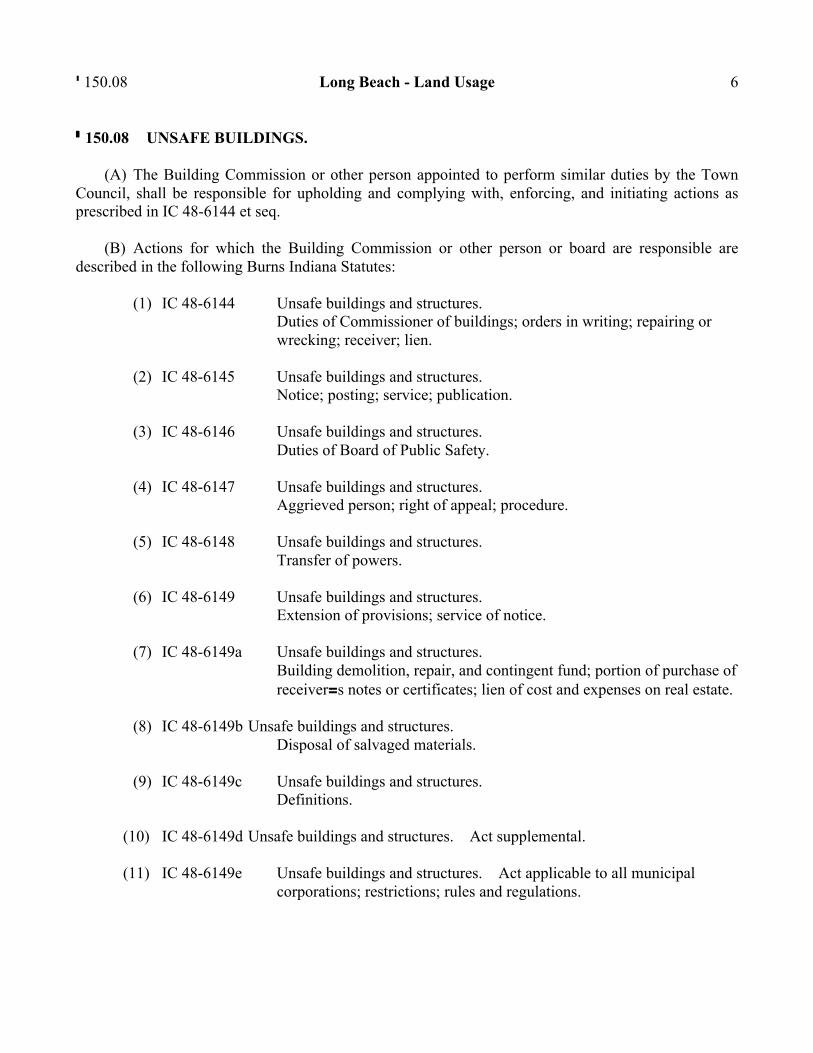
' 150.08 Long Beach - Land Usage 6 ' 150.08 UNSAFE BUILDINGS.
(A) The Building Commission or other person appointed to perform similar duties by the Town Council, shall be responsible for upholding and complying with, enforcing, and initiating actions as prescribed in IC 48-6144 et seq.
(B) Actions for which the Building Commission or other person or board are responsible are described in the following Burns Indiana Statutes:
(1) IC 48-6144 Unsafe buildings and structures. Duties of Commissioner of buildings; orders in writing; repairing or wrecking; receiver; lien.
(2) IC 48-6145 Unsafe buildings and structures.
Notice; posting; service; publication.
(3) IC 48-6146 Unsafe buildings and structures. Duties of Board of Public Safety.
(4) IC 48-6147 Unsafe buildings and structures.
Aggrieved person; right of appeal; procedure.
(5) IC 48-6148 Unsafe buildings and structures. Transfer of powers.
(6) IC 48-6149 Unsafe buildings and structures.
Extension of provisions; service of notice.
(7) IC 48-6149a Unsafe buildings and structures. Building demolition, repair, and contingent fund; portion of purchase of receiver=s notes or certificates; lien of cost and expenses on real estate.
(8) IC 48-6149b Unsafe buildings and structures.
Disposal of salvaged materials.
(9) IC 48-6149c Unsafe buildings and structures. Definitions.
(10) IC 48-6149d Unsafe buildings and structures. Act supplemental.
(11) IC 48-6149e Unsafe buildings and structures. Act applicable to all municipal
corporations; restrictions; rules and regulations.
7 Building Code ' 150.17
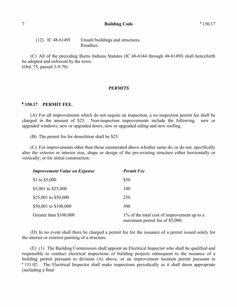
(12) IC 48-6149f Unsafe buildings and structures. Penalties.
(C) All of the preceding Burns Indiana Statutes (IC 48-6144 through 48-6149f) shall henceforth
be adopted and enforced by the town. (Ord. 75, passed 3-9-70) PERMITS ' 150.17 PERMIT FEE.
(A) For all improvements which do not require an inspection, a no inspection permit fee shall be charged in the amount of $25. Non-inspection improvements include the following: new or upgraded windows, new or upgraded doors, new or upgraded siding and new roofing.
(B) The permit fee for demolition shall be $25.
(C) For improvements other than those enumerated above whether same do, or do not, specifically alter the exterior or interior size, shape or design of the pre-existing structure either horizontally or vertically; or for initial construction:
Improvement Value on Expense Permit Fee
$1 to $5,000
$50
$5,001 to $25,000
100
$25,001 to $50,000
250
$50,001 to $100,000
500
Greater than $100,000
1% of the total cost of improvement up to a maximum permit fee of $5,000.
(D) In no event shall there be charged a permit fee for the issuance of a permit issued solely for
the interior or exterior painting of a structure.
(E) (1) The Building Commission shall appoint an Electrical Inspector who shall be qualified and responsible to conduct electrical inspections of building projects subsequent to the issuance of a building permit pursuant to division (A) above, or an improvement location permit pursuant to ' 151.02. The Electrical Inspector shall make inspections periodically as it shall deem appropriate (including a final
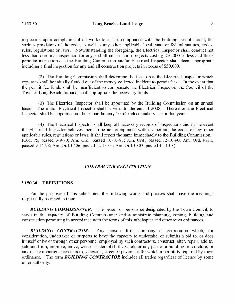
' 150.30 Long Beach - Land Usage 8 inspection upon completion of all work) to ensure compliance with the building permit issued, the various provisions of the code, as well as any other applicable local, state or federal statutes, codes, rules, regulations or laws. Notwithstanding the foregoing, the Electrical Inspector shall conduct not less than one final inspection for any and all construction projects costing $50,000 or less and those periodic inspections as the Building Commission and/or Electrical Inspector shall deem appropriate including a final inspection for any and all construction projects in excess of $50,000.
(2) The Building Commission shall determine the fee to pay the Electrical Inspector which expenses shall be initially funded out of the money collected incident to permit fees. In the event that the permit fee funds shall be insufficient to compensate the Electrical Inspector, the Council of the Town of Long Beach, Indiana, shall appropriate the necessary funds.
(3) The Electrical Inspector shall be appointed by the Building Commission on an annual basis. The initial Electrical Inspector shall serve until the end of 2008. Thereafter, the Electrical Inspector shall be appointed not later than January 10 of each calendar year for that year.
(4) The Electrical Inspector shall keep all necessary records of inspections and in the event the Electrical Inspector believes there to be non-compliance with the permit, the codes or any other applicable rules, regulations or laws, it shall report the same immediately to the Building Commission. (Ord. 75, passed 3-9-70; Am. Ord., passed 10-10-83; Am. Ord., passed 12-10-90; Am. Ord. 9811, passed 9-14-98; Am. Ord. 0406, passed 12-13-04; Am. Ord. 0803, passed 4-14-08) CONTRACTOR REGISTRATION ' 150.30 DEFINITIONS.
For the purposes of this subchapter, the following words and phrases shall have the meanings respectfully ascribed to them:
BUILDING COMMISSIONER. The person or persons so designated by the Town Council, to serve in the capacity of Building Commissioner and administrate planning, zoning, building and construction permitting in accordance with the terms of this subchapter and other town ordinances.
BUILDING CONTRACTOR. Any person, firm, company or corporation which, for consideration, undertakes or purports to have the capacity to undertake, or submits a bid to, or does himself or by or through other personnel employed by such contractors, construct, alter, repair, add to, subtract from, improve, move, wreck, or demolish the whole or any part of a building or structure, or any of the appurtenances thereto, sidewalk, street or pavement for which a permit is required by town ordinance. The term BUILDING CONTRACTOR includes all trades regardless of license by some other authority.
9 Building Code ' 150.32
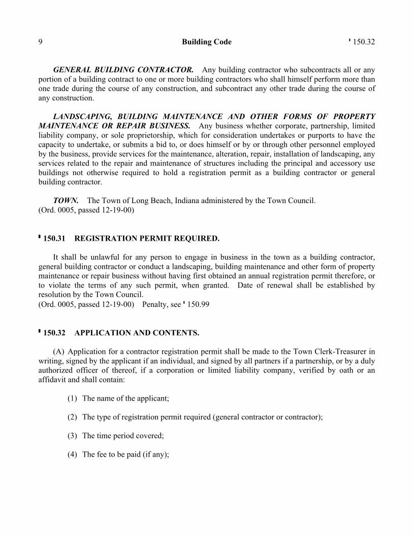
GENERAL BUILDING CONTRACTOR. Any building contractor who subcontracts all or any portion of a building contract to one or more building contractors who shall himself perform more than one trade during the course of any construction, and subcontract any other trade during the course of any construction.
LANDSCAPING, BUILDING MAINTENANCE AND OTHER FORMS OF PROPERTY MAINTENANCE OR REPAIR BUSINESS. Any business whether corporate, partnership, limited liability company, or sole proprietorship, which for consideration undertakes or purports to have the capacity to undertake, or submits a bid to, or does himself or by or through other personnel employed by the business, provide services for the maintenance, alteration, repair, installation of landscaping, any services related to the repair and maintenance of structures including the principal and accessory use buildings not otherwise required to hold a registration permit as a building contractor or general building contractor.
TOWN. The Town of Long Beach, Indiana administered by the Town Council. (Ord. 0005, passed 12-19-00) ' 150.31 REGISTRATION PERMIT REQUIRED.
It shall be unlawful for any person to engage in business in the town as a building contractor, general building contractor or conduct a landscaping, building maintenance and other form of property maintenance or repair business without having first obtained an annual registration permit therefore, or to violate the terms of any such permit, when granted. Date of renewal shall be established by resolution by the Town Council. (Ord. 0005, passed 12-19-00) Penalty, see ' 150.99 ' 150.32 APPLICATION AND CONTENTS.
(A) Application for a contractor registration permit shall be made to the Town Clerk-Treasurer in writing, signed by the applicant if an individual, and signed by all partners if a partnership, or by a duly authorized officer of thereof, if a corporation or limited liability company, verified by oath or an affidavit and shall contain:
(1) The name of the applicant;
(2) The type of registration permit required (general contractor or contractor);
(3) The time period covered;
(4) The fee to be paid (if any);
' 150.33 Long Beach - Land Usage 10
(5) The address of the business for which any notice required herein is to be mailed; and
(6) Any licenses or registrations required to perform services regulated in this subchapter plus a listing of insurance coverage then in effect and which the applicant agrees to keep in force throughout the period covered by the registration permit, including workmen=s compensation, public liability for personal injury or death, property damage and vehicle coverage, listing the insurance company, policy number, amount of coverage and expiration date.
(B) At least the minimum limits of insurance shall be required by law for workman=s compensation; $500,000 for general liability for both public and vehicle coverage. The application shall also contain any other information as may be required by the Building Commissioner at his discretion. (Ord. 0005, passed 12-19-00) ' 150.33 APPLICATION FEE AND FILING PROCEDURES.
An application for a contractor registration permit shall be accompanied by an application fee in an amount of $50 payable to the Clerk-Treasurer. Forms for all permits shall be prepared and completed application kept on file by the Clerk-Treasurer. Each permit issued shall bear the seal of the town, name of the permittee, address, type of registration permit issued, the amount of fee paid and any other information required by the Town Council and Building Commissioner. The Clerk-Treasurer shall file a copy of all registration permits issued to the Building Commissioner. The Clerk-Treasurer shall maintain a list of registration permits issued and provide a copy upon request to the general public. (Ord. 0005, passed 12-19-00) ' 150.34 SCOPE.
Any person having a general building contractor=s registration permit shall not be required to secure an additional permit for work performed as a building contractor, nor shall a permit be required of a building contractor acting as a subcontractor under written contract to a properly permitted general building contractor. General building contractors shall be responsible for verifying that their subcontractors are insured to the minimum limits as listed in ' 150.32. (Ord. 0005, passed 12-19-00) ' 150.35 NONTRANSFERABLE.
No registration permit issued under the provision of this subchapter shall be transferable. (Ord. 0005, passed 12-19-00)
11 Building Code ' 150.38 ' 150.36 SUSPENSION AND REVOCATION.
(A) In addition to any other penalty imposed by this subchapter or other town ordinance for violation of any provision of the ordinance or regulation, a contractor=s permit issued under the provision of this subchapter may be suspended or revoked by the Building Commission after hearing before the Town Council. All orders suspending or revoking registration permits shall state the grounds therefore, shall be signed and shall be subject to appeal to a court of competent jurisdiction.
(B) The commission or omission of any of the following acts shall, in addition to the violation of any applicable section of this subchapter or any town ordinance or state law, constitute grounds for the suspension or revocation of a contractor=s registration permit.
(1) Acceptance of final payment without issuance of waivers of lien and contractor=s affidavit to the permit holder which shall be issued to run with the property.
(2) Non-completion of contract before expiration of the permit.
(3) Allowing insurance policies listed in the permit to lapse or be canceled without replacement of equal coverage by other policies.
(C) The town shall not be liable for any financial loss incurred by any registration permit holder whose permit has been suspended or revoked in accordance with the terms of this subchapter. (Ord. 0005, passed 12-19-00) ' 150.37 RENEWAL OF REVOKED PERMITS RESTRICTED.
No registration permit shall be issued to a person, firm, corporation or limited liability company whose previous permit has been revoked up for period of one year from the date of such revocation. Said period shall be determined by the Building Commissioner and established by the Town Council. (Ord. 0005, passed 12-19-00) ' 150.38 REGISTRATION PERMITS MUST BE IN EFFECT.
It shall be the absolute duty and irrevocable responsibility of the permit holder to verify that all permits required by this subchapter are lawfully in effect before proceeding with any work to alter, repair, add to, subtract from, improve, move, wreck, or demolish to all or any part of a building structure or any of the appurtenances thereto, sidewalk, street or pavement. (Ord. 0005, passed 12-19-00) Penalty, see ' 150.99
' 150.39 Long Beach - Land Usage 12 ' 150.39 VEHICLE IDENTIFICATION REQUIRED.
All automobile and truck service vehicles, except personal vehicles of employees, used in the performance of any service which requires registration under the terms of this subchapter must clearly display on both sides of the vehicle the name of the contractor or subcontractor. (Ord. 0005, passed 12-19-00) Penalty, see ' 150.99 ' 150.40 FORM OF APPLICATION FOR CONSTRICTOR=S REGISTRATION AND CONTRACTOR=S REGISTRATION PERMIT.
The initial form of application for Contractor=s Registration and the initial form of Contractor=s Registration Permit to be used in carrying out the purposes of this subchapter are those that are attached hereto and marked Exhibit AA@ and AB@ respectively and incorporated herein by reference. These forms may be subject to modification by resolution by the Town Council. (Ord. 0005, passed 12-19-00) ' 150.41 LIMITATION OF APPLICABILITY.
All of the terms, conditions, requirements of the Building Code of the town adopted on March 9, 1970, not inconsistent with this subchapter, are to remain in full force and effect and shall not be affected by the adoption of this subchapter. (Ord. 0005, passed 12-19-00) ' 150.98 REMEDIES.
The erection, repairing, and removing of any structure, building, or appurtenances thereto, or the alterations thereof, except in conformity with the requirements of this chapter shall be and is declared to constitute a common nuisance. Such common nuisance may be abated in such manner, and any relief therefrom may be available, as is now, or may hereafter be provided for under the law of the state. The provisions of this chapter may be enforced by injunction or other appropriate proceedings as provided for by the law of the state. It shall be the duty of the Town Council to order any such violation stopped and abated, a copy of which order shall be posted on the property, or served upon the owner, agent, or contractor, by the Town Marshal. (Ord. 75, passed 3-9-70)
13 Building Code ' 150.99 ' 150.99 PENALTY.
(A) Any person, firm, or corporation who violates any of the provisions of this chapter, or shall fail to comply with any of the requirements thereof, shall be deemed guilty of an offense, and each day such violation or noncompliance is permitted to exist or continue shall constitute a separate offense. Upon conviction the person shall be fined not to exceed $10 for any one offense, provided however, that where the laws of the state have provided a specific penalty for the violation and nonconformance with the acts covered by this chapter then such penalty shall apply instead.
(B) Any violation of '' 150.30 - 150.41 shall subject the violator to a fine of not more than $100 per day of violation. Each day a violation exists shall constitute a separate offense. (Ord. 75, passed 3-9-70; Am. Ord. 0005, passed 12-19-00)

Long Beach - Land Usage 14
CHAPTER 151: IMPROVEMENT LOCATION PERMITS Section
151.01 Plan Commission jurisdiction; intent of permit 151.02 Issuance of permit and fee 151.03 Site plan 151.04 Appeal 151.05 Review of decisions
151.99 Penalty
' 151.01 PLAN COMMISSION JURISDICTION; INTENT OF PERMIT.
Within the jurisdiction of the Town Plan Commission no structure, improvement, or use of land may be altered, changed, placed, erected, or located on platted or unplatted lands, unless the structure, improvement, or use, and its location, conform with the Master Plan and ordinances of the town, and an improvement location permit for such structure, improvement, or use has been issued. (Ord. passed 3-9-70) Penalty, see ' 151.99 ' 151.02 ISSUANCE OF PERMIT AND FEE.
The Building Commission shall issue an improvement location permit, (subject to reasonable restrictions and/or conditions as provided for in ' 150.15(A), as amended, of the Code) upon written application when the proposed structure, improvement, or use and its location conform in all respects to the Master Plan and ordinances of the town. The fee for the issuance of an improvement location permit is set forth in ' 150.17, as amended. (Ord. passed 3-9-70; Am. Ord. 9203, passed 8-10-92; Am. Ord. 9811, passed 9-14-98) ' 151.03 SITE PLAN.
Each application for an improvement location permit shall be accompanied by a site plan, drawn to scale, showing the location of the structure, improvement, or use to be altered, changed, placed, erected, or located, the dimensions of the lot to be improved, the size of yards and open spaces, existing and 15
' 151.04 Long Beach - Land Usage 16 proposed streets and alleys adjoining or within the lot, and the manner in which the location is to be improved. (Ord. passed 3-9-70) ' 151.04 APPEAL.
Any decision of the Building Commission concerning the issuance of an improvement location permit may be appealed to the Town Board of Zoning Appeals when the decision in question involves the requirement of the Zoning Code, or to the Town Plan Commission when the decision in question involves the requirements of other parts of the Master Plan, by any person claiming to be adversely affected by such decision. (Ord. passed 3-9-70) ' 151.05 REVIEW OF DECISIONS.
A decision of the Town Plan Commission based upon an appeal from a decision of the Building Commission may be reviewed by certiorari procedure as provided for the appeal of zoning cases from the Board of Zoning Appeals. (Ord. passed 3-9-70) ' 151.99 PENALTY.
Action on the violation of any provision of this chapter and the right of injunction against such violation shall be as provided by Chapter 174, Acts of 1947 of the Indiana General Assembly (IC 36-7-4-201 et seq.), and all acts amendatory thereto. (Ord. passed 3-9-70)
CHAPTER 152: OUTDOOR ADVERTISING Section
152.01 Types of signs permitted 152.02 Name plates 152.03 Bulletin boards 152.04 Business signs 152.05 Temporary signs
' 152.01 TYPES OF SIGNS PERMITTED.
Only the following sign types in '' 152.02 through 152.05 shall be permitted subject to the approval of the Building Commission. No other types of signs or other forms of advertising structures of any type of configuration shall be permitted. Signs shall be designed, erected, altered, reconstructed, moved, or maintained in whole, or in part, in accordance with the provisions set forth in this chapter. (Ord. passed 3-9-70) Penalty, see ' 10.99 ' 152.02 NAME PLATES.
Name plates for residential use shall be permitted subject to the following conditions:
(A) Name plates shall not exceed one square foot in area, and letter or numeral height shall not exceed three inches. Only one face of double-faced signs shall be included in the computation of permissible area. A double-faced sign is one where each of the two sides face in opposite directions.
(B) Sign face may be either internally illuminated or by floodlight. No blinking, flashing, rotating, or animated signs shall be permitted that are visible from the exterior of a building or other structure.
(C) Name plates shall either be flat or wall type and secured in place, or supported on a post located in the front yard area. If of the latter type, it shall:
(1) Project a maximum of 16 inches.
(2) Not extend over public property, nor be erected so as to obstruct street sight lines or traffic control lights, signs at street intersections, or signals at railroad crossings. 17
' 152.03 Long Beach - Land Usage 18
(3) Signs visible from the sight lines along a street shall not contain an arrow or such words as Astop,@ Ago,@ Aslow,@ and so on, or in any other manner resemble highway traffic signs.
(D) Name plates shall display only the:
(1) Name of the premises upon which it is displayed;
(2) Name of the owner or lessee of the premises;
(3) Address of the premises; and
(4) No indication shall be included relating to any possible home occupation engaged in on the premises, nor to names of other than principal occupants.
(E) No name plates shall be permitted above the first floor level. (Ord. passed 3-9-70) Penalty, see ' 10.99 ' 152.03 BULLETIN BOARDS.
Bulletin boards for institutional uses including parks and other public facilities, churches, private clubs, and similar uses shall be permitted subject to the following regulations:
(A) One free-standing sign for each main use per frontage:
(1) The sign shall contain only the name and address of the building, its occupants, and the services rendered.
(2) The sign shall not exceed 32 square feet in area, exclusive of architectural features. The sign structure shall not exceed eight feet in height.
(3) The sign face shall not be internally illuminated but may be flood lighted. No blinking, flashing, rotating, or animated signs shall be permitted that are visible from the exterior of a building or other structure.
(4) Signs shall be set back 15 feet from public right-of-ways; however, this setback may be reduced to ten feet subject to approval of a special exception. In no case shall signs be located within required rear or interior side yards.
(B) One sign attached to the outside face of the main building:
(1) The same shall contain only the name of the building and its occupants.
19 Outdoor Advertising ' 152.04
(2) Letter or numeral heights shall not exceed one foot.
(3) The sign shall not exceed ten square feet in area.
(4) The sign face shall not be internally illuminated but may be floodlighted. No blinking, flashing, rotating, or animated signs shall be permitted that are visible from the exterior of the building.
(5) No such sign shall be allowed to appear above the first floor level. (Ord. passed 3-9-70) Penalty, see ' 10.99 ' 152.04 BUSINESS SIGNS.
(A) Types permitted shall be limited to flat and wall signs indicating name and nature of the principal occupant only or the name and address of the building, or the name and address of the owner. These signs shall be attached to the building in which the occupant is located. Projecting signs shall not be permitted.
(B) The following regulations shall apply to signs for each occupancy:
(1) (a) The total area of all business signs on any one street frontage of the premises shall not exceed four-tenths of a square foot per linear foot of such street frontage or 37-1/2 square feet, whichever is smaller. Corner signs shall not be allowed. A CORNER SIGN is defined to be any sign placed near the intersection of the two street frontages and designed to be visible from both streets.
(b) Building frontage to be used in calculating the permitted sign area shall include frontage whereon a public entrance to the occupancy is located. Separate calculations may be made for front, side, and rear entrances and separate signs may be erected on each of these building frontages.
(2) Signs shall not extend over a public sidewalk or right-of-way, nor obstruct street sight lines or traffic-control lights, signs at street intersections, or signals at railroad crossings. Signs visible from the sight lines along a street shall not contain an arrow or such words as Astop,@ Ago,@ Aslow,@ and the like, or otherwise resemble highway traffic signs. All sign faces shall be mounted on or attached to the building.
(3) No blinking, flashing, rotating, or animated signs shall be permitted on the exterior of any building in this district.
(4) In cases where the store has a rear parking lot, signs may be located on the side or rear of the building and shall be developed to the same standards as are required in the front of the store, provided, however, that the signs shall not be lighted in such manner as to be disturbing to the abutting residential district and such lighting shall be terminated not later than 9:30 p.m.
' 152.05 Long Beach - Land Usage 20
(5) Lights used to illuminate signs or advertising structures shall be so installed as to concentrate the illumination on the sign or advertising structure and to minimize glare upon a public street or adjacent property.
(6) No sign shall be installed above the first floor level.
(7) No signs shall be erected which are freestanding, projecting, on poles, the ground, above marquees, on top of buildings, or in any other form or manner, except as specified elsewhere in this chapter. (Ord. passed 3-9-70) Penalty, see ' 10.99 ' 152.05 TEMPORARY SIGNS.
(A) AFor Rent@ and AFor Sale@ signs shall not be permitted.
(B) On site real estate signs advertising real property which has been subdivided for purposes of sale or lease shall not be permitted.
(C) Special events of short duration and public interest such as a county fair, civic, or church activity shall be permitted. Such informational signs shall be limited to:
(1) Announcement signs which shall not be:
(a) Over 24 square feet in area.
(b) Erected more than 30 days before the event in question and shall be removed within 12 hours thereafter.
(2) Directional signs which shall:
(a) Not be more than three square feet in area.
(b) Show only a directional arrow and the name of the public interest event.
(c) Not be erected more than 14 days before the event in question and shall be removed within 12 hours thereafter. (Ord. passed 3-9-70) Penalty, see ' 10.99
CHAPTER 153: SUBDIVISION CONTROL Section General Provisions
153.01 Establishment of control 153.02 Procedure 153.03 Preliminary plat 153.04 Preliminary plat approval 153.05 Final plat 153.06 Final plat approval 153.07 Variance
Principles and Standards of Design
153.15 Conformance 153.16 Streets 153.17 Blocks 153.18 Lots 153.19 Easements 153.20 Building line
Standards of Improvement
153.30 Conformance 153.31 Monuments and markers 153.32 Streets 153.33 Sewers 153.34 Water 153.35 Storm drainage 153.36 Curb and gutter 153.37 Sidewalks 153.38 Street signs
21
' 153.01 Long Beach - Land Usage 22 Plat Certificates and Deed of Dedication
153.45 Forms 153.46 Commission certificate 153.47 County Commissioner=s certificate 153.48 Surveyor=s certificate 153.49 Deed of dedication
GENERAL PROVISIONS ' 153.01 ESTABLISHMENT OF CONTROL.
No plat or replat of a subdivision of land located within the jurisdiction of the Plan Commission shall be recorded until it shall have been approved by the Commission and the Town Council, and such approval shall have been entered in writing on the plat by the president and secretary of the Commission. (Ord. passed 3-9-70) Penalty, see ' 10.99 ' 153.02 PROCEDURE.
A subdivider desiring approval of a plat of a subdivision of any land lying within the jurisdiction of the Plan Commission, shall submit a written application therefor to the Commission. Such application shall be accompanied by the information, requirements, and plans set forth in '' 153.03 through 153.06, all in accordance with the requirements set forth in ' 153.01. (Ord. passed 3-9-70) Penalty, see ' 10.99 ' 153.03 PRELIMINARY PLAT.
(A) The owner or subdivider shall provide a preliminary plan for the subdivision which shall show the manner in which the proposed subdivision is coordinated with the pattern of existing land uses; specifically with relation to the requirements of the thoroughfares; school and recreational sites; shopping centers; community facilities; sanitation, water supply and drainage, and other developments, existing and proposed, in the vicinity. However, no land shall be subdivided for residential use unless adequate access to the land over improved streets or thoroughfares exists or will be provided by the subdivider, or if such land is considered by the Plan Commission to be unsuitable for such use by reason of flooding or improper drainage, objectionable earth and rock formation, topography, or any other feature harmful to the health and safety of possible residents and the community as a whole.
23 Subdivision Control ' 153.03
(B) The subdivider shall provide the following:
(1) Location map (which may be prepared by indicating the data by notations on available maps) showing:
(a) Subdivision name and location.
(b) Any thoroughfares related to the subdivision.
(c) Existing elementary and high schools, parks, and playgrounds serving the area proposed to be subdivided, and other community facilities.
(d) Title, scale, north point, and date.
(2) A preliminary plat showing:
(a) Proposed name of the subdivision.
(b) Names and addresses of the owner, subdivider and the city planner, land planning consultant, engineer, or surveyor, who prepared the plan.
(c) Streets and right-of-way, on and adjoining the site of the proposed subdivision, showing the names (which shall not duplicate other names of streets in the community, except as designated by the Plan Commission) and including roadway widths, approximate gradients, types and widths of pavement, curbs, sidewalks, crosswalks, and tree planting.
(d) Easements. Locations, widths, and purposes.
(e) Statement concerning the location and approximate size or capacity of utilities to be installed.
(f) Layout of lots, showing dimensions and numbers.
(g) Parcels of land proposed to be dedicated or reserved for schools, parks, playgrounds, or other public, semi-public, or community purposes.
(h) Contours at vertical intervals of two feet if the general slope of the site is less than 10% and at vertical intervals of five feet if the general slope is greater than 10%.
(i) Ground water levels stated in inches below ground surface and given at points of lowest ground elevation.
' 153.04 Long Beach - Land Usage 24
(j) Tract boundary lines showing dimensions, bearings, angles, and references to section, township, and range lines or corners.
(k) Building lines.
(l) Legend and notes.
(m) Other features or conditions which would affect the subdivision favorably or adversely.
(n) Scale (The preliminary plat of the subdivision shall be drawn to a scale of 50 feet to one inch, or 100 feet to one inch; provided however, that if the resulting drawing would be over 36 inches in shortest dimension, a scale as recommended by the Plan Commission may be used), north point and date.
(3) A description of the protective covenants or private restrictions to be incorporated in the plat of the subdivision.
(C) The application shall be accompanied by a certified check or money order in the amount of $10 plus $.25 for each lot in the proposed subdivision with a minimum total charge of $15 to cover the cost of checking and verifying the proposed plat, and such amount shall be deposited in the general fund of the town. (Ord. passed 3-9-70) Penalty, see ' 10.99 ' 153.04 PRELIMINARY PLAT APPROVAL.
(A) After an application for approval of a plat of a subdivision, together with two copies of all maps and data, has been filed, and within 90 days from the date of application for approval of a preliminary plat of a subdivision, or the filing by the applicant of the last item of required supporting data, whichever is later, the Plan Commission shall review the preliminary plat and give its acceptance or return the plat to the subdivider with suggestions for changes. No application will be considered at a meeting unless it has been filed with the Commission at least ten days before the date of such meeting.
(B) After the Commission has given acceptance, it shall set a date for a hearing, notify the applicant in writing, and notify by general publication or otherwise, any person or governmental unit having a probable interest in the proposed plat. The cost of publication of the notice of hearing shall be met by the applicant.
(C) Following the hearing on the preliminary plat, the Commission will notify the applicant in writing that it has approved the preliminary plat and is ready to receive the final plat, or will advise the applicant of any further changes in the preliminary plat which are desired or should have consideration before approval will be given. (Ord. passed 3-9-70)
25 Subdivision Control ' 153.05 ' 153.05 FINAL PLAT.
The final plat shall meet the following specifications:
(A) The final plat may include all or only a part of the preliminary plat which has received approval.
(B) The original drawing of the final plat of the subdivision shall be drawn to a scale of 50 feet to one inch, provided that if the resulting drawing would be over 36 inches in shortest dimension, a scale of 100 feet to one inch may be used. Three black or blue line prints shall be submitted with the original final plat, or, in order to conform to modern drafting and reproduction methods, three black line prints and a reproducible print shall be submitted.
(C) The following basic information shall be shown:
(1) Accurate boundary lines, with dimensions and angles, which provide a survey of the tract, closing with an error of not more than one foot in 5,000 feet.
(2) Accurate distances and directions to the nearest established street corners or official monuments. Reference corners shall be accurately described on the plan.
(3) Accurate locations of all existing and recorded streets intersecting the boundaries of the tract.
(4) Accurate metes and bounds description of the boundary.
(5) Source of title of the applicant to the land as shown by the last entry in the books of the County Recorder.
(6) Street names.
(7) Complete curve notes for all curves included in the plan.
(8) Street lines with accurate dimensions in feet and hundredths of feet, with angles to street, alley, and lot lines.
(9) Lot numbers and dimensions.
(10) Accurate locations of easements for utilities and any limitations on such semi-public or community use.
(11) Accurate dimensions for any property to be dedicated or reserved for public, semi-public, or community use.
' 153.06 Long Beach - Land Usage 26
(12) Building lines and dimensions.
(13) Location, type, material, and size of all monuments and lot markers.
(14) Plans and specifications for the improvements required in this chapter.
(15) Restrictions of all types which will run with the land and become covenants in the deeds for lots.
(16) Name of the subdivision.
(17) Name and address of the owner and subdivider.
(18) North point, scale, and date.
(19) Certification by a registered professional engineer or registered land surveyor.
(20) Certification of dedication of streets and other public property.
(21) Certificate for approval by the Plan Commission.
(22) Certificate for approval by the County Commissioners if required. (Ord. passed 3-9-70) Penalty, see ' 10.99 ' 153.06 FINAL PLAT APPROVAL.
(A) When the final plat is submitted to the Plan Commission, it shall be accompanied by a notice from the Town Council stating that there has been filed with and approved by that body, one of the following:
(1) A certificate that all improvements and installations for the subdivision required for its approval have been made or installed in accordance with specifications; or
(2) A bond which shall:
(a) Run to the Town Council.
(b) Be in an amount determined by the Commission to be sufficient to complete the improvements and installations in compliance with this chapter.
(c) Be with surety satisfactory to the Commission; and
27 Subdivision Control ' 153.07
(d) Specify the time for the completion of the improvements and installations.
(B) Upon the completion of the improvements and installations required of a subdivider for the approval of a final plat, and prior to the acceptance thereof for public maintenance by the Town Council or, if applicable, to any other governmental unit, the subdivider shall provide a three year maintenance bond which shall:
(1) Run to the Town Council and, if applicable, to any other governmental unit having a legal responsibility for the maintenance of the improvements and installations.
(2) Be in an amount equal to 20% of the cost of the improvements and installations as estimated by the Town Council.
(3) Provide surety satisfactory to the Commission.
(4) Warrant the workmanship and all materials used in the construction, installation, and completion of the improvements and installations to be of good quality and have been constructed and completed in a workmanlike manner in accordance with the standards, specifications, and requirements of this chapter and the satisfactory plans and specifications therefor.
(5) Provide that for a period of three years after the installations and improvements have been completed or are accepted for public maintenance by any appropriate governmental unit or agency thereof, the subdivider will at his own expense make all repairs to the improvements and installations, or the foundations thereof, which may become necessary by reason of improper workmanship or materials, with such maintenance, however, not to include any damage to the improvements and installations resulting from forces or circumstances beyond the control of the subdivider or occasioned by the inadequacy of the standards, specifications, or requirements of this chapter.
(C) Within a reasonable time after application for approval of the final plat, the Commission shall approve or disapprove it. If the Commission approves, it shall affix the Commission=s seal upon the plat, together with the certifying signature of its president and secretary. If it disapproves, it shall set forth the reasons for such disapproval in its own records and provide the applicant with a copy. (Ord. passed 3-9-70) ' 153.07 VARIANCE.
Where the subdivider can show that a provision of '' 153.15 through 153.20 would cause unnecessary hardship if strictly adhered to and where, in the opinion of the Plan Commission, because of topographical or other conditions peculiar to the site, a departure may be made without destroying the intent of such provision, the Commission may authorize a variance. Any variance thus authorized is
' 153.15 Long Beach - Land Usage 28 required to be entered in writing in the minutes of the Commission and the reasoning on which the departure was justified shall be set forth. (Ord. passed 3-9-70) PRINCIPLES AND STANDARDS OF DESIGN ' 153.15 CONFORMANCE.
(A) The final plat of the subdivision shall conform to the following principles and standards of design in '' 153.16 through 153.20.
(B) The subdivision plan shall conform to the principles and standards which are generally exhibited in the Master Plan. (Ord. passed 3-9-70) ' 153.16 STREETS.
(A) The street and alley layout shall provide access to all lots and parcels of land within the subdivision, and where streets cross other streets, jogs shall not be created.
(B) Proposed streets shall be adjusted to the contour of the land so as to produce usable lots and streets of reasonable gradient.
(C) Certain proposed streets, where appropriate, shall be extended to the boundary line of the tract to be subdivided so as to provide for normal circulation of traffic within the vicinity.
(D) Wherever there exists a dedicated or platted portion of a street or alley adjacent to the proposed subdivision, the remainder of the street or alley to the prescribed width shall be platted within the proposed subdivision.
(E) Widths of primary, secondary, and feeder streets shall conform to the width specified in the Official Thoroughfare Plan.
(F) The minimum right-of-way of local streets or culs-de-sac in urban areas shall be 50 feet. The minimum right-of-way of feeder streets in rural areas shall be 50 feet unless otherwise designated by the Official Thoroughfare Plan as requiring a minimum right-of-way of 60 feet. All culs-de-sac shall terminate in a circular right-of-way with a minimum diameter of 100 feet, or other arrangement for the turning of all vehicles conveniently within the right-of-way.
29 Subdivision Control ' 153.16
(G) Alleys shall be discouraged in residential districts but should be included in commercial and industrial areas where needed for loading and unloading or access purposes, and where platted shall be at least 20 feet in width.
(H) The center lines of streets should intersect as nearly at right angles as possible.
(I) At intersections of streets and alleys, property line corners shall be rounded by arcs of at least 20 feet radii or by chords of such arcs.
(J) At intersections of streets the property line corners shall be rounded by arcs with radii of not less than 15 feet, or by chords of such arcs.
(K) If the smaller angle of intersection of two streets is less than 60 degrees, the radius of the arc at the intersection of property lines shall be increased as deemed advisable by the Plan Commission.
(L) Intersections of more than two streets at one point shall be avoided. (M) Where parkways or special types of streets are involved, the Plan Commission may apply special standards to be followed in their design.
(N) Whenever the proposed subdivision contains or is adjacent to a railroad right-of-way, a primary or a secondary street, provision shall be made for a marginal access street, or a parallel street adjacent to such railroad right-of-way or primary or secondary street. As a general principle, intersections of such marginal access streets or parallel streets shall not exist at less than 1/4-mile intervals with primary streets or at less than 1/8-mile intervals with secondary streets.
(O) Horizontal visibility on curved streets and vertical visibility on all streets must be maintained along the center lines as follows:
(1) Primary streets: 500 feet.
(2) Secondary streets: 300 feet.
(3) Feeder streets: 150 feet.
(P) Curvature measured along the center line shall have a minimum radius as follows:
(1) Primary streets: 500 feet.
(2) Secondary streets: 300 feet.
(3) Feeder streets: 200 feet.
' 153.17 Long Beach - Land Usage 30
(Q) Between reversed curves on primary and secondary streets there shall be a tangent of not less than 100 feet and on feeder and residential streets such tangent shall be not less than 40 feet.
(R) Maximum grades for streets shall be as follows:
(1) Primary and secondary streets, not greater than 6%.
(2) Local streets and alleys, not greater than 8%.
(S) The minimum grade of any street gutter shall not be less than 0.3%. (Ord. passed 3-9-70) Penalty, see ' 10.99 ' 153.17 BLOCKS.
(A) Blocks should not exceed 1000 feet in length.
(B) Blocks shall be of sufficient width to permit two tiers of lots of appropriate depth except where an interior street parallels a limited access highway or primary street or secondary street or a railroad right-of-way. (Ord. passed 3-9-70) Penalty, see ' 10.99 ' 153.18 LOTS.
(A) All lots shall abut on a public or private street.
(B) Side lines of lots shall be at approximately right angles to straight streets and on radial lines on curved streets. Some variation from this rule is permissible, but pointed or very irregular lots should be avoided.
(C) Double frontage lots should not be platted, except that, where desired along limited access highways or primary streets or secondary streets, lots may face on an interior street and back on such thoroughfares. In that event a planting strip for a screen, at least 20 feet in width shall be provided along the back of each lot.
(D) Widths and areas of lots shall be not less than that provided in the zoning code for single-family dwellings for the district in which the subdivision is located, except that when a water main supply system or a sanitary sewer system are not available, the lot area necessary to install a private water supply or private sewage disposal on the lot in accordance with the State Board of Health regulations shall become the required minimum lot area.

31 Subdivision Control ' 153.31
(E) The depth-to-width ratio of the usable area of a lot shall be a maximum of three to one.
(F) Wherever possible, unit shopping centers, based upon sound development standards, should be designed in contrast to the platting of lots for individual commercial use.
(G) Corner residential lots shall be wider than normal in order to permit appropriate setbacks from both streets. (Ord. passed 3-9-70) Penalty, see ' 10.99 ' 153.19 EASEMENTS.
Where alleys are not provided, easements for utilities shall be provided. Such easements shall have minimum widths of 12 feet, and where located along lot lines, one-half the width shall be taken from each lot. Before determining the location of easements the plan shall be discussed with the local public utility companies to assure their proper placing for the installation of such services. (Ord. passed 3-9-70) Penalty, see ' 10.99 ' 153.20 BUILDING LINE.
Shall be as provided in the zoning code in Chapter 154. (Ord. passed 3-9-70) Penalty, see ' 10.99 STANDARDS OF IMPROVEMENTS ' 153.30 CONFORMANCE.
The improvement of the subdivision shall conform to the following standards in '' 153.31 through 153.38. (Ord. passed 3-9-70) ' 153.31 MONUMENTS AND MARKERS.
(A) Shall be placed so that the center of the pipe or marked point shall coincide exactly with the intersection of lines to be marked, and shall be set so that the top of the monument or marker is level with the finished grade.
' 153.32 Long Beach - Land Usage 32
(B) Monuments shall be set:
(1) At the intersection of all lines forming angles in the boundary of the subdivision.
(2) At the intersection of street property lines.
(C) Markers shall be set:
(1) At the beginning and ending of all curves along street property lines.
(2) At all points where lot lines intersect curves, either front or rear.
(3) At all angles in property lines of lots.
(4) At all other lot corners not established by a monument.
(D) Monuments shall be of stone, precast concrete, or concrete poured in place with minimum dimensions of four inches by four inches by 30 inches. They shall be marked on top with an iron or copper dowel set flush with the top of the monument or deeply scored on top with a cross. Markers shall consist of iron pipes or steel bars at least 30 inches long, and not less than 5/8-inch in diameter. (Ord. passed 3-9-70) Penalty, see ' 10.99 ' 153.32 STREETS.
(A) Streets (and alleys where provided) shall be completed to grades shown on plans, profiles, and cross sections, provided by the subdivider, and prepared by a registered professional engineer and approved by the Plan Commission.
(B) The streets shall be graded, surfaced, and improved to the dimensions required by such plans, profiles, and cross sections and the work shall be performed in the manner prescribed in AStandard Specifications for Road and Bridge Construction and Maintenance@ (current issue) of the State Highway Commission. References in the following divisions refer to the S.H.C. of I. Standard Specifications.
(C) The street pavement shall be of portland cement concrete or a flexible pavement and shall be constructed in accordance with design characteristics at least equal to those given below; except as modified by division (D) of this section:
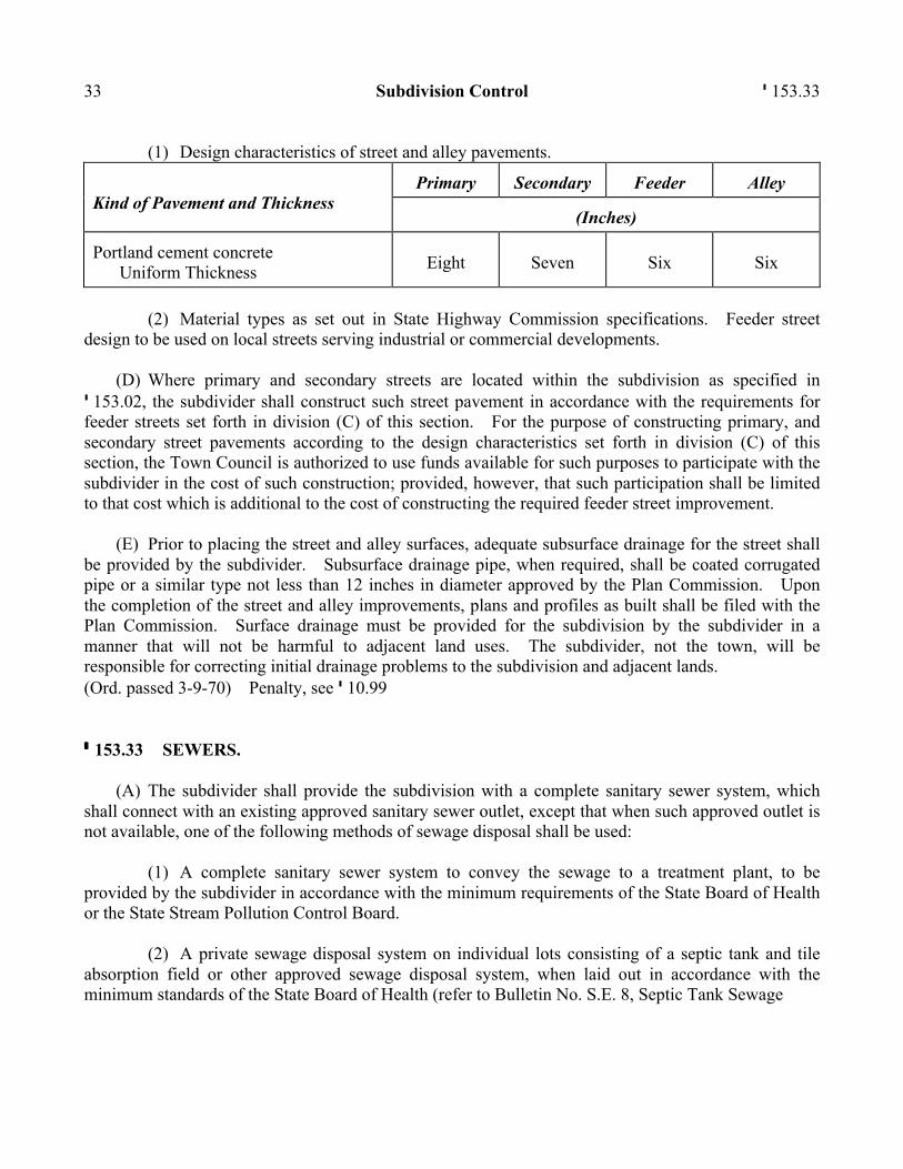
33 Subdivision Control ' 153.33
(1) Design characteristics of street and alley pavements. Kind of Pavement and Thickness
Primary
Secondary
Feeder
Alley
(Inches)
Portland cement concrete Uniform Thickness
Eight
Seven
Six
Six
(2) Material types as set out in State Highway Commission specifications. Feeder street
design to be used on local streets serving industrial or commercial developments.
(D) Where primary and secondary streets are located within the subdivision as specified in ' 153.02, the subdivider shall construct such street pavement in accordance with the requirements for feeder streets set forth in division (C) of this section. For the purpose of constructing primary, and secondary street pavements according to the design characteristics set forth in division (C) of this section, the Town Council is authorized to use funds available for such purposes to participate with the subdivider in the cost of such construction; provided, however, that such participation shall be limited to that cost which is additional to the cost of constructing the required feeder street improvement.
(E) Prior to placing the street and alley surfaces, adequate subsurface drainage for the street shall be provided by the subdivider. Subsurface drainage pipe, when required, shall be coated corrugated pipe or a similar type not less than 12 inches in diameter approved by the Plan Commission. Upon the completion of the street and alley improvements, plans and profiles as built shall be filed with the Plan Commission. Surface drainage must be provided for the subdivision by the subdivider in a manner that will not be harmful to adjacent land uses. The subdivider, not the town, will be responsible for correcting initial drainage problems to the subdivision and adjacent lands. (Ord. passed 3-9-70) Penalty, see ' 10.99 ' 153.33 SEWERS.
(A) The subdivider shall provide the subdivision with a complete sanitary sewer system, which shall connect with an existing approved sanitary sewer outlet, except that when such approved outlet is not available, one of the following methods of sewage disposal shall be used:
(1) A complete sanitary sewer system to convey the sewage to a treatment plant, to be provided by the subdivider in accordance with the minimum requirements of the State Board of Health or the State Stream Pollution Control Board.
(2) A private sewage disposal system on individual lots consisting of a septic tank and tile absorption field or other approved sewage disposal system, when laid out in accordance with the minimum standards of the State Board of Health (refer to Bulletin No. S.E. 8, Septic Tank Sewage
' 153.34 Long Beach - Land Usage 34 Disposal Systems, current issue); provided, however, that a private sewage disposal system on individual lots consisting of a septic tank and tile absorption field shall not be permitted if the water table is less than 30 inches below the ground surface.
(B) The plans for the installation of a sanitary sewer system shall be provided by the subdivider and approved by the State Board of Health (Refer to Regulation HSE 14, I.S.B.H.). Upon the completion of the sanitary sewer installation, the plans for such system as built shall be filed with the Commission.
(C) In this section, and in ' 153.34, the phrase THE SUBDIVIDER SHALL PROVIDE shall be interpreted to mean that the subdivider shall install the facility referred to, or whenever a private sewage disposal system or an individual water supply is to be provided, that such facilities referred to in these sections shall be installed by the developer of the lots in accordance with these regulations. (Ord. passed 3-9-70) Penalty, see ' 10.99 ' 153.34 WATER.
(A) The subdivider shall provide the subdivision with a complete water main supply system, which shall be connected to an existing approved municipal or community water supply, except that when such municipal or community water supply is not available, the subdivider shall provide one of the following:
(1) A complete community water supply system to be provided in accordance with the minimum requirements of the State Board of Health.
(2) An individual water supply on each lot in the subdivision in accordance with the minimum requirements of the State Board of Health (Refer to Bulletin No. S.E. 7, Safe Water Supplies, current issue).
(3) The water supply system shall consist of a minimum six-inch cast iron or transite pipe, or Underwriters approved equal. Water hydrants shall be provided by the subdivider. The location, number, and distance between the fire hydrants shall be shown on each site plan which must be approved by the Plan Commission. All water mains shall be placed underground with a minimum of four-feet tamped fill cover.
(B) The plans for the installation of water main supply system shall be provided by the subdivider and approved by the State Board of Health (Refer to Regulation HSE, 5, I.S.B.H.). Upon completion of the water supply installation, the plans for such system as built shall be filed with the Plan Commission. (Ord. passed 3-9-70) Penalty, see ' 10.99
35 Subdivision Control ' 153.36 ' 153.35 STORM DRAINAGE.
(A) The subdivider shall provide the subdivision with an adequate storm water sewer system whenever curb and gutter is installed and whenever the evidence available to the Plan Commission indicates that the natural surface drainage is inadequate. When the surface drainage is adequate, easements for such surface drainage shall be provided. Deep open ditches for drainage are not permitted in the street, but where curb and gutter are not provided, a shallow swale with its low point at least three inches below the elevation of the subgrade of the pavement may be permitted.
(B) In a subdivision where curbs and gutter are not provided, the subdivider shall furnish one of the following types of improvements to facilitate roadside drainage and to assure suitable entrances for private driveways which are proposed to intersect the roadway:
(1) A corrugated iron pipe, at least 12 inches in diameter and 14 feet in length to be placed where required for each driveway; or
(2) A properly dipped or swaled concrete pavement, 14 feet in length, six feet in width and six inches thick, designed so as not to create a hazard to the under parts of automobiles, at the entrance of each driveway. (Ord. passed 3-9-70) Penalty, see ' 10.99 ' 153.36 CURB AND GUTTER.
(A) Wherever a proposed subdivision lies adjacent to or between other subdivisions which have been provided with curb and gutter, and wherever the proposed subdivision will average more than 3-1/2 lots per gross acre included in the subdivision, the Plan Commission shall require curb and gutter to be installed on each side of the street surface.
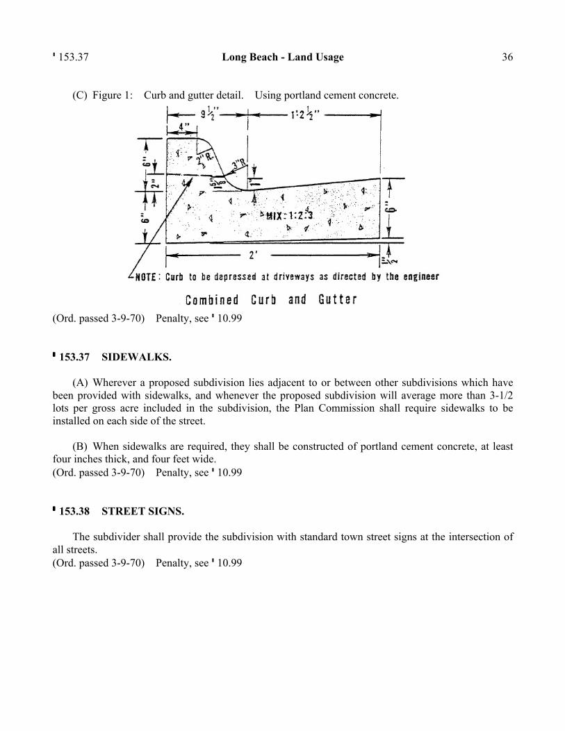
(B) The curb and gutter shall be of the construction type shown in division (C), Figure 1 and shall be constructed according to the following specifications:
(1) The base for the curb and gutter shall be well-compacted on the existing base or grade.
(2) The minimum specifications shall be as shown for the type of cross section in division (C), Figure 1.
(3) All concrete used in the curb and gutter shall meet the state highway specifications for Class D concrete.
(4) Integral or monolithic curb of the same dimensions as shown in division (C), Figure 1 may be built on concrete pavement, provided the pavement widths are maintained as required in this chapter.
' 153.37 Long Beach - Land Usage 36
(C) Figure 1: Curb and gutter detail. Using portland cement concrete.
(Ord. passed 3-9-70) Penalty, see ' 10.99 ' 153.37 SIDEWALKS.
(A) Wherever a proposed subdivision lies adjacent to or between other subdivisions which have been provided with sidewalks, and whenever the proposed subdivision will average more than 3-1/2 lots per gross acre included in the subdivision, the Plan Commission shall require sidewalks to be installed on each side of the street.
(B) When sidewalks are required, they shall be constructed of portland cement concrete, at least four inches thick, and four feet wide. (Ord. passed 3-9-70) Penalty, see ' 10.99 ' 153.38 STREET SIGNS.
The subdivider shall provide the subdivision with standard town street signs at the intersection of all streets. (Ord. passed 3-9-70) Penalty, see ' 10.99
37 Subdivision Control ' 153.47 PLAT CERTIFICATES AND DEED OF DEDICATION ' 153.45 FORMS.
The following forms in '' 153.46 through 153.49 shall be used in final plats. (Ord. passed 3-9-70) ' 153.46 COMMISSION CERTIFICATE.
COMMISSION CERTIFICATE
UNDER AUTHORITY PROVIDED BY CHAPTER 174-ACTS OF 1947, ENACTED BY THE GENERAL ASSEMBLY OF THE STATE OF INDIANA, AND ALL ACTS AMENDATORY THERETO, AND AN ORDINANCE ADOPTED BY THE TOWN COUNCIL OF LONG BEACH, INDIANA, THIS PLAT WAS GIVEN APPROVAL AS FOLLOWS:
Approved by the Long Beach Plan Commission at a meeting held ______________, 19___.
LONG BEACH PLAN COMMISSION
_______________________________________ President
_______________________________________
(SEAL) Secretary (Ord. passed 3-9-70) ' 153.47 COUNTY COMMISSIONER=S CERTIFICATE.
When any part of the subdivision is located in the unincorporated area of the county, the following certificate shall be shown on the final plat:
COUNTY COMMISSIONERS CERTIFICATE
UNDER AUTHORITY PROVIDED BY CHAPTER 47, ACTS OF 1951, OF THE GENERAL ASSEMBLY, STATE OF INDIANA, THIS PLAT WAS GIVEN APPROVAL BY THE BOARD OF COUNTY COMMISSIONERS OF LAPORTE COUNTY, INDIANA,
' 153.48 Long Beach - Land Usage 38
AT A MEETING HELD ON THE ______ DAY OF ________________ , 19___.
BOARD OF COUNTY COMMISSIONERS
______________________________________ ______________________________________
(SEAL) ______________________________________ (Ord. passed 3-9-70) ' 153.48 SURVEYOR=S CERTIFICATE.
SURVEYORS CERTIFICATE
AI, _______________________, HEREBY CERTIFY THAT I AM A REGISTERED LAND SURVEYOR, LICENSED IN COMPLIANCE WITH THE LAWS OF THE STATE OF INDIANA, THAT THIS PLAT CORRECTLY REPRESENTS A SURVEY
COMPLETED BY ME ON ________________, THAT ALL THE MONUMENTS SHOWN THEREON ACTUALLY EXIST, AND THAT THE LOCATION, SIZE, TYPE AND MATERIAL OF SAID MONUMENTS ARE ACCURATELY SHOWN.@
(SEAL) ______________________________________
Signature (Ord. passed 3-9-70) ' 153.49 DEED OF DEDICATION.
Each final plat submitted to the Plan Commission for approval shall carry a deed of dedication in substantially the following form:
AWe, the undersigned ________________, owners of the real estate shown and described herein, do hereby certify that we have laid off, platted and subdivided, and do thereby lay off, plat and subdivide, said real estate in accordance with the within plat.
This subdivision shall be known and designated as ____________, an addition to
____________. All streets and alleys shown and not heretofore dedicated, are hereby dedicated to the public.
Front and side yard building lines are hereby established as shown on this plat, between
which lines and the property lines of the street, there shall be erected or maintained no building or structure.
39 Subdivision Control ' 153.49
There are strips of ground ________ feet in width as shown on this plat and marked AEasement@, reserved for the use of public utilities for the installation of water and sewer mains, surface drainage, poles, ducts, lines and wires, subject at all times to the proper authorities and to the easement herein reserved. No permanent or other structures are to be erected or maintained upon said strips of land, but owners of lots in this subdivision shall take their titles subject to the rights of the public utilities.
(Additional dedications and protective covenants, or private restrictions, would be inserted here
upon the subdivider=s initiative or upon the recommendation of the Commission. Important provisions are those specifying the use to be made of the property and, in the case of residential use, the minimum habitable floor area.)
The foregoing covenants (or restrictions) are to run with the land and shall be binding on all parties and all persons claiming under them until January 1, 19___, (a twenty-five (25) year period is suggested), at which time said covenants, (or restrictions), shall be automatically extended for successive periods of ten (10) years unless changed by vote of a majority of the then owners of the building sites covered by these covenants, or restrictions, in whole or in part. Invalidation of any one of the foregoing covenants or restrictions, by judgment or court order shall in no way affect any of the other covenants or restrictions, which shall remain in full force and effect.
The right to enforce these provisions by injunction, together with the right to cause the
removal, by due process of law, of any structure or part thereof erected, or maintained in violation hereof, is hereby dedicated to the public, and reserved to the several owners of the several lots in this subdivision and to their heirs and assigns.@
Witness our Hands and Seals this ________ day of _____________, 19___.
_____________________________________
State of Indiana ) Signature ) SS: _____________________________________
County of Laporte) Signature
Before me the undersigned Notary Public, in and for the County and State, personally appeared ________________, ______________________ ___________________ and each separately and severally acknowledged the execution of the foregoing instrument as his or her voluntary act and deed, for the purposes therein expressed.
Witness my hand and notarial seal this _________ day of _____________, 19___.
_____________________________________ Signature
(Ord. passed 3-9-70)

Long Beach - Land Usage 40
CHAPTER 154: ZONING CODE Section Title, Interpretation and Enactment
154.001 Title 154.002 Interpretation, conflict and separability 154.003 Saving power 154.004 Exclusion 154.005 Amendments 154.006 Enforcement, violation, and penalties 154.007 Designation of the Administration responsibility
Definitions
154.020 Definitions 154.021 Words not defined 154.022 Identification of terms
Zoning Districts and Map
154.030 Establishment of zoning districts 154.031 Building (location) permit required for construction of authorized uses 154.032 Every building to be constructed on a zoning lot 154.033 Zoning map amendments and interpretation of boundaries 154.034 Replacement of zoning map 154.035 Vacated and filled areas
Residential Zoning District
154.045 Purpose of the zoning district 154.046 Permitted uses and structures 154.047 Minimum residential building width and building area 154.048 Maximum height of buildings 154.049 Uses expressly not allowed 154.050 Special uses/exceptions as permitted uses 154.051 Permitted accessory uses and structures
41
Long Beach - Land Usage 42
154.052 Construction and location standards for accessory uses and structures 154.053 Home occupation/services 154.054 Residential sign regulations 154.055 Fences in the residential district 154.056 Garage or yard sale 154.057 Schedule of district regulations; setback, height, zoning lot size and coverage 154.058 On-site parking requirements 154.059 Duplicate building types 154.060 View protection standards
Local Business Zoning District
154.070 Purpose of the zoning district 154.071 Permitted and special use/exception uses 154.072 Permitted accessory uses and structures 154.073 Uses expressly not allowed 154.074 Maximum height of buildings 154.075 Local business sign regulations 154.076 Fences in the Local Business District 154.077 Schedule of district regulations; setback, height, zoning lot size and coverage 154.078 Off-street parking and loading requirements 154.079 Height variance for chimneys and the like
Flood Hazard (Overlay) District
154.090 Purpose of the zoning district 154.091 Development prohibited in flood hazard area without special approval 154.092 FEMA map available for inspection
Supplemental District Regulations
154.100 Temporary uses 154.101 Corner vision clearance distance 154.102 Accessory uses allowable in the public right-of-way 154.103 Alignment of front building setback line 154.104 Subdivision front yard setbacks and zoning compliance 154.105 Front yard setback requirements for through and corner lots 154.106 Structure projection into yards 154.107 Location of accessory building or structure on a tapered zoning lot 154.108 Air, water, waste, light and noise pollution 154.109 Placement and removal of trash/garbage receptacles 154.110 Fire suppression required; structures greater than 4,000 square feet
43 Zoning Code
154.111 Sand mining and mineral extraction prohibited 154.112 Permit required for earth changes and to alter topography 154.113 Parking of non-licensed, non-operating and certain trucks prohibited 154.114 House and building address identification required 154.115 Towers; including power generation, communication, radio, TV and the like 154.116 Location of heating, ventilation, air conditioning and similar devices 154.117 Cellular communication towers
Nonconforming Uses and Structures
154.125 Intent and single-family amortization exemption 154.126 Nonconforming use declared incompatible 154.127 Residential single nonconforming lot of record in any district 154.128 Nonconforming lots of record in combination 154.129 Nonconforming uses of land 154.130 Nonconforming buildings and structures 154.131 Nonconforming uses of buildings/structures and land in combination 154.132 Repair/maintenance; nonconforming building, structures and land uses 154.133 Expansion of nonconforming building/structures and land uses 154.134 Nonconforming residential dwelling alteration permitted 154.135 Restoration of nonconforming uses in residential districts
Administration and Enforcement
154.145 Office of the Building Commission 154.146 Duties of the Building Commissioner 154.147 Qualifications of a Building Inspector and Electrical Inspector 154.148 Conflict of interest with role of Building Commissioner or Inspector 154.149 Reestablishment of the Advisory Plan Commission 154.150 Conflict of interest with role of Plan Commissioner 154.151 Duties of the Advisory Plan Commission 154.152 Establishment of the Board of Zoning Appeals 154.153 Power and duties of the Board of Zoning Appeals; conflict of interest 154.154 Public hearing requirements for Plan Commission and BZA actions 154.155 Filing of applications and appeals 154.156 Development plan required with application for improvement location permit 154.157 Certificate of occupancy required for use and occupancy 154.158 All decisions appealable to a court of law 154.159 Remedies for non-compliance
154.999 Penalties for non-compliance Appendix A: Town schedule of zoning district regulations
' 154.001 Long Beach - Land Usage 44
Appendix B: Figures Figure 1 Front yard Figure 2 Type of lots Figure 3 Rear lot line - triangular lot Figure 4 Building setback/yard requirements Figure 5 Triangle and reverse/interior lot building setback/yard requirements Figure 6 Building height and top of foundation Figure 7 Vision clearance on corner lots Figure 8 Walkway/deck projection into yard
TITLE, INTERPRETATION AND ENACTMENT ' 154.001 TITLE.
These regulations shall hereafter be known and cited as the Zoning Code of the Town of Long Beach, LaPorte County, Indiana. (Ord. 0203, passed 6-10-02) ' 154.002 INTERPRETATION, CONFLICT AND SEPARABILITY.
(A) In their interpretation and application the provisions of these regulations shall be held to be the minimum requirements for the promotion of public health, safety and general welfare.
(B) Conflicts with public and private provisions:
(1) Public provisions. The regulations are not intended to interfere with, abrogate, or annul any other ordinance, rule or regulation, statute, or other provision of law. Where any provision of these regulations imposes restrictions different from those imposed by rule or regulation, or other provision of law, those provisions which are more restrictive or impose higher standards shall control.
(2) Private provisions. These regulations are not intended to abrogate any easement, covenant or any other private agreement or restriction, provided that where the provisions of these regulations are more restrictive or impose higher standards or regulations than such easements, covenants, or other private agreement or restriction, the requirements of these regulations shall govern. Where the provisions of the easement, covenant, or private agreement or restriction impose duties and obligations more restrictive, or higher standards than the requirements of these regulations, or the determinations of the Advisory Plan Commission or Board of Zoning Appeals in enforcing these regulations, and such
45 Zoning Code ' 154.005 private provisions are not inconsistent with these regulations or determinations thereunder, then such private provisions shall be operative and supplemental to these regulations and determinations made thereunder. Private provisions can only be enforced privately unless a public agency such as the Town of Long Beach has been made a party to such agreement.
(3) Separability. If any part or provision of these regulations or application thereof to any person or circumstances is adjudged invalid by any court of competent jurisdiction, such judgement shall be confined in its operation to the part, provision, or application directly involved in all controversy in which such judgement shall have been rendered and shall not affect or impair the validity of the remainder of these regulations or the application thereof to other persons or circumstances. The town hereby declares that it would have enacted the remainder of the these regulations even without any such part, provision or application. (Ord. 0203, passed 6-10-02) ' 154.003 SAVING POWER.
This chapter shall not be construed as abating any action now pending under, or by virtue of, prior existing zoning ordinance, or as discontinuing, abating, modifying, or altering any penalty accruing or about to accrue, or as affecting the liability of any person, firm, limited liability company, or corporation, or as waiving any right of the town under any section or provision existing at the time of the effective date of this chapter, or as vacating or annulling any rights obtained by any person, firm, limited liability company, or corporation, by lawful action of the town except as shall be expressly provided for in this chapter. (Ord. 0203, passed 6-10-02) ' 154.004 EXCLUSION.
Nothing in this chapter or in any rules, regulations or orders issued pursuant to this chapter shall be deemed to restrict or regulate or to authorize any unit of government, legislative body, Plan Commission or Board of Zoning Appeals now or hereafter established, to restrict or regulate the exercise of the power of eminent domain by the State of Indiana or by any state agency so empowered to exercise eminent domain. As used in this section, the term STATE AGENCY shall mean and include agencies, boards, commissions, departments and institutions, including state universities of the State of Indiana. (Ord. 0203, passed 6-10-02) ' 154.005 AMENDMENTS.
For the purpose of providing for the public health, safety, and general welfare, the Town Council, on recommendation of the Plan Commission, may from time to time amend the text of this chapter
' 154.006 Long Beach - Land Usage 46 and/or zoning map incorporated by reference in this chapter. Public hearings on all proposed amendments shall be held by the Plan Commission and/or Town Council in a manner prescribed by law. (Ord. 0203, passed 6-10-02) ' 154.006 ENFORCEMENT, VIOLATION, AND PENALTIES.
(A) It shall be the duty of the Building Commission and/or Police Chief/Town Marshal to enforce these regulations and to bring any violations or lack of compliance to the attention of the Town Attorney who may file a complaint against the person and prosecute the alleged violation.
(B) Any person may, by suit in a circuit or superior court of the County of LaPorte, enjoin the violation of this chapter.
(C) Removal/discontinuance of uses in violation. The Board of Zoning Appeals by mandatory injunction in the circuit court of LaPorte County against the owner or possessor of the real estate, may require the removal of a structure erected in violation of this chapter, or the removal of any use or condition in violation of this chapter.
(D) A use that violates this chapter shall be treated as if it were a common nuisance, and the owner or possessor of the structure, land, or premises upon which the use is maintained shall be liable for such nuisance.
(E) Daily violation and fines. Any person whether owner or possessor, who shall violate, or who permits or allows a violation, of any of the provisions of this chapter, or who fails to comply therewith or with any requirements thereunder, or who shall build, reconstruct, or structurally alter any building in violation of any detailed statement or plan submitted upon which an approval or grant is given under this chapter, shall upon complaint filed in circuit court of LaPorte County and upon judgement finding such violation, be fined not less than $10 and not more than $500, and each day shall constitute a separate violation.
(F) No improvement location permit or building permit required under the Building Code of the town shall be issued on any property subject to this chapter in violation of the provisions of this chapter.
(G) Recapture of enforcement fees. Notwithstanding anything contained in this chapter to the contrary or appearing to be contrary, and in addition and supplementary to other provisions of this chapter, if the Board of Zoning Appeals or the town is required to utilize the services of the Town Attorney or any other attorney in investigating a possible violation of this chapter or enforcing the provisions of the chapter pursuant to ' 154.006(C), (D) or (E), or any other section, before any board or court (including appeals), and such investigation results in a determination that a violation has occurred or if this Board of Zoning Appeals or Town Council is successful in its enforcement of this chapter by way of suit, appeal or other appropriate proceeding, the respondent, defendant, or party
47 Zoning Code ' 154.020 investigated for a violation shall pay the town its reasonable attorney fees and all cost related to the investigation of the violation and/or the enforcement of this chapter, unless such attorneys fees or costs are specifically waived by the Town Council of the town.
(H) Costs on appeal. As to any appeal from a decision of the Board of Zoning Appeals, cost may not be allowed against the Board of Zoning Appeals unless it appears to the court that the Board acted with gross negligence or in bad faith in making the decision brought up for review.
(I) Right of private property access for inspection. The Building Commission, Police Chief/Town Marshal, and staff or any person or persons assisting the Building Commission or Police Chief/Town Marshall in the application and enforcement of this chapter is hereby authorized to go onto private property for the purpose of conducting inspections required by this chapter or any order of the Plan Commission and Board of Zoning Appeals, or to enforce this chapter. Such inspection or inspections shall occur at reasonable times and shall be conducted in a manner not to disturb the peace. (Ord. 0203, passed 6-10-02) ' 154.007 DESIGNATION OF THE ADMINISTRATION RESPONSIBILITY.
The Town Council hereby designates its Building Commission and Police Chief/Town Marshal and their assigned personnel the responsibility for administration and enforcement of this chapter with the Building Commission serving as the principal administrator and enforcement authority for this chapter and with enforcement assistance to be provided by the Police Chief/Town Marshal. (Ord. 0203, passed 6-10-02) DEFINITIONS ' 154.020 DEFINITIONS.
ACCESSORY BUILDING. A subordinate, detached and roofed structure not designed or used for permanent year-round human habitation which serves a function incidental to and associated with that of the primary residential or commercial use on the same lot.
ACCESSORY USE. A subordinate use which is incidental to that of the primary use and is a use other than human occupancy.
ACCESSORY USE - CHILD CARE. An occupant=s use of a residential dwelling to provide child care for five or fewer children at any time for less than 24 hours a day; activity which is exempt from state child care licensing regulations.
' 154.020 Long Beach - Land Usage 48
ADVISORY PLAN COMMISSION or PLAN COMMISSION. A planning commission serving a single local government jurisdiction established as defined under IC 36-7-1-2. The Town of Long Beach Plan Commission is an ADVISORY PLAN COMMISSION.
ALLEY. A permanent Aduly recorded@ public or private service way primarily designed to serve as a secondary access to the side or rear of those properties whose principal frontage is on some other street or place.
APPLICANT. The fee simple owner of land or agent designated by the owner who makes application to the Plan Commission or Board of Zoning Appeals with the Building Commissioner for an action allowable by the terms of this chapter.
ARCHITECTURAL FEATURES. Cornices, eaves, gutters, belt courses, sills, lintels, bay windows, chimneys, decorative ornaments and the like.
BABY-SITTING. Care provided for compensation in the home for no more than five children; an activity exempt from state child care licensing requirements.
BED AND BREAKFAST, HOME-STAY. An establishment, having one or more bedrooms for rent to transients for compensation in any form as an activity which is subordinate and incidental to the main residential use of the building. These are also referred to as TOURIST HOMES.
BILLBOARD. See SIGN, OUTDOOR ADVERTISING.
BLOCK. Property having frontage on one side of a street and located between the two nearest intersections or intersecting streets, or intersecting street and railroad right-of-way, or other barrier. When intersections or intersecting streets and railroad right-of-way, waterway, or other barriers do not exist, the unit of 660 feet shall be used and may begin at a quarter section line and terminate each 660 feet unless intersected by a street.
BOARD. The Advisory Board of Zoning Appeals of the Town of Long Beach, LaPorte County, Indiana.
BOARDING KENNEL. Use and occupancy of any zoning lot to keep and house four or more dogs, or other small animals that are ordinarily kept as pets, and are at least four years old. BOARDING KENNELS are strictly prohibited in any zoning district in the town. (See ' 154.049(E))
BUFFER LANDSCAPING. Any trees, shrubs, walls, fences, berms or related landscaping features under this chapter or the subdivision regulations to be placed on private property and privately maintained or in a public right-of-way for the purpose of buffering lots from adjacent properties, for esthetic purposes, and/or for creating sound barriers and/or visual privacy.
49 Zoning Code ' 154.020
BUILDING. Any roofed structure built for the support, shelter, enclosure, or protection of persons, animals, chattel, or moveable property of any kind (each part of such structure that is separated from the rest by an unbroken common wall is considered to be a separate building for the purposes of this chapter).
(a) BUILDING, DETACHED. A building having no structural connection with another building.
(b) BUILDING, FRONT LINE OF. The line of the face of the building parallel to building line or building front setback line.
(c) BUILDING LENGTH. The longest side measurement of a building measured at the foundation line.
(d) BUILDING, PRINCIPAL. A building in which is conducted the main or principal use of zoning lot on which the building is situated. Where any part of an accessory building or structure is attached to the principal building by any means, so as to give the impression that the building is a single structure and that such accessory building (including attached garages) shall be counted as a part of the PRINCIPAL BUILDING.
(e) BUILDING WIDTH. The shortest side measurements of the building measured at the foundation line. The shortest side measurement shall not be less than 1/3 of the longest side measurements of any building; used herein as the building length.
(f) BUILDING AREA. The horizontal projected area, measured at the foundation line, of the building on the zoning lot including open areas or terraces, unenclosed porches not more than one story high, and architectural features that project no more than two feet. For any cantilevered building space or floor area projecting or extending beyond the foundation line such square footage shall be included in the total square footage of BUILDING AREA (such as the Ashadow@ of the building total floor area shall be considered in the computation of building area).
(g) BUILDING CODE. The nationally recognized model Building Code adopted by the Town Council, as periodically updated, including supplements, variations, or amendments promulgated by the national code sponsor and/or Town Council.
(h) BUILDING COMMISSION. The person or persons duly appointed and/or delegated the responsibility for the administration and enforcement of these regulations by the Town Council as provided for in '' 154.145 through 154.160.
(i) BUILDING HEIGHT. The distance measured between the top of building or structure and the highest level of the finish grade of the zoning lot adjoining the foundation wall.
' 154.020 Long Beach - Land Usage 50
(j) BUILDING INSPECTOR.
(1) Any persons or persons meeting the qualifications of ' 154.147 and appointed by the Building Commission and Town Council to serve in the position of Building Inspector as provided in '' 154.145 through 154.160.
(2) Any persons or persons meeting the qualifications of '' 150.17 and 154.147(B) and appointed by the Building Commission to serve in the position of Electrical Inspector as provided in '' 154.145 through 154.160.
(k) BUILDING LINE, FRONT or BUILDING SETBACK LINE. The line that establishes the minimum permitted distance on a zoning lot between the front line of a building and the street right-of-way measured perpendicular from the right-of-way line.
(l) BUILDING PERMIT. See IMPROVEMENT LOCATION PERMIT.
BUSINESS. The engaging in the purchase, sale, barter, or exchange of goods, wares, merchandise, or services, the maintenance or operation of offices, or recreational and amusement enterprises for profit. Under the terms of this chapter, BUSINESSES include retail sales and provisions of all personal services of all types.
CERTIFICATE OF OCCUPANCY. A certificate signed by the Building Commissioner or designee stating that the occupancy and use of land and/or building or structure referred to therein complies with the provisions of this chapter.
CHILD CARE. Custodial, supervisory, recreational or institutional care, designed to supplement parental care, given children (other than the provider=s), who are under 11 years old. Child care facilities are either licensed by the state or exempted from licensing requirements. CHILD CARE does not include: public or parochial schools, pre-schools, baby-sitting, day camps, summer camps, foster homes, group homes, or cooperatives reciprocating care by group parents in their own homes. See ACCESSORY USE - CHILD CARE CENTER, CHILD CARE HOME.
CHILD CARE CENTER. A state licensed (or exempted) child care center facility is either:
(1) A nonresidential structure where one or more individuals provide child care for any number of children;
(2) A facility in a residentially occupied residential structure where individuals provide child care for 11 or more children at any time; or
(3) A non-residentially occupied residential structure for six or more children at any time.
51 Zoning Code ' 154.020
CHILD CARE HOME. A state licensed (or exempted) facility in a residential structure where one or more individuals provide child care for six to ten children, for more than four hours but less than 24 hours, for ten or more consecutive working weekdays. The structure shall be occupied as a residence.
COMMERCIAL BUSINESS. Any activity which provides goods or services for consideration in any form including short-term occupancy and use of residential structures for a period of less than 30 days.
COMMISSION. The Long Beach Advisory Plan Commission.
CONDOMINIUM. Real estate lawfully subjected to IC 32-1-6 (the Horizontal Property Law) by the recordation of condominium instruments, in which undivided interests in the common areas and facilities are vested in the condominium unit owners.
COURTWAY, DEDICATED. See PLACE.
DAILY RENTAL USE. The advertising (through any means including word-of-mouth) and/or the letting for consideration of any form, a principal building, and/or accessory structure and/or all or any portion of the zoning lot for exclusive use and/or occupancy for a period of less than 30 consecutive days and the subject property cannot be subjected to more than one lease at any time. Daily rental of a single-family dwelling is hereby declared to be a commercial business use of a principal building, and/or accessory structure and/or all or any portion of the zoning lot.
DECK. An open (unroofed) surface designed to support human use including walkways and platforms constructed of wood, metal, plastic or other material either attached or unattached to a principal or accessory use structure.
(a) DECK, GROUND SURFACE. A deck which is constructed on the surface of the ground, by any means.
(b) DECK, ELEVATED. A deck which is constructed above the surface of the ground.
DETACHED BUILDING. See BUILDING, DETACHED.
DEVELOPMENT (SITE) PLAN. A drawing, including a legal or site description, of all real estate involved which shows the location and size of all buildings, current topography and proposed finish grade topography, structures, and yards; location and dimension of building lines, and easements; widths and lengths of all entrances, and exits to and from any real estate; location of all adjacent or adjoining streets or places; all of which present a unified and organized arrangement of buildings and service facilities and other development and to the uses of properties immediately adjacent to the proposed development.
' 154.020 Long Beach - Land Usage 52
DWELLING. A building or portion thereof, used primarily as a place of abode for one or more human beings, but not including hotels, lodging, or boarding houses or tourist homes (including bed and breakfast facilities).
DWELLING UNIT. A dwelling or portion of a dwelling used by one family for cooking, living and sleeping purposes.
EASEMENT. An authorization grant made by a property owner for use by another of any designated part of his/her property for a clearly specified purpose and officially recorded.
FAMILY. One or more persons living as a single housekeeping unit, as distinguished from a group occupying a hotel, club, nursing home, dormitory, fraternity, or sorority house.
FLOOD HAZARD AREAS. The area subject to flooding or erosion as shown on the flood hazard or floodway-flood boundary maps of the Federal Emergency Management Administration and/or the Indiana Department of Natural Resources.
FLOODPLAIN. The area adjoining a lake, river or stream, which has been or hereafter may be covered by floodwater from the regulatory flood as defined by the Federal Emergency Management Administration and/or the Indiana Department of Natural Resources.
FLOOD PROTECTION GRADE. The elevation of the lowest habitable floor of a building which shall be two feet above the elevation of the regulatory flood as defined by the Federal Emergency Management Administration and/or the Indiana Department of Natural Resources.
FLOODWAY. See REGULATORY FLOODWAY.
FLOODWAY FRINGE. That portion of the floodplain lying outside the floodway, which is inundated by the regulatory flood.
FOUNDATION. The supporting member of a wall or structure situated in the ground.
FRONT YARD. The horizontal space between the nearest foundation of a building to the right-of-way line and that right-of-way line, extending to the side of the lot, and measured as the shortest distance perpendicular from the right-of-way line from the foundation to the right-of-way line. The FRONT YARD of a corner zoning lot shall be the yard abutting the street upon which the zoning lot has its least frontage, except as deed restrictions specify otherwise, or as varied by the Board of Zoning Appeals. For the term of FOUNDATION used herein, any support footing used for any appurtenance to a principal building for porches and the like shall be considered a foundation. (See Appendix B, Figure 1)
FRONT ZONING LOT LINE. See BUILDING, FRONT LINE OF.
53 Zoning Code ' 154.020
GARAGE, PRIVATE. An accessory building with capacity for not more than three motor vehicles per dwelling unit, one of which may be a commercial vehicle of not more than three ton capacity. See ACCESSORY BUILDING.
GARAGE or YARD SALE. See ' 154.056.
GENERAL INDUSTRIAL USE. Manufacturing, processing, extraction, heavy repairing, dismantling, storage, or disposal of equipment, raw materials, manufactured products or wastes, in which some operations, other than transportation, are performed in the open or totally or partially within a building. GENERAL INDUSTRIAL USE as used in this chapter, includes all commercial and industrial operations and facilities not otherwise included in the definition of business as defined in the section.
GROUND FLOOR (GROSS) AREA. The square foot area of a residential building (including garages constructed as part of the principal structure) within its largest outside dimensions computed on a horizontal plane at the top of the foundation, exclusive of unroofed porches, breezeways, terraces, garages, and exterior stairways, but inclusive of any covered porches, breezeways and any other permanent structural attachments, regardless of the means of supporting foundation.
HARDSHIP. A perceived difficulty with regard to one=s ability to improve land stemming from the application of the development standards of this chapter, which may or may not be subject to relief by means of variance. In and of themselves, self-imposed situations and claims based on a perceived reduction of, or restriction of, economic gain shall not be considered HARDSHIP. Self-imposed situations include: the purchase of land with actual or constructive knowledge that, for reasons other than physical characteristics of the property, the development standards herein will inhibit the desired improvements; any improvement initiated in violation of the standards of this chapter, or any result of land division requiring variance from the development standards of this chapter in order to render the site buildable.
HOME OCCUPATION/SERVICE. An accessory use conducted entirely within a dwelling unit and participated in solely by members of the family (except as provided in ' 154.053) which occupy the residence, which use is clearly incidental and secondary to the use of the building for dwelling purposes and does not change the character thereof and in connection with which there is no commodity or service sold upon the premise. In no event shall a shop, tea room, sales display area, or public accessible sales or service area including barbershops, hair salons, beauty shops offices of doctors or dentists and any other medical or other personal service operations be considered part of a HOME OCCUPATION.
(a) Examples of HOME OCCUPATIONS/SERVICES include financial consultants, independent business representatives, and other telephone and computer based business occupations which do not routinely rely on customer or client visitation on the premise of the home occupation.
(b) HOME OCCUPATION/SERVICE is commonly understood to be the use of a home for a business or professional service pursuant to the requirements of ' 154.053.
' 154.020 Long Beach - Land Usage 54
IMPROVEMENT LOCATION PERMIT.
(a) Written permission in the form of a permit issued by the Building Commissioner stating that the proposed erection, construction, enlargement, alteration, repair, demolition or removal, moving of a building or structure or the change of any use or condition of the land referred to therein complies with the provision of this chapter. Under the terms of this chapter an IMPROVEMENT LOCATION PERMIT is an integral part of a building permit issued pursuant to the Building Code of the town.
(b) Issuance of the IMPROVEMENT LOCATION PERMIT unless otherwise requested by the applicant and issued separately by the Building Commissioner, shall accompany or be incorporated in the building permit issued by the Building Commissioner or his or her designee.
INTERESTED PARTIES. Those parties who are owners or occupants of properties adjoining or located adjacent to the property (including those properties immediately across a street, place or alley) for which a zoning action is being sought and to whom notice of pending action under the terms of this chapter must be provided.
LOT. A LOT is a legally described amount of land as defined and shown on the John A. Henry AMap of Long Beach as Developed by Long Beach Development Company@ dated April 1, 1950, which is a compilation of all platted lots at the date of incorporation of the town, or on a subdivision plat approved by the town and legally recorded with the Recorder of LaPorte County after this date.
(a) CORNER ZONING LOT. A zoning lot situated at the intersection of two streets or the bend of a road, where the interior angle of such intersection or bend of such road does not exceed 135 degrees. A zoning lot with streets abutting more than two sides shall also be considered a CORNER LOT. See VISION CLEARANCE ON CORNER LOTS. (See Appendix B, Figure 2)
(b) INTERIOR LOT. A zoning lot other than a corner zoning lot or through zoning lot. (See Appendix B, Figure 2)
(c) INTERIOR ZONING LOT, REVERSED. A zoning lot or irregular shape with the narrowest portion of the zoning lot abutting the street. (See Appendix B, Figure 5)
(d) LOT, ZONING. A ZONING LOT is a single lot meeting the minimum residential zoning lot size requirement of the zoning district in which the zoning lot resides, or two or more lots being the historic combination of two, or more lots under single ownership, when used in any way, as a single integrated home site for a single-family home including surrounding yards and unbuilt preserved natural area(s). A ZONING LOT must be assessable by means of a street or place abutting upon a street or place for at least 60% of the zoning lot width prescribed for the district in which the zoning lot is located.
55 Zoning Code ' 154.020
(e) THROUGH ZONING LOT. A zoning lot having frontage on two parallel or approximately parallel streets. (See Appendix B, Figure 2)
MANUFACTURED HOME.
(a) A single-family dwelling unit designed and built in a factory, installed as a permanent residence, which bears a seal certifying that it was built in compliance with the Federal Manufactured Housing Construction and Safety Standards Law (1974 U.S.C. 5401 et seq.) and which also complies with the following specifications and where such dwelling unit meets the minimum dwelling unit size standards established by the Town Council as set forth in ' 154.047:
(1) Shall have been constructed after January 1, 1981 and must exceed 950 square feet of occupiable space per IC 36-7-4-1106(d);
(2) Is attached to a permanent foundation of material in compliance with the building code of the town and has a permanent perimeter enclosure constructed in accordance with the Town Building Code;
(3) Has wheels, axles and towing chassis removed; and
(4) Has a pitched roof with a minimum rise of 2/12.
(b) No manufactured housing shall be permitted as an addition to a principal residential building in any district.
MOBILE HOME. Any vehicle without motive power designed by the manufacturer or maker with hitch and undercarriage to permit attachment of axles, wheels, and so designed to permit its being used as a conveyance upon public streets and highways and so designed, constructed or reconstructed as will permit the vehicle to be used as a single-family dwelling and not qualifying under the definition of MANUFACTURED HOME.
NONCONFORMING USE. A building, structure, or use of land properly existing at the time of enactment of this chapter which does not conform to the regulations of the district in which it is situated.
OCCUPIED SPACE. See BUILDING AREA. The portion of a building, structure or yard area used on a regular basis opposed to an area used infrequently such as building storage or yard open space.
OPEN USE. The use of a zoning lot with or without building or including a building incidental to the open use with a ground floor area equal to 5% or less of the area of the lot.
PARKING AREA, PUBLIC. An open area, other than a street, alley or place designed for use or used for the temporary parking of more than four motor vehicles when available for public use, whether
' 154.020 Long Beach - Land Usage 56 free or for compensation, or as an accommodation for clients or customers, paved with a suitable dust preventive hard surface.
PARKING SPACE. A space other than on a street, alley or place designed for use or used for the temporary parking of a motor vehicle, and being not less than ten feet wide and 20 feet long exclusive of passage ways.
PERMANENT FOUNDATION. A structural system for the transposing loads from a structure to the earth at a depth below the established frost line without exceeding soil bearing capacity for the supporting wall designed and constructed in conformance with the Town Building Code.
PERMANENT PERIMETER ENCLOSURE. A permanent perimeter structural system completely enclosing the space between the floor joists of the home and the ground, except for necessary openings, constructed in accordance with the Town Building Code.
PERSON. A corporation, limited liability company, firm, partnership, association, organization, or any other group acting as a unit, as well as a natural person.
PLACE OR DESIGNATED COURTWAY. An open, unoccupied officially designated space other than a street or alley, permanently reserved for the use as the principal (or secondary) means of access to abutting property.
PLAT. A map indicating the subdivision or resubdivision of land, intended to be filed for record with the County Recorder.
PRIMARY USE. The principal predominate use of real estate.
PRIMARY USE BUILDING. A building (including any other building attached, by any means, such as by a roof (See BUILDING AREA)), in which the primary use of the zoning is conducted. For single-family residential uses, it is the main dwelling. Only one PRIMARY USE BUILDING is permitted per zoning lot and all others shall be accessory to it.
PRIVATE SCHOOL. A school other than a public school.
PROFESSIONAL OFFICE. Office of members of recognized professions, such as an architect, artist, attorney, dentist, engineer, musician, physician, surgeon, realtors, insurance agents or other like professions.
PUBLIC SCHOOL. A pre-primary, primary, grade or high school, college, or university which is publically owned and operated.
57 Zoning Code ' 154.020
REAR YARD. A REAR YARD is defined herein, encompassing the horizontal space between the nearest foundation of a building to a rear zoning lot line and that rear zoning lot line, extending to the side lines of the lot, and measured as the shortest distance from the foundation to the rear zoning lot line. The REAR YARD of a corner lot shall be that yard at the opposite end of the zoning lot from the front yard. (See Town Schedule of Zoning District Regulations, Appendix A)
RECREATIONAL VEHICLE. A movable vehicular structure designed as a temporary dwelling for travel and vacation uses which:
(a) Is identified on the unit by the manufacturer as a travel trailer or motor home;
(b) Of a size that is legal for street use;
(c) Is a structure mounted on an automobile or truck; and
(d) Is designed to be used for sleeping and human habitation.
REGULATORY FLOOD. That flood having a peak discharge which can be equaled or exceeded on the average of once in a 100-year period, as calculated by a method and procedure which is acceptable to and approved by the Indiana Natural Resources Commission; this flood is equivalent to a flood having a probability of occurrence of 1% in any given year.
REGULATORY FLOODWAY. The channel of a river or stream and those portions of floodplains adjoining the channel which are reasonably required to efficiently carry and discharge peak flow of the regulatory flood of any river or stream and, is that area covered by flood waters in significant downstream motion or covered by significant volumes of stored water during occurrences of the regulatory flood.
SECTION, MANUFACTURED HOUSING. A unit of a manufactured home at least ten feet in width and 30 feet in length.
SETBACK. A line parallel to and equidistant from the relevant zoning lot lines (front, back, side) between which no buildings or structures may be erected unless otherwise permitted by specific terms of this chapter. (See Town Schedule of Zoning District Regulations, Appendix A)
SIDE YARD. The horizontal unoccupied space between the nearest foundation of a building to the side zoning lot line extending from the front zoning lot line to the rear zoning lot line.
SIGN. Any board, device, or structure or part thereof used for advertising, display, or publicity purposes. SIGNS are categorized as on-premise, off-premise, outdoor and portable. The total size of a sign under terms of this chapter shall consider only one surface. SIGNS placed or erected by a
' 154.020 Long Beach - Land Usage 58 governmental agency for the purposes of showing street names or traffic directions or regulations or for other governmental purposes shall be exempted from regulations.
(a) SIGN, ON-PREMISE. A structural poster panel or painted sign, either freestanding or attached to a building, for the purpose of conveying information, knowledge, or ideas to the public about a subject related to the activities on the premises upon which it is located.
(b) SIGN, OFF-PREMISE. A structural poster panel or painted sign, either freestanding or attached to a building, for the purpose of conveying information, knowledge, or ideas to the public about a subject related to the activities off of the premises upon which it is located.
(c) SIGN, OUTDOOR ADVERTISING. A structural poster panel or painted sign, either freestanding or attached to a building, for the purpose of conveying information, knowledge, or ideas to the public about a subject unrelated to the activities on the premises upon which it is located.
(d) SIGN, PORTABLE. A free-standing, on-premise or off-premise advertising device which is designed to be moved from one location to another and is not permanently affixed to the ground or to a structure, or is only affixed by means of tie-down straps or stakes.
SINGLE-FAMILY DWELLING. A building, on a separate lot, containing one dwelling unit.
SPECIAL USE/EXCEPTION AS PERMITTED USE. The authorization of a use that is designated as such by this chapter as being permitted in the district concerned if it meets special conditions, and upon application, is specifically authorized by the Board of Zoning Appeals.
STREET. A right-of-way, other than an alley, place or dedicated courtway, dedicated or otherwise legally established to the public use, affording the principal means of access to abutting properties.
STRUCTURE. Any building or man-made surface or subsurface feature or designed earth feature other than normal finished grading for drainage purposes, including berms, drives, parking areas, garden houses, storage sheds, tents, decks, porches, play houses, game courts, signs, fences, walls, trailers, among others, but not including wires and their supporting poles, towers, of frames of electrical, and other utilities. See BUILDING.
STRUCTURAL ALTERATION. Any change in the supporting members of a building, such as bearing walls or partitions, columns, beams, or girders, or any substantial change in the exterior walls or the roof.
SUBDIVISION. The division of a lot or zoning lot into two or more lots, parcels, sites, units, plats, or interests for the purpose of offer, sale, lease, or development, either on the installment plan or upon any and all other plans, terms and conditions, including re-subdivision.
59 Zoning Code ' 154.020
TOPOGRAPHY, EXISTING. The topography of a zoning lot before any earth changes which modify the elevation of any portion of the zoning lot either by relocation of any amount of soil within the boundary of the site, removal of any amount of soil from the zoning lot or depositing soil brought from another source onto the zoning lot.
TOPOGRAPHY, FINISH GRADE. The topography of the zoning lot after any earth changes. The finish grade cannot be higher than 12 inches below the top of foundation.
TOPOGRAPHY, FINISH GRADE - SEVERE TOPOGRAPHIC ELEVATIONS. In cases of severe topographic elevations, the applicant shall propose a finish grade which shall be approved by the Board of Zoning Appeals or modified, if found necessary by the Board of Zoning Appeals.
TOP OF FOUNDATION ELEVATION. The elevation of the top edge of the foundation as established by the architect or builder of the principal permitted or accessory building constructed on a parcel.
USE. The employment or occupation of a building, structure, or land for a person=s service, benefit, or enjoyment.
USE VARIANCE. The approval of a use other than that prescribed by this chapter. Changes of allowed uses are not permitted by this chapter except by zoning map amendment or other action permitted by law.
VARIANCE. A modification of the specific requirements of this chapter granted by the Board of Zoning Appeals, in accordance with the terms of this chapter, for the purpose of assuring that no property, because of special circumstances applicable to it, shall be deprived of privileges commonly enjoyed by other property in the same vicinity.
VISION CLEARANCE ON CORNER LOTS. A triangular space at the street, alley, place or courtway corner of a corner lot, free from any kind of obstructions to vision between the heights of three and 12 feet above established grade, determined by a diagonal line connecting two points 15 feet equidistant from the street corner along each property line. (See Appendix B, Figure 7)
YARD. A space on the same zoning lot with a principal building that is open and unobstructed except as otherwise authorized by this chapter.
ZONING LOT COVERAGE. The horizontal area of all buildings, measured in accordance with the BUILDING AREA definition of this section, as a percentage of total zoning lot area calculated in accordance to the definition of ZONING LOT in this section.
ZONING LOT LINE, FRONT. In case of an interior zoning lot, a line separating the zoning lot from the right-of-way line of a street or place; and in the case of a corner zoning lot a line separating
' 154.021 Long Beach - Land Usage 60 the narrowest street frontage of the zoning lot from the street or place right-of-way line, except in cases where deed restrictions in effect specify another line as the zoning lot frontage.
ZONING LOT LINE, REAR. A zoning lot line which is opposite and most distant from the front zoning lot line and, in the case of an irregular or triangular-shaped lot, a line ten feet in length within the zoning lot, parallel to and at its maximum distance from the front zoning lot line. (See Appendix B, Figure 5)
ZONING LOT LINE, SIDE. Any zoning lot boundary line not a front zoning lot line or a rear zoning lot line.
ZONING LOT, or LOT. See definition of LOT, ZONING.
ZONING LOT WIDTH. The distance between the side zoning lot lines measured perpendicularly at the front building line. (Ord. 0203, passed 6-10-02; Am. Ord. 0803, passed 4-14-08; Am. Ord. 1002, passed 6-14-10) ' 154.021 WORDS NOT DEFINED.
Any word or term not herein defined shall be construed as defined in Webster=s Unabridged Dictionary, current edition. (Ord. 0203, passed 6-10-02) ' 154.022 IDENTIFICATION OF TERMS.
Wherever the word TOWN appears in this chapter it shall be deemed to refer to the Town of Long Beach, LaPorte County, Indiana; the word COMMISSION refers to the Town of Long Beach Advisory Plan Commission; BOARD refers to the Board of Zoning Appeals of the Town of Long Beach, Indiana; the word DISTRICT refers to a section of the incorporated territory of the town, for which uniform regulations governing the use, height, area, size, and intensity of use of buildings and land, and open spaces about buildings, are herein established; the word ZONING MAP refers to the zoning map entitled ATown of Long Beach, Indiana, Zoning Map@ and any amendments thereto; the word MASTER PLAN refers to the complete plan, or any of its parts, for the development of the incorporated territory within the town prepared by the Commission and adopted in accordance with Chapter 174, Acts of 1947, and all Acts amendatory or supplemental Acts thereto, General Assembly of the State of Indiana. (Ord. 0203, passed 6-10-02)
61 Zoning Code ' 154.033 ZONING DISTRICTS AND MAP ' 154.030 ESTABLISHMENT OF ZONING DISTRICTS.
(A) The Town of Long Beach, Indiana original plat was recorded in February 1914 and the town was incorporated in 1921 as a planned residential resort waterfront recreational community. As such, the original plat of the town and subsequent Master Plan designated only three land uses; single-family residential, business and public (including public and semi-public recreation). In determining the boundaries of districts, and establishing regulations applicable to each district, due consideration and careful consideration has been given to existing conditions, the character of buildings erected in each district, the most desirable use of which the land in each district may be adapted, and the conservation of property values throughout the incorporated territory of the town.
(B) The town is divided into six zoning districts: five Single-Family Residential Districts and one Local Business District, and one Flood Hazard Overlay Zoning District. (Ord. 0203, passed 6-10-02) ' 154.031 BUILDING (LOCATION) PERMIT REQUIRED FOR CONSTRUCTION OF AUTHORIZED USES.
No building, structure or land shall be used for a primary, principal or accessory use and no building or structure shall be erected, reconstructed or structurally altered, which is arranged, intended or designed to be used for any purpose other than a use which is permitted and specified in the district in which such building or land is located, and for which a building (location) improvement permit has been issued by the Building Commission or its designee. (Ord. 0203, passed 6-10-02) Penalty, see ' 154.999 ' 154.032 EVERY BUILDING TO BE CONSTRUCTED ON A ZONING LOT.
Every building hereafter erected to house a principal permitted use in any district shall be located on a zoning lot. In no case shall there be more than one building used for the principal use defined for the district and all accessory use buildings and structures shall be located on the zoning lot. (Ord. 0203, passed 6-10-02) Penalty, see ' 154.999 ' 154.033 ZONING MAP AMENDMENTS AND INTERPRETATION OF BOUNDARIES.
(A) The boundaries of the districts established by ' 154.030 are as shown on the zoning map which is part of this chapter and hereafter known as the Official Zoning Map of the Town of Long Beach,
' 154.034 Long Beach - Land Usage 62 LaPorte, County, Indiana. The Official Zoning Map shall hereafter be kept in the custody of the Town Clerk-Treasurer.
(B) Except as provided by ' 154.032, such boundaries and the Official Zoning Map shall be changed only by amendment to the Official Zoning Map. Upon such amendment the Town Clerk-Treasurer shall within five days of passage of such amendment, change the Official Zoning Map in accordance with such amendment and record the ordinance number and date of adoption of all such amending ordinances on the Official Zoning Ordinance Map.
(C) When the exact boundaries of the district are uncertain, they shall be determined by use of the scale of the zoning map.
(D) When the maps are caused to be changed by amendment the changes shall be to the center of any and all abutting right-of-ways.
(E) If the boundary line of a district divides a zoning lot having frontage on a street so that the front part of the zoning lot lies in one district and the rest of the zoning lot lies in another district, use requirements and restrictions that apply to the front part of the zoning lot apply to the entire lot.
(F) In case of further uncertainty, the Board of Zoning Appeals shall interpret the intent of the zoning map as to the location of the boundary in question. (Ord. 0203, passed 6-10-02; Am. Ord. 1002, passed 6-14-10) ' 154.034 REPLACEMENT OF ZONING MAP.
If the Official Zoning Map becomes damaged or unusable, the Town Council shall cause to be prepared a replacement map which shall be adopted by resolution of the Town Council and contain the following statement: AThis is the Official Replacement Zoning Map of the Town of Long Beach, LaPorte County, Indiana adopted pursuant to the provisions of ' 154.034 of Ordinance No. __________.@ (Ord. 0203, passed 6-10-02) ' 154.035 VACATED AND FILLED AREAS.
The following procedures relate to vacated or filled areas: Whenever any street, alley, place, public way, railroad right-of-way, waterway, or other similar area is vacated by a proper authority, the districts adjoining each side of the such street, place, alley, public way, railroad right-of-way, waterway, or similar area shall be extended automatically to the center of such vacation and all area included in the vacation shall then and thenceforth be subject to all appropriate regulations of the extended districts. (Ord. 0203, passed 6-10-02)
63 Zoning Code ' 154.046 RESIDENTIAL ZONING DISTRICT ' 154.045 PURPOSE OF THE ZONING DISTRICT.
The residential district is established as the district in which the principal use of land is for one single-family dwelling on a zoning lot containing a minimum of 12,000 gross square feet of land area (see Town Schedule of Zoning District Regulations, Appendix A, Note 1) and where either on-site water and/or sewer services meeting the requirements of the LaPorte County Health Department or where either municipal water and/or sewer service can be provided and where such dwellings and accessory uses comply with yard setback requirements set forth in the Town Schedule of Zoning District Regulations, Appendix A. For the residential district in promoting the general purpose of the chapter, the specific intent of the section is:
(A) To encourage the construction of, and the continued use of land solely for single-family dwellings and accessory uses;
(B) To prohibit business use of the land and to prohibit any other use which would be incompatible with the continued development of single-family dwellings;
(C) To encourage the discontinuance of existing uses that would not be permitted as new uses under the terms of the provisions of this chapter;
(D) To discourage any land use which would generate traffic on any street, place, alley or courtway other than normal traffic to serve the residences on these streets, places, alleys or courtway; and
(E) To discourage any use, which because of its unusual character and size would create requirements and costs for public services such as fire and police protection, snow removal, garbage collection, and public supplied water and sewer services where not otherwise currently provided, substantially in excess of such requirements and costs if the district were developed solely for single-family dwelling of compatible size of dwellings within the immediate vicinity. (Ord. 0203, passed 6-10-02) ' 154.046 PERMITTED USES AND STRUCTURES.
The following uses shall be permitted in the residential district:
(A) One single-family dwelling on a zoning lot, either site constructed or factory constructed, meeting the definition of a manufactured home as defined in this chapter where such manufactured home meets the minimum building size regulations of ' 154.047;
' 154.047 Long Beach - Land Usage 64
(B) Accessory buildings and structures, including garages;
(C) Baby-sitting;
(D) Home occupations in the principal building;
(E) Park and recreational areas owned or operated by governmental agencies;
(F) Town municipal buildings and structures including those required for essential services, governmental operations, town street/maintenance services and other community facilities whether or not leased or rented to specific occupants;
(G) Membership owned golf/country clubs including necessary maintenance and related accessory uses and structures; and
(H) Churches, public and private schools, plus related church and school buildings and structures. (Ord. 0203, passed 6-10-02) Penalty, see ' 154.999 ' 154.047 MINIMUM RESIDENTIAL BUILDING WIDTH AND BUILDING AREA.
(A) In the R-1 Residential District, the minimum width of the principal building shall be no less than 32 feet and contain a minimum 1,200 gross square feet of ground floor building area. In the R-1 Residential District, the minium zoning lot size shall be 12,000 gross square feet.
(B) In the R-2 Residential District, the minimum width of the principal building shall be no less than 26 feet and contain a minimum 1,200 gross square feet of ground floor building area. In the R-2 Residential District, the minium zoning lot size shall be 6,000 gross square feet. (Ord. 0203, passed 6-10-02; Am. Ord. 1002, passed 6-14-10) Penalty, see ' 154.999 ' 154.048 MAXIMUM HEIGHT OF BUILDINGS.
(A) In the R-1, R-2, R-3, or R-4 Zoning Districts, no building or structure hereafter shall exceed a height of 27 feet measured from the top of the building or structure to the highest level of the finish grade of the zoning lot adjoining the building wall. (See Town Schedule of Zoning District Regulations, Appendix A)
(B) In the R-5 Zoning Districts, no building or structure hereafter shall exceed a height of 33 feet measured from the top of the building or structure to the highest level of the finish grade of the zoning lot adjoining the building wall. (See Town Schedule of Zoning District Regulations, Appendix A) (Ord. 0203, passed 6-10-02; Am. Ord. 1002, passed 6-14-10) Penalty, see ' 154.999
65 Zoning Code ' 154.050 ' 154.049 USES EXPRESSLY NOT ALLOWED.
The following uses expressly prohibited in the residential district due to their incompatibility with the Master Plan and the spirit and intent of this district:
(A) A mobile home as defined in this chapter when used as a single-family home;
(B) Multiple-family dwelling units of any type;
(C) Business, commercial and general industrial uses of any type not expressly permitted for in this the chapter;
(D) Use of a single-family dwelling unit for daily rental use and/or occupancy by persons who compensate the property owner (in any form) for the privilege of use and/or occupancy of the principal building, accessory structure(s) or zoning lot for a period of less than 30 consecutive days, including bed and breakfast and other home-stay lodging facilities;
(E) The operation of a boarding kennel as defined in this chapter or the raising of animals of any type for sale;
(F) Outdoor storage of recreational vehicles including, campers, trailers of any type, boats, personal water craft, in the front or side yards; and
(G) See ' 154.113 for prohibition on the parking of certain trucks and vehicles in residential zoning districts. (Ord. 0203, passed 6-10-02; Am. Ord. 1002, passed 6-14-10) Penalty, see ' 154.999 ' 154.050 SPECIAL USES/EXCEPTIONS AS PERMITTED USES.
The following uses may be permitted by the Board of Zoning Appeals if the proposed use will constitute a desirable and stable development which will be in harmony with development in adjacent areas and will not cause congestions on public streets nor be contrary to the spirit or purpose of the district or this chapter:
(A) Television, communication towers and related antennas accessory to residential use, where the maximum diameter of the dish is no greater than 24 inches, may be mounted on the roof of the principal permitted structure or mounted on a tower located only in a rear yard. (See ' 154.115 for regulations concerning the location of ham radio towers and antenna)
(B) Child care homes (as defined in this chapter) meeting the following standards:
' 154.051 Long Beach - Land Usage 66
(1) Is conducted totally within or as a permanent addition to the principal building designed as an integral part of the design of the principal building so as to give the impression to the public, viewing the principal building from the street, the appearance of a single family dwelling unit;
(2) All outdoor space needs for child care activities are provided in the rear yard and are completely enclosed by fencing in accord with the fencing provisions of ' 154.055;
(3) No persons, other than persons who occupy the residence engage in the delivery of child care services; and
(4) There is adequate off-street parking spaces for the safe drop-off and pick-up of children, as deemed necessary by the Police Chief/Town Marshal.
(C) Elder care, caretaker or staff dwelling unit meeting the following standards:
(1) Is constructed totally within or as a permanent addition to the principal building; and
(2) Is designed as an integral part of the design of the principal building so as to give the impression to the public, viewing the principal building from the street, the appearance of a single family dwelling unit. (Ord. 0203, passed 6-10-02) Penalty, see ' 154.999 ' 154.051 PERMITTED ACCESSORY USES AND STRUCTURES.
The following uses and structures are permitted in a residential district provided they conform to all setback requirements unless otherwise permitted by the Board of Zoning Appeals:
(A) A private garage or carport, not to exceed the three car capacity;
(B) A shed or storage building for garden equipment, and household items incidental to a permitted use, provided that the floor area of such shed shall not exceed 1% of the size of the zoning lot (such as, for a 12,000 gross square feet zoning lot the maximum would be a shed(s) having a total of 120 gross square feet) located in a rear yard;
(C) A private swimming pool and bath house fenced and protected against hazards to the public by fences or walls which totally enclose the swimming pool not less than five feet in height nor more than seven feet in height. The fence or wall shall be equipped with self-closing and self-latching gates or doors, the latching devise being located not less than four feet above ground or floor surface area of the entryway located in a rear yard;
67 Zoning Code ' 154.052
(D) Elevated decks, permanently installed gazebos, hot tubs and other similar permanently installed structures located in a rear yard;
(E) Statuary, arbors, trellises, awnings, canopies, flag pole, open terraces, landscaping walls, ground level decks and any other structures deemed a residential accessory use by the Board of Zoning Appeals located in the front, side or rear yards. Items in this division must conform with setback requirements for the district in which the zoning lot is located unless varied by the Board of Zoning Appeals;
(F) Barbecue equipment, portable tent/screen house, portable recreational equipment located in the side or rear yards;
(G) Non-illuminated residential identification signs having no more than 120 square inches in total sign area located in the front yard;
(H) Off-street parking facilities as required by the terms of the district location and which are exempt for setback requirements located in the side or rear yards;
(I) Lights capable of providing a maximum light output of 2,300 lumens; and
(J) Outdoor parking of recreational vehicles, boats, camping trailers, of no more than 30 feet long provided they are parked behind the principal structure in the rear yard and no closer than ten feet from a side or rear property line. (Ord. 0203, passed 6-10-02; Am. Ord. 1002, passed 6-14-10) Penalty, see ' 154.999 ' 154.052 CONSTRUCTION AND LOCATION STANDARDS FOR ACCESSORY USES AND STRUCTURES.
(A) A detached or attached accessory structure shall not be located in a front yard, interior side yard (defined as a side yard which adjoins another zoning lot or an alley separating the side yard from another lot), or side yard adjoining a street except as otherwise permitted herein for a specific permitted use.
(B) No accessory use shall be established or structure erected prior to the establishment or erection of the principal use building to which it is accessory. No existing accessory use may be expanded or extended except in compliance with all regulations of '' 154.125 through 154.135.
(C) No accessory building shall be located closer to a side or rear line than ten feet nor exceed 18 feet in height and, if detached from the principal building, shall be set back at least 30 feet from the street, place, alley, courtway, or right-of-way line. On Lake Shore Drive, the required setback may be reduced to 15 feet.
' 154.053 Long Beach - Land Usage 68
(D) The Board of Zoning Appeals may upon application provide for the location of an accessory use in a side yard provided there is no other location on the zoning lot where the use can be located and comply with the location standards or where, due to topography or other physical limitation or need, there is no other suitable location for the accessory use on the zoning lot. (Ord. 0203, passed 6-10-02; Am. Ord. 1002, passed 6-14-10) Penalty, see ' 154.999 ' 154.053 HOME OCCUPATION/SERVICES.
Home occupation and home services shall comply with all standards applicable to the residential district. No accessory use shall be established or structure erected prior to the establishment or erection of the principal or primary use building or structure to which it is accessory. No existing building, structure or accessory use may be expanded or erected except in compliance with all the regulations of this chapter and the following standards:
(A) The home occupation/service is incidental and secondary to the use of the dwelling for dwelling purposes and does not occupy more than 25% of the floor area of the dwelling;
(B) There are no signs, displays or activities that will indicate from the exterior that the dwelling is being used for any purpose other than that of a dwelling;
(C) There are no commodities sold, or services rendered that require receipt and delivery of merchandise, goods, or equipment by other than a passenger motor vehicle or a vehicle with a capacity of not more than 3,000 pounds (such as, United Parcel Service truck);
(D) There are no persons other than the persons who reside in the dwelling and up to three non-resident persons of the immediate family engaged in the home occupation;
(E) All activity, including storage, is conducted completely within the dwelling (except storage which may be done in a garage);
(F) No special structural alterations or construction modifications to the dwelling or garage, nor the installation of special equipment attached to the walls, floor, or ceilings shall be made;
(G) There is no perceptible noise, odor, smoke, toxic fumes, electrical interference, vibration and the like, emanating from the dwelling or garage; and
(H) There is no business activity between the hours of 10:00 p.m. and 7:00 a.m., except activities solely contained within the home. (Ord. 0203, passed 6-10-02) Penalty, see ' 154.999
69 Zoning Code ' 154.055 ' 154.054 RESIDENTIAL SIGN REGULATIONS.
The following signs shall be permitted on a zoning lot in the residential district:
(A) Accessory non-illuminated name plaques as provided in ' 154.051(G);
(B) Non commercial temporary signs including garage or yard sale advertisements, announcements for neighborhood gatherings, school events and the like, provided that the total sign area does not exceed seven square feet. Temporary banners shall also be permitted. All signs shall be installed not more than three days prior to the date of the event and shall be removed not later than two days after the event;
(C) AFor sale@ or Along-term lease for rent@ signs provided the total sign area shall not exceed seven square feet in area and be removed within three days after the date of the sale or lease of the property being advertised;
(D) Temporary political and election campaign signs, provided that the total sign area does not exceed seven square feet, may be installed not more than 30 days prior to the date of any election and shall be removed not later than three days after the date of the election;
(E) No permanent commercial business advertising signs including outdoor advertising, on-premise advertising or other business signs, other than those allowed under ' 154.051(G) are permitted in the residential district, except for up to five Town Center combined off-premise signs at five separate locations chosen by the Building Commission and submitted for approval by the Board of Zoning Appeals designed to give direction and announce the names of Town Center businesses, dimensions of which shall be determined by the Board of Zoning Appeals;
(F) All signs shall be non-illuminated, subdued in appearance, harmonizing in design and color with the surrounding and shall not be attached to any tree or shrub; and
(G) Portable signs are prohibited. (Ord. 0203, passed 6-10-02) Penalty, see ' 154.999 ' 154.055 FENCES IN THE RESIDENTIAL DISTRICT.
Fences in the residential district shall comply with the following standards:
(A) All fences located between the building line or the front building foundation line and the front property line abutting the street or place shall be of natural material either wood or a wood substitute, or ornamental metal iron or metal substitute, or premanufactured plastic (or similar type material) fencing. No chain-link fences of any type are permitted in the front of any building;
' 154.056 Long Beach - Land Usage 70
(B) All fences located between the building line or the front building foundation line and the front property line abutting the street or place shall not exceed four feet in height nor be greater than 12 inches in thickness/width;
(C) All fences located behind the front building line or the front foundation line of the building, whichever is the furthest from the front property line adjoining the street or place, shall not exceed seven feet in height nor be greater than 12 inches in thickness/width;
(D) All fences shall be constructed not closer than six inches to the property line, and it shall be the applicant/property owners= responsibility to determine the location of all property lines prior to installation of any fence. The Building Commissioner may reduce the six inch property line setback dimension for the location of the fence upon presentation of written consent and approval by any and all abutting property owners by the applicant;
(E) All fences must be of the type having two finished sides, that being each side of the fence must have the identical finish; and
(F) Fences to enclose a swimming pool are required pursuant to ' 154.051(C). (Ord. 0203, passed 6-10-02) Penalty, see ' 154.999 ' 154.056 GARAGE OR YARD SALE.
(A) As used herein GARAGE OR YARD SALE is defined as a public or private sale conducted by the owner or occupier of a premise, and conducted within a residence, garage, or other accessory building or outside thereof, which sale is of any number of personal property items owned or in the possession of the owner or occupier of the premise (including possessions of one or more families), which personal property was not acquired by the owner or occupier for the purpose of resale.
(B) A garage or yard sale may be conducted two times in any one calendar year on any premise located in the residential district, but no such sale shall be conducted for more than three consecutive days.
(C) Such garage or yard sale shall only be conducted between the hours of 8:00 a.m. and 6:00 p.m.
(D) All personal property exhibited for sale outside any structure during such garage or yard sale shall be removed from the outside and placed within a structure immediately following the last day of such sale. All signs erected for such garage sales shall be erected and removed as provided for in ' 154.054(B).
(E) No such garage or yard sale shall be held without the owner or occupier of the premise having first obtained a permit therefor. Such permit shall be obtained by applying therefor from the Clerk-
71 Zoning Code ' 154.059 Treasurer or his or her designee. Such permit shall specify the address and date or dates of such sale plus the names of all participating families. (Ord. 0203, passed 6-10-02) Penalty, see ' 154.999 ' 154.057 SCHEDULE OF DISTRICT REGULATIONS; SETBACK, HEIGHT, ZONING LOT SIZE AND COVERAGE.
(A) No building in the residential district shall be erected, reconstructed, or structurally altered in any manner which will encroach upon, or reduce in any manner, the yards, ground floor area, or zoning lot coverage regulations, established and specified for residential uses in the district in which the zoning lot is located.
(B) No zoning lot area shall be modified to be less than specified for the residential use district in which the zoning lot is located.
(Appendix A contains the schedule of district regulations for the residential districts.) (Ord. 0203, passed 6-10-02; Am. Ord. 1002, passed 6-14-10) Penalty, see ' 154.999 ' 154.058 ON-SITE PARKING REQUIREMENTS.
There shall be at least three parking spaces for every dwelling unit. These spaces shall be on the same zoning lot with the principal use building they are intended to serve and contain an area no smaller than ten feet wide by 20 feet long for each parking space of which a minimum of two parking spaces shall be of a hard surface material either concrete, asphalt, compacted gravel, driveway brick pavers or similar material. (Ord. 0203, passed 6-10-02; Am. Ord. 1002, passed 6-14-10) Penalty, see ' 154.999 ' 154.059 DUPLICATE BUILDING TYPES.
Not more than one dwelling of any standardized plan shall be erected in the town, unless recommended by the Building Commissioner and approved as a variance by the Board of Zoning Appeals. A standardized plan is defined as follows:
(A) Where the plan of a house is standardized and remains constant as to width and length;
(B) Where the volume of the house remains practically the same; changes made to a standardized plan where the width and length of the plan and the volume of the house are not substantially changed; shall not be sufficient change to grant a permit;
' 154.060 Long Beach - Land Usage 72
(C) The adding to or subtracting from a standardized plan of small units such as porches, bay windows, terraces, and other appurtenances, or the changing or varying the slope or type of roof, or location or size of door and window openings, or changing or varying the style or design, or changing or varying the finish color of the exterior walls, shall not be sufficient change to a standardized plan to warrant the granting of a permit for its erection in the town. (Ord. 0203, passed 6-10-02) Penalty, see ' 154.999 ' 154.060 VIEW PROTECTION STANDARDS.
(A) After the date of adoption of this chapter, construction of any new home or the expansion, remodeling or redevelopment (partial or total) of any residential dwelling, accessory use, building or structure, on a zoning lot in which the property line abuts or, if not abutting, is adjacent to a non-buildable parcel, tract or area of land that abuts Moon Valley, the Long Beach Golf Course or any water body shall comply with the following view protection standards.
(B) It is the intent of these standards to protect the view of Moon Valley, the Long Beach Golf Course and any water body from the principal permitted building (such as residence or accessory use, building or structure).
(1) No dwelling or accessory use, building or structure located on a zoning lot in which the property line abuts or, if not abutting, is adjacent to a non-buildable lot, parcel or tract of land, that abuts Moon Valley, the Long Beach Golf Course or any water body shall block the view of any other dwelling, accessory use building or structure located on an adjacent zoning lot in which the property line abuts or, if not abutting, is adjacent to a non-buildable lot, parcel or tract of land, that abuts Moon Valley, the Long Beach Golf Course or any water body.
(2) The waterfront setback from the shoreline upon which the dwelling accessory use, building or structure, shall be built on a zoning lot that abuts or, if not abutting, is adjacent to a non-buildable lot, parcel or tract of land, that abuts Lake Michigan shall be a line measured from the zoning lot line abutting the public right-of-way known as Lake Shore Drive perpendicular to said zoning lot line, a distance of 106.60 feet. No dwelling, accessory use, building or structure shall be located any closer to Lake Michigan than 106.60 feet from the zoning lot line abutting the public right-of-way known as Lake Shore Drive.
(3) Notwithstanding any language contained in this section nor in any other section or provision of this chapter there may be added adjacent to the dwelling, building or structure to be built on a zoning lot that abuts or, if not abutting, is adjacent to a non-buildable lot, parcel or tract of land, that abuts Lake Michigan, a deck which may extend no further than a line measured from the zoning lot line abutting the public right-of-way known as Lake Shore Drive perpendicular to said zoning lot line a distance of 123.40 feet. Any such deck, or that portion of a deck which extends beyond a line measured from the
73 Zoning Code ' 154.060 zoning lot line abutting the public right-of-way known as Lake Shore Drive perpendicular to said zoning lot line a distance of 106.60 feet, shall be subject to the following:
(a) All decks must either be ground level or elevated no higher than the elevation of the first story floor. The term FIRST STORY shall be defined as that level of living space of a structure, the floor of which has as its elevation, the height closest to the elevation of the center line of the public right-of-way known as Lake Shore Drive measured immediately adjacent to the building lot.
(b) Notwithstanding division (B)(3)(a) hereinabove, a deck shall be allowed to be constructed at an elevation equal to, but no higher than, the elevation of an existing first story deck on an adjacent zoning lot.
(c) No decks shall be allowed to be constructed or attached to a structure at a height equal to or greater than the second story floor. The term SECOND STORY shall be defined as that level of living space of a structure, the floor of which has an elevation greater than the elevation of its first story floor as defined in division (B)(3)(a) hereinabove.
(4) The waterfront setback from the shoreline of any water body other than Lake Michigan upon which the dwelling, accessory use, building or structure shall be built, shall be determined by the Building Commissioner, as determined by the following criteria:
(a) Equal to the average of the waterfront setbacks of dwellings, accessory uses, buildings or structures already built on both sides of the zoning lot upon which the dwelling, accessory use, building or structure is to be built;
(b) Equal to the average of the waterfront yard setback of the dwelling, accessory use, building or structure already, but only built on one side of the zoning lot upon which a dwelling, accessory use, building or structure is to be built and the required minimum waterfront yard setback of the zoning district; or
(c) The required minimum waterfront yard setback of the zoning district, if zoning lots adjacent on both sides of the zoning lot where the proposed dwelling, accessory use building or structure is to be built upon are vacant.
(5) No other structures, including fences, boathouses, cabanas and other structures and landscaping plants, except for those already in existence, shall be built or planted as to block the view of the surface water features of any dwelling, accessory building, use or structure located on an adjacent zoning lot.
(6) The height of any structure including any proposed new dwelling, accessory use buildings, or structure constructed, and the remodeling and redevelopment of any dwelling, accessory use, building or structure in a residential district on a zoning lot abutting or, if not abutting, is adjacent to a
' 154.070 Long Beach - Land Usage 74 non-buildable parcel, tract or area of land that, abuts a water body other than Lake Michigan shall be limited to the maximum height allowable in the zoning district provided that such height does not block reasonable viewing of the water body from any existing dwelling, accessory building, use or structure on any abutting zoning lot or property.
(7) The height of any structure including any proposed new dwelling, accessory use building, or structure constructed, and the remodeling and redevelopment of any dwelling, accessory use, building or structure in a residential district on a zoning lot abutting or, if not abutting, is adjacent to a non-buildable lot, parcel, tract or area of land that abuts Lake Michigan shall be limited to the maximum height allowable in the zoning district. (Ord. 0203, passed 6-10-02; Am. Ord. 0302, passed 2-9-04; Am. Ord. 1002, passed 6-14-10) Penalty, see ' 154.999 LOCAL BUSINESS ZONING DISTRICT ' 154.070 PURPOSE OF THE ZONING DISTRICT.
The Local Business District is established as the district in which the principal use of land is for commercial purposes to provide for the retail shopping and service needs of residents within the immediate neighborhood on a zoning lot of which the size and dimensions are approved by the Board of Zoning Appeals and where either on-site water and/or sewer services meeting the requirements of the LaPorte County Health Department or where either municipal water and/or sewer service can be provided. (Ord. 0203, passed 6-10-02) ' 154.071 PERMITTED AND SPECIAL USE/EXCEPTION USES.
The following uses shall be permitted in the Local Business District:
(A) Uses permitted in the residential district and subject to the zoning regulations of '' 154.045 through 154.060;
(B) A child care home or center, as defined in this chapter; and
(C) The following uses:
(1) Electronic appliance sales and services;
(2) Public parking areas;
75 Zoning Code ' 154.072
(3) Dressmaking/tailor shop;
(4) Laundry/dry cleaning shop;
(5) Clothing sales;
(6) Shoe repair;
(7) Delicatessen including pizza shop;
(8) Grocery;
(9) Bank including bank teller machine;
(10) Business and professional offices;
(11) Beauty/barber shop;
(12) Apparel shop;
(13) Drug store;
(14) Flower shop;
(15) Postal station;
(16) Community buildings housing business operations; and
(17) Similar uses deemed appropriate by the Board of Zoning Appeals as a special use/exception use. (Ord. 0203, passed 6-10-02) Penalty, see ' 154.999 ' 154.072 PERMITTED ACCESSORY USES AND STRUCTURES.
(A) A fence structure for the screening of trash and garbage receptacles.
(B) Any accessory uses required for the conduct of any business expressly allowed by the terms of this section or any use expressly permitted by the Board of Zoning Appeals as provided by this section or any other section of this chapter shall be approved by the Board of Zoning Appeals, using the following standards:
' 154.073 Long Beach - Land Usage 76
(1) The proposed accessory use is customary and necessary for conduct of the primary business use;
(2) The proposed accessory use cannot be carried-out within the principal business;
(3) The size of the accessory use is the smallest size necessary for the conduct of the primary business use; and
(4) The location of the proposed accessory use will not cause undue harm to abutting and nearby residentially zoned lots. (Ord. 0203, passed 6-10-02) Penalty, see ' 154.999 ' 154.073 USES EXPRESSLY NOT ALLOWED.
General industrial and commercial uses which provide for the manufacture and assembly of products is expressly prohibited in the Local Business District due to their incompatibility with the Master Plan and the spirit and intent of this district. (Ord. 0203, passed 6-10-02) Penalty, see ' 154.999 ' 154.074 MAXIMUM HEIGHT OF BUILDINGS.
In the Local Business Zoning Districts, no building or structure hereafter shall exceed a height of 27 feet measured from the top of the building or structure to the highest level of the finish grade of the zoning lot adjoining the building wall. (See Town Schedule of Zoning District Regulations, Appendix A) (Ord. 0203, passed 6-10-02; Am. Ord. 1002, passed 6-14-10) Penalty, see ' 154.999 ' 154.075 LOCAL BUSINESS SIGN REGULATIONS.
The following signs shall be permitted on a zoning lot in the Local Business District:
(A) Business accessory non-illuminated name plaques;
(B) Non-commercial temporary signs including garage sale advertisements, announcements for neighborhood gatherings, school events and the like, provided that the total sign area does not exceed seven square feet. Temporary banners shall also be permitted. All signs shall be installed not more than three days prior to the date of the event and shall be removed not later than two days after the event;
77 Zoning Code ' 154.077
(C) For sale or rent signs provided the total sign area shall not exceed seven square feet in area and be removed within three days of the date of the sale or lease of the property being advertised;
(D) Temporary political and elections campaign signs, provided that the total sign area does not exceed seven square feet, may be installed not more than 30 days prior to the date of any election and shall be removed not later than three days after the date of the election;
(E) Wall mounted on-premise advertising and other business signs, including outdoor advertising on-premise signs provided that the total sign area does not exceed seven square feet and upon approval of the location by the Building Commissioner;
(F) All signs shall be non-illuminated, subdued in appearance, harmonizing in design and color with the surrounding and shall not be attached to any tree or shrub; and
(G) Portable signs are prohibited. (Ord. 0203, passed 6-10-02) Penalty, see ' 154.999 ' 154.076 FENCES IN THE LOCAL BUSINESS DISTRICT.
Fences in the Local Business District are prohibited except as follows:
(A) A fence, no greater than eight feet in height, either stone, metal, wood or a wood substitute, berm, or other visual barrier of natural material is required to totally visually screen the view of any outdoor storage including garbage and trash receptacles; and
(B) All fences must be of the type having two finished sides, that being each side of the fence must have the identical finish, except where used to enclose a storage area. (Ord. 0203, passed 6-10-02) Penalty, see ' 154.999 ' 154.077 SCHEDULE OF DISTRICT REGULATIONS; SETBACK, HEIGHT, ZONING LOT SIZE AND COVERAGE.
No building or structure in the Local Business District shall be erected, reconstructed, or structurally altered in any manner which will encroach upon, or reduce in any manner, the yards, ground floor area, or zoning lot coverage regulations, established and specified for local business uses in the district in which the zoning lot is located. No zoning lot area shall be so reduced, diminished, and maintained that the yards, other open space, or total zoning lot area shall be less than specified for the Local Business Use District in which the zoning lot is located.
(Appendix A contains the schedule of district regulations for the Local Business District.) (Ord. 0203, passed 6-10-02; Am. Ord. 1002, passed 6-14-10) Penalty, see ' 154.999
' 154.078 Long Beach - Land Usage 78 ' 154.078 OFF-STREET PARKING AND LOADING REQUIREMENTS.
Parking spaces shall be provided for each building located in the Local Business District either in the front yard or within 300 feet of the zoning lot on a site approved by the Building Commissioner according to the following schedule:
(A) Retail and office uses. One parking space for each 125 square feet of building floor area.
(B) Public and all other uses. One parking space for each employee per working shift, one space for each six auditorium seats, one space for each member of a club lodge, or other association including a golf course, subject to review and approval of the Board of Zoning Appeals who may modify the required number of spaces.
(C) Loading space requirements. All businesses shall designate a minimum of one loading berth or designated loading/unloading area, which shall be reviewed and approved by the Building Commissioner.
(D) Combined (group) parking encouraged. Businesses are encouraged to join together to provide combined parking where possible. The Board of Zoning Appeals may modify the total aggregate combined parking requirement where evidence of business use indicates that the peak demand would allow shared parking to fulfill the demand generated by the individual businesses without overflowing the number of parking spaces.
(E) Parking surface to be hard surface. Parking areas and driveways subject to vehicular traffic shall be paved with a dustproof or hard surface.
(F) Screening of parking areas. The Building Commissioner may permit the use of a fence, berm or landscaping for the purpose of totally screening parking areas from view from an abutting residential zoned property.
(G) Handicapped parking requirements. The number and location of designated handicapped parking spaces shall conform with applicable federal and state requirements. The location of such designated spaces shall be approved by the Building Commissioner. (Ord. 0203, passed 6-10-02) Penalty, see ' 154.999 ' 154.079 HEIGHT VARIANCE FOR CHIMNEYS AND THE LIKE.
Chimneys, cooling towers, elevators, bulkheads, fire towers, penthouses, stacks, tanks, water towers, transmission towers, or essential mechanical appurtenance may be erected to a height beyond the maximum building height upon approval of the Board of Zoning Appeals and based on the finding that there is no other means to fulfill the construction required without a height variance. (Ord. 0203, passed 6-10-02)
79 Zoning Code ' 154.100 FLOOD HAZARD (OVERLAY) DISTRICT ' 154.090 PURPOSE OF THE ZONING DISTRICT.
The purpose of this district is to identify the boundary of the designated flood hazards area within the town as identified by the State of Indiana, Department of Natural Resources and the Federal Emergency Management Agency (FEMA). (Ord. 0203, passed 6-10-02) ' 154.091 DEVELOPMENT PROHIBITED IN FLOOD HAZARD AREA WITHOUT SPECIAL APPROVAL.
No development shall be permitted, except access stairs and walks necessary to gain access, within the regulated flood way fringe, regulated floodplain area, regulated floodway or the designated flood hazard boundary as depicted on the zoning map unless approved by the Board of Zoning Appeals and only upon presentation of permits and approvals from all state and federal regulatory agencies. The elevation of lowest habitable floor of any building and structures shall conform to the definition of flood protection grade. (Ord. 0203, passed 6-10-02) Penalty, see ' 154.999 ' 154.092 FEMA MAP AVAILABLE FOR INSPECTION.
In terms of this chapter, the Flood Hazard Boundary shown on the zoning map depicts the Flood Hazard Boundary published by the Federal Emergency Management Agency Community Panel No. 185177A, Map H-01 which is available for inspection at the office of the Clerk-Treasurer during business hours. Properties subject to a flood hazard boundary may be subject to Federal Flood Insurance Regulations. (Ord. 0203, passed 6-10-02) SUPPLEMENTAL DISTRICT REGULATIONS ' 154.100 TEMPORARY USES.
The Building Commissioner or Board of Zoning Appeals may grant a temporary use permit, as provided in divisions (A), (B) or (C), for a period not to exceed one year, unless another time limit is specified, and impose other conditions, for seasonal or transitory uses, if it finds that the intended site
' 154.101 Long Beach - Land Usage 80 is appropriate, that adequate operational safeguards will be maintained, and that adjoining established uses will not be adversely affected. The following uses are deemed to be temporary uses and shall also be subject to the specific regulations and time limits which follow:
(A) Christmas tree sales. In any district, a temporary use permit may be issued by the Building Commissioner for the display of open-lot sales of Christmas trees, but such permit shall be issued for a permit not longer than 45 days.
(B) Contractor=s office and equipment sheds. In any district, a temporary use permit may be issued by the Building Commissioner for a contractor=s temporary structures incidental to a construction project. Such structures shall not contain sleeping or cooking accommodations. Such permit shall be valid for not more than six months but may be renewed for an additional three months. Moreover, such structures shall be removed upon completion of the construction project or upon expiration of the temporary use permit, which ever occurs sooner.
(C) Other uses not herein defined. The Board of Zoning Appeals may grant a temporary use permit for other purposes not herein defined for a period not to exceed 30 days to allow temporary structures for private and public gathering, events and the like, provided the standards of this section are fulfilled. (Ord. 0203, passed 6-10-02) Penalty, see ' 154.999 ' 154.101 CORNER VISION CLEARANCE DISTANCE.
At the intersection of each corner zoning lot, the triangular space determined by the two zoning lot lines at that corner and by a diagonal line connecting the two points on those zoning lot lines that are 15 feet respectively from the corner shall be kept free of any obstruction to vision, as determined by the Police Chief/Town Marshal, between the heights of three and 12 feet above the established grade. (See Appendix B, Figure 7) (Ord. 0203, passed 6-10-02; Am. Ord. 1002, passed 6-14-10) Penalty, see ' 154.999 ' 154.102 ACCESSORY USES ALLOWABLE IN THE PUBLIC RIGHT-OF-WAY.
(A) Accessory uses such as public utility installations, ground level walks, driveways, curbs and mail boxes are permitted in the public right-of-way.
(1) Permission for construction on any curb must be granted in the form of a permit issued by the Long Beach Building Commissioner.
(2) Such permit shall be issued by the Building Commissioner upon approval of the Superintendent of Streets based on an application and drawing showing the type and extent of the construction/installation contemplated by the property owner.
81 Zoning Code ' 154.104
(3) No curb shall be:
(a) Closer than four feet from the edge of the existing street pavement;
(b) No greater than four inches above the surface of the street pavement;
(c) The curb and areas between the curb and the existing street pavement be of a hard surface material, concrete, bituminous pavement, stone/cement pavers or other similar materials acceptable to the Building Commissioner; and
(d) The installation shall be made to form a smooth surface with the elevation of the street pavement and any adjoining surface.
(B) Retaining walls, plaques, ornamental lamp posts, bird baths, or the like are only permitted in the required front, side or rear yard. Driveways on a 40 foot frontage zoning lot located on Lake Shore Drive shall be permitted only in the front yard.
(C) Installation of any other structure or lawn ornamentation shall only be permitted by issuance of a variance issued by the Board of Zoning Appeals.
(D) Trees, shrubs, flowers, or plants are permitted in any required front, side or rear yard, subject to vision clearance requirements of ' 154.101. (Ord. 0203, passed 6-10-02; Am. Ord. 0704, passed 8-13-07; Am. Ord. 1002, passed 6-14-10) Penalty, see ' 154.999 ' 154.103 ALIGNMENT OF FRONT BUILDING SETBACK LINE.
Where the front building line of the principal structure on abutting zoning lots do not conform with the front yard setback requirements of the Town Schedule of Zoning District Regulations, Appendix A, for the zoning district in which the zoning lots are located, the Board of Zoning Appeals may vary the front yard setback requirements to align the front building line of the proposed principal structure with the front building lines of the principal structures on the abutting zoning lots. (Ord. 0203, passed 6-10-02) ' 154.104 SUBDIVISION FRONT YARD SETBACKS AND ZONING COMPLIANCE.
If the front yard or building setback lines established in recorded subdivisions are less than the setback requirements set forth in the Town Schedule of Zoning District Regulations, Appendix A, for the district in which the zoning lot is located, the setback provision of Appendix A shall govern. (Ord. 0203, passed 6-10-02)
' 154.105 Long Beach - Land Usage 82 ' 154.105 FRONT YARD SETBACK REQUIREMENTS FOR THROUGH AND CORNER LOTS.
On through and corner lots a front yard setback meeting the minimum requirements of the zoning district in which the zoning lot is located are required on each street, place or courtway frontage. (Ord. 0203, passed 6-10-02) Penalty, see ' 154.999 ' 154.106 STRUCTURE PROJECTION INTO YARDS.
(A) Any architectural feature (including chimneys, cornices, eaves, sills, canopies, catwalks, elevated decks, stairways, balconies, or similar features) may extend or project into the required front, side or rear yard setback yard area not more than 48 inches. A chimney may project into any required yard not more than two feet, provided that the width of any side yard is not reduced to less than four feet thereby.
(B) An open platform (walkway or ground surface deck) is permitted in the front, side or rear yard setback area. (Ord. 0203, passed 6-10-02) Penalty, see ' 154.999 ' 154.107 LOCATION OF ACCESSORY BUILDING OR STRUCTURE ON A TAPERED ZONING LOT.
Where a reversed interior zoning lot abuts a corner zoning lot, place or an alley separating such lots, an accessory building or structure located on the rear of the zoning lot line of a corner zoning lot shall be setback from the side street or place as far as the dwelling on the reversed interior lot. For each foot that such accessory building or structure is placed from the rear line toward the front of the corner lot, the accessory building or structure may be set four inches closer to the side street line, but in no case closer than the required setback for the district in which the zoning lot is located. (See Appendix B, Figure 5) (Ord. 0203, passed 6-10-02; Am. Ord. 1002, passed 6-14-10) Penalty, see ' 154.999 ' 154.108 AIR, WATER, WASTE, LIGHT AND NOISE POLLUTION.
(A) No residential or business operation or activity shall discharge, or cause to be discharged, air, liquid or solid waste or storm waters in violation of state and federal law and regulation.
(B) No residential or business operation or activity shall cause any site lighting to emanate beyond the boundary of the zoning lot.
83 Zoning Code ' 154.112
(C) No residential or business operation or activity shall cause any discernable sound to emanate beyond the boundary of the zoning lot during the period of 10:00 p.m. to 7:00 a.m. (Ord. 0203, passed 6-10-02) Penalty, see ' 154.999 ' 154.109 PLACEMENT AND REMOVAL OF TRASH/GARBAGE RECEPTACLES.
No residential, commercial or business operation or activity shall cause to be placed within ten feet of the paved portion of any street or place where there shall be more than ten feet between the paved portion of the street and the nearest structure, or place any trash, garbage or recycling container, bin or any other receptacle used for the disposal of any matter prior to the evening of the day before scheduled trash/garbage pick-up. All trash, garbage or recycling containers, bins or any other receptacle used for the disposal of any matter shall be retrieved from the side of the street or place by sundown on the day of the scheduled garbage pick-up. (Ord. 0203, passed 6-10-02; Am. Ord. 0806, passed 8-11-08) Penalty, see ' 154.999 ' 154.110 FIRE SUPPRESSION REQUIRED; STRUCTURES GREATER THAN 4,000 SQUARE FEET.
All buildings or structures constructed after the date of this chapter having greater than 4,000 square feet of gross ground floor area (excluding basement and garage area), and any addition or remodeling resulting in a gross floor area greater than 4,000 square feet of gross floor area shall be required to install within the new construction, a fire suppression system designed by a duly qualified professional holding a state or national license or certification or a qualified building inspector holding an appropriate state or national building inspector certification deemed acceptable by the Building Commission and Fire Chief. (Ord. 0203, passed 6-10-02) Penalty, see ' 154.999 ' 154.111 SAND MINING AND MINERAL EXTRACTION PROHIBITED.
Sand mining or mineral extraction except for removal of soil necessary for the construction of a building pursuant to an approved location improvement or building permit is expressly prohibited. (Ord. 0203, passed 6-10-02) Penalty, see ' 154.999 ' 154.112 PERMIT REQUIRED FOR EARTH CHANGES AND TO ALTER TOPOGRAPHY.
A building permit is required to modify the topography of any zoning lot from its current condition. It is a goal of the town to retain the current dune topography to the maximum extent possible and require developers of zoning lots to plan the development of the zoning lot so as to minimize changes in
' 154.113 Long Beach - Land Usage 84 topography. All applicants for a building permit shall be required to submit a topographic survey, signed by a Indiana Registered Surveyor, showing the existing topography of the zoning lot and proposed final topography of the zoning lot. In granting a permit, the Building Commissioner shall determine that:
(A) The planning and design of the of all structures, revetments, retaining walls and the like are designed to minimize the amount of topographic change of the zoning lot necessary for the construction of the proposed buildings and structures.
(B) The level and shape of all finish grading will complement the natural land form of the zoning lot and all abutting lots and rights-of-way.
(C) That proposed landscaped areas will complement the natural land form of the zoning lot and all abutting lots and rights-of-way.
(D) That the proposed changes of topography minimize disruption of existing plants and/or ground cover on the zoning lot and all abutting zoning lots.
(E) That the proposed changes of topography provide for adequate fire safety access as determined by the Town of Long Beach Fire Chief. (Ord. 0203, passed 6-10-02) Penalty, see ' 154.999 ' 154.113 PARKING OF NON-LICENSED, NON-OPERATING AND CERTAIN TRUCKS PROHIBITED.
(A) No person shall park or cause to be parked a non licensed (operable or non operable) or licensed non operating vehicle of any type on any public or private property within the town, unless enclosed in a garage. In terms of this section a carport or other structure which does not completely enclose the vehicle shall not be considered fulfillment of the definition of a garage for the storage of such vehicles. Storage of a vehicle under a tarp or other fabric or plastic cover shall not be considered compliance with the terms of this section.
(B) No person shall park or cause to be parked any truck including tractors, tractor and trailer combinations, dump trucks, flatbed trucks, stake-bed trucks, vans, step-vans, and any other truck vehicle except automobiles, sport utility vehicles, single-axle pickup trucks and delivery vans, in the town. (Ord. 0203, passed 6-10-02) Penalty, see ' 154.999
85 Zoning Code ' 154.117 ' 154.114 HOUSE AND BUILDING ADDRESS IDENTIFICATION REQUIRED.
All principal buildings including all houses and business structures, shall display in the immediate vicinity of the front door, the address of the property so it can be seen from the street immediately in front of the principal structure. The letters and numbers shall not be less than four inches in height. (Ord. 0203, passed 6-10-02) Penalty, see ' 154.999 ' 154.115 TOWERS; INCLUDING POWER GENERATION, COMMUNICATION, RADIO, TV AND THE LIKE.
(A) A tower used for any purpose, not otherwise governed by federal regulation or a cellular communication tower regulated by ' 154.117, is prohibited in all residential zoning districts. In all non-residential districts a TV antenna tower may be installed in the rear yard, the location of which shall be approved by the Board of Zoning Appeals.
(B) HAM radio towers and antenna, accessory to a residential use, may be located only in a rear yard. A ground antenna, an antenna located between ground level and eight feet above ground level shall be completely enclosed by a fence meeting the specification of ' 154.054. (Ord. 0203, passed 6-10-02) Penalty, see ' 154.999 ' 154.116 LOCATION OF HEATING, VENTILATION, AIR CONDITIONING AND SIMILAR DEVICES.
Placement of any heating, ventilation, air conditioning or similar device used to service a residential dwelling or other structure located in a residential zoning district shall be located only in the rear or side yard unless varied by the Board of Zoning Appeals. (Ord. 0203, passed 6-10-02) Penalty, see ' 154.999 ' 154.117 CELLULAR COMMUNICATION TOWERS.
(A) Intent to provide for wireless communication services. It is the intent of this chapter to allow communication and other similar towers to serve the ever changing technology in the field of personal and business communications for wireless communications as defined in the Telecommunications Act of 1996 which includes Federal Communications Commission (FCC) licensed commercial wireless telecommunications services including cellular, personal communication services (PCS), specialized mobile radio (SMR), enhanced specialized mobile radio (ESMR), paging and similar services that currently exist or that may in the future be developed. The term TOWER shall include all communication towers, other wireless communication antenna support structures, antennas,
' 154.117 Long Beach - Land Usage 86 buildings/facilities and any similar structures necessary for the provision of wireless communication services.
(B) Policy of collocation of antenna and antenna arrays on existing structures. It is the policy of the town to encourage the collocation of antenna and antenna arrays on existing towers, either privately owned or owned by the town, including the existing water tower, existing communications towers and location of a new tower upon land owned by the town; specifically at the Street Department garage facility on land so designated for such purposes. Location of an antenna/antenna array and related equipment shall be permitted as a special use pursuant to the provisions of this chapter. A proposal for the location of a new tower or communication structure for the purpose of collocation of wireless communication antenna/antenna arrays and which meets the locational requirements and construction standards set forth in division (D) below, may be permitted as a special use issued by the Board of Zoning Appeals only on land owned by the town as prescribed above or as prescribed in the following divisions.
(C) Restriction upon the location of new towers unless standards are met. It is a policy of the town to prohibit the location of any additional towers or other communication support structures within the town limits unless the applicant can demonstrate to the reasonable satisfaction of the Board of Zoning Appeals that the following conditions exist and the location of the proposed tower or other communication support structure meets the locational requirements and construction standards as set forth in division (D), below:
(1) There is no existing tower or other communication support structures located within the town limits for which the applicant=s proposed antenna or antenna array can be attached which meets the applicant=s engineering requirements;
(2) There is no existing tower or other support structures located within the town having sufficient height to meet the applicant=s engineering requirements;
(3) There is no existing tower or other support structures located within the town having sufficient structural strength to support the applicant=s proposed antenna or antenna array; and
(4) The applicant has demonstrated to the satisfaction of Board of Zoning Appeals that the proposed tower location and the antenna to be located thereon will not cause communication, television or radio interference.
(D) Location requirements, construction standards and other conditions. All newly constructed towers, communication support structures and any related equipment shall conform to the following locational requirements, construction standards and other conditions as follows:
(1) Towers, not otherwise permitted in this section, shall be allowed as a special use in a residential or commercial district;
87 Zoning Code ' 154.117
(2) The minimum zoning lot size shall be 1/4 acre of land area;
(3) The base of the tower or other communication structure shall be of the self-supporting type and not be of the construction which requires cable support of any kind;
(4) The tower must be set back from all property lines a distance equal to its height, unless engineering plans and specifications have been verified by an Indiana Registered Structural Engineer, designated by the Building Commissioner, that the structural integrity of the tower will withstand the maximum high wind velocity for the area, as reported by a nationally recognized weather service or Town Building Code specifications, and associated impacts, and the likelihood of a tower failure is minimal;
(5) Accessory structures are limited to uses associated with the operation of the tower and may not be located any closer to any property line than 40 feet;
(6) Accessory structures shall not exceed 100 square feet of gross building area;
(7) All other requirements of the zoning district in which the tower is located shall be enforced;
(8) Security to prevent unauthorized access shall be provided for all fence and building enclosures. A written agreement with the Fire Department concerning access for fire safety shall be provided to the town prior to the approval of the special use;
(9) Engineering plans and specifications for the tower, prepared by an Indiana Registered Structural Engineer designated by the Building Commissioner specializing in structural engineering, shall be provided with the application for the special use;
(10) Engineering plans and specifications for the tower mounting foundation and the foundation for any structure shall be prepared by an Indiana Registered Structural Engineer designated by the Building Commission. These shall accompany the application for the special use and shall include soil boring information for the site of the tower mounting foundation and any other foundation in excess of four feet in depth. Soil conditions must be determined suitable for the tower mount foundation by a qualified independent soil engineer chosen by the designated Indiana Registered Structural Engineer, designated by the Building Commissioner;
(11) The applicant shall provide inspection and verification that the installation of the tower, mount and foundation have been installed in compliance with the plans and specifications and all applicable codes and standards. The design engineer shall provide to the Building Commissioner a certification that the construction of the tower complies with the design specifications. Inspections and verification procedures shall be subject to approval of the Building Commissioner;
' 154.117 Long Beach - Land Usage 88
(12) All towers shall meet the standards of the Federal Aviation Administration, Federal Communications Commission and any other applicable regulatory State of Indiana, Federal agency, LaPorte County and/or Town of Long Beach;
(13) Communication towers in excess of 100 feet in height above grade level shall conform with Federal Aviation Administration requirements;
(14) No part of any tower shall be constructed, located or maintained at any time, permanently or temporarily, on or upon any required setback area for the district in which the tower will be located. In no case shall a tower be located within 40 feet of a property line;
(15) Metal towers shall be constructed of, or treated with, corrosive resistant material acceptable to the Indiana Registered Structural Engineer, designated by the Building Commissioner;
(16) Towers shall be grounded for protection against a direct strike by lighting and shall comply as to electrical wiring and connections with all applicable local statutes, regulations and standards;
(17) All attachments to any tower shall be designed to withstand the maximum uniform wind loading as prescribed in the Town Building Code;
(18) All signals and remote control conductors extending substantially horizontally above the ground between the tower and a structure, or between towers, shall be at least eight feet above the ground at all points, unless buried underground;
(19) Towers shall be located so there is room for vehicles doing maintenance to maneuver on the property owned or leased by the applicant, including fire safety equipment;
(20) The base of the tower shall occupy no more than 500 square feet of area;
(21) Minimum spacing between tower locations shall be 1/2 mile in order to prevent a concentration of towers in one area;
(22) Height of the tower shall not exceed 300 feet and no tower located within 500 feet of any residential district shall exceed 175 feet in height from grade;
(23) Towers shall not be illuminated unless required by the Federal Aviation Administration;
(24) Existing on-site vegetation shall be preserved to the maximum extent possible;
(25) There shall not be displayed advertising or identification of any kind intended to be visible from the ground mounted on the tower or other structures, except for emergency purposes;
89 Zoning Code ' 154.117
(26) Any attachments to the tower shall be painted to match the exterior treatment of the tower. The chosen paint scheme should be designed to minimize off-site visibility of the tower as determined by the Building Commissioner;
(27) All structures shall be subject to any local, state and federal regulations concerning non-ionizing electromagnetic radiation. If more restrictive local, state or federal standards are adopted in the future, the tower shall be made to conform to the extent required by such standards or the special use approval will be subject to revocation. Costs for testing and verification of compliance shall be borne by the owner of the tower;
(28) There shall be no employees located on the site on a permanent basis to service or maintain the tower or attachments, unless specifically approved as part of the special use approval. Occasional or temporary repair and service activities are excluded from this restriction;
(29) All parking and drive areas must be paved with material meeting the standards of the zoning district; and
(30) A vegetative buffer shall be required where the property adjoins any residentially zoned property or land use. The tower owner shall plant and maintain two alternating rows of evergreen trees with a minimum height of five feet on 20-foot centers along the entire perimeter, and 20 feet beyond but not further than the property line, of the tower and structure, to provide a visual sight barrier from the adjoining residential zoned properties and the tower and structures. In no case shall the evergreens be any closer than ten feet to the tower or structure.
(a) The tower shall be removed by the property owner or property lessee within six months of being abandoned.
(b) Notice of the abandonment of the tower shall be provided to the town 90 days prior to abandonment.
(c) The applicant shall be responsible for the payment of all costs associated with the town review of the application for the special use and any required plan review or construction inspection, whether or not a special use permit is granted. (Ord. 0203, passed 6-10-02; Am. Ord. 1002, passed 6-14-10) Penalty, see ' 154.999
' 154.125 Long Beach - Land Usage 90 NONCONFORMING USES AND STRUCTURES ' 154.125 INTENT AND SINGLE-FAMILY AMORTIZATION EXEMPTION.
(A) Within the districts established by this chapter or by amendment that may later be adopted, there may exist:
(1) Nonconforming lots;
(2) Nonconforming structures;
(3) Nonconforming use of land;
(4) Nonconforming use of land and structures in combination; and
(5) Nonconforming characteristics of use.
(B) The nonconformities that were lawful before the adoption of this chapter, but which are prohibited, regulated or restricted under the terms of this chapter or may be under future amendments thereto are permitted to continue until they are removed. It is the intent of this chapter to permit these nonconformities to continue and to encourage their modification to become into greater conformance with the terms of this chapter whenever possible.
(C) It is the intent of this chapter to allow for the Building Commission to permit rebuilding or provide for the discontinuance of such nonconforming uses, where such nonconforming uses have been destroyed more than 50% of their current assessed value, as defined by the Township Assessor, except as provided by ' 154.135. This section does not prevent the refurbishment of a nonconforming single-family dwelling provided that the rebuilding or refurbishment does not expand, extend or increase the degree of nonconformity with the terms of this chapter. (Ord. 0203, passed 6-10-02) ' 154.126 NONCONFORMING USE DECLARED INCOMPATIBLE.
Nonconforming uses are declared by this chapter to be incompatible with the permitted use in the district in which such uses are located. A nonconforming use of a structure, a nonconforming use of land, or a nonconforming use of a structure and land in combination shall not be extended or enlarged after passage of this chapter except as provided in this section. (Ord. 0203, passed 6-10-02)
91 Zoning Code ' 154.129 ' 154.127 RESIDENTIAL SINGLE NONCONFORMING LOT OF RECORD IN ANY DISTRICT.
In any residential district, a single-family dwelling and customary accessory buildings may be erected on any single lot of record which became nonconforming as a result of the original adoption of this chapter, which lot of record otherwise meets all requirements contained in the definition of a zoning lot only after approval of a variance from the minimum zoning lot size requirements issued by the Board of Zoning Appeals pursuant to the provisions of ' 154.153 along with a finding by the Board of Zoning Appeals that 1) there is no reasonable means for the applicant to assemble adjoining land area to meet the minimum zoning lot size requirement for the zoning district in which the nonconforming lot resides, and 2) the proposed use complies with the requirements of the LaPorte County Health Department regulations concerning on-site wastewater disposal systems. Should the nonconforming lot fail to meet any other requirements of the zoning district in which the nonconforming lot is located (which shall include, but not be limited to minimum yard setback requirements, maximum building height, maximum lot coverage, minimum building size and width, street access, view protection standards, accessory uses and structures, standards and on-site parking requirements), development standard variances must be obtained from the Board of Zoning Appeals for each noncompliance. (Ord. 0203, passed 6-10-02; Am. Ord. 1002, passed 6-14-10) ' 154.128 NONCONFORMING LOTS OF RECORD IN COMBINATION.
(A) If two or more vacant lots in single ownership or combined into a single tax parcel recorded for LaPorte County tax assessment purposes (including combination of lots or portions of lots) having a continuous front zoning lot line are of record at the time of the original adoption of this chapter, each of which does not meet the minimum requirements established for a zoning lot, the land involved shall be considered to be a single lot for the purposes of this chapter.
(B) No nonconforming lot shall be used or sold in a manner which diminishes compliance with the minimum zoning lot size requirements established by this chapter, nor shall any nonconforming zoning lot be divided which creates a zoning lot which does not conform with the minimum zoning lot size requirements of this chapter. (Ord. 0203, passed 6-10-02; Am. Ord. 1002, passed 6-14-10) Penalty, see ' 154.999 ' 154.129 NONCONFORMING USES OF LAND.
Where, at the time of adoption of this chapter, lawful uses of land exist which would not be permitted by the regulations imposed by this chapter, the uses may continue so long as they remain otherwise lawful, provided:
' 154.130 Long Beach - Land Usage 92
(A) No such nonconforming uses shall be enlarged or increased, or extended to occupy a greater area of land than was occupied at the effective date of this chapter.
(B) No such nonconforming uses shall be moved in whole or in part to any portion of the zoning lot other than that occupied by such uses at the effective date of the adoption of this chapter.
(C) If any such nonconforming uses of land are discontinued or abandoned for more than six months, any subsequent use of such land shall conform to the regulations specified by this chapter for the district in which such land is located.
(D) No additional buildings or structures not conforming to the requirements of this chapter shall be erected in connection with such nonconforming use of land. (Ord. 0203, passed 6-10-02; Am. Ord. 1002, passed 6-14-10) Penalty, see ' 154.999 ' 154.130 NONCONFORMING BUILDINGS AND STRUCTURES.
Where a lawful building or structure exists at the effective date of adoption of this chapter that could not now be built under the terms of this chapter by reason of restriction on area, zoning lot coverage, height, yards, its location on the lot, bulk, or other requirements concerning the building or structure, such building or structure may be continued so long as it remains otherwise lawful, subject to the following provisions:
(A) No such nonconforming building or structure may be enlarged or altered in a way which increases its nonconformity, but any building or structure may be altered to decrease its nonconformity.
(B) Should such a building or structure be moved for any reason for any distance whatever, it shall thereafter conform to the regulations for the district in which it is located after it is moved. (Ord. 0203, passed 6-10-02; Am. Ord. 1002, passed 6-14-10) Penalty, see ' 154.999 ' 154.131 NONCONFORMING USES OF BUILDINGS/STRUCTURES AND LAND IN COMBINATION.
If a lawful use involving individual buildings and structures, or if a building or structure and land in combination, exists at the effective date of adoption of this chapter that would not now be allowed in the district under the terms of this chapter, the lawful use may be continued so long as it remains otherwise lawful, subject to the following provisions:
(A) No existing building or structure devoted to a use not permitted by the terms of this chapter in the district in which it is located shall be enlarged, extended, constructed, reconstructed, moved, or
93 Zoning Code ' 154.133 structurally altered except in changing the use of the building or structure to a use permitted in the district in which it is located, except as provided in '' 154.132 through 154.135.
(B) A nonconforming use may be extended throughout any part of a building or structure which was manifestly arranged or designed for such use at the time of adoption of this chapter, but no such use shall be extended to occupy any land outside such building or structure.
(C) For any building or structure and land in combination, in or on which a nonconforming use is superseded by a permitted use and thereafter conforms to the regulations for the district, any nonconforming use may not thereafter be resumed.
(D) When a nonconforming use of building or structure, or a building or structure and land in combination is discontinued or abandoned for more than six months, the building and structure and land in combination shall not thereafter be used except in conformity with the regulations of the district in which it is located, except as provided in '' 154.132 through 154.135. (Ord. 0203, passed 6-10-02) Penalty, see ' 154.999 ' 154.132 REPAIR/MAINTENANCE; NONCONFORMING BUILDING, STRUCTURES AND LAND USES.
The Building Commission shall issue a location improvement or building permit for any nonconforming building or structure or portion of a building or structure containing a nonconforming use, for repair and maintenance work to be done provided that any such repair and maintenance work does not enlarge or extend the nonconformance. (Ord. 0203, passed 6-10-02) ' 154.133 EXPANSION OF NONCONFORMING BUILDING/STRUCTURES AND LAND USES.
The Board of Zoning Appeals is empowered to grant a special use/exception permit and so order the Building Commission to issue a location improvement or building permit for the purpose of expanding a nonconforming building, structure or building/structure and use of land in combination when such special use/exemption complies with the spirit and intent of the specific district after public hearing, and affirmative findings based on the standards cited in ' 154.153(C) and where such expansion is deemed to be the minimum expansion required for the specific use and/or occupancy of the building and/or structure and/or use of land requested by the applicant. (Ord. 0203, passed 6-10-02)
' 154.134 Long Beach - Land Usage 94 ' 154.134 NONCONFORMING RESIDENTIAL DWELLING ALTERATION PERMITTED.
A nonconforming residential building or other accessory nonconforming structure in any residential district may be altered in any way to improve its livability (or usability of any structure) provided that no such alternation may be made which will increase either the size of the first floor area of the building (such as a building foot print) or volume of the building. (Ord. 0203, passed 6-10-02) ' 154.135 RESTORATION OF NONCONFORMING USES IN RESIDENTIAL DISTRICTS.
A nonconforming use, building or structure, located in a residential district, damaged by fire, casualty, or act of God may be restored, reconstructed and used as before, provided that the size of the first floor area of the building (such as a building foot print), the height of the building or the volume of building or structure may not exceed the size and volume of the building or structure prior to the damage occurrence. (Ord. 0203, passed 6-10-02) ADMINISTRATION AND ENFORCEMENT ' 154.145 OFFICE OF THE BUILDING COMMISSION.
The Town of Long Beach, Indiana, Office of the Building Commission is established to administer the provisions of the Building Code and Zoning Code. It shall be the duty of the Town Council to appoint a Building Commission of not less than three members, not more than two of whom shall be members of the Town Council. The Town Council shall from time to time appropriate sufficient funds to carry into effect the purposes of the Office of Building Commissioner. In all matters relating to the duties of this office, as herein set forth, the Building Commissioner(s) shall be under the jurisdiction of the Town Council. (Ord. 0203, passed 6-10-02) ' 154.146 DUTIES OF THE BUILDING COMMISSIONER.
(A) To serve as the Zoning Administrator to administer and enforce (with assistance of the Police Chief/Town Marshal) this chapter, and all ordinances now in force or which may herein after be established together with all local, state and federal laws, and regulations pertaining to the erection, construction, alternation, repair or removal of buildings and other structures in the town or pertaining to the use and occupancy of real estate in said town.
95 Zoning Code ' 154.147
(B) To recruit qualified applicants and recommend to the Town Council for appointment any person or persons to the position of Building Inspector and/or Electrical Inspector as provided for in this section.
(C) To notify in writing the person responsible for a violation, upon finding that any of the provisions of this chapter are being violated and ordering the action necessary to correct such violation. However, in emergency situations, oral communication may proceed written notice.
(D) To order the discontinuance of illegal use of land, buildings or structures.
(E) To order the removal of illegal buildings or structures or illegal additions or structural alterations.
(F) To order discontinuance of any violation of this chapter.
(G) To take other action authorized by this chapter to ensure compliance with or prevent violation of this chapter, including:
(1) Issuance of any action on Certificates of Occupancy and maintenance of records thereof;
(2) Issuance of all building permits, and inspection of buildings, structures and uses of land to determine compliance with the terms of this chapter;
(3) Maintenance of permanent and current zoning records, including but not limited to all maps, special use permits, amendments to this chapter, special exceptions, variances, appeals and applications thereof, except as otherwise provided in this chapter; and
(4) Transmission of written recommendations on all amendments to this chapter and subdivisions to the Town Council and Plan Commission. (Ord. 0203, passed 6-10-02; Am. Ord. 0803, passed 4-14-08) Cross-reference:
Building Commissioner to administer Unsafe Building Law, see '' 93.20 through 93.23 ' 154.147 QUALIFICATIONS OF A BUILDING INSPECTOR AND ELECTRICAL INSPECTOR.
(A) Any Building Inspector shall be either an Indiana registered architect, Indiana licensed Professional Engineer, licensed and qualified general contractor, Certified Building Inspector/Administrator, or other qualified person determined by the Town Council. An OTHER QUALIFIED PERSON is a person deemed by the Town Council to have at least three years of
' 154.148 Long Beach - Land Usage 96 experience in responsible charge of construction activity as determined by the Town Council on a case by case basis after review and consideration of the resume and employment record of any applicant.
(B) Any Electrical Inspector shall be either an Indiana registered architect, Indiana licensed Professional Engineer, licensed and qualified general contractor, Certified Electrical Building Inspector/Administrator, or other qualified person determined by the Town Council. An OTHER QUALIFIED PERSON is a person deemed by the Town Council to have at least three years of experience as a licensed electrician in supervisory capacity of construction activity as determined by the Town Council on a case by case basis after review and consideration of the resume and employment record of any applicant. (Ord. 0203, passed 6-10-02; Am. Ord. 0803, passed 4-14-08) ' 154.148 CONFLICT OF INTEREST WITH ROLE OF BUILDING COMMISSIONER OR INSPECTOR.
The Building Commissioner or Building Inspector shall not undertake any of the duties herein assigned to the Office of the Building Commission where the Building Commissioner or Building Inspector has a direct or indirect financial interest, where a family member is involved, or where it is otherwise necessary for the Building Commissioner or Building Inspector to recuse him or herself. In such cases a neutral Building Commissioner shall be appointed by the President of the Town Council to perform the duties and responsibilities for processing any action required under the terms of the application and this chapter. (Ord. 0203, passed 6-10-02) ' 154.149 REESTABLISHMENT OF THE ADVISORY PLAN COMMISSION.
There is hereby reestablished an Advisory Plan Commission as defined under IC 36-7-1-2 consisting of seven members. The Town Council by mutual consent shall appoint three Plan Commission members who also serve as members of the Board of Zoning Appeals. The Town Council shall appoint four citizen members, of whom no more than two may be of the same political party. Each member shall be a resident of the town. (Ord. 0203, passed 6-10-02) ' 154.150 CONFLICT OF INTEREST WITH ROLE OF PLAN COMMISSIONER.
A member of the Plan Commission may not participate in any matter considered by the Commission in which he or she has a direct or indirect financial interest or where a member may have a family member involved. The Commission shall enter in its record the fact than the member is disqualified and
97 Zoning Code ' 154.152 the remaining members shall appoint a replacement qualified under this section to participate as a member of the Commission in deliberation and voting upon the aforementioned matter. (Ord. 0203, passed 6-10-02) ' 154.151 DUTIES OF THE ADVISORY PLAN COMMISSION.
The duties of the Advisory Plan Commission shall be commensurate with the duties provided by IC 36-7-4-401 et seq., including:
(A) To prepare and submit to public hearing a Master Plan for the development of the town and to process such amendments which may be required from time to time for enactment by the Town Council;
(B) To make rules pertaining to investigations and public hearings;
(C) To keep complete records of proceedings;
(D) Process and recommend to the Town Council such amendments to this chapter; and
(E) Such other duties as set forth by law and/or assigned by the Town Council. (Ord. 0203, passed 6-10-02) ' 154.152 ESTABLISHMENT OF THE BOARD OF ZONING APPEALS.
(A) A Board of Zoning Appeals is established with membership and appointment provided in accordance with IC 36-7-4-900 consisting of five members.
(B) At the first meeting of each year, the Board shall elect a chairman and vice-chairman from among its members, and it may appoint and fix compensation of a secretary and such employees as are necessary for the discharge of its duties, all in conformity to and in compliance with the salaries and compensation theretofore fixed by the Town Council.
(C) The Board shall adopt rules and regulations as it may deem necessary to effectuate the provisions of the chapter.
(D) All meetings of the Board shall be open to the public. The Board shall keep minutes of its proceedings, keep records of all examinations and other official actions, prepare findings, and record the vote of each member voting upon each question. All minutes shall be filed in the office of the Clerk-Treasurer and shall be of public record. (Ord. 0203, passed 6-10-02)
' 154.153 Long Beach - Land Usage 98 ' 154.153 POWER AND DUTIES OF THE BOARD OF ZONING APPEALS; CONFLICT OF INTEREST.
(A) Powers and duties. The Board of Zoning Appeals shall have the following powers and it shall be its duty to:
(1) Hear and determine appeals from and review any order, requirements, decision, or determination made by an administrative official or staff member made in relation to the enforcement of the zoning ordinance, subdivision ordinance, and the enforcement of the building and occupancy permits as adopted under IC 36-7 et seq. and all sections therein applicable.
(2) In exercising its powers, the Board of Zoning Appeals may reverse or affirm, wholly or partly, or may modify any order, requirement, decision or determination appealed from as its opinion ought to be done in the premises and to that end shall have all the power from whom the appeal is taken.
(3) Hear and approve or deny variances from the development standards of the zoning ordinance. A development standard variance may be approved by the Board of Zoning Appeals only upon a determination in writing that:
(a) The approval will not be injurious to the public health, safety, morals and general welfare of the community;
(b) The use and value of the area adjacent to the property included in the variance will not be affected in a substantially adverse manner; and
(c) The strict application of the terms of the zoning ordinance will result in practical difficulties in the use of the property.
(4) Hear and approve or deny variances of use from the terms of this chapter. A use variance may be approved by the Board of Zoning Appeals only upon a determination in writing that:
(a) The approval will not be injurious to the public health, safety, morals and general welfare of the community;
(b) The use and value of the area adjacent to the property included in the variance will not be affected in a substantially adverse manner;
(c) The need for the variance arises from some condition peculiar to the property involved;
(d) The strict application of the terms of this chapter will constitute an unnecessary hardship if applied to the property for which the variance is sought; and
99 Zoning Code ' 154.153
(e) The approval does not interfere substantially with the comprehensive plan adopted under the 500 series of IC 36-7-4.
(5) Hear and approve or deny special exceptions only where specifically allowed in this chapter. There shall be no cases or application therefor nor any particular situation in which this chapter authorizes special exceptions with the approval of the Board of Zoning Appeals. Further, no previous application shall set a precedent for any other applications before the Board of Zoning Appeals. The Board of Zoning Appeals may grant a special exception for a use in a zoning district if, after a public hearing, it makes findings of facts in writing that:
(a) The requirements and development standards for the requested use as prescribed in this chapter will be met;
(b) The special exception shall be designed so that it can be constructed, operated, and maintain in a manner harmonious with the character of adjacent property in the surrounding area;
(c) The special exception shall not inappropriately change the essential character of the surrounding area;
(d) The special exception shall not interfere with the general enjoyment of adjacent property;
(e) The special exception shall represent an improvement to the use or character of the property under consideration and the surrounding area in general, it shall also be in keeping with the natural environment of the site; and
(f) The special exception shall not be hazardous to adjacent properties, or involve uses, activities, materials or equipment which be detrimental to the health, safety or welfare of persons or property though the excessive production of traffic, noise, smoke, odor, fumes or glare.
(B) Conflict of interest. A member of the Board of Zoning Appeals may not participate in a hearing or decision of the Board of Zoning Appeals concerning a matter in which he or she has a direct or indirect financial interest or for other reasons brought to the attention of the Board of Zoning Appeals and which disqualification is approved by the Board of Zoning Appeals. The Board of Zoning Appeals shall enter in its records the fact that a regular member has such a disqualification and the name of the alternate member, if any, who participates in the hearing or decision. The alternate member, if any, shall be appointed by the authority of the appointing body of the regular member who has been disqualified. Communication with Board of Zoning Appeals member by any person with intent to influence action prior to a hearing or decision regarding matters pending before the Board of Zoning Appeals is prohibited. However, the staff may file with the Board of Zoning Appeals a written statement setting forth any facts or opinions relating to the matter. (Ord. 0203, passed 6-10-02; Am. Ord. 0901, passed 5-11-09)
' 154.154 Long Beach - Land Usage 100 ' 154.154 PUBLIC HEARING REQUIREMENTS FOR PLAN COMMISSION AND BZA ACTIONS.
(A) Prior to consideration of any action concerning an amendment to this chapter by the Advisory Plan Commission or any determination or an appeal or any decision on a permit for a special use/exception, variance or any other matter for which a decision by the Board of Zoning Appeals is required by the terms of this chapter, a public hearing shall be scheduled at a reasonable time and public notice provided as required by IC 36-7-4-604 and IC 36-7-4-920, that being publication of a newspaper of general circulation in the area setting forth the time and place of the hearing and by giving due notice, either by personal distribution or by certified mail, to the owners of adjacent property or properties immediately across the street, alley or courtway and any other interested parties in accord with the rules of the Advisory Plan Commission or Board of Zoning Appeals. At minimum, individual notices shall be issued to all abutting property owners and when deemed desirable by any member on the Plan Commission or Board of Zoning Appeals to nearby residents.
(B) The Advisory Plan Commission or Board of Zoning Appeals shall require the party making application to assume the cost of publication and postage for delivery of notices to interested parties, unless waved by rule of the Advisory Plan Commission, Board of Zoning Appeals or action of the Town Council. (Ord. 0203, passed 6-10-02) ' 154.155 FILING OF APPLICATIONS AND APPEALS.
(A) All applications for an improvement location or building permit, amendment to the Zoning Code to the Advisory Plan Commission or a request for a variance, special use/exception permit or any other decision allowable under the terms of this chapter by the Board of Zoning Appeals shall be submitted to the Building Commission.
(B) An appeal to the Board of Zoning Appeals concerning any decision or action rendered by the Building Commission shall be filed with the Clerk-Treasurer.
(C) Upon receipt of an application, the Building Commission shall notify the Chair of the Advisory Plan Commission and/or Chair of the Board of Zoning Appeals to effect the call of a meeting for the purposes of considering the applicant=s request.
(D) Upon the receipt of an appeal regarding an action of the Building Commission by the Clerk-Treasurer, the Clerk-Treasurer shall notify the Chair of the Board of Zoning Appeals to effect the call of a meeting for the purposes of considering the applicant=s request. (Ord. 0203, passed 6-10-02)
101 Zoning Code ' 154.156 ' 154.156 DEVELOPMENT PLAN REQUIRED WITH APPLICATION FOR IMPROVEMENT LOCATION PERMIT.
(A) Any person whom shall make application for an improvement location or building permit shall furnish the Building Commission with a development (site) plan of the real estate upon which the application for an improvement or building permit is made. The development (site) plan shall be drawn to scale no less than one inch equaling four feet showing the following:
(1) Legal site description of the real estate involved;
(2) An elevation benchmark based on USGS datum;
(3) Location and size of all existing and proposed buildings and structures;
(4) Location of all front, side and rear setback lines required by the terms of district in which the property is located;
(5) Width and length of all entrances and exits to the public street or place from any real estate;
(6) All adjacent streets, places, courtways or alleys;
(7) Existing topography, proposed final/finish grade and the elevation of the top of the foundation in relation to the elevation of the adjoining surface of the street or place; and
(8) Any other information deemed necessary by the Building Commission to fulfill the requirements of the terms of this chapter.
(B) Any application and development (site) plan so furnished to the Building Commission shall be filed by the Building Commission and shall become a permanent record.
(C) The Building Commission may require the relocation of any proposed building or structure or exit or entrance shown on the development (site) plan or the location of new exits or entrances shown on the development (site) plan before issuing an improvement location permit or building permit when such action is necessary to carry out the purpose and intent of this chapter.
(D) Upon receipt of notice from the Board of Zoning Appeals that the application has been approved, the Building Commission shall issue an improvement location permit or building permit. (Ord. 0203, passed 6-10-02)
' 154.157 Long Beach - Land Usage 102 ' 154.157 CERTIFICATE OF OCCUPANCY REQUIRED FOR USE AND OCCUPANCY.
(A) No land shall be occupied or used and no building hereafter erected, reconstructed, or structurally altered shall be occupied or used, in whole or in part, for any purpose whatsoever, until a certificate of occupancy has been issued by the Building Commission or its designee stating that the building and use complies with all of the provisions of this chapter applicable to the building or premise or the use in the district in which the property is located.
(B) Upon completion of the improvement covered by the location improvement permit or building permit, the Building Commission or its designee shall have the premise inspected and, if the inspection reveals, that the proposed improvements have been completed in substantial conformity with the development (site) plan, building permit, and any amendments thereto, shall issue a certificate of occupancy.
(C) (1) Pending the issuance of a certificate of occupancy, a temporary certificate of occupancy may be issued for a period not more than 90 days during the construction or alteration of any building or structure when in the determination of the Building Commission that such occupancy will not pose safety or other harm to inhabitants of the building or structure. The temporary permit may only be issued when there is evidence of at least 75% of the work, as measured in relation to the bulk of the structure being constructed or altered, for which the application was made has been completed and where to the satisfaction of the Building Commission reasonable progress has been made and will be continued toward completion of the construction or alteration in accordance with the terms of the location improvement or building permit. The Building Commission may give one renewal for a period not to exceed 90 days. Additional extensions beyond one renewal shall only be granted by the Board of Zoning Appeals based on evidence of a unique hardship or extenuating circumstance that has delayed the construction progress beyond the control of the property owner or general contractor.
(2) Such temporary certificate of occupancy shall not be construed in any way to alter the respective rights, duties or obligations of the applicant or of the town relating to the use or occupancy of the land or building under the terms of this chapter and such temporary certificate of occupancy shall not be issued except under such restrictions and provisions as will adequately insure the safety of inhabitants of the building or structure.
(D) No change shall be made in the use of land or in the use of any building or part thereof, now or hereafter erected, reconstructed, or structurally altered, without a building permit and a certificate of occupancy having been issued by the Building Commission or its designee, and no such permit shall be issued to make such change unless it is in conformity with the provisions of this chapter.
(E) A certificate of occupancy shall be applied for coincidentally with the application for a location improvement permit or building permit. The certificate of occupancy shall be issued within ten days after the lawful erection, reconstruction, or structural alteration of such building or other improvement
103 Zoning Code ' 154.159 on the land shall have been completed and has received a favorable report by the Building Inspector and the Electrical Inspector.
(F) No improvement location or building permit shall be issued for excavation for or the erection, reconstruction, or structural alteration of any building, before an application has been made for a certificate of occupancy.
(G) A record of all certificates of occupancy shall be kept on file in the office of the Building Commission.
(H) Upon application, the Building Commission shall issue a location improvement permit or building permit for the addition to an existing structure nonconforming as to front yards and/or side yards or both provided such additions will be conforming as to use and does not encroach upon the front yard and/or side yards beyond the limits of the existing structure.
(I) Under the terms of this chapter, no change in the use of land that involves a change in any land or in the condition of the land may be made unless an application has been filed and the special land use/exception approved and the Building Commissioner issues a location improvement permit or building permit. (Ord. 0203, passed 6-10-02; Am. Ord. 0803, passed 4-14-08) ' 154.158 ALL DECISIONS APPEALABLE TO A COURT OF LAW.
Every decision of the Advisory Plan Commission, Board of Zoning Appeals and Town Council shall be subject to review by an applicable court of jurisdiction after fulfillment of any appeals procedures provided by law or the terms of this chapter. (Ord. 0203, passed 6-10-02) ' 154.159 REMEDIES FOR NON-COMPLIANCE.
(A) The Building Commission, Board of Zoning Appeals, Town Council, or any designated enforcement official, or any person, firm, limited liability company, or corporation jointly or severally aggrieved, may institute a suit for injunction to restrain an individual or governmental unit from violating any provision of this chapter.
(B) The Building Commission, Board of Zoning Appeals, Town Council, or any designated enforcement official, may institute a suit for mandatory injunction directing any person, firm, limited liability company, or corporation or a governmental unit to remove a structure erected in violation of any provision of this chapter.
' 154.999 Long Beach - Land Usage 104
(C) Any building, erected, raised, or converted, or land or premise used in violation of any provision of this chapter, or the requirements thereof, is declared to be a common nuisance and as such may be abated in such manner as nuisances are now or may hereafter be abated under existing law. (Ord. 0203, passed 6-10-02) ' 154.999 PENALTIES FOR NON-COMPLIANCE.
Any person violating any of the provisions of this chapter shall be fined not less than $10, and not more than $500. Each day that a violation is permitted to exist shall be construed a separate offense. Nothing herein shall be construed to limit any other remedies at law or equity. (Ord. 0203, passed 6-10-02)
105 Zoning Code Ch. 154, App. A APPENDIX A: TOWN SCHEDULE OF ZONING DISTRICT REGULATIONS [insert LongBeach154AppA here]

Long Beach - Land Usage 106
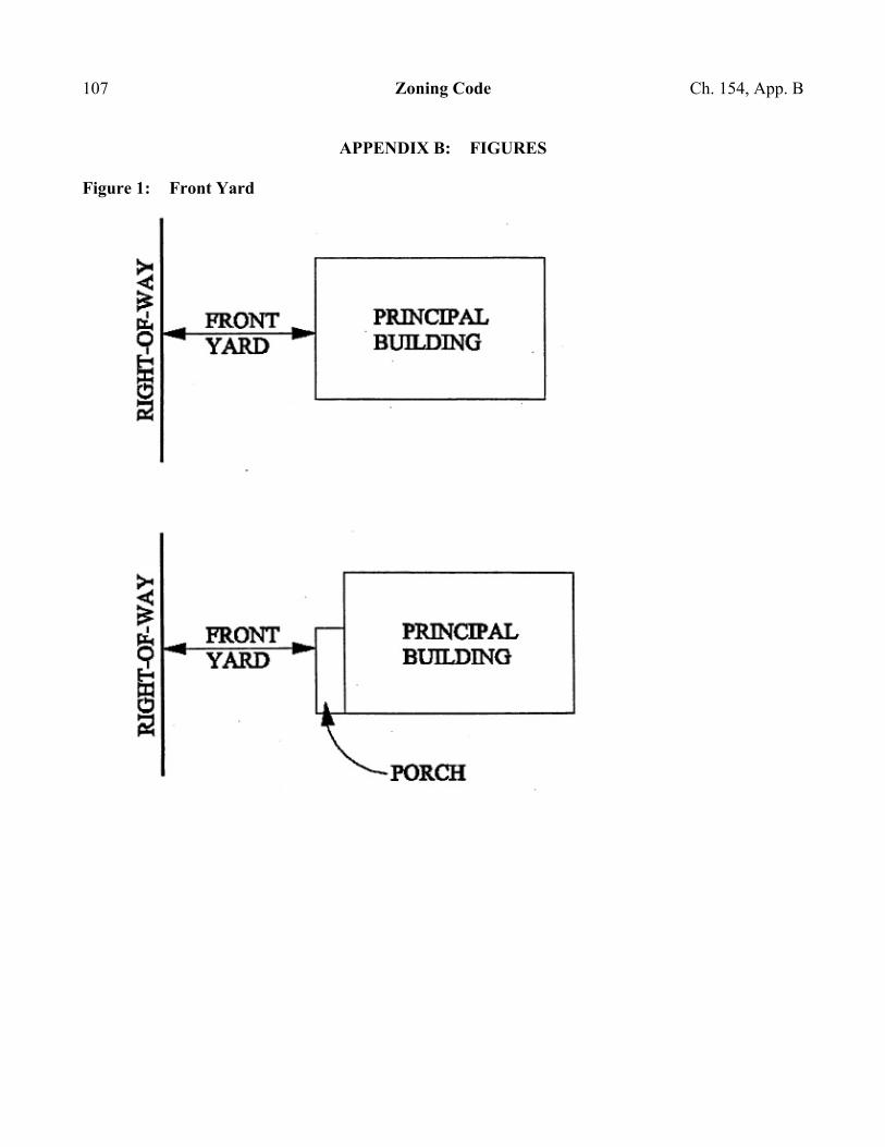
107 Zoning Code Ch. 154, App. B APPENDIX B: FIGURES Figure 1: Front Yard
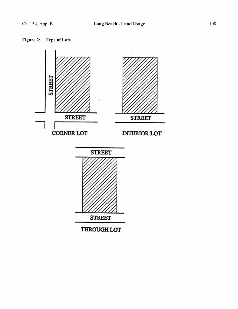
Ch. 154, App. B Long Beach - Land Usage 108 Figure 2: Type of Lots
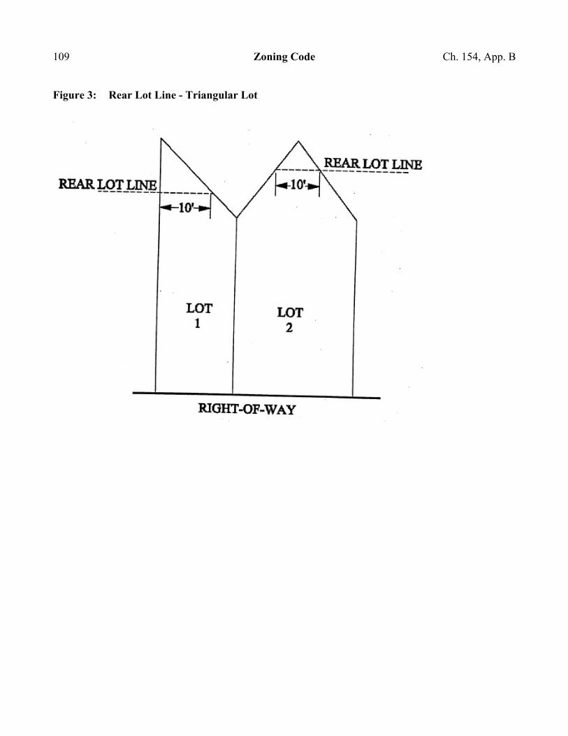
109 Zoning Code Ch. 154, App. B Figure 3: Rear Lot Line - Triangular Lot
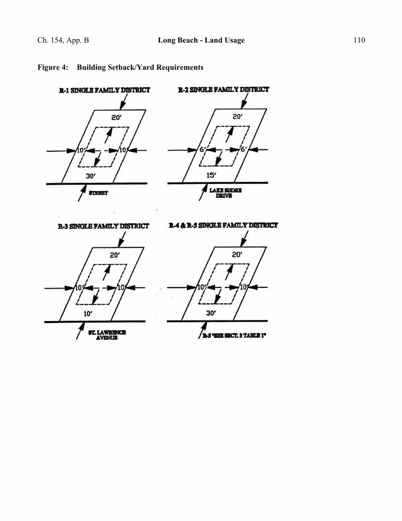
Ch. 154, App. B Long Beach - Land Usage 110 Figure 4: Building Setback/Yard Requirements
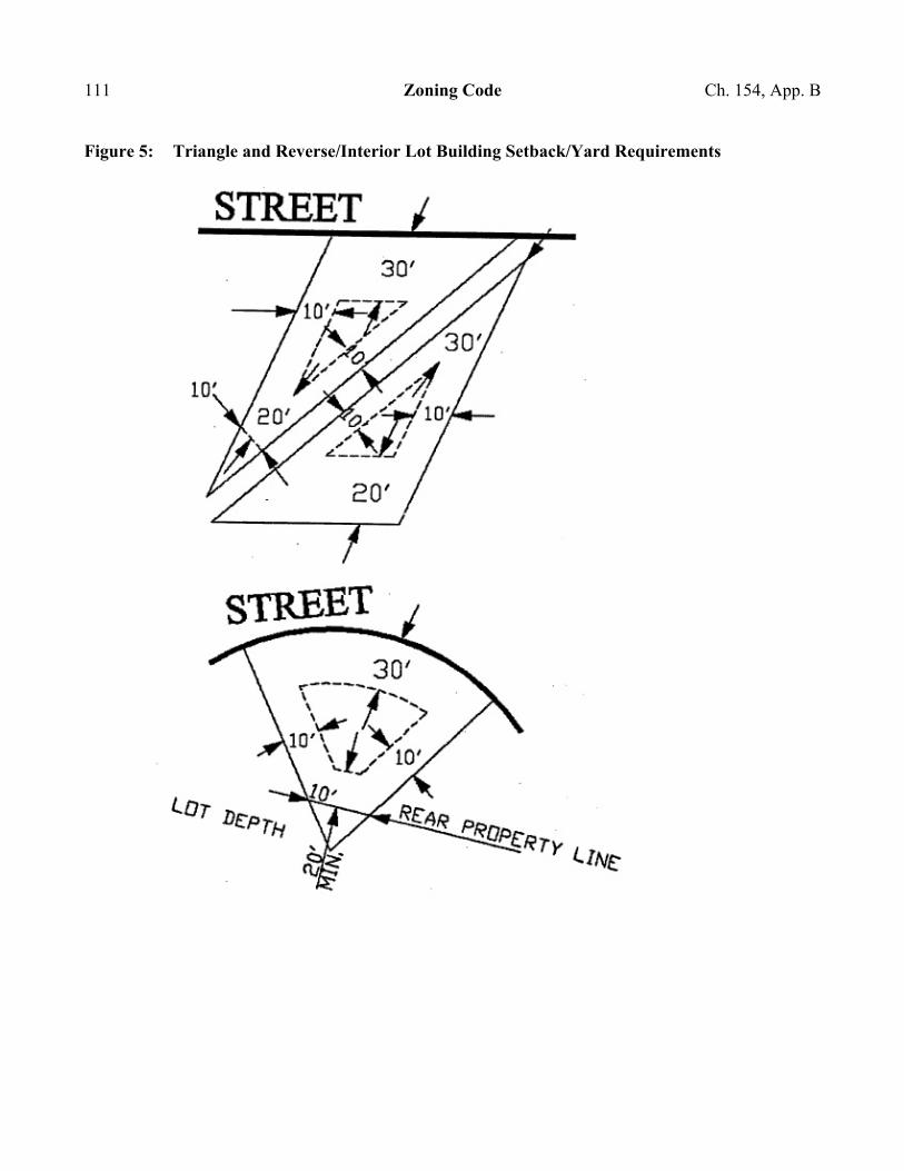
111 Zoning Code Ch. 154, App. B Figure 5: Triangle and Reverse/Interior Lot Building Setback/Yard Requirements
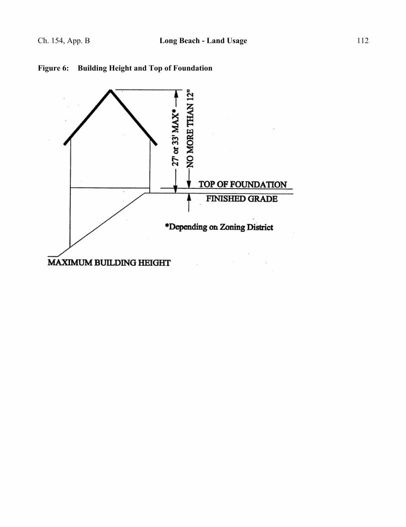
Ch. 154, App. B Long Beach - Land Usage 112 Figure 6: Building Height and Top of Foundation

113 Zoning Code Ch. 154, App. B Figure 7: Vision Clearance on Corner Lots
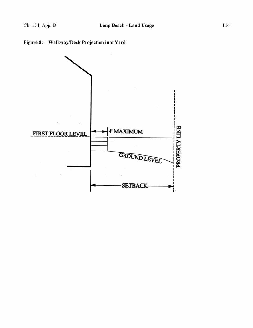
Ch. 154, App. B Long Beach - Land Usage 114 Figure 8: Walkway/Deck Projection into Yard
CHAPTER 155: FLOOD HAZARD AREAS Section Preliminary Provisions
155.01 Statutory authorization 155.02 Findings of fact 155.03 Statement of purpose 155.04 Objectives 155.05 Definitions
General Provisions
155.15 Lands to which this chapter applies 155.16 Basis for establishing regulatory flood data 155.17 Establishment of floodplain development permit 155.18 Compliance 155.19 Abrogation and greater restrictions 155.20 Discrepancy between mapped floodplain and actual ground elevations 155.21 Interpretation 155.22 Warning; disclaimer of liability 155.23 Increased cost of compliance (ICC)
Administration
155.35 Designation of Administrator 155.36 Permit procedures 155.37 Duties and responsibilities of Floodplain Administrator
Provisions for Flood Hazard Reduction
155.50 General standards 155.51 Specific standards 155.52 Standards for subdivision proposals 155.53 Critical facility 155.54 Standards for identified floodways 155.55 Standards for identified fringe
115
' 155.01 Long Beach - Land Usage 116
155.56 Standards for SFHAs without established base flood elevation and/or floodways/fringes 155.57 Standards for flood prone areas
Variance Procedures
155.70 Designation of Variance and Appeals Board 155.71 Duties of Variance and Appeals Board 155.72 Variance procedures 155.73 Conditions for variances 155.74 Variance notification 155.75 Historic structure 155.76 Special conditions
155.99 Penalty
PRELIMINARY PROVISIONS ' 155.01 STATUTORY AUTHORIZATION.
The Indiana Legislature has in IC 36-7-4 and IC 14-28-4 granted the power to local government units to control land use within their jurisdictions. Therefore, the Town Council of the Town of Long Beach does hereby adopt the following floodplain management regulations. (Ord. 13-002, passed 10-14-13) ' 155.02 FINDINGS OF FACT.
(A) The flood hazard areas of the Town of Long Beach are subject to periodic inundation which results in loss of life and property, health and safety hazards, disruption of commerce and governmental services, extraordinary public expenditures for flood protection and relief, and impairment of the tax base, all of which adversely affect the public health, safety, and general welfare.
(B) These flood losses are caused by the cumulative effect of obstructions in floodplains causing increases in flood heights and velocities, and by the occupancy in flood hazard areas by uses vulnerable to floods or hazardous to other lands which are inadequately elevated, floodproofed, or otherwise unprotected from flood damages. (Ord. 13-002, passed 10-14-13)
117 Flood Hazard Areas ' 155.04 ' 155.03 STATEMENT OF PURPOSE.
It is the purpose of this chapter to promote the public health, safety, and general welfare and to minimize public and private losses due to flood conditions in specific areas by provisions designed to:
(A) Restrict or prohibit uses which are dangerous to health, safety, and property due to water or erosion hazards, which result in damaging increases in erosion or in flood heights or velocities.
(B) Require that uses vulnerable to floods, including facilities which serve such uses, be protected against flood damage at the time of initial construction.
(C) Control the alteration of natural floodplains, stream channels, and natural protective barriers which are involved in the accommodation of floodwaters.
(D) Control filling, grading, dredging, and other development which may increase erosion or flood damage.
(E) Prevent or regulate the construction of flood barriers which will unnaturally divert floodwaters or which may increase flood hazards to other lands.
(F) Make federally subsidized flood insurance available for structures and their contents in the town by fulfilling the requirements of the National Flood Insurance Program. (Ord. 13-002, passed 10-14-13) ' 155.04 OBJECTIVES.
The objectives of this chapter are:
(A) To protect human life and health.
(B) To minimize expenditure of public money for costly flood control projects.
(C) To minimize the need for rescue and relief efforts associated with flooding and generally undertaken at the expense of the general public.
(D) To minimize prolonged business interruptions.
(E) To minimize damage to public facilities and utilities such as water and gas mains, electric, telephone, and sewer lines, streets, and bridges located in floodplains.
' 155.05 Long Beach - Land Usage 118
(F) To help maintain a stable tax base by providing for the sound use and development of flood prone areas in such a manner as to minimize flood blight areas.
(G) To ensure that potential homebuyers are notified that property is in a flood area. (Ord. 13-002, passed 10-14-13) ' 155.05 DEFINITIONS.
For the purpose of this chapter, the following definitions shall apply unless the context clearly indicates or requires a different meaning. Unless specifically defined below, words or phrases used in this chapter shall be interpreted so as to give them the meaning they have in common usage and to give this chapter its most reasonable application.
A ZONE. Portions of the SFHA in which the principal source of flooding is runoff from rainfall, snowmelt, or a combination of both. In A ZONES, floodwaters may move slowly or rapidly, but waves are usually not a significant threat to buildings. These areas are labeled as Zone A, Zone AE, Zones A1-A30, Zone AO, Zone AH, Zone AR and Zone A99 on a FIRM or FHBM. The definitions are presented below:
ZONE A. Areas subject to inundation by the 1% annual chance flood event. Because detailed hydraulic analyses have not been performed, no base flood elevation or depths are shown. Mandatory flood insurance purchase requirements apply.
ZONE AE AND A1-A30. Areas subject to inundation by the 1% annual chance flood event determined by detailed methods. Base flood elevations are shown within these zones. Mandatory flood insurance purchase requirements apply. (ZONE AE is on new and revised maps in place of ZONES A1-A30.)
ZONE AH. Areas subject to inundation by 1% annual chance shallow flooding (usually areas of ponding) where average depths are between one and three feet. Average flood depths derived from detailed hydraulic analyses are shown within this zone. Mandatory flood insurance purchase requirements apply.
ZONE AO. Areas subject to inundation by 1% annual chance shallow flooding (usually sheet flow on sloping terrain) where average depths are between one and three feet. Average flood depths derived from detailed hydraulic analyses are shown within this zone. Mandatory flood insurance purchase requirements apply.
ZONE AR. Areas that result from the decertification of a previously accredited flood protection system that is determined to be in the process of being restored to provide base flood protection. Mandatory flood insurance purchase requirements apply.
119 Flood Hazard Areas ' 155.05
ZONE A99. Areas subject to inundation by the 1% annual chance flood event, but which will ultimately be protected upon completion of an under-construction federal flood protection system. These are areas of special flood hazard where enough progress has been made on the construction of a protection system, such as dikes, dams, and levees, to consider it complete for insurance rating purposes. ZONE A99 may only be used when the flood protection system has reached specified statutory progress toward completion. No base flood elevations or depths are shown. Mandatory flood insurance purchase requirements apply.
ACCESSORY STRUCTURE (APPURTENANT STRUCTURE). A structure that is located on the same parcel of property as the principal structure and the use of which is incidental to the use of the principal structure. ACCESSORY STRUCTURES should constitute a minimal initial investment, may not be used for human habitation, and be designed to have minimal flood damage potential. Examples of ACCESSORY STRUCTURES are detached garages, carports, storage sheds, pole barns, and hay sheds.
ADDITION (TO AN EXISTING STRUCTURE). Any walled and roofed expansion to the perimeter of a structure in which the addition is connected by a common load-bearing wall other than a firewall. Any walled and roofed addition, which is connected by a firewall or is separated by independent perimeter load-bearing walls, is new construction.
APPEAL. A request for a review of the Floodplain Administrator=s interpretation of any provision of this chapter or a request for a variance.
AREA OF SHALLOW FLOODING. A designated AO or AH Zone on the community=s Flood Insurance Rate Map (FIRM) with base flood depths from one to three feet where a clearly defined channel does not exist, where the path of flooding is unpredictable and indeterminate, and where velocity flow may be evident. Such flooding is characterized by ponding or sheet flow.
BASE FLOOD ELEVATION (BFE). The elevation of the 1% annual chance flood.
BASEMENT. That portion of a structure having its floor sub-grade (below ground level) on all sides.
BUILDING. See STRUCTURE.
COMMUNITY. A political entity that has the authority to adopt and enforce floodplain ordinances for the area under its jurisdiction.
COMMUNITY RATING SYSTEM (CRS). A program developed by the Federal Insurance Administration to provide incentives for those communities in the Regular Program that have gone beyond the minimum floodplain management requirements to develop extra measures to provide protection from flooding.
' 155.05 Long Beach - Land Usage 120
CRITICAL FACILITY. A facility for which even a slight chance of flooding might be too great. CRITICAL FACILITIES include, but are not limited to, schools, nursing homes, hospitals, police, fire, and emergency response installations, installations which produce, use or store hazardous materials or hazardous waste.
DEVELOPMENT.
(1) Any man-made change to improved or unimproved real estate including but not limited to:
(a) Construction, reconstruction, or placement of a structure or any addition to a structure;
(b) Installing a manufactured home on a site, preparing a site for a manufactured home or installing a recreational vehicle on a site for more than 180 days;
(c) Installing utilities, erection of walls and fences, construction of roads, or similar projects;
(d) Construction of flood control structures such as levees, dikes, dams, channel improvements, etc.;
(e) Mining, dredging, filling, grading, excavation, or drilling operations;
(f) Construction and/or reconstruction of bridges or culverts;
(g) Storage of materials; or
(h) Any other activity that might change the direction, height, or velocity of flood or surface waters.
(2) DEVELOPMENT does not include activities such as the maintenance of existing structures and facilities such as painting, re-roofing; resurfacing roads; or gardening, plowing, and similar agricultural practices that do not involve filling, grading, excavation, or the construction of permanent structures.
ELEVATED STRUCTURE. A non-basement structure built to have the lowest floor elevated above the ground level by means of fill, solid foundation perimeter walls, filled stem wall foundations (also called chain walls), pilings, or columns (posts and piers).
ELEVATION CERTIFICATE. A certified statement that verifies a structure=s elevation information.
121 Flood Hazard Areas ' 155.05
EMERGENCY PROGRAM. The first phase under which a community participates in the NFIP. It is intended to provide a first layer amount of insurance at subsidized rates on all insurable structures in that community before the effective date of the initial FIRM.
ENCROACHMENT. The advance or infringement of uses, fill, excavation, buildings, permanent structures or development into a floodplain, which may impede or alter the flow capacity of a floodplain.
EXISTING CONSTRUCTION. Any structure for which the Astart of construction@ commenced before the effective date of the community=s first floodplain ordinance.
EXISTING MANUFACTURED HOME PARK OR SUBDIVISION. A manufactured home park or subdivision for which the construction of facilities for servicing the lots on which the manufactured homes are to be affixed (including, at a minimum, the installation of utilities, the construction of streets, and either final site grading or the pouring of concrete pads) is completed before the effective date of the community=s first floodplain ordinance.
EXPANSION TO AN EXISTING MANUFACTURED HOME PARK OR SUBDIVISION. The preparation of additional sites by the construction of facilities for servicing the lots on which the manufactured homes are to be affixed (including the installation of utilities, the construction of streets, and either final site grading or the pouring of concrete pads).
FEMA. The Federal Emergency Management Agency.
FIVE-HUNDRED YEAR FLOOD (500-YEAR FLOOD). The flood that has a 0.2% chance of being equaled or exceeded in any year.
FLOOD. A general and temporary condition of partial or complete inundation of normally dry land areas from the overflow, the unusual and rapid accumulation, or the runoff of surface waters from any source.
FLOOD BOUNDARY AND FLOODWAY MAP (FBFM). An official map on which the Federal Emergency Management Agency (FEMA) or Federal Insurance Administration (FIA) has delineated the areas of flood hazards and regulatory floodway.
FLOOD HAZARD BOUNDARY MAP (FHBM). An official map of a community, issued by FEMA, where the boundaries of the areas of special flood hazard have been identified as Zone A.
FLOOD INSURANCE RATE MAP (FIRM). An official map of a community, on which FEMA has delineated both the areas of special flood hazard and the risk premium zones applicable to the community.
' 155.05 Long Beach - Land Usage 122
FLOOD INSURANCE STUDY (FIS). The official hydraulic and hydrologic report provided by FEMA. The report contains flood profiles, as well as the FIRM, FBFM (where applicable), and the water surface elevation of the base flood.
FLOOD PRONE AREA. Any land area acknowledged by a community as being susceptible to inundation by water from any source. (See FLOOD.)
FLOOD PROTECTION GRADE (FPG). The elevation of the regulatory flood plus two feet at any given location in the SFHA. (See FREEBOARD.)
FLOODPLAIN. The channel proper and the areas adjoining any wetland, lake, or watercourse which have been or hereafter may be covered by the regulatory flood. The FLOODPLAIN includes both the floodway and the fringe districts.
FLOODPLAIN MANAGEMENT. The operation of an overall program of corrective and preventive measures for reducing flood damage and preserving and enhancing, where possible, natural resources in the floodplain, including but not limited to emergency preparedness plans, flood control works, floodplain management regulations, and open space plans.
FLOODPLAIN MANAGEMENT REGULATIONS. This chapter and other zoning ordinances, subdivision regulations, building codes, health regulations, special purpose ordinances, and other applications of police power which control development in flood prone areas. This term describes federal, state, or local regulations in any combination thereof, which provide standards for preventing and reducing flood loss and damage. FLOODPLAIN MANAGEMENT REGULATIONS are also referred to as FLOODPLAIN REGULATIONS, FLOODPLAIN ORDINANCE, FLOOD DAMAGE PREVENTION ORDINANCE, and FLOODPLAIN MANAGEMENT REQUIREMENTS.
FLOODPROOFING (DRY FLOODPROOFING). A method of protecting a structure that ensures that the structure, together with attendant utilities and sanitary facilities, is watertight to the floodproofed design elevation with walls that are substantially impermeable to the passage of water. All structural components of these walls are capable of resisting hydrostatic and hydrodynamic flood forces, including the effects of buoyancy, and anticipated debris impact forces.
FLOODPROOFING CERTIFICATE. A form used to certify compliance for non-residential structures as an alternative to elevating structures to or above the FPG. This certification must be by a Registered Professional Engineer or Architect.
FLOODWAY. The channel of a river or stream and those portions of the floodplains adjoining the channel which are reasonably required to efficiently carry and discharge the peak flood flow of the regulatory flood of any river or stream.
123 Flood Hazard Areas ' 155.05
FREEBOARD. A factor of safety, usually expressed in feet above the BFE, which is applied for the purposes of floodplain management. It is used to compensate for the many unknown factors that could contribute to flood heights greater than those calculated for the base flood.
FRINGE. Those portions of the floodplain lying outside the floodway.
FUNCTIONALLY DEPENDENT FACILITY. A facility which cannot be used for its intended purpose unless it is located or carried out in close proximity to water, such as a docking or port facility necessary for the loading and unloading of cargo or passengers, shipbuilding, ship repair, or seafood processing facilities. The term does not include long-term storage, manufacture, sales, or service facilities.
HARDSHIP (AS RELATED TO VARIANCES OF THIS CHAPTER). The exceptional hardship that would result from a failure to grant the requested variance. The Town Council requires that the variance is exceptional, unusual, and peculiar to the property involved. Mere economic or financial hardship alone is NOT exceptional. Inconvenience, aesthetic considerations, physical handicaps, personal preferences, or the disapproval of one=s neighbors likewise cannot, as a rule, qualify as an exceptional hardship. All of these problems can be resolved through other means without granting a variance, even if the alternative is more expensive, or requires the property owner to build elsewhere or put the parcel to a different use than originally intended.
HIGHEST ADJACENT GRADE. The highest natural elevation of the ground surface, prior to the start of construction, next to the proposed walls of a structure.
HISTORIC STRUCTURE. Any structure individually listed on the National Register of Historic Places or the Indiana State Register of Historic Sites and Structures.
INCREASED COST OF COMPLIANCE (ICC). The cost to repair a substantially damaged structure that exceeds the minimal repair cost and that is required to bring a substantially damaged structure into compliance with the local flood damage prevention ordinance. Acceptable mitigation measures are elevation, relocation, demolition, or any combination thereof. All renewal and new business flood insurance policies with effective dates on or after June 1, 1997, will include ICC coverage.
LETTER OF MAP AMENDMENT (LOMA). An amendment to the currently effective FEMA map that establishes that a property is not located in a SFHA. A LOMA is only issued by FEMA.
LETTER OF MAP REVISION (LOMR). An official revision to the currently effective FEMA map. It is issued by FEMA and changes flood zones, delineations, and elevations.
' 155.05 Long Beach - Land Usage 124
LETTER OF MAP REVISION BASED ON FILL (LOMR-F). An official revision by letter to an effective NFIP map. A LOMR-F provides FEMA=s determination concerning whether a structure or parcel has been elevated on fill above the BFE and excluded from the SFHA.
LOWEST ADJACENT GRADE. The lowest elevation, after completion of construction, of the ground, sidewalk, patio, deck support, or basement entryway immediately next to the structure.
LOWEST FLOOR. The lowest of the following:
(1) The top of the lowest level of the structure;
(2) The top of the basement floor;
(3) The top of the garage floor, if the garage is the lowest level of the structure;
(4) The top of the first floor of a structure elevated on pilings or pillars;
(5) The top of the floor level of any enclosure, other than a basement, below an elevated structure where the walls of the enclosure provide any resistance to the flow of floodwaters unless:
(a) The walls are designed to automatically equalize the hydrostatic flood forces on the walls by allowing for the entry and exit of floodwaters by providing a minimum of two openings (in addition to doorways and windows) in a minimum of two exterior walls having a total net area of one square inch for every one square foot of enclosed area. The bottom of all such openings shall be no higher than one foot above the exterior grade or the interior grade immediately beneath each opening, whichever is higher; and
(b) Such enclosed space shall be usable solely for the parking of vehicles and building access.
MANUFACTURED HOME. A structure, transportable in one or more sections, which is built on a permanent chassis and is designed for use with or without a permanent foundation when attached to the required utilities. The term MANUFACTURED HOME does not include a RECREATIONAL VEHICLE.
MANUFACTURED HOME PARK OR SUBDIVISION. A parcel (or contiguous parcels) of land divided into two or more manufactured home lots for rent or sale.
MAP AMENDMENT. A change to an effective NFIP map that results in the exclusion from the SFHA of an individual structure or a legally described parcel of land that has been inadvertently included in the SFHA (i.e., no alterations of topography have occurred since the date of the first NFIP map that showed the structure or parcel to be within the SFHA).
125 Flood Hazard Areas ' 155.05
MAP PANEL NUMBER. The four-digit number followed by a letter suffix assigned by FEMA on a flood map. The first four digits represent the map panel, and the letter suffix represents the number of times the map panel has been revised. (The letter AA@ is not used by FEMA, the letter AB@ is the first revision.)
MARKET VALUE. The building value, excluding the land (as agreed to between a willing buyer and seller), as established by what the local real estate market will bear. MARKET VALUE can be established by independent certified appraisal, replacement cost depreciated by age of building (actual cash value), or adjusted assessed values.
MITIGATION. Sustained actions taken to reduce or eliminate long-term risk to people and property from hazards and their effects. The purpose of MITIGATION is twofold: to protect people and structures, and to minimize the cost of disaster response and recovery.
NATIONAL FLOOD INSURANCE PROGRAM (NFIP). The federal program that makes flood insurance available to owners of property in participating communities nationwide through the cooperative efforts of the federal government and the private insurance industry.
NATIONAL GEODETIC VERTICAL DATUM (NGVD) OF 1929. As corrected in 1929, is a vertical control used as a reference for establishing varying elevations within the floodplain.
NEW CONSTRUCTION. Any structure for which the start of construction commenced after the effective date of the community=s first floodplain ordinance.
NEW MANUFACTURED HOME PARK OR SUBDIVISION. A manufactured home park or subdivision for which the construction of facilities for servicing the lots on which the manufactured homes are to be affixed (including at a minimum, the installation of utilities, the construction of streets, and either final site grading or the pouring of concrete pads) is completed on or after the effective date of the community=s first floodplain ordinance.
NORTH AMERICAN VERTICAL DATUM OF 1988 (NAVD 88). As adopted in 1993, is a vertical control datum used as a reference for establishing varying elevations within the floodplain.
OBSTRUCTION. Includes, but is not limited to, any dam, wall, wharf, embankment, levee, dike, pile, abutment, protection, excavation, canalization, bridge, conduit, culvert, building, wire, fence, rock, gravel, refuse, fill, structure, vegetation, or other material in, along, across or projecting into any watercourse which may alter, impede, retard or change the direction and/or velocity of the flow of water; or due to its location, its propensity to snare or collect debris carried by the flow of water, or its likelihood of being carried downstream.
ONE-HUNDRED YEAR FLOOD (100-YEAR FLOOD). The flood that has a 1% chance of being equaled or exceeded in any given year. Any flood zone that begins with the letter A is subject to the 1% annual chance flood. See REGULATORY FLOOD.
' 155.05 Long Beach - Land Usage 126
ONE-PERCENT (1%) ANNUAL CHANCE FLOOD. The flood that has a 1% chance of being equaled or exceeded in any given year. Any flood zone that begins with the letter A is subject to the 1% ANNUAL CHANCE FLOOD. See REGULATORY FLOOD.
PARTICIPATING COMMUNITY. Any community that voluntarily elects to participate in the NFIP by adopting and enforcing floodplain management regulations that are consistent with the standards of the NFIP.
PHYSICAL MAP REVISION (PMR). An official republication of a community=s FEMA map to effect changes to base (1% annual chance) flood elevations, floodplain boundary delineations, regulatory floodways, and planimetric features. These changes typically occur as a result of structural works or improvements, annexations resulting in additional flood hazard areas, or correction to base flood elevations or SFHAs.
POST-FIRM CONSTRUCTION. Construction or substantial improvement that started on or after the effective date of the initial FIRM of the community or after December 31, 1974, whichever is later.
PRE-FIRM CONSTRUCTION. Construction or substantial improvement, which started on or before December 31, 1974, or before the effective date of the initial FIRM of the community, whichever is later.
PROBATION. A means of formally notifying participating communities of violations and deficiencies in the administration and enforcement of the local floodplain management regulations.
PUBLIC SAFETY AND NUISANCE. Anything which is injurious to the safety or health of an entire community, neighborhood or any considerable number of persons, or unlawfully obstructs the free passage or use, in the customary manner, of any navigable lake, or river, bay, stream, canal, or basin.
RECREATIONAL VEHICLE. A vehicle which is:
(1) Built on a single chassis;
(2) Four hundred square feet or less when measured at the largest horizontal projections;
(3) Designed to be self-propelled or permanently towable by a light duty truck; and
(4) Designed primarily not for use as a permanent dwelling, but as quarters for recreational camping, travel, or seasonal use.
REGULAR PROGRAM. The phase of the community=s participation in the NFIP where more comprehensive floodplain management requirements are imposed and higher amounts of insurance are available based upon risk zones and elevations determined in a FIS.
127 Flood Hazard Areas ' 155.05
REGULATORY FLOOD. The flood having a 1% chance of being equaled or exceeded in any given year, as calculated by a method and procedure that is acceptable to and approved by the Indiana Department of Natural Resources and the Federal Emergency Management Agency. The regulatory flood elevation at any location is as defined in ' 155.16 of this chapter. The REGULATORY FLOOD is also known by the term BASE FLOOD, ONE-PERCENT (1%) ANNUAL CHANCE FLOOD, and 100-YEAR FLOOD.
REPETITIVE LOSS. Flood-related damages sustained by a structure on two separate occasions during a ten-year period ending on the date of the event for which the second claim is made, in which the cost of repairing the flood damage, on the average, equaled or exceeded 25% of the market value of the structure at the time of each such flood event.
SECTION 1316. That section of the National Flood Insurance Act of 1968, as amended, which states that no new flood insurance coverage shall be provided for any property that the Administrator finds has been declared by a duly constituted state or local zoning authority or other authorized public body to be in violation of state or local laws, regulations, or ordinances that intended to discourage or otherwise restrict land development or occupancy in flood prone areas.
SPECIAL FLOOD HAZARD AREA (SFHA). Those lands within the jurisdictions of the town subject to inundation by the regulatory flood. The SFHAs of the town are generally identified as such on the LaPorte County, Indiana and Incorporated Areas Flood Insurance Rate Map prepared by the Federal Emergency Management Agency, dated November 6, 2013. The SFHAs of those parts of unincorporated LaPorte County that are within the extraterritorial jurisdiction of the town or that may be annexed into the town are generally identified as such on the LaPorte County, Indiana and Incorporated Areas Flood Insurance Rate Map prepared by the Federal Emergency Management Agency and dated November 6, 2013. (These areas are shown on a FHBM or FIRM as Zone A, AE, A1- A30, AH, AR, A99, or AO.)
START OF CONSTRUCTION. Includes substantial improvement, and means the date the building permit was issued, provided the actual start of construction, repair, reconstruction, or improvement was within 180 days of the permit date. The ACTUAL START means either the first placement of permanent construction of a structure on a site, such as the pouring of a slab or footings, the installation of piles, the construction of columns, or any work beyond the stage of excavation; or the placement of a manufactured home on a foundation. Permanent construction does not include land preparation, such as clearing, grading and filling; nor does it include the installation of streets and/or walkways; nor does it include excavation for a basement, footings, piers, foundations, or the erection of temporary forms; nor does it include the installation on the property of accessory buildings, such as garages or sheds not occupied as dwelling units or not part of the main structure. For a substantial improvement, the ACTUAL START OF CONSTRUCTION means the first alteration of any wall, ceiling, floor, or other structural part of a building, whether or not that alteration affects the external dimensions of the building.
' 155.05 Long Beach - Land Usage 128
STRUCTURE. A structure that is principally above ground and is enclosed by walls and a roof. The term includes a gas or liquid storage tank, a manufactured home, or a prefabricated building. The term also includes recreational vehicles to be installed on a site for more than 180 days.
SUBSTANTIAL DAMAGE. Damage of any origin sustained by a structure whereby the cost of restoring the structure to its before damaged condition would equal or exceed 50% of the market value of the structure before the damage occurred.
SUBSTANTIAL IMPROVEMENT. Any reconstruction, rehabilitation, addition, or other improvement of a structure, the cost of which equals or exceeds 50% of the market value of the structure before the start of construction of the improvement. This term includes structures that have incurred repetitive loss or substantial damage regardless of the actual repair work performed. The term does not include improvements of structures to correct existing violations of state or local health, sanitary, or safety code requirements or any alteration of a historic structure, provided that the alteration will not preclude the structure=s continued designation as a historic structure.
SUSPENSION. The removal of a participating community from the NFIP because the community has not enacted and/or enforced the proper floodplain management regulations required for participation in the NFIP.
VARIANCE. A grant of relief from the requirements of this chapter, which permits construction in a manner otherwise prohibited by this chapter where specific enforcement would result in unnecessary hardship.
VIOLATION. The failure of a structure or other development to be fully compliant with this chapter. A structure or other development without the elevation, other certification, or other evidence of compliance required in this chapter is presumed to be in VIOLATION until such time as that documentation is provided.
WATER SURFACE ELEVATION. The height, in relation to the North American Vertical Datum of 1988 (NAVD 88) or National Geodetic Vertical Datum of 1929 (NGVD) (other datum where specified) of floods of various magnitudes and frequencies in the floodplains of riverine areas.
WATERCOURSE. A lake, river, creek, stream, wash, channel or other topographic feature on or over which waters flow at least periodically. WATERCOURSE includes specifically designated areas in which substantial flood damage may occur.
X ZONE. The area where the flood hazard is less than that in the SFHA. Shaded X ZONES shown on recent FIRMs (B zones on older FIRMs) designate areas subject to inundation by the flood with a 0.2% chance of being equaled or exceeded (the 500-year flood). Unshaded X ZONES (C zones on older FIRMs) designate areas where the annual exceedance probability of flooding is less than 0.2%.
129 Flood Hazard Areas ' 155.16
ZONE. A geographical area shown on a FHBM or FIRM that reflects the severity or type of flooding in the area.
ZONE A. (See definition for A ZONE.)
ZONE B, C, AND X. Areas identified in the community as areas of moderate or minimal hazard from the principal source of flood in the area. However, buildings in these zones could be flooded by severe, concentrated rainfall coupled with inadequate local drainage systems. Flood insurance is available in participating communities but is not required by regulation in these zones. (ZONE X is used on new and revised maps in place of ZONES B AND C.) (Ord. 13-002, passed 10-14-13) GENERAL PROVISIONS ' 155.15 LANDS TO WHICH THIS CHAPTER APPLIES.
This chapter shall apply to all SFHAs and known flood prone areas within the jurisdiction of Long Beach. (Ord. 13-002, passed 10-14-13) ' 155.16 BASIS FOR ESTABLISHING REGULATORY FLOOD DATA.
(A) This chapter=s protection standard is the regulatory flood. The best available regulatory flood data is listed below. Whenever a party disagrees with the best available data, the party submitting the detailed engineering study needs to replace existing data with better data and submit it to the Indiana Department of Natural Resources for review and approval.
(B) (1) The regulatory flood elevation, floodway, and fringe limits for the studied SFHAs within the jurisdiction of the town shall be as delineated on the 1% annual chance flood profiles in the Flood Insurance Study of LaPorte County, Indiana and Incorporated Areas dated November 6, 2013 and the corresponding Flood Insurance Rate Map prepared by the Federal Emergency Management Agency and dated November 6, 2013 as well as any future updates, amendments, or revisions, prepared by the Federal Emergency Management Agency with the most recent date.
(2) The regulatory flood elevation, floodway, and fringe limits for each of the SFHAs within the jurisdiction of the town, delineated as an AA Zone@ on the LaPorte County, Indiana and Incorporated Areas Flood Insurance Rate Map prepared by the Federal Emergency Management Agency and dated November 6, 2013 as well as any future updates, amendments, or revisions, shall be according to the
' 155.17 Long Beach - Land Usage 130 best data available as provided by the Indiana Department of Natural Resources; provided the upstream drainage area from the subject site is greater than one square mile.
(3) In the absence of a published FEMA map, or absence of identification on a FEMA map, the regulatory flood elevation, floodway, and fringe limits of any watercourse in the community=s known flood prone areas shall be according to the best data available as provided by the Indiana Department of Natural Resources; provided the upstream drainage area from the subject site is greater than one square mile. (Ord. 13-002, passed 10-14-13) ' 155.17 ESTABLISHMENT OF FLOODPLAIN DEVELOPMENT PERMIT.
A floodplain development permit shall be required in conformance with the provisions of this chapter prior to the commencement of any development activities in areas of special flood hazard. (Ord. 13-002, passed 10-14-13) Penalty, see ' 155.99 ' 155.18 COMPLIANCE.
No structure shall hereafter be located, extended, converted or structurally altered within the SFHA without full compliance with the terms of this chapter and other applicable regulations. No land or stream within the SFHA shall hereafter be altered without full compliance with the terms of this chapter and other applicable regulations. (Ord. 13-002, passed 10-14-13) Penalty, see ' 155.99 ' 155.19 ABROGATION AND GREATER RESTRICTIONS.
This chapter is not intended to repeal, abrogate, or impair any existing easements, covenants, or deed restrictions. However, where this chapter and another ordinance conflict or overlap, whichever imposes the more stringent restrictions shall prevail. (Ord. 13-002, passed 10-14-13) ' 155.20 DISCREPANCY BETWEEN MAPPED FLOODPLAIN AND ACTUAL GROUND ELEVATIONS.
(A) In cases where there is a discrepancy between the mapped floodplain (SFHA) on the FIRM and the actual ground elevations, the elevation provided on the profiles shall govern.
131 Flood Hazard Areas ' 155.23
(B) If the elevation of the site in question is below the base flood elevation, that site shall be included in the SFHA and regulated accordingly.
(C) If the elevation (natural grade) of the site in question is above the base flood elevation, that site shall be considered outside the SFHA and the floodplain regulations will not be applied. The property owner should be advised to apply for a LOMA. (Ord. 13-002, passed 10-14-13) ' 155.21 INTERPRETATION.
In the interpretation and application of this chapter all provisions shall be:
(A) Considered as minimum requirements.
(B) Liberally construed in favor of the governing body.
(C) Deemed neither to limit nor repeal any other powers granted under state statutes. (Ord. 13-002, passed 10-14-13) ' 155.22 WARNING; DISCLAIMER OF LIABILITY.
The degree of flood protection required by this chapter is considered reasonable for regulatory purposes and is based on available information derived from engineering and scientific methods of study. Larger floods can and will occur on rare occasions. Therefore, this chapter does not create any liability on the part of Long Beach, the Indiana Department of Natural Resources, or the State of Indiana, for any flood damage that results from reliance on this chapter or any administrative decision made lawfully thereunder. (Ord. 13-002, passed 10-14-13) ' 155.23 INCREASED COST OF COMPLIANCE (ICC).
In order for buildings to qualify for a claim payment under ICC coverage as a Arepetitive loss structure,@ the National Reform Act of 1994 requires that the building be covered by a contract for flood insurance and incur flood-related damages on two occasions during a ten-year period ending on the date of the event for which the second claim is made, in which the cost of repairing the flood damage, on the average, equaled or exceeded 25% of the market value of the building at the time of each such flood event. (Ord. 13-002, passed 10-14-13)
' 155.35 Long Beach - Land Usage 132 ADMINISTRATION ' 155.35 DESIGNATION OF ADMINISTRATOR.
The Town Council hereby appoints the Building Commissioner to administer and implement the provisions of this chapter and is herein referred to as the Floodplain Administrator. (Ord. 13-002, passed 10-14-13) ' 155.36 PERMIT PROCEDURES.
(A) Application for a floodplain development permit shall be made to the Floodplain Administrator on forms furnished by him or her prior to any development activities, and may include, but not be limited to, the following: plans in duplicate drawn to scale showing the nature, location, dimensions, and elevations of the area in question; existing or proposed structures, earthen fill, storage of materials or equipment, drainage facilities, and the location of the foregoing.
(B) Specifically, the following information is required:
(1) Application stage.
(a) A description of the proposed development.
(b) Location of the proposed development sufficient to accurately locate property and structure in relation to existing roads and streams.
(c) A legal description of the property site.
(d) A site development plan showing existing and proposed development locations and existing and proposed land grades.
(e) Elevation of the top of the lowest floor (including basement) of all proposed buildings. Elevation should be in NAVD 88 or NGVD.
(f) Elevation (in NAVD 88 or NGVD) to which any non-residential structure will be floodproofed.
(g) Description of the extent to which any watercourse will be altered or relocated as a result of proposed development.
133 Flood Hazard Areas ' 155.37
(2) Construction stage. Upon placement of the lowest floor, or floodproofing, it shall be the duty of the permit holder to submit to the Floodplain Administrator a certification of the NAVD 88 or NGVD elevation of the lowest floor or floodproofed elevation, as built. Said certification shall be prepared by or under the direct supervision of a registered land surveyor or professional engineer and certified by the same. When floodproofing is utilized for a particular structure said certification shall be prepared by or under the direct supervision of a professional engineer or architect and certified by same. Any work undertaken prior to submission of the certification shall be at the permit holders= risk. (The Floodplain Administrator shall review the lowest floor and floodproofing elevation survey data submitted.) The permit holder shall correct deficiencies detected by such review before any further work is allowed to proceed. Failure to submit the survey or failure to make said corrections required hereby shall be cause to issue a stop-work order for the project. (Ord. 13-002, passed 10-14-13) Penalty, see ' 155.99 ' 155.37 DUTIES AND RESPONSIBILITIES OF FLOODPLAIN ADMINISTRATOR.
(A) The Floodplain Administrator and/or designated staff is hereby authorized and directed to enforce the provisions of this chapter. The Administrator is further authorized to render interpretations of this chapter, which are consistent with its spirit and purpose.
(B) Duties and responsibilities of the Floodplain Administrator shall include, but not be limited to:
(1) Review all floodplain development permits to assure that the permit requirements of this chapter have been satisfied.
(2) Inspect and inventory damaged structures in the SFHA and complete substantial damage determinations.
(3) Ensure that construction authorization has been granted by the Indiana Department of Natural Resources for all development projects subject to '' 155.54 and 155.56(A) of this chapter, and maintain a record of such authorization (either copy of actual permit or floodplain analysis/regulatory assessment).
(4) Ensure that all necessary federal or state permits have been received prior to issuance of the local floodplain development permit. Copies of such permits are to be maintained on file with the floodplain development permit.
(5) Notify adjacent communities and the State Floodplain Coordinator prior to any alteration or relocation of a watercourse, and submit copies of such notifications to FEMA.
(6) Maintain for public inspection and furnish upon request local permit documents, damaged structure inventories, substantial damage determinations, regulatory flood data, SFHA maps, letters of
' 155.37 Long Beach - Land Usage 134 map amendment (LOMA), letters of map revision (LOMR), copies of DNR permits and floodplain analysis and regulatory assessments (letters of recommendation), federal permit documents, and Aas-built@ elevation and floodproofing data for all buildings constructed subject to this chapter.
(7) Utilize and enforce all letters of map revision (LOMR) or physical map revisions (PMR) issued by FEMA for the currently effective SFHA maps of the community.
(8) Assure that maintenance is provided within the altered or relocated portion of said watercourse so that the flood-carrying capacity is not diminished.
(9) Verify and record the actual elevation of the lowest floor (including basement) of all new or substantially improved structures, in accordance with ' 155.36.
(10) Verify and record the actual elevation to which any new or substantially improved structures have been floodproofed in accordance with ' 155.36.
(11) Review certified plans and specifications for compliance.
(12) Stop work orders.
(a) Upon notice from the Floodplain Administrator, work on any building, structure or premises that is being done contrary to the provisions of this chapter shall immediately cease.
(b) Such notice shall be in writing and shall be given to the owner of the property, or to his agent, or to the person doing the work, and shall state the conditions under which work may be resumed.
(13) Revocation of permits.
(a) The Floodplain Administrator may revoke a permit or approval, issued under the provisions of the chapter, in cases where there has been any false statement or misrepresentation as to the material fact in the application or plans on which the permit or approval was based.
(b) The Floodplain Administrator may revoke a permit upon determination by the Floodplain Administrator that the construction, erection, alteration, repair, moving, demolition, installation, or replacement of the structure for which the permit was issued is in violation of, or not in conformity with, the provisions of this chapter.
(14) Inspect sites for compliance. For all new and/or substantially improved buildings constructed in the SFHA, inspect before, during and after construction. Authorized town officials shall have the right to enter and inspect properties located in the SFHA. (Ord. 13-002, passed 10-14-13)
135 Flood Hazard Areas ' 155.50 PROVISIONS FOR FLOOD HAZARD REDUCTION ' 155.50 GENERAL STANDARDS.
In all SFHAs and known flood prone areas the following provisions are required:
(A) New construction and substantial improvements shall be anchored to prevent flotation, collapse or lateral movement of the structure.
(B) Manufactured homes shall be anchored to prevent flotation, collapse, or lateral movement. Methods of anchoring may include, but are not limited to, use of over-the-top or frame ties to ground anchors. This standard shall be in addition to and consistent with applicable state requirements for resisting wind forces.
(C) New construction and substantial improvements shall be constructed with materials and utility equipment resistant to flood damage below the FPG.
(D) New construction and substantial improvements shall be constructed by methods and practices that minimize flood damage.
(E) Electrical, heating, ventilation, plumbing, air conditioning equipment, utility meters, and other service facilities shall be located at/above the FPG or designed so as to prevent water from entering or accumulating within the components below the FPG. Water and sewer pipes, electrical and telephone lines, submersible pumps, and other waterproofed service facilities may be located below the FPG.
(F) New and replacement water supply systems shall be designed to minimize or eliminate infiltration of floodwaters into the system.
(G) New and replacement sanitary sewage systems shall be designed to minimize or eliminate infiltration of floodwaters into the system.
(H) On-site waste disposal systems shall be located and constructed to avoid impairment to them or contamination from them during flooding.
(I) Any alteration, repair, reconstruction or improvements to a structure that is in compliance with the provisions of this chapter shall meet the requirements of new construction as contained in this chapter.
(J) Any alteration, repair, reconstruction or improvement to a structure that is not in compliance with the provisions of this chapter, shall be undertaken only if said non-conformity is not further extended, or replaced.
' 155.51 Long Beach - Land Usage 136
(K) Whenever any portion of the SFHA is authorized for use, the volume of space which will be occupied by the authorized fill or structure below the BFE shall be compensated for and balanced by an equivalent volume of excavation taken below the BFE. The excavation volume shall be at least equal to the volume of storage lost (replacement ratio of 1 to 1) due to the fill or structure.
(1) The excavation shall take place in the floodplain and in the same property in which the authorized fill or structure is located.
(2) Under certain circumstances, the excavation may be allowed to take place outside of but adjacent to the floodplain provided that the excavated volume will be below the regulatory flood elevation, will be in the same property in which the authorized fill or structure is located, will be accessible to the regulatory floodwater, will not be subject to ponding when not inundated by floodwater, and that it shall not be refilled.
(3) The excavation shall provide for true storage of floodwater but shall not be subject to ponding when not inundated by floodwater.
(4) The fill or structure shall not obstruct a drainage way leading to the floodplain.
(5) The grading around the excavation shall be such that the excavated area is accessible to the regulatory floodwater.
(6) The fill or structure shall be of a material deemed stable enough to remain firm and in place during periods of flooding and shall include provisions to protect adjacent property owners against any increased runoff or drainage resulting from its placement.
(7) Plans depicting the areas to be excavated and filled shall be submitted prior to the actual start of construction or any site work; once site work is complete, but before the actual start of construction, the applicant shall provide to the Floodplain Administrator a certified survey of the excavation and fill sites demonstrating the fill and excavation comply with this subchapter. (Ord. 13-002, passed 10-14-13) Penalty, see ' 155.99 ' 155.51 SPECIFIC STANDARDS.
In all SFHAs, the following provisions are required:
(A) General. In addition to the requirements of ' 155.50, all structures to be located in the SFHA shall be protected from flood damage below the FPG. This building protection requirement applies to the following situations:
(1) Construction or placement of any new structure having a floor area greater than 400 square feet.
137 Flood Hazard Areas ' 155.51
(2) Addition or improvement made to any existing structure:
(a) Where the cost of the addition or improvement equals or exceeds 50% of the value of the existing structure (excluding the value of the land).
(b) With a previous addition or improvement constructed since the community=s first floodplain ordinance.
(3) Reconstruction or repairs made to a damaged structure where the costs of restoring the structure to its before damaged condition equals or exceeds 50% of the market value of the structure (excluding the value of the land) before damage occurred.
(4) Installing a travel trailer or recreational vehicle on a site for more than 180 days.
(5) Installing a manufactured home on a new site or a new manufactured home on an existing site. This chapter does not apply to returning the existing manufactured home to the same site it lawfully occupied before it was removed to avoid flood damage.
(6) Reconstruction or repairs made to a repetitive loss structure.
(B) Residential construction. New construction or substantial improvement of any residential structure (or manufactured home) shall have the lowest floor; including basement, at or above the FPG (two feet above the base flood elevation). Should solid foundation perimeter walls be used to elevate a structure, openings sufficient to facilitate the unimpeded movements of floodwaters shall be provided in accordance with the standards of division (D) below.
(C) Non-residential construction. New construction or substantial improvement of any commercial, industrial, or non-residential structure (or manufactured home) shall either have the lowest floor, including basement, elevated to or above the FPG (two feet above the base flood elevation) or be floodproofed to or above the FPG. Should solid foundation perimeter walls be used to elevate a structure, openings sufficient to facilitate the unimpeded movements of floodwaters shall be provided in accordance with the standards of division (D) below. Structures located in all A Zones may be floodproofed in lieu of being elevated if done in accordance with the following:
(1) A registered professional engineer or architect shall certify that the structure has been designed so that below the FPG, the structure and attendant utility facilities are watertight and capable of resisting the effects of the regulatory flood. The structure design shall take into account flood velocities, duration, rate of rise, hydrostatic pressures, and impacts from debris or ice. Such certification shall be provided to the official as set forth in ' 155.37(B)(10).
(2) Floodproofing measures shall be operable without human intervention and without an outside source of electricity.
' 155.51 Long Beach - Land Usage 138
(D) Elevated structures.
(1) New construction or substantial improvements of elevated structures shall have the lowest floor at or above the FPG.
(2) Elevated structures with fully enclosed areas formed by foundation and other exterior walls below the flood protection grade shall be designed to preclude finished living space and designed to allow for the entry and exit of floodwaters to automatically equalize hydrostatic flood forces on exterior walls. Designs must meet the following minimum criteria:
(a) Provide a minimum of two openings located in a minimum of two exterior walls (having a total net area of not less than one square inch for every one square foot of enclosed area).
(b) The bottom of all openings shall be no more than one foot above the exterior grade or the interior grade immediately beneath each opening, whichever is higher.
(c) Openings may be equipped with screens, louvers, valves or other coverings or devices provided they permit the automatic flow of floodwaters in both directions.
(d) Openings are to be not less than three inches in any direction in the plane of the wall. This requirement applies to the hole in the wall, excluding any device that may be inserted such as typical foundation air vent device.
(e) Access to the enclosed area shall be the minimum necessary to allow for parking for vehicles (garage door) or limited storage of maintenance equipment used in connection with the premises (standard exterior door) or entry to the living area (stairway or elevator).
(f) The interior portion of such enclosed area shall not be partitioned or finished into separate rooms.
(g) The interior grade of such enclosed area shall be at an elevation at or higher than the exterior grade.
(h) Where elevation requirements exceed six feet above the highest adjacent grade, a copy of the legally recorded deed restriction prohibiting the conversion of the area below the lowest floor to a use or dimension contrary to the structure=s originally approved design, shall be presented as a condition of issuance of the final certificate of occupancy.
(E) Structures constructed on fill. A residential or nonresidential structure may be constructed on a permanent land fill in accordance with the following:
139 Flood Hazard Areas ' 155.51
(1) The fill shall be placed in layers no greater than one foot deep before compacting to 95% of the maximum density obtainable with either the Standard or Modified Proctor Test method.
(2) The fill should extend at least ten feet beyond the foundation of the structure before sloping below the FPG.
(3) The fill shall be protected against erosion and scour during flooding by vegetative cover, riprap, or bulkheading. If vegetative cover is used, the slopes shall be no steeper than three horizontal to one vertical.
(4) The fill shall not adversely affect the flow of surface drainage from or onto neighboring properties.
(5) The top of the lowest floor including basements shall be at or above the FPG.
(F) Standards for manufactured homes and recreational vehicles. Manufactured homes and recreational vehicles to be installed or substantially improved on a site for more than 180 days must meet one of the following requirements:
(1) The manufactured home shall be elevated on a permanent foundation such that the lowest floor shall be at or above the FPG and securely anchored to an adequately anchored foundation system to resist flotation, collapse, and lateral movement. This requirement applies to all manufactured homes to be placed on a site:
(a) Outside a manufactured home park or subdivision;
(b) In a new manufactured home park or subdivision;
(c) In an expansion to an existing manufactured home park or subdivision; or
(d) In an existing manufactured home park or subdivision on which a manufactured home has incurred substantial damage as a result of a flood.
(2) The manufactured home shall be elevated so that the lowest floor of the manufactured home chassis is supported by reinforced piers or other foundation elevations that are no less than 36 inches in height above grade and be securely anchored to an adequately anchored foundation system to resist flotation, collapse, and lateral movement. This requirement applies to all manufactured homes to be placed on a site in an existing manufactured home park or subdivision that has not been substantially damaged by a flood.
(3) Manufactured homes with fully enclosed areas formed by foundation and other exterior walls below the flood protection grade shall be designed to preclude finished living space and designed
' 155.52 Long Beach - Land Usage 140 to allow for the entry and exit of floodwaters to automatically equalize hydrostatic flood forces on exterior walls as required for elevated structures in division (D) above.
(4) Flexible skirting and rigid skirting not attached to the frame or foundation of a manufactured home are not required to have openings.
(5) Recreational vehicles placed on a site shall either:
(a) Be on site for less than 180 days; and
(b) Be fully licensed and ready for highway use (defined as being on its wheels or jacking system, is attached to the site only by quick disconnect type utilities and security devices, and has no permanently attached additions); or
(c) Meet the requirements for manufactured homes as stated earlier in this section. (Ord. 13-002, passed 10-14-13) Penalty, see ' 155.99 ' 155.52 STANDARDS FOR SUBDIVISION PROPOSALS.
(A) All subdivision proposals shall be consistent with the need to minimize flood damage.
(B) All subdivision proposals shall have public utilities and facilities such as sewer, gas, electrical, and water systems located and constructed to minimize flood damage.
(C) All subdivision proposals shall have adequate drainage provided to reduce exposure to flood hazards.
(D) Base flood elevation data shall be provided for subdivision proposals and other proposed development (including manufactured home parks and subdivisions), which is greater than the lesser of 50 lots or five acres.
(E) All subdivision proposals shall minimize development in the SFHA and/or limit density of development permitted in the SFHA.
(F) All subdivision proposals shall ensure safe access into/out of SFHA for pedestrians and vehicles (especially emergency responders). (Ord. 13-002, passed 10-14-13) Penalty, see ' 155.99
141 Flood Hazard Areas ' 155.54 ' 155.53 CRITICAL FACILITY.
Construction of new critical facilities shall be, to the extent possible, located outside the limits of the SFHA. Construction of new critical facilities shall be permissible within the SFHA if no feasible alternative site is available. Critical facilities constructed within the SFHA shall have the lowest floor elevated to or above the FPG at the site. Floodproofing and sealing measures must be taken to ensure that toxic substances will not be displaced by or released into floodwaters. Access routes elevated to or above the FPG shall be provided to all critical facilities to the extent possible. (Ord. 13-002, passed 10-14-13) Penalty, see ' 155.99 ' 155.54 STANDARDS FOR IDENTIFIED FLOODWAYS.
(A) Located within SFHAs, established in ' 155.16, are areas designated as floodways. The floodway is an extremely hazardous area due to the velocity of floodwaters, which carry debris, potential projectiles, and has erosion potential. If the site is in an identified floodway, the Floodplain Administrator shall require the applicant to forward the application, along with all pertinent plans and specifications, to the Indiana Department of Natural Resources and apply for a permit for construction in a floodway. Under the provisions of IC 14-28-1, a permit for construction in a floodway from the Indiana Department of Natural Resources is required prior to the issuance of a local building permit for any excavation, deposit, construction, or obstruction activity located in the floodway. This includes land preparation activities such as filling, grading, clearing and paving, etc., undertaken before the actual start of construction of the structure. However, it does exclude non-substantial additions/improvements to existing (lawful) residences in a non-boundary river floodway. (IC 14-28-1-26 allows construction of non-substantial additions/improvements to residences in a non-boundary river floodway without obtaining a permit for construction in the floodway from the Indiana Department of Natural Resources. Please note that if fill is needed to elevate an addition above the existing grade, prior approval (construction in a floodway permit) for the fill is required from the Indiana Department of Natural Resources.)
(B) No action shall be taken by the Floodplain Administrator until a permit (when applicable) has been issued by the Indiana Department of Natural Resources granting approval for construction in the floodway. Once a permit for construction in a floodway has been issued by the Indiana Department of Natural Resources, the Floodplain Administrator may issue the local floodplain development permit, provided the provisions contained in this subchapter have been met. The floodplain development permit cannot be less restrictive than the permit for construction in a floodway issued by the Indiana Department of Natural Resources. However, a community=s more restrictive regulations (if any) shall take precedence.
(C) No development shall be allowed which acting alone or in combination with existing or future development, will increase the regulatory flood more than 0.14 of one foot.
' 155.55 Long Beach - Land Usage 142
(D) For all projects involving channel modifications or fill (including levees) the town shall submit the data and request that the Federal Emergency Management Agency revise the regulatory flood data. (Ord. 13-002, passed 10-14-13) Penalty, see ' 155.99 ' 155.55 STANDARDS FOR IDENTIFIED FRINGE.
If the site is located in an identified fringe, then the Floodplain Administrator may issue the local floodplain development permit provided the provisions contained in this subchapter have been met. The key provision is that the top of the lowest floor of any new or substantially improved structure shall be at or above the FPG. (Ord. 13-002, passed 10-14-13) Penalty, see ' 155.99 ' 155.56 STANDARDS FOR SFHAS WITHOUT ESTABLISHED BASE FLOOD ELEVATION AND/OR FLOODWAYS/FRINGES.
(A) Drainage area upstream of the site is greater than one square mile.
(1) If the site is in an identified floodplain where the limits of the floodway and fringe have not yet been determined, and the drainage area upstream of the site is greater than one square mile, the Floodplain Administrator shall require the applicant to forward the application, along with all pertinent plans and specifications, to the Indiana Department of Natural Resources for review and comment.
(2) No action shall be taken by the Floodplain Administrator until either a permit for construction in a floodway or a floodplain analysis/regulatory assessment citing the one-percent annual chance flood elevation and the recommended flood protection grade has been received from the Indiana Department of Natural Resources.
(3) Once the Floodplain Administrator has received the proper permit for construction in a floodway or floodplain analysis/regulatory assessment approving the proposed development, a floodplain development permit may be issued provided the conditions of the floodplain development permit are not less restrictive than the conditions received from the Indiana Department of Natural Resources and the provisions contained in this subchapter have been met.
(B) Drainage area upstream of the site is less than one square mile.
(1) If the site is in an identified floodplain where the limits of the floodway and fringe have not yet been determined and the drainage area upstream of the site is less than one square mile, the Floodplain Administrator shall require the applicant to provide an engineering analysis showing the limits of the floodplain and 1% annual chance flood elevation for the site.
143 Flood Hazard Areas ' 155.72
(2) Upon receipt, the Floodplain Administrator may issue the local floodplain development permit, provided the provisions contained in this subchapter have been met.
(C) Cumulative effect. The total cumulative effect of the proposed development, when combined with all other existing and anticipated development, will not increase the regulatory flood more than 0.14 of one foot and will not increase flood damages or potential flood damages. (Ord. 13-002, passed 10-14-13) Penalty, see ' 155.99 ' 155.57 STANDARDS FOR FLOOD PRONE AREAS.
All development in known flood prone areas not identified on FEMA maps, or where no FEMA published map is available, shall meet applicable standards as required per this subchapter. (Ord. 13-002, passed 10-14-13) Penalty, see ' 155.99 VARIANCE PROCEDURES ' 155.70 DESIGNATION OF VARIANCE AND APPEALS BOARD.
The Board of Zoning Appeals shall hear and decide appeals and requests for variances from requirements of this chapter. (Ord. 13-002, passed 10-14-13) ' 155.71 DUTIES OF VARIANCE AND APPEALS BOARD.
The Board shall hear and decide appeals when it is alleged an error in any requirement, decision, or determination is made by the Floodplain Administrator in the enforcement or administration of this chapter. Any person aggrieved by the decision of the Board may appeal such decision to the local court of competent jurisdiction. (Ord. 13-002, passed 10-14-13) ' 155.72 VARIANCE PROCEDURES.
In passing upon such applications, the Board of Zoning Appeals shall consider all technical evaluations, all relevant factors, all standards specified in other sections of this chapter, and:
(A) The danger of life and property due to flooding or erosion damage.
' 155.73 Long Beach - Land Usage 144
(B) The susceptibility of the proposed facility and its contents to flood damage and the effect of such damage on the individual owner.
(C) The importance of the services provided by the proposed facility to the community.
(D) The necessity to the facility of a waterfront location, where applicable.
(E) The availability of alternative locations for the proposed use which are not subject to flooding or erosion damage.
(F) The compatibility of the proposed use with existing and anticipated development.
(G) The relationship of the proposed use to the comprehensive plan and floodplain management program for that area.
(H) The safety of access to the property in times of flood for ordinary and emergency vehicles.
(I) The expected height, velocity, duration, rate of rise, and sediment of transport of the floodwaters at the site.
(J) The costs of providing governmental services during and after flood conditions, including maintenance and repair of public utilities and facilities such as sewer, gas, electrical, and water systems, and streets and bridges. (Ord. 13-002, passed 10-14-13) ' 155.73 CONDITIONS FOR VARIANCES.
(A) Variances shall only be issued when there is:
(1) A showing of good and sufficient cause.
(2) A determination that failure to grant the variance would result in exceptional hardship.
(3) A determination that the granting of a variance will not result in increased flood heights, additional threats to public safety, extraordinary public expense, create nuisances, cause fraud or victimization of the public, or conflict with existing laws or ordinances.
(B) No variance for a residential use within a floodway subject to ' 155.54 or ' 155.56(A) of this chapter may be granted.
145 Flood Hazard Areas ' 155.74
(C) Any variance granted in a floodway subject to ' 155.54 or ' 155.56(A) of this chapter will require a permit from the Indiana Department of Natural Resources.
(D) Variances to the provisions for flood hazard reduction of ' 155.51 may be granted only when a new structure is to be located on a lot of one-half acre or less in size, contiguous to and surrounded by lots with existing structures constructed below the flood protection grade.
(E) Variances shall only be issued upon a determination that the variance is the minimum necessary, considering the flood hazard, to afford relief.
(F) Variances may be granted for the reconstruction or restoration of any structure individually listed on the National Register of Historic Places or the Indiana State Register of Historic Sites and Structures.
(G) Any applicant to whom a variance is granted shall be given written notice specifying the difference between the base flood elevation and the elevation to which the lowest floor is to be built and stating that the cost of the flood insurance will be commensurate with the increased risk resulting from the reduced lowest floor elevation (see ' 155.74).
(H) The Floodplain Administrator shall maintain the records of appeal actions and report any variances to the Federal Emergency Management Agency or the Indiana Department of Natural Resources upon request (see ' 155.74). (Ord. 13-002, passed 10-14-13) Penalty, see ' 155.99 ' 155.74 VARIANCE NOTIFICATION.
(A) Any applicant to whom a variance is granted shall be given written notice over the signature of a community official that:
(1) The issuance of a variance to construct a structure below the base flood elevation will result in increased premium rates for flood insurance up to amounts as high as $25 for $100 of insurance coverage; and
(2) Such construction below the base flood level increases risks to life and property.
(B) The Floodplain Administrator will maintain a record of all variance actions, including justification for their issuance, and report such variances issued in the community=s biennial report submission to the Federal Emergency Management Agency. (Ord. 13-002, passed 10-14-13)
' 155.75 Long Beach - Land Usage 146 ' 155.75 HISTORIC STRUCTURE.
Variances may be issued for the repair or rehabilitation of historic structures upon a determination that the proposed repair or rehabilitation will not preclude the structure=s continued designation as an historic structure and the variance is the minimum to preserve the historic character and design of the structure. (Ord. 13-002, passed 10-14-13) ' 155.76 SPECIAL CONDITIONS.
Upon the consideration of the factors listed in this subchapter, and the purposes of this chapter, the Board of Zoning Appeals may attach such conditions to the granting of variances as it deems necessary to further the purposes of this chapter. (Ord. 13-002, passed 10-14-13) ' 155.99 PENALTY.
(A) Failure to obtain a floodplain development permit in the SFHA or failure to comply with the requirements of a floodplain development permit or conditions of a variance shall be deemed to be a violation of this chapter. All violations shall be considered a common nuisance and be treated as such in accordance with the provisions of the Zoning Code for the town. All violations shall be punishable by a fine not exceeding $100 per day/violation.
(B) (1) A separate offense shall be deemed to occur for each day the violation continues to exist.
(2) The Long Beach Plan Commission shall inform the owner that any such violation is considered a willful act to increase flood damages and therefore may cause coverage by a standard flood insurance policy to be suspended.
(3) Nothing herein shall prevent the town from taking such other lawful action to prevent or remedy any violations. All costs connected therewith shall accrue to the person or persons responsible. (Ord. 13-002, passed 10-14-13)
CHAPTER 156: POST-CONSTRUCTION STORM WATER RUNOFF CONTROL Section General Provisions
156.001 Findings of fact 156.002 Purpose 156.003 Applicability 156.004 Compatibility with other permit and ordinance requirements 156.005 Development of a storm water design manual 156.006 Definitions
Permit Procedures and Requirements
156.015 Permit required 156.016 Application requirements 156.017 Application review fees 156.018 Application procedure 156.019 Permit duration
Waivers to Storm Water Management Requirements
156.025 Waivers for providing storm water management 156.026 Fee in lieu of storm water management practices 156.027 Dedication of land
General Performance Criteria for Storm Water Management
156.035 General performance criteria for storm water management Basic Storm Water Management Design Criteria
156.040 Minimum control requirements 156.041 Site design feasibility 156.042 Conveyance issues 156.043 Pretreatment requirements 156.044 Treatment/geometry conditions
147
Long Beach - Land Usage 148
156.045 Landscaping plans required 156.046 Maintenance agreements 156.047 Nonstructural storm water practices
Requirements for Storm Water Management Plan Approval
156.055 Storm water management plan required for all developments 156.056 Storm water management concept plan requirements 156.057 Final storm water management plan requirements 156.058 Performance bond/security
Construction Inspection
156.065 Notice of construction commencement 156.066 As-built plans 156.067 Landscaping and stabilization requirements
Maintenance and Repair of Storm Water Facilities
156.075 Maintenance easement 156.076 Maintenance covenants 156.077 Requirements for maintenance covenants 156.078 Inspection of storm water facilities 156.079 Right of entry for inspection 156.080 Records of installation and maintenance 156.081 Failure to maintain practices
Enforcement and Penalties
156.090 Violations 156.091 Notice of violation 156.092 Stop work orders 156.093 Civil penalties 156.094 Restoration of lands 156.095 Holds on occupation permits
149 Post-Construction Storm Water Runoff Control ' 156.002 GENERAL PROVISIONS ' 156.001 FINDINGS OF FACT.
(A) It is hereby determined that:
(1) Land development projects and associated increases in impervious cover alter the hydrologic response of local watersheds, and increase storm water runoff rates and volumes, flooding, stream channel erosion, and sediment transport and deposition;
(2) This storm water runoff contributes to increased quantities of water-borne pollutants; and
(3) Storm water runoff, soil erosion and non-point source pollution can be controlled and minimized through the regulation of storm water runoff from development sites.
(B) (1) Therefore, the town establishes this set of water quality and quantity policies, applicable to all surface waters, to provide reasonable guidance for the regulation of storm water runoff to protect local water resources from degradation.
(2) It is determined that the regulation of storm water runoff discharges from land development projects and other construction activities, in order to control and minimize increases in storm water runoff rates and volumes, soil erosion, stream channel erosion, and non-point source pollution associated with storm water runoff, is in the public interest and will prevent threats to public health and safety. (Ord. 0504, passed 12-12-05) ' 156.002 PURPOSE.
(A) The purpose of this chapter is to establish minimum storm water management requirements and controls to protect and safeguard the general health, safety and welfare of the public residing in watersheds within this jurisdiction.
(B) This chapter seeks to meet this purpose through the following objectives:
(1) Minimize increases in storm water runoff from any development in order to reduce flooding, siltation, increases in stream temperature and stream bank erosion, and maintain the integrity of stream channels.
(2) Minimize increases in non-point source pollution caused by storm water runoff from development which would otherwise degrade local water quality.
' 156.003 Long Beach - Land Usage 150
(3) To the maximum extent practicable, minimize the total annual volume of surface water runoff flowing from any specific site, during and following development, to not exceed the pre-development hydrologic regime.
(4) Reduce storm water runoff rates and volumes, soil erosion and non-point source pollution, wherever possible, through storm water management controls, and ensure that these management controls are properly maintained and pose no threat to public safety. (Ord. 0504, passed 12-12-05) ' 156.003 APPLICABILITY.
(A) This chapter shall be applicable to all subdivision or site plan applications, unless eligible for an exemption or granted a waiver by the town under the specifications of '' 156.025 et seq. of this chapter.
(B) This chapter also applies to land development activities that are smaller than the minimum applicability criteria, if such activities are part of a larger common plan of development that meets the following applicability criteria, even though multiple separate and distinct land development activities may take place at different times on different schedules.
(C) In addition, all plans must also be reviewed by local environmental protection officials to ensure that established water quality standards will be maintained during and after development of the site, and that post-construction runoff levels are consistent with any local and regional watershed plans.
(D) To prevent the adverse impacts of storm water runoff, the town has developed a set of performance standards that must be met at new development sites.
(1) These standards apply to any construction activity disturbing 5,000 or more square feet of land.
(2) The following activities are exempt from these storm water performance criteria:
(a) Additions or modifications to existing single-family structures;
(b) Developments that do not disturb more than 5,000 square feet of land, provided they are not part of a larger common development plan; and
(c) Repairs to any storm water treatment practice that the town deems necessary.
151 Post-Construction Storm Water Runoff Control ' 156.005
(E) When a site development plan is submitted that qualifies as a redevelopment project, as defined in ' 156.006 of this chapter, decisions on permitting an on-site storm water requirements shall be governed by storm water sizing criteria found in the current storm water design manual.
(1) This criteria is dependent on the amount of impervious area created by the redevelopment and its impact on water quality.
(2) Final authorization of all redevelopment projects will be determined after a review by the town. (Ord. 0504, passed 12-12-05) ' 156.004 COMPATIBILITY WITH OTHER PERMIT AND ORDINANCE REQUIREMENTS.
(A) This chapter is not intended to interfere with, abrogate or annul any other ordinance, rule or regulation, statute or other provision of law.
(B) The requirements of this chapter should be considered minimum requirements.
(C) Where any provision of this chapter imposes restrictions different from those imposed by any other ordinance, rule, regulation or other provision of law, whichever provisions are more restrictive or impose higher protective standards for human health or the environment shall be considered to take precedence. (Ord. 0504, passed 12-12-05) ' 156.005 DEVELOPMENT OF A STORM WATER DESIGN MANUAL.
(A) The town may furnish additional policy, criteria and information, including specifications and standards, for the proper implementation of the requirements of this chapter, and may provide such information in the form of a storm water design manual.
(B) This manual will include a list of acceptable storm water treatment practices, including the specific design criteria and operation and maintenance requirements for each storm water practice.
(1) The manual may be updated and expanded from time to time, at the discretion of the local review authority, based on improvements in engineering, science, monitoring and local maintenance experience.
(2) Storm water treatment practices designed and constructed in accordance with these design and sizing criteria will be presumed to meet the minimum water quality performance standards. (Ord. 0504, passed 12-12-05)
' 156.006 Long Beach - Land Usage 152 ' 156.006 DEFINITIONS.
For the purpose of this chapter, the following definitions shall apply unless the context clearly indicates or requires a different meaning.
ACCELERATED EROSION. Erosion caused by development activities that exceed the natural processes by which the surface of the land is worn away by the action of water, wind or chemical action.
APPLICANT. A property owner or agent of a property owner who has filed an application for a storm water management permit.
BUILDING. Any structure, either temporary or permanent, having walls and a roof, designed for the shelter of any person, animal or property, and occupying more than 100 square feet of area.
CHANNEL. A natural or artificial watercourse with a definite bed and banks that conducts continuously or periodically flowing water.
DEDICATION. The deliberate appropriation of property by its owner for general public use.
DETENTION. The temporary storage of storm runoff in a storm water management practice, with the goals of controlling peak discharge rates and providing gravity settling of pollutants.
DETENTION FACILITY. A detention basin or alternative structure designed for the purpose of temporary storage of stream flow or surface runoff, and gradual release of stored water at controlled rates.
DEVELOPER. A person who undertakes land disturbance activities.
DRAINAGE EASEMENT. A legal right granted by a landowner to a grantee allowing the use of private land for storm water management purposes.
EROSION AND SEDIMENT CONTROL PLAN. A plan designed to minimize the accelerated erosion and sediment runoff at a site during construction activities.
FEE IN LIEU. A payment of money in place of meeting all or part of the storm water performance standards required by this chapter.
HOTSPOT. An area where land use or activities generate highly contaminated runoff, with concentrations of pollutants in excess of those typically found in storm water.
HYDROLOGIC SOIL GROUP (HSG). A Natural Resource Conservation Service classification system in which soils are categorized into four runoff potential groups. The groups range from A soils,
153 Post-Construction Storm Water Runoff Control ' 156.006 with high permeability and little runoff production, to D soils, with low permeability and much more runoff production.
IMPERVIOUS COVER. Those surfaces that cannot effectively infiltrate rainfall (e.g., building rooftops, pavement, sidewalks, driveways, and the like).
INDUSTRIAL STORM WATER PERMIT. A National Pollutant Discharge Elimination System permit issued to a commercial industry or group of industries, which regulates the pollutant levels associated with industrial storm water discharges, or specifies on-site pollution control strategies.
INFILTRATION. The process of percolating storm water into the subsoil.
INFILTRATION FACILITY. Any structure or device designed to infiltrate retained water to the subsurface. These facilities may be above grade or below grade.
JURISDICTIONAL WETLAND. An area that is inundated or saturated by surface water or groundwater at a frequency and duration sufficient to support a prevalence of vegetation typically adapted for life in saturated soil conditions, commonly known as hydrophytic vegetation.
LAND DISTURBANCE ACTIVITY. Any activity which changes the volume or peak flow discharge rate of rainfall runoff from the land surface. This may include the grading, digging, cutting, scraping or excavating of soil, placement of fill materials, paving, construction, substantial removal of vegetation, or any activity which bares soil or rock, or involves the diversion or piping of any natural or man-made watercourse.
LANDOWNER. The legal or beneficial owner of land, including those holding the right to purchase or lease the land, or any other person holding proprietary rights in the land.
MAINTENANCE AGREEMENT. A legally recorded document that acts as a property deed restriction, and which provides for long-term maintenance of storm water management practices.
NON-POINT SOURCE POLLUTION. Pollution from any source other than from any discernible, confined and discrete conveyances, and shall include, but not be limited to, pollutants from agricultural, silvicultural, mining, construction, subsurface disposal and urban runoff sources.
OFF-SITE FACILITY. A storm water management measure located outside the subject property boundary described in the permit application for land development activity.
OFFSET FEE. Monetary compensation paid to a local government for failure to meet pollutant load reduction targets.
ON-SITE FACILITY. A storm water management measure located within the subject property boundary described in the permit application for land development activity.
' 156.015 Long Beach - Land Usage 154
RECHARGE. The replenishment of underground water reserves.
REDEVELOPMENT. Any construction, alteration or improvement exceeding 5,000 square feet in areas where existing land use is high density commercial, industrial, institutional or multi-family residential.
STOP WORK ORDER. An order which, when issued, requires that all construction activity on a site be stopped.
STORM WATER MANAGEMENT. The use of structural or nonstructural practices designed to reduce storm water runoff pollutant loads, discharge volumes, peak flow discharge rates and detrimental changes in stream temperature that affect water quality and habitat.
STORM WATER RETROFIT. A storm water management practice designed for an existing development site that previously had either no storm water management practice in place, or a practice inadequate to meet the storm water management requirements of the site.
STORM WATER RUNOFF. Flow on the surface of the ground resulting from precipitation.
STORM WATER TREATMENT PRACTICES (STPs). Measures, either structural or nonstructural, that are determined to be the most effective practical means of preventing or reducing point source or non-point source pollution inputs to storm water runoff and water bodies.
WATER QUALITY VOLUME (WQv). The storage needed to capture and treat 90% of the average annual storm water runoff volume. Numerically, WQv will vary as a function of long-term rainfall statistical data.
WATERCOURSE. A permanent or intermittent stream or other body of water, either natural or man-made, which gathers or carries surface water. (Ord. 0504, passed 12-12-05) PERMIT PROCEDURES AND REQUIREMENTS ' 156.015 PERMIT REQUIRED.
No landowner or land operator shall receive any of the building, grading or other land development permits required for land disturbance activities, without first meeting the requirements of this chapter prior to commencing the proposed activity. (Ord. 0504, passed 12-12-05)
155 Post-Construction Storm Water Runoff Control ' 156.018 ' 156.016 APPLICATION REQUIREMENTS.
(A) Unless specifically excluded by this chapter, any landowner or land operator desiring a permit for a land disturbance activity shall submit to the town a permit application on a form provided for that purpose.
(B) In order to be considered, unless otherwise excepted by this chapter, a permit application must be accompanied by the following: a storm water management concept plan; a maintenance agreement; and a non-refundable permit review fee.
(1) The storm water management plan shall be prepared to meet the requirements of ' 156.035 of this chapter.
(2) The maintenance agreement shall be prepared to meet the requirements of '' 156.075 et seq. of this chapter.
(3) The fees shall be those established by the town. (Ord. 0504, passed 12-12-05) ' 156.017 APPLICATION REVIEW FEES.
(A) The fee for review of any land development application shall be based on the amount of land to be disturbed at the site, and the fee structure shall be established by the town.
(B) All of the monetary contributions shall be credited to a local budgetary category to support local plan review, inspection and program administration, and shall be made prior to the issuance of any building permit for the development. (Ord. 0504, passed 12-12-05) ' 156.018 APPLICATION PROCEDURE.
(A) Applications for land disturbance activity permits may be filed with the town on any regular business day.
(B) Permit applications shall include the following: two copies of the storm water management concept plan, two copies of the maintenance agreement, and any required review fees.
(C) Within 20 business days of the receipt of a complete permit application, including all documents as required by this chapter, the town shall inform the applicant whether the application, plan and maintenance agreement are approved or disapproved.
' 156.019 Long Beach - Land Usage 156
(D) (1) If the permit application, storm water management plan or maintenance agreement are disapproved, the applicant may revise the storm water management plan or agreement.
(2) If additional information is submitted, the town shall have five business days from the date the additional information is received to inform the applicant that the plan and maintenance agreement are either approved or disapproved.
(E) If the permit application, final storm water management plan and maintenance agreement are approved by the town, all appropriate land disturbance activity permits shall be issued. (Ord. 0504, passed 12-12-05) ' 156.019 PERMIT DURATION.
Permits issued under this subchapter shall be valid from the date of issuance through the date the town notifies the permit holder that all storm water management practices have passed the final inspection required under permit condition. (Ord. 0504, passed 12-12-05) WAIVERS TO STORM WATER MANAGEMENT REQUIREMENTS ' 156.025 WAIVERS FOR PROVIDING STORM WATER MANAGEMENT.
(A) (1) Every applicant shall provide for storm water management as required by this chapter, unless a written request is filed to waive this requirement.
(2) Requests to waive the storm water management plan requirements shall be submitted to the town for approval.
(B) The minimum requirements for storm water management may be waived, in whole or in part, upon written request of the applicant; provided that at least one of the following conditions applies:
(1) It can be demonstrated that the proposed development is not likely to impair attainment of the objectives of this chapter.
(2) Alternative minimum requirements for on-site management of storm water discharges have been established in a storm water management plan that has been approved by the town, and implementation of the plan is required by local ordinance.
157 Post-Construction Storm Water Runoff Control ' 156.025
(3) Provisions are made to manage storm water by an off-site facility.
(a) The off-site facility is required to be in place, and designed and adequately sized to provide a level of storm water control equal to or greater than that which would be afforded by on-site practices; and
(b) There is a legally obligated entity responsible for long-term operation and maintenance of the storm water practice.
(4) The town finds that meeting the minimum on-site management requirements is not feasible, due to the natural or existing physical characteristics of a site.
(5) Nonstructural practices will be used on the site that reduce:
(a) The generation of storm water from the site;
(b) The size and cost of storm water storage; and
(c) The pollutants generated at the site.
(6) These nonstructural practices are explained in detail in the current design manual, and the amount of credit available for using such practices shall be determined by the town.
(C) In instances where one of the above conditions applies, the town may grant a waiver from strict compliance with these storm water management provisions, as long as acceptable mitigation measures are provided.
(D) However, to be eligible, the applicant must demonstrate to the satisfaction of the town that the variance will not result in the following impacts to downstream waterways:
(1) Deterioration of existing culverts, bridges, dams and other structures;
(2) Degradation of biological functions or habitat;
(3) Accelerated stream bank or streambed erosion or siltation;
(4) Increased threat of flood damage to public health, life, property.
(E) Furthermore, where compliance with minimum requirements for storm water management is waived, the applicant will satisfy the minimum requirements by meeting one of the mitigation measures selected by the town.
' 156.026 Long Beach - Land Usage 158
(F) Mitigation measures may include, but are not limited to, the following:
(1) (a) The purchase and donation of privately owned lands, or the grant of an easement to be dedicated for preservation and/or reforestation.
(b) These lands should be located adjacent to the stream corridor in order to provide permanent buffer areas to protect water quality and aquatic habitat.
(2) The creation of a storm water management facility or other drainage improvements on previously developed properties, public or private, that currently lack storm water management facilities designed and constructed in accordance with the purposes and standards of this chapter.
(3) Monetary contributions (fee in lieu) to fund storm water management activities such as research and studies (e.g., regional wetland delineation studies, stream monitoring studies for water quality and macro-invertebrates, stream flow monitoring, threatened and endangered species studies, hydrologic studies, and monitoring of storm water management practices). (Ord. 0504, passed 12-12-05) ' 156.026 FEE IN LIEU OF STORM WATER MANAGEMENT PRACTICES.
(A) Where the town waives all or part of the minimum storm water management requirements, or where the waiver is based on the provision of adequate storm water facilities provided downstream of the proposed development, the applicant shall be required to pay a fee in an amount as determined by the town.
(B) When an applicant obtains a waiver of the required storm water management requirements, the monetary contribution required shall be in accordance with a fee schedule (unless the developer and the storm water authority agree on a greater alternate contribution) established by the town, and based on the cubic feet of storage required for storm water management of the development in question.
(C) All of the monetary contributions shall be credited to an appropriate capital improvements program project, and shall be made by the developer prior to the issuance of any building permit for the development. (Ord. 0504, passed 12-12-05) ' 156.027 DEDICATION OF LAND.
(A) In lieu of a monetary contribution, an applicant may obtain a waiver of the storm water management requirements by entering into an agreement with the town, in which the applicant grants an easement or dedicates land for the construction of an off-site storm water management facility.
159 Post-Construction Storm Water Runoff Control ' 156.035
(B) The agreement shall be entered into by the applicant and the town prior to the recording of plats or, if no record plat is required, prior to the issuance of the building permit. (Ord. 0504, passed 12-12-05) GENERAL PERFORMANCE CRITERIA FOR STORM WATER MANAGEMENT ' 156.035 GENERAL PERFORMANCE CRITERIA FOR STORM WATER MANAGEMENT.
Unless judged by the town to be exempt or granted a waiver, the following performance criteria shall be addressed for storm water management at all sites:
(A) (1) All site designs shall establish storm water management practices to control the peak flow rates of storm water discharge associated with specified design storms, and to reduce the generation of storm water.
(2) These practices should seek to utilize pervious areas for storm water treatment, and to infiltrate storm water runoff from driveways, sidewalks, rooftops, parking lots and landscaped areas, to the maximum extent practical to provide treatment for both water quality and quantity.
(B) All storm water runoff generated from new development shall not discharge untreated storm water directly into a jurisdictional wetland or local water body without adequate treatment.
(1) Where such discharges are proposed, the impact of the proposal on wetland functional values shall be assessed using a method acceptable to the town.
(2) In no case shall the impact on functional values be any less than allowed by the Army Corp of Engineers (ACE) or other agencies regulating wetlands in the state.
(C) (1) For new development, structural storm water treatment practices (STPs) shall be designed to remove 80% of the average annual post-development total suspended solids load (TSS).
(2) It is presumed that a STP complies with this performance standard if it is:
(a) Sized to capture the prescribed water quality volume (WQv);
(b) Designed according to the specific performance criteria outlined in the local storm water design manual;
(c) Constructed properly; and
' 156.040 Long Beach - Land Usage 160
(d) Maintained regularly.
(D) To protect stream channels from degradation, a specific channel protection criteria shall be provided as prescribed in the current storm water manual.
(E) Storm water discharges to critical areas with sensitive resources (i.e., cold water fisheries, shellfish beds, swimming beaches, recharge areas, water supply reservoirs) may be subject to additional performance criteria, or may need to utilize or restrict certain storm water management practices.
(F) (1) Certain industrial sites are required to prepare and implement a storm water pollution prevention plan, and shall file a notice of intent (NOI) under the provisions of the National Pollutant Discharge Elimination System (NPDES).
(2) The storm water pollution prevention plan requirement applies to both existing and new industrial sites.
(G) Storm water discharges from land uses or activities with higher potential pollutant loadings, known as Ahotspots,@ may require the use of specific structural STPs and pollution prevention practices.
(H) Prior to design, applicants are required to consult with the town to determine if they are subject to additional storm water design requirements.
(I) The calculations for determining peak flows, as found in the storm water design manual, shall be used for sizing all storm water management practices. (Ord. 0504, passed 12-12-05) BASIC STORM WATER MANAGEMENT DESIGN CRITERIA ' 156.040 MINIMUM CONTROL REQUIREMENTS.
(A) All storm water management practices will be designed so that the specific storm frequency storage volumes, as identified in the current storm water design manual (e.g., recharge, water quality, channel protection, ten-year, 100-year), are met, unless the town grants the applicant a waiver or the applicant is exempt from such requirements.
(B) In addition, if hydrologic or topographic conditions warrant greater control than that provided by the minimum control requirements, the town reserves the right to impose any and all additional requirements deemed necessary to control the volume, timing and rate of runoff. (Ord. 0504, passed 12-12-05)
161 Post-Construction Storm Water Runoff Control ' 156.042 ' 156.041 SITE DESIGN FEASIBILITY.
(A) Storm water management practices for a site shall be chosen based on the physical conditions of the site.
(B) Among the factors that should be considered are:
(1) Topography;
(2) Maximum drainage area;
(3) Depth to water table;
(4) Soils;
(5) Slopes;
(6) Terrain;
(7) Head; and
(8) Location in relation to environmentally sensitive features or ultra-urban areas.
(C) When selecting a storm water management practice, applicants shall consult the storm water design manual for guidance on the factors that determine site design feasibility. (Ord. 0504, passed 12-12-05) ' 156.042 CONVEYANCE ISSUES.
(A) All storm water management practices shall be designed to convey storm water to allow for the maximum removal of pollutants and reduction in flow velocities.
(B) This shall include, but not be limited to:
(1) Maximizing of flowpaths from inflow points to outflow points;
(2) Protection of inlet and outfall structures;
(3) Elimination of erosive flow velocities; and
(4) Providing of underdrain systems, where applicable.
' 156.043 Long Beach - Land Usage 162
(C) The storm water design manual shall provide detailed guidance on the requirements for conveyance for each of the approved storm water management practices. (Ord. 0504, passed 12-12-05) ' 156.043 PRETREATMENT REQUIREMENTS.
(A) Every storm water treatment practice shall have an acceptable form of water quality pretreatment, in accordance with the pretreatment requirements found in the current storm water design manual.
(B) As specified in the storm water design manual, even with pretreatment, certain storm water treatment practices are prohibited in the following circumstances:
(1) Storm water is generated from highly contaminated source areas known as Ahotspots.@
(2) Storm water is carried in a conveyance system that also carries contaminated, non-storm water discharges.
(3) Storm water is being managed in a designated groundwater recharge area.
(4) Certain geologic conditions exist (e.g., karst) that prohibit the proper pretreatment of storm water. (Ord. 0504, passed 12-12-05) ' 156.044 TREATMENT/GEOMETRY CONDITIONS.
(A) All storm water management practices shall be designed to capture and treat storm water runoff according to the specifications outlined in the storm water design manual.
(B) These specifications will designate the water quantity and quality treatment criteria that apply to an approved storm water management practice. (Ord. 0504, passed 12-12-05) ' 156.045 LANDSCAPING PLANS REQUIRED.
All storm water management practices must have a landscaping plan, detailing both the vegetation, and how and who will manage and maintain this vegetation. (Ord. 0504, passed 12-12-05)
163 Post-Construction Storm Water Runoff Control ' 156.055 ' 156.046 MAINTENANCE AGREEMENTS.
(A) (1) All storm water treatment practices shall have an enforceable operation and maintenance agreement to ensure the system functions as designed.
(2) This agreement will include any and all maintenance easements required to access and inspect the storm water treatment practices, and to perform routine maintenance as necessary to ensure proper functioning of the storm water treatment practice.
(B) In addition, a legally binding covenant specifying the parties responsible for the proper maintenance of all storm water treatment practices shall be secured prior to issuance of any permits for land disturbance activities. (Ord. 0504, passed 12-12-05) ' 156.047 NONSTRUCTURAL STORM WATER PRACTICES.
(A) The use of nonstructural storm water treatment practices is encouraged in order to minimize the reliance on structural practices.
(B) Credit in the form of reductions in the amount of storm water that must be managed can be earned through the use of nonstructural practices that reduce the generation of storm water from the site.
(C) These nonstructural practices are explained in detail in the current storm water design manual.
(D) Applicants wishing to obtain credit for use of nonstructural practices must ensure that these practices are documented and remain unaltered by subsequent property owners. (Ord. 0504, passed 12-12-05) REQUIREMENTS FOR STORM WATER MANAGEMENT PLAN APPROVAL ' 156.055 STORM WATER MANAGEMENT PLAN REQUIRED FOR ALL DEVELOPMENTS.
(A) No application for development will be approved unless it includes a storm water management plan detailing in concept how runoff and associated water quality impacts resulting from the development will be controlled or managed.
(B) This plan must:
' 156.056 Long Beach - Land Usage 164
(1) Be prepared by an individual approved by the town; and
(2) Indicate whether storm water will be managed on-site or off-site, and if on-site, the general location and type of practices.
(C) The storm water management plan(s) shall be referred for comment to all other interested agencies, and any comments must be addressed in a final storm water management plan.
(D) This final plan must be signed by a licensed professional engineer (PE), who will verify that the design of all storm water management practices meets the submittal requirements outlined in the submittal checklist found in the storm water design manual.
(E) No building, grading, or sediment control permit shall be issued until a satisfactory final storm water management plan, or a waiver thereof, shall have undergone a review and been approved by the town, after determining that the plan or waiver is consistent with the requirements of this chapter. (Ord. 0504, passed 12-12-05) ' 156.056 STORM WATER MANAGEMENT CONCEPT PLAN REQUIREMENTS.
(A) A storm water management concept plan shall be required with all permit applications, and will include sufficient information (e.g., maps, hydrologic calculations, and the like) to evaluate the environmental characteristics of the project site, the potential impacts of all proposed development of the site, both present and future, on the water resources, and the effectiveness and acceptability of the measures proposed for managing storm water generated at the project site.
(B) The intent of this conceptual planning process is to determine the type of storm water management measures necessary for the proposed project, and to ensure adequate planning for management of storm water runoff from future development.
(C) To accomplish this goal, the following information shall be included in the concept plan:
(1) A map (or maps) indicating the location of existing and proposed buildings, roads, parking areas, utilities, structural storm water management and sediment control facilities.
(a) The map(s) will also clearly show proposed land uses, with tabulation of the percentage of surface area to be adapted to various uses; drainage patterns; locations of utilities, roads and easements; the limits of clearing and grading.
(b) A written description of the site plan and justification of proposed changes in natural conditions may also be required.
165 Post-Construction Storm Water Runoff Control ' 156.057
(2) Sufficient engineering analysis to show that the proposed storm water management measures are capable of controlling runoff from the site in compliance with this chapter and the specifications of the storm water design manual.
(3) A written or graphic inventory of the natural resources at the site and surrounding area as it exists prior to the commencement of the project, and a description of the watershed and its relation to the project site.
(a) This description should include a discussion of soil conditions, forest cover, topography, wetlands and other native vegetative areas on the site.
(b) Particular attention should be paid to environmentally sensitive features that provide particular opportunities or constraints for development.
(4) A written description of the required maintenance burden for any proposed storm water management facility.
(5) The town may also require a concept plan to consider the maximum development potential of a site under existing zoning, regardless of whether the applicant presently intends to develop the site to its maximum potential.
(D) For development or redevelopment occurring on a previously developed site, an applicant shall be required to include within the storm water concept plan measures for controlling, to the maximum extent practicable, existing storm water runoff discharges from the site in accordance with the standards of this chapter. (Ord. 0504, passed 12-12-05) ' 156.057 FINAL STORM WATER MANAGEMENT PLAN REQUIREMENTS.
(A) After review of the storm water management concept plan, and modifications to that plan as deemed necessary by the town, a final storm water management plan must be submitted for approval.
(B) In addition to the information from the concept plan, the final storm water management plan shall include all of the information required in the final storm water management plan checklist found in the storm water design manual. This includes:
(1) Contact information. The name, address and telephone number of all persons having a legal interest in the property, and the tax reference number and parcel number of the property or properties affected.
' 156.057 Long Beach - Land Usage 166
(2) Topographic base map. A topographic base map of the site, with a scale of one inch equals 200 feet, extending a minimum of 100 feet beyond the limits of the proposed development, and indicating existing surface water drainage, including streams, ponds, culverts, ditches and wetlands; current land use, including all existing structures; locations of utilities, roads and easements; and significant natural and man-made features not otherwise shown.
(3) Calculations.
(a) Hydrologic and hydraulic design calculations for the pre-development and post-development conditions for the design storms specified in this chapter.
(b) Such calculations shall include:
1. A description of the design storm frequency, intensity and duration;
2. Time of concentration;
3. Soil curve numbers or runoff coefficients;
4. Peak runoff rates and total runoff volumes for each watershed area;
5. Infiltration rates, where applicable;
6. Culvert capacities;
7. Flow velocities;
8. Data on the increase in rate and volume of runoff for the design storms referenced in the storm water design manual; and
9. Documentation of sources for all computation methods and field test results.
(4) Soils information.
(a) If a storm water management control measure depends on the hydrologic properties of soils (e.g., infiltration basins), then a soils report shall be submitted.
(b) The soils report shall be based on on-site boring logs or soil pit profiles.
(c) The number and location of required soil borings or soil test pits shall be determined, based on what is needed to determine the suitability and distribution of soil types present at the location of the control measure.
167 Post-Construction Storm Water Runoff Control ' 156.057
(5) Maintenance and repair plan.
(a) To ensure their continued function, the design and planning of all storm water management facilities shall include detailed maintenance and repair procedures.
(b) These plans will identify the parts or components of a storm water management facility that need to be maintained, and the equipment and skills or training necessary.
(c) Provisions for the periodic review and evaluation of the effectiveness of the maintenance program, and the need for revisions or additional maintenance procedures, shall be included in the plan.
(6) Landscaping plan.
(a) The applicant must present a detailed plan for the management of vegetation at the site after construction is finished, including who will be responsible for the maintenance of vegetation at the site, and what practices will be employed to ensure that adequate vegetative cover is preserved.
(b) This plan must be prepared by a registered landscape architect or by the soil conservation district.
(7) Maintenance easements.
(a) For the purpose of inspection and repair, the applicant must ensure access to all storm water treatment practices at the site by securing all the maintenance easements needed on a permanent basis.
(b) These easements will be recorded with the plan, and will remain in effect even with transfer of title to the property.
(8) Maintenance agreement. The applicant must execute an easement and an inspection and maintenance agreement, binding on all subsequent owners of land served by an on-site storm water management measure, in accordance with the specifications of this chapter.
(9) Erosion and sediment control plans for construction of storm water management measures. The applicant must prepare an erosion and sediment control plan for all construction activities related to implementing any on-site storm water management practices.
(10) Other permits. Prior to approval of the final storm water management plan, the applicant shall ensure that all other applicable permits have been acquired for the site. (Ord. 0504, passed 12-12-05)
' 156.058 Long Beach - Land Usage 168 ' 156.058 PERFORMANCE BOND/SECURITY.
(A) In order to insure that the storm water practices are installed by the permit holder as required by the approved storm water management plan, the town requires the submittal of a performance security or bond prior to issuance of a permit.
(1) The amount of the installation performance security shall be the total estimated construction cost of the storm water management practices approved under the permit, plus 25%.
(2) The performance security shall contain forfeiture provisions for failure to complete work specified in the storm water management plan.
(B) The installation performance security shall be released in full only upon submission of as-built plans, and written certification by a registered professional engineer that the storm water practice has been installed in accordance with the approved plan and other applicable provisions of this chapter.
(C) The town will make a final inspection of the storm water practice to ensure that it is in compliance with the approved plan and the provisions of this chapter.
(D) Provisions for a partial pro-rata release of the performance security, based on the completion of various development stages, can be done at the discretion of the town. (Ord. 0504, passed 12-12-05) CONSTRUCTION INSPECTION ' 156.065 NOTICE OF CONSTRUCTION COMMENCEMENT.
(A) The applicant must notify the town in advance before the commencement of construction.
(B) Regular inspections of the storm water management system construction shall be conducted by town staff or certified by a professional engineer, or his or her designee, who has been approved by the town.
(C) All inspections shall be documented and written reports prepared that contain the following information:
(1) The date and location of the inspection;
(2) Whether construction is in compliance with the approved storm water management plan;
169 Post-Construction Storm Water Runoff Control ' 156.067
(3) Any variations from the approved construction specifications; and
(4) Any violations that exist.
(D) If any violations are found, the property owner shall be notified in writing of the nature of the violation and the required corrective actions.
(E) No added work shall proceed until any violations are corrected and all work previously completed has received approval by the town. (Ord. 0504, passed 12-12-05) ' 156.066 AS-BUILT PLANS.
(A) All applicants are required to submit actual as-built plans for any storm water management practices located on-site after final construction is completed.
(B) The plan must show the final design specifications for all storm water management facilities, and must be certified by a professional engineer.
(C) A final inspection by the town is required before the release of any performance securities can occur. (Ord. 0504, passed 12-12-05) ' 156.067 LANDSCAPING AND STABILIZATION REQUIREMENTS.
(A) Any area of land from which the natural vegetative cover has been either partially or wholly cleared or removed by development activities shall be revegetated within ten days after the substantial completion of such clearing and construction.
(B) The following criteria shall apply to revegetation efforts:
(1) Reseeding must be done with an annual or perennial cover crop, accompanied by placement of straw mulch or its equivalent of sufficient coverage to control erosion until such time as the cover crop is established over 90% of the seeded area.
(2) Replanting with native woody and herbaceous vegetation must be accompanied by placement of straw mulch or its equivalent of sufficient coverage to control erosion until the plantings are established and are capable of controlling erosion.
' 156.075 Long Beach - Land Usage 170
(3) Any area of revegetation must exhibit survival of a minimum of 75% of the cover crop throughout the year immediately following revegetation.
(4) Revegetation must be repeated in successive years until the minimum 75% survival for one year is achieved.
(C) (1) In addition to the above requirements, a landscaping plan must be submitted with the final design, describing the vegetative stabilization and management techniques to be used at a site after construction is completed.
(2) This plan will explain not only how the site will be stabilized after construction, but who will be responsible for the maintenance of vegetation at the site, and what practices will be employed to ensure that adequate vegetative cover is preserved. (Ord. 0504, passed 12-12-05) MAINTENANCE AND REPAIR OF STORM WATER FACILITIES ' 156.075 MAINTENANCE EASEMENT.
(A) Prior to the issuance of any permit that includes a storm water management facility as one of its requirements, the applicant or owner of the site must execute a maintenance easement agreement that shall be binding on all subsequent owners of land served by the storm water management facility.
(B) The agreement shall provide for access to the facility at reasonable times, for periodic inspection by the town or its contractor or agent, and for regular or special assessments of property owners to ensure that the facility is maintained in proper working condition to meet design standards and any other provisions established by this chapter.
(C) The easement agreement shall be recorded in the land records. (Ord. 0504, passed 12-12-05) ' 156.076 MAINTENANCE COVENANTS.
(A) Maintenance of all storm water management facilities shall be ensured through the creation of a formal maintenance covenant, which must be approved by the town and recorded into the land records prior to final plan approval.

171 Post-Construction Storm Water Runoff Control ' 156.078
(1) To ensure proper function of the storm water management facility, as part of the covenant, a schedule shall be developed for when and how often maintenance will occur.
(2) To ensure proper performance of the facility between scheduled cleanouts, the covenant shall also include plans for periodic inspections.
(B) In lieu of a maintenance covenant, the town may accept dedication of any existing or future storm water management facility for maintenance; provided such facility meets all the requirements of this chapter, and includes adequate and perpetual access and sufficient area, by easement or otherwise, for inspection and regular maintenance. (Ord. 0504, passed 12-12-05) ' 156.077 REQUIREMENTS FOR MAINTENANCE COVENANTS.
(A) At the minimum, all storm water management facilities must undergo an annual inspection to document maintenance and repair needs, and to ensure compliance with the requirements of this chapter and accomplishment of its purposes.
(B) These needs may include: removal of silt, litter and other debris from all catch basins, inlets and drainage pipes; grass cutting and vegetation removal; and necessary replacement of landscape vegetation.
(C) Any maintenance needs found must be addressed in a timely manner, as determined by the town, and the inspection and maintenance requirement may be increased as deemed necessary to ensure proper functioning of the storm water management facility. (Ord. 0504, passed 12-12-05) ' 156.078 INSPECTION OF STORM WATER FACILITIES.
(A) Inspection programs may be established on any reasonable basis, including but not limited to: routine inspections; random inspections; inspections based upon complaints or other notice of possible violations; inspection of drainage basins or areas identified as higher than typical sources of sediment or other contaminants or pollutants; inspections of businesses or industries of a type associated with higher than usual discharges of contaminants or pollutants, or with discharges of a type more likely than the typical discharge to cause violations of state or federal water or sediment quality standards or the NPDES storm water permit; and joint inspections with other agencies inspecting under environmental or safety laws.
' 156.079 Long Beach - Land Usage 172
(B) Inspections may include, but are not limited to: reviewing maintenance and repair records; sampling discharges, surface water, groundwater, and material or water in drainage control facilities; and evaluating the condition of drainage control facilities and other storm water treatment practices. (Ord. 0504, passed 12-12-05) ' 156.079 RIGHT OF ENTRY FOR INSPECTION.
(A) When any new drainage control facility is installed on private property, or when any new connection is made between private property and a public drainage control system, sanitary sewer or combined sewer, the property owner shall grant to the town the right to enter the property, at reasonable times and in a reasonable manner, for the purpose of inspection.
(B) This includes the right to enter a property when the town has a reasonable basis to believe that a violation of this chapter is occurring or has occurred, and to enter when necessary for abatement of a public nuisance or correction of a violation of this chapter. (Ord. 0504, passed 12-12-05) ' 156.080 RECORDS OF INSTALLATION AND MAINTENANCE.
(A) Parties responsible for the operation and maintenance of a storm water management facility shall keep records of the installation and of all maintenance and repairs, and shall retain the records for at least three years.
(B) These records shall be made available to the town upon request during inspection of the facility and at other reasonable times. (Ord. 0504, passed 12-12-05) ' 156.081 FAILURE TO MAINTAIN PRACTICES.
(A) If a responsible party fails or refuses to meet the requirements of the maintenance covenant, the town, after reasonable notice, may correct a violation of the design standards or maintenance needs by performing all necessary work to place the facility in proper working condition.
(B) In the event that the storm water management facility becomes a danger to public safety or public health, the town shall notify the party responsible for maintenance of the storm water management facility in writing.
(C) Upon receipt of that notice, the responsible person shall have three days to effect maintenance and repair of the facility in an approved manner.
173 Post-Construction Storm Water Runoff Control ' 156.091
(D) (1) After proper notice, the town may assess the owner(s) of the facility for the cost of repair work and any penalties.
(2) The cost of the work shall be a lien on the property, or prorated against the beneficial users of the property, and may be placed on the tax bill and collected as ordinary taxes by the county. (Ord. 0504, passed 12-12-05) ENFORCEMENT AND PENALTIES ' 156.090 VIOLATIONS.
Any development activity commenced or conducted contrary to this chapter may be restrained by injunction or otherwise abated in a manner provided by law. (Ord. 0504, passed 12-12-05) ' 156.091 NOTICE OF VIOLATION.
(A) When the town determines that an activity is not being carried out in accordance with the requirements of this chapter, it shall issue a written notice of violation to the owner of the property.
(B) The notice of violation shall contain:
(1) The name and address of the owner or applicant;
(2) The address, when available, or a description of the building, structure or land upon which the violation is occurring;
(3) A statement specifying the nature of the violation;
(4) A statement of the penalty or penalties that shall or may be assessed against the person to whom the notice of violation is directed;
(5) A statement that the determination of violation may be appealed to the municipality by filing a written notice of appeal within 15 days of service of the notice of violation. (Ord. 0504, passed 12-12-05)
' 156.092 Long Beach - Land Usage 174 ' 156.092 STOP WORK ORDERS.
(A) Persons receiving a notice of violation will be required to halt all construction activities.
(B) This stop work order will be in effect until the town confirms that the development activity is in compliance and the violation has been satisfactorily addressed.
(C) Failure to address a notice of violation in a timely manner can result in civil or monetary penalties in accordance with the enforcement measures authorized in this chapter. (Ord. 0504, passed 12-12-05) ' 156.093 CIVIL PENALTIES.
(A) In addition or as an alternative to any penalty provided herein or by law, any person who violates the provisions of this chapter shall be punished by a fine of not less than $100.
(B) Such person shall be guilty of a separate offense for each day during which the violation occurs or continues. (Ord. 0504, passed 12-12-05) ' 156.094 RESTORATION OF LANDS.
(A) Any violator may be required to restore land to its undisturbed condition.
(B) In the event that restoration is not undertaken within a reasonable time after notice, the town may take necessary corrective action, the cost of which shall become a lien upon the property until paid. (Ord. 0504, passed 12-12-05) ' 156.095 HOLDS ON OCCUPATION PERMITS.
Occupation permits will not be granted until a correction to all storm water violations have been made and accepted by the town. (Ord. 0504, passed 12-12-05)