Embed Size (px)
Citation preview

Shropshire Geological Society Special Publication
Geological Trail for Titterstone Clee and Clee Hill
By
Michael Rosenbaum and Brian Wilkinson
A guide for the geological visitor prepared on behalf of the Shropshire Geological Society RIGS Group sponsored by the Aggregate Levy Sustainability Fund
2005 Published by
The Shropshire Geological Society

Shropshire Geological Society Special Publication © 2005
Geological Trail for Titterstone Clee and Clee Hill1
By Michael Rosenbaum and Brian Wilkinson
The Geological Trail of Titterstone Clee and Clee Hill is designed as a guide to lead the geological visitor through the evidence in the ground, tracing over one hundred million years of Earth history from the end of the Silurian when life was just beginning to become established on land, 419 Ma (Ma = million years ago), through the Devonian to the later stages of the Carboniferous, 300 Ma. The Trail also reveals evidence on the ground of the effects of the Quaternary Ice Age, particularly the Devensian Stage which saw the last great advance of the glacial ice across northern and western Britain from 120,000 to just 11,000 years before present.
Titterstone Clee and Clee Hill are part of an outlier of Carboniferous sedimentary rocks, in some places resting unconformably (at an angle) on older Devonian and Silurian sedimentary rocks and elsewhere faulted against them. The outlier is some 13 km long and 3 km wide and has a synclinal (down-folded) structure trending northeast-southwest (Figure 1). The Devonian and Silurian rocks had been affected by earlier folding, largely as a result of being draped over crustal blocks beneath. These are composed of even older rocks moving along faults at depth, in response to the huge stresses generated by the collision of two continental plates towards the end of the Silurian. Subduction (destruction) of the intervening oceanic crust of the Iapetus Ocean was taking place north and west of Shropshire; movements continued for some considerable time after as the stresses equilibrated. As a result, the land surface rose to create a mountain chain in that region which was exposed to weathering and erosion. The detritus was washed down into the region of the Clee Hills during the late Silurian and the Devonian to accumulate what is generally known as the Old Red Sandstone. The name reflects its characteristic colour, seen in newly ploughed fields hereabouts, but browns and greys predominate in the rock. This area then became flooded by the sea at the beginning of the Carboniferous, although it appears that to the north dry land (‘St George’s Land’) remained close by. The shallow relatively clear seas, rich in marine life, initially led to the formation of limestones. Later incursions of clastic sediment as a delta encroached, followed by swampy river floodplains on top of the delta, resulted in a classic sequence of Upper Carboniferous Coal Measures sands, muds and coals accumulating (Figures 2 and 3).
The Clee Hills occupy high ground, unusual for Coal Measures sediments which are generally not particularly strong or resistant to weathering and erosion. Their preservation here has been due to the intrusion, at the end of the Carboniferous, of a thick layer (sill) of molten rock, locally known as the Dhu Stone (a Celtic name meaning “black”) which cooled and crystallised to form a very strong, resistant igneous rock known as dolerite.
Attention is drawn to the border nature of the area – politically (the Welsh Marches or Welsh Borderland of today), and geologically (at the edge of the Avalonian plate in Ediacarian (Late Precambrian) and Cambrian times some 500-600 Ma), on the margins of St George’s Land in the Carboniferous, and most recently subject to glacial action during the Devensian part of the Quaternary Ice Age. [A fuller account of the geology in Shropshire has been written by Peter Toghill (2005)].
The upland areas of Titterstone Clee and Clee Hills have survived to the present, preserving the Carboniferous as an outlier surrounded by much older rocks. Much of the lower ground has been glaciated, most recently during the Devensian, the coldest phase of which occurred about 18,000 years before present. To the west was the meeting point of glaciers from the north (Irish Sea, through Church Stretton), west (through the Clun Valley) and south (from the Wye Valley).
Thus the geological processes and materials deposited reflect a variety of geological environments; changes can be discerned over quite small distances. This has modified a landscape which otherwise reflects its gentle erosion over very long periods of geological time in climatic conditions not dissimilar to those of the present day, the weathered materials having been transported away by rivers. The etching of the rocks has produced a landscape sensitive to the strength, character and disposition of the underlying geology, as will be appreciated by those following this Geological Trail.
1 The Shropshire Geological Society web site at www.shropshiregeology.org.uk has additional information and details of how to obtain further copies of this guide, and information concerning the related leaflet, poster and educational pack.
Geological Trail for Titterstone Clee and Clee Hill 1
Shropshire Geological Society Special Publication © 2005
Geological Trail for Titterstone Clee and Clee Hill 2
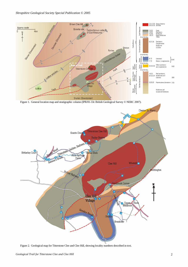
Figure 1. General location map and stratigraphic column (IPR/81-33c British Geological Survey © NERC 2007).
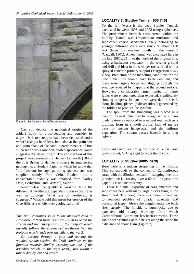
Figure 2. Geological map for Titterstone Clee and Clee Hill, showing locality numbers described in text.

Shropshire Geological Society Special Publication © 2005
Figure 3. Geological section through Titterstone Clee and Clee Hill.
The Trail follows public roads and footpaths. The use of a large scale Ordnance Survey map is strongly recommended, such as the Explorer Series Sheet 203 (1:25,000 scale). Ordnance Survey grid references are included to assist location. A compass and hand lens will be found useful but visitors should refrain from using hammers since the exposures are few in number and small in size; fragments of broken rock can generally be found in the vicinity. Visitors should also follow both the Country Code and the Geologist’s Code.
The numbers within squared brackets in the text that follow refer to grid references for the stopping points (‘Localities’) shown on the accompanying sketch map. 6-figure grid references locate the feature to the nearest 100 m; 8-figure grid references to the nearest 10 m.
There are various options indicated within the text for reducing the length of the visit. The supporting map shows these, alongside a sketch of the outcrop of the dominant rocks mentioned in the course of the Trail.
LOCALITY 1: Display Board [595 753] Start at the display board at the side of the main car park at the summit of the A4117, by the cattle grid above the village of Cleehill. There is a Post Office, village store and baker 300 m down the road; public toilets are opposite the shops.
This is a convenient place to introduce the Trail. The display board has an aerial photograph of the village and its immediate neighbourhood.
Cross the stile and walk 100 m east to the toposcope (viewing platform) where the general setting can be appreciated.
LOCALITY 2: Toposcope [5968 7532] The toposcope is mounted on a concrete plinth which is actually a cap to an old mine shaft that led to a coal mine beneath. Many mines and quarries have worked the local mineral resources in this area,
aspects of which will be considered throughout the Trail.
For now, establish the general setting of Clee Hill by considering first the distant features of the landscape. Clockwise: the towns of Kidderminster and Tenbury Wells; the distant Abberley Hills; the Malverns; and the Brecon Beacons. Then consider the nearer southern (Carboniferous) spur of Clee Hill running south towards the Teme Valley, and the high ground of Mortimore Forest beyond Ludlow to the west.
This landscape reflects the geology beneath, an overview of which is presented by Toghill (2005). First consider the bedrock geology. Some of the oldest rocks in England and Wales Precambrian in age and are found in the Malverns. Silurian rocks can be seen to the west around Ludlow. Silurian rocks also form the Abberley Hills, having been brought to the surface by faulting and folding, penetrating the outcrop of Old Red Sandstone (Upper Silurian and Devonian in age)], present in the Teme Valley and on the lower flanks of Clee Hill. The red soil in the fields indicates their presence. The somewhat younger Carboniferous rocks on Clee Hill have been protected by a late Carboniferous dolerite sill, locally known as Dhu Stone. Next may be considered the Quaternary features, shaped by glaciers and rivers during the last one million years; alternatively consider these from the summit - commentary is provided in the notes for Locality 27.
This varied geology has attracted visitors interested in natural history for many years, one of the earliest accounts being of the visit led by the Rev J.D. La Touche in 1868 for the Woolhope Naturalists' Field Club based in Hereford.
From the toposcope drop downhill 20 m to reach the grass footpath and then continue due east along it, parallel to and south of the A4117, for one kilometre. This crosses the deep gully of the Cornbrook, to which the Trail returns at Locality 9, and the rough ground just west of Shetfields [605
Geological Trail for Titterstone Clee and Clee Hill 3

Shropshire Geological Society Special Publication © 2005
753] known locally as the Brick Kiln Floor which used to be the site of a brick works, a clearer example of which will be seen at Locality 15.
As the Trail traverses the side of Clee Hill, it initially crosses Carboniferous strata (not exposed) and then gradually drops into the Teme valley through Lower Devonian and Upper Silurian strata. Bedrock exposures are rare; nevertheless clues as to its nature are present in the ‘float’ (stones in the surface soil), buildings (especially old stone walls and agricultural structures) and the landforms. The Trail then essentially works “up sequence” from the south through progressively younger rocks, from the top of the Silurian, through the Devonian and into the Carboniferous outlier, reaching the dolerite sill at the summit of Titterstone Clee. It then wanders “down sequence” to the north, off the Carboniferous and onto Upper and Lower Devonian.
Following the track will lead just past the farm at [608 755], some 300 m due south of the road junction with the A4117.
LOCALITY 3: Old workings [608 755] Old workings and spoil heaps just east of the farm indicate the line of the Psammosteus Limestone outcrop. This limestone marks the base of the Devonian (416 Ma). The Devonian Period, formerly known as the Old Red Sandstone, is split into a number of Series, the oldest of which, the Dittonian, is the Stage occurring here. The British Geological Survey (BGS) have mapped this as the St Maughans Formation. The name, Psammosteus Limestone, is doubly misleading, for not only does the ostracoderm fish to which it refers now be recognised as being two distinct species of Traquairaspis, but the fish do not come from the limestone but from sandstones and shales nearby! As a result, the BGS now use the term Bishop’s Frome Limestone Member for this limestone.
The Psammosteus Limestone is not exposed in situ, and its outcrop is difficult to discern on the ground, forming just a low subtle feature which trends south-eastwards. In general it provides a good marker band facilitating geological mapping of the Upper Silurian and Devonian Periods in many places. A good outcrop occurs some 7 km to the east, near Cleobury Mortimer. The limestone has also been extensively worked elsewhere and may be seen some distance to the west, at Locality 23.
Fragments of the Psammosteus Limestone have been found hereabouts (Figure 4). It is probably made up of a sequence of two or three thin limestones with the principal member 2-3 m thick. When seen in situ, this bed appears to be massive towards the top, passing down into a rubbly and concretionary material. Psammosteus Limestone was once thought to have been deposited by a marine
transgression, but is more likely to be a calcrete (a fossil soil). Calcretes form in a hot climate where evaporation brings calcium carbonate to the surface, leaving them as a natural cement in the soil. The palaeogeography at that time had mountains to the northwest, thrown up by plate collision at the end of the Silurian, with extensive fans of alluvium deposited by water washing down eroded debris towards the east, towards the present-day Clee Hills, as described in some detail by Dineley (1950).
Figure 4. Cobbles of pink Psammosteus Limestone in the bed of the River Rea, just downstream of its outcrop in the river bed.
Looking uphill, note the landforms to the north: the ridge of igneous rock (the dolerite sill), spoil heaps from coal mining, and the water supply reservoir.
In the field wall is evidence of brickwork which may have come from the remains of a lime kiln or iron smelter. Such structures are interesting since they reflect both exploitation of local mineral resources and the usage of geological materials for processing those resources. Thus here we have the Psammosteus Limestone as the source of carbonates for manufacturing lime (for building mortar, cement and agricultural lime), Upper Carboniferous Coal Measures clay (fired as brick) to construct the furnace, and coal of similar age (as coke) to provide the fuel.
Also known in this area is the early smelting of iron (at the very beginning of the industrial revolution, more famously associated with Ironbridge to the north), utilising iron ore from the Carboniferous Coal Measures and the local limestone as a flux. The pig iron was being supplied to the forge at Cleobury Mortimer in the early to mid 1700s (Jenkins, 1983).
Note the distorted appearance of the bricks hereabouts as they succumbed to the heat within the furnace. More recent linings have been constructed from more heat-resistant bricks manufactured from Carboniferous clays from Staffordshire.
Geological Trail for Titterstone Clee and Clee Hill 4

Shropshire Geological Society Special Publication © 2005
The Trail continues south down the metalled road towards the hamlet of Hints in the Parish of Coreley.
LOCALITY 4: Hints [6110 7535] On entering the hamlet note the pebbles set in the kerbside – a mixture of sandstones and igneous rocks typical of both the local geology and further afield towards North Wales. These have been obtained from the gravel pit at Bromfield, just north of Ludlow, and have been excavated from fluvioglacial outwash deposits of Devensian age. The famous civil engineer, Thomas Telford, utilised the same gravel to line his reconstructed road along Broad Street, then the most important access to Ludlow from the south.
Examples of sandstone, conglomerate, dolerite, granite and ironstone can be seen among the pebbles. The Trail continues south down the metalled road through the hamlet of Hints and turns right (marked 'No Through Road') at [610 752]. Continue to Upper Woodrow Farm.
LOCALITY 5: Upper Woodrow [6068 7513] Note the range of sedimentary rocks especially well displayed in the farm wall. Here there are sandstones, grits, iron-rich veined sandstones and conglomerates, with quartzites and other pebbles (Figures 5a,b). Contrast their hardness with that of limestone.
Figure 5a. Building stones at Upper Woodrow Farm – Cornbrook Sandstone.
Figure 5b. Building stones at Upper Woodrow Farm – Coal Measures sandstone with ironstone (bands of grey siderite).
Hereabouts are extensive sheets of periglacial Head deposits, resulting from the erosion, weathering and transport of the bedrock higher up the hill during colder climatic conditions. Hodgson (1972) draws attention to the widespread cover of Head on Titterstone Clee Hill and its importance as a base for the local soils.
Consider the source(s) of the building stones seen in the walls.
Continue down the road to Woodrow Farm, just downhill from Upper Woodrow Farm; the Trail crosses the stile on the left and follows the footpath leading south through the orchard. At [6060 7473] it passes under the aqueduct carrying the water supply from the Elan Valley to Birmingham, constructed 1896-1904.
LOCALITY 6: Elan aqueduct [6060 7473] Note the sandstone abutments of the aqueduct (Figure 6). These are understood to have been supplied by Grinshill Quarry north of Shrewsbury, in which case they are Triassic sandstones of arid desert origin, well known nationally as a source of good quality ashlar (strong dimension building stone). Alternatively they could be sandstones of Upper Carboniferous age, deposited by rivers and subsequently cemented by silica. Such material is also well known as a source of good quality ashlar and could have been supplied from sandstone quarries by the River Severn near Bewdley or in South Wales north of Cardiff.
Geological Trail for Titterstone Clee and Clee Hill 5
Shropshire Geological Society Special Publication © 2005
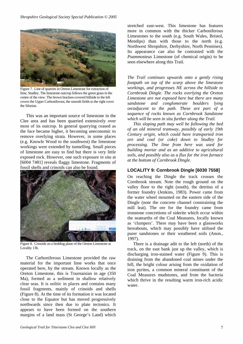
Figure 6. Sandstone ashlar in Elan Aqueduct.
Can you deduce the geological origin of the ashlar? Look for cross-bedding and consider its angle – is it too steep to have been deposited under water? Using a hand lens, look also at the grain size and grain shape of the sand; a predominance of fine silica sand with a rounded, frosted appearance would suggest a dry desert origin. The construction of this project was presented by Herbert Lapworth (1899), the first Briton to deliver a course in engineering geology, as a 'Student Paper' in which he wrote that "the freestone for copings, string courses, etc., was supplied mainly from Cefn, Ruabon, but a considerable quantity was obtained from Darley Dale, Derbyshire, and Grinshill, Salop."
Nevertheless the quality is variable. Note the differential weathering dependant upon exposure as well as lithology. What rate of weathering is suggested? What would this mean for erosion of the Clee Hills as a whole, over geological time? The Trail continues south to the metalled road at Brookrow. It then turns right for 100 m to reach the stream and then sharp right up the footpath which literally follows the stream bed northwest (not the footpath which leads over the stile to the west).
On passing through a gate and leaving the wooded stream section, the Trail continues up the footpath towards Studley, crossing the line of the aqueduct which, to the right (east), lies within a tunnel dug by 'cut and cover'.
LOCALITY 7: Studley Tunnel [603 746] To the left (west) is the deep Studley Tunnel, excavated between 1898 and 1902 using explosives. The predominant bedrock encountered within the Studley Tunnel was Downtonian mudstone and sandstone; coarse sandstones likely belonging to younger Dittonian strata were struck "at about 1400 feet (from the western mouth of the tunnel)" (Cantrill, 1901). A new tunnel was excavated here in the late 1980s, 25 m to the north of the original line, using a backactor excavator in the weaker ground and drill and blast in the stronger rocks, lined with a sprayed concrete primary support (Margerison et al., 1995). Prediction of the tunnelling conditions for the new tunnel line should have been excellent, and these were largely borne out, digging through the syncline revealed by mapping at the ground surface. However, a considerably larger number of minor faults were encountered than expected, significantly slowing progress. In part these were due to shears along bedding planes (“slickensides”) generated by the folding to produce the syncline.
The spoil from the tunnelling was placed in a heap to the east. This may be recognised as a man-made feature as opposed to a natural one, such as a drumlin, from its smooth profile, lack of mature trees or ancient hedgerows, and the uniform vegetation. The stream passes beneath in a long culvert.
The Trail continues along the lane to reach more open ground, forking right to cross the stream.
LOCALITY 8: Studley [6005 7470] Here there is a sudden steepening of the hillside. This corresponds to the contact of Carboniferous strata with the Silurian beneath. In stepping over this junction one is crossing over a 60 million year time gap; this is an unconformity.
There is a small exposure of conglomerates and sandstones here with many large blocks lying in the stream bed. The conglomerates contain subangular to rounded pebbles of quartz, quartzite and occasional jasper. Above the conglomerate the bank rises steeply. The hillside is hummocky due to extensive old quarry workings from which Carboniferous Limestone has been extracted. These can be seen running at mid height along the slope for a distance of about 1 km (Figure 7).
Geological Trail for Titterstone Clee and Clee Hill 6
Shropshire Geological Society Special Publication © 2005
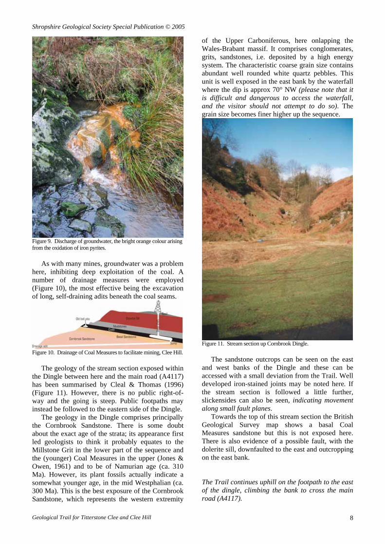
Figure 7. Line of quarries in Oreton Limestone for extraction of lime, Studley. The limestone outcrop follows the green grass in the centre of the view. The brown bracken-covered hillside to the left covers the Upper Carboniferous; the smooth fields to the right cover the Silurian.
This was an important source of limestone in the Clee area and has been quarried extensively over most of its outcrop. In general quarrying ceased as the face became higher, it becoming uneconomic to remove overlying strata. However, in some places (e.g. Knowle Wood to the southwest) the limestone workings were extended by tunnelling. Small pieces of limestone are easy to find but there is very little exposed rock. However, one such exposure in situ at [6004 7481] reveals flaggy limestone. Fragments of fossil shells and crinoids can also be found.
Figure 8. Crinoids on a bedding plane of the Oreton Limestone at Locality 13b.
The Carboniferous Limestone provided the raw material for the important lime works that once operated here, by the stream. Known locally as the Oreton Limestone, this is Tournaisian in age (350 Ma), formed as a sediment in shallow relatively clear seas. It is oolitic in places and contains many fossil fragments, mainly of crinoids and shells (Figure 8). At the time of its formation it was located close to the Equator but has moved progressively northwards since then due to plate tectonics. It appears to have been formed on the southern margins of a land mass (St George’s Land) which
stretched east-west. This limestone has features more in common with the thicker Carboniferous Limestones to the south (e.g. South Wales, Bristol, Mendips) than with those to the north (e.g. Northwest Shropshire, Derbyshire, North Pennines). Its appearance can also be contrasted with the Psammosteus Limestone (of chemical origin) to be seen elsewhere along this Trail. The Trail continues upwards onto a gently rising footpath on top of the scarp above the limestone workings, and progresses NE across the hillside to Cornbrook Dingle. The rocks overlying the Oreton Limestone are not exposed here but there are many sandstone and conglomerate boulders lying on/adjacent to the path. These are part of a sequence of rocks known as Cornbrook Sandstone which will be seen in situ further along the Trail.
This sloping path may well be following the bed of an old mineral tramway, possibly of early 19th Century origin, which could have transported iron ore and coal (or coke) down to Studley for processing. The lime from here was used for building mortar and as an additive to agricultural soils, and possibly also as a flux for the iron furnace at the bottom of Cornbrook Dingle.
LOCALITY 9: Cornbrook Dingle [6030 7558] On reaching the Dingle the track crosses the Cornbrook stream. Note the rough ground on the valley floor to the right (south), the detritus of a former foundry (Jenkins, 1983). Power came from the water wheel mounted on the eastern side of the Dingle (note the concrete channel constraining the mill leat). The ore for the foundry came from ironstone concretions of siderite which occur within the seatearths of the Coal Measures, locally known as ‘clumpers’. There may have been a glassworks hereabouts, which may possibly have utilised the purer sandstones or their weathered soils (Anon., 1997).
There is a drainage adit to the left (north) of the track, on the east bank just up the valley, which is discharging iron-stained water (Figure 9). This is draining from the abandoned coal mines under the hill, the bright colour arising from the oxidation of iron pyrites, a common mineral constituent of the Coal Measures mudstones, and from the bacteria which thrive in the resulting warm iron-rich acidic water.
Geological Trail for Titterstone Clee and Clee Hill 7
Shropshire Geological Society Special Publication © 2005
Figure 9. Discharge of groundwater, the bright orange colour arising from the oxidation of iron pyrites.
As with many mines, groundwater was a problem
here, inhibiting deep exploitation of the coal. A number of drainage measures were employed (Figure 10), the most effective being the excavation of long, self-draining adits beneath the coal seams.
Figure 10. Drainage of Coal Measures to facilitate mining, Clee Hill.
The geology of the stream section exposed within
the Dingle between here and the main road (A4117) has been summarised by Cleal & Thomas (1996) (Figure 11). However, there is no public right-of-way and the going is steep. Public footpaths may instead be followed to the eastern side of the Dingle.
The geology in the Dingle comprises principally the Cornbrook Sandstone. There is some doubt about the exact age of the strata; its appearance first led geologists to think it probably equates to the Millstone Grit in the lower part of the sequence and the (younger) Coal Measures in the upper (Jones & Owen, 1961) and to be of Namurian age (ca. 310 Ma). However, its plant fossils actually indicate a somewhat younger age, in the mid Westphalian (ca. 300 Ma). This is the best exposure of the Cornbrook Sandstone, which represents the western extremity
of the Upper Carboniferous, here onlapping the Wales-Brabant massif. It comprises conglomerates, grits, sandstones, i.e. deposited by a high energy system. The characteristic coarse grain size contains abundant well rounded white quartz pebbles. This unit is well exposed in the east bank by the waterfall where the dip is approx 70° NW (please note that it is difficult and dangerous to access the waterfall, and the visitor should not attempt to do so). The grain size becomes finer higher up the sequence.
Figure 11. Stream section up Cornbrook Dingle.
The sandstone outcrops can be seen on the east and west banks of the Dingle and these can be accessed with a small deviation from the Trail. Well developed iron-stained joints may be noted here. If the stream section is followed a little further, slickensides can also be seen, indicating movement along small fault planes.
Towards the top of this stream section the British Geological Survey map shows a basal Coal Measures sandstone but this is not exposed here. There is also evidence of a possible fault, with the dolerite sill, downfaulted to the east and outcropping on the east bank.
The Trail continues uphill on the footpath to the east of the dingle, climbing the bank to cross the main road (A4117).
Geological Trail for Titterstone Clee and Clee Hill 8
Shropshire Geological Society Special Publication © 2005
LOCALITY 10: Cornbrook Corner [601 759] The outcrop of Coal Measures may be seen to the west, marked by hummocky ground covered in small spoil heaps of grey mudstone where the coal has been mined, and contrast this with the gorse-covered dolerite sill beyond; also note the dolerite sill across the stream to the east. The contact along the stream here is faulted with downthrow to the east. The Trail proceeds northeast along the footpath onto the Common and then bears right towards the prominent spoil heap at [6073 7613].
LOCALITY 11: Barn Pit [6073 7613] The spoil heap is the remains of the Barn Pit, whose shaft was capped in the 1940s. Note the concrete cap to the old shaft – Beware, don’t step on it! This was typical of the late 19th and early 20th Century workings on Clee Hill, mining Upper Carboniferous coal. This occurs within a clastic sequence of shale and sandstone which dates from about 310 to 300 Ma, the product of cyclic fluviatile deposition in swampy conditions on top of a large delta that had grown earlier (represented by the Cornbrook Sandstone). Fragments of coal and black shale along with traces of plant remains can be found in the spoil.
Coal mining on Titterstone Clee and Clee Hill goes back as far as at least the 13th Century (noted in the 1291 'taxatio Ecclesiastica' of Pope Nicholas IV). Extraction before the 18th Century was from bell pits. In 1760 deep shafts began to be employed, here having to cut down through the dolerite sill. They were last worked in the 1920s (Jenkins, 1983).
It must have been hard to sink a shaft through dolerite – so why do it? [land ownership, safer mine roof due to stronger and less fractured rock].
There were four principal coal seams on Titterstone Clee Hill (a more detailed description is given by Dixon, 1917):
Great Coal - approx. 1.5 m Three-quarter Coal - approx. 0.6 m Smith Coal - approx. 1.2 m Four-foot and Gutter Coal - 0.8 to 1.2 m
Note the bleak landscape. Periglacial processes operated here during the last glacial period (the Devensian), especially frost heave and solifluction. Note the hummocky ground, so characteristic of such areas due to frost heave and ice-mound growth, enhanced by vegetation. Large blocks of dolerite could be easily transported on the mud paste created during the brief summer thaw as surface groundwater melted and the wet slurry moved
downhill over the still frozen ground beneath – the difference (contrast) in density was then comparatively small. The Trail proceeds west to the access road for the working quarry. It then leads south down the road for about 400 m to the entrance of the Incline Quarry [599 759], then along the Incline Quarry track with the lake on the right, to the observation point [5955 7565] established by the quarry operator, Hanson plc.
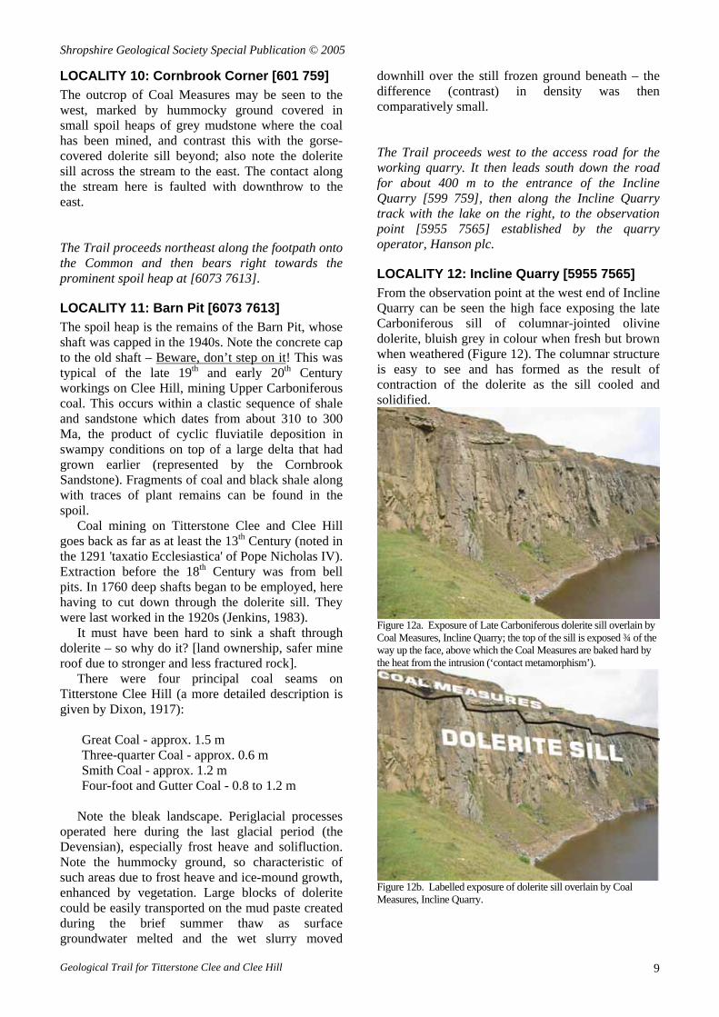
LOCALITY 12: Incline Quarry [5955 7565] From the observation point at the west end of Incline Quarry can be seen the high face exposing the late Carboniferous sill of columnar-jointed olivine dolerite, bluish grey in colour when fresh but brown when weathered (Figure 12). The columnar structure is easy to see and has formed as the result of contraction of the dolerite as the sill cooled and solidified.
Figure 12a. Exposure of Late Carboniferous dolerite sill overlain by Coal Measures, Incline Quarry; the top of the sill is exposed ¾ of the way up the face, above which the Coal Measures are baked hard by the heat from the intrusion (‘contact metamorphism’).
Figure 12b. Labelled exposure of dolerite sill overlain by Coal Measures, Incline Quarry.
Geological Trail for Titterstone Clee and Clee Hill 9
Shropshire Geological Society Special Publication © 2005
Much of the higher ground of the Clee Hills is protected by this dolerite sill. It is locally known as Dhu Stone. Petrologically the dolerite is an analcite-bearing olivine-dolerite which is typical of the Carboniferous basic alkaline intrusions occurring in Britain; analcite is a feldspathoid mineral, akin to a hydrated feldspar. When the sill is exposed by the quarry workings it is seen to be overlain by up to 2 m of sandstone and mudstone, baked hard by contact metamorphism due to the heat from the newly intruded magma. The presence of this cap seems to correspond to the profile exhibited beneath the highest ground. Where the metamorphic cap has been removed by erosion, the dolerite is seen to be deeply weathered and is thus likely to be much more prone to further erosion and consequent reduction in elevation. A quartz-rich sediment like sandstone has a high resistance to chemical attack when exposed to weathering agents at or near the ground surface, as do low permeability sediments like mudstone which inhibit the passage of those agents; in contrast the chemical stability of a basic magma like dolerite, formed at high temperatures at depth, is considerably lower when exposed to weathering agents.
The principal reason for quarrying the dolerite sill in late Victorian times was to produce pavement setts. However, the Incline Quarry was begun in the late 1850s for its first, and perhaps biggest single, order which was for supplying stone for the construction of Cardiff docks. Production of roadstone has been the principal product during the 20th Century.
Above the sill can be seen the flat-lying sediments of the Coal Measures. Access to the contact is currently difficult and dangerous [do not attempt to climb the grassy bank to the west]. In the past this showed the bubbly nature of its contact with the sediments, suggesting that the Coal Measures may have been relatively thin (i.e. near the ground surface) thereby allowing gas bubbles to form in the magma. These were then frozen in as the molten rock solidified on cooling. The zone of alteration due to heating ('contact metamorphism') is quite thin (less than two metres).
Beneath the sill, just below the bed of the (shallow) lake, are further Coal Measures, but these are no longer exposed.
The quarry face appears to be affected by minor faulting of late Carboniferous or later age, possibly reflecting adjustments under the same stress regime responsible for the earlier folding of the sequence to create the synclines of Titterstone and Brown Clee Hills and the Ludlow anticline between.
This would be a convenient place to stop for a picnic or lunch. Local facilities include:
• 250 m SE: Craven View Tea Room and Café, by the main entrance to the working quarry, east of the (disused) Incline Quarry.
• 100 m NW: The Kremlin Inn, close to the west end of the (disused) Incline Quarry and its viewing platform.
• 400 m SW: Centre of Cleehill Village: shops, fish & chips, café attached to bakery, public toilets.]
The Trail continues due south along the track below the Kremlin, crossing the A4117 and then on by footpath down the hillside, passing east of Cleehill village, to Titrail [595 746]. It then turns right (west), crossing the road and takes the footpath leading to Gorstley Rough.
LOCALITY 13: Gorstley Rough [5925 7464] Along Gorstley Rough by Titrail can be seen numerous workings within the Oreton Limestone where limestone was once quarried, referred to in some detail by Murchison (1872). This is the same limestone as seen at Locality 8. Occasional exposures of flaggy limestone may still be found, such as at Locality 13a [5925 7464] where the dip is 40° towards the north-northeast. It is also occasionally possible to find fossils within the limestone (crinoids and shells).
A series of small lime kilns can be seen along the track adjacent to the wood of Gorstley Rough [5916 7467].
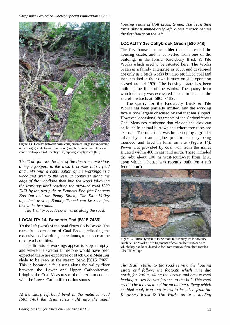
A basal conglomerate lies below the Oreton Limestone. Although the contact is not actually exposed at [5839 7453] (Locality 13b), the limestone and conglomerate form a distinctive feature and can be seen in close proximity (Figure 13). However, it is not possible to see the contact (unconformity) between the basal conglomerate and the underlying Old Red Sandstone [Downtonian] here.
Geological Trail for Titterstone Clee and Clee Hill 10
Shropshire Geological Society Special Publication © 2005
Figure 13. Contact between basal conglomerate (large moss-covered rock to right) and Oreton Limestone (smaller moss-covered rock in centre and top left) at Locality 13b, dipping steeply north (left). The Trail follows the line of the limestone workings along a footpath to the west. It crosses into a field and links with a continuation of the workings in a woodland area to the west. It continues along the edge of the woodland then into the wood following the workings until reaching the metalled road [582 746] by the two pubs at Bennetts End (the Bennetts End Inn and the Penny Black). The Elan Valley aqueduct west of Studley Tunnel can be seen just below the two pubs.
The Trail proceeds northwards along the road.
LOCALITY 14: Bennetts End [5815 7465] To the left (west) of the road flows Colly Brook. The name is a corruption of Coal Brook, reflecting the extensive coal workings hereabouts, to be seen at the next two Localities.
The limestone workings appear to stop abruptly, and where the Oreton Limestone would have been expected there are exposures of black Coal Measures shale to be seen in the stream bank [5815 7465]. This is because a fault runs along the valley floor between the Lower and Upper Carboniferous, bringing the Coal Measures of the latter into contact with the Lower Carboniferous limestones. At the sharp left-hand bend in the metalled road [581 748] the Trail turns right into the small
housing estate of Collybrook Green. The Trail then turns almost immediately left, along a track behind the first house on the left.
LOCALITY 15: Collybrook Green [580 748] The first house is much older than the rest of the housing estate, and is converted from one of the buildings in the former Knowbury Brick & Tile Works which used to be situated here. The Works began as a family enterprise in 1830, and developed not only as a brick works but also produced coal and iron, smelted in their own furnace on site; operation ceased around 1920. The housing estate has been built on the floor of the Works. The quarry from which the clay was excavated for the bricks is at the end of the track, at [5805 7485].
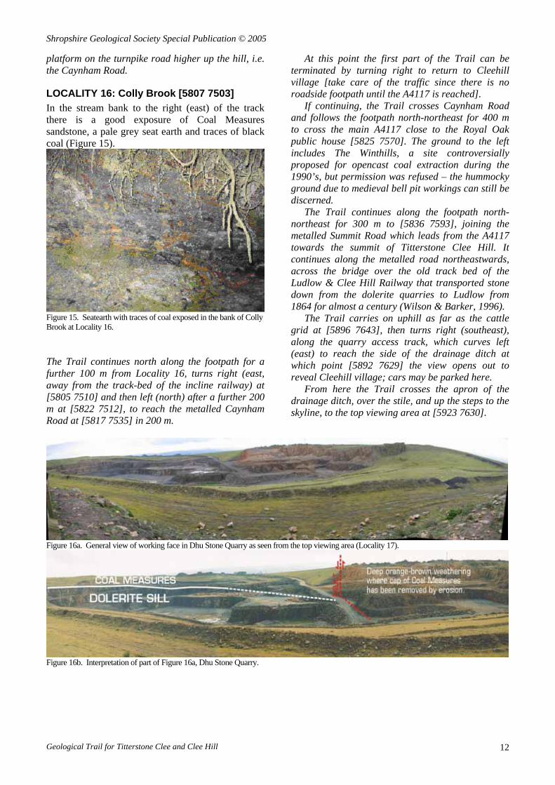
The quarry for the Knowbury Brick & Tile Works has been partially infilled, and the working face is now largely obscured by soil that has slipped. However, occasional fragments of the Carboniferous Coal Measures mudstone that yielded the clay can be found in animal burrows and where tree roots are exposed. The mudstone was broken up by a grinder driven by a steam engine, prior to the clay being moulded and fired in kilns on site (Figure 14). Power was provided by coal won from the mines situated within 400 m east and north. These included the adit about 100 m west-southwest from here, upon which a house was recently built (on a raft foundation!).
Figure 14. Bricks typical of those manufactured by the Knowbury Brick & Tile Works, with fragments of coal on their surface with which they had been dusted to facilitate removal from their moulds; Clee Hill village. The Trail returns to the road serving the housing estate and follows the footpath which runs due north, for 200 m, along the stream and access road leading to two houses further up the hill. This road used to be the track-bed for an incline railway which enabled coal, iron and bricks to be taken from the Knowbury Brick & Tile Works up to a loading
Geological Trail for Titterstone Clee and Clee Hill 11
Shropshire Geological Society Special Publication © 2005
platform on the turnpike road higher up the hill, i.e. the Caynham Road.
LOCALITY 16: Colly Brook [5807 7503] In the stream bank to the right (east) of the track there is a good exposure of Coal Measures sandstone, a pale grey seat earth and traces of black coal (Figure 15).
Figure 15. Seatearth with traces of coal exposed in the bank of Colly Brook at Locality 16. The Trail continues north along the footpath for a further 100 m from Locality 16, turns right (east, away from the track-bed of the incline railway) at [5805 7510] and then left (north) after a further 200 m at [5822 7512], to reach the metalled Caynham Road at [5817 7535] in 200 m.
At this point the first part of the Trail can be terminated by turning right to return to Cleehill village [take care of the traffic since there is no roadside footpath until the A4117 is reached].
If continuing, the Trail crosses Caynham Road and follows the footpath north-northeast for 400 m to cross the main A4117 close to the Royal Oak public house [5825 7570]. The ground to the left includes The Winthills, a site controversially proposed for opencast coal extraction during the 1990’s, but permission was refused – the hummocky ground due to medieval bell pit workings can still be discerned.
The Trail continues along the footpath north-northeast for 300 m to [5836 7593], joining the metalled Summit Road which leads from the A4117 towards the summit of Titterstone Clee Hill. It continues along the metalled road northeastwards, across the bridge over the old track bed of the Ludlow & Clee Hill Railway that transported stone down from the dolerite quarries to Ludlow from 1864 for almost a century (Wilson & Barker, 1996).
The Trail carries on uphill as far as the cattle grid at [5896 7643], then turns right (southeast), along the quarry access track, which curves left (east) to reach the side of the drainage ditch at which point [5892 7629] the view opens out to reveal Cleehill village; cars may be parked here.
From here the Trail crosses the apron of the drainage ditch, over the stile, and up the steps to the skyline, to the top viewing area at [5923 7630].
Figure 16a. General view of working face in Dhu Stone Quarry as seen from the top viewing area (Locality 17).
Figure 16b. Interpretation of part of Figure 16a, Dhu Stone Quarry.
Geological Trail for Titterstone Clee and Clee Hill 12

Shropshire Geological Society Special Publication © 2005
LOCALITY 17: Dhu Stone Quarry [5923 7630] The smooth profile of the ground to either side of the steps as the footpath is ascended is not natural but is due to spoil from quarrying. This includes shale and a few fragments of coal on the surface and can be contrasted with the hummocky ground on the Common seen at Locality 11, produced by frost heave enhanced by vegetation, characteristic of upland landscapes influenced by periglacial processes. The ‘float’ (the stones on the surface within the ground) also reveals its origin as spoil from quarrying, and includes artificial materials such as brick alongside the fragments of rock.
From the top viewing area there is an excellent panorama of the currently active Dhu Stone Quarry being operated by Hanson plc, who prepared this observation point and display board in 2004 (Figure 16).
Figure 17. Top of the Incline Railway, which carried quarried stone from 1864 to 1960. Beyond the wagon is the bridge (still intact) carrying Summit Road across the railway.
The spoil dumps from the quarrying on Titterstone Clee Hill are comparatively small compared to the size of the excavations since most of the quarried stone could be marketed. The main waste is the weathered dolerite, which is too weak and variable in quality to be of commercial use. Some of this has recently (1988-1992) been supplemented by overburden stripped from opencast mining of Coal Measures above the sill within the Dhu Stone Quarry and used for fill and landscaping to restore the topography at the cessation of quarrying (Crump & Donnelly, 1994). The artificial landscape in the disused part of the quarry has been designed to restore the profile of the hill as seen from Ludlow. This (disused) part of the quarry was initially opened from the south (facing Cleehill village) and transported much of its stone along the initially private Ludlow & Clee Hill Railway, down to the main line at Ludlow. Operation commenced in 1864 and ceased in 1960, transporting some 300,000 tons during the 1930s (Wilson & Barker, 1996). The railway was famous for its cable-operated incline at
1 in 9.27 which, at 1,988 yards, was the longest in the country (Figure 17).
The active workings of the present-day quarry show the contact between the Coal Measures and the dolerite sill, to the left of the main access road at the far side. In the past, close examination of this contact was reported to have revealed small lobes of magma intruding the Coal Measures sediments, broken along fracture planes, clearly demonstrating the intrusive character of the dolerite as a sill.
A fault can also be seen, striking along the main access road to the quarry, dropping the sill down to a lower elevation to the left (north) (Figure 18).
Figure 18. A fault exposed in 1970 downthrowing the sill to the north (left) against Coal Measures sediments to the south (right), Dhu Stone Quarry.
Figure 19. Deep weathered profile where protective cap of metamorphosed Coal Measures sediments has been removed, exposing dolerite sill to deep weathering, Dhu Stone Quarry.
The sill shows an extensive weathered profile to the right (south) of the fault (Figure 19); the relatively low chemical stability of dolerite and consequent susceptibility to weathering was mentioned at Locality 12. This is so deep and pervasive that it is quite likely to have been caused by a warmer climate than today – quite possibly Mediterranean. Such conditions existed here during the Triassic (210–250 Ma) and again during the early Paleogene (early Tertiary, 40–60 Ma) when conditions were comparable to present-day Thailand.
Geological Trail for Titterstone Clee and Clee Hill 13
Shropshire Geological Society Special Publication © 2005
It is also worth recalling that, due to plate tectonics, England was then considerably further south, closer to the Equator. Some authors consider the weathering might even be quite geologically recent, dating from warmer periods within the Quaternary (Crump & Donnelly, 1994). The protective influence of the cap of contact metamorphosed sediments was noted at Locality 12; contrast the deeply weathered profile seen here with that exhibited, for instance, at the Incline Quarry.
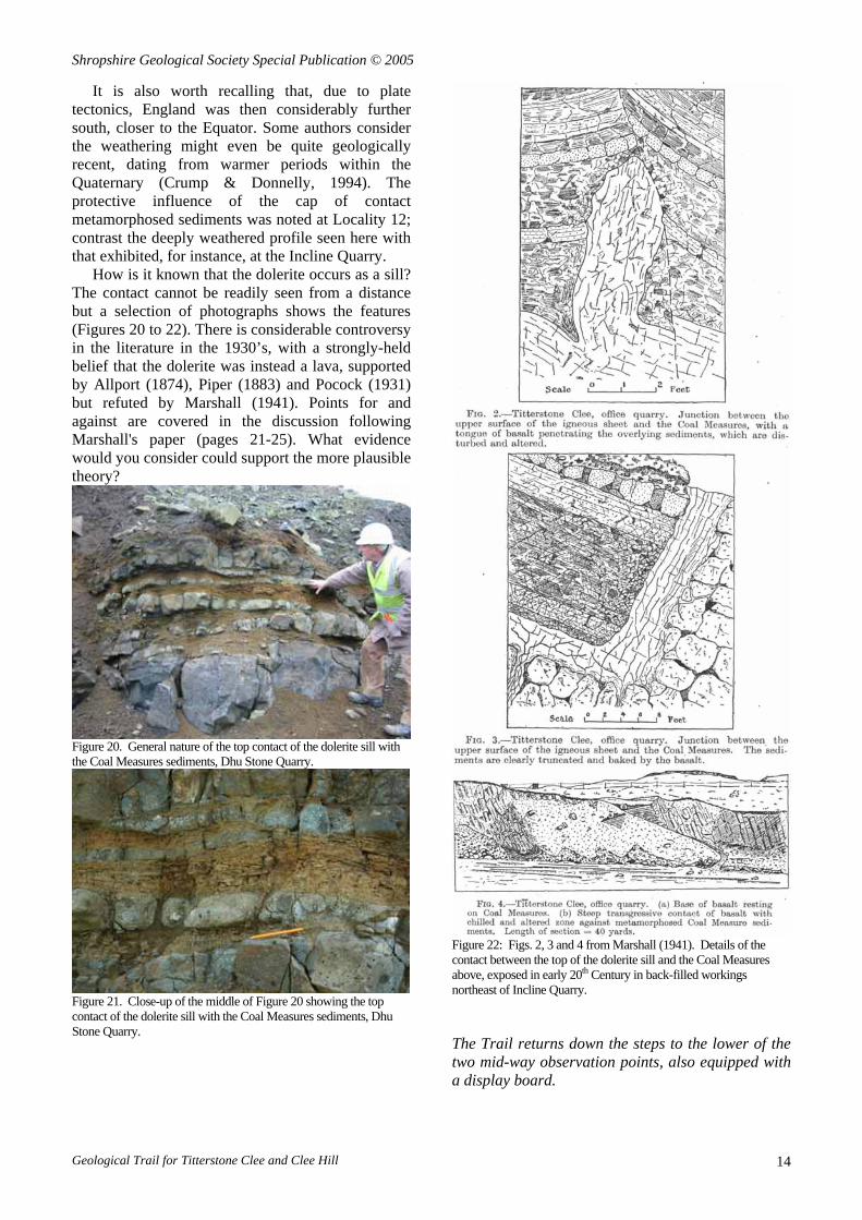
How is it known that the dolerite occurs as a sill? The contact cannot be readily seen from a distance but a selection of photographs shows the features (Figures 20 to 22). There is considerable controversy in the literature in the 1930’s, with a strongly-held belief that the dolerite was instead a lava, supported by Allport (1874), Piper (1883) and Pocock (1931) but refuted by Marshall (1941). Points for and against are covered in the discussion following Marshall's paper (pages 21-25). What evidence would you consider could support the more plausible theory?
Figure 20. General nature of the top contact of the dolerite sill with the Coal Measures sediments, Dhu Stone Quarry.
Figure 21. Close-up of the middle of Figure 20 showing the top contact of the dolerite sill with the Coal Measures sediments, Dhu Stone Quarry.
Figure 22: Figs. 2, 3 and 4 from Marshall (1941). Details of the contact between the top of the dolerite sill and the Coal Measures above, exposed in early 20th Century in back-filled workings northeast of Incline Quarry. The Trail returns down the steps to the lower of the two mid-way observation points, also equipped with a display board.
Geological Trail for Titterstone Clee and Clee Hill 14
Shropshire Geological Society Special Publication © 2005
Figure 23a. Ludlow anticline (top centre) picked out by the upland area of Mortimer Forest where Silurian limestone has resisted erosion.
Figure 23b. Lines to show trend of Ludlow anticline.
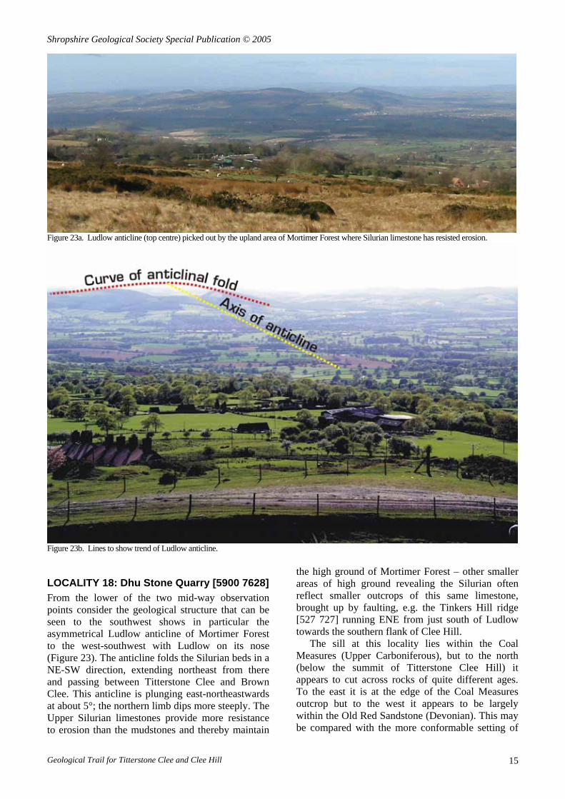
LOCALITY 18: Dhu Stone Quarry [5900 7628] From the lower of the two mid-way observation points consider the geological structure that can be seen to the southwest shows in particular the asymmetrical Ludlow anticline of Mortimer Forest to the west-southwest with Ludlow on its nose (Figure 23). The anticline folds the Silurian beds in a NE-SW direction, extending northeast from there and passing between Titterstone Clee and Brown Clee. This anticline is plunging east-northeastwards at about 5°; the northern limb dips more steeply. The Upper Silurian limestones provide more resistance to erosion than the mudstones and thereby maintain
the high ground of Mortimer Forest – other smaller areas of high ground revealing the Silurian often reflect smaller outcrops of this same limestone, brought up by faulting, e.g. the Tinkers Hill ridge [527 727] running ENE from just south of Ludlow towards the southern flank of Clee Hill.
The sill at this locality lies within the Coal Measures (Upper Carboniferous), but to the north (below the summit of Titterstone Clee Hill) it appears to cut across rocks of quite different ages. To the east it is at the edge of the Coal Measures outcrop but to the west it appears to be largely within the Old Red Sandstone (Devonian). This may be compared with the more conformable setting of
Geological Trail for Titterstone Clee and Clee Hill 15
Shropshire Geological Society Special Publication © 2005
this sill beside the A4117, seen at Locality 10. On Brown Clee to the north the sill is found just within the Coal Measures. It may be that the sill once extended as a continuous sheet between the two Clee Hills, and has since been eroded away, or there may have been separate magma intrusions; there may have been a fault acting as a conduit for the rising magma; or the arching of the Ludlow anticline may have weakened the rocks to enable magma intrusion. The Trail returns to the Summit road by the cattle grid [588 763], turns left (downhill) for 100 m to reach the stile [5885 7632] by the farm track leading to Nine Springs Farm. The Trail crosses the stile and follows the track north-eastwards to reach the Farm at [591 771], and there turn north into the valley of Benson’s Brook.
The wall of the barn adjacent to Nine Springs Farm contains a wonderful selection of local building stones – how many can you identify?
The Trail now follows the Shropshire Way north for 150 m, into the valley of Benson’s Brook.
LOCALITY 19: Benson’s Brook [590 772] This part of the valley reveals a series of good exposures of the Devonian alluvial sediments of Lower Dittonian age (ca. 370 Ma), particularly upstream of the footbridge. Easterly-dipping sandstones and shales may be examined, both in riverside cliffs and in the stream bed. Within the shales note the green reduction spots within the predominantly red sediment, developed during early diagenesis (burial). Detailed examination of the cross bedding, mineral composition and pebble types of the Clee Hills Dittonian sequence suggests that the sediments were derived from high land to the northwest (Allen, 1974).
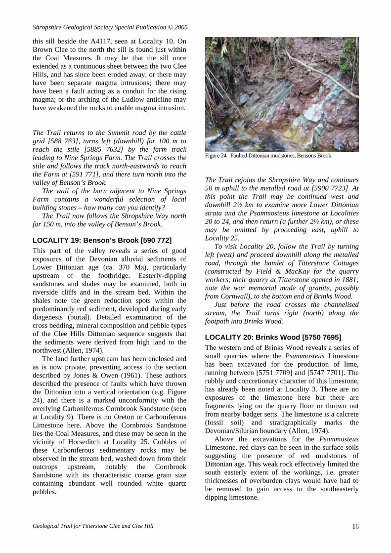
The land further upstream has been enclosed and as is now private, preventing access to the section described by Jones & Owen (1961). These authors described the presence of faults which have thrown the Dittonian into a vertical orientation (e.g. Figure 24), and there is a marked unconformity with the overlying Carboniferous Cornbrook Sandstone (seen at Locality 9). There is no Oreton or Carboniferous Limestone here. Above the Cornbrook Sandstone lies the Coal Measures, and these may be seen in the vicinity of Horseditch at Locality 25. Cobbles of these Carboniferous sedimentary rocks may be observed in the stream bed, washed down from their outcrops upstream, notably the Cornbrook Sandstone with its characteristic coarse grain size containing abundant well rounded white quartz pebbles.
Figure 24. Faulted Dittonian mudstones, Bensons Brook. The Trail rejoins the Shropshire Way and continues 50 m uphill to the metalled road at [5900 7723]. At this point the Trail may be continued west and downhill 2½ km to examine more Lower Dittonian strata and the Psammosteus limestone at Localities 20 to 24, and then return (a further 2½ km), or these may be omitted by proceeding east, uphill to Locality 25.
To visit Locality 20, follow the Trail by turning left (west) and proceed downhill along the metalled road, through the hamlet of Titterstone Cottages (constructed by Field & MacKay for the quarry workers; their quarry at Titterstone opened in 1881; note the war memorial made of granite, possibly from Cornwall), to the bottom end of Brinks Wood.
Just before the road crosses the channelised stream, the Trail turns right (north) along the footpath into Brinks Wood.
LOCALITY 20: Brinks Wood [5750 7695] The western end of Brinks Wood reveals a series of small quarries where the Psammosteus Limestone has been excavated for the production of lime, running between [5751 7709] and [5747 7701]. The rubbly and concretionary character of this limestone, has already been noted at Locality 3. There are no exposures of the limestone here but there are fragments lying on the quarry floor or thrown out from nearby badger setts. The limestone is a calcrete (fossil soil) and stratigraphically marks the Devonian/Silurian boundary (Allen, 1974).
Above the excavations for the Psammosteus Limestone, red clays can be seen in the surface soils suggesting the presence of red mudstones of Dittonian age. This weak rock effectively limited the south easterly extent of the workings, i.e. greater thicknesses of overburden clays would have had to be removed to gain access to the southeasterly dipping limestone.
Geological Trail for Titterstone Clee and Clee Hill 16

Shropshire Geological Society Special Publication © 2005
The Trail continues along the footpath through Brinks Wood northwest towards Bitterley Court (400 m) and the road to Bitterley Church (200 m).
LOCALITY 21: Bitterley Church [570 774] St Mary’s Church, Bitterley, is largely Early English style, 13th Century, and the external walls provide a good display of the harder local building stones. These are predominantly red Dittonian sandstones, occasionally displaying green reduction colouration, and cobbles of dolerite. The latter have probably been collected from fields hereabouts, from the Head, whereas the sandstone is likely to have been quarried, possibly from the same source as used for the construction of Bitterley Court.
Figure 25. Close-up of tufa in the wall of Bitterley Church.
Of particular interest are two further kinds of building stone. The first is a yellow sandstone, occasionally containing beds of white quartz gravel; these have been used for some of the windows as well as the external walls – this is the Carboniferous Cornbrook Sandstone (seen at Locality 9). The second is a white carious stone, occasionally used in the external walls (Figure 25) – this is tufa, a calcareous rock precipitated by water issuing from springs or a stream during cold climatic conditions in the Quaternary. Its origin is likely to be somewhere within the estate of Bitterley Court, possibly just downhill from the outcrop of the Psammosteus Limestone (the closest source of lime).
The 14th Century cross within the churchyard is delicately carved from stone, but its provenance is not known. The Trail returns to Brinks Wood at [5750 7695], either direct by the footpath from Locality 20 or via the metalled road, bearing left at the road junction. Opposite the entrance to Brinks Wood, the Trail enters the field on the south side through a gate and down to the stream of Benson’s Brook.
LOCALITY 22: Benson’s Brook [5754 7694] Large blocks of the Psammosteus Limestone can be seen in the drainage channel by the side of the footpath, between the road and the Brook.
Note the high masonry wall above Benson’s Brook. This supports the now disused railway and is constructed of blocks of olivine dolerite quarried from the sill higher up the hill.
Figure 26. Bitterley Wharf exchange sidings just west of Locality 22, where quarried stone brought down by the incline railways was transferred to trains destined for the main line railway (Field & Mackay (1911). The Trail continues upstream along the footpath, crossing the line of Field & Mackay’s rope-worked 3-foot narrow gauge Titterstone Incline railway (1880-1954) and the cast iron pipe which carried water from their reservoir upstream (Locality 24) to a turbine at Bittlerley Wharf (Figure 26), generating electricity for the rock crusher there. Just beyond, a small stream joins Benson’s Brook from the southeast [5761 7693]. It is interesting to speculate if the breeze blocks in the walls were manufactured from stone dust in one of the quarries on Clee Hill.
LOCALITY 23: Benson’s Brook [5761 7693] At the stream junction can be seen a number of exposures of Dittonian sandstones, gently dipping towards the northeast. Fossil fish and plant remains have been discovered at several nearby locations in these Old Red Sandstone rocks (Ball & Dineley, 1961), but such fossils are not easily found.
In the bed of Benson’s Brook, but not the minor tributary, note the presence of dolerite boulders, reflecting the source of the bed load. The Trail continues upstream by the side of Benson’s Brook, along the footpath, to the stone bridge just below the reservoir at [5800 7705], but be aware that a footpath also crosses the stream earlier, at [5775 7695], but over a very fragile wooden bridge which is unsafe.
LOCALITY 24: Benson’s Brook [578 770]
Geological Trail for Titterstone Clee and Clee Hill 17

Shropshire Geological Society Special Publication © 2005
Further upstream, Head can be seen overlying Dittonian sandstone, here dipping southeast at 12° (Figure 27).
Figure 27. Head exposed by side of Bensons Brook, overlying Dittonian sandstone. Note the pulley wheels which guided the rope that hauled wagons along the incline railway; empty wagons hauled up the slope were counterbalanced by wagons coming downhill loaded with dolerite.
The Dittonian sequence includes sandstones and mudstones which reveal evidence of current bedding, ripple marks and sun crack, conditions of deposition comparable to those found in the Mississippi delta.
The Head is a periglacial deposit derived from material upslope which has moved under the influence of gravity on water-saturated soil above frozen ground (permafrost), here comprising blocks of dolerite and red mudstone in a clay matrix. Head can be distinguished from a glacially-deposited till by considering differences in its composition, relative density, and geomorphological setting].
Just upstream, at [5787 7704], is a dam constructed of masonry blocks of dolerite, but this has now silted up completely. The silt is very soft and on no account should you attempt to walk on its surface or the dam wall be walked on. From here the Trail follows the footpath generally eastwards, south of Benson’s Brook, regaining the Shropshire Way just west of Nine Springs Farm and Locality 19.
It then recrosses Benson’s Brook at Locality 19 and continues 50 m uphill to the metalled road at [5900 7723], then east, uphill to where the metalled road joins the Summit Road leading to Titterstone Clee just above (north) of the part of Benson’s Brook known as Horseditch [596 773].
LOCALITY 25: Horseditch [595 773] Downstream of the road can be found evidence of the outcrop of the Coal Measures sequence.
The geology was first described in detail by Kidston et al. (1917) and summarised by Cleal & Thomas (1996). The sediments are coal-bearing but consist mainly of thick seat earths and sandstones with conglomerates, but there are occasional traces of coal and grey mudstones with ironstone nodules.
The spoil heap from an old bell pit is visible on the south side of the stream, yielding fragments of these lithologies. This area is now a Scheduled Ancient Monument because of these medieval coal workings. Orange staining of sediment in the stream bed is indicative of oxidation of the mineral iron pyrites, a common constituent of fine grained Coal Measures sediments (as discussed at Locality 9). The Trail returns to the metalled road and proceeds northwards over the Coal Measures, uphill towards Titterstone Hill Quarry.
Cars may be parked in the quarry floor of Titterstone Hill Quarry, at [5935 7755]. There is no public access to the actual summit of Titterstone Clee Hill by car beyond this point.
LOCALITY 26: Titterstone Hill Qy [593 776] The Quarry is a prominent excavation in the olivine dolerite sill (Figure 28). It has a similar composition to the sill exposed in the Incline Quarry but the two areas are separated by Coal Measures strata.
Figure 28. The two principal dolerite quarries on Titterstone Clee Hill: Titterstone Hill Quarry to the left of the spherical dome and Radar Quarry to its right, in the centre.
Note the remains of the quarry plant. The embankment for the incline railway can be seen running downhill to the southwest. As already noted, this was built in 1880 by Field & Mackay to take away much of the quarried stone which was worked in Victorian times primarily for pavement setts, whereas it was for roadstone in the 20th Century.
Geological Trail for Titterstone Clee and Clee Hill 18
Shropshire Geological Society Special Publication © 2005
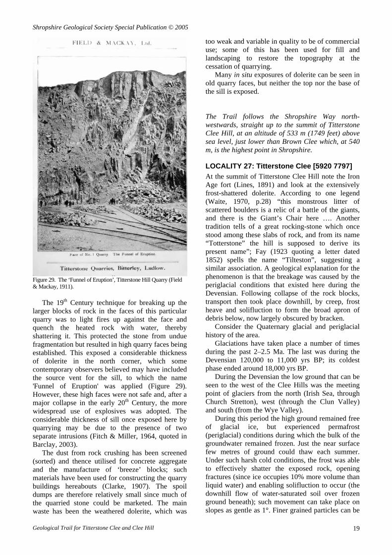
Figure 29. The ‘Funnel of Eruption’, Titterstone Hill Quarry (Field & Mackay, 1911).
The 19th Century technique for breaking up the larger blocks of rock in the faces of this particular quarry was to light fires up against the face and quench the heated rock with water, thereby shattering it. This protected the stone from undue fragmentation but resulted in high quarry faces being established. This exposed a considerable thickness of dolerite in the north corner, which some contemporary observers believed may have included the source vent for the sill, to which the name 'Funnel of Eruption' was applied (Figure 29). However, these high faces were not safe and, after a major collapse in the early 20th Century, the more widespread use of explosives was adopted. The considerable thickness of sill once exposed here by quarrying may be due to the presence of two separate intrusions (Fitch & Miller, 1964, quoted in Barclay, 2003).
The dust from rock crushing has been screened (sorted) and thence utilised for concrete aggregate and the manufacture of ‘breeze’ blocks; such materials have been used for constructing the quarry buildings hereabouts (Clarke, 1907). The spoil dumps are therefore relatively small since much of the quarried stone could be marketed. The main waste has been the weathered dolerite, which was
too weak and variable in quality to be of commercial use; some of this has been used for fill and landscaping to restore the topography at the cessation of quarrying.
Many in situ exposures of dolerite can be seen in old quarry faces, but neither the top nor the base of the sill is exposed. The Trail follows the Shropshire Way north-westwards, straight up to the summit of Titterstone Clee Hill, at an altitude of 533 m (1749 feet) above sea level, just lower than Brown Clee which, at 540 m, is the highest point in Shropshire.
LOCALITY 27: Titterstone Clee [5920 7797] At the summit of Titterstone Clee Hill note the Iron Age fort (Lines, 1891) and look at the extensively frost-shattered dolerite. According to one legend (Waite, 1970, p.28) “this monstrous litter of scattered boulders is a relic of a battle of the giants, and there is the Giant’s Chair here …. Another tradition tells of a great rocking-stone which once stood among these slabs of rock, and from its name “Totterstone” the hill is supposed to derive its present name”; Fay (1923 quoting a letter dated 1852) spells the name “Tilteston”, suggesting a similar association. A geological explanation for the phenomenon is that the breakage was caused by the periglacial conditions that existed here during the Devensian. Following collapse of the rock blocks, transport then took place downhill, by creep, frost heave and solifluction to form the broad apron of debris below, now largely obscured by bracken.
Consider the Quaternary glacial and periglacial history of the area.
Glaciations have taken place a number of times during the past 2–2.5 Ma. The last was during the Devensian 120,000 to 11,000 yrs BP; its coldest phase ended around 18,000 yrs BP.
During the Devensian the low ground that can be seen to the west of the Clee Hills was the meeting point of glaciers from the north (Irish Sea, through Church Stretton), west (through the Clun Valley) and south (from the Wye Valley).
During this period the high ground remained free of glacial ice, but experienced permafrost (periglacial) conditions during which the bulk of the groundwater remained frozen. Just the near surface few metres of ground could thaw each summer. Under such harsh cold conditions, the frost was able to effectively shatter the exposed rock, opening fractures (since ice occupies 10% more volume than liquid water) and enabling solifluction to occur (the downhill flow of water-saturated soil over frozen ground beneath); such movement can take place on slopes as gentle as 1°. Finer grained particles can be
Geological Trail for Titterstone Clee and Clee Hill 19

Shropshire Geological Society Special Publication © 2005
readily washed down and out of the soil in such conditions, leaving behind ground covered in a mantle of boulders (Figures 30 and 31). Similar conditions have been deduced from the geomorphology on the Stiperstones in southwest Shropshire (Clark, 1994).
Figure 30. Blocks of dolerite carried downhill by periglacial processes, Titterstone Clee Hill.
Figure 31. General view looking north towards Titterstone Clee Hill showing (in the centre) the downslope edge of a solifluction sheet.
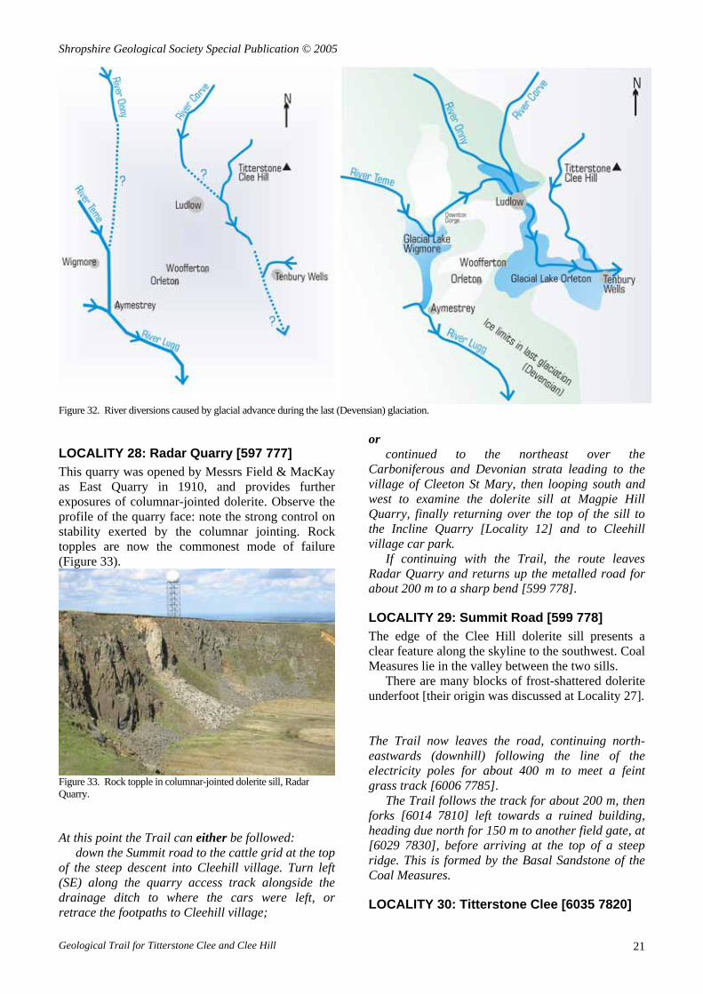
River valleys responded to the changing regimes too, in response to the drop in base level (since sea level dropped by many tens of metres as the water worldwide became locked within the glacial ice) and to the influx of meltwater loaded with sediment from the glaciers. A complex network of river channels and terrace deposits resulted, and some river capture and relocation took place. An example that can be seen from here is provided by the River Teme, which now flows east to the Severn (Figure 32). Formerly the Teme flowed south towards the Wye, and within part of the present valley flowed west, in the opposite direction to today. Evidence comes from the direction in slope of the higher river terrace deposits (Cross & Hodgson, 1975). Indeed, it is possible that the local rivers may have flowed predominantly towards the southeast as part of an early course of the River Thames, which is known to
have existed since the beginning of the Tertiary and thought to have drained this region (Gibbard & Lewin, 2003).
The glacial ice on occasion dammed the river valleys to create temporary lakes, for example the Glacial Lakes Wigmore and Orleton. The impounded water sometimes led to overflow and erosion of new channels, notably that from Glacial Lake Wigmore, which caused the River Teme to flow east from its original southward path through Aymestrey, and instead lead east to Ludlow.
Looking west, in the middle distance one can see Bromfield, just north of Ludlow, and the Ludlow Race Course. Note the relatively wide, flat expanse of low ground, dipping gently southwards. This is a lobe of fluvio-glacial (river-deposited) sand and gravel, initially deposited in a delta within a glacial-dammed lake (Glacial Lake Orleton). At its peak, this lake extended north from Orleton (just beyond the prominent aerial farm at Woofferton), through Ludlow, and reached as far north as Bromfield. As the lake drained so the meltwater developed a major braided river flowing south towards Ludlow.
How do we know that melting glaciers were responsible? [The rivers Corve, Onny and Teme are too small today to transport large quantities of gravel, whereas meltwater from glaciers dumping their load could; the composition of some of the pebbles reveals an origin many miles to the north, which can be explained by the passage of the Irish Sea glacier that came down across the North Shropshire plain and reached as far south as the Stretton Valley, a little to the north of the area in view].
The ice then still damming Glacial Lake Orleton prevented the Teme's southerly progress. The resulting lake eventually spilt over to the east and enhanced erosion of the pre-existing valley floor enabled the river to continue flowing east through Tenbury Wells and drain into the River Severn, reversing the direction of flow of its former tributary in the present-day Lower Teme valley. The consequence is a misfit river within the Lower Teme valley which still occasionally floods since the drainage of excess water is somewhat inefficient. The Trail leads down from the summit of Titterstone Clee Hill, eastwards past the radar station, to join the metalled road leading back down the hill, past the derelict offices of Radar Quarry.
Geological Trail for Titterstone Clee and Clee Hill 20
Shropshire Geological Society Special Publication © 2005
Figure 32. River diversions caused by glacial advance during the last (Devensian) glaciation.
or LOCALITY 28: Radar Quarry [597 777] continued to the northeast over the
Carboniferous and Devonian strata leading to the village of Cleeton St Mary, then looping south and west to examine the dolerite sill at Magpie Hill Quarry, finally returning over the top of the sill to the Incline Quarry [Locality 12] and to Cleehill village car park.
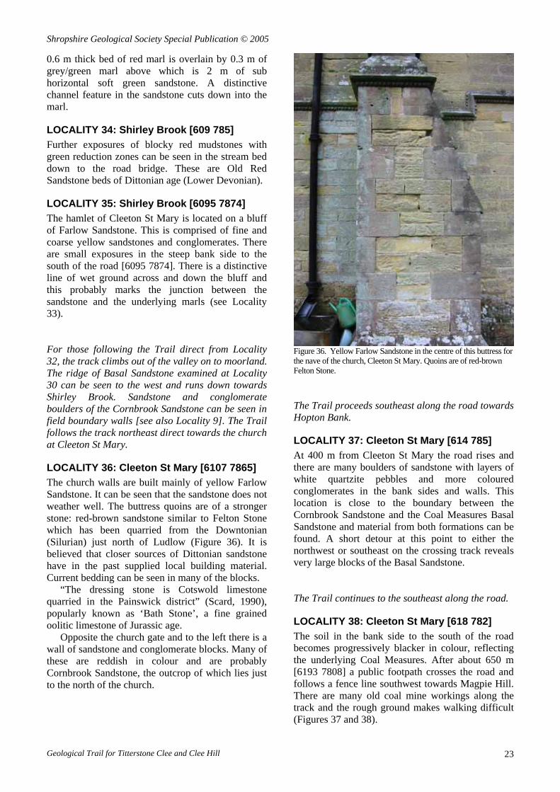
This quarry was opened by Messrs Field & MacKay as East Quarry in 1910, and provides further exposures of columnar-jointed dolerite. Observe the profile of the quarry face: note the strong control on stability exerted by the columnar jointing. Rock topples are now the commonest mode of failure (Figure 33). If continuing with the Trail, the route leaves
Radar Quarry and returns up the metalled road for about 200 m to a sharp bend [599 778].
LOCALITY 29: Summit Road [599 778] The edge of the Clee Hill dolerite sill presents a clear feature along the skyline to the southwest. Coal Measures lie in the valley between the two sills.
There are many blocks of frost-shattered dolerite underfoot [their origin was discussed at Locality 27]. The Trail now leaves the road, continuing north-eastwards (downhill) following the line of the electricity poles for about 400 m to meet a feint grass track [6006 7785].
Figure 33. Rock topple in columnar-jointed dolerite sill, Radar Quarry. The Trail follows the track for about 200 m, then
forks [6014 7810] left towards a ruined building, heading due north for 150 m to another field gate, at [6029 7830], before arriving at the top of a steep ridge. This is formed by the Basal Sandstone of the Coal Measures.
At this point the Trail can either be followed:
down the Summit road to the cattle grid at the top of the steep descent into Cleehill village. Turn left (SE) along the quarry access track alongside the drainage ditch to where the cars were left, or retrace the footpaths to Cleehill village; LOCALITY 30: Titterstone Clee [6035 7820]
Geological Trail for Titterstone Clee and Clee Hill 21

Shropshire Geological Society Special Publication © 2005
A good exposure of the Basal Sandstone can be seen in the steep face of the ridge. The exposure shows thick beds of quartzitic sandstone and conglomerate dipping SE at about 40°. They appear to be about 15 m thick and form a strong NE-trending feature running down towards Shirley Brook. The Trail returns to the track, following it eastwards and taking a right fork towards Shirley Brook, just before a power line. It crosses an area of moorland with many bell pits where the shallow coals lie above the Basal Sandstone.
LOCALITY 31: Shirley Brook [6068 7829] Where the track crosses the brook [6068 7829] there are many dolerite, sandstone and conglomerate boulders. The spoil from bell pits can be seen flanking the west bank both up and down stream at this point. However it may be noted that there are no bell pits in an equivalent position on the east bank implying that coal-bearing strata are absent to the east at this point. This indicates a fault along the line of the brook with a downthrow to the west. The Shirley Brook thus appears to be a fault-guided stream. The Trail can now be followed either along the track to the northeast and into Cleeton St Mary or continued downstream. If the former, go direct to Locality 36. If the latter, continue with Locality 32.
LOCALITY 32: Shirley Brook [6079 7846] The downstream Trail is rough underfoot, with many sandstone and conglomerate boulders to be crossed. At about 200 m downstream of the footpath/stream crossing [Locality 31] a fine grained yellow sandstone is exposed in the stream sides and bed [6079 7846]. This is the Farlow Sandstone which is Upper Devonian in age.
The Farlow Sandstone is best exposed 3 to 4 km to the east, between Farlow, Oreton and Preston where some 20 m of fine and coarse grained grey and yellow sandstones and massive yellow and green quartz conglomerates are found.
The pronounced ridge of Basal Sandstone [Locality 30] ends just to the west of Shirley Brook at this point so it appears that the Upper Carboniferous strata are here overstepping the Upper Devonian – a 70 million year gap in deposition - an unconformity. Unfortunately the contact cannot be seen directly in Shirley Brook. It is interesting to note that here, to the north of the Clee Hill outlier, the Carboniferous rocks lie unconformably on Devonian strata whereas to the south [Locality 8] they rest on Silurian rocks.
Immediately downstream of the Farlow Sandstone exposure the banks of the stream become very marshy suggesting a spring line.
Figure 34. Dittonian sediments, Shirley Brook.
Figure 35. Channel within Dittonian Sandstone, red mudstone beneath; Shirley Brook.
LOCALITY 33: Shirley Brook [6082 7862] Downstream of the marshy ground red and green marls occur in the stream bed and banks. These are part of the Dittonian series [Lower Devonian - see Localities 22, 23, 24]. The marls have a much lower permeability (water flow capacity) than the overlying Farlow Sandstone and this leads to marshy conditions as water drains through the sandstone but is unable to drain through the marls. On proceeding downstream a good exposure of the Dittonian occurs on the west bank of the brook (Figures 34 and 35). A
Geological Trail for Titterstone Clee and Clee Hill 22
Shropshire Geological Society Special Publication © 2005
0.6 m thick bed of red marl is overlain by 0.3 m of grey/green marl above which is 2 m of sub horizontal soft green sandstone. A distinctive channel feature in the sandstone cuts down into the marl.
LOCALITY 34: Shirley Brook [609 785] Further exposures of blocky red mudstones with green reduction zones can be seen in the stream bed down to the road bridge. These are Old Red Sandstone beds of Dittonian age (Lower Devonian).
LOCALITY 35: Shirley Brook [6095 7874] The hamlet of Cleeton St Mary is located on a bluff of Farlow Sandstone. This is comprised of fine and coarse yellow sandstones and conglomerates. There are small exposures in the steep bank side to the south of the road [6095 7874]. There is a distinctive line of wet ground across and down the bluff and this probably marks the junction between the sandstone and the underlying marls (see Locality 33). For those following the Trail direct from Locality 32, the track climbs out of the valley on to moorland. The ridge of Basal Sandstone examined at Locality 30 can be seen to the west and runs down towards Shirley Brook. Sandstone and conglomerate boulders of the Cornbrook Sandstone can be seen in field boundary walls [see also Locality 9]. The Trail follows the track northeast direct towards the church at Cleeton St Mary.
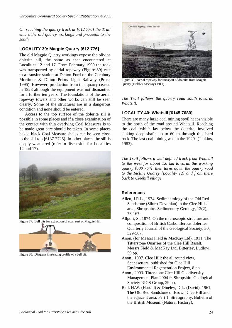
LOCALITY 36: Cleeton St Mary [6107 7865] The church walls are built mainly of yellow Farlow Sandstone. It can be seen that the sandstone does not weather well. The buttress quoins are of a stronger stone: red-brown sandstone similar to Felton Stone which has been quarried from the Downtonian (Silurian) just north of Ludlow (Figure 36). It is believed that closer sources of Dittonian sandstone have in the past supplied local building material. Current bedding can be seen in many of the blocks.
“The dressing stone is Cotswold limestone quarried in the Painswick district” (Scard, 1990), popularly known as ‘Bath Stone’, a fine grained oolitic limestone of Jurassic age.
Opposite the church gate and to the left there is a wall of sandstone and conglomerate blocks. Many of these are reddish in colour and are probably Cornbrook Sandstone, the outcrop of which lies just to the north of the church.
Figure 36. Yellow Farlow Sandstone in the centre of this buttress for the nave of the church, Cleeton St Mary. Quoins are of red-brown Felton Stone. The Trail proceeds southeast along the road towards Hopton Bank.
LOCALITY 37: Cleeton St Mary [614 785] At 400 m from Cleeton St Mary the road rises and there are many boulders of sandstone with layers of white quartzite pebbles and more coloured conglomerates in the bank sides and walls. This location is close to the boundary between the Cornbrook Sandstone and the Coal Measures Basal Sandstone and material from both formations can be found. A short detour at this point to either the northwest or southeast on the crossing track reveals very large blocks of the Basal Sandstone. The Trail continues to the southeast along the road.
LOCALITY 38: Cleeton St Mary [618 782] The soil in the bank side to the south of the road becomes progressively blacker in colour, reflecting the underlying Coal Measures. After about 650 m [6193 7808] a public footpath crosses the road and follows a fence line southwest towards Magpie Hill. There are many old coal mine workings along the track and the rough ground makes walking difficult (Figures 37 and 38).
Geological Trail for Titterstone Clee and Clee Hill 23
Shropshire Geological Society Special Publication © 2005
On reaching the quarry track at [612 776] the Trail enters the old quarry workings and proceeds to the south.
LOCALITY 39: Magpie Quarry [612 776] The old Magpie Quarry workings expose the olivine dolerite sill, the same as that encountered at Localities 12 and 17. From February 1909 the rock was transported by aerial ropeway (Figure 39) east to a transfer station at Detton Ford on the Cleobury Mortimer & Ditton Priors Light Railway (Price, 1995). However, production from this quarry ceased in 1928 although the equipment was not dismantled for a further ten years. The foundations of the aerial ropeway towers and other works can still be seen clearly. Some of the structures are in a dangerous condition and none should be entered.
Access to the top surface of the dolerite sill is possible in some places and if a close examination of the contact with thin overlying Coal Measures is to be made great care should be taken. In some places baked black Coal Measure shales can be seen close to the sill top [6137 7725]. In other places the sill is deeply weathered (refer to discussion for Localities 12 and 17).
Figure 37. Bell pits for extraction of coal, east of Magpie Hill.
Figure 38. Diagram illustrating profile of a bell pit.
Figure 39. Aerial ropeway for transport of dolerite from Magpie Quarry (Field & Mackay (1911). The Trail follows the quarry road south towards Whatsill.
LOCALITY 40: Whatsill [6145 7680] There are many large coal mining spoil heaps visible to the north of the road around Whatsill. Reaching the coal, which lay below the dolerite, involved sinking deep shafts up to 60 m through this hard rock. The last coal mining was in the 1920s (Jenkins, 1983). The Trail follows a well defined track from Whatsill to the west for about 1.6 km towards the working quarry [600 764], then turns down the quarry road to the Incline Quarry [Locality 12] and from there back to Cleehill village.
References Allen, J.R.L., 1974. Sedimentology of the Old Red
Sandstone (Siluro-Devonian) in the Clee Hills area, Shropshire. Sedimentary Geology, 12(2), 73-167.
Allport, S., 1874. On the microscopic structure and composition of British Carboniferous dolerites. Quarterly Journal of the Geological Society, 30, 529-567.
Anon. (for Messrs Field & MacKay Ltd), 1911. The Titterstone Quarries of the Clee Hill Basalt. Messrs Field & MacKay Ltd, Bitterley, Ludlow, 59 pp.
Anon., 1997. Clee Hill: the all round view, Scenesetters, published for Clee Hill Environmental Regeneration Project, 8 pp.
Anon., 2003. Titterstone Clee Hill Geodiversity Management Plan 2004-9, Shropshire Geological Society RIGS Group, 29 pp.
Ball, H.W. (Harold) & Dineley, D.L. (David), 1961. The Old Red Sandstone of Brown Clee Hill and the adjacent area. Part 1: Stratigraphy. Bulletin of the British Museum (Natural History),
Geological Trail for Titterstone Clee and Clee Hill 24

Shropshire Geological Society Special Publication © 2005
Geological (Palaeontological) Series, 5(7), 177-242.
Barclay, W.J., 2003. Clee Hill Quarries, Shropshire. Chapter 7 in: Stephenson, D., Loughlin, S.C., Millward, D., Waters, C.N. & Williamson, I.T. (eds.) Carboniferous and Permian Rocks of Great Britain North of the Variscan Front. Geological Conservation Review Series, No. 27. Joint Nature Conservation Committee, Peterborough, 299-301.
British Geological Survey, 2000. Map for 1:50 000 Geological Sheet 181 (Ludlow), HMSO.
Cantrill, T.C., 1901. Report on the examination of the sections at the reservoirs and along the course of the aqueduct of the Birmingham Corporation Waterworks, Rhyader to Frankley, 1901. Summary of Progress of the Geological Survey of the United Kingdom. Memoirs of the Geological Survey, HMSO, 60-64.
Cantrill, T.C. (in Page, W., ed.), 1968. A history of Shropshire. Vol.1: Geology, The University of London, Institute of Historical Research (which became the Victoria County History), 1-46.
Clark, R., 1994. Tors, rock platforms and debris slopes at Stiperstones. Field Studies, 8, 451-472.
Clarke, W., 1907. Notes on the Clee Hill Basalt from a practical point of view. Paper read at the AGM of the Incorporated Association of Municipal and County Engineers held at Shrewsbury 14-16 July, 1906. The Clee Hill Dhu Stone Company, Ludlow, 10 pp.
Cleal, C.J. & Thomas, B.A., 1996. English Midlands: Cornbrook Dingle; Benson's Brook. Chapter 7 in: Cleal, C.J. & Thomas, B.A. (eds.) British Upper Carboniferous Stratigraphy. Geological Conservation Review Series, No. 11, Chapman and Hall, London, 138-140.
Cross, P. & Hodgson, J.M., 1975. New evidence for the glacial diversion of the River Teme near Ludlow, Salop. Proceedings of the Geologists' Association, 86, 313-331.
Crump, L.A. & Donnelly, R., 1994. Opencast coal mining: a unique opportunity for Clee Hill Quarry; in: Whateley, M.K.G. & Harvey, P.K. (eds.) Mineral Resource Evaluation II: Methods and Case Histories. Geological Society Special Publication 79, London, 219-232.
Dineley, D.L., 1950. The Northern part of the Lower Old Red Sandstone outcrop of the Welsh Borderland. Transactions of the Woolhope Naturalists' Field Club, 33(2), 127-147.
Dineley, D.L. & Gossage, D.W., 1959. The Old Red Sandstone of the Cleobury Mortimore area, Shropshire. Proceedings of the Geologists' Association, 70, 221-238.
Dixon, E.E.L., 1917. The geology of the Titterstone Clee Hill coalfield. Transactions of the Royal Society of Edinburgh, 51, 1064-1071.
Dwerryhouse, A.R. & Miller, A.A., 1930. The glaciation of Clun Forest, Radnor Forest and some adjoining districts. Quarterly Journal of the Geological Society, 86, 96-129.
Fay, A.M., 1923. Victorian Days – England: letters of an American Girl 1851-52. Houghton, Mifflin Co., Boston & New York. The Riverside Press, Cambridge, Ma.
Gibbard, P.L. & Lewin, J., 2003. The history of the major rivers of southern Britain during the Tertiary. Journal of the Geological Society, London, 160, 829–845.
Grindley, H.E., 1939. Notes on the glaciation of the Teme Valley. Transactions of the Woolhope Naturalists' Field Club, 1936-8(2), 94-95.
Hodgson, J.M., 1972. Memoir and accompanying map for one-inch Soil Survey Sheet 181 (Ludlow), HMSO, 139 pp.
Jenkins, A.E., 1983. Titterstone Clee Hills: Everyday life, industrial history and dialect, A.E. Jenkins, Orleton, 156 pp.
Jones, D.G. & Owen, T.R., 1961. The age and relationships of the Cornbrook Sandstone, Geological Magazine, 98, 285-294.
Kidston, R., Cantrill, T.C. & Dixon, E.E.L., 1917. The Forest of Wyre and Titterstone Clee coalfields. Transactions of the Royal Society of Edinburgh, 51, 999-1084.
La Touche, J.D., 1868. Geological address on the top of Titterstone Clee Hill. Transactions of the Woolhope Naturalists' Field Club, 1868, 2, 102-112.
Lapworth, H., 1899-1900. The construction of the Elan Aqueduct: Rhyader to Dolau. Minutes of the Proceedings Institution of Civil Engineers, 140, 235-248.
Lines, H.H., 1891. Titterstone Camp and others. Transactions of the Shropshire Archaeological and Natural History Society, Series 2, 3, 1-35.
Margerison, R.J., Eastaff, D.J. & Norbury, K.W., 1995. Role of the contractor's engineering geologist in the construction of the New Studely Tunnel; in: Eddlestone, M., Walthall, S., Cripps, J.C. & Culshaw, M.G. (eds.) Engineering Geology of Construction. Geological Society Engineering Group Special Publication No. 10, London, 299-308.
Marshall, C.E., 1941. Field relations of certain of the basic igneous rocks associated with the Carboniferous strata of the Midland Counties. Quarterly Journal of the Geological Society, 98, 1-25.
Murchison, R.I., 1833. On the sedimentary deposits which occupy the western parts of Shropshire
Geological Trail for Titterstone Clee and Clee Hill 25
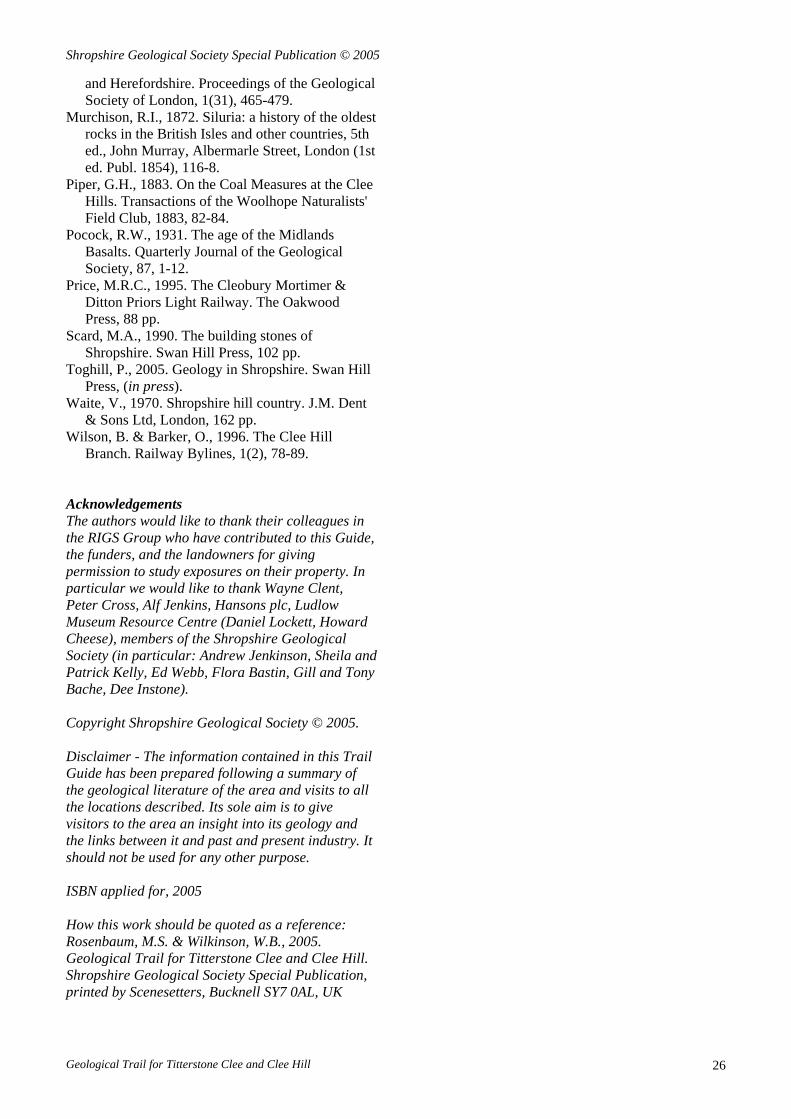
Shropshire Geological Society Special Publication © 2005
and Herefordshire. Proceedings of the Geological Society of London, 1(31), 465-479.
Murchison, R.I., 1872. Siluria: a history of the oldest rocks in the British Isles and other countries, 5th ed., John Murray, Albermarle Street, London (1st ed. Publ. 1854), 116-8.
Piper, G.H., 1883. On the Coal Measures at the Clee Hills. Transactions of the Woolhope Naturalists' Field Club, 1883, 82-84.
Pocock, R.W., 1931. The age of the Midlands Basalts. Quarterly Journal of the Geological Society, 87, 1-12.
Price, M.R.C., 1995. The Cleobury Mortimer & Ditton Priors Light Railway. The Oakwood Press, 88 pp.
Scard, M.A., 1990. The building stones of Shropshire. Swan Hill Press, 102 pp.
Toghill, P., 2005. Geology in Shropshire. Swan Hill Press, (in press).
Waite, V., 1970. Shropshire hill country. J.M. Dent & Sons Ltd, London, 162 pp.
Wilson, B. & Barker, O., 1996. The Clee Hill Branch. Railway Bylines, 1(2), 78-89.
Acknowledgements The authors would like to thank their colleagues in the RIGS Group who have contributed to this Guide, the funders, and the landowners for giving permission to study exposures on their property. In particular we would like to thank Wayne Clent, Peter Cross, Alf Jenkins, Hansons plc, Ludlow Museum Resource Centre (Daniel Lockett, Howard Cheese), members of the Shropshire Geological Society (in particular: Andrew Jenkinson, Sheila and Patrick Kelly, Ed Webb, Flora Bastin, Gill and Tony Bache, Dee Instone). Copyright Shropshire Geological Society © 2005. Disclaimer - The information contained in this Trail Guide has been prepared following a summary of the geological literature of the area and visits to all the locations described. Its sole aim is to give visitors to the area an insight into its geology and the links between it and past and present industry. It should not be used for any other purpose. ISBN applied for, 2005 How this work should be quoted as a reference: Rosenbaum, M.S. & Wilkinson, W.B., 2005. Geological Trail for Titterstone Clee and Clee Hill. Shropshire Geological Society Special Publication, printed by Scenesetters, Bucknell SY7 0AL, UK
Geological Trail for Titterstone Clee and Clee Hill 26