Embed Size (px)
Citation preview
White Paper for the 2010 Mexico GPS Workshop:
TLALOC-Net – a next-generation, multi-sensor atmospheric and GPS array for hazards, weather, climate, and earthquake monitoring, forecasting and research
in the Americas
September 20-22, 2010. Puerto Vallarta, Mexico
Workshop organizing committee
E. Cabral-Cano and V. Kostoglodov, Instituto de Geofisica, UNAM;
C. DeMets, University of Wisconsin;
E. R. Kursinski, University of Arizona;
M. Jackson and M. Miller, UNAVCO.
This workshop was sponsored by the National Science Foundation (NSF)
and the Consejo Nacional de Ciencia y Tecnología de México (CONACyT).
TLALOC TLALOC netnet
2
Executive Summary
During September 20-22, 2010, a workshop sponsored jointly by NSF and CONACyT was held in Puerto Vallarta, Mexico to discuss the rationale, uses, and implementation of a state-of-the-art atmospheric and GPS network in Mexico for applied research in climate and weather forecasting and the physical processes controlling earthquakes and volcanoes. Thirty-five international scientists from 22 universities and agencies attended, spanning atmospheric, climatic, hydrologic, Solid Earth, and space weather disciplines.
This white paper outlines the scientific merits of a dense network of permanent, continuously operating GPS stations in Mexico, its potentially transformative effects on Mexican science and scientists, its ability to improve short-term and long-term hazards forecasting in and around Mexico, and a clear path toward a sustainable array.
As the name of the network, we have chosen TLALOC, which stands for Trans-boundary, Land and Atmosphere Long-term Observational and Collaborative network. Tlaloc was the Aztec god of water, feared for his ability to deliver hail, rain, and lightning upon the inhabitants. He was also associated with the mountains and caves of Mesoamerica and his name is thought to derive from the Nahuatl word for "earth". Thus, the name, Tlaloc, provides a beautiful linkage between the solid earth and water cycle roles envisioned for this GPS network in Mexico.
One key achievement of the workshop toward bringing TLALOC-Net to fruition was a written declaration signed by all 14 participating Mexican scientists to form a first-ever consortium of Mexican investigators and institutions who will share their data openly, work in a unified fashion to advocate and facilitate GPS-based science in Mexico, and strive to build Mexicoʼs human and technical capacity for cutting-edge research and hazards forecasting. Several productive follow-up meetings have been held to identify and further align the meteorological and geophysical interests of Mexican and American universities and government agencies. These yielded an offer by Adrian Vazquez, head of Mexicoʼs National Meteorological Service (SMN), to house the core of the TLALOC array at existing, staffed SMN locations. This commitment by Mexican collaborators will not only increase the security of stations installed, but is critical for the long-term sustainability and shared operations and maintenance of the proposed TLALOC Network.
In light of the enthusiastic scientific and agency responses during and after the workshop prompted by TLALOC Netʼs numerous applications and benefits, we have prepared this white paper to build the foundation for eventual funding requests to both NSF and CONACyT. With a properly coordinated implementation, TLALOC-Net promises to be a singular event in fostering natural science research in Mexico via open sharing of the Networkʼs new data types, and the collaborative work of a new generation of Mexican and American scientists who will employ TLALOC-Net as a primary tool in their research. Strong linkages between U.S. and Mexican scientists would also result given that both countries share many of the climatic, atmospheric, hydrologic, and solid Earth challenges and processes that TLALOC-Net is aimed at solving.
3
Below, we outline the scientific context for the TLALOC Network. Separate summaries of the hydro-atmospheric and solid Earth justifications for the proposed array follow, after which the white paper concludes with a description of the tangible benefits to Mexico and the US. Several appendices document the workshop participants, a first-time agreement between Mexican GPS scientists for broad collaboration and data sharing, and an assortment of workshop ideas that space considerations exclude from the body of the white paper.
Overview
Mexico is simultaneously blessed with solid Earth and atmospheric research opportunities and threatened by an array of potentially devastating natural hazards that do not stop at international borders. These opportunities and threats can be separated into two categories - those that occur suddenly and those that unfold more gradually over longer periods. In the former category, earthquakes, volcanic eruptions, hurricanes, heavy precipitation, flooding and landslides are well recognized and are high priorities for operational forecasting and basic and applied research. In the latter category, changes in climate are predicted to further dry out already arid parts of northern Mexico and the southwestern U.S., raising concerns about the sustainability of agricultural production and exports critical to the regional populations and economies of both Mexico and the U.S. Aquifers critical to crop irrigation and municipal water supplies are being drawn down in many areas more rapidly than they are being recharged, raising similar concerns about sustainability. Furthermore, the hazards are likely escalating, as rising global temperatures appear to be intensifying drought and heavy rainfall events across Mexico and adjacent areas of the U.S., with increasingly likely devastating local and regional impacts. From a global perspective, these hydrological shifts also threaten one of the most ecologically and biologically diverse areas on the planet, raising fundamental questions about whether and how this diversity can in fact be sustained.
The hazards described above provide compelling justification to fundamentally expand monitoring in Mexico to support research focused on improving short-term and long-term forecasting of weather, climate, and hazards and quantitatively assessing sustainability and the physical processes controlling earthquakes and volcanoes. Much of the excitement about TLALOC-Net is due to the unique ability of GPS to address the full range of research and hazards in a very cost effective manner. For example, densified measurements of the atmospheric water vapor that streams across Mexico into the United States could transform our understanding of the factors controlling precipitation, with the benefits accruing to both countries. Dense networks of GPS stations will allow for improved models of strain accumulation along the earthquake prone Mexican plate boundaries. Further applications include improved short and long term forecasts needed for hydroelectric energy decision-making, improving Mexican agricultural productivity, improving understanding and modeling of the spread of water-related vector diseases such as dengue fever and encephalitis and providing the linkage

4
between surface conditions and satellite measurements that will enhance the value of satellite observations as proxies for key variables over Mexico.
A further central goal of TLALOC-Net is to recruit and foster a new generation of Mexican atmospheric, hydrologic, and solid Earth scientists and technical staff whose expertise would benefit the entire country and the U.S. Relatively few Mexican scientists are presently trained in the above disciplines, due in part to the lack of a modern, dense observational infrastructure that would permit intense, focused research on these topics. Knowledge transfer and cross-fertilization between Mexican and U.S. scientists and students are thus a key objective of any effort to build a next-generation Earth and Atmospheric imaging array in Mexico.
Summary of atmospheric, hydrologic, and space weather applications and outcomes
TLALOC-Net has numerous applications for hydrometeorologic and climate research. Much interest from Mexican scientists lies in applying GPS as a cost effective method for addressing the suite of major natural hazards that threaten Mexico over short time periods, namely, earthquakes, volcanic eruptions, tropical cyclones, flooding and drought, and for understanding the medium-term and longer-term impacts of climate change that may already be contributing to recent record-breaking rainfall, flooding events and the overall water resources management in Mexico. Indeed, scientific assessments like the Climate Change Science Program Report 3.3 (http://www.climatescience.gov/Library/sap/sap3-3/final-report/default.htm) argue that substantial changes have already begun and predict an increased likelihood of extreme weather events, including both precipitation and drought, as temperatures increase globally.
The weather, climate and tectonics of Mexico and U.S. do not recognize the international border that separates them. Both countries therefore have common interests in weather- and climate-related research and forecasting. For example, both countries share a common interest in hurricane prediction and preparedness, particularly hurricanes in the Gulf of Mexico and Caribbean. In addition, both countries are concerned about predictions that the already semi-arid U.S. Southwest and Mexican Northwest will dry out further and experience increasingly severe droughts as global temperatures and regional populations increase. Because much of the moisture enters the U.S. from northern Mexico, a dense observational network in Mexico would provide critical upstream information for predicting weather and monitoring changes in the flux of moisture entering North America. More generally, Mexico is a key and geographically complex land area that separates the Atlantic and Pacific oceans and plays complicated and often poorly understood roles in North American weather and climate. As one of the most ecologically and biologically diverse areas on the planet, Mexico and the World have much to lose by environmental change and would benefit, as noted by Adrian

5
Vazquez, from placing a subset of TLALOC-Net sites near existing and planned eco- and biodiversity monitoring stations in Mexico.
The need for combined GPS/meteorological Network across Mexico is also driven by the limited utility of satellite meteorological data over continental Mexico. Visible and infrared wavelengths cannot penetrate clouds and land-surface emissivity variations make passive microwave measurements very difficult to interpret. While Mexicoʼs 14 radiosonde sites presently profile the atmosphere once or twice per day, these measurements are spatially sparse and temporally infrequent, and, at some sites, have been completely unavailable for extended periods, adversely affecting both Mexican and U.S. weather prediction and climate monitoring. In contrast, measurements of water column and surface water vapor at one hundred or more TLALOC-Net sites will provide near-continuous data to be assimilated into weather-forecasting centers in the U.S. and Mexico and to quality control sonde humidity profiles, a role that has proven quite important with the poorly performing Sippican sonde humidity sensors now in use by the U.S. National Weather Service. TLALOC-Netʼs automated rain gauges will also vastly improve upon the sparse existing rainfall network in Mexico, much of which only reports a single measurement each day. Near-real-time transmission of the new, time-resolved rainfall measurements will reveal significant rainfall events as they occur and provide the ground truth needed to correct satellite observations and hydrometeorological models. TLALOC-Net will also provide the first national soil moisture monitoring network in Mexico, which is critical for flood prediction, drought monitoring, better understanding of the North American water cycle budget, and ultimately for supporting a sustainable water resource management in both Mexico and the U.S.
Figure 1. Approximate locations of 152 TLALOC-Net Stations. Not shown are 10 supersite station locations.
6
All hydrometeorological sites in the TLALOC-Network (Figure 1) will include a GNSS receiver, barometer, thermometer, hygrometer, anemometer and rain gauge. In addition, a subset of sites will be hydrometeorological “super” sites with additional instrumentation that includes (a) flux measurements of sensible heat, water vapor and CO2, (b) a COSMOS style neutron soil moisture sensor, (c) a disdrometer to determine rain particle size distribution and (d) 2 to 3 additional GNSS receivers separated by approximately 10 km that when used together will determine water vapor weighted winds.
Data from these supersites will establish quantitative temporal-spatial relationships between variables such as precipitation, soil moisture, and evaporation and the relation between the shallow soil moisture observed by GPS and deeper soil moisture measured by COSMOS. Supersite data will make the rest of the network more useful, improve the physical representation of processes in models and enable satellite measurements to act as proxies for key hydro-ecological variables, enormously increasing the value of spatially-extensive satellite data in the region.
The Network will also support NOAA real-time Space Weather operations by mapping the time varying structure of the ionosphere over Mexico with a goal of 5 to 15 minute latency to support physical and data assimilation modeling and determine and improve forecasts of the ionospheric response to solar flares, geomagnetic storms, and the atmosphere.
While more than 100 GPS receivers already exist in Mexico, their distribution is focused along the southwestern coast of Mexico and will not support the wide range of hydro-meteorological applications noted above. To achieve the science goals, a set of network locations distributed more evenly across the Mexican subcontinent is required that would monitor principal paths of atmospheric moisture into Mexico, monitoring locations upstream of flow into the U.S. that will improve weather forecasting in the U.S., and monitoring areas prone to severe flooding, drought, areas where both large and uncertain signatures of climate change are anticipated, and zones of ecological importance. Several island locations have been identified as key TLALOC-Net sites in the Pacific and Gulf of Mexico that would monitor the moisture flow upstream of flow onto the continent to improve severe weather forecasting and determine any climate related shifts in storm tracks that would substantially alter existing precipitation patterns, thus impacting the sustainability of water management, agricultural and economic productivity and biodiversity of Mexico. The Pacific island sites in particular would also be extremely useful for monitoring the plate boundaries off the Mexican west coast.
For a modest investment, TLALOC-Net will transform Mexico from a data-sparse to a data-rich environment for hydrometeorological and climatic research. It will not only produce a wealth of presently unavailable data in near-real-time for the Mexican and U.S. operational and research communities and government agencies engaged in weather and climate forecasting, but will also greatly improve the usefulness of the wealth of satellite and other data that are already being collected, but are of limited use unless quantitatively linked to near surface conditions.
7
TLALOC-Net has the potential to initiate and drive a much needed expansion of the relatively small but increasingly important Mexican meteorological and climatological research community. Researchers and government agencies on both sides of the border anticipate that this superb observational array will invigorate research and advanced education in Mexico and the U.S. and strengthen greatly the intellectual exchange and collaborative research between the two countries.
Other activities: Several developments after the workshop in Puerto Vallarta merit mention. First, discussions with Mexican and U.S. researchers and government agency representatives who were unable to attend the workshop have confirmed that a relatively low cost, long-term monitoring network like TLALOC is well matched to the real problems and challenges faced by those agencies, including the constraints of the present economic environment. In particular, two meetings in El Paso, Texas and in Mexico City in early and late October respectively with Adrian Vazquez, head of Mexicoʼs National Meteorological Service SMN, revealed a high level of interest and support for TLALOC-Net at Mexicoʻs SMN. Furthermore, SMN offered to house the core of the TLALOC-Net sites at existing, staffed SMN observatories throughout Mexico. This lays to rest a key uncertainty identified at the workshop, namely, how to sustain TLALOC-Net in order to achieve the long-term stability that is required for operational weather forecasting and climate monitoring.
The TLALOC-Net concept was also presented in early October at the 35th NOAA Climate Diagnostics and Prediction Workshop (CDPW) in Raleigh, North Carolina. This included a meeting with Tom Karl, head of the new NOAA Climate Service, who expressed strong interest in this network and the recently funded COCONet in the Caribbean, which along with TLALOC-Net would provide complete geographic coverage of atmospheric water vapor through the Caribbean, Central and North America. TLALOC-Netʼs scope and timing dovetails with many other concurrent activities and interests at SMN and NOAA, a number of which are in similar stages of development. TLALOC-Net would also provide important ground truth for future NASA missions such as the Soil Moisture Active & Passive (SMAP) and the Global Precipitation Mission (GPM). Thus, with a well-coordinated and integrated implementation plan, this network can take advantage of numerous synergies and yield a whole that is significantly greater than the sum of its parts.
Summary of solid Earth applications and outcomes
Few countries have as much land area exposed to earthquake and volcanic hazards as Mexico. Surrounded by four tectonic plates, large areas of southern, central, and western Mexico, and Baja California have had damaging historic or recent earthquakes and will experience them again in the future. The most destructive of these, the 1985 Michoacan earthquake, caused over 5,000 deaths and ten billion dollars of damage in Mexico City, Mexicoʼs capital and the worldʼs 3rd most populous city. Consequently, nearly all GPS research in Mexico to date has focused on the earthquake cycle in these
8
regions and ~80% of Mexicoʼs GPS infrastructure was built and is maintained by solid Earth scientists over the past 15 years. The workshop in Puerto Vallarta was the first time that all (except one) of the scientists responsible for building and maintaining these networks came together to strongly endorse the concept of upgrading and unifying their now-separate networks into an integrated TLALOC array. Such an array would have transformative effects on solid Earth research in Mexico on a number of levels.
Subduction of the Rivera and Cocos plates beneath Mexicoʼs 1500-km-long Pacific coast produces ~10 mega-earthquakes per century, with average magnitudes of 7.8 to 8.2. Of particular concern, the Guerrero seismic gap last ruptured more than a century ago and is closer to Mexico City than the 1985 Michoacan earthquake rupture zone. The worldʼs largest-ever episodic transient slip event (ETS) occurred beneath Guerrero in 2002, near the region of the fault where great earthquakes nucleate and at least five episodic transient slip events have been measured by GPS beneath the state of Oaxaca and are the focus of additional on-going research. Understanding whether ETS beneath Guerrero has the potential to trigger a mega-earthquake along nearby locked areas of the subduction fault is of critical importance in earthquake studies and is a focus of much ongoing research. A complementary key element of the TLALOC Network would be to instrument several core TLALOC-Net sites with complementary borehole strainmeters in the Michoacan-Guerrero-Oaxaca region in order to improve (by a factor of ten) the detectability threshold for small episodic slips in this region.
Four factors make the Mexico subduction zone a nearly ideal laboratory for studies of the full spectrum of fault behaviors that comprise the earthquake cycle in Mexico and elsewhere. A shallow angle of Cocos plate subduction and coast-to-trench distances of only 45-60 km combine to place large areas of southern Mexico directly above parts of the subduction interface that are involved in the earthquake cycle. As a consequence TLALOC-Net would have superb downward-looking resolution of the subduction interface beneath the continent, making it ideal for geodetic and seismic studies of the earthquake cycle. Convergence rates across the subduction zone are rapid and thus give rise to large measurable signals at the surface. Finally, the relatively short 50-100-yr. seismic cycle increases the chances that sustained observations will span all phases of the earthquake cycle. Few other areas on Earth are as well suited for detailed subduction-focused research.
High earthquake hazard also occurs in the northern Baja California peninsula, where a network of faults connected to the southern San Andreas fault carry motion northward out of the Gulf of California. The M7.2 El Mayor-Cucapa earthquake on April 4, 2010 caused extensive local damage in the Mexicali valley and raised concerns that it might trigger further earthquakes along the southern San Andreas fault. Numerous other faults in the state of Chiapas in southern Mexico and along the Mexican Volcanic Belt in central Mexico have ruptured in historic times and pose significant -though less imminent- seismic hazard. Continuous measurements by suitably sited GPS receivers will define the crustal velocity field and interseismic strain rates across seismically active areas, a key element of earthquake forecasting.
9
Other activities: In late September 2010, prior to the workshop, one of the workshop organizers (DeMets) traveled to Mexico City to meet with Dr. Carlos Valdes, the head of the Mexican Seismologic Service (SSN), who was unable to send a representative to the meeting in Puerto Vallarta due to agendaʼs overlap with the 100th anniversary of SSN and 25th anniversary of the 1985 earthquake. Dr. Valdes pledged the full support and cooperation of SSN for the TLALOC Network. His support is noteworthy because SSN operates ~20 seismic stations with co-located GPS receivers that would be secure long-term locations for TLALOC-Net equipment, thereby helping to place the Network on a more sustainable footing.
Finally, several workshop participants (i.e. Cabral, DeMets, & Kostoglodov) have installed and presently operate well over half of the ~120 existing continuous GPS stations in Mexico. Their strong support for TLALOC-Net and pre-existing networks offer roughly $500,000 of “leverage” (i.e. cost savings) for the TLALOC array and substantially decrease the time and money it would require to construct a functional integrated network, particularly in southern and central Mexico where most of their GPS stations are located.
TLALOCʼs potential impact on educational, scientific capacity building in Mexico and stronger US-Mexico collaborative efforts.
As of mid-2010, most of the ~120 continuous GPS sites in Mexico are maintained by a handful of researchers engaged in earthquake cycle studies and other natural hazards such as volcano monitoring and land subsidence. Ironically, the technical support and resources provided to operate the growing network have decreased in the past 1-2 years, placing a heavy burden on a handful of investigators to maintain these sites. This is not only an inefficient use of time for scientists who should be investing their hours into data analysis and interpretation, but is also unsustainable – the loss or retirement of just one or two key individuals could result in the abandonment of as many as 50-70 of the 120 stations, constituting an enormous backward leap for GPS research in Mexico.
The above underlines a critical need to broaden Mexicoʼs scientific and technical know-how and support for solid Earth, atmospheric, and hydrologic applications of GPS. Properly implemented, TLALOC could be the most significant, singular event in fostering natural science collaborative research in Mexico via open data sharing from a centralized archive, real-time data delivery, and growth of a new generation of Mexican scientists who employ TLALOC as a primary tool in their research. Strong linkages between U.S. and Mexican scientists would also result given that many of the same climatic, atmospheric, hydrologic, and solid Earth problems that TLALOC is aimed at occur on both sides of the Mexico-U.S. border. Interestingly the workshop highlighted this observation as most if not all of the be Mexican or US participants in both solid Earth, atmospheric or ionospheric weather have already established collaborative research with their foreign counterparts.

10
A number of tangible ways to accomplish the above and have broader impacts on Mexican society were proposed by one of the workshop participants (Rajul Pandya) at the workshop and are summarized in detail in Appendix 3. These include (1) multiple GPS certificates that would be co-awarded at U.S. and Mexican institutions to prepare a new generation of GPS technicians, engineers, and scientists, (2) an annual GPS science conference in Mexico, with emphasis on student participation and mentoring activities, (3) development of the capacity for data processing, archiving, and visualization in Mexico, (4) development of useful, readily available products for non-scientists including disaster management teams, urban and regional planners, agricultural extension agents, meteorologists at the Mexican Meteorological Service, and possibly, public health researchers for climate/weather sensitive vector diseases like malaria or dengue fever, (5) School/community outreach. For example, the process of placing a GPS site provides an opportunity to interact with, learn from, and benefit a community (possibly by making telecom/Internet communications that are necessary for data transfer available for community or school use). A free and open data policy of the TLALOC network will allow the private sector to access standard and high-rate, real-time data and data products, further contributing to economic stimulation and capacity building in both Mexico and the U.S.
Creation of a Mexican GPS organization/consortium: Seventeen Mexican scientists from six research and academic institutions participated in the workshop (details can be found in the participant list near the end of this documents). From their viewpoint, Mexican scientists who are engaged in atmospheric, hydrologic, and solid Earth studies are now beginning to recognize the potential of GPS for problems of great importance for Mexico. Topics with the greatest potential societal benefits are atmospheric, space and natural disaster prevention studies, including severe weather warnings and forecasts or real-time ionospheric activity. Following discussion between the Mexican scientists during the second morning of the workshop, the scientists returned to the larger group with the announcement that they had reached consensus that fundamental advances in studies of natural phenomena and disaster prevention in Mexico would be greatly facilitated through national scale cooperation and open data sharing policies. To this purpose, all the Mexican participants co-wrote and signed a letter of intent to create a new organization/consortium with the following goals: (1) Establish an open GPS data sharing policy and implement it through rapid development of a centralized, open data archive, (2) Encourage scientific collaborations between Mexican universities/agencies, particularly for investigators pursuing similar lines of research, (3) Build human resources, including improved student mobility and academic exchange, (4) Share instruments, hardware and software between institutions, and (5) Promote participation in geodetic and environmental observations from other academic, government and private sector agencies. Specific short-term goals of this volunteer organization will include a complete inventory of all GPS infrastructure in Mexico, including documentation of ancillary information and metadata, implementation of a central data archive for data preservation and improved Web access, an analysis of data quality, recommendations for specific upgrades and/or operational protocols to better standardize the existing GPS infrastructure, advocacy for sufficient human resources for
11
station maintenance and data acquisition and download, development of a short-term plan to implement near real-time data transmission, and outreach activities to inform the Mexican atmospheric and space sciences communities and disaster prevention agencies of the many benefits of a unified Mexican GPS network. Over the next 1-2 years, the group will spearhead the Mexican effort to procure funding for the TLALOC network, a multisensor integrated real-time network for atmospheric, hydrologic, and solid Earth applications and research spanning Mexico and the Americas.
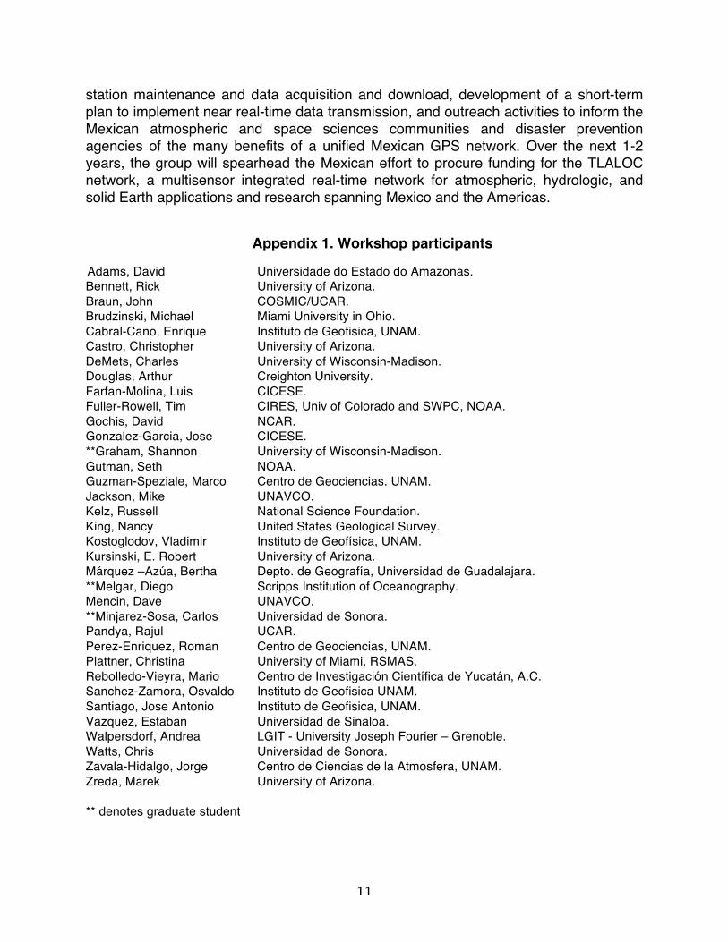
Appendix 1. Workshop participants
Adams, David Universidade do Estado do Amazonas. Bennett, Rick University of Arizona. Braun, John COSMIC/UCAR. Brudzinski, Michael Miami University in Ohio. Cabral-Cano, Enrique Instituto de Geofisica, UNAM. Castro, Christopher University of Arizona. DeMets, Charles University of Wisconsin-Madison. Douglas, Arthur Creighton University. Farfan-Molina, Luis CICESE. Fuller-Rowell, Tim CIRES, Univ of Colorado and SWPC, NOAA. Gochis, David NCAR. Gonzalez-Garcia, Jose CICESE. **Graham, Shannon University of Wisconsin-Madison. Gutman, Seth NOAA. Guzman-Speziale, Marco Centro de Geociencias. UNAM. Jackson, Mike UNAVCO. Kelz, Russell National Science Foundation. King, Nancy United States Geological Survey. Kostoglodov, Vladimir Instituto de Geofísica, UNAM. Kursinski, E. Robert University of Arizona. Márquez –Azúa, Bertha Depto. de Geografía, Universidad de Guadalajara. **Melgar, Diego Scripps Institution of Oceanography. Mencin, Dave UNAVCO. **Minjarez-Sosa, Carlos Universidad de Sonora. Pandya, Rajul UCAR. Perez-Enriquez, Roman Centro de Geociencias, UNAM. Plattner, Christina University of Miami, RSMAS. Rebolledo-Vieyra, Mario Centro de Investigación Científica de Yucatán, A.C. Sanchez-Zamora, Osvaldo Instituto de Geofisica UNAM. Santiago, Jose Antonio Instituto de Geofisica, UNAM. Vazquez, Estaban Universidad de Sinaloa. Walpersdorf, Andrea LGIT - University Joseph Fourier – Grenoble. Watts, Chris Universidad de Sonora. Zavala-Hidalgo, Jorge Centro de Ciencias de la Atmosfera, UNAM. Zreda, Marek University of Arizona. ** denotes graduate student
12
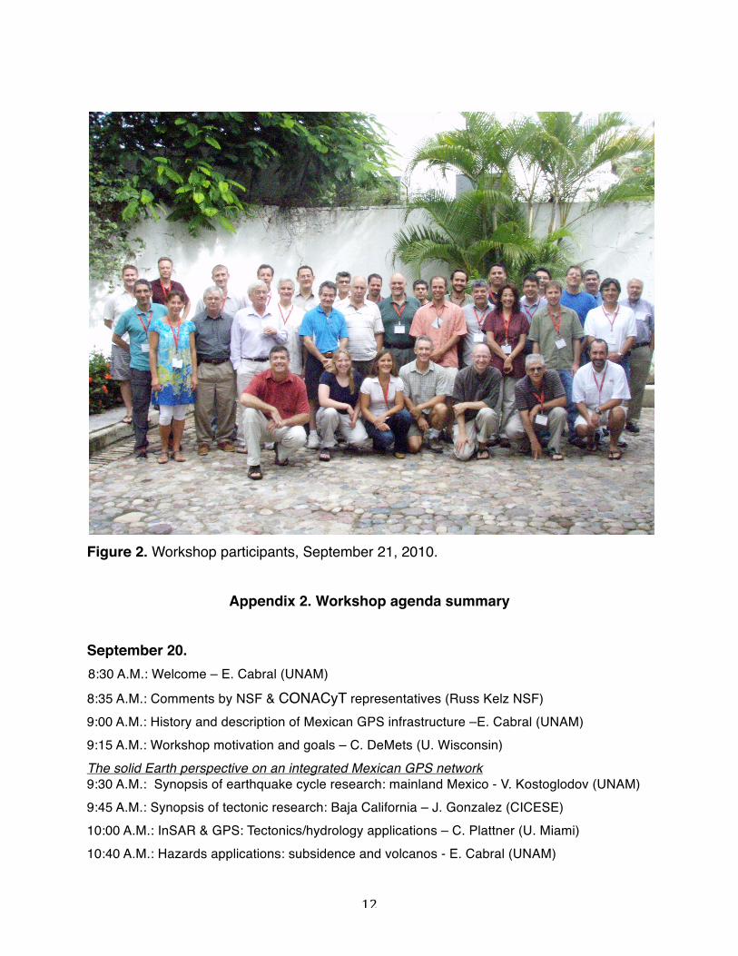
Figure 2. Workshop participants, September 21, 2010.
Appendix 2. Workshop agenda summary September 20.
8:30 A.M.: Welcome – E. Cabral (UNAM) 8:35 A.M.: Comments by NSF & CONACyT representatives (Russ Kelz NSF)
9:00 A.M.: History and description of Mexican GPS infrastructure –E. Cabral (UNAM) 9:15 A.M.: Workshop motivation and goals – C. DeMets (U. Wisconsin) The solid Earth perspective on an integrated Mexican GPS network 9:30 A.M.: Synopsis of earthquake cycle research: mainland Mexico - V. Kostoglodov (UNAM) 9:45 A.M.: Synopsis of tectonic research: Baja California – J. Gonzalez (CICESE) 10:00 A.M.: InSAR & GPS: Tectonics/hydrology applications – C. Plattner (U. Miami) 10:40 A.M.: Hazards applications: subsidence and volcanos - E. Cabral (UNAM)

13
11:00 A.M.: Seismic/GPS co-location: Mexican SSN and Scripps– D. Melgar (Scripps) The atmosphere, hydrosphere, and ionosphere: Perspectives on a Mexican GPS network 11:15 A.M: Overview of GPS applications for atmospheric research – R. Kursinski (U. Arizona) 11:40 A.M: GPS-based atmospheric research at NOAA – S. Gutman (NOAA) 1:30 P.M.: Mexican PWV flow, IASCLIP, & the Gulf of Mexico – A. Douglas (Creighton U.) 1:45 P.M.: GPS PWV in the Gulf of Mexico & beyond: COCONET et al. – J. Braun (UCAR) 2:00 P.M.: NAME: Precipitation and relation to GPS – D. Gochis (NCAR) 2:15 P.M.: GPS PWV measurements & modeling – C. Castro & C. Minjarez (U. Arizona/U. Sonora) 2:30 P.M.: La Paz experience with PWV – L. Farfan (CICESE) 3:00 P.M.: Dense GPS networks for studying moist convection – D. Adams (U. E. Amazonas) 4:15 P.M.: Ionospheric applications – T. Fuller-Rowell (U. Colorado) 4:30 P.M.: 30-minute focus group discussion 5:00-6:00 PM: End of day brain-storming by session organizers Cabral, DeMets, Jackson, Kostoglodov, & Kursinski
September 21: 8:30-9:00 A.M.: Focus group – Mexican scientists and participants 9:15 A.M.: Description of new agenda for Day 2 – C. DeMets (UW) 9:20-9:30 A.M.: NSF rep commentary (Kelz) 9:30-10 A.M.: UNAVCO: Organization, role/funding, science M. Jackson 10:00 A.M.: Soil moisture from neutrons – M. Zreda (U. Arizona) 10:15 A.M.: Surface moisture from GPS - J. Braun (UCAR) 10:30 A.M.: Surface moisture fluxes and exchange – C. Watts (U. Sonora) 10:45-11:15 A.M.: Integrated GPS/MET network requirements – M. Jackson (UNAVCO) 11:20 AM: UNAVCO response to northern Baja earthquake – K. Feaux (UNAVCO) 11:30A.M.: Borehole strain meter applications, logistics, and cost – D. Mencin (UNAVCO) 11:50 A.M.: Announcement of a Mexico GPS consortium: E. Cabral 12:00: Seismologic/earthquake forecasting – the fole of GPS: M. Brudzinski (Miami U) 12:10: Open discussion 4:30-6:30 PM – Discussion of what will be required to achieve the key scientific goals of a proposed network.
14
September 22: 9 A.M. onwards: Open meeting of workshop organizers Cabral, DeMets, Jackson, Kostoglodov, and Kursinski to distill the workshop material and work on meeting report and white paper.
Appendix 3. Ideas for broader impacts (courtesy of Rajul Pandya, UCAR). 1. A set of certificates in GPS, co-delivered at Mexican and US institutions, would help prepare a new generation of GPS technicians, engineers and scientists. The classes could be co-taught by Mexican and US investigators, using Videocon linked classrooms and laboratories in the US and Mexico, and there should be a strong field component that would include hands-on opportunities to install and use GPS stations in Mexico. The certificates could be created at the undergraduate level, which would focus on installing and troubleshooting GPS and met receivers and a little bit on data collection and processing, while a graduate certificate would focus on techniques for processing and analyzing data. In Mexico this would help train a workforce to maintain and use the GPS stations over the long run (especially in meteorology where GPS –related expertise is quite limited) and help bring together US students and foster an interdisciplinary approach to using GPS data.
2. Regular GPS science meetings: part of the value of preparing the proposal was the opportunity to present the science enabled by GPS to an audience of scientists and graduate students, especially in Mexico. We propose to host an annual GPS science conference in Mexico, and include students in particular. In addition to science sessions, the meeting may also include mentoring sessions for students on topics like opportunities, preparing for the next phase of education/profession (e.g. graduate school opportunities). If presentations are peer-reviewed, proceedings could be published for this meeting, too, as either a special issue of an existing journal or as a stand-alone volume.
3. Data management and archive in Mexico: We will, as part of this proposal, develop capacity for data processing, archiving (including redundancy), and visualization in Mexico. Initially focused on GPS data, the capability could extend to other environmental fields. A concentrated effort to develop products of use to various stakeholders; including disaster management teams, urban and regional planners, agricultural extension agents, meteorologists at the Mexican National Meteorological Service, and even public health researchers for climate/weather sensitive diseases like Malaria or Dengue Fever. The effort will begin with a stakeholder forum where GPS scientists listen to stakeholders and identify ways that GPS products can contribute to
15
stakeholder capacity. Based on this forum, 2-3 promising applications will be developed and piloted. Promising in this context is the combination of a) stakeholders willing to invest time in testing and modifying a new product, b) a relatively short path from existing data to usable product, and c) the potential societal benefit of the product. I imagine this to take one FTE; someone with a good scientific base, data-management/processing skills, and good interpersonal skills and ability to work in applications and with stakeholders. To really round this out, you could examine the economic benefit of the new product vs. the cost to develop it (not an easy thing to do, though).
4. School/Community Outreach: Placing a site provides an opportunity to interact with, learn from and benefit a community. A simple example of this might be opening the telecom/internet communications necessary for the station to community use – perhaps via a local school. Community education about the station, and including hands-on, culturally appropriate science activities (via churches, public meetings, etc) will be part of every siting visit. One way to accomplish this is to develop connections to local/regional education partners; another is to prepare a set of presentations/activities that engineers and scientists can use in delivering the presentations themselves.
5. There is also a chance, in visiting communities, to learn about their perceptions of hazards and how they learn about hazards. This sociological research could be a nice supplement to the GPS agenda, and help understand community readiness; including readiness to use new GPS-derived hazards information. In the met community, Rebecca Mors (UCAR) and Eve Gruntfest would be good to connect with about this.
Appendix 4. Miscellaneous workshop items relevant to forward planning (Most of those were raised during an open discussion from 4:50-6 PM on Sept. 21). 1. Several investigators at the workshop expressed a strong desire for TLALOC to include a portable array of GPS and assorted meteorological instruments in order to conduct experiments at smaller spatial scales than possible with TLALOC. One strong justification for expending funds to procure the portable instruments is the difficulty and cost of importing scientific equipment from foreign countries to Mexico for temporary deployments. 2. Investigators at the workshop were supportive of archiving all TLALOC data at UNAVCO in Boulder, but asked that UNAVCO also assist the Mexican community in building a mirror archive at a location to be determined.
16
3. In a similar vein, workshop investigators agreed that a GPS data processing facility in Mexico is essential – solid Earth investigators in Mexico who have been engaged in GPS research for years still do not have a strong processing capability and rely on their foreign collaborators for some of its processing (by BERNESE, GAMIT, and GIPSY). This is in part due to difficulty of obtaining foreign GIPSY licenses and/or cost of obtaining other processing software licenses. 4. Much sentiment was expressed in favor of building geodetic and atmospheric “supersites”, which would complement the core of the TLALOC network and would have the standard suite of geodetic and atmospheric instrumentation, as well as other specialized instrumentation. Additional instruments at the solid Earth supersites could include an accelerometer and a borehole strainmeter. An atmospheric super site would also include a high quality rain gauge, a neutron-based soil moisture detector, a flux tower for humidity and carbon flux measurements, an accelerometer, a high quality monument and a web cam. Equipment to measure rainwater isotopes would be useful, too, at some sites, but might require constant maintenance, etc. 5 - A nominal 200-km-spacing for TLALOC continuous real time stations would be excellent for tracking precipitable water vapor (PWV), but fewer stations, as long as they generated data in real-time, would still be a fantastic progress. Several participants suggested that besides a homogeneous regular spacing of stations, other elements should be considered for a more definitive station location analysis. Some locations will be much more data sensitive to forecasting than others, so a regular grid is not a requirement, however full coverage of Mexico is indeed essential. Both the atmospheric and solid Earth communities expressed their necessities of higher density stations including transects across key localities. For example tracking the North American Monssoon phenomenon would require one or several TLALOC stations transects across the Sierra Madre Occidental. Other atmospheric key sites would include very high elevation (>4,000m) sites. These locations would coincide with other key natural hazard sites such as several active volcanoes along the Mexican Volcanic Belt. Sites on several Pacific islands west of Mexicoʼs mainland are critical and would be high impact sites for forecasting. In particular, Clipperton Island (controlled by France, but with whom some participants have excellent contacts) and other islands in the Revillagigedo Archipelago such as Socorro island are logistically feasible. This site lost its radiosonde capability, so GPS PWV from this location is crucial. Guadalupe island is also an excellent candidate; currently its GPS equipment has malfunctioned. Suggestions that PEMEX offshore oil platforms in the Gulf of Mexico could be used for PWV/MET need further investigations. A nominal 200-km-spacing station density would be sufficient for space weather/ionospheric work.
5. Four-station, tightly packed (10-km footprint) clusters might be used to track wind velocities by watching how PWV moves across the station cluster over minutes time frames. These very dense GPS station clusters might be feasible using one dual-frequency GPS receiver plus 3 lower cost L1 GPS receivers and assuming a common ionosphere over the whole dense GPS clusters
17
6. Data latency is a critical parameter for GPS-based meteorology. Currently operating NOAAʼs water vapor monitoring facility needs a latency less than 5 minutes to perform 15-minute weather updates across the USA. The latency required for strong motion/early warning systems is a few seconds which may not be feasible for all of TLALOC sites.
7. Long term sustainability of TLALOC is widely regarded as a key issue. Considerations for site locations should consider existing meteorological infrastructure such as sites at major airports to take advantage of radiosondes and other conventional meteorological observations, that are already in place. Aircraft are equipped with meteorological systems that rely atmospheric profiles during take-off and landing. In these cases, redundancy with existing facility measurements is desirable.
8. Its conceivable that sites with wired Internet connections or strong cellular modem signal, could achieve data latency of sub-2-seconds, which would be useful for local surveyors (mostly in urban sites).
9. Flash-flood warnings – are they feasible? Participants suggested it might be feasible to achieve sufficiently small scales in convection models to perform flash-flood warnings, However they would have to be pursued from a research perspective, before any operational implementation is considered. It is agreed that that the low hanging fruit is to use satellite based techniques for flash flood forecasting. Possibly use PWV curves to develop algorithms for identifying thresholds for heavy precipitation and issue warnings based on threat categories. The proposed network would enable research toward this goal.
10. Mexican participants stated that in order to promote a stronger participation of Mexican agencies other than CONACyT, TLALOC needs a significant natural hazard component.
11. TLALOC applications are far-reaching and could be used to study the sustainability of agriculture due to aquifer overexploitation and land subsidence. A good example where atmospheric site requirements overlap with climate studies, solid earth and hydrological applications is the Yaqui Valley in the state of Sonora, one of Mexicoʼs most productive areas, is a prime example that would benefit from such work.
12. There is also a consensus that continuous GPS sites for tectonic applications need to be selected very carefully in Baja California to avoid installing sites that donʼt provide useful or unique information.
14 Some participants indicated that atmospheric observations need high-rate data, which is a requisite for many rapidly occurring atmospheric phenomenon. Moreover, it is also highly desirable to feed data back to real-time operational NWP models because it greatly facilitates data analysis. Retrospective NWP analyses require a lot of extra time
18
15. Mike Brudzinski, a professor of seismology at the University of Miami – Ohio, contributed the following, which space considerations precluded from placing in the main body of the text.
“In relation to solid Earth studies that rely on GPS, a particularly critical hypothesis relevant to earthquake forecasting is whether deep episodic transient slip is temporally correlated with megathrust earthquakes, as suggested by several lines of evidence that include the proximity of the source zones for ETS and great earthquakes [e.g., Rogers and Dragert, 2003], the initiation of megathrust earthquakes at the down-dip end of the seismogenic zone, and modeling of stress transfer from ETS source regions to the lower portion of the seismogenic zone [Dragert, 2004; Hirn and Laigle, 2004; Kodaira et al., 2004]. This hypothesis is untested to date because no great earthquakes have yet occurred in well-instrumented areas where ETS has also been detected. The prevalence of ETS along the Mexican subduction zone and existence of several seismic gaps where large earthquakes are expected anytime (e.g. Guerrero) offers an excellent opportunity to test the above hypothesis in the near future. Even if TLALOC observations show there is no temporal correlation, the TLALOC GPS network would likely yield new information about how ruptures grow to such a large scale, where fault afterslip is located in relation to the source regions of earthquakes and ETS, and the relative contributions of fault afterslip and viscoelastic rebound to post-seismic transient deformation.
Finally, subtle ground vibrations called tectonic tremor have been detected everywhere along the MSZ where continuous seismic measurements are being made, including Guerrero, Oaxaca, and Jalisco. Tremor locations are typically limited to a narrow, trench-parallel band between the 40-km and 60-km subduction contours, downdip from the source regions of episodic transient slip in Guerrero and Oaxaca and from the source region of fault afterslip (Jalisco), suggesting that distinctly different processes accommodate subduction from the shallow to deep areas of the subduction interface (Song et al. 2009; Brudzinski et al. 2010). How stress is transferred between these is unknown.”

19
Appendix 5. Proposed Budget. Proposed Equipment Installation and Budget Plan TLALOC-Net infrastructure includes a combination continuously operating, high-rate (1 sps), real-time GNSS receivers paired with high quality metrological sensors located at existing Servicio Meteorologico Nacional (SMO) stations, upgraded existing GPS stations with real-time data communications currently operated by Mexican collaborators, and selected new stations. The minimum station configuration includes a stable geodetic monument and internet-based GNSS receiver/antenna pair capable of resolving atmospheric water vapor and measuring plate movements as small as a few millimeters per year and a meteorologic sensor capable of barometric, pressure, temperature, windspeed, and rainfall measurements (Configuration 1). Configuration 1 will be used for all new installations and transects and will total approximately 134 stations. We anticipate that 10 stations will be hydrometeorological “super” sites with additional instrumentation that includes (1) flux measurements of sensible heat, water vapor and CO2, (2) a COSMOS style neutron soil moisture sensor, (3) a disdrometer to determine rain particle size distribution and (4) 2 to 3 additional GNSS receivers separated by approximately 10 km that when used together will determine water vapor weighted winds (Configuration 2). We plan to upgrade 20 existing stations (that have high bandwidth VSAT/cellular coverage) and are currently operated by our Mexican collaborators. For these upgrades we will replace GPS equipment and enclosures and install MET sensors (Configuration 3). We will choose stations that are secure, with robust data communications and geodetic quality monumentation. We also plan to replace GPS receivers and antennas at 20 manually downloaded stations where GPS equipment is currently failing. These existing stations will contribute uniquely to TLALOC-Net by adding, in most cases, an additional decade of observations allowing better characterization of time transient events and error spectra. This temporal dimension can never be replaced by new instruments. Continued data flow from the existing stations during the buildout of the network will double the length of time series of stations over the anticipated life of TLALOC-Net. During the Puerto Vallarta workshop there was discussion of adding approximately 10 borehole strainmeters, preferably co-located with GNSS stations, along the Guerrero coast to resolve areal/shear strains associated with transient deformation and provide unique information about the Episodic Tremor and Slip (ETS) events that recur on this section of the Pacific-North American plate boundary. Borehole strainmeters will be budgeted separately. Similar to the NSF funded Africa Array and COCONet projects, we anticipate that a project of this magnitude would have significant US/Mexican community involvement including participation of US and International scientists, early career researchers, students, representatives from Mexican and US funding agencies, and members of the private sector in a pre-proposal meeting that would refine the science goals, equipment

20
needs, installation plan, data processing and data flow schemes, and define a capacity building plan within Mexico. Station installation For budgeting purposes we provide approximate costs for equipment, installation and monumentation, UNAVCO staff salary and travel costs, recurring data communications costs, travel to each site by our Mexican collaborators, and any permitting and reconnaissance fees. We do not include other collaborator travel, staff salaries, institutional overheads, meeting costs or participant support costs, or ongoing maintenance costs. Configuration 1 includes 76 stations located at existing Servicio Meteorologico Nacional (SMO) observatories (Figure 1). These stations are staffed, secure, and have power and internet provided. We assume the there will be no permitting or ongoing data communications costs. Approximate costs for these stations are $56.4k per site. To provide complete network coverage, approximately 58 new stations are required. Seven of these sites are on islands and eight sites are located on volcanoes/high elevations. Fourteen of these stations are site transects across the Sierra Madre
Figure 3. Approximate locations of 152 TLALOC-Net Stations. Not shown are 10 supersite station locations.
21
Occidental (suggested by the atmospheric community). The remaining station will fill gaps in the network. All of these sites require full reconnaissance, permitting, enclosures, security, and data communications. The island and volcano sites will be far more logistically complicated sites. Estimated cost of the newly constructed non-volcano non-island sites is $73.4k per site. The cost of the volcano and island sites is inflated by 30% and estimated at approximately $95.5k per site (Table 1). Configuration 2 stations (hydrometeorological “super” sites) will be the most technically complex stations to install. They include standard GNSS and MET infrastructure in addition to flux measurements of sensible heat, water vapor and CO2, soil moisture sensor, a disdrometer to determine rain particle size distribution and 2 to 3 additional GNSS and associated infrastructure separated by approximately 10 km that when used together will determine water vapor weighted winds. We assume there will be 10 supersites. The approximate cost of the supersites is $302.7k per site (Table 1). Configuration 3 stations involve replacement of existing GPS instrumentation, solar power, and the installation of standard MET instruments at existing high quality GNSS stations in Mexico. We assume the stations will have ongoing real-time data communications and site security. We assume that of the 20 stations we will need to install a new GPS monument at 5 sites. The approximate cost of Configuration 3 stations is $39.9k per site (Table 1). We will also replace GPS receivers and antennas at approximately 20 existing manual download stations. The travel for these replacements will be covered under existing PI grants and so the cost will be $9.5k for equipment per site. We also propose to purchase 10 portable campaign systems with geodetic quality GNSS receivers and antennas, portable solar panels, and temporary mounts. These systems will be used for temporary deployment in response to large earthquake or weather events. The cost of these systems is approximately $10.5k. Data Center A key goal of TLALOC-Net is to establish a data processing and archiving facility in Mexico with a data backup located at UNAVCO. We propose that UNAVCO personnel will guide Mexican collaborators in setting up a long term archive and GNSS data processing center which will be capable of storing and distributing all TLALOC-Net data. To ensure archiving and data flow start in the first year of the project, UNAVCO will provide a safe data repository at the chosen Mexican facility, with FTP access for high and low rate GNSS and met data files. The repository effort is split over two years. In year 1, UNAVCO will provide hardware/software engineering support and training to Mexican collaborators for setting up a basic FTP structure for both 15-second and high rate data, the procurement and installation of 2 RAID systems (servers + storage) with enough capacity to store 5 years of 1-second and 15-second compressed RINEX data
22
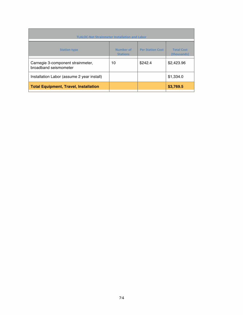
from the network (~10TB per RAID). A tape backup will provide redundant storage of all GNSS data and will be the primary storage area for raw receiver files. In the second year, UNAVCO will implement a basic web data access tool that will facilitate GNSS data discovery and provide access for a broader spectrum of Mexican users. This web tool will include a map-based station display and will allow data discovery based on geographical region and time. The total cost of equipment for the data center is $373.6k. Processing of both GPS and MET data and delivering data products to a diverse user community. The aforementioned data archive can be used and expanded to store and distribute data products. The processing expertise for a project like TLALOC-Net will require close involvement with, and guidance by the geodetic and atmospheric communities and it can not be fully planned for or budgeted in this document. We suggest that as TLALOC-Net moves to the proposal stage, that the PIʼs will convene a meeting with international partners and more fully articulate the geodetic and atmospheric processing and distribution plan while keeping in mind successful models like SCIGN, PBO, COCONet, and Africa Array. Labor We estimate the installation of TLALOC-Net stations will take 4 years and require four full time engineers for equipment configuration, assembly, and installation. This includes an Engineer III to oversee all Mexican operations, an Engineer II skilled in data communications and power systems, and two Engineer Iʼs. We also allocate 0.5 FTE per year for overall project management, NSF reporting, and oversight, 0.75 FTE per year for a permitting coordinator, who along with Mexican collaborators, will secure land use permits, and 0.5 FTE per year for administrative duties. For the data center we budget 0.2 of an Archive Data Manager, and 0.5 FTE for a Database Engineer and a Real-time Data Flow engineer. These FTEʼs will assist in the specification, procurement, and installation of equipment and software at the TLALOC-Net data center in Mexico. Total cost of labor for a project of this size is approximately $3,754.4k. Borehole strainmeters At the workshop in Puerto Vallarta, attendees discussed and validated the need for strain measurements in the gap between seismic and geodetic frequencies, to detect transient fault slip, and to detect and model strain signals associated with ETS in southern Mexico. Borehole strainmeter installation is labor intensive and requires the use of water-well type drill rigs to penetrate the ~300m depths necessary top provide the instruments sufficient insulation from surface and thermal noise. UNAVCO crews installed 75 bore hole strainmeters during the construction of PBO and are well versed in the installation and operations and maintenance of both Gladwin Tensor strainmeters and the Carnegie Three-component dilatometer. We envision 10 strainmeters with broadband seismic and GPS installed along the Guerrero-Oaxaca coast. For budget purposes we considered a Carnegie strainmeter, broadband seismometer, Marmot field
23
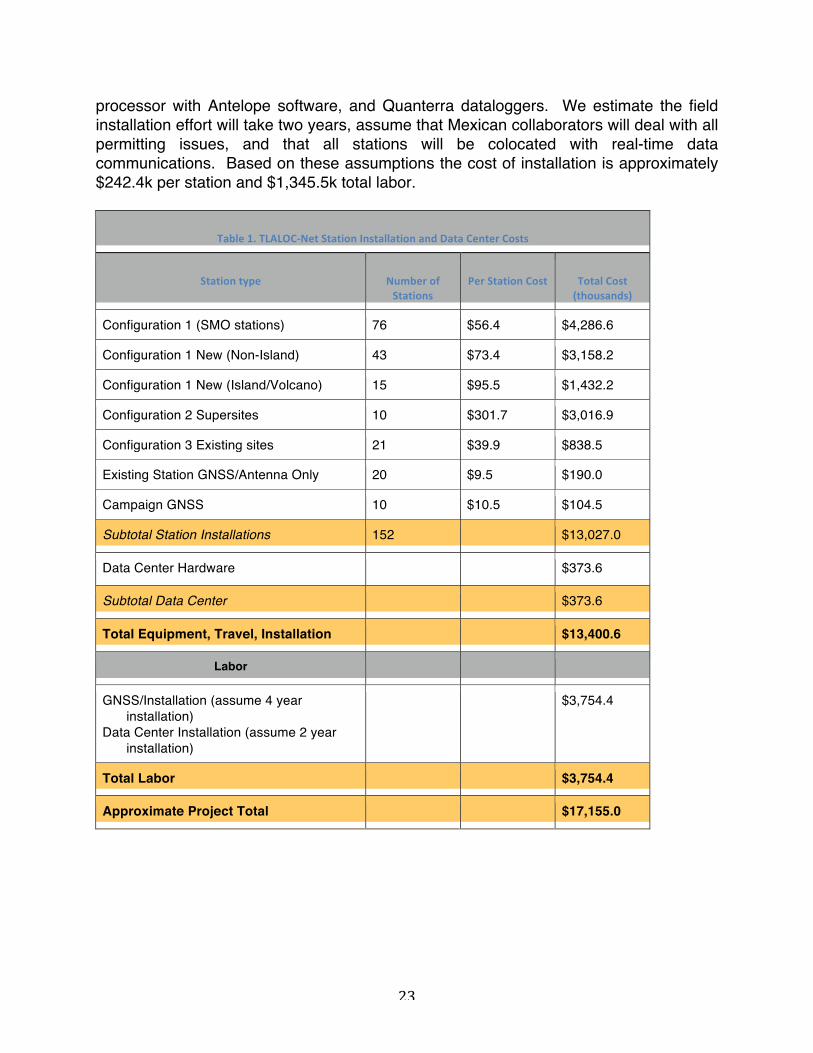
processor with Antelope software, and Quanterra dataloggers. We estimate the field installation effort will take two years, assume that Mexican collaborators will deal with all permitting issues, and that all stations will be colocated with real-time data communications. Based on these assumptions the cost of installation is approximately $242.4k per station and $1,345.5k total labor.
Table 1. TLALOC-‐Net Station Installation and Data Center Costs
Station type Number of Stations
Per Station Cost Total Cost (thousands)
Configuration 1 (SMO stations) 76 $56.4 $4,286.6
Configuration 1 New (Non-Island) 43 $73.4 $3,158.2
Configuration 1 New (Island/Volcano) 15 $95.5 $1,432.2
Configuration 2 Supersites 10 $301.7 $3,016.9
Configuration 3 Existing sites 21 $39.9 $838.5
Existing Station GNSS/Antenna Only 20 $9.5 $190.0
Campaign GNSS 10 $10.5 $104.5
Subtotal Station Installations 152 $13,027.0
Data Center Hardware $373.6
Subtotal Data Center $373.6
Total Equipment, Travel, Installation $13,400.6
Labor
GNSS/Installation (assume 4 year installation)
Data Center Installation (assume 2 year installation)
$3,754.4
Total Labor $3,754.4
Approximate Project Total $17,155.0
24
TLALOC-‐Net Strainmeter Installation and Labor
Station type Number of Stations
Per Station Cost Total Cost (thousands)
Carnegie 3-component strainmeter, broadband seismometer
10 $242.4 $2,423.96
Installation Labor (assume 2 year install) $1,334.0
Total Equipment, Travel, Installation $3,769.5