Embed Size (px)
Citation preview

TMH 18
Road Asset Data Electronic
Exchange Formats
10 /2014
Commit tee of Transpor t Of f ic ia ls
COTOSouth Africa
Committee of Transport
Officials
COTOSouth Africa
Committee of Transport
Officials

TECHNICAL METHODS FOR HIGHW AYS
TMH 18
Road Asset Data Electronic
Exchange Formats
10 /2014
Dra f t Vers ion 4
Commit tee of Transpo r t Of f ic ia ls

Compiled under auspices of the:
Roads Coordinating Body (RCB)
Committee of Transport Officials (COTO)
Published by:
The South African National Roads Agency Limited
PO Box 415,
Pretoria, 0001
Disclaimer of Liability
The document is provided “as is” without any warranty of any kind, expressed or
implied. No warranty or representation are made, either expressed or imply, with
respect to fitness of use and no responsibility will be accepted by the Committee
of the authors for any losses, damages or claims of any kind, including, without
limitation, direct, indirect, special, incidental, consequential or any other loss or
damages that may be arise from the use of the document.
All rights reserved
No part of this document may be modified or amended without permission and
approval of the Roads Coordinating Body (RCB). Permission is, however, granted
to freely copy, print, reproduce or distributed this document.

Series Name:
The Technical Methods for Highways consists of a series of publication that is used
to either prescribe or to provide guidelines on various aspects related to highway
engineering. The documents are primarily aimed at ensuring the use of uniform
methods throughout South Africa.
Users of the documents must ensure that the latest editions or versions of the
document are used. When a document is referred to in other documents, the
reference should be to the latest edition or version of the document.
Any comments on the document will be welcomed and should be forwarded to the
author of the document. When appropriate, such comments may be incorporated
in future editions of the document.
Synopsis:
Specification for the submission of road network definition and related data

Table of Contents
ITEM PAGE
Executive Summary i
1 Global Format Specifications ......................................................................... 2
1.1 Data File Format .................................................................................. 2
1.2 File Naming Convention ...................................................................... 2
1.3 Authority Id .......................................................................................... 2
1.4 Data Types .......................................................................................... 3
1.5 Date Formats ....................................................................................... 3
1.6 File Extensions .................................................................................... 4
1.7 Base fields required for all data files .................................................... 4
2 Network Definition .......................................................................................... 5
2.1 Roads .................................................................................................. 5
2.2 Network Definition File (.net extension)................................................ 6
2.2.1 Network Measurements ................................................................................ 8
2.2.2 Network History ............................................................................................. 8
2.2.3 The South African Numbered Route Description and Destination ............... 8
2.2.4 Provincial Road number ................................................................................ 9
2.3 Geometry (.kml or .kmz extension) ...................................................... 9
2.3.1 Geometry Data KML ...................................................................................... 9
2.3.2 KML Geodetic reference system .................................................................... 9
2.4 KML Elements used for geometry ...................................................... 10
2.5 Sample Geometry Data (.kml extension) ........................................... 10
2.6 Geometry example ............................................................................ 11
3 Road Classification ...................................................................................... 11
3.1 Road Classification File Format (.rcl extension) ................................. 11
4 Lane Configuration Details ........................................................................... 14
4.1 Primary Direction ............................................................................... 14
4.2 Lane Code definition .......................................................................... 14
4.3 Lane Configuration File (.lan extension) ............................................. 15
4.4 Traffic Link Volume (.adt extension) ................................................... 16

5 Pavement Data Submission Types .............................................................. 17
5.1 Standard segment lengths for different road types ............................. 18
5.2 Flexible Pavement Surfaced Visual Condition Summary (.vcf extension)
18
5.3 Concrete Visual Condition Summary (.vcc extension) ........................ 23
5.4 Block Visual Condition Summary (.vcb extension) ............................. 28
5.5 Unsurfaced Visual Condition Summary (.vcu extension) .................... 31
5.6 Combined Instrument Data File (.cid extension) ................................ 37
5.7 Normalised Deflection Bowl Data (.fwd extension) ............................. 38
5.8 FWD F25 files (.f25 extension) .......................................................... 41
6 Structure Data Submission Types ................................................................ 44
This section will be updated as soon as issues related the different look-ups that
exist for maintenance activities in Struman Software is resolved ....................... 44
References ........................................................................................................ 44
7 APPENDIX A: F25 FILE FORMAT ............................................................... 45
7.1 EXAMPLE F25 UPLOAD FILE FORMAT AND LISTING ................... 45
7.1.1 Introduction ................................................................................................. 45
7.1.2 Annotated Description of F25 FWD Upload File Format ............................. 45
7.1.3 Header Data ................................................................................................. 45
7.1.4 Test Data ...................................................................................................... 50
7.1.5 FWD Peak Load and Deflection Measurements .......................................... 51
LIST OF FIGURES
FIGURE PAGE
Figure 1 Geometry example visualization .......................................................... 11
Figure 2 Lane code numbering .......................................................................... 15
Figure 3 Lane code numbering with road configuration changes ....................... 15
LIST OF TABLES

TABLE PAGE
Table 1: General data file format .......................................................................... 2
Table 2: Authority ID’s ......................................................................................... 3
Table 3: Date and Time Format Strings .............................................................. 3
Table 4: Date and Time Format Strings .............................................................. 4
Table 5: File Extensions....................................................................................... 4
Table 6: Data file base required fields .................................................................. 5
Table 7: Network definition .................................................................................. 6
Table 8: Road Classification Information ............................................................ 12
Table 9: Lane configuration Information ............................................................. 15
Table 10: Traffic Link Volume ............................................................................ 16
Table 11: Segment lengths by road type ............................................................ 18
Table 12: Visual Condition .................................... Error! Bookmark not defined.
Table 13: Flexible Pavement Visual Condition ................................................... 18
Table 14: Concrete Types .................................................................................. 23
Table 15: Concrete Visual Condition .................................................................. 23
Table 16: Block Visual Condition ....................................................................... 28
Table 17: Unsurfaced types ............................................................................... 32
Table 18: Unsurfaced Visual Condition .............................................................. 32
Table 19: Combined Instrument Data ................................................................ 37
Table 20: Normalized deflection bowl data ........................................................ 38

COTO Standard for Road Network Data
TMH18 – Draft Version 4 Page
1-i of 60
Executive Summary
This document details the formats for data submission for a national roads
database. Data will be compiled into a centralised database, of which the data will
be geographically linked and viewable from a centralised data server.

COTO Standard for Road Network Data
TMH18 – Draft Version 4 Page 2 of 60
1 Global Format Specifications
The following section defines general data format specifications. These specifications are
applied across all data file formats. For detailed specification for each data type, please
consult the relevant sections further in this document.
1.1 Data File Format
The file format is based on csv (comma-separated values), however the comma-separator
is replaced by a semi-colon character which allows for commas to be used in the data.
All data files must be submitted in plain text using the UTF-8 encoding system. A regular
carriage return and line feed will indicate the end of a record, while fields will be delimited by
a semi-colon character.
Empty fields are indicated by including only the delimiter character, it is not necessary to
include anything else. All fields must be represented within a record or the file will be rejected.
Table 1: General data file format
Formatting Specification
File Format UTF8
Record Delimiter Carriage Return followed by Line Feed
Field Delimiter Semi Colon
Null Field No characters followed by field delimiter. Null fields cannot be omitted.
Header No File Header is required, the file definitions are predefined
1.2 File Naming Convention
The following conventions are used to construct a unique file name per a data file. Each
component indicated by the square brackets is defined below.
[AUTHORITY_ID]_[ROAD_ID]_[DATE YYYYMMDDHH24].[DATA EXTENSION]
Example: ECP_P0023_201409301419.fwd
This file would contain FWD data for the Eastern Cape Province, captured on the 30th
September 2014 at 2:19 PM.
If the data files are small enough, all data for the province could be combined into 1 file (using
[SENDER_ID] only, without specifying the [ROAD_ID].
See sections that follow for further definitions regarding the components that make up the
filename.
1.3 Authority Id
The ‘Authority Id’ is a unique 3 to 5 character alphanumeric code that uniquely identifies the
ownership of the data. Each data authority will be issued with this code before submission
can occur, this links all data submitted to that authority and can help prevent issues where
data id’s are incorrectly used or duplicated across authorities.

COTO Standard for Road Network Data
TMH18 – Draft Version 4 Page 3 of 60
Table 2: Authority ID’s
Provinces Metros
ECP: Eastern Cape Province BUF: Buffalo City Metropolitan Municipality
FSP: Free State Province CTP: City of Cape Town Metropolitan Municipality
GTP: Gauteng Province JHB: City of Johannesburg Metropolitan Municipality
KZN: Kwazulu Natal TSH: City of Tshwane Metropolitan Municipality
LPP: Limpopo Province EKU: Ekurhuleni Metropolitan Municipality
MPP: Mpumalanga Province ETH: eThekwini Metropolitan Municipality
NCP: Northern Cape Province MAN: Mangaung Metropolitan Municipality
NWP: North West Province NMA: Nelson Mandela Bay Metropolitan Municipality
WCP: Western Cape Province
1.4 Data Types
Table 3: Date and Time Format Strings
Data Type Description Example
Text Alphanumeric characters are allowed in text fields. The standard UTF8
character set is supported.
R45 Junction 4km east of
Malmesbury
Integer A whole number without fractional values. The length column indicates the
maximum size of the number.
Integer(5)
23000
Decimal A decimal type allows fractional values to be specified. A decimal is
described by specifying both a precision and scale.
Precision is the maximum number of digits allowed
Scale is the maximum number of digits allowed after the decimal point,
the fractional value.
Precision and scale are specified in brackets after the decimal type name
is specified. Precision first and then scale.
Typical KM location field
uses
Decimal(5,3)
Example value: 12.342
Date Date fields are given as text values with a specific date format string.
Please see the next section 1.5 for more details on the date formats
specification.
YYYYMMDD HH:MI:SS
20120201 19:32:21
1.5 Date Formats
The date part of the filename refers to the date that the file was generated from the senders
system. The year is specified first, followed by month and then day. This order is used as the
file can then be sorted chronologically by data generation date, within a file system by sorting
on the file name. The HH24 consists of a number from 0 to 23 representing the 24 hours in
the day. Please note that hours, days and months below 10 must be padded with a
zero, for example hour 9 would be represented as 09. The rest of the date characters that
makes up the ‘Date’ part of the filename, refer to their classical representations, year, month
and day.
The highest time precision format is seconds however the minimum precision required is
hours. Please see specific file formats for the required precision.

COTO Standard for Road Network Data
TMH18 – Draft Version 4 Page 4 of 60
Table 4: Date and Time Format Strings
Format Description Format String Example
Year YYYY 2012
Month MM 02
Day DD 01
Date Time Separator [Space]
Time Separator : 23:01:23
Hour 24 hour format HH24 23
Minutes MI 59
Seconds SI 59
The full date format is as follows:
Format: YYYYMMDD HH24:MI:SI
Example: 20120201 19:32:21 = 1st February 2012 - 7:32:21 PM
1.6 File Extensions
Each type of data submitted has a dedicated file extension. Please note that the extensions
are case sensitive.
The file extensions are listed in Error! Reference source not found. below.
Table 5: File Extensions
Data Type File Extension
Road Network Definition net
Road Geometry Data kml
Road Geometry Data Compressed kmz
Road Classification rcl
Lane Definition lan
Traffic Link Volume adt
Visual Condition Flexible Pavement
Visual Condition Concrete Pavement
Visual Condition Block Pavement
Visual Condition Unsurfaced
Pavement
vcf
vcc
vcb
vcu
Combined Instrument Data
(Riding Quality, Rutting Data,
Texture Depth)
cid
Normalised FWD data fwd
Falling Weight Deflectometer F25 f25
1.7 Base fields required for all data files
The fields indicated below are required for all data types submitted, they help represent a
unique location for which the data is associated to.

COTO Standard for Road Network Data
TMH18 – Draft Version 4 Page 5 of 60
Table 6: Data file base required fields
Field Name Data Type Format Requirements
Road Id Character,
alphanumeric Max 20 Chars Required
Foreign key in Network table
Lane Code Character,
alphanumeric
Max 5 Chars Optional
Required should the data represent an
individual lane, this is the case for most
data sets. Only leave this field empty for
data that is not lane specific.
See Lane Configuration Details section
Start KM or Survey Point KM Numeric
Decimal(6,3)
Format is 999.999 Required
Must refer to km position as measured on
the “network” record for this
“Road Id”
Measured in (km) kilometres
End KM Numeric
Decimal(6,3)
Format is 999.999 Optional if Survey point Must refer to km
position as measured on the “network”
record for this
“Road Id”
Measured in (km) kilometres
Date of survey Date Time YYYYMMDD HH24:MI Required
2 Network Definition
2.1 Roads
The network is defined by a series of roads, roads together can form routes. The road
establishes the base reference system for all measurements of data. Each road is identified
by a unique road_id and this id must be used to reference all related data along with the
relevant measure defined in kilometre unit of measure.
How roads are defined should fit in with the existing authority’s methodology so that it
correlates with field practices and is familiar with the relevant parties who work with the data
(for example node-to-node). However the methodology has to follow the following
requirements listed below to ensure data integrity.
a) Must have a road identifier which is unique across the entire authority’s
network
b) Must be the reference system for all other related data (All data submitted for
a road must use the submitted measurements)
c) Should the roads geometry change in any way, it is required to resubmit the
roads classification file and geometry before submitting newly measured data,
failure to do so could result in incorrect data processing
d) Must have only a single line string geometry element that represents the road,
no compound geometry objects
e) Dual carriageways must be represented by two roads, the road naming
convention can indicate that the roads are connected, however they are still
treated as separate entities
f) As this base road’s geometry will be used to dynamically segment related
data, it is suggested that the logical smaller unit (sub section of a route or

COTO Standard for Road Network Data
TMH18 – Draft Version 4 Page 6 of 60
road) will be used to make segmentation more accurate as opposed to a road
defining a full route
Example of Road ID’s
D1042_010+
DR1776_010
TR03801E
2.2 Network Definition File (.net extension)
The network definition should be submitted within a .net file. The name of the file should be
the province identifier and route number with the date (or only the province identifier and
date). This filename is used for all the associated data files with only the file extension
changing.
The network definition submitted is valid for the start and end date range specified in the
field. Should there already be an active network definition loaded, then the new definition file
will become available for the range specified. If the range of the new file conflicts with the
existing network, the network definition will not be loaded and an error will be returned
indicating a date range conflict.
It is important to keep the network definition up-to-date and do so before submitting new data.
Only if the network definition has not changed will it not be necessary to update it.
Table 7: Network definition (.net)
Field description Field name Length Data type Format and description
Authority ID AUTH_ID 5 TEXT,
alphanumeric
The unique id given to an authority, this
associates the network link to the relevant
authority
Road ID ROAD_ID 12 TEXT,
alphanumeric
The unique id for which data is joined to. See 2.1
for more information.
Route ROUTE 12 TEXT,
alphanumeric
The route that the road belongs to if applicable.
Route Sequence ROUTE_SEQ 3 NUMERIC
Precision 3
Format is 999
Start KM START_KM 6 NUMERIC,
Precision 6
Scale 3
Format is 999.999
Measured in (km) kilometres
End KM END_KM 6 NUMERIC,
Precision 6
Scale 3
Format is 999.999
Measured in (km) kilometres
Start Date START_DATE 8 DATE YYYYMMDD
End Date END_DATE 8 DATE YYYYMMDD set to NULL if the link is still active
RDDA Road
identifier
RDDA_ID 7 TEXT,
alphanumeric
character 1 – N for National, R for Regional.
chr 2 to 4 Number of road i.e. N002 or R311
chr 5 to 6 Section, i.e. N00231 or R32103
chr 7 Main Direction N,E,W,S. i.e. N00121N
If Route is not defined in RDDA document then
use seven 0’s (see point 2.2.3)

COTO Standard for Road Network Data
TMH18 – Draft Version 4 Page 7 of 60
Provincial/Metro
Road Number
AUTH_RD_ID 7 TEXT,
alphanumeric
As no direction is built into this number, there will
be cases where this is not unique within the
dataset.
Chr 1-2 – Road Type initial (NR, RR,TR, MR, DR,
OP)
3-7 - Road Number and Section where applicable
(N.B.: blanks in the road number MUST be zero-
filled)
SADC Road
Number
SADC_ROUTE 12 TEXT,
alphanumeric
The SADC route that the road belongs to if
applicable.
Primary Direction of
road by Authority
AUTH_RD_DIR 1 TEXT,
alphanumeric
Direction of increasing Provincial Km Markers
N = North
S=South
E = East
W=West
RCAM
Classification
RCAM_CLASS 5 TEXT,
alphanumeric R1: Rural principal distributor
R2: Rural major distributor
R3: Rural minor distributor
R4: Rural collector road
R4B: Rural collector road
R5: Rural local road
R5B: Rural local road
R6B: Rural walkway
R7B: Other
R7C: Other
R7D: Other
R7E: Other
R7F: Other
R7G: Other
R7H: Other
U1: Urban principal arterial
U2: Urban major arterial
U3: Urban minor arterial
U4a: Urban Commercial collector street
U4b: Urban Residential collector street
U5a: Urban Commercial local street
U5b: Urban Residential local street
U6a: Urban Pedestrian priority street or area
U6b: Urban Pedestrian only street or area
Start Description START_DESC 100 TEXT,
alphanumeric
Description of Start Point
End Description END_DESC 100 TEXT,
alphanumeric
Description of End Point
Geometry Link ID GIS_LINK_ID 20 TEXT,
alphanumeric
A unique identifier linking the road feature in KML
file to the record, only use this field if the geometry
attribute ID is different to the Road ID. Ideally the
Road Id field should match the geometry feature
and this field left empty.

COTO Standard for Road Network Data
TMH18 – Draft Version 4 Page 8 of 60
Data Example:
The example below is the classification data of the R04601 road both east and west. The
authority responsible for the road is been indicated as Eastern Cape Province by the value
ECP. As it is a dual carriageway example two road links defined. Both entries are linked to
the R046 route and are the first road links defined for the route as indicated by the route
sequence number of 1. For dual carriageway roads related road links are defined by sharing
the route sequence and the primary directing indicates which side of the road each link
represents. The remaining field’s descriptions can be found in the table above. Please see
the Geometry section for more detail on how to define the related geometry data items, note
that in this example the data items are related by the GIS_LINK_ID field with the respective
ids being 200 and 201.
ECP;R04601E;R046;1;0.00;24.76;20021013;;R04601E;TR02401;;E;R3;R45 Junction 4km
east of Malmesbury;R44 Junction at Hermon;200;(CR)(LF)
ECP;R04601W;R046;1;0.00;24.36;20022008;;R04601W;TR02402;;W;R3;R45 Junction 4km
east of Malmesbury;R44 Junction at Hermon;201;(CR)(LF)
Note: In this example the link end date is set to NULL as it is still current, only use the link
end date should this definition of the road no longer be current past the end date.
2.2.1 Network Measurements
The geometry data submitted for the network definition file defines the base measurement
system for all linear data submitted within the date range specified for the definition. The
geometry is used to create the base measurement system, the length of the network is
calculated from point to point using an algorithm that takes all three dimensions into account.
This makes the geometry data of utmost importance to be as accurate as possible along the
network and at a maximum resolution of a point every 20 metres. Should higher resolution
data be available then it is advisable to submit it, however a 10m resolution is adequate.
2.2.2 Network History
Each time the alignment of the road changes, it is required to resubmit the network definition
file, each new submission establishes a new version of the road. The start and end date
become the duration for that road version and all submitted data will then map against the
matched road version by the measurement date.
It is critical that the network definitions are maintained and accurate or it could result in
incorrect mapping of submitted data. Validation checks will be performed against the data
submitted to ensure that data is not submitted outside of the current road versions minimum
and maximum km range.
2.2.3 The South African Numbered Route Description and Destination
The South African Numbered Route Description and Destination document of May 2012
indicates that, all the National and Regional Routes in South Africa are listed and described
from their origin, through the towns they traverse, up to the points where they end. Some
route descriptions will follow other routes where they overlap, but for the purpose of this

COTO Standard for Road Network Data
TMH18 – Draft Version 4 Page 9 of 60
document, the route with the smaller denomination will take precedence. Links should not
overlap each other.
2.2.4 Provincial Road number
Is unique per Province but not for the whole country. This will mean that in a national
database, the provincial route numbers may be duplicated.
2.3 Geometry (.kml or .kmz extension)
Each record in the “Network Definition File” must have a corresponding geometry definition
within the geometry file.
The “Road ID” (ROAD_ID) or “GIS_LINK_ID” field must be included in the geometry
information in order to associate the geometry entry with the correct road.
2.3.1 Geometry Data KML
The primary geometry data format supported is KML, data must be submitted within a kml or
kmz file, the format of the data is required to be in OGC KML 2.2. For more information please
consult the following references.
OGC KML Specification documentation on the Open Geo Spatial website
www.opengeospatial.org http://portal.opengeospatial.org/files/?artifact_id=27810
The geometry data contained within the KML file should match the General Road
Classification and Information file’s list of link. Each line feature representing a link should
have the Link Id attribute set to the value of the matching record. Alternatively the
GIS_LINK_ID field can be used. Should the GIS_LINK_ID be set, it is required that the
records within the General Road Classification file have the GIS_LINK_ID field populated
appropriately to ensure that the data can be joined.
The geometry data file name must match the General Road Classification file name except
for extension which must be kml or kmz. Below is an example of a matching file name.
ECP_P0023_2012120119.rcl
ECP_P0023_2012120119.kmz
It is recommended that the kmz format is used as it uses compression to reduce the files size
thus reducing the data load for transmission and storage.
2.3.2 KML Geodetic reference system
Please note that all co-ordinates given must conform to the KML geodetic reference system.
This is for both the KML files and all co-ordinates given within data files.
For its reference system, KML uses 3D geographic coordinates: longitude, latitude and
altitude, in that order, with negative values for west, south and below mean sea level if the
altitude data is available. The longitude, latitude components (decimal degrees) are as
defined by the World Geodetic System of 1984 (WGS84). The vertical component (altitude)
is measured from the WGS84 EGM96 Geoid vertical datum. If altitude is omitted from a
coordinate string, e.g. (−122.917, 49.2623) then the default value of 0 (approximately sea
level) is assumed for the altitude component, i.e. (−122.917, 49.2623, 0).

COTO Standard for Road Network Data
TMH18 – Draft Version 4 Page 10 of 60
A formal definition of the coordinate reference system (encoded as GML) used by KML is
contained in the OGC KML 2.2 Specification. This definition references well-known EPSG
CRS components.
2.4 KML Elements used for geometry
<kml> Standard opening tag for a KML file, please note that the appropriate xml
declaration should be made above it. See sample section for detail.
<Document> The document element should contain all the geometries for all sections
within the
<name> Name that represent the route, will be appropriate if the date was added to
the name to indicate for time period it represents.
<Placemark> Each placemark should contain only one link for the route the document
represents. Placemarks are a repeatable element and there should be one for each
link specified within the rcl file.
<Placemark id> It is essential that the id of each placemark is set to either the Road
id or if specified the gis_link_id
<Placemark><name> Representing name for the link. The name used for data import
will be the one specified within the network definition file, however this field can be
included for display purposes of the kml.
<Placemark><LineString> The geometry element used for the link, if the elevation is
not known of the road then it should be set to 0. Note: KML elevation is measured in
metres.
2.5 Sample Geometry Data (.kml extension)
A sample kml extract for a road link is given, please note the id of each placemark
corresponds to the link id or the gis_link_id specified within the corresponding Network
Definition File.
Note: The full sequence of co-ordinates have been removed as there would typically be far
too many too display within this document effectively.
<?xml version="1.0" encoding="UTF-8"?>
<kml xmlns="http://www.opengis.net/kml/2.2">
<Document id=" ECP_P0023_20120119">
<name>P0023: January 2012</name>
<Placemark id="100">
<name>P002301N</name>
<LineString>
<extrude>0</extrude>
<tessellate>0</tessellate>
<coordinates 28.6841466620528,-25.9847599989329,1461.099 28.6841699953205,-25.9846633261782,1461.099</coordinates>
</LineString>
</Placemark>
<Placemark id="102">
<name>P002302N</name>
<LineString>
<extrude>0</extrude>
<tessellate>0</tessellate>
<coordinates 28.7841466620528,-26.1247599989329,1462.099 28.6841699953205,-26.1246633261782,1462.099</coordinates>
</LineString>
</Placemark>

COTO Standard for Road Network Data
TMH18 – Draft Version 4 Page 11 of 60
</Document>
</kml>
2.6 Geometry example
The screen shots below show a typical visualization of geometry data for the N14 highway
section at a 10m resolution. The top left shows a regular Map Backdrop, the right hand side
shows the horizontal alignment in red, which is plotted from the 10m data and below the
vertical alignment is plotted for the visible section in the map view.
Using the geometry supplied an accurate rolling distance is calculated as the measure
reference for the road. Using this reference all data submitted with GPS co-ordinates can be
snapped to the road at the calculated km position with a good degree of accuracy. This
ensures that data readings keep their spatial position and are not influenced by the vehicles
odometer or other methods of network location measures that are not consistently accurate.
Figure 1 Geometry example visualization
3 Road Classification
3.1 Road Classification File Format (.rcl extension)
The General Road Classification File defines the segments for the classification for each
road defined in the network. A segment is created each time one of the road’s attributes
change, each segment is uniquely identified by the segment ID field which is constructed by
using the road ID separated by an underscore and a five digit number which is left-hand side
padded with zeros. This number represents the start of the segment in metres.
The following is required for the road classification data;
a) There must be at least 1 record for every Road ID in the “Network Definition File”.
b) The ‘Road ID’ used must exist in the “Network Definition File” so that segments can
be linked to the relevant Road.

COTO Standard for Road Network Data
TMH18 – Draft Version 4 Page 12 of 60
c) The ‘Start km’ and ‘End km’ values used in the classification segments, must fall
within the ‘Start km’ and ‘End km’ values for the related ‘Road ID’ in the “Network
Definition File”.
Table 8: Road Classification Information (.rcl)
Field description Field name Length Data type Format and description
Segment ID SEG_ID 20 TEXT,
alphanumeric
Unique identifier, not null
[ROAD_ID]_00000
Start km START_KM 6 DECIMAL(6, 3) Format is 999.999
Measured in (km) kilometres
End km END_KM 6 DECIMAL(6, 3) Format is 999.999
Measured in (km) kilometres
Start Date START_DATE 8 DATE YYYYMMDD
End Date END_DATE 8 DATE YYYYMMDD set to NULL if the link is still active
Status STATUS 1 INTEGER 1 Current
2 To be verified
3 Under construction
4 Planned
Surface Type SURF_TYPE 4 TEXT,
alphanumeric
Unpaved Roads:
GRAV gravel
EARTH (or sand)
TRACK
Concrete Pavements:
CJP Jointed Concrete plain
DJP Dowelled
CRC Continuously Reinforced Concrete
UTCP Ultra-thin Concrete Reinforced Pavement
Flexible Pavements
FLEX Bituminous surface
Block Pavements
BLOC Concrete block paving
Road Type ROAD_TYPE 3 TEXT,
alphanumeric
S2U single unpaved shoulders
S2P single paved shoulders
N2U undivided unpaved shoulders
N2P undivided paved shoulders
D2P dual paved shoulders 2 lanes
D3P dual paved shoulders 3 lanes etc.
DnP dual paved should with n number of lanes
example: D4P represents a dual carriageway
with 4 lanes per carriageway
Road Width
ROAD_WIDTH 4 DECIMAL(4,2) Width of paved surface. Gravel roads from
shoulder breakpoint to shoulder break point.
Format is 99.99
Measured in (m) metres
Number of lanes NO_LANES 2 INTEGER(2) Number of lanes. In case of dual carriageways,
number of lanes in one direction. Full lane details
are supplied in the Lane Definition File.

COTO Standard for Road Network Data
TMH18 – Draft Version 4 Page 13 of 60
Number of shoulders NO_SHOULD
ERS
1 INTEGER(1) Number of shoulders road for the section
specified. Full shoulder details are supplied in the
Lane Definition File.
Base Date BASE_DATE 8 DATE YYYYMMDD – The year the base was
constructed or last rehabilitated
Surface Date SURF_DATE 8 DATE YYYYMMDD – The year the surface layer was
constructed or last resurfaced.
Terrain Classification
TERR_CLASS
1 TEXT,
alphanumeric
F Flat terrain, R Rolling terrain M Mountainous terrain
RCAM
RCAM_CLASS
5 TEXT
alphanumeric
R1: Rural principal distributor
R2: Rural major distributor
R3: Rural minor distributor
R4: Rural collector road
R4B: Rural collector road
R5: Rural local road
R5B: Rural local road
R6B: Rural walkway
R7B: Other
R7C: Other
R7D: Other
R7E: Other
R7F: Other
R7G: Other
R7H: Other
U1: Urban principal arterial
U2: Urban major arterial
U3: Urban minor arterial
U4a: Urban Commercial collector street
U4b: Urban Residential collector street
U5a: Urban Commercial local street
U5b: Urban Residential local street
U6a: Urban Pedestrian priority street or area
U6b: Urban Pedestrian only street or area
District DISTRICT
6 TEXT,
alphanumeric
Use district lookup
Local Municipality MUNIC
6 TEXT,
alphanumeric
Use municipality lookup
Responsible Authority
RESP_AUTH
5 TEXT
alphanumeric
Should the responsibility for this segment not be
the authority specified in the road definition file
then the correct authority id must be specified
here.
Start Longitude START_LONG
ITUDE 12 DECIMAL(12, 9)
Longitude Value in Decimal Degrees
World Geodetic System of 1984 (WGS84)
Start Latitude START_LATIT
UDE 12 DECIMAL(12, 9)
Latitude Value in Decimal Degrees
World Geodetic System of 1984 (WGS84)
End Longitude END_LONGIT
UDE 12 DECIMAL(12, 9)
Longitude Value in Decimal Degrees
World Geodetic System of 1984 (WGS84)

COTO Standard for Road Network Data
TMH18 – Draft Version 4 Page 14 of 60
End Latitude END_LATITU
DE 12 DECIMAL(12, 9)
Latitude Value in Decimal Degrees
World Geodetic System of 1984 (WGS84)
Segment Status SEGMENT_ST
ATUS
20 TEXT,
alphanumeric
1 Built
2 To be Verified
3 Under Construction
4 New Link
5 Upgrade to Paved
6 Road Closed 7 Inaccessible
8 Track
Example Data:
R54001N_000000;0.00;8.00;20100110;;1;FLEX;S2P;11.4;2;1;20000201;20080201;F;U1;1;
10000;20000;GAU;-25.927733;27.902582;1;(CR)(LF)
R54001N_008000;8.00;12.00;20100110;;1;FLEX;S2P;16.4;3;1;20000201;20080201;F;U1;1
;10000;20000;GAU;-25.945197;27.807632;1;(CR)(LF)
R54001N_012000;12.00;14.00;20100110;;1;CRCP;S2P;16.4;3;1;20020201;20080201;R;U1;
1;10000;20000;GAU;-26.023740;27.766433;1;(CR)(LF)
4 Lane Configuration Details
4.1 Primary Direction
The primary direction for a road is determined by the side that is increasing in kilometres
towards either of the primary geographical directions, North or East. This side of the road is
then labelled the ‘primary direction’, the opposite side of the road would be the ‘secondary
direction’. This is done for the entire route, not each individual section of road as some
sections might change orientation during its course. Thus once the primary direction is
determined it is applied to all sections within it.
4.2 Lane Code definition
In order to identify which lane and direction the data represents, a uniform lane numbering
system has been defined. The code is comprised of the following three components direction,
lane type and lane position.
Direction is defined as either primary or secondary.
The lane type code is left blank in the case of regular travel lanes however F and S are used
for the fast and slow shoulders respectively.
Lastly the lanes are numbered with the fast lane being represented by the number 1 and
each lane number is then incremented by 1 going towards the slowest lane.
Please see previous section for method to determine the primary and secondary direction.

COTO Standard for Road Network Data
TMH18 – Draft Version 4 Page 15 of 60
PRIMARY DIRECTION
PS P1P(n) PF
...
SSS1 S2 S(n)SF
...
...
...
P2
...
...
...
...
SECONDARY DIRECTION
PS: Primary shoulder
PF: Primary far shoulder
SF: Secondary Shoulder
SS: Secondary far shoulder
PS(n) SS(n)
Figure 2 Lane code numbering
P1 S1
1990
P2 S2
1995
P1 S1
Secondary Direction
First construction of road
Additional lane and shoulder added to right side. Original right shoulder uses as new lane.
PS SS
PS SS
Figure 3 Lane code numbering with road configuration changes
4.3 Lane Configuration File (.lan extension)
The lane configuration file contains detailed definition of each lane for each road segment.
Table 9: Lane configuration Information (.lan)
Field Description Field Name Length DATA TYPE Format and description
Lane Segment ID LANE_SEG_I
D
20 TEXT,
alphanumeric
Unique identifier, not null
[ROAD_ID]_[LANE_CODE]_00000
Start km START_KM 6 DECIMAL(6,3) Format is 999.999
Measured in (km) kilometres
End km END_KM 6 DECIMAL(6,3) Format is 999.999
Measured in (km) kilometres
Lane Width SHOULDER_
WIDTH
4 DECIMAL(4,2) Width of lane in metres
Format is 99.99
Measured in (m) metres
Centre Line Offset CL_OFFSET 5 DECIMAL(5,2) Offset of the nearest side of the lane from the
centre line.
Format is 999.99
Measured in (m) metres
Shoulder Type SHOULDER_
TYPE
20 TEXT,
alphanumeric
GRAVEL
PAVED
Example Data:

COTO Standard for Road Network Data
TMH18 – Draft Version 4 Page 16 of 60
R04601E_P1_000000;0.00;8.00;2.2;0.2;;(CR)(LF)
R04601E_P1_008000;8.00;12.00;2.4;0.2;;(CR)(LF)
R04601E_P1_012000;12.00;14.00;2.2;0.2;;(CR)(LF)
R04601E_S1_000000;0.00;8.00;2.2;-0.2;;(CR)(LF)
R04601E_S1_008000;8.00;12.00;2.4;-0.2;;(CR)(LF)
R04601E_S1_012000;12.00;14.00;2.2;-0.2;;(CR)(LF)
R04601E_PS_000000;0.00;8.00;1.8;2.4;PAVED;(CR)(LF)
R04601E_PS_008000;8.00;12.00;2.0;2.6;PAVED;(CR)(LF)
R04601E_PS_012000;12.00;14.00;1.8;-2.4;PAVED;(CR)(LF)
R04601E_SS_000000;0.00;8.00;1.8;-2.4;PAVED;(CR)(LF)
R04601E_SS_008000;8.00;12.00;2.0;-2.6;PAVED;(CR)(LF)
R04601E_SS_012000;12.00;14.00;1.8;-2.4;PAVED;(CR)(LF)
4.4 Traffic Link Volume (.adt extension)
Table 10: Traffic Link Volume (.adt)
Column
Description Column
Heading Len
gth DATA TYPE Format
Road ID ROAD_ID 12 TEXT,
alphanumeric Unique Road Id from Network Definition
Lane Code LANE_CODE 4 TEXT,
alphanumeric
Lane Code representing direction P or S.
Start km START_KM
6 DECIMAL(6,3) Format is 999.999
Measured in (km) kilometres
End km END_KM
6 DECIMAL(6,3) Format is 999.999
Measured in (km) kilometres
Date of Last Count DT_LST_CNT 6 DATE Format is YYYYMMDD
AADT Light AADT_L 6 INTEGER(6) Format is 999999
AADT Minibus AADT_M 6 INTEGER(6) Format is 999999
AADT Bus AADT_B 6 INTEGER(6) Format is 999999
AADT Truck Short AADT_TS 6 INTEGER(6) Format is 999999
AADT Truck Medium AADT_TM 6 INTEGER(6) Format is 999999
AADT Truck Long AADT_TL 6 INTEGER(6) Format is 999999
AADT Total AADT 6 INTEGER(6) Format is 999999
Start Longitude START_LONGI
TUDE 12 DECIMAL(12,9)
Longitude Value in Decimal Degrees
World Geodetic System of 1984 (WGS84)
Start Latitude START_LATITU
DE 12 DECIMAL(12,9)
Latitude Value in Decimal Degrees
World Geodetic System of 1984 (WGS84)
From Node FROM_NODE
100 TEXT,
alphanumeric
Optional
To Node TO_NODE
100 TEXT,
alphanumeric
Optional
From Node Type
FROM_NODE_
TYPE 20
TEXT,
alphanumeric
Optional
+ : Road crossing/Intersection
BD: Begin Dual

COTO Standard for Road Network Data
TMH18 – Draft Version 4 Page 17 of 60
BEGIN
Begin Freeway
BO: Borders/Boundaries (BOUND: Boundary)
BR: OVER
BRIDGE
BS:UB: Begin Subsidy
CP Change of Pavement Type
CLOSED Closed/Gated
ED End Dual
EN: End of segment (no node)
END End of Road
EP End of Paved Segment (ET End Tar)
ESUB End Subsidy
EV
MBOUND Municipal Boundary
ORIR
SP: start of Paved Segment (BT Begin Tar)
ST: start of segment (no node)
SV
T T Junction
TL T Junction Left
TR T Junction Right
V VILLAGE/ TOWN
MX: Maximum segment length used as segment
end
To Node Type TO_NODE_TYP
E 20
TEXT,
alphanumeric
Optional
Example:
The Link volume in terms Average Annual Daily Traffic (AADT) for Main Road 310
(MR00310) (R303 Section 1), between start km 0.00 and end km 16.34 is 910 for Light
vehicles, 25 for Heavy vehicles, with a Total of 935. In cases where Light and Trucks are not
counted separately, supply only total AADT, with null (none) values in columns for AADT
Heavy and AADT Light. Do not populate with zeros where data is not available. If buses and
taxis are counted separately, buses should be added to AADT Truck Medium while taxis
should be added to AADT Light.
Data example:
MR00310;P;0;16,20121201,3432;120;54;250;33;42,2560;-25.927733;27.902582;;;; CR)(LF)
MR00310;S;0;16,20121201,3234;123;50;270;23;43,2562;-25.927733;27.902582;;;; (CR)(LF)
5 Pavement Data Submission Types
Only the data for the latest measurement date must be delivered when delivering data on a
yearly basis.
The start and end km of the data values must fall within the start and end km of the road
defined in the network definition file. Any values that fall outside of the road start and end km
will be discarded.

COTO Standard for Road Network Data
TMH18 – Draft Version 4 Page 18 of 60
5.1 Standard segment lengths for different road types
Table 11: Segment lengths by road type
Type of pavement Standard Assessment Length (km)
Rural Urban
Flexible 2.0 Block lengths (max 0.5 km)
Concrete 0.2 0.2
Block 0.2 0.2
Unpaved 5.0 Block lengths (max 0.5 km)
Note: Assessment lengths should not exceed ± 50% of standard
5.2 Flexible Pavement Surfaced Visual Condition Summary (.vcf extension)
See TMH 9 Part B for detailed specification on the visual condition for flexible pavement.
Table 12: Flexible Pavement Visual Condition (.vcf)
Column Description Column Heading Length DATA TYPE Format and details
Road ID ROAD_ID 12 TEXT, alphanumeric Senders Unique Road Id
Lane Code LANE_CODE 4 TEXT, alphanumeric Lane Code representing both direction and lane position. (P1, P2, S1 etc.)
Start km START_KM 6 DECIMAL(6,3)
The START_KM, END_KM must fall within the range of a record in the Road classification table where the SURF_TYPE is indicated as FLEX
Format is 999.99
Measured in (km) kilometres
End km END_KM 6 DECIMAL(6,3)
The START_KM, END_KM must fall within the range of a record in the Road classification table where the SURF_TYPE is indicated as FLEX
Format is 999.99
Measured in (km) kilometres
Terrain Classification
Same as in Classification table
TERR_CLASS 1 TEXT, alphanumeric
Format is ‘A’
‘F’ for a Flat terrain,
‘R’ for a Rolling terrain
‘M’ for a mountainous terrain
Gradient GRADIENT 1 TEXT, alphanumeric
F: Flat
M: Medium
S: Steep
Road Width ROAD_WIDTH 4 NUMERIC, fixed 1 Width of paved surface. Gravel roads from shoulder breakpoint to shoulder break point.
Date of measurement
MEASURE_DATE 13 DATE/TIME YYYYMMDD HH24:MI:SI

COTO Standard for Road Network Data
TMH18 – Draft Version 4 Page 19 of 60
Visual Condition Index (VCI)
VCI 4 DECIMAL(4,1) Format is 999.9
Reseal Condition Index (RCI)
RCI 4 DECIMAL(4,1) Format is 999.9
Maintenance Need Index (MNI)
MNI 4 DECIMAL(4,1) Format is 999.9
Surface Condition Index (SCI)
SCI 4 DECIMAL(4,1) Format is 999.9
Structural Condition Index (STCI)
STCI 4 DECIMAL(4,1) Format is 999.9
Functional Condition Index (FCI)
FCI 4 DECIMAL(4,1) Format is 999.9
Crack Condition Index (CCI)
CCI 4 DECIMAL(4,1) Format is 999.9
Engineering Assessment (surfacing):
Current Surface SURFACE 2 TEXT, alphanumeric
TRH 14 codes for different surfacing types Code - Description: AC - Asphalt surfacing - continuously-graded. AG - Asphalt surfacing - gap-graded. AS - Asphalt surfacing – semi-gap-graded. AO -Asphalt surfacing - open-graded. S1 - Surface Treatment – single seal S2 - Surface Treatment – multiple seal S3 - Sand Seal S4 - Cape Seal / Single seal and slurry S5 - Slurry Seal
Description
Slurry Seal
Texture TEXTURE 30 TEXT, alphanumeric
Coarse Medium Fine Varying The texture can be expressed as fine, fine-medium, medium, medium-coarse or coarse, or varying, if it varies across the width of the road. The texture can be marked as “Varying” and “Fine” to “Coarse”. See TMH 9 Part B
Voids VOIDS 30 TEXT, alphanumeric
None Few Many Varying Ratings between the major classes can also be recorded (None – Few or Few – Many)
Surfacing failures Degree
SURFACE_FAILURE_DEG
1 INTEGER(1) 1-5
Surfacing failures Extent
SURFACE_FAILURE_EXT
1 INTEGER(1) 1-5
Surfacing patching Degree
SURFACE_FAILPATCH_DEG
1 INTEGER(1) 1-5
Surfacing patching Extent
SURFACE_FAILPATCH_EXT
1 INTEGER(1) 1-5

COTO Standard for Road Network Data
TMH18 – Draft Version 4 Page 20 of 60
Surfacing cracks Degree
SURFACE_CRACK_DEG
1 INTEGER(1) 1-5
Surfacing cracks Extent
SURFACE_CRACK_EXT
1 INTEGER(1) 1-5
Aggregate loss Degree
AGGR_LOSS_DEG
1 INTEGER(1) 1-5
Aggregate loss Extent
AGGR_LOSS_EXT
1 INTEGER(1) 1-5
Aggregate loss Activity
AGGR_LOSS_ACT
1 TEXT, alphanumeric A - Active N - Non-Active
Binder condition (Dry/Brittle) Degree
BINDER_CONDITION_DEG
1 INTEGER(1) 1-5
Binder condition (Dry/Brittle) Extent
BINDER_CONDITION_EXT
1 INTEGER(1) 1-5
Bleeding / flushing (fattiness) Degree
BLEEDING_DEG 1 INTEGER(1) 1-5
Bleeding / flushing (fattiness) Extent
BLEEDING_EXT 1 INTEGER(1) 1-5
Surface deformation / Shoving Degree
SURF_DEFORM_DEG
1 INTEGER(1) 1-5
Surface deformation / Shoving Extent
SURF_DEFORM_EXT
1 INTEGER(1) 1-5
Engineering Assessment (structural):
Block Cracks Degree
BLOCK_CRACK_DEG
1 INTEGER(1) 1-5
Block Cracks Extent BLOCK_CRACK_EXT
1 INTEGER(1) 1-5
Longitudinal/Slip Cracks Degree
LONG_CRACK_DEG
1 INTEGER(1) 1-5
Longitudinal/Slip Cracks Extent
LONG_CRACK_EXT
1 INTEGER(1) 1-5
Longitudinal/Slip Cracks Type
LONG_CRACK_TYPE
1 TEXT, alphanumeric S - Slip
L – Longitudinal
Transverse cracks Degree
TRANSVERSE_CRACK_DEG
1 INTEGER(1) 1-5
Transverse cracks Extent
TRANSVERSE_CRACK_EXT
1 INTEGER(1) 1-5
Crocodile (fatigue) cracks Degree
CROCODILE_CRACK_DEG
1 INTEGER(1) 1-5
Crocodile (fatigue) cracks extent
CROCODILE_CRACK_EXT
1 INTEGER(1) 1-5
Pumping Degree PUMPING_DEG 1 INTEGER(1) 1-5
Pumping Extent PUMPING_EXT 1 INTEGER(1) 1-5
Deformation: Rutting Degree
RUTTING_DEG 1 INTEGER(1) 1-5
Deformation: Rutting Extent
RUTTING_EXT 1 INTEGER(1) 1-5
Deformation: Undulation/ Settlement Degree
UNDULATION_DEG
1 INTEGER(1) 1-5
Deformation: Undulation/ Settlement Extent
UNDULATION_EXT
1 INTEGER(1) 1-5

COTO Standard for Road Network Data
TMH18 – Draft Version 4 Page 21 of 60
Patching Degree PATCHING_DEG 1 INTEGER(1) 1-5
Patching Extent PATCHING_EXT 1 INTEGER(1) 1-5
Potholes Degree POTHOLES_DEG 1 INTEGER(1) 1-5
Potholes Extent POTHOLES_EXT 1 INTEGER(1) 1-5
Failures Degree FAILURES_DEG 1 INTEGER(1) 1-5
Failures Extent FAILURES_DEG 1 INTEGER(1) 1-5
Functional Assessment
Roughness (Riding quality) Degree
RIDING_QUAL_DEG
1 INTEGER(1)
1: Very Good
2: Good
3: Moderate
4: Poor
5: Very Poor
Roughness (Riding quality) Problems: Potholes
RQUAL_PROB_HOLE
1 TEXT, alphanumeric HOLE Potholes
Y or N
Roughness (Riding quality) Problems: Patching
RQUAL_PROB_PATCH
1 TEXT, alphanumeric PATCH Patching
Y or N
Roughness (Riding quality) Problems: Undulations
RQUAL_PROB_ UNDUL
1 TEXT, alphanumeric UNDUL Undulations
Y or N
Roughness (Riding quality) Problems: General Unevenness
RQUAL_PROB_ UNEVEN
1 TEXT, alphanumeric UNEVEN Gen Uneven
Y or N
Roughness (Riding quality) Problems: Corrugations
RQUAL_PROB_ CORR
1 TEXT, alphanumeric CORR Corrugations
Y or N
Skid Resistance Degree
SKID_RESISTANCE_DEG
1 INTEGER(1)
1: Very Good
2: Good
3: Moderate
4: Poor
5: Very Poor
Skid Resistance Problems: Bleeding
SKID_PROB_ BLEED
1 TEXT, alphanumeric
BLEED Bleeding
Y or N
Skid Resistance Problems: Polished
SKID_PROB_POLISH
1 TEXT, alphanumeric POLISH Polished
Y or N
Surface Drainage DRAINAGE_SURF
13 TEXT, alphanumeric
Adequate,
Inconsistent,
Inadequate
Surface Drainage Problems:
Rutting
DRAIN_PROB_RUT
1 TEXT, alphanumeric Rutting
Y or N
Surface Drainage Problems:
Shoulders
DRAIN_PROB_SHOULD
1 TEXT, alphanumeric Shoulders
Y or N
Surface Drainage Problems:
Alignment
DRAIN_PROB_ALIGN
1 TEXT, alphanumeric Alignment
Y or N

COTO Standard for Road Network Data
TMH18 – Draft Version 4 Page 22 of 60
Surface Drainage Problems: Side Drains
DRAIN_PROB_SIDE
1 TEXT, alphanumeric Side Drains
Y or N
Untraveled way (Unpaved shoulders)
UNPAVED_SHOULDER
1 TEXT, alphanumeric
N: None,
S: Safe,
I: Inconsistent,
U: Unsafe
Untraveled way (Unpaved shoulders) Problems:
Eroded
UNPAVED__PROB_ERODED
1 TEXT, alphanumeric Eroded
Y or N
Untraveled way (Unpaved shoulders) Problems:
Overgrown
UNPAVED__PROB_OGROWN
1 TEXT, alphanumeric Overgrown
Y or N
Untraveled way (Unpaved shoulders) Problems:
Inclined
UNPAVED__PROB_INCLINED
1 TEXT, alphanumeric Inclined
Y or N
Untraveled way (Unpaved shoulders) Problems:
Too high
UNPAVED__PROB_2HIGH
1 TEXT, alphanumeric Too high
Y or N
Untraveled way (Unpaved shoulders) Problems: Too narrow
UNPAVED__PROB_2NARROW
1 TEXT, alphanumeric Too narrow
Y or N
Edge defects: Edge breaks Degree
EDGE_BREAK_DEG
1 INTEGER(1) 1-5
Edge defects: Edge breaks Extent
EDGE_BREAK_EXT
1 INTEGER(1) 1-5
Edge defects: Short transverse cracks Degree
EDGE_CRACKS_DEG
1 INTEGER(1) 1-5
Edge defects: Short transverse cracks Extent
EDGE_CRACKS_EXT
1 INTEGER(1) 1-5
Edge defects: Drop-off Degree
EDGE_DROPOFF_DEG
1 INTEGER(1) 1-5
Edge defects: Drop-off Extent
EDGE_DROPOFF_EXT
1 INTEGER(1) 1-5
Overall Pavement Condition
OPC 1 INTEGER(1)
1: Very Good
2: Good
3: Moderate
4: Poor
5: Very Poor
Other Problems:
Service Crossings
OTHER_PROB_CROSSINGS
1 TEXT, alphanumeric Service Crossings
Y or N
Other Problems:
Trees
OTHER_PROB_TREES
1 TEXT, alphanumeric Trees
Y or N
Other Problems:
Moles
OTHER_PROB_MOLES
1 TEXT, alphanumeric Moles
Y or N
Other Problems:
Mechanical Damage
OTHER_PROB_DAMAGE
1 TEXT, alphanumeric Mechanical Damage
Y or N
COTO Standard for Road Network Data
TMH18 – Draft Version 4 Page 23 of 60
Comments COMMENTS 100 TEXT, alphanumeric
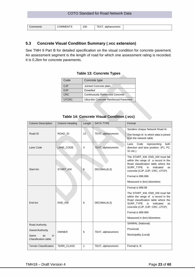
5.3 Concrete Visual Condition Summary (.vcc extension)
See TMH 9 Part B for detailed specification on the visual condition for concrete pavement.
An assessment segment is the length of road for which one assessment rating is recorded.
It is 0.2km for concrete pavements.
Table 13: Concrete Types
Code Concrete type
CJP Jointed Concrete plain
DJP Dowelled
CRC Continuously Reinforced Concrete
UTCRC Ultra-thin Concrete Reinforced Pavement
Table 14: Concrete Visual Condition (.vcc)
Column Description Column Heading Length DATA TYPE Format
Road ID ROAD_ID 12 TEXT, alphanumeric
Senders Unique Network Road Id
The foreign id to which data is joined
to in the network table
Lane Code LANE_CODE 4 TEXT, alphanumeric
Lane Code representing both
direction and lane position. (P1, P2,
S1 etc.)
Start km START_KM 6 DECIMAL(6,3)
The START_KM, END_KM must fall
within the range of a record in the
Road classification table where the
SURF_TYPE is indicated as
concrete (CJP, DJP, CRC, UTCP)
Format is 999.999
Measured in (km) kilometres
End km END_KM 6 DECIMAL(6,3)
Format is 999.99
The START_KM, END_KM must fall
within the range of a record in the
Road classification table where the
SURF_TYPE is indicated as
concrete (CJP, DJP, CRC, UTCP)
Format is 999.999
Measured in (km) kilometres
Road Authority
Owner/Authority
Same as in
Classification table
OWNER 6 TEXT, alphanumeric
SANRAL (National)
Provincial
Municipality (Local)
Terrain Classification TERR_CLASS 1 TEXT, alphanumeric Format is ‘A’

COTO Standard for Road Network Data
TMH18 – Draft Version 4 Page 24 of 60
Same as in
Classification table
‘F’ for a Flat terrain,
‘R’ for a Rolling terrain
‘M’ for a mountainous terrain
Gradient GRADIENT 1 TEXT, alphanumeric
F: Flat
M: Medium
S: Steep
Road Width ROAD_WIDTH 4 DECIMAL(4,2)
Width of paved surface. Gravel roads
from shoulder breakpoint to shoulder
break point.
Format is 99.99
Date of
measurement MEASURE_DATE 13 DATE/TIME YYYYMMDD HH24:MI:SI
Surface Type SURF_TYPE 4 TEXT, alphanumeric
Concrete Pavements:
CJP Jointed Concrete plain
DJP Dowelled
CRC Continuously Reinforced
Concrete
UTCRC Ultra-thin Concrete
Reinforced Pavement
Visual Condition
Index (VCI) VCI 4 DECIMAL(4,1) Format is 999.9
Reseal Condition
Index (RCI) RCI 4 DECIMAL(4,1) Format is 999.9
Maintenance Need
Index (MNI) MNI 4 DECIMAL(4,1) Format is 999.9
Surface Condition
Index (SCI) SCI 4 DECIMAL(4,1) Format is 999.9
Structural Condition
Index (STCI) STCI 4 DECIMAL(4,1) Format is 999.9
Functional Condition
Index (FCI) FCI 4 DECIMAL(4,1) Format is 999.9
Crack Condition
Index (CCI) CCI 4 DECIMAL(4,1) Format is 999.9
Random Cracking
Degree
RANDOM_CRAC
K_DEG 1 INTEGER(1)
Concrete (JCP, CRC, UTCRC)
1-5
Random Cracking
Extent
RANDOM_CRAC
K_EXT 1 INTEGER(1)
Concrete (JCP, CRC, UTCRC)
1-5
Transverse cracks
Degree
TRANSVERSE_C
RACK_DEG 1 INTEGER(1)
Concrete (JCP, CRC, UTCRC)
1-5
Transverse cracks
Extent
TRANSVERSE_C
RACK_EXT 1 INTEGER(1)
Concrete (JCP, CRC, UTCRC)
1-5
Longitudinal cracking
Degree
LONG_CRACK_D
EG 1 INTEGER(1)
Concrete (JCP, CRC, UTCRC)
1-5
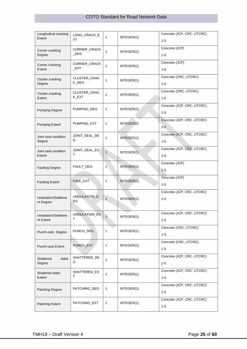
COTO Standard for Road Network Data
TMH18 – Draft Version 4 Page 25 of 60
Longitudinal cracking
Extent
LONG_CRACK_E
XT 1 INTEGER(1)
Concrete (JCP, CRC, UTCRC)
1-5
Corner cracking
Degree
CORNER_CRACK
_DEG 1 INTEGER(1)
Concrete (JCP)
1-5
Corner cracking
Extent
CORNER_CRACK
_EXT 1 INTEGER(1)
Concrete (JCP)
1-5
Cluster cracking
Degree
CLUSTER_CRAC
K_DEG 1 INTEGER(1)
Concrete (CRC, UTCRC)
1-5
Cluster cracking
Extent
CLUSTER_CRAC
K_EXT 1 INTEGER(1)
Concrete (CRC, UTCRC)
1-5
Pumping Degree PUMPING_DEG 1 INTEGER(1) Concrete (JCP, CRC, UTCRC)
1-5
Pumping Extent PUMPING_EXT 1 INTEGER(1) Concrete (JCP, CRC, UTCRC)
1-5
Joint seal condition
Degree
JOINT_SEAL_DE
G 1 INTEGER(1)
Concrete (JCP, CRC, UTCRC)
1-5
Joint seal condition
Extent
JOINT_SEAL_EX
T 1 INTEGER(1)
Concrete (JCP, CRC, UTCRC)
1-5
Faulting Degree FAULT_DEG 1 INTEGER(1) Concrete (JCP)
1-5
Faulting Extent FAUL_EXT 1 INTEGER(1) Concrete (JCP)
1-5
Undulation/Settleme
nt Degree
UNDULATION_D
EG 1 INTEGER(1)
Concrete (JCP, CRC, UTCRC)
1-5
Undulation/Settleme
nt Extent
UNDULATION_EX
T 1 INTEGER(1)
Concrete (JCP, CRC, UTCRC)
1-5
Punch-outs Degree PUNCH_DEG 1 INTEGER(1) Concrete (CRC, UTCRC)
1-5
Punch-outs Extent PUNCH_EXT 1 INTEGER(1) Concrete (CRC, UTCRC)
1-5
Shattered slabs
Degree
SHATTERED_DE
G 1 INTEGER(1)
Concrete (JCP, CRC, UTCRC)
1-5
Shattered slabs
Extent
SHATTERED_EX
T 1 INTEGER(1)
Concrete (JCP, CRC, UTCRC)
1-5
Patching Degree PATCHING_DEG 1 INTEGER(1) Concrete (JCP, CRC, UTCRC)
1-5
Patching Extent PATCHING_EXT 1 INTEGER(1) Concrete (JCP, CRC, UTCRC)
1-5

COTO Standard for Road Network Data
TMH18 – Draft Version 4 Page 26 of 60
Texture TEXTURE 30 TEXT, alphanumeric
Coarse
Medium
Fine
Varying
The texture can be expressed as
fine, fine-medium, medium, medium-
coarse or coarse, or varying, if it
varies across the width of the road.
The texture can be marked as
“Varying” and “Fine” to “Coarse”.
See TMH 9 Part C
Functional Assessment
Roughness (Riding
quality) Degree
RIDING_QUAL_D
EG 1 INTEGER(1)
1: Very Good
2: Good
3: Moderate
4: Poor
5: Very Poor
Roughness (Riding
quality) Problems:
Punch Outs
RQUAL_PROB_P
UNCH 1 TEXT, alphanumeric
Punch Outs
Y or N
Roughness (Riding
quality) Problems:
Shattered Slabs
RQUAL_PROB_
SHATTERED 1 TEXT, alphanumeric
Shattered Slabs
Y or N
Roughness (Riding
quality) Problems:
Patching
RQUAL_PROB_P
ATCH 1 TEXT, alphanumeric
PATCH Patching
Y or N
Roughness (Riding
quality) Problems:
Undulations
RQUAL_PROB_
UNDUL 1 TEXT, alphanumeric
UNDUL Undulations
Y or N
Roughness (Riding
quality) Problems:
Faulting
RQUAL_PROB_
FAULT 1 TEXT, alphanumeric
Faulting
Y or N
Skid Resistance
Degree
SKID_RESISTAN
CE_DEG 1 INTEGER(1)
1: Very Good
2: Good
3: Moderate
4: Poor
5: Very Poor
Surface Drainage DRAINAGE_SUR
F 13 TEXT, alphanumeric
Adequate,
Inconsistent,
Inadequate
Surface Drainage
Problems:
Rutting
DRAIN_PROB_R
UT 1 TEXT, alphanumeric
Rutting
Y or N
Surface Drainage
Problems:
Shoulders
DRAIN_PROB_S
HOULD 1 TEXT, alphanumeric
Shoulders
Y or N
Surface Drainage
Problems:
Alignment
DRAIN_PROB_AL
IGN 1 TEXT, alphanumeric
Alignment
Y or N

COTO Standard for Road Network Data
TMH18 – Draft Version 4 Page 27 of 60
Surface Drainage
Problems:
Side Drains
DRAIN_PROB_SI
DE 1 TEXT, alphanumeric
Side Drains
Y or N
Untraveled way
(Unpaved shoulders)
UNPAVED_SHOU
LDER 1 TEXT, alphanumeric
N: None,
S: Safe,
I: Inconsistent,
U: Unsafe
Untraveled way
(Unpaved shoulders)
Problems:
Erosion by
water/traffic
UNPAVED__PRO
B_ERODED 1 TEXT, alphanumeric
Eroded
Y or N
Untraveled way
(Unpaved shoulders)
Problems:
Wearing out by traffic
UNPAVED__PRO
B_WEARING 1 TEXT, alphanumeric
Weared Out
Y or N
Untraveled way
(Unpaved shoulders)
Problems:
Inclined – differences
in level between
edge of carriage way
and shoulder
UNPAVED__PRO
B_INCLINED 1 TEXT, alphanumeric
Inclined
Y or N
Untraveled way
(Unpaved shoulders)
Problems:
Overgrown
UNPAVED__PRO
B_OGROWN 1 TEXT, alphanumeric
Overgrown
Y or N
Untraveled way
(Unpaved shoulders)
Problems:
Too high
UNPAVED__PRO
B_2HIGH 1 TEXT, alphanumeric
Too high
Y or N
Untraveled way
(Unpaved shoulders)
Problems:
Too narrow
UNPAVED__PRO
B_2NARROW 1 TEXT, alphanumeric
Too narrow
Y or N
Overall Pavement
Condition OPC 1 INTEGER(1)
1: Very Good
2: Good
3: Moderate
4: Poor
5: Very Poor
Other Problems:
Crushing
OTHER_PROB_C
RUSHING 1 TEXT, alphanumeric
Crushing of the slab as a result of
expansion under hot weather as well
as poor concrete.
Y or N
Other Problems:
Blow up
OTHER_PROB_B
LOWUP 1 TEXT, alphanumeric
Blow-up or lifting of a thin UTCRCP
slab as a result of expansion under
hot weather. In this case at a
construction joint
Y or N
Other Problems:
Secondary Reaction
OTHER_PROB_R
EACTION 1 TEXT, alphanumeric
Clear signs of secondary reaction
between aggregate and cement,
probably alkali-silica reaction,
occurring close to joints or cracks.
Y or N
Comments COMMENTS 100 TEXT, alphanumeric

COTO Standard for Road Network Data
TMH18 – Draft Version 4 Page 28 of 60
5.4 Block Visual Condition Summary (.vcb extension)
See TMH 9 Part D for detailed specification on the visual condition for block pavement.
Table 15: Block Visual Condition (.vcb)
Column Description Column Heading Length DATA TYPE Format
Road ID ROAD_ID 12 TEXT,
alphanumeric
Senders Unique Network Road Id
The foreign id to which data is
joined to in the network table
Lane Code LANE_CODE 4 TEXT,
alphanumeric
Lane Code representing both
direction and lane position. (P1,
P2, S1 etc.)
Start km START_KM 6 DECIMAL(6,3)
The START_KM, END_KM must
fall within the range of a record in
the Road classification table
where the SURF_TYPE is
indicated as concrete (CJP, DJP,
CRC, UTCP)
Format is 999.999
Measured in (km) kilometres
End km END_KM 6 DECIMAL(6,3)
The START_KM, END_KM must
fall within the range of a record in
the Road classification table
where the SURF_TYPE is
indicated as concrete (CJP, DJP,
CRC, UTCP)
Format is 999.99
Measured in (km) kilometres
Road Authority
Owner/Authority
Same as in Classification table
OWNER 6 TEXT,
alphanumeric
SANRAL (National)
Provincial
Municipality (Local)
Terrain Classification
Same as in Classification table TERR_CLASS 1
TEXT,
alphanumeric
Format is ‘A’
‘F’ for a Flat terrain,
‘R’ for a Rolling terrain
‘M’ for a mountainous terrain
Gradient GRADIENT 1 TEXT,
alphanumeric
F: Flat
M: Medium
S: Steep
Road Width ROAD_WIDTH 4 DECIMAL(4,2)
Width of paved surface. Gravel
roads from shoulder breakpoint to
shoulder break point.
Format 99.99

COTO Standard for Road Network Data
TMH18 – Draft Version 4 Page 29 of 60
Measured in (m) metres
Date of measurement MEASURE_DATE 13 DATE/TIME YYYYMMDD HH24:MI:SI
Block Shape Code BLOCK_TYPE 3
TEXT,
alphanumeric
S-A Blocks which allow geometrical
interlock between ALL vertical
faces of adjacent blocks.
S-B Blocks which allow geometrical
interlock between some faces of
adjacent blocks.
S-C Blocks which allow no
geometrical interlock between
adjacent faces.
Lay Pattern BLOCK_LAY 2
TEXT,
alphanumeric
HB
Herring-bone
SB
Stretcher-bond
BW
Basket Weave
OT
Other
Block thickness BLOCK_THICK 3 NUMERIC B lock thickness in mm (should
be between 50 and 80 mm)
Chamfers CHAMFERS 2
TEXT,
alphanumeric
45 – 45 degree angle
R – rounded
90 - none
Visual Condition Index (VCI) VCI 4 DECIMAL(4,1) Format is 999.9
Reseal Condition Index (RCI) RCI 4 DECIMAL(4,1) Format is 999.9
Maintenance Need Index (MNI) MNI 4 DECIMAL(4,1) Format is 999.9
Surface Condition Index (SCI) SCI 4 DECIMAL(4,1) Format is 999.9
Structural Condition Index (STCI) STCI 4 DECIMAL(4,1) Format is 999.9
Functional Condition Index (FCI) FCI 4 DECIMAL(4,1) Format is 999.9
Crack Condition Index (CCI) CCI 4 DECIMAL(4,1) Format is 999.9
Spalled/ cracked/ broken blocks
degree
SPALLED_CRACK_
DEG 1 INTEGER(1) 1-5
Spalled/ cracked/ broken blocks
extent
SPALLED_CRACK_
EXT 1 INTEGER(1) 1-5
Block surface integrity (Durability)
Degree
SURF_INTEGRITY_
DEG 1 INTEGER(1) 1-5
Block surface integrity (Durability)
Extent
SURF_INTEGRITY_
EXT 1 INTEGER(1) 1-5
Loss of jointing sand Degree
JOINT_LOSS_DEG 1 INTEGER(1) 1-5
Loss of jointing sand Extent
JOINT_LOSS_EXT 1 INTEGER(1) 1-5
Edge Restraint (or Anchor Beam)
Damage Degree
EDGE_DAMAGE_D
EG 1 INTEGER(1) 1-5
Edge Restraint (or Anchor Beam)
Damage Extent
EDGE_DAMAGE_E
XT 1 INTEGER(1) 1-5

COTO Standard for Road Network Data
TMH18 – Draft Version 4 Page 30 of 60
Deformation: Rutting Degree RUTTING_DEG 1 INTEGER(1) 1-5
Deformation: Rutting Extent RUTTING_EXT 1 INTEGER(1) 1-5
Potholes/Patching/Reinstatemen
ts Degree POT_PATCH_DEG 1 INTEGER(1) 1-5
Potholes/Patching/Reinstatemen
ts Extent POT_PATC_EXT 1 INTEGER(1) 1-5
Undulation/Settlement Degree UNDULATION_DEG 1 INTEGER(1) 1-5
Undulation/Settlement Extent UNDULATION_EXT 1 INTEGER(1) 1-5
Functional Assessment
Roughness (Riding quality)
Degree
RIDING_QUAL_DE
G 1 INTEGER(1)
1: Very Good
2: Good
3: Moderate
4: Poor
5: Very Poor
Roughness (Riding quality)
Problems:
Potholes/failures/Patching
RQUAL_PROB_PA
TCH 1
TEXT,
alphanumeric
Potholes, Failures, Patching
Y or N
Roughness (Riding quality)
Problems:
Loose blocks
RQUAL_PROB_
LOOSE 1
TEXT,
alphanumeric
Loose blocks because of loss of
jointing sand;
Y or N
Roughness (Riding quality)
Problems:
Undulations/Settlement
RQUAL_PROB_
UNDUL 1
TEXT,
alphanumeric
UNDUL Undulations
Y or N
Skid Resistance Degree SKID_RESISTANCE
_DEG 1 INTEGER(1)
1: Very Good
2: Good
3: Moderate
4: Poor
5: Very Poor
Surface Drainage DRAINAGE_SURF 13 TEXT,
alphanumeric
Adequate,
Inconsistent,
Inadequate
Surface Drainage Problems:
Profile
DRAIN_PROB_PRO
FILE 1
TEXT,
alphanumeric
Profile
Y or N
Surface Drainage Problems:
Rutting
DRAIN_PROB_RUT 1 TEXT,
alphanumeric
Rutting
Y or N
Surface Drainage Problems:
Shoulders/Edge restraint too high
DRAIN_PROB_SHO
ULD 1
TEXT,
alphanumeric
Shoulders
Y or N
Surface Drainage Problems:
Side Drains
DRAIN_PROB_SID
E 1
TEXT,
alphanumeric
Side Drains
Y or N
Surface Drainage Problems:
Failures/Depressions DRAIN_PROB_FAIL 1
TEXT,
alphanumeric
Failures/Depressions
Y or N
Untraveled way (Unpaved
shoulders)
UNPAVED_SHOUL
DER 1
TEXT,
alphanumeric N: None,

COTO Standard for Road Network Data
TMH18 – Draft Version 4 Page 31 of 60
S: Safe,
I: Inconsistent,
U: Unsafe
Untraveled way (Unpaved
shoulders)
Problems:
Erosion by water/traffic
UNPAVED__PROB
_ERODED 1
TEXT,
alphanumeric
Eroded
Y or N
Untraveled way (Unpaved
shoulders)
Problems:
Wearing out by traffic
UNPAVED__PROB
_WEARING 1
TEXT,
alphanumeric
Weared Out
Y or N
Untraveled way (Unpaved
shoulders)
Problems:
Inclined – differences in level
between edge of carriage way
and shoulder
UNPAVED__PROB
_INCLINED 1
TEXT,
alphanumeric
Inclined
Y or N
Untraveled way (Unpaved
shoulders)
Problems:
Overgrown
UNPAVED__PROB
_OGROWN 1
TEXT,
alphanumeric
Overgrown
Y or N
Untraveled way (Unpaved
shoulders)
Problems:
Too high
UNPAVED__PROB
_2HIGH 1
TEXT,
alphanumeric
Too high
Y or N
Untraveled way (Unpaved
shoulders)
Problems:
Too narrow
UNPAVED__PROB
_2NARROW 1
TEXT,
alphanumeric
Too narrow
Y or N
Overall Pavement Condition OPC 1 INTEGER(1)
1: Very Good
2: Good
3: Moderate
4: Poor
5: Very Poor
Other Problems:
Trees
OTHER_PROB_TR
EES 1
TEXT,
alphanumeric
Trees
Y or N
Other Problems:
Moles
OTHER_PROB_MO
LES 1
TEXT,
alphanumeric
Moles
Y or N
Other Problems:
Mechanical Damage
OTHER_PROB_DA
MAGE 1
TEXT,
alphanumeric
Mechanical Damage
Y or N
Comments COMMENTS 100 TEXT,
alphanumeric
5.5 Unsurfaced Visual Condition Summary (.vcu extension)
See TMH 9 Part E for detailed specification on the visual condition for unsurfaced roads.

COTO Standard for Road Network Data
TMH18 – Draft Version 4 Page 32 of 60
Table 16: Unsurfaced types
Code Unsurfaced type
E Earth road: An unpaved road in which
the in situ material is directly travelled
by vehicles.
G Gravel road: An unpaved road in
which an imported material has been
placed to provide a riding surface for
vehicles.
T Track road
Table 17: Unsurfaced Visual Condition (.vcu)
Column Description Column Heading Length DATA TYPE Format
Road ID ROAD_ID 12 TEXT,
alphanumeric
Senders Unique Network Road Id
The foreign id to which data is joined to in
the network table
Lane Code LANE_CODE 4 TEXT,
alphanumeric
Lane Code representing both direction and
lane position. (P1, P2, S1 etc.)
Start km START_KM 6 DECIMAL(6,3)
Format is 999.99
The START_KM, END_KM must fall within
the range of a record in the Road
classification table where the SURF_TYPE
is indicated as concrete (CJP, DJP, CRC,
UTCP)
End km END_KM 6 DECIMAL(6,3)
Format is 999.99
The START_KM, END_KM must fall within
the range of a record in the Road
classification table where the SURF_TYPE
is indicated as concrete (CJP, DJP, CRC,
UTCP)
Road Authority
Owner/Authority
Same as in
Classification table
OWNER 6 TEXT,
alphanumeric
SANRAL (National)
Provincial
Municipality (Local)
Terrain Classification
Same as in
Classification table
TERR_CLASS
1 TEXT,
alphanumeric
Format is ‘A’
‘F’ for a Flat terrain,
‘R’ for a Rolling terrain
‘M’ for a mountainous terrain
Gradient GRADIENT
1 TEXT,
alphanumeric
F: Flat
M: Medium

COTO Standard for Road Network Data
TMH18 – Draft Version 4 Page 33 of 60
S: Steep
Road Width ROAD_WIDTH 4 DECIMAL(4,2) Width of paved surface. Gravel roads from
shoulder breakpoint to shoulder break point.
Date of
measurement
MEASURE_DATE 13 DATE/TIME YYYYMMDD HH24:MI:SI
Visual Condition
Index (VCI) VCI 4 DECIMAL(4,1)
Format is 999.9
Reseal Condition
Index (RCI) RCI 4 DECIMAL(4,1)
Format is 999.9
Maintenance Need
Index (MNI) MNI 4 DECIMAL(4,1)
Format is 999.9
Surface Condition
Index (SCI) SCI 4 DECIMAL(4,1)
Format is 999.9
Structural Condition
Index (STCI) STCI 4 DECIMAL(4,1)
Format is 999.9
Functional Condition
Index (FCI) FCI 4 DECIMAL(4,1)
Format is 999.9
Crack Condition
Index (CCI) CCI 4 DECIMAL(4,1)
Format is 999.9
Road Type ROAD_TYPE
1 TEXT,
alphanumeric
E Earth: An unpaved road in which the in situ material is directly travelled by vehicles. G Gravel: An unpaved road in which an
imported material has been placed to provide
a riding surface for vehicles.
T Track:
Moisture Condition MOISTURE 1
TEXT,
alphanumeric
W wet, M moist (damp) or D dry
Engineering Assessment (Material Properties)
Gravel Quality GRAVEL_QUALIT
Y 1 INTEGER(1)
1: Very Good
2: Good
3: Moderate
4: Poor
5: Very Poor
Gravel Quality
Influencing Factors:
Excessive oversize stones and/or loose gravel
GQUAL_OVERSI
ZE 1
TEXT,
alphanumeric
Y or N
Gravel Quality
Influencing Factors:
Excessive clay and/or silt (i.e. plasticity too high)
GQUAL_CLAY 1 TEXT,
alphanumeric
Y or N
Gravel Quality
Influencing Factors:
Excessive loose gravel or sand – loose with insufficient fines (i.e. plasticity too low)
GQUAL_LOOSE 1 TEXT,
alphanumeric
Y or N
Maximum size MAX_SIZE 1 INTEGER(1) 1: > 50mm,
2: 25 – 50mm,

COTO Standard for Road Network Data
TMH18 – Draft Version 4 Page 34 of 60
3: 13 – 25mm, and
4: < 13mm.
Grading GRADING 1 TEXT,
alphanumeric
C coarse,
M medium or
F fine
Plasticity PLASTICITY 1 TEXT,
alphanumeric
L Low
Non-cohesive (sandy)
M Medium
Intermediate cohesion
H High
Cohesive (clayey)
Gravel Quantity:
Layer thickness
GRAVEL_QUANTI
TY 1 INTEGER(1)
1: >125 mm
2: 100mm – 125mm
3: 50mm – 100mm
4: 25mm – 50mm
5: 0mm
Exposed Subgrade EXPOSED_SUBG
RADE 1
TEXT,
alphanumeric
N None
I Isolated
F Frequent
C Continuous
Subgrade Quality SUBGRADE_QUA
LITY 1
TEXT,
alphanumeric
G Good
M Moderate
P Poor
Engineering Assessment (Surface Distress)
Potholes Degree POTHOLES_DEG 1 INTEGER(1) 1-5
Potholes Extent POTHOLES_EXT 1 INTEGER(1) 1-5
Corrugations Degree CORRUGATIONS
_DEG 1 INTEGER(1)
1-5
Corrugations Extent CORRUGATIONS
_EXT
1 INTEGER(1)
1-5
Rutting Degree RUTTING_DEG 1 INTEGER(1) 1-5
Rutting Extent RUTTING_EXT 1 INTEGER(1) 1-5
Loose Material
Degree
LOOSE_MATERI
AL_DEG 1 INTEGER(1)
1-5
Loose Material
Extent
LOOSE_MATERI
AL_EXT 1 INTEGER(1)
1-5
Stoniness fixed
(embedded) Degree
STONINESS_FIX
_DEG 1 INTEGER(1)
1-5
Stoniness fixed
(embedded) Extent
STONINESS_FIX
_EXT 1 INTEGER(1)
1-5
Stoniness loose
Degree
STONINESS_LO
OSE_DEG 1 INTEGER(1)
1-5
Stoniness loose
Extent
STONINESS_LO
OSE_EXT 1 INTEGER(1)
1-5

COTO Standard for Road Network Data
TMH18 – Draft Version 4 Page 35 of 60
Erosion Longitudinal
Degree
EROSION_LONG
_DEG 1 INTEGER(1)
1-5
Erosion Longitudinal
Extent
EROSION_LONG
_EXT 1 INTEGER(1)
1-5
Erosion Transverse
(or Diagonal) Degree
EROSION_TRAN
S_DEG 1 INTEGER(1)
1-5
Erosion Transverse
(or Diagonal) Extent
EROSION_TRAN
S_EXT 1 INTEGER(1)
1-5
Functional Assessment
Roughness (Riding
quality) Degree
RIDING_QUAL_D
EG 1 INTEGER(1)
1: Very Good
2: Good
3: Moderate
4: Poor
5: Very Poor
Roughness (Riding
quality) Problems:
Deformation
RQUAL_PROB_D
FORM 1
TEXT,
alphanumeric
Deformation
Y or N
Roughness (Riding
quality) Problems:
Potholes
RQUAL_PROB_H
OLE 1
TEXT,
alphanumeric
HOLE Potholes
Y or N
Roughness (Riding
quality) Problems:
Stoniness
RQUAL_PROB_S
TONINESS 1
TEXT,
alphanumeric
Stoniness
Y or N
Roughness (Riding
quality) Problems:
Rock Outcrop
RQUAL_PROB_
ROCKS 1
TEXT,
alphanumeric
Rock Outcrop
Y or N
Roughness (Riding
quality) Problems:
Corrugations
RQUAL_PROB_
CORR 1
TEXT,
alphanumeric
CORR Corrugations
Y or N
Roughness (Riding
quality) Problems:
Ruts
RQUAL_PROB_
RUTS 1
TEXT,
alphanumeric
Ruts
Y or N
Roughness (Riding
quality) Problems:
Erosion
RQUAL_PROB_
EROSION 1
TEXT,
alphanumeric
Erosion
Y or N
Trafficability/passabil
ity Degree
TRAFFICABILITY
_DEG 1 INTEGER(1)
1-5
Trafficability/passabil
ity Problems:
Steep Grades
TRAFFIC_PROB_
STEEP 1
TEXT,
alphanumeric
Y or N
Trafficability/passabil
ity Problems:
Rocky Terrein
TRAFFIC_PROB_
ROCKY 1
TEXT,
alphanumeric
Y or N
Trafficability/passabil
ity Problems:
Vegetation
Encroachment
TRAFFIC_PROB_
VEGETATION 1
TEXT,
alphanumeric
Y or N
Trafficability/passabil
ity Problems:
Insufficient cross drainage provision/ dangerous drifts/ wash-aways
TRAFFIC_PROB_
DRAINAGE 1
TEXT,
alphanumeric
Y or N

COTO Standard for Road Network Data
TMH18 – Draft Version 4 Page 36 of 60
Safety
Safety Degree SAFETY_DEG 1 INTEGER(1)
1: Very Good
2: Good
3: Moderate
4: Poor
5: Very Poor
Safety Problems:
Dust
SAFETY_PROB_
DUST 1
TEXT,
alphanumeric
Y or N
Safety Problems:
Slipperiness
SAFETY_PROB_
SLIP 1
TEXT,
alphanumeric
Y or N
Safety Problems:
Skid Resistance
SAFETY_PROB_
SKID 1
TEXT,
alphanumeric
Y or N
Safety problems due
to poor drainage and
wash-aways
SAFETY_PROB_
DRAINAGE 1
TEXT,
alphanumeric
Y or N
Transverse Profile TRANSVERS_PR
OFILE 1 INTEGER(1)
1: Very Good
2: Good
3: Moderate
4: Poor
5: Very Poor
Profile Problems:
Windrows
PROFILE_PROB_
WINDROWS 1
TEXT,
alphanumeric
Y or N
Profile Problems:
Rutting
PROFILE_PROB_
RUTTING 1
TEXT,
alphanumeric
Y or N
Profile Problems:
Road Shape
PROFILE_PROB_
SHAPE 1
TEXT,
alphanumeric
Y or N
Profile Problems:
Road Level
PROFILE_PROB_
LEVEL 1
TEXT,
alphanumeric
Y or N
Drainage from thr
road (side of the
road)
DRAINAGE_SIDE 13 TEXT,
alphanumeric
1: Very Good
2: Good
3: Moderate
4: Poor
5: Very Poor
Drainage Problems:
Culvert Inlets
DRAIN_PROB_C
ULVERTS 1
TEXT,
alphanumeric
Y or N
Drainage Problems:
Side Drains
DRAIN_PROB_SI
DE 1
TEXT,
alphanumeric
Y or N
Drainage Problems:
Mitre Drains
DRAIN_PROB_MI
TRE 1
TEXT,
alphanumeric
Y or N
Drainage Problems:
Road Level
DRAIN_PROB_LE
VEL 1
TEXT,
alphanumeric
Y or N
Overall Pavement
Condition OPC 1 INTEGER(1) 1: Very Good

COTO Standard for Road Network Data
TMH18 – Draft Version 4 Page 37 of 60
2: Good
3: Moderate
4: Poor
5: Very Poor
Other Problems:
Trees
OTHER_PROB_T
REES 1
TEXT,
alphanumeric
Trees
Y or N
Other Problems:
Moles
OTHER_PROB_M
OLES 1
TEXT,
alphanumeric
Moles
Y or N
Other Problems:
Mechanical Damage
OTHER_PROB_D
AMAGE 1
TEXT,
alphanumeric
Mechanical Damage
Y or N
Comments COMMENTS 100 TEXT,
alphanumeric
5.6 Combined Instrument Data File (.cid extension)
The combined condition file contains the following three measurement types of data;
Roughness, Rutting and Texture, in a single file format. For a single file submission all three
measurement data types need to have been done at the same time and location as they
share the Road Id, Lane Code, Start Km, End Km and measurement date.
Table 18: Combined Instrument Data (.cid)
Column Description Column Heading Length DATA TYPE Format
Road ID ROAD_ID 12 TEXT, alphanumeric
Senders Unique Road Id
Lane Code LANE_CODE 4 TEXT, alphanumeric
Lane Code representing both direction and lane position. (P1, P2, S1 etc.)
Start km START_KM 6 DECIMAL(6,3) Format is 999.999
End km END_KM 6 DECIMAL(6,3) Format is 999.999
Date of measurement
MEASURE_DATE 13 DATE/TIME YYYYMMDD HH24:MI:SI
Avg. IRI Left Wheel path (m/km)
AVG_IRI_L 3 DECIMAL(3,1) Format is 99.9
Avg. IRI Right Wheel path (m/km)
AVG_IRI_R 3 DECIMAL(3,1) Format is 99.9
IRI Left Std. Dev. IRI_L_STDV 3 DECIMAL(3,1) Format is 99.9
IRI Right Std. Dev. IRI_R_STDV 3 DECIMAL(3,1) Format is 99.9
Avg. HRI AVG_HRI 3 DECIMAL(3,1) Format is 99.9
HRI Std. Dev. HRI_STDV 3 DECIMAL(3,1) Format is 99.9
Avg. Rut in Left Wheel path
AVG_RUT_L 4 DECIMAL(4,1) Format is 999.9
Avg. Rut in right Wheel path
AVG_RUT_R 4 DECIMAL(4,1) Format is 999.9
Rut Std. Dev. Left RUT_L_STDV 4 DECIMAL(4,1) Format is 999.9

COTO Standard for Road Network Data
TMH18 – Draft Version 4 Page 38 of 60
Rut Std. Dev. Right RUT_R_STDV 4 DECIMAL(4,1) Format is 999.9
Avg. MPD Left Wheel path
AVG_MPD_L 3 DECIMAL(3,2) Format is 9.99
Avg. MPD Centre AVG_MPD_C 3 DECIMAL(3,2) Format is 9.99
Avg. MPD Right Wheel path
AVG_MPD_R 3 DECIMAL(3,2) Format is 9.99
MPD Std. Dev. Left MPD_STDV_L 3 DECIMAL(3,2) Format is 9.99
MPD Std. Dev. Centre
MPD_STDV_C 3 DECIMAL(3,2) Format is 9.99
MPD Std. Dev. Right MPD_STDV_R 3 DECIMAL(3,2) Format is 9.99
Start Longitude START_LONGITUDE 12 DECIMAL(12,9)
Longitude Value in Decimal Degrees
World Geodetic System of 1984 (WGS84)
Start Latitude START_LATITUDE 12 DECIMAL(12,9)
Latitude Value in Decimal Degrees
World Geodetic System of 1984 (WGS84)
Data example:
MR00233;P1;3.60;3.70;20100401;15:32;4.5;4.1;0.5;0.6; 3.2;0.4;
12.1;15.3;1.2;2.1;0.73;;0.82;0.3;;0.4;-25.927733;27.902582(CR)(LF)
5.7 Normalised Deflection Bowl Data (.fwd extension)
Table 19: Normalized deflection bowl data (.fwd)
Column Description Column Heading Length DATA TYPE Format
Road ID ROAD_ID 12 TEXT, alphanumeric Senders Unique Road Id
Lane Code LANE_CODE 4 TEXT, alphanumeric
Lane Code representing both
direction and lane position.
(P1, P2, S1 etc.)
Survey Point (km) SURVEY_KM 6 DECIMAL(6,3) Format is 999.999
Measurement Date DATE 10 DATE YYYYMMDD HH24:MI:SI
Air Temperature at time of
measurement (Degrees
Celsius)
TEMP_AIR 4 DECIMAL(3,2)
Format is 99.9, where the last
digit represent one digit after
the decimal
Surface Temperature at time
of measurement (Degrees
Celsius)
TEMP_SURFACE 3 DECIMAL(3,2)
Format is 99.9, where the last
digit represent one digit after
the decimal
Load applied to pavement
(KN) PEAK_LOAD 4
DECIMAL(4,2) Format is 99.99
Drop Number DROP_NUM 2 INTEGER(2) Format 99
Deflection of pavement at
load plate centre (D0) DEF_0 4
INTEGER(4) Format is 9999
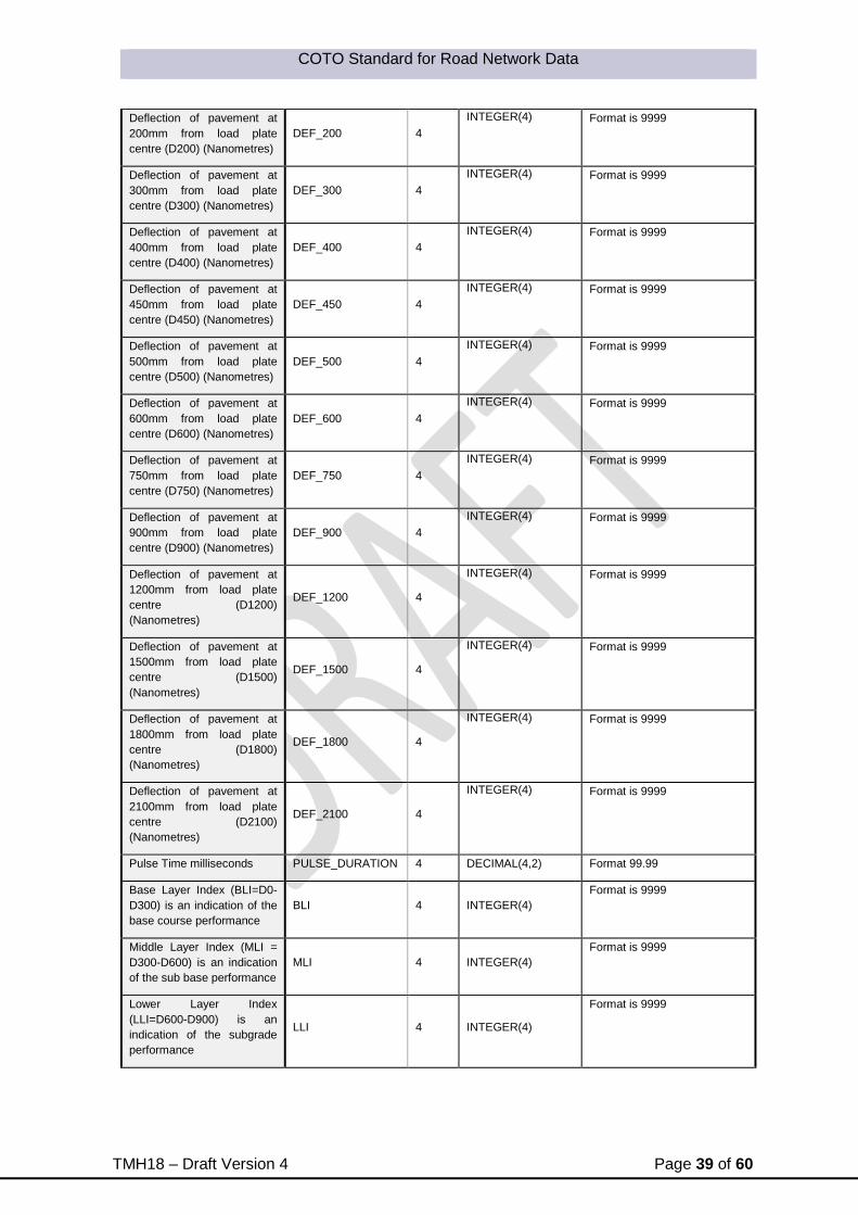
COTO Standard for Road Network Data
TMH18 – Draft Version 4 Page 39 of 60
Deflection of pavement at
200mm from load plate
centre (D200) (Nanometres)
DEF_200 4
INTEGER(4) Format is 9999
Deflection of pavement at
300mm from load plate
centre (D300) (Nanometres)
DEF_300 4
INTEGER(4) Format is 9999
Deflection of pavement at
400mm from load plate
centre (D400) (Nanometres)
DEF_400 4
INTEGER(4) Format is 9999
Deflection of pavement at
450mm from load plate
centre (D450) (Nanometres)
DEF_450 4
INTEGER(4) Format is 9999
Deflection of pavement at
500mm from load plate
centre (D500) (Nanometres)
DEF_500 4
INTEGER(4) Format is 9999
Deflection of pavement at
600mm from load plate
centre (D600) (Nanometres)
DEF_600 4
INTEGER(4) Format is 9999
Deflection of pavement at
750mm from load plate
centre (D750) (Nanometres)
DEF_750 4
INTEGER(4) Format is 9999
Deflection of pavement at
900mm from load plate
centre (D900) (Nanometres)
DEF_900 4
INTEGER(4) Format is 9999
Deflection of pavement at
1200mm from load plate
centre (D1200)
(Nanometres)
DEF_1200 4
INTEGER(4) Format is 9999
Deflection of pavement at
1500mm from load plate
centre (D1500)
(Nanometres)
DEF_1500 4
INTEGER(4) Format is 9999
Deflection of pavement at
1800mm from load plate
centre (D1800)
(Nanometres)
DEF_1800 4
INTEGER(4) Format is 9999
Deflection of pavement at
2100mm from load plate
centre (D2100)
(Nanometres)
DEF_2100 4
INTEGER(4) Format is 9999
Pulse Time milliseconds PULSE_DURATION 4 DECIMAL(4,2) Format 99.99
Base Layer Index (BLI=D0-
D300) is an indication of the
base course performance
BLI 4 INTEGER(4)
Format is 9999
Middle Layer Index (MLI =
D300-D600) is an indication
of the sub base performance
MLI 4 INTEGER(4)
Format is 9999
Lower Layer Index
(LLI=D600-D900) is an
indication of the subgrade
performance
LLI 4 INTEGER(4)
Format is 9999

COTO Standard for Road Network Data
TMH18 – Draft Version 4 Page 40 of 60
Start Longitude
START_LONGITUD
E 12 DECIMAL(12,9)
Longitude Value in Decimal
Degrees
World Geodetic System of
1984 (WGS84)
Start Latitude
START_LATITUDE
12 DECIMAL(12,9)
Latitude Value in Decimal
Degrees
World Geodetic System of
1984 (WGS84)
Deflection bowl measurements were taken starting at survey point 56.7 km on single
carriageway Main Road 310 on 21 March 2011 at 14:03. The air temperature was 22.8C,
the pavement surface temperature was 52.4ºC, the asphalt temperature was 63.1ºC, and the
load applied to the pavement was 40 kN:
D0 1120 nanometres
D200 980 nanometres
D300 701 nanometres
D400 Not Measured
D450 Not Measured
D500 Not Measured
D600 564 nanometres
D750 Not Measured
D900 356 nanometres
D1200 103 nanometres
D1500 80 nanometres
D1800 Not Measured
D2100 Not Measured
Pulse Time 30.05ms
BLI 419
MLI 137
LLI 208
This data should be presented as please note that line endings are shown with (CR)(LF) as
the document width could not accommodate the data length:
R30301N;MR00310;P1;56.70;20110321;14:03;22.8;52.4;63.1;40;2;1120;980;701;;;;564;
; 356;103;80;;;30.05;419;137;208; -25.927733;27.902582(CR)(LF)

COTO Standard for Road Network Data
TMH18 – Draft Version 4 Page 41 of 60
5.8 FWD F25 files (.f25 extension)
F25 files are an internationally accepted raw format for FWD data. The files contain all the
information of an FWD survey. The file format is ASCII but with an .f25 extension.
F25 File Example:
5001,25.08,1,40, 3, 1,"FwdWin "
5002,"25SIN ","8002-165","CP15-416"
5003,"Administ","NRA (2x4","SRT ","F25"
5010,0,0,0,0,0,0,0,3,1,0,0,0,0,0,1,0,0,0,0,0,1,"MDB"
5011,0,1,2012,07,11,02,37,0,"Non",000
5200,"525 ",2,0.998, 91.6, -0.24, 1.667
5201,"4671 ",4,0.995,1.038
5202,"4672 ",4,1.000,1.011
5203,"4673 ",4,1.002,1.010
5204,"7566 ",4,1.001,1.029
5205,"4675 ",4,1.002,1.051
5206,"4676 ",4,1.006,0.992
5207,"4677 ",4,1.005,0.982
5208,"4678 ",4,1.002,1.008
5209,"4679 ",4,1.009,1.023
5210,"7567 ",4,1.004,0.999
5211,"4674 ",4,1.005,1.032
5212,"NA ",4,0.000,0.000
5213,"NA ",4,0.000,0.000
5214,"NA ",4,0.000,0.000
5215,"NA ",4,0.000,0.000
5216,"NA ",4,0.000,0.000
5217,"NA ",4,0.000,0.000
5218,"NA ",4,0.000,0.000
5020, 150, 0, 200, 300, 400, 500, 600, 750, 900, 1200, 1500,
1800,N0 ,N0 ,N0 ,N0 ,N0 ,N0 ,N0
5021, 300, 0, 0, 0, 0, 0, 0, 0, 0, 0,N0
,N0 ,N0 ,N0 ,N0 ,N0 ,N0 ,N0 ,N0
5022,1, 0, 0, 50, 100, 200, 390,"L123456789"
5023,1,3,0, 0.000, 13.000, 13.000, 0.000, 0.000,1,1
5024,1,0,0,1,3,3, 5, 2.0, 2, 2.0,1,0,0, 60

COTO Standard for Road Network Data
TMH18 – Draft Version 4 Page 42 of 60
5029, 1, 393, 1, 393
5030,"Administrator "
5031,"N3 "
5032," "
5301,0,0,0,3, 0.000,0,0,1 ,2012,07,11,02,36,0,0000
5302,0,0,0,0,0,0,0,0," "
5303, 0.0, 25.0, 23.0
5041," "
5042," "
5043," "
5044," "
5280,0,102119.2,-26.2932850, 28.1559567,1561.7, 2, 7, 0, 0
5301,0,0,0,3, 13.000,0,0,1 ,2012,07,11,12,21,0,0000
5302,0,0,0,0,0,0,0,0," "
5303,0, 0.0, 25.1, 22.3
1, 563, 494.6, 383.6, 306.6, 237.9, 192.5, 138.0, 89.6, 57.7, 29.0, 20.1,
16.3, 28.050
2, 595, 481.7, 375.5, 301.2, 235.2, 191.2, 138.2, 90.8, 59.1, 30.4, 21.3,
16.2, 28.900
3, 714, 564.8, 452.2, 350.2, 283.1, 233.6, 170.9, 109.3, 79.4, 39.0, 26.9,
21.7, 27.550
5280,0,102224.4,-26.2940650, 28.1564517,1557.2, 2, 8, 0, 0
5301,0,0,0,3, 12.900,0,0,1 ,2012,07,11,12,22,0,0000
5302,0,0,0,0,0,0,0,0," "
5303,0, 0.0, 25.1, 22.2
1, 568, 396.0, 331.9, 279.2, 228.1, 190.2, 139.2, 95.7, 63.1, 31.9, 18.3,
6.5, 27.850
2, 573, 391.5, 330.0, 276.2, 226.8, 188.8, 139.4, 95.0, 64.0, 31.0, 18.5,
6.7, 28.150
3, 711, 458.2, 387.8, 326.6, 269.9, 227.0, 168.5, 118.0, 79.4, 39.7, 23.9,
10.7, 27.450
5280,0,102321.4,-26.2945683, 28.1568317,1554.3, 2, 8, 0, 0
5301,0,0,0,3, 12.800,0,0,1 ,2012,07,11,12,23,0,0000
5302,0,0,0,0,0,0,0,0," "
5303,0, 0.0, 25.1, 22.3
1, 572, 348.6, 284.4, 234.7, 193.0, 157.2, 119.1, 83.2, 52.5, 25.4, 16.2,
4.3, 27.900
2, 567, 340.2, 278.7, 230.0, 189.5, 155.8, 117.5, 86.6, 52.0, 25.4, 15.4,
4.0, 28.150

COTO Standard for Road Network Data
TMH18 – Draft Version 4 Page 43 of 60
3, 713, 399.8, 331.3, 274.7, 227.1, 186.1, 143.6, 99.5, 65.0, 34.2, 22.2,
7.1, 27.400
Every line starting with a 5 contains different information. Programs like Rubicon or Elsym
can read these files in their raw format to use in analyses.
An explanation of the meaning of the data are contained in Appendix A.

COTO Standard for Road Network Data
TMH18 – Draft Version 4 Page 44 of 60
6 Structure Data Submission Types
This section will be updated as soon as issues related the different
look-ups that exist for maintenance activities in Struman Software
is resolved
References

COTO Standard for Road Network Data
TMH18 – Draft Version 4 Page 45 of 60
7 APPENDIX A: F25 FILE FORMAT
7.1 EXAMPLE F25 UPLOAD FILE FORMAT AND LISTING
7.1.1 Introduction
The output file with the file name extension F25 contains the header information and peak
load and deflection data in ASCII format. This file typically contains 46 lines of "header"
information followed by test data and/or comments. Each line or record is prefixed by a four
digit "Line-ID-Number" (LIN) or object field, which identifies its format and content. Data
elements on a line are stored in a fixed column, comma separated, format. Most of the text
fields are enclosed in double quotes. This text data is stored as entered by the operator with
leading and trailing spaces in some cases. Numbers are right justified.
In this appendix, a detailed, annotated, description of the format and contents of the F25
upload file is presented.
7.1.2 Annotated Description of F25 FWD Upload File Format
In the following format and content descriptions of the F25 upload file, fields on each data
line are specified using an [ X, Y] column designation, where X is the begin column and Y
the end column, since the data are placed in fixed column width locations. Each line of data
in the file is prefixed with a Line ID Number (LIN), which serves as an object field, in columns
[1,4]. This LIN is used to describe the contents of each line. Also used in the description of
the header portion of file is the sequential line number in which each LIN appears in a typical
file.
7.1.3 Header Data
Typically, the first 46 lines of data in the F25 FWD data file, contains header data.
The number of lines of header data in the file is shown in columns 14 and 15 in the first line
of the data file.
7.1.3.1 Program Version - LIN 5001
5001,25.11,1,46, 4, 1,”Aug 2000 “
[ 6, 7] 25 Program Edition
[ 8, 10] .11 Program Edition Version
[ 12, 12] 1 No of Headers (always 1)
[ 14, 15] 46 No of Lines in Header
[ 17, 18] 4 Lines per Station Id
[ 20, 21] 1 Lines per Drop
[ 24, 39] Aug 2000 Program Comment
7.1.3.2 Primary “Files” - LIN 5002
5002,”25SIN “,”8002-061”,”9000-323”
[ 7, 14] 25SIN Data Format Setup File - 25SIN (SI units with Numeric

COTO Standard for Road Network Data
TMH18 – Draft Version 4 Page 46 of 60
Stations)
[ 18, 25] 8002-061 Trailer ID
[ 29, 36] 9000-323 Processor ID
7.1.3.3 Secondary “Files” - LIN 5003
5003,”OPERATOR”,”3-RGD_LT”
[ 7, 14] OPERATOR Operator File
[ 18, 25] 3-RGD_LT TSU - Test Setup File - Used to determine drop number and
drop height sequence
7.1.3.4 Units & History option - LIN 5010
5010,0,0,0,0,0,0,0,5,1,0,0,0,0,0,1,0,0,0,0,0,1,”H25”
[ 6, 6] 0 Temperature - 0=deg C, 1=deg F;
[ 8, 8] 0 Spare
[ 10, 10] 0 Weight(Mass) - 0=Kg, 1=lb;
[ 12, 12] 0 Spare
[ 14, 14] 0 Deflection - 0=microns, 1=milli-inches;
[ 16, 16] 0 Distance - 0-mm, 1=inch;
[ 18, 18] 0 Spare
[ 20, 20] 5 Location 2=Meters ;
3=km
4=km extended
5=Feet
6=Yards
7=Miles
8=Miles extended
9=Miles.feet
[ 22, 22] 1 Geographic angle;
[ 24, 24] 0 Force - 0=kN, 1=lb;
[ 26, 26] 0 Pressure - 0=kPa, 1=psi;
[ 28, 28] 0 Heavy Pressure;
[ 30, 30] 0 Spare
[ 32, 32] 0 Spare
[ 34, 34] 1 Angle (Rad, Deg);
[ 36, 36] 0 Spare
[ 38, 38] 0 Spare
[ 40, 40] 0 Spare
[ 42, 42] 0 Spare
[ 44, 44] 0 Spare
[ 46, 46] 1 History Mode, 0=ASCII 1=BINARY (separate file);
[ 49, 51] H25 History File Extension;
7.1.3.5 Date and Time
5011,0,1,1999,11,08,17,32,1,”Mon”,312
[ 6, 6] 0 Date
[ 8, 8] 1 Time
[ 10, 20] 1999,11,08 Test Date
[ 11, 14] 1999 Year
[ 16, 17] 11 Month

COTO Standard for Road Network Data
TMH18 – Draft Version 4 Page 47 of 60
[ 19, 20] 08 Day
[ 22, 26] 17,32 Time;
[ 22, 23] 17 Hour;
[ 25, 26] 32 Minute;
[ 28, 28] 1 Day of week (0=Sun);
[ 31, 33] Mon Literal Day of week;
[ 36, 38] 312 Julian Day (1=Jan 1);
7.1.3.6 Load Cell - LIN 5200
5200,”F0201 “,2,0.980, 87.6, -0.72, 7.229
[ 7, 8] F0 First two Characters Load Cell File Name;
[ 9, 11] 201 Load Cell Serial Number
[ 12, 14] Remaining Characters in load Cell File Name;
[ 17, 17] 2 Type
[ 19, 23] 0.980 Relative Gain
[ 25, 29] 87.6 Absolute Gain
[ 31, 36] -0.72 Unbalanced Zero;
[ 38, 44] 7.229 Shunt Value;
7.1.3.7 Deflection Sensors - LIN 5201 - 5218
5201,”2181 “,4,0.998,1.014
[ 1, 4] 5201 LIN Number - Representing Sensor Number
[ 1, 2] 52 First two Digits of LIN
[ 3, 4] 01 Sensor Number
[ 7, 14] 2181 Deflection Sensor File Name, Deflection Sensor Serial Number (Equal
to NA if Sensor Not Active.)
[ 17, 17] 4 Type;
[ 19, 23] 0.998 Relative Gain
[ 25, 29] 1.014 Absolute Gain
LIN 5202...5218 (lines 8..24) same format as LIN 5201
25. Load Plate Radius and X Positions of Deflection Sensors - LIN 5020
5020, 150, 0, 200, 300, 450, 600, 900, 1200, 1500, 1800,N0 ,..
[ 6, 11] 150 Load Plate Radius
[ 13, 18] 0 X-Position Sensor 1
[ 20, 25] 203 X-Position Sensor 2
[ 27, 32] 305 X-Position Sensor 3
[ 34, 39] 457 X-Position Sensor 4
...
[132,137] NO X-Position Sensor 18 - NO - Not Active;
7.1.3.8 Load Plate Diameter of Plate and Y-Positions of Deflection Sensors - LIN 5021
5021, 300, 0, 0, 0, 0, 0, 0, 0, 0, 0,N0 ,..
[ 6, 11] 300 Load Plate Diameter;
[ 13, 18] 0 Y - Position of Sensor 1;
[ 20, 25] 0 Y - Position of Sensor 2;
[ 27, 32] 0 Y - Position of Sensor 3;
..
[132,137] NO Y - Position of Sensor 18 - NO - Not Active;

COTO Standard for Road Network Data
TMH18 – Draft Version 4 Page 48 of 60
7.1.3.9 “Other” Physicals - LIN 5022
5022,0, 200, 192, 50, 100, 200, 390
[ 6, 6] 0 Plate Type: 0=Standard 1=Split Plate;
[ 8, 11] 200 Loading Mass;
[ 13, 16] 192 Mass (sensed);
[ 18, 22] 50 Load Height ONE;
[ 24, 28] 100 Load Height TWO;
[ 30, 34] 200 Load Height THREE;
[ 36, 40] 390 Load Height FOUR;
7.1.3.10 Station and Lane Information - LIN 5023
5023,1,3,2, 8, 481, 481, 1, 328,1,1
[ 6, 6] 1 Station is: 0=Alpha 1=Numeric;
[ 8, 8] 3 Numeric Station is: 1=Real, 2=Location, 3=DMI, 4=DMI Rounded;
[ 10, 10] 2 Step Mode: 0=None, 1=Fixed, 2=Logical;
[ 12, 19] 8 Min Station;
[ 21, 28] 481 Max Station;
[ 30, 37] 481 Previous Station;
[ 39, 46] 1 Station Step;
[ 48, 55] 328 DMI Rounding;
[ 57, 57] 1 Lane is: 0=Alpha 1=Numeric;
[ 59, 59] 1 Numeric Lane is: 1=Real 2=Location;
7.1.3.11 Test Setup Options - LIN 5024
5024,0,0,0,1,0,1, 3, 2.0, 2, 3.0,0,0,0, 120
[ 6, 6] 0 Station Prompt;
[ 8, 8] 0 Temperature Prompt(s);
[ 10, 10] 0 Condition Prompt;
[ 12, 12] 1 Reject Prompt;
[ 14, 14] 0 Decrease Check;
[ 16, 16] 1 Roll Off Check;
[ 18, 23] 3 Pressure Variation;
[ 25, 28] 2.0 Pressure Variation %;
[ 30, 35] 2 Deflection Variation;
[ 37, 40] 3.0 Deflection Variation %;
[ 42, 42] 0 Temperatures “Keep”;
[ 44, 44] 0 Smoothing
[ 46, 46] 0 History Smoothing,
[ 48, 51] 120 Cut off (Hz),
7.1.3.12 No of Sequences, Drops total - LIN 5029
5029, 20, 240, 134, 2579
[ 6, 13] 20 Sequences stored in file;
[ 15, 22] 240 Drops stored in file;
[ 24, 31] 134 Total No Sequences Run by Program with this Rig;
[ 33, 40] 2579 Total No Drops Run by Program with this Rig;

COTO Standard for Road Network Data
TMH18 – Draft Version 4 Page 49 of 60
7.1.3.13 Operator Name - LIN 5030
5030,”Mike Esposito “
[ 7, 38] Mike Espos.. Operators Name
7.1.3.14 RoadID LIN 5031
5031,”N000102N”
[ 7, 14] N000102N – SANRAL Road ID;
7.1.3.15 RoadID Description - LIN 5032
5032,”Klipriver to Worcester”
[ 7, 51] Klipriver to W... RoadID Description
36. Station Id for NUMERIC type Station and Lane - LIN 5301
5301,2,1,3,5, 15.400,1,1, 0.000,1999,11,08,17,32
[ 6, 6] 2 Side of Road
[ 8, 8] 1 Station
[ 10, 10] 3 Numeric Station
[ 12, 12] 5 Location
[ 14, 21] 15 Station
[ 23, 23] 1 Alpha/Numeric Lane
[ 25, 25] 1 Numeric Lane
[ 27, 34] 0.000 Lane
[ 36, 45] 1999,11,08 Date
[ 36, 39] 1999 Year
[ 41, 42] 11 Month
[ 44, 45] 08 Day
[ 47, 51] 17,32 Time
[ 47, 48] 17 Hour
[ 50, 51] 32 Minute
7.1.3.16 Comment Codes - LIN 5302
5302,0,1,8,2,0,0,0,0
[ 6, 6] 0 Weather
[ 8, 8] 1 Sunlight
[ 10, 10] 8 Pavement
[ 12, 12] 2 Cracks
[ 14, 14] 0 E
[ 16, 16] 0 F
[ 18, 18] 0 G
[ 20, 20] 0 H
38. Temperatures - LIN 5303
5303,0, 0.0, 16.7, 18.3
[ 6, 6] 0 Temperature Units Code: 0= Deg C, 1= Deg F
[ 8, 12] 0.0 Asphalt
[ 14, 18] 16.7 Pavement Surface
[ 20, 24] 18.3 Air
39. Comment 1 - LIN 5041

COTO Standard for Road Network Data
TMH18 – Draft Version 4 Page 50 of 60
5041,” “
[ 7, 51] Comment 1,
44. Comment 2 - LIN 5042
5042,” “
[ 7, 51] Comment 2,
45. Comment 3 - LIN 5043
5043,” “
[ 7, 82] Operator Comment 3,
46. Comment 4 - LIN 5044
5044,” “
[7, 82] Operator Comment 4,
7.1.4 Test Data
In the test data portion of the file, test data are stored in chronological order in repeating data
blocks which contain measurements at each test point or station. The number of data lines
in each data group varies depending on the test setup. The test data are arranged in the
following groups:
Station Information - LIN 5301, 5302, and 5303
FWD Peak Load and Deflection Measurements
Station Information
The first line of station information data always has a LIN of 5280. This Line contains the
GPS Location Information.
5280,0, 82337,-34.2256667, +19.1877283, 173.9, 4, 7, 100,8
[ 6, 6] 0: No of Failure;
1= Too Few Satellites
2= DOPS too Large
3= Position STD too large
4= Velocity STD too large
5= Too many iterations for velocity
6= Too many iterations for position
7= 3 sat startup failed
8= Initial Acq.
9= Timeout
[ 8, 13] 82337 UTC Time (Seconds into the week);
[ 15, 25] –34.2256667 GPS Latitude in degrees (real);
[ 27, 38] +19.1877283 GPS Longitude in degrees (real);
[ 40, 45] 173.9 GPS Elevation in Meters;
[ 47, 48] 4 PDOP (Position Dilution of Precision)
[ 50, 52] 7 Number of Satellites Visible;
[ 54, 57] 100 Signal strength
[ 59, 63] 8 – HDOP (Horizontal Dilution of Precision)
LIN 5301 Station Id for NUMERIC type Station and Lane -
5301,2,1,3,2, 15.200,1,1, 0.000,1999,11,08,16,24
[ 6, 6] 2 Side of Road;
[ 8, 8] 1 Station is: 0=Alpha 1=Numeric;
[ 10, 10] 3 Numeric Station is: 1=Real, 2=Location, 3=DMI, 4=DMI Rounded;
[ 12, 12] 3 Location 2=Meters ;

COTO Standard for Road Network Data
TMH18 – Draft Version 4 Page 51 of 60
3=km
4=km extended
5=Feet
6=Yards
7=Miles
8=Miles extended
9=Miles.feet
[ 14, 21] 15.200 Station
[ 23, 23] 1 Alpha/Numeric Lane, 0=Alpha 1=Numeric;
[ 25, 25] 1 Numeric Lane, 1=Real 2=Location;
[ 27, 34] 0.000 Lane;
[ 36, 45] 1999,11,08 Date,
[ 36, 39] 1999 Year
[ 41, 42] 11 Month
[ 44, 45] 08 Day
[ 47, 51] 16,24 Time,
[ 47, 48] 16 Hour, 00 - 24
[ 50, 51] 24 Minute, 00-59
LIN 5302 Comment Codes - LIN 5302
5302,0,1,0,2,0,0,0,0
[ 6, 6] 0 Weather Code;
0= Sunny
1= Cloudy
2= Rainy
[ 8, 8] 1 Sunlight Code;
0= Day time
1= Night time
[ 10, 10] 0 Vertical Alignment Code;
0= Normal
1= Cut
2= Fill
[ 12, 12] 2 Cracks Code;
0= None
1= Moderate
2= Severe
[ 14, 14] 0 E;
[ 16, 16] 0 F;
[ 18, 18] 0 G;
[ 20, 20] 0 H;
LIN 5303 Temperatures - LIN 5303
5303,0, 0.0, 20.2, 21.7
[ 6, 6] 0 Temperature Units Code: 0= Deg C, 1= Deg F;
[ 8, 12] 0.0 Asphalt;
[ 14, 18] 20.2 Pavement Surface Temperature
[20, 24] 21.7 Air Temperature,
7.1.5 FWD Peak Load and Deflection Measurements
The lines which contain FWD peak load and deflection values use the LIN object field as a
sequence step number. Its value corresponds to the drop number in the load sequence at
the test location. For most data, the LIN will start with 2, since 1 seating drop are performed
prior to recording the deflection and load measurements. The following example data are 2

COTO Standard for Road Network Data
TMH18 – Draft Version 4 Page 52 of 60
repeat drops from one drop height and then one drop from a different height. The Peak load
duration is added at the end of every line and is in milliseconds to 3 decimal places.
2, 572, 209, 194, 179, 159, 140, 109, 85, 68, 42, 27.321
3, 575, 210, 195, 181, 160, 141, 110, 86, 68, 43, 27.364
4, 771, 276, 258, 239, 210, 185, 144, 111, 90, 56, 28.354
.
.
.
[ 1, 4] 2 Sequence Step No is LIN,
[ 6, 11] 572 Peak Load (pressure) (kPa),
[ 13, 18] 209 Peak Deflection Sensor 1, microns,
[ 20, 25] 194 Peak Deflection Sensor 2, microns,
[ 27, 32] 179 Peak Deflection Sensor 3, microns,
[ 34, 39] 159 Peak Deflection Sensor 4, microns,
[ 41, 46] 140 Peak Deflection Sensor 5, microns,
[ 48, 53] 109 Peak Deflection Sensor 6, microns,
[ 55, 60] 85 Peak Deflection Sensor 7, microns,
[ 62, 67] 68 Peak Deflection Sensor 8, microns,
[ 69, 74] 42 Peak Deflection Sensor 9, microns,
[75, 82] Peak Load duration – in milliseconds.
Example Fwd *.F25 File
5001,25.12,1,40, 3, 1,”December 94 “
5002,”25SIN “,”8002-165”,”9000-145”
5003,”SYSOP “,”NRA98 “
5010,0,0,0,0,0,0,0,3,1,0,0,0,0,0,1,0,0,0,0,0,1,”H25”
5011,0,1,2001,10,13,10,29,6,”Sat”,286
5200,”F0357 “,2,1.005, 88.1, -1.21, 7.220
5201,”2571 “,4,1.001,0.997
5202,”2572 “,4,0.998,1.025
5203,”2573 “,4,0.999,0.996
5204,”2574 “,4,0.998,1.001
5205,”2575 “,4,1.000,0.991
5206,”2576 “,4,0.999,0.998
5207,”2577 “,4,0.999,1.000
5208,”2578 “,4,0.995,1.041
5209,”3460 “,4,1.000,0.988
5210,”NA “,0,0.000,0.000
5211,”NA “,0,0.000,0.000
5212,”NA “,0,0.000,0.000
5213,”NA “,0,0.000,0.000
5214,”NA “,0,0.000,0.000
5215,”NA “,0,0.000,0.000
5216,”NA “,0,0.000,0.000
5217,”NA “,0,0.000,0.000
5218,”NA “,0,0.000,0.000
5020, 150, 0, 200, 300, 450, 600, 900, 1200, 1500, 1800
5021, 300, 0, 0, 0, 0, 0, 0, 0, 0, 0
5022,1, 200, 118, 70, 133, 216, 337

COTO Standard for Road Network Data
TMH18 – Draft Version 4 Page 53 of 60
5023,1,3,0, 38.300, 43.000, 38.300, -0.100, 0.001,1,1
5024,1,1,1,1,3,3, 3, 2.0, 2, 1.0,0,0,0, 60
5029, 26, 78, 44787, 184997
5030,”Frank NICKOLS “
5031,”N000202W “
5032,”Houwhoek pass Start to Houwhoek pass End 200M INTERVALS “
5301,0,1,3,3, 38.300,1,1, 0.000,2001,10,13,10,29
5302,0,1,5,0,0,1,,,” “
5303,0, 21.0, 21.0, 23.0
5041,”Previous test: “
5042,”Next Test(s): “
5043,” “
5044,” “
5280,0, 82337,-34.2256667, +19.1877283, 173.9, 4, 7, 100,8
5301,0,1,3,3, 42.700,1,1, 0.000,2001,10,13,09,58
5302,0,1,5,0,0,1,,,” “
5303,0, 21.0, 21.0, 22.1
2, 617, 485, 360, 253, 162, 108, 55, 34, 23, 19, 27.244
3, 606, 479, 353, 248, 160, 110, 54, 35, 24, 16, 30.235
4, 745, 543, 400, 284, 187, 128, 65, 42, 29, 23, 27.267
5280,0, 95005,-31.8929933, +26.8502933,1117.3, 4, 6, 100,8
5301,0,1,3,3, 2.100,1,1, 0.000,2001,10,24,11,28
5302,0,1,5,0,0,1,,,” “
5303,0, 33.0, 33.0, 28.4
2, 615, 501, 331, 201, 113, 73, 42, 30, 23, 18, 24.354
3, 615, 497, 329, 201, 113, 72, 42, 29, 24, 19, 28.234
4, 756, 559, 379, 236, 138, 91, 53, 37, 29, 13, 27.254