Embed Size (px)
Citation preview
TO: Manager, Company Announcements ASX Limited 09.06.05 CONTACT: John Heugh +61 8 9474 1444
REPORT OUTLINES “ULTRA-CLEAN” FUEL POTENTIAL
OF NT/SA BORDER COAL SEAMS
Vast potential resources of coal described as a viable Exploration Target in an area of the Simpson Desert straddling the South Australian-Northern Territory border could yield a major source of highly marketable “ultra-clean” middle distillate fuels through modern underground coal gasification technologies, according to an independent report by Mulready Consulting Services released today. The independent report, prepared for Perth-based Central Petroleum Limited (ASX: “CTP”) estimates that a “best” case recoverable prospective resource of 1.25 trillion barrels of liquid petroleum products produced by “syngas” in a Gas to Liquids (GTL) process may be possible from Central’s tenements, which cover a large portion of the Pedirka Basin. Central said the findings added weight to its goal to develop a large-scale GTL processing plant in Alice Springs, to produce “ultra-clean” diesel, jet fuel or naphtha for a global market driven by the trend to more energy-efficient vehicles. “The recent emergence of sophisticated Underground Coal Gasification (UCG) and GTL technologies in Australia is paving the way for us to possibly unlock a huge unutilised potential resource in Central Australia, and create a UCG/GTL operation of major national significance,” Central Petroleum’s Managing Director, Mr John Heugh, said. Today’s report follows Central’s announcement earlier this year of a one-trillion-tonne plus black coal Exploration Target at between 200 and 1,000 metres depth within the Early Permian Purni Formation of the Pedirka Basin, including significant coal thicknesses of well over 100 metres of cumulative coal seams. “The Mulready report estimates that the “best” case (mid-case) syngas prospective resource which may be available via UCG processes in our Pedirka Basin petroleum acreage could produce about 1.25 trillion barrels of liquid gas in a GTL plant or plants, which would be sufficient to fuel a 140,000 barrel-a-day gas-to-liquids plant for about 27,000 years,” Mr Heugh said. “The UCG technology has not been proven at large commercial scale in the west however and the Exploration Target remains just that until more wells are drilled.” “In this era of growing energy efficiency and the desire for ever cleaner fuels, liquid hydrocarbons are commanding a premium over gas and are much simpler to transport and easy to sell – not only for transport and electricity, but for the manufacture of chemicals, solvents, fertilizers, and numerous other consumer products. “We are looking at the findings of this report alongside our pre-feasibility study into the potential for a large-scale GTL plant, which we believe could attract commercial interest from one of the larger global petroleum corporations,” Mr Heugh said. “With global markets of clean liquid petroleum products growing by the day, and the potential for our domestic market to also grow rapidly if gas sales prices rise, we believe there is a huge market for these products – and certainly these factors may be enough to justify construction of a GTL plant or plants if such resources are eventually defined by further drilling.” “Our early drilling results also suggest that the coals in the Pedirka Basin have reasonably fit for purpose qualities and adequate macro and micro permeability, which are fundamental parameters for UCG production,” he said.
For
per
sona
l use
onl
y
General Disclaimer Potential volumetrics of gas may be categorised as undiscovered prospective recoverable gas in accordance with AAPG/SPE guidelines. Since oil volumetrics are derived from gas estimates the same categorisation applies. Resource estimates included in this announcement by the Company, have not been reviewed by either PXA or QGC. Therefore those resource estimates represent the views of Company and are not necessarily held by either PXA or QGC. The Company, CTP, is interested in UCG applications in its own right, outside of the Joint Venture with PXA and references to UCG potential do not necessarily reflect the views of PXA or QGC. Any exploration programme recommendations have not been approved by relevant Joint Venture partners as yet and accordingly constitute a proposal only. Risks This report is based on the potential of the acreage concerned to host a viable Exploration Target for coal which, if successfully explored for, discovered and proven, could feasibly be exploited utilising technology (Underground Coal Gasification or “UCG”) which has not yet been applied on a large commercial scale in the western world. Apparently commercial scale former Soviet Union, Russian and Ukrainian applications of UCG are difficult to assess and apply in the Australian context due to a lack of detailed information following the collapse of the Soviet Union as a viable entity. Two Australian companies have however, published results from pilot UCG programmes, Carbon Energy Limited and Linc Energy Limited and it is the publically available results from these two programmes, inter alia, that have been applied in this report as a basis for the computation of potential volumes of liquid hydrocarbons that may be available from the application of UCG and GTL technology in the Company’s permits and applications for permits in the Pedirka Basin. These published results include the conclusion that in an area suitable generally for UCG, approximately 50% of a given area of coal can be burned via UCG producing approximately 20,000 SCFG per tonne or 20 Gigajoules per tonne. Published results of Gas to Liquids (GTL) plant output have given industry at large a benchmark of 1 barrel of liquid petroleum product such as diesel, jet fuel or naphtha being produced from 10,000 SCFG or 10 Gigajoules of gas imput. Risk factors are covered in more detail in Section 11 of the following report. Sincerely,
John Heugh Managing Director Central Petroleum Limited MEDIA CONTACT: John Heugh Kevin Skinner Central Petroleum Limited Field Public Relations (O8) 9474 1444 (08) 8234 9555 0427 107 690 0414 822 631
For
per
sona
l use
onl
y
Services: Petroleum Exploration Planning & Management Permit Valuations Basin Studies Prospect & Permit Evaluations
Petroleum Exploration & Development Geology Reserves Estimates Econoic Evaluation Wellsite Supervision
A REVIEW OF THE POTENTIAL
FOR UNDERGROUND COAL GASIFICATION AND GAS
TO LIQUIDS APPLICATIONS IN
EP’s 93, 97, 105, 106 & 107
AND EPA’s 130 &131
PEDIRKA BASIN, ONSHORE NORTHERN TERRITORY
AND PELA 77 PEDIRKA BASIN, ONSHORE SOUTH AUSTRALIA
AUSTRALIA
Level 11, 500 Collins St. Melbourne VICTORIA 3000 Postal: P.O. Box 300 Collins St. West Melbourne 8007 Tel: (03) 9629 1575 Fax: (03) 9614 4275 Mobile: 0409 006 550 A/H: (03) 9840 2760 Email: [email protected] Incorporated in Victoria
A.B.N. 70 007 049 099
ulready Consulting Services Pty. Ltd. F
or p
erso
nal u
se o
nly
R.A. MEANEY MULREADY CONSULTING SERVICES PTY LTD June 2009 Competent Persons Statement Al Maynard & Associates The information in this report which relates to Exploration Results of coal in the Pedirka Basin is based on information compiled by Mr Allen Maynard, who is a Member of the Australian Institute of Geosciences (“AIG”) and a Corporate Member of the Australasian Institute of Mining & Metallurgy (“AusIMM”) and an independent consultant to the Company. Mr Maynard is the principal of Al Maynard & Associates Pty Ltd and has over 30 years of exploration and mining experience in a variety of mineral deposit styles. Mr Maynard has sufficient experience which is relevant to the styles of mineralisation and types of deposit under consideration and to the activity which he is undertaking to qualify as a Competent Person as defined in the 2004 Edition of the “Australasian Code for reporting of Exploration Results, Mineral Resources and Ore Reserves”. Mr Maynard consents to inclusion in this Report of the matters based on his information in the form and context in which it appears. Mulready Consulting Services The Mulready Consulting Services Report was prepared by their Associate, Mr Roger Meaney, who holds a BSc (Hons) from Latrobe University and has over 30 years experience in the petroleum exploration and production industry with 8 years experience in the field of coal bed methane. General Disclaimer Potential volumetrics of gas may be categorised as undiscovered prospective recoverable gas in accordance with AAPG/SPE guidelines. Since oil volumetrics are derived from gas estimates the corresponding categorisation applies. Resource estimates included in this announcement by the Company, have not been reviewed by either PXA or QGC. Therefore those resource estimates represent the views of Company and are not necessarily held by either PXA or QGC. The Company, CTP, is interested in UCG applications in its own right, outside of the Joint Venture with PXA and references to UCG potential do not necessarily reflect the views of PXA or QGC. Exploration programme recommendations have not been approved by relevant Joint Venture partners and accordingly constitute a proposal only. Risks This report is based on the potential of the acreage concerned to host a viable Exploration Target for coal which, if successfully explored for, discovered and proven, could feasibly be exploited utilising technology (Underground Coal Gasification or “UCG”) which has not yet been applied on a large commercial scale in the western world. Apparently commercial scale former Soviet Union, Russian and Ukrainian applications of UCG are difficult to assess and apply in the Australian context due to a lack of detailed information following the collapse of the Soviet Union as a viable entity. Two Australian companies have however, published results from pilot UCG programmes, Carbon Energy Limited and Linc Energy Limited and it is the publically available results from these two programmes, inter alia, that have been applied in this report as a basis for the computation of potential volumes of liquid hydrocarbons that may be available from the application of UCG and GTL technology in the Company’s permits and applications for permits in the Pedirka Basin. These published results include the conclusion that in an area suitable generally for UCG, approximately 50% of a given area of coal can be burned via UCG producing approximately 20,000 SCFG per tonne or 20 Gigajoules per tonne. Published results of Gas to Liquids (GTL) plant output have given industry at large a benchmark of 1 barrel of liquid petroleum product such as diesel, jet fuel or naphtha being produced from 10,000 SCFG or 10 Gigajoules of gas input. Risk factors are covered in more detail in Section 11 of this report.
For
per
sona
l use
onl
y
05.06.2009 EXECUTIVE SUMMARY
• The CEO of APPEA, Ms Belinda Robinson, at the June 2009 APPEA conference in Darwin has reported that Australia is currently 55% self sufficient in liquid petroleum with a current liquid petroleum trade deficit of some $13 billion dollars annually. By 2017, Australia’s self sufficiency in liquid petroleum is forecast to reduce to 32% with a trade deficit of some $28 billion annually.
• Central Petroleum Limited (Central) is focused on developing the hydrocarbon potential,
either conventional or non-conventional, of Central Australia.
• Central is a public company which listed in March 2006 with a large acreage portfolio in Central Australia including, but not limited to, Exploration Permit (EP) 93 and Exploration Permit (Applications) (EPA’s) 130 and 131 in the Northern Territory (NT) and Petroleum Exploration Licence (Application) (PELA) 77 in South Australia (SA). These tenements are located in the coal rich Pedirka Basin.
• Subsequently Central, in their own right and through their fully owned subsidiary Merlin
Energy Pty Ltd, in 2007, acquired from Traditional Oil Pty Ltd (Traditional) EPA’s 105, 106 and 107, also located in the Pedirka Basin, in the NT sector of the basin.
• In light of their philosophy of utilizing, either directly or indirectly, the very large known coal
and/or consequently hydrocarbon potential of the Pedirka Basin, Central acquired equity in yet more Pedirka Basin acreage as a result of a farmin into parts of EP 97.
• The company’s tenements now cover most of the western sector of the potentially
prospective, but under explored, Pedirka Basin of central Australia, as well as the overlying and underlying sedimentary sequences, which are also prospective.
• Studies by, and for, the company, and by the relevant State Departments of Minerals and
Energy have highlighted the conventional hydrocarbon prospectivity of the basin, and correspondingly these tenements.
• This prospectivity has been confirmed and enhanced by the results of recent seismic
acquisition, oil exploration and coal bed methane drilling, conducted by the company.
• Ancillary studies including borehole sampling and analytical studies aimed at both conventional hydrocarbon, underground coal gasification and coal bed methane targets, has greatly substantiated and extended the conclusions of earlier reports prepared by State Geological Surveys, Department of Minerals and Energy and consultants.
• These reports concluded that the area covered by the Pedirka Basin area has significant
prospectivity for the presence of, and the potential to, develop conventional and non-conventional hydrocarbons. This applies to all eight of the company’s tenements in the basin.
• The “best” case estimate is that an unrisked and as yet undiscovered Prospective
Recoverable Synthetic gas (syngas) Resource of 12,500 trillion cubic feet (TCF) could be contained, above the arbitrary 1000 metre cutoff, within the Early Permian Purni Formation coals in Central’s Pedirka Basin acreage. The corresponding” maximum” and “minimum” estimate cases are 13,900 TCF and 11,100 TCF, respectively.
For
per
sona
l use
onl
y
• No calculations have been made for the overlying Triassic aged Peera Peera Formation
coals which are also present, and overly the Purni Formation coals, in local depocentres within the area of interest.
• According to, inter alia, Holt Campbell Payton, Consulting Engineers of Perth, typically a Gas
to Liquid (GTL) plant will require about 10 thousand standard cubic feet of gas (mmSCF) to synthesize one barrel of oil. This is equivalent to 100 million barrels of oil per TCF of gas. Hence the “best” indicative possible syngas ‘resource’ anticipated in the company’s total Pedirka Basin petroleum tenement acreage, 12,500 TCF, could produce some 1.25 trillion barrels of liquids. Similarly the maximum and minimum cases could produce 1.39 and 1.11 trillion barrels of liquids respectively.
• The company’s entire Pedirka Basin petroleum tenement acreage with the above “best”,
“high” and “low” estimates of possible recoverable prospective syngas gas resources from underground gasification operations, given above and the synthesis conversion rate, as stated above, could conceivably fuel a 140,000 bbl/day GTL plant for approximately 27,000 years, 30,000 years and 24,000 years respectively. These figures make little sense in a meaningful commercial analysis context but obviously higher output plants would need to be considered to exploit such a massive resource. The figures above may seem inordinately large, but if discounted by 90% would still constitute a massive potential resource project. The implication is that if the technology works and is commercial, and the resource estimates are substantiated, the upside potential could prove of major significance.
• Central’s Pedirka Basin acreage is known to contain extensive Permian and lesser Triassic
coal measures and carbonaceous shales, correlatives of which are known to have sourced the gas accumulations in the Cooper Basin and the oil accumulations of the overlying Eromanga Basin, adjacent and overlying basins respectively. These coals also have considerable potential for coal bed methane drainage and/or underground coal gasification, a very environmentally benign and energy efficient utilization of the energy contained in coal.
• These source beds, which contain Type 2 or oil prone macerals, could also have sourced
conventional hydrocarbon accumulations. Oil was recovered from a drillstem test of the Poolawanna Formation in Poolawanna 1 in the east of the Pedirka/Simpson Desert Basin complex, east of Central’s tenements. Indications of oil have been also been encountered in the Eromanga Basin sequence in wells, in and around Central’s acreage, hence this sequence is also prospective for conventional hydrocarbons.
• Conventional oil prospectivity exists in the Poolowanna Formation and the Algebuckina
Sandstone.
• The acreage also contains section within the underlying Amadeus Basin Sequence which is
considered to be prospective for “basin centred gas accumulations” in the tight and dirty Horn Valley Siltstone.
• Given the knowledge of the Central Australian petroleum systems of Permian sourced but
Mesozoic reservoired oil, the company’s acreage is well sited for Eromanga Basin oil discoveries.
• Central have plans for the establishment of one, or more, large scale gas to liquids (GTL)
synthesis plants, probably located in Alice Springs for strategic reasons, given the proving up of appropriate coal and/or syngas or methane reserves. Future potential for direct coal to liquids processing also exists.
• Such plants would use the latest variant of the Fischer-Tropsch reaction to produce liquids,
which could include ultra-clean dieseline, jet fuel and naphtha.
For
per
sona
l use
onl
y

• Given the company’s extensive acreage in the Pedirka Basin, and in Central Australia in
general, should the company’s plans come to fruition, then they should become the dominant player in a large scale underground coal gasification, gas and/or coal to liquids industrial processes, of nationally strategic significance, in Central Australia.
• It is known that markets, both locally and internationally, exist for clean liquid petroleum
products, which could include ultra-clean diesel, jet fuel and naphtha. These markets are substantial and are under-supplied. Other by products of the hydrogenation process should also have ready markets in the chemical industry.
• Markets for the disposal of sales gas may also exist in southern and eastern Australia, if gas
prices rise to sufficient levels. • It is considered appropriate that conventional and non- conventional exploration be
conducted simultaneously, as far is as possible, in the initial stages of exploration in the permit areas. This should be a natural occurrence.
• Besides additional exploration programs, additional more precise sampling methods and
analytical studies will be required to accurately estimate the likely prospective resources present in the company’s acreage.
• This report is primarily directed at the all encompassing potential for non-conventional
hydrocarbons in the acreage controlled by the company in Central Australia. To develop any discovered resources ancillary industrial processes may have to be pursued.
For
per
sona
l use
onl
y
LIST OF CONTENTS
EXECUTIVE SUMMARY
1.0 Introduction
2.0 Tenements………………………………………………………………….…..9-10 2.1 Petroleum Exploration Permits…………………..……………………........ .10-11 2.2 Mineral Lease Applications………………………………………………..... .11-14 3.0 Geology ……………………………………………………………………..... 14-15 3.1 Geological Evolution……………………………………………………….......15-16 3.2 Stratigraphy……………………………………………………………………..16-19 4.0 Petroleum Geology…………………………………………………………....19 4.1 Source rocks…………………………………………………………………….19-22 4.1.1 Pedirka Basin 4.1.2 Organic Matter and Maturity 4.2 Geochemical Well Data……………………..………………………………….22-25 4.2.1 Gas Detector 4.2.2 Barrel Cores 4.2.3 Gas Saturation 4.2.4 Vitrinite Reflectance 4.2.5 Porosity and Permeability 5.0 Previous Exploration………………………………………………………….25 5.1 Historical Exploration……………………………………………………………25-26 5.2 Recent Exploration………………………………………………………………26-27 5.3 Results of Recent Drilling……………………………………………………….27-31 5.3.1 Eromanga Basin Sequence 5.3.2 Simpson Basin Sequence 5.3.2 Pedirka Basin Sequence 6.0 Underground Coal Gasification……………………………………………..31-32 6.1 Historical Background to UCG…………………………………………………32-33 6.2 Technical Aspects of UCG……………………………………………………..33-35 6.3 Economic Advantages of UCG………………………………………………...35 6.4 Environmental Benefits of UCG………………………………………………..35-36 7.0 The Possible Prospective Coal Resource in Central’s Pedirka Basin Acreage…………………………………………….37-38 8.0 The Possible Prospective Syngas Resource in Central’s Pedirka Basin Acreage……………………………………………………38-41 9.0 Gas to Liquid (GTL) and Coal to Liquid (CTL) Synthesis……………….41-44 10.0 Methodology…………………………………………………………………..44-45 11.0 Risks…………………………………………………………………………….45 12.0 Recommendations…………………………………………………………...45-46 13.0 Conclusions…………………………………………………………………...46-47 14.0 Declarations…………………………………………………………………...47-50 15.0 Selected References…………………………………………………………51-52 16.0 Glossary of Technical Terms ………………………………………………53
For
per
sona
l use
onl
y
LIST OF FIGURES AND APPENDICES Figures Figure 1 Central Petroleum Limited - Acreage Map Figure 2 Enlarged Acreage Map - Central Australia Figure 3 Structural Elements Map –Pedirka Basin area Central Australia Figure 4 Schematic Cross section - Pedirka Basin Figure 5 Stratigraphic Column - Central Australia Figure 6 Isopach Map of Purni Formation in Central Petroleum Limited’s Pedirk Basin Acreage Figure 7 Pedirka Basin Acreage showing both Petroleum Tenements and Applications as well as Mineral Lease Applications Appendices Appendix 1 “SUMMARY INDEPENDENT APPRAISAL REPORT ON THE COAL POTENTIAL HELD BY CENTRAL PETROLEUM LTD (ASX:CTP) IN THE PEDIKA BASIN CENTRAL AUSTRALIA”. AL MAYNARD & ASSOCIATES OF PERTH. Appendix 2 “Appraisal of GTL Development Options for Potential CBM Resources of the Pedirka Basin”. Jake De Boer, GHD Engineering Pty Ltd and David Holt, Holt Campbell Payton Pty Ltd of Perth.
For
per
sona
l use
onl
y
1.0 INTRODUCTION
Central Petroleum Limited (Central) has equity holdings in, and is the exploration operator, of seven large petroleum exploration tenements in Central Australia and parts of another. These tenements cover most of the Pedirka Basin of South Australia (SA) and the Northern Territory (NT). The company also has extensive holdings in the adjacent Amadeus Basin, some in the Lander Trough of the NT and others in the Georgina Basin, both in the Queensland (Qld) and the NT sectors of that basin. These tenements, along with all other acreage held by the company, are shown in Figure 1, the company’s acreage portfolio. The acquisition of this prospective acreage occurred at a time of low industry activity and when large tracts of acreage were available. Central was attracted to the Pedirka Basin by the long recognized, and well known, presence of extensive and thick Early Permian aged Purni Formation black coal measures over a wide area. Laboratory analysis of coal samples taken from oil and coal bed (CBM) exploration wells recently drilled by Central have confirmed that this coal is of sub-bituminous rank. The company’s driving goal has always been the eventual commercialization of the basin’s large non–conventional hydrocarbon potential. However Central is, and always has been, mindful of the conventional hydrocarbon potential of the basin in general and its acreage in particular. The company’s primary non- conventional hydrocarbon objective initially was CBM drainage and some exploration directed at that goal has been conducted, in concert with conventional hydrocarbon exploration. Given the widespread lateral and vertical extent of these coals the company is now investigating the potential of utilizing these coals by way of underground coal gasification (UCG) techniques to feed one or more potential Gas to Liquid plants. The energy yield from UCG is believed to be about 20 times that of CBM from a given coal resource. CBM exploration still remains a major interest to Central and after completion of this report, which is directly entirely toward underground coal gasification; an updated report on the CBM potential of the company’s acreage, incorporating the data from recent exploration drilling in EP 93 and the ‘Simpson’ Farming Block of EP 97 will be completed. That report will augment and supersede two previously prepared and submitted independent reports issued by Mulready Consulting Services Pty Ltd, namely:- “The Unconventional Petroleum Potential of EP 93 and EPA’s 130 & 131 and PELA 77 Pedirka Basin Onshore Northern Territory and South Australia, Australia” and “The Unconventional Petroleum Potential of EPA’s 105, 106 and 107 Onshore Pedirka Basin Northern Territory, Australia”. The second report was initially prepared as an addendum to the first and then the first report was subsequently updated to encompass all of Central’s Pedirka Basin acreage.
For
per
sona
l use
onl
y
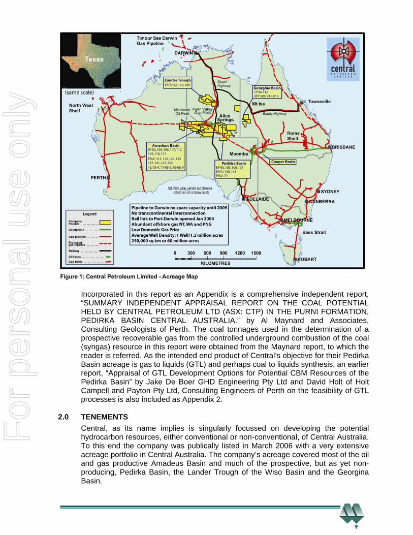
Incorporated in this report as an Appendix is a comprehensive independent report, “SUMMARY INDEPENDENT APPRAISAL REPORT ON THE COAL POTENTIAL HELD BY CENTRAL PETROLEUM LTD (ASX: CTP) IN THE PURNI FORMATION, PEDIRKA BASIN CENTRAL AUSTRALIA.” by Al Maynard and Associates, Consulting Geologists of Perth. The coal tonnages used in the determination of a prospective recoverable gas from the controlled underground combustion of the coal (syngas) resource in this report were obtained from the Maynard report, to which the reader is referred. As the intended end product of Central’s objective for their Pedirka Basin acreage is gas to liquids (GTL) and perhaps coal to liquids synthesis, an earlier report, “Appraisal of GTL Development Options for Potential CBM Resources of the Pedirka Basin” by Jake De Boer GHD Engineering Pty Ltd and David Holt of Holt Campell and Payton Pty Ltd, Consulting Engineers of Perth on the feasibility of GTL processes is also included as Appendix 2.
2.0 TENEMENTS
Central, as its name implies is singularly focussed on developing the potential hydrocarbon resources, either conventional or non-conventional, of Central Australia. To this end the company was publically listed in March 2006 with a very extensive acreage portfolio in Central Australia. The company’s acreage covered most of the oil and gas productive Amadeus Basin and much of the prospective, but as yet non-producing, Pedirka Basin, the Lander Trough of the Wiso Basin and the Georgina Basin.
For
per
sona
l use
onl
y
A small portion of the western Simpson Desert (=Simpson) Basin is also included in the acreage package. Since that time the company has added a substantial amount of acreage to its portfolio, in the Pedirka and Georgina Basins and the Lander Trough. Recently for strategic reasons, discussed below Central through its wholly owned subsidiary, Merlin Coal Ltd, has applied for some Mineral Licences in the NT over the area of some of its petroleum tenements. The company’s petroleum tenements and applications, along with some critical properties, are detailed in Table 1 of the Maynard report and the Mineral Licence Applications are listed in Table 2 of the same report. 2.1 Petroleum Exploration Permits The focus of this report is Central’s Pedirka Basin acreage, specifically the scope for underground coal gasification of Permian coals in the eight tenements in which the company has an interest. As such only these tenements, listed below, will be considered. These tenements are collectively known as the company’s Pedirka Basin acreage, they are:- • EP 93 in the Northern Territory • EP 97 in the Northern Territory • EP105 in the Northern Territory • EP 106 in the Northern Territory • EP 107 in the Northern Territory • EPA 130 in the Northern Territory • EPA 131 in the Northern Territory • PELA 77 in South Australia It should be noted that Central’s holdings in EP 97 are restricted to three discrete Farmin Blocks namely, “Dune”, ”Simpson” and “Bejah”, as shown in Figures 1, 2, 3, 6 and 7.This is particularly obvious on the latter two, larger scale drawings. The company’s Pedirka Basin acreage package extends over some 53,270 km2. However the company’s total acreage area is much more extensive.
Only the Pedirka Basin is of interest to this report and it, only, will be discussed. The initial Pedirka Basin acreage held by Central, upon listing, was:- • EP 93 • EPA 130 • EPA 131 • PELA 77
The company, through its wholly owned subsidiary Merlin Energy Pty Ltd (Merlin Energy), in 2007, acquired acreage held by Traditional Oil Pty Ltd (Traditional) in the NT sector of the Pedirka Basin. The blocks acquired in that transaction, which is detailed in a previously mentioned report, were:- • EP 105 • EP 106 • EP 107 It should be noted that at the stage of acquisition, the above three permits were at the Application (=EPA’s) stage. They are now granted permits.
For
per
sona
l use
onl
y
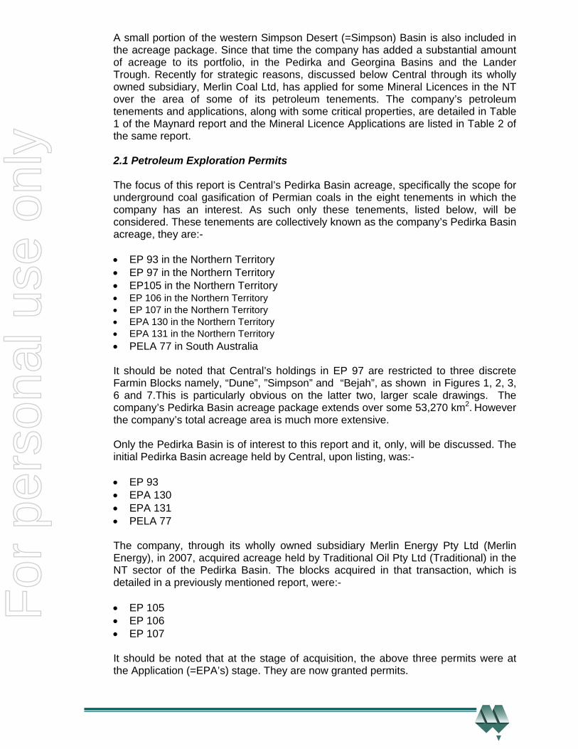
The last addition to the company’s acreage in the Pedirka Basin package was the package of the “Dune”, ” Simpson” and “Bejah” Farmin Blocks, all located in EP 97, which were acquired through a farmin to Rawson Resources Limited’s (Rawson) NT permit, namely, EP 97. The company’s Central Australian acreage is shown, at an expanded, scale in Figure 2. This drawing, also shows the major existing infrastructure in the area and that which is proposed. The company’s Pedirka Basin acreage is also shown on Figures 1, 3, 6 and 7, at varying scales.
2.2 Mineral Lease Applications Central, through this extensive acreage package, virtually controls the entire Pedirka Basin. In recent times Central has, for the strategic reasons discussed below, applied for Mining Leases over most of the then available area covered, fully or partly, by the seven Petroleum Exploration Permits and Applications (EPs and EPA’s) controlled by, or portions of which the company has equity, in the NT sector of the basin. These Applications are listed below and shown in Figure 7.
For
per
sona
l use
onl
y
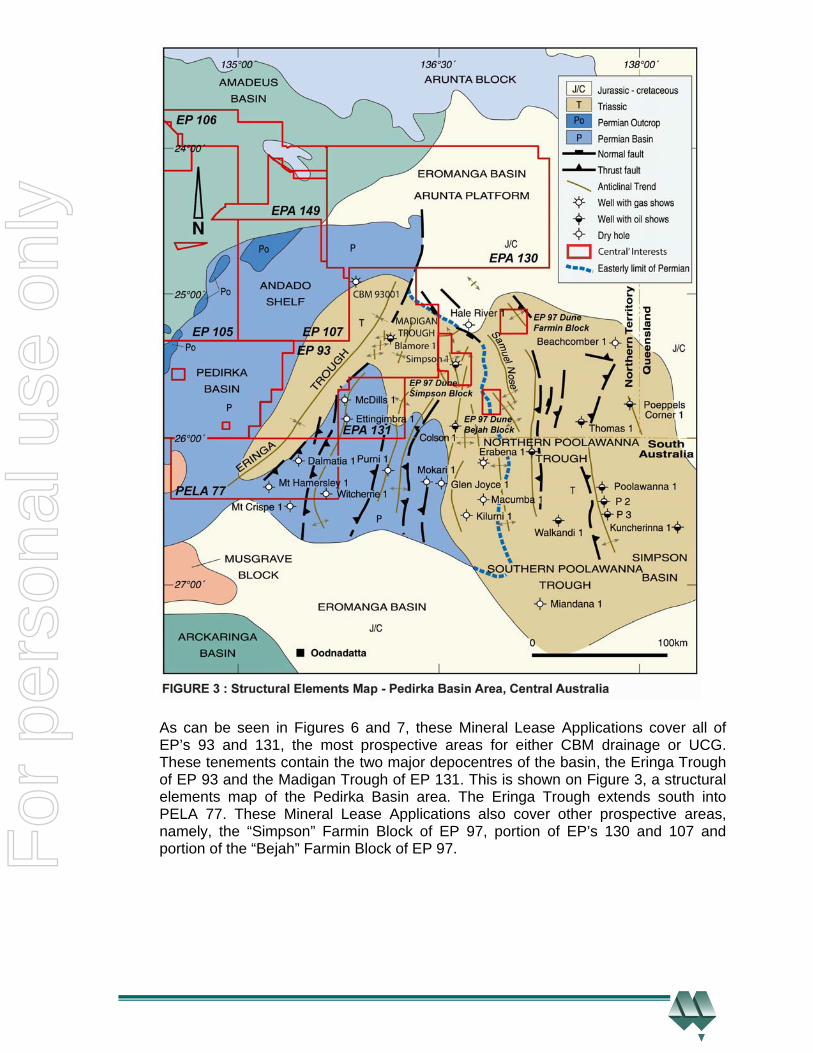
As can be seen in Figures 6 and 7, these Mineral Lease Applications cover all of EP’s 93 and 131, the most prospective areas for either CBM drainage or UCG. These tenements contain the two major depocentres of the basin, the Eringa Trough of EP 93 and the Madigan Trough of EP 131. This is shown on Figure 3, a structural elements map of the Pedirka Basin area. The Eringa Trough extends south into PELA 77. These Mineral Lease Applications also cover other prospective areas, namely, the “Simpson” Farmin Block of EP 97, portion of EP’s 130 and 107 and portion of the “Bejah” Farmin Block of EP 97.
For
per
sona
l use
onl
y

As a result of the above mentioned undetermined status of the rights to UCG in petroleum tenements in the NT, Central applied for the twenty one Mineral Leases, which cover much of Central ‘s NT petroleum tenements, and are listed below:- • EL 27094 • EL 27095 • EL 27096 • EL 27097 • EL 27098 • EL 27099 • EL 27100 • EL 27101 • EL 27102 • EL 27103 • EL 27104 • EL 27105 • EL 27106 • EL 27107 • EL 27108 • EL 27109 • EL 27110 • EL 27111 • EL 27112 • EL 27113 • EL 27114 The location of these Applications, which extend over an area of 18,687 km2, is shown on Figures 6 and 7, along with those of the company’s petroleum tenements. The individual Applications are annotated on Figure 7. These Applications cover most of, and the best portions of the, coal development in Central’s NT petroleum tenements. The major reason for this action was to obtain and safeguard the rights to underground gasification of the coal contained in these petroleum tenements in the unlikely event that these rights are not included in the awarding of petroleum exploration permits in the Northern Territory. The granting of a Petroleum Exploration Permit in the NT does not specifically, at this stage, convey the rights to the utilization of any coal, by underground coal gasification methods, contained within the permit area. The NT Government is yet to make a decision on whether the awarding of a Petroleum Exploration Permit will also include associated rights, other than the direct rights to explore for conventional petroleum and/or non –conventional hydrocarbons, such as coal bed methane drainage. In particular, the rights to utilize the coal in-situ with underground coal gasification methods. It is expected that, like SA, these ancillary rights to underground coal gasification will be awarded to the holder of the Petroleum Exploration Permit. Central has applied for the previously mentioned Mineral Leases in the unexpected case that this is not so.
For
per
sona
l use
onl
y
A different situation applies in SA where the granting of a Petroleum Exploration Licence or Application automatically carries the right to apply underground gasification techniques to any coal contained within the PEL or PELA .Hence there is no need to apply for concurrent Mineral Leases in that State.
3.0 GEOLOGY
The Pedirka Basin of Central Australia is located in both the NT and SA, and it covers an area of approximately 73,000 km2 of which Central holds equity in some 53,270 km2 or 73% of the basin area. Central’s Pedirka basin acreage is located in northern SA, north of the settlement of Oodnadatta and in south eastern NT and it straddles the State-Territory border. The northwest corner of the acreage package is just 20 kilometres east of Alice Springs. Its location is shown on Figures 1, 2, 3, 6 and 7. The positions of the underlying, overlying and adjacent basins are shown on Figure 3, a structural elements map. Their spatial relationship is shown in Figure 4, a schematic cross section through the Central Australian sedimentary basins. . The acreage held by Central contains the basin’s depocentres, the Eringa and Madigan Troughs, the western basin bounding Andado Shelf, the northern basin bounding Arunta Platform and the informally named “Mc Dills-Witcherrie Horst” in the south. The basin bounding Musgrave Block is located to the south-west. The extent of the Permian aged Pedirka Basin is shown in Figure 3. The area of Central’s permits contains 4 distinct sedimentary sequences, the oldest being the Paleozoic sediments of the Amadeus Basin sequence which overly metamorphic and granitic basement. This sequence is unconformably overlain by sediments of the Carboniferous-Permian Pedirka Basin sequence, which is rich in coals and carbonaceous shales. Central’s tenements contain the Pedirka Basin’s two main depocentres, the Eringa and Madigan’s Troughs in the central sector of its acreage. The acreage also contains the Simpson (Desert) Basin sequence which is composed of Triassic section. Its main depocentre, which is located to the east of the company’s tenements, is known as the Poolowanna Trough. It too contains some coal and carbonaceous shales, particularly in the section over the Eringa and Madigan Troughs. That source-rich basin is unconformably overlain by sediments of the oil productive Mesozoic aged Eromanga Basin. It too has local subdued depocentres over the Madigan and Eringa Troughs. In addition to the extensive Early Permian coals of the Purni Formation of the Pedirka Basin sequence other carbonaceous sediments, the Triassic aged Simpson Basin sequence, are present in most of EP 93, in the central portion of PELA 77, the south-eastern corner of EP 107 and the north-eastern corner of EP 131. The Triassic Peera Peera Formation of the Simpson Basin contains some intervals of coal and/or carbonaceous shales. The Triassic coals, where present, could be secondary targets for CBM and UCG exploration in EP’s 93 and EP131. This is especially so out in the centres of the Eringa and Madigan Troughs where appreciable Triassic coal is thought to be present, above the underlying Permian aged Purni coals, and at depths above the arbitrary economic cutoff depth of 1000m for UCG. It must be remembered that conventional ideas about structural position do not necessarily apply for CBM drainage and UCG.
For
per
sona
l use
onl
y
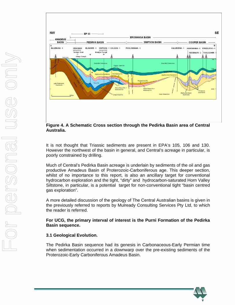
Figure 4. A Schematic Cross section through the Pedirka Basin area of Central Australia.
It is not thought that Triassic sediments are present in EPA’s 105, 106 and 130. However the northwest of the basin in general, and Central’s acreage in particular, is poorly constrained by drilling. Much of Central’s Pedirka Basin acreage is underlain by sediments of the oil and gas productive Amadeus Basin of Proterozoic-Carboniferous age. This deeper section, whilst of no importance to this report, is also an ancillary target for conventional hydrocarbon exploration and the tight, “dirty” and hydrocarbon-saturated Horn Valley Siltstone, in particular, is a potential target for non-conventional tight “basin centred gas exploration”. A more detailed discussion of the geology of The Central Australian basins is given in the previously referred to reports by Mulready Consulting Services Pty Ltd, to which the reader is referred. For UCG, the primary interval of interest is the Purni Formation of the Pedirka Basin sequence. 3.1 Geological Evolution. The Pedirka Basin sequence had its genesis in Carbonaceous-Early Permian time when sedimentation occurred in a downwarp over the pre-existing sediments of the Proterozoic-Early Carboniferous Amadeus Basin.
For
per
sona
l use
onl
y
Sedimentation in the Amadeus Basin was controlled and constrained by basement blocks of metamorphic and igneous composition, the Arunta Block to the north and the Musgrave block to the south. The western margin of the basin is a shallow basement ridge which separates the Amadeus Basin from the Canning Basin of Western Australia.
The basin’s eastern margin is not well understood but appears to be truncated, as does the southern margin. Two pulses of marine deposition are thought to have occurred; these were then followed by a later pulse of continental sedimentation. Several episodes of structuring then occurred, involving uplift and erosion and then sinking and marine transgression. The previously mentioned basement blocks acted as immobile bulwarks against which the sediments of the Amadeus Basin were deformed and structured, due to north-south compression. Subsequently subsidence occurred in the deeper eastern and southern ends of the basin and the lacustrine, fluvial, and often glacially derived sediments of the Permian aged Pedirka Basin were deposited unconformably on the Amadeus Basin section. Much coal was deposited in this cycle. A hiatus then occurred before the Triassic aged Simpson (Desert) Basin sequence was deposited, unconformably, on the Pedirka Basin sequence. These sediments are of lacustrine, flood plain and fluvial origin, with some glacial influence. This cycle is dominated by carbonaceous shale with some coal. The depocentre of this basin, the Poolowanna Trough is eastwards of the Pedirka Basin depocentres, the Eringa and Madigan Troughs and eastwards of Central’s acreage. However Simpson Desert Basin section is present in some of Central’s Pedirka Basin blocks, namely as discussed above in EP 93, EPA’s 107 and 131 and PELA 77. Uplift and erosion occurred as a result of the widespread Triassic structuring event. This was followed by the cyclic sedimentation of the Eromanga Basin sequence, of fluvial and flood plain origin. The Poolowanna Formation, the basal unit is a good source rock, containing some coal and carbonaceous shale, which are known to be mature and to contain oil prone macerals. It also contains good reservoir quality sandstones. Cyclic alternating interbedded high and low energy then occurred during the deposition of the Eromanga Basin sequence of alternating and juxtaposed high quality clastics reservoirs and regional seals. A marine transgression occurred in Cretaceous time when the Wallumbilla Formation was deposited. This unit is a regional top seal to the Eromanga Basin sequence. The basin complex has had, for most of its life, an intra-cratonic setting. In eastern and central Australia this has resulted in the deposition of considerable amounts of coal and or carbonaceous shale, good source rocks, juxtaposed along with many good fluviatile sandstone reservoir units. This is good trapping geometry for conventional hydrocarbon accumulations.
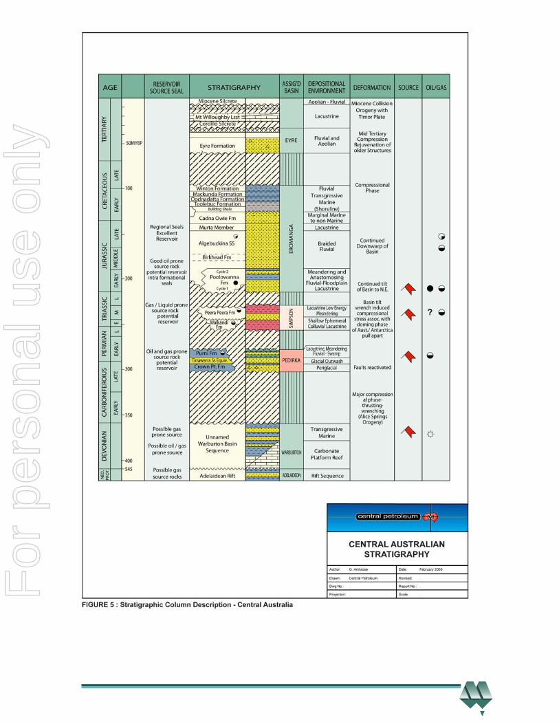
3.2 Stratigraphy Included as Figure 5, is a combined stratigraphic column for the sedimentary basin complex of Central Australia. There are known source and sealing intervals in each basin sequence along with good quality conventional reservoirs units, as shown on the drawing.
For
per
sona
l use
onl
y

As this report is concerned with the unconventional hydrocarbon potential of underground coal gasification, the source rocks and the reservoirs are one and the same, namely the Early Permian Purni Formation coals. Petroleum Exploration Permits and Applications (EPs and EPA’s) controlled by, or portions of which the company has equity, in the NT sector of the basin. These Applications are listed below and shown in Figure 7. Petroleum Exploration Permits and Applications (EPs and EPA’s) controlled by, or portions of which the company has equity, in the NT sector of the basin. These Applications are listed below and shown in Figure 7.
As discussed below in Section 4.0 the rocks of prime interest for UCG are coals, and the Early Permian Purni Formation in particular. Hence the other intervals present in the geological section will only be discussed in passing. Conventional reservoir units are of no consequence and will not be discussed in detail. The source intervals other than the Purni Formation coals are also of no consequence to UCG, hence they too, will not be discussed. The sealing units of interest to UCG are the ash bands of the Purni Formation.
For
per
sona
l use
onl
y
For
per
sona
l use
onl
y
The reservoirs, source intervals and sealing units, other than in the Purni Formation, are fully discussed in the previously mentioned reports, prepared by Mulready Consulting Services Pty Ltd and in other reports in the possession of Central and in the papers listed in the references. For unconventional hydrocarbon exploration of, and potential production from, the underground gasification of coals, the interval of major stratigraphic interest is the Purni Formation of the Pedirka Basin Sequence The Early Permian aged Purni Formation is composed of interbedded grey shale and carbonaceous siltstone, fine to coarse grained sandstone along with coal and conglomerate. It was deposited in a flood plain, lacustrine and fluvial environment. The unit was known to be 350 metres thick in the Mokari 1 well, east of the company’s acreage. However recent drilling by Central shows that it is more than 564 metres thick at Blamore 1 and 593 metres of the interval was drilled in Simpson 1 which reached total depth in that unit. Central’s recent drilling program has greatly added to the knowledge of the vertical and horizontal extent and the composition of the Purni Formation.
4.0 PETROLEUM GEOLOGY The discussion on petroleum geology for unconventional hydrocarbon exploration, CBM and UCG, is rather truncated compared with that of conventional hydrocarbon exploration. A detailed discussion of petroleum geology and its relevance to, firstly the conventional and secondly the CBM potential of Central’s Pedirka Basin acreage is given in the previously referred to reports prepared by Mulready Consulting Services Pty Ltd. The reader is referred to those reports. The need for separate and distinct:- • Mature source rocks • Reservoirs • Seals • Traps becomes redundant for, and not applicable, to UCG. Because the source rocks, reservoirs and seals all converge to one unit, namely the coal seam, which also becomes the trap. Maturity is established, as by definition the coal is mature. Furthermore the need for carrier beds is negated as the energy of the coal, and ultimately the syngas, is self contained within the coal. In a similar vein, the timing of geological structuring is irrelevant as the coal and ultimately the syngas is located in-situ within the coal. Hence all that has to be established for underground gasification is the presence of coal in economically viable quantities. This has been done; see the report by Al Maynard and Associates. 4.1 Source Rocks For UCG procedures there are two possible source rock intervals, the Purni Formation in the Pedirka Basin Sequence and to a far lesser extent where present, the Peera Peera Formation in the Simpson Basin.
For
per
sona
l use
onl
y
These source intervals are Permian and Triassic, respectively in age. Both are believed to have the capacity to generate oil and gas where mature, as their lateral correlatives are known to have done so and hydrocarbon indications in wells in the basin area could only have been sourced from these units. Previous and recent analytical studies show that the Purni coals are in the early oil generating window. Furthermore they show that these coals have substantial amounts of liptinite kerogens and as such would be prone to generating appreciable amounts of liquid hydrocarbons. The expected major source will, overwhelming, be the Purni Formation. No prospective resource determinations have been made for the more restricted, less coal rich Peera Peera Formation. 4.1.1 Pedirka Basin The Pedirka Basin, like all other Carboniferous-Permian and Triassic basins of Eastern and Central Australia is coal rich. Source rock analyses from the 14 wells drilled, prior to Central’s recent drilling, show a much higher exinite to vitrinite ratio than similar source rocks of the Cooper Basin which indicates that it is more oil prone. The results from the recently drilled Blamore 1, CBM 93-1 and Simpson 1 wells confirm this. The rocks have a higher content of Type 2 or oil prone macerals. However any generated oil will with increasing time and depth of burial break down to dry gas and expel already reservoired oil updip and marginward. This is the accepted model for the inter-related oil pools in the source poor Mesozoic Eromanga Basin and the gas pools in the source rich underlying Permo–Triassic Cooper Basin. It is becoming clearer from the results of Central’s recent drilling program that the same mechanism applies in the Pedirka-Simpson and Eromanga complex of basins, hence conventional oil and/or gas may be reservoired in the overlying Simpson and Eromanga Basins whilst the latter generated gas will be trapped within the Pedirka Basin. This gas will be trapped in conventional reservoirs as well as held by hydrostatic pressure in the generating Purni Formation coals. The residual oils shows in the lower Jurassic section in Simpson 1 and Blamore 1 as well as in the previously drilled Colson 1 well confirm this model. The fact that in both Blamore 1 and CBM 93-1 the gas encountered whilst drilling, normal and iso-butane and pentane homologues, are usually associated with wet gas or liquids is further evidence that a gas/oil system similar to the accepted Cooper/ Eromanga model is operative in the company’s Pedirka Basin acreage.
4.1.2 Organic Matter and Maturity
All of the existing quantitative data that is available on maturity from the area of the company’s acreage indicates that the source rocks are mature for hydrocarbon generation, both oil and gas. This is supported by the empirical evidence of gas shows and oil fluorescence in inappropriately sited oil exploration wells. Geochemical analyses conducted for the Geological Surveys of SA and the NT have also confirmed that the Pedirka and Simpson Basin and lower Eromanga Basin sequences contain rich and mature hydrocarbon source rocks. The reader is referred to the listed references. Hence the area has generated oil and gas. This has been confirmed by analysis of data from Central’s recent drilling program.
For
per
sona
l use
onl
y

Analytical analyses of cuttings from the recently drilled Blamore 1 well, indicate that the Purni Formation coals, from various intervals of the well, at this location, are typically composed of:-
• 25-50 % of inertinite (=Type 4) kerogens. This oxidized material is not usually
considered to be a large source of hydrocarbons, although it could produce biogenic gas at shallow depths, before oxidation.
• 16-65% of vitrinite (=Type 3) kerogens which is prone to gas and condensate
generation. Some members of the vitrinite group are rich in hydrogen and will generate liquid hydrocarbons
• 5-10% liptinite or algal (=Type 1) kerogens which are known to be prone to oil and
condensate generation. The analytical results of the examination of cuttings are not as reliable as those from cores. This results from the fact that the cuttings are exposed to the atmosphere and are degraded, oxidized, to some degree. Central obtained similar results from cores cut in the CBM 93-1 well which gives a pretty definitive answer, given the separation of the wells. It should be noted that globules of oil were observed in vitrinite in the samples from Blamore 1, during analyses. Interestingly the oil prone kerogen, exinite, seen in wells further south, was not observed in this well. The coals contain an adequate amount of and an appropriate type of organic matter to be hydrocarbon source rocks. The cuttings from Blamore 1 had Vitrinite Reflectances (VRo) values of between 0.52 -0.58%, which places them in the early oil generating window. Values from wells within the Madigan Trough, further south, where the coals are more deeply buried will be are higher and well within the oil generative window. Additional Vitrinite Reflectance studies will be conducted on cores from any future CBM wells, which Central may have scheduled. Rock Evaluation (Rockeval) Pyrolysis data is consistent with that obtained from the Vitrinite Reflectance studies, showing that the organic matter at the top of the Purni coals is immature for oil generation, but is in the early oil generating window near the base of the unit. Hydrogen Indices, which indicate the oil prone nature of the organic matter, also increase from the top of the unit to the base in line with the correlative section in the Cooper Basin. It is known that the upper Patchawarra coals are gas prone in the Cooper Basin and that the lower coals are oil prone. The Patchawarra Formation is a time correlative of the Purni Formation and has a similar composition and has had a similar geological evolution. A Van Krevelan Diagram, which plots maximum temperature (Tmax)) against Hydrogen Indices, for Blamore 1, and which is not included, indicates that most of the organic matter is Type 2 and Type 3 and as such should generate gas with some oil. This is similar for the correlative Cooper and Bowen Basins, which are both productive of both oil and gas. It is known that some coals contain more oil generating macerals than do shales, the traditional source rocks, and that the hydrogen rich vitrinite 2 group contains oil generative material even though traditionally it is included in the gas prone vitrinite group.
For
per
sona
l use
onl
y
This appears to be the case in Blamore 1 where most of the observed oil inclusions were seen in vitrinite. Of the 8 samples studied, 5 had higher Hydrogen Indices than 200 mg/g and hence should generate some liquids. The basal sample, with a value of 452 mg/m, matches that of the richest known source rocks from the oil productive Eromanga Basin. Some gas is produced in the early oil window. It is also thought that besides this thermogenically formed gas, that gas of a biogenic, or bacterial, origin could be produced at shallower depths. These studies indicate that the oil generative window commences at about 1250 metres in both the Pedirka and Simpson Desert Basin sequences. It should be noted that vitrinite reflectance suppression has been observed, so that the actual window is probably shallower. The hot dry gas window will be more deeply buried. In the case for conventionally sourced and reservoired hydrocarbons, the Horn Valley Siltstone of the more deeply buried Amadeus Basin sequence is known to be now in the dry gas window. The Simpson Basin sequence rocks are of a similar maturity to those of the Pedirka Basin sequence. The source rocks of the Early Jurassic Poolowanna Formation (=Basal Jurassic of Queensland) are also early mature for oil generation in the Poolowanna Trough, and perhaps in Central’s acreage. However it should be noted that this interval, a basal Eromanga Basin unit, is not a blanket unit and is often absent from basement highs and accordingly may not be laterally extensive in Central’s acreage, particularly in the most western of Central’s Pedirka Basin blocks, the more recently acquired acreage. Hence the company’s Pedirka Basin acreage contains a multitude of known mature source rocks. Recognized reservoir units are known to juxtaposed with these potentially generating intervals. Large structural traps have been identified within the area. All of this bodes well for the existence of large conventional accumulations of hydrocarbons. In the case of non-conventional accumulations at depths less than the oil window the chance of biogenic methane and/or thermogenic methane also exists, as at early maturity levels wet gas can be generated. It is known that shallowly buried members of the Jurassic aged Walloon Coal Measures of the Surat Basin sequence of Qld host coal bed methane. During earlier oil exploration programs several seismic shot hole drilling rigs were burnt out on the Darling Downs area of Qld as a result of shallow gas flows from this unit. Hence the coals do not have to be within the gas window to host methane. The fact that the potential source rocks are rich in oil prone macerals is fortuitous as the gas adsorbed to the coal, will contain higher homologues than methane and should produce more synthetic crude during synthesis than methane alone would. These rich source rocks should also give a good syngas yield.
4.2 Geochemical Well Data The recent drilling program by Central has provided some valuable new data in a sparsely explored basin complex. It has provided hard geological, physical and chemical information.
For
per
sona
l use
onl
y
4.2.1 Gas Detector During the drilling by Central of the three previously mentioned wells, they were carefully monitored for their CBM potential for as well as for their conventional hydrocarbon potential. Simpson 1 and Blamore 1 were drilled to test conventional structural traps for their oil potential whereas, as indicated by its name, CBM 03-1 was a well with exclusive CBM objectives. It should be noted that Blamore 1 was specifically monitored for its CBM potential. Both CBM 93-1 and Blamore1 exhibited quite high, often greater than 200 units, gas detector readings. It should be noted that readings of normal (nC4) and iso butane (C4) as well as pentane (C5) were noted in both wells, these homologues are usually indicative of the presence of liquid hydrocarbons. This is consistent with the analytical source rock determinations and empirical production results from the Early Permian aged Patchawarra Formation of the Cooper Basin, an analogue of the Purni Formation. The highest reading on the gas detector was 233 units recorded between 1797 and 1805 metres in Blamore 1. This interval is substantially deeper than the arbitrary economic cutoff depth, however lateral equivalents of this interval should be present at markedly shallower depths on the unexplored and undrilled Andado Shelf to the west of the Eringa Trough. This is an area which warrants sustained exploration drilling. The Top of the Purni Formation was encountered at 672 metres, relative to the Kelly bushing, (KB) in CBM 93-1, 1533.7 metres KB in Blamore 1 and at 1834 m KB in Simpson 1. Hence to honour the economic cutoff, UCG activity in the NT sector, should in the first instance, aimed at the Andado Shelf in the vicinity of CBM 93-1, and the south-west flank of the Eringa Trough. In general the gas levels observed whilst drilling through the coals were quite high. 4.2.2 Barrel Cores The only well for which barrel cores were cut was CBM 93-1, where cores over selected intervals of the coals were retrieved for analysis. In Blamore 1 only cuttings were collected for laboratory analysis. No cores were cut nor analysed for Simpson 1, however several interval of cuttings from this latter well were analysed. Not all the final analytical results are in the possession of Central at this time. Coring operations for the well appear to have been inappropriate and inadequate due to a shortage of available CBM coring equipment. Central were unable to obtain a contractor with the necessary core barrels for coal bed methane core evaluation and were forced to use standard oilfield core barrels. And this equipment proved to be totally unsuitable for the cutting, retrieval and sealing of the cores and the subsequent determination of the gas saturations of the cores appear to have been totally corrupted and at variance to the empirical gas detector readings. This is most unfortunate as coal saturation is a critical parameter required to evaluate coals for CBM drainage. Central are determined to use coring equipment designed for CBM coring in for any future CBM evaluation drilling. 4.2.3 Gas Saturation Whilst most of the results of the laboratory tests known and appear to be consistent with observations, and are encouraging, the gas saturation determinations are puzzling, and contradictory. They are at great variance to the empirical gas detector readings.
For
per
sona
l use
onl
y
Some other tests remain to be completed. In general the analytical gas saturation readings were low and are at odds with the gas detector readings. The methods of cutting, retrieval, sealing and storage of the samples were very questionable, with large time lapses between retrieval and sealing of cores and chip samples. As stated above Central plans to improve core retrieval procedures in future drilling operations to overcome and eliminate this ambiguity. The author of this report is of the view that no definite conclusions on the gas saturation of the coals can be made until the complication of poor sample cutting, retrieval, sealing and storage is eliminated. 4.2.4 Vitrinite Reflectance All Vitrinite Reflectance studies of samples taken from the cores retrieved from the CBM 93- 1 well, and from the cuttings samples from Blamore 1 and Simpson 1, are mature for hydrocarbon generation. Those from near the top of the Purni Formation are in the wet gas window whilst those within the formation are in the early oil window. Some from near the base of the near the base of the formation are approaching the gas window. Thermal maturity is not as important for UCG as it is for conventional hydrocarbon generation, as in UCG the coal seams of the formation are partially combusted and syngas is released and collected. The results of vitrinite studies are more fully discussed in Section 4.1.2 above, Organic Matter and Maturity. 4.2.5 Porosity and Permeability Visual examination of cuttings and cores of the coals establish the presence of fractures in Blamore 1 between 1535 and 1746 metres KB, establishing the presence of macro porosity and permeability, properties critical to the storage and transmission of fluids, respectively. This was confirmed by the dipmeter log from the electric log suite. Similarly the Nuclear Magnetic Resonance (NMR) log detected moveable water, another indicator of permeability, in the Blamore 1 well, particularly below 1675 metres KB. Further studies on permeability and some on porosity are currently being undertaken. Porosity and permeability, whilst important parameters for conventional hydrocarbon production, are of no real importance in UCG, as the seam is merely set on fire. Even with the incomplete and ambiguous analytical results, most of the physical coal properties appear to be suitable for CBM development, but the ambiguity on gas saturation must be resolved. However this report is directed towards UCG and a separate and distinct updated revision of the previously mentioned reports on CBM is yet to be prepared. That impending report will incorporate final and definitive result of coal analyses. The lack of some of the analytical properties of the coal is of no real consequence to the suitability of the coals to UCG methods and potential yields. And the lack of knowledge of them is of no technical shortcoming. UCG is fundamentally the same process as surface gasification to manufacture town gas and coke, and does not require high quality steaming coal, but just coal of which there is plenty known to be present in the Purni Formation.
For
per
sona
l use
onl
y
5.0 PREVIOUS EXPLORATION
The Pedirka Basin is a very lightly explored area in both a conventional and non-conventional sense. Exploration commenced there in the late 1950’s when the Australian exploration search for oil became serious with the arrival of American companies and modern technology. In the SA sector of the basin the operating company was The French Petroleum Company, later to become Total. In the NT sector the pioneering exploration operator was Amerada Petroleum Company of Australia, an affiliate of the Amerada Petroleum Corporation of the United States. These companies have, to this day, conducted the bulk of the exploration in the western sector of the basin, the area in which Central holds its acreage. 5.1 Historical Exploration Modern exploration commenced in the SA sector of the basin in the late 1950’s when the newly formed Santos-Delhi consortium, formed to explore Santos Limited’s extensive Central Australian acreage, was also awarded Oil Exploration Licences (OEL) 20 and 21 in the western Pedirka Basin. The French Petroleum Company farmed into this acreage as operator and conducted an extensive frontier exploration program. Their program was a typical frontier program of gravity and magnetic surveys along with regional and subsequently detail seismic surveys. As a result of this reconnaissance some four wildcat wells, in chronological order, Witcherrie 1, Purni 1, Mt Crispe 1 and, Mokari 1 were drilled in 1963, 1964, and 1966 when the last two of the above wells were spudded. All were unsuccessful, however minor oil and gas shows are reported in the Purni Formation. All of these wells, the locations of which are shown on Figure 3, were aimed at Cooper Basin targets, following the large Permian gas discovery at Gidgealpa 3. After the terms of the farmin were met Delhi, the exploration operator in the broader Cooper–Eromanga acreage became operator in the Pedirka Basin sector also. Later the newly listed company, Beach Petroleum N L (Beach) drove the first round of exploration in the NT sector of the basin after they were awarded Oil Permit (OP) 57. That permit is sited further north, straddling the State-Territory border, but located in the NT sector of the basin. The American major, Amerada Petroleum Corporation (Amerada) farmed into the permit and acquired seismic data and subsequently two wells, Mc Dills 1 and Hale River 1 were unsuccessfully drilled. These wells which were plugged and abandoned without significant hydrocarbon shows, were drilled for Amadeus Basin “look a like” targets. An exploration hiatus then occurred in that lightly explored and very remote area. A second round of exploration was initiated in the SA sector, when between 1969 and 1979, five seismic surveys were acquired and two wells, Poolowanna 1 and Macumba 1, were drilled in 1977. In the former well important sub-commercial hydrocarbon flows were obtained from open hole drillstem tests. In the first instance a flow of gas from the Triassic Peera Peera Formation and secondly one of oil from the Lower Jurassic ”Basal Jurassic Unit” (=Poolowanna Formation) were recorded. The second round of drilling in the NT followed the drilling results obtained at Poolowanna 1and the wells drilled were also directed at Eromanga /Pedirka/Simpson Basin targets. A total of four wells were drilled in this round of exploration, the first was Colson 1, spudded by Beach in OP 177, The other three, Beachcomber 1, Thomas 1 and Poeppel’s Corner 1 were drilled by the Beach and the North Broken Hill mining company consortium.
For
per
sona
l use
onl
y
The last two of these wells, which are not definitively located, encountered minor oil shows. These four wells are all located east of Central’s acreage. The nearest, Colson 1, penetrated some 13 metres of net coal in seams greater than 2 metres thick. Following the oil indications encountered in the Lower Eromanga Basin section and the gas indications in the Simpson Basin sequence in Poolowanna 1, exploration activity in the SA sector was accelerated and six seismic surveys and six exploration wells were drilled during the 1980’s. These wells were Erabena 1 and Walkandi 1 in 1981, oil shows are reported from the Simpson Basin sequence in Erabena 1. Two wells, Glen Joyce 1 and Kilurni 1 were spudded in 1985, neither had reported conventional hydrocarbon shows. Following the drilling of these two wells Santos became the exploration operator of the Cooper Eromanga Basin acreage and drilled Mt Hammersley 1 in 1987 and Dalmatia 1 in 1988. No hydrocarbon shows are reported from either of these wells, which are located in the east of PELA 77.These are the last wells drilled in SA in the area of Central’s acreage prior to Central’s drilling in late 2008 Shortly after this, in 1990, Territory Petroleum Limited in a consortium with Adelaide Petroleum N L drilled the Ettingimbra 1 well on the “Mc Dills-Witcherrie Horst” in the then EP 1 in southern NT sector of the basin. This unsuccessful well, with Pedirka/ Simpson Basin objectives, was the last drilled in the basin before Central’s recent wells, which are discussed below. 5.2 Recent Exploration After a long hiatus, exploration drilling, driven by Central, has recommenced in the Pedirka Basin. In late 2008 the company conducted a three well drilling program. This program was unusual in that it had both conventional and non–conventional targets. The first well drilled, Blamore 1 in EP 93, had conventional targets but was also evaluated for CBM information, the second was CBM 93-1 a well with specific CBM objectives and also located in EP 93 and finally Simpson 1 in the Simpson Farmin Block of EP 97. The last well had conventional objectives as it was thought that the Purni Formation coals, if present, would be too deep and too thin for economic CBM drainage at that location. Central had varying amounts of success with this drilling program, the conventional target in Blamore 1 was penetrated unsuccessfully, however at least 15 metres of residual oil staining was unexpectedly noted at the top of the Jurassic Algebuckina Sandstone. Much valuable data was obtained from the Purni coals as cuttings were analysed in the laboratory for coal and gas properties related to CBM extraction. Unfortunately cuttings samples are not ideal for analytical studies and the results of these studies were at variance with gas levels recorded during drilling operations and this ambiguity remains unresolved. There was no conventional target for CBM 93-1 and barrel cores from the Purni Formation coals, the prime target, were cut for laboratory studies of the coals, for the evaluation of their CBM potential.
For
per
sona
l use
onl
y
As mentioned above, unsuitable oilfield, rather than CBM, core barrels were used and the resultant cores were unsuitable for rigorous analysis. In a similar vein to the studies for Blamore 1, there is a great variance, which remains and must be resolved, between the laboratory results and the good gas readings obtained whilst drilling. It is now known that the methods used for the cutting, storing and sealing of the cores were less than satisfactory and improved methods must and will be used for any further coring that is to be undertaken. The last well drilled in 2008, Simpson 1, was also plugged and abandoned as a dry hole however a residual oil column was noted across the Base Jurassic Unconformity with residual oil in the base of the Poolowanna Formation and also in the top of the Triassic Walkandi Formation. Some laboratory analyses of cuttings samples from this well were conducted for CBM studies. This oil staining as well as that mentioned above at Blamore 1 is of a migrated nature. This is harbinger for conventional oil exploration in the lower Eromanga Basin section as oil, and in a large charge, from underlying source rocks has passed into the Eromanga Basin sequence, and as there are no surface oil seeps known in the area it may still be entrapped there. 5.3 Results of Recent Drilling The results of Central’s recent drilling program, of three exploration wells spudded in the second half of 2008, are encouraging, both for the search for conventional hydrocarbons and non-conventional hydrocarbons. 5.3.1 Eromanga Basin Sequence To the author, the most surprising results of the drilling by Central, mentioned above, are the reported intervals of residual oil staining, in conventional reservoirs, in both the Blamore 1 and Simpson 1 wells. It should be noted that CBM 93-1 was not drilled on a structure, so the failure to obtain hydrocarbon indications in conventional reservoirs in that well is no surprise. The first occurrence of staining was over more than fifteen metres, in the Jurassic aged Algebuckina Sandstone in the Blamore 1 well. This unit is the undifferentiated lower portion of the Eromanga Basin sequence and includes, amongst other units, the Hutton Sandstone, the major oil producing unit in the oil fields to the east in SA and Queensland. Importantly this residual oil appears to be migrated oil, indicating a significant charge of oil from depth has passed through this unit. Conventional traps in this unit, marginward of Blamore 1, on the Andado Shelf could be prospective and should considered as sites for future exploration wells. The second episode of oil staining was noted, across the “Top Triassic Unconformity“, in Simpson 1, where residual oil was staining was recorded from the Triassic Walkandi Formation and from the overlying Poolowanna Formation of the Eromanga Basin sequence. The significance of this show is similar to that of the Blamore 1 well in that oil has been generated in the Purni Formation and has migrated both laterally and vertical in the geological section. This process is known to have occurred in the similar aged Cooper/ Eromanga and Bowen /Surat Basin Complexes further east.
For
per
sona
l use
onl
y
Whilst the Eromanga Basin sequence is not directly relevant to UCG, some conventional hydrocarbon potential is recognized, and has been increased by recent drilling results, it will be discussed below in passing. The Jurassic-Cretaceous Eromanga Basin, in its classic conventional producing areas to the east of Central’s acreage, consists of cyclic, interbedded and juxtaposed shale and silty units overlain and underlain by excellent reservoir units of fluviatile sandstones. The finer grained units, whilst they do contain some organic matter, are not as rich source rocks as those of the underlying Triassic and Permian intervals of coals and carbonaceous shales, except for the Poolowanna Formation If is generally accepted that the bulk of the hydrocarbons hosted in the Eromanga Basin have been expelled from the underlying Cooper Basin, that is from the Triassic and Permian units. This oil has been found robust traps in all reservoir units from the basal Jurassic unit, the Poolowanna Formation to sands within the Cadna-Owie, Formation wherever there are intact seals, either regional or intra-formational. The residual oil shows in Blamore 1, Simpson 1 and Colson 1, amongst others and the live oil recoveries from the Poolowanna wells and the James Oil Field which produces oil from the Triassic Nappamerri Formation, further east, indicate that there is a chance of hydrocarbons being conventionally trapped in the Poolowanna Formation and Algebuckina Sandstone, either by regional or intra-formational seals, in valid traps in the area of Central’s acreage. The Algebuckina Formation has an excellent regional top seal in marine shales of the Wallumbilla Formation and in Blamore 1 the residual oil shows were directly beneath the Murta Member of the Mooga Formation, a known seal. As such care should be taken whilst drilling through this unit and the Poolowanna Formation, to deeper targets, as they may be hydrocarbon bearing. At this stage there is insufficient information to attempt to quantify either a possible exploration program for, or the magnitude of possible potential resources in these units. It would appear that a significant oil charge has been generated and driven out of the Triassic or Permian source rocks in the Madigan and Eringa Troughs hence Lower Mesozoic reservoirs are a legitimate conventional hydrocarbon target in Central’s Pedirka Basin acreage. It should be noted that several shallow mineral holes, CUR 3 and CUR 5, drilled just east of the outcropping Musgrave Block, west of Central’s acreage, encountered organic shales at an early mature stage in a unit equivalent to the Jurassic aged Birkhead Formation of the Eromanga Basin sequence. If his unit is laterally widespread it may provide a regional top seal to the excellent reservoir sandstones of the Hutton Sandstone equivalent. It is not expected to be a major source contributor to the Eromanga Basin sequence. In summary it may be a regional seal To the Hutton Sandstone equivalent. 5.3.2 Simpson Basin Sequence Triassic section was encountered in two of the three Central wells, it was absent from the CBM exploration well, CBM 93-1 which is located in the far north-west corner of EP 93.
For
per
sona
l use
onl
y
This well failed to encounter any Simpson Basin sequence sediments, surprisingly, as the well location was believed to be on the western flank of the Eringa Trough, a Pedirka and Simpson Basin depocentre. However Triassic Walkandi Formation section was encountered in the two other Central wells, Blamore 1 and Simpson 1. In the Blamore 1 well, sited in EP 93, the most centrally located of these wells, some 247.4 metres of Triassic aged Walkandi Formation, was encountered. Whilst the more easterly located Simpson 1 well in the Simpson Farmin Block of EP 97 intersected some 99 metres of Walkandi Formation. No appreciable coal horizons were noted in this formation. Whilst the Peera Peera Formation of the Simpson Basin sequence not discussed in detail in this report, it may hold some additional potential for UCG. This unit is of Triassic age and is composed of grey and black shales, coal and thin fluvial sandstones. It was laid down in a flood plain, lacustrine and fluvial environment and does contain some coal and carbonaceous shale. This interval was not intersected in Blamore 1, CBM 93-1 AND Simpson 1 but is it is believed to be present in the Madigan and Eringa Troughs, local depocentres, in EP’s 93 and 107 and EPA 131 and PELA 77. It is not as widespread and thick as the Early Permian Purni Formation. Where present, it may have some potential for UCG. It has not been considered in detail in this report. 5.3.3 Pedirka Basin Sequence Central’s recent drilling program in the Pedirka Basin has greatly added to the knowledge of the vertical and horizontal extent and the composition of the Purni Formation as discussed in Section 3.2 above It was found to be 564.3 metres thick in Blamore 1, of which 162 metres, gross, was gassy coals and approximately 140 metres was, net, in seams greater than 2 metres thick. Of this coal, more than 106 metres was clean, with a density log reading of 1.6 gram per cubic centimetre (gm/cc). The thickest seam intersected was 16.1 metres thick and at least 140 metres of net coal in seams greater than 2 metres thick is present in the well. The intersection of the Purni Formation in the CBM exploration well, CBM 93-1, was similar, 521.5 metres, illustrating the blanket nature of this coal rich unit. Of this some 132 metres of net clean coal in seams greater than 2 metres was present. Note the Well Completion Report registers some 498.7 metres of Purni Formation section, presumably there has been some fine tuning of the formation top selection since the drilling of the well. The last well drilled by Central, Simpson 1, intersected 135 metres of Purni Formation of which there was 7 metres net coal in seams greater than 2 metres.
For
per
sona
l use
onl
y
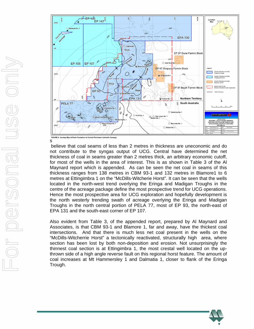
The leading proponents believe that coal seams of less than 2 metres in thickness are uneconomic and do not contribute to the syngas output of UCG. Central have determined the net thickness of coal in seams greater than 2 metres thick, an arbitrary economic cutoff, for most of the wells in the area of interest. This is as shown in Table 3 of the Al Maynard report which is appended. As can be seen the net coal in seams of this thickness ranges from 138 metres in CBM 93-1 and 132 metres in Blamore1 to 6 metres at Ettingimbra 1 on the “McDills-Witcherie Horst”. It can be seen that the wells located in the north-west trend overlying the Eringa and Madigan Troughs in the centre of the acreage package define the most prospective trend for UCG operations. Hence the most prospective area for UCG exploration and hopefully development is the north westerly trending swath of acreage overlying the Eringa and Madigan Troughs in the north central portion of PELA 77, most of EP 93, the north-east of EPA 131 and the south-east corner of EP 107. Also evident from Table 3, of the appended report, prepared by Al Maynard and Associates, is that CBM 93-1 and Blamore 1, far and away, have the thickest coal intersections. And that there is much less net coal present in the wells on the “McDills-Witcherrie Horst” a tectonically reactivated, structurally high area, where section has been lost by both non-deposition and erosion. Not unsurprisingly the thinnest coal section is at Ettingimbra 1, the most crestal well located on the up-thrown side of a high angle reverse fault on this regional horst feature. The amount of coal increases at Mt Hammersley 1 and Dalmatia 1, closer to flank of the Eringa Trough. F
or p
erso
nal u
se o
nly
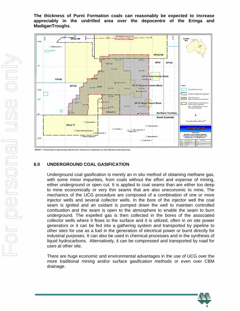
The thickness of Purni Formation coals can reasonably be expected to increase appreciably in the undrilled area over the depocentre of the Eringa and MadiganTroughs.
6.0 UNDERGROUND COAL GASIFICATION
Underground coal gasification is merely an in situ method of obtaining methane gas, with some minor impurities, from coals without the effort and expense of mining, either underground or open cut. It is applied to coal seams than are either too deep to mine economically or very thin seams that are also uneconomic to mine. The mechanics of the UCG procedure are composed of a combination of one or more injector wells and several collector wells. In the bore of the injector well the coal seam is ignited and an oxidant is pumped down the well to maintain controlled combustion and the seam is open to the atmosphere to enable the seam to burn underground. The expelled gas is then collected in the bores of the associated collector wells where it flows to the surface and it is utilized, often in on site power generators or it can be fed into a gathering system and transported by pipeline to other sites for use as a fuel in the generation of electrical power or burnt directly for industrial purposes. It can also be used in chemical processes and in the synthesis of liquid hydrocarbons. Alternatively, it can be compressed and transported by road for uses at other site. There are huge economic and environmental advantages in the use of UCG over the more traditional mining and/or surface gasification methods or even over CBM drainage.
For
per
sona
l use
onl
y

6.1 Historical Background to UCG The first mention of the method was in 1868, by the German engineer Carl Wilhelm Siemens, later anglicised to Sir William, younger brother of Werner von Siemens the founder of the German electrical company, and manager of Siemens’ English operations. He suggested it as a method of utilizing waste coal and the coal pillars left in the mines to hold the roof up. Siemens’ suggestion was not followed up directly, however Dimitri Mendeleyev, the famous Russian scientist and developer of the Periodic Table, a fundamental tenet of Chemistry, further developed Siemens’ ideas over the next few decades and popularized the theoretical ideas of UCG in Russia. The first attempt to apply UCG was made by the Nobel Laureate Sir William Ramsay in the Durham Coal Fields of England in 1912, in an experimental undertaking. Given the positive results that he obtained, Ramsay attempted, in 1913, to raise the cash to commercialize the method and build a UCG plant. He successfully raised the cash but unfortunately World War 1 intervened and the effort was abandoned, as it was in all of Western Europe until after World War 2. Russia seems to be the place where the potential of UCG was most widely recognized. This started, with a political objective, when Vladimir Lenin wrote in 1913 in his book Pravda (=Truth), which is a political treatise, of the advantages of technology and that the UCG method “would liberate the workers from the dangers of mining”. After the coming to power of the Soviet Government in Russia, Joseph Stalin in 1928 directed the Skochinsky Institute of Mining to research UCG. This research continued on during the 1930’s, and after the expenditure of the equivalent of billions of United States (US) dollars, a plant was constructed in the Ukraine in 1937. This plant was unsuccessful and many of the scientists involved with it were executed by Soviet authorities in a subsequent purge. During this time little research was conducted on the use of coal as a source of hydrocarbons in Western Europe except in Germany where the famous Fischer-Tropsch method of synthesis of coal gas to liquid petroleum was perfected. In 1939 the Russians built a second, but this time successful, UCG operation in the Ukraine which operated until it was shut down by the occupying Germans during World War 2. Post World War 2, the Soviet Government built and operated 14 large scale UCG plants across the Soviet Union. However with the discovery of large scale natural gas deposits in the mid 1960s in the Soviet Union, these plants, with the exception of a plant in Angren, Uzebekistan and another in Siberia, were shut down as they could not compete with the cheap and plentiful natural gas. In Western Europe, immediately after the cessation of World War 2 and as a consequence of knowledge of Russia’s successful application of UCG in the Ukraine in the late 1930’s becoming known, research into, UCG was recommenced in Western Europe. This also coincided with a general and widespread energy shortage in Western Europe.
For
per
sona
l use
onl
y
Initially this new work was directed towards thin seams of coal at shallow depths and was tested at Bois-la Dame in Belgium in 1948. This application of the stream method was conducted on a commercial scale at the “P5” pilot plant at Newman Spinney in Derbyshire, England during 1958-9.Technically the pilot plant was successful but it was uneconomic due to the new availability of cheaper energy sources. This was a result of the discovery of large gas fields in the Dutch and then English sectors of the North Sea in the late 1950s and early 1960s. With the subsequently available cheap energy prices, all work on the development of UCG stopped in Western Europe. The United States, given its vast cheap oil and gas deposits, lagged in the evaluation of the potential of UCG and it was only in 1972 that a group of energy research institutes and universities began an extensive field testing program. The American research was heavily based on the earlier Russian work. The Americans incorporated much oil field drilling and well completion technology into their studies. Starting in 1989, the European Union, through its working group on UCG, conducted successful trials in Spain, England and Belgium on deep thin coal seams. At present, with the exception of Australia, China is the leading nation in trialling UCG. Nations like Australia, China and India with their large coal reserves and modest oil reserves would seem to be ideal candidates for the application of UCG and associated synthesis. This is particularly true for deposits located at depths which are uneconomic to mine, either by underground or open cut methods, or which are remotely located, such as the Pedirka Basin of Central Australia. Successful demonstrations of UCG have been conducted in Queensland, the first by Linc Energy near Chincilla using technology licenced from Ergo Exergy (Ergo) of Canada. The successful Chincilla test, supervised by Ergo, was successfully controlled shut down and Linc Energy have since struck an arrangement with the Skochinsky Institute of Mining from Russia, the pioneers of the industrial process, to pursue UCG development in Queensland. Carbon Energy also have a successful pilot operation at Bloodwood Creek in south- west Queensland and another at Kogan in the same general area. 6.2 Technical Aspects of UCG UCG is merely the partial, in situ, burning of underground coal seams and the collection of the by-products, which are later refined to remove those which are of no commercial value. The chemical processes involved are very similar to those of the long used and well understood traditional surface coal gasification. The mechanics of the procedure involve the drilling of one or more injector wells to the coal seam and one or more collector wells drilled to the same seam at some distance from the injector well(s). A stream of oxidant, usually water and air or water and oxygen is pumped under pressure to the seam which is then ignited. The oxidant stream is regulated so that the coal does not fully burn but emits syngas, which consists of carbon dioxide (CO2), hydrogen (H2), carbon monoxide (CO) and smaller quantities of methane (CH4) and hydrogen sulphide (H2S). The controlled burning of the coal seam is constrained above and below by non combustible beds adjacent to the coal seam. These beds restrict the zone of combustion in a vertical sense. The syngas is collected in the wellbore of the collector well, an area of lower pressure, open to the atmosphere, after transmission through the coal seam.
For
per
sona
l use
onl
y
In areas where there is limited permeability in the coals, various methods, including hydraulic fracturing amongst others, are used to artificially induce and enhance permeability within the coal seams. These techniques, which result in an increase the macro permeability of the coal in particular, are used to increase syngas flow to the collector wells. In a sense UCG is similar to the traditional method of surface gasification, the major difference being that the coal seam is the reactor and the layers above and below it are the walls of the reactor. The chemical reactions involved are the same for UCG and surface gasification. A great benefit of the method is that the waste products or ash are retained in the underground chamber and hence the problem of disposal of the waste is eliminated. There are two major methods of UCG, these are:- 1) The Stream Method which utilizes vertical wells and reverse combustion to open
up internal pathways in the coal. This is the original Russian method which has since been refined by Ergo, one of the world’s leaders of UCG technology. This method was used in the pilot plant at Chincilla, Queensland, where the oxidant was air and water. Another Queensland operator Carbon Energy Limited plan to use oxygen as the oxidant in their trials at Bloodwood Creek, west of Dalby.
2) The Controlled Retraction Injection Point (CRIP) method developed by United
States researchers. This method uses dedicated inseam boreholes, drilled using oil field drilling technology, and moveable injection points. In this method the oxidant is oxygen or enriched air.
Successful underground coal gasification requires several necessary and sufficient conditions:- • The seam depth is between 30 and 1250 metres below the natural surface. A
depth range to 800 metres has been established by the Chincilla pilot plant in Queensland The deeper cutoff above has been invoked in studies conducted in England. The Bloodwood Creek pilot is at a depth of 200 metres.
• The seam thickness is 5 metres or greater. The average seam thickness at Bloodwood Creek is 7 metres.
• The seam is continuous with no discontinuities. • The ash content of the coal is less than sixty percent (60%) • The coal seam is below the upper level of the ground water. The increased
overburden pressure, due to the presence of the overlying ground water, ensures that the reaction and the by products are confined to the coal seam.
• There are no aquifers of potable water in direct contact with the combusted coal. The Chincilla pilot plant showed that nearby, but isolated, aquifers were not contaminated with syngas.
These conditions appear to be all met in Central’s Pedirka Basin acreage. There is some variance in these parameters in some of the research papers but the figures above appear to be generally accepted. The value of the lower depth range in the various studies has not really been a true variable in the tests conducted to date, as it is constrained by the depth of the base of the coal seam where the pilot study was conducted. It is the view of the author that the lower depth range value for UCG has not really, as yet, been determined.
For
per
sona
l use
onl
y
There are significant economic advantages for UCG over mining, either underground or open cut and surface gasification. It should be noted that Central has no immediate plans to mine and gasify this coal at the surface as it is too deeply buried and too remotely located from ports and major cities to be economic under present economic conditions. However the company is actively considering a UCG and associated GTL operation. 6.3 Economic Advantages of UCG The essence of UCG is that it allows the access to more coal resources than would be economically recoverable by conventional mining methods. Estimates by some authorities indicate that world wide coal reserves could be increased by approximately 600 billion tonnes. In the United States alone the prestigious Lawrence Livermore National Laboratory estimates that UCG could increase recoverable coal resources in that nation by 300 percent. The operator of the Chincilla Pilot plant believes, and presumably has established, that both the capital and operating the costs of UCG are appreciably lower than traditional methods of mining. In many, if not all, cases the substitution of UCG product gas for traditional natural gas results in appreciable cost savings. This is also true when comparing UCG with surface gasification. It is understood that the Majuba power station operated by the South African utility Eskom produces electrical power at between one third and one sixth of the cost of equivalent sized plants using surface gasification. The fundamental saving and benefit over traditional mining of UCG results from the elimination of the mining, and often, coal transport costs. With UCG it is only necessary to drill several injector and collector wells and then either utilize the produced gas on site or transport it via low cost, low pressure pipelines to off site locations for power generation, crude synthesis, chemical manufacture and other procedures. Other significant savings result from the greatly reduced site clean up costs. This results from the fact that the vast majority of waste is confined in the underground gasification chamber. There are also reduced greenhouse gas emissions, particularly in the oxides of carbon, resulting from UCG processes. Another potential benefit of UCG is the use of depleted areas for the long term safe storage of carbon dioxide that is carbon dioxide sequestration. This is expected to be a growing field with the looming introduction of carbon emission taxes and associated costs. 6.4 Environmental Benefits of UCG. There are many environmental benefits associated with the use of UCG. Besides the “feel good” effects of environmentally benign operations there are great ancillary cost savings to be made in the consequent elimination of expensive clean- ups or the installation of costly low emission plant and equipment. The major benefit results from the fact that with no mining operations there are no overburden dumps, no spoil dumps, and no ash or tailings dams, which eventually have to be removed or at best landscaped. Most of the waste is constrained within the underground combustion chamber, a significant cost saving.
For
per
sona
l use
onl
y
Associated with the underground combustion is the fact that the slow controlled burning results in a cleaner burn and much less toxic by-products are generated and released into the atmosphere. Again besides being environmentally friendly this cleaner burn obviates the need for expensive scrubbing gear on the waste release equipment, either smoke stacks or water release pipes from any plant utilizing syngas. Some studies have indicated that ash content of syngas is one seventh (1/7th) that of surface burnt coal, namely 10milligrams per cubic metre (mm/m3) compared to 70mm/m3. The various concentrations of deleterious oxides of nitrogen (NOX) and Sulphur dioxide (SO2), important greenhouse gases are greatly reduced, with underground combustion. This fact is most important, as it is believed that the contributions to Greenhouse Gases from oxides of nitrogen are in the order of 300 times those from CO2. It has been estimated that the cost to capture CO2, using the commercially available Selexol absorbent is approximately US$ 25 per tonne. This gas could be reinjected at low cost into the depleted coal seams. The resultant carbon credits could be used by the operating company or sold to large scale greenhouse emitters under the impending Carbon Emission Regime.
Similarly other gases can be recovered from the syngas stream, namely ammonia (NH4) and hydrogen sulphide (H2S) and used in industrial processes, the former in the manufacture of fertilizer and the latter in the production of sulphuric acid. Both have a ready market and the removal of these gases cleans up the exhausted gas. There is a great need for the output of either product, fertilizer in particular is in short supply and has become very expensive. Its manufacture would be very profitable. The cleaned up syngas can be used in GTL synthesis or in the generation of electrical power in combined cycle gas turbine power stations. The major perceived environmental impediment to UCG utilization, groundwater contamination, appears to have been recognized in pilot test studies conducted at Hoe Creek, Wyoming, USA by the Lawrence Livermore National Laboratory. In this case in which the pressure in the combustion chamber was greater than that of the surrounding rock, contaminants, including phenol leechate, which is very water soluble but short lived, and benzene, a long lived carcinogen polluted the lower pressure ground water table. This is countered empirically by the results from the pilot plant at Chincilla Queensland, where no contamination was observed. However, fortuitously, it has been found that if the coal is buried deeply enough so that the overburden pressure on it is greater than the pressure in the combustion chamber the pollutants are held within the combustion chamber and there is no pollution of the water table. This has been the case at the large scale pilot plant at Chincilla, Queensland and at Bloodwood Creek in the same State. UCG has great economic and environmental benefits over the traditional mining and associated surface gasification method. It has overwhelming efficiency advantages over CBM drainage procedures.
For
per
sona
l use
onl
y
7.0 THE POSSIBLE POTENTIAL COAL RESOURCE IN CENTRAL’S PEDIRKA BASIN ACREAGE
As a result of recent drilling, coring and mapping in the company’s acreage an estimate of the magnitude of the potential coal resource, syngas and ultimately GTL synthesis hydrocarbons, within those tenements can be made. This estimate also incorporates earlier drilling and the interpretations of seismic data. Such an estimate of the potential coal resource has been made by Al Maynard and Associates Pty Ltd of Perth in “Summary Independent Appraisal Report on the Coal Potential held by Central Petroleum Ltd (ASX:CTP) in the Purni Formation, Pedirka Basin Central Australia”, a report commissioned by Central. This report, which is very thorough and detailed, is included as Appendix 1. Al Maynard and Associates, which specializes in the exploration of and the evaluation of mineral tenements, has prepared their report under the guidelines of the Valmin (2005) and the Joint Ore Reserves Committee (JORC) of the Australian Institute of Mining and Metallurgy (AusIMM) codes, as adopted by the Australian Institute of Geoscientists and AusIMM, the primary certification bodies for Australian geoscientists, particularly minerals geologists. Traditionally mineral exploration and reserves or resource definition has always involved much more direct sampling than petroleum exploration and/or reserves/resource definition. To this end given the spacing between the data points in Central’s acreage, petroleum exploration wells, Al Maynard and Associates operating under the above mentioned codes were unable to define and quantify a JORC consistent compliant mineral resource, which has to be measured, inferred or indicated, in Central’s Pedirka Basin acreage. However they were able to define and quantify a potential coal tonnage under the “exploration target” classification of the JORC code. The reader is referred to Al Maynard and Associates’ report for a more detailed description of their methodology. To arrive at an estimate of the amount coal present within Central’s acreage several procedures were followed:- • Seismic mapping , depth conversion and isopach mapping by Central • Planimetering and coal volume calculations by Maynard and Associates
In the following stages:- 1) An isopach, or interval thickness, map of the Purni Formation across the eight
petroleum tenements and associated mineral application areas was prepared from seismic interpretation and mapping and depth conversion. This mapping was tied, calibrated and constrained at well intersections. This mapping is shown in Figure 6 of this report and Figures 7 and 8 in the Maynard report. It should be noted that much high frequency “jitter” is present in the computer contouring due to the sparsity of data points
2) The total net thickness of Purni Formation coals greater than or equal to 2 metres
was plotted against the Total Purni Formation thickness. This graph is shown as Graph 4 in the Maynard report.
For
per
sona
l use
onl
y
3) From 2) above, a function relating gross Purni coal thickness to total net Purni Formation thickness was derived. The derived function is:-
G= 0.0004* T +0.0211* T Where N=Total Net Purni Coal Thickness and
T =Total Purni Formation Thickness.
4) The area, in square kilometres, between each of the contours of a100 metre spacing interval was digitized. The areas of each contour interval were then multiplied by the mid interval thickness and then summed, then divided by the total area to create an area weighted average Purni Formation thickness. And the weighted average Purni Formation thickness was then used in 3) above to calculate the total net thickness of the Purni Formation coal seams.
5) Coal tonnages have been calculated for above the 1000m depth contour and below that depth. This depth value is arbitrary, although representative. The base of the test seam at Chincilla was 800 metres, a test plant in England was successful with a seam base at 1250metres and Carbon Energy (CNX), a UCG industry consulting group, are working on a seam located at 200metres in their Bloodwood Creek pilot project in southwest Queensland. However it is understood that they believe that UCG is viable down to depths of 1,000 metres.
The coal tonnages were then converted to cubic metres and then to cubic feet by the author for use in the estimation of the possible prospective gas (syngas) resource contained within Central’s Pedrka Basin acreage.
8.0 THE POSSIBLE PROSPECTIVE SYNGAS RESOURCE IN CENTRAL’S PEDIRKA BASIN ACREAGE
There is believed to be a large synthetic gas resource potentially hosted in the Early Permian aged Purni Formation coals located within Central’s Pedirka Basin acreage of Central Australia. Under controlled combustion conditions with limited amounts of oxygen and steam, coal will burn to produce synthetic gas or “syngas”. This product is composed primarily of carbon monoxide and methane. It is known as syngas because it can be used to synthesize chemical products such as ammonia, methanol and more importantly liquid hydrocarbons, amongst others. The procedure is that when the coal is partially burned the hot gases generated react with the coal to produce more gas in somewhat of a controlled chain reaction. The process is a variant of the well understood and widely used surface gasification process used for more than a century to produce town gas. A major technology group Carbon Energy with an extensive research background in the USA, New Zealand and Australia believe that the underground coal gasification recovers 80 percent of the energy of the coal, in the produced syngas. This is higher than that recovered from mining, either underground or open cut as the whole seam is utilized and there is no coal loss at the surface in washing and transport procedures. The same group believe that UCG recovers more than 20 times the energy recovered by coal bed methane drainage methods.UCG is certainly the most efficient method of energy utilization of the more deeply buried coals. The procedure utilizes all the energy bound up in the coal, whereas this is not the case for CBM drainage.
For
per
sona
l use
onl
y
As no pilot UCG plant is, or has been, operational in Central’s Pedirka Basin acreage hence no local performance parameters are available. However Carbon Energy have indicated that at their Bloodwood Creek trial some 55 kilometres west of Dalby in the Queensland section of the Mesozoic aged Surat Basin that the crucial parameter, gas output is:- 100 million tonnes of coal will produce 2 thousand Petajoules of energy of which 1 thousand Petajoules will be recoverable as syngas, or 1 million tonnes of coal will produce 10 Petajoules of recoverable syngas. Traditionally as a rule of thumb, until analytical determinations have been made to determine the energy value of the gas, one Petajoule is taken to be equivalent to one billion cubic feet (BCF) of sales gas. Hence 1 million tonnes of coal will produce 10 BCF of gas. Whilst the Jurassic aged Walloon Coals are different to, and much younger, than the Early Permian Purni Coals, if this sort of yield is obtained in the Pedirka Basin a be very large potential resource will have been freed up for development. The Purni Formation coals are known to be a good and mature hydrocarbon generative source and are more deeply buried than the shallow Walloon Coals. Depth of burial is usual directly related to thermal maturity and hydrocarbon yield. It should be noted that the gas recovery of 10 BCF per 100 million tonnes of coal equates to a recovery factor of 283 m3 per tonne, this is approximately 25 times that of the measured gas saturation of coals from the Galilee and Ipswich Basins of Queensland. It is roughly consistent with the determination made by Carbon Energy that UCG methods recover approximately 20 times as much gas as do CBM methods. Using the coal tonnages for the maximum, average and minimum cases, above and below the arbitrary cutoff of 1000 metres for Petroleum tenements in the NT and in SA, as well as for the area covered by the Mining Applications by Central’s fully owned subsidiary Merlin Coal Pty Limited, as determined by Al Maynard and Associates of Perth, the estimated possible syngas resources are listed below. Note that the syngas volumes are in units of trillion cubic feet (TCF).
For
per
sona
l use
onl
y
CASE COAL TONNAGE SYNGAS ENERGY SYNGAS VOLUME (Billion tonnes) (Petajoules) (TCF)
a) Petroleum Tenements in the NT (Coal above 1000 m) Maximum 997 9,970,000 9,970 Average 897 8,970,000 8,970 Minimum 797 7,970,000 7,970
b) Petroleum Tenements in the NT (Coal below 1000 m) Maximum 866 8,660,000 8,660 Average 780 7,800,000 7,800 Minimum 693 6,930,000 6,930
c) Petroleum Tenements in SA (Coal above 1000 m) Maximum 391 3,910,000 3,910 Average 352 3,520,000 3,520 Minimum 312 3,120,000 3,120
d) Petroleum Tenements in SA (Coal below 1000 m) Maximum 0 0 0 Average 0 0 0 Minimum 0 0 0
e) Sum for Petroleum Leases (Coal above 1000 m) Maximum 1,390 13,880,000 13,880 Average 1,250 12,500,000 12,500 Minimum 1,110 11,100,000 11,110
f) Sum of Petroleum Leases (Coal below 1000 m) Maximum 866 866,000 8,660 Average 780 780,000 7,800 Minimum 693 693,000 6,930
g) Mining Tenements in the NT (above 1000 m) Maximum 795 7,950,000 7,590 Average 716 7,160,000 7,160 Minimum 636 6,360,000 6,360
h) Mining Tenements in the NT (below 1000 m) Maximum 1,030 10,310,000 10,031 Average 928 928,000 9,280 Minimum 825 825,000 8,250
i) SA Petroleum Tenement and NT Mining Tenements (Coal above 1000) Maximum 1,186 11,860,000 11,860 Average 1,068 10,680,000 10,680 Minimum 948 9,480,000 9,480
j) SA Petroleum Tenement and NT mining Tenements (Coal below 1000 m) k) Maximum 795 7,950,000 7,590 l) Average 716 7,160,000 7,160 m) Minimum 636 6,360,000 6,360
Table 1. Prospective Recoverable Resource Estimations F
or p
erso
nal u
se o
nly
As can be seen from the above table an extremely large prospective recoverable syngas resource is present in the acreage holdings of Central in the Pedirka Basin. Several possible combinations of Petroleum and Mining Tenements may apply, as set out above. It is expected that Central will be granted the UCG rights to all the petroleum tenements, in which case Case e) above will apply. In the unlikely event that Central are not granted the UCG rights to the NT Petroleum Tenements but are awarded the Mining Tenements then Case i) will apply. These are the two most relevant alternatives and are the highest probability outcomes, however others may occur. It should be noted that;- 1) The estimated possible potential coal and prospective syngas resources
listed above have not been discovered and proven. At this stage, they represent an “exploration target” only. Further delineation, both seismic and drilling, is required to definitively quantify a potential resource and then a reserve.
Several interesting points emerge from the above Table:- • All the coal in PELA 77 is above the 1,000 metre arbitrary economic cutoff
depth. • Twenty eight percent (28%) of all coal above the arbitrary economic cutoff
depth is located in PELA 77. • The Mineral Lease Applications in the NT cover eighty percent (80%) of all
the coal in the NT, above the arbitrary economic cutoff depth. As a consequence of these observations consideration should be given to expediting the formal awarding of PELA 77 to Central, that is to fulfill the commitments to have the tenement formally and fully awarded to the company. And to then concentrate on beginning operations in that tenement, as there is no uncertainty regarding the rights to UCG. Upon resolution of the UCG position in the NT the sphere of operations can then be extended across the border into nearby EP 93, probably the most prospective block in the NT. By beginning in PELA 77, an area with no known hindrances, Central can immediately access more than one quarter (25 percent) of the possible prospective resource in their acreage package.
9.0 GAS TO LIQUID (GTL) AND COAL TO LIQUID (CTL) SYNTHESIS
This section of the report has substantial input from a report prepared, by David Holt of Holt Campbell Payton Pty Ltd and Jake De Boer of GHD Engineering Pty Ltd., for Central. It was prepared with methane, primarily, as the proposed input fuel. The first step in methane feed GTL is the synthesis of methane to syngas, hence a cost saving would apply to the use of syngas as feedstock. However the scale of the study should remain representative. Central has undertaken several studies of the viability of gas to liquids conversion (GTL) and its many variants for a proposed Fischer-Tropsch GTL plant with capacity ranging from 2,500-10,000-50,000 plus bbls/day located at Alice Springs and drawing upon prospective resources in conventional reservoirs in their acreage.
For
per
sona
l use
onl
y
Naturally methane gas drained from coals could be used as a source or source supplement, as could syngas. Both GTL and coal to liquids (CTL) for are considered here for the Pedirka Basin acreage. The gas to liquids, process is well understood and well established and in use in many locations around the world, particularly in South Africa, Qatar and Malaysia, amongst others. The preferred process is a refinement of the well-known Fischer-Tropsch process, World War 2. The process is essentially the indirect conversion of coal or natural gas to liquid hydrocarbons which is a two-step process that involves firstly gasifying the feedstock to form “synthesis gas” and then converting the synthesis gas to liquid products, Current interest in the process has stemmed from a combination of anticipated higher crude oil pricing coupled with increased environmental requirements for clean burning (low sulphur and low aromatic) transportation fuels, which are a hallmark of Fischer-Tropsch fuels. Methanol synthesis shows many common features with Fischer-Tropsch synthesis and has enhanced the commercial experience of the technology elements. An alternative approach for CTL has been the direct process commonly known as the Bergius process, which was also developed in Germany before World War 2. Here coal is hydrogenated to an oil, similar in composition to a light crude oil. The hydrogen used is preferably made with methane reforming. Current preference is for the indirect route, with various projects underway in China and other countries. While most grades of coal and natural gas of varying composition can be used in the process, the lower grades of input fuel result in a lower liquid fuel output for the same input. As coal (typically 0.8 Hydrogen /1 Carbon) is more hydrogen deficient compared to the Fischer-Tropsch product (2. Hydrogen /1 Carbon) or methane (4 Hydrogen /1 Carbon) the net result is higher carbon losses for carbon dioxide (CO2) compared to methane as a GTL feedstock. Initial preference is thus to use the hydrogen rich CBM as feedstock in preference to the coal in the coal seams themselves, which offers substantial benefits for a lower capital cost as well as lower emission project. Arrow Energy Limited with Alcan South Pacific have announced the results of a feasibility study to examine potential for a GTL plant drawing upon coal bed methane resources (CBM) in Queensland to provide a liquid fuel for Alcan’s Gove aluminium refinery. The proposed plant is to be of 20,000 bbls/day output and the results indicated favourable profitability and operating economics. The Brisbane-based company has said the joint study evaluated the GTL project against the current and alternative energy options available for Alcan's Australian operations. This demonstrates the potential for the scaling up of CBM from a niche to large scale gas supplier. Shell in conjunction with Arrow is also investigating the economics of an export liquefied natural gas (LNG) facility at Gladstone, Queensland utilizing CBM. Syntroleum, an international GTL technology company, have signed a Memorandum of Understanding with Linc Energy Limited to examine potential for GTL production from Linc’s proposed underground coal gasification (UCG) project at Chinchilla in Queensland.
For
per
sona
l use
onl
y
This could be seen as variant to above ground coal gasification, and suitable to some coal resources. Carbon Energy has UCG pilot plants at Bloodwood Creek and Kogan, Queensland Fischer-Tropsch diesel is recognized as a clean diesel. This diesel is saleable in existing markets, is compatible with all existing infrastructure, has virtually no sulphur, below 10 ppm, nor aromatic components, is biodegradable and is non toxic. It also has a long “shelf life”, approximately 8 years, compared with refinery diesel, which is typically 6 months. Tests (Shell, DOE, Syntroleum and others) have demonstrated (with engine optimization) that it has better performance than conventional or refinery diesel. The favourable high cetane number and other characteristics allow a typical premium of US$ 5-7 per barrel over petroleum diesel. The combustion of the Fischer-Tropsch diesel results in reduction of engine pollutants. Politically Australia is diesel short compared to petrol, and this constrains the ability to increase market penetration, with substantially (30%) more fuel efficient diesel cars. As noted in the Holt Campbell Payton report, a GTL plant with CBM feed stock, would require less than half the capital investment of a CTL plant, and consequently GTL from gas delivered to a plant will be more economic in general than from a CTL plant. Feedstock from a UCG operation would presumably result in even lower costs. Central currently has the UCG and CBM rights to the coal in PELA 77. The company also has the CBM rights to all of its NT petroleum tenements but at this stage the position of UCG is uncertain in the NT. To ensure its rights to UCG in the NT Central has applied for all available Mineral Leases over the coal in the NT petroleum leases, in case the UCG rights are not automatically assigned to the petroleum tenement holder, in the unresolved situation in the NT. If awarded Central would also hold the mining rights to the coal, for CTL synthesis in the unlikely case that that route was pursued. If Central is unsuccessful in obtaining the outstanding UCG rights it could concentrate on operating in SA where it has no impediments to conventional exploration, CBM or UCG. In the unlikely event that the company is unsuccessful in obtaining UCG and mining rights in the NT the company may have to enter into commercial arrangements with coal companies, this would add supplementary costs and result in reduced revenue to Central in the case of CTL processing, but for GTL, Central controls the rights to all conventional and non-conventional reservoirs. Recently Central has also applied for Mineral Leases over most of the coal in their NT petroleum tenements. The company already holds the rights to UCG and CBM in their SA acreage. Syntroleum believes that a 20,000 barrel a day GTL plant would be economic at an oil price of US$ 35-40 per barrel, which is appreciably lower than current and forecast long term oil prices. Such a plant would require an input gas feed of approximately. 250 MMCFD, compared to 200 MMCFD required for Holt Campbell Payton’s preferred process. The outputs of the synthesis are diesel, jet fuel, naphtha, and liquified petroleum gas with ancillary potential for wax and lubricants, all valuable commercial products, with ready markets in Australia and abroad. Other more mature GTL technologies, such as Sasol’s, would yield about 25,000 bbl/d from the same amount of feedstock. In the case of Syntroleum, the low yield is attributable to reforming with air instead of steam or oxygen as is done with other processes.
For
per
sona
l use
onl
y
The reader is referred to the report by Holt Campbell Payton, which is appended as Appendix 2, and the Syntroleum presentation which is in the possession of Central. Other companies have variants of the process and the reports from Rentech and Japan Oil and Gas National Corporation are also referred to. Central has commissioned a pre-feasibility study for a GTL plant in Central Australia involving 10,000 bbl/day to 50,000 bbl/day plant outputs. Whilst the latter report was prepared for the adjacent Amadeus Basin, it is also relevant for the Pedirka Basin. The study, by Perth-based consulting engineers Holt Campbell Payton, concluded that a 50,000 bbl/day GTL plant requiring some 3.8 TCFG in reserves for a 20 year life cycle would break even at about US$ 35per barrel oil price with feedstock priced at A$ 1.25 /gigajoule, whereas an increase in gas price to A$ 2.50 would raise the break even point to about US$ 40/bbl oil price. This projection is based on the utilization of yet to be discovered resources in Central’s Amadeus Basin tenements. Those tenements, whilst similar to the Pedirka Basin blocks, are not the subject of this report. The reader is referred to the said report. Higher plant capacities than this, have also been studied by Central. The authors of the above mentioned report have also reported on the potential of a 140,000 bbl/day plant located at Alice Springs using gas from unconventional sources from the Pedirka Basin. This is detailed in the attached report by Holt Campbell and Payton.
10.0 METHODOLOGY
The basis of this report was an open file study of much of the data available on the onshore Pedirka Basin sequence (Permian) in both the Northern Territory and South Australian sectors of the basin, although reference was made to the underlying Amadeus Basin sequence (Devonian and older) and overlying Simpson Basin sequence (Triassic) and Eromanga Basin sequence Jurassic-Cretaceous). Many internal reports provided by Central were also utilized and these included daily drilling reports, analytical studies and well completion reports for the three wells recently drilled by Central. Independent reports on the coal tonnages contained in Central’s acreage and a report on the feasibility of GTL processes in the company’s acreage were also utilized, as were previous reports submitted by Mulready Consulting Services Pty Ltd to Central Petroleum Limited. Many reports and presentations by GTL and UCG specialist consulting companies were also used. Much information from the internet and discussions with officers of State and Territory Geological Surveys and Department of Minerals and Energy are also included, as are data clarifications from officers of Central Petroleum Limited. The reader is referred to these reports which are listed in the references section. Knowledge in the possession of the author of coal bed methane drainage in NSW and QLD was also included as was his knowledge of conventional exploration in NSW, QLD, NT and SA. Publications on coal bed methane exploration, development and production were also referred to as were publications on the underground gasification of coals and gas to liquids synthesis.
For
per
sona
l use
onl
y
11.0 RISKS
All petroleum exploration, whether conventional or non-conventional, contains inherent risk. The main risks in Central’s proposed non-conventional program, for UCG and CBM are:- • The gas saturation of the coals, which are not known unambiguously • The location of water sands within or near the coals • The lateral extent of the coals • The thickness of the coal beds • The depth of the coals • That economic flow rates are achieved from CBM development wells • That economic flow rates can be achieved from UCG collector wells • The success of possible hydraulic fracturing operations, if required • The thermal and pressure isolation of the ground water aquifers from the coals
seams in the case of UCG In spite of the above risks there is enough encouragement, in the author’s view, to pursue this high potential reward project. Overall the risk on underground gasification of the coals appears to be quite contained. There would seem to be less economic risk with UCG than with CBM, given the higher recovery factor.
12.0 RECOMMENDATIONS
The prime recommendation of this report is that Central persists with its objective to explore for, develop and produce hydrocarbons of a non-conventional origin from their Pedirka Basin acreage. Their innovative ideas of underground coal gasification and synthesis to synthetic crude oil are capable of unlocking a large scale, but un-utilized resource in the basin complex contained within their tenements. Liquid hydrocarbons command a premium over gas and are more readily economically transportable and more readily saleable. Ready local and, probably, export markets exist for liquids in this time of oil shortage and high prices. Other possible uses power generation, chemical manufacture, fertilizer manufacture and others, all seem to have ready markets. A vast prospective resource appears to be contained within the company’s tenements. The company’s objectives are sound in that they are targeting Permian and possibly Triassic coal rich intervals, correlatives of which are known to have sourced both conventional and non-conventional hydrocarbon production in adjacent basins in eastern and central Australia. These units have also exhibited hydrocarbon shows in wells sited within and adjacent to Central’s tenements. It is the author’s opinion, that while either CBM or UCG methods are applicable in the company’s acreage, that the greater return will come from UCG. This is because that procedure is more efficient in utilizing the coal resource. UCG utilizes all the coal and is twenty times more efficient in energy recovery than CBM. In some areas Peera Peera Formation coals of the Triassic aged Simpson Basin coals will be present at shallower depths than those of the underlying Permian aged Purni Formation coals of the Pedirka Basin sequence.
For
per
sona
l use
onl
y
Consideration should be given to utilizing these shallower, thinner and less laterally and vertically extensive coals as well. Given the fact that it has been established, by recent drilling, that a significant migrated oil charge has reached the reservoirs of the overlying Simpson and Eromanga Basins care should be taken whilst drilling through these sequences, especially on the basin flanks on the Andado Shelf, as conventional hydrocarbons, probably oil, may be entrapped This applies particularly to the Poolowanna Formation and the Algebuckina Sandstone. For similar reasons, an additional recommendation is that wells aimed primarily at the the Pedirka and Simpson Desert Basin sequences be drilled into the underlying Horn Valley Siltstone of the Amadeus Basin sequence; despite its tight and dirty nature. As, it appears to be similar to the section drilled in the Amadeus Basin to the west which is known to be gas saturated over a wide vertical and lateral extent. This very rich source rock appears to be an ideal candidate for fracture stimulation and it is known to be oil prone. This unit should be investigated by coring and conducting fracture stimulation trials. In the initial stages of exploration the search for conventional and non-conventional hydrocarbons should be combined and exploratory wells should be sited on structural closures, as a conventional oil discovery would quickly establish economic viability. Yet another recommendation is that the all early exploration holes be fully cored through the coal units to accurately gauge their thickness and that the subsequent cores be fully analysed with a particular emphasis on gas saturation, cleating and other fundamental properties. Improved coring techniques are required. The final recommendation is, that in the first instance that attention be directed towards PELA 77 , which is believed to contain more than one quarter of the total possible resource, all of which is above the arbitrary economic. And they are no known “political” hindrances on UCG operations.
13.0 CONCLUSIONS
The following conclusions are drawn from this report:- • The major conclusion of this report is that Central’s Pedirka Basin acreage package
is prospective for hydrocarbons, either reservoired conventionally or non-conventionally.
• The coals of the Pedirka and Simpsons Desert Basin sequences are rich, mature
source rocks and correlatives of them have sourced many conventional oil and gas accumulations in adjacent basins. Good oil and gas shows have been encountered in poorly sited wells in and adjacent to Central’s acreage. The carbonaceous shales of these units are also known to be good, mature source rocks. Similarly, the very rich source rocks of the Horn Valley Siltstone of the underlying Amadeus Basin sequence are thought to be present, locally, beneath the Pedirka Basin sequence.
For
per
sona
l use
onl
y
• Some drilling and analytical results suggest that the coals are in the early oil generating window in Central’s acreage. Drilling results indicate that the coals have good macro and micro permeability, fundamental parameters for either CBM or UCG production. This observation is yet to be confirmed by analytical results, the appropriate studies are continuing.
• If the Company’s exploration programs are successful the sheer size of target resource should enable the construction of a large scale GTL plant and or a CTL plant. Recent feasibility studies suggest that these processes are economic at the current oil price. However the economic viability of these processes is volume dependent.
• Ready markets exist for the sale of liquids and to a lesser extent gas, and other
chemical by-products. • Central has a very innovative and elegant proposal to utilize a known, but
undeveloped, possible resource of large magnitude in a remote location. • The company has an overwhelming acreage position in the Pedirka Basin area, and
will dominate production from it, if their exploration programs are fruitful. • The Pedirka and the associated basins in the company’s acreage are virtually
unexplored and potential exists for large discoveries of hydrocarbons either of a conventional or non-conventional nature.
• For logistical and political reasons UCG operations should start in PELA 77 unless the NT Government determines under a formal ruling that UCG will be administered under the NT Petroleum Act which is probably the logical outcome considering the political imbroglio that had developed in Queensland where UCG was administered under the Mining Act and CBM under the Petroleum Act.
14.0 DECLARATIONS
Sources of Information Data on Central’s Pedirka Basin acreage was supplied by Mr. J Heugh, the Managing Director of Central, Mr Greg Ambrose, the Exploration Manager and Mr T Rudge, an employee of the company and by Mr Graham Mc Clung a consultant to the company. It was supplemented discussions by with officers of the SA and NT Department of Minerals and Energy and the State and Territory Geological Surveys and by public domain data as listed in the References (see below). Previous Independent Geological Reports A prior report on Central Petroleum Limited’s central Australian acreage, with emphasis on the Amadeus Basin was prepared by Mulready Consulting Services for inclusion in Central Petroleum Limited’s Prospectus. That report is dated 12 September 2005. This report has been prepared as an update to two earlier reports on the Pedirka Basin prepared by Mulready Consulting Services for Central Petroleum Limited. The first “ The Unconventional Petroleum Potential of EP 93, EPA’s 130 & 131 and PELA 77 Pedirka Basin Onshore Northern Territory and South Australia” was dated March 2007.
For
per
sona
l use
onl
y
The second an addendum to that report, “The Unconventional Petroleum Potential of EPA’S 105, 106 and 107 Pedirka Basin onshore Northern Territory, Australia” was produced in June 2007. Independent reports by Al Maynard and Associates, Consulting Geologists and Holt Campbell Payton, Consulting Engineers have been utilized in the preparation of this report and are appended. Title Verification of title was not within the brief of Mulready Consulting Services Pty Ltd in relation to this Report. Inspection As is usual for exploration permits we have not undertaken an inspection of the properties dealt with in this Report. Comment It is our view that the proposed programme, to explore for and develop non-conventional hydrocarbon resources, particularly underground coal gasification, in Central’s central Australian acreage, as outlined in this report, is soundly based on the results of previous exploration, studies by the company and the appropriate state Departments of Minerals and Energy and by recent developments in under ground coal gasification and the synthesis of gas and coal to liquid hydrocarbons. We think the proposed project is sound, appropriate and reasonable as indicated by recent drilling results. Limitations and risk In preparing this Report we have relied on the sources indicated above. A draft of this Report was supplied to Central for comment regarding any errors of fact. Exploration for, and development of, hydrocarbons is inherently speculative. There is as yet no direct method for determining the presence of hydrocarbons prior to drilling of an exploration well. There is always the risk that any potential trap may not contain hydrocarbons by virtue of inappropriately located or timed hydrocarbon generation or migration, or due to ineffective seal or later disruption of the trap. In the case of un-conventional accumulation there are additional constraints such as the levels of gas saturation of the coals, depths to the coals and the quality and quantity of the water which may need to be disposed of, amongst others A potential trap may also contain non-commercial volumes due to adverse reservoir conditions or inadequate charge of hydrocarbons. A major risk for non-conventional exploration is the extent, both horizontal and vertical, of the coal seams and the isolation of the coals from water bearing sandstones. In this Report discussion of potential traps, including structures, features and culminations, and of related prospective hydrocarbon volumes, should not be taken to imply that a commercial accumulation is known to exist.
For
per
sona
l use
onl
y
Independence Mulready Consulting Services Pty Ltd is not operating under an Australian financial services license in providing this Report. (i) Mulready Consulting Services Pty Ltd; (ii) A related body corporate of Mulready Consulting Services Pty Ltd; (iii) A director or employee of Mulready Consulting Services Pty Ltd or a related body
corporate of Mulready Consulting Services Pty Ltd; (iv) An associate of any of the above Otherwise there are; • No other interests whether pecuniary or not and whether direct or indirect, of
Mulready Consulting Services Pty Ltd or any associate of Mulready Consulting Services Pty Ltd.
• No other associations or relationships between Mulready Consulting Services Pty
Ltd or any associate of Mulready Consulting Services Pty Ltd and Central Petroleum Limited that might reasonably be expected to be or have been capable of influencing Mulready Consulting Services Pty Ltd in providing this Report.
Neither Mulready Consulting Services Pty Ltd nor any of its directors, employees or Associates has any beneficial interest in Central Petroleum Pty Ltd, nor in any of the permits which are the subject of this Report, nor in any adjacent permits. Conformity This report has been prepared to conform to the requirements of the Australian Securities and Investments Commission Policy 75 (Independent expert reports to shareholders) and Practice Note 42 (Independence of Expert’s Reports) and 43 (Valuation Reports and Profit Forecasts) as applicable. Date of report This report is dated 5 June 2009. Consent Mulready Consulting Services Pty Ltd consents to the issue of this Independent Geologist’s Report in the form and context of which it is intended, and is included. Qualifications Jack N. Mulready graduated from the University of Melbourne with a B.Sc. (Geology) 1963, Dip. Ed.(1966) and B.A. (1999) and from R.M.I.T. with a Fellowship Diploma in Management in 1978. He has over 38 years of experience within the petroleum exploration and production industry in Australia, New Zealand, USA, Indonesia, China and PNG. He is a member of the Petroleum Exploration Society of Australia, the Geological Society of Australia and the American Association of Petroleum Geologists (Certified APPG Geologist No. 5321), and is subject to the code of ethics of these bodies.
For
per
sona
l use
onl
y
He has prepared numerous independent geologist’s reports and valuations for a variety of Australian companies in accordance with the requirements of the Australian Stock Exchange. Jack Mulready B.Sc., B.A., Dip. Ed., F.Dip. RMIT, MGSA, MPESA, Certified APPG Geologist #5321. Roger Meaney, Associate Consultant Petroleum Geologist, graduated from LaTrobe University with a B.Sc. (Honours) in Physics and a Diploma of Education in 1973.He later completed the requirements for a B.Sc. in Geology from the same institution, part time. He has more than 30 years experience in oil and gas exploration. He was employed as a Petroleum Geophysicist by Esso Australia Limited, AAR Limited and Santos Limited and worked in all facets of hydrocarbon exploration. He has extensive technical experience in both the onshore and offshore sectors of the industry in Australia and some in the United States of America, Canada and Papua New Guinea and in management. Roger also has experience in the coal bed methane drainage industry. He is a member of the Society of Exploration Geophysicists and of the Petroleum Exploration Society of Australia, and is subject to the code of ethics of these bodies. Roger is a past Vice President and President of the Queensland Petroleum Exploration Association, Australia’s oldest Petroleum Exploration body. Roger has completed several Independent Geologist’s Reports for Australian companies in accordance with the requirements of the Australian Stock Exchange. R.A. Meaney B.Sc. (Hon), Dip. Ed., MSEG, MPESA
For
per
sona
l use
onl
y
15.0 SELECTED REFERENCES
The reports and publications, listed below, along with internal reports, supplied by Central were used in the compilation of this report, as was knowledge in the possession of the author. • Petroleum Potential of the Eringa Trough in S.A and the N.T. E.M. Alexander, D.
Pegum, P. Tingate, C.J Staples, B.H. Michaelsen and D.M. McKirdy. APEA Journal 1986.
• Pre-Feasibility Study for a 10,000 bbl/day FT GTL plant in central Australia with
notes on a 50,000 bbl/day option • New Petroleum Models in the Pedirka Basin, Northern Territory, Australia. G.J.
Ambrose, K. Liu, I. Deighton, P.J. Eadington and C.J Boreham. APEA Journal 2005.
• Permits OP 238 and EP 2 Pedirka/Simpson Desert/ Western Eromanga Basins
Geohistory Study 1987. Darryl Kingsley. • Hydrocarbon Potential of the Pedirka Basin Northern Territory Australia. N.T.
Department of Mines and Energy.2000. • Landsat MSS Interpretation of the Eringa Trough South Australia and Northern
Territory. R. Russell. 2000. • Australian Petroleum Accumulations Report1 Amadeus Basin. Bureau of
Mineral Resources, Geology and Geophysics. 1986. • Coalbed Methane Technology, Halliburton Company, Duncan, Oklahoma • The Cooper and Eromanga Basins Australia, Edited by B.J.O’Neill, 1989 • Handbook of South Australian Geology, Geological Survey of South Australia,
1969 • Field Geologist’s Manual, Monograph 9, Australian Institute of Mining and
Metallurgy, 1987 • Pre-feasibility Study for a 10,000bbl/day FT GTL Plant in Central Australia with
For
per
sona
l use
onl
y
Notes on a 50,000bbl/day Option, Technical Note. Holt Campbell Payton Pty Ltd. Report to Central Petroleum Limited
• Gas-to Liquids and Coal-to Liquids an Obvious Solution. Dennis. L. Yakobsen
Rentech Inc. • Eringa Trough Exploration Opportunity. Elinor Alexander and Brent Jensen-
Schmidt.Department of Mines and Energy, South Australia. Report 95/36. • Jogmec’s GTL Research and Development for Utilization in the Future.
Yoshifumi Suehiro, Japan Oil and Gas National Corporation • Sustec-Syntroleum Coal to Liquids Integrating Gasification, Fischer-Tropsch
and Refining Technology. Gas-to Liquids and Coal-to Liquids. Ken Roberts, Syntroleum Inc
• Summary Independent Appraisal Report on the Coal Potential held by Central Petroleum Ltd (ASX:CTP) in the Purni Formation, Pedirka Basin Central Australia. Al Maynard and Associates Pty Ltd
• The Unconventional Petroleum Potential of EP 93 and EPA’s 130 &131 and
PELA 77 Pedirka Basin Onshore Northern Territory and South Australia, Australia. R A Meaney, Mulready Consulting Services Pty Ltd
• The Unconventional Petroleum Potential of EPA’s 105,106 and 107 Onshore
Pedirka Basin Northern Territory, Australia. R A Meaney, Mulready Consulting Services Pty Ltd
• Appraisal of GTL Development Options for Potential the CBM Resources of the
Pedirka Basin. J De Boer and D Holt, Holt Campbell Payton • Underground Coal Gasification. Dr Len Walker, Linc Energy. In The Australian
Coal Review, October 1999. • Underground Coal Gasification in the UK. The (English) Coal Board, 2009? • Underground Coal Gasification. World Coal Institute, 2009? • Technology delivering cleaner energy. Carbon Energy, 2009? • Underground Coal Gasification. Wikipedia 2009
For
per
sona
l use
onl
y
16.0 GLOSSARY OF TECHNICAL TERMS
Anticline: a tectonic structure in which strata are folded so as to form an arch or dome.
Anticlinal trap: a hydrocarbon trap formed by the upward bowing of strata into a dome or arch.
Appraisal well: a well drilled to determine the extent of hydrocarbons discovered in previous well on the same structure.
Barrel (bbl): the unit of volume measurement used for petroleum and its products. 1 barrel = 42 U.S. Gallons = 35 Imperial Gallons (approx.) or 159 litres (approx.)
BCF: billion cubic feet (109 cubic feet) = 28.317 million cubic metres. bopd: barrels of oil per day. Basin: a depression of large size in which sediments have
accumulated. Cambrian: a geological time period approximately 545 to 490 million years
ago. Carbonates: sedimentary rocks composed of calcium and/or magnesium
carbonate e.g. limestone. Carboniferous: a geological time period approximately 354 to 298 million years
ago Claystone: a sedimentary rock composed predominantly of particles less
than silt size usually comprising clay minerals. Closure: the area within the lowest closing contour of a structure, also, a
closed structure. See four-way dip closure. Condensate: hydrocarbons (predominantly pentane and heavier compounds)
which spontaneously separate out from natural gas at the wellhead and condense to liquid.
Culmination: the highest point on a four-way dip closed structure, also used to indicate that a four-way dip closure exists.
Cretaceous: a geological time period approximately 141 to 65 million years ago
Depocentre: an area or site of maximum deposition in a sedimentary basin. Depression: a low place of any size on the Earth’s surface, also may refer to
a sedimentary trough or basin Deposition: the laying down of potential rock forming material i.e. sediments. Devonian: a geological time period approximately 410 to 354 million years
ago. Dip: the angle of the plan of a bed relative to the horizontal. Dry hole: a well drilled without finding gas or oil in commercial quantities. Exploration well: a well drilled to determine whether hydrocarbons are present in
a particular area or structure. Facies/lithofacies: the rock record of any sedimentary environment, including both
physical and organic characters. Fault: a fracture in the Earth’s crust along which the rocks on one side
are displaced relative to those on the other. Fault trap: A hydrocarbon trap which relies on the termination of a reservoir
against a seal due to fault displacement. Field: a geographical area under which an oil or gas reservoir lies. Fold/Folding: a bend in strata, commonly a product of deformation.
For
per
sona
l use
onl
y
Formation: a unit in stratigraphy defining a succession of rocks of the same type.
Four-way dip: a structural feature seen on orthogonal seismic lines to dip away in all four possible directions, closure indicating that any hydrocarbons beneath a sealing stratum will be trapped in this feature.
Gas in Place (GIP):
an estimated measure of the total amount of gas contained in a reservoir and, as such, a higher figure than Recoverable Gas.
Geology: the science relating to the history and development of the Earth’s crust.
Geophysics: the physics of the Earth; a hybrid discipline involving a combination of physical and geological principles.
Hydrocarbons: naturally occurring organic compounds containing only the elements hydrogen and carbon that may exist as solids, liquids or gases.
Horizon: a term used in seismic interpretation to identify the signal reflected from a particular layer of rock.
Intraformational: existing within a geological formation, for example a single shale bed in an alternating sequence of sands and shales may be an intraformational seal.
Jurassic: a geological time period approximately 205 to 141 million years ago.
Lacustrine: sediments deposited in a lake environment. Lead: inferred geologic feature or structural pattern requiring
investigation. Licence: an authority to explore for or produce oil or gas in a particular
area issued to a company by the governing state. Limestone: a rock composed of calcium carbonate. Lithology: the physical and mineralogical characteristics of a rock. Log(s): see well log. Log interpretation: technical analysis of the results of well logging leading to
quantitative estimates of various rock properties including contained liquids and gases.
Marine: deposited in the sea. Mature (source): Mesozoic:
the condition, caused by pressure, temperature and time, in which organic matter in a potential source rock will be converted to hydrocarbons. The geological era extending approximately from 225 to 65 million years ago
Migration: the movement of hydrocarbons from regions of higher to lower pressure.
MMSTB: millions of standard barrels. MMCFD: millions of cubic feet per day = 28,317 cubic metres per day. Net Pay: the subsurface geological layer where a deposit of oil or gas is
found in potentially commercial quantities. NPV ‘Net present value’. A monetary value for future cash flows which
is discounted to allow for the time value of money. Oil: a mixture of liquid hydrocarbons of different molecular weights. Oil Field: a geographical area under which an oil reservoir lies. Oil in Place (OIP): an estimated measure of the total amount of oil contained in a
reservoir and, as such, a higher figure than Recoverable Oil. Ordovician: a geological time period approximately 490 to 434 million years
ago.
For
per
sona
l use
onl
y
Permeability: a measure of the capacity of rock or stratum to allow water or other fluids such as oil to pass through it.
Permian: a geological time period approximately 298 to 251 million years ago.
Petroleum: a generic name for hydrocarbons, including crude oil, natural gas liquids, natural gas and their products.
Petroleum system:
the set geological conditions which give rise to petroleum accumulations.
Petrophysical: the physical properties of rocks, in this context, as measured by well logs.
Pipeline: a pipe through which oil, its products, or gas is pumped between two points, either offshore or onshore.
Porosity: the ratio of the volume of pore space in rock to its total volume, expressed as a percentage.
Prospect: a feature sufficiently defined to warrant the drilling of a well without the necessity of further investigation.
P/Z Pressure vs compressibility, an Engineering analysis used to calculate reserves of gas.
Quartz: a mineral composed of silicon dioxide. Quaternary: the most recent geological era, commencing approximately 1.8
million years ago. Recoverable Gas: an estimated measure of the total amount of gas which could be
brought to the surface from a given reservoir; this is usually of order 60% - 70% of the estimated Gas in Place.
Recoverable Oil: an estimated measure of the total amount of oil which could be brought to the surface from a given reservoir; this is usually less than 50% of the estimated Oil in Place and commonly in the 20% to 40% range.
Reservoir: pervious and porous rocks (usually sandstone, limestone or dolomite) capable of containing significant quantities of hydrocarbons.
Risk: an expression of uncertainty (high risk) or uncertainty (no risk) often relating to the presence of principal geological factors controlling oil accumulations.
Rugosity: the irregularity or roughness of a borehole, often caused by unstable formation or by poor drilling practice.
Sandstone: a sedimentary rock composed predominantly of sand sized grains, usually quartz.
Seal: an impermeable rock (usually claystone or shale) that prevents the passage of hydrocarbons.
Seismic survey: a technique for determining the detailed structure of the rocks underlying a particular area by passing acoustic shock waves into the strata and detecting and measuring the reflected signals.
Sediment: solid material, whether mineral or organic, which has been moved from its position of origin and redeposited.
Sedimentary rock: a rock formed as a result of the consolidation of sediments. Shale: a claystone exhibiting a finely laminated structure. Show: an indication of oil or gas from an exploratory well. Silt/siltstone: rock intermediate in texture and grain size between sandstone
and claystone. Source rocks: rocks (usually claystone or coal) that have generated or are in
the process of generating significant quantities of hydrocarbons.
For
per
sona
l use
onl
y
Stratigraphy: the study of stratified rocks, especially their age, correlation and
character. Structural Trap: a trap formed as a result of folding, faulting or a combination of
both. Structure: deformed sedimentary rocks, where the resultant bed
configuration is such as to form a trap for migrating hydrocarbons.
Tectonic: descriptive of all movements of the Earth’s crust caused by directed pressures, and the results of those movements.
Tertiary era: an era of geological time approximately 65 to 1.8 million years ago.
TOC Total organic carbon (content – as a %age) Trap: a body of reservoir rock, vertically or laterally sealed, the attitude
of which allows it to retain the hydrocarbons that have migrated into it.
Trend: a strike direction of a geological feature. Triassic: a geological time period approximately 251 to 205 million years
ago. Unconformity (angular)
lack of parallelism between rock strata in sequential contact, caused by a time break in sedimentation.
Updip: the direction leading most directly to higher elevations on an inclined stratum or structure.
Uplift: elevation of any extensive part of the Earth’s surface relative to some other part.
Well-log (log): a recording of rock properties obtained by lowering various instruments down a drilled well by means of a wireline.
For
per
sona
l use
onl
y
APPENDIX 1
AL MAYNARD & ASSOCIATES Pty Ltd
Consulting Geologists www.geological.com.au ABN 75 120 492 435 9/280 Hay Street, Tel: (+618) 9388 1000 Mob: 04 0304 9449 SUBIACO, WA, 6008 Fax: (+618) 9388 1768 A/h: (618) 9443 3333 Australia [email protected]
Australian & International Exploration & Evaluation of Mineral Properties
SUMMARY INDEPENDENT
APPRAISAL REPORT
ON THE COAL POTENTIAL
HELD BY
CENTRAL PETROLEUM LTD (ASX:CTP)
IN THE PURNI FORMATION,
PEDIRKA BASIN
CENTRAL AUSTRALIA
Writers: Phillip A Jones B.AppSc(Geol), MAusIMM, MAIG Allen J Maynard BAppSc(Geol), MAIG, MAusIMM Company: Al Maynard & Associates Pty Ltd Date: 16th February, 2009 Revised: 20th April, 2009. F
or p
erso
nal u
se o
nly
EXECUTIVE SUMMARY
This independent appraisal has been prepared by Al Maynard & Associates (“AM&A”) at the request of Central Petroleum Limited (“CTP”), ABN 72 083 254 308, to conduct an independent report on the potential tonnage of Permian coal within CTP’s licences that could possibly be amenable to underground coal gasification (“UCG”) and/or gas to liquids (“GTL”) which could also include coal to liquids (“CTL”) subject to suitable results from future testwork. DISCLAIMER : The interest of CTP in the applications of UCG, GTL or CTL in the Permian Pedirka Basin, is in its own right, outside of the current joint venture with Petroleum Exploration Australia (“PXA”), now owned by Queensland Gas Company Ltd (“QGC”), a British Gas (“BG”) Group Ltd business. Neither this joint current venture nor QGC or BG have an interest in examining the potential of UCG in this area under the Petroleum Acts of the Northern Territory or South Australia. Central Petroleum Limited is interested in examining the potential for UCG in its own right outside of the current joint venture with PXA” Under current Northern Territory legislation, UCG has not been classified as being a process available under either the Petroleum Act or the Mining Act. Industry observers anticipate that UCG will be available under the Petroleum Act as it is in the jurisdiction of South Australia. Such a decision will avoid the imbroglio that has developed in Queensland where UCG applications are available under the Mining Act and Coal Bed Methane (“CBM”) is available under the Mining Act. CTP has announced that most of the acreage it operates under the Petroleum Act in the Northern Territory has also been covered by the Company in separate exploration licence applications under the Mining Act (by its wholly owned subsidiary Merlin Coal Pty Ltd) in case the Northern Territory decides, counter to industry expectations, to allow UCG under the Mining Act. This approach would also allow CTP to explore for and ultimately develop Coal to Liquids (“CTL”) applications in its Mining Act tenements subject to granting. This report concludes that there is an “Exploration Target Potential” within the petroleum permits for 1.1 to 1.4 trillion tonnes of coal less than 1,000 metres (m) below the surface, at an as yet unspecified coal quality although drilling results to date indicate the coal generally being sub-bituminous in rank. The petroleum permits Target potential range below 1,000m is a further 0.7 to 0.87 trillion tonnes of coal The preferred target tonnage is based on the structure and geometry of the basin and three-dimensional information derived from seismic surveys, drill holes with lengthy coal intercepts and geological and geophysical down-hole logging data. The potential quantity and quality is conceptual in nature and there has been insufficient exploration to define a Mineral Resource and it is uncertain if further exploration will eventually result in the determination of a Mineral Resource. F
or p
erso
nal u
se o
nly
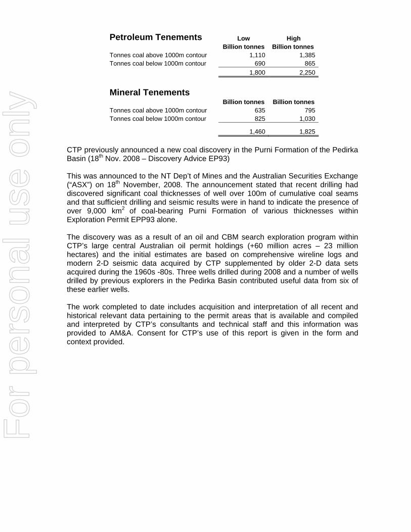
Petroleum Tenements Low High Billion tonnes Billion tonnes Tonnes coal above 1000m contour 1,110 1,385 Tonnes coal below 1000m contour 690 865 1,800 2,250 Mineral Tenements Billion tonnes Billion tonnes Tonnes coal above 1000m contour 635 795 Tonnes coal below 1000m contour 825 1,030
1,460 1,825 CTP previously announced a new coal discovery in the Purni Formation of the Pedirka Basin (18th Nov. 2008 – Discovery Advice EP93) This was announced to the NT Dep’t of Mines and the Australian Securities Exchange (“ASX”) on 18th November, 2008. The announcement stated that recent drilling had discovered significant coal thicknesses of well over 100m of cumulative coal seams and that sufficient drilling and seismic results were in hand to indicate the presence of over 9,000 km2 of coal-bearing Purni Formation of various thicknesses within Exploration Permit EPP93 alone. The discovery was as a result of an oil and CBM search exploration program within CTP’s large central Australian oil permit holdings (+60 million acres – 23 million hectares) and the initial estimates are based on comprehensive wireline logs and modern 2-D seismic data acquired by CTP supplemented by older 2-D data sets acquired during the 1960s -80s. Three wells drilled during 2008 and a number of wells drilled by previous explorers in the Pedirka Basin contributed useful data from six of these earlier wells. The work completed to date includes acquisition and interpretation of all recent and historical relevant data pertaining to the permit areas that is available and compiled and interpreted by CTP’s consultants and technical staff and this information was provided to AM&A. Consent for CTP’s use of this report is given in the form and context provided.
For
per
sona
l use
onl
y

TABLE OF CONTENTS PAGE 1.0 INTRODUCTION 1
1.1 Scope and Limitations ................................................................................. 1 1.2 Statement of Competence........................................................................... 1
2.0 DESCRIPTION OF THE MINERAL ASSETS 2 2.1 Methods and Guidelines 2 2.11 Environmental Implications ......................................................................... 2 2.12 Commodities-Metal Prices .......................................................................... 2 2.13 Mineralisation Summary .............................................................................. 2 2.14 Encumbrances/Royalty ............................................................................... 2
3.0 BACKGROUND INFORMATION 2 3.1 Topography, Vegetation & Climate ............................................................. 2
4.0 GEOLOGY 5 4.1 Introduction.................................................................................................. 5 4.2 Geological Setting ....................................................................................... 5
5.0 HISTORIC EXPLORATION 6 5.1 Introduction.................................................................................................. 6 5.2 History of the Coalfield ................................................................................ 6
6.0 DATA 7 6.1 Review, Audit and Database Integrity ......................................................... 7 6.2 Borehole Data ............................................................................................. 7 6.2.1 Drilling in the 1980s.................................................................................... 7 6.2.2 Geological Logging .................................................................................. 10 6.2.3 Sampling and Analysis ............................................................................. 10
7.0 GEOLOGICAL MODELLING 10 7.1 Purni Topography ...................................................................................... 10 7.2 Assumptions Made .................................................................................... 10
8.0 COAL POTENTIAL ESTIMATES 10 8.1 Method ........................................................................................................ 10 8.2 Target Tonnage Estimate............................................................................ 15 8.3 Target Range Conclusions......................................................................... 16
9.0 PROPOSED EXPLORATION 16 9.1 Legality of Exploration ............................................................................... 16 9.2 Exploration Potential ................................................................................. 16 9.3 Proposed Drilling Program ........................................................................ 17 9.4 Exploration Objectives............................................................................... 17
10.0 CONCLUSIONS 17 11.0 SELECTED REFERENCES 23 11.1 PROCESS OVERVIEW 25 12.0 PERSONAL DETAILS OF COMPETENT PERSONS 26 13.0 DEFINITION OF TERMS 27
For
per
sona
l use
onl
y

List of Figures Figure 1: Location of all CTP petroleum permits including the Purni Coal Project – Pedirka Basin. .....................................................................................................................3 Figure 2: Overview Map CTP’s Central Australian Permits...............................................5 Figure 3: Stratigraphic Column Description – Pedirka Basin.............................................6 Figure 4: Cross-Section – Pedirka Basin. ..........................................................................7 Figure 5: Location of Petroleum Permits, Exploration Wells & Contours of Purni Formation Thickness...........................................................................................................8 Figure 6: Location of Mineral Tenements & Applications (NT only). ...............................9 Figure 7: Digitised Purni Formation isopach contours for the Petroleum Permits NT & SA. .....................................................................................................................................13 Figure 8: Digitised Purni Formation isopach contours for the Mineral Tenement Applications - NT . ............................................................................................................14 List of Tables, Plate & Graph Table 1: Petroleum Permit & Application Details covering the Pedirka Basin. ................4 Table 2: Mineral Exploration Licence Application Details.................................................4 Table 3: Coal seam intersections. ...................................................................................11 Table 4: Purni Formation coal Target Potential estimates summary .............................15 Table 5: Range of Target Estimates................................................................................16 Table 6: Potential Tonnage Calculations Summary........................................................22 Plate 1: Hunt Rig 2 drilling at Blamore-1 (2008) Source CTP. ........................................11 Graph 1: Purni Formation vs. Coal Seam Thickness of available holes.........................12
For
per
sona
l use
onl
y
The Directors 16th February, 2009 Central Petroleum Limited (Revised 20th April, 2009) Suite 3, Level 4, Southshore Centre, 85 The Esplanade, South Perth WA 6151, Australia. Dear Sirs, The following report is compiled from information provided by Central Petroleum Ltd (“CTP”), the Regional Development Primary Industry Fisheries and Resources Department of the Northern Territory (“RDPIFR”), the Department Primary Industries & Resources of South Australia (“PIRSA”) and other publicly available data.
1.0 INTRODUCTION This report has been prepared by AM&A at the request of CTP to provide an independent appraisal of the coal tonnage (JORC “Exploration Target”) potential within the Company’s central Australian petroleum permit holdings of approximately 41,270 km2 straddling the NT and SA border of which 24,000 km2 (58%) is at the application stage and has not yet been granted.
1.1 Scope and Limitations This appraisal has been prepared in accordance with the requirements of the Valmin (2005) and the JORC Codes as adopted by the Australian Institute of Geoscientists (‘AIG’) and the Australasian Institute of Mining and Metallurgy (‘AusIMM’). CTP will be invoiced and expected to pay a fee for the preparation of this report. This fee comprises a normal commercial daily rate plus expenses, if incurred. Payment is not contingent of the results of this report or the success of any subsequent public or private fundraising. Except for these fees, neither the writers nor their families nor associates have any interest, either direct, indirect or contingent, in the properties reported upon, nor in CTP itself nor in any of CTP’s associated entities.
1.2 Statement of Competence This report has been prepared by Brian J. Varndell (“BJV”) B.Sc(Spec Hons Geol), FAusIMM, a geologist with more than 35 years experience in mineral exploration and mining and more than 25 years experience in mineral asset valuation, and the AM&A principal Allen J. Maynard (“AJM”) BApp.Sc(Geol) MAusIMM and Member of AIG, a geologist with 30 years in the exploration industry and 25 years in mineral asset valuation and Phillip A. Jones BAppSc(Geol) MAusIMM, MAIG, a geologist with more than 30 years continuous experience in the exploration and mining industry. The writers hold the appropriate qualifications, experience and independence to qualify as independent “Experts” under the definitions of the Valmin Code. The writers also acknowledge the work done by CTP’s own staff and other independent consultants who interpreted the seismic data, geophysical well logs and prepared the various isopach maps in relation to the Pedirka Basin and the Purni Formation.
For
per
sona
l use
onl
y
2.0 DESCRIPTION OF THE MINERAL ASSETS
2.1 Methods and Guidelines
2.11 Environmental Implications
Information to date indicates that the project area does not contain fauna or flora species regarded as being rare, threatened or endangered. This is subject to clarification environmental surveys by appropriate parties.
2.12 Commodities-Metal Prices In this appraisal current mineral (coal) prices were not considered.
2.13 Mineralisation Summary
Not enough drilling has been done to date to define JORC compliant resources (Measured Indicated or Inferred) within CTP’s permit holdings. So all coal potential tonnage estimations are defined under the JORC Code “Exploration Target” definition. This potential quantity and quality is conceptual in nature, and there has been insufficient exploration to define a Mineral Resource and it is uncertain if further exploration will eventually result in the determination of a Mineral Resource.
2.14 Encumbrances/Royalty There will be statutory State royalties due on all production and statutory land rentals levied.
3.0 BACKGROUND INFORMATION
3.1 Topography, Vegetation & Climate The project is located in central Australia (Fig 1) over fairly flat topography with sparse vegetation comprising low shrubs and bushes and occasional small trees. The warm to hot climate ensures that exploration and mining are possible all year round although the paucity of good roads mean that significant areas are relatively inaccessible during the northwest-monsoon period from December to February inclusive. The winters are mild (average 200C) and dry, the summers are hot (average 350C) with occasional thunder storms and an average annual rainfall (mostly falling in the monsoon period) of 280 mm (11 inches). The Pedirka Basin is overlain by the Simpson Desert, the world’s largest parallel sand dune desert which was crossed for the first time in a motor vehicle in 1962, by Reg Spriggs, one of the pioneers of petroleum exploration in the Cooper Basin. The dunes are 5-15m in height and the construction of roads traversing them can be expensive on a dollar per kilometre basis whereas long inter-dune corridors allow rapid construction of far less expensive roads. F
or p
erso
nal u
se o
nly
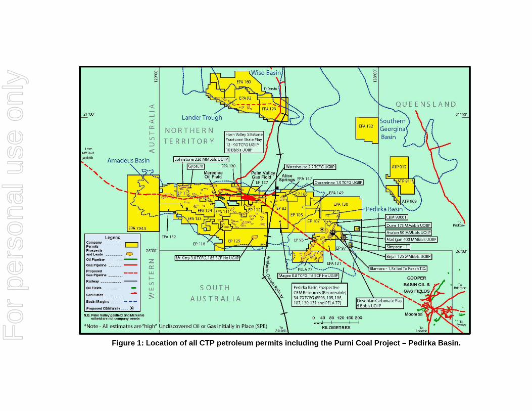
Figure 1: Location of all CTP petroleum permits including the Purni Coal Project – Pedirka Basin. F
or p
erso
nal u
se o
nly
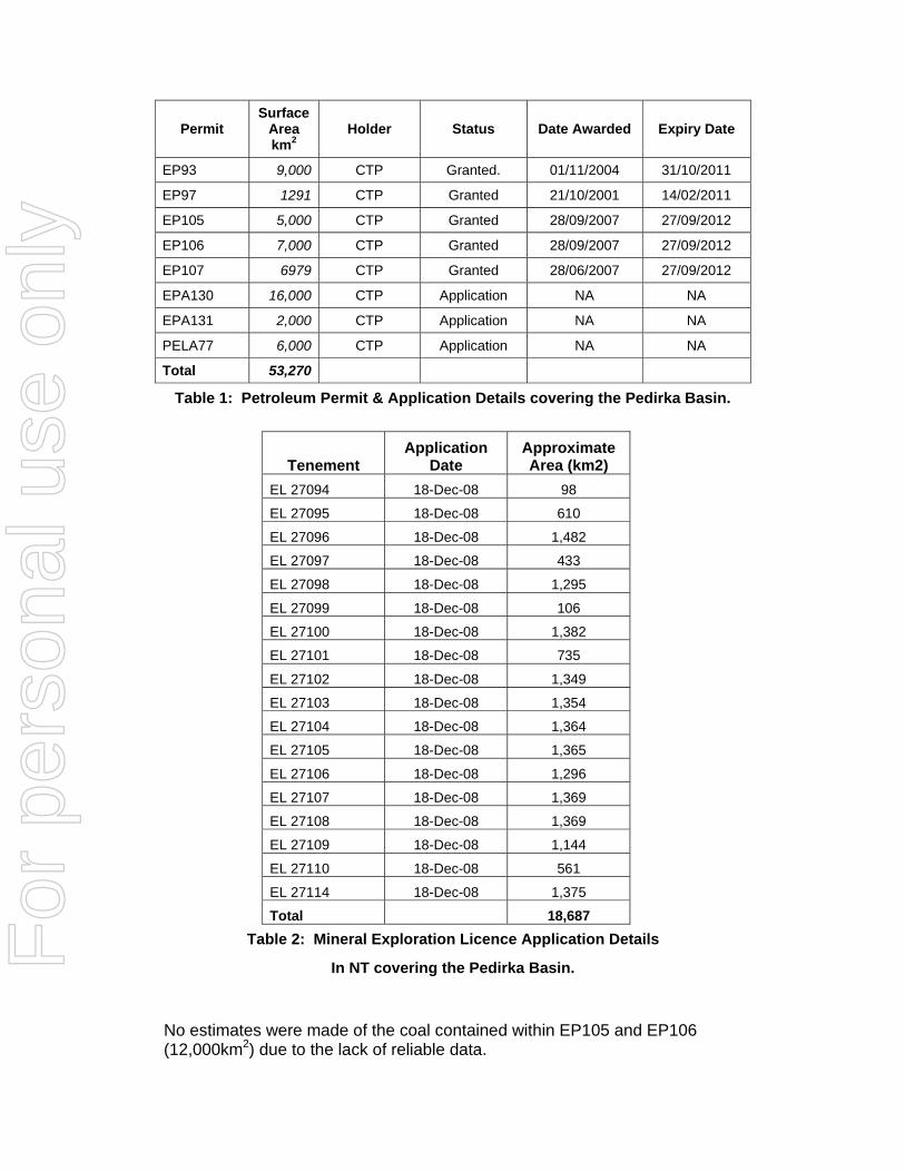
Permit Surface
Area km2
Holder Status Date Awarded Expiry Date
EP93 9,000 CTP Granted. 01/11/2004 31/10/2011
EP97 1291 CTP Granted 21/10/2001 14/02/2011
EP105 5,000 CTP Granted 28/09/2007 27/09/2012
EP106 7,000 CTP Granted 28/09/2007 27/09/2012
EP107 6979 CTP Granted 28/06/2007 27/09/2012
EPA130 16,000 CTP Application NA NA
EPA131 2,000 CTP Application NA NA
PELA77 6,000 CTP Application NA NA
Total 53,270
Table 1: Petroleum Permit & Application Details covering the Pedirka Basin.
Tenement Application
Date Approximate Area (km2)
EL 27094 18-Dec-08 98
EL 27095 18-Dec-08 610
EL 27096 18-Dec-08 1,482
EL 27097 18-Dec-08 433
EL 27098 18-Dec-08 1,295
EL 27099 18-Dec-08 106
EL 27100 18-Dec-08 1,382
EL 27101 18-Dec-08 735
EL 27102 18-Dec-08 1,349
EL 27103 18-Dec-08 1,354
EL 27104 18-Dec-08 1,364
EL 27105 18-Dec-08 1,365
EL 27106 18-Dec-08 1,296
EL 27107 18-Dec-08 1,369
EL 27108 18-Dec-08 1,369
EL 27109 18-Dec-08 1,144
EL 27110 18-Dec-08 561
EL 27114 18-Dec-08 1,375
Total 18,687 Table 2: Mineral Exploration Licence Application Details
In NT covering the Pedirka Basin. No estimates were made of the coal contained within EP105 and EP106 (12,000km2) due to the lack of reliable data.
For
per
sona
l use
onl
y

Figure 2: Overview Map CTP’s Central Australian Permits including the Pedirka Basin.
4.0 GEOLOGY
4.1 Introduction The coalfield is also being investigated by CTP to supply potential coal-to-liquids and gas-to-liquids projects; This technology has undergone significant innovative improvements in recent .years compared to the original Fischer-Tropsch Process developed before and during the Second World War.
4.2 Geological Setting The Pedirka basin covers about 150,000km2 with some 80% being in the Northern Territory and the balance in South Australia. This intracratonic basin unconformably overlies the Amadeus Basin and Western Warburton Basin both of which were deformed during the Alice Springs Orogeny. A NW-SE compressional phase in the Mid to Late Carboniferous initiated deposition in the Pedirka Basin (PIRSA, 1998).
For
per
sona
l use
onl
y
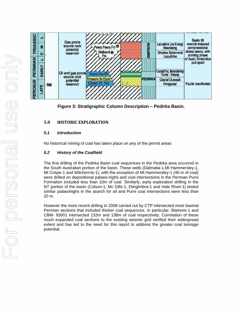
Figure 3: Stratigraphic Column Description – Pedirka Basin.
5.0 HISTORIC EXPLORATION
5.1 Introduction No historical mining of coal has taken place on any of the permit areas
5.2 History of the Coalfield The first drilling of the Pedirka Basin coal sequences in the Pedirka area occurred in the South Australian portion of the basin. These wells (Dalmatia-1,Mt Hammersley-1, Mt Crispe-1 and Witcherrrie-1), with the exception of Mt Hammersley-1 (46 m of coal) were drilled on depositional palaeo-highs and coal intersections in the Permian Purni Formation included less than 10m of coal. Similarly, early exploration drilling in the NT portion of the basin (Colson-1, Mc Dills-1, Etingimbra-1 and Hale River-1) tested similar palaeohighs in the search for oil and Purni coal intersections were less than 20 m. However the more recent drilling in 2008 carried out by CTP intersected more basinal Permian sections that included thicker coal sequences. In particular, Blamore-1 and CBM- 93001 intersected 132m and 138m of coal respectively. Correlation of these much expanded coal sections to the existing seismic grid verified their widespread extent and has led to the need for this report to address the greater coal tonnage potential.
For
per
sona
l use
onl
y
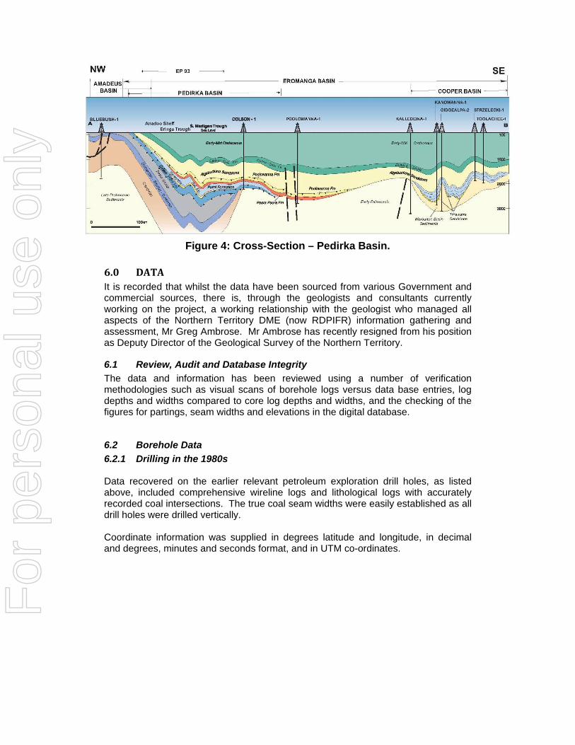
Figure 4: Cross-Section – Pedirka Basin.
6.0 DATA It is recorded that whilst the data have been sourced from various Government and commercial sources, there is, through the geologists and consultants currently working on the project, a working relationship with the geologist who managed all aspects of the Northern Territory DME (now RDPIFR) information gathering and assessment, Mr Greg Ambrose. Mr Ambrose has recently resigned from his position as Deputy Director of the Geological Survey of the Northern Territory.
6.1 Review, Audit and Database Integrity The data and information has been reviewed using a number of verification methodologies such as visual scans of borehole logs versus data base entries, log depths and widths compared to core log depths and widths, and the checking of the figures for partings, seam widths and elevations in the digital database.
6.2 Borehole Data 6.2.1 Drilling in the 1980s Data recovered on the earlier relevant petroleum exploration drill holes, as listed above, included comprehensive wireline logs and lithological logs with accurately recorded coal intersections. The true coal seam widths were easily established as all drill holes were drilled vertically. Coordinate information was supplied in degrees latitude and longitude, in decimal and degrees, minutes and seconds format, and in UTM co-ordinates.
For
per
sona
l use
onl
y
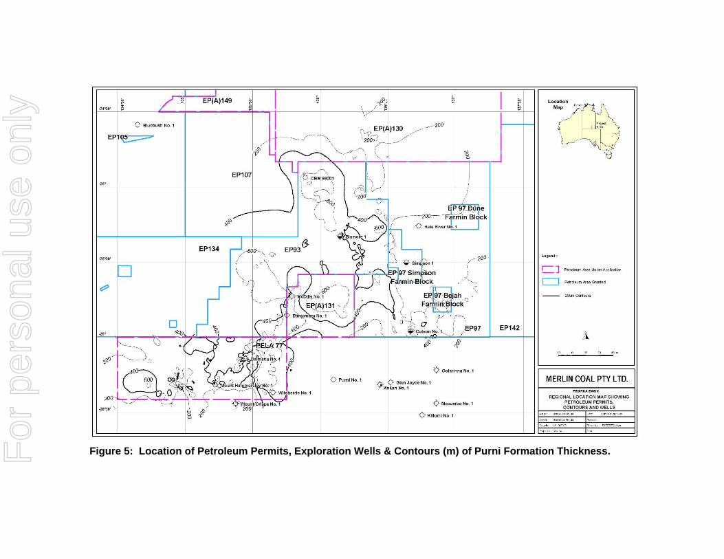
Figure 5: Location of Petroleum Permits, Exploration Wells & Contours (m) of Purni Formation Thickness. F
or p
erso
nal u
se o
nly
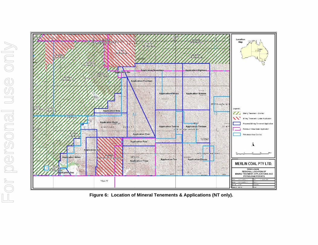
Figure 6: Location of Mineral Tenements & Applications (NT only). F
or p
erso
nal u
se o
nly

6.2.2 Geological Logging Detailed geological descriptions on the occurrence and presence of coal and other rock types were recorded in the borehole/well logs. The minimum geological logging interval for all drilling was 10 feet (3m) through coal bearing units. Wireline logs of varying vintage were collected in all cases.
6.2.3 Sampling and Analysis Sampling data and coal intersection results are only available for some of the boreholes.
7.0 GEOLOGICAL MODELLING
7.1 Purni Topography The target coal sequences occur in the Permian Purni Formation, the thickness of coals being strongly influenced by the ancient palaeotopography. Previous drilling was designed to test for oil and without exception targeted Purni Formation depositional palaeohighs where oil is most likely to be found. These palaeohighs were covered by relatively thin Purni sections with attenuated coal sequences. The first wells to test more basinal sequences were the recently drilled Blamore-1 and CBM93-01, both of which intersected thick coal sequences.
7.2 Assumptions Made Potential tonnages were estimated using MapInfo Software ® and manual methods. All roof and floor elevations obtained from the drilling and seismic data were gridded using a normalised kriging algorithm.
8.0 COAL POTENTIAL ESTIMATES The classification of coal resources into inferred, indicated and measured, is a function of increasing geological confidence in the estimate. Coal resources are reported on either a gross in situ, in situ, or mineable in situ reporting basis. There are no resource estimates for the Purni Coal project as not enough information is available to categorise any such estimates with JORC Code guidelines. However, we have estimated the range of potential tonnages in the JORC “Exploration Target” category taking into account all available information. .
8.1 Method To calculate the potential coal tonnage potential within each of the Central Petroleum tenements the area of the Purni formation was multiplied by the average coal seam thickness then by the bulk density of the coal. The difficulty is estimating the average coal seam thickness. Only four drill holes have been drilled through the Purni Formation with coal seam thickness data available, Table 1. Within the study area an additional 6 wells tested palaeohighs, all with coal thicknesses less than 20 m.
For
per
sona
l use
onl
y
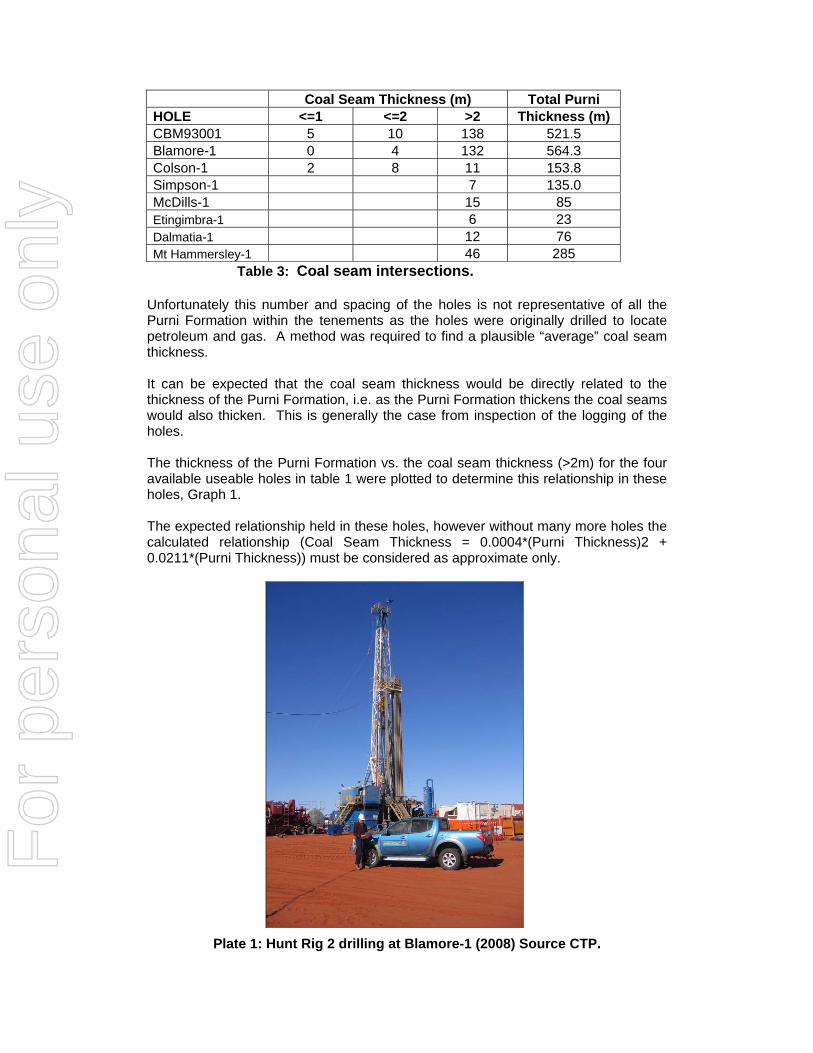
Coal Seam Thickness (m) Total Purni HOLE <=1 <=2 >2 Thickness (m) CBM93001 5 10 138 521.5 Blamore-1 0 4 132 564.3 Colson-1 2 8 11 153.8 Simpson-1 7 135.0 McDills-1 15 85 Etingimbra-1 6 23 Dalmatia-1 12 76 Mt Hammersley-1 46 285
Table 3: Coal seam intersections. Unfortunately this number and spacing of the holes is not representative of all the Purni Formation within the tenements as the holes were originally drilled to locate petroleum and gas. A method was required to find a plausible “average” coal seam thickness. It can be expected that the coal seam thickness would be directly related to the thickness of the Purni Formation, i.e. as the Purni Formation thickens the coal seams would also thicken. This is generally the case from inspection of the logging of the holes. The thickness of the Purni Formation vs. the coal seam thickness (>2m) for the four available useable holes in table 1 were plotted to determine this relationship in these holes, Graph 1. The expected relationship held in these holes, however without many more holes the calculated relationship (Coal Seam Thickness = 0.0004*(Purni Thickness)2 + 0.0211*(Purni Thickness)) must be considered as approximate only.
Plate 1: Hunt Rig 2 drilling at Blamore-1 (2008) Source CTP.
For
per
sona
l use
onl
y
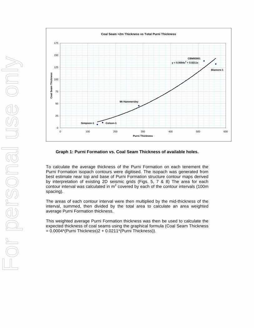
Coal Seam >2m Thickness vs Total Purni Thickness
y = 0.0004x2 + 0.0211x
0
25
50
75
100
125
150
175
0 100 200 300 400 500 600
Purni Thickness
Coa
l Sea
m T
hick
ness
Simpson-1 Colson-1
CBM93001
Blamore-1
Mt Hammersley
Graph 1: Purni Formation vs. Coal Seam Thickness of available holes.
To calculate the average thickness of the Purni Formation on each tenement the Purni Formation isopach contours were digitised. The isopach was generated from best estimate near top and base of Purni Formation structure contour maps derived by interpretation of existing 2D seismic grids (Figs. 5, 7 & 8) The area for each contour interval was calculated in m2 covered by each of the contour intervals (100m spacing). The areas of each contour interval were then multiplied by the mid-thickness of the interval, summed, then divided by the total area to calculate an area weighted average Purni Formation thickness. This weighted average Purni Formation thickness was then be used to calculate the expected thickness of coal seams using the graphical formula (Coal Seam Thickness = 0.0004*(Purni Thickness)2 + 0.0211*(Purni Thickness)).
For
per
sona
l use
onl
y
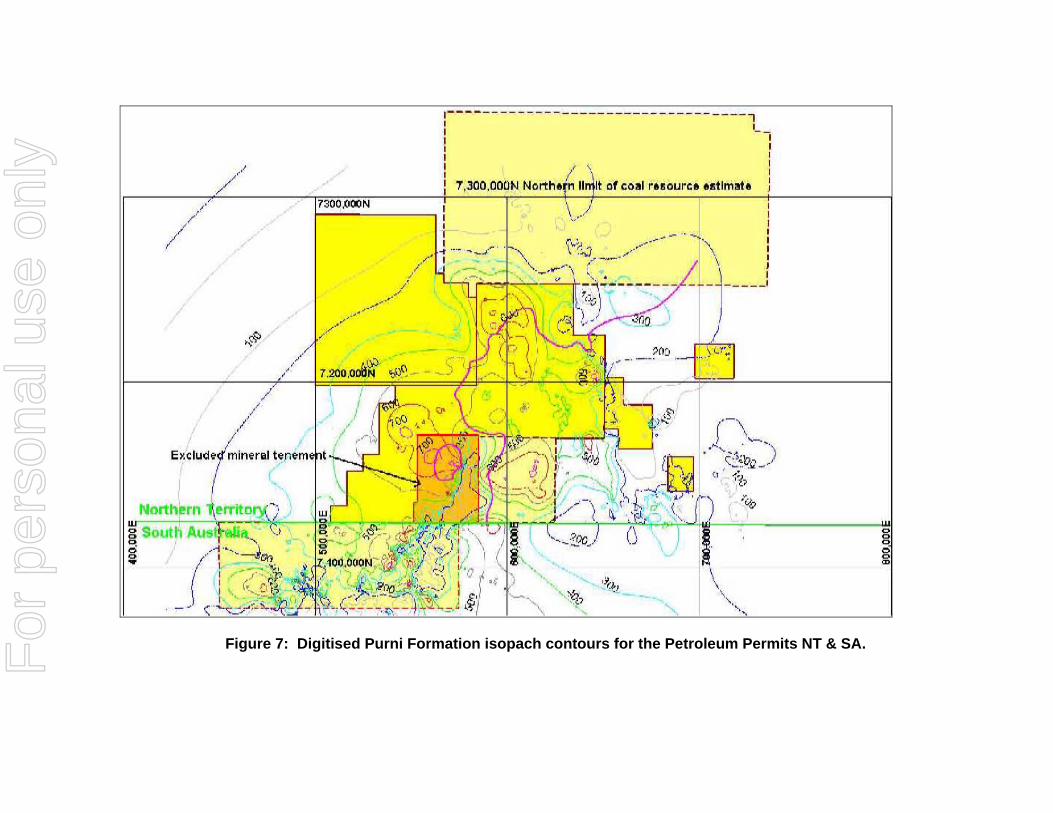
Figure 7: Digitised Purni Formation isopach contours for the Petroleum Permits NT & SA. For
per
sona
l use
onl
y
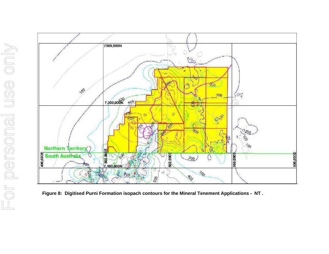
.
Figure 8: Digitised Purni Formation isopach contours for the Mineral Tenement Applications - NT .
For
per
sona
l use
onl
y
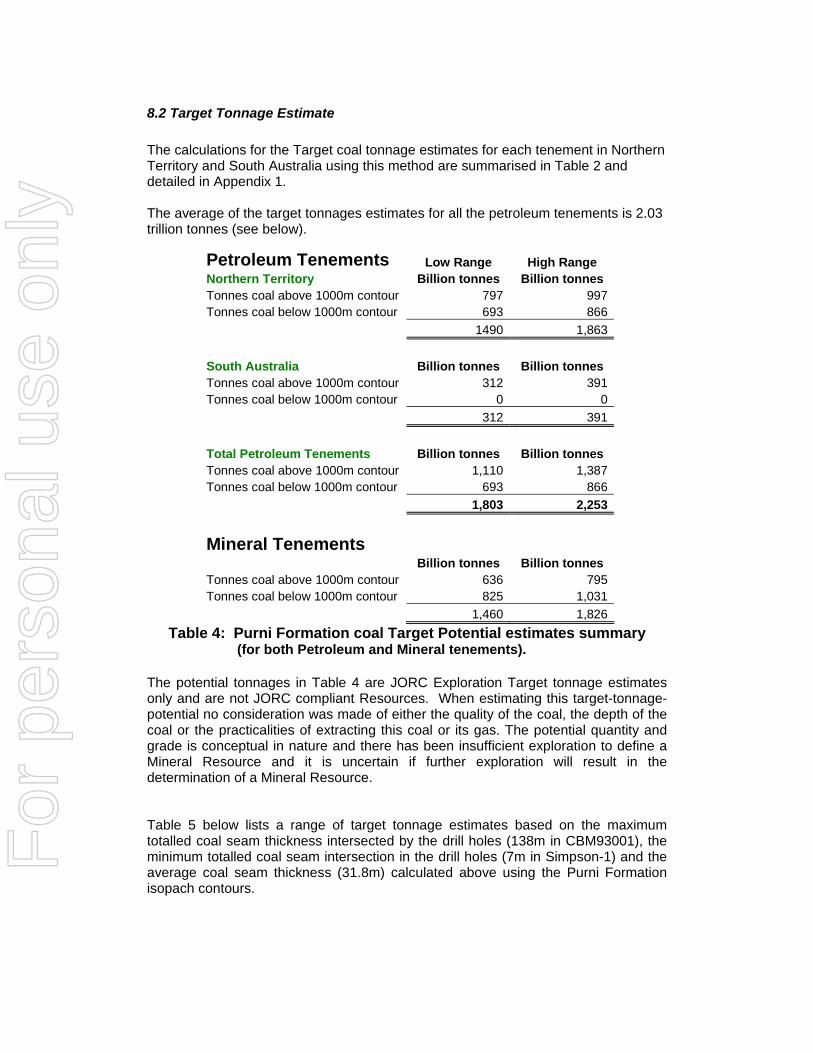
8.2 Target Tonnage Estimate The calculations for the Target coal tonnage estimates for each tenement in Northern Territory and South Australia using this method are summarised in Table 2 and detailed in Appendix 1. The average of the target tonnages estimates for all the petroleum tenements is 2.03 trillion tonnes (see below).
Table 4: Purni Formation coal Target Potential estimates summary (for both Petroleum and Mineral tenements).
The potential tonnages in Table 4 are JORC Exploration Target tonnage estimates only and are not JORC compliant Resources. When estimating this target-tonnage-potential no consideration was made of either the quality of the coal, the depth of the coal or the practicalities of extracting this coal or its gas. The potential quantity and grade is conceptual in nature and there has been insufficient exploration to define a Mineral Resource and it is uncertain if further exploration will result in the determination of a Mineral Resource. Table 5 below lists a range of target tonnage estimates based on the maximum totalled coal seam thickness intersected by the drill holes (138m in CBM93001), the minimum totalled coal seam intersection in the drill holes (7m in Simpson-1) and the average coal seam thickness (31.8m) calculated above using the Purni Formation isopach contours.
Petroleum Tenements Low Range High Range Northern Territory Billion tonnes Billion tonnes Tonnes coal above 1000m contour 797 997 Tonnes coal below 1000m contour 693 866 1490 1,863 South Australia Billion tonnes Billion tonnes Tonnes coal above 1000m contour 312 391 Tonnes coal below 1000m contour 0 0 312 391 Total Petroleum Tenements Billion tonnes Billion tonnes Tonnes coal above 1000m contour 1,110 1,387 Tonnes coal below 1000m contour 693 866 1,803 2,253 Mineral Tenements Billion tonnes Billion tonnes Tonnes coal above 1000m contour 636 795 Tonnes coal below 1000m contour 825 1,031 1,460 1,826
For
per
sona
l use
onl
y
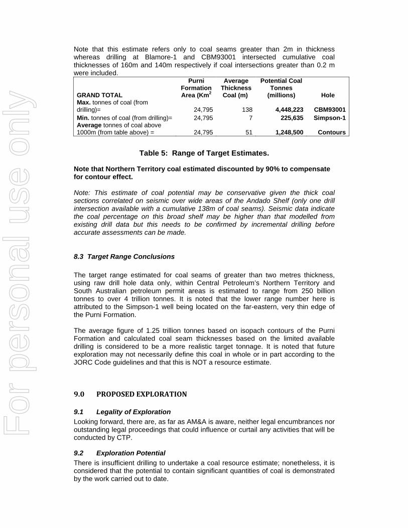
Note that this estimate refers only to coal seams greater than 2m in thickness whereas drilling at Blamore-1 and CBM93001 intersected cumulative coal thicknesses of 160m and 140m respectively if coal intersections greater than 0.2 m were included.
GRAND TOTAL
Purni Formation Area (Km2
Average Thickness Coal (m)
Potential Coal Tonnes
(millions) Hole Max. tonnes of coal (from drilling)= 24,795 138 4,448,223 CBM93001Min. tonnes of coal (from drilling)= 24,795 7 225,635 Simpson-1Average tonnes of coal above 1000m (from table above) = 24,795 51 1,248,500 Contours
Table 5: Range of Target Estimates.
Note that Northern Territory coal estimated discounted by 90% to compensate for contour effect. Note: This estimate of coal potential may be conservative given the thick coal sections correlated on seismic over wide areas of the Andado Shelf (only one drill intersection available with a cumulative 138m of coal seams). Seismic data indicate the coal percentage on this broad shelf may be higher than that modelled from existing drill data but this needs to be confirmed by incremental drilling before accurate assessments can be made.
8.3 Target Range Conclusions The target range estimated for coal seams of greater than two metres thickness, using raw drill hole data only, within Central Petroleum’s Northern Territory and South Australian petroleum permit areas is estimated to range from 250 billion tonnes to over 4 trillion tonnes. It is noted that the lower range number here is attributed to the Simpson-1 well being located on the far-eastern, very thin edge of the Purni Formation. The average figure of 1.25 trillion tonnes based on isopach contours of the Purni Formation and calculated coal seam thicknesses based on the limited available drilling is considered to be a more realistic target tonnage. It is noted that future exploration may not necessarily define this coal in whole or in part according to the JORC Code guidelines and that this is NOT a resource estimate.
9.0 PROPOSED EXPLORATION
9.1 Legality of Exploration Looking forward, there are, as far as AM&A is aware, neither legal encumbrances nor outstanding legal proceedings that could influence or curtail any activities that will be conducted by CTP.
9.2 Exploration Potential There is insufficient drilling to undertake a coal resource estimate; nonetheless, it is considered that the potential to contain significant quantities of coal is demonstrated by the work carried out to date.
For
per
sona
l use
onl
y
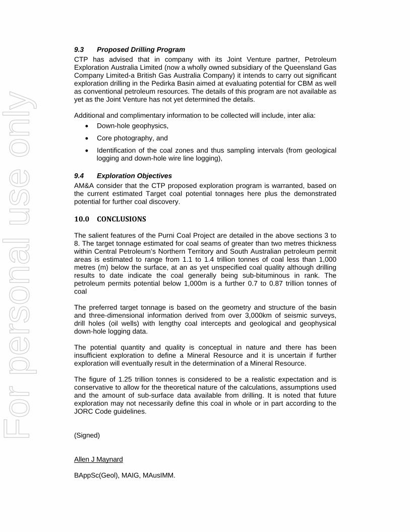
9.3 Proposed Drilling Program CTP has advised that in company with its Joint Venture partner, Petroleum Exploration Australia Limited (now a wholly owned subsidiary of the Queensland Gas Company Limited-a British Gas Australia Company) it intends to carry out significant exploration drilling in the Pedirka Basin aimed at evaluating potential for CBM as well as conventional petroleum resources. The details of this program are not available as yet as the Joint Venture has not yet determined the details. Additional and complimentary information to be collected will include, inter alia:
• Down-hole geophysics,
• Core photography, and
• Identification of the coal zones and thus sampling intervals (from geological logging and down-hole wire line logging),
9.4 Exploration Objectives AM&A consider that the CTP proposed exploration program is warranted, based on the current estimated Target coal potential tonnages here plus the demonstrated potential for further coal discovery. 10.0 CONCLUSIONS The salient features of the Purni Coal Project are detailed in the above sections 3 to 8. The target tonnage estimated for coal seams of greater than two metres thickness within Central Petroleum’s Northern Territory and South Australian petroleum permit areas is estimated to range from 1.1 to 1.4 trillion tonnes of coal less than 1,000 metres (m) below the surface, at an as yet unspecified coal quality although drilling results to date indicate the coal generally being sub-bituminous in rank. The petroleum permits potential below 1,000m is a further 0.7 to 0.87 trillion tonnes of coal The preferred target tonnage is based on the geometry and structure of the basin and three-dimensional information derived from over 3,000km of seismic surveys, drill holes (oil wells) with lengthy coal intercepts and geological and geophysical down-hole logging data. The potential quantity and quality is conceptual in nature and there has been insufficient exploration to define a Mineral Resource and it is uncertain if further exploration will eventually result in the determination of a Mineral Resource. The figure of 1.25 trillion tonnes is considered to be a realistic expectation and is conservative to allow for the theoretical nature of the calculations, assumptions used and the amount of sub-surface data available from drilling. It is noted that future exploration may not necessarily define this coal in whole or in part according to the JORC Code guidelines. (Signed) Allen J Maynard BAppSc(Geol), MAIG, MAusIMM.
For
per
sona
l use
onl
y
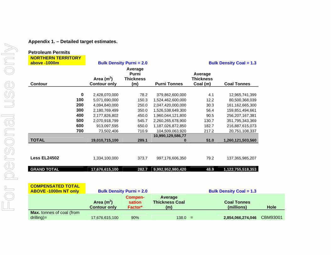
Appendix 1. – Detailed target estimates. Petroleum Permits NORTHERN TERRITORY above -1000m Bulk Density Purni = 2.0 Bulk Density Coal = 1.3
Contour Area (m2)
Contour only
Average Purni
Thickness (m) Purni Tonnes
Average Thickness Coal (m) Coal Tonnes
0 2,428,070,000 78.2 379,862,600,000 4.1 12,965,741,399
100 5,071,690,000 150.3 1,524,462,600,000 12.2 80,500,368,039 200 4,094,840,000 250.0 2,047,420,000,000 30.3 161,162,665,300 300 2,180,769,499 350.0 1,526,538,649,300 56.4 159,851,494,661 400 2,177,826,802 450.0 1,960,044,121,800 90.5 256,207,167,381 500 2,070,918,799 545.7 2,260,265,678,900 130.7 351,795,343,369 600 913,097,595 650.0 1,187,026,872,850 182.7 216,887,615,073 700 73,502,406 710.9 104,509,063,920 217.2 20,751,108,337
TOTAL 19,010,715,100 289.1 10,990,129,586,77
0 51.0 1,260,121,503,560 Less EL24502 1,334,100,000 373.7 997,176,606,350 79.2 137,365,985,207 GRAND TOTAL 17,676,615,100 282.7 9,992,952,980,420 48.9 1,122,755,518,353 COMPENSATED TOTAL ABOVE -1000m NT only Bulk Density Purni = 2.0 Bulk Density Coal = 1.3
Area (m2)
Contour only
Compen- sation Factor*
Average Thickness Coal
(m) Coal Tonnes
(millions) Hole Max. tonnes of coal (from drilling)= 17,676,615,100 90% 138.0 = 2,854,066,274,046 CBM93001
For
per
sona
l use
onl
y
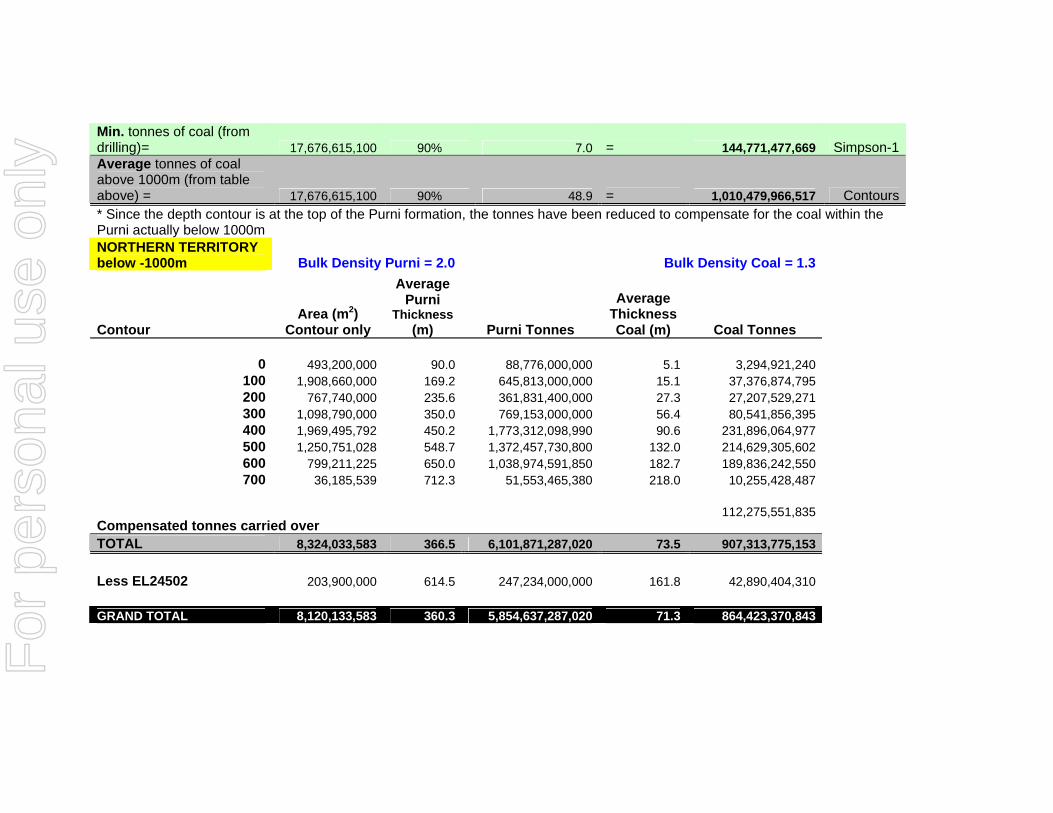
Min. tonnes of coal (from drilling)= 17,676,615,100 90% 7.0 = 144,771,477,669 Simpson-1Average tonnes of coal above 1000m (from table above) = 17,676,615,100 90% 48.9 = 1,010,479,966,517 Contours* Since the depth contour is at the top of the Purni formation, the tonnes have been reduced to compensate for the coal within the Purni actually below 1000m NORTHERN TERRITORY below -1000m Bulk Density Purni = 2.0 Bulk Density Coal = 1.3
Contour Area (m2)
Contour only
Average Purni
Thickness (m) Purni Tonnes
Average Thickness Coal (m) Coal Tonnes
0 493,200,000 90.0 88,776,000,000 5.1 3,294,921,240
100 1,908,660,000 169.2 645,813,000,000 15.1 37,376,874,795 200 767,740,000 235.6 361,831,400,000 27.3 27,207,529,271 300 1,098,790,000 350.0 769,153,000,000 56.4 80,541,856,395 400 1,969,495,792 450.2 1,773,312,098,990 90.6 231,896,064,977 500 1,250,751,028 548.7 1,372,457,730,800 132.0 214,629,305,602 600 799,211,225 650.0 1,038,974,591,850 182.7 189,836,242,550 700 36,185,539 712.3 51,553,465,380 218.0 10,255,428,487
Compensated tonnes carried over 112,275,551,835
TOTAL 8,324,033,583 366.5 6,101,871,287,020 73.5 907,313,775,153 Less EL24502 203,900,000 614.5 247,234,000,000 161.8 42,890,404,310 GRAND TOTAL 8,120,133,583 360.3 5,854,637,287,020 71.3 864,423,370,843 F
or p
erso
nal u
se o
nly
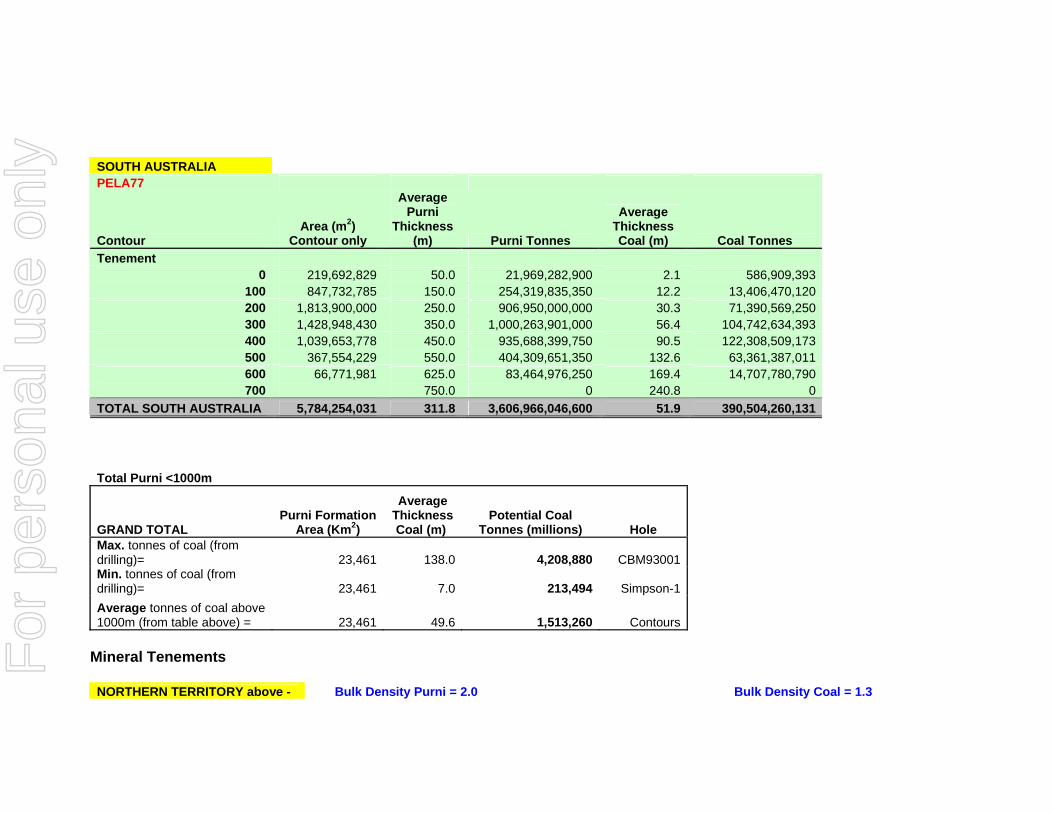
SOUTH AUSTRALIA PELA77
Contour Area (m2)
Contour only
Average Purni
Thickness (m) Purni Tonnes
Average Thickness Coal (m) Coal Tonnes
Tenement 0 219,692,829 50.0 21,969,282,900 2.1 586,909,393
100 847,732,785 150.0 254,319,835,350 12.2 13,406,470,120 200 1,813,900,000 250.0 906,950,000,000 30.3 71,390,569,250 300 1,428,948,430 350.0 1,000,263,901,000 56.4 104,742,634,393 400 1,039,653,778 450.0 935,688,399,750 90.5 122,308,509,173 500 367,554,229 550.0 404,309,651,350 132.6 63,361,387,011 600 66,771,981 625.0 83,464,976,250 169.4 14,707,780,790 700 750.0 0 240.8 0
TOTAL SOUTH AUSTRALIA 5,784,254,031 311.8 3,606,966,046,600 51.9 390,504,260,131
Total Purni <1000m
GRAND TOTAL Purni Formation
Area (Km2)
Average Thickness Coal (m)
Potential Coal Tonnes (millions) Hole
Max. tonnes of coal (from drilling)= 23,461 138.0 4,208,880 CBM93001
Min. tonnes of coal (from drilling)= 23,461 7.0 213,494 Simpson-1
Average tonnes of coal above 1000m (from table above) = 23,461 49.6 1,513,260 Contours
Mineral Tenements NORTHERN TERRITORY above - Bulk Density Purni = 2.0 Bulk Density Coal = 1.3
For
per
sona
l use
onl
y
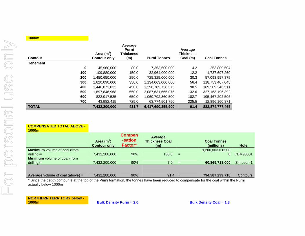
1000m
Contour Area (m2)
Contour only
Average Purni
Thickness (m) Purni Tonnes
Average Thickness Coal (m) Coal Tonnes
Tenement 0 45,960,000 80.0 7,353,600,000 4.2 253,809,504
100 109,880,000 150.0 32,964,000,000 12.2 1,737,697,260 200 1,450,650,000 250.0 725,325,000,000 30.3 57,093,957,375 300 1,620,090,000 350.0 1,134,063,000,000 56.4 118,753,407,045 400 1,440,873,032 450.0 1,296,785,728,575 90.5 169,509,346,511 500 1,897,846,968 550.0 2,087,631,665,075 132.6 327,163,196,392 600 822,917,585 650.0 1,069,792,860,500 182.7 195,467,202,506 700 43,982,415 725.0 63,774,501,750 225.5 12,896,160,871
TOTAL 7,432,200,000 431.7 6,417,690,355,900 91.4 882,874,777,465 COMPENSATED TOTAL ABOVE -1000m
Area (m2)
Contour only
Compen-sation Factor*
Average Thickness Coal
(m) Coal Tonnes
(millions) Hole Maximum volume of coal (from drilling)= 7,432,200,000 90% 138.0 =
1,200,003,012,000 CBM93001
Minimum volume of coal (from drilling)= 7,432,200,000 90% 7.0 = 60,869,718,000 Simpson-1
Average volume of coal (above) = 7,432,200,000 90%
91.4 = 794,587,299,718 Contours * Since the depth contour is at the top of the Purni formation, the tonnes have been reduced to compensate for the coal within the Purni actually below 1000m NORTHERN TERRITORY below -1000m Bulk Density Purni = 2.0 Bulk Density Coal = 1.3
For
per
sona
l use
onl
y
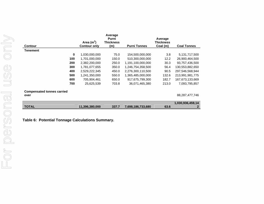
Contour Area (m2)
Contour only
Average Purni
Thickness (m) Purni Tonnes
Average Thickness Coal (m) Coal Tonnes
Tenement 0 1,030,000,000 75.0 154,500,000,000 3.8 5,131,717,500
100 1,701,000,000 150.0 510,300,000,000 12.2 26,900,464,500 200 2,382,200,000 250.0 1,191,100,000,000 30.3 93,757,436,500 300 1,781,077,655 350.0 1,246,754,358,500 56.4 130,553,882,650 400 2,529,222,345 450.0 2,276,300,110,500 90.5 297,546,568,944 500 1,241,350,000 550.0 1,365,485,000,000 132.6 213,991,981,775 600 705,904,461 650.0 917,675,799,300 182.7 167,673,133,669 700 25,625,539 703.8 36,071,465,380 213.0 7,093,795,857
Compensated tonnes carried over 88,287,477,746
TOTAL 11,396,380,000 337.7 7,698,186,733,680 63.6 1,030,936,459,14
2
Table 6: Potential Tonnage Calculations Summary.
For
per
sona
l use
onl
y
Central Petroleum UCG & GTL Potential Pedirka Basin June 2009 Page 23 of 43
11.0 SELECTED REFERENCES AusIMM, (2004): "Australasian Code for Reporting of Mineral Resources and Ore Reserves (JORC Code), prepared by the Joint Ore Reserves Committee (JORC) of the AusIMM, the Australian Institute of Geoscientists (AIG) and the Minerals Council of Australia (MCA)”, effective December 2004. AusIMM. (2005): "Code for the Technical Assessment and Valuation of Mineral and Petroleum Assets and Securities for Independent Expert Reports (the VALMIN Code)" 2005 Edition. AusIMM, (1998): "Valmin 94 - Mineral Valuation Methodologies" Canadian Institute of Mining, Metallurgy and Petroleum, (2000), "ClM Standards on Mineral Resources and Reserves-Definitions and Guidelines". Prepared by the CIM Standing Committee On Reserve Definitions. Adopted by CIM Council August 20, 2000. Central Petroleum Ltd (2008): Extensive geophysical and geological data, seismic sections and interpretations, Oil well geophysical & geological logs. CIM, (April 2001), "CIM Special Committee on Valuation of Mineral Properties (CIMVAL)" Discussion paper. ClM, (2003): - "Standards and Guidelines for Valuation of Mineral Properties. Final Version, February 2003". Special Committee of the Canadian Institute of Mining, Metallurgy and Petroleum on Valuation of Mineral Properties (CIMV AL). Kilburn, LC, (1990): "Valuation of Mineral Properties which do not contain Exploitable Reserves" CIM Bulletin, August 1990. Mulready, J, (2007): The Unconventional Petroleum Potential of EP93 & EPAs 130, 131 & PELA77, Pedirka Basin, Onshore NT & SA, Australia. PIRSA, (1998) –Prospectivity of the Pedirka Basin. Rudenno, (1998): "The Mining Valuation Handbook". ++++++++++++++++++++++++++++++++++++++++++++++++++++++++++= From: http://www.ergoexergy.com/eucg.htm - Ergo Energy UCG notes The εUCG technology uses a variety of modern drilling methods, including high-precision directional holes, as well as conventional vertical and inclined (or angled) holes. In its arsenal are various methods of well-linking, the capability to inject different oxidants (air, enriched air, O2/H2O, CO2/O2 and so on), and a great variety of designs of underground gasifiers. It can be applied to coal in a wide range of geological conditions, with the following preferred parameters:
• Coal seam thickness from 0.5 to 30 m.
For
per
sona
l use
onl
y
Central Petroleum UCG & GTL Potential Pedirka Basin June 2009 Page 24 of 43
• Dip from 0o to 70o.
• Depth from 30 to 800 m.
• Calorific value (LHV) from 8.0 to 30.0 MJ/kg (which includes low-quality lignite and bituminous coal).
Unmined and un-minable coal deposits, with such obstacles to mining as high fault frequency, volcanic intrusions and other complex depositional and tectonic features, have been often found a part of the εUCG resource base. In every geological setting, a specific εUCG design will be tailor-made to fit the unique conditions of a target coal seam.
Normally, εUCG is applied to relatively deep coal in water-saturated conditions, although it is also possible to gasify unsaturated coal seams that lie above the water table.
εUCG is an industrial technology that operates large-scale gas production facilities consisting of multiple modules or gasifiers.
The specific benefits of operating a large εUCG underground gasifier include the following:
• A practically unlimited supply of coal will be available for gasification; no external coal and water supply is required to sustain the reaction.
• The εUCG process creates an immense underground gas and heat storage capacity, making the gas supply very stable and robust.
• An underground gasifier comprises a number of underground reactors with largely independent outputs. The gas streams from different reactors can be mixed as required, to ensure consistency of overall gas quality. The outputs of reactors can also be varied, in order to optimize coal extraction and overall gas output from the gasifier.
• No ash or slag removal and handling are necessary, since inert material predominantly remains in the underground cavities.
• Ground water influx into the gasifier creates an effective "steam jacket" around the reactor, making the heat loss in situ tolerably small.
• Optimal pressure in the underground gasifier promotes groundwater flow into the cavity, thus confining the chemical process to the boundaries of the gasifier and preventing contamination of the underground environment.
Multiple gasifiers may be required to supply fuel to an industrial consumer; the exact number will depend on the size of the fuel supply required and the precise geology of the coal deposit targeted. ++++++++++++++++++++++++++++++++++++++++++++ From: http://www.lincenergy.com.au/process.php Linc Energy
For
per
sona
l use
onl
y
Central Petroleum UCG & GTL Potential Pedirka Basin June 2009 Page 25 of 43
11.1 PROCESS OVERVIEW
COAL TO GAS . GAS TO DIESEL .. GAS TO POWER
Underground Coal Gasification (UCG) clean coal technology is a proven underground combustion process, which produces a synthetic gas or syngas at the surface that can be economically used for a variety of purposes including:
• Production of liquid fuels using Coal To Liquids technology
• Electricity generation using gas turbines / combined cycles
• As feedstock in different petrochemical processes
UCG clean coal technology has been successfully operating commercially at a number of sites in the ex-Soviet Union for more than 40 years, where two plants are still in operation. In this application the Syngas is used primarily for power generation and heating.
Linc Energy through an extensive R&D programme, which included government support, has developed a benchmark UCG facility at Chinchilla in Queensland, Australia. This is the first facility of its kind to have achieved sustained success in the western world.
Linc Energy´s long term business plan is to use the Syngas produced via UCG as feedstock to an adjacent on-site Coal To Liquids (CTL) plant with a target production capacity of 20,000 barrels of diesel fuel per day (20,000 BPD). Most importantly, the diesel fuel produced from Linc´s Syngas will be a cleaner alternative to conventional refinery diesel.
Additionally, Linc Energy´s long term business plan is to use the Syngas produced via UCG as feedstock in a Gas Turbine or Combined Cycle plant to generate much-needed and more environmentally friendly electricity.
Bringing together the unique production processes of UCG clean coal technology and CTL presents exciting opportunities for the future of the company and the country. Linc´s Syngas is a much cheaper feedstock for the CTL process than traditional sources such as Natural Gas or Coal Gas derived from above ground coal gasification.
The unique advantage is that Linc can produce its Syngas directly from the coal seam and then feed the output straight into the CTL Plant and Power Plant planned for the Chinchilla site.
The innovative thinking that has led to this unique process combination has the potential to make Linc Energy one of the world´s leading producers and suppliers of ultra-clean liquid fuels. This has an added advantage of helping address the insatiable global demand for diesel and other liquid fuels.
For
per
sona
l use
onl
y
Central Petroleum UCG & GTL Potential Pedirka Basin June 2009 Page 26 of 43
12.0 PERSONAL DETAILS OF COMPETENT PERSONS Personal Details Allen J Maynard [Director – Al Maynard & Associates Pty Ltd (“AM&A”)]
Residential Address: 2 Marian Street, Leederville, WA, 6007, Australia.
BAppSc(Geol), MAIG, MAusIMM Qualifications
Experience Allen has continuously been engaged as a geologist in the mineral exploration and evaluation industry since 1978 working on gold, diamonds and other precious stones, base metal and platinum group minerals, coal, mineral sands and industrial minerals projects. He has explored and evaluated in more than twenty countries on the five continents and Greenland. He is a Corporate Member of the Australasian Institute of Mining and Metallurgy (MAusIMM), Member of the Australian Institute of Geoscientists (MAIG) and satisfies Australian Securities Exchange Limited (ASX) and Australian Securities and Investments Commission (ASIC) regulations and requirements to provide independent expert reports for listed and unlisted public companies.
Employment Summary
Independent Geological Consultant since 1982. Principal of AM&A.
Areas of Expertise Surface mineral exploration, project generation and valuation, design and implementation of mineral exploration programs from conception to completion. Provision of independent project appraisals and valuations for companies listed on AIM, ASX, JSE, LSE, TSE:VX Exchanges.
Personal Details Philip A Jones [Consulting Geologist – Al Maynard & Associates Pty Ltd (“AM&A”)]
Residential Address: 4 Buchan Pl, Hillarys, WA, 6025, Australia.
BAppSc(Geol), MAIG, MAusIMM Qualifications
Experience Philip has continuously been engaged as a geologist in the mineral exploration and evaluation industry since 1975 working on iron ore, gold, phosphate and base metals and industrial minerals projects. He has worked on numerous mines and exploration projects in Australia, New Zealand, Papua New Guinea, Indonesia, China and Kyrgyzstan. He is a Corporate Member of the Australasian Institute of Mining and Metallurgy (MAusIMM), Member of the Australian Institute of Geoscientists (MAIG).
Employment Summary
Independent Geological Consultant since 1992 as well as employed by CRA (Rio Tinto) Christmas Island Phosphates P/L, Nevoria Gold Mines P/L, Aurora Gold NL.
Areas of Expertise Resource estimation, project evaluation, mine geologist.
For
per
sona
l use
onl
y
Central Petroleum UCG & GTL Potential Pedirka Basin June 2009 Page 27 of 43
13.0 DEFINITION OF TERMS Units B billion cm centimetre g gram g/cc gram per cubic centimetre or per centilitre ha Hectare hrs hours K one thousand units kg kilogram km kilometre kt thousand metric tonnes ktpm thousand metric tonnes per month M metre m2 square metre – measure of area m3 cubic metre mm millimetre mpa metres per annum M million Mt million metric tonnes Mtpa million metric tones per annum pa per annum pha per Hectare S second T metric tonne tpa metric tonne per annum tpd metric tonne per day tpm metric tonne per month tm-3 density measured as metric tonnes per cubic metreAUD Australian Dollar
Glossary of Terms anticline arch-shaped fold in rocks, closing upwards, with the oldest rocks in the core antiformal arch-shaped rock structure, closing upwards, but in which it may not be
possible to determine the oldest rocks arenaceous term describing sedimentary rocks with a modal grain size in the sand fraction argillaceous term describing sedimentary rocks with a modal grain size in the silt fraction assay the chemical analysis of mineral samples to determine the elemental content basinal a basin like depression that may be erosional or structural in origin braided divergence of stream channels into complex system of smaller channels calorific value The heat liberated by the coal’s complete combustion in oxygen carbonaceous carbon rich channel watercourse, also in this sense sedimentary material course
For
per
sona
l use
onl
y
Central Petroleum UCG & GTL Potential Pedirka Basin June 2009 Page 28 of 43
Glossary of Terms composite combining more than one sample result to give an average result over a larger
distance cross section a diagram or drawing that shows features transacted by a vertical plane drawn
at right angles to the longer axis of a geologic feature density measure of the relative “heaviness” of objects with a constant volume,; density
= mass/volume dilution waste which is unavoidably mined with ore dip angle of inclination of a geological feature/rock from the horizontal drill-hole method of sampling rock that has not been exposed extensional faults faulting resulting in the extension of the earth’s crust facies a rock unit defined by its composition, internal geometry and formation
environment fault the surface of a fracture along which movement has occurred fluvial pertaining to the processes and actions of a river/stream fold plastic deformation of previously horizontal rock strata graben a block of rock that lies between two faults and has moved downward to form a
depression between the two adjacent fault blocks. See also horst horst a block of rock that lies between two faults and has moved upward relative to
the two adjacent fault blocks. See also graben Indicated Mineral Resource
that part of a mineral resource for which tonnage, densities, shape, physical characteristics, grade and mineral content can be estimated with a reasonable level of confidence. it is based on exploration, sampling and testing information gathered through appropriate techniques from locations such as outcrops, trenches, pits, workings and drill holes. the locations are too widely or inappropriately spaced to confirm geological and/or grade continuity but are spaced closely enough for continuity to be assumed
Inferred Mineral Resource
that part of a mineral resource for which tonnage, grade and mineral content can be estimated with a low level of confidence. it is inferred from geological evidence and assumed but not verified geological and/or grade continuity. it is based on information gathered through appropriate techniques from locations such as outcrops, trenches, pits, workings and drill holes which may be limited or of uncertain quality and reliability
Insitu tonnage an estimated measure of mass of coal in the ground containing inherent moisture
intercalated existing or introduced between layers of a different type lineament a large-scale linear feature which expresses itself in terms of topography,
which is in itself an expression of underlying structural features
lithological geological description pertaining to different rock types Measured that part of a mineral resource for which tonnage, densities, shape, physical
For
per
sona
l use
onl
y
Central Petroleum UCG & GTL Potential Pedirka Basin June 2009 Page 29 of 43
Glossary of Terms Mineral Resource characteristics,
grade and mineral content can be estimated with a high level of confidence. it is based on detailed and reliable exploration, sampling and testing information gathered through appropriate techniques from locations such as outcrops, trenches, pits, workings and drill holes. the locations are spaced closely enough to confirm geological and grade continuity
metasediments metamorphosed sedimentary rock Mineral Resource a concentration (or occurrence) of material of economic interest in or on the
earth’s crust in such form, quality and quantity that there are reasonable and realistic prospects for eventual economic extraction. the location, quantity, grade, continuity and other geological characteristics of a mineral resource are known, estimated from specific geological evidence and knowledge, or interpreted from a well constrained and portrayed geological model. Mineral resources are sub-divided in order of increasing confidence, in respect of geoscientific evidence, into inferred, indicated and measured categories
moisture inherent water content in coal expressed as a percentage normal fault fault in which the hangingwall moves downward relative to the footwall petrographic systematic description and interpretation of rock textures and mineralogy in
thin section sedimentary pertaining to rocks formed by the accumulation of sediments, formed by the
erosion of other rocks
sill a thin, tabular, horizontal to sub-horizontal body of igneous rock formed by the injection of magma into planar zones of weakness
stratigraphy study of stratified rocks in terms of time and space strike direction of line formed by the intersection of strata surfaces with the horizontal
plane, always perpendicular to the dip direction
subcrop describing a rock stratum that unconformably underlies another rock stratum syncline concave fold in stratified rock in which the strata dip down to meet in a trough unconformity buried erosion surface separating two rock masses; older exposed to erosion
for long interval of time before deposition of younger
vitrinite a maceral, or petrological unit of coal, analogous to a mineral in non-organic rock
Washproduct an analytical compositing verification and simulation software program yield the actual quantity of product realised after the mining and treatment process.
Abbreviations
For
per
sona
l use
onl
y
Central Petroleum UCG & GTL Potential Pedirka Basin June 2009 Page 30 of 43
Abbreviations ABARE Australian Bureau of Agricultural and Resource Economics AMSL above mean sea-level CPI Consumer Price Index GIS Geographical Information System GPS Global Positioning System GDP Gross Domestic Product JORC Joint Ore Reserves Committee of the Australasian Institute of Mining and Metallurgy PCI pulverised coal injection QA/QC Quality Assurance and Quality Control RC Reverse circulation RD Rotary drill
For
per
sona
l use
onl
y
Central Petroleum UCG & GTL Potential Pedirka Basin June 2009 Page 31 of 43
Appendix 2
Prepared by Holt Payton Campbell of Perth
Appraisal of GTL Development Option for
Potential CBM Resource of the Pedirka Basin
Commissioned by Central Petroleum Limited,
January 2007
This report presents a brief review of options for large scale commercial development of potentially very large coal bed methane (CBM) resource in Central Petroleum’s Pedirka Basin acreage in Central Australia. It provides a preliminary appraisal of the technical and economic aspects of production and marketing of synthetic petroleum products utilising current gas-to-liquids (GTL) technology to process coal bed methane. This report does not attempt to produce profit forecasts for Central and should not be relied upon as a basis for investment in a GTL development for Central’s potential CBM resource in the Pedirka Basin. This report is intended to provide specialist information on GTL options to support an independent geological study by Mulready Consulting Services Pty Ltd on the potential for non-conventional hydrocarbon accumulations in Central Petroleum's Pedirka Basin holdings. The authors are competent persons with considerable experience in assessing coal gasification and GTL technologies, and the assumptions used and the conclusions reached in this report are considered by them to be based on reasonable grounds and appropriate for the scope of the assignment. The report has drawn upon a number of sources including updated technical and cost related data for the Qatar Shell GTL project that is currently under construction and other public domain data last researched January 2007 to derive an analysis of the potential commercial outcomes of a conceptual 140,000 bbl/day CTL plant located near Alice Springs in Central Australia.
Estimations of plant costs and other costs are likely to escalate over time, new and improved technology is likely to be developed and no forecasts of oil prices can be made nor is attempted except to note the currently accepted outlook of the International Energy Agency.
For
per
sona
l use
onl
y

Central Petroleum UCG & GTL Potential Pedirka Basin June 2009 Page 32 of 43
Disclaimer
This Technical Note has been prepared on behalf of and for the exclusive use of Central Petroleum Limited and is subject to and issued in accordance with the agreement between Central Petroleum Limited and Holt Campbell Payton Pty Ltd. Holt Campbell Payton Pty Ltd accepts no liability or responsibility whatsoever in respect of any use of or reliance upon this report by any third party.
Copying this report without the permission of Central Petroleum Limited is not permitted.
For
per
sona
l use
onl
y
Central Petroleum UCG & GTL Potential Pedirka Basin June 2009 Page 33 of 43
Note about Authors
This report was prepared by Principal Consultants, Dave Holt and Jake DeBoer of Holt Campbell and Payton Pty Ltd, a firm providing feasibility and costing analyses for a number of applications in energy project developments. Dave Holt – MEngSc, M.E. – is a partner in Perth-based consulting engineering practice (HCP Pty Ltd) who has had a key involvement in several conceptual developments for coal gasification and synfuels. He has over 35 years in project development, project management and engineering in oil and gas and power fields. Relevant experience includes power station work with Collie coal, project management of Woodside’s North Rankin gas recycling (enhanced condensate recovery) project, and recently, owner’s facilities engineer for OMV’s Patricia-Baleen offshore gasfield development in Eastern Victoria. Jake DeBoer – MSc (Chem Eng.) B.Comm – is a Principal Consultant with over 24 years experience, specialising in synfuels project development, Fischer-Tropsch technology, coal gasification, alternative / renewable energy and implementation strategy and management. He was previously with Sasol Technology based in Johannesburg, South Africa where he had been Manager of New Ventures Assessment and previously Chief Chemical Engineer. Jake moved to Australia in 2003 and was involved with APEL’s Victorian Power and Liquids project through HCP. He is currently with GHD Engineers as Principal Chemical Engineer where he has recently been involved with various coal-to-liquids developments
For
per
sona
l use
onl
y

Central Petroleum UCG & GTL Potential Pedirka Basin June 2009 Page 34 of 43
Table of Contents
1 INTRODUCTION 35
Resource Magnitude 35
2 MARKETING OPTIONS 35 LNG 35 Pipeline Gas 35 Gas-to-Liquid (GTL) 36
3 SYNTHETIC DIESEL MARKET 36 Australian Context 36 Global Fuels Market 36 Global Trend Towards Diesel Cars 37
4 LARGE SCALE GTL PLANT 37 Qatar Shell GTL 38
5 INDICATIVE ECONOMICS OF A LARGE SCALE GTL DEVELOPMENT 39 Capital Cost 39 Reference GTL Product Selling Price 40 Cost of Production 40
6 CONCLUSION 42
For
per
sona
l use
onl
y
Central Petroleum UCG & GTL Potential Pedirka Basin June 2009 Page 35 of 43
1 INTRODUCTION This report presents a brief review of options for large scale commercial development of a potentially very large coal bed methane resource in Central Petroleum’s Pedirka Basin acreage in Central Australia.
Central has undertaken several studies of the viability of gas to liquids conversion and its many variants for a proposed Fischer Tropsch GTL plant with capacity ranging from 2,500-10,000-50,000 plus bbls/day located at Alice Springs and drawing upon possible undiscovered resources in conventional reservoirs in their acreage. A much larger GTL development is considered here for the Pedirka Basin acreage. It is based on Shell's 140,000 bbl/day GTL plant, presently under construction in Qatar, which is the largest GTL project to date.
Resource Magnitude According to the Independent Geologist’s Report provided by Mulready Consulting Services, the possible original gas in place (OGIP) coal bed methane resource of Central's acreage in the Pedirka basin, is inferred to be 67.7 TCF .The associated anticipated recoverable gas is believed to range between 50TCF and 24 TCF. This represents a significant gas resource by any world-scale standard. It should be noted that the proved, probable and possible gas reserves in the discovered North West Shelf fields, North Rankin, Goodwyn, Perseus and Angel, have an estimated total OGIP of 30 TCF. As such, the Pedirka Basin CBM resource should lend itself to large scale development to bring this nationally important energy resource to market. With present technology, there are several options that could be considered.
2 MARKETING OPTIONS LNG
Notwithstanding the large prospective recoverable gas resources potentially available, remoteness from shipping ports would be expected to make this resource relatively unattractive for export as LNG. Although it could be feasible to convey dried gas by pipeline to an LNG plant at a port location (~ 1500km-Port Darwin) it is unlikely to be competitive with gas from an offshore gas field. A typical LNG facility processing 1400 mmscfd (0.5 TCF per year) would produce approximately 10.2 million tons per annum (tpa) of LNG. As a benchmark, the Woodside LNG plant on the Burrup peninsula in Western Australia presently produces about 12 million tpa of LNG. Pipeline Gas
The existing pipeline infrastructure from Moomba in the Cooper basin to the markets in the East Coast has a ultimate capacity of about 0.3 TCF/year. The option of installing a pipeline from the Pedirka through to Moomba, a distance of approximately 750km, would ensure continuation of gas supply through this system for many years to come, but would hardly exploit the large gas resource available to meet future energy need and is probably more viable when and if gas prices reach A$5/gigajoule in today’s money. F
or p
erso
nal u
se o
nly
Central Petroleum UCG & GTL Potential Pedirka Basin June 2009 Page 36 of 43
GastoLiquid (GTL)
Synthetic fuels are a new generation of near zero sulphur and aromatics transport fuels made with the Fischer Tropsch process from natural gas (GTL), coal (CTL) or biomass (BTL). The process produces typically 70 percent synthetic diesel and 30 percent naphtha, a premium sulphur-free chemical feedstock which is also an excellent gas turbine fuel. At present, a modest amount of synthetic diesel is made commercially by Shell (Malaysia) and SASOL and PetroSA (South Africa). A number of large scale plants are now being built or planned and product availability (although representing only a relatively small fraction of total middle distillate products on the world market) is expected to increase significantly from 2010 onwards. The largest plant presently under construction is the Qatar Shell ("Pearl") GTL facility which will process 1400 mmscfd (0.5 TCF per year) of dry gas to produce 140,000 bpd of GTL fuels. A facility such as this (or several such facilities) could effectively convert the CBM resources of the Pedirka basin into clean useful transport fuels over a reasonable timescale. With GTL technology, the inferred possible recoverable 50.7 TCF CBM resource of the Pedirka basin would be equivalent to a huge oilfield with an inventory of 5.7 billion barrels of ultra-clean premium transport fuel, which because of its high value could be transported via rail link from Alice Springs or other suitable loading facilities on sidings to Port Darwin for export from central Australia. Rail transport costs to Darwin from central Australia are anticipated to be approximately A$3.50/bbl or less in high volume shipments. A resource of this magnitude could have strategic significance in both a military and a politico-economical sense for Australia and or its allies.
3 SYNTHETIC DIESEL MARKET
Demand for GTL fuel is essentially new and is expected to expand quickly, with much opportunity for producers who enter the market early. Australian Context
Last August (2006), the Australian Federal Government announced its intention to promote the development of a synthetic fuels industry to produce liquid transport fuels from coal and gas and "to position Australia as a leader in gas-to-liquids and coal-to-liquids". This followed disclosure that the nation's oil production had fallen a further 10 per cent last financial year. Fuel supplied in the Australian market is dominated by fuel refined in Australia from local or imported crude. In 2004/05 roughly two-thirds of refinery feedstock was imported, the remainder being supplied from declining local resources. Furthermore, about one quarter of the diesel consumed in Australia was imported as refined product (23 million bbl/year), mainly from Singapore. Global Fuels Market
Diesel and jet fuel are the fastest growing segments of the refined products market. The International Energy Agency reports that the demand for diesel in OECD countries has grown at nearly 3% per year over the last decade and is currently about 13.6 million barrels per day. Much of this growth is attributed to the swing towards high-efficiency diesel motor vehicles in Europe in recent years where around half the new passenger vehicles produced are now diesel engined. According to the Petroleum Economist, global diesel demand is likely to continue to grow at around 3% per year while demand for certain other refined products is likely to flatten and even decline.
For
per
sona
l use
onl
y
Central Petroleum UCG & GTL Potential Pedirka Basin June 2009 Page 37 of 43
The refining industry faces significant challenges both to meet future diesel demand and to produce cleaner diesel. Concerns over air pollution in many jurisdictions have led to a continuing tightening of diesel vehicle emission specifications. Vehicle manufacturers have improved exhaust treatment technology and enhanced engines significantly, but these technology advances have required the introduction of clean diesel fuels. Significant refinery investment is being required to meet the sulphur-free specifications as well as tight specifications for other parameters such as cetane (min 51) and polyaromatic hydrocarbons (max 11%wt). GTL diesel can make up the supply shortfall in both quantity and quality. With a high cetane number and near zero sulphur and aromatics, GTL diesel is considered an exceptionally clean motor fuel. It can be used either as ultra-clean diesel in itself or as a blend with refinery diesel - which produces a fuel with lower emissions and will meet the clean fuel specifications of tomorrow. Typically, the diesel yield of GTL plants, at 70%, is higher than refineries, at 40%. Global Trend Towards Diesel Cars
Advanced diesel technology offers better fuel efficiency, more power and more durability, as well as quiet, clean, premium vehicles that were previously the domain of petrol cars. Over 40% of new passenger cars in Europe now have diesel engines compared to less than 20% a decade ago. Initially, fuel tax and vehicle sales tax policies drove diesel uptake in Europe, although it is likely that consumer preference for power and comfort is now a significant factor. Well over 60% of new passenger cars, and over 80% of luxury cars, are diesels. This trend has now spread to China and South-east Asian countries and, with the recent introduction of ultra-low sulphur diesel spec fuels is expected to spread rapidly in North America. A switch from “gasoline” to diesel in North America is expected to put significant strain on global refining capacity since the yield of diesel that can be obtained from crudes is limited to about 40 percent while markets have to be found for the other products. For Australia, with its abundant but remote gas resources such as the Pedirka basin’s CBM, GTL technology offers a new value-adding industry opportunity capitalising on the global trend toward diesel and a pathway to best meet sustainable transport objectives. 4 LARGE SCALE GTL PLANT A large scale development of the Pedirka basin CBM would be expected to attract interest from major developers of GTL projects such as Shell, Sasol-Chevron, ExxonMobil or StatOil-PetroSA. As such, it is envisaged that the first plant might be similar to the largest GTL facility presently under construction which is the Qatar Shell Pearl GTL project. This plant consists of eight process trains of a design similar to that of the two-train Oryx GTL (34,000 bpd) which recently went into service in Qatar. The sheer size of the undertaking means that it would need to be supported by a substantial industrial infrastructure and associated community such as has grown up around the mining industry at Mt Isa or the offshore petroleum industry at Karratha for example. In respect of a Central Australian development, there is already a well established community and industrial infrastructure at Alice Springs which can be built upon. It is assumed, therefore, that the plant would be best located at the Brewer industrial area near Alice Springs and that gas would be conveyed by pipeline to that location from a central compression station in the Pedirka gathering system some 280km away.
For
per
sona
l use
onl
y
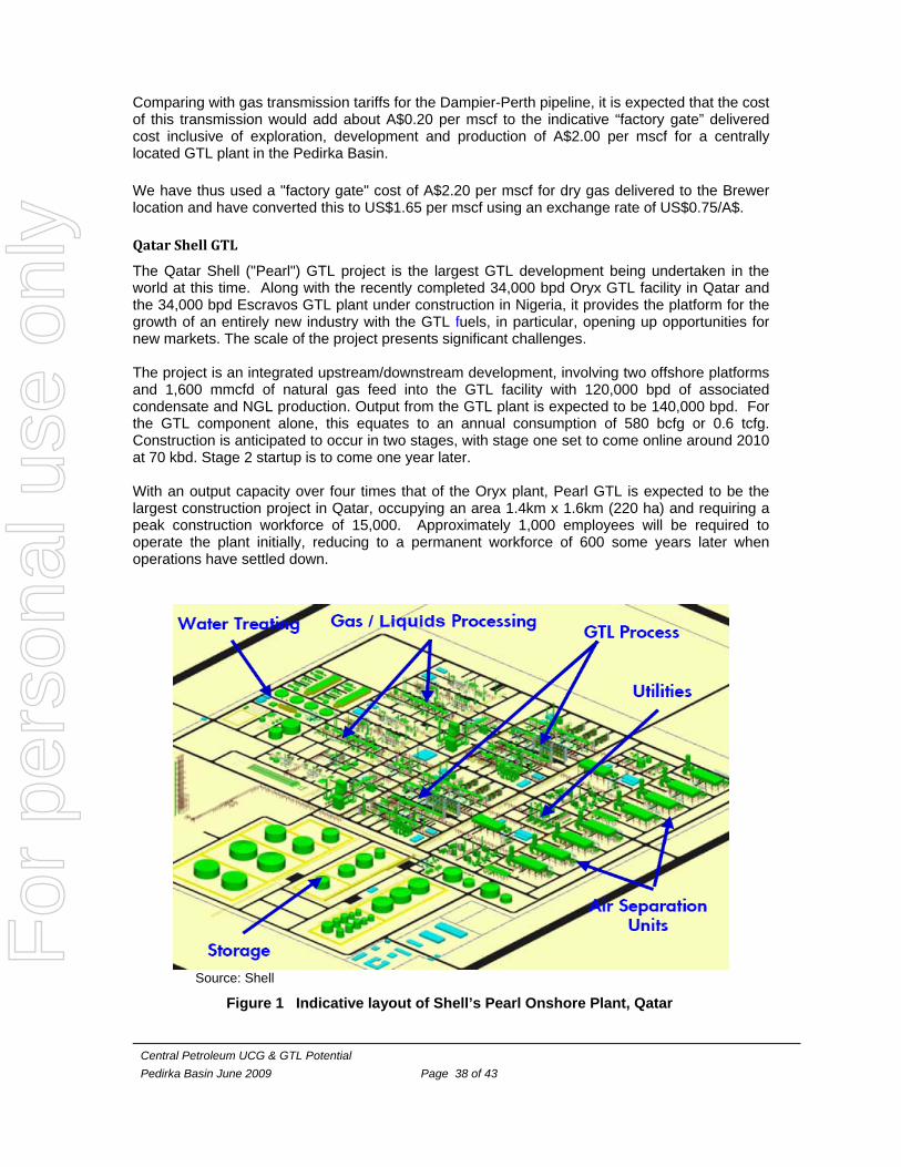
Central Petroleum UCG & GTL Potential Pedirka Basin June 2009 Page 38 of 43
Comparing with gas transmission tariffs for the Dampier-Perth pipeline, it is expected that the cost of this transmission would add about A$0.20 per mscf to the indicative “factory gate” delivered cost inclusive of exploration, development and production of A$2.00 per mscf for a centrally located GTL plant in the Pedirka Basin. We have thus used a "factory gate" cost of A$2.20 per mscf for dry gas delivered to the Brewer location and have converted this to US$1.65 per mscf using an exchange rate of US$0.75/A$. Qatar Shell GTL
The Qatar Shell ("Pearl") GTL project is the largest GTL development being undertaken in the world at this time. Along with the recently completed 34,000 bpd Oryx GTL facility in Qatar and the 34,000 bpd Escravos GTL plant under construction in Nigeria, it provides the platform for the growth of an entirely new industry with the GTL fuels, in particular, opening up opportunities for new markets. The scale of the project presents significant challenges. The project is an integrated upstream/downstream development, involving two offshore platforms and 1,600 mmcfd of natural gas feed into the GTL facility with 120,000 bpd of associated condensate and NGL production. Output from the GTL plant is expected to be 140,000 bpd. For the GTL component alone, this equates to an annual consumption of 580 bcfg or 0.6 tcfg. Construction is anticipated to occur in two stages, with stage one set to come online around 2010 at 70 kbd. Stage 2 startup is to come one year later. With an output capacity over four times that of the Oryx plant, Pearl GTL is expected to be the largest construction project in Qatar, occupying an area 1.4km x 1.6km (220 ha) and requiring a peak construction workforce of 15,000. Approximately 1,000 employees will be required to operate the plant initially, reducing to a permanent workforce of 600 some years later when operations have settled down.
Source: Shell
Figure 1 Indicative layout of Shell’s Pearl Onshore Plant, Qatar
For
per
sona
l use
onl
y
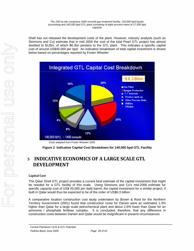
Central Petroleum UCG & GTL Potential Pedirka Basin June 2009 Page 39 of 43
The 230 ha site comprises 1600 mmscfd gas treatment facility, 120,000 bpd liquids processing and 140,000 bpd GTL plant consisting of eight process trains of 17,500 bpd
capacity Shell has not released the development costs of the plant. However, industry analysts (such as Simmons and Co) estimate that in mid 2006 the cost of the total Pearl GTL project has almost doubled to $12bn, of which $6.3bn pertains to the GTL plant. This indicates a specific capital cost of around US$45,000 per bpd. An indicative breakdown of total capital investment is shown below based on percentages reported by Foster Wheeler
Chart adapted from Foster Wheeler 2005
Figure 2 Indicative Capital Cost Breakdown for 140,000 bpd GTL Facility
5 INDICATIVE ECONOMICS OF A LARGE SCALE GTL DEVELOPMENT
Capital Cost
The Qatar Shell GTL project provides a current best estimate of the capital investment that might be needed for a GTL facility of this scale. Using Simmons and Co's mid-2006 estimate for specific capacity cost of US$ 45,000 per daily barrel, the capital investment for a similar project, if built in Qatar would thus be expected to be of the order of US$6.3 billion. A comparative location construction cost study undertaken by Brown & Root for the Northern Territory Government (2001) found that construction costs for Darwin were an estimated 1.3% higher than Qatar for a large scale petrochemical plant and about 2.6% lower than Qatar for an ammonia / phosphate fertiliser complex. It is concluded, therefore, that any difference in construction costs between Darwin and Qatar would be insignificant in present circumstances
For
per
sona
l use
onl
y
Central Petroleum UCG & GTL Potential Pedirka Basin June 2009 Page 40 of 43
Taking into account that the reduction in complexity of non-cyclonic standard of construction for Central Australia compared with Darwin could well offset the logistics issues associated with building a large industrial plant near Alice Springs, it is considered that the capital cost of a 140,000 bpd plant would be about the same as if built in Qatar. Total plant investment cost, excluding Darwin marine terminal, would thus be approximately US$6.3 billion.
Reference GTL Product Selling Price
Average Singapore refining spread has risen US$12-15 per bbl over the last two years and the underlying factors that have caused this, (namely decline of spare refining capacity, increasing use of heavy crudes and tighter sulphur specifications) seem unlikely to disappear in the foreseeable future. With the product slate for a GTL plant being typically diesel, 72%, and naphtha, 28%, the refining differential for the GTL slate as a whole has averaged US$11.5 /bbl over the last two years. Product freight costs have also increased sharply over the past few years and are currently over US$4/bbl according to Caltex Australia. The cost of importing diesel from Singapore includes the Singapore FOB price plus the freight cost. This would give a US$4/bbl advantage to an Australian producer selling to the local market over that for an export market which would be at Singapore competitive pricing. Therefore, for this indicative economic appraisal, it is assumed that the product would be sold into the Australian market and that the average wholesale price of GTL fuels would be approximately US$15.5 above the Dubai crude price. Cost of Production
Estimated cost per barrel for the GTL plant is as follows:
Cost Component Ref. Rate US$/bbl
Natural Gas Feedstock [10.0 mscf/bbl] A$2.25/mscf 16.5
Capital (assumed 90% capacity factor) 15%pa of TDC 20.5
Operating and Maintenance 6.5
Transport from Plant to Port 2cents(A) /ntkm 2.5
Total Cost of Production (& Transport) 46.0
A delivered cost of US$46.0 /bbl would be the same as the landed cost of similar petroleum products imported from Singapore with Dubai crude at US$30.5 /bbl.
For
per
sona
l use
onl
y
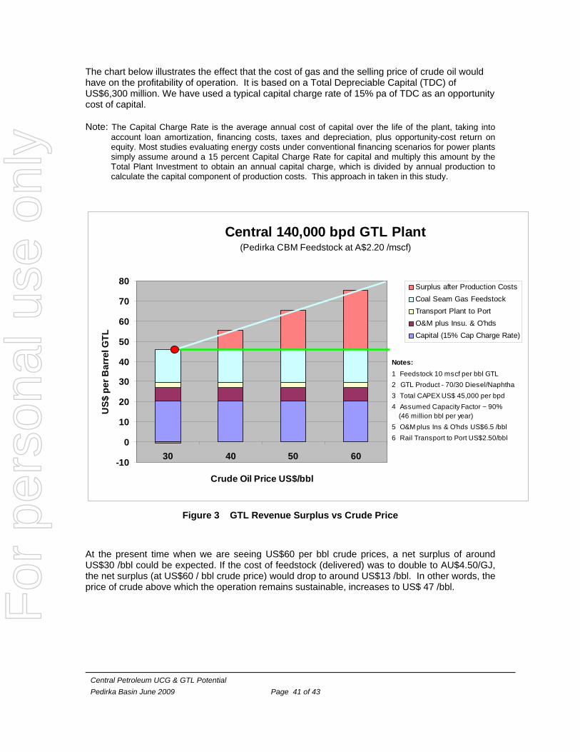
Central Petroleum UCG & GTL Potential Pedirka Basin June 2009 Page 41 of 43
The chart below illustrates the effect that the cost of gas and the selling price of crude oil would have on the profitability of operation. It is based on a Total Depreciable Capital (TDC) of US$6,300 million. We have used a typical capital charge rate of 15% pa of TDC as an opportunity cost of capital.
Note: The Capital Charge Rate is the average annual cost of capital over the life of the plant, taking into account loan amortization, financing costs, taxes and depreciation, plus opportunity-cost return on equity. Most studies evaluating energy costs under conventional financing scenarios for power plants simply assume around a 15 percent Capital Charge Rate for capital and multiply this amount by the Total Plant Investment to obtain an annual capital charge, which is divided by annual production to calculate the capital component of production costs. This approach in taken in this study.
Central 140,000 bpd GTL Plant (Pedirka CBM Feedstock at A$2.20 /mscf)
-10
0
10
20
30
40
50
60
70
80
30 40 50 60
Crude Oil Price US$/bbl
US$
per
Bar
rel G
TL
Surplus after Production CostsCoal Seam Gas FeedstockTransport Plant to PortO&M plus Insu. & O'hdsCapital (15% Cap Charge Rate)
Notes:1 Feedstock 10 mscf per bbl GTL2 GTL Product - 70/30 Diesel/Naphtha3 Total CAPEX US$ 45,000 per bpd4 Assumed Capacity Factor ~ 90% (46 million bbl per year)5 O&M plus Ins & O'hds US$6.5 /bbl6 Rail Transport to Port US$2.50/bbl
Figure 3 GTL Revenue Surplus vs Crude Price
At the present time when we are seeing US$60 per bbl crude prices, a net surplus of around US$30 /bbl could be expected. If the cost of feedstock (delivered) was to double to AU$4.50/GJ, the net surplus (at US$60 / bbl crude price) would drop to around US$13 /bbl. In other words, the price of crude above which the operation remains sustainable, increases to US$ 47 /bbl.
For
per
sona
l use
onl
y

Central Petroleum UCG & GTL Potential Pedirka Basin June 2009 Page 42 of 43
6 CONCLUSION
If a 140,000 bpd plant (over 50 million bpa) was to be constructed of a similar size to the Shell Pearl Qatar GTL plant to process Pedirka Basin CBM, such a plant would require some 0.5 tcfg per annum of dry gas and over a 20 year life cycle would consume about 10 tcfg, which appears to be well within the broad scope of the inferred prospective recoverable resources concluded in the Independent Geologist’s Report of 50.8 TCF to 23.7 TCF.
For
per
sona
l use
onl
y