Embed Size (px)
Citation preview
Consultants in Natural Resources and the Environment
Denver 1842 Clarkson St. Denver, CO 80218 303.830.1188
Durango 1015 ½ Main Avenue Durango, CO 81301 970.422.2136
Hotchkiss P.O. Box 932 161 South 2nd St. Hotchkiss, CO 81419 970.872.3020
Idaho 4001 East Main Street Emmett, ID 83617 208.365.7684 www.eroresources.com
ERO Resources Corp.
November 4, 2015
To: Mr. Steve Rogers, Project Manager, Golder Associates Inc.
From: Karen Baud, ERO Resources Corporation
Re: DRAFT Boxelder Watershed Dams B-2 and B-3 Watershed Plan – Wildlife Resources Summary
In support of North Poudre Irrigation Company’s (NPIC) Boxelder Watershed Dams B-2 and B-3 Watershed Plan, ERO Resources Corporation (ERO) has prepared this memorandum summarizing wildlife resources potentially occurring in or affected by activities in the B-2 and B-3 study areas (Figures 1 and 2), with a focus on resources addressed in Natural Resources Conservation Service (NRCS) Environmental Evaluation forms NRCS-WS-1R and NRCS-CPA-52. A summary of data sources and methods used to evaluate the B-2 and B-3 study areas is also provided. Vegetation communities, including wetlands, waters of the U.S., riparian habitat, potential threatened or endangered plant habitat, and noxious weeds in the study areas will be described in a separate memorandum provided by AlpineEco.
Methods
ERO gathered data from existing sources, such as Colorado Parks and Wildlife (CPW), U.S. Fish and Wildlife Service (USFWS), Colorado Natural Heritage Program, Colorado Breeding Bird Atlas, North American Breeding Bird Survey (BBS), and Larimer County. ERO conducted a field review of the study areas on July 18, 2015. Wildlife species or tracks, scat, songs, calls, or other signs of wildlife presence observed in the study areas were recorded. Trees within 0.5 mile of the study areas were scanned for signs of potential raptor nests. Based on the information gathered from existing sources, the initial site review, and vegetation community mapping from AlpineEco, ERO identified important wildlife attributes of the study areas.
General Wildlife Habitat
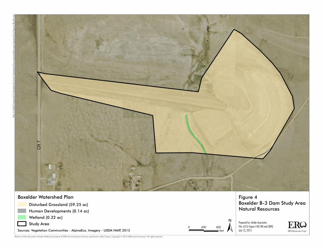
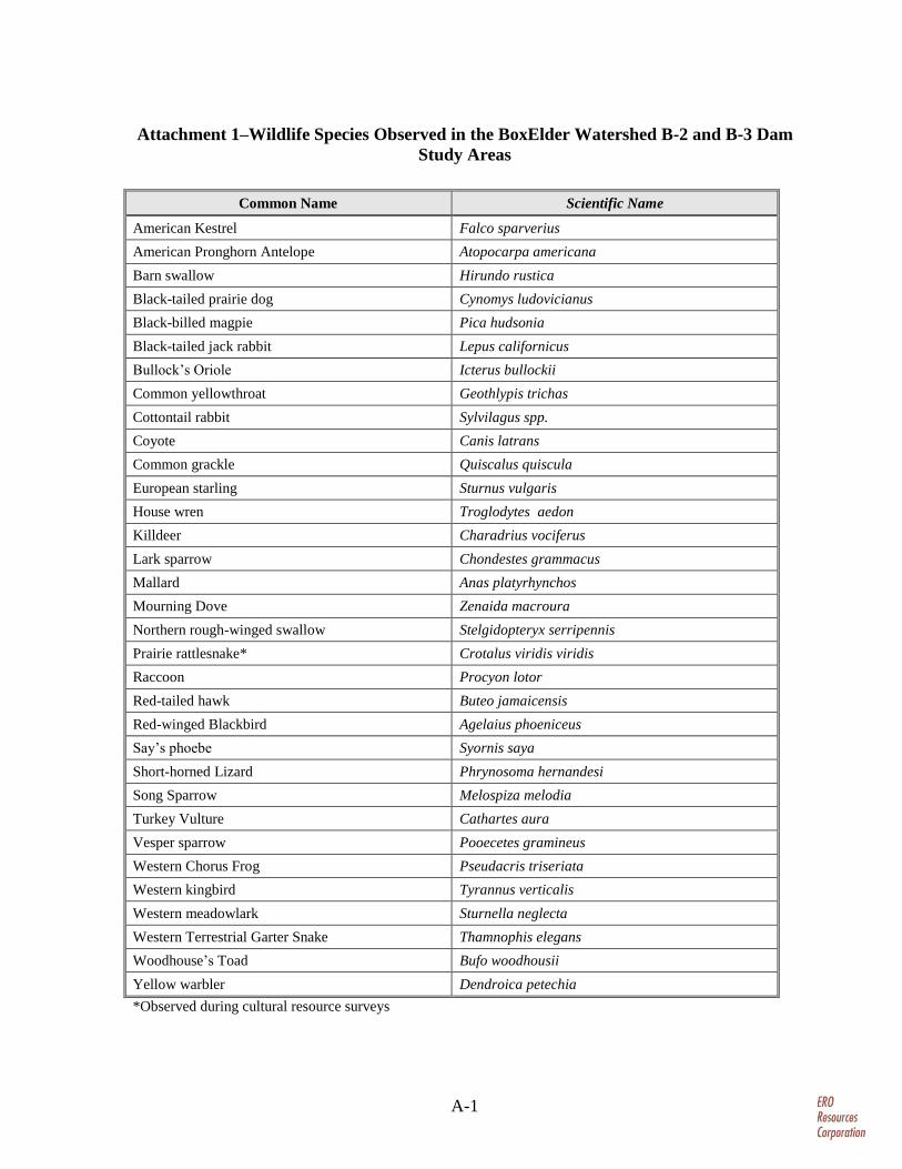
AlpineEco identified main vegetation communities providing wildlife habitat in the study areas, which are shown on Figures 3 and 4. A list of wildlife species observed in the study areas is provided in Attachment 1. The dominant vegetation type in the study areas is disturbed grassland, which provides habitat for a variety of small mammals, reptiles, amphibians, medium-sized carnivores, and birds (see attached Photos 1 through 4). Mammals occurring in grassland habitats in the study areas include herbivores such as pronghorn antelope, cottontail rabbit, and black-tailed jack-rabbit, as well as predators such as coyote. Songbird species typically associated with shortgrass and mid-grass prairie, such as the vesper sparrow, western meadowlark, and
Steve Rogers Page 2 Golder Associates Inc. November 4, 2015
ERO Resources Corporation
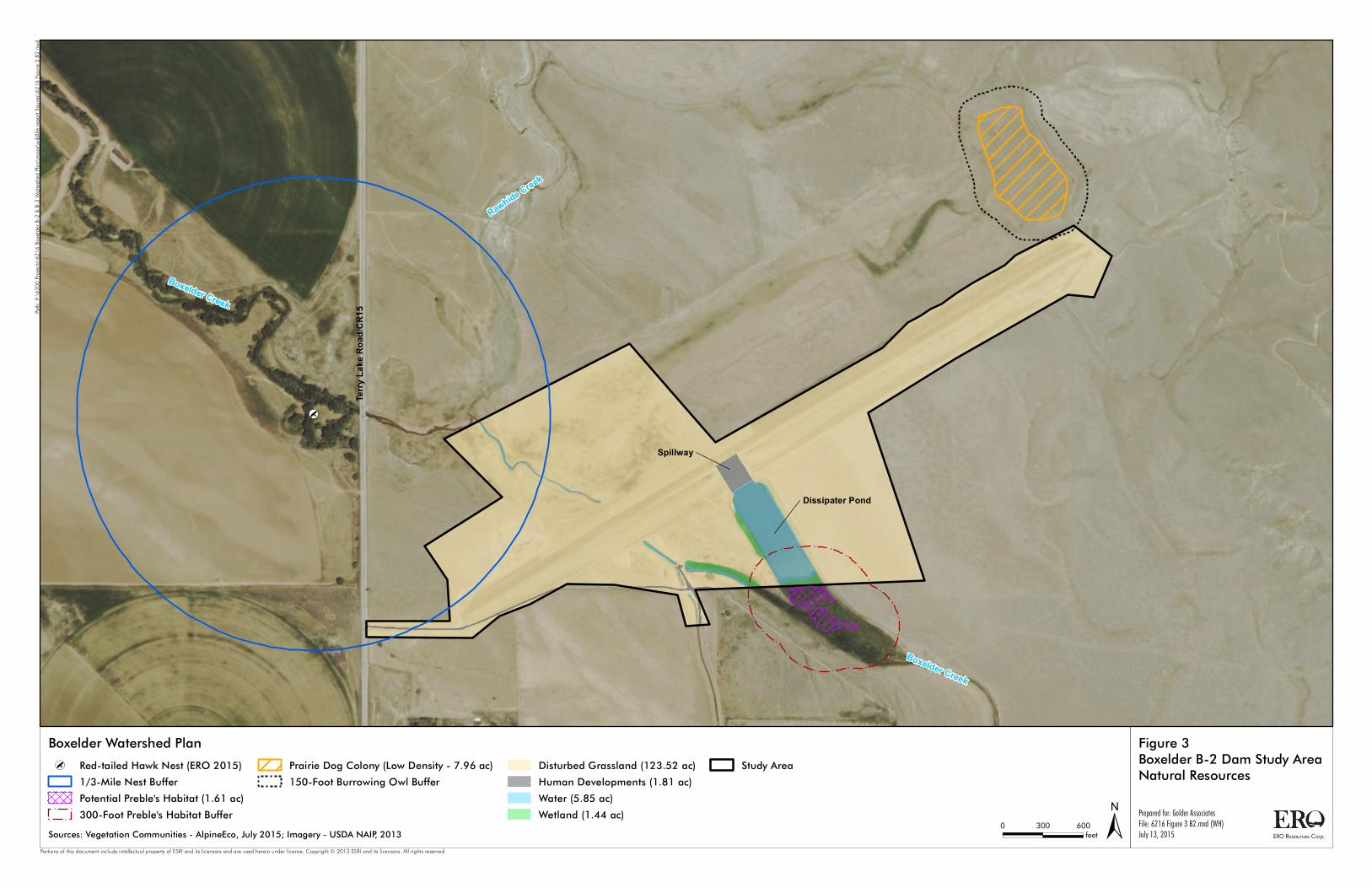
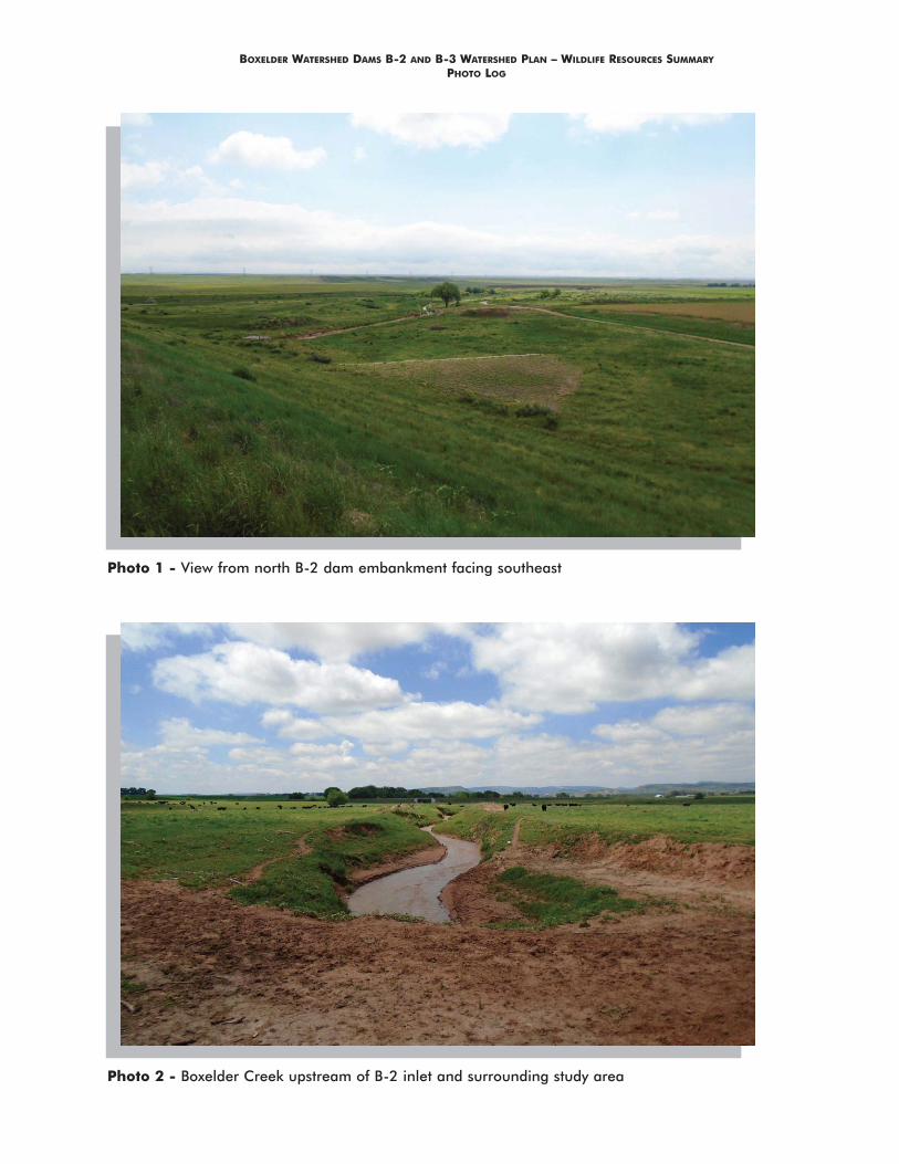
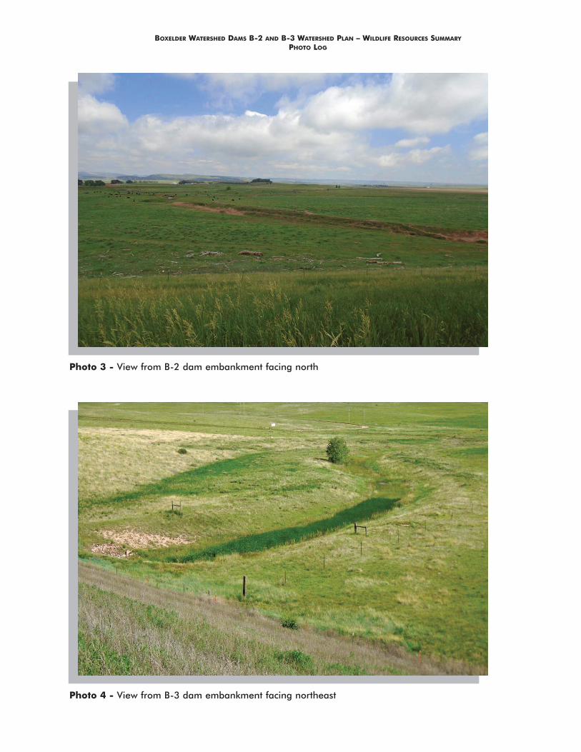
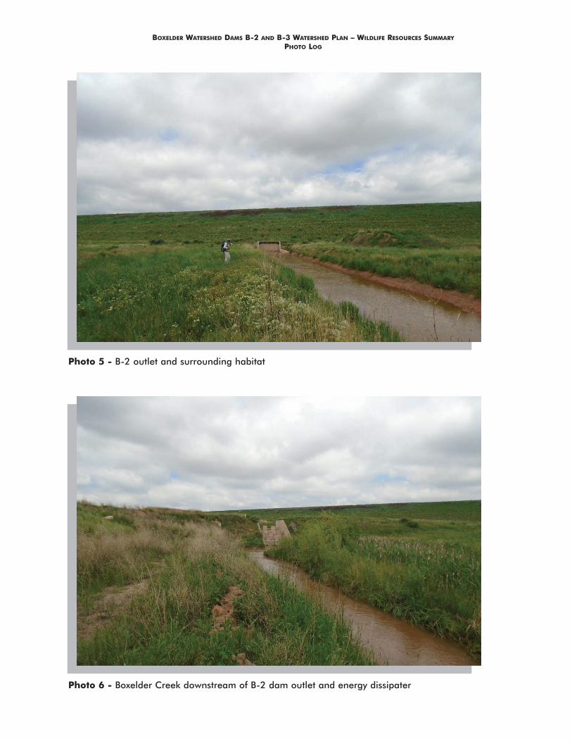
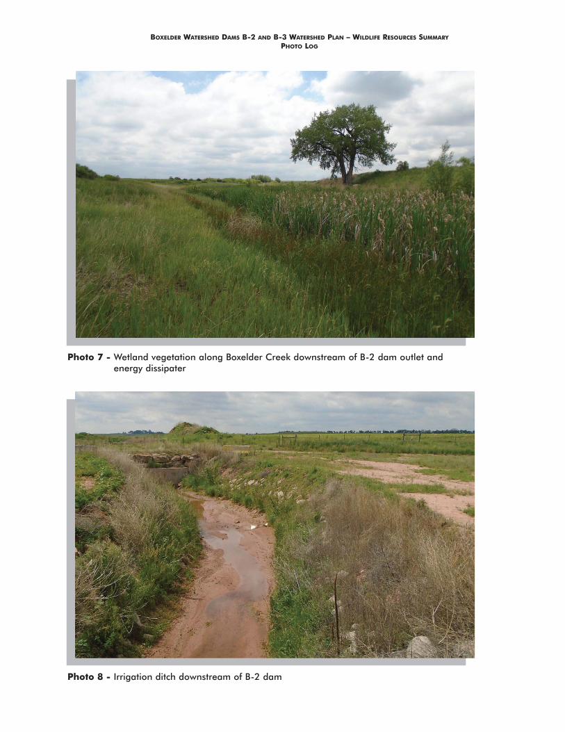
lark sparrow, are abundant in the study areas. Reptiles and amphibians observed in upland grasslands include short-horned lizard, Woodhouse’s toad, and prairie rattlesnake. One low-density (about 10 active burrows per acre) black-tailed prairie dog colony is northwest of the B-2 study area (Figure 3). In addition, one pronghorn antelope was observed in the study areas. Wetlands and waters of the US, as well as small ephemeral ponds, provide habitat for a variety of amphibians, reptiles, and birds (see attached Photos 5 through 12). In particular, the wetland area on the southern portion of the dissipater pond below the spillway provides dense cover and breeding and foraging habitat for a diverse array of amphibians, birds, and mammals. Isolated trees along Boxelder Creek below the B-2 dam and below the outlet of the B-3 dam provide patches of cover and nesting areas for birds such as western kingbird and Bullock’s oriole amidst a relatively dry and open landscape.
State Special Status Species
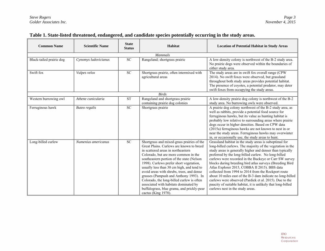
State special status species are species listed by the state of Colorado as threatened, endangered, or of concern. According to Colorado law (Colo. Rev. Stat. Ann. §§ 33-2-102-106), the state must maintain a list of species determined to be endangered or threatened within the state. State-listed wildlife species that are not already protected under the Endangered Species Act, as amended (ESA) are protected under Colorado Statute 33, which is regulated by the CPW. The suitability of the vegetation communities as habitat for wildlife species of concern was evaluated during field investigations; however, no formal surveys to determine the presence or absence of these species were conducted. State special status species potentially occurring in the study areas are shown in Table 1 below.
Of the species with potential habitat in the study areas, based on known occurrences from the nearest BBS route (Pardiek et al. 2015) COBBA II data for Buckeye and Carr SW USGS quadrangles (Breeding Bird Atlas Explorer 2015, COBBA II 2015), and Hammerson (1999), and habitat affinities described in Table 1 below, long-billed curlew, mountain plover, and northern cricket frog are unlikely to occur in the study areas. Ferruginous hawks may hunt or fly through the study areas, but are unlikely to be affected by activities at the dams.
Steve Rogers Page 3 Golder Associates Inc. November 4, 2015
ERO Resources Corporation
Table 1. State-listed threatened, endangered, and candidate species potentially occurring in the study areas.
Common Name Scientific Name State Status
Habitat Location of Potential Habitat in Study Areas
Mammals Black-tailed prairie dog Cynomys ludovicianus SC Rangeland; shortgrass prairie A low-density colony is northwest of the B-2 study area.
No prairie dogs were observed within the boundaries of either study area.
Swift fox Vulpes velox SC Shortgrass prairie, often intermixed with agricultural areas
The study areas are in swift fox overall range (CPW 2014). No swift foxes were observed, but grassland throughout both study areas provides potential habitat. The presence of coyotes, a potential predator, may deter swift foxes from occupying the study areas.
Birds Western burrowing owl Athene cunicularia ST Rangeland and shortgrass prairie
containing prairie dog colonies A low-density prairie dog colony is northwest of the B-2 study area. No burrowing owls were observed.
Ferruginous hawk Buteo regalis SC Shortgrass prairie A prairie dog colony northwest of the B-2 study area, as well as rabbits, provide a potential food source for ferruginous hawks, but its value as hunting habitat is probably low relative to surrounding areas where prairie dogs occur in higher densities. Based on CPW data (2015a) ferruginous hawks are not known to nest in or near the study areas. Ferruginous hawks may overwinter in, or occasionally use, the study areas to hunt.
Long-billed curlew Numenius americanus SC Shortgrass and mixed-grass prairies of the Great Plains. Curlews are known to breed in scattered areas in northeastern Colorado, but are more common in the southeastern portion of the state (Nelson 1998). Curlews prefer short vegetation, usually less than 30 cm high, and tend to avoid areas with shrubs, trees, and dense grasses (Pampush and Anthony 1993). In Colorado, the long-billed curlew is often associated with habitats dominated by buffalograss, blue grama, and prickly-pear cactus (King 1978).
Grassland habitat in the study areas is suboptimal for long-billed curlews. The majority of the vegetation in the study areas is generally higher and denser than typically preferred by the long-billed curlew. No long-billed curlews were recorded in the Buckeye or Carr SW survey blocks during breeding bird atlas surveys (Breeding Bird Atlas Explorer 2015, COBBA II 2015). BBS data collected from 1994 to 2014 from the Rockport route about 10 miles east of the B-3 dam indicate no long-billed curlews were observed (Pardiek et al. 2015). Due to the paucity of suitable habitat, it is unlikely that long-billed curlews nest in the study areas.
Steve Rogers Page 4 Golder Associates Inc. November 4, 2015
ERO Resources Corporation
Common Name Scientific Name State Status
Habitat Location of Potential Habitat in Study Areas
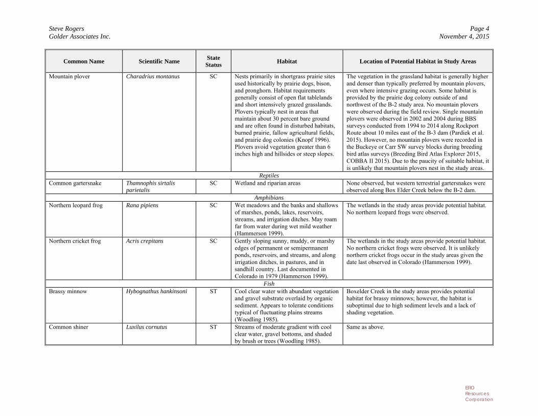
Mountain plover Charadrius montanus SC Nests primarily in shortgrass prairie sites used historically by prairie dogs, bison, and pronghorn. Habitat requirements generally consist of open flat tablelands and short intensively grazed grasslands. Plovers typically nest in areas that maintain about 30 percent bare ground and are often found in disturbed habitats, burned prairie, fallow agricultural fields, and prairie dog colonies (Knopf 1996). Plovers avoid vegetation greater than 6 inches high and hillsides or steep slopes.
The vegetation in the grassland habitat is generally higher and denser than typically preferred by mountain plovers, even where intensive grazing occurs. Some habitat is provided by the prairie dog colony outside of and northwest of the B-2 study area. No mountain plovers were observed during the field review. Single mountain plovers were observed in 2002 and 2004 during BBS surveys conducted from 1994 to 2014 along Rockport Route about 10 miles east of the B-3 dam (Pardiek et al. 2015). However, no mountain plovers were recorded in the Buckeye or Carr SW survey blocks during breeding bird atlas surveys (Breeding Bird Atlas Explorer 2015, COBBA II 2015). Due to the paucity of suitable habitat, it is unlikely that mountain plovers nest in the study areas.
Reptiles Common gartersnake Thamnophis sirtalis
parietalis SC Wetland and riparian areas None observed, but western terrestrial gartersnakes were
observed along Box Elder Creek below the B-2 dam. Amphibians
Northern leopard frog Rana pipiens SC Wet meadows and the banks and shallows of marshes, ponds, lakes, reservoirs, streams, and irrigation ditches. May roam far from water during wet mild weather (Hammerson 1999).
The wetlands in the study areas provide potential habitat. No northern leopard frogs were observed.
Northern cricket frog Acris crepitans SC Gently sloping sunny, muddy, or marshy edges of permanent or semipermanent ponds, reservoirs, and streams, and along irrigation ditches, in pastures, and in sandhill country. Last documented in Colorado in 1979 (Hammerson 1999).
The wetlands in the study areas provide potential habitat. No northern cricket frogs were observed. It is unlikely northern cricket frogs occur in the study areas given the date last observed in Colorado (Hammerson 1999).
Fish Brassy minnow Hybognathus hankinsoni ST Cool clear water with abundant vegetation
and gravel substrate overlaid by organic sediment. Appears to tolerate conditions typical of fluctuating plains streams (Woodling 1985).
Boxelder Creek in the study areas provides potential habitat for brassy minnows; however, the habitat is suboptimal due to high sediment levels and a lack of shading vegetation.
Common shiner Luxilus cornutus ST Streams of moderate gradient with cool clear water, gravel bottoms, and shaded by brush or trees (Woodling 1985).
Same as above.
Steve Rogers Page 5 Golder Associates Inc. November 4, 2015
ERO Resources Corporation
Common Name Scientific Name State Status
Habitat Location of Potential Habitat in Study Areas
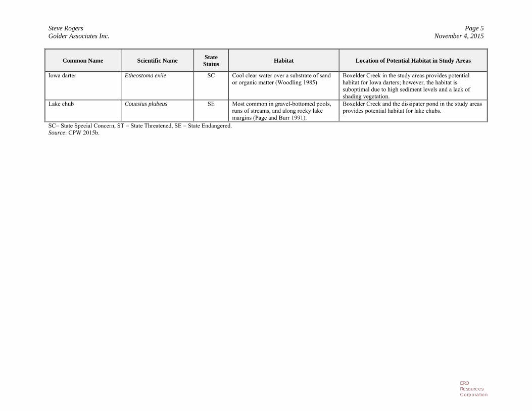
Iowa darter Etheostoma exile SC Cool clear water over a substrate of sand or organic matter (Woodling 1985)
Boxelder Creek in the study areas provides potential habitat for Iowa darters; however, the habitat is suboptimal due to high sediment levels and a lack of shading vegetation.
Lake chub Couesius plubeus SE Most common in gravel-bottomed pools, runs of streams, and along rocky lake margins (Page and Burr 1991).
Boxelder Creek and the dissipater pond in the study areas provides potential habitat for lake chubs.
SC= State Special Concern, ST = State Threatened, SE = State Endangered. Source: CPW 2015b.
Steve Rogers Page 6 Golder Associates Inc. November 4, 2015
ERO Resources Corporation
Recommendations Burrowing Owl. Burrowing owls are protected under the Migratory Bird Treaty Act (MBTA). CPW recommends no human encroachment within 150 feet of a burrowing owl nest site from March 15 through October 31 (Colorado Division of Wildlife (CDOW) 2008). CPW also recommends surveys of prairie dog colonies providing potential burrowing owl breeding habitat prior to any work that would disturb the burrows between March 15 and October 31. If burrowing owls are found within the construction footprint, CPW recommends that individual nest burrows and a 150-foot buffer around the burrow be left undisturbed during construction (CDOW 2008).
The prairie dog town northwest of the B-2 study area (Figure 2) provides potential nesting habitat for burrowing owls; however, the study area extends into a very small area within the 150-foot buffer. ERO recommends the following approach to minimize potential effects on burrowing owls:
Avoid impacts by ensuring that the construction disturbance area remains outside the 150-foot buffer. If this is not possible, avoid construction activities where the study areas and 150-foot buffer overlap.
If the above measure is not possible, coordinate with the CPW to determine if burrowing owl surveys are necessary. Typically, in cases where potential impacts on burrowing owls cannot be avoided, the CPW recommends conducting burrowing owl surveys and establishing seasonal timing restrictions within 150 feet of habitat where burrowing owls are detected. Given the small amount of habitat potentially affected and the low prairie dog density, the CPW may determine that surveys are not needed.
Swift Fox. To avoid impacts on the swift fox, in ERO’s experience, the CPW typically recommends that no surface-disturbing construction activities occur during the swift fox breeding season (January to August) in swift fox habitat. If construction must occur from January to August, preconstruction surveys for the swift fox are often recommended. ERO suggests coordinating with the CPW to determine appropriate swift fox protection measures.
Amphibians and Reptiles. To minimize impacts on amphibian species of state concern, ERO recommends avoiding impacts on wetlands. If avoidance of wetlands is not possible, wetland mitigation associated with 404 permitting, such as habitat reconstruction/replacement, would also benefit wetland-associated amphibians and reptiles. Best Management Practices (BMPs) implemented as part of a Stormwater Pollution Prevention Plan would minimize potential water quality effects on reptiles and amphibians.
State Sensitive Fish. BMPs implemented as part of a Stormwater Pollution Prevention Plan would minimize potential impacts on any state sensitive fish, as well as other aquatic organisms, that might be present in the study areas.
Steve Rogers Page 7 Golder Associates Inc. November 4, 2015
ERO Resources Corporation
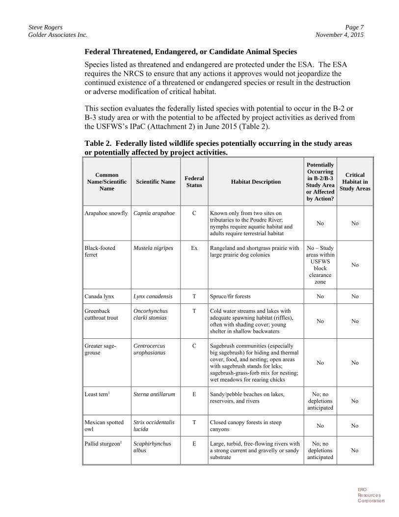
Federal Threatened, Endangered, or Candidate Animal Species
Species listed as threatened and endangered are protected under the ESA. The ESA requires the NRCS to ensure that any actions it approves would not jeopardize the continued existence of a threatened or endangered species or result in the destruction or adverse modification of critical habitat.
This section evaluates the federally listed species with potential to occur in the B-2 or B-3 study area or with the potential to be affected by project activities as derived from the USFWS’s IPaC (Attachment 2) in June 2015 (Table 2).
Table 2. Federally listed wildlife species potentially occurring in the study areas or potentially affected by project activities.
Common Name/Scientific
Name Scientific Name
Federal Status Habitat Description
Potentially Occurring in B-2/B-3 Study Area or Affected by Action?
Critical Habitat in
Study Areas
Arapahoe snowfly Capnia arapahoe C Known only from two sites on tributaries to the Poudre River; nymphs require aquatic habitat and adults require terrestrial habitat
No No
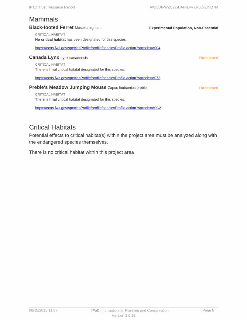
Black-footed ferret
Mustela nigripes Ex Rangeland and shortgrass prairie with large prairie dog colonies
No – Study areas within
USFWS block
clearance zone
No
Canada lynx Lynx canadensis T Spruce/fir forests No No
Greenback cutthroat trout
Oncorhynchus clarki stomias
T Cold water streams and lakes with adequate spawning habitat (riffles), often with shading cover; young shelter in shallow backwaters
No No
Greater sage-grouse
Centrocercus urophasianus
C Sagebrush communities (especially big sagebrush) for hiding and thermal cover, food, and nesting; open areas with sagebrush stands for leks; sagebrush-grass-forb mix for nesting; wet meadows for rearing chicks
No No
Least tern1 Sterna antillarum E Sandy/pebble beaches on lakes, reservoirs, and rivers
No; no depletions anticipated
No
Mexican spotted owl
Strix occidentalis lucida
T Closed canopy forests in steep canyons
No No
Pallid sturgeon1 Scaphirhynchus albus
E Large, turbid, free-flowing rivers with a strong current and gravelly or sandy substrate
No; no depletions anticipated
No
Steve Rogers Page 8 Golder Associates Inc. November 4, 2015
ERO Resources Corporation
Common Name/Scientific
Name Scientific Name
Federal Status Habitat Description
Potentially Occurring in B-2/B-3 Study Area or Affected by Action?
Critical Habitat in
Study Areas
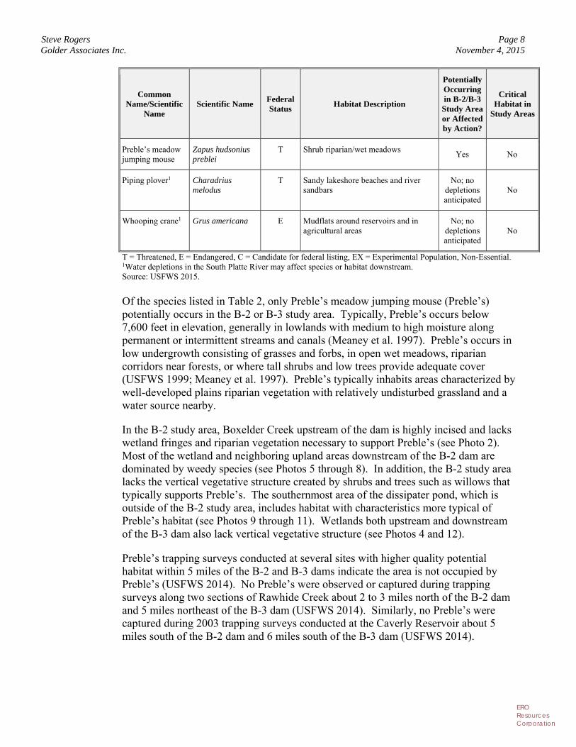
Preble’s meadow jumping mouse
Zapus hudsonius preblei
T Shrub riparian/wet meadows Yes No
Piping plover1 Charadrius melodus
T Sandy lakeshore beaches and river sandbars
No; no depletions anticipated
No
Whooping crane1 Grus americana E Mudflats around reservoirs and in agricultural areas
No; no depletions anticipated
No
T = Threatened, E = Endangered, C = Candidate for federal listing, EX = Experimental Population, Non-Essential. 1Water depletions in the South Platte River may affect species or habitat downstream. Source: USFWS 2015.
Of the species listed in Table 2, only Preble’s meadow jumping mouse (Preble’s) potentially occurs in the B-2 or B-3 study area. Typically, Preble’s occurs below 7,600 feet in elevation, generally in lowlands with medium to high moisture along permanent or intermittent streams and canals (Meaney et al. 1997). Preble’s occurs in low undergrowth consisting of grasses and forbs, in open wet meadows, riparian corridors near forests, or where tall shrubs and low trees provide adequate cover (USFWS 1999; Meaney et al. 1997). Preble’s typically inhabits areas characterized by well-developed plains riparian vegetation with relatively undisturbed grassland and a water source nearby.
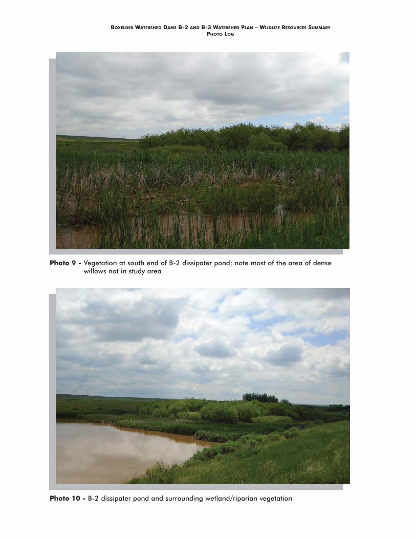
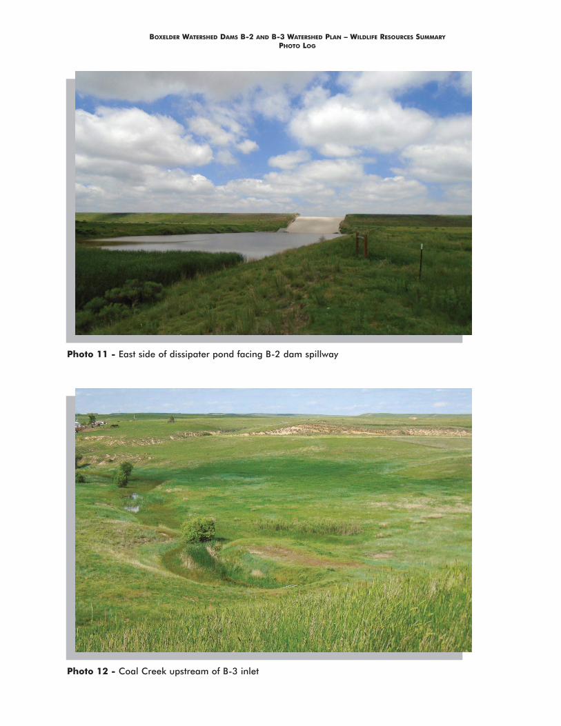
In the B-2 study area, Boxelder Creek upstream of the dam is highly incised and lacks wetland fringes and riparian vegetation necessary to support Preble’s (see Photo 2). Most of the wetland and neighboring upland areas downstream of the B-2 dam are dominated by weedy species (see Photos 5 through 8). In addition, the B-2 study area lacks the vertical vegetative structure created by shrubs and trees such as willows that typically supports Preble’s. The southernmost area of the dissipater pond, which is outside of the B-2 study area, includes habitat with characteristics more typical of Preble’s habitat (see Photos 9 through 11). Wetlands both upstream and downstream of the B-3 dam also lack vertical vegetative structure (see Photos 4 and 12).
Preble’s trapping surveys conducted at several sites with higher quality potential habitat within 5 miles of the B-2 and B-3 dams indicate the area is not occupied by Preble’s (USFWS 2014). No Preble’s were observed or captured during trapping surveys along two sections of Rawhide Creek about 2 to 3 miles north of the B-2 dam and 5 miles northeast of the B-3 dam (USFWS 2014). Similarly, no Preble’s were captured during 2003 trapping surveys conducted at the Caverly Reservoir about 5 miles south of the B-2 dam and 6 miles south of the B-3 dam (USFWS 2014).
Steve Rogers Page 9 Golder Associates Inc. November 4, 2015
ERO Resources Corporation
Recommendations Based on our evaluation of wetland and riparian habitat in the study areas and nearby trapping survey results, ERO believes that it is unlikely that habitat supporting Preble’s occurs at either the B-2 or B-3 study area. Based on research conducted by Shenk and Sivert (1999), the FWS has recommends that projects within 300 feet of the 100-year flood plain of rivers and streams, and projects that may have secondary impacts to such areas be assessed for their potential to impact Preble’s and its habitat. ERO recommends avoiding construction activities within 300-feet of potential Preble’s habitat at the southern end of the dissipater pond (Figure 3). If disturbance of Preble’s habitat within the 300-foot buffer can be avoided, ERO recommends requesting concurrence from the USFWS with our conclusions once watershed plan alternatives are developed. ERO would be happy to prepare the habitat assessment on behalf of the NRCS, but to do so, the NRCS would need to send a letter to the USFWS stating that ERO has permission to conduct Section 7 consultation on its behalf. ERO can provide a template for this letter, if needed. If construction within 300 feet of potential Preble’s habitat at the southern end of the dissipater pond cannot be avoided, additional consultation, and potentially Preble’s trapping surveys, may be necessary.
Raptors and Other Migratory Birds
As explained in the migratory bird spreadsheet in form NRCS-CPA-52:
The Migratory Bird Treaty Act (MBTA) of 1918, as amended, is the domestic law that affirms, or implements, the United States' commitment to four international conventions (with Canada, Japan, Mexico, and Russia) for the protection of a shared migratory bird resource. Executive Order (E.O.) 13186, Responsibilities of Federal Agencies to Protect Migratory Birds, requires NRCS to consider the impacts of planned actions on migratory bird populations and habitats for all planning activities. The Bald and Golden Eagle Protection Act of 1940, as amended (BGEPA), prohibits the take of bald and golden eagles and their nests.
Migratory birds are essentially all wild birds found in the United States, except the house sparrow, starling, feral pigeon, and resident game birds, such as pheasant, grouse, quail, and wild turkeys.…The MBTA fully protects all migratory birds and their parts (including eggs, nests, and feathers). Thus, the act makes it unlawful, unless permitted by regulation, for anyone to kill, capture, collect, possess, buy, sell, trade, ship, import, or export any migratory bird, including feathers, parts, nests, or eggs. This prohibition applies to Federal agencies as well as private individuals.
MBTA, BGEPA, and E.O. 13186 require NRCS to consider the impacts of planned actions on migratory bird populations and habitats for all planning activities. This may require cooperation with the US Fish and Wildlife Service if the action will result in a measurable negative effect on migratory bird populations. If, for example, a
Steve Rogers Page 10 Golder Associates Inc. November 4, 2015
ERO Resources Corporation
proposed action can potentially kill or injure a migratory bird resulting in an intentional or unintentional “take” to the birds, nests, or eggs, conservation measures must be considered to mitigate adverse impacts.” The Special Environmental Concern Evaluation Procedure Guide Sheet for migratory birds in the Form NRCS-CPA-52 states that nesting season in Colorado is March 15th - July 15th.
The B-2 and B-3 study areas provide breeding habitat for numerous ground-nesting bird species such as killdeer, western meadowlark, and vesper sparrow. A variety of migratory birds and several nests with eggs were observed in the B-2 and B-3 study areas (see Attachment 1). An active red-tailed hawk nest was observed about ¼ mile east of the B-2 study area boundary (Figure 3). No other raptor nests were observed within ½ mile of either the B-2 or B-3 study area.
Raptors in Colorado are protected under the MBTA, discussed above. The CPW has published recommended buffer zones for nesting and breeding raptors in the state, which generally range from ¼ to ½ mile from a nest site, depending on the species (CDOW 2008). The USFWS typically considers that implementation of the CPW buffers and seasonal restrictions fulfill compliance requirements of the MBTA for raptors.
Recommendations NRCS policy is to avoid potential impacts on migratory birds to the extent possible by minimizing ground disturbance in migratory bird nesting habitat during nesting season. The Special Environmental Concern Evaluation Procedure Guide Sheet for migratory birds in Form NRCS-CPA-52 states that nesting season in Colorado is March 15 through July 15. To the extent possible, conducting habitat-disturbing activities (such as tree removal, grading, scraping, and grubbing) in the nonbreeding season would minimize disturbance (or take) of an active migratory bird nest, including nests of ground-nesting species.
If the unintentional take of migratory birds, either individually or cumulatively, would result in a measurable negative effect on a migratory bird population, NRCS policy is to develop additional principles, standards, and practices in coordination with the USFWS to further lessen the amount of unintentional take. If construction must occur during March 15 through July 15, coordination with the USFWS is recommended to determine if preconstruction surveys or other measures, such as vegetation removal and grubbing prior to the nesting season, are appropriate.
CPW recommends a ⅓-mile disturbance buffer around active red-tailed hawk nests (CDOW 2008) during the breeding season. Although raptors often return to the same nest sites each year, they may also change nest sites. The large cottonwood trees along Boxelder Creek provide potential nesting habitat for red-tailed and other hawks. If habitat-disturbing activities may occur during the breeding season within ⅓ mile of Boxelder Creek, a raptor nest survey should be conducted during the breeding season prior to activities. The typical breeding season for red-tailed hawks in Colorado is from mid-February to mid-July.
Steve Rogers Page 11 Golder Associates Inc. November 4, 2015
ERO Resources Corporation
References
Breeding Bird Atlas Explorer (online resource). 2015. U.S. Geological Survey Patuxent Wildlife Research Center. Available at: http://www.pwrc.usgs.gov/bba. Data extracted from: Kingery, H.E., ed. 1998. Colorado Breeding Bird Atlas. Denver, CO: Colorado Bird Atlas Partnership and Colorado Division of Wildlife. 636 pp.
Colorado Breeding Bird Atlas II (COBBA II). 2015. Confidential preliminary data provided to K. Baud at ERO Resources Corp. Publication of COBBA II book and posting of final data to website anticipated for fall 2015.
Colorado Division of Wildlife (CDOW). 2008. Recommended Buffer Zones and Seasonal Restrictions for 42 Colorado Raptors. Available at: https://cpw.state.co.us/Documents/WildlifeSpecies/LivingWithWildlife/RaptorBufferGuidelines2008. Last accessed: June 2015.
Colorado Parks and Wildlife (CPW). 2014. CPW Wildlife Shapefile Download. From: Species Activity Data Collection. Redlands, CA: ESRI. Available at: http://www.arcgis.com/home/item.html?id=2f17353065f84d369a45308c8f5e6bac Last accessed: June 2015.
Colorado Parks and Wildlife (CPW). 2015a. Species of Concern. Available at: http://cpw.state.co.us/learn/Pages/SOC-ThreatenedEndangeredList.aspx. Last accessed: June 2015.
Colorado Parks and Wildlife (CPW). 2015b. Raptor Nest Database provided to ERO Resources under Non-disclosure Agreement to keep nest location information confidential and sensitive.
Hammerson, G.A. 1999. Amphibians and Reptiles in Colorado. Second Edition. University Press of Colorado, Niwot, CO. 484 pp.
King, R. 1978. Habitat use and related behaviors of breeding Long-billed Curlews. Master’s thesis, Colorado State University, Fort Collins, CO.
Knopf, F.L. 1996. Mountain Plover (Charadrius montanus). In The Birds of North America, no. 211 (A. Poole and F. Gill, eds.). The Academy of Natural Sciences, Philadelphia, PA and The American Ornithologists’ Union, Washington, DC.
Meaney, C.A., A. Deans, N.W. Clippenger, M. Rider, N. Daly, and M. O’Shea-Stone. 1997. Third year survey for Preble’s meadow jumping mouse (Zapus hudsonius preblei) in Colorado. Boulder, CO. Under contract to Colorado Division of Wildlife.
Nelson, D. 1998. Long-Billed Curlew. In Kingery, H.E. (ed.). Colorado Breeding Bird Atlas pp. 182 and 183. Colorado Bird Atlas Partnership and Colorado Division of Wildlife, Denver.
Page, L.M. and B.M. Burr. 1991. A field guide to freshwater fishes of North America north of Mexico. Houghton Mifflin Company, Boston. 432 pp.
Steve Rogers Page 12 Golder Associates Inc. November 4, 2015
ERO Resources Corporation
Pampush, G.J. and R.G. Anthony. 1993. Nest Success, Habitat Utilization, and Nest Site Selection of Long-billed Curlews in the Columbia Basin, OR. Condor 95:957-967.
Pardieck, K.L., D.J. Ziolkowski Jr., and A.R. Hudson. 2015. North American Breeding Bird Survey Dataset 1966 - 2014, version 2014.0. U .S. Geological Survey, Patuxent Wildlife Research Center. Available at: www.pwrc.usgs.gov/BBS/RawData/.
Shenk, T. M. and M. M. Sivert. 1999b. Temporal and spatial variation in the demography of Preble’s meadow jumping mouse (Zapus hudsonius preblei). Unpublished report of the Colorado Division of Wildlife. 16 pp.
U.S. Fish and Wildlife Service (USFWS). 1999. Survey Guidelines for Preble’s Meadow Jumping Mouse. USFWS, Colorado Field Office.
U.S. Fish and Wildlife Service (USFWS). 2014. Preble’s meadow jumping mouse (Zapus hudsonius preblei) trapping database for scientific collection activities conducted under section 10 of the Endangered Species Act. Colorado Ecological Services Field Office. Denver.
U.S. Fish and Wildlife Service (USFWS). 2015. Information, Planning and Conservation System, IPaC Trust Resource Report. Last accessed: June 15, 2015.
Woodlind, J. 1985. Colorado’s Little Fish, a Guide to the Minnows and Other Lesser Known Fishes in the State of Colorado. Published by Colorado Division of Wildlife, Denver, CO.
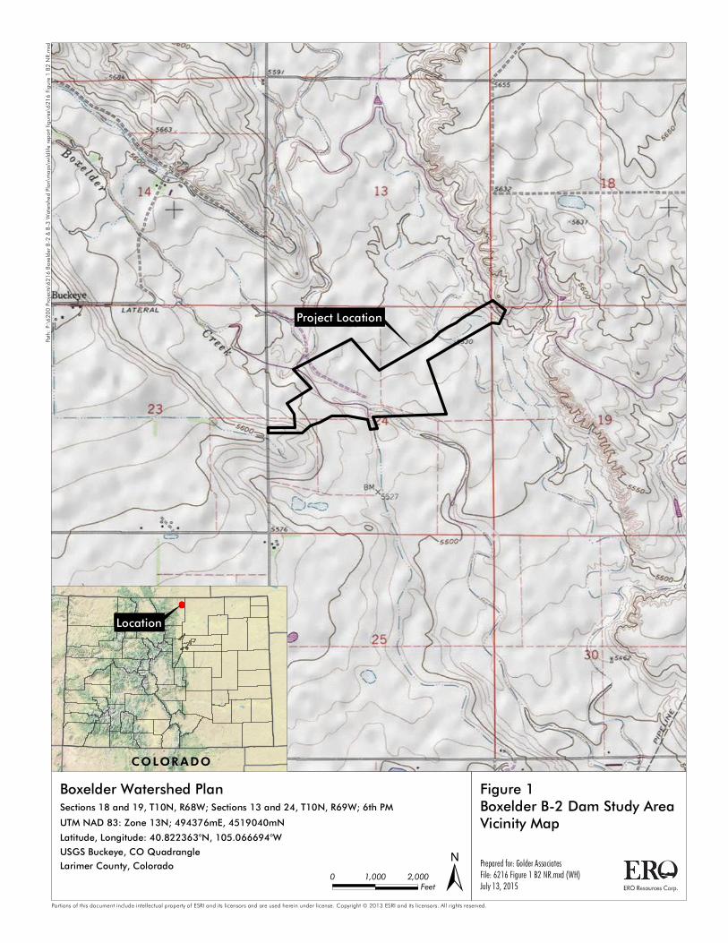
Project Location
Prepared for: Golder AssociatesFile: 6216 Figure 1 B2 NR.mxd (WH)July 13, 2015 ±
Figure 1Boxelder B-2 Dam Study AreaVicinity MapBoxelder Watershed Plan
Portions of this document include intellectual property of ESRI and its licensors and are used herein under license. Copyright © 2013 ESRI and its licensors. All rights reserved.
0 2,0001,000 Feet
COLORADO
Location
Sections 18 and 19, T10N, R68W; Sections 13 and 24, T10N, R69W; 6th PMUTM NAD 83: Zone 13N; 494376mE, 4519040mNLatitude, Longitude: 40.822363°N, 105.066694°WUSGS Buckeye, CO QuadrangleLarimer County, Colorado
Path:
P:\62
00 Pr
ojects
\6216
Boxel
der B
-2 & B
-3 Wa
tershe
d Plan
\map
s\wild
life re
port f
igures
\621
6 Figu
re 1 B
2 NR.m
xd
Project Location
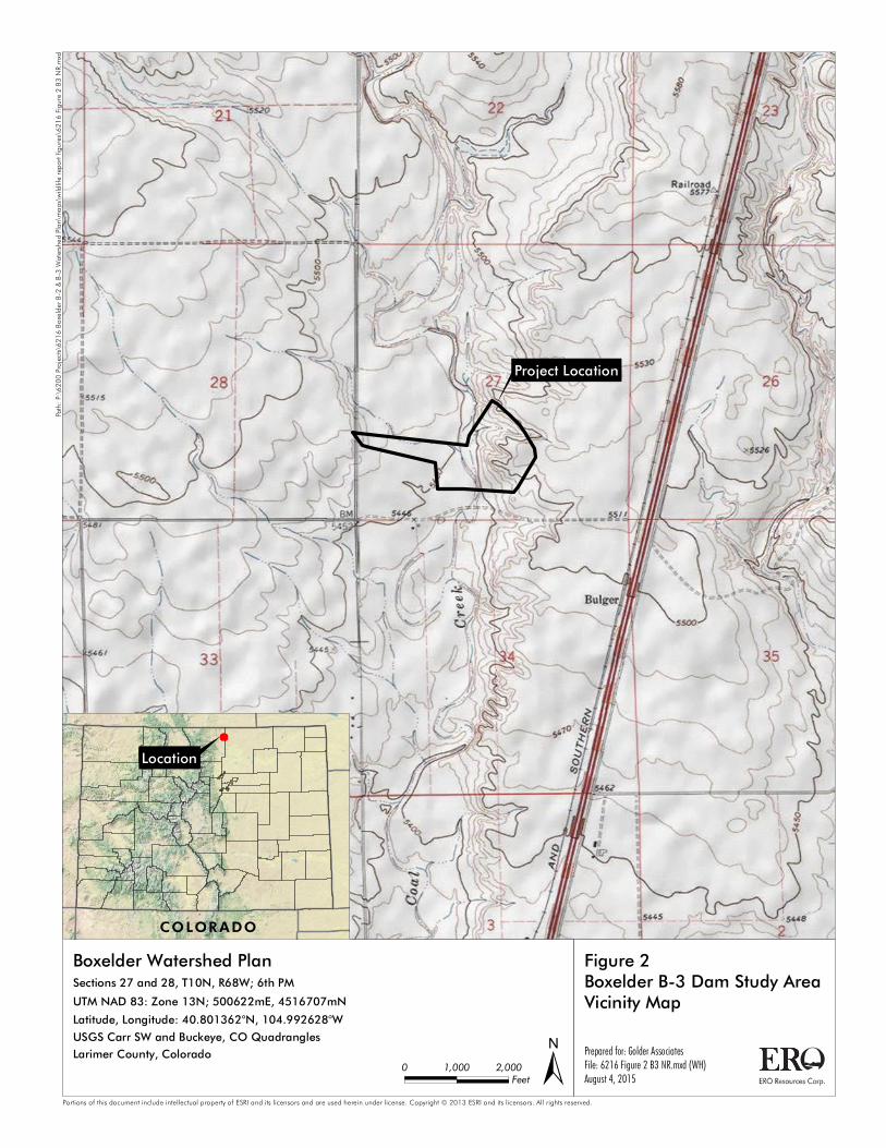
Prepared for: Golder AssociatesFile: 6216 Figure 2 B3 NR.mxd (WH)August 4, 2015 ±
Figure 2Boxelder B-3 Dam Study AreaVicinity MapBoxelder Watershed Plan
Portions of this document include intellectual property of ESRI and its licensors and are used herein under license. Copyright © 2013 ESRI and its licensors. All rights reserved.
0 2,0001,000 Feet
COLORADO
Location
Sections 27 and 28, T10N, R68W; 6th PMUTM NAD 83: Zone 13N; 500622mE, 4516707mNLatitude, Longitude: 40.801362°N, 104.992628°WUSGS Carr SW and Buckeye, CO QuadranglesLarimer County, Colorado
Path:
P:\62
00 Pr
ojects
\6216
Boxel
der B
-2 & B
-3 Wa
tershe
d Plan
\map
s\wild
life re
port f
igures
\621
6 Figu
re 2 B
3 NR.m
xd
[b
!!
!!
!
!
!
!
!
!!
!
!
!
! !
!
!
!
!
!
!
!!
!
!
Terry
Lake
Roa
d/CR1
5
Boxelder Creek
Boxelder Creek
Rawhide Creek
Spillway
Dissipater Pond
Figure 3Boxelder B-2 Dam Study AreaNatural ResourcesPrepared for: Golder AssociatesFile: 6216 Figure 3 B2.mxd (WH)July 13, 2015
Boxelder Watershed Plan[b Red-tailed Hawk Nest (ERO 2015)
1/3-Mile Nest BufferPotential Preble's Habitat (1.61 ac)
!
!
!
!!
300-Foot Preble's Habitat Buffer
Prairie Dog Colony (Low Density - 7.96 ac)150-Foot Burrowing Owl Buffer
Disturbed Grassland (123.52 ac)Human Developments (1.81 ac)Water (5.85 ac)Wetland (1.44 ac)
Study Area
Sources: Vegetation Communities - AlpineEco, July 2015; Imagery - USDA NAIP, 2013Portions of this document include intellectual property of ESRI and its licensors and are used herein under license. Copyright © 2013 ESRI and its licensors. All rights reserved.
±0 600300 feet
Path:
P:\62
00 Pr
ojects
\6216
Boxel
der B
-2 & B
-3 Wa
tershe
d Plan
\map
s\wild
life re
port f
igures
\621
6 Figu
re 3 B
2.mxd
CR 7
Prepared for: Golder AssociatesFile: 6216 Figure 4 B3 NR.mxd (WH)July 13, 2015 ±
Figure 4Boxelder B-3 Dam Study AreaNatural ResourcesBoxelder Watershed Plan
Portions of this document include intellectual property of ESRI and its licensors and are used herein under license. Copyright © 2013 ESRI and its licensors. All rights reserved.
0 400200 feet
Disturbed Grassland (59.25 ac)Human Developments (0.14 ac)Wetland (0.32 ac)Study Area
Sources: Vegetation Communities - AlpineEco, Imagery - USDA NAIP, 2013
Path:
P:\62
00 Pr
ojects
\6216
Boxel
der B
-2 & B
-3 Wa
tershe
d Plan
\map
s\wild
life re
port f
igures
\621
6 Figu
re 4 B
3 NR.m
xd
BOXELDER WATERSHED DAMS B-2 AND B-3 WATERSHED PLAN – WILDLIFE RESOURCES SUMMARY
PHOTO LOG
Photo 1 - View from north B-2 dam embankment facing southeast
Photo 2 - Boxelder Creek upstream of B-2 inlet and surrounding study area
BOXELDER WATERSHED DAMS B-2 AND B-3 WATERSHED PLAN – WILDLIFE RESOURCES SUMMARY
PHOTO LOG
Photo 3 - View from B-2 dam embankment facing north
Photo 4 - View from B-3 dam embankment facing northeast
BOXELDER WATERSHED DAMS B-2 AND B-3 WATERSHED PLAN – WILDLIFE RESOURCES SUMMARY
PHOTO LOG
Photo 5 - B-2 outlet and surrounding habitat
Photo 6 - Boxelder Creek downstream of B-2 dam outlet and energy dissipater
BOXELDER WATERSHED DAMS B-2 AND B-3 WATERSHED PLAN – WILDLIFE RESOURCES SUMMARY
PHOTO LOG
Photo 7 - Wetland vegetation along Boxelder Creek downstream of B-2 dam outlet andenergy dissipater
Photo 8 - Irrigation ditch downstream of B-2 dam
BOXELDER WATERSHED DAMS B-2 AND B-3 WATERSHED PLAN – WILDLIFE RESOURCES SUMMARY
PHOTO LOG
Photo 9 - Vegetation at south end of B-2 dissipater pond; note most of the area of densewillows not in study area
Photo 10 - B-2 dissipater pond and surrounding wetland/riparian vegetation
BOXELDER WATERSHED DAMS B-2 AND B-3 WATERSHED PLAN – WILDLIFE RESOURCES SUMMARY
PHOTO LOG
Photo 11 - East side of dissipater pond facing B-2 dam spillway
Photo 12 - Coal Creek upstream of B-3 inlet
A-1
Attachment 1–Wildlife Species Observed in the BoxElder Watershed B-2 and B-3 Dam
Study Areas
Common Name Scientific Name
American Kestrel Falco sparverius
American Pronghorn Antelope Atopocarpa americana
Barn swallow Hirundo rustica
Black-tailed prairie dog Cynomys ludovicianus
Black-billed magpie Pica hudsonia
Black-tailed jack rabbit Lepus californicus
Bullock’s Oriole Icterus bullockii
Common yellowthroat Geothlypis trichas
Cottontail rabbit Sylvilagus spp.
Coyote Canis latrans
Common grackle Quiscalus quiscula
European starling Sturnus vulgaris
House wren Troglodytes aedon
Killdeer Charadrius vociferus
Lark sparrow Chondestes grammacus
Mallard Anas platyrhynchos
Mourning Dove Zenaida macroura
Northern rough-winged swallow Stelgidopteryx serripennis
Prairie rattlesnake* Crotalus viridis viridis
Raccoon Procyon lotor
Red-tailed hawk Buteo jamaicensis
Red-winged Blackbird Agelaius phoeniceus
Say’s phoebe Syornis saya
Short-horned Lizard Phrynosoma hernandesi
Song Sparrow Melospiza melodia
Turkey Vulture Cathartes aura
Vesper sparrow Pooecetes gramineus
Western Chorus Frog Pseudacris triseriata
Western kingbird Tyrannus verticalis
Western meadowlark Sturnella neglecta
Western Terrestrial Garter Snake Thamnophis elegans
Woodhouse’s Toad Bufo woodhousii
Yellow warbler Dendroica petechia
*Observed during cultural resource surveys
U.S. Fish & Wildlife Service
Boxelder Watershed DamsB-2 and B-3IPaC Trust Resource ReportGenerated June 15, 2015 11:37 AM MDT
AWQD6-WZC2Z-DAFNJ-VXRLO-ZINO7MIPaC Trust Resource Report
06/15/2015 11:37 Page 2 Information for Planning and ConservationIPaCVersion 2.0.19
US Fish & Wildlife Service
IPaC Trust Resource Report
Project DescriptionNAME
Boxelder Watershed Dams B-2 andB-3
PROJECT CODE
AWQD6-WZC2Z-DAFNJ-VXRLO-ZINO7M
LOCATION
Larimer County, Colorado
DESCRIPTION
No description provided
U.S. Fish & Wildlife Contact InformationSpecies in this report are managed by:
Colorado Ecological Services Field OfficeDenver Federal CenterP.O. BOX 25486Denver, CO 80225-486 (303) 236-4773
AWQD6-WZC2Z-DAFNJ-VXRLO-ZINO7MIPaC Trust Resource Report
06/15/2015 11:37 Page 3 Information for Planning and ConservationIPaCVersion 2.0.19
Endangered
Threatened
Threatened
Endangered
Candidate
Endangered SpeciesProposed, candidate, threatened, and endangered species that are managed by the
and should be considered as part of an effect analysisEndangered Species Programfor this project.
Birds Greater Sage-grouse Centrocercus urophasianus
CRITICAL HABITAT
has been designated for this species.No critical habitat
https://ecos.fws.gov/speciesProfile/profile/speciesProfile.action?spcode=B06W
Least Tern Sterna antillarum
THIS SPECIES ONLY NEEDS TO BE CONSIDERED IF THE FOLLOWING CONDITION APPLIES
Water-related activities/use in the N. Platte, S. Platte and Laramie River Basins may affect listed species inNebraska.
CRITICAL HABITAT
has been designated for this species.No critical habitat
https://ecos.fws.gov/speciesProfile/profile/speciesProfile.action?spcode=B07N
Mexican Spotted Owl Strix occidentalis lucida
CRITICAL HABITAT
There is critical habitat designated for this species.final
https://ecos.fws.gov/speciesProfile/profile/speciesProfile.action?spcode=B074
Piping Plover Charadrius melodus
THIS SPECIES ONLY NEEDS TO BE CONSIDERED IF THE FOLLOWING CONDITION APPLIES
Water-related activities/use in the N. Platte, S. Platte and Laramie River Basins may affect listed species inNebraska.
CRITICAL HABITAT
There is critical habitat designated for this species.final
https://ecos.fws.gov/speciesProfile/profile/speciesProfile.action?spcode=B079
Whooping Crane Grus americana
THIS SPECIES ONLY NEEDS TO BE CONSIDERED IF THE FOLLOWING CONDITION APPLIES
Water-related activities/use in the N. Platte, S. Platte and Laramie River Basins may affect listed species inNebraska.
CRITICAL HABITAT
There is critical habitat designated for this species.final
https://ecos.fws.gov/speciesProfile/profile/speciesProfile.action?spcode=B003
AWQD6-WZC2Z-DAFNJ-VXRLO-ZINO7MIPaC Trust Resource Report
06/15/2015 11:37 Page 4 Information for Planning and ConservationIPaCVersion 2.0.19
Candidate
Threatened
Threatened
Endangered
Threatened
Endangered
Threatened
Fishes Greenback Cutthroat Trout Oncorhynchus clarki stomias
CRITICAL HABITAT
has been designated for this species.No critical habitat
https://ecos.fws.gov/speciesProfile/profile/speciesProfile.action?spcode=E00F
Pallid Sturgeon Scaphirhynchus albus
THIS SPECIES ONLY NEEDS TO BE CONSIDERED IF THE FOLLOWING CONDITION APPLIES
Water-related activities/use in the N. Platte, S. Platte and Laramie River Basins may affect listed species inNebraska.
CRITICAL HABITAT
has been designated for this species.No critical habitat
https://ecos.fws.gov/speciesProfile/profile/speciesProfile.action?spcode=E06X
Flowering Plants Colorado Butterfly Plant Gaura neomexicana var. coloradensis
CRITICAL HABITAT
There is critical habitat designated for this species.final
https://ecos.fws.gov/speciesProfile/profile/speciesProfile.action?spcode=Q0VV
North Park Phacelia Phacelia formosula
CRITICAL HABITAT
has been designated for this species.No critical habitat
https://ecos.fws.gov/speciesProfile/profile/speciesProfile.action?spcode=Q204
Ute Ladies'-tresses Spiranthes diluvialis
CRITICAL HABITAT
has been designated for this species.No critical habitat
https://ecos.fws.gov/speciesProfile/profile/speciesProfile.action?spcode=Q2WA
Western Prairie Fringed Orchid Platanthera praeclara
THIS SPECIES ONLY NEEDS TO BE CONSIDERED IF THE FOLLOWING CONDITION APPLIES
Water-related activities/use in the N. Platte, S. Platte and Laramie River Basins may affect listed species inNebraska.
CRITICAL HABITAT
has been designated for this species.No critical habitat
https://ecos.fws.gov/speciesProfile/profile/speciesProfile.action?spcode=Q2YD
Insects Arapahoe Snowfly Capnia arapahoe
CRITICAL HABITAT
has been designated for this species.No critical habitat
https://ecos.fws.gov/speciesProfile/profile/speciesProfile.action?spcode=I0W0
AWQD6-WZC2Z-DAFNJ-VXRLO-ZINO7MIPaC Trust Resource Report
06/15/2015 11:37 Page 5 Information for Planning and ConservationIPaCVersion 2.0.19
Threatened
Threatened
Experimental Population, Non-Essential
Mammals Black-footed Ferret Mustela nigripes
CRITICAL HABITAT
has been designated for this species.No critical habitat
https://ecos.fws.gov/speciesProfile/profile/speciesProfile.action?spcode=A004
Canada Lynx Lynx canadensis
CRITICAL HABITAT
There is critical habitat designated for this species.final
https://ecos.fws.gov/speciesProfile/profile/speciesProfile.action?spcode=A073
Preble's Meadow Jumping Mouse Zapus hudsonius preblei
CRITICAL HABITAT
There is critical habitat designated for this species.final
https://ecos.fws.gov/speciesProfile/profile/speciesProfile.action?spcode=A0C2
Critical HabitatsPotential effects to critical habitat(s) within the project area must be analyzed along withthe endangered species themselves.
There is no critical habitat within this project area
AWQD6-WZC2Z-DAFNJ-VXRLO-ZINO7MIPaC Trust Resource Report
06/15/2015 11:37 Page 6 Information for Planning and ConservationIPaCVersion 2.0.19
Bird of conservation concern
Bird of conservation concern
Bird of conservation concern
Bird of conservation concern
Bird of conservation concern
Bird of conservation concern
Bird of conservation concern
Bird of conservation concern
Bird of conservation concern
Bird of conservation concern
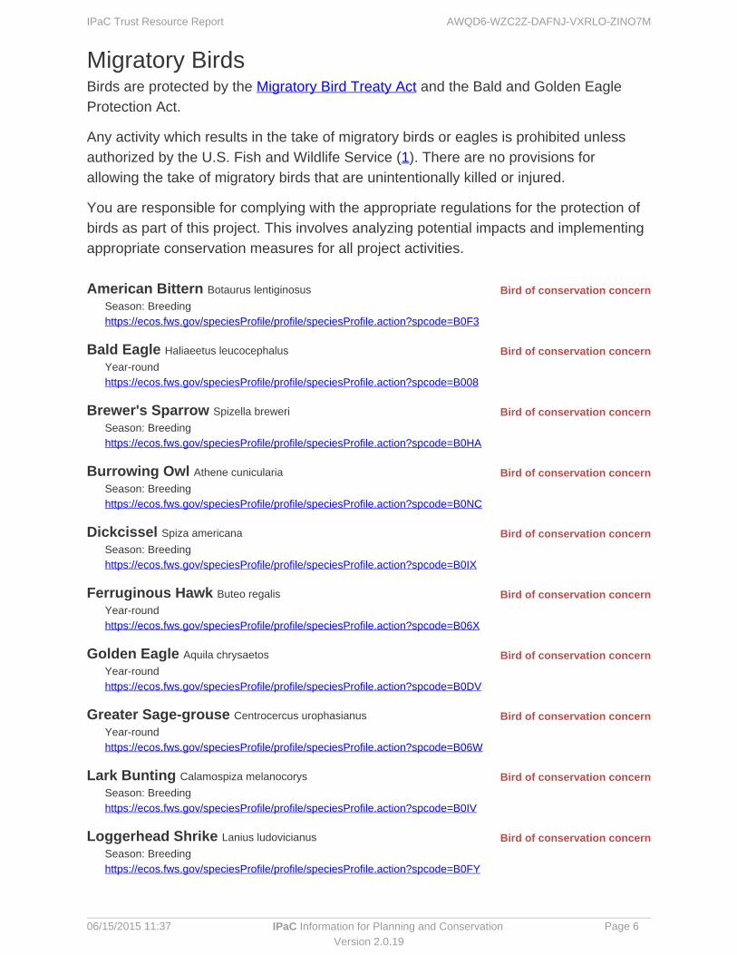
Migratory BirdsBirds are protected by the and the Bald and Golden EagleMigratory Bird Treaty ActProtection Act.
Any activity which results in the of migratory birds or eagles is prohibited unlesstakeauthorized by the U.S. Fish and Wildlife Service ( ). There are no provisions for1allowing the take of migratory birds that are unintentionally killed or injured.
You are responsible for complying with the appropriate regulations for the protection ofbirds as part of this project. This involves analyzing potential impacts and implementingappropriate conservation measures for all project activities.
American Bittern Botaurus lentiginosus
Season: Breedinghttps://ecos.fws.gov/speciesProfile/profile/speciesProfile.action?spcode=B0F3
Bald Eagle Haliaeetus leucocephalus
Year-roundhttps://ecos.fws.gov/speciesProfile/profile/speciesProfile.action?spcode=B008
Brewer's Sparrow Spizella breweri
Season: Breedinghttps://ecos.fws.gov/speciesProfile/profile/speciesProfile.action?spcode=B0HA
Burrowing Owl Athene cunicularia
Season: Breedinghttps://ecos.fws.gov/speciesProfile/profile/speciesProfile.action?spcode=B0NC
Dickcissel Spiza americana
Season: Breedinghttps://ecos.fws.gov/speciesProfile/profile/speciesProfile.action?spcode=B0IX
Ferruginous Hawk Buteo regalis
Year-roundhttps://ecos.fws.gov/speciesProfile/profile/speciesProfile.action?spcode=B06X
Golden Eagle Aquila chrysaetos
Year-roundhttps://ecos.fws.gov/speciesProfile/profile/speciesProfile.action?spcode=B0DV
Greater Sage-grouse Centrocercus urophasianus
Year-roundhttps://ecos.fws.gov/speciesProfile/profile/speciesProfile.action?spcode=B06W
Lark Bunting Calamospiza melanocorys
Season: Breedinghttps://ecos.fws.gov/speciesProfile/profile/speciesProfile.action?spcode=B0IV
Loggerhead Shrike Lanius ludovicianus
Season: Breedinghttps://ecos.fws.gov/speciesProfile/profile/speciesProfile.action?spcode=B0FY
AWQD6-WZC2Z-DAFNJ-VXRLO-ZINO7MIPaC Trust Resource Report
06/15/2015 11:37 Page 7 Information for Planning and ConservationIPaCVersion 2.0.19
Bird of conservation concern
Bird of conservation concern
Bird of conservation concern
Bird of conservation concern
Bird of conservation concern
Bird of conservation concern
Bird of conservation concern
Bird of conservation concern
Bird of conservation concern Mccown's Longspur Calcarius mccownii
Season: Breedinghttps://ecos.fws.gov/speciesProfile/profile/speciesProfile.action?spcode=B0HB
Mountain Plover Charadrius montanus
Season: Breedinghttps://ecos.fws.gov/speciesProfile/profile/speciesProfile.action?spcode=B078
Peregrine Falcon Falco peregrinus
Season: Breedinghttps://ecos.fws.gov/speciesProfile/profile/speciesProfile.action?spcode=B0FU
Prairie Falcon Falco mexicanus
Year-roundhttps://ecos.fws.gov/speciesProfile/profile/speciesProfile.action?spcode=B0ER
Red-headed Woodpecker Melanerpes erythrocephalus
Season: Breedinghttps://ecos.fws.gov/speciesProfile/profile/speciesProfile.action?spcode=B0HR
Sage Thrasher Oreoscoptes montanus
Season: Breedinghttps://ecos.fws.gov/speciesProfile/profile/speciesProfile.action?spcode=B0ID
Short-eared Owl Asio flammeus
Season: Winteringhttps://ecos.fws.gov/speciesProfile/profile/speciesProfile.action?spcode=B0HD
Swainson's Hawk Buteo swainsoni
Season: Breedinghttps://ecos.fws.gov/speciesProfile/profile/speciesProfile.action?spcode=B070
Williamson's Sapsucker Sphyrapicus thyroideus
Season: Breedinghttps://ecos.fws.gov/speciesProfile/profile/speciesProfile.action?spcode=B0FX

AWQD6-WZC2Z-DAFNJ-VXRLO-ZINO7MIPaC Trust Resource Report
06/15/2015 11:37 Page 8 Information for Planning and ConservationIPaCVersion 2.0.19
RefugesAny activity proposed on lands must undergo a 'CompatibilityNational Wildlife RefugeDetermination' conducted by the Refuge. If your project overlaps or otherwise impacts aRefuge, please contact that Refuge to discuss the authorization process.
There are no refuges within this project area
AWQD6-WZC2Z-DAFNJ-VXRLO-ZINO7MIPaC Trust Resource Report
06/15/2015 11:37 Page 9 Information for Planning and ConservationIPaCVersion 2.0.19
WetlandsImpacts to and other aquatic habitats from your project may be subject toNWI wetlandsregulation under Section 404 of the Clean Water Act, or other State/Federal Statutes.
Project proponents should discuss the relationship of these requirements to their projectwith the Regulatory Program of the appropriate .U.S. Army Corps of Engineers District
DATA LIMITATIONS
The Service's objective of mapping wetlands and deepwater habitats is to producereconnaissance level information on the location, type and size of these resources. Themaps are prepared from the analysis of high altitude imagery. Wetlands are identifiedbased on vegetation, visible hydrology and geography. A margin of error is inherent inthe use of imagery; thus, detailed on-the-ground inspection of any particular site mayresult in revision of the wetland boundaries or classification established through imageanalysis.
The accuracy of image interpretation depends on the quality of the imagery, theexperience of the image analysts, the amount and quality of the collateral data and theamount of ground truth verification work conducted. Metadata should be consulted todetermine the date of the source imagery used and any mapping problems.
Wetlands or other mapped features may have changed since the date of the imagery orfield work. There may be occasional differences in polygon boundaries or classificationsbetween the information depicted on the map and the actual conditions on site.
DATA EXCLUSIONS
Certain wetland habitats are excluded from the National mapping program because ofthe limitations of aerial imagery as the primary data source used to detect wetlands.These habitats include seagrasses or submerged aquatic vegetation that are found inthe intertidal and subtidal zones of estuaries and nearshore coastal waters. Somedeepwater reef communities (coral or tuberficid worm reefs) have also been excludedfrom the inventory. These habitats, because of their depth, go undetected by aerialimagery.
DATA PRECAUTIONS
Federal, state, and local regulatory agencies with jurisdiction over wetlands may defineand describe wetlands in a different manner than that used in this inventory. There is noattempt, in either the design or products of this inventory, to define the limits ofproprietary jurisdiction of any Federal, state, or local government or to establish thegeographical scope of the regulatory programs of government agencies. Personsintending to engage in activities involving modifications within or adjacent to wetlandareas should seek the advice of appropriate federal, state, or local agencies concerningspecified agency regulatory programs and proprietary jurisdictions that may affect suchactivities.

AWQD6-WZC2Z-DAFNJ-VXRLO-ZINO7MIPaC Trust Resource Report
06/15/2015 11:37 Page 10 Information for Planning and ConservationIPaCVersion 2.0.19
7.91 acres
RiverineR4SBA