Embed Size (px)
Citation preview

1
Municipal Building 222 West Hargett Street Raleigh, North Carolina 27601 One Exchange Plaza 1 Exchange Plaza, Suite 1020 Raleigh, North Carolina 27601 City of Raleigh Post Office Box 590 • Raleigh North Carolina 27602-0590 (Mailing Address)
TO: Ruffin L. Hall, City Manager
FROM: Ken Bowers, AICP, Director; Jason Hardin, AICP
DEPARTMENT: City Planning
DATE: November 7, 2019
SUBJECT: Special item for November 19, 2019 – Rezoning Z-15-19
On November 6, 2019, City Council closed the public hearing for rezoning Z-
15-19 Six Forks Road and Industrial Drive and deferred action for two weeks to
allow the applicant to submit new conditions. Following the closing of the
hearing, the applicant submitted new conditions relating to housing affordability
and parking provision, topics that had been discussed during Growth and
Natural Resources Committee review. The committee referred the item back to
Council, and Council may now take action on the request.
The request is:
Z-15-19 Six Forks Road and Industrial Drive, located at the northeast corner of the intersection, consisting of Wake County PIN 1715331206. Approximately 12.63 acres are requested by RBD Six Forks, LLC to be rezoned. Current zoning: Industrial Mixed Use-3 Stories-Parking Limited (IX-3-PL) Requested zoning: Residential Mixed Use-Seven Stories-Green Frontage-Conditional Use (RX-7-GR-CU) Zoning conditions submitted on November 6, 2019:
• Limit residential use of the property to no more than 500 units
• Limit parking to no more than 1.5 space per unit
• Specify that 15 percent of the additional housing units gained by the rezoning (all units beyond the first 289) will be affordable to households at or below 80 percent of area median income. The request is consistent with the Future Land Use Map. The request is consistent with the Comprehensive Plan. The Planning Commission vote 6-0 to recommend approval of the request. The Atlantic CAC voted 15-0 in support of the rezoning on July 18, 2019.
Attached are the Planning Commission Certified Recommendation (including
Staff Report and Traffic Study Worksheet), the Zoning Conditions, the Petition
for Rezoning, and the Neighborhood Meeting Report.


RALEIGH PLANNING COMMISSION
CERTIFIED RECOMMENDATION
CR# 11930
CASE INFORMATION: Z-15-19 SIX FORKS ROAD AND INDUSTRIAL DRIVE Location
Six Forks Road, at the northwest corner of its intersection with
Industrial Drive
Address: 819 East Six Forks Road
PIN: 1715331206
iMaps, Google Maps, Driving/transit directions from Municipal Building
Current Zoning IX-3-PL
Requested Zoning RX-7-GR-CU
Area of Request 12.63 acres
Corporate Limits The subject site is located within the corporate limits and is surrounded by properties also within corporate limits.
Property Owner RBD Six Forks, LLC
Applicant RBD Six Forks, LLC, represented by Thomas H. Johnson Jr.
Citizens Advisory Council (CAC)
Atlantic
PC Recommendation Deadline
November 11, 2019
SUMMARY OF PROPOSED CONDITIONS
1. No more than 500 housing units will be constructed.
COMPREHENSIVE PLAN GUIDANCE
Future Land Use High Density Residential
Urban Form City Growth Center; Urban Thoroughfare
Consistent Policies LU 1.2—Future Land Use Map and Zoning Consistency
LU 2.2 Compact Development.
LU 4.4 Reducing VMT Through Mixed Use.
LU 4.9 Corridor Development.
LU 6.2 Complimentary Uses and Urban Vitality
LU 11.4 Rezoning/Development of Industrial Areas.
H 1.8 Zoning for Housing.
Inconsistent Policies None

FUTURE LAND USE MAP CONSISTENCY
The rezoning case is Consistent Inconsistent with the Future Land Use Map.
COMPREHENSIVE PLAN CONSISTENCY
The rezoning case is Consistent Inconsistent with the 2030 Comprehensive Plan.
PUBLIC MEETINGS
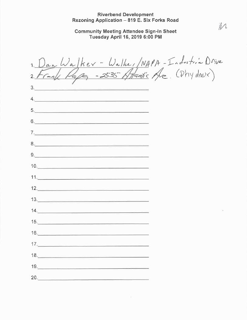
Neighborhood
Meeting CAC (Atlantic)
Planning
Commission City Council
4/16/19
Two attendees
5/16/19; 7/18/19
(Y-15, N-0)
8/13/19 8/20/19
PLANNING COMMISSION RECOMMENDATION
The rezoning case is Consistent with the relevant policies in the Comprehensive Plan,
and Approval of the rezoning request is reasonable and in the public interest.
The rezoning case is Consistent with the relevant policies in the comprehensive Plan, but
Denial of the rezoning request is reasonable and in the public interest.
The rezoning is Inconsistent with the relevant policies in the Comprehensive Plan, and
Denial of the rezoning request is reasonable and in the public interest.
The rezoning case is Inconsistent with the relevant policies in the Comprehensive Plan,
but Approval of the rezoning request is reasonable and in the public interest due to changed
circumstances as explained below. Approval of the rezoning request constitutes an
amendment to the Comprehensive Plan to the extent described below.
Reasonableness and
Public Interest
The request is reasonable and in the public interest. The parcel to
be rezoned is in an area where more density is appropriate, and
the request is consistent with the Comprehensive Plan, Future
Land Use Map, and all relevant policies.
Change(s) in
Circumstances
N/A
Amendments to the
Comprehensive Plan
N/A
Recommendation Approval
Motion and Vote Motion: Geary
Second: Novak
In Favor: Geary, Jeffreys, Lyle, McIntosh, Novak, Winters
Opposed: None

Reason for Opposed
Vote(s)
N/A
ATTACHMENTS 1. Staff report 2. Rezoning Application 3. Zoning conditions
This document is a true and accurate statement of the findings and recommendations of the
Planning Commission. Approval of this document incorporates all of the findings of the
attached Staff Report and Comprehensive Plan Amendment Analysis.
_____________________8/31/2019 _________________________8/13/2019
Planning Director Date Planning Commission Chair Date
Staff Coordinator: Jason Hardin: (919) 996-2657; [email protected]

OVERVIEW
The proposal seeks to rezone one parcel totaling 12.63 acres at the northeast corner of Six
Forks Road and Industrial Drive. The parcel is currently zoned Industrial Mixed Use-Three
Stories-Parking Limited (IX-3-PL). The request is to increase the amount of housing that can
be build on the site by rezoning it to Residential Mixed Use-Seven Stories-Green Frontage-
Conditional Use (RX-7-GR-CU).
The property is at the heart of a mixed-use area centered roughly on the intersection of
Wake Forest Road and Six Forks Road. The area includes large amounts of retail, significant
warehouse and light industrial space, and a range of housing types on the edges. Interstate
440 and a CSX rail corridor run through the area. North of 440, the area includes Duke
Raleigh Hospital, Wake Tech’s Beltline campus, and additional residential uses.
The property is currently the site of a warehouse/distribution facility and is adjacent to the
CSX railroad. It is largely bordered by warehouse/distribution uses, although the parcel to the
northwest is the site of a large commercial development to be anchored by a Wegmans
grocery store.
In terms of zoning, adjacent properties are zoned IX-3-PL, with properties to the northwest
and southwest zoned Community Mixed Use-Three Stories-Parking Limited (CX-3-PL). The
Future Land Use Map designates the subject property and properties to the north as High
Density Residential. The requested Residential Mixed Use category is consistent with that
designation, as is the requested height of seven stories. The plan’s height guidance
suggests that up to 12 stories is appropriate in centers such as the one in which the site is
located. Areas to the south, east, and west are designed for Community Mixed Use or
Neighborhood Mixed Use.
The Urban Form Map applies to the site in two primary ways. The entire area is designated
as a City Growth Center, and Six Forks Road and Industrial Drive are Urban Thoroughfares.
Both designations support a more urban, walkable building form. That policy is met by the
requested Green frontage designation, which requires the edge of the building be between
20 and 50 feet of the street.
The current Urban Form Map also shows the area as being near a future rail station. While
that designation is based on outdated transit plans and would be removed by the pending
Comprehensive Plan update, the Plan’s other designations for the area – City Growth
Center, Urban Thoroughfare, and the Future Land Use Map – would not be removed,
reflecting the both area’s future as a hub of the planned frequent bus network and the fact
that it is an emerging center of the Midtown area.
The primary effects of the rezoning would be to increase the potential number of housing
units by allowing additional height and moving away from IX zoning, which does not permit
residential units on the ground floor. It would also no longer permit the wide range of uses,
ZONING STAFF REPORT – CASE Z-15-19
Conditional Use

including industrial uses, allowed in IX. Instead, the RX zoning would permit residential units
and up to 4,000 square feet of office or retail space at the corner of Six Forks and Industrial.
OUTSTANDING ISSUES
Outstanding
Issues
1. None Suggested
Mitigation
1. N/A


COMPREHENSIVE PLAN
Determination of the conformance of a proposed use or zone with the Comprehensive Plan
includes consideration of the following questions:
A. Is the proposal consistent with the vision, themes, and policies contained in the
Comprehensive Plan?
Yes. In particular, by allowing more housing in an area with significant transit service
and plans for frequency improvements, the proposal is consistent with the themes of
Expanding Housing Choices and Coordinating Land Use and Transportation. The
proposal also is consistent with several specific policies that support those themes.
B. Is the use being considered specifically designated on the Future Land Use Map in the
area where its location is proposed?
Yes. The property is designated as High Density Residential in the Future Land Use
Map. The proposed residential use, with the possibility of a small amount of ground
floor retail, is consistent with that designation.
C. If the use is not specifically designated on the Future Land Use Map in the area where its
location is proposed, is it needed to service such a planned use, or could it be
established without adversely altering the recommended land use and character of the
area?
The use is consistent with the Future Land Use Map.
D. Will community facilities and streets be available at City standards to serve the use
proposed for the property?
Yes, as noted in the impact analysis section below.
Future Land Use
Future Land Use designation: High Density Residential
The rezoning request is
Consistent with the Future Land Use Map.
Inconsistent
This category envisions higher-density residential development, with RX as the most closely
related zoning district. Height guidance for this category in the Comprehensive Plan
envisions up to 12 stories in areas at the core of a mixed-use center or that are served by
high levels of transit. In this case, the property is at the core of the mixed-use area centered
roughly at the intersection of Wake Forest and Six Forks roads. Additionally, plans call for
high-frequency (15 minute) bus transit along that section of Six Forks Road.

Urban Form
Urban Form designation: City Growth Center; Urban Thoroughfare (Six Forks Road,
Industrial Drive); Transit Stop Half-Mile Buffer (based on outdated transit plans,
proposed to be removed in pending update of Comprehensive Plan)
The rezoning request is
Consistent with the Urban Form Map.
Inconsistent
Other (no Urban Form designation OR no Urban Form designation, but zoning frontage
requested)
The urban form guidance suggests an urban frontage (buildings closer to street, no parking
between building and street) or hybrid frontage (some parking allowed between the building
and street). The requested Green frontage, which requires the building be brought to
between 20 feet and 50 feet of the right of way, is fully consistent with this guidance. The
requested frontage would prevent a more suburban-style setback permitted by the existing
Parking Limited frontage, which has a build-to range of 0’-100’. For the sake of comparison,
the build-to for an apartment building with no frontage is 10’-55’.
Compatibility
The proposed rezoning is
Compatible with the property and surrounding area.
Incompatible.
The area is characterized by a relatively intensive mix of uses, including retail, housing, warehouse and light industrial facilities, and educational and health care institutions. The requested RX-7-GR-CU zoning is compatible with the area and would tend to create a more balanced mix of uses than the current mix, which tilts toward retail.
Public Benefits of the Proposed Rezoning
• The proposal would add to the housing supply in the city and add additional housing
variety.
• The proposal would create more of a balance between residential and commercial
uses in a mixed-use area.
Detriments of the Proposed Rezoning
• None
Policy Guidance
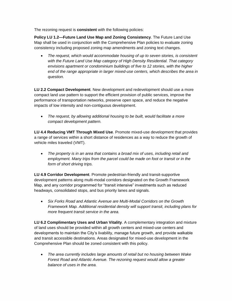
The rezoning request is consistent with the following policies:
Policy LU 1.2—Future Land Use Map and Zoning Consistency. The Future Land Use
Map shall be used in conjunction with the Comprehensive Plan policies to evaluate zoning
consistency including proposed zoning map amendments and zoning text changes.
• The request, which would accommodate housing of up to seven stories, is consistent
with the Future Land Use Map category of High Density Residential. That category
envisions apartment or condominium buildings of five to 12 stories, with the higher
end of the range appropriate in larger mixed-use centers, which describes the area in
question.
LU 2.2 Compact Development. New development and redevelopment should use a more
compact land use pattern to support the efficient provision of public services, improve the
performance of transportation networks, preserve open space, and reduce the negative
impacts of low intensity and non-contiguous development.
• The request, by allowing additional housing to be built, would facilitate a more
compact development pattern.
LU 4.4 Reducing VMT Through Mixed Use. Promote mixed-use development that provides
a range of services within a short distance of residences as a way to reduce the growth of
vehicle miles traveled (VMT).
• The property is in an area that contains a broad mix of uses, including retail and
employment. Many trips from the parcel could be made on foot or transit or in the
form of short driving trips.
LU 4.9 Corridor Development. Promote pedestrian-friendly and transit-supportive
development patterns along multi-modal corridors designated on the Growth Framework
Map, and any corridor programmed for “transit intensive” investments such as reduced
headways, consolidated stops, and bus priority lanes and signals.
• Six Forks Road and Atlantic Avenue are Multi-Modal Corridors on the Growth
Framework Map. Additional residential density will support transit, including plans for
more frequent transit service in the area.
LU 6.2 Complimentary Uses and Urban Vitality. A complementary integration and mixture
of land uses should be provided within all growth centers and mixed-use centers and
developments to maintain the City’s livability, manage future growth, and provide walkable
and transit accessible destinations. Areas designated for mixed-use development in the
Comprehensive Plan should be zoned consistent with this policy.
• The area currently includes large amounts of retail but no housing between Wake
Forest Road and Atlantic Avenue. The rezoning request would allow a greater
balance of uses in the area.

LU 11.4 Rezoning/Development of Industrial Areas. Allow the rezoning and/or
redevelopment of industrial land for non-industrial purposes when the land can no longer
viably support industrial activities or is located such that industry is not consistent with the
Future Land Use Map. Examples include land in the immediate vicinity of planned transit
stations.
• The area is currently zoned for light industrial uses but is designated as High Density
Residential on the Future Land Use Map.
Policy H 1.8 Zoning for Housing. Ensure that zoning policy continues to provide ample
opportunity for developers to build a variety of housing types, ranging from single-family to
dense multi-family. Keeping the market well supplied with housing will moderate the costs of
owning and renting, lessening affordability problems, and lowering the level of subsidy
necessary to produce affordable housing.
• The rezoning would increase housing supply by permitting more housing on the site
than current zoning allows.
The rezoning request is inconsistent with the following policies:
None
Area Plan Policy Guidance
The area is not within an adopted area plan. The Midtown-St. Albans area plan process is
ongoing, with a final report anticipated this fall. The plan has not contemplated a change to
the Future Land Use Map in this area.

CLIMATE CHANGE AND AFFORDABILITY
ANALYSIS
Carbon/Energy Footprint: Transportation
Summary: The site is both more walkable and more transit-rich than the city as a whole,
suggesting that allowing more development here will tend to lead to more walking and transit
trips and shorter driving trips, which would decrease transportation-related carbon emissions
on a per capita basis.
Carbon/Energy Footprint: Housing
Housing Type Average Annual Energy Use (million BTU)
Permitted in this project?
Detached House 82.7 Yes
Townhouse 56.5 Yes
Small Apartment (2-4 units) 42.1 Yes
Larger Apartment 34.0 Yes
Source: U.S. Energy Information Administration, 2015 survey. Statistics for residential structures in the South.
Summary: The rezoning would permit townhouses, small apartment buildings, and larger
apartment buildings (defined as having more than four units), which are all on average
substantially more energy-efficient than other housing types. Therefore, the rezoning will
tend to decrease carbon emissions from building operations on a per-capita basis.
City Average Site Notes
Transit Score 30 40
The site has higher access to transit than
the city average, and planned increases to
transit frequency in the area will improve
transit service in coming years.
Walk Score 30 37
Source: Walk Score is a publicly available service that measures pedestrian friendliness by analyzing population density
and road metrics such as block length and intersection density. The higher the Transit Score or Walk Score, the greater
the percentage of trips that will be made on transit or by walking, and the smaller the carbon footprint. The scores also
correlate with shorter vehicle trips, which also produce less carbon. The city has a wide range of scores. Raleigh
Municipal Building, for instance, has a Walk Score of 92, meaning the area is highly pedestrian-friendly and that many
destinations are within a short walk. Some areas in the city have scores in single digits, indicating that few if any
destinations are within walking distance, so nearly all trips are made by car.
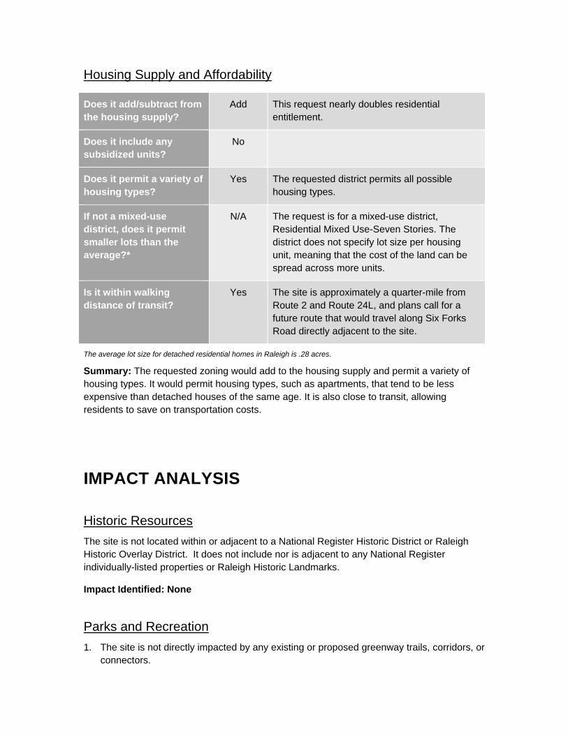
Housing Supply and Affordability
The average lot size for detached residential homes in Raleigh is .28 acres.
Summary: The requested zoning would add to the housing supply and permit a variety of
housing types. It would permit housing types, such as apartments, that tend to be less
expensive than detached houses of the same age. It is also close to transit, allowing
residents to save on transportation costs.
IMPACT ANALYSIS
Historic Resources
The site is not located within or adjacent to a National Register Historic District or Raleigh
Historic Overlay District. It does not include nor is adjacent to any National Register
individually-listed properties or Raleigh Historic Landmarks.
Impact Identified: None
Parks and Recreation
1. The site is not directly impacted by any existing or proposed greenway trails, corridors, or
connectors.
Does it add/subtract from
the housing supply?
Add This request nearly doubles residential
entitlement.
Does it include any
subsidized units?
No
Does it permit a variety of
housing types?
Yes The requested district permits all possible
housing types.
If not a mixed-use
district, does it permit
smaller lots than the
average?*
N/A The request is for a mixed-use district,
Residential Mixed Use-Seven Stories. The
district does not specify lot size per housing
unit, meaning that the cost of the land can be
spread across more units.
Is it within walking
distance of transit?
Yes The site is approximately a quarter-mile from
Route 2 and Route 24L, and plans call for a
future route that would travel along Six Forks
Road directly adjacent to the site.

2. Nearest existing park access is provided by Kiwanis Park (1 mile) and Fallon Park (1.2
miles)
3. Nearest existing greenway trail access is provided by Crabtree Creek Greenway Trail (.4
miles).
4. Current park access level of service in this area is graded a B letter grade.
Impact Identified: None requiring mitigation
Public Utilities
Maximum Demand
(current use)
Maximum Demand
(current zoning)
Maximum Demand
(proposed zoning)
Water 797 gpd 76,517 gpd 125,000
Waste Water 797 gpd 76,517 gpd 125,000
1. The proposed rezoning would add approximately 48,423 gpd to the wastewater
collection and water distribution systems of the City. There are existing sanitary sewer
and water mains adjacent to the proposed rezoning area
2. At the time of development plan submittal, a Downstream Sewer Capacity Study may be
required to determine adequate capacity to support the proposed development. Any
improvements identified by the study would be required to be permitted prior to the
issuance of Building Permit and constructed prior to release of a Certificate of
Occupancy
3. Verification of water available for fire flow is required as part of the Building Permit
process. Any water system improvements recommended by the analysis to meet fire flow
requirements will also be required of the Developer.
Impact Identified: None requiring mitigation
Stormwater
Floodplain No FEMA floodplain
Drainage Basin Crabtree
Stormwater Management Subject to stormwater regulations under Article 9 of UDO.
Overlay District none
Impact Identified: None requiring mitigation
Transportation

Rezoning Case: Z-15-19
Transportation Review
Site Location and Context
Location
The Z-15-19 site is located at the northeast corner of Atlantic Avenue and Industrial Drive,
adjacent to the CSX Transportation railroad corridor.
Area Plans
The Z-15-19 site is not located with an existing area plan boundary.
Other Projects in the Area
An adjacent development that is under construction (SP-11-2016) will construct Wake Towne
Drive as a new public street between Industrial Drive and Wake Forest Road. A project to
complete the sidewalk on the east side of Wake Forest Road between Creekside Drive and
Georgetown Road is under design by the City of Raleigh. NCDOT has a project in planning
to upgrade the interchange of I-440 with Wake Forest Road. The CSX Transportation
railroad corridor is planned to be upgraded for higher-speed intercity passenger rail by
NCDOT. This project is not programmed for funding at this time.
Existing and Planned Infrastructure
Streets
The subject property fronts on East Six Forks Road, which is NCDOT maintained and is
specified as a 4-lane divided avenue parking in Map T-1 of the Comprehensive Plan (the
Street Plan). It also fronts on Industrial Drive, which is maintained by the City of Raleigh and
is specified as a 2-lane undivided avenue in the Street Plan.
In accordance with UDO section 8.3.2, the maximum block perimeter for RX-12 Zoning
districts is 2,500 feet. The current block perimeter for Z-15-19 is approximately 13,400 feet,
spanning Industrial Dr, Wake Forest Rd, Navaho Dr, Bush St, Wolfpack Ln, Atlantic Ave, and
E Six Forks Rd. This block is constrained by the CSX Railroad and I-440.
Pedestrian Facilities
There are no existing sidewalks on site frontage. There are existing sidewalks on the south
side of Six Forks Road. An adjacent development that is under construction (SP-11-2016)
will add sidewalk to sections of Industrial Drive, construct Wake Towne Drive, and an east-
west pedestrian connection between Industrial Dr and Wake Forest Road. Missing sidewalk
on Wake Forest Road is in design as a city project. Sidewalks will be required at the time of
site plan.
Bicycle Facilities
There are no existing bicycle facilities within the vicinity of the site. In the long-term bikeway
plan, bicycle lanes are planned for Industrial Drive and a separated bicycle facility is planned
for Six Forks Road. Approximately 0.3 mile south of the site, the Industrial Drive right-of-way
connects to the Crabtree Creek Greenway Trail. At this time the connection is not improved
or formalized.

Transit
The site is currently served by two different GoRaleigh services. Route 2 operates on Wake
Forest Road with service every 30 minutes all day. Route 24L, the North Crosstown
Connector, operates in a one-way loop on Wake Forest Road with service every 30 minutes
during peak times and every 60 minutes in off-peak times.
Access
Access to the subject site will be via either Six Forks Road or Industrial Drive.
TIA Determination
The potential trip generation is below the threshold for a TIA.
Impact Identified: None requiring mitigation
Urban Forestry
Changing the frontage from PL to GR will not change the amount of tree conservation.
Impact Identified: None.
Impacts Summary
None requiring mitigation. The rezoning would add to the housing supply and permit housing
types that tend to be less costly than larger-lot detached houses of the same age. It is in a
location that is more walkable and more transit-rich than the city as a whole, meaning it could
lead to lower per-capita transportation carbon emissions.
Mitigation of Impacts
None needed.

CONCLUSION
The request to rezone the property from IX-3-PL to RX-7-GR-CU is consistent with the
Future Land Use Map and Comprehensive Plan as a whole. The site is in a large mixed-use
area with improving transit options and would contribute to a more balanced mix of uses. It
would tend to decrease the city’s per capita carbon footprint and would improve affordability
by increasing the housing supply and allowing a housing type that is less expensive than the
alternatives.
CASE TIMELINE
Date Action Notes
4/26/19 Petition filed
7/10/19 Petition revised to change
request from RX-12-GR-CU to
RX-7-GR-CU; condition added
limiting residential use to 500
units.
8/1/19 Condition language revised. Technical revision.

APPENDIX
SURROUNDING AREA LAND USE/ ZONING SUMMARY
SUBJECT
PROPERTY NORTH SOUTH EAST WEST
Existing
Zoning IX-3-PL IX-3-PL IX-3-PL IX-3-PL IX-3-PL
Additional
Overlay - SHOD-2 - - -
Future
Land Use
High Density
Residential
High Density
Residential
Neighborhood
Mixed Use
Community
Mixed Use
Community
Mixed Use
Current
Land Use
Warehouse/
Distribution
Warehouse/
Distribution
Warehouse/
Distribution
Railroad/office/
manufacturing Warehouse
Urban
Form
City Growth
Center;
Urban
Thoroughfare
City Growth
Center;
Urban
Thoroughfare
City Growth
Center; Urban
Thoroughfare
City Growth
Center; Urban
Thoroughfare
City Growth
Center;
Urban
Thoroughfare
CURRENT VS. PROPOSED ZONING SUMMARY
EXISTING ZONING PROPOSED ZONING
Zoning IX-3-PL RX-7-GR-CU
Total Acreage 12.63 12.63
Setbacks:
Front
Side street
Side
Rear
0’-100’
0’-100’
0’ or 6’
0’ or 6’
20’-50’
20’-50’
0’ or 6’
0’ or 6’
Residential Density: 22.9 units/acre 40 units/acre
Max. # of Residential Units 289 500
Max. Gross Building SF 976,402 654,000
Max. Gross Office SF 351,915 4,000
Max. Gross Retail SF 288,927 4,000
Max. Gross Industrial SF 976,402 -
Potential F.A.R 1.8 1.2
*The development intensities for proposed zoning districts were estimated using an impact analysis tool. The estimates
presented are only to provide guidance for analysis.
Relevant Planning Commission Minutes August 13, 2019: Z-15-19
AGENDA ITEM E 4: Z-15-19 – Six Forks Road and Industrial Drive, northeast corner of the
intersection (Atlantic CAC)
This site is located at Six Forks Road and Industrial Drive, at the northeast corner of the intersection.
This is a request to rezone property from IX-3-PL to RX-7-GR-CU.
Planner Hardin presented the case.
Thomas Johnson, representing the applicant, then spoke in favor.
Greg Hobbs of Hobbs Properties, which owns properties in the vicinity, spoke in support the request.
John Bruckel also spoke in favor, stating that housing would be appropriate use for the site.
No opposing comments.
Ms. Winters spoke regarding some areas being overly dense and others having less density. She also
spoke about the impact on traffic and walkability and the effect on the quality of life of neighbors.
Planner Hardin spoke regarding increase in frequency of traffic; the Midtown area plan is in the final
stages and will address those concerns.
Mr. Geary made a motion to approve the case because it consistent with the Future Land Use Map
and Comprehensive Plan. Mr. Novak seconded the motion. The vote was unanimous 6-0.

Department of City Planning | 1 Exchange Plaza, Suite 300 | Raleigh, NC 27601 | 919-996-26
PAGE 1 OF WWW.RALEIGHNC.GOV
Rezoning Application
REZONING REQUEST
General Use Conditional Use Master Plan
Existing Zoning ___
Proposed Zoning Base District _______ Height ______ Frontage ______
OFFICE USE ONLY
Transaction #
If the property has been previously rezoned, provide the rezoning case number:
Provide all previous transaction numbers for Coordinated Team Reviews, Due Diligence Sessions, or Pre-Submittal Conferences:
GENERAL INFORMATION
Property Address
Date
Property PIN Deed Reference (book/page)
Nearest Intersection
Property Size (acres)
Property Owner/AddressPhone Fax
Project Contact Person/AddressPhone Fax
Owner/Agent Signature Email
A rezoning application will not be considered complete until all required submittal components listed on the Rezoning Checklist have been received and approved.
REVISION
RBD Six Forks, LLC
By:Alan Taylor
Z-27B-2014
570397
819 E Six Forks Road
4/26/2019
1715331206 17148 / 433
Industrial Drive12.63per survey
RBD Six Forks, LLC c/o Riverbend Development, Inc.Attn: Alan Taylor455 2nd Street SE, Suite 400Charlottesville, VA 22902-5793
434-245-4970
Thomas H. Johnson, Jr. - Williams Mullen301 Fayetteville Street, Suite 1700Raleigh, NC 27601
919-981-4006
7/10/2019
IX 3 PLRX 7 GR

PAGE 3 OF WWW.RALEIGHNC.GOV
REZONING APPLICATION ADDENDUM
Comprehensive Plan AnalysisOFFICE USE ONLY
Transaction #
Rezoning Case #
The applicant is asked to analyze the impact of the rezoning request. State Statutes require that the rezoning either be consistent with the adopted Comprehensive Plan, or that the request be reasonable and in the public interest.
STATEMENT OF CONSISTENCY
Provide brief statements regarding whether the rezoning request is consistent with the future land use designation, the urban form map, and any applicable policies contained within the 2030 Comprehensive Plan.
1.
2.
3.
4.
PUBLIC BENEFITS
Provide brief statements regarding the public benefits derived as a result of the rezoning request.
1.
2.
3.
4.
REVISION
The Future Land Use map gives the subject property designation as High Density Residential. The City's current RX zoning districtwould be consistent with the future designation. The subject property is located within a City Growth Center district, whichpromotes multi-family and high density residential properties.
The subject property is also near a Transit Emphasis Corridor and within the Future Fixed Guideway Transit system. A high densityresidential designation would be consistent with the City's efforts to increase density in areas with public transit.
A suburban frontage (Parking Limited) is currently designated for the property and a change to Green Frontage, and urbanfrontage, is proposed.
2030 Comprehensive Plan policies that this proposed rezoning commits to adhere to include, but are not limited to:Future Land Use Map LU-3 ; Recommended Height Designations Table LU-2 ; High Density Development Policy DT1.16; Open Space in New Development Policy LU8.9; Pedestrian Networks Policy T 5.9; Building Orientation Policy T 5.10; City Growth Center Map UD-1
The proposed rezoning would allow for the continued development of high density residential unitsin a City Growth Center area.
The proposed rezoning would encourage more live/work/play opportunities in this area by bringing more highdensity residential units in an evolving section of the Midtown area of the City. The proposed development iswithin walking distance of the new Wegmans Midtown East center currently under construction.
The lots proposed for rezoning are currently underutilized with most of the parcel being undeveloped. A highdensity residential development will provide more housing within walking distance to retail and otherbusinesses.
The proposed development would be located along and near main transit thoroughfares thatcurrently are served by or will be served by mass transit options.

PAGE OF WWW.RALEIGHNC.GOV
REZONING APPLICATION ADDENDUM
OFFICE USE ONLY
Transaction #
Rezoning Case #
The applicant is asked to analyze the impact of the rezoning request.
.
P S
Provide brief statements ing
REVISION
There are no known historic resources or structures on the properties.
N/A

WWW.RALEIGHNC.GOV REVISION .1 .1PAGE 5 OF 1
URBAN DESIGN GUIDELINES
The applicant must respond to the Urban Design Guidelines contained in the 2030 Comprehensive Plan if:a) The property to be rezoned is within a "City Growth Center" or “Mixed-Use Center”, orb) The property to be rezoned is located along a "Main Street" or "Transit Emphasis Corridor"
as shown on the Urban Form Map in the 2030 Comprehensive Plan.
Urban Form DesignationClick here to view the Urban Form Map.
1.All Mixed-Use developments should generally provide retail (such as eating establishments, food stores, and banks), and other such uses as office and residential within walking distance of each other. Mixed uses should be arranged in a compact and pedestrian friendly form.Response:
2.Within all Mixed-Use Areas buildings that are adjacent to lower density neighborhoods should transition (height, design, distance and/or landscaping) to the lower heights or be comparable in height and massing.Response:
3.A mixed use area’s road network should connect directly into the neighborhood road network of the surrounding community, providing multiple paths for movement to and through the mixed use area. In this way, trips made from the surrounding residential neighborhood(s) to the mixed use area should be possible without requiring travel along a major thoroughfare or arterial. Response:
4.
Streets should interconnect within a development and with adjoining development. Cul-de-sacs or dead-end streets are generally discouraged except where topographic conditions and/or exterior lot line configurations offer no practical alternatives for connection or through traffic. Street stubs should be provided with development adjacent to open land to provide for future connections. Streets should be planned with due regard to the designated corridors shown on the Thoroughfare Plan.Response:
5.
New development should be comprised of blocks of public and/or private streets (including sidewalks). Block faces should have a length generally not exceeding 660 feet. Where commercial driveways are used to create block structure, they should includethe same pedestrian amenities as public or private streets.Response:
The proposed development would be a high density residential units.
The proposed rezoning area is surrounded by IX and CX zoning districts currently. In regards to futuredevelopment, the subject parcel would be in the vicinity of commercial and other high density residential properties.The proposed rezoning would be consistent with current and future developments.
The subject property is along E Six Forks Road and will have access points off Six Forks Road and Industrial Drive.
The property is adjacent to an existing railway line to the East, which does not allow for an ingress/egress in thatdirection. However, the existing streets will provide adequate traffic access.
No additional streets are proposed with this rezoning. Pedestrian walkways and access is expected to be improvedas part of the development.
City Growth Center

WWW.RALEIGHNC.GOV REVISION .1 .1PAGE 6 OF 1
6.
A primary task of all urban architecture and landscape design is the physical definition of streets and public spaces as places of shared use. Streets should be lined by buildings rather than parking lots and should provide interest especially for pedestrians. Garage entrances and/or loading areas should be located at the side or rear of a property.Response:
7.
Buildings should be located close to the pedestrian-oriented street (within 25 feet of the curb), with off-street parking behind and/or beside the buildings. When a development plan is located along a high volume corridor without on-street parking, one bay of parking separating the building frontage along the corridor is a preferred option.Response:
8.If the site is located at a street intersection, the main building or main part of the building should be placed at the corner. Parking, loading or service should not be located at an intersection.Response:
9.
To ensure that urban open space is well-used, it is essential to locate and design it carefully. The space should be located where it is visible and easily accessible from public areas (building entrances, sidewalks). Take views and sun exposure intoaccount as well.Response:
10.
New urban spaces should contain direct access from the adjacent streets. They should be open along the adjacent sidewalks and allow for multiple points of entry. They should also be visually permeable from the sidewalk, allowing passersby to see directly into the space.Response:
11.The perimeter of urban open spaces should consist of active uses that provide pedestrian traffic for the space including retail, cafés, and restaurants and higher-density residential.Response:
12.A properly defined urban open space is visually enclosed by the fronting of buildings to create an outdoor "room" that is comfortable to users.Response:
The proposed rezoning requests a GR- Green frontage designation which would comply with this type ofdevelopment.
The proposed rezoning requests a GR- Green frontage designation which would comply with this type ofdevelopment.
The proposed project will have a building at the intersection of Six Forks Road and Industrial Drive.
The proposed development will comply with open space design standards found in the City's ordinance.
The proposed development will comply with pedestrian access and visibility design standards found in the City'sordinance.
The proposed development will comply with pedestrian access and outdoor amenity design standards found in theCity's ordinance.
The proposed rezoning requests a GR- Green frontage designation which would provide open, landscaped greenspace between the building and the road.

WWW.RALEIGHNC.GOV REVISION .1 .1PAGE 7 OF 1
13.New public spaces should provide seating opportunities.Response:
14.Parking lots should not dominate the frontage of pedestrian-oriented streets, interrupt pedestrian routes, or negatively impact surrounding developments.Response:
15.Parking lots should be located behind or in the interior of a block whenever possible. Parking lots should not occupy more than1/3 of the frontage of the adjacent building or not more than 64 feet, whichever is less.Response:
16.
Parking structures are clearly an important and necessary element of the overall urban infrastructure but, given their utilitarian elements, can give serious negative visual effects. New structures should merit the same level of materials and finishes as that a principal building would, care in the use of basic design elements cane make a significant improvement.Response:
17.Higher building densities and more intensive land uses should be within walking distance of transit stops, permitting public transit to become a viable alternative to the automobile.Response:
18.Convenient, comfortable pedestrian access between the transit stop and the building entrance should be planned as part of the overall pedestrian network.Response:
19.
All development should respect natural resources as an essential component of the human environment. The most sensitive landscape areas, both environmentally and visually, are steep slopes greater than 15 percent, watercourses, and floodplains. Any development in these areas should minimize intervention and maintain the natural condition except under extreme circumstances. Where practical, these features should be conserved as open space amenities and incorporated in the overall site design.Response:
The proposed development will comply with Outdoor amenity design standards found in the City's ordinance.
The proposed rezoning requests a GR- Green frontage designation which would comply with this type ofdevelopment.
The proposed rezoning requests a GR- Green frontage designation which would comply with this type ofdevelopment.
No parking structures are proposed.
Several mass transit stops are available within walking distance to the proposed rezoning development. Futureplans for a Fixed-Guideway Transit stop would also be within walking distance.
The proposed development would provide improved and comfortable pedestrian access to mass transit stops aswell as surrounding mixed use developments.
There are no known sensitive natural resources or landscape areas on the subject properties.
WWW.RALEIGHNC.GOV REVISION .1 .1PAGE 8 OF 1
20.It is the intent of these guidelines to build streets that are integral components of community design. Public and private streets, as well as commercial driveways that serve as primary pedestrian pathways to building entrances, should be designed as the main public spaces of the City and should be scaled for pedestrians.Response:
21.
Sidewalks should be 5-8 feet wide in residential areas and located on both sides of the street. Sidewalks in commercial areas and Pedestrian Business Overlays should be a minimum of 14-18 feet wide to accommodate sidewalk uses such as vendors, merchandising and outdoor seating.Response:
22.
Streets should be designed with street trees planted in a manner appropriate to their function. Commercial streets should have trees which complement the face of the buildings and which shade the sidewalk. Residential streets should provide for an appropriate canopy, which shadows both the street and sidewalk, and serves as a visual buffer between the street and the home. The typical width of the street landscape strip is 6-8 feet. This width ensures healthy street trees, precludes tree roots from breaking the sidewalk, and provides adequate pedestrian buffering. Street trees should be at least 6 1/4" caliper and should be consistent with the City's landscaping, lighting and street sight distance requirements.Response:
23. Buildings should define the streets spatially. Proper spatial definition should be achieved with buildings or other architectural elements (including certain tree plantings) that make up the street edges aligned in a disciplined manner with an appropriate ratio of height to width.Response:
24. The primary entrance should be both architecturally and functionally on the front facade of any building facing the primary public street. Such entrances shall be designed to convey their prominence on the fronting facade.Response:
25. The ground level of the building should offer pedestrian interest along sidewalks. This includes windows entrances, and architectural details. Signage, awnings, and ornamentation are encouraged.Response:
26. The sidewalks should be the principal place of pedestrian movement and casual social interaction. Designs and uses should be complementary to that function.Response:
All sidewalks, roadways and driveways will comply with the City's ordinance standards.
All sidewalks will comply with the City's ordinance standards.
All streetscapes/tree plantings will comply with the City's ordinance standards.
The proposed development with the requested GR-Green designation will define the frontage design and streetlandscapes as required in the City's ordinance.
The proposed development with the requested GR-Green designation will define the frontage design and streetlandscapes as required in the City's ordinance.
The proposed development with the requested GR-Green designation will define the ground level frontage designas required in the City's ordinance.
All sidewalks will comply with the City's ordinance standards for GR-Green designation.


128602.17R000-118.220_Sears_7385_-_Raleigh,_NC_ALTA_ver3-Signed