Embed Size (px)
Citation preview

TO:- Planning Committee
Councillor Brian Cox, Councillor Matt Ewart, Councillor Jeff Ashley, Councillor Meg
Barrow, Councillor Brian Bates, Councillor Len Bates, Councillor Joyce Bolton, Councillor
Barry Bond, Councillor Mary Bond, Councillor Anthony Bourke, Councillor Nigel Caine,
Councillor Donald Cartwright, Councillor Val Chapman, Councillor David Clift J.P,
Councillor Bob Cope, Councillor Mike Davies MCIAT, Councillor Brian Edwards, Councillor
Lisa Emery, Councillor Paul Fieldhouse, Councillor Isabel Ford, Councillor Rita Heseltine,
Councillor Lin Hingley, Councillor Alan Hinton, Councillor Steve Hollis, Councillor Diane
Holmes, Councillor Keith James, Councillor Janet Johnson, Councillor Roger Lees J.P.,
Councillor Peter Lever, Councillor Henryk Lobuczek, Councillor Dave Lockley, Councillor
Robert Marshall, Councillor Terry Mason, Councillor Robert McCardle, Councillor John
Michell, Councillor Roy Moreton, Councillor Kath Perry, Councillor Ray Perry, Councillor
Christine Raven, Councillor John Raven, Councillor Robert Reade, Councillor Wendy
Sutton, Councillor Ken Upton, Councillor Bernard Williams, Councillor Kath Williams,
Councillor Reg Williams, Councillor David Williams, Councillor Henry Williams, Councillor
Roy Wright
Date: Tuesday, 21 July 2015
Time: 18:30
Venue: Council Chamber Council Offices, Wolverhampton Road, Codsall, South
Staffordshire, WV8 1PX
S.Winterflood
Chief Executive
A G E N D A
Part I – Public Session
1 Minutes of Meeting held on 16 June 2015
3 - 6
2 Apologies
To receive any apologies for non-attendance.
Page 1 of 116

3 Declarations of Interest
To receive any declarations of interest.
4 Report of Director of Planning and Strategic Services
To determine the planning applications as set out in the attached
Appendix.
7 - 116
RECORDING
Please note that this meeting will be recorded.
PUBLIC SPEAKING
Please note: Any members of the public wishing to speak must confirm their
intention to speak in writing or e-mail to Development Management no later
than 1 working day before the Committee i.e. before 12.00 p.m. on the
preceding Monday.
E-mails to [email protected]
Please see Speaking at Regulatory Committee leaflet on the website for full
details. Failure to notify the Council of your intention to speak may mean you
will not be allowed to speak at Committee.
Page 2 of 116
9 July 2015
Minutes of the meeting of the Planning
Committee South Staffordshire Council
held in the Council Chamber Council
Offices, Wolverhampton Road, Codsall,
South Staffordshire, WV8 1PX on
Tuesday, 16 June 2015 at 18:30
Present:-
Councillor Brian Bates (Member), Councillor Len Bates (Member), Councillor Barry Bond
(Member), Councillor Mary Bond (Member), Councillor Donald Cartwright (Member),
Councillor Val Chapman (Member), Councillor Brian Cox (Chairman), Councillor Brian
Edwards (Member), Councillor Lin Hingley (Member), Councillor Alan Hinton (Member),
Councillor Diane Holmes (Member), Councillor Janet Johnson (Member), Councillor
Roger Lees (Member), Councillor Robert Marshall (Member), Councillor Kath Perry
(Member), Councillor Ray Perry (Member), Councillor John Raven (Member), Councillor
Robert Reade (Member), Councillor Wendy Sutton (Member), Councillor Bernard Williams
(Member), Councillor Kath Williams (Member), Councillor Reg Williams (Member),
Councillor David Williams (Member), Councillor Roy Wright (Member), Councillor Jeff
Ashley (Member), Councillor Anthony Bourke (Member), Councillor David Clift (Member),
Councillor Dave Lockley (Member), Councillor Terry Mason (Member), Councillor Ken
Upton (Member), Councillor Henry Williams (Member), Councillor Peter Lever (Member),
Councillor Steve Hollis (Member), Councillor Meg Barrow (Member), Councillor Joyce
Bolton (Member), Councillor Lisa Emery (Member), Councillor Matt Ewart (Vice
Chairman), Councillor Paul Fieldhouse (Member)
6 MINUTES - 21 MAY 2015
RESOLVED that the minutes of the meeting of the Planning Committee held on 21st May 2015 be approved.
7 APOLOGIES
Apologies for non-attendance were submitted on behalf of Councillors N. Caine, Mrs R. Heseltine, K. James, H. Lobuczek, R. McCardle, R. Moreton and Mrs C. Raven.
8 DECLARATIONS OF INTEREST
Councillor Mrs M Bond declared a non-pecuniary interest in planning application 15/00303/FUL as she had been closely involved in this project as Lead Cabinet Member for Environmental Services. Cllr Mrs Bond left the room for consideration of this item. Councillor D Cartwright declared a non-pecuniary interest in planning application 15/00243/FUL as the property was owned by his nephew.
9 REPORT OF DIRECTOR OF PLANNING AND STRATEGIC SERVICES
The Committee received the report of the Director of Planning and Strategic
Services, together with a schedule of replies to consultations on planning
Page 3 of 116

9 July 2015
applications received after the agenda was prepared, a copy of each having previously been circulated to each member of the Committee (copies attached to the official minutes) and made the following decision arising therefrom. Prior to consideration of the respective planning applications, the Committee heard representations from the persons below in respect of:-
15/00121/FUL – The Royal Oak PH, Bobbington - Mr P Rotham (Agent for Applicant) 15/00268/FUL - Suzorma, Hunters Ride - Ms S Butterfield (Agent for Applicant), Ms L Adams (Objector) 15/00386/FUL - Land at Paradise Lane, Slade Heath - Ms E Da Costa (Agent for Applicant) RESOLVED that the planning applications detailed in the report of the Director of Planning and Strategic Services be determined in accordance with the recommendations therein with the exception of the following items:-
NO. & PARISH PROPOSAL APPLICANT 15/00181/FUL Conversion of redundant agricultural Mr I Lewis PERTON buildings to provide 4 dwellings RESOLVED that the application be approved with the following additional conditions: 1. No development hereby approved shall be commenced until full details of the following have been submitted to and approved in writing by the Local Planning Authority: - Details of surface water drainage
- Surfacing materials within the site curtilage The development shall thereafter be implemented in accordance with the approved details and be completed prior to first occupation. 2. The development hereby permitted shall not be brought into use until the access to the sire within the limits of the public highway has been completed. 3. The development hereby permitted shall not be brought into use until a surface water drainage interceptor, connected to a surface water outfall, has been provided across the access immediately to the rear of the highway boundary unless otherwise agreed in writing by the Local Planning Authority.
NO. & PARISH PROPOSAL APPLICANT 15/00189/OUT Re-development of the site to Mrs J Taylor HATHERTON provide 2No. 3 bed dwellings and 2No. 2 bed dwellings RESOLVED that the application be refused for the following reasons: 1. The site is within the Green Belt and the proposed development is not considered to be appropriate development as set out in policy GB1 of the adopted Core Strategy. The development is therefore harmful to the Green Belt, contrary to
policy GB1 of the adopted Core Strategy. 2. The proposed development would be an unnecessary visual intrusion into the Green Belt and would be prejudicial to the openness, character and amenity of this part of the Green Belt, contrary to the policies set out in policy EQ11 of the adopted Core Strategy. 3. No special circumstances have been advanced to justify inappropriate development in the Green Belt.
NO. & PARISH PROPOSAL APPLICANT 15/00214/FUL Proposed new vehicular access Mr Barn WOMBOURNE onto Pool House Road
Page 4 of 116

9 July 2015
RESOLVED that the application be deferred for an accurate amended plan to be submitted. NO. & PARISH PROPOSAL APPLICANT
15/00231/FUL Hybrid application comprising Mrs P McHugh WOMBOURNE development of supported living accommodation with new highway access and parking in full, and 3no. bungalows in outline only RESOLVED that the application be deferred to allow for further discussions and consideration of alternative access arrangements. NO. & PARISH PROPOSAL APPLICANT 15/00268/VAR Condition to be varied to allow for Ms J Lomas
HATHERTON the disabled occupant's care to be Deputy for provided by relevant personnel Jamie Rossookh RESOLVED that the application be refused for the following reason: 1. Occupation of the residential unit by a 'care buddy' is unacceptable, as this term is insufficiently precise and has no legal definition; the condition would be unenforceable. NO. & PARISH PROPOSAL APPLICANT
15/00276/FUL Extension to utility building Mr J Lee BREWOOD & COVEN RESOLVED that the application be refused for the following reasons: 1. The site is within the Green Belt and the proposed development is considered to be inappropriate development as set out in policy GB1 of the adopted Core Strategy. The development is therefore harmful to the Green Belt, contrary to policy GB1 of the adopted Core Strategy.
2. The proposed development would be an unnecessary visual intrusion into the Green Belt and would be prejudicial to the openness, character and amenity of this part of the Green Belt, contrary to the policies set out in policy EQ11 of the adopted Core Strategy. 3. No special circumstances have been advanced to justify inappropriate development in the Green Belt. NO. & PARISH PROPOSAL APPLICANT 15/00303/FUL Change of use from decommissioned South SAREDON sewage treatment works to outdoor Staffordshire environment centre Council
RESOLVED that the application be granted with the following amended recommendation: 1. Delegate approval to Team Leader (Minor Applications and Appeals) following consultation with the Chairman and Vice-Chairman on receipt of a satisfactory Phase 1 ecological survey detailing appropriate mitigation measures, and the addition of an appropriately worded condition (if deemed necessary) to be added to the report. Should the survey be unsatisfactory the application be referred back to the Planning Committee with a revised report addressing the issues.
NO. & PARISH PROPOSAL APPLICANT 15/00365/FUL Proposed business development PSR Solutions
Page 5 of 116

9 July 2015
Ltd. PENKRIDGE involving a change of use and extensions to a detached dwelling to create national headquarters for a construction industry recruitment company
RESOVLED that the application be deferred for the applicant to undertake a road safety audit.
The Meeting ended at: 19:58
CHAIRMAN
Page 6 of 116

PLANNING COMMITTEE 21 JULY 2015
REPORT OF DIRECTOR OF PLANNING AND STRATEGIC SERVICES
Purpose of the Report To determine the planning applications as set out in the attached Appendix.
Background Information
Planning Applications for determination -
PAGE
Deferred Item - 2 13 - 46 Applications - 5 47 - 116
Total
NOTES:
1 Unless otherwise stated any dimensions quoted in the reports on
applications are scaled from the submitted plans or Ordnance Survey maps.
BACKGROUND PAPERS The following documents have been identified in accordance with the provisions of Section 100(D)(5)(a) of the Local Government Act, 1972 and are listed in
accordance with Section 100(D)(1)(a) for inspection by members of the public.
Background papers used in compiling the schedule of applications consist of:-
(i) The individual planning application (which may include supplementary
information supplied by or on behalf of the applicant) and
representations received from persons or bodies consulted upon the
application by the Local Planning Authority, and from members of the
public and interested bodies, by the time of preparation of the
schedule.
(ii) The Town and Country Planning Act, 1990, as amended and related
Acts, Orders and Regulations, the National Planning Policy Framework
(NPPF), the Planning Practice Guidance Notes, any Circulars,
Ministerial Statements and Policy Guidance published by or on behalf
of the Secretary of State for the Department for Communities and
Local Government.
(iii) The Core Strategy for South Staffordshire adopted in December 2012
and Supplementary Planning Documents
(iv) Relevant decisions of the Secretary of State in relation to planning
appeals and relevant decisions of the courts.
Page 7 of 116

These documents are available for inspection by Members or any member of the public and will remain available for a period of up to 4 years from the date of the meeting, during the normal office hours. Requests to see them should be made
to our Customer Services Officers on 01902 696000 and arrangements will be made to comply with the request as soon as practicable. The Core Strategy and
the individual planning applications can be viewed on our web site www.sstaffs.gov.uk
Advice to Applicants and the Public The recommendations and reports of the Director of Planning and Strategic
Services contained in this schedule may, on occasions, be changed or updated as a result of any additional information received by the Local Planning Authority between the time of its preparation and the appropriate meeting of the
Authority.
Where updates have been received before the Planning Committee’s meeting, a written summary of these is published generally by 5pm on the day before the Committee Meeting. Please note that verbal updates may still be made at the
meeting itself.
With regard to the individual application reports set out in the Appendix then unless otherwise specifically stated in the individual report the following general statements will apply.
Summary of Report
The summary of the report relative to each application is set out in the appendix.
Proposed decision/recommendation The recommendation relative to each application is set out in the appendix.
Alternative Options Considered Not applicable
Reasons for Decision
The reasons for decision relative to each recommendation are set out in the Appendix.
Links to Council Plan The reasons for the recommendation for each application addresses issues
pertaining to the Council’s Plan. Scrutiny Powers
Not applicable
Financial Implications Unless otherwise stated there are no direct expenditure implications arising from the recommendations
Legal Powers for Proposed Action
Town and Country Planning Act 1990 Planning (Listed Buildings and Conservation Areas) Act 1990 Planning (Consequential Provisions) Act 1990
Planning (Hazardous Substances) Act 1990 Page 8 of 116
Planning and Compensation Act 1991 Planning and Compulsory Purchase Act 2004
Crime and Disorder Implications Unless otherwise stated all matters reported are not considered to have any
adverse impact on crime and disorder for the purpose of the Crime and Disorder Act and all matters have been considered in relation thereto.
Equal Opportunities/Diversity Implications Unless otherwise stated all matters reported are not considered to have any
adverse impact on the Equal Opportunities Act and all matters have been considered in relation thereto.
Sustainability Issues South Staffordshire Council is committed to the principles of sustainability.
Tackling climate change is a strategic priority and protection and enhancement of our local environment is at the heart of our vision for local communities. As such the Council is committed to:
Use resources efficiently
Minimise pollution and waste Protect and enhance the local natural and built environments
Provide services, which meet current local needs whilst ensuring our local environment is protected for future generations.
Lead by example and consider the environmental impact of our
decisions.
Unless otherwise stated all matters reported are not considered to have any significant adverse impact on sustainability or climate change and all matters have been considered in relation thereto.
Health and Wellbeing Implications
Unless otherwise stated all matters reported are not considered to have any adverse impact on health and wellbeing and all matters have been considered in relation thereto.
Human Rights Implications
If an objection has been received to the application then the proposals set out in this report are considered to be compatible with the Human Rights Act 1998. The recommendation to approve the application aims to secure the proper
planning of the area in the public interest. The potential interference with rights under Article 8 and Article 1 of the First Protocol has been considered and the
recommendation is considered to strike an appropriate balance between the interests of the applicant and those of the occupants of neighbouring property and is therefore proportionate. The issues arising have been considered in detail
in the report and it is considered that, on balance, the proposals comply with Local plan policy and are appropriate.
If the application is recommended for refusal then the proposals set out in the report are considered to be compatible with the Human Rights Act 1998. The
recommendation to refuse accords with the policies of the adopted Local plan and the applicant has the right of appeal against this decision.
Risk Assessment Not applicable
Page 9 of 116

Consultations Undertaken The results of consultations with interested parties, organisations, neighbours and Councillors are reported in each report in the Appendix.
Category of Exempt Information
Not applicable Budget and Policy Compliance
The report has no implications on the Council’s budget. Any policy matters are dealt with in Reasons for Decision.
Key Decision Information Not applicable
Conflicts of Interest declared (if any)
None Dispensations Granted by Standards Committee (if any)
None
Appendices Attached hereto are the detailed reports on the individual planning applications
for determination by the Committee.
Andrew Johnson
Director of Planning and Strategic Services
CONSULTEES
CH – County Highways
CLBO – Conservation Officer CPO – County Planning Officer CPRE – Campaign to Protect Rural England
CPSO – County Property Services Officer CA – County Archaeologist
CS – Civic Society EA – Environment Agency EHGS – Environmental Health Officer
ENGS – Engineer FC – The Forestry Commission
HA – Highways Agency LPM – Landscape Planning Manager HENGS – Engineer
NE – Natural England PC – Parish Council
OSS – Open Space Society STW – Severn Trent Water SWT – Staffordshire Wildlife Trust
Page 10 of 116

App no
Applicant/Address Parish Recommendation Page
Deferred Items
15/00214/FUL Mr Barn
Eden Holme
Pool House Road
Wombourne
Wolverhampton
South Staffordshire
WV5 8AZ
WOMBOURNE
Approve 13-22
15/00231/FUL Mrs Paula McHugh
Brookside Care
Home
Giggetty Lane
Wombourne
Wolverhampton
South Staffordshire
WV5 0AX
WOMBOURNE Approve 23-46
Applications
15/00094/FUL Mr Ken Drakeford
Elder Cottage
Four Crosses Lane
Four Crosses
Cannock
South Staffordshire
WS11 1RU
HATHERTON Refuse 47-56
15/00417/OUT Mr Neil Cox
Land West Of
Watery Lane And
North Of Sandy
Lane
Codsall
South Staffordshire
CODSALL Approve 57-88
15/00427/FUL Mr Dominic Allen
Wenlock House
Stretton Road
Lapley
Stafford
South Staffordshire
ST19 9QQ
LAPLEY,
STRETTON &
WHEATON
ASTON
Refuse 89-96
15/00429/OUT Mrs Sheila Allen
68 Manor Avenue
Great Wyrley
Walsall
South Staffordshire
WS6 6NS
GREAT
WYRLEY
Approve 97-108
15/00511/FUL Mr And Mrs Stephen
Edge
Square House
Boarding Kennels
And Cattery
Square House
Cannock Road
Mansty
Stafford
South Staffordshire
ST19 5SA
HUNTINGTON Approve 109-116
Page 11 of 116

Page 12 of 116

Lucy Duffy: Team Leader – Planning Committee 21st July 2015
DEFERRED ITEM
15/00214/FUL Mr Barn WOMBOURNE Eden Holme, Pool House Road, Wombourne, WV5 8AZ
Proposed new vehicular access onto Pool House Road
1. SITE DESCRIPTION AND PLANNING HISTORY
1.1 Site Description
1.1.1 See Appendix A 1.2 Planning History
1.2.1 See Appendix A
1.3 Pre-application Discussions
1.3.1 See Appendix A
2. APPLICATION DETAILS 2.1 The Proposal
2.1.1 See Appendix 1
2.2 Agents Submission
2.2.1 See Appendix A
3. POLICY CONTEXT
3.1 See Appendix A 4. CONSULTATION RESPONSES
4.1 See Appendix A
4.2 County Highways (received 26/06/2015) There are no objections on Highway grounds to the proposed development subject to the following conditions being
included on any approval:-
1. The development hereby permitted shall not be brought into use until the access to the site within the limits of the public highway has been completed. 2. The development hereby permitted shall not be brought into use until the
existing site access made redundant as a consequence of the development hereby permitted is permanently closed.
3. The development hereby permitted shall not be brought into use until the access drive, parking, servicing and turning areas have been provided in accordance with the approved plans.
Page 13 of 116

Lucy Duffy: Team Leader – Planning Committee 21st July 2015
4. The development hereby permitted shall not be brought into use until the visibility splays shown on the submitted plan of 2.0m x 82.0m to the north and
2.0m x 120.0m to the south have been provided. The visibility splays shall thereafter be kept free of all obstructions to visibility over a height of 600 mm above the adjacent carriageway level.
5. The development hereby permitted shall not be brought into use until a surface water drainage interceptor, connected to a surface water outfall, has
been provided across the access immediately to the rear of the highway boundary unless otherwise agreed in writing by the Local Planning Authority. Reasons.
1. In the interest of highway safety and to comply with Staffordshire County Council requirement for vehicular access crossings.
2 - 4. In the interest of highway safety. 5. To safeguard the public highway. To comply with the principles set out in the National Planning Policy Framework.
Informative for Decision Notice. Condition 1 shall require a Minor Works Agreement with Staffordshire County
Council Note to Planning Officer. This Form X supersedes previous dated 5th June 2015
5. APPRAISAL
5.1 to 5.5 See Appendix A
5.6 Extra Information
5.6.1 Since the application was heard at June’s committee the applicant has amended the location of the proposed access from reasonably central to the site
to the south west corner. This would still involve the removal of a small number of trees and shrubbery however for the reasons given in the first report this is considered acceptable.
5.6.2 The County Highways Officer has no objections to the amended access as
visibility can be achieved to the east and west of the site. 5.6.3 A condition will require that a site meeting involving the applicant/agent
and the Council’s arboricultural officer (AO) is arranged to agree where the exact number of trees/shrubbery are to be removed; as well as a plan showing any
such discussions being submitted to and approved in writing by the AO prior to their subsequent removal. I consider the proposal is acceptable and recommend the application for approval subject to conditions.
6. RECOMMENDATION APPROVE
1. The development to which this permission relates must be begun not later
than the expiration of 3 years beginning with the date on which this
permission is granted.
2. The development shall be carried out in accordance with the approved drawings: numbered 1018 05 Rev B.
Page 14 of 116

Lucy Duffy: Team Leader – Planning Committee 21st July 2015
3. Notwithstanding what is shown on the approved plans, no existing trees, shrubs or hedges on the site or its boundaries shall be lopped, topped or
cut down, including those which need to removed to form the new access, without the prior written consent of the Local Planning Authority. Any such agreement must involve a meeting on site and the submission of a tree
survey indicating the trees that are to be removed. If any existing trees, shrubs or hedges are cut down or die, they shall be replaced with the
same species (unless otherwise agreed with the Local Planning Authority) within the next available planting season and shall be maintained to the satisfaction of the Local Planning Authority.
4. The development hereby permitted shall not be brought into use until the
access to the site within the limits of the public highway has been completed.
5. The development hereby permitted shall not be brought into use until the existing site access made redundant as a consequence of the development
hereby permitted is permanently closed. 6. The development hereby permitted shall not be brought into use until the
access drive, parking, servicing and turning areas have been provided in accordance with the approved plans.
7. The development hereby permitted shall not be brought into use until the
visibility splays shown on the submitted plan of 2.0m x 82.0m to the north
and 2.0m x 120.0m to the south have been provided. The visibility splays shall thereafter be kept free of all obstructions to visibility over a height of
600 mm above the adjacent carriageway level.
8. The development hereby permitted shall not be brought into use until a surface water drainage interceptor, connected to a surface water outfall, has been provided across the access immediately to the rear of the
highway boundary unless otherwise agreed in writing by the Local Planning Authority.
Reasons:
1. The reason for the imposition of these time limits is to comply with the requirements of Section 91 of the Town and Country Planning Act 1990.
2. In order to define the permission and to avoid doubt.
3. To safeguard the amenity of the area in accordance with policy EQ11 of the adopted Core Strategy.
4. In the interests of public and highway safety and convenience and to
conform to the requirements of policy EQ11 of the adopted Core Strategy.
5. In the interests of public and highway safety and convenience and to
conform to the requirements of policy EQ11 of the adopted Core Strategy. 6. In the interests of public and highway safety and convenience and to
conform to the requirements of policy EQ11 of the adopted Core Strategy.
Page 15 of 116

Lucy Duffy: Team Leader – Planning Committee 21st July 2015
7. In the interests of public and highway safety and convenience and to
conform to the requirements of policy EQ11 of the adopted Core Strategy. 8. In the interests of public and highway safety and convenience and to
conform to the requirements of policy EQ11 of the adopted Core Strategy.
Appendix A
15/00214/FUL Mr Barn WOMBOURNE
Eden Holme Pool House Road Wombourne Wolverhampton South Staffordshire WV5 8AZ
Proposed new vehicular access onto Pool House Road
1. SITE DESCRIPTION AND PLANNING HISTORY 1.1 Site Description
1.1.1 Currently, the site contains a fire damaged bungalow that is now merely a
shell of a building. In addition to the bungalow, there is also a store, and a caravan. The site sits in an elevated position from Pool House Road, and the land to the North, East and West is used for agriculture. Located on the other side of
the road is the Pool House estate which is an established residential development.
1.1.2 Despite being located just off a relatively busy 'C' road, the plot feels
isolated due to the nature of the boundary treatment and the substantial size of the plot. Along the Southern boundary bordering the road there is a continuous line of over 15ft high conifers which provide a significant screen, and ensures
that the site cannot be seen from the public highway.
1.1.3 The road that the entrance to the site adjoins is also used as the main thoroughfare for an electrical business. The site itself is used in connection with a taxi business.
1.2 Site History
2010 Siting of Portakabin-type building on hard-standing for use as welfare facilities for taxi drivers and the occasional parking of no more than six private
hire cars, refused (10/00984) appeal upheld (11/00022/REF) 2011 Reinstatement of dwelling after fire damage, Approved [11/00377/FUL]
2011 Proposed single storey side extensions and proposed two storey rear extension, Approved [11/00839/LUP] 2012 Proposed three car detached garage block, Refused [12/00038/LUP]
2012 Proposed 3 car detached garage block. Proposed detached outbuilding, Approved [12/00294/LUP]
2013 Five bed detached dormer house and ancillary office building for welfare facility for taxi drivers, Approved [13/00025/FUL] 2014 Two detached dwellings with detached double garage accommodation
(refused 14/00488/OUT)
Page 16 of 116

Lucy Duffy: Team Leader – Planning Committee 21st July 2015
There is an ongoing Enforcement Investigation at the site in relation to the mobile home and mobile taxi base.
1.3 Pre-application Advice
1.3.1 Advice was sought from County Highways.
2. APPLICATION DETAILS 2.1 The Proposal
2.1.1 The application proposes to provide an access to the dwelling, removing
the need to share the existing access with the business use to the rear and side of the site. The access will be 4.3m wide and will require the removal in part of the existing hedge.
3. POLICY CONTEXT
3.1 Within the Green Belt
3.2 Core Strategy
Policy GB1 Development in the Green Belt Policy EQ11 Wider Design Considerations Policy EV12 Parking Provision
3.3 National Planning Policy Framework
7. Requiring Good Design 9. Protecting the Green Belt
4. CONSULTATION RESPONSES
Councillor Mrs Mary Bond has called the application to Committee, who has concerns about the loss of the hedge.
No Parish Council comments (expired 10/04/2015)
County Highways comments will be reported via the update list
Landscape Officer (received 10/04/2014) It appears that the visibility splay will not affect the conifers so I have no issues.
No Neighbours comments (expired 10/04/2015)
Site Notice (expired 31/03/2014) 5. APPRAISAL
5.1 The application has been called to Committee by Councillor Mrs Mary Bond,
who has concerns about the loss of the hedge. 5.2 Key Issues
Page 17 of 116

Lucy Duffy: Team Leader – Planning Committee 21st July 2015
- Principle of Development - Highways
- Loss of Hedge 5.3 Principle of development
5.3.1 Policy GB1 of the Core Strategy and NNPF states that Changes of Use of
land are acceptable where the carrying out of engineering or other operations, or the making of a material change of use of land, where the works or use proposed would have no material effect on the openness of the Green Belt or the
fulfilment of its purposes.
5.3.2 The access requires a limited amount of tarmac to be laid and I do not consider it would have a material effect on the openness of the Green Belt nor the fulfilment of its purposes.
5.4 Highways/parking
5.4.1 County Highways comments, together with any suggested conditions if appropriate, will be reported to Committee via the update list.
5.5 Loss of the Hedge
5.5.1 The Landscape officer considers the loss of a section of the hedge acceptable to form the access and considers a condition retaining the remainder
is reasonable in this instance.
6. CONCLUSION.
6.1 The hedge along the road frontage is prominent and effectively screens the site. It will be possible to create the proposed access by removing a limited part of the hedge and this could be covered by a condition.
7. RECOMMENDATION APPROVE
Subject to the following condition(s):
1. The development to which this permission relates must be begun not later than the expiration of 3 years beginning with the date on which this permission
is granted. 2. The development shall be carried out in accordance with the approved
drawings: numbered 1018 05 Rev B.
3. Notwithstanding what is shown on the approved plans, no existing trees, shrubs or hedges on the site or its boundaries shall be lopped, topped or cut down, including those which need to removed to form the new access, without
the prior written consent of the Local Planning Authority. If any existing trees, shrubs or hedges are cut down or die, they shall be replaced with the same
species (unless otherwise agreed with the Local Planning Authority) within the next available planting season and shall be maintained to the satisfaction of the Local Planning Authority.
Page 18 of 116

Lucy Duffy: Team Leader – Planning Committee 21st July 2015
Reasons
1. The reason for the imposition of these time limits is to comply with the requirements of Section 91 of the Town and Country Planning Act 1990.
2. In order to define the permission and to avoid doubt.
3. To safeguard the amenity of the area in accordance with policy EQ11 of the adopted Core Strategy.
4. Proactive Statement
The Council has considered the application submitted, but did not consider amendments to the proposal were necessary. The application is considered to be acceptable in accordance with the reasons for granting planning permission
above. The Local Planning Authority has therefore worked in a positive and proactive manner in relation to dealing with the planning application, in
accordance with paragraphs 186 and 187 of the National Planning Policy Framework, 2012. The proposal is considered to be a sustainable form of development and so
complies with the provisions of the National Planning Policy Framework, 2012.
Page 19 of 116

Lucy Duffy: Team Leader – Planning Committee 21st July 2015
15/00214/FUL Eden Holme, Pool House Road, Wombourne
Page 20 of 116

Lucy Duffy: Team Leader – Planning Committee 21st July 2015
Page 21 of 116

Page 22 of 116

Andeep Gill: Senior Case Officer – Planning Committee 21st July 2015
DEFERRED ITEM
15/00231/FUL
Mrs Paula McHugh
WOMBOURNE
Brookside Care Home Giggetty Lane Wombourne Wolverhampton South
Staffordshire WV5 0AX Hybrid planning application comprising development of supported living
accommodation (8no. self contained one bedroom suites, 1no. two bedroom suite, all together with communal resource centre) (class C2)
with new highway access and parking applied for in full, and 3no. bungalows (class C3) applied for in outline only with all matters reserved except for access.
1. SITE DESCRIPTION AND PLANNING HISTORY
1.1 Site Description
1.1.1 See Appendix B
1.2 Planning History 1.2.1 See Appendix B
1.3 Pre-application Discussions
1.3.1 See Appendix B
2. APPLICATION DETAILS
2.1 The Proposal 2.1.1 See Appendix B
2.2 Agents Submission
2.2.1 See Appendix B
3. POLICY CONTEXT
3.1 See Appendix B
4. CONSULTATION RESPONSES 4.1 See Appendix B
5. APPRAISAL
5.1-5.11 see Appendix B
5.12 Extra Information
Page 23 of 116
Andeep Gill: Senior Case Officer – Planning Committee 21st July 2015
5.12.1 Although there was a condition on the recommendation sent to Planning
Committee of 16th June requiring the submission and approval of a traffic management scheme, Cllr Mrs Bond sought alternative access arrangements to
avoid construction traffic manoeuvring through the Giggetty Lane estate before any application is approved.
5.12.2 A Traffic Management Plan was submitted on 7th July and at this stage there was insufficient time to review this fully. I would refer Members to the
update list for further details.
6. CONCLUSION 6.1 See Appendix B
Appendix B
15/00231/FUL
Mrs Paula McHugh
WOMBOURNE
Brookside Care Home Giggetty Lane Wombourne Wolverhampton South Staffordshire WV5 0AX
Hybrid planning application comprising development of supported living accommodation (8no. self contained one bedroom suites, 1no. two
bedroom suite, all together with communal resource centre) (class C2) with new highway access and parking applied for in full, and 3no.
bungalows (class C3) applied for in outline only with all matters reserved except for access.
1. SITE DESCRIPTION AND PLANNING HISTORY
1.1 Site Description 1.1 The application site relates to Brookside Residential Home which covers an
area of 0.48ha and is within the Wombourne Development Boundary. The residential home became vacant in 2014 and comprises a linked single and two
storey block with a flat roof that covers a footprint of 530sqm.
1.2 To the north of the site is Wombrook, to the west is De Rosa Glass commercial units, to the southwest is a fire station, to the south is Cherry Trees School and to the east is a housing estate. The site is well screened by mature
vegetation along the north, east and west boundaries; with some vegetation along the southwest and southern boundary.
1.3 Primary access to the site is from Brook Road to the east through the housing estate and since the Home closed this access point has been gated off.
Upon my site visit there was evidence of neighbours’ cars double parking infront of this gate effectively blocking it off. Secondary access can be achieved from
Giggetty Lane by utilising the access for Cherry Trees School.
1.4 There are no strong views of the site from the streetscene as the site is
largely surrounded by buildings screening it from public vantage points. Therefore, there is no strong pattern of development with the wider locale.
Page 24 of 116

Andeep Gill: Senior Case Officer – Planning Committee 21st July 2015
1.2 Relevant Planning History
1984, Proposed vehicular coverage (84/01062)
1985, Garage (85/00489)
1.3 Pre-application Discussions
Pre-application discussions have taken place
2. APPLICATION DETAILS
2.1 Proposal
2.1.1 This is a hybrid application comprising two parts. The first seeks full planning consent for the demolition of the existing Home and its replacement
with nine self-contained supported living accommodation units (eight one bed and one two bed); including access and landscaping. The second part seeks outline planning consent for three dwellings with all matters reserved excluding
access. These dwellings would be sited towards the eastern half of the site.
2.1.2 The supported living accommodation would be made up of four individual blocks sited to the centre and western half of the site, arranged in a square. Out of these two of the blocks would be single storey (southern half) and two of the
blocks would be two storey (northern half). The two single storey blocks would be for a communal resource unit and a two bedroom bungalow. The communal
resource unit would have a footprint of 127sqm and measure a height of 2.5m to the eaves where it would join a pitched roof that has a maximum height of 6.2m. The bungalow would have a footprint of 85sqm and measure a height of
2.5m to the eaves where it would join a pitched roof that has a final height of 5.4m.
2.1.3 The two storey blocks would each be made up of four one bedroom flats with a stairwell and lift shaft in the middle. They would each have a footprint of
159sqm and measure a height of 5.2m to the eaves where they would join a pitched roof that has a maximum height of 8m.
2.1.4 At the centre of the site there would be nine parking spaces for communal,
staff and visitor parking. Entrance to the self-contained living accommodation is fenced off and access is controlled through secured gates. Communal gardens have been provided for residents to the northern and western ends of the site.
2.1.5 It has been indicated on the plan 2012/K528/030(K) that the outline
planning consent would only cover the areas around the curtilage of the proposed dwellings at a combined area of 0.09ha. The dwellings would comprise of a pair of semi-detached and a detached bungalow that would astride the
access road. Parking and garden areas have been indicated for each of the bungalows, however, all matters have been reserved for these dwellings except
for access. Therefore, only the principle of development has been assessed for these outline dwellings in this report.
2.1.6 The primary access road to the site would be ungated and would follow the same general trajectory as existing except for some alteration to the curvature
from Brook Road. This would provide a more ‘smooth’ approach, and as a result
Page 25 of 116

Andeep Gill: Senior Case Officer – Planning Committee 21st July 2015
of ungating this access six parking spaces have been provided within the site
along the eastern boundary as relief parking for residents of Brook Road. The secondary access road leading to Giggetty Lane through Cherry Trees School
would be gated off.
2.1.7 It has been indicated on the plan 2012/K528/030(K) that the whole site would be fully landscaped and introduce additional tree planting within the site. Seven of the trees from within the site are proposed to be removed and one of
the trees around the curtilage of the site would be removed.
2.2 Agent Submission
- Design and Access Statement
- Arboricultural Report - Extended Phase 1 Habitat Survey
- Pre-construction Information Pack 3. POLICY CONTEXT
3.1 The application site is in the Wombourne Development Boundary.
3.2 Core Strategy Development Plan Document, December 2012:
Core Policy 1 – The Spatial Strategy for South Staffordshire EQ1 – Protecting, Enhancing and Expanding Natural Assets
EQ4 – Protecting and Enhancing the Character and Appearance of the Landscape EQ5 – Sustainable Resources and Energy Efficiency EQ7 – Water Quality
EQ8 – Waste EQ9 – Protecting Residential Amenity
EQ11 – Wider Design Considerations EQ12 – Landscaping H1 – Achieving a Balanced Housing Market
H2 – Provision of Affordable Housing H4 – Delivering Affordable Housing
H5 – Specialist Housing Accommodation EV11 – Sustainable Travel
EV12 – Parking Provision CS1 – Designing Out Crime
4. CONSULTATION RESPONSES
Ecological Officer (30/04/15): no objection subject to condition requiring demolition to be conducted outside of the bird breeding season and an external lighting scheme. Further survey work for bat activity was initially requested but
this was withdrawn via email on the 13/05/15.
County Highways (27/04/15): no objection subject to conditions: 1. The development hereby permitted shall not be brought into use until
the access, parking, servicing and turning areas have been provided in accordance with the approved plans.
2. The access shall remain ungated.
Page 26 of 116

Andeep Gill: Senior Case Officer – Planning Committee 21st July 2015
3. The development hereby permitted shall not be commenced until an
off-site traffic management scheme comprising of;- The routeing of construction vehicles to and from the site.- Parking facilities for vehicles
of site personnel, operatives and visitors.- Arrangements for the loading and unloading of plant and materials.- Areas of storage for plant and
materials used during the construction of the proposed development.- Measures to prevent the disposition of deleterious material onto the public highway have been submitted to and approved in writing by the
Local Planning Authority. The approved traffic management scheme shall thereafter be implemented prior to any works commencing on site.
4. The proposed development hereby permitted shall not be brought into use until the proposed cycle parking facilities have been provided with reasonable weather protection, a secure fixture and allow cycles to be
parked without risk of damage. 5. No development hereby approved shall be commenced for the 3
bungalows until full details of the following have been submitted to and approved in writing by the Local Planning Authority:- Layout of the site including disposition of buildings and the provision of parking within the
site curtilage;- Means of surface water drainage - Surfacing materials. The development shall thereafter be implemented in accordance with
the approved details and be completed prior to first occupation/first use of the development.
Further comments were received via email on the 18/05/15 from the County Highways Officer upon reading the applicant’s Pre-Construction Information
Pack:
“I am unhappy that construction traffic is proposed to go through Brook Road.
All efforts should be made to use the existing access off Giggetty Lane.”
Police (10/04/15): Initial concerns were raised over the broken fence adjacent to Wombrook footpath. An amended plan was received on the 21/04/15 (2012/K528/030(K)) indicating a new 1.8m fence along this boundary. New
comments were received via email on the 28/04/15 with no objections raised.
Staffordshire Fire and Rescue Service (10/04/15): standing advice given.
Staffordshire Badger Conservation Group (09/04/15): no objection.
Environment Agency (14/04/15): no objection.
Environmental Protection: no objection.
Natural England (15/04/15): no objection.
Ramblers Association (27/04/15): no objection.
Severn Trent Water (27/04/15): no objection subject to condition: The development hereby permitted shall not commence until drainage
plans for the disposal of surface water and foul sewage have been submitted to and approved by the Local Planning Authority. The scheme
Page 27 of 116

Andeep Gill: Senior Case Officer – Planning Committee 21st July 2015
shall be implemented in accordance with the approved details before the
development is first brought into use.
Cllr M Bond (09/04/15):
“Thank you for attending a site meeting this morning. I followed up our meeting with a visit to one of the residents, who told me the residents would still not be happy with the proposed parking suggestion; he has lived on the Giggetty for
most of his adult life and knows that there is an exceptionally high level of theft and vandalism, drug dealing, anti-social behaviour, etc, on this housing estate
and he truly does not believe that vehicles out of sight of his home and the homes of his neighbours would be safe; his neighbours are of the same very strong opinion.
I intend to make contact with both SSHA and Heantun Housing to attempt to get them to give some consideration to the residents and not just walk over their
points of view and concerns. The options as I see them are:- 1. There is a wide footpath between the very narrow roadway and the
front gardens of the houses in this small 'cul-de-sac'. Parking bays could easily be scooped out of the pavements which would free up
the narrow road to enable access to be gained to Brookside by the new residents when the development has been completed.
2. As an alternative to this the front gardens of the maisonettes
numbered 1,3,5 and 7 are quite generous and could easily be tarmaced over to provide two car parking spaces for each 2-
maisonette block.
The other concern of the residents was the possibility of construction traffic
attempting to gain access to the site from Giggetty Lane via Birchill Avenue/Elder Grove/Brook Road; this would be a total nightmare for all the
residents who live in these very narrow streets. There must be agreement with the developers that they access the site from Giggetty Lane via the driveway to Cherry Trees School.
I will want this application to come to committee to ensure that all relevant
points have been addressed. As explained, both myself and the residents are in favour of the development but I do not want the lives of the existing residents -
who have lived there for many years and are generally quite elderly - made a misery by not taking their concerns into account.
Conservation Officer (response deadline expired 04/05/15)
Wombourne Parish Council (response deadline expired 29/04/15)
Mainline Pipelines (response deadline expired 29/04/15)
County Planning (response deadline expired 29/04/15)
Landscape Officer (response deadline expired 29/04/15)
Staffordshire Wildlife Trust (response deadline expired 29/04/15)
National Grid Plant Protection (response deadline expired 29/04/15)
Page 28 of 116

Andeep Gill: Senior Case Officer – Planning Committee 21st July 2015
Open Spaces Society (response deadline expired 29/04/15)
Strategic Development (response deadline expired 29/04/15)
Cllr M Davies (response deadline expired 29/04/15)
4.1 Representations
4.1.1 Two neighbour letters received raising the following concerns:
- The opening of the gates from Brook Road will impact upon residents’
parking provision.
- The parking area provided by the developer is away from our homes which will increase our car insurance premiums. Parking away from
homes will potentially be risk of vandalism and there would be no guarantee the spaces will only be used by residents of Brook Road.
- The road is narrow and would be incapable of carrying traffic to use the
facility. - The Council will gain from the sale of land and the developer will not
widen the road. 5. APPRAISAL
5.1 The application has been called to Planning Committee by Councillor Mary
Bond.
5.2 Key Issues
- Principle of development
- Affordable housing - Design and layout - Landscaping
- Ecology - Amenity of future occupiers
- Impact upon neighbours - Highways
- Representations
5.3 Principle of development
5.3.1 Planning law requires that applications for planning permission be
determined in accordance with the development plan, unless material considerations indicate otherwise. The development is in the Wombourne Development Boundary and Wombourne is identified as a main service village as
stated in Core Policy 1. As a main service village, it will be the main focus for housing growth and service provision to meet the needs of this rural District.
5.3.2 Policy H1 seeks to deliver a wide choice of high quality homes and to provide a mix of housing sizes inline with the Strategic Housing Market
Assessment (SHMA). Additionally, this policy supports proposals for extra care housing and encourages developers to work with housing partners in
Page 29 of 116

Andeep Gill: Senior Case Officer – Planning Committee 21st July 2015
determining the appropriate mix and type of dwellings; it also expects new
development to be built in accordance with Lifetime Homes.
5.3.3 The proposal is for 11 dwellings in total with 8 one bed flats and 1 two bed bungalow as part of the supported living accommodation; and three dwellings (it
is assumed that these dwellings will be for the open market as it has not been stated that they will be part of the supported accommodation). The SHMA supports the delivery of supported accommodation and identifies the need for
two bedroom units.
5.3.4 The scheme is to be delivered by Heantun Housing Association who are a Registered Provider. Although the scheme will predominately provide one bedroom accommodation, Policy H1 does encourage work with housing partners
in determining the mix and type of dwellings. The Registered Provider has determined the appropriate mix for the development and will construct it to
meet Lifetime Homes standards; therefore complying with Policy H1.
5.3.5 Policy H5 supports specialist housing accommodation and it promotes sites
in sustainable locations and the redevelopment of existing sites. It also resists development that would lead to a loss of specialist accommodation unless
alternative provision is made.
5.3.6 As stated in the submitted Design and Access Statement the previous use
was as a residential home (C2) and the new use would be for supported living accommodation (C3). Although one form of specialist accommodation would be
lost, it would be replaced with another form of specialist accommodation; and would involve the redevelopment of an existing site in an existing sustainable location within the village of Wombourne. Therefore complying with Policy H5.
5.3.7 The three dwellings proposed in outline form would deliver additional
housing stock within the development boundary. There is a strong demand for two bedroom dwellings as identified in the SHMA, but as these dwellings are in outline form the amount of bedrooms proposed will be addressed at the
Reserved Matters stage. The principle of development for the three dwellings is acceptable as it is within a sustainable location in a development boundary,
complying with Policy H1.
5.4 Affordable housing
5.4.1 Policy H2 seeks to secure the provision of affordable housing and sets
parameters on when this should be delivered. National Planning Policy Guidance has advised local authorities, inter alia, that affordable housing can only be
sought for developments of 11 units or more. As this proposal aims to deliver 11 units in total, 30% should be secured for affordable housing as per policy.
5.4.2 The scheme is to be delivered by a Registered Landlord, therefore the supported living units would qualify as affordable housing. Nine out of the 11
units will be delivered as social rented housing (as supported living accommodation) which equates to 82%, surpassing the 30% required by policy.
5.4.3 It is common practice to secure affordable housing via a Section 106 Agreement as stipulated in Policy H4. However, in this instance, because a
Registered Landlord is delivering the scheme, a condition has been imposed
Page 30 of 116

Andeep Gill: Senior Case Officer – Planning Committee 21st July 2015
stating that the supported living accommodation as identified on the approved
plans shall remain as affordable housing provided by a registered provider for the lifetime of the development. This will provide security over the supported
living units and if the scheme was to be offered as market accommodation in the future, then this condition would need to be removed or a new planning
application would need to be submitted.
5.5 Design and layout
5.5.1 Policy EQ11 states that the design of new development should be of the
highest quality, reflecting local character and distinctiveness.
5.5.2 There is a varied style of development around the site comprising
commercial buildings and residential. There is no strong pattern of development that the proposed scheme can draw from, giving it an element of freedom for
architectural flair.
5.5.3 The four blocks proposed for the supported living accommodation would be
a maximum of two storeys in height and are characterised by gable ends with canopies over the front doors. The development will use varied facing materials
of red and grey brickwork with silicon render, which is then crowned with dark grey roof tiles. This variation gives the buildings a multitoned exterior which uplifts the appearance of the locale, which does not have a distinctive character
at present.
5.5.4 The proposed development would enhance local character and provide a distinctive development in this location, having a positive impact on any views achieved from the streetscene. The proposed development therefore complies
with Policy EQ11.
5.5.5 Three out of the four blocks would incorporate PV solar panels on the roof for energy generation. This will go some way in achieving lower fossil fuel dependency and contribute to the carbon targets as set out in Policy EQ5.
5.5.6 Development will be permitted where proposals do not have a negative
impact on water quality, as stipulated in Policy EQ7. The Environment Agency raised no objection to the proposed scheme and neither did Severn Trent Water
subject to a drainage condition. The proposal therefore complies with Policy EQ7.
5.5.7 Provision of bin storage for waste and recycling has been provided as
indicated on the plan 2012/K528/030(K), therefore complying with Policy EQ8.
5.5.8 Policies EV11 and EV12 seek sustainable forms of transport to access the site and adequate parking provision respectively. The proposal is in Wombourne Development Boundary where there are opportunities for public transport and
local services are established for future patrons of the site. Cycle storage has also been indicated on the plan 2012/K528/030(K) for a total of 10 bikes within
two sheds to the south of the site (this is clarified within the submitted Design and Access Statement). Further details of these cycle storage areas have been reserved via condition. Nine parking spaces have been provided for the
supported living scheme complying with Appendix 5: Parking Standards of the adopted Core Strategy.
Page 31 of 116

Andeep Gill: Senior Case Officer – Planning Committee 21st July 2015
5.6 Landscaping
5.6.1 Policy EQ4 and EQ12 states that the local distinctiveness of the landscape
should be maintained and where possible enhanced; and that the landscaping of new development must be an integral part of the overall design.
5.6.2 An indicative landscape scheme has been shown on the plan 2012/K528/030(K). The proposed scheme incorporates new lawned areas, tree
planting and communal garden. Seven trees from within the site would be removed, although this would be mitigated by additional tree planting, and one
tree around the site curtilage would be removed.
5.6.3 The indicated landscape scheme has been sufficiently thought out and
would enhance the local area. Conditions have been imposed requiring a fully comprehensive landscape scheme to be submitted, and that no tree removal
should occur and adequate tree protection details should be provided. These conditions will ensure that an acceptable landscape scheme will be delivered.
5.7 Ecology
5.7.1 Policy EQ1 states that permission for development will be granted which would not cause significant harm to habitats of nature conservation together with species that are protected or under threat.
5.7.2 An Extended Phase 1 Habitat Survey was submitted with the application
which concluded that attention should be given to breeding birds and that urgent attention should be given to bats. It recommended that any vegetation removed should be done outside the bird breeding season and that bat boxes could be
incorporated into the design of the scheme.
5.7.3 The habitat survey was passed to our County Ecologist who raised no objection to the proposed scheme. Conditions were recommended relating to demolitions being conducted outside the bird breeding season and for an
external lighting scheme. An additional condition has also been inserted relating to details of bat boxes and their locations to be provided, to comply with the
recommendations as set out in the submitted habitat survey.
5.7.4 The proposed development would not threaten protected species or cause harm to habitats of nature conservation and biological enhancements would be introduced via bat boxes; complying with Policy EQ1.
5.8 Amenity of future occupiers
5.8.1 The proposal would introduce supported living accommodation arranged in a square, with some of the buildings being sited close to one another. The
maximum distance between buildings is 18m with the minimum distance being 3.5m.
5.8.2 Appendix 6: Space About Dwellings Standards sets out parameters of minimal spatial distances that are desired between facing windows. This
guidance mainly refers to protecting habitable room windows, and the front and rear habitable room windows serving the units comply with this guidance.
Page 32 of 116

Andeep Gill: Senior Case Officer – Planning Committee 21st July 2015
5.8.3 However, a lounge and staff office window serving the flank wall of the
communal resource unit faces a flank wall living room and kitchen window to one of the flats at a distance of 3.5m and 4.95m respectively. Although flank
wall windows, these distances could compromise the privacy and outlook of future occupiers. However, considering that the living room and kitchen window
are smaller and are secondary windows to the room they serve as they are flank facing, a condition has been imposed requiring these to be obscure glazed in order to protect the privacy and outlook of future occupiers.
5.8.4 Three of the windows serving a shower room face habitable room
windows. A condition has therefore been imposed stating that all shower room windows be obscure glazed in order to protect privacy.
5.8.5 Communal garden areas have been provided along the western and northern ends of the development. This would have a minimum area of 704sqm
which is considered to be sufficient to serve the patrons of the site.
5.9 Impact upon neighbours
5.9.1 Policy EQ9 seeks to protect residential amenity. The eastern boundary of
the site adjoins a garage courtyard and the garden area for the maisonette 1 & 3 Brook Road who are the nearest residential neighbours. The proposed supported living units would be sited 55m from these neighbours with the proposed
dwellings (in outline form) indicated to be 23.5m away. Considering these distances, it is concluded there would be no detrimental material impact upon
the amenity of nearby residents in terms of loss of light, loss of privacy or overbearing impact. Additionally, the ground level of the application site slopes down away from Brook Road, further mitigating the developments impact upon
nearby residents.
5.9.2 Further residents are sited to the north over Wom Brook more than 30m from the site boundary. No material harm would be caused to their amenity as a result of the proposed development due to the amount of natural screening and
separation distance; therefore complying with Policy EQ9.
5.10 Highways
5.10.1 Concerns have been raised by local residents over parking. Since the access from Brook Road has been gated off residents have become accustomed to double parking infront of the gates. Once this access is ungated, residents can
no-longer park infront of these, compromising availability to park their vehicles. There are also concerns over construction traffic coming through Brook Road,
and the roads leading up to this, as they are narrow and could struggle to carry construction traffic.
5.10.2 The submitted plan 2012/K528/030(K) indicates six parking spaces along the eastern boundary as relief for residents of Brook Road. It is not a
requirement for the applicant to provide parking for residents in order to make this application acceptable, because it is an established site with access already provided. The fact that residents double park infront of these gates, and as a
result of opening these gates means it impacts on neighbouring parking, is not a material planning consideration. However, the applicant has provided these relief
Page 33 of 116

Andeep Gill: Senior Case Officer – Planning Committee 21st July 2015
spaces as a gesture of good will; but it should be made clear that these spaces
are not a requirement to make the proposal acceptable in planning terms.
5.10.3 Concerns about criminal activity in the locale have been expressed and whether leaving cars out of sight from the home would be safe. Policy CS1 seeks
to reduce opportunities for crime, the fear of crime and anti-social behaviour. The Police were consulted as part of the application and raised no concerns over the parking of vehicles in this location.
5.10.4 Cllr Bond has made two suggestions on relieving residents’ parking
concerns and this is to insert parking bays over the pavements or to provide private driveways for the maisonettes 1-7. As stated in the paragraph above, it is not a requirement for the applicant to provide parking for residents because
the access road is already established and it is their right to re-open and use this without fear of obstruction. The two suggestions made by Cllr Bond can be
raised with County Highways to see if they can be formulated into action; but the burden of cost cannot be placed upon the applicant through the planning system as it is not required to make the development acceptable in planning
terms. County Highways raised no objection to the scheme subject to conditions; however, concerns were raised over the construction plan as described below.
5.10.5 The applicant submitted a Pre-commencement Information Pack and it states that the access road through Cherry Trees School will not be available
during the works and that Brook Road will likely form the route into the site. It is stated within the document that there are complications using this route because
of the narrow site access, but aims to cause as little disruption as possible to residents. Upon reading this the County Highways Officer stated that:
“I am unhappy that construction traffic is proposed to go through Brook Road. All efforts should be made to use the existing access off Giggetty
Lane.”
5.10.6 An email from the Head of Cherry Trees School (dated 02/06/15) was
forwarded to me from the applicant on the 03/06/15, stating why it would be inappropriate for the development to use the access off Giggetty Lane. These
have been summarised below:
- The access driveway is regularly used by parents, teachers, visiting professionals and the school minibus,
- Construction vehicles would make noise sensitive pupils anxious and
the distraction of noisy vehicles would be an issue in the classrooms, - The pupils have a range of learning and behavioural needs and
construction traffic would have a negative effect on concentration, - Deliveries to the school are conducted at any time between 08:00-
17:00; and the school has several events planned for July where many
visitors will attend, - The driveway was laid at great cost which will certainly be damaged by
construction vehicles.
5.10.7 Although undesirable to use Brook Road as the primary construction
access point, it is an existing access point and if re-opened could be used. The Head has expressed concerns over using the access point through Cherry Trees
School off Giggetty Lane. Additionally, this access does not come under the
Page 34 of 116

Andeep Gill: Senior Case Officer – Planning Committee 21st July 2015
applicant’s control and is not within the red line of the application site; therefore
it would be difficult to condition this access to be used during the construction phase.
5.10.8 Notwithstanding the applicant’s ability to utilise the Brook Road access; a
condition has been imposed requiring a traffic management scheme which will provide further specific details on from the submitted Pre-commencement Information Pack. This will ensure least disturbance is caused to local residents
during the construction phase.
5.11 Representations
5.11.1 Concerns raised by neighbours not addressed above:
“The parking area provided by the developer is away from our homes
which will increase our car insurance premiums… there would be no guarantee the spaces will only be used by residents of Brook Road.”
Any increase in insurance premium is not a material planning consideration. Signs could be erected or the spaces marked as ‘private’ to
ensure only specific residents use the spaces. Again, there is no planning requirement for the applicant to provide spaces for residents of Brook Road.
“The Council will gain from the sale of the land and the developer will not
widen the road.” Any monetary gain as a result of developments is not a material planning
consideration.
6. CONCLUSION
6.1 The proposal would redevelop an existing brownfield site previously used as a care home within the Wombourne Development Boundary. The proposal would
deliver much needed supported living accommodation and the three dwellings in outline form will add to the housing stock in Wombourne. The design of the
proposal would enhance local character through its choice of materials and will also supply landscaped areas. No detrimental harm would be caused to protected species, or upon the amenity of neighbouring residents or the amenity
of future occupiers. Although some highways issues have been highlighted with regard to construction access, in the planning balance, as the access point is
existing and can be ungated at any time, it is considered to be acceptable. The application is therefore recommended for approval and is in accordance with Core Policy 1 and policies EQ1, EQ4, EQ5, EQ7, EQ8, EQ9, EQ11, EQ12, H1, H2,
H4, H5, EV11 and EV12 of the adopted Core Strategy.
7. RECOMMENDATION APPROVE Subject to the following condition(s):
1) The development to which this full planning permission relates, as
indicated on the approved plan 2012/K528/005(-), must be begun not
Page 35 of 116
Andeep Gill: Senior Case Officer – Planning Committee 21st July 2015
later than the expiration of 3 years beginning with the date on which this
permission is granted.
2) In relation to the outline planning permission, as indicated on the approved plan 2012/K528/005(-); before the development commences,
and within 3 years of the date of this permission, full details of the following reserved matters shall be submitted to the Local Planning Authority:
a. The Layout - The way in which buildings, routes and open spaces are to
be provided within the development and their relationship to buildings and spaces in the vicinity of the site;
b. The Scale - The height, width, length and overall appearance of each of the proposed buildings, including the proposed facing materials, and how
they relate to their surroundings; c. The Appearance - The aspects of a building or place which determine
the visual impression it makes;
e. The Landscaping - The treatment of private and public space and the impact upon the site's amenity through the introduction of hard and soft landscaping.
3) The development to which the outline permission relates must be begun
no later than the expiration of two years from the final approval of the reserved matters or, in the case of approval on different dates, the final approval of the last such matter to be approved.
4) The development shall be carried out in accordance with the approved
plans: 2012/K528/001(B)
2012/K528/005(-) 2012/K528/006(-)
2012/K528/007(-) 2012/K528/030(K)
2012/K528/050(A) 2012/K528/051(A) 2012/K528/052(A)
2012/K528/031(C) 2012/K528/032(-)
B13118-D01 Extended Phase 1 Habitat Survey
5) The supported living accommodation as identified on the approved plans shall remain as affordable housing provided by a Registered Provider for
the lifetime of the development.
6) The windows serving the shower rooms for the supported living
accommodation as shown on the approved plans 2012/K528/050(A), 2012/K528/051(A), 2012/K528/052(A) and 2012/K528/031(C) shall be
Page 36 of 116

Andeep Gill: Senior Case Officer – Planning Committee 21st July 2015
obscure glazed and maintained as such throughout the life of the
development.
The southern facing flank wall windows serving the living room and kitchen for Suite 2 as shown on the approved plans 2012/K528/050(A)
and 2012/K528/031(C) shall be obscure glazed and maintained as such throughout the life of the development.
7) The development hereby permitted shall not commence until drainage plans for the disposal of surface water and foul sewage have been
submitted to and approved by the Local Planning Authority. The scheme shall be implemented in accordance with the approved details before the development is first brought into use.
8) The development hereby permitted shall not be brought into use until the
access, parking, servicing and turning areas have been provided in accordance with the approved plans.
9) The access from Brook Road shall remain ungated.
10) The development hereby permitted shall not be commenced until an off-site traffic management scheme comprising of:
- The routeing of construction vehicles to and from the site; - Parking facilities for vehicles of site personnel, operatives and visitors;
- Arrangements for the loading and unloading of plant and materials; - Areas of storage for plant and materials used during the construction of the proposed development; and
- Measures to prevent the disposition of deleterious material onto the public highway have been submitted to and approved in writing by the
Local Planning Authority. The approved traffic management scheme shall thereafter be
implemented prior to any works commencing on site.
11) The proposed development hereby permitted shall not be brought into use until the proposed cycle parking facilities have been provided with
reasonable weather protection, a secure fixture and allow cycles to be parked without risk of damage.
12) No development hereby approved shall be commenced for the three dwellings in outline form until full details of the following have been
submitted to and approved in writing by the Local Planning Authority: - Layout of the site including disposition of buildings and the provision of
parking within the site curtilage; - Means of surface water drainage; and
- Surfacing materials. The development shall thereafter be implemented in accordance with the
approved details and be completed prior to first occupation/first use of the development.
Page 37 of 116

Andeep Gill: Senior Case Officer – Planning Committee 21st July 2015
13) The demolition of any building on site shall only occur outside of the bird
breeding season, unless immediately preceded by a survey by a suitably qualified ecologist or ornithologist.
14) The permission hereby granted does not grant or imply consent for the
installation of any means of lighting on the site or the building. Before any development takes place a scheme for the lighting of the building, roadways and parking areas shall be submitted to the Local Planning
Authority for approval and the development shall be carried out in accordance with the approved scheme. Additional lighting or alterations to
the approved scheme shall not be carried out other than with the written approval of the Local Planning Authority.
15) The development hereby approved shall not be brought into use until details of bat boxes and their positioning have been submitted to the Local
Planning Authority for their approval, and then implemented and retained for the lifetime of the development.
16) Before the development commences a landscape scheme shall be submitted to the Local Planning Authority for approval. The approved
scheme shall be implemented concurrently with the development and completed within 12 months of the completion of the development. The Local Planning Authority shall be notified when the scheme has been
completed. Any failures shall be replaced within the next available planting season and the scheme shall be maintained to the satisfaction of
the Local Planning Authority.
17) No existing trees, shrubs or hedges on the site or its boundaries shall be
lopped, topped or cut down without the prior consent of the Local Planning Authority. If any existing trees, shrubs or hedges are cut down or die,
they shall be replaced with the same species (unless otherwise agreed with the Local Planning Authority) within the next available planting season and shall be maintained to the satisfaction of the Local Planning
Authority.
18) The destruction by burning of any materials during the construction period shall not take place within 6 metres of the canopy spread of any trees or
hedges shown to be retained on the approved plans. Reasons
1) The reason for the imposition of these time limits is to comply with the
requirements of Section 91 of the Town and Country Planning Act 1990.
2) The reason for the imposition of these time limits is to comply with the
requirements of Section 92 of the Town and Country Planning Act 1990.
3) The reason for the imposition of these time limits is to comply with the requirements of Section 92 of the Town and Country Planning Act 1990.
4) In order to define the permission and to avoid doubt.
Page 38 of 116
Andeep Gill: Senior Case Officer – Planning Committee 21st July 2015
5) To ensure the proposed supported living accommodation remains as
affordable housing and to comply with policy H2 of the adopted Core Strategy.
6) To protect the privacy and outlook of future occupiers in accordance with
policy EQ9 of the adopted Core Strategy.
7) To ensure that the development is provided with a satisfactory means of
drainage as well as to reduce the risk of creating or exacerbating a flooding problem and to minimize the risk of pollution, in accordance with
policy EQ7 of the adopted Core Strategy.
8) In the interest of highway danger.
9) In the interest of highway danger.
10) In the interest of highway danger.
11) In the interest of site sustainability.
12) In the interest of highway danger.
13) In order to protect any protected species on the site in accordance with
EQ1 of the adopted Core Strategy.
14) In order to protect any protected species on the site in accordance with EQ1 of the adopted Core Strategy.
15) In order to protect any protected species on the site in accordance with EQ1 of the adopted Core Strategy.
16) To safeguard the amenity of the area in accordance with policy EQ11 of
the adopted Core Strategy.
17) To safeguard the amenity of the area in accordance with policy EQ11 of
the adopted Core Strategy.
18) To safeguard the amenity of the area in accordance with policy EQ11 of the adopted Core Strategy.
19) Pro-active Statement
In accordance with paragraphs 186 and 187 of the National Planning Policy Framework (2012) the Local Planning Authority has worked with the applicant in a positive and proactive manner to approve the proposed
development, which accords with the adopted Core Strategy (2012).
20) INFORMATIVE This consent will require approval under Section 7 of the Staffordshire Act
1983 and will require a Section 38 of the Highways Act 1980. Please contact Staffordshire County Council to ensure that approvals and
agreements are secured before commencement of works.
Page 39 of 116

Andeep Gill: Senior Case Officer – Planning Committee 21st July 2015
15/00231/FUL Brookside Care Home, Giggetty Lane, Wombourne
Page 40 of 116

Andeep Gill: Senior Case Officer – Planning Committee 21st July 2015
Page 41 of 116

Andeep Gill: Senior Case Officer – Planning Committee 21st July 2015
Page 42 of 116

Andeep Gill: Senior Case Officer – Planning Committee 21st July 2015
Page 43 of 116

Andeep Gill: Senior Case Officer – Planning Committee 21st July 2015
Page 44 of 116

Andeep Gill: Senior Case Officer – Planning Committee 21st July 2015
Page 45 of 116

Andeep Gill: Senior Case Officer – Planning Committee 21st July 2015
Page 46 of 116

Laura Moon: Case Officer - Planning Committee 21st July 2015
15/00094/FUL
Mr Ken Drakeford
HATHERTON
Land at Elder Cottage, Four Crosses Lane, Four Crosses, WS11 1RU New 2 bedroom detached dormer bungalow
1. SITE DESCRIPTION AND PLANNING HISTORY
1.1 Site Description
1.1.1 The application relates to a piece of land that is located to the rear of four properties along Four Crosses Lane, Four Crosses. The land is
currently used as a residential garden in association with Elder Cottage. 1.2 Planning History
1997 Demolition of 4 dwellings and use of land to form landscape gardens
and erection of 4 new dwellings, refused, allowed on appeal [97/00429] 2. APPLICATION DETAILS
2.1 The Proposal
2.1.1 The application proposes to erect a two bedroom dormer bungalow with a detached garage. The existing container, poultry shed and carport
will be removed from the site. The bungalow will occupy a footprint of 78sqm with an overall floor area of 124sqm. The dormer bungalow will
have a ridge height of 6.4m. The dwelling will have an amenity area of approximately 100sqm with the provision of at least three off road parking
spaces. 2.2 Agents Submission
2.2.1 The application is supported by;
- Sustainability Statement - Lifetime Homes Statement
- Signed Unilateral Agreement.
3. POLICY CONTEXT 3.1 Within the Green Belt
3.2 Core Strategy
Strategic Objective 1: To protect and maintain the Green Belt and Open Countryside in order to sustain the distinctive character of South
Staffordshire. Core Policy 1: The Spatial Strategy for South Staffordshire
Policy GB1- Development within the Green Belt Policy EQ2 - Cannock Chase Special Area of Conservation Policy EQ5 - Sustainable Resources and Energy Efficiency
Policy EQ6 - Renewable Energy
Page 47 of 116

Laura Moon: Case Officer - Planning Committee 21st July 2015
Policy EQ9 - Protecting Residential Amenity Core Policy 4 - Promoting High Quality Design
Policy EQ11 - Wider Design Considerations Policy EQ12 - Landscaping Core Policy 11 - Sustainable Transport
Appendix 5 Parking Standards Appendix 6 Space about Dwellings
3.3 National Planning Policy Framework
Part 7 - Requiring Good Design Part 9 - Protecting Green Belt Land
4. CONSULTATION RESPONSES
4.1 Comments received
Councillor Ashley called the application to committee (received 09/06/2015)
No comments received from Hatherton Parish Council (expired 10/06/2015)
County Highways (received 09/06/2015) There are no objections on Highway grounds to the proposed development subject to the following
conditions being included on any approval:- 1. The development hereby permitted shall not be brought into use until
the access, parking, servicing and turning areas have been provided in accordance with the approved plans.
2. The development hereby permitted shall not be brought into use until a surface water drainage interceptor, connected to a surface water outfall, has been provided across the access
immediately to the rear of the highway boundary unless otherwise agreed in writing by the Local Planning Authority.
3. The development hereby permitted shall not be brought into use until the following details have been submitted to and approved in writing by the Local Planning Authority
No comments from Environmental Health (expired 10/06/2015)
Local Plans: No comments received
Severn Trent (received 04/06/2015) No objection to the proposal subject to the inclusion of the following condition:
The development hereby permitted shall not commence until drainage plans for the disposal of surface water and foul sewage have been submitted to and approved by the Local Planning Authority. The scheme
shall be implemented in accordance with the approved details before the development is first brought into use
No Neighbour comments (expired 10/06/2015)
Site Notice (expired 19/06/2015)
Page 48 of 116

Laura Moon: Case Officer - Planning Committee 21st July 2015
5. APPRAISAL
5.1 The application has been called to planning committee by Councillor Ashley on the grounds that there may be very special circumstances.
5.2 Key Issues
- Principle of development - Very Special Circumstances
- Impact on the openness of the Green Belt - Impact on neighbouring properties
- Space about dwelling standards - Impact on the SAC - Sustainability/Lifetime Homes
- Highways/access
5.3 Principle of development 5.3.1 The site is located within the Green Belt where GB1 of the Core
Strategy and Part 9 of the NPPF stipulate that new buildings will not be permitted unless they fall under any of the categories listed in GB1. The
proposed dwelling cannot be included in any of the categories and is therefore inappropriate development in the Green Belt harmful by definition and contrary to GB1 of the Core Strategy. The proposal should
be resisted unless very special circumstances are demonstrated to outweigh the harm caused.
5.4 Very Special Circumstances
5.4.1 For the development to be considered for approval the applicant needs to demonstrate material considerations which amount to very
special circumstance sufficient to outweigh the automatic harm to the Green Belt. No very special circumstances have been received from the
applicant/agent. 5.4.2 I note that the rear of the site is used as part of the residential
curtilage for Elder Cottage and therefore the parcel of land has ancillary domestic outbuildings. However, paragraph 89 stipulates that replacement
buildings are only acceptable within the Green Belt providing that the new building is not materially larger and is in the same use. In addition the Councils Green Belt and Open Countryside SPD mentions off setting
garden or ancillary buildings is usually an unacceptable approach to adding bulk, massing, floor area or volume to a new building. Therefore I
would give little weight to this in the overall consideration of the proposal. 5.5 Impact on the openness of the Green Belt
5.5.1 The most important aspect of Green Belt is their openness. Any
development proposals should therefore not cause any undue harm or loss of openness. The proposal to erect a dormer bungalow on the site would have an adverse impact on the openness of the Green Belt due to its bulk
and massing.
Page 49 of 116

Laura Moon: Case Officer - Planning Committee 21st July 2015
5.6 Neighbouring amenity
5.6.1 The proposals will not cause any undue impact through the loss of privacy, loss of light or overlooking to any neighbouring property. The
positioning of the dormer bungalow and the separation distance between the proposed and neighbouring dwellings exceeds distances in excess of
the required 21m [27m]. This ensures that there will be no detrimental harm caused on the neighbouring properties. There is no concern in this regard.
5.7 Space about dwelling standards
5.7.1 The proposal satisfies space about dwelling standards.
5.8 Impact on the SAC
5.8.1 The latest Footprint Ecology Report has established that any new residential development within a 15KM buffer zone of the Cannock Chase SAC will have a significant impact on the SAC in terms of increased visitor
pressure (i.e. the zone of influence). The application site is within the 15KM buffer zone. Mitigation, in a form of a financial agreement will need
to be provided if any net dwellings are located within 0-8km of the SAC, in this instance the site falls within this criteria. As a signed unilateral agreement has been submitted with the application I consider that the
proposal conforms to Core Strategy Policy EQ2.
5.9 Sustainability/Lifetime Homes
5.9.1 Policy H1 states that the Council will expect all new housing to be built to meet Lifetime Homes Standards. The proposals are in compliance with Lifetime Homes Standards. The proposal will meet the reduced
carbon emissions and also proposes the use of solar panels as an alternative renewable energy solution in accordance with the requirements
set out in policy EQ5 of the Core Strategy. 5.10 Highways/access
5.10.1 Access, parking and turning arrangements have been provided to
the satisfaction of County Highways. The proposals are compliant with policy EV12 of the Core Strategy.
6. CONCLUSION
6.1 The site is within the Green Belt where there is a presumption against inappropriate development unless it can be demonstrated that there are very special circumstances to outweigh the harm caused to the openness
of the Green Belt. In this case, no very special circumstances have been demonstrated by the applicant that would be sufficient enough to
outweigh the harm the proposed new dwellings would cause on the openness of the Green Belt. I therefore recommend the application for refusal.
Page 50 of 116

Laura Moon: Case Officer - Planning Committee 21st July 2015
7. RECOMMENDATION REFUSE
Reasons 1. The site is within the Green Belt and the proposed development is
not considered to be appropriate development as set out in policy GB1 of the adopted Core Strategy. The development is therefore
harmful to the Green Belt, contrary to policy GB1 of the adopted Core Strategy.
2. The Local Planning Authority has considered the reasons advanced, but does not consider that these reasons constitute the very special
circumstances required to justify inappropriate development in the Green Belt.
3. Proactive Statement
The Council has considered the application submitted which does not comply with the Council's policies and/or is unacceptable in principle, and cannot be made acceptable by amendments. In
reaching this decision the Local Planning Authority has therefore complied with paragraphs 186 and 187 of the National Planning
Policy Framework, 2012.
Page 51 of 116

Laura Moon: Case Officer - Planning Committee 21st July 2015
Application 15/00094/FUL
Elder Cottage, Four Crosses Lane, Four Crosses
Page 52 of 116

Laura Moon: Case Officer - Planning Committee 21st July 2015
Page 53 of 116

Laura Moon: Case Officer - Planning Committee 21st July 2015
Page 54 of 116

Laura Moon: Case Officer - Planning Committee 21st July 2015
Page 55 of 116

Page 56 of 116

Andeep Gill: Senior Case Officer – Planning Committee 21st July 2015
15/00417/OUT
Mr Neil Cox
CODSALL
Land West Of Watery Lane And North Of Sandy Lane, Codsall Outline planning permission for residential development (Class
C3) with associated access, landscaping, open space and drainage infrastructure at land off Watery Lane, Codsall, South
Staffordshire. All matters are reserved, save for access 1. SITE DESCRIPTION AND PLANNING HISTORY
1.1 The application site relates to a parcel of greenfield land measuring
7.67ha that is situated adjacent the northern end of Codsall Development Boundary. The site borders Sandy Lane to the south and Watery Lane to the east where access to the site is already established from this road via
a mini-roundabout. The site is on the edge of the development boundary and although it is outside of it, there are established housing estates over
the roads to the south and east; with an allotment and fields to the west and a field with another allotment over to the north.
1.1.1 The site is bound by mature hedgerows and trees largely screening the site from public view. The site comprises agricultural fields of
grassland used for animal grazing, with the topography of the land being relatively flat with a gentle rise in form from north to south. There is a small stream that runs along the northern boundary and a ditch to the
southeast.
1.1.2 There are four residential dwellings to the south that front onto Sandy Lane and have their rear boundaries adjoining the application site.
Two of the properties are central to the boundary (Church View and Springfields) and two are in the corner at the junction with Watery Lane (The Barn and Corner Farm).
1.1.3 The application site was removed from the Green Belt under Policy
GB2 in the 1996 South Staffordshire Local Plan as safeguarded land (formerly 'white land'). This was done to meet longer term development needs post 2001 and has remained as safeguarded land for 19 years.
1.2 Relevant Planning History
1.2.1 None.
1.3 Pre-application Discussions
1.3.1 Pre-application discussions have taken place. 2. APPLICATION DETAILS
2.1 The application is in outline form with all matters reserved except for
access. The proposal is for residential development (C3) of the land. 2.1.1 An indicative masterplan (BIR.4516_8C) has been provided which
states that there will be approximately 160 dwellings. It should be noted
Page 57 of 116

Andeep Gill: Senior Case Officer – Planning Committee 21st July 2015
that as the application is in outline with access only, this plan showing the layout of the scheme can be subject to change in any future Reserved
Matters application. Therefore, the amount of dwellings may change or the layout, proposed landscaping etc.
2.2 Agent Submission
2.2.1 Design and Access Statement Planning Statement Draft Section 106 Agreement
Protected Species Surveys Ecological Appraisal
Ecological Mitigation Strategy Phase 1 Environmental Risk Assessment Flood Risk Assessment
Travel plan Transport Assessment
Utilities Report Affordable Housing Delivery Plan Archaeological Desk Based Assessment
Economic Benefits Statement Agricultural Land Classification
Hedgerow Assessment Landscape and Visual Appraisal Tree Survey
3. POLICY CONTEXT
3.1 The application site is not in the Green Belt and not in, but adjacent
to, the Codsall Development Boundary. The site has safeguarded land status as defined in the Council's Core Strategy (2012).
3.2 Core Strategy Development Plan Document, December 2012:
National Policy 1 - The Presumption in Favour of Sustainable Development Core Policy 1 - The Spatial Strategy for South Staffordshire Core Policy 2 - Protecting and Enhancing the Natural and Historic
Environment Core Policy 6 - Housing Delivery
GB2 - Land Safeguarded for Longer Term Needs EQ1 - Protecting, Enhancing and Expanding Natural Assets EQ4 - Protecting and Enhancing the Character and Appearance of the
Landscape EQ9 - Protecting Residential Amenity
EQ13 - Development Contributions H2 - Provision of Affordable Housing H4 - Delivering Affordable Housing
EV11 - Sustainable Travel
3.3 National Planning Policy Framework (NPPF), March 2012 3.3.1 Planning law requires that applications for planning permission must
be determined in accordance with the development plan, unless material
Page 58 of 116

Andeep Gill: Senior Case Officer – Planning Committee 21st July 2015
considerations indicate otherwise. This document sets out the national overarching aims for planning with a presumption in favour of sustainable
development. Development that is sustainable should be favoured, without delay, and should be seen as a golden thread running through both plan-making and decision-taking.
Para 6-10: Achieving Sustainable Development
Para 11-16: The Presumption in Favour of Sustainable Development Para 47-55: Delivering a Wide Choice of High Quality Homes Para 79-92: Protecting Green Belt Land
Para 109-125: Conserving and Enhancing the Natural Environment Para 186-187: Decision-taking
3.4 National Planning Practice Guidance (NPPG), 2013
3.4.1 This online planning practice guidance created by Government was set-up with the aim of making planning guidance more accessible and to
provide assistance in the decision making process. Para 012: Are there any circumstances where infrastructure contributions
through planning obligations should not be sought from developers? Para 014: In what circumstances might it be justifiable to refuse planning
permission on the grounds of prematurity? 4. CONSULTATION RESPONSES
4.1
Codsall Parish Council (received 03/06/15) Councillors expressed their
concerns about the infrastructure, unsure how the village can absorb this plan. Members felt that the layout was more in line with Perton's village layout than Codsall's.
Bilbrook Parish Council (received 18/06/15):
- 60mph Speed reduction required on Watery Lane - Second entrance to site required - Risk of flooding or creation of flood risk
- Road system is inadequate - Additional street lighting would be required on Watery Lane
- No contractor vehicles to be parked on the highway - Public link (no. 10) to be removed - public access prohibited
County Ecologist (received 17/06/15) The Ecological Appraisal appears to accurately describe the site and correctly identifies hedgerows and
streams as the habitat features of most importance for support of biodiversity. Findings regarding protected and important species reflect the habitat types present. It should be noted that the reports does not
met Chartered Institute of Ecology and Environmental Management (CIEEM) and SCC report writing guidelines as author and surveyors are
not identified. This means that no check could be made of relevant experience and competencies and that records from the reports cannot be entered on Staffordshire Ecological Record as no recorder name has been
Page 59 of 116

Andeep Gill: Senior Case Officer – Planning Committee 21st July 2015
provided. Recommendations found in the Ecological Appraisal for further survey and mitigation of impacts of development are appropriate.
The Protected Surveys report is in general appropriate and survey methods followed published guidelines; there are short-comings but these
do not affect overall findings which demonstrate that there are no significant protected or priority species issues provided development is in
accordance with the Indicative Masterplan. Again no authors or surveyors are identified so it is not clear whether these had appropriate experience and protected species licences and records are invalid for SER purposes.
The great crested newt survey discounted some ponds due to low Habitat Suitability Index (HSI) score. As no great crested newts were recorded
elsewhere it is unlikely that these ponds support this species but it is unwise to discount ponds unless large fish populations are present - not true of one of these ponds. Bat activity surveys were not carried out but
these are considered unnecessary unless layout is altered from the indicative masterplan as all potential tree roosts and main foraging
habitats are to be retained. The Hedgerow Survey and Assessment report indicates that the
hedgerows are of historical interest and qualify as important under the Hedgerow Regulations 1997. While they may not meet Regulations
criteria regarding ecology, they are nonetheless important parts of the local ecological network and should be retained where possible and compensation provided where retention is not possible, e.g. for access
provision. Consultation is recommended with the District Conservation Officer before approval of any removal. Compensation measures
recommended in the report are appropriate in regard of ecology and should be included in detailed layout and Reserved Matters applications,
see s.4.below. The Ecological Mitigation Strategy is appropriate to the site and the
interest recorded. Recommendations for mitigation during the construction phase and through landscape provision and management are
in line with good practice and should ensure compatibility with policy and legislation. The Indicative Masterplan appears to show that the strategic elements of this Strategy have been incorporated into proposals. I would
recommend a wider corridor of greenspace to be retained on the west and north boundaries than the 10 metres recommended in s.4.33. It appears
that the Indicative Masterplan does include a wider corridor apart from in short southern section of the western boundary. The Ecological Appraisal refers to the need to include rough grassland in the greenspace corridor to
mitigate loss of this habitat for foraging barn owls. This is not included in Mitigation Strategy text though included on the Appendix 2 Ecological
Enhancements drawing. Recommendations for this are found in s.4.0 below.
As a minor issue I would recommend woodcrete bat and bird boxes where available, rather than wood, as these are long lasting and low
maintenance. Records indicate a low survival of semi-natural habitat in the local area,
with small woodlands being quite widely scattered in a matrix of low
Page 60 of 116

Andeep Gill: Senior Case Officer – Planning Committee 21st July 2015
diversity grassland pastures and arable land, partially connected by a good network of hedgerows. The proposed habitat provision as part of
this development will contribute to local ecological quality and enhance the local habitat network.
Recommendations
It is recommended that outline approval includes a condition requiring detailed layout to be in accordance with the Proposed Indicative Masterplan. This retains habitat likely to be used by protected species,
which forms part of the local ecological network, and provides enhancements for biodiversity.
It is recommended that a condition be applied to outline consent requiring any mature trees to be removed or lopped by Reserved Matters
submissions to be subject to bat activity surveys.
It is recommended that outline approval includes a condition requiring Reserved Matters applications to include a lighting plan that takes account of protected species and avoids light spill on to the north and west
boundary trees and hedgerows over one Lux.
It is recommended that SuDS features are designed to include features of value for biodiversity. The Design and Access Statement appears to indicate that these attenuation basins will be dry much of the time.
Should hydrological conditions and soils allow it is recommended that at least one SuDS feature includes permanent water, as described in s.4.18 -
4.19 of the Ecological Mitigation Strategy, especially as common toad, a species of principal importance, was recorded on site and adjacent to the
site. It is recommended that Reserved Matters applications be accompanied by
a Construction Environmental Management Plan (CEMP), informed by the Ecological Mitigation Strategy and Hedgerow Survey and Assessment and
detailing measures to avoid impacts on retained habitats and on species, during site preparation and construction.
It is recommended that Reserved Matters applications be accompanied by a Landscape and Ecology Management Plan (LEMP) for retained and
enhanced greenspace informed by the Ecological Mitigation Strategy and Hedgerow Survey and Assessment and to include mitigation for loss of barn owl habitat in the form of rough grassland, preferably to include a
diverse species mix and managed to maintain barn owl foraging opportunities.
It is recommended that a requirement be included in outline consent for highways drainage to utilise amphibian friendly drainage such as ACO off-
set gully-pots, to protect the common toad population."
Housing and Regeneration (received 04/06/15) Affordable Housing Approximately 160 dwellings are proposed therefore the provision of
affordable housing will be required. Policy H2 of the adopted Core
Page 61 of 116

Andeep Gill: Senior Case Officer – Planning Committee 21st July 2015
Strategy requires 40% of dwellings to be affordable on greenfield land. The proposal is therefore in accordance with this policy, with 64 affordable
homes to be provided. Policy H4 requires that the affordable housing element of the development
should achieve a balance of rental property and intermediate affordable housing; therefore a split of 50% social rent and 50% intermediate
tenures (e.g. shared ownership) would be required. It is the Council's preference for all affordable housing to be delivered by a Registered Provider, as they are considered the most effective provider.
Housing Mix
In terms of affordable housing, the 2012 Strategic Housing Market Assessment indicates a large need in Codsall for 2 bedroom
accommodation, followed by 1 and 3 bedroom homes. The mix proposed by the applicant is therefore supported as it reflects this need, in
accordance with Core Policy H1; achieving a balanced housing market based on evidenced need.
In terms of market housing, the Housing Market Assessment indicates a substantial shortfall of 4 and 2 bedroom accommodation, plus a small
need for 1 bedroom homes. We would therefore expect this need also to be reflected in the proposed mix.
It should also be noted that in accordance with Policy H1, the Council will expect all new housing (both market and affordable) to be built to meet
Lifetime Homes Standards.
School Organisation Team (received 29/06/15) This proposed development falls within the catchments of St. Nicholas CE (VC) First School, shared middle catchments of Codsall Middle / Bilbrook CE (VC)
Middle and Codsall Community High School.
You have advised that the development proposed is schedules to provide 160 dwellings. Excluding the 32 RSL dwellings from secondary only, a development of 160 houses including 32 RSLs could add 24 First School
aged children, 15 Middle school aged children, 12 High school aged children and 4 6th Form aged children.
Codsall Middle/ Bilbrook CE (VC) Middle Schools and Codsall Community High School are projected to have limited vacancies to accommodate the
likely demand from pupils generated by the development. However, St. Nicholas CE (VC) First School is projected to be full for the foreseeable
future. We will therefore be requesting a contribution towards First School provision only.
We would seek an Education Contribution for First school places only (24 x
£11,031 = £264, 744.00). The above contribution is based on the 2008/09 cost multipliers which are
subject to change.
Page 62 of 116

Andeep Gill: Senior Case Officer – Planning Committee 21st July 2015
Education contributions requested will be used in line with CIL legislation.
To mitigate the impact of the Watery Lane site on First School provision, we are currently investigating the options available. Further details will be provided during the drafting of the S106 Agreement.
The above is based on current demographics which can change over time
and therefore we would wish to be consulted on any further applications for this site."
Additional comments received on 01/07/14:
As you will be aware our response related to the mitigation needed for a development of 160 dwellings.
Should the number of dwellings be increased, further pressure will be placed on local schools and additional education contributions sought, in
addition to the already identified £264,744. As there is no certainty over the number of dwellings, over the 160 already identified, we would propose a formula based approach for
seeking education contributions, for any additional dwellings.
For any additional dwelling over the 160 dwellings, the following education contribution would be requested, which is calculated using the formula "a x b", where
a = £5351.00 (Five Thousand and Fifty One Pounds Only) Index Linked, and
b = the number of dwellings identified in any Reserved Matters, less the number of dwellings which are only 1 (one) bedroom or take the form of
flats or apartments with only 2 (two) bedrooms, or dwellings designated as Rented Social Housing Units.
County Highways (received 09/06/15) There are no objections on Highway grounds to the proposed development subject to the following conditions
being included on any approval: 1. The development hereby permitted shall not be brought into use until
the access to the site within the limits of the public highway has been completed.
2. No development hereby approved shall be commenced until full details of the following have been submitted to and approved in writing by the
Local Planning Authority:
- layout of site including disposition of buildings and provision of parking, turning and servicing within the site curtilage. - Means of surface water drainage.
- Surfacing materials. The development shall thereafter be implemented in accordance with the approved details and be completed prior to first
occupation.
Page 63 of 116

Andeep Gill: Senior Case Officer – Planning Committee 21st July 2015
3. The development hereby permitted shall not be occupied until the off-site highway works broadly indicated on submitted drawing No.
21038_02_020_01 have been completed. 4. The development hereby permitted shall not be commenced until an
off-site traffic management scheme comprising of:
- Routing of construction vehicles. - Wheel wash facilities. - Measures to remove any mud or other deleterious material deposited on
the highway. - Car parking facilities for staff and visitors.
- Timetable for implementation. Has been submitted to and approved in writing by the Local Planning
Authority. The approved traffic management scheme shall thereafter be implemented prior to any works commencing on site.
5. The Travel Plan which is hereby approved shall be implemented in accordance with the timetable set out in that plan unless otherwise agreed
in writing by the Local Planning Authority. Reports demonstrating progress in promoting sustainable transport measures shall be submitted annually
on each anniversary of the date of the planning consent to the Local Planning Authority for approval for a period of five years from first occupation of the
development permitted by this consent.
Reasons:
1 - 4. In the interest of highway safety. 5. To promote sustainable modes of transport. To comply with the principles set out in the National Planning Policy
Framework.
County Archaeology (received 11/06/15) The archaeological advisors have previously been in discussions with the historic environment team at Staffordshire County Council. Following on from this a detailed Desk-
Based Assessment (DBA) and geophysical survey have been submitted in support of the current application. These have been reviewed and have
been found to conform to the requirements of the relevant Chartered Institute for Archaeologists (CIfA) standards and guidance. The DBA concludes that trial trenching would be appropriate to 'ground truth' the
results of the completed geophysical survey; this approach is to be supported.
Bearing in mind the results of the DBA and the geophysical survey and the scale of the proposed scheme, it is therefore advised that archaeological
trial trenching be carried out across the site to test the surveyed area and investigate archaeological potential along the road frontage. This
approach is supported by National Planning Policy Framework (NPPF) para 128 which states that the '…local planning authorities should require developers to submit an appropriate desk-based assessment and, where
necessary, a field evaluation' in order to inform our understanding of
Page 64 of 116

Andeep Gill: Senior Case Officer – Planning Committee 21st July 2015
significance (the desk-based assessment already having been completed). The applicant should be aware that the results of this trial trenching
exercise will inform the need for and scale of subsequent archaeological mitigation (such as a watching brief or excavation). Therefore, sufficient time should be factored into the development programme to allow for
these works. All such archaeological works should be carried out by a suitably experienced archaeological organisation working to the
appropriate Chartered Institute for Archaeologists (CIfA) standards and guidance and a Brief prepared by the Staffordshire County Council historic Environment Team as advisors to the LPA.
This work would most appropriately be secured via a condition being
attached to any permission issued which states: "No development shall take place within the area of the proposed scheme
indicated (this would be the area of archaeological interest) until the applicant, or their agents or successors in title, has secured the
implementation of a programme of archaeological work (to include post-excavation, reporting and appropriate publication) in accordance with a written scheme of investigation which has been submitted by the applicant
and approved by the Planning Authority.”
Rights of Way The County Council's Definitive Map of Public Rights of Way shows that no
rights of way are recorded in the immediate vicinity of the proposal.
The County Council has not received any application under Section 53 of the Wildlife and Countryside Act 1981 to add or modify the Definitive Map
of Public Rights of Way, which affects the land in question. It should be noted, however, that this does not preclude the possibility of
the existence of a right of way at common law, or by virtue of a presumed dedication under Section 31 of the Highways Act 1980.
It may, therefore, be necessary to make further local enquiries and seek legal advice in respect of any physically evident route affecting the land,
or the apparent exercise of a right of way by members of the public.
Police (received 26/05/15): standing advice given. Staffordshire Fire and Rescue Service (received 16/06/15) standing advice
given
Staffordshire Badger Conservation Group (received 22/05/15) no objection
Environment Agency (received 10/06/15) We endorse the recommendations of Ali Glaiser at Staffordshire County Council,
particularly the aspiration to increase the size of the buffer from the stated 10m (para 3.4), along with the mitigation strategy recommended by Just Ecology (Apr 2015), subject to incorporation of the county
council's recommendations."
Page 65 of 116

Andeep Gill: Senior Case Officer – Planning Committee 21st July 2015
Environmental Protection (received 01/06/15) no objection
Natural England (received 26/05/15) no objection
Network Rail (received 26/05/15) no objection
Ramblers Association (received 08/06/15) The Ramblers Association would welcome any public footpaths that can be created within the development to enable residents to walk to the facilities in Codsall Village.
The Ramblers Association has no objections to the proposal
Strategic Development (received 30/06/15) The application is in outline for the redevelopment of land adjoining Codsall Development boundary. All matters are reserved except for access; and the indicative layout
shows 160 dwellings, cycle and pedestrian links, public open space and the provision of a new community green with children's play equipment
The site is 7.67 ha in extent and is an area of land designated as Safeguarded Land in the adopted Local Plan (Core Strategy). There is
residential development to the south and east, with agricultural land to the west and north. There are allotments in the land to the west, with
open views up to St Nicholas Church. Codsall is classified as a Main Service Village in the settlement hierarchy in
Core Policy 1 of the Core Strategy and is one of 9 villages identified as the main focus for growth up to 2028.
NPPF
The National Planning Policy Framework (NPPF) is based on a presumption in favour of sustainable development when assessing and determining
proposals. One of the aims of NPPF is 'to boost significantly the supply of housing' in a sustainable way and to 'encourage and not act as an
impediment to sustainable growth'. However, the site is designated in the adopted Core Strategy as
Safeguarded Land and para 85 of NPPF is clear that:
'… safeguarded land is not allocated for development at the present time. Planning permission for the permanent development of safeguarded land should only be granted following a Local Plan review which proposes the
development'.
South Staffordshire Local Plan The South Staffordshire Core Strategy has a clear spatial strategy which
includes the fundamental aims of protecting the Green Belt, delivering sustainable development to meet local needs and recognising the balance
of rural/urban regeneration. Codsall is one of 9 Main Service Villages which are identified for growth in the plan period. Codsall has a housing target in Policy CP6 Housing Delivery, of a minimum of 222 dwellings up
to 2028.
Page 66 of 116

Andeep Gill: Senior Case Officer – Planning Committee 21st July 2015
Emerging Site Allocations Document (SAD)
The Council is preparing its SAD which will identify sites to meet the housing targets in the villages set out in Policy H6. Three public
consultations were held in 2014 on the Issues and Options of those sites with housing potential which accorded with the spatial strategy. The site
at Watery Lane was included in the consultation as one of a number of sites being considered to meet Codsall's housing requirements. Of the responses received from residents, 21 were in support of the site and 7
objected.
The responses to those consultations have been considered and the evaluation and assessment of sites is currently underway with a view to selecting the preferred options, which, subject to Member agreement, will
be consulted on further. It is hoped that the Preferred Options publication consultation will begin in September 2015 and will last for a minimum of 6
weeks. This means that the publication, submission and Examination of the SAD has slipped from the LDS timetable and it is estimated that formal adoption will not now be likely until late 2016/early 2017.
Safeguarded Land
This site was removed from the Green Belt under policy GB2 in the 1996 South Staffordshire Local Plan as safeguarded land (formerly 'White Land')
to meet longer term development needs post 2001. It has remained as safeguarded land since that time (19 years) and a new Policy GB2: Land
Safeguarded for Longer Term Needs in the adopted Core Strategy confirms that the land will be considered for future development in the
Council's Site Allocations document. In line with the NPPF, Policy GB2 (c) of the CS is clear that development prior to allocation in the SAD will be regarded as a departure from the plan.
Strategic Objective 1 and Policy CP1 of the Core Strategy seek to protect
and maintain the Green Belt in South Staffordshire. To this end, in order to protect the Green Belt a sequential approach to the identification of sites for development has been established. There are four tiers to the
sequential approach and non-Green Belt land in sustainable locations (Safeguarded Land and land in the Open Countryside OC1) is preferable in
that sequence, to Green Belt land. Housing Supply
The housing requirement in the adopted Core Strategy is for the delivery
of 3850 dwellings over the period 2006 - 2028. This equates to an annual average rate of 175 dwellings per annum. The Council's strategy is for rural regeneration in South Staffordshire to meet local needs as a
counterpoint to the regeneration of the Black Country. The most recently published Housing Land Supply Statement (2013-2014) shows a net
oversupply of completions, against target, of 553 dwellings and a 5 YHLS of 6.8 years.
Page 67 of 116

Andeep Gill: Senior Case Officer – Planning Committee 21st July 2015
The SAD seeks to deliver the housing numbers set out in the adopted Core Strategy. The numbers consulted on through the SAD process were
adjusted for the Issues and options consultation to take account of dwellings new to supply between 1st April 2010 (the date when the Core Strategy numbers were calculated) and 30th September 2013. This
means that there are a number of variances across the villages; but for Codsall this means a reduction of only dwelling.
Housing Mix and Tenure
Policy H2 of the adopted Core Strategy seeks the provision of affordable housing setting thresholds for different sizes of site and categories of
settlement. A greenfield site of this size would be required to provide 40% on site affordable housing, split 50:50 between social rented and shared ownership. The information provided on housing tenure with the
application accords with these principles and is supported. The exact type and tenure will be established in a reserved matters permission.
Core Strategy policy H1 requires a wide choice of new homes and an appropriate mix of tenure and types of dwellings to meet the demographic
needs of the District. The Housing Strategy and Regeneration Team will provide comments on the proposed mix of dwellings.
Policy H1 requires that all new housing should be built to meet Lifetime Homes Standards (LHS) and Policy EQ5 Sustainable Resources and Energy
Efficiency, states that all new residential development will be required to meet minimum carbon standards.
As this is an outline application the final housing mix and requirements for
renewable energy, lifetimes homes standards will be considered as part of a future reserved matters permission.
Policy Observations
The national and local policy position for the development of safeguarded land, in advance of a review of the development plan, is clear. However, in April 2013 an appeal against the refusal of planning permission for
housing development on an area of safeguarded land, also brought forward from the 1996 South Staffordshire Local Plan, at Elmwood
Avenue, Essington was allowed. The proposal was for a scheme of 28 dwellings in the context of a housing requirement of 23 dwellings for Essington in CP6. The Inspector stated that the development was
considered a departure from the Core Strategy, but that the proposed scheme would not 'seriously prejudice the plan making process in view of
the anticipated programme for the preparation' of the SAD. Guidance in Para 14 Planning Practice Guidance states that: ' …refusal of
planning permission on the grounds of prematurity will seldom be justified where a draft Local plan has yet to be submitted for Examination'. It also
states that in the context of the presumption in favour of sustainable development that unless the 'adverse impacts of granting permission would significantly and demonstrably outweigh the benefits' refusal of
planning permission is unjustified.
Page 68 of 116

Andeep Gill: Senior Case Officer – Planning Committee 21st July 2015
This application is for approximately 160 dwellings, on a site that has
been identified as one of the options in the SAD process to meet the housing requirement for Codsall of 221 dwellings. There are no sites within Codsall development boundary that could accommodate the full
housing allocation and therefore safeguarded land would be a preferable option applying the sequential test. Without prejudice to the final
selection of preferred options, yet to be agreed by Members, the site has performed well against the first tier of the SAD site selection methodology. Although the SAD is further along than was the case at
Elmwood Avenue, it has not been submitted to the Secretary of State for Examination.
LOCAL PLANS TEAM CONCLUSION
The application is in outline with all matters reserved except access. The proposal to provide cycle and pedestrian links, public open space,
children's play area, and onsite affordable housing are welcomed. Issues such as housing mix and tenure, renewable energy, design, lifetime homes standards etc should be addressed by the reserved matters
permission.
The site lies adjacent to Codsall village development boundary and was removed from the Green belt in the 1996 Local Plan to meet longer term development needs. It has been designated in the adopted Core Strategy
as Safeguarded Land. The proposal would therefore be contrary to policy GB2. The approach set out in the Core Strategy seeks to protect Green
Belt land and development of non-Green Belt land is preferable in the sequential test. There are parallels in this instance with an appeal site at
Elmwood Avenue, Essington where the Inspector concluded that despite being a departure from the Core Strategy, the development would represent sustainable development and should be allowed. Therefore,
without prejudice to the SAD preferred options process, it is the view of the Local Plans Team that this application would represent sustainable
development in line with the thrust of NPPF. Codsall is one of 9 Main Service Villages identified as the focus for housing
growth 2006 - 2028 in the Core Strategy. The site would make a contribution towards the housing numbers for Codsall in a sustainable
location and would also contribute to the overall Housing Land Supply." Severn Trent Water (received 01/06/15) No objection to the proposal
subject to the inclusion of the following condition:
The development hereby permitted shall not commence until drainage plans for the disposal of surface water and foul sewage have been submitted to and approved by the Local Planning Authority. The scheme
shall be implemented in accordance with the approved details before the development is first brought into use.
Cllr M Ewart (consultation expired 09/06/15)
Cllr M Barrow (consultation expired 09/06/15)
Page 69 of 116

Andeep Gill: Senior Case Officer – Planning Committee 21st July 2015
Open Spaces Society (consultation expired 09/06/15)
National Grid (consultation expired 09/06/15)
Staffordshire Wildlife Trust (consultation expired 09/06/15)
Legal (consultation expired 09/06/15) Landscape (consultation expired 09/06/15)
Campaign to Protect Rural England (consultation expired 09/06/15)
Waste (consultation expired 09/06/15)
County Planning (consultation expired 09/06/15)
Flood Risk Team (consultation expired 09/06/15) 4.2 Representations
4.2.1 There were 3 neighbour objection letters raising the following
concerns: - Loss of privacy.
- Pedestrian/cycle (also emergency access) may encourage a meeting point for youths and gives more space for illegal parking during
school drop offs/pickups. - Removal of hedgerow along Sandy Lane would increase noise
pollution. - Increase in traffic and noise. - Impact on wildlife and on the countryside.
- How will the boundary treatment and the trees for the properties backing onto the site be dealt with?
5. APPRAISAL
5.1 The application has been referred to Planning Committee because it is contrary to Policy GB2 of the Council's Core Strategy.
5.2 Key Issues
- Principle of development - Issue of prematurity
- Planning obligations - Landscape - Highways and Access
- Ecology - Impact on neighbours
- Sustainable development - Representations
5.3 Principle of development
Page 70 of 116

Andeep Gill: Senior Case Officer – Planning Committee 21st July 2015
5.3.1 Planning law requires applications to be determined in accordance
with the development plan unless material considerations indicate otherwise. The NPPF is such a material consideration in planning decisions and the NPPG lays out good practice guidance to local authorities in
directing the decision making process.
5.3.2 The NPPF states that the purpose of the planning system is to contribute to the achievement of sustainable development and the presumption in favour of sustainable development should be seen as a
golden thread running through the decision making process. This is reflected within NP1 of the Core Strategy which states:
"When considering development proposals the Council will take a positive approach that reflects the presumption in favour of sustainable
development contained in the NPPF. It will work proactively with applicants jointly to find solutions which mean that proposals can be
approved wherever possible, and to secure development that improves the economic, social and environmental conditions in the District."
5.3.3 The NPPF further states that housing applications should be considered in the context of the presumption in favour of sustainable
development. 5.3.4 CP1 classifies Codsall as a Main Service Village where it will be one
of the main focuses for housing growth and CP6 identifies that Codsall needs to deliver a minimum of 222 dwellings as part of its housing target
by 2028. This figure was subsequently reviewed in the Site Allocations Document (SAD) Issues and Options Consultation (March 2014) to 221.
5.3.5 The site was initially identified for long term development needs via polices GB4 and GB5 of the 1996 Local Plan. As a result of this it was
taken out of the Green Belt and afforded safeguarded land status, where the development of the land would not be granted until a review of the
Local Plan proposes development of this area. 5.3.6 The safeguarded land status of the site was continued within Policy
GB2 of the adopted Core Strategy protecting it from immediate development stating:
"Existing safeguarded land, formerly identified under the 1996 Local Plan will be considered for future development in the Site Allocations DPD…"
5.3.7 A substantial number of dwellings need to be provided in Codsall by
2028 and although the site may be deemed appropriate for development because it is not within the Green Belt, because it is safeguarded land it can only be considered for future development as part of the SAD process.
Therefore, development coming forward at this stage needs to be assessed against the issue of prematurity; which has been addressed in
paragraph 5.4. 5.3.8 The NPPF and CP2 attach importance to the best and most versatile
agricultural land. In the West Midlands Agricultural Land Classification the
Page 71 of 116

Andeep Gill: Senior Case Officer – Planning Committee 21st July 2015
majority of the site is classified as non-agricultural land, with part of the northern end of the site being identified as Grade 4 - Poor.
5.3.9 An Agricultural Land Classification report was provided with the application which found the soil to be sandy clay loam overlying
sandstone. It concluded that 6.9ha of the site to be Grade 3a - Good quality agricultural land.
5.3.10 Although the land has a good score, Codsall is surrounded by Good and Very Good agricultural land. Therefore, the development of the site
would not detrimentally impact upon the District's farming ability as there is a plethora of land available. Additionally, the alternative agricultural
land surrounding Codsall is within the Green Belt and is therefore largely protected from development ensuring its availability perpetually.
5.4 Issues of prematurity
5.4.1 The NPPF gives local authorities powers to safeguard land for future development needs, with the caveat that it should be made clear that safeguarded land is not allocated for development at the present time.
Policy GB2 has transferred this parcel of safeguarded land, formerly identified under the 1996 Local Plan, to be considered for future
development through the SAD as per CP6 to ensure phasing of development over time.
5.4.2 Policy GB2 further states that safeguarded land will retain its status until a review proposes development of these areas in whole or part.
Permanent development prior to allocation will be regarded as a departure from the plan. This application is contrary to GB2 as it is proposing
premature development of safeguarded land. 5.4.3 However, paragraph 014 of the NPPG states that:
"…in the context of the Framework and in particular the presumption in
favour of sustainable development - arguments that an application is premature are unlikely to justify a refusal of planning permission other than where it is clear that the adverse impacts of granting permission
would significantly and demonstrably outweigh the benefits, taking the policies in the Framework and any other material considerations into
account. Such circumstances are likely, but not exclusively, to be limited to situations where both: a) the development proposed is so substantial, or its cumulative effect
would be so significant, that to grant permission would undermine the plan-making process by predetermining decisions about the scale, location
or phasing of new development that are central to an emerging Local Plan or Neighbourhood Planning; and b) the emerging plan is at an advanced stage but is not yet formally part
of the development plan for the area.
Refusal of planning permission on grounds of prematurity will seldom be justified where a draft Local Plan has yet to be submitted for examination, or in the case of a Neighbourhood Plan, before the end of the local
planning authority publicity period. Where planning permission is refused
Page 72 of 116

Andeep Gill: Senior Case Officer – Planning Committee 21st July 2015
on grounds of prematurity, the local planning authority will need to indicate clearly how the grant of permission for the development
concerned would prejudice the outcome of the plan-making process." 5.4.4 The argument of prematurity has already been tested at this
Council in April 2013 where an appeal against the refusal of planning permission for housing on an area of safeguarded land, which was also
brought forward from the 1996 Local Plan, at Elmwood Avenue, Essington (APP/C3430/A/12/2189442). The appeal was upheld by the Inspector whom concluded that although the development was considered a
departure from the Core Strategy, the proposed scheme would not seriously prejudice the plan making process in view of the anticipated
programme for the preparation of the SAD. 5.4.5 It therefore needs to be construed whether the proposed housing
development on this parcel of safeguarded will significantly undermine the plan making process because an emerging plan is at an advanced stage.
5.4.6 The site has safeguarded land status and hence has been taken out of the Green Belt. The site will be considered for development as part of
the plan making process in order to meet longer-term development needs.
5.4.7 The SAD process seeks to deliver the 221 housing numbers required for Codsall. The Council is currently in the process of preparing its SAD and three public consultations were held in 2014 where the
responses to these consultations have been considered (21 were in support of this site and 7 objected) and the evaluation and assessment of
sites is currently underway. The preferred options publication consultation will begin in September 2015 and will last for a minimum of six weeks.
This means that the publication, submission and examination of the SAD has been delayed and it is estimated that its formal adoption will likely to be late 2016/early 2017.
5.4.8 Policy CP6 sets a sequential approach to the identification of sites
as part of the SAD for housing and they comprise four tiers: 1st - sites within the development boundary
2nd - safeguarded land or land in the Open Countryside 3rd - previously developed land outside but adjacent to the development
boundary 4th - sites in the Green Belt outside but adjacent to the development boundary
5.4.9 The site has been identified as one of the options in the SAD
process and there are no identified sites in the Codsall development boundary that can accommodate a substantial number of dwellings. Therefore this parcel of safeguarded land would be the preferable option
when applying the sequential test and it should be noted that the site performed well against the first stage of the SAD selection methodology.
5.4.10In considering the information:
Page 73 of 116
Andeep Gill: Senior Case Officer – Planning Committee 21st July 2015
- The site is likely to be the preferred option in the SAD process because it is 2nd in the tier and there are no identified parcels of land
within the Codsall development boundary (1st tier) that can accommodate a large number of dwellings. Additionally, the site has already scored highly in the first stage of the SAD selection methodology.
- The site has been safeguarded land, to be considered for future development, for 19 years now and our SAD is not at an advanced stage.
5.4.11It is therefore concluded that although the proposal would be contrary to Policy GB2, because the proposal would not undermine the
plan making process the argument of prematurity is unlikely to justify a refusal on the principle of development.
5.5 Planning obligations
5.5.1 Policy EQ13 states that contributions will be sought from developers where necessary to achieve sustainable development. Although the
application is in outline form with all details reserved save for access, it is common practice to try and get the particulars that would require entering into a Section 106 Agreement secured at this stage. The contributions
sought for are:
- Affordable housing - Educational facilities - Green infrastructure
- Monitoring of Travel Plans
5.5.2 The applicant has submitted a draft S106 that includes contributions for affordable housing, educational contributions and green
infrastructure. 5.5.3 Policy H2 seeks 40% affordable housing on greenfield land for 10 or
more dwellings. Paragraph 012 of the NPPG subsequently amended the threshold for local authorities nationwide in March 2015 in that affordable
housing can only be sought from developments of 11 or more units and which have a maximum floorspace of no more than 1000sqm. This change does not compromise Policy H2 in seeking 40% affordable housing.
5.5.4 Policy H4 states that affordable housing should be secured in
perpetuity and set 50% social rental and 50% intermediate tenures. The draft S106 stipulates that 40% of the dwellings constructed will be affordable and comprise 50% social rented units and 50% intermediate
housing units. This is considered to be acceptable for when the final S106 is finalised, complying with policies EQ13, H2 and H4.
5.5.5 The draft S106 states that an educational contribution of £264,744 is to be paid. This sum is based upon 160 dwellings as shown on the
indicative masterplan. The School Organisation Team are comfortable with this sum and have also provided a formula to calculate the sum if the
number of dwellings increases at the Reserved Matters stage. The fact that the applicant is willing to provide an educational contribution complies with Policy EQ13.
Page 74 of 116

Andeep Gill: Senior Case Officer – Planning Committee 21st July 2015
5.5.6 The draft S106 makes reference to providing a monetary sum for green infrastructure. This is to cover the Council's cost of maintenance.
This sum has not yet been finalised, but will be included within any final S106.
5.5.7 County Highways have recommended a Travel Plan monitoring fee of £6,300 to be secured via a S106. This sum will be included within any
final S106 to ensure County Highways can perform their monitoring duty. 5.6 Landscape
5.6.1 Policy EQ4 states that the rural character and local distinctiveness
of the landscape should be maintained and where possible enhanced. 5.6.2 The application site is currently used for animal grazing and bound
by mature hedgerows and trees. Relinquishing this land for development would alter its character from greenfield to residential. It therefore needs
to be established whether the loss of the site would detrimentally impact upon the rural character and local distinctiveness of the area.
5.6.3 The site cannot be seen from Sandy Lane to the south due to the mature hedgerow screening the site. From Watery Lane to the east some
views can be achieved from the mini-roundabout, but then the site is screened by mature hedgerows further along the eastern boundary when moving north.
5.6.4 A Landscape and Visual Appraisal was submitted with the
application that has considered the landscape and visual effects upon the site. In addition to views from Codsall, it looked at views from public
vantage points achieved from the north and the west; particularly from the Staffordshire Way and Gunstone Lane. It found that views of the site are generally filtered by the robust belt of vegetation binding the site and
by hedgerows and hedgerow trees in the adjacent fields.
5.6.5 The appraisal further states that the hedgerow along the southern boundary would be removed because it acts as a barrier to the assimilation of the proposed development with the existing settlement
pattern along Sandy Lane. The remaining hedgerows and the hedgerow trees along the western, northern and eastern boundaries will largely be
retained. 5.6.6 Considering that the site is well screened it affords limited views
from the public realm, with the clearest view being achieved from the mini-roundabout on Watery Lane. The site does not form part of the wider
rural landscape when viewed from the development boundary due to the mature vegetation binding the site. Consequently, the site does not serve as a clear transition point between the settlement edge of Codsall and the
wider rural landscape to the west and north.
5.6.7 The site is on the edge of the development boundary and there are housing estates to the east and south. If the site is developed for housing it would 'round off' the pattern of development to the north of Codsall.
The impact of developing the site from Watery Lane would be largely
Page 75 of 116

Andeep Gill: Senior Case Officer – Planning Committee 21st July 2015
limited to upper built form, as with the housing estate opposite, where together they would both enhance local distinctiveness by effectively
forming a gateway into Codsall village when arriving from the north. 5.6.8 Views from Staffordshire Way and Gunstone would also be upper
built form and because it will be facing towards Codsall it will not have an impact upon rural character because the wider landscape is largely
residential. 5.6.9 From Sandy Lane the streetscene would change from a hedgerow
frontage to residential. Again, the site does not grant views to the wider rural landscape because it is well screened. Therefore its alteration to
residential form would not be an overtly striking change. The creation of a frontage of residential dwellings along this road would assimilate with the streetscene and be a palatable adjustment to the visual change in the
locale.
5.6.10However, although it has been indicated that the hedgerow along the southern boundary is to be removed, landscaping details have been reserved. To ensure an appropriate landscape scheme is delivered a
condition has been imposed stating no removal of vegetation shall occur without the consent of the Local Planning Authority.
5.6.11The site is safeguarded land which was taken out of the Green Belt to meet future development needs. It is adjacent to the development
boundary and because of its established screening it does not contribute to the rural character of the locale where it forms part of a clear defined
wider landscape. Additionally, there are established residential estates to the east and south and a future housing scheme on this site would
assimilate with them. The site would absorb into a residential locality and would not detrimentally impact upon local distinctiveness. Therefore, the alteration from greenfield to residential is considered to be acceptable,
complying with Policy EQ4.
5.7 Highways and Access 5.7.1 The primary access to the site will be via the established mini-
roundabout on Watery Lane. There would be a secondary vehicle access point via Sandy Lane but this will solely be used for emergency access and
will mainly be used as a pedestrian/cycle link. A second pedestrian/cycle link would come from the existing gated entrance at the northeast corner of the site where a new pedestrian footpath would be established along
the verge up towards the allotments.
5.7.2 The singular vehicle access into the site from Watery Lane will ensure that the proposed development would not be used as a thoroughfare for vehicles and would naturally calm vehicle movement
from within the estate itself because there would be one point of access and egress.
5.7.3 The pedestrian/cycle links would ensure a freer flow movement of people to Sandy Lane to the south and the allotments to the north. This
would encourage future residents to walk or cycle around the locale
Page 76 of 116

Andeep Gill: Senior Case Officer – Planning Committee 21st July 2015
because they will be afforded greater circulation into and out of the estate than they would by car. Additionally, because future residents would be
adjacent to the Codsall Development Boundary they will be provided with opportunities to utilise public transport; complying with the sustainable travel ethos of Policy EV11.
5.7.4 It should be noted that the County Highways Officer assessed the
application and raised no objection subject to conditions. The proposed development would therefore not give rise to highway danger and will be adequately accessible for both pedestrians and vehicle users.
5.8 Ecology
5.8.1 The NPPF seeks to minimise impacts and provide gains in biodiversity. This is echoed within Policy EQ1 which states that permission
will be granted for development that does not cause significant harm to sites or habitats of nature conservation.
5.8.2 As part of the application several documents were provided to address ecological impact. These included Protected Species Surveys,
Ecological Appraisal, Ecological Mitigation Strategy and Hedgerow Assessment. The Principal Ecologist at Staffordshire County Council has
reviewed the literature and concluded: - The recommendations in the Ecological Appraisal for further surveys
and mitigation of impacts of development are appropriate. - The Protected Surveys report is generally appropriate and there are
no significant protected or priority protected issues, provided that the development is in accordance with the indicative masterplan.
- Bat surveys are not considered necessary unless the layout is altered from the indicative masterplan as all potential tree roosts and main foraging habitats are to be retained.
- The Hedgerow Survey indicates the hedgerows are of historical interest and qualify as important; but the compensation measures
recommended are appropriate. - The Ecological Mitigation Strategy is appropriate but recommends that a wider corridor of greenspace should be retained along the northern
and western boundaries than the 10m recommended.
5.8.3 The recommendations made by the County Ecologist were supported by the Environment Agency who had no objections to the proposal.
5.8.4 In line with the recommendations made above, the documents
provided have been included within the approved plans condition to ensure the recommendations made within them are adhered to.
5.8.5 However, the County Ecologist has recommended that a condition be attached to ensure that the layout of the scheme be in accordance with
the indicative masterplan provided. This is because the indicative masterplan retains habitats likely to be used by protected species, which forms part of the local ecological network and provides enhancements for
biodiversity.
Page 77 of 116

Andeep Gill: Senior Case Officer – Planning Committee 21st July 2015
5.8.6 This type of condition cannot be imposed because the application
does need seek layout or landscape details to be assessed at this stage. Only the matters sought for, which in this case is access, can be assessed and therefore further details will be provided in the Reserved Matters
stage. The other conditions recommended have been imposed, particularly if mature trees are to be removed then a bat survey would be required.
5.8.7 Overall, the reports provided with the application along with their recommendations demonstrate that ecological issues have been
addressed; complying with Policy EQ1 and the NPPF.
5.9 Impact on neighbours 5.9.1 Policy EQ9 seeks to protect the amenity of nearby residents. As the
details for layout and scale have not yet been provided it will be difficult to ascertain the impact of the proposal upon residential amenity in terms of
loss of privacy, loss of light or overbearing impact; this will be looked at further at the Reserved Matters stage.
5.9.2 The principle of residential development adjacent to an established residential locale is an appropriate form of development as it would be a
'friendly neighbour'. Any noise or disturbance emitted is what one would expect from residential uses.
5.10 Sustainable development
5.10.1The NPPF states that housing applications should be considered in the context of sustainable development and the presumption of
sustainable development should be seen as a golden thread running through the decision making process. Local authorities are charged with looking for solutions rather than problems and that decision takers at
every level should seek to approve applications for sustainable development.
5.10.2There are three dimensions to sustainable development. They are economic, social and environmental. The application has broadly been
assessed against each one below:
Economic - a large scale housing development would boost the local and wider economy through job creation and the purchase of materials during the construction phase.
Social - there is an identified need for housing in Codsall and this proposal
would go some way in delivering needed housing stock. Environmental - the site is not within the Green Belt and as safeguarded
land is identified for long term development needs. Surveys have been conducted and found no harm to protected species.
5.10.3Additionally, the site is within a sustainable location as it is adjacent to the development boundary where community facilities are already
established including public transport links.
Page 78 of 116

Andeep Gill: Senior Case Officer – Planning Committee 21st July 2015
5.10.4The proposed scheme is considered to be sustainable development
because it meets the three dimensions associated with this. Also when all other relevant planning considerations are taken into account, on balance, at this outline stage, the proposal is considered acceptable.
5.11 Representations
5.11.1Concerns raised by neighbours not addressed above:
"Pedestrian/cycle (also emergency access) may encourage a meeting point for youths and gives more space for illegal parking during school
drop offs/pickups." The Police were consulted as part of the application and raised no
objections.
"Removal of hedgerow along Sandy Lane would increase noise pollution." This hedgerow may act as a barrier to vehicle traffic noise for the
neighbours who back onto the application site, but its potential removal would not increase noise to these neighbours by any harming degree.
Environmental Protection raised no objections to the proposal. "Increase in traffic and noise."
There will inevitably be an increase in traffic in the locale as a result of a
housing development but the level of noise would be compatible with the surrounding residential locality.
"How will the boundary treatment and the trees for the properties backing onto the site be dealt with?"
These details will be further alluded upon at the Reserved Matters stage
and a condition has been imposed stating no tree removal. Any trees on neighbouring land cannot be removed without express consent of the property owner.
6. CONCLUSION
6.1 The application site is an area of safeguarded land identified for long term development needs. The site is to be considered for future
development through the Site Allocation Document (SAD) as there is an identified need to provide 221 dwellings in Codsall. This application seeks
to bring the site forward prematurely before the SAD process has run its course, contrary to Policy GB2.
6.1.1 However, the site has had its safeguarded land status for 19 years and it is considered that the proposal would not undermine or prejudice
the plan-making process by releasing the land prior to the finalisation of the SAD because this document is not at an advanced stage. Additionally, the site is likely to be the preferred option in the SAD process and
performed well against the first stage of the selection methodology.
Page 79 of 116

Andeep Gill: Senior Case Officer – Planning Committee 21st July 2015
6.1.2 The release of the land would not compromise the District's
agricultural output nor would it have a detrimental impact upon the rural character or local distinctiveness of the area. Access / egress to the site for both vehicles and pedestrians is acceptable and the proposed
development would not give rise to highway danger. Ecological impacts have been taken into consideration and the recommendations made for
further surveys and mitigation measures are acceptable. Planning obligations will be sought to ensure the development is policy compliant and acceptable in planning terms; and overall the proposal represents
sustainable development and will ensure the delivery of additional housing stock. The application is therefore recommended for approval, subject to
the signing of a Section 106 Agreement, complying with policies NP1, CP1, CP2, CP6 EQ1, EQ4, EQ13, H2, H4 and EV11 of the adopted Core Strategy, and the National Planning Policy Framework.
7. RECOMMENDATION Approve subject to a Section 106
Subject to the following condition(s):
1. The development to which this permission relates must be begun not later that whichever is the later of the following dated: -
i) The expiration of five years from the date on which this permission is granted;
ii) The expiration of two years from the final approval of the reserved matters or, in the case of approval on different dates, the
final approval of the last such matter to be approved.
2. Before the development commences, and within 3 years of the date of this permission, full details of the following reserved matters shall be submitted to the Local Planning Authority:
a. The Layout - The way in which buildings, routes and open spaces
are to be provided within the development and their relationship to buildings and spaces in the vicinity of the site;
b. The Scale - The height, width, length and overall appearance of each of the proposed buildings, including the proposed facing
materials, and how they relate to their surroundings;
c. The Appearance - The aspects of a building or place which
determine the visual impression it makes;
e. The Landscaping - The treatment of private and public space and the impact upon the site's amenity through the introduction of hard and soft landscaping.
3. The development to which the outline permission relates must be
begun no later than the expiration of two years from the final approval of the reserved matters or, in the case of approval on different dates, the final approval of the last such matter to be approved.
Page 80 of 116

Andeep Gill: Senior Case Officer – Planning Committee 21st July 2015
4. The development shall be carried out in accordance with the approved plans and documents:
BIR.4516_8C - access only 21038_02_020_01
21038_06_170_01 Protected Species Surveys
Ecological Appraisal Ecological Mitigation Strategy Hedgerow Assessment
Travel Plan
5. A drainage plan shall be provided at the reserved matters stage detailing the disposal of surface water and foul sewage. The scheme shall be implemented in accordance with the approved details before the
development is first brought into use.
6. Prior to any mature trees to be removed or lopped by reserved matters submission(s) will be subject to bat activity surveys.
7. A lighting plan shall be provided at the reserved matters stage that takes account of protected species and avoids light spill on to the north
and west boundary trees and hedgerows over one Lux. 8. At least one SuDS feature should include permanent water, as
described in s.4.18 - 4.19 of the Ecological Mitigation Strategy.
9. A Construction Environmental Management Plan (CEMP) shall be provided at reserved matters stage that is informed by the Ecological
Mitigation Strategy and Hedgerow Assessment; detailing measures to avoid impacts on retained habitats and on species, during site preparation and construction.
10. A Landscape and Ecology Management Plan (LEMP) shall be provided
at reserved matters stage, for retained and enhanced greenspace informed by the Ecological Mitigation Strategy and Hedgerow Assessment and to include mitigation for loss of barn owl habitat in the form of rough
grassland, to include a diverse species mix and managed to maintain barn owl foraging opportunities.
11. Highways drainage details shall utilise amphibian friendly drainage such as ACO off-set gully-pots.
12. The development hereby permitted shall not be brought into use until
the access to the site within the limits of the public highway has been completed.
13. No development hereby approved shall be commenced until full details of the following have been submitted to and approved in writing by the
Local Planning Authority:
- layout of site including disposition of buildings and provision of
parking, turning and servicing within the site curtilage.
Page 81 of 116

Andeep Gill: Senior Case Officer – Planning Committee 21st July 2015
- means of surface water drainage. - surfacing materials.
The development shall thereafter be implemented in accordance with the approved details and be completed prior to first occupation.
14. The development hereby permitted shall not be occupied until the off-
site highway works broadly indicated on submitted drawing 21038_02_020_01 have been completed.
15. The development hereby permitted shall not be commenced until an off-site traffic management scheme comprising of:
- Routing of construction vehicles. - Wheel wash facilities.
- Measures to remove any mud or other deleterious material deposited on the highway.
- Car parking facilities for staff and visitors. - Timetable for implementation.
To be submitted to and approved in writing by the Local Planning Authority. The approved traffic management scheme shall thereafter be
implemented prior to any works commencing on site. 16. The Travel Plan which is hereby approved shall be implemented in
accordance with the timetable set out in that plan unless otherwise agreed in writing by the Local Planning Authority. Reports demonstrating progress
in promoting sustainable transport measures shall be submitted annually on each anniversary of the date of the planning consent to the Local
Planning Authority for approval for a period of five years from first occupation of the development permitted by this consent.
17. No development shall take place within the area of the proposed scheme indicated (this would be the area of archaeological interest) until
the applicant, or their agents or successors in title, has secured the implementation of a programme of archaeological work (to include post-excavation, reporting and appropriate publication) in accordance with a
written scheme of investigation which has been submitted by the applicant and approved by the Planning Authority.
Reasons
1. The reason for the imposition of these time limits is to comply with the requirements of Section 92 of the Town and Country Planning Act 1990.
2. The reason for the imposition of these time limits is to comply with the requirements of Section 92 of the Town and Country Planning Act 1990.
3. The reason for the imposition of these time limits is to comply with the
requirements of Section 92 of the Town and Country Planning Act 1990. 4. In order to define the permission and to avoid doubt.
Page 82 of 116

Andeep Gill: Senior Case Officer – Planning Committee 21st July 2015
5. To ensure that the development is provided with a satisfactory means of drainage as well as to reduce the risk of creating or exacerbating a
flooding problem and to minimise the risk of pollution. 6. To ensure the proposal does not detrimentally impact upon biodiversity,
in accordance with policy EQ1 of the adopted Core Strategy.
7. To ensure the proposal does not detrimentally impact upon biodiversity, in accordance with policy EQ1 of the adopted Core Strategy.
8. Common toad, a species of principal importance, was recorded on site and adjacent to the site; in accordance with policy EQ1 of the adopted
Core Strategy. 9. To ensure the proposal does not detrimentally impact upon biodiversity,
in accordance with policy EQ1 of the adopted Core Strategy.
10. To ensure the proposal does not detrimentally impact upon biodiversity, in accordance with policy EQ1 of the adopted Core Strategy.
11. To protect the common toad population, a species of principal importance, in accordance with policy EQ1 of the adopted Core Strategy.
12. In the interest of highway safety.
13. In the interest of highway safety.
14. In the interest of highway safety.
15. In the interest of highway safety. 16. To promote sustainable modes of transport.
17. To ensure the proposal does not detrimentally impact upon heritage
assets, in accordance with policy EQ3 of the adopted Core Strategy. 18. In accordance with paragraphs 186 and 187 of the National Planning
Policy Framework (2012) the Local Planning Authority has worked with the applicant in a positive and proactive manner to approve the proposed
development, which accords with the adopted Core Strategy (2012). 19. Proactive Statement
The Council has considered the application submitted, but did not consider
amendments to the proposal were necessary. The application is considered to be acceptable in accordance with the reasons for granting planning permission above. The Local Planning Authority has therefore
worked in a positive and proactive manner in relation to dealing with the planning application, in accordance with paragraphs 186 and 187 of the
National Planning Policy Framework, 2012.
Page 83 of 116

Andeep Gill: Senior Case Officer – Planning Committee 21st July 2015
The proposal is considered to be a sustainable form of development and so complies with the provisions of the National Planning Policy Framework,
2012. 20. INFORMATIVES
Ecology
It is recommended that woodcrete bat and bird boxes are used, rather than wood, as these are long lasting and low maintenance.
Highways
i). The condition requiring off-site highway works shall require a Major Works Agreement with Staffordshire County Council and the applicant is
therefore requested to contact Staffordshire County Council in respect of securing the Agreement. The link below provides a further link to a Major
Works Information Pack and an application Form for the Major Works Agreement. Please complete and send to the address indicated on the application Form which is Staffordshire County Council, Network
Management Unit, Staffordshire Place 2, Tipping Street, Stafford. ST16 2DH. (or email to [email protected])
http://www.staffordshire.gov.uk/transport/staffshighways/licences/ ii). This Form X is issued on the assumption that the developer enters into
a Section 106 Agreement to secure the following:- A Travel Plan monitoring fee of £6,300.
iii). This Form X is issued on the assumption that there will be no more
than 180 dwellings constructed in accordance with the submitted Transport Assessment.
Page 84 of 116

Andeep Gill: Senior Case Officer – Planning Committee 21st July 2015
15/00417/OUT Watery Lane, Codsall
Page 85 of 116

Andeep Gill: Senior Case Officer – Planning Committee 21st July 2015
Page 86 of 116

Andeep Gill: Senior Case Officer – Planning Committee 21st July 2015
Page 87 of 116

Page 88 of 116

Paul Thompson: Planning Assistant – Planning Committee 21st July 2015
15/00427/FUL
Mr Dominic Allen
LAPLEY, STRETTON & WHEATON ASTON
Wenlock House, Stretton Road, Lapley, ST19 9QQ
Erection of free-standing car port
1. SITE DESCRIPTION AND PLANNING HISTORY 1.1. Site description
1.1.1 Wenlock House is a substantial replacement dwelling south of Lapley, set back from the southern side of Stretton Road by around 45 metres and approached via a gravel drive across lawns wide open but for
the white gates and railings lining the drive itself.
1.1.2 Along the western boundary of the applicant's land are two outbuildings. The first is a modern barn, approved and built in 2007 and used for the storage of hay and machinery; it is situated some 30 metres
forward of the dwelling, outside its domestic curtilage. In 2012 it was joined by a traditional stable block comprising four stables and a tack
room, which is some 20 metres closer to the house. 1.2 Planning history
o 2015: Erection of free-standing car port. Withdrawn immediately
prior to committee decision (15/00160/FUL). o 2014: Erection of free-standing car port. Refused (14/00743/FUL).
o 2012: Stable block and tack room. Approved with conditions following earlier withdrawal (12/00271/FUL and 12/00005/FUL). o 2010: Open barn. Refused (10/00637/FUL).
o 2007: o Erection of barn to store hay, tractor and farm equipment.
Approved with conditions (07/00961/FUL). o All-weather manège. Approved with conditions (07/00762/FUL). o Demolition and replacement of existing property and outbuildings.
Approved with conditions (07/ 00111/FUL). o 2005: Change of use to residential curtilage. Approved (05/01136)
2. APPLICATION DETAILS
2.1 This application is a resubmission of the proposal refused last year: a detached three-bay car-port sited roughly 9 metres west of Wenlock
House and measuring 6 metres deep, 10.5 metres wide and 4 metres tall. It would have a simple tiled hipped roof, its predecessor's decorative projecting gable having been removed along with its low walls and
railings.
2.2. No pre-application discussions. 3. POLICY CONTEXT
3.1 Within the West Midlands Green Belt.
Page 89 of 116

Paul Thompson: Planning Assistant – Planning Committee 21st July 2015
3.2 Adopted Core Strategy Strategic Objective 1: To protect and maintain the Green Belt and Open
Countryside in order to sustain the distinctive character of South Staffordshire. Core Policy 1: The Spatial Strategy for South Staffordshire
Policy GB1: Development in the Green Belt Core Policy 3: Sustainable Development and Climate Change
Policy EQ5: Sustainable Resources and Energy Efficiency Policy EQ9: Protecting Residential Amenity Core Policy 4: Promoting High Quality Design
Policy EQ11: Wider Design Considerations Core Policy 11: Sustainable Transport
Policy EV12: Parking Provision Appendix 5: Car parking standards Appendix 6: Space about Dwellings
3.3 Adopted local guidance
Green Belt and Open Countryside Supplementary Planning Document [SPD]
3.4 National Planning Policy Framework [NPPF] Part 7 Requiring good design
Part 9 Protecting Green Belt land Part 10 Meeting the challenge of climate change, flooding and coastal change
4. CONSULTATION RESPONSES
Councillor Roy Wright requested that the application be determined by the
Planning Committee (received 23/06/2015) Councillor Brian Cox "cannot see any special reason to depart from the
normal policy of restricting development in the Green Belt" (received 22/06/2015)
No comments were received from Lapley, Stretton & Wheaton Aston Parish Council (expired 10/07/2015)
No neighbour comments (expired 10/07/2015)
Site notice posted (expired 16/017/2015)
5. APPRAISAL
5.1 This application is being determined by Committee at Councillor Roy Wright's request
5.2 Key Issues:
- Principle of development - Very Special Circumstances - Impact on openness
- Impact on neighbouring properties
Page 90 of 116

Paul Thompson: Planning Assistant – Planning Committee 21st July 2015
- Impact on character of area - Space about Dwellings
- Highways/Parking - Impact on sustainability
5.3. Principle of development
5.3.1 The property is within the West Midlands Green Belt. According to the NPPF, the essential characteristics of Green Belt land are its permanence and its openness.
5.3.2 A reasonable definition of 'openness' is 'free from development
above ground level'. New buildings reduce openness, and are, according to both the NPPF and Policy GB1, inappropriate development in the Green Belt.
5.3.3. Although this carport has open sides, it still has a substantial roof
and supporting pillars, so it will reduce openness like any other new building. It is therefore inappropriate.
5.3.4 Inappropriate development is harmful to the Green Belt by definition, and any harm to the Green Belt is to be accorded substantial
weight in the planning balance. Inappropriate development should only be approved where the harm to the Green Belt is outweighed by other considerations, known as very special circumstances.
5.4 Very special circumstances
5.4.1 Before examining the case for this proposal, it is worth examining
that of the replacement dwelling. Its enlargement relative to the original was justified in part by the removal of a structure not much larger than—and functionally identical to—this one, and was acceptable only subject to
the removal of permitted development rights.
5.4.2 A barn and stable block have both gained planning permission since the replacement dwelling's approval. If this carport were to be built, the new Wenlock House would have more outbuilding floorspace than did the
old, thereby removing the justification own for its existence.
5.4.3 No circumstances have been advanced by the agent to justify the building, and I can see none myself. There is nothing here to outweigh the harm to the Green Belt and its openness, so the proposal is contrary to
Policy GB1 and the relevant principles in the NPPF.
5.5 Impact on openness and visual amenity 5.5.1 The size and scale of the building would reduce the openness of the
Green Belt and represents an increase in structures of a permanent nature and scale; cumulatively, the proliferation of buildings in this part of the
Green Belt materially harms openness. 5.5.2 Although an attempt has been made to reduce the impact on
openness, the removal of the decorative gable has damaged its
Page 91 of 116

Paul Thompson: Planning Assistant – Planning Committee 21st July 2015
congruence with both the existing house and the stable block and serves to illustrate the inherent unsuitability of this structure.
5.6 Design
5.6.1 Policy EQ11 requires that new development "respect local character and distinctiveness, including that of the surrounding development and
landscape […] by enhancing the positive attributes whilst mitigating the negative aspects", and that "[i]n terms of scale, volume […] and materials, development should contribute positively to the street scene
and surrounding buildings, whilst respecting the scale of spaces and buildings in the local area."
5.6.2 As discussed in paragraph 5.5 of this report, the alternative design has resulted in an amended scheme which would look at odds with the
existing outbuildings and host dwelling. I therefore consider that the scheme is at odds with the aims of EQ11.
5.6 Impact on neighbouring properties
5.6.1 This proposal is sufficiently distant from neighbouring properties that it will have no effect upon them.
5.7 Space about dwellings
5.7.1 The proposal does not infringe local 'space about dwellings' standards.
5.8 Highways/parking
5.8.1 This application raises no highways or parking issues.
5.9 Impact on sustainability
5.9.1 This proposal has little bearing on sustainability or energy efficiency.
6. CONCLUSIONS
6.1 This proposal is inappropriate development in the Green Belt, and will constitute a visual intrusion into its openness. No very special circumstances have been advanced or identified to justify the harm it will
cause the Green Belt, and such measures as have been taken to reduce its impact have only served to reduce its fit with local character. This
proposal is contrary to Policies GB1 and EQ11, as well as the Green Belt principles in the NPPF, and should be refused.
7. RECOMMENDATION REFUSE
Reasons 1. The site is within the Green Belt and the proposed development is
not considered to be appropriate development as set out in policy
Page 92 of 116

Paul Thompson: Planning Assistant – Planning Committee 21st July 2015
GB1 of the adopted Core Strategy. The development is therefore harmful to the Green Belt, contrary to policy GB1 of the adopted
Core Strategy. 2. No special reasons have been advanced on agricultural or other
grounds to justify a departure from the normal policy of restricting development in this Green Belt area.
3. The proposed development would be an unnecessary visual
intrusion into the Green Belt and would be prejudicial to the
openness, character and amenity of this part of the Green Belt, contrary to the policies set out in policy GB1 of the adopted Core
Strategy. 4. The design of the proposed development is is not considered to
reflect the scale and character of the site contrary to policy EQ11 of the adopted Local Plan.
5. Proactive statement
The local planning authority [LPA] has found that the proposal does not comply with the LPA's policies and/or is unacceptable in
principle, and cannot be made acceptable by amendments. In reaching this decision, the LPA has, therefore, complied with paragraphs 186 and 187 of the National Planning Policy Framework,
2012.
Prior to determining the application, the LPA advised the agent of the aforementioned concerns. It is this LPA's view that the agent is
unable to overcome them. 6. This refusal refers to drawing 786/A/200 revision A, received 20
May 2015.
Page 93 of 116

Paul Thompson: Planning Assistant – Planning Committee 21st July 2015
15/00427/FUL Wenlock House, Stretton Road, Lapley
Page 94 of 116

Paul Thompson: Planning Assistant – Planning Committee 21st July 2015
Page 95 of 116

Paul Thompson: Planning Assistant – Planning Committee 21st July 2015
Page 96 of 116

Laura Moon: Case Officer – Planning Committee 21st July 2015
15/00429/OUT
Mrs Sheila Allen
GREAT WYRLEY
68 Manor Avenue, Great Wyrley, WS6 6NS 2 Dormer Bungalows and 4 Houses
1. SITE DESCRIPTION AND PLANNING HISTORY
1.1 Site Description
1.1.1 The application relates to a piece of land on the corner of Manor Avenue and Norton Lane, formerly used as a paddock. Residential
properties bound the site to the north, east, south and west of the site. 1.2 Planning History
1.2.1 No relevant planning history
2. APPLICATION DETAILS
2.1 The Proposal
This is an outline application for the erection of six houses on land to the side and rear of No.68 Manor Close. Permission is being sought for the access and layout. The layout shows that each dwelling will have the
provision of two off road parking spaces.
Plots 1 & 2 will be three bed houses. The properties will have a garden depth of 10.5m and an area of 63sqm.
Plots 3 & 4 will be two bed houses. The properties will have a garden depth of 10.5m and an area of 58sqm and 65sqm respectively.
Plots 5 & 6 will be three bed bungalows. The properties will have a garden
depth of between 12m and 10.5m and an area of 132sqm and 110sqm respectively.
2.2 Agents Submission
Not applicable 3. POLICY CONTEXT
3.1 Within the Development Boundary
3.2 Core Strategy
Policy NP1 - The Presumption in favour of Sustainable Development Policy EQ2 - Cannock Chase Special Area of Conservation
Policy EQ5 - Sustainable Resources and Energy Efficiency Policy EQ6 - Renewable Energy Policy EQ9 - Protecting Residential Amenity
Core Policy 4 - Promoting High Quality Design
Page 97 of 116

Laura Moon: Case Officer – Planning Committee 21st July 2015
Policy EQ11 - Wider Design Considerations Policy EQ12 - Landscaping
Core Policy 6: Housing Delivery Policy H1: Achieving a Balanced Housing Market Core Policy 11 - Sustainable Transport
Appendix 5 Parking Standards Appendix 6 Space about Dwellings
3.3 National Planning Policy Framework
Chapter 6: Delivering a wide choice of high quality homes Chapter 7: Requiring good design
4. CONSULTATION RESPONSES
4.1 Comments received
Councillor Bates requests the application for committee (received 22/06/2015)
No Great Wyrley Parish Council comments (expired 23/06/2015)
Strategic Development (received 09/07/2015) The application is in accordance with the principles of the National Planning Policy Framework (NPPF) which is based on a presumption in favour of sustainable
development; and of Policy NP1 in the Core Strategy which state a positive approach should be taken to new development wherever possible.
South Staffordshire Local Plan
The South Staffordshire Core Strategy’s spatial strategy includes the fundamental aims of protecting the Green Belt, delivering sustainable
development to meet local needs and recognising the balance of rural/urban renaissance. Great Wyrley is one of 9 Main Services Villages
identified for growth during the plan period (CP1). The redevelopment of a site in a sustainable location, in a village identified
for growth, close to a good level of facilities and services and with good transport links meets the aims of policies CP3, EQ11 and CP6.
Core Strategy policy H1 requires a wide choice of new homes and an appropriate mix of tenure and types of dwellings to meet the demographic
needs of the District. The proposal is for 2 x 3 bed houses; 2 x 2 bed houses; and 2 x 3 bed bungalows. This reflects the surrounding properties
which are mixture of houses/bungalows and meets an identified need for bungalows districtwide. The proposal is below the threshold for the provision of affordable dwellings.
Policy H1 requires that all new housing should be built to meet Lifetime
Homes Standards (LHS) and Policy EQ5 Sustainable Resources and Energy Efficiency, states that all new residential development will be required to meet minimum carbon standards.
Page 98 of 116
Laura Moon: Case Officer – Planning Committee 21st July 2015
As this is an outline application the final housing mix and requirements for renewable energy, lifetimes homes standards will be considered as part of
a future reserved matters permission. Cannock Chase SAC
The site lies within the 8km zone of influence of the Cannock Chase SAC
and therefore each unit is required to pay an appropriate financial contribution (£232 per net dwelling plus an admin charge of £100 per agreement) as mitigation. This is a requirement for the proposal to be
acceptable in terms of Core Strategy Policy EQ2.
CONCLUSION This is an undeveloped site, which lies within the development boundary
of a Main Service Village, which are identified as the main focus for growth in the adopted Core Strategy. The dwellings will contribute to the
Council’s housing land supply, making efficient use of land, and providing housing in a sustainable location.
Lifetimes Homes Standards and SAC contribution should be considered and made a requirement of any future reserved matters permission.
The application accords with the NPPF presumption in favour of sustainable development and Core Strategy Policy NP1.
County Highways (received 22/06/2015) There are no objections on
Highway grounds to the proposed development subject to the following conditions being included on any approval:-
1. The development hereby permitted shall not be brought into use until the accesses to the site within the limits of the public highway have been
completed. 2. The development hereby permitted shall not be brought into use until
surface water drainage interceptors, connected to a surface water outfall, have been provided across the accesses immediately to the rear of the highway boundary unless otherwise agreed in writing by the Local
Planning Authority. 3. The development hereby permitted shall not be brought into use until
the access drives and parking areas have been provided in accordance with the approved plans. 4. No development hereby approved shall be commenced until full details
of the following have been submitted to and approved in writing by the Local Planning Authority - Means of surface water drainage. The
development shall thereafter be implemented in accordance with the approved details and be completed prior to first occupation of the development
Flood Risk Team (received 19/06/2015) The proposed development has
been reviewed and the Flood Risk Management Team have no comments to offer on this occasion
Page 99 of 116
Laura Moon: Case Officer – Planning Committee 21st July 2015
Severn Trent Water (received 23/06/2015) No objection subject to following condition:
Before any development takes place a scheme for the provision and implementation of foul drainage and surface water drainage works shall be submitted for the approval of the Local Planning Authority. The
development shall not be occupied/brought into use until the approved scheme has been completed
4 x Neighbour letters (received June and July) concerns over: - Distance between properties
- Landscaping - Overdevelopment of site
- Traffic / parking - Flood risk - overflowing sewers - Design issues
- Loss of light, privacy and overlooking - The house numbering system is already muddled
Site notice expired 24/06/2015
5. APPRAISAL
5.1 The application has been referred to planning committee by Councillor Bates over parking, flooding issues and the overdevelopment of the site.
5.2 Key Issues - Principle of development
- Housing Mix - Impact on neighbouring amenity/space about dwelling standards
- Impact on the character of the area - Impact on SAC - Flooding Issues
- Sustainability/Lifetime Homes - Highways/Access
- Other Matters 5.3 Principle of development
5.3.1 The property is within the development boundary, where residential
development is generally an acceptable form of development, provided the proposal adheres to amenity and parking space standards and causes no adverse impact on neighbouring properties or the character of the
area.
5.3.2 Paragraph 14 of the NPPF states that there should be a presumption in favour of sustainable development which should be seen as a golden thread running through both plan making and decision taking and
proposal that accord with the development plan should be approved without delay.
5.3.3 The application is outline with matters reserved therefore the only matters under consideration are the principle of residential development,
access and layout. Should outline permission be granted then matters of
Page 100 of 116
Laura Moon: Case Officer – Planning Committee 21st July 2015
appearance, scale and landscaping would be considered at a later stage though the submission of a reserved matters application.
5.4 Housing Mix
5.4.1 Policy H1 states that proposals for new housing development should provide for a mix of housing sizes and types which is informed by the
Housing Market Assessment and the Sub-Regional Housing Market Assessment.
5.4.2 The Assessment highlights that in Great Wyrley there is a shortfall of one and four bed dwellings [-50 & -315] and an oversupply of three
beds [+195]. Two bed accommodations within the area are currently meeting the demand [+1]. However Core Policy H1 supports a mix of 2 and 3 bed units district wide. Although the scheme is providing more 3
bed dwellings than 2 beds, two of these are to be bungalows, of which there is a shortage in the district, which tips the balance in favour of the
proposal. 5.5 Impact on neighbouring amenity /space about dwelling standards
5.5.1 Policy EQ9 of the Core Strategy requires that new development
should take into account the amenity of any nearby residents. 5.5.2 Several concerns have been expressed by residents over a loss of
privacy and overlooking. Whilst I have taken these comments into account; Appendix 6 of the Core Strategy recommends that a separation
of 15m should be kept between one/two storey dwellings to habitable rooms over public space and 21m between one/two storey dwellings to
habitable rooms over private space. The proposed development satisfies these criteria.
5.5.3 The proposed two dormer bungalows are positioned 18m from No.35 Norton Lane across a public highway and plots 1-4 on the layout
plan are positioned in excess of 30m from the properties along Norton Lane. In addition to this No.34 Norton Lane and No.68 Manor Avenue contain no habitable windows on their side elevations however it remains
in accordance with the flank wall requirements.
5.5.4 Although the garden areas are narrow in comparison to the surrounding development the overall area and depth complies with Councils recommended amenity areas for new builds. Furthermore, the
Council's standards recommends that 1m access ways are available at the side of new properties in order to allow access to rear gardens,
maintenance and bin refuge. This development also complies with this criterion.
5.5.5 Subsequently I consider that the layout of the development will not impact on the amenity of nearby residents, in accordance with Policy EQ9.
5.6 Impact on the character of the area
Page 101 of 116

Laura Moon: Case Officer – Planning Committee 21st July 2015
5.6.1 Policy EQ11 of the Core Strategy requires that in terms of scale, volume, massing and materials, developments should contribute positively
to the street scene and surrounding buildings, whilst respecting the scale of spaces and buildings in the local area.
5.6.2 Norton Lane and Manor Avenue both contain a mixture of two storey and single storey properties. Therefore I do not consider that the erection
of two dormer bungalows along Manor Avenue and four two storey dwellings along Norton Lane would harm the character of the area, if the buildings are appropriately designed. Any grant of approval would be
subject to a landscape scheme and details regarding the design at the reserved matters stage.
5.7 Impact on the SAC
5.7.1 The latest Footprint Ecology Report has established that any new residential development within a 15KM buffer zone of the Cannock Chase
SAC will have a significant impact on the SAC in terms of increased visitor pressure (i.e. the zone of influence). The application site is within the 15KM buffer zone. Mitigation, in a form of a financial agreement will need
to be provided if any net dwellings are located within 0-8km of the SAC, in this instance the site falls within this criteria. Therefore a condition will be
attached to any grant of consent to ensure that the financial payment through the means of a unilateral agreement is submitted at the reserved matters stage in order to conform to Core Strategy Policy EQ2.
5.8 Flooding Issues
5.8.1 Concerns have been expressed by local residents with regards to a
flood risk. The consensus feedback received is that the sewers are overloaded and are unable to cope with the surface water flow due to the amount of houses.
5.8.2 This application proposes to utilise soakaways for the disposal of
surface water and therefore does not propose a connection to the main sewer. If the soakaways are properly installed this application would not pose any flood risk issues to neighbouring properties.
5.8.3 Both Severn Trent Water and the Flood Risk Team at the County
Council have been consulted on the above application. Neither body has expressed any concerns over the proposal due to the use of soakaways. Further comments have been requested from the County Council
regarding the application and these comments will be added to the late list.
5.9 Sustainability/Lifetime Homes
5.9.1 It is a requirement of the Council that all new development provides renewable energy; reduce carbon emissions and meets Lifetimes Homes
standards. The applicant was not required to submit plans as part of the application process therefore such details have not been provided. A number of conditions will be placed on any permission which will need to
be discharged before development commences. In this light, it is
Page 102 of 116

Laura Moon: Case Officer – Planning Committee 21st July 2015
reasonable to put conditions on the permission which requests renewable energy and Lifetime Homes details to be approved at a later stage before
development commences. 5.10 Highways/Access
5.10.1 Concern has been expressed by local residents over the increase in
traffic and the parking area. The existing access and parking arrangements for the host dwelling, No.68 Manor Avenue is to remain unchanged. Each dwelling will have their own access and the provision of
two off road car parking spaces, which is compliant with the parking standards contained within Appendix 6 of the Councils Core Strategy.
5.9.2 The County Highways Department have raised no objections to the development subject to conditions. It is therefore considered that the
proposal is complaint with Policy EV12 of the Core Strategy.
5.11 Other Matters 5.11.1 As this is only an outline application with matters reserved, it is
difficult to comment in detail on any issues that may arise, particularly with regard to design and landscaping. However, I am satisfied that these
detailed considerations can be addressed through the reserved matters application.
5.11.2 The majority of the concerns received have been addressed in the main body of the report. Concerning the already muddled house
numbering system for the road, this is not a material planning consideration.
6. CONCLUSIONS
6.1 In conclusion I consider the proposed development to be acceptable and in accordance with development plan policies. Therefore for the
reasons mentioned I recommend the application for approval. 7. RECOMMENDATION PERCON
Subject to the following condition(s):
1. The development which this permission relates must be begun not
later than whichever is the later of the following dates:
a. The expiration of three years from the date on which this
permission is granted; b. The expiration of two years from the final approval of the
reserved matters or, in the case of approval on different dates, the
final approval of the last such matter to be approved.
2. The development shall be carried out in accordance with the approved drawings: 1781-01 received on the 20th May 2015
Page 103 of 116

Laura Moon: Case Officer – Planning Committee 21st July 2015
3. Before the development commences, and within 3 years of the date of this permission, full details of the following reserved matters
shall be submitted to the Local Planning Authority: a. The Scale - The height, width, length and overall appearance of
each of the proposed buildings, including the proposed facing materials, and how they relate to their surroundings;
b. The Appearance - The aspects of a building or place which
determine the visual impression it makes;
c. The Landscaping - The treatment of private and public space and
the impact upon the site's amenity through the introduction of hard and soft landscaping.
4. No development shall commence until details of how the proposed development complies with Lifetime Homes Standards shall be
submitted to and approved in writing by the Local Planning Authority.
5. No development shall commence until details of the proposed renewable energy technologies have been submitted to and
approved by the Local Planning Authority. The development shall be carried out in accordance with the approved details and maintained for the lifetime of the development.
6. Before any development takes place a scheme for the provision and
implementation of foul drainage and surface water drainage works shall be submitted for the approval of the Local Planning Authority.
The development shall not be occupied/brought into use until the approved scheme has been completed.
7. The site is located within 0-8km zone of influence for the SAC. No development shall commence until a Unilateral Agreement is
submitted to the Local Planning Authority which provides the appropriate mitigation in form of a financial payment [charge of £232 for any net dwelling and single payment of £100 for admin
costs].
8. The development hereby permitted shall not be brought into use until the accesses to the site within the limits of the public highway have been completed.
9. The development hereby permitted shall not be brought into use
until the access drives and parking areas have been provided in accordance with the approved plans.
10. The development hereby permitted shall not be brought into use until a surface water drainage interceptor, connected to a surface
water outfall, has been provided across the accesses immediately to the rear of the highway boundary unless otherwise agreed in writing by the Local Planning Authority.
Page 104 of 116

Laura Moon: Case Officer – Planning Committee 21st July 2015
11. No development hereby approved shall be commenced until full details of the following have been submitted to and approved in
writing by the Local Planning Authority: - Means of surface water drainage. The development shall thereafter be implemented in accordance
with the approved details and be completed prior to first occupation of the development
Reasons
1. The reason for the imposition of these time limits is to comply with the requirements of Section 91 of the Town and Country Planning
Act 1990. 2. In order to define the permission and to avoid doubt.
3. The application is in outline only.
4. To comply with policy H1 of the adopted Core Strategy.
5. In order to meet the Councils minimum carbon standards as set out in Policy EQ5 of the adopted Core Strategy.
6. To ensure that the development is provided with a satisfactory
means of drainage as well as to reduce the risk of creating or
exacerbating a flooding problem and to minimize the risk of pollution, in accordance with policy EQ7 of the adopted Core
Strategy.
7. To mitigate against the impact additional residential development within the zone of influence has on the European Designated Site (Cannock Chase Special Area of Conservation), in line with the
Habitats Directive 92/43/EEC and policy EQ2 of the Core Strategy.
8. In the interest of highway safety and to comply with Staffordshire County Council requirement for vehicular access crossings.
9. In the interest of highway safety.
10. To safeguard the public highway. 11. In the interest of highway safety
12. Informative
The dropped crossings to the site shall be constructed in accordance with the submitted drawing No. 1609-10 A. Please note that prior to
the access being constructed you require Section 184 Notice of Approval from Staffordshire County Council. The link below provides
a further link to 'vehicle dropped crossings' which includes a 'vehicle dropped crossing information pack' and an application Form for a dropped crossing. Please complete and send to
Page 105 of 116

Laura Moon: Case Officer – Planning Committee 21st July 2015
the address indicated on the application Form which is Staffordshire County Council, Network Management Unit, Staffordshire Place 1,
Wedgwood Building, Tipping Street, Stafford. ST16 2DH. (or email to [email protected]) http://www.staffordshire.gov.uk/transport/staffshighways/licences/
13. Proactive Statement
The Council has considered the application submitted, but did not consider amendments to the proposal were necessary. The
application is considered to be acceptable in accordance with the reasons for granting planning permission above. The Local Planning
Authority has therefore worked in a positive and proactive manner in relation to dealing with the planning application, in accordance with paragraphs 186 and 187 of the National Planning Policy
Framework, 2012.
The proposal is considered to be a sustainable form of development and so complies with the provisions of the National Planning Policy Framework, 2012.
Page 106 of 116

Laura Moon: Case Officer – Planning Committee 21st July 2015
15/00429/OUT 68 Manor Avenue, Great Wyrley
Page 107 of 116
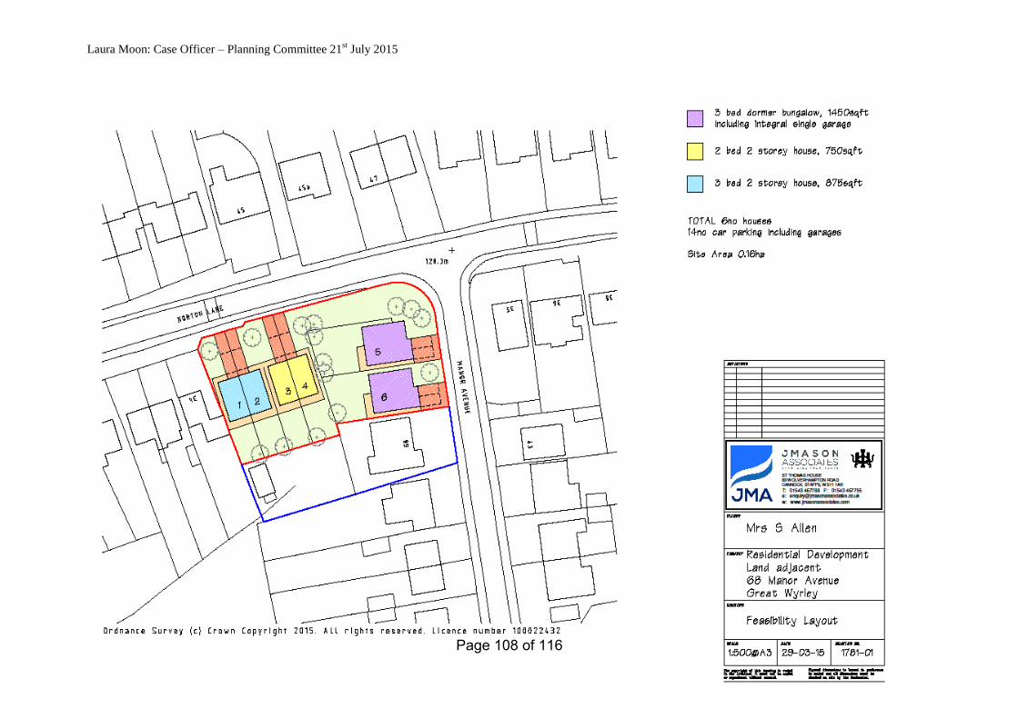
Laura Moon: Case Officer – Planning Committee 21st July 2015
Page 108 of 116

Laura Moon: Case Officer – Planning Committee 21st July 2015
15/00511/FUL
Mr And Mrs Stephen Edge
HUNTINGTON
Square House Boarding Kennels And Cattery, Square House, Cannock Road, Mansty, ST19 5SA
Re-Location of Stables
1. SITE DESCRIPTION AND PLANNING HISTORY
1.1 Site Description
1.1.1 This application relates to the existing kennels and cattery at Square House, which is sited along Mansty Lane in Penkridge. The land under ownership extends to some 116 hectares where most of the land is used
for agricultural purposes. This application relates to the existing stables which are located in the main courtyard adjacent to the farmhouse.
1.2 Planning History
1994 Calf shed, hay and straw building for storage, approved (94/00799) 1995 Boarding Kennels, Approved (95/00815)
1996 Extension to barn/tractor store, approved (96/00602) 1997 Extension to boarding kennels, approved (97/00962) 1997 Extensions, Refused (97/01034)
2002 Demolition of agricultural barn and tractor store, construction of new kennel block with runs, approved (02/00103/FUL)
2003 Agricultural building, approved by letter (03/00668/AGR) 2014 Extension to existing agricultural building, withdrawn
(14/00722/AGR) 2014 A new agricultural building, approved by letter (14/00723/AGR) 2014 Extension to existing agricultural building, approved (14/00787/FUL)
2015 Re-location of stables and erection of building for use as kennels/cattery, refused (15/00116/FUL)
2015 Erection of building for use as boarding kennels/cattery, approved (15/00352/FUL)
2. APPLICATION DETAILS
2.1 The Proposal 2.1.1 The application proposes to re-site the existing wooden stable blocks
from the main compound further north of the site [towards Mansty Lane] in front of an approved agricultural building. The size of the stable blocks
is to remain unchanged. No new access is proposed. 2.1.2 A previous application to re-site the stable blocks further south west
of the compound was refused over concerns on the proposals impact on the AONB as the proposal extended beyond the existing compound
(15/00116/FUL). 2.2 Agents Submission
Page 109 of 116

Laura Moon: Case Officer – Planning Committee 21st July 2015
2.2.1 The agent has provided a supporting statement the key points are;
- The two stable blocks are used by the applicants to accommodate their own horses and a need for these to be relocated follows from the recent approval of application ref. 15/00352/FUL. It also has the operational
advantage of physically separating the business and leisure facilities. - The revised (following the previous refusal ref. 15/00116/FUL) proposed
re-location site is well-screened in views from the adjoining highway by the existing hedgerow and in views from the east by the approved new agricultural store (shortly to be erected) and any long distance views from
the north by the existing landform. We see no conflict with policy EV7.
3. POLICY CONTEXT 3.1 Within the Green Belt
3.2 Core Strategy
Strategic Objective 1: To protect and maintain the Green Belt and Open Countryside in order to sustain the distinctive character of South Staffordshire.
Core Policy 1: The Spatial Strategy for South Staffordshire Core Policy 1: The Spatial Strategy
GB1: Development in the Green Belt EQ2: Cannock Chase Special Area of Conservation EQ9: Protecting Residential Amenity
Core Policy 4: Promoting High Quality Deign EQ11: Wider Design Considerations
EQ12: Landscaping Core Policy 7: Employment and Economic Development
Policy EV7: Equine Related Development Core Policy 11: Sustainable Transport EV11: Sustainable Travel
3.3 NPPF
Part 1: Building a strong, competitive economy Part 7: Requiring good design Part 9: Protecting Green Belt Land
4. CONSULTATION RESPONSES
4.1 Comments received
This report was written before the consultee response period expired. I would refer Members to the Update list for any comments received in the
interim period. Councillor Ashley called the application into committee (received
02/07/15)
No comments from Huntington Parish Council (expired 14/07/2015) No Landscape Officer comments (expired 14/07/2015)
Page 110 of 116

Laura Moon: Case Officer – Planning Committee 21st July 2015
No Environmental Health comments (expired 14/07/2015)
No County Highways comments (expired 14/07/2015) No AONB Officer comments (expired 14/07/2015)
Site Notice (expired 21/07/2015)
5. APPRAISAL
5.1 The application has been referred to regulatory committee by Councillor Ashley as it is considered that the proposal is contrary to Green
Belt policy. 5.2 Key Issues
- Principle of development
- Impact on openness, visual amenity and AONB - Impact on neighbouring amenity - Highways/access
5.3 Principle of development
5.3.1 Before exploring the merits of the development it is important to note that this application is not proposing any additional built
development, it is to re-locate the existing stable block 65m North West of the current courtyard, alongside Mansty Road and adjacent the site of a
large agricultural building submitted and approved in 2014. Work is due to commence on this building this year.
5.3.2 The application site is within the Green Belt where there is a presumption against inappropriate development. However, Core Strategy
policy GB1 considers an exception to this is the provision of appropriate facilities for outdoor sport and recreation which is considered an
acceptable form of development in the Green Belt. Policy EV7 outlines the principles by which such proposals would be supported.
5.3.3 Whilst Policy GB1 refers to small-scale, recent appeal decisions have placed greater emphasis on the wording contained with the NPPF
'appropriate facilities for outdoor sport and recreation'. Paragraph 89 does not give numbers or sizes of what is deemed appropriate however I consider that for size of the site nine stables plus a tack room to be
appropriate outdoor facilities for sport and recreation. This proposal is therefore fully in accordance with paragraph 89 of the NPPF and not
inappropriate development in the Green Belt. 5.4 Impact on openness, visual amenity and the AONB
5.4.1 GB1 of the Core Strategy states that developments which conflict
with preserving the openness of the Green Belt will not be permitted. The most important aspect of Green Belt is their openness. Any development proposals should therefore not cause any undue harm or loss of openness.
Page 111 of 116
Laura Moon: Case Officer – Planning Committee 21st July 2015
5.4.2 The existing stable block is to be sited close to Mansty Road. The re-location site is well-screened by an existing mature hedgerow from the
adjoining highway and views from the east would be limited by the approved agricultural store once built. Any long distance views from the north would be limited by the existing landform. Taking this into
consideration along with the low height of the building and the use of suitable materials [timber cladding with felt roofing] I do not consider that
the proposal will cause any harm on the either the visual amenities of the Green Belt, or the AONB.
5.5 Impact on neighbouring amenity
5.5.1 Policy EQ9 of the Core Strategy requires that new development should take into account the amenity of any nearby residents. As there are no residential properties in close vicinity of the site, there is no
concern in this regard.
5.6 Highways/access 5.6.1 There are highways or parking issues in respect of this application.
6. CONCLUSIONS
6.1 The proposal represents appropriate facilities for outdoor sport and recreation within the Green Belt in accordance with paragraph 89 of the
National Planning Policy Framework. The proposal would not have a material impact on the openness of the Green Belt or on neighbouring
amenity. For these reasons I recommend the application for approval.
7. RECOMMENDATION APPROVE Subject to the following condition(s):
1. The development to which this permission relates must be begun
not later than the expiration of 3 years beginning with the date on which this permission is granted.
2. The development shall be carried out in accordance with the approved drawings: 896/A/047 Rev A and 896/A/060 Rev A
received on the 11th June 2015. Reasons
1. The reason for the imposition of these time limits is to comply with
the requirements of Section 91 of the Town and Country Planning Act 1990.
2. In order to define the permission and to avoid doubt.
3. Proactive Statement
The Council has considered the application submitted, but did not
consider amendments to the proposal were necessary. The
Page 112 of 116
Laura Moon: Case Officer – Planning Committee 21st July 2015
application is considered to be acceptable in accordance with the reasons for granting planning permission above. The Local Planning
Authority has therefore worked in a positive and proactive manner in relation to dealing with the planning application, in accordance with paragraphs 186 and 187 of the National Planning Policy
Framework, 2012.
The proposal is considered to be a sustainable form of development and so complies with the provisions of the National Planning Policy Framework, 2012.
Page 113 of 116

Laura Moon: Case Officer – Planning Committee 21st July 2015
15/00511/FUL Square House Boarding Kennels and Cattery, Square House, Cannock Road, Mansty
Page 114 of 116

Laura Moon: Case Officer – Planning Committee 21st July 2015
Page 115 of 116

Laura Moon: Case Officer – Planning Committee 21st July 2015
Page 116 of 116