Embed Size (px)
Citation preview

Today’s Agenda Assignment 1 is due Monday
I’ll accept until Friday without penalty Questions? Review Taaffe’s Model Gravity Model Atlanta
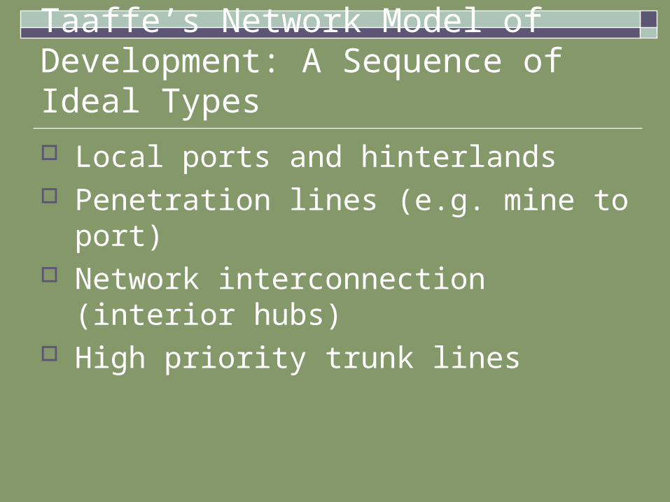
Taaffe’s Network Model of Development: A Sequence of Ideal Types
Local ports and hinterlands Penetration lines (e.g. mine to port) Network interconnection (interior hubs) High priority trunk lines
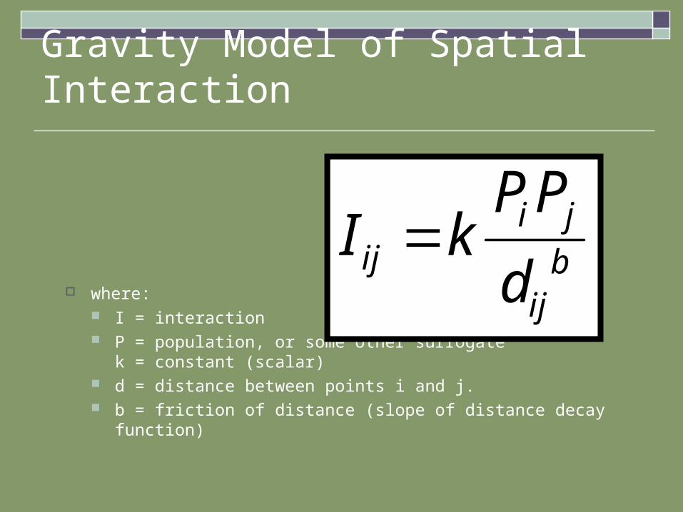
Gravity Model of Spatial Interaction
where: I = interaction P = population, or some other surrogate
k = constant (scalar) d = distance between points i and j. b = friction of distance (slope of distance decay function)
I kPP
dij
i j
ijb
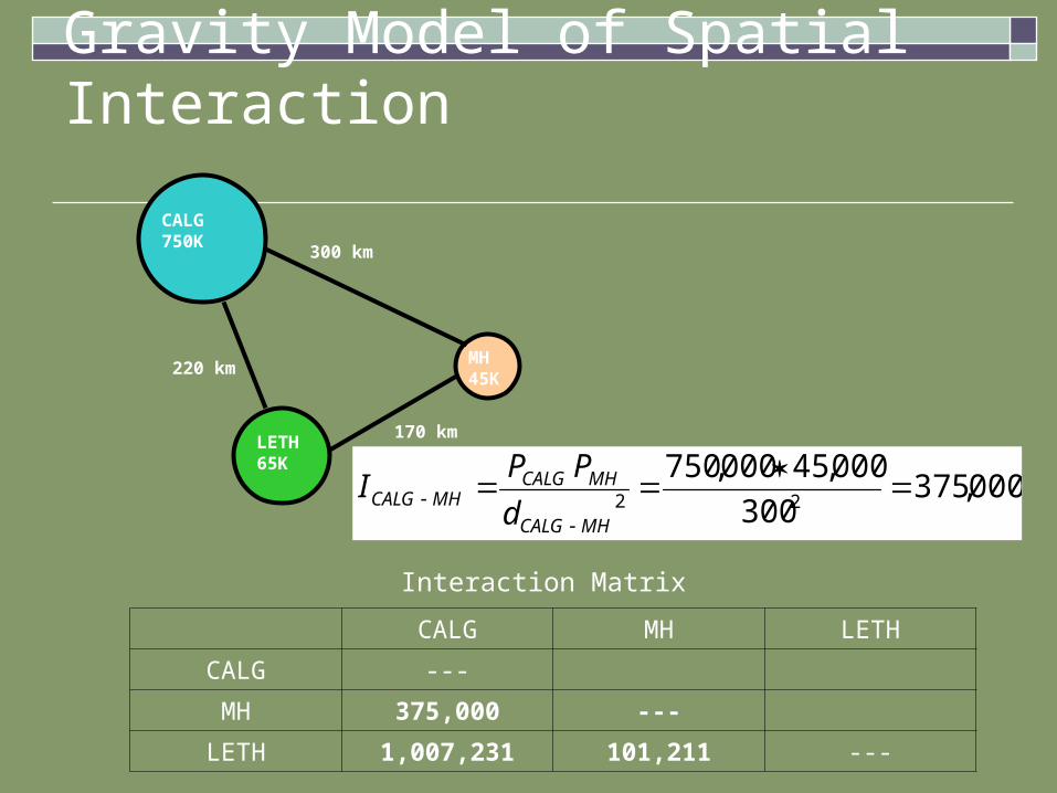
Gravity Model of Spatial Interaction
CALG750K
LETH65K
MH45K
300 km
220 km
170 km
CALG MH LETH
CALG ---
MH 375,000 ---
LETH 1,007,231 101,211 ---
Interaction Matrix
000,375300
000,45000,75022
MHCALG
MHCALGMHCALG
d
PPI
Gravity Model of Spatial Interaction
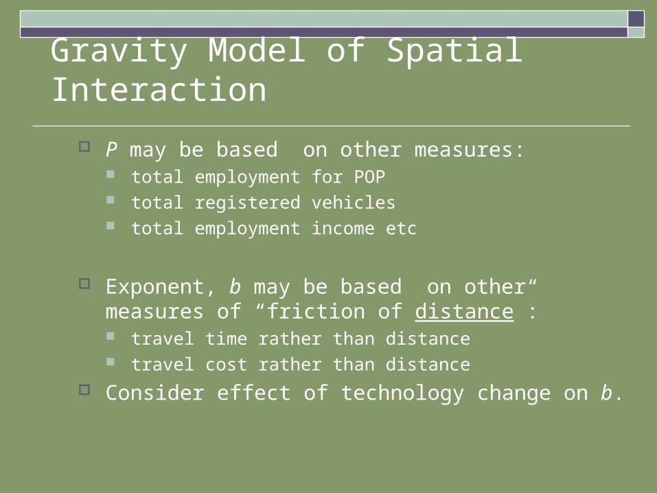
P may be based on other measures: total employment for POP total registered vehicles total employment income etc
Exponent, b may be based on other measures of “friction of distance”: travel time rather than distance travel cost rather than distance
Consider effect of technology change on b.

Atlanta
Emblematic of the “new south” Rapid growth in sunbelt Urbanization, industrialization, high technology, corporate centre,
transportation Rivalry with Savannah as Georgia’s key port Railroad Delta airline hub Interstate highway system and I-285 beltway Edge City/suburban downtown phenomenon Decentralization of Office space


Impact of Transportation on Economic Activity Water – coastal, river, lake, cities Railway – Prairie cities Highway development – 3 phases of impact
Substitution: shipping by rail→road Modal separation Pedestrians and highways
Transition: adjacent land use/density Induced demand
Developmental: Transportation ↔ Economic activity


![Agile V Model.ppt - RBCS, Inc · I’ll show you… The Agile V Model ... agile The Agile V Model ... Agile V Model.ppt [Compatibility Mode]](https://img.pdfslide.net/doc/110x75/5acdaca47f8b9a6a678dca0e/agile-v-modelppt-rbcs-inc-ll-show-you-the-agile-v-model-agile-the-agile.jpg)
![Convex Optimization CMU-10725 · Definition [Penalty function] Example [Penalty function] 18 Derivative of the penalty function Penalty program: Penalty function: Assumptions: Derivatives:](https://img.pdfslide.net/doc/110x75/5f4d6fd89079d1731710faab/convex-optimization-cmu-definition-penalty-function-example-penalty-function.jpg)