Embed Size (px)
Citation preview

Evacuations and other impacts from large ash producing eruptions: perspectives from Patagonia
Tom Wilson1; Carol Stewart1; Graham Leonard2; Gustavo
Villarosa3; Valeria Outes3; Heather Bickerton1; Peter Baxter4
1:University of Canterbury, New Zealand2: GNS Science, New Zealand
3: Universidad de Comahue, Argentina4:University of Cambridge, United Kingdom
Workshop on Strategy of Volcanic Disaster Mitigation 27 November 2013

OverviewImpacts from large silicic eruptions in
Patagonia (southern South America)EvacuationsInfrastructure disruptionAgricultural impacts
Is it possible to identify vulnerability thresholds?
Managing volcanic ash risk...some perspectives

Research Context – Ash Impact Research• Over the past 20 years our New Zealand research
group (and collaborators) have aimed to undertake a sustained and systematic approach to volcanic impact assessment - critical infrastructure: electricity, water supplies,
wastewater, land and air transport, telecommunications
- ash cleanup and disposal- primary industries, e.g. agriculture- social impacts- emergency management
• Reconnaissance trips to impacted areas to bring lessons home
• Followed by laboratory testing of critical infrastructure components...VAT Lab

Recon Trips: by volcano & year visitedEldfell (Heimaey) 2008Redoubt 1996; 2010
Pinatubo2007
Merapi 2006
Sakurajima2001
Shinmoedake2011
Ruapehu1995-96
Lapevi2003-05
Hudson2008
Chaiten2009
Puyehue Cordon-Caulle2012
Etna2003
Tungurahua2005; 2010
Pacaya2010

1) How did impacts unfold in real situations, what were main problems, what was resilient/tolerant (equally important)what mitigation actions were effective, previous preparedness, lessons learned, adaptive behaviours, etc
2) Trips conducted at various time intervals afterwards
3) Trips range from small scale (1 person), to larger multi-disciplinary teams
4) Emphasis on collaborating with local authorities, scientists, and utility managers
5) Development of standardised impact assessment procedures
Reconnaissance Trips

What impacts does ash fall have on urban and rural environments?
New Zealand and Patagonia share similar:LatitudeVolcanoesClimate (esp. west) CHAITEN
HUDSON
PUYEHUE CORDON-CAULLE

References:• PCC: Villarosa et al.
unpub data• Chaiten: Watt et al.
2009; Alfano et al. 2011• Hudson: Scasso et al.
1994
40°S
50°S
Puerto Ibanez
Chile Chico
Los Antiguos
Tres Cerros
Puerto San Julian
Perito Moreno
Chaiten
FutaleyufuEsquel
Trevelin
Villa La Angostura
Bariloche
CHAITEN
HUDSON
PCC
Jaccobacci
1991 Hudson Eruption• VEI 5• 4.3 km3 bulk volume• 100,000km2 affected• Trachyandesite-
rhyodacite
2008 Chaiten Eruption• VEI 4• 0.5-1.0 km3 bulk volume• 150,000km2 affected• Rhyolite
2011 Puyehue Cordon-Caulle Eruption• VEI 4• ~4.5 km3 bulk volume• 150,000km2 affected• Rhyodacite

2008 Chaiten Eruption
Late-April-2 May: seismic activity
Late 2 May: Plinian eruption began at Chaiten volcano
20 km column height


Source: NASA

• Initial Evacuation of isolated rural areas affected by ashfalls were evacuated during the night of the 2-3 May.
• Significant concerns that the eruption would continue to increase in intensity (pyroclastic flow hazards)
• Evidence of pyroclastic
flow and lahar deposits under Chaiten town (pop. 4,000)

Evacuation of Chaiten town• Over 5,000 people evacuated from the town and surrounding areas by boat
and vehicle between 3-4 May 2008. Usually with minimal possessions (speed was key).
• All available ships amassed at Chaiten harbour (24 hours).
• Public + private resources used.

Evacuation management
• Evacuees were separated across several different towns.
• Images of houses flooded/destroyed and pets roaming the streets was very distressing
- media management important

Exclusion Zone Management
• Some residents had a strong desire to return to Chaiten...
• Initially the area was off-limits to anyone – some exceptions (e.g. Scientists)
• Police controlled the exclusion zone - looting and safety
• Some organised trips for residents to collect personal possessions

Long term planning...what to do with Chaiten?
1. Reoccupy
2. Abandon and relocate town
3. Abandon and disperse population
Strong sense of community
Following two risk assessments, the town was officially abandoned on 29 January 2009
But....decision ‘reversed’ and reoccupation of Chaiten by 2012

Source: NASA

75 mm of ash fall induced infrastructure failure in Futaleufu, Chile (2,000 residents - temporary evacuation)
• Water supply compromised• Power supply cut• Roads disrupted by thick ashfalls• Health concerns
Compounded effects
Tourism and agriculture severely impacted
Evacuation of >80% of town. Duration: 1-12 months


1991 Hudson eruption
Several thousand people evacuated within several days - weeks (issue with returning)
Reactive, mostly self- evacuation from farms and small towns
Evacuations driven by:- Public health concerns of air
and water quality- Fear of roof collapse (Ibanez
Valley where ash fall >250 mm)
- Livestock death due to feed coverage and water contamination
- Disruption of essential services (urban)
1993 – S. Weaver

1991 1996 2001 20060
200
400
600
800
1000
1200
1400
1600
1800
2000
30-60 km from vent60-80 km from vent200-300 km from vent
Length of Abandonment following eruption (Year)
Ash
Dep
th
Length of farm abandonment following eruption vs. ashfall depth
Wilson et al. 2011

Ash Impacts to Agriculture (brief summary)
Livestock: starvation, irritation, poisoning
Pastures and crops: coverage, toxicity (rare), UV reduction, acid damage, lodging, soil cycles disrupted, soil fertility impacts, etc.
Water Supplies: turbidity, toxicity (rare)
Critical Services: disruption to electricity, roads, etc.
Variety of mitigation options

-100-80-60-40-20020400
50
100
150
200
250
300
30-60 km60-90 km90-120 km300-400 km
Farmer Perception of Productivity Change between 1991-2008
Ash
Dep
th (
mm
)
• Ashfalls >300 mm led to large productivity decline (most had been abandoned for 5-16 years)
• Ashfalls <300 mm lead to a range of productivity adjustments
Wilson et al. 2011

Eruption HUDSON 1991 CHAITEN 2008 PUYEHUE CORDON-CAULLE 2011
Town Affected Puerto Ibanez Chile Chico Los
AntiguosPerito
MorenoTres
CerrosPuerto
San Julian Chaiten Futaleyufu Trevelin Esquel Villa La Angostura Bariloche Jaccobacci
Distance from Vent (km) 90 120 125 175 473 545 11 75 100 110 44 90 231
Ash hazard character-
istics
Thickness of ash fall (mm)
20 100 80 20 40 5 20 30 15 10 150 40 35
Duration of main ash fall 4 days 4 days 4 days 4 days 2-4 days 2-4 days 3 days 6 days 4 days 2-3 days 5-6 days 5-6 days 5-6 days
Remob of ash
(duration)15 years 15 years 15 years 15 years 5-10
years5-10 years
0.5-4 years 1-2 years 6-18
months6-18
months6-12
months6-12
months>18
months
Critical Infra-
structure
Power
Water
Ground Transport
Waste-water & Sewage
Telecom
Municipal Cleanup
Undertaken Yes Yes Yes Yes No Yes Yes Yes Yes Yes Yes Yes YesDuration
Evacuation of
population
Official Evac Yes No No No No No Yes Yes No No No No NoSelf evac – immediate <50% <50% <30% <25% >75% <5% 100% >50% <5% <5% <20% <5% <20%Self evac - long term <50% Yes Yes Yes >75% Yes >50% -- -- -- ??? -- --
DURATION
Hour(s)
Day(s)
Month(s)
Year(s)
SEVERETY
Few isolated issues
Widespread outages
Total disruption
Electrical + Water: high dependence high disruptive impact
System design key factor
Ground transportation: most common and often longest disruption. Roads (and properties) require clean up costly and time consuming
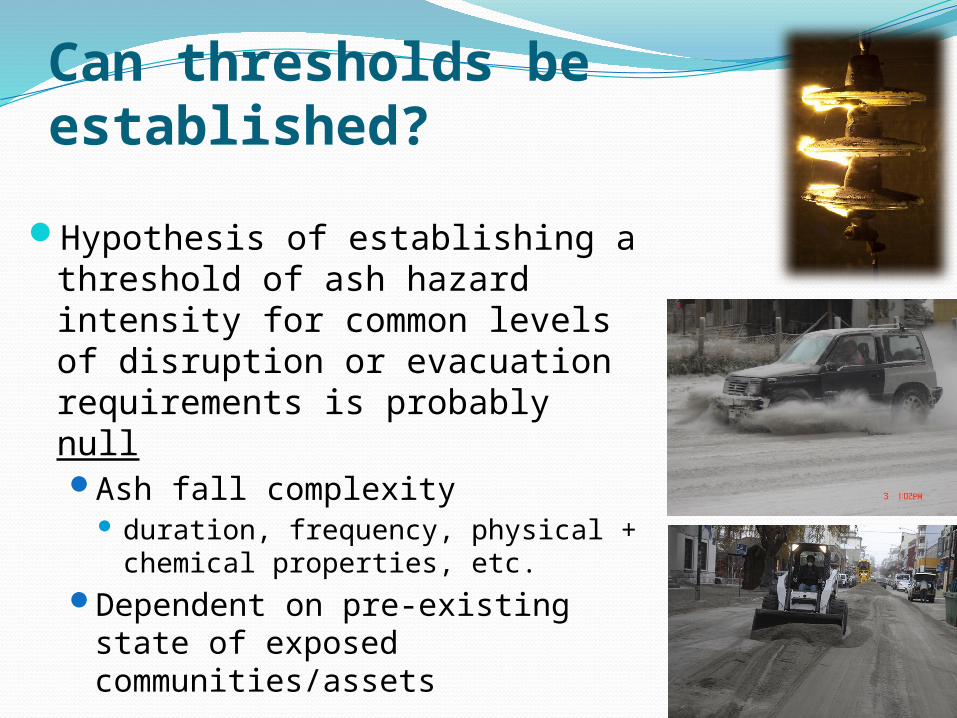
Can thresholds be established?
Hypothesis of establishing a threshold of ash hazard intensity for common levels of disruption or evacuation requirements is probably nullAsh fall complexity
duration, frequency, physical + chemical properties, etc.
Dependent on pre-existing state of exposed communities/assets

Summary of ash fall impacts to critical infrastructureDisruptive rather than catastrophically damaging
Most infrastructure systems will tolerate volcanic ash...up to a point
Loose relationship with ash thickness/load, but strongly influenced by:system design level of planning adaptive capacity
The complex characteristics of volcanic ash can create a range of possible direct and indirect impactsPossibly leading to complex, cascading effectsIndividual case-by-case assessment approach probably most
appropriate


Drivers of evacuation
following ash falls
Airborne ash = anxiety of
respirable hazard
Anxiety of ash contamination of
food supplies
Anxiety of ash contamination of water supplies
Critical Infrastructure
disruption(power, water,
etc.)
(Fear of) Roof collapse
Loss of industry (e.g. agriculture,
tourism, etc.)
Official evacuations used to manage proximal hazards
But self-evacuation very common in areas exposed to ash ash fall
Duration of exposure to ashy conditions will influence evacuation decision and duration of evacuation Primary air fall Remobilisation
Few evacuation from fear of roof collapse insufficient ash loads
Evacuations

Return of evacuees following ashfallWhat is there to return to?
Speed and quality of system restoration Urban clean up public health concerns Agriculture rehabilitation Restoration of essential services (critical
infrastructure)
Agricultural regions >300mm ash fall will struggle Significant reduction in productivity
Tourism areas Disruption of attractions Negative perception

Some considerations for mitigating ash fall risk Sustained preparedness activities are valuable. But specific
continuity planning for volcanic eruptions is rare Poor awareness of hazard and likely impacts . Strong adaptive capacities often exhibited + novel and unique approaches
commonly developed Lack of preparation actions was costly (time of restoration, delayed key
decisions) Trial and error approach Delays effective response, risks public relations
‘issues’
Access to specialised, sector-specific impact, preparedness and post-event response/recovery information
Effective and timely warnings Allow protective actions to be taken, e.g. seal buildings, shutdown vulnerable
systems, etc. Meaningfully tailored to end-user requirements (triggers for action)
Mutual support/continuity agreements Mutual support agreements: access to greater resources Clean up plan: critical routes, pre-identified ash dump sites
Standardised physical and chemical ash characterisation Assess public health and agricultural impacts Essential for risk communication
Integration of scientific organisations within emergency management framework
Extends beyond volcanologists Agriculturalists, engineers, social scientists, etc.
Timely, adaptable and consistent impact assessment

Thank you
Any questions?


![[Ian J. Bickerton] the Arab-Israeli Conflict a](https://img.pdfslide.net/doc/110x75/55cf9dfa550346d033b0200e/ian-j-bickerton-the-arab-israeli-conflict-a.jpg)