Embed Size (px)
Citation preview

Page 1 of 15
TUTORIAL
Benthic Terrain Modeler for ArcGIS 10.1
August 2013
Introduction
This tutorial will introduce you to the Benthic Terrain Modeler (BTM) toolbox for ArcGIS
v10.1, a collection of Esri® ArcGIS®-based tools that coastal and marine resource managers
can use in concert with bathymetric data sets, in order to examine and classify the benthic
environment. The BTM toolbox contains a set of customized scripts that allow users to
create grids of bathymetric position index (BPI), standardized BPI’s, slope, rugosity, and
other geomorphometric measurements from an input bathymetric data set. Additionally, a
terrain classification script gives users the freedom to create their own zone and structure
classifications and define the relationships that characterize them.
The BTM toolbox for ArcGIS 10.1 creates a user-defined classification system of benthic
terrain. The BTM scripts transform digital elevation data into a classified product for use in
research or natural resource management. However the principles behind the tool are
general enough to be used on any digital elevation data. The inclusion of flexible and
customizable terrain classifications allows investigators and managers to create terrain maps
in a variety of environments. To learn more about the original tool development and its
applications in natural resource mapping and coastal management please refer to the BTM
document located at the link below. More resources including information on BTM product
development and community support can be found in the appendix.
http://proceedings.esri.com/library/userconf/proc04/docs/pap1433.pdf
The BTM was initially developed as a desktop extension for ArcGIS versions 8.x through 9.2
Service Pack 3. The version for ArcGIS 10.1 is comprised of a series of ArcPy scripts combined
in a custom Toolbox that allows the user to run the individual processes as separate
functions, or in a graphical environment from a Python Add-in. The updated version also
allows the tools to run on any kind of raster data supported by ArcGIS, including Bathymetric
Attributed Grids (BAGs), GeoTIFFs, and raster GRIDS. The initial project was a partnership
between the NOAA Coastal Services Center and Oregon State University. The current version
of the Benthic Terrain Modeler is also a joint collaboration between NOAA CSC, the

Benthic Terrain Modeler for ArcGIS v10
Page 2 of 15
Massachusetts Office of Coastal Zone Management, and Esri. Contact information regarding
technical support and product development is located in the appendix.
Benthic Terrain Modeler for ArcGIS 10.1 Functions:
• Build Bathymetric Position Index (BPI) Grids The creation of Bathymetric Position Index
(BPI) data sets at two different scales is central to the methods behind the benthic
terrain classification process. BPI is a derivative of the input bathymetric data set, and is
used to define the location of specific features and regions relative to other features
and regions within the same data set.
• Build Broad-Scale BPI creates a broad-scale BPI data set that allows you to
identify larger regions within the benthic landscape.
• Build Fine-Scale BPI creates a fine-scale BPI data set that allows you to identify
smaller features within the benthic landscape.
• Standardize BPI’s creates standardized BPI data sets that may be classified to identify
various benthic zones and/or structures.
• Calculate Aspect creates an aspect raster to be used in the classification tools.
• Calculate Curvature creates a ‘slope of slope’ raster, and can optionally calculate plan
and profile curvature.
• Calculate Slope creates a slope raster to be used in the classification tools.
• Calculate Depth Statistics calculates depth summary statistics, such as mean, variance
and standard deviation, over a set neighborhood size. These statistics can be useful
predictors in understanding the benthic zones in analyses tasks like habitat
classification.
• Classify Benthic Terrain: creates a user-defined structures layer based on BPI’s, slope,
standard deviation breaks, and depth. The benthic zones in the output layer include
crests, depressions, flats, and slopes. The benthic structures in the output layer will
consist of narrow depression, local depression on flat, lateral midslope depression,
depression on crest, broad depression, broad flat, shelf, open slopes, local crest in
depression, local crest on flat, lateral midslope crest, narrow crest, and steep slope.
Note: this tool combines the Zone Classification Builder and Structure Classification
Builder steps of the toolbox provided at ArcGIS 10.0.
• Terrain Ruggedness (VRM) measures terrain ruggedness, or rugosity, as the variation in
three-dimensional orientation of grid cells within a neighborhood. Vector analysis is used
to calculate the dispersion of vectors normal (orthogonal) to grid cells within the
specified neighborhood. This method effectively captures variability in slope and aspect
into a single measure. Ruggedness values in the output raster can range from 0 (no
terrain variation) to 1 (complete terrain variation). Typical values for natural terrains
range between 0 and about 0.4.

Benthic Terrain Modeler for ArcGIS v10
Page 3 of 15
Note: The BPI, Slope, and Classification Builder scripts are all part of a single benthic terrain
modeling process. The Terrain Ruggedness (VRM) script is an add-on for identifying rugosity in
the benthic terrain environment that yields results unrelated to BPI.
Setup Instructions for Benthic Terrain Modeler for ArcGIS 10.1
BTM for ArcGIS 10.1 is packaged as a .zip file. Unzip the contents to your computers root C:
drive in order to follow the tutorial steps below. The file location should read:
C:\BTM_Tutorial. Within the BTM_Tutorial folder are two folders, one containing the BTM
Toolbox with scripts, and another containing sample data that will be used throughout the
tutorial.
Note: The program files may be saved anywhere but in doing so the paths will differ for the
following instructions.
1. To add the Benthic Terrain Modeler toolbox into ArcMap first open a new map project.
2. Open the ArcToolbox window by clicking Geoprocessing > ArcToolbox and pin it to the
display if it is not already. Right-click on the ArcToolbox top folder in the window and
select Add Toolbox. Navigate to the C:\BTM_Tutorial\toolbox folder and add BTM.pyt.
3. Expand the BTM toolbox in ArcToolbox to see it consists of 7 Python scripts. Note that
the Spatial Analyst extension is required to run the BTM tools.
Note: This tutorial only guides the user on how to perform the BTM functions using the provided
sample data and estimated input values. Bathymetric values and data ranges vary greatly from
one area to another and this should be noted when using the BTM with your own data sets.
Also, this tutorial also does not fully explain the processes that run the scripts in ArcMap. This
tutorial is intended to guide the user on the script-based version of the BTM for ArcGIS 10.x. If
interested in the information regarding the initial product development and the processes that
BTM utilizes, please refer to the original BTM for ArcGIS 8.x user documentation found at
http://www.csc.noaa.gov/digitalcoast/tools/btm/index.html and click on the BTM Tutorial for
ArcGIS 9.2 link.
BTM Tutorial
Add the sample map.
1. Click on Open and navigate to the C:\BTM_Tutorial\sample_data folder and open
btm.mxd. Bathymetric data are the only data required for the BTM tools. The included
hillshade layer can be used to enhance the visualization of the results, but does not
affect the mechanics of the actual tools.

Benthic Terrain Modeler for ArcGIS v10
Page 4 of 15
The bathymetric data used in this tutorial was collected by the U.S. Geological Survey and the
National Oceanic and Atmospheric Administration offshore of Massachusetts between Duxbury
and Hull. These data are available as an ArcInfo 32-bit floating point binary grid in
Environmental Systems Research Institute (ESRI) format. The GRID has a 5-meter horizontal
resolution and the spatial reference is WGS_1984_UTM_Zone_19N. For more information on
acquiring bathymetric data for use with the BTM please visit:
http://pubs.usgs.gov/of/2009/1072/html/appendix1.html.
For each of the following steps, the tools can be accessed one of two ways: either by using the
BTM menu in ArcMap, or using the toolbox directly. Below, the geoprocessing tool dialogs are
shown. To access the BPI tools, use the Bathymetric Position Index menu of the Add-in:

Benthic Terrain Modeler for ArcGIS v10
Page 5 of 15
Build Broad Scale BPI
1. Double-click the first script, Broad Scale BPI, in the BTM toolbox to open it. Populate
the script with the following parameters :
Input bathymetric raster: C:\BTM_Tutorial\sample_data\bathy5m.tif
Inner radius: 25
Outer radius: 250
Output raster: C:\BTM_Tutorial\sample_data\broad_bpi
2. Note that a scale factor is automatically computed based on the input radii. Click OK to
run the script. Once the script runs the symbology will need to be changed. Double-click
the broad_bpi layer in the table of contents, select the Symbology tab, and then select
the Stretched display option. Change the color ramp if necessary. Click Apply and then
OK. Drag the layer beneath the hillsahde5m layer. Your results should look similar to
the graphic below for the Broad Scale BPI.
Benthic Terrain Modeler for ArcGIS v10
Page 6 of 15
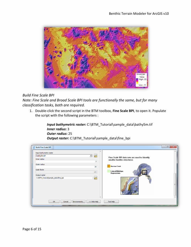
Build Fine Scale BPI
Note: Fine Scale and Broad Scale BPI tools are functionally the same, but for many
classification tasks, both are required.
1. Double-click the second script in the BTM toolbox, Fine Scale BPI, to open it. Populate
the script with the following parameters :
Input bathymetric raster: C:\BTM_Tutorial\sample_data\bathy5m.tif
Inner radius: 3
Outer radius: 25
Output raster: C:\BTM_Tutorial\sample_data\fine_bpi

Benthic Terrain Modeler for ArcGIS v10
Page 7 of 15
2. As with the broad BPI, note that the scale factor is automatically computed. Click OK to
run the script. Once the script runs the symbology will need to be changed. Double-click
the fine_bpi layer in the table of contents, select the Symbology tab, and then select
the Stretched display option. Change the color ramp to match the broad_bpi color
ramp. Click Apply and then OK. Drag the layer beneath the hillshade5m layer. Your
results should look similar to the graphic below for the Fine Scale BPI.
3. Toggle between the broad_bpi and fine_bpi layers to note the differences between the
broad scale and fine scale bathymetric position index grids.
Standardize BPI Grids
1. Double-click the Standardize BPIs script in the BTM toolbox to open it. First standardize
the broad scale BPI. Select broad_bpi as the input raster, name the output broad_std.
Note that the mean and standard deviation of the raster are computed automatically,
and can be useful guides for interpreting the results. Next, select fine_bpi as the second
input raster, and name the output fine_std.

Benthic Terrain Modeler for ArcGIS v10
Page 8 of 15
2. Click OK to run the script. Once the script runs the symbology will need to be changed
as in the previous steps. Drag the layer beneath the hillshade5m layer. Your results
should look similar to the graphic below for the Standardized Broad Scale BPI and
Standardized Fine Scale BPI rasters.

Benthic Terrain Modeler for ArcGIS v10
Page 9 of 15
BTM also supports a range of geomorphology operations. Slope is a required input for the BTM
classification task, and can be accessed from the Geomorphometry menu of the Add-in:
Calculate Slope
1. Double-click the Calculate Slope script in the BTM toolbox to open it. The output slope
raster will be used in the following scripts. Select the bathy5m raster as the input and
name the output file slope, saving it to the sample_data folder.
2. Click OK to run the Calculate Slope script. Once the slope layer is added to the
map change the color ramp in the layer properties and then drag it beneath the
hillshade5m layer in the table of contents. Your layer should have slope values
similar to the graphic below.

Benthic Terrain Modeler for ArcGIS v10
Page 10 of 15
Note: artifacts in the bathymetry data may be magnified by some of the steps as
seen below. In this case, small NW to SE changes in bathy are highlighted caused
by verging multibeam swathes.
Classify Benthic Terrain
Note: the 10.0 version of these tools provided two tools, a “Zone Classification Builder” and
a “Structure Classification Builder”. Both of the tools used the same model, but represented
the classification problem in different terms. In this version of the tool, we have retained
the original BTM method of classifying benthic terrain based on a classification dictionary,
which can be used to generate both structures and zones.
1. Open and inspect the classification dictionary, which maps ranges of input rasters to
specific classes. An example dictionary is included as :
C:\BTM_Tutorial\sample_data\fagatelebay_classification.csv
If you open the file, you should see a spreadsheet that looks like following:

Benthic Terrain Modeler for ArcGIS v10
Page 11 of 15
The first column in the sheet provides numerical class codes, which will be written to
the output raster. The second column provides descriptive names, which could be
structures, zones, or other classifications. The other columns in the spreadsheet define
the ranges of values which describe specific classes in the output.
BTM previously used an XML-based classification dictionary, authored within the
classification wizard itself. The current tool can still read and use the older format, but
CSVs were preferred for their easy authoring, and direct Excel support is planned for
the 10.2 version of the tool.
2. Double-click the Classify Benthic Terrain tool in the BTM toolbox to open it. Populate
the script with the following input parameters:
Classification dictionary:
C:\BTM_Tutorial\sample_data\fagatelebay_classification.csv
Standardized broad-scale BPI raster: C:\BTM_Tutorial\sample_data\broad_std
Standardized fine-scale BPI raster: C:\BTM_Tutorial\sample_data\fine_std
Slope raster: C:\BTM_Tutorial\sample_data\slope
Bathymetric raster: C:\BTM_Tutorial\sample_data\bathy5m
Output raster: C:\BTM_Tutorial\sample_data\structures

Benthic Terrain Modeler for ArcGIS v10
Page 12 of 15
3. Click OK to run the script. Drag the classified layer beneath the hillshade5m layer
in the table of contents and change the ramp color to your preference. Your
classified layer should look similar to the graphic below.
Terrain Ruggedness (Vector Ruggedness Measure)
1. Double-click the Terrain Ruggedness (VRM) script in the BTM toolbox to open it.
Populate the script with the following input parameters

Benthic Terrain Modeler for ArcGIS v10
Page 13 of 15
Elevation Raster: C:\BTM_Tutorial\sample_data\bathy5m
Neighborhood Size: 3
Output Workspace: C:\BTM_Tutorial\sample_data
Output raster: C:\BTM_Tutorial\sample_data\rug_5m
2. Click OK to run the script. Drag the rug_5m layer beneath the hillshade5m layer
in the table of contents and change the ramp color to your preference. Your
rug_5m layer should look similar to the graphic below.

Benthic Terrain Modeler for ArcGIS v10
Page 14 of 15
3. Ruggedness values in the output raster can range from 0 (no terrain variation) to
1 (complete terrain variation). Typical values for natural terrains range between
0 and about 0.4, however it is important to understand that the number is
unitless and not directly comparable between study sites. This script, originally
created by Mark Sappington, was adapted for ArcGIS v10 by the Massachusetts
Office of Coastal Zone Management. For more information regarding the script
processes please refer to:
Sappington, J.M., K.M. Longshore, and D.B. Thompson. 2007. Quantifying
Landscape Ruggedness for Animal Habitat Analysis: A Case Study Using Bighorn
Sheep in the Mojave Desert. Journal of Wildlife Management. 71(5): 1419 -1426.
Appendix
Contact Information and Technical Assistance: Esri
Shaun Walbridge
805-722-9025
Dawn Wright, Ph.D.
909-793-2853, ext. 2182
esri.com/oceans
NOAA Coastal Services Center
Matt Pendleton
843-740-1196
Massachusetts Office of Coastal Zone Management
Dan Sampson
Emily Huntley
617-626-1241

Benthic Terrain Modeler for ArcGIS v10
Page 15 of 15
BTM Development and Support Information:
Wright, D. J., E. R. Lundblad, E. M. Larkin, R. W. Rinehart, J. Murphy, L. Cary-Kothera, and K.
Draganov. 2005. ArcGIS Benthic Terrain Modeler. Corvallis, Oregon, Oregon State University,
Davey Jones Locker Seafloor Mapping/Marine GIS Laboratory and NOAA Coastal Services
Center. Accessible online at: http://www.csc.noaa.gov/digitalcoast/tools/btm.
Alternate BTM Tutorial for ArcGIS 8.x, 9.x
http://dusk.geo.orst.edu/buffgis/Arc9Labs/lab3_analysis_modelsS09.pdf
Seafloor Mapping/Marine and Coastal GIS – Oregon State University
http://marinecoastalgis.net/