Embed Size (px)
Citation preview

TOPIC 2:
MAPPING AND LOCATION

A. Earth Science is broken down into 4 major areas:1. Geology - study of the Earth.2. Oceanography- seawater, coastal processes, seafloor, and marine life.3. Meteorology - the atmosphere, weather and climate.4. Astronomy - the universe

B. Formation of the Earth1.Earth and the other planets formed during the same time span and from the same material.
A. The nebular hypothesis - bodies of our solar system evolved from an enormous rotating cloud called the solar nebula. (mostly hydrogen and helium, & some heavier elements.

B. With the release of heat the interior of the new Earth partially melted.1. The denser elements, (iron and nickel) sunk to the interior.2. The lighter, rocky materials floated outward toward the surface.3. Therefore, Earth has layers with distinct properties.

C. Gases (least dense) were able to escape from the interior which allowed an early atmosphere and eventually oceans to form. Both were composed of the gases that escaped from earth.
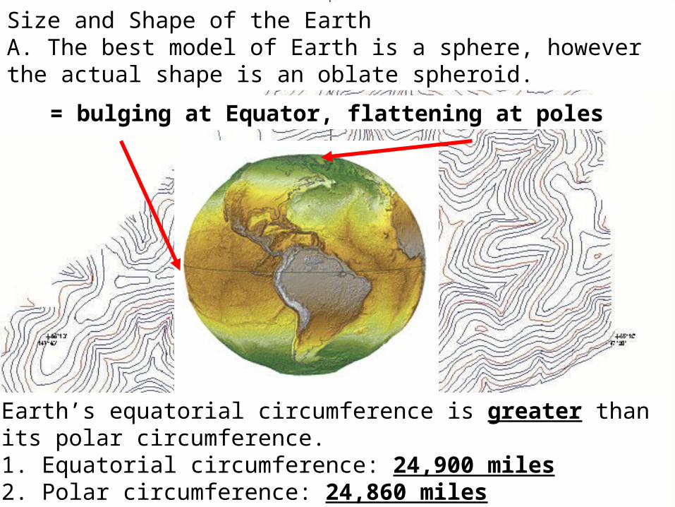
= bulging at Equator, flattening at poles
Size and Shape of the EarthA. The best model of Earth is a sphere, however the actual shape is an oblate spheroid.
Earth’s equatorial circumference is greater than its polar circumference.1. Equatorial circumference: 24,900 miles2. Polar circumference: 24,860 miles

Causes of Earth’s Shape:A. Gravity- a force pulling inward equally in all directions - - causes earth to be spherical.
B. Centrifugal Force- an outward force caused by the spinning (rotating) of earth on its axis. - causes earth to bulge.* The faster the rotational speed, the greater the centrifugal force.


How do we know the Earth is a sphere?1.) Photos from space – nearly a perfect sphere2.) Ships disappear over horizon

3.) ECLIPSESAs the moon orbits Earth it passes through Earth’s shadow. You can actually see Earth’s curvature.
How do we know the Earth is an oblate spheroid? Can you see the bulge from space? NO – so how do we know?
4. Carefully measure your WEIGHT: = Mass x Gravity
Gravity is a factor of both mass and DISTANCE.What does this mean? When you are closer to a larger
mass, the greater the gravitational force

EARTH – not to scale
Where would you weigh more?
Pole or Equator?
Info on the size of the Earth is in the ESRT:

In one of the greatest feats in all of Earth Science history, a man names Erosthothenes was able to
figure this out in 240 B.C.! (they didn’t even know of the New World back then!)

The Earth: In Parts
1.) ATMOSPHERE – contains gases above Earth’s surface and aerosols: suspended solid & liquid
particles
It is layered into sections:
Lowest layer:
Separated by:
(boundaries)
#1 gas?
NITROGEN

The Earth: In Parts
2.) HYDROSPHERE – layer of water (oceans/lakes, etc) – 70% of the Earth’s surface
3.) LITHOSPHERE – solid outer shell of Earth (crust) – broken into plates
4.) INTERIOR – mantle, inner core, outer core

In order of from least thick to thickest:HYDROSPHERE – LITHOSPHERE – ATMOSPHERE – INTERIOR
In order from most dense to least dense:INTERIOR – LITHOSPHERE – HYDROSPHERE –ATMOSPHERE

COORDINATE SYSTEMS
To help find your location on Earth, people have divided the planet into a series of grids.
1. Latitude-longitude coordinate system: the most common system for determining location on the planet.

a. Latitude: the distance (in degrees) N or S of the Equator. Each degree can be broken into 60 minutes.
2. Parallels: latitude lines run W ->E and never intersect 3. North/South Pole: occur at maximum latitude (90°)

1. The altitude of Polaris changes as one moves N or S (in the N. Hemisphere) because Earth’s surface is curved.(Altitude is the height (degrees) that an object is above the horizon.
Observer Latitude Altitude of Polaris
1
2
3
4

WHAT YOU NEED TO KNOW!1: The altitude of Polaris = the latitude of the viewer
What latitude? What latitude?
WHAT YOU NEED TO KNOW!2: How to find Polaris in the night sky

Latitude lines (parallels) run W->E, and measure distance N and S of the 0 degree line:
THE EQUATOR
Notice – the lines of latitude NEVER
intersect!

Longitude lines (meridians) run N->S, and measure distance E and W of the 0 degree line:
THE PRIME MERIDIAN
Where do lines of longitude intersect?
N & S Poles
b. Longitude: distance E or W of the 0° Prime Meridian


The other side of the planet from the Prime Meridian is known as the :
INTERNATIONAL DATE LINE (180 degrees W or E)


3. Determining Time A. Local Noon (12:00) at any point on earth : The moment the sun reaches its highest altitude of the day in the sky for that location.

There is a tip for finding longitude that you must remember:
It has to do with the concept of a TIME ZONE
The Earth rotates WEST TO EAST at 15° each hour, so every 15° of longitude gives us a new time zone.

E. West of the prime meridian the time is earlier East of the prime meridian the time is later.
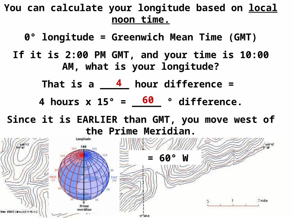
You can calculate your longitude based on local noon time.
0° longitude = Greenwich Mean Time (GMT)
If it is 2:00 PM GMT, and your time is 10:00 AM, what is your longitude?
That is a _____ hour difference =
4 hours x 15° = _____ ° difference.
Since it is EARLIER than GMT, you move west of the Prime Meridian.
= 60° W
4
60