Embed Size (px)
Citation preview
www.elsevier.com/locate/catena
Catena 55 (2004) 163–181
Topographic controls of landslides in Rio de Janeiro:
field evidence and modeling
Nelson F. Fernandesa,*, Renato F. Guimaraesb,Roberto A.T. Gomesa, Bianca C. Vieiraa,David R. Montgomeryc, Harvey Greenbergc
aDepartamento de Geografia, Universidade Federal do Rio de Janeiro, Rio de Janeiro, 21941-599, BrazilbDepartamento de Geografia, Universidade de Brasılia, Brasılia, 70910-900, Brazil
cEarth and Space Sciences, University of Washington, Seattle, WA, USA
Abstract
Landslides are common features in the Serra do Mar, located along the southeastern Brazilian
coast, most of them associated with intense summer storms, specially on the soil-mantled steep
hillslopes around Rio de Janeiro city, where the favelas (slums) proliferated during the last few
decades. On February 1996, hundreds of landslides took place in city of Rio de Janeiro triggered by
intense rainstorms. Since then, many studies have been carried out in two experimental river basins
in order to investigate the role played by the topographic attributes in controlling the spatial
distribution of landslides inside them. Landslide scars and vegetation cover were mapped using aerial
photographs and field observations. A detailed digital terrain model (4 m2 resolution) of the basins
was generated from which the main topographic attributes were analyzed, producing maps for slope,
hillslope form, contributing area and hillslope orientation. By comparing these maps with the spatial
distribution of the landslide scars for the 1996 event, a landslide potential index (LPI) for the many
classes of the different topographic attributes was defined. At the same time, field experiments with
the Guelph permeameter were carried out and a variety of scenarios were simulated with the
SHALSTAB model, a process-based mathematical model for the topographic control on shallow
landslides. The results suggest that most of the landslides triggered in the studied basins were
strongly influenced by topography, while vegetation cover did affect landslide distribution. Between
the topographic attributes, hillslope form and contributing area played a major role in controlling the
spatial distribution of landslides. Therefore, any procedure to be used in this environment towards
the definition of landslide hazards need to incorporate these topographic attributes.
D 2003 Elsevier B.V. All rights reserved.
Keywords: Landslide hazard; Hillslope hydrology; Mathematical modeling; Tropical soils
* Corresponding author. Tel.: +55-21-33931764; fax: +55-21-25989474.
0341-8162/$ - see front matter D 2003 Elsevier B.V. All rights reserved.
doi:10.1016/S0341-8162(03)00115-2
E-mail address: [email protected] (N.F. Fernandes).
N.F. Fernandes et al. / Catena 55 (2004) 163–181164
1. Introduction
Landslides are common processes in the Serra do Mar, a long coast range that follows
almost all the way from south to southeastern Brazil, well-known by its steep scarps that
lead to the generation of fantastic landforms like the sugar-loaves. In the major cities,
particularly the city of Rio de Janeiro, these processes triggered by intense summer
rainstorms, have become more frequent since the 1960s (Meis and Silva, 1968a,b; Barata,
1969; Costa Nunes, 1969; Jones, 1973), when the occupation quickly spread towards the
steep hillslopes inside and around the city. Nowadays, many of the soil-mantled steep
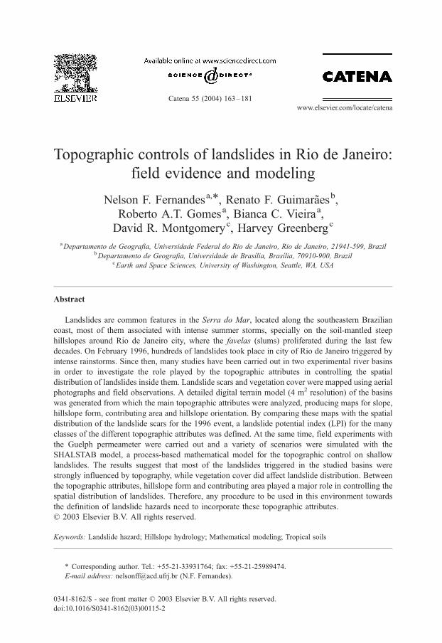
hillslopes are densely occupied (Fig. 1), especially by the slums (favelas), affecting slope
stability by the extensive usage of cuts, landfills, deforestation, changes in drainage
conditions, accumulation of trash deposits on hillslopes, among others, adding new
relationships to the natural conditioning factors related to geology and geomorphology
(e.g., Brunsden and Prior, 1984; Sidle et al., 1985; Crozier, 1986). However, along the
steep slopes of the Serra do Mar escarpments in Southeastern Brazil, it is evident that
landslides play a major role in controlling landscape evolution in the long term (e.g.,
Bigarella et al., 1965; Meis and Silva, 1968a; Modenesi, 1988; Lopes, 1997; Furian et al.,
1999; Coelho Netto, 1999; Cruz, 2000).
A recent landslide inventory of Rio de Janeiro city (Amaral and Palmeiro, 1997b),
although covering just the period from 1962 to 1992, attests an increase in slope instability
during the years of 1967, 1986 and 1988, directly related to intense summer rainstorms
registered in those years. A future update in this inventory will certainly include 1996 in
this list. From 1986 to 1996, landslide disasters killed 123 people and destroyed 414
houses in the city (Amaral, 1997). It is evident that the development of procedures able to
carry out effective landslide prediction in such areas, although urged, is not easily
achieved.
Fig. 1. Spreading of occupation towards the hillslopes around Lagoa Rodrigo de Freitas, Rio de Janeiro city.
N.F. Fernandes et al. / Catena 55 (2004) 163–181 165
Intense summer rainstorms are the main landslide-triggering factor. Unfortunately,
rainfall amounts in the order of 200–300 mm in just 1–2 days are not rare in the city
(Brandao, 1997). For example, in January 1966, a summer storm dumped about 480 mm
rainfall over downtown Rio de Janeiro (about sea level) in just 3 days, while at stations
placed at higher elevations (about 500 m), rainfall values got closer to 700 mm during this
short period (Jones, 1973). More recently, in February 1988, about 384 mm rainfall were
accumulated in the city during 4 days, with half of it registered during just one night
(Brandao, 1997).
Geological features associated with the Pre-Cambrian bedrocks (granites, biotite and
plagioclase gneisses, migmatites, basic and alkaline dikes, etc.), including metamorphic
foliation, unloading and tectonic fractures, also play a major role in landsliding within
the city limits (e.g., Barata, 1969; Jones, 1973; Barros et al., 1988; Amaral et al.,
1992; Barroso, 1992; Amaral and Palmeiro, 1997a). Unloading fractures, for example,
control the downward migration of the weathering processes (differential weathering),
resulting in zones of similar weathering inside the thick weathering mantles, attested in
many places by abrupt soil-bedrock boundaries. Frequently, these fractures can be
clearly observed within the city, representing important mechanical and hydrological
discontinuities.
Slope deposits are also directly associated with landslides in Rio de Janeiro. On the
foothills of the escarpments, as well as in most of the topographic hollows, highly
heterogeneous talus deposits can be observed. In some hillslopes, usually associated with
saturated soils, these deposits can move very fast, attaining rates of 12.7 mm/day, as
observed by Lacerda (1997) in the Tijuca massif. Colluvial deposits in the city, although
thinner than the ones observed in other places in southeastern Brazil, may locally be
important in defining critical places, particularly when these deposits are layered
(Fernandes et al., 1994).
The colluvial mantle along the hillslopes of the city has a high clay content, usually
above 40%, overlaying a thick sandy-silt saprolite. As already suggested by Jones (1973),
and later confirmed by many others, the hydraulic conductivity in this environment tends
to be greater in the saprolite than in the colluvial mantle (e.g., Wolle and Hachich, 1989;
Vieira and Fernandes, 2003). Such behaviour has important implications for defining the
rupture mechanisms in these type of hillslopes, particularly those concerned either with the
development of critical, positive pore-water pressures inside saturated soils or with the loss
of soil suction and decrease in apparent cohesion inside unsaturated soils (e.g., Vargas et
al., 1986; Wolle and Hachich, 1989; Campos et al., 1994).
By comparing the location of landslide scars, associated with one single event or with a
sequence of events, with the spatial distribution of the topographic attributes observed in
the field, one can estimate the effect of each parameter on landsliding, as well as the
triggering mechanisms (e.g., Gao, 1993; Larsen and Torres-Sanchez, 1998; Montgomery
et al., 2000; Zhou et al., 2002). Besides, they improve our prediction abilities. These
analyses have become more widely accessible due to increasing availability of high-
quality digital elevation models.
In general terms, previous studies concerned with the role played by geomorphology in
landsliding in southeastern Brazil have focused their attention mainly to the steepness
parameter. For example, Cruz (1974) estimated threshold slope angles of about 22j (40%)
N.F. Fernandes et al. / Catena 55 (2004) 163–181166
for the Serra do Mar escarpments in Caraguatatuba, south of Rio de Janeiro in Sao Paulo
State, by overlaying the spatial distribution of landslide scars with the map for slope
angles. Similar values (from 20j to 29j) were later obtained by field experiments with a
portable shear device in the same area (Cruz and Colangelo, 2000). Threshold angles have
also been estimated in other places around the world. For example, Gao (1993) observed
that the landslide potential increased rapidly for hillslopes above 31j in Virginia (USA),
while Zhou et al. (2002) observed that most of the landslides in Hong Kong, following the
1993 event, took place on slope angles above 25j–30j.Although slope is a major topographic attribute, affecting both the hydrological
conditions and stability analysis, its importance seems to have been overestimated in
landslide hazard mapping procedures, particularly in Rio de Janeiro. Consequently, gentle
hillslopes initially considered as having low landslide susceptibility were affected by
landslides, especially debris-flows, during the 1996 rainstorms. This attests that other
topographic parameters must be taken into consideration.
In Southeastern Brazil, few studies have tried to consider the contribution of other
morphological attributes on landsliding. Hillslope form, for example, although earlier
suggested as an important parameter (Meis and Silva, 1968a,b), was not incorporated into
stability analysis and landslide hazard mapping procedures. More recently, the role played
by concave forms (hollows) has been intensively investigated, including their effects on
surface and subsurface hillslope hydrology (e.g., Coelho Netto, 1985; Fernandes et al.,
1994), on gullying (e.g., Coelho Netto et al., 1988; Coelho Netto and Fernandes, 1990;
Coelho Netto, 1999), as well as on landsliding (e.g.; Lacerda, 1997; Guimaraes et al.,
1999; Guimaraes, 2000; Fernandes et al., 2001).
Another important topographic attribute is contributing area (per unit contour) since it
defines the location of the convergent segments in a landscape. These portions are directly
associated with the concentration of surface and subsurface flows, contributing to the
development of soil saturation (e.g., Beven and Kirkby, 1979; O’Loughlin, 1986) and
many studies have attested the importance of contributing area in defining critical areas for
landsliding (e.g., Dietrich et al., 1993, 1995; Montgomery and Dietrich, 1994; Wieczorek
et al., 1997; Montgomery et al., 2000).
The effective use of mathematical models for landslide prediction implies the
understanding of the complex interactions between triggering mechanisms and condition-
ing factors. This knowledge requires, on the other hand, detailed field data concerning soil
properties (cohesion, friction angle, specific weight, hydraulic conductivity, etc.) and
hillslope hydrology, particularly the spatial and temporal variations in pore-water pressures
(e.g., Anderson and Burt, 1978; Coelho Netto, 1985; Wilson and Dietrich, 1987; Harp et
al., 1990; Fernandes et al., 1994; Montgomery et al., 1997; Gerscovich et al., 1997).
In February 1996, hundreds of landslides were triggered in the city of Rio de
Janeiro after a series of intense rainstorms, especially inside the Tijuca Massif (Fig. 2).
In some parts of the city, during just 2 days, more than 350 mm of rain was recorded
(GEORIO, 1996; Brandao, 1997; Coelho Netto, 1999). Most of the mass movements
were shallow translation slides that converged towards the main valleys leading to
catastrophic debris flows, which were able to move huge blocks and generated a great
amount of destruction, including the loss of 222 houses and the death of 44 people
(Amaral, 1997).
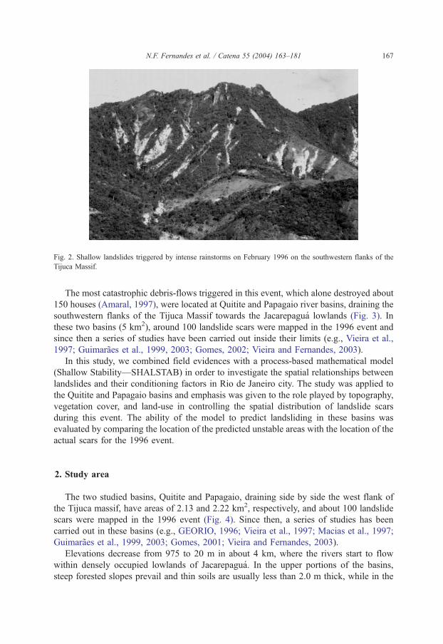
Fig. 2. Shallow landslides triggered by intense rainstorms on February 1996 on the southwestern flanks of the
Tijuca Massif.
N.F. Fernandes et al. / Catena 55 (2004) 163–181 167
The most catastrophic debris-flows triggered in this event, which alone destroyed about
150 houses (Amaral, 1997), were located at Quitite and Papagaio river basins, draining the
southwestern flanks of the Tijuca Massif towards the Jacarepagua lowlands (Fig. 3). In
these two basins (5 km2), around 100 landslide scars were mapped in the 1996 event and
since then a series of studies have been carried out inside their limits (e.g., Vieira et al.,
1997; Guimaraes et al., 1999, 2003; Gomes, 2002; Vieira and Fernandes, 2003).
In this study, we combined field evidences with a process-based mathematical model
(Shallow Stability—SHALSTAB) in order to investigate the spatial relationships between
landslides and their conditioning factors in Rio de Janeiro city. The study was applied to
the Quitite and Papagaio basins and emphasis was given to the role played by topography,
vegetation cover, and land-use in controlling the spatial distribution of landslide scars
during this event. The ability of the model to predict landsliding in these basins was
evaluated by comparing the location of the predicted unstable areas with the location of the
actual scars for the 1996 event.
2. Study area
The two studied basins, Quitite and Papagaio, draining side by side the west flank of
the Tijuca massif, have areas of 2.13 and 2.22 km2, respectively, and about 100 landslide
scars were mapped in the 1996 event (Fig. 4). Since then, a series of studies has been
carried out in these basins (e.g., GEORIO, 1996; Vieira et al., 1997; Macias et al., 1997;
Guimaraes et al., 1999, 2003; Gomes, 2001; Vieira and Fernandes, 2003).
Elevations decrease from 975 to 20 m in about 4 km, where the rivers start to flow
within densely occupied lowlands of Jacarepagua. In the upper portions of the basins,
steep forested slopes prevail and thin soils are usually less than 2.0 m thick, while in the
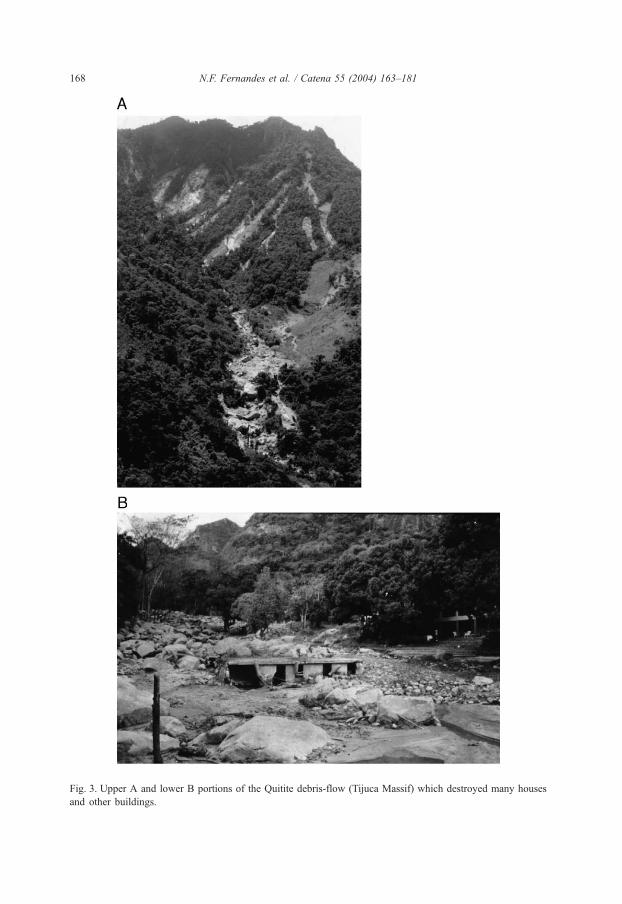
Fig. 3. Upper A and lower B portions of the Quitite debris-flow (Tijuca Massif) which destroyed many houses
and other buildings.
N.F. Fernandes et al. / Catena 55 (2004) 163–181168
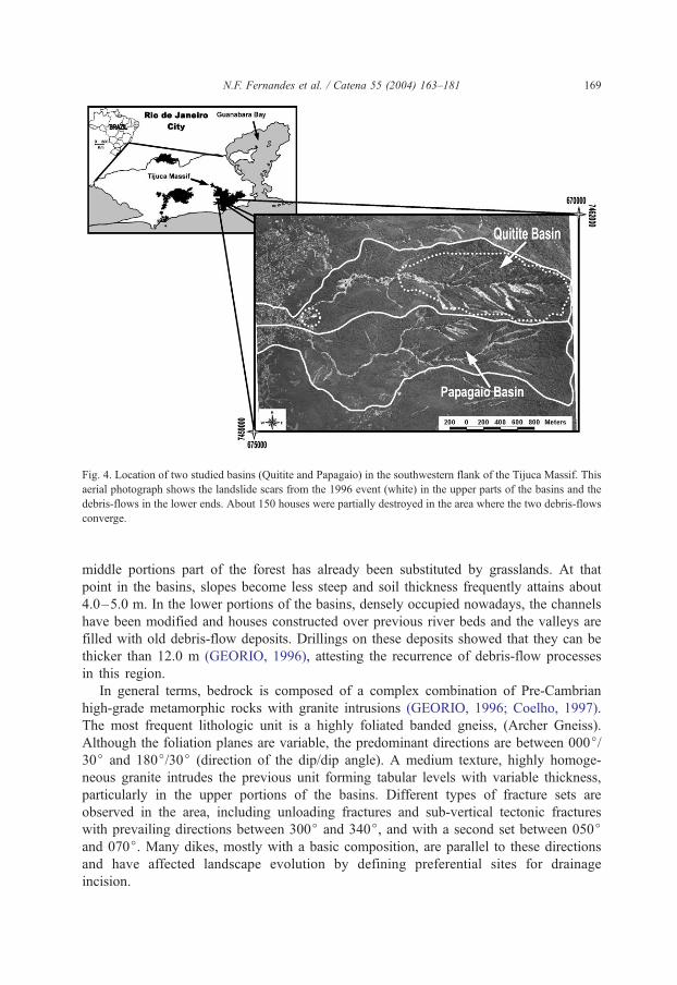
Fig. 4. Location of two studied basins (Quitite and Papagaio) in the southwestern flank of the Tijuca Massif. This
aerial photograph shows the landslide scars from the 1996 event (white) in the upper parts of the basins and the
debris-flows in the lower ends. About 150 houses were partially destroyed in the area where the two debris-flows
converge.
N.F. Fernandes et al. / Catena 55 (2004) 163–181 169
middle portions part of the forest has already been substituted by grasslands. At that
point in the basins, slopes become less steep and soil thickness frequently attains about
4.0–5.0 m. In the lower portions of the basins, densely occupied nowadays, the channels
have been modified and houses constructed over previous river beds and the valleys are
filled with old debris-flow deposits. Drillings on these deposits showed that they can be
thicker than 12.0 m (GEORIO, 1996), attesting the recurrence of debris-flow processes
in this region.
In general terms, bedrock is composed of a complex combination of Pre-Cambrian
high-grade metamorphic rocks with granite intrusions (GEORIO, 1996; Coelho, 1997).
The most frequent lithologic unit is a highly foliated banded gneiss, (Archer Gneiss).
Although the foliation planes are variable, the predominant directions are between 000j/30j and 180j/30j (direction of the dip/dip angle). A medium texture, highly homoge-
neous granite intrudes the previous unit forming tabular levels with variable thickness,
particularly in the upper portions of the basins. Different types of fracture sets are
observed in the area, including unloading fractures and sub-vertical tectonic fractures
with prevailing directions between 300j and 340j, and with a second set between 050jand 070j. Many dikes, mostly with a basic composition, are parallel to these directions
and have affected landscape evolution by defining preferential sites for drainage
incision.
N.F. Fernandes et al. / Catena 55 (2004) 163–181170
3. Methods
3.1. Field mappings and landslide scars
Landslide scars were mapped in 1:20.000 aerial photographs, taken just 2 months after
the 1996 event. Most of them were later visited in the field in order to define landslide
types, soil characteristics, thickness of the failed material, soil depth and geology. Field
mapping was also carried out to generate drainage and vegetation maps (Vieira et al.,
1997, 1998). Detailed geologic mapping has also been conducted in some parts of the two
basins (GEORIO, 1996; Coelho, 1997), but access to the steep and dense forested slopes
in the upper portions is very difficult.
3.2. Topographic attributes and landslide potential indices
A detailed digital elevation model, with a 2.0� 2.0 m grid, was generated for the two
basins from the restitution of the aerial photographs described before. The spatial
distribution of the investigated topographic attributes (slope, hillslope form, contributing
area and hillslope orientation) was mapped using a geographic information system (GIS).
These maps, together with the vegetation map, were overlaid with the landslide scar map,
allowing the definition of the classes prevailing in each cell inside the landslide scars, for
the four topographic variables, as well as for the vegetation cover.
Frequency maps for the classes considered for the four topographic attributes were then
produced. A landslide potential index (LPI) was obtained for each terrain variable by
calculating the ratio between the number of cells disturbed by landslides and the total
number of cells for that specific class. This index identifies the relative influence of each
class on landsliding, for vegetation and for each one of the four topographic attributes
investigated. More details concerning these procedures can be obtained in other studies
(Vieira et al., 1998; Guimaraes et al., 1999; Guimaraes, 2000).
3.3. Modeling landslide susceptibility
We applied the model SHALSTAB (Dietrich and Montgomery, 1998) to the Quitite and
Papagaio basins, simulating a variety of scenarios (Guimaraes et al., 1999, 2003;
Guimaraes, 2000). Because this model simulates the topographic control on shallow
landsliding, it was considered suitable to be used in the study area. During the numerical
simulations, the topographic variables were obtained from the detailed digital elevation
model of the basins while the soil properties were estimated from field investigations and
from previous studies carried out in areas nearby. Although the model allows the
incorporation of the spatial variability of soil properties, in this study, they were considered
constant within the two basins. Other studies are being conducted in order to analyze these
influences on landsliding.
The SHALSTAB model is a deterministic mathematical model, which defines the
relative susceptibility to shallow landsliding in a defined landscape. It has been developed
since the early 1990s (Dietrich et al., 1992, 1993, 1995; Montgomery and Dietrich, 1994)
and has been applied to many sites in the west coast of the United States (e.g.,
N.F. Fernandes et al. / Catena 55 (2004) 163–181 171
Montgomery et al., 1998, 2000; Dietrich and Sitar, 1997). This model assumes that
although site specific properties control the size and the moment when shallow landslides
are triggered, the main controlling factor defining their location is topography (Mont-
gomery and Dietrich, 1994). Based on this assumption, SHALSTAB combines a steady
state runoff model that estimates the topographically induced spatial variation in pore
pressures with an infinite slope model for shallow landsliding (Dietrich and Sitar, 1997).
The calculations incorporate, for each cell in the basin, variables associated with
topography (slope and contributing area), usually obtained from the digital elevation
model, climate (precipitation), as well as soil properties (thickness, hydraulic conductivity,
density, cohesion and friction angle).
A landslide inventory of Rio de Janeiro (Amaral and Palmeiro, 1997b), considering all
the landslides that occurred in the city from 1962 to 1992, has shown that shallow
translation landslides are the most important in the city, corresponding to about 38% of
all landslides. Other studies attest that they also predominate in other parts of the Serra do
Mar (e.g., Cruz, 1974; De Ploey and Cruz, 1979; Wolle and Carvalho, 1989; Lacerda,
1997). Therefore, due to their regional importance, efficient procedures, able to predict
the spatial distribution of shallow landslides in this tropical environment, are urged.
Because we hypothesize that topography, particularly contributing area (per contour
width), plays a major role in controlling landsliding in the Serra do Mar, the SHALSTAB
model seems to represent a useful tool for regional landslide prediction in such an
environment.
Eq. (1) shows the mathematical expression SHALTAB computes for each cell in the
grid (4 m2, in this study). Although the equation can be solved for the critical rainfall (Qc)
required to trigger landslides in the study area, since we did not have many reliable data
concerning the spatial variability of soil transmissivity (T), we solved it for the ratio Qc/T,
as suggested by Dietrich and Montgomery (1998). For the different scenarios analyzed, all
the cells in the grid were classified according to the computed values for the ratio Qc/T.
The greater its absolute value, the more unstable the hillslope is. More details on this
analysis can be obtained elsewhere (e.g., Montgomery and Dietrich, 1994; Dietrich and
Montgomery, 1998).
Qc
T¼ sinh
ða=bÞCV
qwgzcos2h tan/
þ qs
qw
1� tanhtan/
� �� �ð1Þ
where: Qc is the critical rainfall required to fail, T is the soil transmissivity (the product
between soil thickness and saturated hydraulic conductivity), a/b is the contributing area
per contour width, h is the local slope, qw is the density of the water, g is the acceleration
of gravity, z is soil thickness, qs is the soil bulk density, / is the soil friction angle and CVisthe soil cohesion.
3.4. Hydraulic conductivity
Soil hydraulic conductivity plays an important role in landsliding, especially in areas
with thick weathered profiles, like most of the tropical hillslopes. Differential weathering
usually generates hydraulic discontinuities inside the weathered mantle, which may act as

N.F. Fernandes et al. / Catena 55 (2004) 163–181172
impeding layers during infiltration of intense summer rainstorms. These layers may
locally contribute to soil saturation and to the development of critical pore-water
pressures. Besides, as suggested by other studies carried out in the Serra do Mar (De
Ploey and Cruz, 1979), steep forested hillslopes may present, as observed in Caragua-
tatuba (Sao Paulo), soils with high hydraulic conductivity values, allowing rapid
infiltration and interflow along soil cracks and roots, which contribute to landsliding in
this environment.
Other studies in southeastern Brazil have shown that, in contrast to the typical
weathered profile of temperate region, which shows a decrease in saturated hydraulic
conductivity with depth, thick tropical soils may show instead an increase with depth
(Wolle and Hachich, 1989; Wolle and Carvalho, 1994). The pattern of changes in
hydraulic conductivity with depth will directly affect slope stability because it will define
the establishment of either lateral parallel flow or vertical downward flow.
A variety of methods have been proposed to estimate soil hydraulic conductivity in the
field (e.g., Freeze and Cherry, 1979; Stephens, 1996; Tindall and Kundel, 1999). In this
study, we used the Guelph permeameter (Reynolds and Elrick, 1985) to estimate vertical
and lateral variations in hydraulic conductivity (both for the soil and for the weathered
mantle) for different bedrock types that outcrop in the Papagaio basin. To investigate the
hypothesis that hydraulic discontinuities inside the weathered mantle may have locally
contributed to landslide generation in the basin, field measurements of hydraulic
conductivity were carried out close to the border and inside landslide scars from the
1996 event. About 90 measurements of the saturated hydraulic conductivity were
obtained, comprising the entire profile from the surface to bedrock, or to a maximum
depth of about 6.0 m (Vieira and Fernandes, 2003). Because of the portability of the
Guelph permeameter, some experiments were conducted close to landslide scars located
on steep slopes at elevations above 500 m.
4. Results and discussion
4.1. Topographic attributes, vegetation cover and landsliding
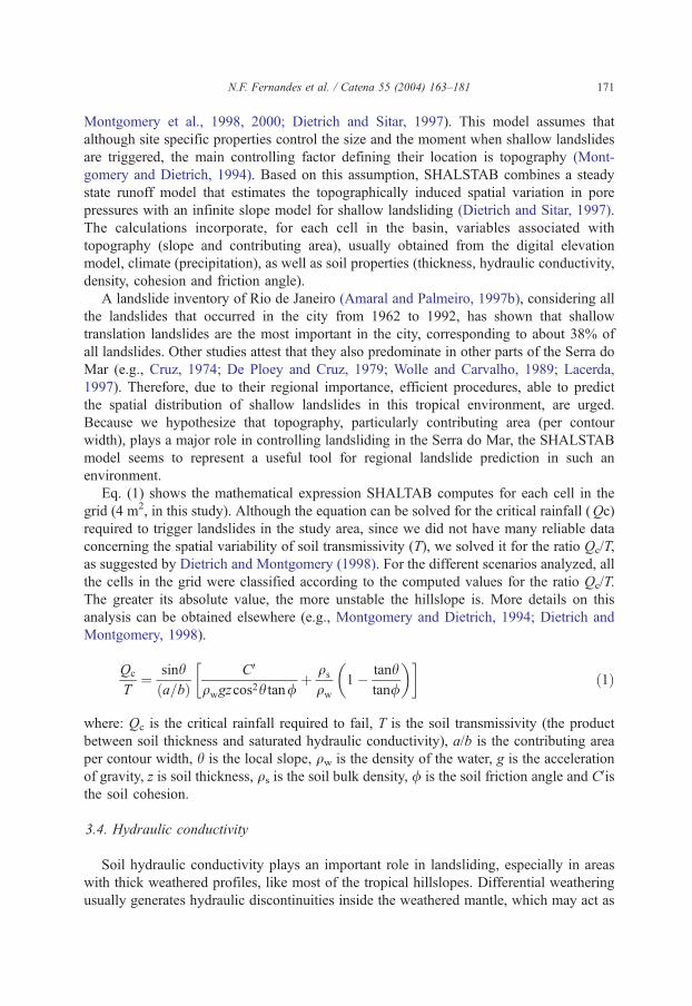
Fig. 5 shows the frequency distribution and the landslide potential index (LPI) for the
four topographic attributes studied (slope, hillslope form, contributing area and hillslope
orientation) as well as for the vegetation cover. The results attest that slope angles between
18.6j and 37.0j are the most frequent to fail in the two basins (Fig. 5a). They also show
that the LPI increases when slope angles increase until a limiting slope class of 37.1j–55.5j is achieved. For angles above this limit, LPI decreases attesting that these very steep
hillslopes were less disturbed by landslides than others more gentle. In our basins, the
steepest sites are associated with shallow soils, which may have already previously failed,
and bedrock escarpments. These results, suggesting the existence of threshold slope angles
for landsliding, are similar to the ones presented by Gao (1993), Larsen and Torres-
Sanchez (1998) and others.
Hillslope form (Fig. 5b), as already expected, played a major role in controlling
landslide distribution in the two basins. Although convex hillslope forms are the most
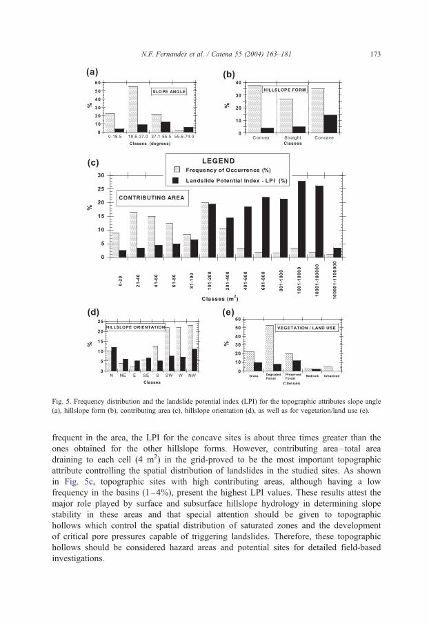
Fig. 5. Frequency distribution and the landslide potential index (LPI) for the topographic attributes slope angle
(a), hillslope form (b), contributing area (c), hillslope orientation (d), as well as for vegetation/land use (e).
N.F. Fernandes et al. / Catena 55 (2004) 163–181 173
frequent in the area, the LPI for the concave sites is about three times greater than the
ones obtained for the other hillslope forms. However, contributing area–total area
draining to each cell (4 m2) in the grid-proved to be the most important topographic
attribute controlling the spatial distribution of landslides in the studied sites. As shown
in Fig. 5c, topographic sites with high contributing areas, although having a low
frequency in the basins (1–4%), present the highest LPI values. These results attest the
major role played by surface and subsurface hillslope hydrology in determining slope
stability in these areas and that special attention should be given to topographic
hollows which control the spatial distribution of saturated zones and the development
of critical pore pressures capable of triggering landslides. Therefore, these topographic
hollows should be considered hazard areas and potential sites for detailed field-based
investigations.
N.F. Fernandes et al. / Catena 55 (2004) 163–181174
Hillslope orientation (aspect) shows a strong inheritance from bedrock structure,
especially metamorphic foliation. As presented in Fig. 5d, about 70% of the hillslopes
inside the two basins face SW, W and NW. Associated with this general trend, the
highest LPI values are observed for hillslopes facing N and NW directions. Although
hillslope orientation also indirectly affects other factors that contribute to landslides, such
as precipitation, soil moisture, vegetation cover and soil thickness, it is evident that in
these basins, bedrock structure plays the most important role in controlling hillslope
orientation.
Fig. 5e shows the results associated with vegetation cover and land use. Although
degraded forest is the most frequent vegetation cover in the basins, LPI values are
relatively similar for grasslands, degraded forest and preserved forest. The highest LPI
value shown by preserved forest should be analyzed with caution because this vegetation
type is spatially associated with the steepest hillslopes. This suggests that other inves-
tigations, based on statistical analysis, should be carried out in order to characterize better
the relationships between these parameters.
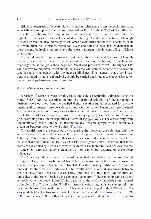
4.2. Landslide susceptibility analysis
A variety of scenarios were simulated and landslide susceptibility estimated using the
model SHALTAB. As described before, the spatial distribution of the topographic
attributes were obtained from the detailed digital elevation model generated for the two
basins. Soil parameters were considered constant inside the two basins and were obtained
from field evidences and from previous studies carried out in the area. Fig. 6 shows the
results for one of these scenarios, derived from applying Eq. (1) to each cell (4 m2) in the
grid, describing landslide susceptibility in terms of log Qc/T values. The classes vary from
unconditionally stable (orange) to unconditionally unstable (gray), with a continuous
gradation between these two end-points (Fig. 6a).
The model results are evaluated by comparing the predicted unstable sites with the
actual location of landslide scars in the basins, triggered by the intense rainstorms of
February 1996. It can be observed that some sites considered unconditionally unstable by
the model did not fail in the 1996 event. Field investigations attest, however, that these
areas are constituted by bedrock escarpments. In this case, therefore, field observations are
in agreement with the model prediction that soil cannot be sustained on these steep
hillslopes.
Fig. 6b shows a detailed view for part of the studied area, defined by the box selected
in Fig. 6a. The spatial distribution of landslide scars is overlaid in this figure, allowing a
general comparison between the estimated landslide susceptibility and the actual
landslide location for the 1996 event. The results attest a general agreement between
the predicted most unstable classes (gray and red) and the spatial distribution of
landslides in the basins. Besides, the elongated geometry of these most unstable classes,
as predicted by the model SHALSTAB, is similar to those of the landslide scars mapped
in the field. Fig. 7 shows SHALSTAB efficiency in estimating landslide susceptibility in
these two basins. For a total number of 92 landslide scars mapped in the 1996 event, 95%
was predicted by the two most unstable classes of the model (Guimaraes et al., 1999;
2003; Guimaraes, 2000). Other studies are being carried out in the area in order to
Fig. 6. a (top) shows landslide susceptibility (in a 3D-view) as predicted by SHALSTAB, expressed in terms of
log Qc/T, for one the simulated scenarios (CV/z = 2; /= 45j; qs = 1.5 g/cm3) in the two studied basins: Quitite (left)
and Papagaio (right). The figure at the bottom (b) shows approximately a detailed view of the area inside the
square in a. It can be noticed a good agreement between landslide scars from 1996 and the most unstable sites
predicted by the model. The area on the far right of b was not analyzed by the model.
N.F. Fernandes et al. / Catena 55 (2004) 163–181 175
incorporate the effects of grid scale (Gomes, 2002) and distributed soil parameters in
model efficiency.
4.3. Variations in soil hydraulic conductivity
About 90 field measurements of saturated hydraulic conductivity, using the Guelph
permeameter, were carried out in Papagaio basin. About 95% of the obtained values,
describing the entire weathered profile to a 5.0m depth, varied from 1.0� 10� 6 to
9.0� 10� 5 m/s (Vieira and Fernandes, 2003). The general trend observed in areas with
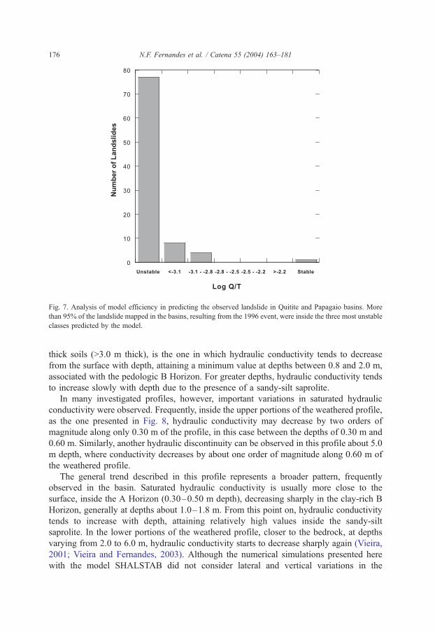
Fig. 7. Analysis of model efficiency in predicting the observed landslide in Quitite and Papagaio basins. More
than 95% of the landslide mapped in the basins, resulting from the 1996 event, were inside the three most unstable
classes predicted by the model.
N.F. Fernandes et al. / Catena 55 (2004) 163–181176
thick soils (>3.0 m thick), is the one in which hydraulic conductivity tends to decrease
from the surface with depth, attaining a minimum value at depths between 0.8 and 2.0 m,
associated with the pedologic B Horizon. For greater depths, hydraulic conductivity tends
to increase slowly with depth due to the presence of a sandy-silt saprolite.
In many investigated profiles, however, important variations in saturated hydraulic
conductivity were observed. Frequently, inside the upper portions of the weathered profile,
as the one presented in Fig. 8, hydraulic conductivity may decrease by two orders of
magnitude along only 0.30 m of the profile, in this case between the depths of 0.30 m and
0.60 m. Similarly, another hydraulic discontinuity can be observed in this profile about 5.0
m depth, where conductivity decreases by about one order of magnitude along 0.60 m of
the weathered profile.
The general trend described in this profile represents a broader pattern, frequently
observed in the basin. Saturated hydraulic conductivity is usually more close to the
surface, inside the A Horizon (0.30–0.50 m depth), decreasing sharply in the clay-rich B
Horizon, generally at depths about 1.0–1.8 m. From this point on, hydraulic conductivity
tends to increase with depth, attaining relatively high values inside the sandy-silt
saprolite. In the lower portions of the weathered profile, closer to the bedrock, at depths
varying from 2.0 to 6.0 m, hydraulic conductivity starts to decrease sharply again (Vieira,
2001; Vieira and Fernandes, 2003). Although the numerical simulations presented here
with the model SHALSTAB did not consider lateral and vertical variations in the
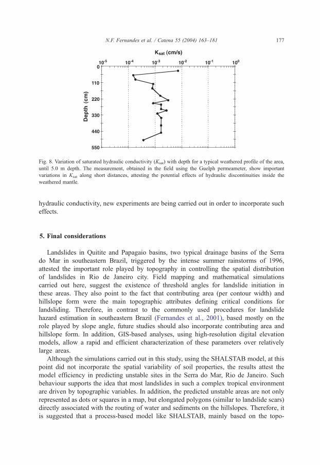
Fig. 8. Variation of saturated hydraulic conductivity (Ksat) with depth for a typical weathered profile of the area,
until 5.0 m depth. The measurement, obtained in the field using the Guelph permeameter, show important
variations in Ksat along short distances, attesting the potential effects of hydraulic discontinuities inside the
weathered mantle.
N.F. Fernandes et al. / Catena 55 (2004) 163–181 177
hydraulic conductivity, new experiments are being carried out in order to incorporate such
effects.
5. Final considerations
Landslides in Quitite and Papagaio basins, two typical drainage basins of the Serra
do Mar in southeastern Brazil, triggered by the intense summer rainstorms of 1996,
attested the important role played by topography in controlling the spatial distribution
of landslides in Rio de Janeiro city. Field mapping and mathematical simulations
carried out here, suggest the existence of threshold angles for landslide initiation in
these areas. They also point to the fact that contributing area (per contour width) and
hillslope form were the main topographic attributes defining critical conditions for
landsliding. Therefore, in contrast to the commonly used procedures for landslide
hazard estimation in southeastern Brazil (Fernandes et al., 2001), based mostly on the
role played by slope angle, future studies should also incorporate contributing area and
hillslope form. In addition, GIS-based analyses, using high-resolution digital elevation
models, allow a rapid and efficient characterization of these parameters over relatively
large areas.
Although the simulations carried out in this study, using the SHALSTAB model, at this
point did not incorporate the spatial variability of soil properties, the results attest the
model efficiency in predicting unstable sites in the Serra do Mar, Rio de Janeiro. Such
behaviour supports the idea that most landslides in such a complex tropical environment
are driven by topographic variables. In addition, the predicted unstable areas are not only
represented as dots or squares in a map, but elongated polygons (similar to landslide scars)
directly associated with the routing of water and sediments on the hillslopes. Therefore, it
is suggested that a process-based model like SHALSTAB, mainly based on the topo-
N.F. Fernandes et al. / Catena 55 (2004) 163–181178
graphic controls on landslides, has a high potential for predicting landslide susceptibility in
steep tropical areas where soil properties are still not well known.
Acknowledgements
This research was supported by CNPq (Brazilian National Research Council), FAPERJ
(Rio de Janeiro State Research Foundation) and PRONEX (Nucleus of Excellence
Program-grant 664050/1998-0). Many colleagues collaborated in different moments for
the development of this study, especially Claudio Amaral, Eurıpedes Vargas Jr., Tacio de
Campos, Ana Cristina F. Vieira, Andrea P. de Souza, Ana Valeria F.A. Bertolino, Carla
Santi, Carlos Andre Mendes, Edna Lindaura Luiz, Rafael Lucas, Vıtor del Pieri, Kelly
Esch and Helder Jardim. We also thank William Dietrich for providing access to
SHALSTAB and for the discussions. This paper was improved by the comments made by
Mike Thommas and two anonymous reviewers.
References
Amaral, C., 1997. Landslides disasters management in Rio de Janeiro. 2nd Pan-American Symposium on Land-
slides (II PSL/2a COBRAE). ABMS, ABGE e ISSMGE, Rio de Janeiro, pp. 209–212.
Amaral, C., Palmeiro, F., 1997a. Correlac�ao entre geologia e escorregamentos nas encostas do Rio de Janeiro
a partir de tratamento de banco de dados, analise via Autocad-SIG e mapeamento de detalhe. 2nd Pan-
American Symposium on Landslides (II PSL/2a COBRAE). ABMS, ABGE e ISSMGE, Rio de Janeiro,
pp. 201–207.
Amaral, C., Palmeiro, F., 1997b. Local landslide inventory of Rio de Janeiro: state of the art and access. 2nd
Pan-American Symposium on Landslides (II PSL/2a COBRAE). ABMS, ABGE e ISSMGE, Rio de Janeiro,
pp. 195–200.
Amaral, C.P., Barros, W.T., Porto Jr., R., 1992. The structural control within a landslide in Rio de Janeiro. In:
Bell, D.H. (Ed.), Landslides. Balkema, Rotterdam, pp. 1339–1343.
Anderson, M.G., Burt, T.P., 1978. The role of topography in controlling throughflow generation. Earth Surface
Processes and Landforms 3, 331–344.
Barata, F.E., 1969. Landslides in the tropical region of Rio de Janeiro. 7th Int. Confer. on Soil Mech. and Found.
Eng., Mexico. ISSMFE, London, pp. 507–516.
Barroso, J.A., 1992. Aspectos lito-estruturais na estabilidade de encostas favelizadas na Serra da Carioca-Rio de
Janeiro. 1a Conferencia Brasileira sobre Estabilidade de Encostas-1a COBRAE. ABMS, Rio de Janiero,
pp. 685–696.
Barros, W.T., Amaral, C., Sobreira, F.G., d’Orsi, R., Maia, H.S., Cunha, R.P., 1988. Catastrophic avalanche at the
St. Genoveva clinic slope (in Portuguese). Solos e Rochas 11, 17–27.
Beven, K.J., Kirkby, M.J., 1979. A physically based, variable contributing area model of basin hydrology.
Bulletin of Hydrological Sciences 24, 43–69.
Bigarella, J.J., Mousinho, M.R., Silva, J.X., 1965. Considerac�oes a respeito da evoluc�ao das vertentes. Boletim
Paranaense de Geografia 16 & 17, 85–116.
Brandao, A.M.P.M., 1997. As chuvas e a ac�ao humana: Uma infeliz coincidencia. In: Rosa, L.P., Lacerda,
W.A. (Eds.), Tormentas Cariocas. COPPE/UFRJ, Rio de Janeiro, pp. 21–38.
Brunsden, D., Prior, D.B. (Eds.), 1984. Slope Instability. Wiley, Chichester.
Campos, T.M.P., Andrade, M.H.N., Gerscovich, D.M.S., Vargas Jr., E.A., 1994. Analysis of the failure of an
unsaturated gneissic residual soil slope in Rio de Janeiro, Brazil. 1st Panam. Symp. on Landslides, Guaquil,
Equador, pp. 201–213.
Coelho, A.L., 1997. Geologia estrutural e hidrogeologia da regiao do Quitite, Jacarepagua (RJ): Condicionantes
N.F. Fernandes et al. / Catena 55 (2004) 163–181 179
dos escorregamentos nas encostas. Geology Dept. Monograph. State University of Rio de Janeiro, Rio de
Janeiro. 29 pp.
Coelho Netto, A.L., 1985. Surface hydrology and soil erosion in a tropical montainous rainforest drainage basin,
RJ. PhD Thesis. Katholieke University Leuven, Belgium.
Coelho Netto, A.L., 1999. Catastrophic landscape evolution in a humid region (SE Brazil): inheritances from
tectonic, climatic and land use induced changes. Supplementi di Geografia Fisica e Dinamica Quaternaria III
(T.3). Comitato Glaciologico Italiano, Torino, pp. 21–48.
Coelho Netto, A.L., Fernandes, N.F., 1990. Hillslope erosion, sedimentation, and relief inversion in SE Brazil:
bananal, vol. 192. SP. IAHS Publ, Oxfordshire, UK, pp. 174–182.
Coelho Netto, A.L., Fernandes, N.F., Deus, C.E., 1988. Gullying in the southeastern Brazilian Plateau, vol. 174.
SP. IAHS Publ, Oxfordshire, UK, pp. 35–42.
Costa Nunes, A.J., 1969. Landslides in soils of decomposed rock due to intense rainstorms. 7th Int. Confer. on
Soil Mech. and Found. Eng. ISSMFE, London, pp. 547–554.
Crozier, M.J., 1986. Landslides: Causes, Consequences, and Environment. Croom Helm, London.
Cruz, O., 1974. A Serra do Mar e o Litoral na Area de Caraguatatuba-SP. Serie Teses e Monografias. Instituto de
Geografia-USP, Sao Paulo.
Cruz, O., 2000. Studies on the geomorphic processes of overland flow and mass movements in the Brazilian
geomorphology. Revista Brasileira de Geociencias 30, 500–503.
Cruz, O., Colangelo, A.C., 2000. Shear strength of the materials applied to the slope stability analysis in a humid
tropical environment (Sao Paulo, Brasil). Geografia Fisica e Dinamica Quaternaria 23, 33–41.
De Ploey, J., Cruz, O., 1979. Landslides in the serra do mar, Brazil. Catena 6, 111–122.
Dietrich, W.E., Montgomery, D.R., 1998. SHALSTAB: A Digital Terrain Model for Mapping Shallow Landslide
Potential. National Council of the Paper Industry for Air and Stream Improvement. Technical Report.
Dietrich, W.E., Sitar, N., 1997. Geoscience and geotechnical engineering aspects of debris-flow hazard assess-
ment. In: Chen, C.-L. (Ed.), 1st International Conf. on Debris. Flow Hazards Mitigation: Mechanics, Pre-
diction, and Assessment. ASCE, San Francisco, USA, pp. 656–676.
Dietrich, W.E., Wilson, C.J., Montgomery, D.R., McKean, J., Bauer, R., 1992. Erosion thresholds and land
surface morphology. Geology 20, 675–679.
Dietrich, W.E., Wilson, C.J., Montgomery, D.R., McKean, J., 1993. Analysis of erosion thresholds, channel
networks, and landscape morphology using a digital terrain model. Journal of Geology 101, 259–278.
Dietrich, W.E., Reiss, R., Hsu, M.-L., Montgomery, D.R., 1995. A process-based model for colluvial soil depth
and shallow landsliding using digital elevation data. Hydrological Processes 9, 383–400.
Fernandes, N.F., Coelho Netto, A.L., Lacerda, W.A., 1994. Subsurface hydrology of layered colluvium mantles
in unchannelled valleys—Southeastern Brazil. Earth Surface Processes and Landforms 19, 609–626.
Fernandes, N.F., Guimaraes, R.F., Gomes, R.A.T., Vieira, B.C., Montgomery, D.R, Greenberg, H.M., 2001.
Condicionantes geomorfologicos dos deslizamentos nas encostas: avaliac�ao de metodologias e aplicac�ao de
modelo de previsao de areas susceptıveis. Revista Brasileira de Geomorfologia 2, 51–71.
Freeze, R.A., Cherry, J.A., 1979. Groundwater. Prentice Hall, Englewood Cliffs.
Furian, S., Barbiero, L., Boulet, R., 1999. Organization of the soil mantle in tropical southeastern Brazil (Serra do
Mar) in relation to landslides processes. Catena 38, 65–83.
Gao, J., 1993. Identification of topographic settings conducive to landsliding from DEM in Nelson County, VA,
USA. Earth Surface Processes and Landforms 18, 579–591.
GEORIO, 1996. Estudos Geologicos-Geotecnicos a Montante dos Condomınios Capim Melado e Vilarejo,
Jacarepagua. Fundac�ao GEORIO. Geotechnical Institute of Rio de Janeiro City, Rio de Janeiro.
Gerscovich, D.M.S., Vargas Jr., E.A., Campos, T.M.P., 1997. Modelagem tridimensional do regime de fluxo de
um talude na cidade do Rio de Janeiro, Brasil. In: Campos, T.M.P., Vargas Jr., E.A. (Eds.), Anais 3j Simp.
Bras. de Solos Nao Saturados (NSAT’97). ABMS, Rio de Janeiro, pp. 281–293.
Gomes, R.A.T., 2002. Condicionantes Geomorfologicos e o Efeito da Escala Cartografica na Previsao de Areas
Crllticas a Deslizamentos. MSc Thesis. Federal University of Rio de Janeiro, Brazil.
Guimaraes, R.F., 2000. A modelagem matematica na avaliac�ao de areas de risco a deslizamentos: o exemplo das
bacias dos rios Quitite e Papagaio (RJ). PhD Thesis. Federal University of Rio de Janeiro, Brazil.
Guimaraes, R.F., Montgomery, D.R., Greenberg, H.M., Gomes, R.A.T., Fernandes, N.F., 1999. Application of a
model for the topographic control on shallow landslides to catchments near Rio de Janeiro. In: Lipard, S.J.,
N.F. Fernandes et al. / Catena 55 (2004) 163–181180
Naess, A., Sinding-Larsen, R. (Eds.), IAMG99—Annual Conference of the International Association of
Mathematical Geology. IAMG, Trondheim, Noruega, pp. 349–354.
Guimaraes, R.F., Fernandes, N.F., Gomes, R.A.T., Greenberg, H.M., Montgomery, D.R, Carvalho Jr., O.A., 2003.
Parameterization of soil parameters for a model of the topographic controls on shallow landsliding. Engineer-
ing Geology 69, 99–108.
Harp, E.L., Wells II, W.G., Sarmiento, J.G., 1990. Pore pressure response during failure in soils. Geological
Society of America Bulletin 102, 428–438.
Jones, F.O., 1973. Landslides of Rio de Janeiro and the Serra das Araras escarpment, Brazil. U.S. Geological
Survey Professional Paper 697, 42.
Lacerda, W.A., 1997. Stability of natural slopes along the tropical coast of Brazil. In: Almeida, M. (Ed.),
Proceeding of the International Symposium on Recent Developments in Soil and Pavement Mechanics.
A.A. Balkema, Rotterdam, pp. 17–39.
Larsen, M.C., Torres-Sanchez, A.J., 1998. The frequency and distribution of recent landslides in three montane
tropical regions of Puerto Rico. Geomorphology 24, 309–331.
Lopes, J.A.U., 1997. The role of landslides in the landscape evolution: theoretical and practical aspects. 2nd Pan-
American Symposium on Landslides. ABMS, ABGE & ISSMGE, Rio de Janeiro, pp. 91–100.
Macias, J., Amaral, C.P., Vargas Jr., E., 1997. Retroanalise do comportamento mecanico das corridas de massa de
1996 no Rio de Janeiro: determinac�ao da velocidade de deslocamento e da viscosidade dos movimentos
envolvidos. 2a Conferencia Brasileira sobre Estabilidade de Encostas—2nd Pan-American Symposium on
Landslides. ABMS, ABGE & ISSMGE, Rio de Janeiro, pp. 243–251.
Meis, M.R.M., Silva, J.X., 1968a. Considerac�oes geomorfologicas a proposito dos movimentos de massa
ocorridos no Rio de Janeiro. Revista Brasileira de Geografia 30, 55–72.
Meis, M.R.M., Silva, J.X., 1968b. Mouvements de masse recents, a Rio de Janeiro: Une etude de geomorpho-
logie dynamique. Revue de Geomorphologie Dynamique 18, 145–152.
Modenesi, M.C., 1988. Quaternary mass movements in a tropical plateau (Campos de Jordao, Sao Paulo, Brazil).
Zeitschrift fur Geomorphologie N.F. 32, 425–440.
Montgomery, D.R., Dietrich, W.E., 1994. A physically based model for the topographic control on shallow
landsliding. Water Resources Research 30, 1153–1171.
Montgomery, D.R., Dietrich, W.E., Torres, R., Anderson, S.P., Heffner, J.T., Loague, K., 1997. Hydrologic
response of a steep, unchanneled valley to natural an applied rainfall. Water Resources Research 33, 91–109.
Montgomery, D.R., Sullivan, K., Greenberg, M.H., 1998. Regional test of a model for shallow landsliding.
Hydrological Processes 12, 943–955.
Montgomery, D.R., Schmidt, K.M., Greenberg, M.H., Dietrich, W.E., 2000. Forest clearing and regional land-
sliding. Geology 28, 311–314.
O’Loughlin, E.M., 1986. Prediction of surface saturation zones in natural catchments by topographic analysis.
Water Resources Research 22, 794–804.
Reynolds, W.D., Elrick, D.E., 1985. In situ measurement of field-saturated hydraulic conductivity, sorptivity and
the alpha-parameter using the Guelph Permeameter. Soil Science 140, 292–302.
Sidle, R.C., Pearce, A.J., O’Loughlin, C.L., 1985. Hillslope stability and land use. Water Resources Monograph
Series, vol. 11. American Geophysical Union, Washington.
Stephens, D.B., 1996. Vadose Zone Hydrology. Lewis Publishers, Boca Raton, Florida.
Tindall, J.A., Kundel, J.R., 1999. Unsaturated Zone Hydrology for Scientists and Engineers. Prentice Hall, Upper
Saddle River.
Vargas Jr., E., Oliveira, A.R.B., Costa Filho, L.M., Campos, T.P., 1986. A study of the relationship between the
stability of slopes in residual soils and rain intensity. International Symposium on Environmental Geotech-
nology. Envo Publishing, Leigh, USA, pp. 491–500.
Vieira, B.C., 2001. Caracterizac�ao in situ da condutividade hidraulica dos solos e sua influencia no condiciona-
mento dos deslizamentos da bacia do rio Papagaio, Macic�o da Tijuca (RJ). MSc Thesis. Federal University of
Rio de Janeiro, Brazil.
Vieira, B.C., Castro Jr., E., Fernandes, N.F., 1998. Controles fito-morfologicos dos escorregamentos da bacia do
Quitite (RJ). Revista GEOSUL 27, 324–328.
Vieira, B.C., Fernandes, N.F., 2003. Landslides in Rio de Janeiro: the role played by variations in soil hydraulic
conductivity. Hydrological Processes (in press).
N.F. Fernandes et al. / Catena 55 (2004) 163–181 181
Vieira, B.C., Vieira, A.C.F., Fernandes, N.F., Amaral, C.P., 1997. Estudo comparativo dos movimentos de massa
ocorridos em Fevereiro de 1996 nas bacias do Quitite e Papagaio (RJ): Uma abordagem geomorfologica. 2nd
Pan-American Symposium on Landslides (II PSL)/2a Conferencia Brasileira Sobre Estabilidade de Encostas
(2a COBRAE). ABMS, ABGE e ISSMGE, Rio de Janeiro, Brazil, pp. 165–174.
Wieczorek, G.F., Mandrone, G., DeCola, L., 1997. The influence of hillslope shape on debris-flow initiation. In:
Chen, C.-L. (Ed.), 1st International Conf. on Debris Flow Hazards Mitigation: Mechanics, Prediction, and
Assessment. ASCE, San Francisco, USA, pp. 21–31.
Wilson, C.J., Dietrich, W.E., 1987. The contribution of bedrock groundwater flow to storm runoff and high
pore pressure development in hollows. International Association of Hydrological Scientists Publication 165,
49–59.
Wolle, C.M., Carvalho, C.S., 1989. Deslizamentos em encostas na Serra do Mar-Brasil. Solos e Rochas 12,
27–36.
Wolle, C.M., Carvalho, C.S., 1994. Taludes naturais. In: Falconi, F.F., Negro Jr., A. (Eds.), Solos do Litoral
de Sao Paulo. Associac�ao Brasileira de Mecanica de Solos-Nucleo Regional de Sao Paulo-ABMS, Sao
Paulo, pp. 180–203.
Wolle, M.C., Hachich, W., 1989. Rain-induced landslides in southeastern Brazil. 12th Int. Conf. on Soil Mech.
and Found. Eng.. Balkema, Rio de Janeiro,Brasil, pp. 1639–1642.
Zhou, C.H., Lee, C.F., Li, J., Xu, Z.W., 2002. On the spatial relationship between landslides and causative factors
on Lantau Island, Hong Kong. Geomorphology 43, 197–207.